-the case of great east japan earthquake-
TRANSCRIPT
JAXA’s Disaster Monitoring Activities
- the case of Great East Japan Earthquake-
June 6th 2011
Takao Akutsu
Planning ManagerJapan Aerospace Exploration Agency (JAXA)
2
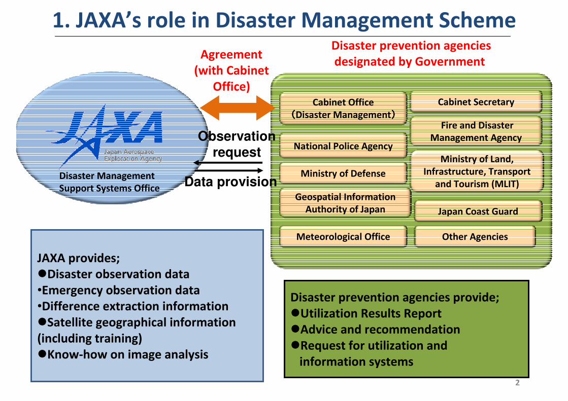
1. JAXA’s role in Disaster Management SchemeDisaster prevention agencies
designated by Government
Cabinet Secretary
National Police Agency
Fire and Disaster
Management Agency
Ministry of Defense
Ministry of Land,
Infrastructure, Transport
and Tourism (MLIT)
Geospatial Information
Authority of Japan
Meteorological Office
Japan Coast Guard
Other Agencies
Agreement
(with Cabinet
Office)Cabinet Office
((((Disaster Management))))
JAXA provides;
�Disaster observation data
•Emergency observation data
•Difference extraction information
�Satellite geographical information
(including training)
�Know-how on image analysis
Disaster prevention agencies provide;
�Utilization Results Report
�Advice and recommendation
�Request for utilization and
information systems
Observationrequest
Data provisionDisaster Management
Support Systems Office
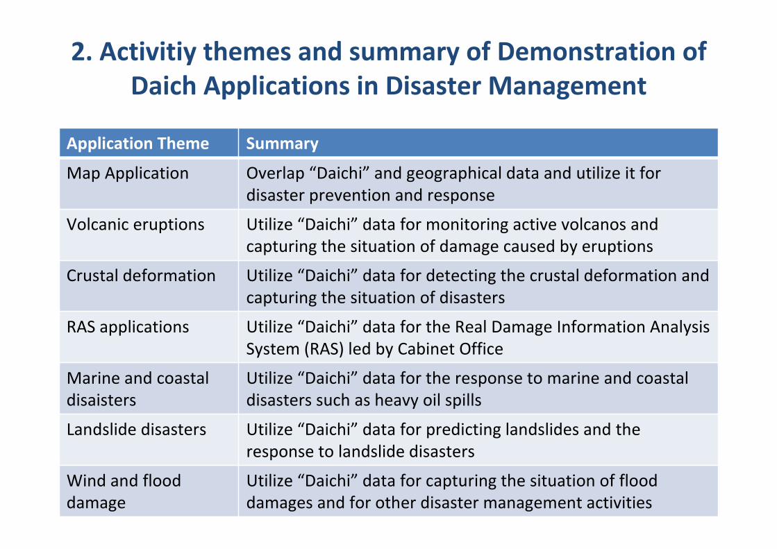
2. Activitiy themes and summary of Demonstration of
Daich Applications in Disaster Management
Application Theme Summary
Map Application Overlap “Daichi” and geographical data and utilize it for
disaster prevention and response
Volcanic eruptions Utilize “Daichi” data for monitoring active volcanos and
capturing the situation of damage caused by eruptions
Crustal deformation Utilize “Daichi” data for detecting the crustal deformation and
capturing the situation of disasters
RAS applications Utilize “Daichi” data for the Real Damage Information Analysis
System (RAS) led by Cabinet Office
Marine and coastal
disaisters
Utilize “Daichi” data for the response to marine and coastal
disasters such as heavy oil spills
Landslide disasters Utilize “Daichi” data for predicting landslides and the
response to landslide disasters
Wind and flood
damage
Utilize “Daichi” data for capturing the situation of flood
damages and for other disaster management activities
4
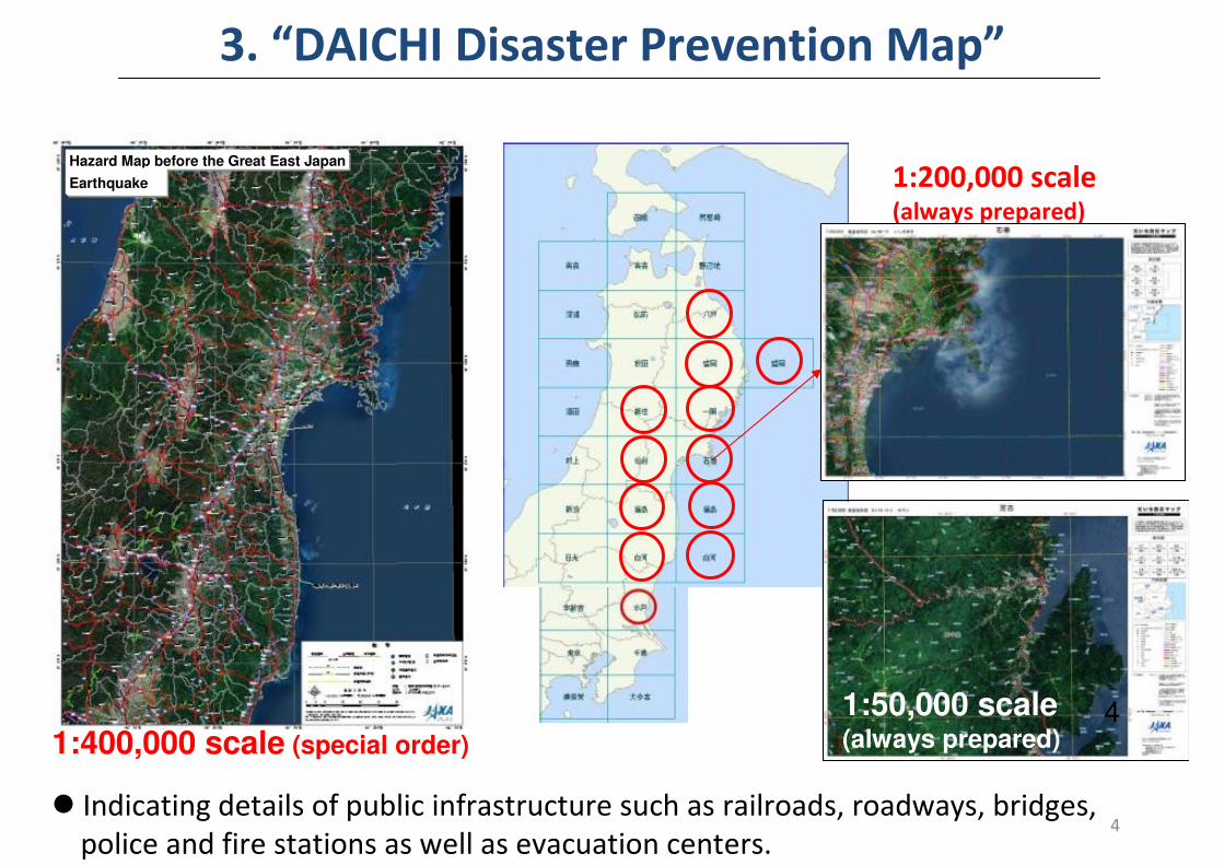
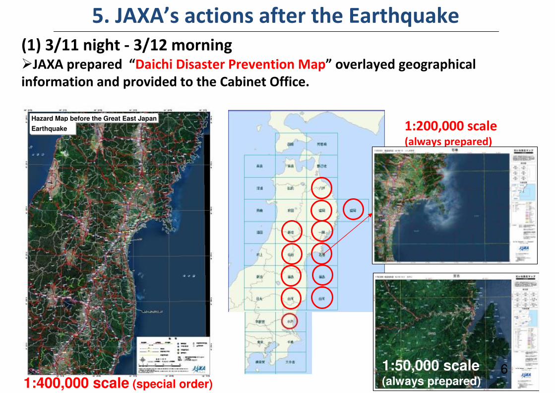
3. “DAICHI Disaster Prevention Map”
� Indicating details of public infrastructure such as railroads, roadways, bridges,
police and fire stations as well as evacuation centers.
1:400,000 scale (special order)
1:200,000 scale(always prepared)
1:50,000 scale(always prepared)
4
Hazard Map before the Great East Japan
Earthquake
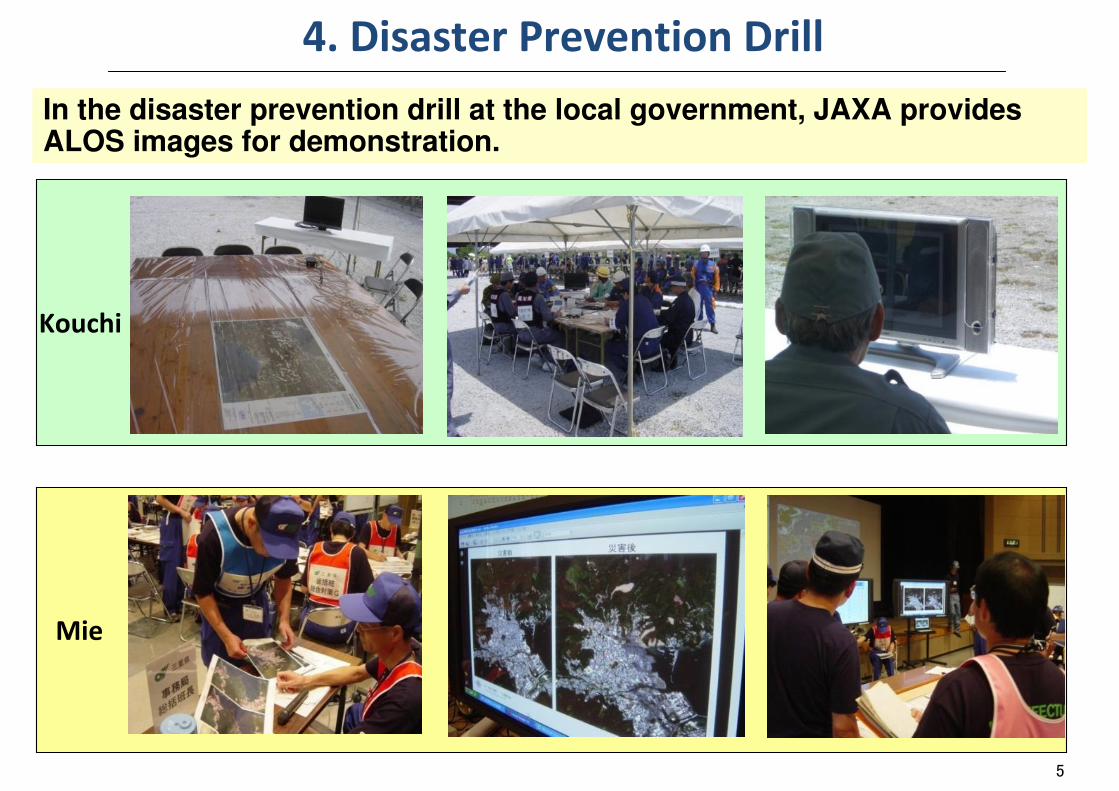
4. Disaster Prevention Drill
In the disaster prevention drill at the local government, JAXA provides ALOS images for demonstration.
5
Kouchi
Mie
6
5. JAXA’s actions after the Earthquake
1:400,000 scale (special order)
1:200,000 scale(always prepared)
(1) 3/11 night - 3/12 morning�JAXA prepared “Daichi Disaster Prevention Map” overlayed geographical
information and provided to the Cabinet Office.
1:50,000 scale(always prepared)
6
Hazard Map before the Great East Japan
Earthquake
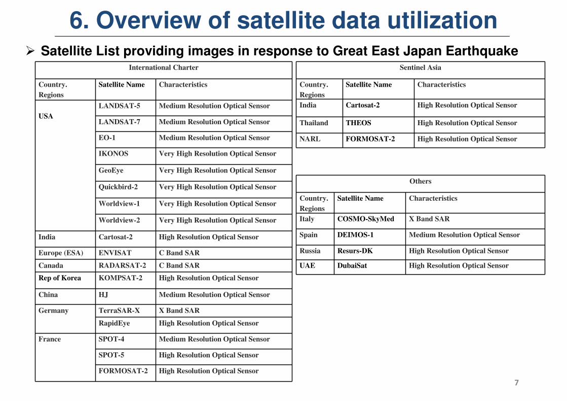
International Charter
Country.
Regions
Satellite Name Characteristics
USA
LANDSAT-5 Medium Resolution Optical Sensor
LANDSAT-7 Medium Resolution Optical Sensor
EO-1 Medium Resolution Optical Sensor
IKONOS Very High Resolution Optical Sensor
GeoEye Very High Resolution Optical Sensor
Quickbird-2 Very High Resolution Optical Sensor
Worldview-1 Very High Resolution Optical Sensor
Worldview-2 Very High Resolution Optical Sensor
India Cartosat-2 High Resolution Optical Sensor
Europe (ESA) ENVISAT C Band SAR
Canada RADARSAT-2 C Band SAR
Rep of Korea KOMPSAT-2 High Resolution Optical Sensor
China HJ Medium Resolution Optical Sensor
Germany TerraSAR-X X Band SAR
RapidEye High Resolution Optical Sensor
France SPOT-4 Medium Resolution Optical Sensor
SPOT-5 High Resolution Optical Sensor
FORMOSAT-2 High Resolution Optical Sensor
Sentinel Asia
Country.
Regions
Satellite Name Characteristics
India Cartosat-2 High Resolution Optical Sensor
Thailand THEOS High Resolution Optical Sensor
NARL FORMOSAT-2 High Resolution Optical Sensor
Others
Country.
Regions
Satellite Name Characteristics
Italy COSMO-SkyMed X Band SAR
Spain DEIMOS-1 Medium Resolution Optical Sensor
Russia Resurs-DK High Resolution Optical Sensor
UAE DubaiSat High Resolution Optical Sensor
� Satellite List providing images in response to Great East Japan Earthquake
6. Overview of satellite data utilization
7
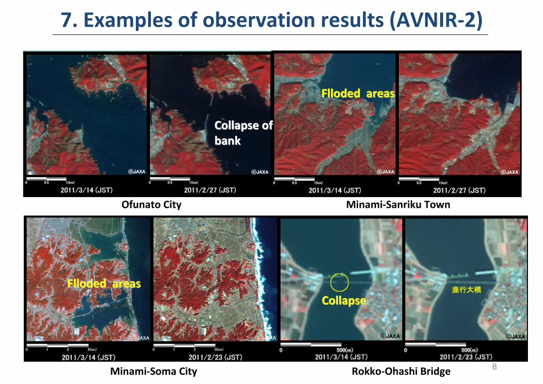
Minami-Sanriku TownOfunato City
Rokko-Ohashi Bridge
CollapseCollapse
Minami-Soma City
Collapse of Collapse of
bankbank
Flloded areasFlloded areas
7. Examples of observation results (AVNIR-2)
Flloded areasFlloded areas
8
co
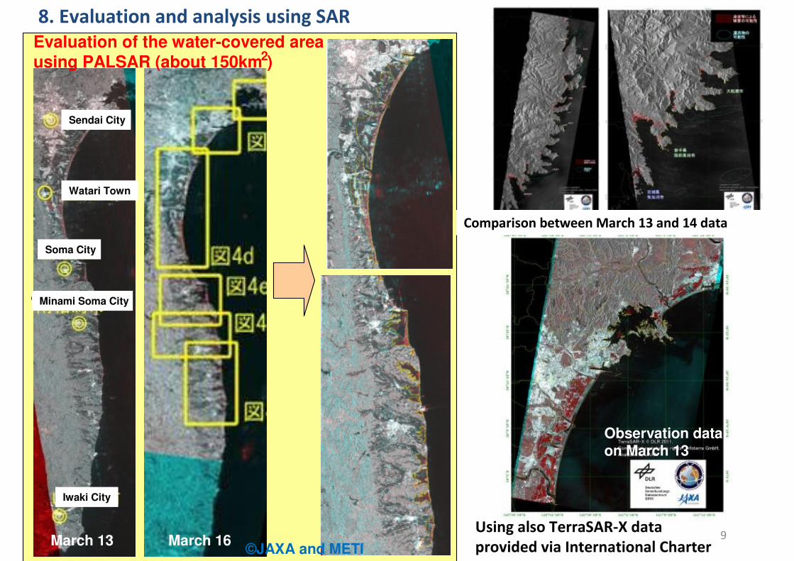
March 13 March 16Using also TerraSAR-X data
provided via International Charter
Observation data on March 13
Comparison between March 13 and 14 data
Evaluation of the water-covered area
using PALSAR (about 150km )
8. Evaluation and analysis using SAR
2
9
Sendai City
Watari Town
Soma City
Minami Soma City
Iwaki City
©JAXA and METI
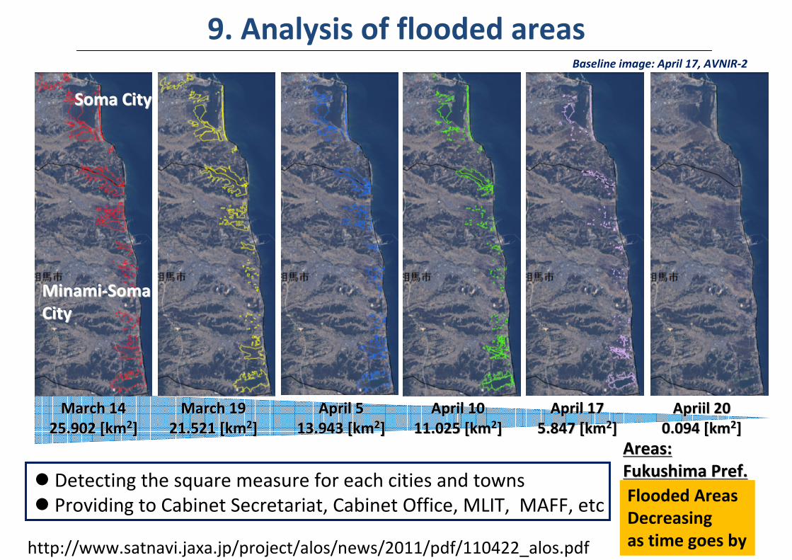
March 14March 14
25.902 [km25.902 [km22]]
March 19March 19
21.521 [km21.521 [km22]]
April 5April 5
13.943 [km13.943 [km22]]
April 10April 10
11.025 [km11.025 [km22]]
April 17April 17
5.847 [km5.847 [km22]]
Apriil 20Apriil 20
0.094 [km0.094 [km22]]
MinamiMinami--SomaSoma
CityCity
Soma CitySoma City
Baseline image: April 17, AVNIR-2
� Detecting the square measure for each cities and towns
� Providing to Cabinet Secretariat, Cabinet Office, MLIT, MAFF, etc
http://www.satnavi.jaxa.jp/project/alos/news/2011/pdf/110422_alos.pdf
Flooded Areas
Decreasing
as time goes by
Areas: Areas:
Fukushima Pref.Fukushima Pref.
9. Analysis of flooded areas
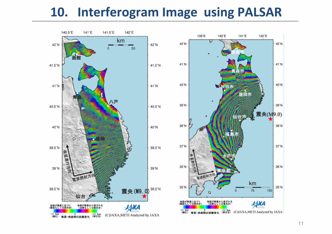
10. Interferogram Image using PALSAR
11

11. Detetcion of the Drifted Mterials
12

13
12. Provision of satellite communication: KIZUNA
� March 17:
Arrival at Iwate Pref. Office
� March 20:
Setting up communication line between the Iwate Prefectural Office (emergency response headquarters)
and Kamaishi City (Local emergency response headquarters)
� March 24: Setting up ground antenna
at Ofunato City, and completing communication line in three points
� April 24Connection completed
14
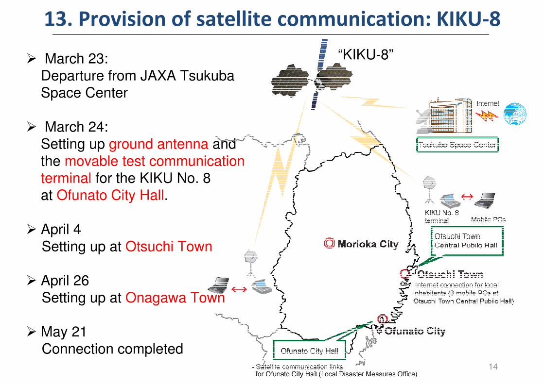
13. Provision of satellite communication: KIKU-8
� March 23: Departure from JAXA Tsukuba Space Center
� March 24: Setting up ground antenna and
the movable test communication terminal for the KIKU No. 8 at Ofunato City Hall.
� April 4
Setting up at Otsuchi Town
� April 26
Setting up at Onagawa Town
� May 21
Connection completed
“KIKU-8”
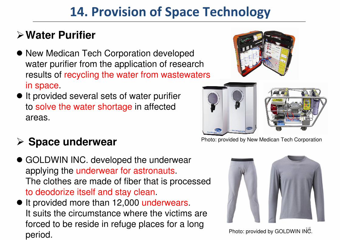
14. Provision of Space Technology
�Water Purifier
� New Medican Tech Corporation developed water purifier from the application of research
results of recycling the water from wastewaters in space.
� It provided several sets of water purifier
to solve the water shortage in affected areas.
� Space underwear
� GOLDWIN INC. developed the underwear
applying the underwear for astronauts. The clothes are made of fiber that is processed
to deodorize itself and stay clean. � It provided more than 12,000 underwears.
It suits the circumstance where the victims are
forced to be reside in refuge places for a long period.
15
Photo: provided by New Medican Tech Corporation
Photo: provided by GOLDWIN INC.
Conclusion
JAXA will reflect the lessons and learned of
this Great East Japan Earthquake, to make the
most use of Space Applications to the disaster
management and mitigation.