the great east japan earthquake and tsunami · cho fishery cooperative, hitoshi maekawa, and ... pr...
TRANSCRIPT
The Great East Japan Earthquake and Tsunami
7
Photographers: Koji Fujita, Yoshiaki Kawauchi, Hiroaki Nakamura, Naomichi Nakamura (PR Miyako)
Photo contribut ors (without title): Miyako Fishery Cooperative, Taro-cho Fishery Cooperative, Hitoshi Maekawa, and Kaoru Wada
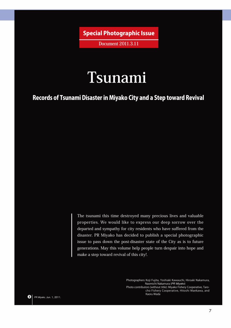
Special Photographic IssueDocument 2011.3.11
TsunamiRecords of Tsunami Disaster in Miyako City and a Step toward Revival
PR Miyako, Jun. 1, 2011.❸
The tsunami this time destroyed many precious lives and valuable properties. We would like to express our deep sorrow over the departed and sympathy for city residents who have suffered from the disaster. PR Miyako has decided to publish a special photographic issue to pass down the post-disaster state of the City as is to future generations. May this volume help people turn despair into hope and make a step toward revival of this city!.
The Great East Japan Earthquake and Tsunami
8
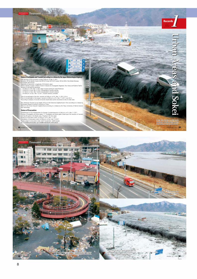
At 3:23 p.m. on Mar. 11. Black waves quickly grew in height, making a roaring sound as they poured into urban areas.
Recordsfile1
Special Photographic IssueDocument 2011.3.11 Tsunami Records of Disaster in Miyako and a Step toward Revival
Urban Areas and Sokei
PR Miyako, Jun. 1, 2011. PR Miyako, Jun. 1, 2011. ❹❺
Status of Earthquake and Tsunami (according to a release by the Japan Meteorological Agency)Date and time of the occurrence: at about 2:46 p.m. on Mar. 11, 2011Epicenter: Off the Sanriku Coast at lat 38° 6.2′ N, long 142° 51.6′ E, about 130 km ESE of the Oshika PeninsulaFocal depth: about 24 kmMagnitude at hypocenter: a magnitude of 9.0 (interim value)Seismic intensity: 5-upper in Moichi; 5-lower in Satsuki-cho, Kuwagasaki, Nagasawa, Taro, Kawai, and Kadoma TashiroIssuance of warnings and advisories:
At 2:49 p.m. on Fri., Mar. 11, 2011, Major tsunami warning for Iwate PrefectureAt 8:20 p.m. on Sat., Mar. 12, 2011, Downgraded to tsunami warningAt 7:30 a.m. on Sun., Mar. 13, 2011, Downgraded to tsunami advisoryAt 5:58 p.m. on Sun., Mar. 13, 2011, Tsunami advisory canceled
Time of arrival/height of the first tsunami: at 2:48 p.m. on Fri., Mar. 11, 2011; 0.2 mTime of arrival/height of the largest tsunami: at 3:26 p.m. on Fri., Mar. 11, 2011; over 8.5 m*According to analysis of records at tsunami observation points recovered on-site at a later date.
(For reference) Tsunami run-up height: 37.9 m in the Koborinai neighborhood in Taro according to a release by Earthquake Research Institute, University of Tokyo38.9 m in the Omoe Aneyoshi neighborhood according to a release by the Tokyo University of Marine Science and Technology
Status of EvacuationEstablishment of City Headquarters for Disaster Countermeasures: at 2:46 p.m. on Fri., Mar. 11, 2011Closing of floodgates and sluice gates: 111 floodgates and sluice gates closed upon the issuance of tsunami warning (93 gates in the Miyako area, 18 gates in the Taro area)Issuance of evacuation order: at 2:49 p.m. on Fri., Mar. 11, 2011Cancellation of evacuation order: at 5:58 p.m. on Sun., Mar. 13, 2011People subject to evacuation order: 5,227 households, 12,842 peopleNo. of shelters/evacuees: up to 8,889 individuals at 85 places
At 3:25 p.m. on Mar. 11. Seven minutes after the above picture with the water level rising above the dike, water violently poured into urban areas.
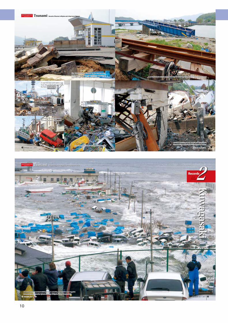
A submerged crossing in front of the City Hall. Horns of cars caught by waves kept sounding for a while before silence reigned over the place.
At 3:18 p.m. on Mar. 11. The Hei River with the bottom visible during an ebb tide. A fire engine ran along the dike calling for evacuation.
Special Photographic IssueDocument 2011.3.11 Tsunami Records of Disaster in Miyako and a Step toward Revival
PR Miyako, Jun. 1, 2011. PR Miyako, Jun. 1, 2011.❼ ❻
The Great East Japan Earthquake and Tsunami
9
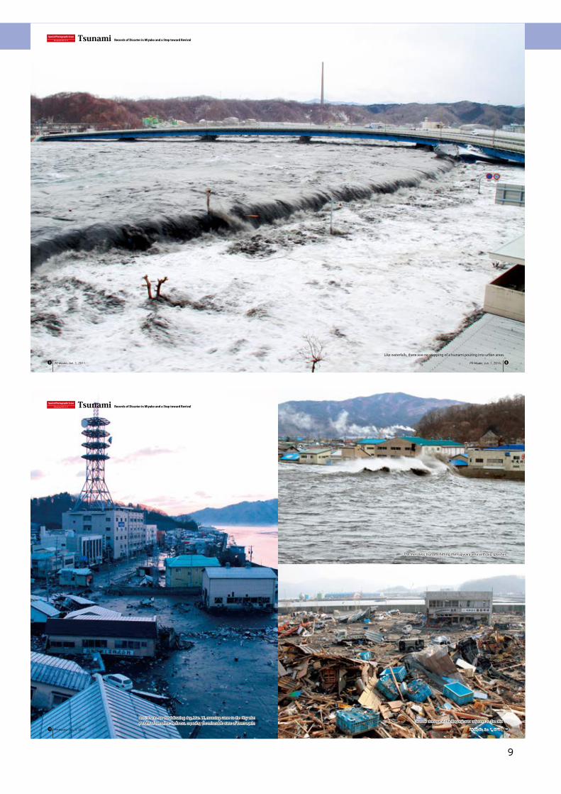
Like waterfalls, there was no stopping of a tsunami pouring into urban areas.
Special Photographic IssueDocument 2011.3.11 Tsunami Records of Disaster in Miyako and a Step toward Revival
PR Miyako, Jun. 1, 2011. PR Miyako, Jun. 1, 2011. ❽❾
At 5:30 a.m. on the following day, Mar. 12, morning came to the City after a night of complete darkness, exposing the miserable state of town again.
The merciless tsunami hitting the Fujiwara area with big splashes
Special Photographic IssueDocument 2011.3.11 Tsunami Records of Disaster in Miyako and a Step toward Revival
PR Miyako, Jun. 1, 2011. PR Miyako, Jun. 1, 2011. ❿⓫
Disaster damage in the Koganji area adjacent to the dike
The Great East Japan Earthquake and Tsunami
10
At Desaki Pier, fish market facilities, related materials, and vehicles were engulfed in waves one after another (photo courtesy of Miyako Fishery Cooperative).
Special Photographic IssueDocument 2011.3.11 Tsunami Records of Disaster in Miyako and a Step toward Revival
Recordsfile2
Kuwagasaki
PR Miyako, Jun. 1, 2011. PR Miyako, Jun. 1, 2011. ⓮⓯
Special Photographic IssueDocument 2011.3.11 Tsunami Records of Disaster in Miyako and a Step toward Revival
PR Miyako, Jun. 1, 2011. PR Miyako, Jun. 1, 2011.
Rias Harbor Miyako destroyed by the tsunami much to the regret of those who had been preparing to host inter-high school sailing competitions.
Around a crossing in the Sokei/Kanbayashi area. Stranded ships commingled with destroyed houses.
A JR Yamada Line railroad bridge over the Hei River torn apart by the impact of the tsunami
⓬⓭The ravaged lobby on the first floor of the City Hall
Countless cars and ships swept by water landed in urban areas.
A road blocked with debris and mud. View of the Tsukiji area from the front of the City Hall.
The Great East Japan Earthquake and Tsunami
11
Destroyed houses carried away to Miyako Bay by backwash (photo courtesy of Miyako Fishery Cooperative)
Despite the strenuous search conducted continuously by reinforcement teams from across the country, many precious lives were lost. A cruise vessel is stranded in the background.
Former fish market building. The force of waves carried up a car to land just below the arching ceiling.
View of Takonohama Town and Minato Town from the Jodogahama Bridge
Special Photographic IssueDocument 2011.3.11 Tsunami Records of Disaster in Miyako and a Step toward Revival
PR Miyako, Jun. 1, 2011. PR Miyako, Jun. 1, 2011.⓱ ⓰
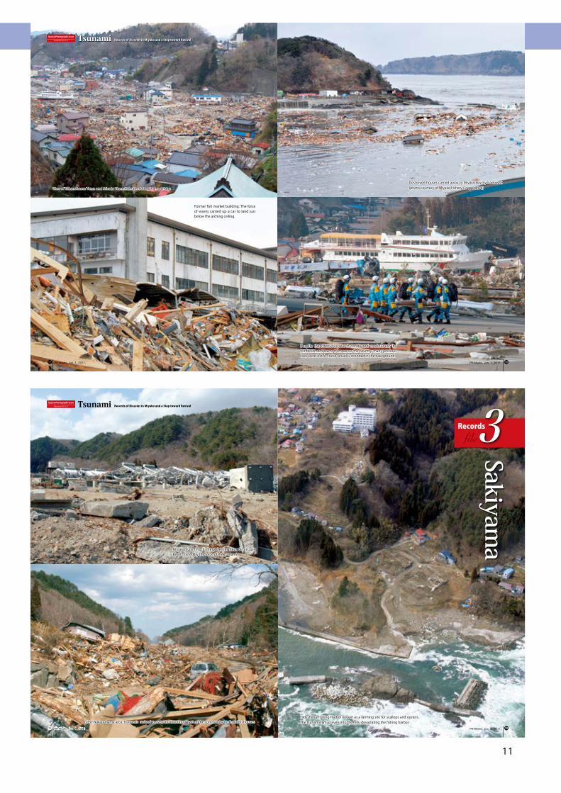
Hideshima Fishing Harbor known as a farming site for scallops and oysters. The tsunami ran up even into the hills, devastating the fishing harbor.
Miyako Farming Fishery Center near Onatsupe Beach ruined by the force of the tsunami
In the Nakanohama area, tsunamis rushed to even the innermost part of the community to demolish houses.
Special Photographic IssueDocument 2011.3.11 Tsunami Records of Disaster in Miyako and a Step toward Revival
Recordsfile3
Sakiyama
PR Miyako, Jun. 1, 2011.PR Miyako, Jun. 1, 2011. ⓲⓳
The Great East Japan Earthquake and Tsunami
12
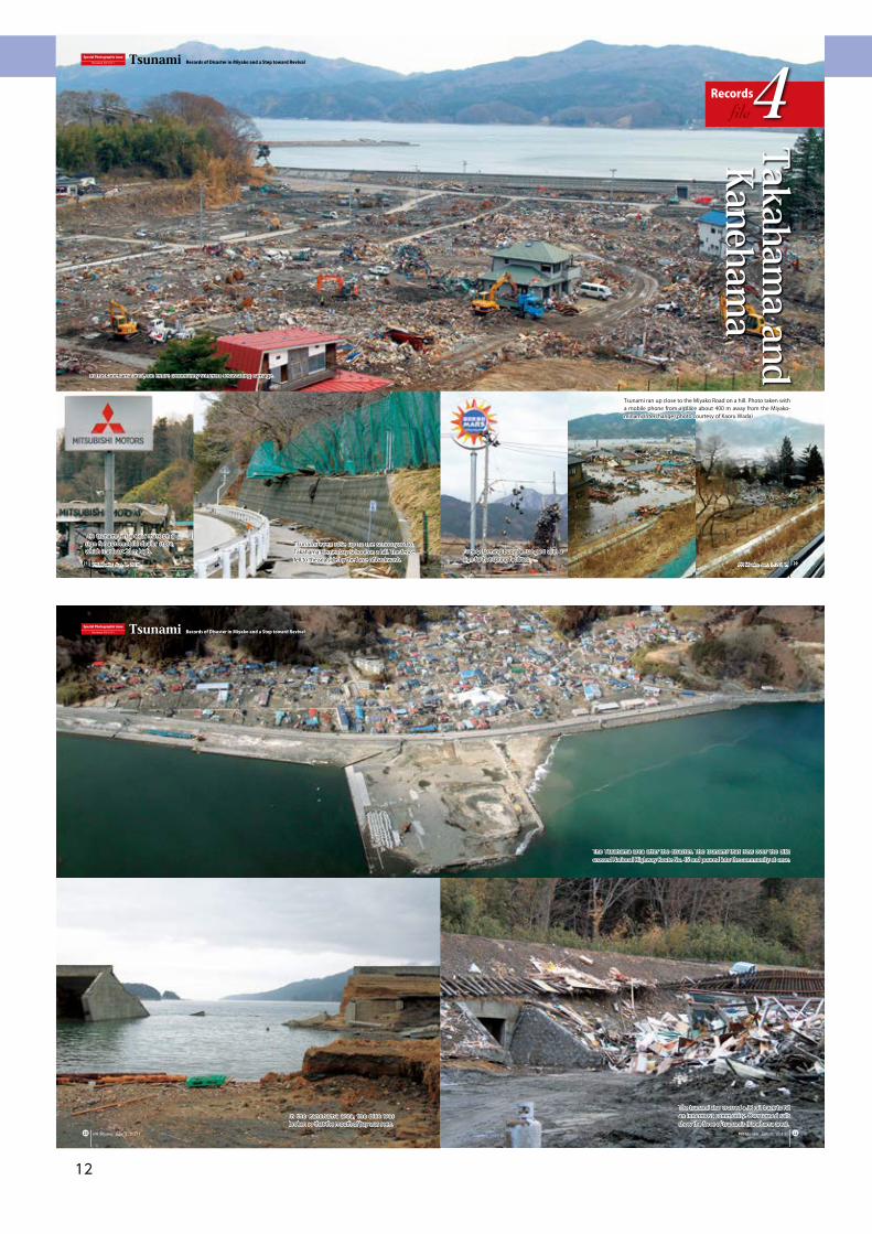
In the Kanehama area, the dike was broken so that the mouth of bay was seen.
The tsunami also crossed a JR rail track to hit an innermost community. Overturned rails show the force of tsunamis (Kanehama area).
The Takahama area after the disaster. The tsunami that flew over the dike crossed National Highway Route No. 45 and poured into the community at once.
Special Photographic IssueDocument 2011.3.11 Tsunami Records of Disaster in Miyako and a Step toward Revival
PR Miyako, Jun. 1, 2011. PR Miyako, Jun. 1, 2011.� �
The tsunami left a clear mark on a sign for automobile dealer store, which is at least 20 m high. Fishery farming buoys entangled with a
sign for hot spring facilities
Tsunami ran up close to the Miyako Road on a hill. Photo taken with a mobile phone from a place about 400 m away from the Miyako-minami Interchange (photo courtesy of Kaoru Wada)
Tsunami even rose up to the schoolyard of Takahama Elementary School on a hill. The fence fell to the sea side by the force of backwash.
Special Photographic IssueDocument 2011.3.11 Tsunami Records of Disaster in Miyako and a Step toward Revival
Recordsfile4
Takahama and
Kanehama
PR Miyako, Jun. 1, 2011.PR Miyako, Jun. 1, 2011. ⓴�
In the Kanehama area, the entire community suffered devastating damage.
The Great East Japan Earthquake and Tsunami
13
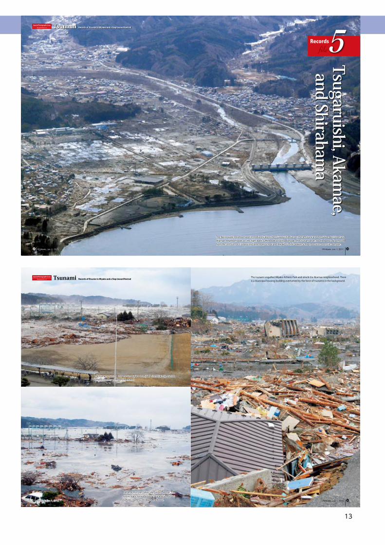
The Norinowaki neighborhood immediately along the Tsugaruishi River on the left bank and the Sakae-dori Street and Akamae neighborhoods on the right bank suffered devastating damage. The tsunami even reached areas far removed from the sea, such as Tsugaruishi Elementary School and Miyako Technical High School, to cause extensive damage.
Special Photographic IssueDocument 2011.3.11 Tsunami Records of Disaster in Miyako and a Step toward Revival
Recordsfile5
Tsugaruishi, Akamae,
and Shirahama
PR Miyako, Jun. 1, 2011. PR Miyako, Jun. 1, 2011. ��
The tsunami engulfed Miyako Athletic Park and struck the Akamae neighborhood. There is a municipal housing building overturned by the force of tsunamis in the background.
The tsunami rushing into the schoolyard of Miyako Technical High School (photo courtesy of Hitoshi Maekawa)
Several minutes after the photo above. The entire place turned into the sea after a moment (photo courtesy of Hitoshi Maekawa).
Special Photographic IssueDocument 2011.3.11 Tsunami Records of Disaster in Miyako and a Step toward Revival
PR Miyako, Jun. 1, 2011.PR Miyako, Jun. 1, 2011. ��
The Great East Japan Earthquake and Tsunami
14
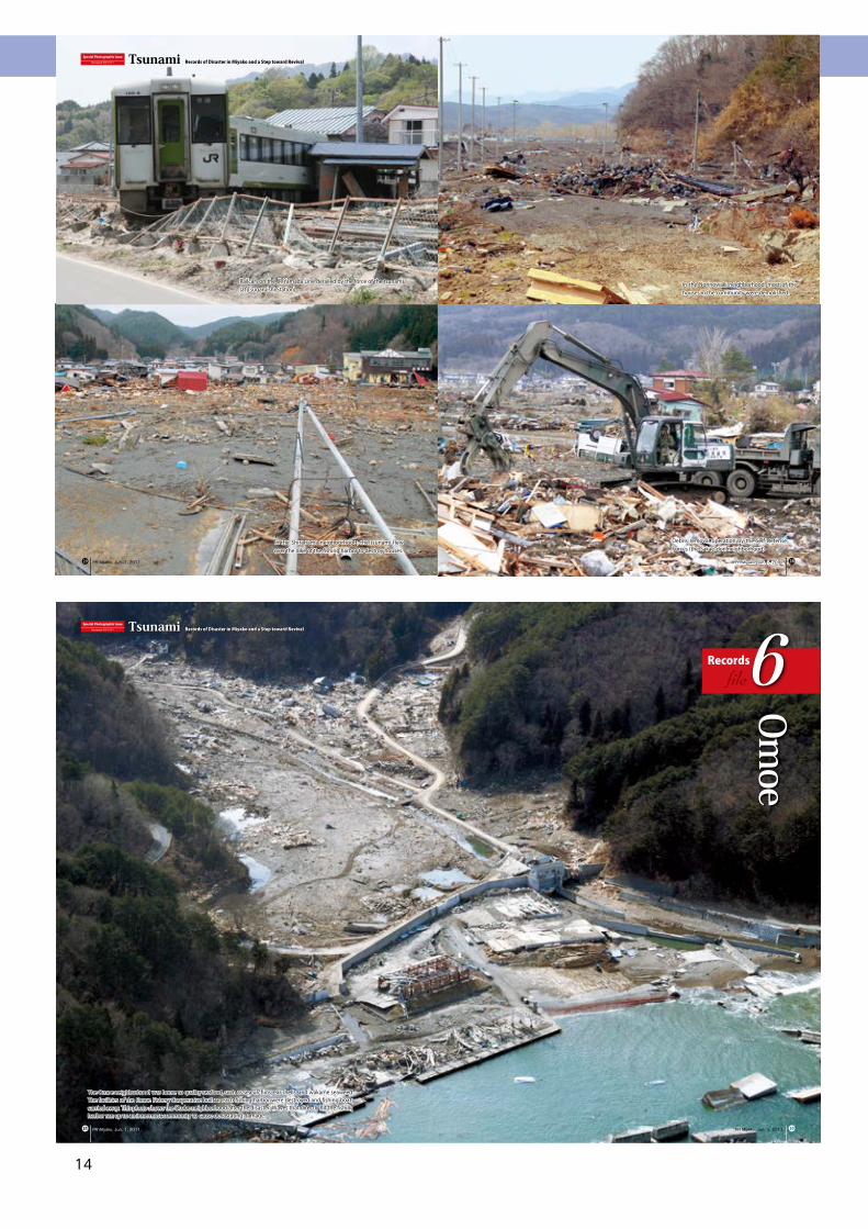
The Omoe neighborhood was home to quality seafood, such as sea urchins, ear shells, and wakame seaweed. The facilities of the Omoe Fishery Cooperative built at each fishing harbor were destroyed and fishing boats carried away. This photo shows the Otobe neighborhood after the disaster. Waves that directly hit the fishing harbor ran up to an innermost community to cause devastating damage.
Special Photographic IssueDocument 2011.3.11 Tsunami Records of Disaster in Miyako and a Step toward Revival
Recordsfile6
Omoe
PR Miyako, Jun. 1, 2011. PR Miyako, Jun. 1, 2011. ��
In the Shirahama neighborhood, the tsunami flew over the dike of the fishing harbor to destroy houses.
Railcars on the JR Yamada Line derailed by the force of the tsunami (at Tsugaruishi Station)
In the Norinowaki neighborhood, most of the houses in the community were demolished.
Debris removal operation by the Self-Defense Forces (the Sakae-dori neighborhood)
Special Photographic IssueDocument 2011.3.11 Tsunami Records of Disaster in Miyako and a Step toward Revival
PR Miyako, Jun. 1, 2011. PR Miyako, Jun. 1, 2011. ��
The Great East Japan Earthquake and Tsunami
15
Omoe Fishing Harbor (in Sato). Facilities like the ice-making/refrigeration plant and seedling production facilities for ear shells were lost.
Otobe Fishing Harbor. Facilities like the processing plant and pickup site were destroyed except for steel frames.
The tsunami broke down the Mukaiwatari Bridge over the Omoe Peninsula Line, obstructing traffic.
The Chikei neighborhood. The tsunami hit the fishing harbor and rose up to the level of Chikei Elementary School.
Special Photographic IssueDocument 2011.3.11 Tsunami Records of Disaster in Miyako and a Step toward Revival
PR Miyako, Jun. 1, 2011. PR Miyako, Jun. 1, 2011. ��
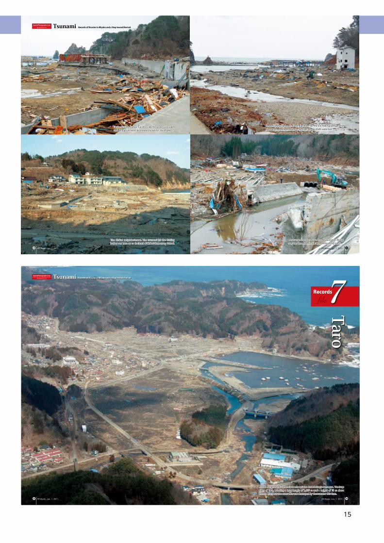
A wide range of the Taro neighborhood was devastatingly damaged. The huge dikes of Taro, boasting a total length of 2,433 m and a height of 10 m above the sea level, but the outer dike was destroyed by the tsunami this time.
Special Photographic IssueDocument 2011.3.11 Tsunami Records of Disaster in Miyako and a Step toward Revival
Recordsfile7
Taro
PR Miyako, Jun. 1, 2011. PR Miyako, Jun. 1, 2011. ��
The Great East Japan Earthquake and Tsunami
16
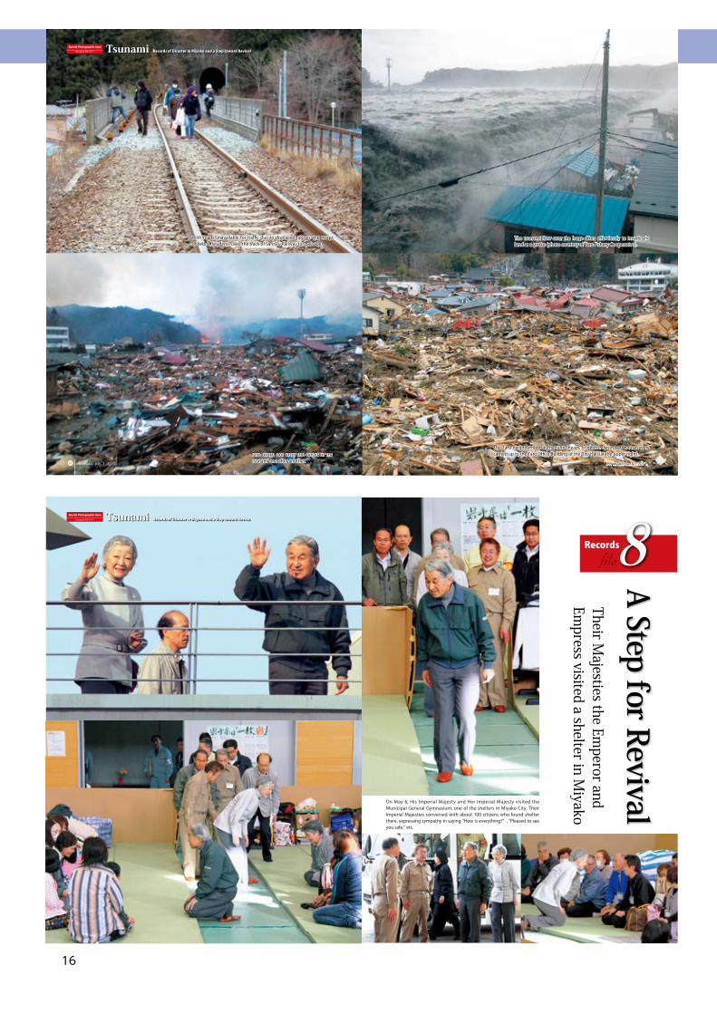
The tsunami flew over the huge dikes effortlessly to invade the land at a stroke (photo courtesy of Taro Fishery Cooperative).
The Taro neighborhood turned into heaps of debris. Destroyed houses were carried up to the Taro Office Building of the City Hall (at the upper right).Fire broke out after the onset of the
tsunami one after another.
With roads unavailable for traffic due to displaced houses and heaps of debris, residents used the track of Sanriku Railway for passage.
Special Photographic IssueDocument 2011.3.11 Tsunami Records of Disaster in Miyako and a Step toward Revival
PR Miyako, Jun. 1, 2011. PR Miyako, Jun. 1, 2011. ��
⓬⓭
On May 6, His Imperial Majesty and Her Imperial Majesty visited the Municipal General Gymnasium, one of the shelters in Miyako City. Their Imperial Majesties conversed with about 100 citizens who found shelter there, expressing sympathy in saying “How is everything?” , “Pleased to see you safe,” etc.
Their Majesties the Em
peror and Em
press visited a shelter in Miyako
Special Photographic IssueDocument 2011.3.11 Tsunami Records of Disaster in Miyako and a Step toward Revival
Recordsfile8
A Step for Revival
The Great East Japan Earthquake and Tsunami
17
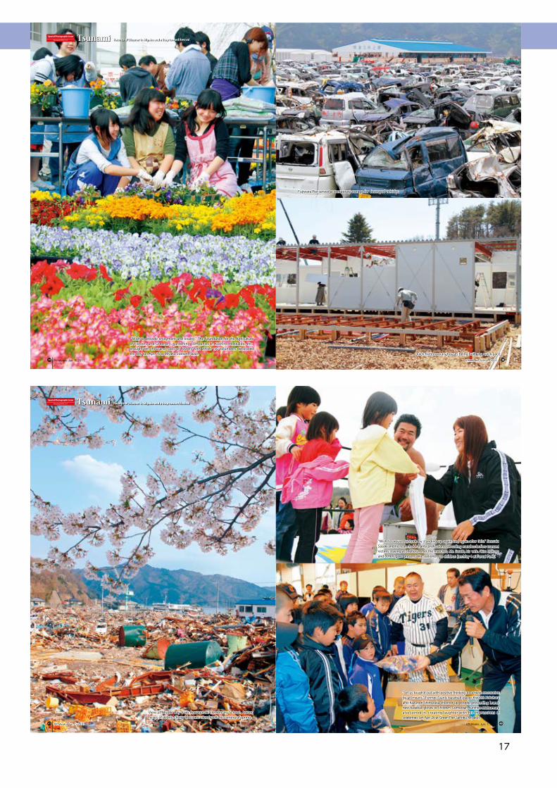
Fujiwara Pier served as temporary storage for destroyed vehicles.
Quick-fix temporary houses being built at a quick pace
“Wish to provide enjoyment and vitality.” The Foundation for the Agriculture of Flowers and Greenery, gardening companies in Kushiro, Hokkaido, etc., brought ten thousand roots of flowers with which 150 volunteers decorated the City (on Apr. 16 at Miyako Station Plaza).
Special Photographic IssueDocument 2011.3.11 Tsunami Records of Disaster in Miyako and a Step toward Revival
PR Miyako, Jun. 1, 2011. PR Miyako, Jun. 1, 2011. ��
“Wish to arouse fortitude by standing up again and again after falls.” Kensuke Sasaki and his team held charity professional wrestling matches before tsunami victims staying at shelters. After the matches, Mr. Sasaki, his wife Akira Hokuto, and others gave presents like stationery to children (on May 4 at Fureai Park).
“Let us tough it out with positive thinking to achieve restoration by all means.” Former Giants baseball player Kiyoshi Nakahata and Kazunori Shinozuka cheered up people, presenting brand-new baseball gloves to children. Comedian Kunihiro Matsumura also joined in, creating laughter with his impressions of celebrities (on Apr. 26 at Green Pier Sanriku Miyako).
View of Miyako Bay from Kuwagasaki Elementary School. Among heaps of debris, cherry blossoms silently tell the coming of spring.
Special Photographic IssueDocument 2011.3.11 Tsunami Records of Disaster in Miyako and a Step toward Revival
PR Miyako, Jun. 1, 2011.PR Miyako, Jun. 1, 2011. ��
The Great East Japan Earthquake and Tsunami
18
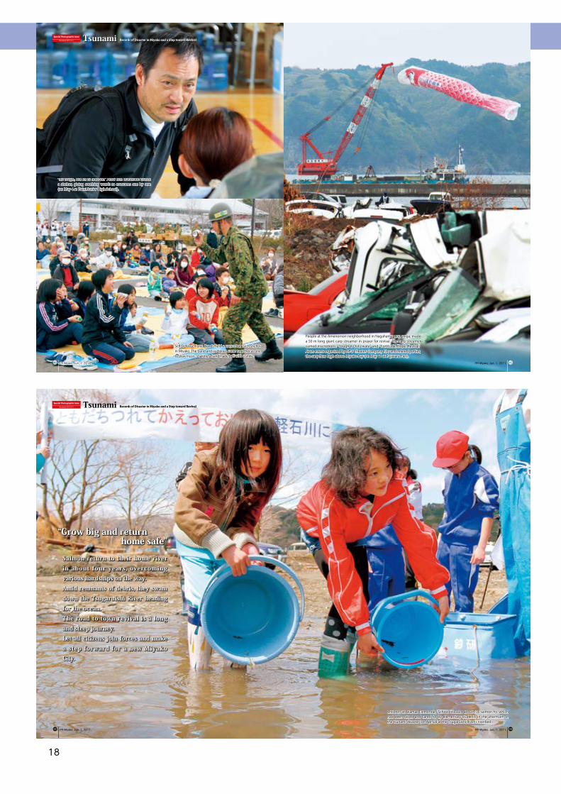
Children at Akamae Elementary School released about 100 salmon fry, which had been raised and cared for by elementary students in the aftermath of the tsunami disaster (on Apr. 28 at the Tsugaruishi River's riverbed).
Special Photographic IssueDocument 2011.3.11 Tsunami Records of Disaster in Miyako and a Step toward Revival
PR Miyako, Jun. 1, 2011. PR Miyako, Jun. 1, 2011.
“Grow big and return home safe”
Salmon return to their home river in about four years, overcoming various hardships on the way.Amid remnants of debris, they swam down the Tsugaruishi River heading for the ocean.The road to town revival is a long and steep journey.Let all citizens join forces and make a step forward for a new Miyako City.
��
“It's tough, but let us hold on.” Actor Ken Watanabe visited a shelter, giving soothing words to evacuees one by one (on May 4 at Daini Junior High School).
Self-Defense Force Bands held a concert at each shelter in Miyako. The band and audience came together as one to play music, shaking a handmade bell with a smile.
People at the Amenomori neighborhood in Nagahama City, Shiga, made a 50 m long giant carp streamer in prayer for revival. The carp streamer carried inscriptions: “Tough it Out, Iwate” and “Fortitude, Hope, Revival.” At an event organized by NPO Theater Company You and related parties, the carp flew high above Miyako Bay (on May 11 at Fujiwara Pier).
Special Photographic IssueDocument 2011.3.11 Tsunami Records of Disaster in Miyako and a Step toward Revival
PR Miyako, Jun. 1, 2011.PR Miyako, Jun. 1, 2011. ��

The Great East Japan Earthquake and Tsunami
19
The Great East Japan Earthquake and Tsunami
20
1. Overview of Earthquake and Tsunami
(1) Overview of Earthquake○ Date and time of earthquake occurrence: at 14:46 on Mar. 11, 2011○ NameOn Mar. 11, the Japan Meteorological Agency named the earthquake as “the 2011 Earthquake Off the Pacific Coast of Tohoku.” On Apr. 1, the Japanese Government officially announced the name of the disaster caused by the earthquake as “Higashi Nihon Daishinsai (The Great East Japan Earthquake).” Iwate Prefecture makes it a rule to use the name “Higashi Nihon Daishinsai Tsunami (The Great East Japan Earthquake and Tsunami).”○ Epicenter: Off the coast of Sanriku, around 130 km ESE of the Oshika Peninsula38°6.21′ N, 142°51.66′ E○ Focal depth: about 24 km○ Source region: estimated to be about 450 km in length and about 200 km in width○ Magnitude: 9.0
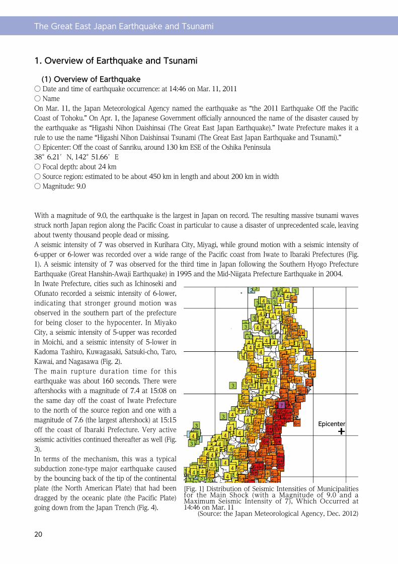
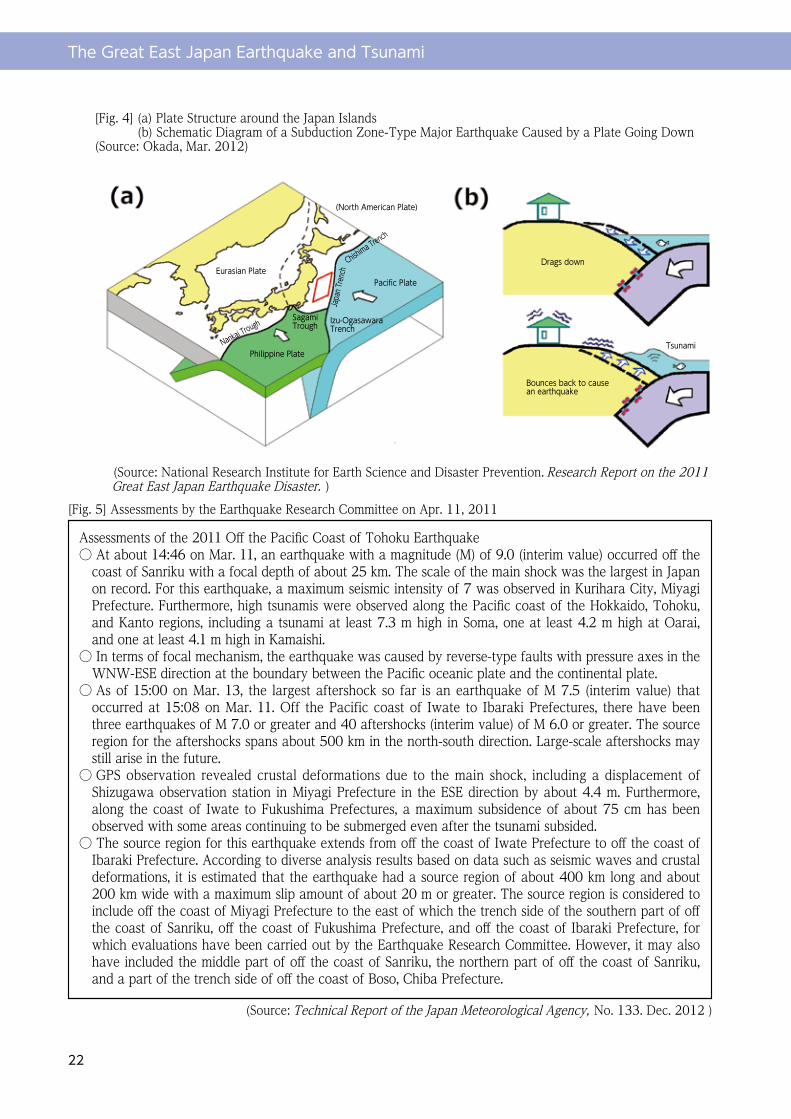
With a magnitude of 9.0, the earthquake is the largest in Japan on record. The resulting massive tsunami waves struck north Japan region along the Pacific Coast in particular to cause a disaster of unprecedented scale, leaving about twenty thousand people dead or missing.A seismic intensity of 7 was observed in Kurihara City, Miyagi, while ground motion with a seismic intensity of 6-upper or 6-lower was recorded over a wide range of the Pacific coast from Iwate to Ibaraki Prefectures (Fig. 1). A seismic intensity of 7 was observed for the third time in Japan following the Southern Hyogo Prefecture Earthquake (Great Hanshin-Awaji Earthquake) in 1995 and the Mid-Niigata Prefecture Earthquake in 2004.In Iwate Prefecture, cities such as Ichinoseki and Ofunato recorded a seismic intensity of 6-lower, indicating that stronger ground motion was observed in the southern part of the prefecture for being closer to the hypocenter. In Miyako City, a seismic intensity of 5-upper was recorded in Moichi, and a seismic intensity of 5-lower in Kadoma Tashiro, Kuwagasaki, Satsuki-cho, Taro, Kawai, and Nagasawa (Fig. 2). The main rupture duration time for this earthquake was about 160 seconds. There were aftershocks with a magnitude of 7.4 at 15:08 on the same day off the coast of Iwate Prefecture to the north of the source region and one with a magnitude of 7.6 (the largest aftershock) at 15:15 off the coast of Ibaraki Prefecture. Very active seismic activities continued thereafter as well (Fig. 3).In terms of the mechanism, this was a typical subduction zone-type major earthquake caused by the bouncing back of the tip of the continental plate (the North American Plate) that had been dragged by the oceanic plate (the Pacific Plate) going down from the Japan Trench (Fig. 4).
[Fig. 1] Distribution of Seismic Intensities of Municipalities for the Main Shock (with a Magnitude of 9.0 and a Maximum Seismic Intensity of 7), Which Occurred at 14:46 on Mar. 11
(Source: the Japan Meteorological Agency, Dec. 2012)
Epicenter
The Great East Japan Earthquake and Tsunami
21
Apr. 7, 201123:32 M7.2Seismic intensity: 6-upper
Apr. 12, 201114:07 M6.4Seismic intensity: 6-lower
Mar. 23, 20117:12 M6.0Seismic intensity: 5-upper
Apr. 11, 201117:16 M7.0Seismic intensity: 6-lower
Mar. 19, 201118:56 M6.1Seismic intensity: 5-upper
Mar. 11, 201117:40 M6.0Seismic intensity: 5-upper
Mar. 11, 201115:08 M7.4Seismic intensity: 5-lower
Mar. 11, 201114:46 M9.0Seismic intensity: 7
Mar. 9, 201111:45 M7.3Seismic intensity: 5-lower
Jul. 10, 20119:57 M7.3Seismic intensity: 4
Mar. 11, 201115:25 M7.5Seismic intensity: 4
Mar. 11, 201116:29 M6.6Seismic intensity: 5-upper
Jul. 23, 201113:34 M6.4Seismic intensity: 5-upper
Jul. 31, 20113:53 M6.5Seismic intensity: 5-upper
Mar. 11, 201115:15 M7.6Seismic intensity: 6-upper
[Fig. 3] The Off the Pacific Coast of Tohoku Earthquake and Its AftershocksEach circle represents an earthquake with a magnitude of 5.0 or greater and a focal depth of 0-90 km that occurred from Mar. 1, 2011, to Feb. 29, 2012. In particular, boxes with lead lines refer to earthquakes with a magnitude or 7.0 or greater and those with a magnitude of 6.0 or greater and a seismic intensity of 5-upper or greater that occurred inside the tilted rectangular region. (Source: the Japan Meteorological Agency, Dec. 2012)
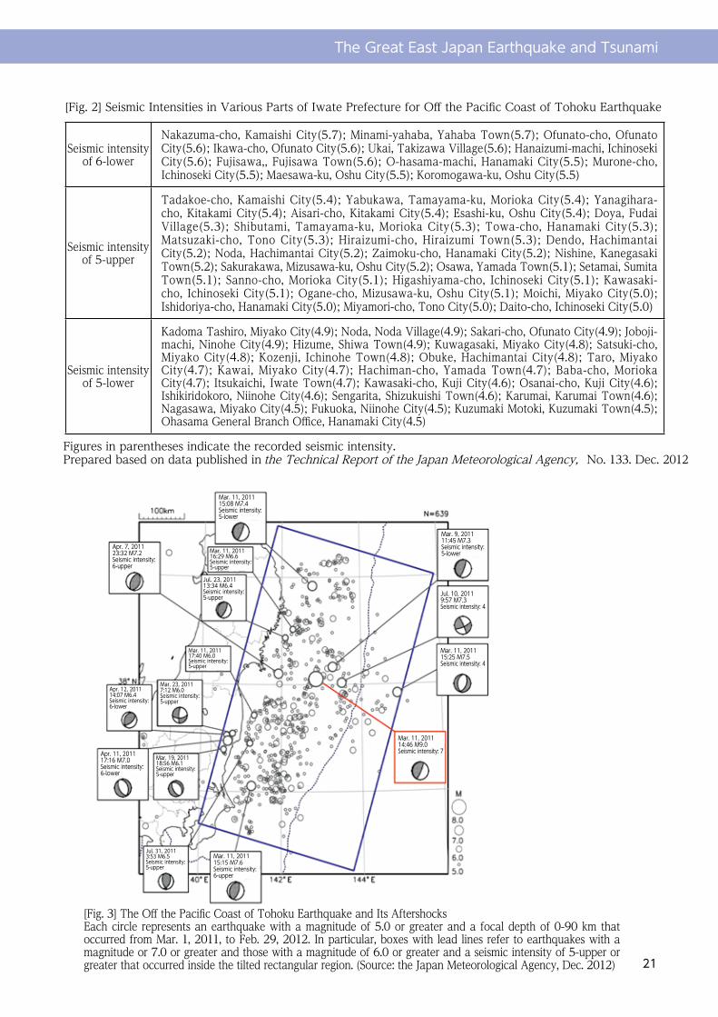
[Fig. 2] Seismic Intensities in Various Parts of Iwate Prefecture for Off the Pacific Coast of Tohoku Earthquake
Figures in parentheses indicate the recorded seismic intensity.Prepared based on data published in the Technical Report of the Japan Meteorological Agency, No. 133. Dec. 2012
Seismic intensity of 6-lower
Nakazuma-cho, Kamaishi City(5.7); Minami-yahaba, Yahaba Town(5.7); Ofunato-cho, Ofunato City(5.6); Ikawa-cho, Ofunato City(5.6); Ukai, Takizawa Village(5.6); Hanaizumi-machi, Ichinoseki City(5.6); Fujisawa,, Fujisawa Town(5.6); O-hasama-machi, Hanamaki City(5.5); Murone-cho, Ichinoseki City(5.5); Maesawa-ku, Oshu City(5.5); Koromogawa-ku, Oshu City(5.5)
Seismic intensity of 5-upper
Tadakoe-cho, Kamaishi City(5.4); Yabukawa, Tamayama-ku, Morioka City(5.4); Yanagihara-cho, Kitakami City(5.4); Aisari-cho, Kitakami City(5.4); Esashi-ku, Oshu City(5.4); Doya, Fudai Village(5.3); Shibutami, Tamayama-ku, Morioka City(5.3); Towa-cho, Hanamaki City(5.3); Matsuzaki-cho, Tono City(5.3); Hiraizumi-cho, Hiraizumi Town(5.3); Dendo, Hachimantai City(5.2); Noda, Hachimantai City(5.2); Zaimoku-cho, Hanamaki City(5.2); Nishine, Kanegasaki Town(5.2); Sakurakawa, Mizusawa-ku, Oshu City(5.2); Osawa, Yamada Town(5.1); Setamai, Sumita Town(5.1); Sanno-cho, Morioka City(5.1); Higashiyama-cho, Ichinoseki City(5.1); Kawasaki-cho, Ichinoseki City(5.1); Ogane-cho, Mizusawa-ku, Oshu City(5.1); Moichi, Miyako City(5.0); Ishidoriya-cho, Hanamaki City(5.0); Miyamori-cho, Tono City(5.0); Daito-cho, Ichinoseki City(5.0)
Seismic intensity of 5-lower
Kadoma Tashiro, Miyako City(4.9); Noda, Noda Village(4.9); Sakari-cho, Ofunato City(4.9); Joboji-machi, Ninohe City(4.9); Hizume, Shiwa Town(4.9); Kuwagasaki, Miyako City(4.8); Satsuki-cho, Miyako City(4.8); Kozenji, Ichinohe Town(4.8); Obuke, Hachimantai City(4.8); Taro, Miyako City(4.7); Kawai, Miyako City(4.7); Hachiman-cho, Yamada Town(4.7); Baba-cho, Morioka City(4.7); Itsukaichi, Iwate Town(4.7); Kawasaki-cho, Kuji City(4.6); Osanai-cho, Kuji City(4.6); Ishikiridokoro, Niinohe City(4.6); Sengarita, Shizukuishi Town(4.6); Karumai, Karumai Town(4.6); Nagasawa, Miyako City(4.5); Fukuoka, Niinohe City(4.5); Kuzumaki Motoki, Kuzumaki Town(4.5); Ohasama General Branch Office, Hanamaki City(4.5)
The Great East Japan Earthquake and Tsunami
22
[Fig. 4] (a) Plate Structure around the Japan Islands (b) Schematic Diagram of a Subduction Zone-Type Major Earthquake Caused by a Plate Going Down(Source: Okada, Mar. 2012)
[Fig. 5] Assessments by the Earthquake Research Committee on Apr. 11, 2011
(Source: Technical Report of the Japan Meteorological Agency, No. 133. Dec. 2012 )
(Source: National Research Institute for Earth Science and Disaster Prevention. Research Report on the 2011 Great East Japan Earthquake Disaster. )
Assessments of the 2011 Off the Pacific Coast of Tohoku Earthquake○ At about 14:46 on Mar. 11, an earthquake with a magnitude (M) of 9.0 (interim value) occurred off the
coast of Sanriku with a focal depth of about 25 km. The scale of the main shock was the largest in Japan on record. For this earthquake, a maximum seismic intensity of 7 was observed in Kurihara City, Miyagi Prefecture. Furthermore, high tsunamis were observed along the Pacific coast of the Hokkaido, Tohoku, and Kanto regions, including a tsunami at least 7.3 m high in Soma, one at least 4.2 m high at Oarai, and one at least 4.1 m high in Kamaishi.
○ In terms of focal mechanism, the earthquake was caused by reverse-type faults with pressure axes in the WNW-ESE direction at the boundary between the Pacific oceanic plate and the continental plate.
○ As of 15:00 on Mar. 13, the largest aftershock so far is an earthquake of M 7.5 (interim value) that occurred at 15:08 on Mar. 11. Off the Pacific coast of Iwate to Ibaraki Prefectures, there have been three earthquakes of M 7.0 or greater and 40 aftershocks (interim value) of M 6.0 or greater. The source region for the aftershocks spans about 500 km in the north-south direction. Large-scale aftershocks may still arise in the future.
○ GPS observation revealed crustal deformations due to the main shock, including a displacement of Shizugawa observation station in Miyagi Prefecture in the ESE direction by about 4.4 m. Furthermore, along the coast of Iwate to Fukushima Prefectures, a maximum subsidence of about 75 cm has been observed with some areas continuing to be submerged even after the tsunami subsided.
○ The source region for this earthquake extends from off the coast of Iwate Prefecture to off the coast of Ibaraki Prefecture. According to diverse analysis results based on data such as seismic waves and crustal deformations, it is estimated that the earthquake had a source region of about 400 km long and about 200 km wide with a maximum slip amount of about 20 m or greater. The source region is considered to include off the coast of Miyagi Prefecture to the east of which the trench side of the southern part of off the coast of Sanriku, off the coast of Fukushima Prefecture, and off the coast of Ibaraki Prefecture, for which evaluations have been carried out by the Earthquake Research Committee. However, it may also have included the middle part of off the coast of Sanriku, the northern part of off the coast of Sanriku, and a part of the trench side of off the coast of Boso, Chiba Prefecture.
(North American Plate)
Bounces back to cause an earthquake
Tsunami
Drags down
Nankai TroughSagami Trough Izu-Ogasawara
TrenchJa
pan T
rench
Chishima Trench
Philippine Plate
Pacific PlateEurasian Plate
The Great East Japan Earthquake and Tsunami
23
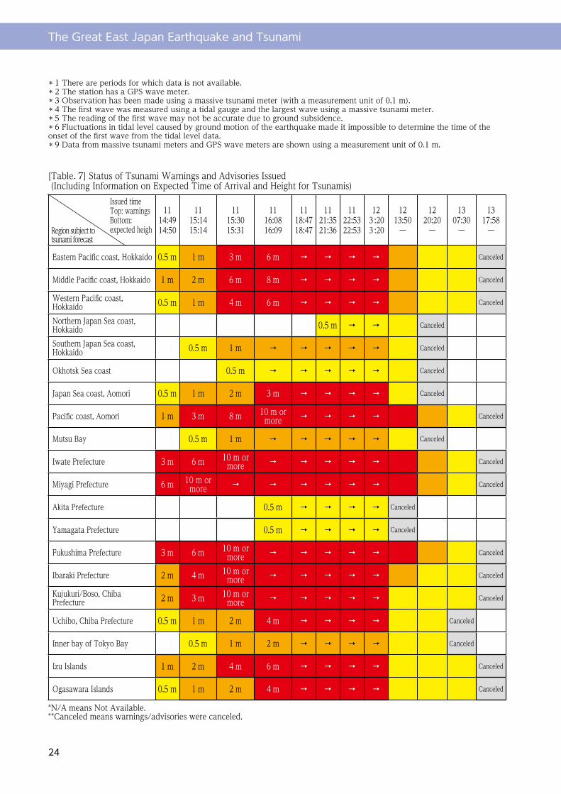
(2) Overview of TsunamiSince the Off the Pacific Coast of Tohoku Earthquake was a subduction zone-type massive earthquake with a magnitude of 9.0, its tsunamis also were of extraordinary scale. High tsunamis have been observed along the Pacific coast of Hokkaido to Okinawa with tsunamis having been also observed along the coast of the Sea of Japan, Sea of Okhotsk, and East China Sea. Furthermore, tsunamis have reportedly reached Hawaii as well as the Northern and Southern Americas.At places such as Kamaishi and Ofunato in Iwate Prefecture and Ishinomaki in Miyagi Prefecture, the first wave of tsunami arrived at 14:46, or substantially at the same time as the occurrence of the earthquake, with a height of 10-20 cm, with the largest wave having hit at around 15:20, or about 30 minutes after the occurrence of the earthquake. In Miyako City, according to observation data at Hitachihama Beach tidal station of the Japan Meteorological Agency, the first tsunami was observed at 15:01 with another wave with a height of 8.5 m or more having been observed at 15:26 (These data may not be accurate since the tidal station was swept away. Fig. 6).According to a report by the Earthquake Research Institute, the University of Tokyo, a tsunami run-up height of 37.9 m was observed at Koborinai, Taro. According to tsunami trace survey results by the 2011 Tohoku Earthquake and Tsunami Joint Survey Group, a maximum run-up height for the tsunami this time was 40.5 m at Omoe Aneyoshi, Miyako City. This figure broke the reputed highest run-up height in Japan on record of 38.2 m, which had been observed at the time of Meiji Sanriku Earthquake and Tsunami in 1896 at Ryori, Sanriku-cho, Ofunato City.At 14:49, three minutes after the occurrence of the earthquake, the Japan Meteorological Agency issued major tsunami warnings for Iwate, Miyagi, and Fukushima prefectures, forecasting a tsunami height of 3 m. At 15:14, JMA updated the expected tsunami height to 6 m, and at 15:30 to over 10 m. However, some places near the coast were already hit by a tsunami at this time, or the updated information did not reach some other places because telecommunication there was cut off. Subsequently, JMA downgraded the alerts to tsunami warnings at 20:20 on Mar. 12, and then to tsunami advisories at 7:30 on Mar. 13, cancelling all warnings and advisories at 17:58 on Mar. 13 (Fig. 7). The Sanriku Coast is known as zone frequented by tsunamis, suffering a number of massive tsunami disasters in the past, including the Meiji Sanriku Earthquake and Tsunami in 1896 (with a magnitude of 8.3), the Showa Sanriku Earthquake and Tsunami in 1933 (with a magnitude of 8.1), and the Chilean Earthquake and Tsunami in 1960. Furthermore, it has been reported that the Sendai Plain saw a tsunami run-up distance of about 3 km in the wake of the Jogan Earthquake in 869 during the Heian Era (with a magnitude of 8.3; Satake et al., 2008). It is said that the tsunami this time is similar to the Meiji Sanriku Tsunami in height and to the Jogan Earthquake in run-up distance inland from the coastline (Okada, 2012).
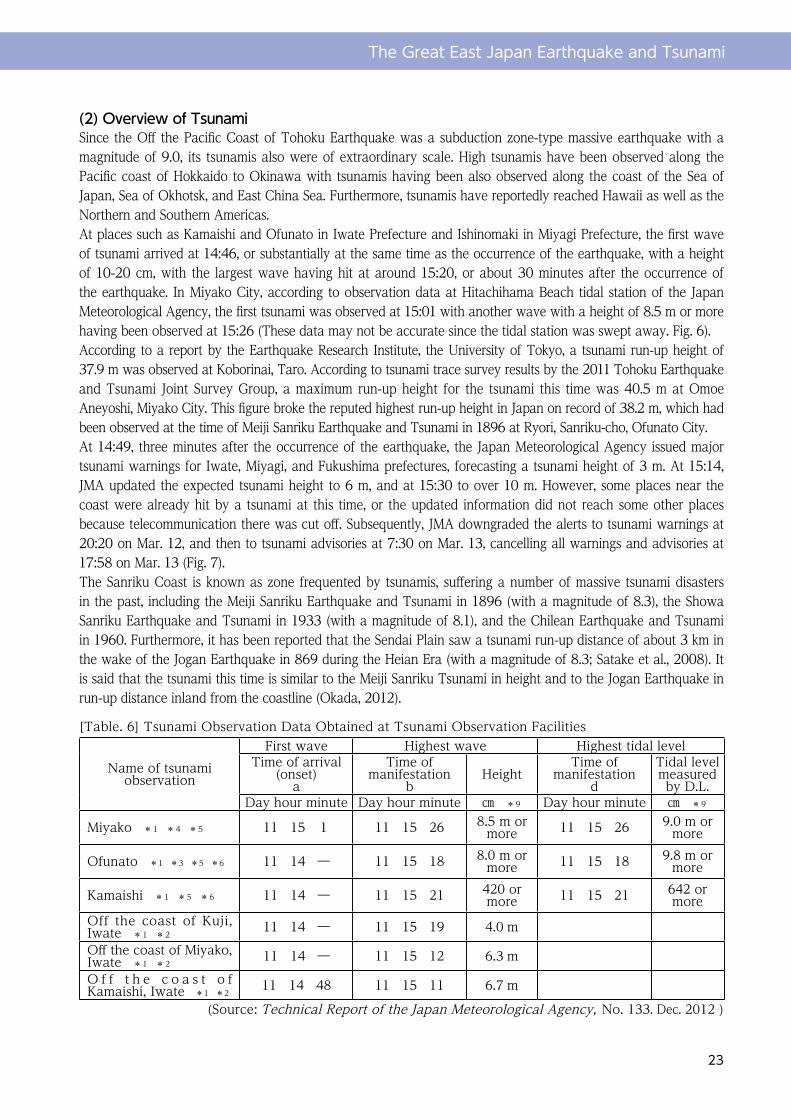
[Table. 6] Tsunami Observation Data Obtained at Tsunami Observation Facilities
(Source: Technical Report of the Japan Meteorological Agency, No. 133. Dec. 2012 )
Name of tsunami observation
First wave Highest wave Highest tidal levelTime of arrival
(onset)a
Time of manifestation
bHeight
Time of manifestation
d
Tidal level measured by D.L.
Day hour minute Day hour minute ㎝ *9 Day hour minute ㎝ *9
Miyako *1 *4 *5 11 15 1 11 15 26 8.5 m or more 11 15 26 9.0 m or
more
Ofunato *1 *3 *5 *6 11 14 ― 11 15 18 8.0 m or more 11 15 18 9.8 m or
more
Kamaishi *1 *5 *6 11 14 ― 11 15 21 420 or more 11 15 21 642 or
moreOff the coast of Kuji, Iwate *1 *2
11 14 ― 11 15 19 4.0 mOff the coast of Miyako, Iwate *1 *2
11 14 ― 11 15 12 6.3 mO f f t h e c o a s t o f Kamaishi, Iwate *1 *2
11 14 48 11 15 11 6.7 m
The Great East Japan Earthquake and Tsunami
24
[Table. 7] Status of Tsunami Warnings and Advisories Issued (Including Information on Expected Time of Arrival and Height for Tsunamis)
*N/A means Not Available. **Canceled means warnings/advisories were canceled.
Issued time Top: warnings Bottom: expected heigh
11 14:49 14:50
11 15:14 15:14
11 15:30 15:31
11 16:08 16:09
11 18:47 18:47
11 21:35 21:36
11 22:53 22:53
12 3:20 3:20
12 13:50
―
12 20:20
―
13 07:30
―
13 17:58
―
Eastern Pacific coast, Hokkaido 0.5 m 1 m 3 m 6 m → → → → Canceled
Middle Pacific coast, Hokkaido 1 m 2 m 6 m 8 m → → → → Canceled
Western Pacific coast, Hokkaido 0.5 m 1 m 4 m 6 m → → → → Canceled
Northern Japan Sea coast, Hokkaido 0.5 m → → Canceled
Southern Japan Sea coast, Hokkaido 0.5 m 1 m → → → → → Canceled
Okhotsk Sea coast 0.5 m → → → → → Canceled
Japan Sea coast, Aomori 0.5 m 1 m 2 m 3 m → → → → Canceled
Pacific coast, Aomori 1 m 3 m 8 m 10 m or more → → → → Canceled
Mutsu Bay 0.5 m 1 m → → → → → Canceled
Iwate Prefecture 3 m 6 m 10 m or more → → → → → Canceled
Miyagi Prefecture 6 m 10 m or more → → → → → → Canceled
Akita Prefecture 0.5 m → → → → Canceled
Yamagata Prefecture 0.5 m → → → → Canceled
Fukushima Prefecture 3 m 6 m 10 m or more → → → → → Canceled
Ibaraki Prefecture 2 m 4 m 10 m or more → → → → → Canceled
Kujukuri/Boso, Chiba Prefecture 2 m 3 m 10 m or
more → → → → → Canceled
Uchibo, Chiba Prefecture 0.5 m 1 m 2 m 4 m → → → → Canceled
Inner bay of Tokyo Bay 0.5 m 1 m 2 m → → → → Canceled
Izu Islands 1 m 2 m 4 m 6 m → → → → Canceled
Ogasawara Islands 0.5 m 1 m 2 m 4 m → → → → Canceled
* 1 There are periods for which data is not available.* 2 The station has a GPS wave meter.* 3 Observation has been made using a massive tsunami meter (with a measurement unit of 0.1 m).* 4 The first wave was measured using a tidal gauge and the largest wave using a massive tsunami meter.* 5 The reading of the first wave may not be accurate due to ground subsidence.* 6 Fluctuations in tidal level caused by ground motion of the earthquake made it impossible to determine the time of the onset of the first wave from the tidal level data.* 9 Data from massive tsunami meters and GPS wave meters are shown using a measurement unit of 0.1 m.
Region subject to tsunami forecast
The Great East Japan Earthquake and Tsunami
25
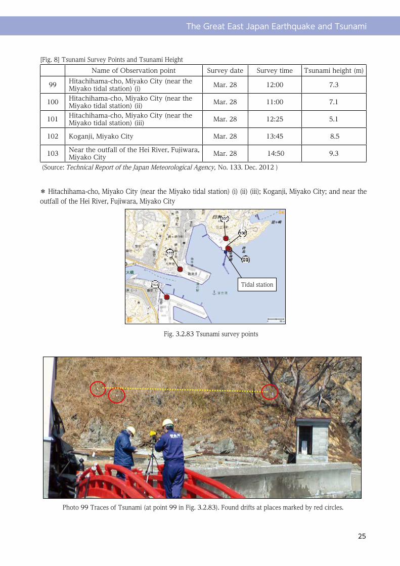
[Fig. 8] Tsunami Survey Points and Tsunami HeightName of Observation point Survey date Survey time Tsunami height (m)
99 Hitachihama-cho, Miyako City (near the Miyako tidal station) (i) Mar. 28 12:00 7.3
100 Hitachihama-cho, Miyako City (near the Miyako tidal station) (ii) Mar. 28 11:00 7.1
101 Hitachihama-cho, Miyako City (near the Miyako tidal station) (iii) Mar. 28 12:25 5.1
102 Koganji, Miyako City Mar. 28 13:45 8.5
103 Near the outfall of the Hei River, Fujiwara, Miyako City Mar. 28 14:50 9.3
(Source: Technical Report of the Japan Meteorological Agency, No. 133. Dec. 2012 )
気象庁技術報告 第 133 号 2012 年
- 170-
漂着物位置
防潮堤
写真 98 津波の痕跡(第 3.2.82 図の 98)樹木の枝に漂着物を確認
写真 99 津波の痕跡(第 3.2.83 図の 99)赤丸内で漂着物を確認
○宮古市日立浜町(宮古検潮所付近)①・②・③,宮古市光岸地,宮古市藤原閉伊川河口付近
第 3.2.83 図 津波調査地点
検潮所
* Hitachihama-cho, Miyako City (near the Miyako tidal station) (i) (ii) (iii); Koganji, Miyako City; and near the outfall of the Hei River, Fujiwara, Miyako City
Fig. 3.2.83 Tsunami survey points
Tidal station
Photo 99 Traces of Tsunami (at point 99 in Fig. 3.2.83). Found drifts at places marked by red circles.
The Great East Japan Earthquake and Tsunami
26
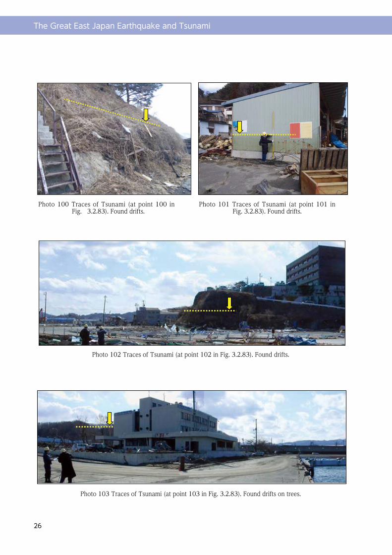
気象庁技術報告 第 133 号 2012 年
- 171-
写真 100 津波の痕跡(第 3.2.83 図の 100)
漂着物を確認
写真 102 津波の痕跡(第 3.2.83 図の 102)漂着物を確認
写真 101 津波の痕跡(第 3.2.83 図の 101)
漂着物を確認
写真 103 津波の痕跡(第 3.2.83 図の 103)樹木で漂着物を確認
Photo 100 Traces of Tsunami (at point 100 in Fig. 3.2.83). Found drifts.
Photo 102 Traces of Tsunami (at point 102 in Fig. 3.2.83). Found drifts.
Photo 103 Traces of Tsunami (at point 103 in Fig. 3.2.83). Found drifts on trees.
Photo 101 Traces of Tsunami (at point 101 in Fig. 3.2.83). Found drifts.