study of geomorphological hazard in the main...
TRANSCRIPT
1CERG: European Center on Seismological and Geomorphological Hazards, Strasbourg, Audit: 6-7th October 2008
Title of the activityStudy of geomorphological hazard in the main productive areas of the mountain basin of the River Panaro (Modena Apennines, Italy)
NameM. Panizza and D. Castaldini, P. Coratza, A. Ghinoi, M. Marchetti, M. Soldati, G. Tosatti
OrganizationDipartimento di Scienze della Terra - Università degli Studi di Modena e Reggio Emilia
Period of time (start 2006– end 2008)
General Assembly 8th february 2009
2CERG: European Center on Seismological and Geomorphological Hazards, Strasbourg, Audit: 6-7th October 2008
ObjectivesResearch, takes into account the study of geomorphological hazards (i.e. mass wasting, erosional processes and floods) in the mountain basin’s areas of the River Panaro which host productive activities.
The twofold goal of the study is: a) implementation of detailed maps (1:5,000/1:10,000 scale) showing the main productive areas subject to geomorphological hazard;
b) suggesting remedial measures in order to solve or at least mitigate processes resulting from geomorphological hazard.
General Assembly 8th february 2009

3CERG: European Center on Seismological and Geomorphological Hazards, Strasbourg, Audit: 6-7th October 2008
Study area
Study area is located in the mid-upper basin of the River Panarowhich collects the waters from the central section of the Northern Apennines (catchment basin of 1,784 km2).
From the hydraulic viewpoint, the mid-upper basin of the R. Panaro – which covers an area of about 800 km2 – is managed by the Land Reclamation Syndicate of Burana-Leo-Scoltenna-Panaro which cooperates with this research programme.
General Assembly 8th february 2009

4CERG: European Center on Seismological and Geomorphological Hazards, Strasbourg, Audit: 6-7th October 2008
Study area Lithological sketch of the Panaro’s mountain basin
1. Arenaceous Flysch of the Tuscan Units.
2. Arenaceous and calcareous-arenaceous Flysch of the Ligurian Units.
3. Basal clayey complexes of the Ligurian Units and argillitic formations of the Tuscan Units.
4. Epiligurian Sequence (sandstones, marls etc.)
5. Clayey and sandy formations of the Neogene-Quaternary sequences of the hillside margin.
6. Quaternary alluvial deposits of the plain.
General Assembly 8th february 2009

5CERG: European Center on Seismological and Geomorphological Hazards, Strasbourg, Audit: 6-7th October 2008
MethodsImplementation of geomorphological hazard maps made reference to the method applied by Panizza et al. (2004) and Corsini et al. (2005) for the Bolzano Autonomous Province in the South Tyrol, which complies with the Italian law (DM180/98, L267/98, DPCM 29/9/98).
This method, derived from Heinimann et al. (1998), is based on a classification of the intensity and frequency of the events for each category of processes.
This is achieved by means of univocal matrix combinations which allow the definition of various levels of geomorphological hazard.Corsini A., Mair V. & Panizza M. (2005), Aspetti concettuali e operativi per la realizzazione di carte di pericolosità idrogeologica: l’esempio della metodologia CARG - Provincia Autonoma di Bolzano per il Foglio 028 “La Marmolada. In: E.M. Ferrucci e O. Zani (a cura di). Atti 2°Forum Nazionale Rischio di frana e assetto idrogeologico nei territori collinari e montani: Questioni, metodi, esperienze a confronto.Ambiente & Territorio, Maggioli Ed., 124, 49-74.
Heinimann H.R., Holtenstein K., Kienholz H., Krummenhacher B. & Mani P. (1998), Methoden zur Analyse und Bewertung von Naturgefahren. Umwelt-Materialien Nr. 85, Naturgefahren, BUWAL, Bern, 248 pp.
Panizza M., Corsini A., Marchetti M., Pasuto A., Silvano S. & Soldati M. (2004), Cartographie du risque de mouvements de terrain au Tyrol du Sud. In: Y. Veyret, G. Garry & N. Meschinet de Richmond (eds.), Risques naturels et aménagement en Europe. Armand Colin, Paris, 131-142.
General Assembly 8th february 2009
6CERG: European Center on Seismological and Geomorphological Hazards, Strasbourg, Audit: 6-7th October 2008
The research, was devided into 3 phases:
• Phase 1) identification of areas with productive structures affected by geomorphological hazards;
• Phase 2) Collection of all available data on hazards around those areas, interpretation of aerial photographs, satellite images, field mapping and detailed cartography of geomorphological hazards;
• Phase 3) assessment of geomorphological hazard levelsand suggestion of remedial measures
Research phasesResearch phases
General Assembly 8th february 2009

7CERG: European Center on Seismological and Geomorphological Hazards, Strasbourg, Audit: 6-7th October 2008
In order to identify all potential study areas, an overlay between the mosaic of all Land Regulation Plans (LRP) and the Hazard Inventory Map (HIM) (last update: year 2006) of the Province has been done in GIS (both in digital shape-file format).
Phase 1Phase 1
Selection of all areaswith existing and planned productive structures from the LRP mosaic
General Assembly 8th february 2009

8CERG: European Center on Seismological and Geomorphological Hazards, Strasbourg, Audit: 6-7th October 2008
Overlay with the HazardInventory Map of theEmilia-Romagna Region
Phase 1Phase 1
General Assembly 8th february 2009

9CERG: European Center on Seismological and Geomorphological Hazards, Strasbourg, Audit: 6-7th October 2008
Preliminary field recognitions has allowed to identify productive areas that were not mentioned by the Land Regulation Plans
Phase 1Phase 1
General Assembly 8th february 2009
10CERG: European Center on Seismological and Geomorphological Hazards, Strasbourg, Audit: 6-7th October 2008
After eliminating areas where productive structures are not affected by hazards, aided by overview field surveys, 16 areas have been selected for more detailed investigations: among all, those having an extent > 2 hahave been considered.
Small productive areas next to each other have been grouped into clusters. All 16 lie within the Modena Province.
Phase 1Phase 1
General Assembly 8th february 2009
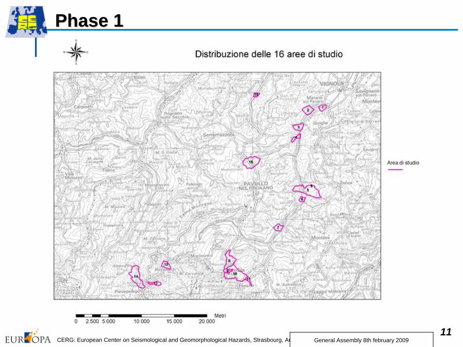
11CERG: European Center on Seismological and Geomorphological Hazards, Strasbourg, Audit: 6-7th October 2008
Phase 1Phase 1
General Assembly 8th february 2009

12CERG: European Center on Seismological and Geomorphological Hazards, Strasbourg, Audit: 6-7th October 2008
Phase Phase 22
In Phase 2, study and cartography of geomorphological hazards for all 16 areas have been based :• on detailed mining of historical and bibliographical data; • on consultation of geological documentation(geomorphological and geological maps, Hazard Inventory Map, professional geological reports etc.); • on interpretation of aerial and satellite images of different time periods (years ’50, ’70, ’90 & 2000);• on the detailed field mapping accompanied by interviews with local inhabitants about past instability events.
General Assembly 8th february 2009

13CERG: European Center on Seismological and Geomorphological Hazards, Strasbourg, Audit: 6-7th October 2008
• The great group of data has been gathered within a Geodatabase through which it has been possible to do a critical cross and synthesis of the knowledge acquired.
• This phase has led to the creation of 16 detailed geomorphological maps (scale 1:5000/1:10.000).
• The application of this method has also led to reconstruct a detailed framework for the evolution of geomorphological hazards in the basin.
Phase 2Phase 2
General Assembly 8th february 2009
14CERG: European Center on Seismological and Geomorphological Hazards, Strasbourg, Audit: 6-7th October 2008
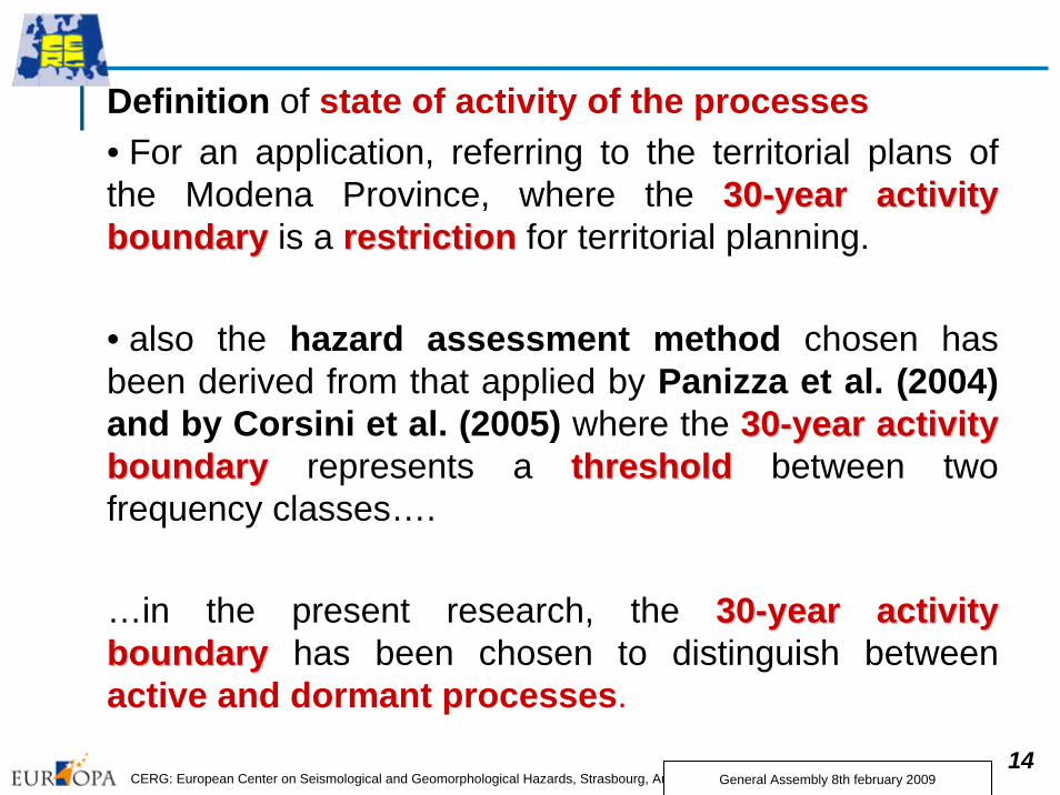
Definition of state of activity of the processes• For an application, referring to the territorial plans of the Modena Province, where the 3030--year activity year activity boundaryboundary is a restrictionrestriction for territorial planning.
• also the hazard assessment method chosen has been derived from that applied by Panizza et al. (2004) and by Corsini et al. (2005) where the 3030--year activity year activity boundaryboundary represents a thresholdthreshold between two frequency classes….
…in the present research, the 3030--year year activity activity boundaryboundary has been chosen to distinguish between active and dormant processes.
General Assembly 8th february 2009

15CERG: European Center on Seismological and Geomorphological Hazards, Strasbourg, Audit: 6-7th October 2008
Phase 2Phase 2 Observations ………on the topographical base maptopographical base map and the changes occurred in the changes occurred in the landscapelandscape
Available Regional Technical Map (RTM) at the 1:5.000 scale is a quite “obsolete” map, also made geomorphological mapping sometimes relatively difficult.
General Assembly 8th february 2009

16CERG: European Center on Seismological and Geomorphological Hazards, Strasbourg, Audit: 6-7th October 2008
Phase 2Phase 2 ObservationsIt was very important to verifythe assessment of the state of activity of processesthrough the crosscross--validation validation of testimonial sourcesof testimonial sourcesaccompanied, when possible, by the analysis of analysis of professional geological professional geological reportsreports.
General Assembly 8th february 2009
17CERG: European Center on Seismological and Geomorphological Hazards, Strasbourg, Audit: 6-7th October 2008
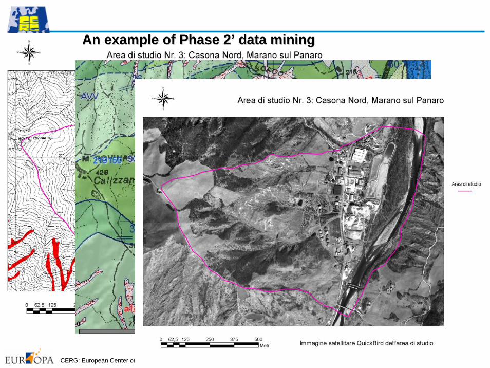
An example of Phase 2An example of Phase 2’’ data miningdata mining

18CERG: European Center on Seismological and Geomorphological Hazards, Strasbourg, Audit: 6-7th October 2008
An example of Phase 2An example of Phase 2’’ data miningdata miningArea di Studio nr. 3 Casona Nord, Marano sul Panaro
General Assembly 8th february 2009

19CERG: European Center on Seismological and Geomorphological Hazards, Strasbourg, Audit: 6-7th October 2008
An example of Phase 2An example of Phase 2’’ geomorphologicalgeomorphological mappingmapping
General Assembly 8th february 2009

20CERG: European Center on Seismological and Geomorphological Hazards, Strasbourg, Audit: 6-7th October 2008
Phase 3Phase 3The hazard assessmenthazard assessment was undertaken using the matricial method applied by Panizza et al. (2004) and by Corsini et al. (2005).That method, derived from Heinimann et Heinimann et al. (1998)al. (1998), is based on a matrix that relates pre-defined classes of IntensityIntensity and Return Return periodperiod of hazards and whose crossing allows to define different hazard levels for each hazard category.
•Heinimann H.R., Holtenstein K., Kienholz H., Krummenhacher B. & Mani P. (1998), Methoden zur Analyse und Bewertung von Naturgefahren. Umwelt-Materialien Nr. 85, Naturgefahren, BUWAL, Bern, 248 pp
Matrix for landslide hazard ass.
Return period
Inte
nsity
Matrix for hazard assess. of torrential processes and floods
Return period
Inte
nsity
General Assembly 8th february 2009

21CERG: European Center on Seismological and Geomorphological Hazards, Strasbourg, Audit: 6-7th October 2008
Phase Phase 3: 3: example example of of hazard maphazard map
Inte
nsity
Return period Return period
Inte
nsity
torrential processes and floods hazards ass.
landslide hazard ass.
General Assembly 8th february 2009

22CERG: European Center on Seismological and Geomorphological Hazards, Strasbourg, Audit: 6-7th October 2008
Phase 3 RemarksPhase 3 Remarks
Where data were not available to assess the hazard level, it has been decided to leave the geomorphological geomorphological symbolsymbol representing the process/form.
In the hazard maps, the presence of mitigationsmitigations is indicated by a superimposed patternsuperimposed pattern.
From the examination of the studied cases, it has been noted that, in areas where mitigations have been done, the hazard levelhazard level has to be evaluated as lowerlower than the level assessed.
General Assembly 8th february 2009
23CERG: European Center on Seismological and Geomorphological Hazards, Strasbourg, Audit: 6-7th October 2008
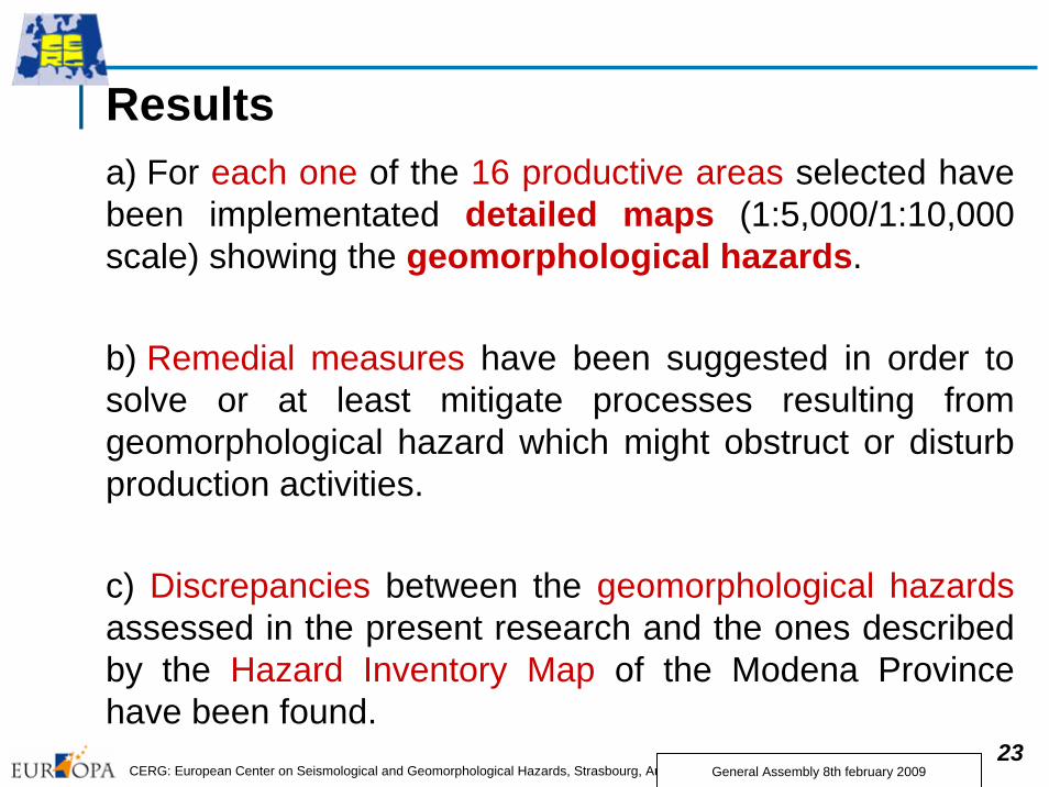
Resultsa) For each one of the 16 productive areas selected have been implementated detailed maps (1:5,000/1:10,000 scale) showing the geomorphological hazards.
b) Remedial measures have been suggested in order to solve or at least mitigate processes resulting from geomorphological hazard which might obstruct or disturb production activities.
c) Discrepancies between the geomorphological hazardsassessed in the present research and the ones described by the Hazard Inventory Map of the Modena Province have been found.
General Assembly 8th february 2009
24CERG: European Center on Seismological and Geomorphological Hazards, Strasbourg, Audit: 6-7th October 2008
d) These discrepancies are due to the fact that hazards, in the Hazard Inventory Map of the Modena Province, are assumed by geological geological mapsmaps,, where morphogenetic processes and their deposits have a secondary role with respect to the tectonic and structural aspects.e) From this it derives that the Hazard Inventory Maps of the Administrations, which has a great importance in territorial planning, should be elaborated on the base of an accurate accurate geomorphologicalgeomorphologicalmappingmapping.
f) State of activity of a certain process can not be sufficient for creating territorial-planning constraints. Also IntensityIntensity should be taken into account, better if associated to a certain return periodreturn period, according, for example, to the matrix used in this research.
g) These maps are also available for the Modena Province Administration in order to update its Hazard Inventory Map which is a reference document for the territorial planning.
General Assembly 8th february 2009
25CERG: European Center on Seismological and Geomorphological Hazards, Strasbourg, Audit: 6-7th October 2008
PublicationsAbstracts
CASTALDINI D. & GHINOI A. (2007) - Geomorphological hazards assessment in the mountainbasin of the Panaro River (Northern Apennines, Italy). Geophysical Research Abstracts, Vol. 9, SRef-ID: 1607-7962/gra/EGU 2007 - A - 08977GHINOI A. & CASTALDINI D. (2007) - Studio della pericolosità geomorfologica in areeproduttive del bacino montano del Fiume Panaro (Appennino Settentrionale). AIGeo, II Conv. Naz. "Ambiente geomorfologico e attività dell'uomo: Risorse, Rischi, Impatti", Torino 28-30/3/2007. ARPA Torino, 60-61PANIZZA M. (2007) - Geomorfologia dell’area di S. Andrea Pelago (Appennino Modenese). AIGeo, II Conv. Naz. "Ambiente geomorfologico e attività dell'uomo: Risorse, Rischi, Impatti", Torino 28-30/3/2007. ARPA Torino, 142
PapersCASTALDINI D. & GHINOI A. (2007) - Geomorphological hazards affecting main productive areas in the mountain basin of the Panaro River (Modena Apennines, Italy): a Case Study. Analele Universitatii din Oradea, Seria Geografie, tom. XVII, Editura Universitatii din Oradea 2007, ISSN 1221-1223, 11- 20.CASTALDINI D. & GHINOI A. (2008) - Studio della pericolosità geomorfologica in areeproduttive del bacino montano del Fiume Panaro (Appennino Settentrionale). Memorie SocietàGeografica Italiana (in print)PANIZZA M. 2008) - Geomorfologia periglaciale dell’area di S. Andrea Pelago (AppenninoModenese). Memorie Società Geografica Italiana (in print)
General Assembly 8th february 2009

26CERG: European Center on Seismological and Geomorphological Hazards, Strasbourg, Audit: 6-7th October 2008
Appendix
Other studies within the framework of the CERG activities carried out in the period 2006-08.
General Assembly 8th february 2009

27CERG: European Center on Seismological and Geomorphological Hazards, Strasbourg, Audit: 6-7th October 2008
Title of the activityReview of the flood hazard in the area between the rivers Po, Secchia and Panaro (Po Plain, Northern Italy)
Short descriptionThis study examined the geomorphological aspects of the flood hazard in the area between the Rivers Po, Secchia and Panaro (southern central sector of the Po Plain).
The flood hazard, related to morphological factors, is much higher in the sector north of Modena (where the rivers flow elevated over the surrounding plain between high banks) than in the sector south of the town (where the watercourses run deep in the alluvial plain).
General Assembly 8th february 2009

28CERG: European Center on Seismological and Geomorphological Hazards, Strasbourg, Audit: 6-7th October 2008
Microrelief map of the northern sector of the study area.
Areas flooded by river Po in the northern sector of the study area in the 19th century
General Assembly 8th february 2009

29CERG: European Center on Seismological and Geomorphological Hazards, Strasbourg, Audit: 6-7th October 2008
Digital Elevation Model and areas flooded by rivers Secchia and Panaro in the surroindings of Modena in the 20th centuries
General Assembly 8th february 2009

30CERG: European Center on Seismological and Geomorphological Hazards, Strasbourg, Audit: 6-7th October 2008
An important contribution to assess the flood hazard can be given by the geomorphological investigation through the implementation of GIS georeferenced thematic documents (Digital Elevation Model, microrelief, surface deposits and geomorphological maps) and related Data Base.
PublicationsPaper
CASTALDINI D. (2006) - Geomorphological aspects of the flood hazard in the area between the rivers Po, Secchia and Panaro (Po Plain, Northern Italy). In SOROCHOVSCHI V. (ed.) - Riscuri si catastrofe. An 5 Nr. 3/2006, Casa Cartii de Stiinta, Cluj Napoca, ISSN 1584-5273, 163-174.
General Assembly 8th february 2009

31CERG: European Center on Seismological and Geomorphological Hazards, Strasbourg, Audit: 6-7th October 2008
Title of the activityStudy of the recent evolution of the River Panaro (Northern Italy)
General Assembly 8th february 2009
Short descriptionThe research, considers the morphological changesof the River Panaro from the 19th century and provides the relationshipsbetween human activityand stream morphology.

32CERG: European Center on Seismological and Geomorphological Hazards, Strasbourg, Audit: 6-7th October 2008General Assembly 8th february 2009
MethodologyThe studies were carried out using historical documents and maps, aerial and satellite images taken in various dates, digital treatment of maps and ortophotographs and field-surveys.

33CERG: European Center on Seismological and Geomorphological Hazards, Strasbourg, Audit: 6-7th October 2008
In the Panaro valley, from the 1930s to the 1950s, the river showed a braided pattern which occupied almost the entire flat valley floor. Important changes occurred later, due to the downcutting and narrowing of the active channel, which have continued until the present day.
General Assembly 8th february 2009

34CERG: European Center on Seismological and Geomorphological Hazards, Strasbourg, Audit: 6-7th October 2008
In the upper part of the plain, after the 1950s, the braided pattern became canalised and deepened.
General Assembly 8th february 2009

35CERG: European Center on Seismological and Geomorphological Hazards, Strasbourg, Audit: 6-7th October 2008
The channel changes in the Apennines and in the upper part of the plain were mainly due to gravel excavation along the riverbed. Fluvial barrages were constructed which increased the water erosionpower downstream. As a result, the deepening process has continuedand a new terrace level has formed in the past 30 years.The shape of the longitudinal profile changed from a hyperbola-typecurve to a step-type one.
General Assembly 8th february 2009

36CERG: European Center on Seismological and Geomorphological Hazards, Strasbourg, Audit: 6-7th October 2008
In the mid-lower part of the plain, the river length has been reducedby 10-11 km (about 13%) by artificial meander cut-offs carried out to reduce flood hazard. In this way, the R. Panaro has assumed the aspect of an artificial watercourse.
General Assembly 8th february 2009

37CERG: European Center on Seismological and Geomorphological Hazards, Strasbourg, Audit: 6-7th October 2008
PublicationsAbstract
CASTALDINI D. & GHINOI A. (2007) - Morphological changes in the valley and in the upper plain of the Panaro river (Province of Modena). Sesto Forum Italiano di Scienze della Terra, Sessione T64 "Dinamica recente ed attuale di alvei fluviali in Italia", 12–14/09/2007, Rimini. Epitome Vol. 2, ISSN 1972-1552, p. 361.
PaperCASTALDINI D. & GHINOI A. (2008) - Recent morphological changes of the River Panaro (Northern Italy). Il Quaternario, Italian Journal of Quaternary Sciences, 21 (1B), ISSN 0394-3356, 267-278.
General Assembly 8th february 2009

38CERG: European Center on Seismological and Geomorphological Hazards, Strasbourg, Audit: 6-7th October 2008
Title of the activityGeomorphological Mapping of the Upper Tagliole Valley (Modena Apennines, Northern Italy)
General Assembly 8th february 2009
Short description
This study is aimed to the geomorphological mapping at the 1:10,000 scale of the upper Tagliole Valley – which is located in the Frignano Park (high Modena Apennines).

39CERG: European Center on Seismological and Geomorphological Hazards, Strasbourg, Audit: 6-7th October 2008
Geomorphological map
General Assembly 8th february 2009

40CERG: European Center on Seismological and Geomorphological Hazards, Strasbourg, Audit: 6-7th October 2008
Publication
PaperCASTALDINI D., VALDATI J. & ILIES D.C. (2008) -Geomorphological and Geo-tourist maps of the Upper TaglioleValley (Modena Apennines, Northern Italy). Servizio GeologicoItaliano (in print) .
General Assembly 8th february 2009

41CERG: European Center on Seismological and Geomorphological Hazards, Strasbourg, Audit: 6-7th October 2008General Assembly 8th february 2009
THANKS FOR YOUR ATTENTIONTHANKS FOR YOUR ATTENTION