studies of tectonic movements in saudi arabia...
TRANSCRIPT
STUDIES OF TECTONIC MOVEMENTS IN
SAUDI ARABIA USING CORS
M. Al Rajhi, Ali Al Omar, R. Yanar, F. Kartal, K. Eren,
SUBJECT TO TALKS
� BACKGROUND
� GEODETIC NETWORK OF SAUDI ARABIA AND
FIDUCIAL STATIONS
– GFN OF Saudi Arabia in 2004.0 Based on ITRF2000 Datum
– GFN OF Saudi Arabia in 2012.7 Based on ITRF2008 Datum
� TECTONIC DISPLACEMENTS FROM 2004 TO 2012
� CONCLUDING REMARKS
KUALA LUMPUR 2014, XXV FIG CONGRESS
KUALA LUMPUR 2014, XXV FIG CONGRESS
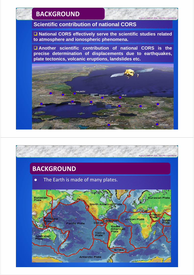
Scientific contribution of national CORS
� National CORS effectively serve the scientific studies relatedto atmosphere and ionospheric phenomena.
BACKGROUND
� Another scientific contribution of national CORS is theprecise determination of displacements due to earthquakes,plate tectonics, volcanic eruptions, landslides etc.
BACKGROUND
� The Earth is made of many plates.
KUALA LUMPUR 2014, XXV FIG CONGRESS
BACKGROUND
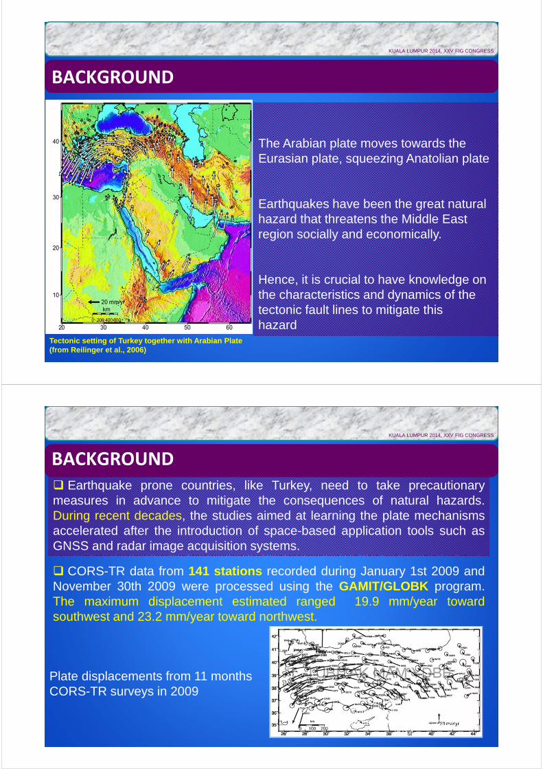
The Arabian plate moves towards the Eurasian plate, squeezing Anatolian plate
Earthquakes have been the great natural hazard that threatens the Middle East region socially and economically.
Hence, it is crucial to have knowledge on the characteristics and dynamics of the tectonic fault lines to mitigate this hazard
Tectonic setting of Turkey together with Arabian Plate (from Reilinger et al., 2006)
KUALA LUMPUR 2014, XXV FIG CONGRESS
BACKGROUND
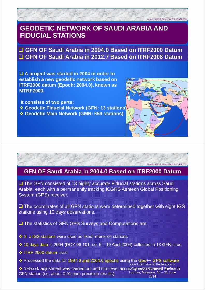
� Earthquake prone countries, like Turkey, need to take precautionarymeasures in advance to mitigate the consequences of natural hazards.During recent decades, the studies aimed at learning the plate mechanismsaccelerated after the introduction of space-based application tools such asGNSS and radar image acquisition systems.
� CORS-TR data from 141 stations recorded during January 1st 2009 andNovember 30th 2009 were processed using the GAMIT/GLOBK program.The maximum displacement estimated ranged 19.9 mm/year towardsouthwest and 23.2 mm/year toward northwest.
Plate displacements from 11 months CORS-TR surveys in 2009
KUALA LUMPUR 2014, XXV FIG CONGRESS
XXV International Federation of Surveyors Congress, Kuala
Lumpur, Malaysia, 16 – 21 June 2014
GEODETIC NETWORK OF SAUDI ARABIA AND FIDUCIAL STATIONS
� GFN OF Saudi Arabia in 2004.0 Based on ITRF2000 Datum� GFN OF Saudi Arabia in 2012.7 Based on ITRF2008 Datum
� A project was started in 2004 in order to establish a new geodetic network based on ITRF2000 datum (Epoch: 2004.0), known as MTRF2000.
It consists of two parts:� Geodetic Fiducial Network (GFN: 13 stations)� Geodetic Main Network (GMN: 659 stations)
KUALA LUMPUR 2014, XXV FIG CONGRESS
GFN OF Saudi Arabia in 2004.0 Based on ITRF2000 Datum
� The GFN consisted of 13 highly accurate Fiducial stations across Saudi Arabia, each with a permanently tracking iCGRS Ashtech Global Positioning System (GPS) receiver.
� The coordinates of all GFN stations were determined together with eight IGS stations using 10 days observations.
� The statistics of GFN GPS Surveys and Computations are:
� 8 x IGS stations were used as fixed reference stations
� 10 days data in 2004 (DOY 96-101, i.e. 5 – 10 April 2004) collected in 13 GFN sites,
� ITRF-2000 datum used,
� Processed the data for 1997.0 and 2004.0 epochs using the Geo++ GPS software
� Network adjustment was carried out and mm-level accuracy was obtained for each GFN station (i.e. about 0.01 ppm precision results).
KUALA LUMPUR 2014, XXV FIG CONGRESS
XXV International Federation of Surveyors Congress, Kuala
Lumpur, Malaysia, 16 – 21 June 2014
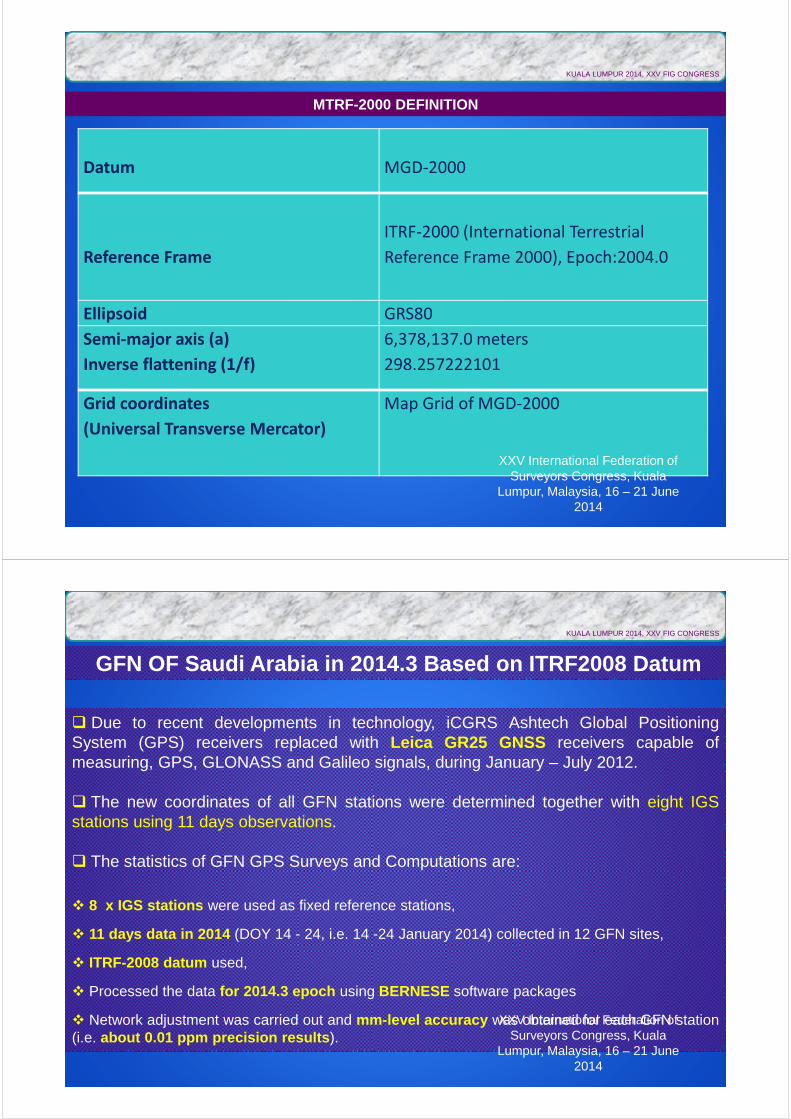
Datum MGD-2000
Reference Frame
ITRF-2000 (International Terrestrial
Reference Frame 2000), Epoch:2004.0
Ellipsoid GRS80
Semi-major axis (a)
Inverse flattening (1/f)
6,378,137.0 meters
298.257222101
Grid coordinates
(Universal Transverse Mercator)
Map Grid of MGD-2000
MTRF-2000 DEFINITION
KUALA LUMPUR 2014, XXV FIG CONGRESS
XXV International Federation of Surveyors Congress, Kuala
Lumpur, Malaysia, 16 – 21 June 2014
GFN OF Saudi Arabia in 2014.3 Based on ITRF2008 Datum
� Due to recent developments in technology, iCGRS Ashtech Global PositioningSystem (GPS) receivers replaced with Leica GR25 GNSS receivers capable ofmeasuring, GPS, GLONASS and Galileo signals, during January – July 2012.
� The new coordinates of all GFN stations were determined together with eight IGSstations using 11 days observations.
� The statistics of GFN GPS Surveys and Computations are:
� 8 x IGS stations were used as fixed reference stations,
� 11 days data in 2014 (DOY 14 - 24, i.e. 14 -24 January 2014) collected in 12 GFN sites,
� ITRF-2008 datum used,
� Processed the data for 2014.3 epoch using BERNESE software packages
� Network adjustment was carried out and mm-level accuracy was obtained for each GFN station(i.e. about 0.01 ppm precision results).
KUALA LUMPUR 2014, XXV FIG CONGRESS
XXV International Federation of Surveyors Congress, Kuala
Lumpur, Malaysia, 16 – 21 June 2014
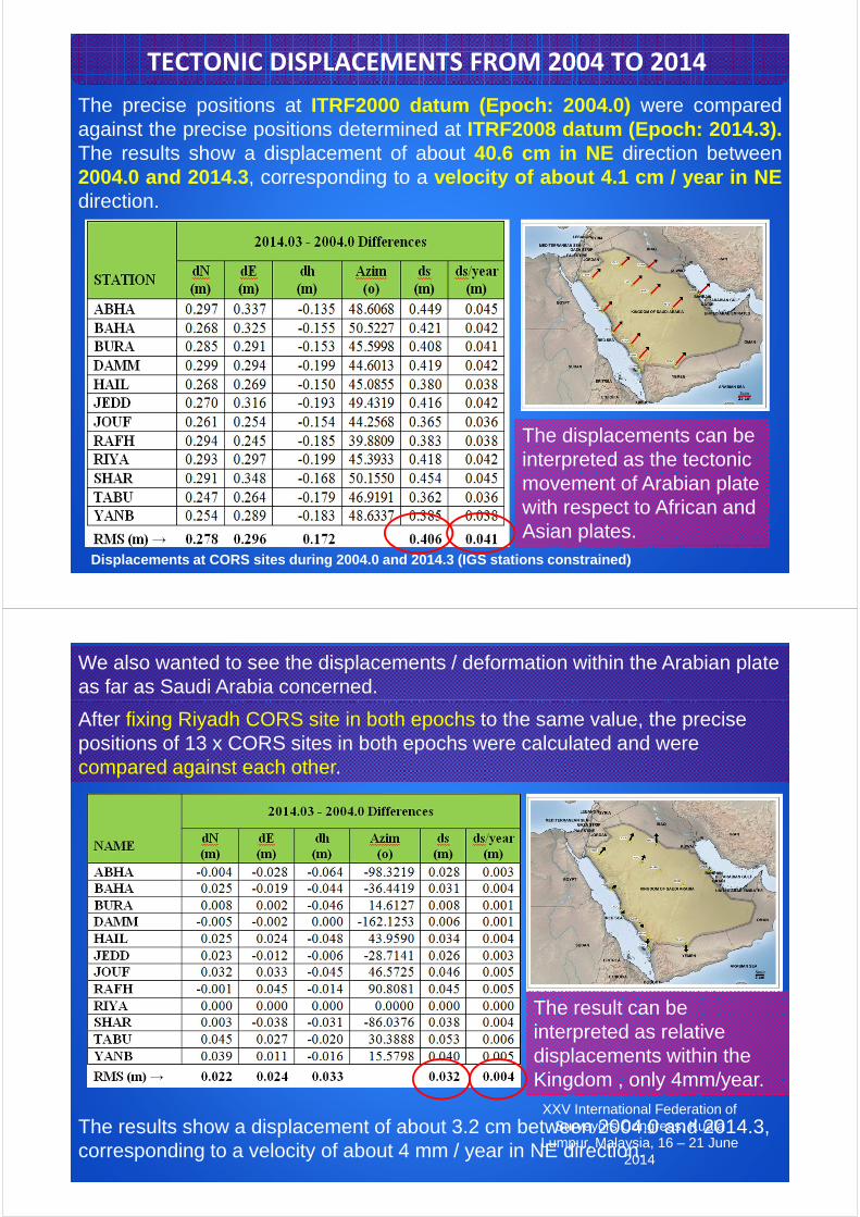
The precise positions at ITRF2000 datum (Epoch: 2004.0) were comparedagainst the precise positions determined at ITRF2008 datum (Epoch: 2014.3).The results show a displacement of about 40.6 cm in NE direction between2004.0 and 2014.3, corresponding to a velocity of about 4.1 cm / year in NEdirection.
TECTONIC DISPLACEMENTS FROM 2004 TO 2014
Displacements at CORS sites during 2004.0 and 2014.3 (IGS stations constrained)
The displacements can be interpreted as the tectonic movement of Arabian plate with respect to African and Asian plates.
We also wanted to see the displacements / deformation within the Arabian plate as far as Saudi Arabia concerned.
After fixing Riyadh CORS site in both epochs to the same value, the precise positions of 13 x CORS sites in both epochs were calculated and were compared against each other.
The results show a displacement of about 3.2 cm between 2004.0 and 2014.3, corresponding to a velocity of about 4 mm / year in NE direction.
The result can be interpreted as relative displacements within the Kingdom , only 4mm/year.
XXV International Federation of Surveyors Congress, Kuala
Lumpur, Malaysia, 16 – 21 June 2014
CONCLUDING REMARKS
� Since the mid 1980’s GNSS has been serving usersthroughout the world with navigation and geodetic positioningdata. With the introduction of network based CORS, GNSS isnow providing these services more accurately andeconomically.
� The GNSS data together with other types of data such asInSAR, seismic, etc. shall effectively serve studies related togeohazards, disaster management, and early warning.
KUALA LUMPUR 2014, XXV FIG CONGRESS
CONCLUDING REMARKS
� Here, very precise coordinates (mm-level precision) of 13 xGFN stations were determined in the latest ITRF2008 datumand epoch 2014.3. Thus, once again, Saudi Arabia has veryprecise fiducial stations to be used as referencethroughout the Kingdom.
� The results show that a displacement of about 40.6 cm inNE direction between 2004.0 and 2014.3, corresponding to avelocity of about 4.1 cm / year in NE direction althoughrelative displacements within the Kingdom is only 4 mm/year. These numbers show that the coordinates based onMTRF2000 datum has about 41 cm offset in NE directionwith respect to the coordinates computed at the present withreference to IGS stations.
KUALA LUMPUR 2014, XXV FIG CONGRESS
THANK YOU FORYOUR ATTENTION
KUALA LUMPUR 2014, XXV FIG CONGRESS