standards of competence for category a hydrographic surveyors … · standards of competence for...
TRANSCRIPT

1
INTERNATIONAL
FEDERATION OF
SURVEYORS
INTERNATIONAL
HYDROGRAPHIC
ORGANIZATION
INTERNATIONAL
CARTOGRAPHIC
ASSOCIATION
STANDARDS OF COMPETENCE
FOR CATEGORY "A" HYDROGRAPHIC
SURVEYORS
Publication S-5A
First Edition
Version 1.0.1 - June 2017
Published by the
International Hydrographic Organization
4b, quai Antoine 1er, B.P. 445
MC 98011 Monaco Cedex
Principauté de Monaco
E-mail: [email protected]
Web: www.iho.int
Comments arising from the experience gained in the application of the guidance are welcome. They
should be addressed to the Chair of the International Board on Standards of Competence for
Hydrographic Surveyors and Nautical Cartographers at the above address. This document is published
periodically. Please check with IHO for the latest edition, including current amendments.

2
© Copyright International Hydrographic Organization 2016
This work is copyright. Apart from any use permitted in accordance with the Berne Convention for the Protection of Literary and Artistic Works (1886), and except in the
circumstances described below, no part may be translated, reproduced by any process, adapted, communicated or commercially exploited without prior written permission
from the International Hydrographic Organization (IHO). Copyright in some of the
material in this publication may be owned by another party and permission for the translation and/or reproduction of that material must be obtained from the owner.
This document or partial material from this document may be translated, reproduced
or distributed for general information, on no more than a cost recovery basis. Copies may not be sold or distributed for profit or gain without prior written agreement of the
IHO and any other copyright holders.
In the event that this document or partial material from this document is reproduced, translated or distributed under the terms described above, the following statements are to be included:
“Material from IHO publication [reference to extract: Title, Edition] is reproduced with the permission of the International Hydrographic Organization (IHO) Secretariat (Permission No ……./…) acting for the International Hydrographic Organization (IHO), which does not accept responsibility for the correctness of the material as reproduced: in case of doubt, the IHO’s authentic text shall prevail. The incorporation of material sourced from IHO shall not be construed as constituting an endorsement by IHO of this product.”
“This [document/publication] is a translation of IHO [document/publication] [name]. The IHO has not checked this translation and therefore takes no responsibility for its accuracy. In case of doubt the source version of [name] in [language] should be consulted.”
The IHO Logo or other identifiers shall not be used in any derived product without prior written permission from the IHO.
3
1. INTRODUCTION
All components of the hydrographic surveying and nautical cartography profession face
challenges as to how best to ensure the continuance of high standards and how best to
ensure the continuation of best practices based on minimum standards of competence
world-wide. In order to achieve these objectives, three international organizations (FIG,
IHO and ICA) have developed Standards of competence that institutions or professional
bodies may adopt for their educational/training programmes and competency schemes.
Standards indicate the minimum competences necessary for hydrographic surveyors.
Standards recognize two levels of competence. Category "A" programmes introduces
competences from the underlying principles level. Category "B" programmes introduce
the competences from a practical level.
The intention is that a Category "A" individual with appropriate experience, would be a
senior professional in their chosen field (government, industry, academia). Category "B"
individuals with appropriate experience would be technical professionals leading and
delivering products and services to meet specifications and outcomes.
2. DEFINITIONS
2.1 Subjects, topics, and elements
The S5-A standard contains the following list of Basic subjects, Foundation Science
subjects and Hydrographic Science subjects:
B1: Mathematics, statistics, theory of observations ....................................................... 7
B2: Information and Communication Technology ......................................................... 8
B3: Physics ..................................................................................................................... 9
B4: Nautical science ..................................................................................................... 10
B5: Meteorology ........................................................................................................... 12
F1: Earth Models .......................................................................................................... 13
F2: Oceanography ........................................................................................................ 15
F3: Geology and geophysics ........................................................................................ 16
H1: Positioning ............................................................................................................. 18
H2: Underwater Sensors and Data Processing ............................................................. 21
H3: LiDAR and Remote Sensing ................................................................................. 24
H4: Survey Operations and Applications ..................................................................... 25
H5: Water Levels and Flow .......................................................................................... 28
H6: Hydrographic Data Acquisition and Processing .................................................... 30
H7: Management of Hydrographic Data ...................................................................... 32
H8: Legal Aspects ........................................................................................................ 33
CMFP: COMPLEX MULTIDISCIPLINARY FIELD PROJECT............................... 35
4
Topics and Elements:
Each Foundation Science, Hydrographic Science or Basic subject comprises
a list of topics which are denoted by Bx.y, Fx.y, or Hx.y;
Each topic contains elements which are denoted by Bx.y<c> Fx.y<c> or
Hx.y<c>.
For example, the subject H1 “Positioning” contains the topic H1.1 Vessel and sensor
reference frames that has the element H1.1a “Common reference frames for sensors”.
2.2 Learning outcomes and list of content
It is important to understand that each element is associated with:
one or more intended learning outcomes, that a student should be able to achieve
on completion of the programme. All learning outcomes should be assessed.
This may be done through one of, or a combination of, the following:
examination, assessed exercise or presentation, laboratory report, or final project
work.
a list of content. This list is associated with one or more learning outcomes and
describes the theoretical knowledge or practical/technical context which the
course syllabi should address in order to meet a particular learning outcome.
3. Programme preparation and submission
The preparation of a programme submission to the IBSC should be done in accordance
with the document entitled GUIDELINES FOR THE IMPLEMENTATION OF THE
STANDARDS OF COMPETENCE FOR HYDROGRAPHIC SURVEYORS. This
document is available from the IHO website: www.iho.int → Standards & Publications.
The cross reference table is a mandatory requirement for a programme submission and
MUST be completed. A template is specified and is available from the IHO website:
www.iho.int
5
LIST OF ACRONYMS AND INITIALISMS USED IN THIS DOCUMENT
1D One-dimensional
2D Two-dimensional
3D Three-dimensional
A Advanced (level of knowledge)
ADCP Acoustic Doppler Current Profiler
AIS Automatic Identification System
ASV Autonomous Surface Vehicle
AUV Autonomous Underwater Vehicle
B Basic (level of knowledge)
CAD Computer Aided Design
CMFP Complex Multidisciplinary Field Project
CW Continuous Wavelength
DOP Dilution of Precision
ECDIS Electronic Chart Display and Information System
ECS Electronic Chart System
ENC Electronic Navigational Chart
EPIRB Emergency Position Indicating Radio Beacon
F Fundamental Sciences Subjects
FIG International Federation of Surveyors
FOG Fiber Optic Gyroscope
GEBCO General Bathymetric Chart of the Oceans
GIS Geographical Information System
GK Gauss-Krüger
GLONASS GLObal NAvigation Satellite System
GMDSS Global Maritime Distress and Safety System
GNSS Global Navigation Satellite System
GPS Global Positioning System
GRS80 Geodetic Reference System (1980)
H Hydrographic Sciences Subjects
HAT Highest Astronomical Tide
I Intermediate (level of knowledge)
IBSC International Board on Standards of Competence for Hydrographic
Surveyors and Nautical Cartographers
ICA International Cartographic Association
IHO International Hydrographic Organization
IMU Inertial Motion Unit
INS Inertial Navigation System
LAN Local Area Network
LAT Lowest Astronomical Tide
LiDAR Light Detection And Ranging
MBES Multi-Beam Echo Sounder
MEMS Microelectromechanical systems
MSDI Marine Spatial Data Infrastructure
MSI Maritime Safety Information
MSL Mean Sea Level
NAVTEX Navigational Telex
NMEA National Marine Electronics Association

6
NtoM Notice to Mariners
P Practicals (fieldwork and/or laboratories)
RAM Random Access Memory
RINEX Receiver Independent Exchange Format
RNC Raster Navigational Chart
ROV Remotely Operated Underwater Vehicle
S-44 IHO Publication S-44 - Standards for Hydrographic Surveys
S-100 IHO Publication S-100 Universal Hydrographic Data Model
S-102 IHO Publication S-102 Bathymetric Surface Product Specification
SARSAT Search And Rescue Satellite Aided Tracking
SAS Synthetic Aperture Sonar
SBES Single Beam Echo Sounder
SG Self-guided exercises (or student’s personal independent work)
SQL Structured Query Language
SSDM Standard Seabed Data Model
T Theoretical (theory through lectures)
TIN Triangulated Irregular Network
UNCLOS United Nations Convention on the Law of the Sea
UPS Universal Polar Stereographic
USBL Ultra Short Baseline
UTM Universal Transverse Mercator
WWNWS World Wide Navigational Warning Service
XML Extended Markup Language

7
S-5A STANDARDS:
INTENDED LEARNING OUTCOMES
AND
ASSOCIATED CONTENT
1. BASIC SUBJECTS
B1: Mathematics, statistics, theory of observations
Topic/Element Content Learning outcomes
B1.1 Geometry and Linear Algebra
B1.1a Geometry (B)
(i) Conic Sections, geometry of
the ellipse and of the ellipsoid.
(ii) Parametric equations of curves
and surfaces.
Express curves and surfaces in parametric
form. Compute lengths and coordinates on an
ellipse.
B1.1b Linear
Algebra (I)
(i) Vector and affine spaces,
vector and inner products,
norms.
(ii) Linear operators, matrix
representation, composition,
transpose.
(iii) Translations, rotations,
coordinate transformations,
similitudes, orthogonal
projection.
Derive and compute 2D and 3D
transformations, as typically involved in
geodesy, surveying and survey data geo-
referencing.
B1.1c
Numerical
methods for
linear systems
of equations (I)
(i) Systems of linear equations,
Gauss elimination.
(ii) Matrix decomposition, and
factorization.
(iii) Condition number of a matrix.
Solve linear equations by numerical
methods in a scientific computing
environment and analyze error bounds.
B1.2 Differential calculus and differential equations B1.2a
Differential and
integral calculus (B)
(i) Real and vector valued
functions.
(ii) Series, Taylor expansions
(iii) Gradient of a real-valued
functions.
(iv) Jacobian matrix
(v) Integrals of real-valued
functions.
(vi) Numerical integration
methods.
Apply differential calculus to real and
vector valued functions from a n-
dimensional vector space. Calculate integral of classical functions
and approximate numerical values.

8
B1.2b
Differential
equations (I)
(i) Linear ordinary differential
equations, general solution
with right hand side.
(ii) Nonlinear differential
equations, and linearization.
(iii) Numerical methods for non-
linear ordinary differential
equations.
Compute explicit solutions for linear
ordinary differential equations and apply
numerical methods to approximate
solutions to non-linear differential
equations.
B1.2c
Numerical
solutions of
non-linear
equation (B)
(i) Iterative methods.
(ii) Rounding and numerical
errors.
Apply numerical methods to find
approximate solutions for non-linear
equations.
B1.3 Probability and statistics B1.3a
Probabilities and
Bayesian
estimation (B, I)
(i) Probability measures, density
functions
(ii) Mathematical expectation,
variance
(iii) Covariance, correlation
(iv) Conditional probabilities,
Bayes law
(v) Minimum mean square
estimation
(vi) Distributions including
normal, chi-squared, t and F
Define probability measures, derive
associated formulae and calculate values
from data. (B) Select a distribution for a given random
variable and apply a Bayesian estimation
method. (I)
B1.3b Statistics (I)
(i) Random variables, mean,
variance, standard deviation
(ii) Estimation of mean, variance,
covariance
(iii) Statistical testing, confidence
intervals
Compute confidence intervals and
associated statistical measures for random
variables using various distributions.
B2: Information and Communication Technology
Topic/Element Content Learning outcomes
B2.1 Computer
systems (I)
(i) Central Processing Unit
(ii) RAM, data storage devices and
standards
(iii) Communication board, serial
links, communication ports
and standards, buffers,
Ethernet links, data
transmission rates
(iv) Communication protocols
(v) Clocks, clocks drift, time
tagging and synchronization of
data
(vi) Operating systems
(vii) Device drivers
Describe the different components of a
real-time data acquisition system,
including various modes of
communication and time-tagging. Describe the role of a device driver and its
relation to data exchange. Create/Configure a data link and evaluate
any time delays across the link.

9
B2.2 Office
work software
suites (B)
(i) Word processors
(ii) Spreadsheets
(iii) Graphics software
Use classical office work software suites.
Prepare a poster describing scientific or
project results.
B2.3
Programming (B)
(i) Basic operations of a computer
program or script
(ii) Algorithms (loops, conditional
instructions)
(iii) Scientific computation
environments
(iv) Application to data exchange,
file conversion
Write a program or script for data format
conversion and/or basic algorithm
computation. Configure a small network and transfer
data over that network
B2.4 Web and
network services (B)
(i) Networks (LANs)
(ii) Network and cloud storage
(iii) Internet
(iv) Networks integrity
(v) Communication protocols
Describe the different network options
used in remote data exchange and storage
applications.
B2.5 Databases (B)
(i) File types (binary, text, XML)
(ii) Relational databases
(iii) Geospatial databases
(iv) Database management systems
and query languages
Describe different types of geospatial data
and their representation. Construct a database, populate it and
query its content using a database
language, such as SQL.
B3: Physics
Topic/Element Content Learning outcomes
B3.1 Kinematics (B)
(i) Angular and linear velocities,
accelerations
(ii) Angular velocities addition
rules, accelerations due to
rotational motion, Coriolis
Law
Explain the principle and the relationship
between position, velocity and
acceleration for both rotational and linear
motion.
B3.2 Gravity (B)
(i) The inertial frame
(ii) Newton’s law, forces,
accelerations, energy
(iii) Center of gravity, center of
instantaneous rotation
(iv) Gravitational field
(v) Potential fields
Differentiate between inertial and Earth
fixed frames. Differentiate center of gravity from center
of instantaneous rotation. Develop the mathematical relationship
between potential and acceleration in a
gravitational field.
B3.3 Magnetism (B)
(i) Magnetic characteristic of
ferrous bodies
(ii) Magnetic field
Describe ferromagnetic properties and
resulting magnetic field.

10
B3.4 Waves (B)
(i) Harmonic waves modeling and
wave parameters (amplitude,
frequency, wavelength,
celerity and phase)
(ii) Longitudinal and transverse
waves
(iii) Intensity, Decibel scale
(iv) Attenuation
(v) Doppler effect
(vi) Interferometric principles
Explain harmonics in the context of waves
and resulting constructive and destructive
interferences patterns from multiple
waves and sources. Use the Decibel scale to define intensity
and characterize attenuation. Explain the Doppler effect.
B3.5
Electromagnetic
waves (B)
(i) Electromagnetic waves
properties and propagation
(ii) Radiation, emission and
absorption
(iii) Reflection, refraction,
diffraction
(iv) Optical reflectance
Calculate field of view and resolving
power of optics. Describe aberrations. Describe the effect of wavelength on the
propagation in a medium. Describe the effect of a medium in the
propagation of an electromagnetic wave B3.6
Geometrical
optics (B)
(i) Mirror, prisms, lenses and
filters
(ii) Telescopic optics and
magnification
(iii) Snell-Descartes law
Model a light ray-path through medium
with various reflective and refractive
properties. Use the characteristics of a lens to
calculate geometrical properties of an
image. B3.7 Lasers (B)
(i) Principle of lasers
(ii) Laser parameters (frequency,
wavelength)
(iii) Types of lasers
(iv) Laser attenuation
Describe the operation, unique properties,
and applications of stimulated sources of
emission.
B3.8
Transducers and
clocks (B)
(i) Pressure transducers
(ii) Thermal transducers
(iii) Types of clocks
(iv) Measurement of elapsed time
Describe different types of transducers
and their calibration requirements. Describe time measurement devices in
relation to their drift coefficient and
accuracy.
B4: Nautical science
Topic/Element Content Learning outcomes
B4.1
Conventional
aids to
navigation (B)
(i) Types of buoys and beacons
(ii) Radar beacons
(iii) AIS systems
Describe the characteristics and purposes
of fixed and floating aids to navigation
and the use of automatic identification
systems.
B4.2 GMDSS (B)
(i) Sea areas
(ii) EPIRBs and SARSAT
(iii) Digital selective calling
(iv) NAVTEX
(v) SafetyNET
(vi) Promulgation of Maritime
Safety Information (MSI)
Describe the components and purpose of
GMDSS.

11
(vii) World Wide Navigational
Warning Service (WWNWS)
B4.3 Nautical
charts (B)
(i) Content, datum, projection,
scale and types of nautical
charts
(ii) Chart symbols
(iii) Chart graticules
(iv) Uncertainty indicators (e.g.
source diagram, reliability
diagram, zone of confidence,
notes)
(v) Navigational hazards
(vi) Plotting instruments
(vii) ECDIS, ENC, RNC and ECS
Plan and layout a route on a nautical
chart, enter/plot positions, identify
navigational hazards and revise
navigational plan as required. Describe the content of a nautical chart
and explain datum, projection and scale. Describe the uncertainty indicators
associated with nautical charts.
B4.4 Navigation
publications (B)
(i) Sailing directions,
(ii) Light and radio lists,
(iii) Tides and current tables
(iv) Notice to Mariners (NtoM)
and Urgent Notice to Mariners
Use content of nautical publications in a
survey planning context.
B4.5 Compasses (B)
(i) Magnetic compasses
(ii) Gyros
(iii) Compass error and corrections
Describe the capabilities, limitations and
sources of errors of magnetic and gyro
compasses. Determine and apply corrections for
magnetic and gyro compass error. B4.6 Emergency
procedures (B)
(i) Fire extinguishers
(ii) Life preservers and cold water
survival suits, life rafts
(iii) Distress signals and EPIRB
(iv) Procedures for man-overboard,
fire, and abandoning ship
Explain the importance of the emergency
equipment and procedures. Identify types of fire extinguishers and
their use.
B4.7 Safe
working practice (B)
(i) Water-tight doors and hatches
(ii) Suspended loads
(iii) Enclosed spaces
(iv) Working aloft, with equipment
over the side, life lines.
(v) Work permitting
(vi) Securing equipment for sea
(vii) Cables and antenna installation
(viii) Earthing (grounding) of
electrical equipment
(ix) High voltage electrical safety
(x) Personal protective equipment
Describe procedures for maintaining a
safe working environment. Design safe cable routes for survey
instruments. Define procedures for securing equipment
for heavy weather.
B4.8 Rope and
wires (B)
(i) Types of wire and rope
(ii) Characteristics (stretch,
floating, strength) of ropes and
wires.
(iii) Basic knots
Select and tie basic knots. Select appropriate wire or rope.
B4.9 Towed and
over the side
instruments
(i) Rosette systems and
instruments
(ii) ROVs, AUVs, ASVs, towed
systems, catenary and layback
Specify procedures for deployment and
recovery of oceanographic and
hydrographic equipment.

12
(I)
(iii) A-frames, cable blocks,
electro-mechanical wire, wire
strength factor for deep casts,
slip rings and optical cabling
(iv) Moon pools
(v) Launch and recovery
(vi) Station keeping and
maneuvering
B4.10
Anchoring (B)
(i) Shipboard ground tackle
including anchor, chain,
windlass, stoppers
(ii) Small boat anchoring
(iii) Multiple anchors
Describe ship and small boats anchoring
and ground tackle. Explain how the final position of the
vessel can be adjusted through the use of
anchors. B4.11
Instrument
moorings (I)
(i) Launch and recovery
(ii) Anchors and acoustic releases
(iii) Scope, wire, flotation, tension
(iv) Weights
Specify types of mooring and procedures
for mooring underwater instruments.
B5: Meteorology
Topic/Element Content Learning outcomes
B5.1 Weather
fundamentals
and observations (B)
(i) Vertical structure and the
variability of the atmosphere
(ii) Temperature, humidity, dew-
point, frost-point
(iii) Atmospheric pressure, winds
(iv) Clouds and precipitations
(v) Rain, snow
(vi) Visibility, advection fog and
radiation fog
(vii) Pressure systems
(viii) Geostrophic winds, anabatic
and katabatic winds
(ix) Instruments and sensors used
to register temperatures,
pressure, direction and
intensity of wind
(x) Sea state scales, weather
warning categories, wave
height, periods and direction
Define physical meteorological
parameters Operate instruments and sensors used to
register temperature, pressure, direction
and intensity of wind. Record these
parameters according to internationally
accepted standards. Identify characteristics of weather by
simple observation of the sea and the sky. B5.2 Wind,
waves and seas (B)
Explain the relation between atmospheric
pressure, temperature and wind. Describe wind circulation around pressure
systems and the effect of friction
B5.3 Weather
forecasting (B)
(i) Synoptic charts
(ii) Weather forecast
Interpret a synoptic chart. Produce an
operational short range forecast based on
meteorological information, weather
bulletins and facsimile charts.

13
2. FOUNDATION SCIENCE SUBJECTS
F1: Earth Models
Topic/Element Content Learning outcomes
F1.1 Physical geodesy
F1.1aThe
gravity field of
the Earth (B)
(i) Newton’s law of gravitation
(ii) Centrifugal acceleration
(iii) Gravity (acceleration)
(iv) Gravity potential
(v) Level or equipotential surfaces
(vi) The Geoid
(vii) Normal gravity and ellipsoidal
models such as GRS80.
(viii) Gravity anomalies
(ix) Gravity observations
Describe relationships between the gravity
field of the Earth, normal gravity and
level surfaces.
F1.1b Gravity
observations and
their reduction. (B)
Explain methods for observing gravity
and computation of gravity anomalies
F1.1c Height
systems and
height
determination (B)
(i) Dynamic heights
(ii) Orthometric heights
(iii) Normal heights
(iv) Level ellipsoid
(v) Theoretical misclosure of a
leveling loop
(vi) Geopotential models
(vii) High resolution global and
local geoid grids
(viii) Deflection of the vertical
Describe different height models and the
role of gravity-based heights in modern
levelling networks.
F1.1d
Geopotential
and geoidal
Modelling (I)
Describe techniques used to model the
Earth’s geopotential. Discuss the application and limitations of
geopotential models and their verification
in height determination.
F1.2 Coordinate Systems
F1.2a
Coordinate
Systems for
Positioning (I)
(i) Traditional geodetic datums
(ii) Terrestrial reference systems
and reference frames.
(iii) Modern geodetic datums based
on terrestrial reference frames.
(iv) Datum transformation
techniques including similarity
transformations and grid based
approaches.
Explain principles of astronomic and
geocentric datums together with their
practical realizations.
F1.2b Datum
transformation
techniques (A)
Compare datum transformation methods
and transform coordinates between
datums and between reference frames. Estimate transformation parameters from
observations. F1.2c Geodetic
computations on
the ellipsoid (I)
(i) Grid computations and
spherical trigonometry.
(ii) Forward and inverse
computations for geodesic and
normal section curves on the
ellipsoid.
Assess the various solutions available for
forward and inverse computations on the
ellipsoid. Compare grid and spherical methods with
ellipsoidal computations.
F1.2d Three-
Dimensional
Geodetic
Modeling
(i) Local and global Cartesian
coordinate frames. Reference
to physical plumb line and
ellipsoidal normal. Geoid
Explain the mathematical model of 3D
geodesy, integrating satellite and
terrestrial observations.
14
(A) heights and deflections of the
vertical.
(ii) 3D observation equations and
3D adjustment. Laplace
equation.
Evaluate a typical hybrid network, using
commercial software. Describe
application of 3D Geodesy to hydrographic survey
control and 3D positioning of survey
vessels.
F1.3 Land surveying methods and techniques
F1.3a
Trigonometric
surveys (I)
(i) Principles of distance
measurement and angle
measurement
(ii) Atmospheric and radiometric
corrections for optical
measurements.
(iii) Calibration requirements and
documentation
(iv) Sextant (in legacy context)
(v) Theodolite
(vi) Total Station
(vii) Intersection, Resection, Polar
and Traverse
(viii) Astronomic methods for
determination of orientation.
(ix) Establishing ground control
using GNSS, distance and
angle measurements.
(x) Control station recovery
(xi) Logistical aspects of providing
control
Select appropriate methods and use
corresponding instruments for local
positioning.
F1.3b Existing
survey control (I)
Recover survey marks and associated
documentation with an appreciation for
the datum and accuracy associated with
the historical survey.
F1.3c
Establishing
survey control (I)
Establish terrestrial control using GNSS
in accordance with published quality
control procedures
F1.3d
Instrument tests (I)
Field test and use distance and angle
measurement instruments. Select appropriate field validation
procedures F1.3e Historical
surveys (B)
Relate historical surveys to legacy
positioning systems.
F1.4 Levelling
F1.4a Levelling
instruments (I)
(i) Levelling instruments
(ii) Total stations
(iii) Effects of curvature and
refraction
(iv) Reduction of levels and
correction to the relevant
height datum
(v) Calibration requirements and
documentation
Explain the principles of operation of
instruments used in determination of
height differences.
F1.4b Height
reduction (A)
Conduct surveys in accordance with
standards. Reduce elevation measurements and use
adjustment procedures.
F1.5 Map Projections
F1.5a Map
Projections (A)
(i) Equidistant, equal area,
azimuthal and conformal
projections.
(ii) Properties and applications of
cylindrical, conical and
stereographic projections.
(iii) Grids, graticules and
associated coordinates.
Classify the properties of projections. Use parameters associated with map
projections to compute distortion and
apply corrections between geodetic and
grid coordinates. Use geometrical properties of map
projections to contrast and compare the
15
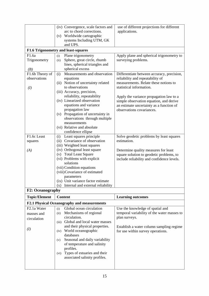
(iv) Convergence, scale factors and
arc to chord corrections.
(v) Worldwide cartographic
systems Including UTM, GK
and UPS.
use of different projections for different
applications.
F1.6 Trigonometry and least-squares
F1.6a
Trigonometry (B)
(i) Plane trigonometry
(ii) Sphere, great circle, rhumb
lines, spherical triangles and
spherical excess
Apply plane and spherical trigonometry to
surveying problems.
F1.6b Theory of
observations (I)
(i) Measurements and observation
equations
(ii) Notion of uncertainty related
to observations
(iii) Accuracy, precision,
reliability, repeatability
(iv) Linearized observation
equations and variance
propagation law
(v) Propagation of uncertainty in
observations through multiple
measurements
(vi) Relative and absolute
confidence ellipse
Differentiate between accuracy, precision,
reliability and repeatability of
measurements. Relate these notions to
statistical information. Apply the variance propagation law to a
simple observation equation, and derive
an estimate uncertainty as a function of
observations covariances.
F1.6c Least
squares (A)
(i) Least squares principle
(ii) Covariance of observation
(iii) Weighted least squares
(iv) Orthogonal least square
(v) Total Least Square
(vi) Problems with explicit
solutions
(vii) Condition equations
(viii) Covariance of estimated
parameters
(ix) Unit variance factor estimate
(x) Internal and external reliability
Solve geodetic problems by least squares
estimation. Determine quality measures for least
square solution to geodetic problems, to
include reliability and confidence levels.
F2: Oceanography
Topic/Element Content Learning outcomes
F2.1 Physical Oceanography and measurements
F2.1a Water
masses and
circulation
(I)
(i) Global ocean circulation
(ii) Mechanisms of regional
circulation.
(iii) Global and local water masses
and their physical properties.
(iv) World oceanographic
databases
(v) Seasonal and daily variability
of temperature and salinity
profiles.
(vi) Types of estuaries and their
associated salinity profiles.
Use the knowledge of spatial and
temporal variability of the water masses to
plan surveys. Establish a water column sampling regime
for use within survey operations.
16
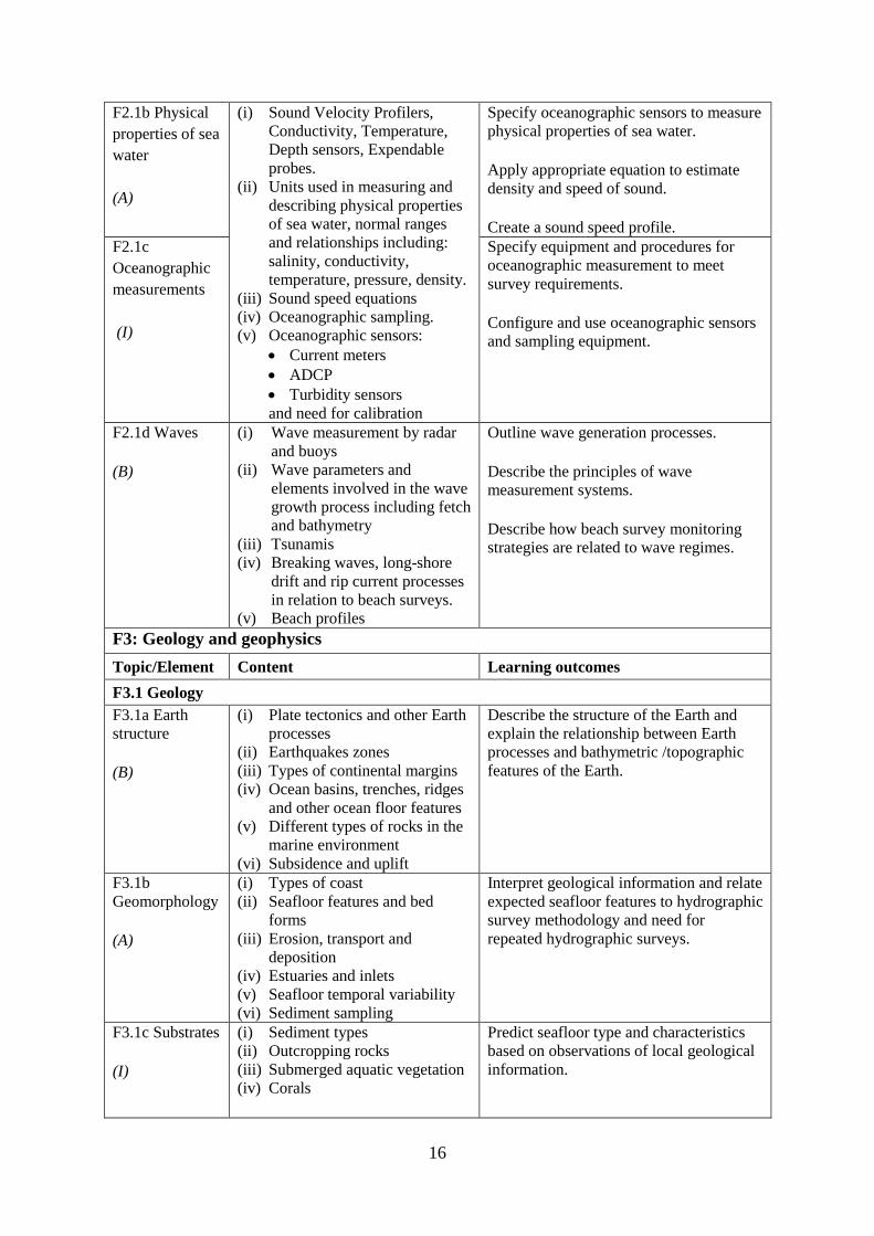
F2.1b Physical
properties of sea
water
(A)
(i) Sound Velocity Profilers,
Conductivity, Temperature,
Depth sensors, Expendable
probes.
(ii) Units used in measuring and
describing physical properties
of sea water, normal ranges
and relationships including:
salinity, conductivity,
temperature, pressure, density.
(iii) Sound speed equations
(iv) Oceanographic sampling.
(v) Oceanographic sensors:
Current meters
ADCP
Turbidity sensors
and need for calibration
Specify oceanographic sensors to measure
physical properties of sea water. Apply appropriate equation to estimate
density and speed of sound. Create a sound speed profile.
F2.1c
Oceanographic
measurements
(I)
Specify equipment and procedures for
oceanographic measurement to meet
survey requirements. Configure and use oceanographic sensors
and sampling equipment.
F2.1d Waves (B)
(i) Wave measurement by radar
and buoys
(ii) Wave parameters and
elements involved in the wave
growth process including fetch
and bathymetry
(iii) Tsunamis
(iv) Breaking waves, long-shore
drift and rip current processes
in relation to beach surveys.
(v) Beach profiles
Outline wave generation processes. Describe the principles of wave
measurement systems. Describe how beach survey monitoring
strategies are related to wave regimes.
F3: Geology and geophysics
Topic/Element Content Learning outcomes
F3.1 Geology
F3.1a Earth
structure (B)
(i) Plate tectonics and other Earth
processes
(ii) Earthquakes zones
(iii) Types of continental margins
(iv) Ocean basins, trenches, ridges
and other ocean floor features
(v) Different types of rocks in the
marine environment
(vi) Subsidence and uplift
Describe the structure of the Earth and
explain the relationship between Earth
processes and bathymetric /topographic
features of the Earth.
F3.1b
Geomorphology (A)
(i) Types of coast
(ii) Seafloor features and bed
forms
(iii) Erosion, transport and
deposition
(iv) Estuaries and inlets
(v) Seafloor temporal variability
(vi) Sediment sampling
Interpret geological information and relate
expected seafloor features to hydrographic
survey methodology and need for
repeated hydrographic surveys.
F3.1c Substrates (I)
(i) Sediment types
(ii) Outcropping rocks
(iii) Submerged aquatic vegetation
(iv) Corals
Predict seafloor type and characteristics
based on observations of local geological
information.

17
F3.2 Geophysics
F3.2a Gravity
fields and
gravity surveys
(B)
(i) Gravity meters
(ii) Relative and absolute gravity
measurements
(iii) Bathymetric corrections for
gravity measurements
(iv) Local gravity anomalies and
gravity surveys
(v) Influence of gravity on sea
surface topography and
correlation with seafloor
features
Explain the principle of operation of
gravity meters and the need for
corrections.
Discuss the objectives of gravity surveys
in relation to seabed features.
F3.2b Magnetic
fields
(B)
(i) Magnetic fields of the Earth
(ii) Magnetic anomalies in relation
to rock types and tectonic
history
(iii) Temporal variations
(iv) Magnetic Earth models and
databases
Describe the Earth magnetic field, its
spatial and temporal variability.
F3.2c Seismic
surveys
(I)
(i) Continuous
reflection/refraction seismic
profiling.
(ii) Typical sound sources,
receivers and recorders.
(iii) Analogue high resolution
seismic systems (including
pinger, boomers, sparkers,
chirp)
(iv) Frequency and wavelength in
relation to resolution and
penetration
(v) Equipment configuration for
towing, launch and recovery
(vi) Applications such as pipeline
or hazard detection, seabed
sediment identification for
mapping, shallow sedimentary
channels.
(vii) Principles of seismic
stratigraphy
Evaluate coverage and penetration of
systems and correlate equipment with
applications.
Distinguish between noise, outliers, and
real seafloor features and sub-seafloor
geometry
18
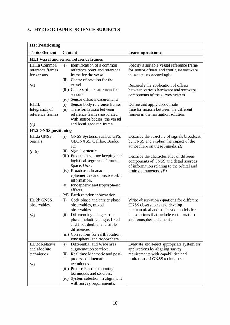
3. HYDROGRAPHIC SCIENCE SUBJECTS
H1: Positioning
Topic/Element Content Learning outcomes
H1.1 Vessel and sensor reference frames
H1.1a Common
reference frames
for sensors (A)
(i) Identification of a common
reference point and reference
frame for the vessel
(ii) Centre of rotation for the
vessel
(iii) Centers of measurement for
sensors
(iv) Sensor offset measurements.
Specify a suitable vessel reference frame
for sensor offsets and configure software
to use values accordingly. Reconcile the application of offsets
between various hardware and software
components of the survey system.
H1.1b
Integration of
reference frames (A)
(i) Sensor body reference frames.
(ii) Transformations between
reference frames associated
with sensor bodies, the vessel
and local geodetic frame.
Define and apply appropriate
transformations between the different
frames in the navigation solution.
H1.2 GNSS positioning
H1.2a GNSS
Signals (I, B)
(i) GNSS Systems, such as GPS,
GLONASS, Galileo, Beidou,
etc.
(ii) Signal structure.
(iii) Frequencies, time keeping and
logistical segments: Ground,
Space, User.
(iv) Broadcast almanac
ephemerides and precise orbit
information.
(v) Ionospheric and tropospheric
effects.
(vi) Earth rotation information.
Describe the structure of signals broadcast
by GNSS and explain the impact of the
atmosphere on these signals. (I) Describe the characteristics of different
components of GNSS and detail sources
of information relating to the orbital and
timing parameters. (B)
H1.2b GNSS
observables (A)
(i) Code phase and carrier phase
observables, mixed
observables.
(ii) Differencing using carrier
phase including single, fixed
and float double, and triple
differences.
(iii) Corrections for earth rotation,
ionosphere, and troposphere.
Write observation equations for different
GNSS observables and develop
mathematical and stochastic models for
the solutions that include earth rotation
and ionospheric elements.
H1.2c Relative
and absolute
techniques (A)
(i) Differential and Wide area
augmentation services.
(ii) Real time kinematic and post-
processed kinematic
techniques.
(iii) Precise Point Positioning
techniques and services.
(iv) System selection in alignment
with survey requirements.
Evaluate and select appropriate system for
applications by aligning survey
requirements with capabilities and
limitations of GNSS techniques

19
H1.2d
Installation and
operation (A)
(i) Antenna installation to
consider coverage, stability
and multipath environment.
(ii) Levels of redundancy in
systems and communications
(iii) Data exchange formats and
protocols such as RINEX and
NMEA
Specify, supervise and test the installation
of GNSS hardware and software for both
inshore and offshore operations.
H1.2e Quality
control (A)
(i) Sources of error including
multipath, atmospheric effects,
base station network, sensor
offsets, etc.
(ii) Measures and monitoring of
precision (DOP variations) and
reliability (statistical testing).
(iii) Integrity monitoring of base
station data.
(iv) Verification checks between
systems or against known
points.
Develop a quality control plan for GNSS
operations including risk management
associated with GNSS components and
services. Assess the performance of GNSS
positioning against the defined quality
control criteria.
H1.3 Inertial navigation systems
H1.3a
Accelerometers
and gyroscopes,
inclinometers,
and compass (A)
(i) Accelerometers technology
(pendulums, vibrating
elements)
(ii) Gyroscopes (FOG, Ring laser,
Sagnac effect)
(iii) MEMS
(iv) Inclinometers
(v) Flux gate compass
Describe accelerometer technologies, and
differentiate between inclinometers,
compass and gyroscopes. Describe error
sources associated with these devices.
H1.3b
Strapdown
inertial
measurement
units (A)
(i) Technologies available for
IMU measurements through
gyroscopes and accelerometers
(ii) Sources of error in inertial
sensors: bias; scale factor; and,
noise.
(iii) The inertial navigation
equation and error equations.
(iv) Static alignment of the IMU.
(v) Heave estimation from gyros
and accelerometers.
(vi) Induced heave.
Describe the technologies used in inertial
measurements and quantify associated
navigation errors. Undertake static alignment of an IMU. Develop strategies for mitigating induced
heave and select filter parameters for
heave estimation.
H1.3c Kalman
filtering (I)
(i) Bayesian estimation
(ii) State representation of a
dynamic observation equation,
observability
(iii) Continuous, Semi-discrete and
discrete Kalman filtering
(iv) Optimal smoothing
Apply Kalman filtering methods to a
dynamic observation process. Define the parameters of a Kalman Filter
in relation with sensors performances and
dynamic model uncertainty. Differentiate between stationary and non-
stationary observation processes H1.3d Aided
inertial
navigation
(i) INS and GNSS loosely and
tightly coupled solutions.
(ii) Velocity and ranging aided
INS navigation.
Describe the role of aiding sensors to
reduce INS navigation drift.
20
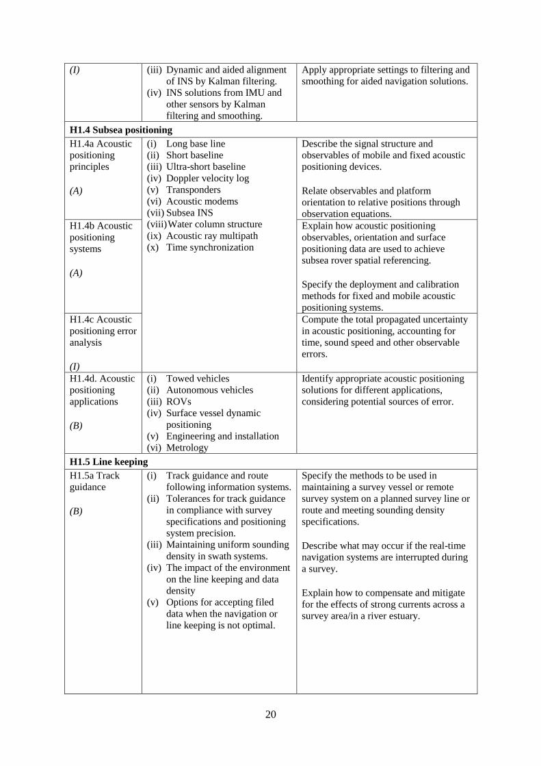
(I) (iii) Dynamic and aided alignment
of INS by Kalman filtering.
(iv) INS solutions from IMU and
other sensors by Kalman
filtering and smoothing.
Apply appropriate settings to filtering and
smoothing for aided navigation solutions.
H1.4 Subsea positioning
H1.4a Acoustic
positioning
principles (A)
(i) Long base line
(ii) Short baseline
(iii) Ultra-short baseline
(iv) Doppler velocity log
(v) Transponders
(vi) Acoustic modems
(vii) Subsea INS
(viii) Water column structure
(ix) Acoustic ray multipath
(x) Time synchronization
Describe the signal structure and
observables of mobile and fixed acoustic
positioning devices. Relate observables and platform
orientation to relative positions through
observation equations. H1.4b Acoustic
positioning
systems (A)
Explain how acoustic positioning
observables, orientation and surface
positioning data are used to achieve
subsea rover spatial referencing. Specify the deployment and calibration
methods for fixed and mobile acoustic
positioning systems. H1.4c Acoustic
positioning error
analysis (I)
Compute the total propagated uncertainty
in acoustic positioning, accounting for
time, sound speed and other observable
errors.
H1.4d. Acoustic
positioning
applications (B)
(i) Towed vehicles
(ii) Autonomous vehicles
(iii) ROVs
(iv) Surface vessel dynamic
positioning
(v) Engineering and installation
(vi) Metrology
Identify appropriate acoustic positioning
solutions for different applications,
considering potential sources of error.
H1.5 Line keeping
H1.5a Track
guidance (B)
(i) Track guidance and route
following information systems.
(ii) Tolerances for track guidance
in compliance with survey
specifications and positioning
system precision.
(iii) Maintaining uniform sounding
density in swath systems.
(iv) The impact of the environment
on the line keeping and data
density
(v) Options for accepting filed
data when the navigation or
line keeping is not optimal.
Specify the methods to be used in
maintaining a survey vessel or remote
survey system on a planned survey line or
route and meeting sounding density
specifications. Describe what may occur if the real-time
navigation systems are interrupted during
a survey. Explain how to compensate and mitigate
for the effects of strong currents across a
survey area/in a river estuary.

21
H2: Underwater Sensors and Data Processing
Topic/Element Content Learning outcomes
H2.1 Underwater acoustics
H2.1a
Transducers and
generation of
acoustic waves (I)
(i) Piezoelectric principles
(ii) Transducer arrays design,
beam-forming, side lobes.
(iii) Transducer Quality factor
(iv) Plane and spherical waves in
terms of wavelength,
amplitude and frequency.
(v) Absorption, spherical
spreading
(vi) Frequency, attenuation
relationship to range
(vii) Acoustic units, intensities and
sound levels
(viii) Signal to noise ratio
(ix) Active Sonar Equation
including sound source, causes
of propagation loss in relation
to water properties together
with characteristics of the sea
floor and targets, acoustic
noise level and directivity
(x) Continuous Wavelength (CW),
Chirp transmission
(xi) System parameters including
bandwidth, pulse length, pulse
repetition rate, gain, detection
threshold.
(xii) Range resolution and spatial
resolution.
(xiii) Dynamic range, clipping and
saturation
(xiv) Sound speed profile and
gradient
(xv) Ray-tracing theory
(xvi) Sound channel
(xvii) Non horizontal sound speed
layers
Analyze the effect of transducer design on
beam characteristics and performance. Describe the design and use of multi-
frequency, wide-bandwidth and
parametric transducers. Differentiate between chirp and CW
transmission, and characterize their
relative performance. Determine source level from typically
available sonar specification. H2.1b
Propagation of
acoustic waves (A)
Explain how properties of the acoustic
medium and source frequency affect the
propagation of acoustic waves. Calculate propagation loss in practical
situations, using medium property
observations and available tables. H2.1c Acoustic
noise (I)
Identify the sources of noise and describe
the effect of noise on echo sounding.
Define the directivity index. Calculate the effect on sonar range of a
variety of noise conditions and sonar
directivity circumstances. H2.1d
Reflection,
scattering and
system
performance. (I)
Define the characteristic impedance of an
acoustic medium. Assess the effects of varying seafloor
composition, texture, and slope on echo
strength.
H2.1e
Refraction and
ray-tracing. (A)
Use the sound speed profile to compute
the path of sound ray through the water
column.
H2.2 Single beam systems
H2.2a Single
beam echo
sounders
principles (I)
(i) Single beam, split beam and
dual beam concepts
(ii) Beam footprint
(iii) Specification of a single beam
echo sounder.
(iv) Bottom detection principles
(matched filtering,
thresholding) and range
resolution.
Explain the principles of operation of a
single beam sounder detailing how
acoustic parameters influence sounder
returns.
H2.2b Single
beam returns
interpretation
Interpret single beam returns including
analysis of full echo envelopes and
features of the sea bed and water column.

22
(A)
(v) Full-echo-envelope returns and
bottom characterization
H2.2c Single
beam survey
system (A)
(i) Components of a single beam
echo sounder system to
include: positioning system,
motion sensor, acquisition
system, source of reference
level (i.e. tide gauge, GNSS)
(ii) Acoustic parameters of single
beam echo-sounders
(iii) Reduction of soundings to the
specified datum
Specify survey system to perform a single
beam survey in accordance with
application requirements. Select appropriate range, scale, frequency
and pulse for specific applications in
relation to spatial resolution, bottom
penetration, depth of water and water
column analysis.
H2.2d
Processing of
single beam data (I, A)
(i) Systematic effects in system
components:
Single Beam Echo-
Sounders
IMU/INS
Sound speed profilers and
other peripheral sensors
(ii) Single beam echo sounders
data processing workflows
Specify processing workflow for single
beam data. (I) Integrate and merge data of various
sources and of various types in preparation
for product generation. (A)
H2.3 Sonar imagery systems
H2.3a Side-scan
sonar systems (A)
(i) Principles, components and
geometry of side scan sonar
systems
(ii) Range, beam angle
(iii) Resolution in relation to beam
width, sampling rate angle of
incidence and pulse length.
Evaluate, select and configure side-scan
sonar in alignment with survey
operational needs.
H2.3b Synthetic
Aperture Sonar (I)
(i) Principles of synthetic aperture
imaging
Discuss and compare the use of SAS with
that of more conventional sonar imaging
systems.
H2.4 Swath echo sounder systems
H2.4a Multi-
beam echo
sounders (A, I)
(i) Principles and geometry of
multi-beam sonar systems
(ii) Combination of transducer
elements into transmit and
receive arrays.
(iii) Beam stabilization and beam
steering
(iv) Amplitude and phase bottom
detection
(v) Variations in beam spacing
and footprint size
(vi) Backscatter recording modes
(e.g., beam average, side scan
time series, beam time series)
(vii) Backscatter and seabed
classification
(viii) Water column data
(ix) Power, gain, pulse length
Explain the basic principles of multi-beam
sonar transmit and receive beam forming
and beam steering. (I) Explain the effect of aperture size and
element spacing on array performance. (I) Analyze the techniques of amplitude and
phase methods of bottom detection and
relate them to depth uncertainty. (A) H2.4b Multi-
beam system
parameters (A)
Tune acoustic parameters on-line for
depth and backscatter. Determine the beam footprint size and
sounding spacing across the swath and
assess the limitations and likelihood of
detecting objects on the seafloor under
varying surveying conditions.

23
(x) Multiple signal returns,
aliasing of multiple signals in
the water.
Explain the use of water column returns
and differentiate from bottom detection.
H2.4c Multi-
beam systems (A)
(i) positioning system, telemetry,
motion and attitude sensors,
(ii) acquisition system,
(iii) source of reference level (i.e.
tide gauge, GNSS),
(iv) Sound Speed measurements
Specify survey system to perform a multi-
beam survey in accordance with
application requirements.
H2.4d Multi-
beam data
processing (A)
(i) Multi-beam data elements:
(ii) Beam and travel-time data
(iii) IMU/INS
(iv) Positioning data
(v) Time stamping
(vi) Offsets between sensor
reference points
(vii) Sound speed profile
(viii) Data file formats
Describe how and where data elements are
combined to produce geo-referenced
soundings. Integrate and merge data elements in
preparation for data processing.
H2.4e
Interferometric
Sonar (A)
(i) Principles and geometry of
interferometric (phase
measurement) sonar systems
(ii) Sounding determination
principles
(iii) Mounting methods and towing
(iv) Transducers arrangement
(v) Sounding filtering and binning
techniques
Analyze the principles and geometry of
interferometry and phase differencing
bathymetric sonars and the arrangement
of transducer arrays. Explain the need for filtering phase
measurement data for depth, object
detection and backscatter.
Explain the effect of aperture size and
transducer geometry on array
performance. Assess the relative merits of multi-beam
and phase differencing systems for
specific mapping applications in water
depths from very shallow to full ocean
depths.
H2.5 Backscatter
H2.5a
Backscatter
from side scan,
interferometric
swath sonars
and multi-beam
echo sounders (A)
(i) Relationship between
backscatter content and
characteristics of the seabed,
water column properties and
acoustic signal parameters
(ii) Generation of backscatter
information within acoustic
systems
(iii) Principle of backscatter
compensation for absorption,
incidence angle, gain and
power
(iv) Mosaicing
Specify and configure a side scan sonar
and a swath echo sounder for backscatter
acquisition under varying environmental
conditions and for specific application.
Monitor and assess quality on-line and
apply appropriate compensation.
Apply backscatter principles to produce a
compensated backscatter mosaic.
24
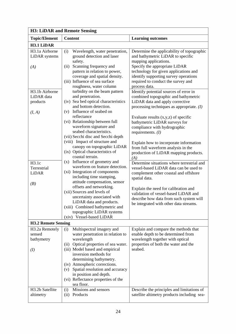
H3: LiDAR and Remote Sensing
Topic/Element Content Learning outcomes
H3.1 LiDAR
H3.1a Airborne
LiDAR systems (A)
(i) Wavelength, water penetration,
ground detection and laser
safety.
(ii) Scanning frequency and
pattern in relation to power,
coverage and spatial density.
(iii) Influence of sea surface
roughness, water column
turbidity on the beam pattern
and penetration.
(iv) Sea bed optical characteristics
and bottom detection.
(v) Influence of seabed on
reflectance
(vi) Relationship between full
waveform signature and
seabed characteristics.
(vii) Secchi disc and Secchi depth
(viii) Impact of structure and
canopy on topographic LiDAR
(ix) Optical characteristics of
coastal terrain.
(x) Influence of geometry and
waveform on feature detection.
(xi) Integration of components
including time stamping,
attitude compensation, sensor
offsets and networking.
(xii) Sources and levels of
uncertainty associated with
LiDAR data and products.
(xiii) Combined bathymetric and
topographic LiDAR systems
(xiv) Vessel-based LiDAR
Determine the applicability of topographic
and bathymetric LiDAR to specific
mapping applications. Specify the appropriate LiDAR
technology for given applications and
identify supporting survey operations
required to conduct the survey and
process data. H3.1b Airborne
LiDAR data
products (I, A)
Identify potential sources of error in
combined topographic and bathymetric
LiDAR data and apply corrective
processing techniques as appropriate. (I) Evaluate results (x,y,z) of specific
bathymetric LiDAR surveys for
compliance with hydrographic
requirements. (I) Explain how to incorporate information
from full waveform analysis in the
production of LiDAR mapping products.
(A) H3.1c
Terrestrial
LiDAR (B)
Determine situations where terrestrial and
vessel-based LiDAR data can be used to
complement other coastal and offshore
spatial data. Explain the need for calibration and
validation of vessel-based LiDAR and
describe how data from such system will
be integrated with other data streams.
H3.2 Remote Sensing
H3.2a Remotely
sensed
bathymetry (I)
(i) Multispectral imagery and
water penetration in relation to
wavelength
(ii) Optical properties of sea water.
(iii) Model based and empirical
inversion methods for
determining bathymetry.
(iv) Atmospheric corrections.
(v) Spatial resolution and accuracy
in position and depth.
(vi) Reflectance properties of the
sea floor.
Explain and compare the methods that
enable depth to be determined from
wavelength together with optical
properties of both the water and the
seabed.
H3.2b Satellite
altimetry
(i) Missions and sensors
(ii) Products
Describe the principles and limitations of
satellite altimetry products including sea-
25
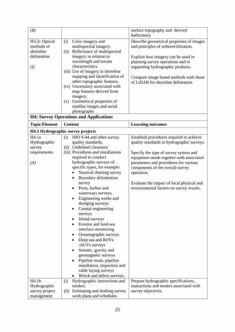
(B)
surface topography and derived
bathymetry
H3.2c Optical
methods of
shoreline
delineation (I)
(i) Color imagery and
multispectral imagery.
(ii) Reflectance of multispectral
imagery in relation to
wavelength and terrain
characteristics.
(iii) Use of imagery in shoreline
mapping and identification of
other topographic features.
(iv) Uncertainty associated with
map features derived from
imagery.
(v) Geometrical properties of
satellite images and aerial
photographs
Describe geometrical properties of images
and principles of orthorectification. Explain how imagery can be used in
planning survey operations and in
supporting hydrographic products. Compare image based methods with those
of LiDAR for shoreline delineation
H4: Survey Operations and Applications
Topic/Element Content Learning outcomes
H4.1 Hydrographic survey projects
H4.1a
Hydrographic
survey
requirements (A)
(i) IHO S-44 and other survey
quality standards.
(ii) Underkeel clearance
(iii) Procedures and installations
required to conduct
hydrographic surveys of
specific types, for example:
Nautical charting survey
Boundary delimitation
survey
Ports, harbor and
waterways surveys.
Engineering works and
dredging surveys
Coastal engineering
surveys
Inland surveys
Erosion and land-sea
interface monitoring
Oceanographic surveys
Deep sea and ROVs
/AUVs surveys
Seismic, gravity and
geomagnetic surveys
Pipeline route, pipeline
installation, inspection and
cable laying surveys
Wreck and debris surveys.
Establish procedures required to achieve
quality standards in hydrographic surveys. Specify the type of survey system and
equipment needs together with associated
parameters and procedures for various
components of the overall survey
operation. Evaluate the impact of local physical and
environmental factors on survey results.
H4.1b
Hydrographic
survey project
management
(i) Hydrographic instructions and
tenders.
(ii) Estimating and drafting survey
work plans and schedules
Prepare hydrographic specifications,
instructions and tenders associated with
survey objectives.
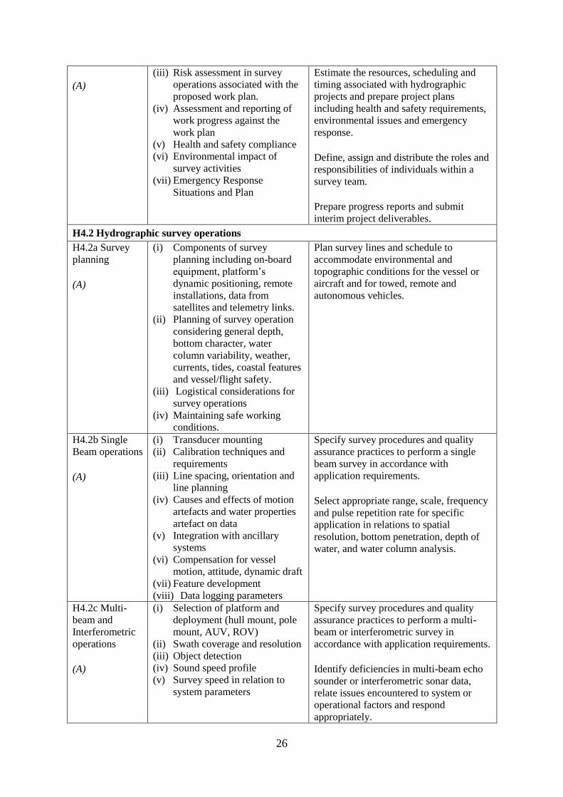
26
(A)
(iii) Risk assessment in survey
operations associated with the
proposed work plan.
(iv) Assessment and reporting of
work progress against the
work plan
(v) Health and safety compliance
(vi) Environmental impact of
survey activities
(vii) Emergency Response
Situations and Plan
Estimate the resources, scheduling and
timing associated with hydrographic
projects and prepare project plans
including health and safety requirements,
environmental issues and emergency
response. Define, assign and distribute the roles and
responsibilities of individuals within a
survey team. Prepare progress reports and submit
interim project deliverables.
H4.2 Hydrographic survey operations
H4.2a Survey
planning (A)
(i) Components of survey
planning including on-board
equipment, platform’s
dynamic positioning, remote
installations, data from
satellites and telemetry links.
(ii) Planning of survey operation
considering general depth,
bottom character, water
column variability, weather,
currents, tides, coastal features
and vessel/flight safety.
(iii) Logistical considerations for
survey operations
(iv) Maintaining safe working
conditions.
Plan survey lines and schedule to
accommodate environmental and
topographic conditions for the vessel or
aircraft and for towed, remote and
autonomous vehicles.
H4.2b Single
Beam operations (A)
(i) Transducer mounting
(ii) Calibration techniques and
requirements
(iii) Line spacing, orientation and
line planning
(iv) Causes and effects of motion
artefacts and water properties
artefact on data
(v) Integration with ancillary
systems
(vi) Compensation for vessel
motion, attitude, dynamic draft
(vii) Feature development
(viii) Data logging parameters
Specify survey procedures and quality
assurance practices to perform a single
beam survey in accordance with
application requirements. Select appropriate range, scale, frequency
and pulse repetition rate for specific
application in relations to spatial
resolution, bottom penetration, depth of
water, and water column analysis.
H4.2c Multi-
beam and
Interferometric
operations (A)
(i) Selection of platform and
deployment (hull mount, pole
mount, AUV, ROV)
(ii) Swath coverage and resolution
(iii) Object detection
(iv) Sound speed profile
(v) Survey speed in relation to
system parameters
Specify survey procedures and quality
assurance practices to perform a multi-
beam or interferometric survey in
accordance with application requirements. Identify deficiencies in multi-beam echo
sounder or interferometric sonar data,
relate issues encountered to system or
operational factors and respond
appropriately.
27
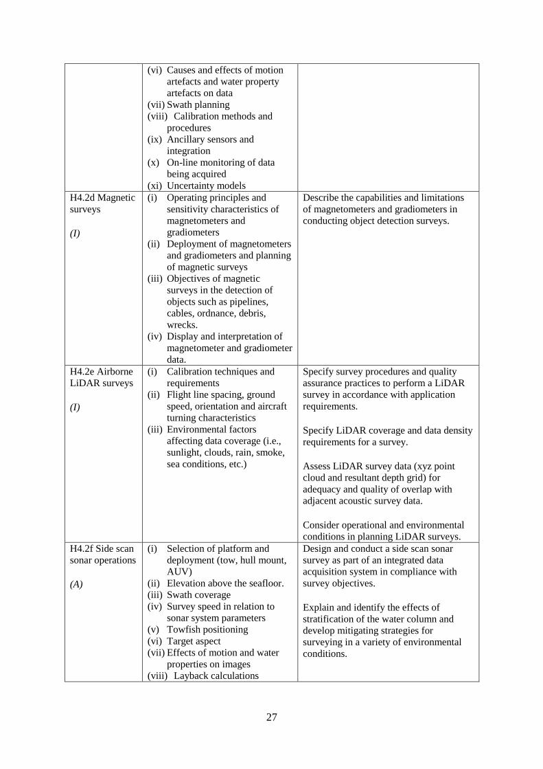
(vi) Causes and effects of motion
artefacts and water property
artefacts on data
(vii) Swath planning
(viii) Calibration methods and
procedures
(ix) Ancillary sensors and
integration
(x) On-line monitoring of data
being acquired
(xi) Uncertainty models
H4.2d Magnetic
surveys (I)
(i) Operating principles and
sensitivity characteristics of
magnetometers and
gradiometers
(ii) Deployment of magnetometers
and gradiometers and planning
of magnetic surveys
(iii) Objectives of magnetic
surveys in the detection of
objects such as pipelines,
cables, ordnance, debris,
wrecks.
(iv) Display and interpretation of
magnetometer and gradiometer
data.
Describe the capabilities and limitations
of magnetometers and gradiometers in
conducting object detection surveys.
H4.2e Airborne
LiDAR surveys (I)
(i) Calibration techniques and
requirements
(ii) Flight line spacing, ground
speed, orientation and aircraft
turning characteristics
(iii) Environmental factors
affecting data coverage (i.e.,
sunlight, clouds, rain, smoke,
sea conditions, etc.)
Specify survey procedures and quality
assurance practices to perform a LiDAR
survey in accordance with application
requirements. Specify LiDAR coverage and data density
requirements for a survey. Assess LiDAR survey data (xyz point
cloud and resultant depth grid) for
adequacy and quality of overlap with
adjacent acoustic survey data. Consider operational and environmental
conditions in planning LiDAR surveys. H4.2f Side scan
sonar operations (A)
(i) Selection of platform and
deployment (tow, hull mount,
AUV)
(ii) Elevation above the seafloor.
(iii) Swath coverage
(iv) Survey speed in relation to
sonar system parameters
(v) Towfish positioning
(vi) Target aspect
(vii) Effects of motion and water
properties on images
(viii) Layback calculations
Design and conduct a side scan sonar
survey as part of an integrated data
acquisition system in compliance with
survey objectives. Explain and identify the effects of
stratification of the water column and
develop mitigating strategies for
surveying in a variety of environmental
conditions.
28
H4.2g Side-scan
sonar data
interpretation (A)
(i) Side scan sonar backscatter
and sea floor reflection.
(ii) Side scan images and
mosaicking
(iii) Sources of distortion and
artefacts from water column
properties, motion
(iv) Determination of height, size
and position of seafloor
features
(v) Sonar signature of wrecks,
pipelines, gas, fish and fresh
water, etc.
Interpret side scan sonar imagery through
assessment of individual and overlapping
swaths to identify potential sonar targets
for further investigation. Interpret side scan sonar imagery to assess
differences in seafloor composition and
topography.
H4.3 Seabed characterization
H4.3a
Classification
from acoustic
data (I)
(i) SBES full echo envelope
(ii) Sub-bottom profiler full echo-
envelope
(iii) Side scan sonar images
(iv) Synthetic aperture sonars
images
(v) Side scan sonar and swath
echo sounders backscatter
information
(vi) Ground-truthing
Explain the concept of incidence angle
dependence and describe the signal
processing steps required to obtain
corrected backscatter data for seafloor
characterization.
Explain the techniques available and their
limitations for observing, interpreting and
classifying differences in seabed
characteristics from acoustic sensors. H4.3b
Classification
from optical
data (B)
(i) Hyperspectral and
multispectral sensors images
(ii) Underwater cameras
(iii) LiDAR
(iv) Ground-truthing
Explain the techniques available and their
limitations for observing and interpreting
differences in seabed and inter-tidal zone
characteristics from optical sensors.
H4.3c Seabed
sampling (I)
(i) Grabs
(ii) Corers
(iii) Use in ground-truthing
Plan a sampling campaign to classify the
seabed as part of a survey. Use remotely sensed information to select
sampling sites. H4.3d Seabed
characterization (I)
(i) Classification standards
(ii) Classification methods
Consider the combination of remotely
sensed information with seabed samples
in a seafloor characterization survey. Apply classification standards to seabed
characterization results.
H5: Water Levels and Flow
Topic/Element Content Learning outcomes
H5.1 Principles of Water Levels
H5.1a Tide
theory (I)
(i) Tide generating forces, the
equilibrium and real tides.
(ii) Tide constituents and different
types of tide.
(iii) Amphidromic points and co-
tidal and co-range lines.
(iv) Geomorphological and basin
influences on tidal
characteristics
Characterize features of the tide in terms
of tide raising forces and local
hydrographic features.

29
H5.1b Non-tidal
water level
variations (I)
(i) Changes in water level caused
by: atmospheric pressure,
wind, seiches, ocean
temperature and precipitation.
(ii) Water level variations
occurring in inland waters.
(iii) Water level variations in
estuaries, wet lands and rivers
Evaluate the effect of non-tidal influences
on water levels in the conduct of a
hydrographic survey.
H5.2 Water level measurements
H5.2a Water
level gauges (A)
(i) Principles of operation of
various types of water level
gauges including pressure
(vented and unvented), GNSS
buoys, float, radar, acoustic
sensors and tide poles.
(ii) Installing gauges,
establishment and levelling of
associated survey marks
(iii) Determination of tide
correctors from water level
observations
(iv) Networks of water level
gauges
(v) Use of satellite altimetry in
determining water levels
(vi) Uncertainties associated with
water level measurement
devices
(vii) Uncertainties associated with
duration of observations.
(viii) Uncertainties associated with
spatial separation of water
level measurements.
Select appropriate type of water level
gauge technology according to survey
project operations. Install, level to a vertical reference, and
calibrate a water level gauge while
evaluating sources of errors and applying
appropriate corrections. H5.2b Tidal
measurement (A)
Evaluate and select appropriate sites for
water level monitoring. Select water level gauge parameters for
logging data, data communication, data
download and for network operation with
appropriate quality control measures. H5.2c
Uncertainty in
water level (I)
Assess and quantify the contribution of
water level observations to uncertainties
in survey measurements. Assess the uncertainty in water level
observations due to duration of
observations and distance from water
level gauge.
H5.3 Tide modelling
H5.3a Harmonic
analysis (I)
(i) Harmonic constituents from
astronomical periods
(ii) Harmonic coefficients and
residuals.
(iii) Water level time series
observations
(iv) Fourier series and Fourier
analysis
(v) Tide tables and tide prediction
Compute standard harmonic constituents
from astronomical periods. Derive harmonic coefficients and
residuals from times series observations
using Fourier analysis. Describe the computation of tide tables
from harmonic coefficients. Compare the tidal characteristics and
residuals of two tide stations using
harmonic analysis. H5.3b Ocean
water level (B)
(i) Earth tide
(ii) Harmonic astronomic
component
(iii) Oceanographic components
(iv) Meteorological component.
(v) Satellite altimetry
Describe ocean water level models and
observation methods.
30
H5.4 Ellipsoid separation models and vertical datums
H5.4a
Separation
models (I)
(i) Single-point and regional
models
(ii) Principle of Separation surface
construction
(iii) Ellipsoid to Chart Datum
separation models
(iv) Tidally defined vertical datums
components, including LAT,
HAT, MSL, etc…
(v) Chart Datum and sounding
datum
(vi) Geoid as a reference surface
(vii) Datums in oceans coastal
waters, estuaries, rivers and
lakes
(viii) Interpolation of datums
between water level stations
(ix) Reduction of survey data to a
datum
Explain the relationship between geoid,
ellipsoid, and chart datum. Apply relevant offsets to convert between
datums H5.4b Vertical
Datums (A)
Select, establish, interpolate and transfer a
vertical datum in various environments.
H5.4c Sounding
reduction (A)
Reduce ellipsoidal referenced survey data
to a water level datum using an
appropriate separation model with an
appreciation for associated uncertainty. Apply tide correctors to reduce survey
soundings to a chart datum.
H5.5 Currents
H5.5a Tidally
induced currents (B)
(i) The relationship between
currents and tides
(ii) Rectilinear and rotary tidal
currents
(iii) current meters,
(iv) acoustic current profilers
(v) Drogues
(vi) Surface current radar
observation
(vii) Static and mobile current
measurements
(viii) Current surveys
(ix) Portraying current data
Explain the forces behind tidally induced
currents and describe temporal variations. Differentiate between tidal and non-tidal
current. H5.5b Current
measurement,
portrayal and
surveys (I)
Select, use techniques and instruments for
current measurement. Plan current surveys. Use appropriate methods for processing
and displaying current data.
H6: Hydrographic Data Acquisition and Processing
Topic/Element Content Learning outcomes
H6.1 Real-time data acquisition and control
H6.1a
Hydrographic
Data acquisition
(A)
(i) Integration of data from
various sensors in accordance
with survey specifications to
include equipment such as:
Echo-sounder (SBES,
MBES)
Terrestrial and airborne
LiDAR
Sound velocity profiler,
surface velocity probe
Side-scan sonar
Surface positioning system
IMU / INS
Subsea positioning system
(USBL)
Define, configure and validate a complex
survey suite for different types of surveys
in accordance with technical specification. Specify and configure communication
interfaces between survey devices and
system components.
H6.1b Real-time
data monitoring
(A)
Evaluate performance of an integrated
survey system against survey
specifications using quality control
methods and address deficiencies using
troubleshooting methods. Identify type and sources of system errors
and undertake system analysis.
31
ROVs and AUVs
(ii) Data acquisition system and
software
(iii) Time-tagging
(iv) Data visualization
(v) Data quality control methods
(vi) Types and sources of errors
(vii) System errors identification
methods
E6.1c Survey
data storage and
transfer (A)
(i) Content of files in different
formats used to record data in
survey planning, data
acquisition and products.
(ii) Multiple data types
(iii) Storage requirements
(iv) Proprietary vs. standard data
format
(v) Metadata
(vi) Organization of survey
databases.
Export survey data to databases and
analysis tools taking account of different
data formats. Employ data storage strategies to facilitate
survey data flow. Populate and maintain metadata associated
with different data types and products.
H6.2 Bathymetric data filtering and estimation
H6.2 a Filtering
and estimation
of single beam
data (A)
(i) Data cleaning techniques
(manual and automated)
(ii) Identification of outliers
(iii) Identification and
classification of systematic
errors
(iv) Total propagated uncertainty -
horizontal
(v) Total propagated uncertainty -
vertical
(vi) Comparing crossing data
between survey lines
(vii) Comparing overlapping data
between platforms
(viii) Assessing coverage in
relation with contour lines and
features
Identify and remove outliers and validate
data cleaning and other decisions made in
processing single beam data. Interpret and resolve systematic errors
detected during data processing Perform time series analysis of data from
multiple sensors to detect artefacts and
other errors that may exist in a survey
dataset. Specify additional coverage and
associated survey parameters to resolve
shortcomings in survey data.
H6.2b Filtering
and estimation
of multi-beam
data (A)
(i) Data cleaning techniques
(manual and automated)
(ii) Identification of outliers
(iii) Identification and
classification of systematic
errors
(iv) Total propagated uncertainty -
horizontal
(v) Total propagated uncertainty -
vertical
(vi) Comparing crossing and
adjacent data between survey
lines
(vii) Comparing overlapping data
between platforms
Identify and remove outliers and validate
data cleaning and other decisions made in
processing multi-beam data. Interpret and resolve systematic errors
detected during data processing Perform time series analysis of data from
multiple sensors to detect artefacts and
other errors that may exist in a survey
dataset. Assess processed data for coverage and
quality, and specify remedial surveys.

32
H6.2c Spatial
data quality
control (A)
(i) A posteriori and a priori total
propagated uncertainty
(horizontal and vertical)
(ii) Primary and secondary survey
sensors used for quality
control
(iii) Relative and absolute
uncertainties
Differentiate between relative and
absolute uncertainties. Estimate and compare uncertainties
through the use of different spatial and
temporal datasets. Define procedures used to assess and
accept or reject data. H6.2d Spatial
data
interpolation (I, A)
(i) 1D polynomial interpolation
(ii) Interpolating splines, B-
Splines, multi-dimensional
splines
(iii) Spatial interpolation by inverse
distance and Kriging
(iv) Grids and TIN construction
from spatial data
(v) Contouring techniques
Choose an appropriate interpolation
method and compute a surface from
sparse survey measurements. (I) Select appropriate spatial data processing
methods to create digital terrain models or
gridded surfaces and contouring. (A)
H6.2e Spatial
data
representation (I, A)
(i) Point Clouds
(ii) Surface models
(iii) Raster and vector data
(iv) Spatial resolution
(v) Data resolution
(vi) Horizontal scale and vertical
exaggeration
(vii) Volume computations
(viii) Profiles
Apply estimation procedures to survey
measurements to represent data according
to survey product requirements. (I) Select optimal parameters for data
representation. (A)
H7: Management of Hydrographic Data
Topic/Element Content Learning outcomes
H7.1 Data organization and presentation
H7.1a Databases (I)
(i) Relational databases
(ii) Spatial databases
(iii) Databases to hold different
types of feature and
geographical information
Explain the concepts of relational and
spatial databases. Conceptualize, develop, and populate a
spatial database to represent hydrographic
survey elements and define relationships
between those elements. H7.1b Marine
GIS basics (B)
(i) Features and feature types of
point, line and polygon with
marine examples.
(ii) Marine and coastal data bases
(iii) Datums and projections
(iv) Vertical datums
(v) Survey metadata
(vi) Base maps and images
Identify the data types that might be used
to represent features from the marine
environment considering the attribute that
might be associated with such features. Create a GIS project using marine spatial
data. Perform spatial processing on marine data
sets including datum and projection
transformations.
H7.2 Marine data sources and dissemination
H7.2a MSDI (B)
(i) Basic concept of MSDI
(ii) Importance and role of data
standards
Describe the role of hydrographic data in
Marine Spatial Data Infrastructures.
33
(iii) The value and benefit of good
metadata
(iv) Data exchange and sharing
H7.2b Open
access marine
data (B)
(i) Open access databases
including GEBCO
(ii) Marine data portals
(iii) Data reliability from web
sources
(iv) Crowd-sourced data
Distinguish between types and sources of
data as a measure of reliability and utility.
H7.3 Spatial data integration and deliverables
H7.3a Spatial
data integration (I)
(i) Tools and method for
integration and comparison of
hybrid data sets
(ii) Co-registration of hybrid data
sets
Integrate data from multiple sources and
sensor types in the conduct of a multi-
sensor survey.
H7.3b Spatial
data visualisation (A)
(i) Use of color schemes
(ii) Shading and illumination
(iii) Vertical exaggeration
(iv) Standards
Evaluate and select the best visualization
method to highlight features of interest
and quality-control a hydrographic data
set.
H7.3c
Deliverables (A)
(i) Products provided directly
from source data such as
sounding data files and
metadata.
(ii) Feature databases such as
wrecks, rocks and obstructions
(iii) Data required for sailing
directions, light lists, radio
aids to navigation, port guides
and notices to mariners.
(iv) Digital and paper products
derived from source data for
various survey types and usage
such as GIS and CAD files
and/or geo-referenced images.
(v) Reports on quality control,
procedures, results and
conclusions detailing
processes adopted within
survey operations and data
processing.
(vi) Standards including:
IHO S-100, and product
standards such as S-102.
Standard Seabed Data
Model (SSDM).
Describe hydrographic deliverables and
produce paper products as well as digital
products in accordance with specifications
and standards. Prepare a report on a hydrographic
survey.
H8: Legal Aspects
Topic/Element Content Learning outcomes
H8.1 Product liability
H8.1a
Responsibilities
of the
(i) Nautical charts.
(ii) Notice to mariners.
(iii) Survey notes and reports.
Detail the role and responsibilities of the
hydrographic surveyor as required under
industrial standards and

34
hydrographic
surveyor (B, I)
(iv) Fundamentals of professional
liability relating to surveying
(v) Professional ethics relating to
commercial and government
projects
(vi) Legal issues and liability
associated with hydrographic
equipment and products.
national/international
legislation/conventions. (B) Identify the sources of ethical guidance
and discuss ethical considerations when
dealing in a professional capacity with
client and contracts. (I) Discuss the potential liability of the
hydrographic surveyor in common
hydrographic endeavors. (I) H8.1b Contracts (I)
(i) Invitation to tender and survey
work specifications
(ii) Response to tender
(iii) Contractual obligations and
insurance
(iv) Survey work and deliverables
Develop the technical content of an
invitation to tender.
Analyze the risk and develop the technical
content of a response that would include
details and cost of necessary resources.
Interpret contractual obligations in terms
of survey planning, execution and
deliverables.
H8.2 Maritime zones
H8.2a
Delimitations (B)
(i) Historical development of
1982 UNCLOS Baselines –
normal (including closing
lines); straight and
archipelagic
(ii) Base points
(iii) Baselines
(iv) Internal waters.
(v) Territorial seas.
(vi) Contiguous zones.
(vii) Exclusive Economic Zone
(viii) Extended continental shelf.
(ix) High seas
Define the types of baselines under
UNCLOS and how the territorial sea limit
and other limits are projected from them,
including the use of low tide elevations. Conduct and document surveys with
appreciation for the type of baselines and
the implication of the baselines. Describe the legal operational constraints
that apply within maritime zones.
E8.2b Impact of
surveys
(I)
(i) Vessel speed restrictions and
permanent and temporary
threshold shifts (hearing) and
harassment levels for marine
mammals.
(ii) Limitation of use of physical
techniques such as bottom
sampling and moorings in
environmentally sensitive
areas.
(iii) Respect for cultural traditions
in relation to use of the
environment
(iv) Marine protected areas
Specify appropriate procedures and
limitations for use of surveying equipment
in compliance with environmental laws
and marine protected area regulations.

35
CMFP: COMPLEX MULTIDISCIPLINARY FIELD PROJECT
Programmes must include a supervised and evaluated Complex Multidisciplinary Field Project
with a minimum aggregate period of at least four weeks; see “GUIDELINES FOR THE
IMPLEMENTATION OF THE STANDARDS OF COMPETENCE FOR HYDROGRAPHIC
SURVEYORS AND NAUTICAL CARTOGRAPHERS”.
The Complex Multidisciplinary Field Project for Category "A" level shall comprise a
comprehensive field survey incorporating different aspects of hydrography in a complex
environment with varying sea-floor and oceanographic conditions.
Students should undertake:
Survey specification and planning;
Hydrographic and oceanographic measurements using a comprehensive suite of
instruments;
Data processing, quality control and quality assurance ;
Preparation of different type of product deliverables and reports.
Note: The Complex Multidisciplinary Field Project does not include the practical exercises that
form a part of the course modules syllabi and are designed to complement the theory
component.