sites of geological and geomorphological …...some sites of very high significance may not be at...
TRANSCRIPT

Wakelin Associates VEAC Melbourne Metropolitan Investigation: Geological Sites 1
Sites of Geological and Geomorphological Significance
on Public Land
VEAC Metropolitan Melbourne Study 2008/9
Final Report May 2009
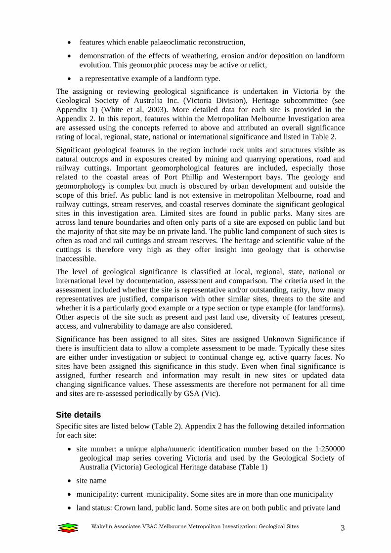
Basalt columns at The Organ Pipes National Park: a site of State significance ML 016
(Photo: Bernie Joyce)
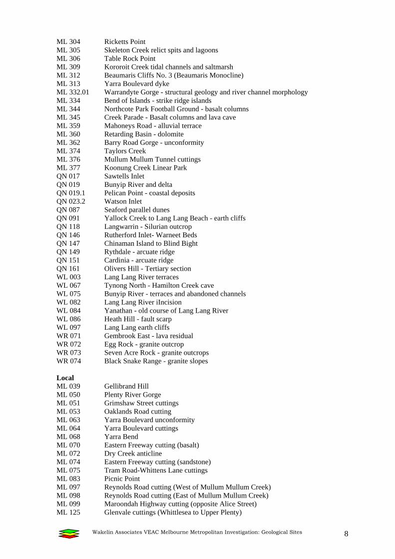
Southern railway cutting, Royal Park:a site of Regional significance ML 069 (Photo: Susan White)

Wakelin Associates VEAC Melbourne Metropolitan Investigation: Geological Sites 2
Introduction The significant geological and geomorphological sites of the Metropolitan Melbourne Investigation area display characteristics of the Cainozoic history as well as the earlier Mesozoic or Palaeozoic geology and show a wide variety of geological site type.
Many localities display geological and landform features of interest for educational, research or conservation purposes. Geological sites display features developed over geological time, such as an outcrop with sediments or fossils. As well, many geomorphological sites are important for displaying active land forming processes, such as stream erosion and deposition. Some sites show rare or unusual minerals, fossils or landforms. The size and nature of such features varies widely and includes natural outcrops, exposures in road and railway cuttings, quarries or other excavated sites and important landforms. Sites are rated according to a defined scale of significance.
In total there are 153 sites of geological or geomorphological significance described for this investigation area. Two sites are of International and three of National significance. Eight sites are of State significance while the remaining list comprises those of Regional or Local geological heritage value.
Significance Assessment Three overlapping concepts, outstanding, rare and representative, are used when selecting sites and assessing their level of significance. Significance is often ascribed to features because they are outstanding in some way. However, recognition of only outstanding or rare sites is insufficient to identify all significant elements of the geological landscape and recognition of representative places complements and balances such perception. Representative sites are examples of features typical of a region; outstanding sites are excellent examples of a feature, either in the region or on a wider scale; and rarity is based on the degree of replication of a feature, the extreme case being a feature that is unique. A geographic scale enables comparison of the significance of sites, for example, is the site of local, regional, state, national or international significance. These ratings may be used in combination; for example a representative feature for a region may also be an outstanding or rare example on a state or national level. Significance ratings contain a degree of subjectivity for they are in part determined by the existing data about the site as well as the level of knowledge of the assessors of similar sites elsewhere. It is important to note that geological, including geomorphological, significance may not relate to the aesthetics of a landscape. Some sites of very high significance may not be at all aesthetic, e.g. quarry faces or road cuttings whereas aesthetically pleasing views may not always be assigned a high geological significance (White et al, 2003).
Geological sites possess at least one of the following attributes to be considered for assessment on their significance:
• a type section of a geological unit,
• a fossil locality,
• exposures of a range of features characteristic of the rock unit, or exposures of features which are unusual in the rock unit, or demonstrates relationships between rock units,
• an unusual occurrence of a particular feature or mineral,
• an illustration of tectonic and/or volcanic processes,
Wakelin Associates VEAC Melbourne Metropolitan Investigation: Geological Sites 3
• features which enable palaeoclimatic reconstruction,
• demonstration of the effects of weathering, erosion and/or deposition on landform evolution. This geomorphic process may be active or relict,
• a representative example of a landform type.
The assigning or reviewing geological significance is undertaken in Victoria by the Geological Society of Australia Inc. (Victoria Division), Heritage subcommittee (see Appendix 1) (White et al, 2003). More detailed data for each site is provided in the Appendix 2. In this report, features within the Metropolitan Melbourne Investigation area are assessed using the concepts referred to above and attributed an overall significance rating of local, regional, state, national or international significance and listed in Table 2.
Significant geological features in the region include rock units and structures visible as natural outcrops and in exposures created by mining and quarrying operations, road and railway cuttings. Important geomorphological features are included, especially those related to the coastal areas of Port Phillip and Westernport bays. The geology and geomorphology is complex but much is obscured by urban development and outside the scope of this brief. As public land is not extensive in metropolitan Melbourne, road and railway cuttings, stream reserves, and coastal reserves dominate the significant geological sites in this investigation area. Limited sites are found in public parks. Many sites are across land tenure boundaries and often only parts of a site are exposed on public land but the majority of that site may be on private land. The public land component of such sites is often as road and rail cuttings and stream reserves. The heritage and scientific value of the cuttings is therefore very high as they offer insight into geology that is otherwise inaccessible.
The level of geological significance is classified at local, regional, state, national or international level by documentation, assessment and comparison. The criteria used in the assessment included whether the site is representative and/or outstanding, rarity, how many representatives are justified, comparison with other similar sites, threats to the site and whether it is a particularly good example or a type section or type example (for landforms). Other aspects of the site such as present and past land use, diversity of features present, access, and vulnerability to damage are also considered.
Significance has been assigned to all sites. Sites are assigned Unknown Significance if there is insufficient data to allow a complete assessment to be made. Typically these sites are either under investigation or subject to continual change eg. active quarry faces. No sites have been assigned this significance in this study. Even when final significance is assigned, further research and information may result in new sites or updated data changing significance values. These assessments are therefore not permanent for all time and sites are re-assessed periodically by GSA (Vic).
Site details Specific sites are listed below (Table 2). Appendix 2 has the following detailed information for each site:
• site number: a unique alpha/numeric identification number based on the 1:250000 geological map series covering Victoria and used by the Geological Society of Australia (Victoria) Geological Heritage database (Table 1)
• site name
• municipality: current municipality. Some sites are in more than one municipality
• land status: Crown land, public land. Some sites are on both public and private land

Wakelin Associates VEAC Melbourne Metropolitan Investigation: Geological Sites 4
• site significance: International, National, State, Regional and Local
• general location: Melbourne suburb or nearest town/village
• map data and detailed location: 1:250,000, map zone (55) and GPS location in AGD94 projection
• land use: very general statement if known e.g. stream reserve
• site scale: Large (>500m length/25ha area), medium (100-500m/1-25ha) small (<100m/1ha)
• site description: short description of geology
• significance statement: reasons for significance
• management statement: suggestions for management actions and requirements for International, National, and State significance sites only
• list of references: detailed references in reference list at end of this report.
Sites of geological and geomorphological significance have been identified and described from literature and personal contacts with earth science professionals and field checked where necessary.
However a list such as this will always be incomplete. Extra sites are added as they become known. As this assessment is for public land only, if land is acquired or sold the list will need updating. Nevertheless it represents the known sites of geological and geomorphological significance in the Melbourne area at this time.
Although a few important sites are just outside the borders of the investigation area, they have not been incorporated into the list. This includes the Internationally significant Westernport Tidal Watershed (QN 173), which is off shore and is not specifically in the investigation area.
Sites are identified using the alpha/numeric identification numbers based on the 1:250000 geological map series covering Victoria and used by the Geological Society of Australia (Victoria) Geological Heritage database. The site identification number is associated with the relevant map sheet: ML Melbourne; QN Queenscliff, WL Warragul and a small part of WR Warburton (Table 1).
Table 1: Relationships between map sheets. This table indicates the relative positions of the 1:250 000 sheet areas, which made up this study. The investigation area does not cover the entire area of these map sheets.
MELBOURNE ML
WARBURTON WR
QUEENSCLIFF QN
WARRAGUL WL
A total of 153 sites of geological significance are identified in the investigation area, where at least part of the site is on public land. The bulk of these sites are of either Regional or Local significance but a thirteen sites are of International, National or State significance. Many of these sites have been known for some years from Joyce & King (1980) and several studies by Rosengren (1983; 1984a,b; 1986; 1988; 1993) but a few new sites have

Wakelin Associates VEAC Melbourne Metropolitan Investigation: Geological Sites 5
been identified during this study. A number of the sites, even though known, have not previously been subjected to the GSA assessment process.
International significance In this study only two sites of International significance have been identified: ML 310 and ML 311, the Beaumaris Cliffs Tertiary fossil sites No. 1 (Keefers) and No. 2 (Yacht Squadron) respectively. These sites are comparable with examples known internationally and are type examples widely known as reference sites by the international geological community. Over forty such sites have been identified in Victoria. These important reference and type location sites have serious management problems, which have not been addressed even though the issues have been raised with relevant state and municipal government authorities in the past. Continued inadequate management a resulting in the degradation of such sites is a poor advertisement for the value placed on geological heritage. Management suggestions are made in the spreadsheet and in the section below on management of geological sites. These sites should be nominated for inclusion on the Federal Government’s National Heritage List with some urgency.
National significance Three sites of National significance have been identified on public land. These are the Taylor’s Creek silcrete cave (ML 190), Dry Creek-Maribyrnong River junction Quaternary fossil site (ML 011) and the Yallock Creek swamp sediments (QN 152). Nationally significant sites are those which show features that are rare in Australia or are important nationally by virtue of their scale or state of preservation. They are widely used as reference sites by the Australian geological community, and they should be included in a national register of sites of scientific significance. Seventy sites of national significance have been identified in Victoria. The silcrete cave is an example of an extremely unusual cave formation and is vulnerable to damage. Similar to the Beaumaris sites (described above), degradation of this site is a serious problem and no attempt has been made to mitigate the problems. Assistance from the speleological community could be sought (Victorian Speleological Association and Australian Speleological Federation) and Parks Victoria has a Cave and Karst Advisory Group.
At the Dry Creek-Marybyrnong River fossil site (ML 011), the stream banks and quarries expose a sequence through Silurian sediments, Tertiary sediments and both Older and Newer Volcanics. The valleys contain two main terraces which contain significant archaeological material. A number of detailed studies have been carried out at the fossil site, contributing to the understanding of the regional Pleistocene prehistory and palaeoclimates. The site is now degraded by gullying, bank instability and weed invasion.
The Yallock Creek swamp sediments (QN 152) are one of Australia’s great swamp landscapes. They do not appear to be specifically threatened at the moment, as access is not easy. However coastal protection works and infrastructure should not damage this site. These sites should be nominated for inclusion on the Federal Government’s National Heritage List. Management suggestions are provided in the relevant section below.
State significance
Eight sites of State significance have been identified. These sites are important in defining the geology and geomorphology of Victoria. These range from type sections of lithologies restricted to Victoria e.g. sedimentary sequences (Werribee River cliffs - floodplain sediments ML 375), major tectonic features (Athlone - Lang Lang River Knickpoint WL 088), Cainozoic volcanic sites (The Organ Pipes ML 016, and Williamstown lava blister ML 308), Cainozoic climatic and hydrological sites (Green Gully ML 012) at Keilor and complex modern coastal sites such as Altona Meadows active sand spits (ML 249), Lyall

Wakelin Associates VEAC Melbourne Metropolitan Investigation: Geological Sites 6
Inlet to Bunyip River (QN19.2), Quail Island and Watson Inlet Area (QN 023), where the modern processes are active. Management suggestions are made in the spreadsheet an in the section below on management of geological sites.
Regional and Local significance Seventy-three sites of Regional significance are identified. These sites include landforms or geological features representative of the Melbourne region and include several examples of the alluvial terraces along various urban creeks or streams.
Sixty-seven sites of Local significance are listed. These are features representative of smaller areas in a region and although these are not of high significance, they can be locally important for educational and scientific purposes. As such they should not be regarded as unimportant because other more highly significant features exist. Specific management suggestions are not made for these sites of lower heritage value but general comments made below for site management are equally applicable.
Management of sites Management of geological sites needs careful consideration especially with regard to the role of vegetation, especially revegetation and slope or coastal stabilisation works. More detailed information is available from the Geological Society of Australia (Vic) website <http://www.vic.gsa.org.au/Heritage/Management.htm>. Although many features are robust they require sympathetic management, especially in metropolitan areas where sites are often destroyed or obscured by urbanization. Rock faces in cuttings and quarries that have long provided valuable exposures are increasingly being obscured by plantings or destroyed altogether in accompanying landscaping and facility provision such as car parking. Landforms that have been identified as geologically significant are being concealed beneath a mantle of trees and shrubs. In some parks the very features that were cited as reasons for creating the reserve are now scarcely visible. With careful planning it should be possible to enhance the biological, aesthetic and safety values at geologically significant sites without compromising the geological values.
The following general principles are suggested for management of sites of geological significance.
Sites that have been identified as geologically significant should be managed in such a way that those features that contribute to its geological value are retained or enhanced and not obscured, damaged or destroyed. Within the boundaries of a large site, the components that have special value may not be distributed uniformly so that practices that are acceptable or desirable in one part may not be in another part.
Where sites have a range of heritage values, then conservation should be based on respecting all the differing values of the place without unwarranted emphasis on any one aspect at the expense of others.
Revegetation and associated land rehabilitation operations that adversely impact on geological values should only be undertaken for essential purposes where no other alternative strategy is available. Revegetation Guidelines are available from the GSA (Vic) website < http://www.vic.gsa.org.au/Heritage/Management.htm>.
Several of the highly significant sites listed in this report are in urgent need of appropriate management. Both the Internationally significant sites and two of the three Nationally significant sites are currently under serious threat of degradation and destruction. Although the State significant sites are not as threatened they also are generally in need of more appropriate management.

Wakelin Associates VEAC Melbourne Metropolitan Investigation: Geological Sites 7
Table 2 List of sites of geological and geomorphological significance
International ML 310 Beaumaris Cliffs Tertiary fossil site No. 1 (Keefers) ML 311 Beaumaris Cliffs Tertiary fossil site No. 2 (Yacht Squadron) National ML 011 Dry Creek-Maribyrnong River junction Quaternary fossil site ML 190 Taylors Creek silcrete cave QN 152 Yallock Creek Swamp Sediments State ML 012 Green Gully (Taylors Creek) ML 016 Organ Pipes (The) ML 249 Altona Meadows active sand spits ML 308 Williamstown lava blister ML 375 Werribee River cliffs - floodplain sediments (Provisional) QN 019.2 Lyall Inlet to Bunyip River QN 023 Quail Island and Watson Inlet Area WL 088 Athlone - Lang Lang River Knickpoint Regional ML 018 Breakneck Hill cutting No. 1 ML 019 Breakneck Hill cutting No. 2 ML 036 Djerriwarrh Creek (Western Highway cuttings) ML 042 Royal Park Railway Station cutting ML 052 Studley Park Pumping Station track cuttings ML 055 Dights Falls ML 055.01 Merri Creek/Yarra River confluence and digitate delta. ML 069 Southern railway cutting, Royal Park ML 078 Victoria Street cuttings ML 081 Newmans Road-Porter Street cuttings ML 088 Somerton tuff outcrop ML 129 Bulla kaolin pit No.2 ML 130 Wellington Road cutting ML 142 Rockbeare Park ML 167 Werribee River delta sediments ML 168 Altona sand ridges ML 169 Williamstown foreshore ML 170 Red Bluff ML 171 Black Rock Point ML 213 Plenty Road cutting (Newer Volcanics) ML 214 Coburg Lake Reserve (basalt outcrop) ML 215 Coburg Lake Reserve (eastern bank) ML 216 De Chene Reserve (tessellated pavement) ML 217 De Chene Reserve (quarry) - lava flow features. ML 223 Maribyrnong River terraces ML 233 Exford cutting ML 236 Jacksons Creek (Ordovician and Newer Volcanics) ML 246 Altona East sand bars ML 247 Point Cook coastal ridges ML 248 Point Cook parallel sand ridges ML 259 Sunbury Municipal Tip (basalt sediment contact) ML 262 Tea Gardens (Newer Volcanics) ML 268 Werribee River prior stream ML 272 Merrett Rifle Range shore platform
Wakelin Associates VEAC Melbourne Metropolitan Investigation: Geological Sites 8
ML 304 Ricketts Point ML 305 Skeleton Creek relict spits and lagoons ML 306 Table Rock Point ML 309 Kororoit Creek tidal channels and saltmarsh ML 312 Beaumaris Cliffs No. 3 (Beaumaris Monocline) ML 313 Yarra Boulevard dyke ML 332.01 Warrandyte Gorge - structural geology and river channel morphology ML 334 Bend of Islands - strike ridge islands ML 344 Northcote Park Football Ground - basalt columns ML 345 Creek Parade - Basalt columns and lava cave ML 359 Mahoneys Road - alluvial terrace ML 360 Retarding Basin - dolomite ML 362 Barry Road Gorge - unconformity ML 374 Taylors Creek ML 376 Mullum Mullum Tunnel cuttings ML 377 Koonung Creek Linear Park QN 017 Sawtells Inlet QN 019 Bunyip River and delta QN 019.1 Pelican Point - coastal deposits QN 023.2 Watson Inlet QN 087 Seaford parallel dunes QN 091 Yallock Creek to Lang Lang Beach - earth cliffs QN 118 Langwarrin - Silurian outcrop QN 146 Rutherford Inlet- Warneet Beds QN 147 Chinaman Island to Blind Bight QN 149 Rythdale - arcuate ridge QN 151 Cardinia - arcuate ridge QN 161 Olivers Hill - Tertiary section WL 003 Lang Lang River terraces WL 067 Tynong North - Hamilton Creek cave WL 075 Bunyip River - terraces and abandoned channels WL 082 Lang Lang River iIncision WL 084 Yanathan - old course of Lang Lang River WL 086 Heath Hill - fault scarp WL 097 Lang Lang earth cliffs WR 071 Gembrook East - lava residual WR 072 Egg Rock - granite outcrop WR 073 Seven Acre Rock - granite outcrops WR 074 Black Snake Range - granite slopes Local ML 039 Gellibrand Hill ML 050 Plenty River Gorge ML 051 Grimshaw Street cuttings ML 053 Oaklands Road cutting ML 063 Yarra Boulevard unconformity ML 064 Yarra Boulevard cuttings ML 068 Yarra Bend ML 070 Eastern Freeway cutting (basalt) ML 072 Dry Creek anticline ML 074 Eastern Freeway cutting (sandstone) ML 075 Tram Road-Whittens Lane cuttings ML 083 Picnic Point ML 097 Reynolds Road cutting (West of Mullum Mullum Creek) ML 098 Reynolds Road cutting (East of Mullum Mullum Creek) ML 099 Maroondah Highway cutting (opposite Alice Street) ML 125 Glenvale cuttings (Whittlesea to Upper Plenty)

Wakelin Associates VEAC Melbourne Metropolitan Investigation: Geological Sites 9
ML 127 Wellington Road cutting ML 133 Elizabeth Street cuttings ML 165 Bulla Adamellite (Somerton Road) ML 172 Bridge Inn Road cutting ML 176 Hunters Lane cutting ML 182 Radio Tower Hill ML 211 McArthurs Road cutting ML 212 Plenty Road cutting (Red Bluff Sand) ML 232 Essendon West Tertiary sediment ML 250 Kororoit Creek floodplain ML 255 Skeleton Creek consequent stream (Altona) ML 257 Steele Creek terrace floodplain ML 263 Werribee River terraces ML 265 Werribee River knickpoint No. 1 ML 266 Taylors Creek (Newport Formation) ML 271 Sydenham Park Silurian and Tertiary sediments ML 284 Altona shore platform ML 286 Andersons Swamp (Lake Stanley) ML 292 Deep Creek Wildwood outcrops ML 296 Kororoit Creek incised valley ML 298 Kororoit Creek valley (St Albans) ML 299 Kororoit Creek waterhole (Deer Park) ML 300 Kororoit Creek valley (Altona North) ML 302 Kororoit Creek escarpments ML 335 Homestead Road Bend - lateral rock bars ML 336 Entrance to Warrandyte Gorge ML 343.01 Yarra Bend Park - radial basalt columns ML 343.02 Quarries Park - ropy lava ML 346 Rushall Station - basalt structures ML 347 Sumner Park - Silurian/basalt unconformity ML 348 Capp Reserve - Melbourne Formation ML 349 Tate Reserve - former creek course ML 350 Kendall and Harding Streets - Melbourne Formation and terrace ML 351 Edgars Creek terrace and meanders ML 352 Edgars Creek - waterfall and geological structure ML 353 Kodak - Cliff of Melbourne Formation ML 354 Edgars Creek - dolomite nodules ML 355 Coburg Lake - basalt structures and unconformity ML 356 Coburg Lake - alluvial terrace ML 357 Carr Street - Weathered Silurian ML 358 Moomba Park Reserve - basalt escarpment ML 361 Retarding Basin - alluvial basin ML 368 Wallan - Woodstock Road cuttings - Humevale Formation (1) ML 369 Wallan - Woodstock Road cuttings - Humevale Formation (2) QN 110 Upper Beaconsfield - Split Rock QN 113 Pakenham - Toomuc Creek incision QN 115 Cardinia Park - stream incision WL 068 Cannibal Creek - impeded drainage WL 069 Cannibal Hill - Tynong Granite WL 074 Bunyip River - terraces WL 080 Koo-Wee-Rup - Main Drain

Wakelin Associates VEAC Melbourne Metropolitan Investigation: Geological Sites 10
References Abele, C. 1976. ‘Tertiary - Central coastal basins.' In J.G. Douglas & J.A. Ferguson (eds) Geology of Victoria. Geological Society of Australia, Special Publication 5. Anderson, J.R. 1972. The Quaternary geology and sedimentology of the Gallus sites at Keilor, Victoria. BSc (Hons) thesis, University of Melbourne (unpubl.). Anon. 1891. Notes in reference to views showing occurrences of Silurian rocks. Reports and Statistics of the Mining Department for the Quarter Ended March 1891, Department of Mines, Victoria. Bell, G., Bowen, K.G., Douglas, J.G., Hancock, J.S., Jenkin, J.J., Kenley, P.R., Knight, J.L., Neilson, J.L., Spencer-Jones, D., Talent, J.A., Thomas, D.E. & Whiting, R.G. 1967. ‘Geology of the Melbourne District, Victoria.’ Geological Survey of Victoria Bulletin 59. Birch, W.D. 1994. Volcanoes in Victoria. Royal Society of Victoria, Melbourne. Bird, E.C.F. 1972. ‘Beach systems on the Melbourne coast.’ Geography Teacher 10: 59-72. Bird, E.C.F., Cullen, P.W. & Rosengren, N.J. 1973. ‘Conservation problems at Black Rock Point.’ Victorian Naturalist 90 (9): 240-247. Bird, E.C.F & Barson, M.M. 1975 ‘Shoreline changes in Westernport Bay Proceedings of the Royal Society of Victoria’. 87 (1): 15-28. Bird, J.F. ‘Geomorphological implications of flood control measures, Lang Lang River, Victoria’. Australian Geographical. Studies. 18 (2): 169-183. Bowler, J.M. 1966. ‘Port Phillip Survey 1957-1963: Geology and geomorphology.’ Memoirs of the National Museum of Victoria 27: 19-67. Bowler, J.M. 1970. ‘Alluvial terraces in the Maribyrnong valley near Keilor, Victoria’. Memoirs of the National Museum of Victoria 30: 15-59. Cass, M.R. 1973. The geology of the Tyabb and Koo-Wee-Rup sections of the Targo-Westernport pipeline. B.Sc. (Hons.) thesis, Geol. Dept., Univ. of Melb. (unpubl.). Chapman, F. & Cudmore, F.A. 1924. ‘New or little known fossils in the National Museum.’ Proceedings of the Royal Society of Victoria 36: 107-162. Cochrane, R.M. & Tan, S.H. 1993. ‘An assessment of geological sites of national Estate Significance in the Central Highlands of Victoria.’ Unpublished report for LCC. Condon, M.A. 1951. ‘The geology of the lower Werribee River.’ Proceedings of the Royal Society of Victoria 63: 1-24. Cooney, A.M. & King, R.L. 1988. ‘Geology and geological features of the Yarra Bend/Studley Park Reserve.’ Geological Survey of Victoria Unpublished Report 1988/44. Crawford, W. 1939. ‘The physiography of the Gisborne Highlands.’ Proceedings of the Royal Society of Victoria 52: 262-279. Cudmore, F.A. 1926. ‘Extinct vertebrates from Beaumaris.’ Victorian Naturalist 43(3):78-82. Cullen, P. (1973). Coastal conservation problems at Seaford. Victorian Naturalist. 50: 251-257. Davey, A.G. & White, S. 1986. ‘Victorian caves and karst: strategies for management and catalogue.’ Report to the Caves Classification Committee, Department of Conservation, Forests & Lands. Education Department Victoria 1985. Field Sites, Melbourne, Excursion Guide to Victorian Geology. Edwards, A.B. 1940. ‘A note on the physiography of the Woori Yallock Basin’. Proceedings of the Royal Society of Victoria. 52 (1): 336-341.

Wakelin Associates VEAC Melbourne Metropolitan Investigation: Geological Sites 11
Faul, D.J., Bader, K. & King, R.L. 1994. ‘An outcrop containing tuff in Merri Creek, Somerton, Melbourne.’ Geological Survey of Victoria, Unpublished Report 1994. Finlayson, B.L., 1981. ‘Underground Streams on Acid Igneous Rocks in Victoria’ Helictite 19(1): 5-14 Gallus, A. 1976. ‘The middle and early Upper Pleistocene stone industries at the Dry Creek archaeological site near Keilor, Australia.’ The Artefact 1(2). Gell, R.A. , 1974. Shore development in the Lang Lang area. B.Sc Hons. thesis (unpub). Dept. of Geog., Univ. of Melb. Geological Survey Victoria, 1959, Melbourne and Suburbs, Australia (map) 1:361,680. Gill, E.D. 1950a. ‘Geology of Picnic Point.’ Proceedings of the Royal Society of Victoria 62: 121-127. Gill, E.D. 1950b. ‘Nomenclature of certain Tertiary sediments near Melbourne, Victoria.’ Proceedings of the Royal Society of Victoria 62: 165-171. Gill, E.D. 1957. ‘The stratigraphical occurrence and palaeoecology of some Australian Tertiary marsupials.’ Memoirs of the National Museum of Victoria 21. Gill, E.D. 1973. ‘Quaternary sediments of the Maribyrnong River, Keilor.’ In J. McAndrew & M.A.H. Marsden (eds) Regional guide to Victorian Geology (2nd edition). School of Geology, University of Melbourne; 31-32. Hall, T.S. & Pritchard, G.B. 1897a. ‘A contribution to our knowledge of the Tertiaries in the neighbourhood of Melbourne.’ Proceedings of the Royal Society of Victoria 9: 187-229. Hall, T.S. & Pritchard, G.B. 1897b. ‘Note on a tooth of Palorchestes from Beaumaris.’ Proceedings of the Royal Society of Victoria 10: 57-59. Hanks, W. 1934, The Tertiary sands and Older Basalt of Coburg, Pascoe Vale and Campbellfield, Victoria. Proceedings of the Royal Society of Victoria, 46 Part II: 144-150. Hart, T.S. 1893. ‘Notes on rocks of Brighton and Moorabbin and surrounding districts.’ Victorian Naturalist 9: 156-159. Hauser, H.B. 1923. ‘The Geology of Studley Park.’ Proceedings of the Pan Pacific Science Congress, Australia 2: 1648-1654. Hills, E.S. 1940a. ‘A question of Recent emergence of the shores of Port Phillip Bay.’ Proceedings of the Royal Society of Victoria 52: 84-102. Hills, E.S. 1941. ‘The Silurian rocks of the Studley Park district.’ Proceedings of the Royal Society of Victoria 53(1):167-191. Hills, E.S. 1975. Physiography of Victoria (5th edition). 372 pp. Whitcombe & Tombs, Australia. Hobbs, B.E. 1988. ‘Melbourne - eastern suburbs’. In I. Clark & B. Cook (eds) Victorian geology excursion guide. Australian Academy of Science, Canberra: 387-399. James, A.V.G. 1920. ‘The physiography and geology of the Bulla - Sydenham area’. Proceedings of the Royal Society of Victoria 32(2): 323-349. Jenkin, J.J. 1962. ‘The geology and hydrogeology of the Westernport area’. Dept. of Mines, Vict. Underground Water Investigation Report. No. 5. Jenkin, J.J. 1970. ‘Geological history of the West Gippsland Region’. Proceedings of the Royal Society of Victoria 84 (1): 19-28. Jenkin, J.J. 1976. Quaternary. In J.G. Douglas & J.A. Ferguson (eds) Geology of Victoria. Geological Society of Australia Special Publication 5: 305-309. Jenkin, J.J., Lawrence, C.R., Kenley, P.R., Gill, E.D., Macumber, P.G. & Neilson, J.L. 1988. Chapter 9: Quaternary. In J.G. Douglas & J.A. Ferguson (eds) Geology of Victoria. Geological Society of Australia (Victoria Division): 351-402.

Wakelin Associates VEAC Melbourne Metropolitan Investigation: Geological Sites 12
Jones, O.A. 1927. ‘Silurian graptolites from Studley Park, Melbourne, Australia’. Geological Magazine 44(3): 101-105. Joshi, M.S. & Atkinson, P.L. 1988. ‘Bulla - Toolern Vale - Gisborne – Greenvale’. In I. Clark & B. Cook (eds) Victorian geology excursion guide. Australian Academy of Science, Canberra: 413-432. Joyce, E.B. & Anderson, R.S. 1976. ‘Late Quaternary geology and environment at the Dry Creek archaeological site near Keilor in Victoria, Australia’. The Artefact 1(2): 47-74. Joyce, E.B. & King, R.L. 1980. Geological Features of the National Estate in Victoria, 208 pp. Geological Society of Australia, Victoria Division, Melbourne. Joyce, E.B. 1983. ‘Sub-basaltic silcrete at Keilor’. Abstracts of the Institute of Australian Geographers, 18th Conference: 49. Joyce, E.B., Webb, J.A. & Tidey, A. 1983. ‘Silcrete in south central Victoria’. Bureau of Mineral Resources Geology & Geophysics Record 1983/27: 82-87. Jutson, J.T. 1909. ‘Physical history of the Plenty River’. Proceedings of the Royal Society of Victoria 22(2): 153-171. Jutson, J.T. 1931. ‘Erosion and sedimentation in Port Phillip Bay, Victoria.’ Proceedings of the Royal Society of Victoria 43: 164-174. Keble, R.A. (1918). ‘The significance of lava residuals in the development of Western Port and Port Phillip drainage systems’. Proceedings of the Royal Society of Victoria 31(1): 124-165. Kenley, P.R. 1967. ‘Tertiary.’ In Geology of the Melbourne district, Victoria. Geological Survey of Victoria Bulletin 59: 34-46. Key, L.M. (1967). Historical geography of the Kooweerup district. M.A. thesis (unpub.) Dept. of Geog. Univ. of Melb. (unpubl.). King, R.L., Cochrane, R.M. & Cooney, A.M. 1987. ‘Significant geological features along the coast in the City of Sandringham.’ Geological Survey of Victoria Unpublished Report 1987/35. Land Conservation Council, Victoria 1993. ‘Marine and Coastal Special Investigation Descriptive Report’. Land Conservation Council, 1993. Lawrence, C.R., Abele, C., Gloe, C.S., Hocking, J.B., Holdgate, G., Kenley, P.R. & Ripper, D. 1976. ‘Tertiary’. In J.G. Douglas & J.A. Ferguson (eds) Geology of Victoria. Geological Society of Australia Special Publication 5:177-274. Marsden, M.A.H. and Mallett, C.W. (1975). ‘Quaternary evolution, morphology and sediment distribution, Westernport Bay, Victoria’. Proceedings of the Royal Society of Victoria. 87 (1): 107-137. McDougall, I., Allsopp, H.L. & Chamaleun, F.H. 1966. ‘Isotopic dating of the Newer Volcanics of Victoria, and geomagnetic polarity epochs.’ Journal of Geophysical Research 71(24): 6107-6118. McDougall, K.L. 1986. Sites of botanical significance in the western region of Melbourne.’ Dept. Conservation, Forests & Lands, and Melbourne Western Region Commission Inc., Melbourne. Miles, I.W. (1976). The morphology of northern Westernport Bay. M.Sc. thesis (unpubl.) Dept. of Geog. Univ. of Melb. Mitchell, M.M., Cochrane, R.M. & King, R.L. 2000. Sites of geological significance in the Melbourne 1:250 000 mapsheet area. Geological Survey of Victoria Technical Record 2000/1. 184 p.

Wakelin Associates VEAC Melbourne Metropolitan Investigation: Geological Sites 13
Price, R.C., Gray, C.M. & Frey, F.A. 1997. ‘Strontium isotopic and trace element heterogeneity in the plains basalts of the Newer Volcanics Province, Victoria, Australia.’ Geochimica et Cosmochimica Acta 61(1): 171-192. Price, R.C., Gray, C.M., Nicholls, I.A. & Day, A. 1988. Cainozoic Volcanic rocks. In J.G. Douglas & J.A. Ferguson (eds) Geology of Victoria. Geological Society of Australia (Victoria Division): 439-452. Pritchard, G.B. 1974. ‘Geology of Royal Park.’ Victorian Naturalist 91(8): 223-235. Pritchard, G.B. 1976. ‘Geology of the Sandringham - Beaumaris coastline.’ Victorian Naturalist 93(1): pp. 4-20. Rosengren, N. 1993. The Merri Creek: Sites of Geological and Geomorphological Significance. Report prepared for Merri Creek Management Committee Inc. Rosengren, N., Frood, D. & Lowe, K. 1983. Sites of Geological, Geomorphological, Botanical and Zoological Significance in the Flood Plain of the Upper Yarra River. Unpub. Report prepared for the Upper Yarra Valley and Dandenong Ranges Authority. Rosengren, N.J. 1984a. ‘Sites of geological and geomorphological significance in the catchment of the Gippsland Lakes.’ Environmental Studies Series 402. Dept of Conservation, Forests and Lands, Victoria. Rosengren, N.J. 1986. ‘Sites of geological and geomorphological significance in the western region of Melbourne.’ Dept of Conservation, Forests & Lands, Victoria. Rosengren, N.J. 1988. ‘Sites of geological and geomorphological significance around Port Phillip Bay.’ Department for Planning and Environment. Rosengren, Neville. 1984b. ‘Sites of geological and Geomorphological Significance in the Westernport Bay Catchment.’ Environmental Studies Series No. 401, Ministry for Conservation, Victoria. Schleiger, N.W. 1988. ‘Coburg.’ In I. Clark & B. Cook (eds) Victorian geology excursion guide. Australian Academy of Science, Canberra: 475-484. Simpson, G.G. 1970. ‘Miocene penguins from Victoria, Australia, and Chubut, Argentina.’ Memoirs of the National Museum of Victoria 31: 17-23. Singleton, F.A. 1923. ‘The geology of Royal Park.’ Proceedings of the Pan Pacific Science Congress, Australia 1923, Melbourne Handbook: 93-96. Singleton, F.A. 1941. ‘The Tertiary geology of Australia.’ Proceedings of the Royal Society of Victoria 53: 1-125. Singleton, O.P. 1973. ‘Geology of the Bacchus Marsh district.’ In J. McAndrew & M.A.H. Marsden (eds) Regional guide to Victorian geology (2nd edition). School of Geology, University of Melbourne: 59-64. Spencer-Jones, D., Marsden, M.A.H., Barton, C.M. & Carrillo-Rivera, J.J. (1975). “Geology of the Westernport sunkland”. Proceedings of the Royal Society of Victoria. 87 (1&2): 43-68 Stillwell, F.L. 1911. ‘Notes on the geology of Broadmeadows.’ Proceedings of the Royal Society of Victoria 24: 156-178. Talent, J.A. 1967. ‘Sedimentary Petrology and Palaeontology.’ In Geology of the Melbourne District, Victoria. Geological Survey Bulletin 59: 24-30. Thompson, B. R. 1974. The geology and hydrology of the Western Port sunklands. Geol. Surv. Rept. 1974/1 VandenBerg, A.H.M. 1971. ‘Explanatory notes on the Ringwood 1:63, 360 geological map.’ Geological Survey of Victoria Unpublished Report 1971/1.

Wakelin Associates VEAC Melbourne Metropolitan Investigation: Geological Sites 14
VandenBerg, A.H.M. 1973. Geology of the Melbourne district. In J. McAndrew & M.A.H. Marsden (eds) Regional guide to Victorian geology (2nd edition). School of Geology, University of Melbourne: 14-30. Webb, J.A. & Joyce, E.B. 1983. ‘Taylor Creek silcrete cave.’ Helictite 21(1): 25-32. Webb, J.A. 1988. ‘Studley Park and Royal Park.’ In I. Clark & B. Cook (eds) Victorian geology excursion guide. Australian Academy of Science, Canberra. Whincup, S. (1944). Superficial sand deposits between Brighton and Frankston. Proceedings of the Royal Society of Victoria 56, 53-76. White, A.J.R. 1988. Mernda. In I. Clark & B. Cook (eds) Victorian geology excursion guide. Australian Academy of Science, Canberra, pp.433-442. White, S., King, R. L., Mitchell, M. M., Joyce, E. B., Cochrane, R. M., Rosengren N. J. & Grimes, K. G. 2003 ‘Conservation and heritage registering sites of significance’ In: Birch W.D.(ed). 2003 Geology of Victoria Geological Society of Australia Special Publication 23. Geological Society of Australia (Victoria Division) : 703–711. Wilkinson, H.E. 1969. ‘Description of an upper Miocene albatross from Beaumaris, Victoria, Australia, and a review of fossil Diomedeidae.’ Memoirs of the National Museum of Victoria 29, pp. 41-51. Willis, J.H. 1951. ‘Melbourne's mangroves are dead.’ Victorian Naturalist 67: 205. Woodbourne, M.O. 1969. ‘A lower mandible of Zygomaturis gilli from the Sandringham Sands, Beaumaris.’ Memoirs of the National Museum of Victoria 29: 29-39.

Wakelin Associates VEAC Melbourne Metropolitan Investigation: Geological Sites 15
Appendix 1 GSA Protocol for assigning or reviewing geological significance. Assigning or reviewing geological significance is undertaken in Victoria by the Geological Society of Australia Inc (Victoria Division), Heritage subcommittee. The GSA is a volunteer learned society. The GSA has developed a methodology and protocol for assigning or reviewing geological significance (White et. al 2003), which has been accepted as reliable and repeatable by organizations such as the former Australian Heritage Commission (now Australian Heritage Council).
The following information is reviewed from personal experience, fieldwork, literature review and consultation with other geologists with specific knowledge and expertise. The GSA subcommittee has members with a wide range of geological experience and expertise. Significance rating is achieved by consensus after considerable discussion on the merits of each site. This is particularly the case for sites of International and National significance where an extensive understanding of comparable sites outside Victoria is desirable.
It is important to note that geological, including geomorphological, significance may not necessarily relate to the aesthetics of a landscape. Some sites of very high significance may not be at all aesthetic, e.g quarry faces or road cuttings whereas aesthetically pleasing views may not always be assigned a high geological significance.
Geological sites should possess at least one of the following attributes to be considered for assessment on their significance:
a type section of a geological unit, a fossil locality, exposures of a range of features characteristic of the rock unit, or exposures of
features which are unusual in the rock unit, or demonstrates relationships between rock units,
an unusual occurrence of a particular feature or mineral, an illustration of tectonic and/or volcanic processes, features which enable palaeoclimatic reconstruction, demonstration of the effects of weathering, erosion and/or deposition on
landform evolution. This geomorphic process may be active or relict, a representative example of a landform type.
The criteria for significance is related to whether a site can be regarded as important with regards to it being representative or outstanding. A choice often has to be made between the most outstanding or unusual example and an excellent representative example from a group of very similar ones.
The representative approach (McRae-Williams et al., 1981; King, 1985; Davey & White, 1986; Joyce, 1995) has been found to be the most appropriate in assessing significance but outstanding examples must be considered. Criteria used in such assessment include:
how representative is the feature? how adequately is each type of feature represented over a particular scale? which feature is the most appropriate to represent a particular type? how many representatives are justified? How far would you travel with an interstate or international visitor with an
interest in that type of site? How does it compare with other similar sites - regionally, in the state, in
Australia, internationally? Is it under threat and if so, what is the nature of that threat? How common or rare is the feature? Is it a particularly good example?

Wakelin Associates VEAC Melbourne Metropolitan Investigation: Geological Sites 16
Is it a type section or type example (for landforms).
Other aspects of the site such as present and past land use, diversity of features present, access, and vulnerability to damage are also considered. Features or areas are also described according to size, physical and/or geological type and age.
The level of geological significance is classified at local, regional, state, national or international level by documentation, assessment and comparison. The significance rating assigned to a site is periodically reassessed in the light of new information and/or site condition.
The criteria for classification are:
• International Significance: These sites are landforms, structures, rock formations or fossils which are rare in the world, and/or by the nature of their scale, state of preservation or display, are comparable with examples known internationally. They may be global type examples and are widely known as reference sites by the international geological community. A site could be included in an international register of sites of scientific significance and would rate listing on the Register of the National Estate by the Australian Heritage Commission (now Council). Forty-five features of international significance have been recognised, documented and assessed in Victoria. Tower Hill is an example of an internationally significant site due to the well-preserved evidence of phreatic volcanic processes.
• National Significance: Sites that are rare in Australia or are important nationally by virtue of their scale or state of preservation are assigned national significance. Widely used as reference sites by the Australian geological community, they should be included in a national register of sites of scientific significance and would be considered for listing on the Register of the National Estate by the Australian Heritage Commission (now Council). Seventy sites of national significance have been identified in Victoria. An example is Mount Buffalo.
• State Significance: These sites are important in defining the geology and geomorphology of Victoria and may be reference sites or type examples and would be considered for listing on the Register of the National Estate by the Australian Heritage Council. There are over 200 sites of state significance identified and documented in Victoria. An example is Mount Kororoit, Diggers Rest.
• Regional Significance: These sites include landforms or geological features representative of regions of about 60km radius. An example is the Royal Park railway cuttings in Melbourne.
• Local Significance: These are features representative of smaller areas in a region, eg. the Ovens Valley. Such sites are usually related to an area of a local municipality or an area with a radius of 20km. A typical example is the Stony Creek Road cuttings at Halls Gap where there is a good exposure that shows the relationship of igneous rocks to the main body of the Grampians Group sediments.
• Unknown Significance: Sites are assigned this rating if there is insufficient data to allow a complete assessment to be made. Typically these sites are either under investigation or subject to continual change eg. active quarry faces.

Appendix 2 Geological Sites of Significance in the VEAC Metropolitan Melbourne Investigation Area ID No. Site name Location LGA Sig Size Land use Easting Northing Description Significance statement Management - International /
National / State only References
MELBOURNE ML 011 Dry Creek-
Maribyrnong River junction Quaternary fossil site
Keilor Brimbank NAT M Stream Reserve
309450 5824820 Geological sections along stream banks and in quarries show a sequence through Silurian sediments, Tertiary sediments and both older and Newer Volcanics. The valleys contain 2 main terraces which contain significant archaeological material. The older alluvial material, known as the Arundel Formation (older than ~25,000 years), contains megafauna whilst a human cranium and stone artefact assemblage have been found in the younger Doutta Galla Silt (< 25,000 to 6,000 years). The cranium is dated around 15,000±2,000 years BP using Carbon 14. Significant information on Pleistocene climates has been determined.
A number of detailed studies have been carried out at this site which have made a valuable contribution to the understanding of the regional Pleistocene prehistory and palaeoclimate. The cranium was once the oldest dated human remains in Victoria. The site is now degraded by gullying, bank instability and weed invasion.
The geological sections that are stable (not in danger of collapse or slumping) should be retained. Advice on conservation of significant archaeological features at the site should be obtained. The bank instability, gullying and weed invasion should be addressed.
Anderson 1972; Gill 1973; Gallus 1976; Jenkin 1976; Joyce & Anderson 1976; Jenkin et al. 1988; Mitchell et al 2000; Rosengren 1986
ML 012 Green Gully (Taylors Creek)
Keilor Brimbank State M Other reserve
308800 5822000 The creek is incised through late Cainozoic Newer Volcanics basalt, exposing underlying Tertiary sediments and Older Volcanics basalt. A local disconformity separates the Tertiary bryozoal calcarenite (Batesfordian) from overlying fossiliferous ferruginous sand. Quaternary terraces occur at the junction with the Maribyrnong River. Within the Doutta Galla Silt of the Keilor Terrace, human bones estimated to be 8,000 years BP (Carbon 14) have been found.
Good stratigraphic exposures within a managed park system (Brimbank Park) make this a potentially excellent teaching site. The sedimentology of the Doutta Galla Silt has been well studied and good age control and paleaoclimatic information is available.
The physiographic importance of the terrace sequences has been reduced by the amount of excavation and site disturbance. Advice on conservation of significant archaeological features and their geological setting at the site should be obtained and acted upon.
Bowler 1970; Gill 1973; Lawrence et al. 1976; Jenkin et al. 1988; Mitchell et al 2000
ML 016 Organ Pipes (The) Sydenham Hume / Brimbank
State L National Park, Utilities and Services
303000 5828900 Incision of Jacksons Creek has exposed a variety of features in the late Cainozoic Newer Volcanics which overlie Tertiary sand and gravel, and Palaeozoic bedrock. The Organ Pipes are a spectacular example of columnar jointing which developed as the basalts cooled. The columns are both vertical and inclined and in an adjacent cliff section have formed a rosette. Other volcanic features at this locality include a tessellated pavement, spheroidal weathering and an eroded scoria cone. The volcanics at this site are part of the basaltic icelandite field which extends from Diggers Rest to Williamstown (2.5 - 2.8 Ma).
An excellent example of columnar basalt and other volcanic features exposed in attractive natural surroundings. A good teaching site because of the range of volcanic features, exposure of the local geology and accessibility. The Organ Pipes National Park protects not only the geological features described here, but also the largest and least modified area of volcanic plains grasslands and shrublands to the west of Melbourne.
Regular pruning/removal of vegetation which obscured the geological features is needed. Continued improvement of interpretation material on geological features is desired. Sympathetic management for geological values is needed at the Organ Pipes.
James 1920; Rosengren 1986;Joshi & Atkinson 1988; Birch 1994; Price et al. 1988;1997; Mitchell et al. 2000
ML 018 Breakneck Hill cutting No. 1
Toolern Vale
Melton Reg S Utilities and Services
285500 5839000 The road cutting exposes Upper Ordovician sandstone and mudstone of the Riddell Sandstone. The sandstone shows ripple marks and graded bedding. Black shales and mudstones contain abundant fossils (graptolites). These beds are almost vertical and the sandstones show gash veins which are filled by secondary quartz.
Good example of local geology. Used as an excursion locality.
Joshi & Atkinson 1988; Mitchell et al 2000
ML 019 Breakneck Hill cutting No. 2
Toolern Vale
Melton Reg M Utilities and Services
285400 5839350 At this location a palaeosol developed on Ordovician sediments shows the effects of baking and bleaching by overlying late Cainozoic Newer Volcanics basalt. The basalt shows deep and excellent spheroidal weathering.
Good example of relationships of local rock units and weathering. Used as an excursion locality.
Joshi & Atkinson 1988; Mitchell et al 2000
Wakelin Associates VEAC Melbourne Metropolitan Investigation: Geological Sites 17

Wakelin Associates VEAC Melbourne Metropolitan Investigation: Geological Sites 18
ID No. Site name Location LGA Sig Size Land use Easting Northing Description Significance statement Management - International / National / State only
References
ML 036 Djerriwarrh Creek (Western Highway cuttings)
Melton Melton Reg M Utilities and Services
281000 5826000 Towards the western end of this cutting, folded Ordovician basement is exposed revealing interesting features including numerous faults showing flexure and displacement of bedding. Approximately 30 m from the western end, a shale bed defines a tight anticline with a well-developed divergent cleavage fan. Tension veining also occurs on the limbs of this fold. . The Ordovician sediments are overlain by Tertiary Werribee Formation clay, sand and gravel with carbonate concretions. The thickness of the Tertiary unit is difficult to determine because of weathering but may be up to three metres in some places. Newer Volcanics basaltic lava flows of late Cainozoic age overlie the Tertiary material and form extensive plains to the east. Towards the eastern end of the cutting, a structure that has the appearance of a small reverse fault in the Tertiary has produced a kink in the base of the overlying basalt flow. Pliocene gravel, clay and sand show cross-bedding, and cut and fill structures.
The stratigraphic relationships of the Ordovician, Tertiary and Newer Volcanics are well exposed in this cutting as is the complex folding in the Ordovician sediments. The site was for many years used for teaching purposes, but access to the eastern half of the cutting is now dangerous due to the freeway.
Singleton 1973b; Joyce & King 1980; Rosengren 1986; Schleiger 1995; Mitchell et al 2000
ML 039 Gellibrand Hill Westmeadows
Hume Local M Utilities and Services
312500 5830400 Large tors of Devonian Bulla Adamellite containing a variety of xenoliths occur at the top of Gellibrand Hill. Granite from this area, due to its close proximity to Melbourne, was used in the first Princes Bridge. The nearby homestead, now managed by Parks Victoria, used blocks of adamellite as construction material. Gellibrand Hill is one of the few high points from which the whole district can be viewed. During the eruption of the late Cainozoic Newer Volcanics it remained exposed as an 'island'.
A good example of a common granitic feature.
Stillwell 1911; Rosengren 1986; Joshi & Atkinson 1988; Mitchell et al 2000; Education Department Victoria 1985
ML 042 Royal Park Railway Station cutting
Royal Park Melbourne Reg M Other reserve
319650 5816500 Steeply dipping sandstone and mudstone of the Silurian Dargile Formation are overlain with angular unconformity by coarse grained sandstone of the Tertiary Brighton Group. An iron stained soil with buckshot gravel has developed on the latter unit.
In conjunction with the southern railway cutting (ML 69), this is one of the traditional teaching sites for earth science in Melbourne. At this site the nature and relationship of Palaeozoic and Tertiary sediments in Victoria are clearly displayed.
Singleton 1923; Bell et al. 1967;Talent 1967; Pritchard 1974; Joyce & King 1980; Mitchell et al 2000; Education Department Victoria 1985
ML 050 Plenty River Gorge
Plenty Whittlesea Local L Other reserve
332600 5830500 The gorge on the Plenty River exposes an anticline in Silurian sedimentary rocks and the contact with the overlying Plio-Pleistocene Newer Volcanics basalt.
Good educational site showing structure and relationship of local rock units.
Anon. 1891; Jutson 1909; Joyce & King 1980; Mitchell et al 2000; Education Department Victoria 1985
ML 051 Grimshaw Street cuttings
Greensborough
Banyule Local S Utilities and Services
332000 5825180 On the south side of Grimshaw Street, east of the junction with Greensborough Road, an angular unconformity between Tertiary sands and underlying Silurian bedrock is exposed.
This is an accessible site that displays aspects of the local geology.
Mitchell et al 2000
Wakelin Associates VEAC Melbourne Metropolitan Investigation: Geological Sites 19
ID No. Site name Location LGA Sig Size Land use Easting Northing Description Significance statement Management - International / National / State only
References
ML 052 Studley Park Pumping Station track cuttings
Kew Boroondara Reg M Other reserve
324150 5814310 While the Silurian Dargile Formation (also known as Melbourne Formation) is generally folded into broad open folds, these cuttings reveal a range of geological features in a zone of intense folding and faulting. Features shown include: joints sets that have developed parallel and perpendicular to bedding and are often infilled with limonite (iron oxide and hydroxide) deposited from groundwater moving through the rocks; faults that run parallel to the beds and often truncate bedding, commonly at the axis of folds; drag of beds against fault planes, and fault planes with slickensides that reveal the direction of fault movement; crumpled bedding due to faulting; mudstone that has deformed plastically (incompetent) in comparison to the more rigid (competent) sandstones; asymmetric anticlinal and synclinal folds; fine grained sediments containing fossils such as graptolites, brachiopods, starfish and marine algae; and hillside creep where slow downhill movement of rock and soil has bent the rocks.
This is an excellent series of exposures in a small area with good and safe access. The cuttings allow inspection of typical structural features that affect the Silurian-Devonian sediments of the Melbourne region. These exposures are one of the best examples of these features in the region and form an important part of the classic Studley Park localities. These and nearby localities at Studley Park (e.g. ML 55) have been fundamental for the teaching of elements of structural geology and sedimentology in the Melbourne region for over 100 years.
Hauser 1923; Jones 1927; Hills 1941; Bell et al. 1967; Webb 1988; Mitchell et al 2000; Education Department Victoria 1985
ML 053 Oaklands Road cutting
Oaklands Junction
Hume Local S Utilities and Services
309250 5835500 Contact metamorphosed sediments of Silurian age are exposed in this road cutting. Devonian granitic rocks to the south are responsible for the contact metamorphism.
A road cutting exposing a feature that is common in Victoria.
Mitchell et al 2000; Education Department Victoria 1985
ML 055 Dights Falls Kew Boroondara & Yarra
Reg S Other reserve
323900 5814700 A resistant band of Dargile Formation sandstone of Upper Silurian age has created a small waterfall in the Yarra River. Interbedded sandstone and siltstone outcrop in the embankment with further exposures on the top of the small spur overlooking the falls. On the eastern side of an anticlinal fold, the bedding planes dip to the east at 60 to 65 degrees. Sedimentary features include cross-bedding and planar lamination. On the top of the spur, broad areas of bedding planes that display ripple marks are exposed.
This is a good exposure of a geological unit that outcrops widely in the Melbourne region. It is regularly used as a teaching and excursion locality in conjunction with the Studley Park Pumping Station track cutting (ML 52).
Cooney & King 1988; Webb 1988; Mitchell et al 2000
ML 055.01
Merri Creek/Yarra River confluence and digitate delta.
Clifton Hill Yarra Reg S Other reserve
324100 5814900 At the confluence of the Merri Creek and Yarra River, a deltaic deposit of clay, silt, sand and gravel has extended the course of the Merri Creek into the channel of the Yarra River just upstream of Dights Falls.
This is a very disturbed site. Although a small deltaic form can still be discerned, the context of the site has been lost as a result of the Freeway engineering works
Rosengren 1993
ML 063 Yarra Boulevard unconformity
Kew Boroondara & Yarra
Local S Other reserve
324650 5813900 Flat-lying sand and gravel of the Pliocene Brighton Group can be seen overlying folded Silurian sediments. The boundary or unconformity represents a time break of approximately 400 million years.
This unconformity is well exposed at a number of better localities in the Melbourne region.
Cooney & King 1988; Webb 1988; Mitchell et al 2000
ML 064 Yarra Boulevard cuttings
Kew Boroondara & Yarra
Local M Other reserve
325300 5813900 A series of long and high cuttings in the Silurian Dargile Formation showing the typical lithology and structural style of Lower Palaeozoic sediments of the Melbourne region. In particular, numerous low angle reverse faults clearly displace the various sandstones, mudstones and dykes.
These cuttings are a good example of features in a widespread rock unit well exposed at numerous localities in the Melbourne region.
Hills 1975; Cooney & King 1988; Mitchell et al 2000
ML 068 Yarra Bend Kew Boroondara & Yarra
Local M Other reserve
324560 5814580 Opposite the access road to Corben Oval, cliffs of late Cainozoic Newer Volcanics basalt are exposed on the west side of the Yarra River. The basalt is probably part of the Burnley Basalt Flow which has been radiometrically dated near Alphington at ~0.8 Ma (see ML 142 & 179), however other measurements indicate an age of 0.93-0.96 Ma.
This is an average example of a feature that is common in central and western Victoria.
McDougall et al 1966; Cooney & King 1988; Price et al 1997�; Mitchell et al 2000

Wakelin Associates VEAC Melbourne Metropolitan Investigation: Geological Sites 20
ID No. Site name Location LGA Sig Size Land use Easting Northing Description Significance statement Management - International / National / State only
References
ML 069 Southern railway cutting, Royal Park
Royal Park Melbourne Reg M Other reserve
318840 5815850 Tertiary sands unconformably overlie very weathered Miocene basalt of the Older Volcanics. The clayey sands immediately above the basalt contain Middle Miocene bivalves and gastropods. These Middle Miocene sediments are overlain disconformably by cross-bedded coarse sandstone containing occasional Late Miocene - Early Pliocene bivalves and gastropods as well as leaves and fruit.
In conjunction with the Royal Park Railway Station cutting (ML 42) this is one of the traditional teaching sites for geology in Melbourne. The site displays palaeo-landsurfaces, weathering, fossils, an unconformity and a disconformity.
Webb 1988; Mitchell et al 2000
ML 070 Eastern Freeway cutting (basalt)
Studley Park
Boroondara & Yarra
Local M Utilities and Services
324600 5815150 Excellent exposures of Newer Volcanics basalt occur on both sides of the freeway. Rough columnar jointing is present. This basaltic flow is probably part of the Burnley Basalt Flow (~0.8 Ma; see also ML 68, 142, 179, 377 & 376).
Although the exposures are good, their location on a freeway, where only emergency parking is allowed, means that it is not possible to stop at the site. There are numerous other good exposures of basalt in metropolitan Melbourne.
McDougall et al 1966; Hobbs 1988; Price et al 1997; Mitchell et al 2000
ML 072 Dry Creek anticline
Kew East Boroondara Local M Other reserve
328100 5815500 An anticline in the Silurian Dargile Formation is exposed in cuttings on the north side of the freeway. Weathered dykes of Tertiary age have been bricked in to stop erosion.
Exposures of folded Silurian sediments are common in Victoria. The freeway restricts access to this locality.
Hobbs 1988; Mitchell et al 2000
ML 074 Eastern Freeway cutting (sandstone) Bellvue
Bellevue Manningham
Local S Utilities and Services
330500 5816560 Silurian sandstones of the Andersons Creek Formation are folded into an anticline which is exposed on the north side of the Eastern Freeway.
Folds in Silurian-Devonian sediment are a common feature in central Victoria. This cutting is an average example of an anticline.
Hobbs 1988; Mitchell et al 2000
ML 075 Tram Road-Whittens Lane cuttings
Doncaster Manningham
Local S Utilities and Services
334980 5815040 Thinly bedded sandstones and shales of the Silurian Dargile Formation are exposed in Tram Road and in an eroded gutter on the northwest side of Whittens Lane. Cross-bedded current ripples are present in the sandstones. Jointing is well developed.
Exposures of common features. Hobbs 1988; Mitchell et al 2000
ML 078 Victoria Street cuttings
Doncaster Manningham
Reg M Utilities and Services
336560 5817000 The site shows a small syncline in the Silurian Dargile Formation. The syncline is one of a number of parasitic or drag folds that have developed on the limb of a much broader fold. About 70 m to the north a fault disrupts the sediments. The strike of the fault is east-west and the vertical movement may be south-side down. Horizontal movement may also be involved. Jointing, differential weathering and variable soil profile are also displayed.
An instructive site that is used as an excursion locality.
Hobbs 1988; Mitchell et al 2000
ML 081 Newmans Road-Porter Street cuttings
Templestowe
Manningham
Reg M Utilities and Services
336900 5819660 A series of cuttings in the Silurian Dargile Formation display sedimentary features (ripple marks, current bedded sandstone, laminated shales), faults, quartz veins, slickensides on bedding planes and a plunging anticline.
This site has a variety of sedimentological and structural features and is a useful teaching site.
Mitchell et al 2000
ML 083 Picnic Point Sandringham
Bayside Local S Other reserve
323800 5798100 An emerged shore platform in upper Miocene ferruginous Black Rock Sandstone lies ~2.6 m above mean low water spring tide level. In the past a rich pelecypod and bivalve fauna has been collected from an overlying raised beach deposit or shell bed.
The shell bed has been disturbed and therefore its value is reduced.
Gill 1950a; VandenBerg 1973; Jenkin 1976; Mitchell et al 2000; LCC 1993
ML 088 Somerton tuff outcrop
Somerton Hume Reg S Other reserve
319780 5832700 An outcrop occurs on the eastern bank of the Merri Creek at Somerton which shows late Cainozoic Newer Volcanics basalt overlain by alluvial channel deposits of conglomerate and ash/tuff base surge deposits from a maar.
This is the first recorded occurrence of base surge maar material in an area characterised by basalt flows and scoria cones. The outcrop is unusual in that the regional geology does not suggest a ready supply of groundwater for phreatomagmatic - maar type eruptions.
Faul et al 1994; Mitchell et al 2000; Rosengren 1993

Wakelin Associates VEAC Melbourne Metropolitan Investigation: Geological Sites 21
ID No. Site name Location LGA Sig Size Land use Easting Northing Description Significance statement Management - International / National / State only
References
ML 097 Reynolds Road cutting (West of Mullum Mullum Creek)
Templestowe
Manningham
Local S Utilities and Services
339900 5818650 Sandstones and shales of the Silurian Anderson Creek Formation are strongly jointed and cut by quartz veins. Limonite is concentrated along joints and bedding planes, in places forming a prominent boxwork. Differential weathering between shales and sandstone, and hillside creep are also observable.
The cutting exposes geological features common in the Melbourne area.
Hobbs 1988; Mitchell et al 2000
ML 098 Reynolds Road cutting (E of Mullum Mullum Creek)
Templestowe
Manningham
Local M Utilities and Services
340500 5818640 The Tunstall Syncline developed in the Silurian Anderson Creek Formation is exposed in this road cutting. Quartz veins and a weathered dyke are also present.
The cutting displays geological features common in the Melbourne area.
Hobbs 1988; Mitchell et al 2000
ML 099 Maroondah Highway cutting (opposite Alice Street)
Croydon Maroondah Local S Utilities and Services
348500 5816800 Thinly-bedded sandstone and shale of the Silurian Dargile Formation outcrop on the eastern limb of the Ringwood Anticline. Kink folds and west dipping normal faults occur.
The cutting is a good exposure of a common feature in the Melbourne area.
Hobbs 1988; Mitchell et al 2000; Education Department Victoria 1985
ML 125 Glenvale cuttings (Whittlesea to Upper Plenty)
Whittlesea Whittlesea Local S Utilities and Services
331000 5852000 A number of features are of interest in the cuttings including Silurian beds showing small-scale transverse faults and folding on an anticlinorium. Of geomorphic interest are Pleistocene-Recent high-level terraces along Bruce and Yarra creeks.
Silurian sediments are widespread in the Melbourne Trough and exposures are common. These exposures demonstrate aspects of the local geology.
Mitchell et al 2000
ML 127 Wellington Road cutting
Rowville Knox Local S Utilities and Services
344860 5800800 Shale of the Lower Devonian Humevale Formation is intruded by a basalt dyke probably of Tertiary age.
Good outcrop of a common feature in the Melbourne Trough and is used as an excursion locality.
Hobbs 1988; Mitchell et al 2000; Education Department Victoria 1985
ML 129 Bulla kaolin pit No.2
Bulla Hume Reg S Previous Mining; Utilities and Services
306200 5832800 The abandoned quarry in Devonian Bulla Adamellite shows a progression from fresh granite at the base to strongly weathered at the top. The igneous texture is still retained in the weathered material with quartz and cordierite crystals scattered through a kaolin matrix derived from weathered feldspar. The kaolin has developed from deep weathering, probably during the Late Cretaceous and into the early Tertiary. There are two small quarries in similar material along the track a short distance to the north. The adamellite is overlain by Quaternary basalt.
The quarrying has provided the best exposure in the region of the development of residual kaolin on granite. Kaolin is a high value industrial mineral and the area offers potential for further kaolin deposits.
Rosengren 1986; Mitchell et al 2000; Education Department Victoria 1985
ML 130 Wellington Road cutting
Mulgrave Monash Reg M Utilities and Services
340940 5801040 Thinly bedded sandstone and siltstone of the Lower Devonian Dargile Formation are unconformably overlain by sand and gravel of the Tertiary Red Bluff Sand Formation.
This outcrop provides a clear example of the relationship of two of the main units in the region. It is used as an excursion locality.
Hobbs 1988; Mitchell et al 2000
ML 133 Elizabeth Street cuttings
Coburg Moreland Local S Utilities and Services
322000 5820900 Folded Upper Silurian beds have been faulted with the rocks on the north side of the fault showing a N-S trend, and those south of the fault an E-W trend. In the thicker sandstones, laminar beds are overlain by ripple drift foreset beds. Iron oxide has been extensively deposited along joints with some boxwork development. Two middle Tertiary dolerite dykes, now highly weathered, have intruded the sediments along fault zones.
Used as a teaching locality as it is the only easily accessed exposure of Silurian bedrock in this area.
Schleiger 1988; Mitchell et al 2000
ML 142 Rockbeare Park Ivanhoe Banyule Reg M Stream Reserve
326760 5817380 A range of features are of interest at this locality including an exposure of Silurian bedrock in a cliff section along Darebin Creek and a contact with the overlying Quaternary Newer Volcanics basalt. Radiometric dating of the olivine basalt from the nearby Alphington basalt quarry (now largely infilled) range in age from 0.77 to 0.83 Ma indicating that this is the youngest Newer Volcanics flow in the Melbourne area (also see ML 68). The flow extends south through Richmond and is known as the Burnley Basalt Flow which extends along the Yarra River and to the Yarra Delta. The source is probably Hayes Hill near Donnybrook (ML 179). The flood plain with meander is of geomorphic interest.
A range of features displaying elements of the regional geology makes this a useful excursion locality.
McDougall et al 1966; Jenkin et al. 1988; Price et al. 1988; 1997; Mitchell et al 2000

Wakelin Associates VEAC Melbourne Metropolitan Investigation: Geological Sites 22
ID No. Site name Location LGA Sig Size Land use Easting Northing Description Significance statement Management - International / National / State only
References
ML 165 Bulla Adamellite (Somerton Road)
Greenvale Hume Local S Other reserve
316000 5832100 This rock is part of the outer zone of the Devonian Bulla Adamellite. Numerous very large broken boulders occur on the northern side of Somerton Road and on private land immediately to the north. The adamellite is mid-grey in colour and contains a large variety of xenoliths. These include, dark angular to rounded fragments of layered metasedimentary rock, biotite clots, mottled white and grey quartz-biotite-plagioclase inclusions, and dark grey fine-grained cordierite and garnet and garnet-bearing inclusions.
Good exposures of a common local rock type.
Joshi & Atkinson 1988; Mitchell et al 2000; Rosengren 1986
ML 167 Werribee River delta sediments
Werribee South
Wyndham Reg M Other reserve
296850 5794400 At the mouth of the Werribee River is an eroded deltaic shoreline with low cliffs cut into alluvial clays and sandy clays.
This is one of the few sites where sections of the upper parts of the delta sediment can be seen.
Condon 1951; Bowler 1966; Rosengren 1986; Mitchell et al 2000
ML 168 Altona sand ridges
Altona Wyndham Reg M Other reserve
307000 5805400 Holocene parallel shelly sand ridges overlie emerged shell beds. The shell beds are about 2.4 m thick and contain only species still existing. The ridges reach a maximum height above present low-water mark of 3.7 m and are probably wind-modified beach ridges.
One of a number of sites around Port Phillip Bay providing evidence of a Holocene higher sea level.
Hills 1940a; Jenkin 1976; Rosengren 1986; Mitchell et al 2000; LCC 1993
ML 169 Williamstown foreshore
Williamstown
Hobsons Bay
Reg L Other reserve
315100 5806100 A low sea cliff marks the edge of a late Cainozoic Newer Volcanics basalt plain and below this and extending to the shoreline is a raised shore platform in basalt. The platform is grassed and covered with loose boulders and not normally subject to wave attack. Marine shells occur in black soil on the platform. A small eroded lava blister indicates that this is an abrasion platform rather than an original surface. Along the foreshore, exposures of a number of structural features and flow forms may be observed.
The basalt platform is of unusual form and along with the low cliff and shell deposits inland, could be taken to be evidence for a former, slightly higher sea level.
Hills 1940a; Rosengren 1986; Rosengren 1988; Mitchell et al 2000; LCC 1993
ML 170 Red Bluff Sandringham
Bayside Reg M Other reserve
325120 5796100 The cliff exposes the type section for the Red Bluff Sand and the underlying Black Rock Sandstone which together comprise the Tertiary Brighton Group. Only the top 3 m of the Black Rock Sandstone is exposed here and consists of a fine sandstone at the base of the bluff. The overlying Red Bluff Sand is a clayey-sand and gravel with some cross-bedding. Erosion of the Red Bluff Sand has produced badlands topography.
Type section for two widespread Tertiary rocks in the Melbourne Region. The contact between the two formations of the Brighton Group is exposed. It is one of the few remaining examples of the formerly active coastal cliffs in the northeast of Port Phillip Bay.
Hart 1893; Hall & Pritchard 1897a; Gill 1957; Kenley 1967; Bird et al 1973; VandenBerg 1973; Pritchard 1976; Joyce & King 1980; King et al 1987; Rosengren 1988
ML 171 Black Rock Point Black Rock Bayside Reg M Other reserve
325130 5795700 Cliffs developed in Red Bluff Sand and rilled by rainwash are fronted by a platform developed on the harder ferruginous Black Rock Sandstone. Both formations belong to the Tertiary Brighton Group. The cliff sections show a variety of geological features, including the contact between the Black Rock Sandstone and the younger Red Bluff Sand, and laterite weathering features probably dating from Neogene times.
The site compliments Red Bluff (ML 170) as it provides a good vantage point to view the bluff while also allowing better and safer access to the excellent exposure of the contact between the Black Rock Sandstone and the Red Bluff Sand.
Gill 1957; Bird 1972; Bird et al 1973; Abele 1976; King et al 1987; Rosengren 1988; Mitchell et al 2000; LCC 1993
ML 172 Bridge Inn Road cutting
Mernda Whittlesea Local S Other reserve
330130 5836800 The cutting has exposed interbedded sandstone, siltstone and mudstone of the Dargile Formation of Silurian age. Beds average 10 cm in thickness. Fine lamination and cross bedding is present. A yellow sodic duplex soil, with three distinct horizons is well developed on top of the cutting.
A typical example of features observed in an extensive and widely exposed unit.
White 1988; Mitchell et al 2000
ML 176 Hunters Lane cutting
Mernda Whittlesea Local S Other reserve
330750 5834100 The cutting has exposed hornfels and quartzite of the Devonian Morang Adamellite contact metamorphic aureole. The rocks are recrystallized Lower Devonian Dargile Formation with fine cross-bedding preserved in the laminated hornfels.
An exposure of a very common rock type and phenomena.
White 1988; Mitchell et al 2000

Wakelin Associates VEAC Melbourne Metropolitan Investigation: Geological Sites 23
ID No. Site name Location LGA Sig Size Land use Easting Northing Description Significance statement Management - International / National / State only
References
ML 182 Radio Tower Hill Mernda Whittlesea Local M Other reserve
330620 5834500 Outcrops of the marginal phase of the Devonian Morang Adamellite occur near the radio tower. K-feldspar (>8 cm) are set in a ground mass of quartz, plagioclase, K-feldspar, biotite and other minerals. A few aplite dykes intersect the adamellite.
Numerous outcrops of granite such as at this locality occur widely in Victoria.
White 1988; Mitchell et al 2000
ML 190 Taylors Creek silcrete cave (NW-2)
Keilor Brimbank NAT M Other reserve
307600 5824100 Taylors Creek flows through a small cave beneath a silcrete unit developed in Pliocene fluviatile sediments. The sediments are overlain by late Cainozoic Newer Volcanics basalt. The remobilisation of silica by groundwater and redeposition of this silica as silcrete directly beneath a basalt flow is a common feature in Victoria. A well exposed section is available for study.
This is an unusual stream cave, and the only one known of its kind in Victoria.
The site is threatened by urban development and degradation of Taylors Creek. Up until nearby residential building occurred, the site was protected by its relative isolation but it is now surrounded by housing and properties back onto the upper valley slopes. The features of the site can tolerate visitor use, but the quality of the site will deteriorate rapidly if water quality continues to decline and refuse continues to accumulate. An active management policy should be maintained to ensure decrease degradation of the site. Delineation of a public reserve for informal open space activities without facilities would be an appropriate use for the site. Adjacent property owners should be informed of the significance of the site and encouraged to participate in its conservation. Liaison with the Victorian Speleological Association would be valuable for its speleological values.
Joyce 1983; Joyce et al 1983; Webb & Joyce 1983; Davey & White 1986; Rosengren 1986; Mitchell et al 2000
ML 211 McArthurs Road cutting
Mernda Whittlesea Local S Other reserve
331750 5834150 Small outcrops and loose boulders of fresh late Cainozoic Newer Volcanics vesicular basalt are exposed on both sides of the road.
Although this is a poor example of a very common rock type, this site is used as an excursion locality.
White 1988; Mitchell et al 2000
ML 212 Plenty Road cutting (Red Bluff Sand)
Mill Park Whittlesea Local S Other reserve
329800 5829400 Poorly developed beds of grit, sand and sandy clay of the Pliocene Red Bluff Sands are exposed.
Average exposure of a widely occurring rock unit. This site is used as an excursion locality.
White 1988; Mitchell et al 2000
ML 213 Plenty Road cutting (Newer Volcanics)
Bundoora Whittlesea Reg S Other reserve
329600 5827100 Partially weathered dark grey basalt boulders overlie deeply weathered basalt showing onion skin weathering and undulating layering. Both flows belong to the late Cainozoic Newer Volcanics.
Good outcrops showing relationships between two basalt flows. This site is used as an excursion locality.
White 1988; Mitchell et al 2000
ML 214 Coburg Lake Reserve (basalt outcrop)
Coburg Moreland Reg M Other reserve
320720 5821680 Several late Cainozoic Newer Volcanics basalt flows outcrop on the western bank of the Lake Reserve. The lowest layer is ropey lava of pahoehoe type basalt. The remainder of the basalt is massive and vesicular. In places the vesicles are elongated due to movement of lava while it was consolidating. Some vesicles contain secondary calcite and aragonite. The basalt is well jointed. To the south, a radiometric age of ~2.2 Ma has been obtained from an extension of this flow.
These relatively good outcrops are used as teaching and excursion sites together with sites ML 215, 216 and 217. As a group the sites are of regional significance.
Schleiger 1988; Price et al 1997; Mitchell et al 2000; Rosengren 1993
ML 215 Coburg Lake Reserve (eastern bank)
Coburg Moreland Reg S Other reserve
321840 5821760 Silurian mudstone and siltstone dipping at 20 degrees west are overlain by late Cainozoic Newer Volcanics basalt. The basalt and Silurian rocks are separated by a pre-basaltic soil. The basalt shows crude columnar and flat platy jointing which formed as the basalt cooled. Spheroidal weathering and the deposition of white magnesium carbonate along joints by weathering are present.
Individually this is a very common geological feature. This locality together with localities ML 214, 216 and 217 is used as an excursion site. As a group the sites are of regional significance.
Schleiger 1988; Mitchell et al 2000

Wakelin Associates VEAC Melbourne Metropolitan Investigation: Geological Sites 24
ID No. Site name Location LGA Sig Size Land use Easting Northing Description Significance statement Management - International / National / State only
References
ML 216 De Chene Reserve (tessellated pavement)
Coburg Moreland Reg S Other reserve
321900 5821070 A cross section of tessellated pavement of irregular jointed columnar Newer Volcanics basalt of Quaternary age is exposed.
Individually this is a very common geological feature. However, when considered with ML 214, 215 and 217 the locality is of regional significance.
Schleiger 1988; Mitchell et al 2000; Rosengren 1993
ML 217 De Chene Reserve (quarry) - lava flow features.
Coburg Moreland Reg S Other reserve
322300 5821100 The disused quarry shows a transverse section of a late Cainozoic Newer Volcanics lava tongue. The dip of the joints indicating the directions that the lava moved. Weathering of the basalt has produced rounded corestones and some joints are partly filled with secondary minerals such as limonite and magnesite. The blocking of the ancient valleys by this lava resulted in a lake forming upstream in Edgars Creek which partly filled with sediment. Edgars Creek has since then cut into this sediment and eroded a wide floodplain near the junction of Merri Creek.
Individually this is a very common geological feature. However, when considered with ML 214, 215 and 216 the locality is of regional significance as these sites are used for excursions.
Schleiger 1988; Mitchell et al 2000; Rosengren 1993
ML 223 Maribyrnong River terraces
Avondale Heights
Moonee Valley
Reg S Other reserve
312000 5817350 The site includes a terrace and part of the floodplain of the Maribyrnong River.
River terraces and flood plains are common features in Victoria and elsewhere, but many are modified by urban development. This level terrain is a relatively unmodified example of the terraces that occur along the Maribyrnong River.
Rosengren 1986; Mitchell et al 2000
ML 232 Essendon West Tertiary sediment
Essendon Moonee Valley
Local M Other reserve
313700 5819000 The river cliffs at this site expose upper Tertiary Red Bluff Sand resting on weathered basalt of the Palaeogene Older Volcanics. Cross-bedded pale yellow to red sand and clay of the Red Bluff Sand are well exposed in a small abandoned quarry. The basalt outcrops at river level.
The site provides a clear exposure of some of the upper Tertiary sedimentary formations overlying the early Tertiary Older Volcanics basalt.
Rosengren 1986; Mitchell et al 2000
ML 233 Exford cutting Exford Melton Reg S Other reserve
286700 5819300 The road cutting exposes a weathered augite basalt of the Quaternary Exford Volcanics, unconformably overlain by a gravel of well rounded clasts. The larger clasts are of quartz and sandstone up to 10 cm long and there are occasionally basalt pebbles at the base of the gravel. The unit is thicker at the western end thinning eastward. Above the gravel is a cohesive red sandy/silty alluvium containing irregular calcareous nodules.
The site is a good example of an unconformity and shows the different regimes that have operated on areas of the plains that are unrelated to present stream activity.
Rosengren 1986; Mitchell et al 2000
ML 236 Jacksons Creek (Ordovician and Newer Volcanics)
Sunbury Hume Reg M Other reserve
300700 5834400 The site includes a substantial exposure of Ordovician rocks overlain by late Cainozoic Newer Volcanics. On the southern side of the channel in the undercut cliff, the structure of the steeply dipping Ordovician sedimentary rocks and the contact between the formations is well displayed. The black shale beds in the Ordovician sequence contain graptolite fossils.
The well exposed contact zone, river cliffs, fossil localities, depositional features and the several types of valley slopes make the site a considerable educational resource.
Rosengren 1986; Mitchell et al 2000
ML 246 Altona East sand bars
Altona Hobsons Bay
Reg M Other reserve
306350 5800400 The site includes the intertidal and submarine topography of part of northern Port Phillip Bay. The coastline is sandy with occasional Newer Volcanic basalt boulders, while offshore a 500 m wide belt of sand bars lie roughly parallel to the coastline. The bars are of low amplitude (20-40 cm) with broad flattened crests spaced from 15 to 30 m apart. There are about 20 bars in the entire sequence, the outer bars are sub-parallel and regular with some individual bars extending unbroken for 400 - 600 m. The outer edge of the bar system terminates abruptly with the sandy bars resting on submerged basalt. There appears to be little or no sand accumulating past this edge.
This system forms a major component of the complex of sandy onshore and offshore accumulation features.
Rosengren 1986; 1988; Mitchell et al 2000; LCC 1993

Wakelin Associates VEAC Melbourne Metropolitan Investigation: Geological Sites 25
ID No. Site name Location LGA Sig Size Land use Easting Northing Description Significance statement Management - International / National / State only
References
ML 247 Point Cook coastal ridges
Point Cook Wyndham Reg M Other reserve
306570 5800450 The point is an outcrop of late Cainozoic Newer Volcanics basalt buried by sand, shell and gravel. There is one prominent sand ridge about 150 m inland. In front of this are lower hummocky ridges behind a wide beach of shelly sand.
This site demonstrates one of the several different forms of sand accumulation in the area. It is an important site for determining the sedimentary history of the northwestern part of Port Phillip Bay.
Jutson 1931; Rosengren 1986; 1988; Mitchell et al 2000
ML 248 Point Cook parallel sand ridges
Point Cook Hobsons Bay
Reg M Other reserve
306350 5800400 Southwest from Point Cook is a zone of sand ridges 250 m wide that completely encloses a former embayment or depression in basalt of the late Cainozoic Newer Volcanics. The ridges are basically wave-built features consisting of sand, shells and rounded basalt pebbles in the lower parts. The swales lie above the water table and hence there is no salt marsh development.
These sand ridges represent an unusual phase of coastal progradation and are important in determining the sedimentary history of this part of the bay.
Jutson 1931; Condon 1951; McDougall 1986; Rosengren 1986; 1988; Mitchell et al 2000; LCC 1993
ML 249 Altona Meadows active sand spits
Altona Hobsons Bay
State M Other reserve
307000 5803800 Several elongated, recurving sand spits extend northwards from the mouth of Skeleton Creek. Strong wave action generated by southerly winds is responsible for the seaward trending spits travelling north. The offsets or recurves at the ends of the spits are built landwards by strong onshore easterlies.
The spits are one of the major coastal sand bodies of Port Phillip Bay and are an outstanding example of a recurving sand spit system.
The ridges should be subject to a minimum of disturbance to allow retention of their form and vegetation. No sand or shell extraction should be permitted from either onshore or offshore and no coastal engineering works undertaken.
Jutson 1931; Bowler 1966; Rosengren 1986; 1988; Mitchell et al 2000; LCC 1993
ML 250 Kororoit Creek floodplain
Rockbank Melton Local S Stream Reserve
295000 5823800 Upstream of Beattys Road Bridge is a wide floodplain with abandoned stream channels. Below the bridge, the valley narrows and is incised into enclosing late Cainozoic Newer Volcanics basalt flows. A small quarry exposes a section through the basalt which shows strong platy jointing.
The site illustrates the influence of basalt flows on drainage patterns. The features developed here are common in the Newer Volcanics Province.
Rosengren 1986; Mitchell et al 2000
ML 255 Skeleton Creek consequent stream (Altona)
Hoppers Crossing
Wyndham Local M Other reserve
300000 5805000 Skeleton Creek is a consequent stream having its course controlled by the margins of the late Cainozoic Werribee Plain volcanics. The stream channel is weakly incised and the stream gradient is low. Swampy alluvium has infilled the channel.
This site provides a good example of a consequent stream developed on volcanic plains. It contrasts well with the strongly incised Kororoit Creek valley. Consequent streams are numerous on the Newer Volcanics of Victoria.
Rosengren 1986; Mitchell et al 2000
ML 257 Steele Creek terrace floodplain
Maribyrnong Maribyrnong Local M Other reserve
313200 5819100 The site includes two terrace levels west of Steele Creek. The higher terrace level represents the valley of the creek when it entered the Maribyrnong River 500 m west of the present junction. A narrow deltaic deposit has been built at the present stream junction.
The site illustrates aspects of the geomorphological history of the Maribyrnong River valley and its tributaries and includes fluvial deposits from several stages of valley development.
Rosengren 1986; Mitchell et al 2000
ML 259 Sunbury Municipal Tip (basalt sediment contact)
Sunbury Hume Reg S Other reserve
295300 5841300 Within this operating tip, the contact between Ordovician sediments and late Cainozoic Newer Volcanics can be seen. The contact is very sharp and dips steeply towards the north. The lowermost volcanic rock is a thin layer of fragmental material possibly representing a minor eruption pipe or dyke rather than a flow. It changes abruptly above to a hard dense basalt.
The contact is unusual in that there is no baked soil on the Ordovician rocks beneath the volcanics. The exposure is very clear and not obscured by slope wash or soil. The site may become obscured by waste disposal activities.
Rosengren 1986; Mitchell et al 2000
ML 262 Tea Gardens (Newer Volcanics)
Maribyrnong Maribyrnong Reg S Mining Other reserve
312300 5818000 The two abandoned quarries at this site show excellent fresh sections in jointed basalt of the late Cainozoic Newer Volcanics. The basalts contain large vesicles and show flow features in many of the large cavities. The underlying Tertiary Red Bluff Sand is pale coloured and shows examples of cross bedding. The contact is clearly exposed in the second quarry.
The Tea Gardens section provides good examples of a range of volcanic features as well as a good exposure of the local stratigraphic relationships. It is easily accessed and therefore a good teaching locality.
Rosengren 1986; Mitchell et al 2000

Wakelin Associates VEAC Melbourne Metropolitan Investigation: Geological Sites 26
ID No. Site name Location LGA Sig Size Land use Easting Northing Description Significance statement Management - International / National / State only
References
ML 263 Werribee River terraces
Werribee Wyndham Local M Other reserve
294500 5799900 The site includes Pleistocene alluvial sediments, abandoned channels and terraces of the valley of the Werribee River. Immediately south of the Maltby by-pass bridge, the river channel is bordered on the east by a narrow floodplain with flood chute scars, while behind this is an older terrace 2-4 m high. To the west are cliffs in alluvium of the Werribee Delta.
The site illustrates stages in the development of alluvial features of the lower Werribee River.
Rosengren 1986; Mitchell et al 2000
ML 265 Werribee River knickpoint No. 1
Werribee Wyndham Local M Other reserve
293200 5801800 The site provides examples of Quaternary terrace deposits, sediments of the Werribee River delta (exposed on the west of the valley), modern floodplain sediments and late Cainozoic Newer Volcanics basalt outcropping in the river channel. Prior to diversion works on the Werribee River system, this site formed a definite knickpoint in the stream. Rapids in the channel shaped the outcropping basaltic rocks which are now very water-worn and show incipient pot holes and small gutters.
The site shows aspects of the morphological and sedimentary history of the Werribee River as well as the influence on channel form of reducing the rate of river flow.
Rosengren 1986; Mitchell et al 2000
ML 266 Taylors Creek (Newport Formation)
Sunshine Brimbank Local S Utilities and Services
308000 5822000 Along the northern side of Taylors Creek, Miocene fossiliferous ferruginous grits of the Newport Formation (which include wood fragments) overlie basalts of the early Tertiary Older Volcanics. Limestone and diatomaceous deposits along the stream have now been obscured by extensions of the Keilor Tip.
The site illustrates one of the most inland exposures of the Newport Formation. The significance of the site has been greatly reduced by the extensions to the tip in recent years.
Rosengren 1986; Mitchell et al 2000
ML 268 Werribee River prior stream
Werribee Wyndham Reg L Other reserve
290300 5797300 This stream (Lollypop Creek) is an abandoned distributary channel or prior stream of the system that fed from the Werribee River to deposit the Pleistocene to Recent of the Werribee River Delta.
The channel is an example of the processes that produced the extensive sedimentary body of the Werribee River Delta. It is evidence that the delta was built as a subaerial feature by terrestrial streams and is not a true sub-aqueous delta.
Rosengren 1986; Mitchell et al 2000
ML 271 Sydenham Park Silurian and Tertiary sediments
Keilor Brimbank Local S Agriculture Other reserve
306500 5827600 In the river channel at the base of a cliff, steeply dipping Silurian sediments form rapids. Overlying the Silurian sediments are siliceous beds of Cainozoic coarse sand and silcrete. The more resistant siliceous beds form an escarpment at the cliff top.
The site is an example of an unconformity and also shows the influence of resistant beds in determining escarpment development.
Rosengren 1986; Mitchell et al 2000
ML 272 Merrett Rifle Range shore platform
Williamstown
Hobsons Bay
Reg M Other reserve
315200 5806500 Four features of significance occur at the southern end of the Rifle Range: 1) an intertidal area with hummocks of Sarcocornia quinqueflora which is growing in roughly circular mounds which are in various stages of development and are enclosing former intertidal areas; 2) a shore platform of late Cainozoic Newer Volcanics basalt. The basalt is massively jointed and breaks the platform into a series of 4 to 6 sided blocks. The highest surface of the platform is approximately one metre above high water mark and the surface slopes landward to be buried by deposits of sand, silt and shells; 3) Avicennia marina (White Mangrove) growing on the rocky platform just behind the platform. At this point, a breach in the platform has been widened by wave action and a small circular lagoon has been eroded in the sediments that overlie the basalt; and 4) a 1.5 m high break of slope eroded into the shell deposits 100 m inland and roughly parallel to the coast. This feature may be a former shoreline.
The site has regional significance due to the proximity of several different features in a small area.
Jutson 1931; McDougall 1986; Rosengren 1986; 1988; Mitchell et al 2000; LCC 1993

Wakelin Associates VEAC Melbourne Metropolitan Investigation: Geological Sites 27
ID No. Site name Location LGA Sig Size Land use Easting Northing Description Significance statement Management - International / National / State only
References
ML 284 Altona shore platform
Altona Hobsons Bay
Local S Other reserve
309700 5806250 The intertidal shore platform developed on late Cainozoic Newer Volcanics basalt has become uneven as the joints in the basalt have been weathered. The platform is now a series of regular 4-5 sided basalt blocks 1-1.5 m in diameter which are separated by gutters.
The shore platforms along the Altona-Seaholme coast are the only natural hard rock outcrops in the Altona area.
Rosengren 1986; 1988; Mitchell et al 2000; LCC 1993
ML 286 Andersons Swamp (Lake Stanley)
Ardeer Brimbank Local M Other reserve
305600 5812600 This locality consists of a natural volcanic depression on the late Cainozoic Newer Volcanics plains surface which contains an intermittent lake approximately 300 m wide. Drainage into the lake is via a channel along the slopes of Mount Derrimut.
This is the largest lava depression lake in the western suburbs of Melbourne and provides a good example of the topographic complexity of the late Cainozoic Newer Volcanics plains surface.
Rosengren 1986; Mitchell et al 2000
ML 292 Deep Creek Wildwood outcrops
Diggers Rest
Melton Local L Utilities and Services
306000 5835200 Tertiary Bullengarook Gravels resting unconformably on Silurian and Ordovician sedimentary bedrock have been exposed by Deep Creek and Emu Creek. The rocks are exposed on the steep valley side and in the channel of Deep Creek. The small conical hill on the valley floor just north of the bridge on the western side of the road is an inlier of Silurian rocks in the core of an abandoned high-level meander of Deep Creek.
The site illustrates the characteristic landforms and geology of Deep Creek valley.
Rosengren 1986; Mitchell et al 2000
ML 296 Kororoit Creek incised valley
Sunshine Brimbank Local M Stream Reserve
308500 5812200 The Kororoit Creek valley is deeply incised into the late Cainozoic Newer Volcanics basalt plains, with escarpments of strongly jointed basalt forming the upper valley slopes. Fallen blocks from the escarpment have accumulated on the lower valley slopes and the valley floor is alluviated with a weakly incised channel.
The site includes the most deeply incised sector of Kororoit Creek in the metropolitan area.
Rosengren 1986; Mitchell et al 2000
ML 298 Kororoit Creek valley (St Albans)
Keilor Brimbank Local L Stream Reserve
302400 5819500 The valley of the Kororoit Creek varies from a shallow u-shaped profile to more deeply incised sectors. The number of deep permanent pools indicate the recharge nature of the stream along this sector is high.
The site illustrates the varied nature of the valley profile of Kororoit Creek.
Rosengren 1986; Mitchell et al 2000
ML 299 Kororoit Creek waterhole (Deer Park)
Sunshine Brimbank Local M Stream Reserve
305000 5817200 The meandering channel of Kororoit Creek includes several deep pools developed below undercut basalt banks. Alluvial terraces have been deposited on the inner bank of the meander bends.
The site is a clear example of the hydrologic complexity of Kororoit Creek with an alternation of deep pools and shallow reaches. It is one of the least modified sectors of the creek in the metropolitan area.
Rosengren 1986; Mitchell et al 2000
ML 300 Kororoit Creek valley (Altona North)
Sunshine Hobsons Bay
Local M Stream Reserve
309000 5810800 The site is a meander of Kororoit Creek with a terrace and remnant of a meander cut-off on the western side of the valley.
The site contrasts with the deeply incised sector of Kororoit Creek north of the Princes Highway.
Rosengren 1986; Mitchell et al 2000
ML 302 Kororoit Creek escarpments
Sunshine Brimbank Local M Other reserve
309000 5810800 Late Cainozoic Newer Volcanics basalt forms escarpments, and a narrow alluvial terrace also occurs in the creek valley.
The site is an example of the original valley form of Kororoit Creek.
Rosengren 1986; Mitchell et al 2000
ML 304 Ricketts Point Beaumaris Bayside Reg M Other reserve
327150 5792900 At Ricketts Point the shore platform exposed at low tide extends seaward over 250 m, and is by far the widest platform on the eastern coast of Port Phillip Bay. The platform is of hard, ferruginous Tertiary Black Rock Sandstone and the lithology and structure of this unit is clearly displayed. Inland of Beach Road is a remnant sea cliff.
This site clearly displays the structure of the Black Rock Sandstone and together with the Table Rock area (ML 306) further south, shows the influence of the anticline/syncline sequence in determining coastal geomorphology. These sites in conjunction with Red Bluff (ML 170) and Black Rock Point (ML 171) have structural. palaeontological and geomorphological significance. Access is easy and safe for students. The inland bluff is the only example of this feature on the Melbourne coast and presents an interesting problem of
Hall & Pritchard 1897a; Singleton 1941; Gill 1950a; Kenley 1967; King Cochrane & Cooney 1987; Hall & Pritchard 1897b; Gill 1950b; Mitchell et al 2000; LCC 1993

Wakelin Associates VEAC Melbourne Metropolitan Investigation: Geological Sites 28
ID No. Site name Location LGA Sig Size Land use Easting Northing Description Significance statement Management - International / National / State only
References
interpretation.
ML 305 Skeleton Creek relict spits and lagoons
Altona Hobsons Bay
Reg M Other reserve
306400 5802400 To the north of Point Cook is an area of lagoons, low sand and shell ridges. The lagoon floors are late Cainozoic Newer Volcanics basalt buried by silty sand. The ridges are remnant spits, and are similar to the active spit systems north of Skeleton Creek. Some lobate forms of the silty sand may be washover fans into lagoons rather than recurving spits.
The site is an example of several relict coastal landforms and provides an interesting comparison with the active coastal features near the mouth of Skeleton Creek.
Rosengren 1988; Mitchell et al 2000; LCC 1993
ML 306 Table Rock Point Beaumaris Bayside Reg M Other reserve
327620 5792750 The coastal cliffs in the vicinity of Table Rock represent the most extensive cliff development on Port Phillip Bay in the Tertiary Black Rock Sandstone. The well defined jointing in the Black Rock Sandstone together with the generally hard nature of the rocks have resulted in the formation of low vertical cliffs, with marine processes being dominant over surface run-off as the major geomorphic process impacting on cliff forms. Undermining of the cliffs has produced small sea caves. The sudden deviation in coastline direction to NE-SW reflects the influence of the Beaumaris Monocline.
Table Rock area provides a good example of marine erosion on moderately hard flat-lying sediment (as distinct from cliff development in the softer rocks to the north at Red Bluff- ML 170, and Black Rock Point- ML 171). The development of sea caves is rare in this region. Table Rock area provides good access to inspect this style of coastline in a scenically pleasing setting.
King et al 1987; Mitchell et al 2000; LCC 1993
ML 308 Williamstown lava blister
Williamstown
Hobsons Bay
State S Other reserve
315850 5806200 At the rear of the late Cainozoic Newer Volcanics shore platform is a raised, kidney shaped basalt structure that has been interpreted as a lava blister. This structure is a shallow elliptical open bowl, 4.8 m by 3.4 m, with a 30-40 cm deep rim. Lava blisters develop when fluid lava crosses a shallow body of standing water or swampy ground, causing the underlying water to boil, and the resulting confined steam pressure is sufficient to raise the surface of the lava into a closed domal form. The upper part of the blister has been subsequently removed by weathering and erosion.
While there are many types of raised and uneven surfaces on lava flows, true lava blisters are unusual in the Cainozoic volcanic rocks of Victoria (see also ML 169). As the structure is now seldom over washed by waves, the truncation of the upper surface of the blister may have been caused by wave action at a slightly higher sea level.
The structure is vulnerable to damage during activities such as road maintenance, coastal protection works and development of recreation facilities as it is only a few metres from the edge of the road. The management authority should be made aware of the significance and vulnerability of this feature as a matter of urgency. It is desirable to set back the road several metres at this point to provide protection for the site or to provide alternative traffic movement around the Gellibrand Fort. No coastal installations or sea defence works should be undertaken here that would cause damage to, or would obscure, the blister.
Jutson 1931; Hills 1940a; Rosengren 1986; 1988; Mitchell et al 2000; LCC 1993
ML 309 Kororoit Creek tidal channels and saltmarsh
Altona Hobsons Bay
Reg M Other reserve
312100 5807800 The southern side of the lower Kororoit Creek is fringed by saltmarsh vegetation. The marsh is crossed by several tidal creeks including one that is relatively deep and large.
The site is a remnant example of the original tidal wetland terrain characteristic of the lower reaches of Kororoit Creek. It is one of few such areas remaining on this part of the coast, and given that the original terrain of the area was mostly wetland (but not lakes) it is worthy of preservation.
Willis 1951; McDougall 1986; Rosengren 1986; 1988; Mitchell et al 2000; LCC 1993

Wakelin Associates VEAC Melbourne Metropolitan Investigation: Geological Sites 29
ID No. Site name Location LGA Sig Size Land use Easting Northing Description Significance statement Management - International / National / State only
References
ML 310 Beaumaris Cliffs Tertiary fossil site No. 1 (Keefers)
Beaumaris Bayside INT M Other reserve
328100 5793400 A steep undercut cliff of Upper Miocene Black Rock Sandstone has a narrow shore platform with large blocks of fallen sandstone. The sandstone outcrops in the cliffs, the platform, and as small reefs offshore. A thin bed with concretionary phosphate and iron nodules and vertebrate and invertebrate fossils outcrops on the shore platform. The higher beds in the cliffs are ferruginised with ironstone. The lower beds are richly fossiliferous (pelecypods, echinoids, foraminifera, molluscs) and are the best and most diverse fossil locality in the Melbourne area. Particularly the "Lovenia" beds about 3 m above HWM contain large numbers of well preserved specimens of the echinoid Lovenia forbesi. Numerous fossils derived from the cliff beds have also been recovered from fallen blocks. Vertebrate fossils are commonest in the nodule bed. The nodule bed represents a flooding event and a period of concentrated sedimentation. Terrestrial fossils, including giant kangaroo, wallaby and wombat bones have also been removed from rock fragments from the cliff base and are presumed to have fallen from non-marine beds of the higher Red Bluff Sand.
The site forms part of the type locality for the Cheltenhamian Stage, a stratigraphical subdivision of the Late Miocene. This is a reference site for comparison with all other rock sequences of this age in Australia. The site has also yielded one of the most diverse assemblages of fossil marine mammals recorded in Australia. It is the basis of numerous scientific studies and fossil collections.
The site should be managed as a geological reference site and high priority given to maintaining exposure of the fossil beds both in the cliff and the nearshore area. Activity of any kind that would cover, damage or remove these exposures should be prohibited including coastal protection works or extensions to boating or other facilities. Access, movement and collecting policy and management should occur in consultation with the Museum of Victoria palaeontologists. As an internationally significant site and type locality for the Cheltenhamian Stage there is a need for researchers to access it as a reference site. It should be managed jointly with ML 311.
Hall & Pritchard 1897a; Chapman & Cudmore 1924; Cudmore 1926; Singleton 1941; Gill 1957; Wilkinson 1969; Woodbourne 1969; Simpson 1970; King et al 1987; Rosengren 1988
ML 311 Beaumaris Cliffs Tertiary fossil site No. 2 (Yacht Squadron)
Beaumaris Bayside INT M Other reserve
328250 5793500 This description is similar to that of Beaumaris Cliffs No. 1 (ML 310). The coast is a steep to vertical undercut cliff of Upper Miocene Black Rock Sandstone. There is only a narrow shore platform and the numerous large blocks of fallen sandstone at the cliff base makes traversing this section difficult and restricted to low tides. The Black Rock Sandstone is 15 m thick and outcrops in the cliffs, the platform, and as small reefs parallel to the coastline. At the base of the cliffs is a thin calcareous sandstone overlain by fine sandy marl and sandstone with calcareous concretions. Higher in the cliffs the beds are ferruginised, with hard ironstone in the upper sections. The lower beds are richly fossiliferous and have long been known as the best and most diverse fossil locality in the Melbourne area.
This locality has yielded a greater number and more diverse assemblage of fossils than any other comparable locality in Australia.
The site should be managed as a geological reference site and high priority given to maintaining exposure of the fossil beds both in the cliff and the nearshore area. Activity of any kind that would cover, damage or remove these exposures should be prohibited including coastal protection works or extensions to boating or other facilities. Of particular concern are the extensions of the Beaumaris Yacht Squadron which has been allowed to build parking facilities over important outcrop and degradation around the edges of the reclamation area. This should be rectified. Access, movement and collecting policy and management should occur in consultation with the Museum of Victoria palaeontologists. As an internationally significant site and type locality for the Cheltenhamian Stage there is a need for researchers to access it as a reference site. It should be managed jointly with ML 310.
Hall & Pritchard 1897a; Chapman & Cudmore 1924; Cudmore 1926; Singleton 1941; Gill 1957; Wilkinson 1969; Woodbourne 1969; Simpson 1970; VandenBerg 1971; King et al 1987

Wakelin Associates VEAC Melbourne Metropolitan Investigation: Geological Sites 30
ID No. Site name Location LGA Sig Size Land use Easting Northing Description Significance statement Management - International / National / State only
References
ML 312 Beaumaris Cliffs No. 3 (Beaumaris Monocline)
Beaumaris Bayside Reg M Other reserve
328500 5793500 The site displays the dip of the Upper Miocene Black Rock Sandstone (15-20 degrees average) where the beds are warped along the Beaumaris Monocline. Opposite Wells Road, the monoclinal warp is seen in profile in a small cove with a sea cave. The contact with the Red Bluff Sand is seen here in the upper part of the cliff. Small reefs lying parallel to the coast are resistant sandstone beds outcropping along the strike of the monocline. Towards Charman Road, the dip steepens to 25 degrees and the strike becomes more northerly as the monocline trends inland. East of Charman Road, the softer Red Bluff Sand is warped down to sea level and the erosion of this softer material has produced the pronounced bight and simple curving coastline between Beaumaris and Mordialloc. Fossils have been found.
The site is a very clear example of a monoclinal fold. The variation in dip and strike of the beds is clearly displayed, as is the effect of the changing lithology (from Black Rock Sandstone to Red Bluff Sand) on coastal cliff profiles. It also has significance as a fossil locality
Hall & Pritchard 1897a; Singleton 1941; Gill 1957; Wilkinson 1969; Woodbourne 1969; Simpson 1970; Pritchard 1976; King et al 1987; Rosengren 1988; Hall & Pritchard 1897b
ML 313 Yarra Boulevard dyke
Kew Boroondara Reg S Other reserve
324630 5813970 Intruding and cross-cutting the folded Silurian sedimentary rocks at Studley Park are a number of igneous dykes. Most are completely weathered to clay and in road cuttings many have been concreted to prevent erosion. At this locality a dyke can be seen in cuttings on both sides of the road. The dyke has decomposed to clay with a lining of limonite deposited on the walls. It is thought the dykes are Miocene in age (6-7 Ma).
Dykes cutting older sediments are a common feature in Victoria. This is a rather poor example and would normally be of low significance. However, due to its proximity to the excellent features along the Pumping Station track (ML 52) and at Dights Falls (ML 55), this site has long been used as a teaching locality on the geological history of the area.
Hills 1975; Cooney & King 1988; Webb 1988; Mitchell et al 2000
ML 332.01
Warrandyte Gorge - structural geology and river channel morphology
Warrandyte Nillumbik / Manningham
Reg L Other reserve
346200 5824800 Resistant beds outcrop in the channel and form the rapids and islands in this site. The rock outcrops in the channel are exposed during normal river level. They are not obscured to any extent by vegetation or alluvial deposits, and bedding, dip and strike can be readily determined. On the whole, the trend of the river channel between Warrandyte and Yering Gorge is either transverse or oblique to the strike of the rocks with only short sectors aligned parallel to strike.
This sector clearly illustrates the influence of local rock structures in determining channel alignment and pattern. Hence, the sector indicated for this site is representative of general character.
Rosengren Frood & Lowe 1983
ML 334 Bend of Islands - Strike Ridge Islands
Warrandyte Nillumbik Reg M Other reserve
347300 5825450 The sandstone of the Dargile Formation outcrop in the Yarra River channel. The sandstone outcrops are transverse to the channel and have acted as the nucleus for accumulation of sediments to form substantial vegetated islands.
This is the largest rock bar island on the Yarra River and is a clear example of the effect on channel patterns production by the north-south trend of the bedrock.
Rosengren Frood & Lowe 1983
ML 335 Homestead Road Bend - Lateral Rock Bars
Warrandyte Nillumbik Local S Other reserve
349200 5825000 Outcrops of Dargile Formation sandstone strike east-west across the Yarra River channel. The outcrops serve as a nucleus for deposition of sand and mud and this accumulation has been built up by floods to above normal river levels.
An excellent of this type of meander deflection which illustrates clearly the development of an ingrown meander.
Rosengren Frood & Lowe 1983
ML 336 Entrance to Warrandyte Gorge
Warrandyte Nillumbik Local M 349600 5824500 The western edge of the Yarra flats is defined by an escarpment trending south-west from Yarra Glen. This site encloses the entrance to the Warrandyte Gorge and includes the narrowing valley, part of the escarpment and depositional slope forms. It marks the end of the depositional Yarra flats and the beginning of the erosional Warrandyte Gorge.
This site encloses the area where a major change occurs in the configuration of the Yarra Valley.
Rosengren Frood & Lowe 1983
ML 343.01
Yarra Bend Park - Radial Basalt Columns
Fairfield Boroondara
Local S Other reserve
324000 5816300 The basalt on the eastern side of the Merri Creek shows a complex radial fracture system in the basalt lava flows. At the base of the cliff are widely spaced vertical fractures cut by closely spaced horizontal joints.
This is a good example of a radial fracture pattern in basalt lava flows and illustrates the complexity of jointing that occurs in basalt. It complements other sites that illustrate different basalt fracture systems in the area.
Rosengren 1993
Wakelin Associates VEAC Melbourne Metropolitan Investigation: Geological Sites 31
ID No. Site name Location LGA Sig Size Land use Easting Northing Description Significance statement Management - International / National / State only
References
ML 343.02
Quarries Park - Ropy Lava
Collingwood Yarra Local S Other reserve
324375 5815475 The site is a small exposure of lava at the edge of the former quarry now filled by the Collingwood Municipal Tip. The outcrop shows contrasting basalt structures.
A clear example of some primary structures of a lava flow (ropy lava, vesicles, joints) and types of weathering (spheroidal weathering and flaking), which complement the larger scale structures seen at other nearby lava sites.
Rosengren 1993
ML 344 Northcote Park Football Ground - Basalt Columns
Westgarth Darebin Reg S Other reserve
324140 5816110 The natural cliff at this very narrow part of the Merri Creek gorge displays lava flows with contrasting orientations of vertical jointing dividing the flow into three sections. The lower columnar section is known as a 'colonnade' the middle as an 'entablature' and the upper is massive or scoriaceous.
An excellent example of a commonly observed sequence of joint fractures in basalt lava flows that divide the flow into three vertical divisions.
Rosengren 1993
ML 345 Creek Parade - Basalt Columns and Lava Cave
Westgarth Darebin Reg M Other reserve
323650 5815950 This is a very clear exposure of at least two lava flows or flow units that form a vertical cliff face adjacent to the low level crossing of the Merri Creek by the Merri Path at the west of Creek Parade. The lower ropy flow has large aligned vesicles and probably represents a thin cooling flow unit (or units) with rapid gas escape forming aligned and elongated gas bubble holes. The lower flow is a massive non-ropy lava flow with complex jointing and weathering features. The lower 3 m has persistent vertical joints spaced at 40 - 50 cm in a distinct columnar form. Closely spaced but irregular horizontal joints divide the columns into angular sub-blocks. Overlying the columnar section with a disjunct boundary, the flow has disorganised jointing giving an irregular fractured surface. Unusual irregular spheroidal weathering patterns on the lower, columnar flow include corestones where the “onion skin” layers are surrounded by basalt that is apparently little weathered. A small cave (lava tube) in vesicular and ropy basalt is to the east. This is a primary feature of the lava flow and not a weathering or erosion hollow.
This is an outstanding site with very high regional significance for the variety of lava structures that are shown in close proximity and with safe access. The weathering patterns and the lava cave are also unusual features in the Melbourne area.
Rosengren 1993
ML 346 Rushall Station - Basalt Structures
Rushall Darebin Local M Other reserve
323250 5816200 Vertical and overhanging cliffs 8 to 10 m high line the Merri Creek’s southern bank and extend for 200m west of the level footbridge. The exposures are of the same sequence seen at ML 345 although the lowermost ropy unit is not exposed. Corestone development is more advanced in the columnar unit than at ML 345 and other distinctive weathering forms are clearly displayed. The creek’s channel downstream is rocky with gravels derived from the cliff’s jointed blocks.
The exposure is an excellent section to show the internal structure of a lava flow and the changes due to jointing and weathering. It supplements the exposures at site ML 345 by giving a broader overview of the joint types.
Rosengren 1993
ML 347 Sumner Park - Silurian/Basalt Unconformity
Northcote Darebin Local M Other reserve
322470 5817310 An artificial channel sector exposes Silurian sandstones and mudstones which on the right bank are overlain by weathered basalts, and the base of the Newer Volcanics basalts, where a formerly meandering course of the Merri Creek has been straightened at Sumner Park. It is a formerly meandering course of the Merri Creek. The contact between Silurian and basalt is an inclined plane representing one side of an ancestral (pre-basaltic) Merri Creek valley. In places, ancient stream gavels in the form of rounded pebbles of quartz and Silurian sandstone lie between the basalt and the Silurian rocks. At higher levels, the weathered Silurian strata is crushed and contorted where it has been overridden by the lava flow. Basalt structures just above the level of the ancient river bed resemble pillow lavas (elongate rounded rock masses 40 to 60 cm long that form when basalt flows into water). Whether these are pillows, pahoehoe lava toes or weathering structures has not been investigated.
Geological unconformities are significant sites as they are definitive bench marks separating geological events and displays the complex features associated with burial of a former land surface by a lava flow.
Rosengren 1993

Wakelin Associates VEAC Melbourne Metropolitan Investigation: Geological Sites 32
ID No. Site name Location LGA Sig Size Land use Easting Northing Description Significance statement Management - International / National / State only
References
ML 348 Capp Reserve - Melbourne Formation
Preston Darebin Local S Other reserve
321625 5819840 The cliffs are the remaining faces of the large clay quarry that occupied this site and provide sections of Silurian sedimentary rocks of the Melbourne Formation including one of the small, decomposed dykes that are common in the Melbourne Formation. Fractures and some beds are enriched by red-brown limonite which contrasts with the original pale colour of the sediments. The true dip of the beds is uniformly towards the east-south-east as the site lies just east of the axis of the Whittlesea Anticline, one of the major fold areas of the Silurian rocks in the Melbourne area. Because the cliffs provide adjacent sections at right angles, the true dip (i.e. the real dip to the E-S-E) is seen only on the northern face, while the eastern face shows an apparent dip to the south. The sedimentary rocks are cut by two small decomposed dykes.
This is an excellent section of the Silurian sedimentary rocks of the Melbourne district in an safely accessible situation.
Rosengren 1993; Bell et al. 1967
ML 349 Tate Reserve - Former Creek Course
Coburg Moreland Local M Other reserve
321900 5820100 A broad shallow depression once with a swampy base is a higher level channel of the Merri Creek. Between this channel and the present channel is a rounded hill, an outlier of basalt that has been isolated by the creek’s migration eastward and incision.
The site is an example of an earlier, less incised channel of the Merri Creek. Due to the extensive modification to creek courses in the Metropolitan area, it is one of the few places where earlier higher level channels may be seen.
Rosengren 1993
ML 350 Kendall and Harding Streets - Melbourne Formation and Terrace
Coburg & Preston
Darebin / Moreland
Local S Other reserve
322000 5820240 The Silurian Melbourne Formation cliff on the left bank of the Merri Creek cliff marks the western edge of a broad ridge of Silurian rock that forms the divide between the Merri Creek and Darebin Creek in Northcote and Preston.
An example of the complex of processes that have produced cliffs and terraces along much of the Merri Creek.
Rosengren 1993
ML 351 Edgars Creek Terrace and Meanders
Newlands Moreland Local M Other reserve
321450 5821800 The site is a broad terrace and floodplain crossed by the incised meandering channel of Edgars Creek. Undercut bank sections show the stratigraphy of lava flows and deposited sediments. Bones of extinct marsupials including Diprotodon were found in clays of a remnant of the Pleistocene lake deposit, although these older sites are now covered by buildings. The creek is incised up to 2 metres below the level were partly blocked by the lava flows and deposited sediment in a series of lakes and swamps. A natural “goose-neck” meander is forming at the site. This is natural process and illustrates the method by which alluvium is transported and stored in stream channels.
The site is a clear example of a confined floodplain. Fossil deposits previously found.
Rosengren 1993; Hanks 1934
ML 352 Edgars Creek - Waterfall and Geological Structure
Newlands Moreland Local M Other reserve
321480 5822000 The site is an outcrop of Silurian sandstone and mudstone overlain by alluvial deposits of Edgars Creek. There are three persistent joint directions and several subordinate ones. The dip of bedding surfaces, a joint system and secondary infill of fractures by limonite are illustrated. It nicely illustrates a process of waterfall formation across a resistant bed and shows how this system gradually retreats upstream.
An excellent and safely accessible exposure of the Melbourne Formation and its structures. There are few comparable sites in the Melbourne Metropolitan area illustrates a process of waterfall formation.
Rosengren 1993
ML 353 Kodak - Cliff of Melbourne Formation
Coburg North
Moreland Local M Other reserve
321940 5822560 The 8m high cliff exposes Melbourne Formation sediments above the left bank of Edgars Creek. The creek flows westerly along the strike of the sediments for about 100m. North of this point the creek flow laterally along the eastern edge of a lava flow.
A good natural vertical section of Melbourne Formation sediments.
Rosengren 1993

Wakelin Associates VEAC Melbourne Metropolitan Investigation: Geological Sites 33
ID No. Site name Location LGA Sig Size Land use Easting Northing Description Significance statement Management - International / National / State only
References
ML 354 Edgars Creek - Dolomite Nodules
North Coburg
Moreland Local Other reserve
323130 5824410 Edgars Creek is incised into a thin cover of weathered basalt veneered with alluvium. The base of the creek exposes Silurian sediments. Above the sediments is an irregular horizon of nodular rocks from pea-sized fragments to lumps of 30cm diameter of dolomite (calcium magnesium carbonate). Some have manganese rich dendritic infill. The material is not siliceous and differs from the silcretes at Barry Road gorge.
This is the only site in the Melbourne area where such sub-basaltic material is known. The site is also of interest for the unconformity shown between the Silurian and the overlying sediments as it provides an extensive creek channel exposures of Silurian rocks.
Rosengren 1993; G.S.V. 1959
ML 355 Coburg Lake - Basalt Structures and Unconformity
North Coburg
Moreland Local S Other reserve
320950 5821650 The site exposes Melbourne Formation sediments underlying Newer Volcanics basalt. Between the two formations is a buried clayey soil. The Silurian rock dips towards the west indicating this to be one side of a pre-basaltic valley now filled with lava.
An example of the contact between basalt and Silurian rocks and is a clear example of the ancestral valley of the Merri Creek now filled with lava.
Rosengren 1993
ML 356 Coburg Lake - Alluvial Terrace
North Coburg
Moreland Local M Other reserve
320630 5821870 The site is an alluvial terrace 4m above the level of the Merri Creek Channel. The terrace edge shows a higher level bedrock channel overlain by boulders and rounded stream-worn cobbles of basalt. These are enclosed by an alluvial silty deposit.
A clear and safely accessible example of the internal structure of the Merri Creek river terraces.
Rosengren 1993
ML 357 Carr Street - Weathered Silurian
North Coburg
Moreland Local S Other reserve
320825 5821950 An old road cutting shows a section of weathered Silurian sandstone and mudstone overlain by weathered basalt. Traces of the buried soil developed on the Silurian rocks are visible although this is partly obscured by basalt debris.
The deep weathering of the Silurian (Melbourne Formation rocks) well illustrated.
Rosengren 1993
ML 358 Moomba Park Reserve - Basalt Escarpment
Fawkner Moreland Local S Other reserve
321750 5825750 The site is a basalt escarpment rising 5 m above the narrow floodplain of the Merri Creek. The opposite bank is a convex slip-off slope with a narrow basal terrace. The basalt outcrop illustrates jointing and vesicles of varying size and orientation.
The site is an example of the typical form of an incised valley with a basalt escarpment on the outer bend.
Rosengren 1993
ML 359 Mahoneys Road - Alluvial Terrace
Hume / Moreland
Reg M Other reserve
321150 5826200 This is an alluvial terrace of the Merri Creek backed by a degraded valley side bluff.
A common geomorphological feature of the Merri Creek that has been extensively modified. I
Rosengren 1993
ML 360 Retarding Basin - Dolomite
Thomastown
Whittlesea Reg M Other reserve
321290 5827480 The site is the eastern slope of the Merri Creek valley cut into weathered pale-coloured Silurian mudstone overlain by weathered basalt. Overlying this material downstream is a thick, stratified alluvial deposit containing small calcareous nodules. Outcropping and scattered on the surface are boulders and pebbles of dolomite, less than 3% silica by weight and is not a chert as indicated by Hall (1989). No definite in situ material can be identified.
An unusual feature in the context of the Merri Creek. The massive nodular material described above has some similarities with that at ML 354 on Edgars Creek. It is (or was) abundant at the surface and would probably have been available to Aboriginal people. Given its composition and structure, it would not be a very suitable tool-making material.
Rosengren 1993
ML 361 Retarding Basin - Alluvial Basin
Thomastown
Hume Local M Other reserve
321400 5827900 The site is a broad erosional basin floored with alluvium and crossed by the meandering channel of Merri Creek. The features of interest are the development of this broad erosional feature, the small flat-topped hills and the meandering Merri Creek.
The basin is an unusual feature in the context of the Merri Creek. Other broad flood basins upstream are a result of the stream being blocked by lava flows and are not erosional in origin.
Rosengren 1993
ML 362 Barry Road Gorge - Unconformity
Campbellfield
Hume / Whittlesea
Reg M Other reserve
321200 5828300 The site includes cliffs, alluvial and bedrock terraces and minor floodplains. The major feature is a 15m high cliff on the right bank of the Merri Creek. The cliff exposes the unconformity between basalt and the Silurian bedrock Silurian sedimentary rocks and the Newer Volcanics basalt, with a number of related features (buried soil, ground water leakage and carbonate deposition).
The site is the best example of these geological features along the Merri Creek and comparable to the well known Organ pipes National Park.
Rosengren 1993

Wakelin Associates VEAC Melbourne Metropolitan Investigation: Geological Sites 34
ID No. Site name Location LGA Sig Size Land use Easting Northing Description Significance statement Management - International / National / State only
References
ML 368 Wallan - Woodstock Road Cuttings - Humevale Formation (1)
Wallan Whittlesea Local M Utilities and Services
325200 5850550 The road cuttings expose gently dipping interbedded sandstone and siltstone beds of the Humevale Formation. There is a 1.5m wide decomposed dyke intersecting the sedimentary beds.
An accessible exposure of the Humevale Formation, which is the bedrock of the upper catchment of the Merri Creek.
Rosengren 1993
ML 369 Wallan - Woodstock Road Cuttings - Humevale Formation (2)
Wallan Whittlesea Local M Utilities and Services
325700 5852400 The cuttings expose gently dipping interbedded sandstone and siltstone beds of the Humevale Formation. There are small natural erosion tunnels in the soil horizon of the eastern cutting. A 2m wide decomposed dyke intersects the sedimentary beds.
An accessible exposure of the Humevale Formation, which is the bedrock of the upper catchment of the Merri Creek.
Rosengren 1993
ML 374 Taylors Creek Hakea Rd Keilor
Brimbank Reg S Stream Reserve
307200 5824000 Cliff section exposures 2 lava flows; the lower with developed columnar jointing and the upper with closely spaced horizontal fractures. The flow boundary is clearly shown in a red ropey lava surface on the lower flow.
Clear and accessible natural section of a lava sequence.
Rosengren 1986
ML 375 Werribee River cliffs - floodplain sediments
Werribee Golf Club cliffs
Wyndham State S Stream Reserve
295500 5798500 Cliff section on eastern bank of Werribee River expose floodplain sediments crossed by distributary streams and an alluvial island at the upstream end of the site.
One of the best natural sections of thick alluvial deposits of the Werribee River flood plain.
If it is considered that engineering works are necessary to reduce the hazard river erosion may pose to K Road, the works should attempt to maintain the integrity of the steepest sections near the golf clubhouse. It would be preferable to divert the river course, by shortening the meander, rather than regrading or walling the river banks. The unmade public road south of K road along the river bank is an unnecessary risk, and should either be closed or relocated away from the cliff edge and improved. Dredging or other interference with the channel island should not be permitted.
Rosengren 1986
ML 376 Mullum Mullum Tunnel Cuttings
Donvale Boroondara Reg M Utilities and Services
339114 5814300 Series of road cuttings between Springvale Rd and the tunnel showing the Silurian sandstones of the Andersons Creek Formation, and box work infilling of joints.
Folds in Silurian-Devonian sediment are a common feature in central Victoria. This cutting is an excellent example of folds and the joint boxworks which is less commonly seen. Limited access due to freeway location.
ML 377 Koonung Creek Linear Park
Doncaster Boroondara Reg M Utilities and Services, stream reserve
335500 5815000 Cuttings along bike path with excellent exposure of the Silurian sandstones of the Andersons Creek Formation. Good examples of jointing, bedding planes and folding. The modified Koonung Creek valley also can be observed at this site showing channel form and alignment.
Folds in Silurian-Devonian sediment are a common feature in central Victoria. This cutting is an excellent example of folds, joints and bedding planes. Access to the modified channel of the Koonung Creek is boxwoks which is less commonly seen. Excellent access due to linear park and bike path compared to other freeway cuttings (ML 376 and ML 074)
QUEENSCLIFF
QN 017
Sawtells Inlet Tooradin Casey Reg M Other reserve
356000 5769000 A mangrove fringed sinuous tidal inlet typical of those that fringe the northern margin of Westernport Bay.
A clear display of the development of flood tide meanders.
Rosengren 1984c
QN 019
Bunyip River and Delta
Koo-wee-rup
Cardinia / Casey
Reg L Other reserve
358500 5769000 A good view of the broad flat expanse of drained swamplands generally known as the Koo-Wee-Rup Swamp. Swampland reclamation and excavation of artificial channels have changed the former geomorphological processes.
The delta is an example of the substantial changes to landform that resulted from draining the Koo-Wee-Rup Swamp.
Rosengren 1984c; LCC 1993; Key 1967; Bird & Barson 1975; Marsden & Mallett 1975

Wakelin Associates VEAC Melbourne Metropolitan Investigation: Geological Sites 35
ID No. Site name Location LGA Sig Size Land use Easting Northing Description Significance statement Management - International / National / State only
References
QN 019.1
Pelican Point - Coastal Deposits
Tooradin Casey Reg L Other reserve
361614 5768500 The site contains intertidal flats, chenier ridges, mangrove and salt marsh zones, backed by the Holocene and Pleistocene sand ridges. One of the few coastal exposures of freshwater peat.
Unusual tidal drainage pattern. The freshwater peat is not often exposed elsewhere.
Rosengren 1984c; LCC 1993
QN 019.2
Lyall Inlet to Bunyip River
Koo-wee-rup
Cardinia / Casey
State L Other reserve
358500 5769000 The coastal area consists of intertidal flats, sand beaches, chenier ridges, and mangrove and salt marsh zones which are crossed by a network of active and abandoned tidal creeks.
The area displays the impact of the drainage of the Koo-Wee-Rup Swamp upon the adjacent coast. By comparison with records and maps dating back to 1842 the site provides a major reference point for measuring the rates and nature of coastal change. Comparison may be made with areas such as Watsons Inlet (Site QN 023) which have been less effected by drainage schemes. The distinctive low cliff between the salt marsh and the fluvial and swamp deposits (as marked by the abandoned cliff) is an important feature in determining the Holocene sea level history of the Westernport region.
No engineering works should be undertaken on the coast of the site. The boundary of the salt marsh (the low cliff) should be left undisturbed and no levee banks or drainage ditches should be constructed between this line and low water mark. As the spread of Spartina has serious geomorphological consequences; surveys should be undertaken annually to determine if this grass is spreading into adjacent inlets, and consideration given to containing this spread.
Rosengren 1984c
QN 023
Quail Island and Watson Inlet Area
Warneet Casey State L Other reserve
350000 5768000 Pleistocene dunes- intervening swamps are fringed by salt marsh, mangroves and tidal sand and mud banks. A relatively undisturbed area for study of sedimentological processes in a shallow tidal inlet.
A relatively undisturbed area for study of sedimentological processes in shallow tidal embayment in a prograding section including the nature of sedimentation in a mangrove environment. This is the least disturbed mangrove and salt marsh area on the mainland shore of Westernport Bay.
High priority must be given to preserving the entire tidal drainage system of Watson Inlet including the salt marsh, mangrove, inter-tidal and sub-tidal areas. Further dredging and deepening of tidal creek systems should be prohibited and control must be exercised on extending land drainage and waste water outlets into and across the mangrove and salt marsh zone. The development of any harbour or launching facilities inside the area of the site should be prohibited.
QN 023.2
Watson Inlet Warneet Casey/ Mornington Peninsula
Reg L Other reserve
350000 5768000 The inlet is funnel-shaped with a main central tidal drainage system and many small tributary tidal creeks. The inlet is mangrove fringed.
A relatively undisturbed area for study of sedimentological processes in shallow tidal embayment.
Rosengren 1984c
QN 087
Seaford Parallel Dunes
Seaford Frankston Reg M Other reserve
335500 5780000 Dune blowouts are eroding a series of low unconsolidated ridges on the seaward side of Kananook Creek. Remnant of a large barrier wetland complex.
The site is the most intact remnant of the large barrier and wetland complex that dominated the physiography of the area between Mordialloc and Frankston. Drainage schemes and residential development have greatly modified the wetland and barrier terrain. This is the largest barrier system in Port Phillip Bay and the second largest in Victoria after the Gippsland Lakes/Corner Inlet barriers. It is an important area for studies of dune, barrier and bar morphology and evolution.
Rosengren 1988b; LCC 1993; Whincup 1944; Cullen 1973
QN 091
Yallock Creek to Lang Lang Beach - Earth Cliffs
Koo-wee-rup
Cardinia Reg L Other reserve
368254 5765500 Cliffs to 2 m high have been cut and are fronted by extensive tidal mudflats along the east coast of Western Port.
One of the few remnants of the landscape of the great swamp areas that existed to the north-east of Westernport Bay. It illustrates the hydrological and topographical distinctiveness of
Rosengren 1984c; Key 1967; Miles 1976

Wakelin Associates VEAC Melbourne Metropolitan Investigation: Geological Sites 36
ID No. Site name Location LGA Sig Size Land use Easting Northing Description Significance statement Management - International / National / State only
References
the area between the Tobin Yallock and Koo-Wee-Rup swamps. The outcrops in the coastal cliffs are of particular interest to display the phases of wetland sediment accumulation.
QN 110
Upper Beaconsfield - Split Rock
Upper Beaconsfield
Cardinia Local S Utilities and Services
362500 5792200 Split Rock is a single spherical boulder of Tynong Granite approximately three metres in diameter. It is an appropriately named feature as it is split into two nearly equal parts separated by a single curving fracture plane.
A classic example of a split rock, an unusual weathering form that is characteristic of granitic rock.
Rosengren 1984c
QN 113
Pakenham - Toomuc Creek Incision
Pakenham Cardinia Local M Stream reserve
365200 5786000 This section of Toomuc Creek has recently widened and deepened its channel since drainage of swamplands to the south.
An example of the impact of the drainage of the swamplands on channel morphology
Rosengren 1984c
QN 115
Cardinia Park - Stream Incision
Cardinia park
Cardinia / Casey
Local L Stream reserve
359500 5781600 The Cardinia Creek is deeply incised into a former swampy flood plain. Formed with the draining of the former swampland over the last 100 years. The eroding channel walls expose the swamp and flood plain sediments.
An example of the impact of the swamp drainage schemes on channel patterns in the northern catchment of Westernport Bay.
Rosengren 1984c; Bird & Barson 1981; Key 1967
QN 118
Langwarrin - Silurian Outcrop
Langwarrin Frankston Reg M Utilities and Services
339300 5773500 Silurian shales, mudstones and thin sandstone beds are exposed in the cuttings close to the top structural axis of the Mornington Peninsula.
The site is of interest to demonstrate the position of the Silurian strata in relation to the axis, a major tectonic feature.
Rosengren 1984c
QN 146
Rutherford Inlet- Warneet Beds
Warneet Casey Reg M Other reserve
352700 5768600 The cliffs bordering Rutherford Inlet are 2-4 m high, and display geological sections of the unconformity between the Warneet Beds and the overlying Cranbourne Sands.
The best exposure of the beds classified by as the Warneet Beds. Additional interest in the site is due to uncertainly and controversy of the age and origin of these beds.
Rosengren 1984c; LCC 1993 Cass 1973; Thompson 1974; Spencer –Jones et al 1975; Jenkin 1962.
QN 147
Chinaman Island to Blind Bight
Warneet Casey/ Unincorporated
Reg L Other reserve
355000 5767600 Chinaman Island preserves Cranbourne Sand topography. There are abandoned beaches and spits, and on the western shore on Rutherford Inlet there are major outcrops of highly ferruginous sandstone which forms low cliffs, shore platforms and cobble beaches. However the stratigraphy is still poorly understood, particularly the origin of the ferruginous sandstones.
The stratigraphic position of the ferruginous sandstones is not understood. The parallel sand ridges are evidence of higher sea level and/or stronger wave action in the northern part of Westernport Bay.
Rosengren 1984c; LCC 1993
QN 149
Rythdale - Arcuate Ridge
Rythdale Cardinia Reg L Utilities and Services
365500 5777900 The narrow ridge traversed by Hobson Rd extends for 3 km south of the Deep Creek Drain but not more than 100 m wide.
This ridge is an unusual feature. Rosengren 1984c; Jenkin 1962; Jenkin 1970
QN 151
Cardinia - Arcuate Ridge
Cardinia Cardinia Reg L Utilities and Services
361140 5776485 A low (5-8 m high) sandy ridge above the drained wetlands of the former Dalmore Swamp is composed of coarse and gravely and clayey sand, with a well defined concave western margin which resembles an abandoned shoreline. In contrast the eastern edge is less regular with small lobes of sand surrounded by peaty swamp deposits.
This is one of the two unusual broadly arcuate sand ridges that rise above the drained swamplands. Their exact mode of origin has not been investigated in detail.
Rosengren 1984c; Jenkin 1962; Jenkin 1970

Wakelin Associates VEAC Melbourne Metropolitan Investigation: Geological Sites 37
ID No. Site name Location LGA Sig Size Land use Easting Northing Description Significance statement Management - International / National / State only
References
QN 152
Yallock Creek Swamp Sediments
Koo-wee-rup
Cardinia NAT L Other reserve
367200 5767300 The site includes one of the few great swamp landscapes in Australia. The outcrops in the coastal cliffs show phases of wetland sediment accumulation. The lower course of the Yallock Creek illustrates one of the few defined natural drainage channels existing prior to the drainage of the Koo-Wee-Rup and Tobin Yallock swamps. The drainage schemes have effectively reduced the Yallock Creek to a tidal and flood overflow channel. The abandoned channel in its meandering trench has 3 identifiable terrace levels. With no mangrove fringe and intermittent beaches, the shoreline south from the Yallock Creek is a 1- 2 m high eroding cliff which provides a series of cross-sections into the sediments of the former Tobin Yallock Swamp. Those exposed near the mouth are dark grey clays and sandy clays – the absence of peat indicating this was the swamp margin.
The site includes one of the few remnants of the landscape of the great swamp areas that existed to the north-east of Westernport Bay and illustrates the hydrological and topographical distinctiveness of the area between the two swamps. The outcrops in the coastal cliffs are of particular interest to display the phases of wetland sediment accumulation.
No reclamation or further drainage or construction works should be permitted in the area of the site. Works that would alter the form and dimension of the channel of the Yallock Creek should be prohibited.
Rosengren 1984c; LCC 1993; Miles 1976
QN 161
Olivers Hill - Tertiary Section
Frankston Frankston Reg S Utilities and Services
334400 5775300 A cliff slope developed by an old landslip at the base of Olivers Hill exposes a Tertiary sediment sequence underlying weathered Older Volcanics basalt. The most distinctive bed, at the base of the section, is a weathered conglomerate with cobbles and boulders of Palaeozoic sandstone, shale, quartzite and slate set in a sandy clay matrix. The conglomerate rests on weathered granite but the contact is obscured by slope wash debris. The sediments dip northward at an angle of about 15 degrees. Best exposure of sub-basaltic sediments on the Port Phillip Bay's east coast.
Best exposure of sub-basaltic sediments on the Port Phillip Bay's east coast.
Rosengren 1988; LCC 1993
WARRAGUL WL 003
Lang Lang River Terraces
Bayles Cardinia Reg M Stream Reserve
385000 5766300 Exposed in the deeply incised channel of the Lang Lang River is a good section through Heath Hill Silt which contains fossil wood fragments with occasional pebble layers; contact with underlying Older Volcanics is made at the bottom of the sequence. Probable fluviatile silty sands and clays with occasional pebble layers, wood fragments and coaliifed logs of Heath Hill Silts and the underlying Older Volcanics are exposed in incised channel. Site includes and abandoned stream course and floodway of the river. Temporary base level of stream formed by outcrops of Older Volcanics. River subjected to extensive artificial drainage modification.
Area is a classic site to demonstrate the rapid geomorphological changes that may accompany engineering works on river systems. The present phase of rapid incision and retreat of the knickpoint in the channel have been clearly documented and related to the drainage and other river control schemes implemented since the 1870s. A major opportunity to study such change and the impact of engineering works on landforms.
Rosengren 1984c
WL 067
Tynong North - Hamilton Creek Cave
Tonimbuk Cardinia Reg L Stream Reserve
381600 5790400 A sector of the stream flows underground and is reported to have a chamber three metres wide and up to five metres high.
Accessible sectors of underground streams in granite are unusual in Victoria. The site awaits more detailed survey.
Rosengren 1984c; Finlayson 1981.
WL 068
Cannibal Creek - Impeded Drainage
Tonimbuk Cardinia Local L Stream Reserve
382200 5787000 Cannibal Creek is a valley in the southern section of the granitic ranges north of the Princes Highway. The valley floor gradient is low and encumbered by granite wash from the adjacent slopes, and the stream channel has developed several anabranches.
This is a clear example of drainage impedance developed in granitic terrain.
Rosengren 1984c
WL 069
Cannibal Hill - Tynong Granite
Tonimbuk Cardinia Local L Other reserve
384400 5787600 Cannibal Hill is a conspicuous summit on the southern edge of outcrop of the Tynong Granite. On the northern slopes are rock slabs and flared slopes of granite but there are no large tors.
An easily accessible example of the Tynong Granite.
Rosengren 1984c
WL 074
Bunyip River - Terraces
Spion Kopje
Cardinia / Baw Baw
Local L Stream Reserve
390600 5786200 The Bunyip River, at the junction of Two Mile Creek and Cannibal Creek is bordered by river terraces, including a paired terrace system. The Bunyip is incised into the flood plain to a depth of five metres.
Of considerable interest for the study of the chronology of river channel changes since European settlement.
Rosengren 1984c

Wakelin Associates VEAC Melbourne Metropolitan Investigation: Geological Sites 38
ID No. Site name Location LGA Sig Size Land use Easting Northing Description Significance statement Management - International / National / State only
References
WL 075
Bunyip River - Terraces and Abandoned Channels
Tonimbuk Cardinia Reg L Stream Reserve
390400 5784100 This section of the Bunyip River is deeply incised into the floodplain that was developed prior to drainage of the swamps to the south. The configuration and depth of these older channels indicates three stages of terrace incision.
Of considerable interest for the study of the chronology of river channel changes since European settlement.
Rosengren 1984c
WL 080
Koo-Wee-Rup - Main Drain
Bayles Cardinia Local L Utilities and Services
371000 5774900 The channel of the main drain carries a bed load of coarse sand and minor gravel that gives the channel a braided form. The accumulation of the sands impedes the water flow in the drain and it is necessary to dredge the channel to allow proper drainage.
The site demonstrates the capacity of the drains to transport coarse materials across former swamplands and is an indication of the origin of the old sandy levee banks and ridges in the Bayles district.
Rosengren 1984c
WL 082
Lang Lang River Incision
Bayles Cardinia Reg L Stream Reserve
377200 5767300 The former course of the Lang Lang River at the western end of Protectors Flats is indicated by a sinuous depression and low sandy banks. The river now follows an artificial alignment and occupies a trench over 6 m deep. The present phase of rapid incision and retreat of the knickpoint in the channel have been clearly documented and related to the drainage and other river control schemes implemented since the 1870's. It provides a major opportunity to study rapid river channel change and the impact of engineering works on landforms and geomorphological processes.
Demonstrates the rapid geomorphological changes that may accompany engineering works on river systems. The present phase of rapid incision and retreat of the knickpoint in the channel have been clearly documented and related to the drainage and other river control schemes implemented since the 1870's. It provides a major opportunity to study rapid river channel change and the impact of engineering works on landforms and geomorphological processes.
Rosengren 1984c; Key 1967; Thompson 1974; Bird 1981.
WL 084
Yannathan - Old Course of Lang Lang River
Catani Cardinia Reg L Stream Reserve
380800 5767300 The site includes a long sector of the former channel of the Lang Lang River.
The site is an example of the major landscape changes that accompanied the draining of the swamplands.
Rosengren 1984c
WL 086
Heath Hill - Fault Scarp
Catani Bass Coast / Cardinia
Reg L Utilities and Services
380000 5772000 The Eastern margin of the Koo-Wee-Rup Plain is marked by an abrupt rise tensing NE-SW. This rise extends from west of Drouin towards the coast of Grantville and forms the western margin of the elevated block-faulted terrain of the South Gippsland Hills.
The area includes physiographical and geological features important in determining the stratigraphy and structure of the eastern part of the Westernport catchment.
Rosengren 1984c; Thompson 1974; Spencer –Jones et al 1975; Jenkin 1962; 1974
WL 088
Athlone - Lang Lang River Knickpoint
Heath Hill Cardinia State M Stream Reserve
386600 5765200 The site marks the limit of headward erosion of the Lang Lang River following rejuvenation subsequent to drainage and diversion works downstream. The site illustrates the rate and mechanism of retreat of the erosion head of the Lang Lang River.
The site is of major importance in illustrating the rate and mechanism of retreat of the erosion head of the Lang Lang River. The steep banks display an important stratigraphic section of phases of late Quaternary sedimentation in the Lang Lang valley.
Private unplanned and unco-ordinated erosion control works should not be permitted, as dumping of rock and other material will obscure the geologically important sections in the stream channel and banks. Consultation should be made with geomorphologists familiar with the nature of channel and bank erosion rates before any reclamation works are undertaken at the site.
Rosengren 1984c
WL 097
Lang Lang Earth Cliffs
Lang Lang Cardinia Reg M Other reserve
369000 5763000 Example of a rapidly changing low coastal cliff along a crenulate coastline.. The profiles expose peat horizons but the embayments have beaches of coarse shell fragments, sand and gravel. Sandy cheniers occur where storm waves have overtopped the low cliffs,
A classic example of a rapidly changing low coastal earth cliff with excellent exposures of the swamp materials.
Rosengren 1984c; LCC 1993; Gell 1974; Miles 1976
WARBURTON WR 071
Gembrook East - Lava Residual
Gembrook Cardinia Reg L Utilities and Services
375000 5798200 The site includes an area on the watershed between the Westernport stream and the tributaries of the Yarra River. It is a possible site of pre-basaltic stream system extending from Woori Yallock Basin crossing to the present divide.
The site is of particular interest in the context of early geomorphological discussion on the evolution of the Yarra and Westernport drainage systems
Rosengren 1984c; Keble 1918; Edwards 1940
Wakelin Associates VEAC Melbourne Metropolitan Investigation: Geological Sites 39
ID No. Site name Location LGA Sig Size Land use Easting Northing Description Significance statement Management - International / National / State only
References
WR 072
Egg Rock - Granite Outcrop
Gembrook Cardinia Reg L Utilities and Services, other reserve
381100 5802600 The rock slopes and boulders at Egg Rock are outcrops of the Tynong Granite, a medium grained to porphyritic intrusive rock. Differential weathering produced large tors and exfoliation sheets with a small area of broken rocks on the peak’s northern.
Extensive outcrop. Rosengren 1984c
WR 073
Seven Acre Rock - Granite Outcrops
Gilderoy Cardinia Reg L Other reserve
390000 5803200 The site includes four separate areas of outcrop of Tynong Granite. The areas include treeless rock slabs and granite tors several metres high.
Extensive area of tor exposure on the Tynong Granite
Rosengren 1984c
WR 074
Black Snake Range - Granite Slopes
Gembrook Cardinia Reg L Other reserve
381500 5796700 The Black Snake Range is a prominent east-west divide developed in the Tynong Granite. The crest of the divide rises to almost 400 metres and at this site there are numerous exposed granite slopes and large boulders near the ridge crest.
Typical of the low ranges in the upper catchment of the main tributaries of the Bunyip River.
Rosengren 1984c
Abbreviations: Size: S- Small (100 m across or 1 ha); M- Medium (100-500 m across or 1-25 ha) and L- Large (>500 m across or 25 ha) Significance (Sig): INT – International; NAT – National; State: Reg – Regional; Local Zone: Zone is 55; Easting & Northing are AGD 94 co-ordinate system.