shingle creek management area general management plan · pdf file ·...
TRANSCRIPT


Shingle Creek Management Area General Management Plan 2016-2026 South Florida Water Management District, Land Stewardship Section
0
Intentionally left blank

Shingle Creek Management Area General Management Plan 2016-2026 South Florida Water Management District, Land Stewardship Section
1
Shingle Creek Management Area
Ten-Year General Management Plan
(2016-2026)
January 2016
Land Stewardship Section South Florida Water Management District
3301 Gun Club Road West Palm Beach, Florida 33416-4680
Table of Contents List of Maps & Tables ------------------------------------------------------------------ 3 List of Appendices ---------------------------------------------------------------------- 4 Executive Summary ------------------------------------------------------------------- 5 2. Introduction and Management Plan Purpose ------------------------- 7 2.1 Management Area Goals and Objectives ------------------------------------- 8 3. Site History --------------------------------------------------------------------- 12 4. Resource Inventory ---------------------------------------------------------- 26 4.1 Hydrology ------------------------------------------------------------------------ 26 4.2 Soils ------------------------------------------------------------------------------ 32 4.3 Natural Communities ---------------------------------------------------------- 35 4.4 Wildlife -------------------------------------------------------------------------- 35
Shingle Creek Management Area General Management Plan 2016-2026 South Florida Water Management District, Land Stewardship Section
2
4.5 Cultural Resources ------------------------------------------------------------- 35 5. Natural Resource Management ------------------------------------------- 36 5.1 Restoration Projects ------------------------------------------------------------ 36 5.1.1 Mitigation ------------------------------------------------------------------------ 37 5.1.2 Monitoring ---------------------------------------------------------------------- 37 5.2 Vegetation Management ------------------------------------------------- 38 5.2.1 Exotic/Invasive Plants --------------------------------------------------------- 39 5.2.2 Rare, Threatened and Endangered Species --------------------------------- 40 5.2.3 Forest Resources-------------------------------------------------------- ------- 41 5.2.4 Range Resources ---------------------------------------------------------------- 42 5.3 Fire ---------------------------------------------------------------------------- 43 5.3.1 Fire History ---------------------------------------------------------------------- 43 5.3.2 Prescribed Fire Planning ------------------------------------------------------ 45 5.3.3 Wildfire Suppression ----------------------------------------------------------- 46 5.4 Wildlife Management ----------------------------------------------------- 46 5.4.1 Game Management ------------------------------------------------------------- 47 5.4.2 Exotic/Invasive Species -------------------------------------------------------- 47 5.4.3 Rare, Threatened and Endangered Species --------------------------------- 48 6. Public Use ----------------------------------------------------------------------- 49 6.1 Resource Protection ------------------------------------------------------------ 52 6.2 Environmental Education ----------------------------------------------------- 53 7. Administration ---------------------------------------------------------------- 53 7.1 Planning and Budgeting ------------------------------------------------------- 53 7.2 Infrastructure ------------------------------------------------------------------- 55 7.3 Personnel and Equipment ----------------------------------------------------- 55 7.4 Volunteers and Alternative Work Force ------------------------------------- 56 7.5 Contractual Management ------------------------------------------------------ 56 7.6 Management Review ----------------------------------------------------------- 57 8 References Cited -------------------------------------------------------------- 61

Shingle Creek Management Area General Management Plan 2016-2026 South Florida Water Management District, Land Stewardship Section
3
Maps & Tables
Maps
1. Shingle Creek Management Area --------------------------------------------------- 10 2. USGS Quadrangle Map 1:100,000 -------------------------------------------------- 11 3. Spanish Missions in Florida --------------------------------------------------------- 13 4. Lands Granted to the Duke of Alagon ---------------------------------------------- 15 5. Lands Sold to Hamilton Disston ---------------------------------------------------- 15 6. 1882 Regional Map ------------------------------------------------------------------- 17 7a. 1879 Natural Communities Map ---------------------------------------------------- 18 7b. 1879 Natural Communities Map – Local Detail ---------------------------------- 19 8a. 1944 Aerial Photo --------------------------------------------------------------------- 24 8b. 1969 Aerial Photo --------------------------------------------------------------------- 24 8b. 1984 Aerial Photo --------------------------------------------------------------------- 24 9. 2013 Aerial Photo --------------------------------------------------------------------- 25 10a. Historic Hydrologic Basins ---------------------------------------------------------- 27 10b. Local Hydrologic Basins ------------------------------------------------------------- 28 11a. Regional Geomorphic Features------------------------------------------------------ 29 11b. Regional Topography ----------------------------------------------------------------- 30 12. Soils ------------------------------------------------------------------------------------ 33 13. Natural Communities, FNAI Classification ---------------------------------------- 34 14. Fire History--------------------------------------------------------------------------- 44 15. Public Use----------------------------------------------------------------------------- 51
Tables 1. Shingle Creek History ---------------------------------------------------------------- 23 2. Category I Invasive Exotic Plants -------------------------------------------------- 40 3. Listed State Floral Species ----------------------------------------------------------- 41 4. Shingle Creek Biological Assessments and Inventories -------------------------- 47 5. Listed Faunal Species ---------------------------------------------------------------- 49 6. Operational Budget ------------------------------------------------------------------ 55

Shingle Creek Management Area General Management Plan 2016-2026 South Florida Water Management District, Land Stewardship Section
4
Appendices
A. Land Stewardship Program Goals and Policies ------------------------------------- 63 B. Soil Descriptions ------------------------------------------------------------------------ 71 C. Natural communities ------------------------------------------------------------------- 72 D. Species List ------------------------------------------------------------------------------ 73

Shingle Creek Management Area General Management Plan 2016-2026 South Florida Water Management District, Land Stewardship Section
5
1. Executive Summary The South Florida Water Management District (District) owns and manages 2,424 acres in the Shingle Creek basin. These lands are a major receiving body for stormwater runoff from areas south and southwest of Orlando. The Shingle Creek swamp plays a major role in flood attenuation and regional water quality improvement. This General Management Plan describes the historical, ecological, and managerial aspects of the area as a means to coordinate effective management programs. The plan serves as a guidance document for the implementation of resource-based land management practices. This plan is a compilation of assessments, research reports, and an earlier conceptual management plan combined with new information and proposals. It also provides information on land management activities and objectives for the management area. NATURAL SETTING The natural character of the management area is defined by four distinct soil categories as defined by the Natural Soil Landscape Positions soil classification system: flatwood soils, flats soils, sand depression soils, muck depression soils, and urban or made lands. These soils support eight distinct plant communities as described by the Florida Natural Areas Inventory: basin marsh, basin swamp, depression marsh, dome swamp, mesic flatwoods, mesic hammock, wet flatwoods, and wet prairie. Channelized portions of Shingle Creek represent the many past hydrologic alterations that have reshaped the natural character of this watershed. Nearly the entire creek is channelized as it runs along the Management Area’s east boundary between State Road 528 and the Osceola County line. Natural sheet flow through the adjacent wetlands has also been impacted by berms and utility roads. Hydrologic restoration opportunities on the creek are limited considering the current system provides major flood conveyance for Orlando and southwest Orange County. The Management Area has been classified as a Regional Biodiversity Hotspot with 54 species of wildlife and 11 listed plant species. Wetlands comprise approximately 60 percent of the Management Area, most of which is within the 100-year floodplain. Consequently, the area is critically important for flood attenuation, water supply, water quality enhancement, and wildlife habitat. RESOURCE MANAGEMENT Resource management programs for the management areas consist of:
Prescribed fire to mimic the natural fire frequency in the fire-dependent natural communities.
Vegetation management such as shredding and/or mowing to control invasive woody shrubs and eliminate hazardous fire fuels.

Shingle Creek Management Area General Management Plan 2016-2026 South Florida Water Management District, Land Stewardship Section
6
Wildlife management, including surveys, nest box installation, and habitat management.
Exotic vegetation treatment.
Monitoring the health of the natural communities and the impact of management practices on them.
Hydrologic restoration of wetlands to establish optimal flows and hydroperiods.
MONITORING The District performs periodic vegetative community monitoring. Species specific surveys are conducted as necessary, typically with a District contractor. PUBLIC USE Several recreational opportunities are available in the Management Area including hiking, fishing, birding, canoeing, nature appreciation, geocaching, and biking. The management area features two boardwalks, which connect a network of trails providing direct access along Shingle Creek and to a shelter for picnicking located within the pine flatwoods plant community.

Shingle Creek Management Area General Management Plan 2016-2026 South Florida Water Management District, Land Stewardship Section
7
2. Introduction and Management Plan Purpose The Shingle Creek drainage basin spans approximately 112 square miles in Orange and Osceola Counties and consists of one main channel, numerous tributaries, canals, and lakes. The Shingle Creek Management Area (Management Area) (Maps 1 and 2) lies within the broader Shingle Creek swamp, a floodplain swamp dominated by cypress, black gum, and red maple. The largest portion of the swamp lies in southwest Orange County. Shingle Creek, channelized in the 1920’s, now flows along the eastern edge of the swamp and is one of four primary systems forming the headwaters of the Kissimmee Chain-of-Lakes. The creek originates near State Road 50 in Orlando and flows 23 miles south through Orange and Osceola counties, ultimately discharging into Lake Tohopekaliga. Shingle Creek swamp is part of a historically extensive mosaic of pine flatwoods communities, mesic hammocks, and isolated wetlands. Today, urban development and agriculture have reduced the mosaic of these natural communities considerably, particularly near the creek’s headwaters in western Orlando. Almost all land adjacent to the swamp has been developed for housing, commerce, or agriculture. This General Management Plan consolidates relevant information about the Management Area including land management goals and objectives, past and present land uses, resource data, restoration and management needs, public use programs, and administrative duties to guide management actions for the period 2016 to 2026. The Management Plan was developed in accordance with Section 373.1391, and Section 373.591, Florida Statutes. State statutes direct the District to provide natural resource protection and management while allowing compatible multiple uses on public lands. This directive and requirements set forth in Florida Statutes provide three primary goals for the Land Stewardship Section:
Conserve and protect water resources
Protect and/or restore land to its natural state and condition
Allow appropriate public use To accomplish these goals, the Land Stewardship Program performs six major functions:
Strategic, project, and management planning
Operation and maintenance of land resources
Development of public use programs
Development of restoration projects
Evaluation of management activities

Shingle Creek Management Area General Management Plan 2016-2026 South Florida Water Management District, Land Stewardship Section
8
Administration of land management contracts and leases The plan consolidates current site information and general guidelines for management of the area. It also updates and replaces the 2010-2015 General Management Plan for the area. As such, it serves as a collective information source for management staff, partners, and the general public. 2.1 Management Area Goals and Objectives The Land Stewardship Section’s primary functions and management priorities for 2016-2026 are contained in the following Goals and Objectives: Goal 1: Manage natural communities and modified habitats to protect and enhance water, floral, and faunal resources Objectives:
Continue to maintain and monitor hydrologic restoration projects. Seek funding to restore and maintain an appropriate hydroperiod through the restoration of sheet flow over berms and backfilling ditches.
Continue the regular application of fire through a well-planned and documented prescribed burning program with a target of 100 acres of flatwoods burned within rotation (see Section 5.3).
Continue an aggressive, integrated exotic plant management program to eliminate and control infestations of all invasive exotic plant species. Treatments will be documented and coordinated with other management activities (see Section 5.2.2).
Continue to utilize mechanical vegetation control to minimize encroachment of woody vegetation in wet prairies and short hydroperiod wetlands.
Continue and enhance the monitoring and evaluation of restoration activities on area vegetation and wildlife. Conduct game and non-game wildlife population surveys.
Provide resource protection through partnerships with the Florida Fish and Wildlife Conservation Commission (FWC) and Orange County Sheriff’s Department.
Goal 2: Provide resource-based public use opportunities Objectives:
Continue to provide compatible uses such as: Hiking Biking Fishing Canoeing Nature appreciation
Shingle Creek Management Area General Management Plan 2016-2026 South Florida Water Management District, Land Stewardship Section
9
Continue public use program through coordination with Orange County Schools, local partners, adjacent landowners (including Homeowner’s Associations) and recreation user groups.
Maintain and enhance present public-use improvements (roads, signs, access points, boardwalks, bridges, and other structures) using a combination of District maintenance, construction contracts, and volunteers.
Provide environmental education through the use of cooperative guided programs, area brochures, signage, and updated kiosks at public access points.
Construct a boardwalk through Shingle Creek swamp linking the Marriott Trail to the west pine island.
Improve access to the West Pine Island for recreational users and maintenance equipment.
Provide access to the adjacent pine island within the management area via a boardwalk from the Middle School Trail.
Goal 3: Maintain area infrastructure Objectives:
Continue to maintain and manage the management area boundaries through posting, fencing, and fireline maintenance.
Continue to maintain public access point facilities and information kiosks.
Complete annual inspection reports of recreation facilities and repair or replace amenities as needed.

Shingle Creek Management Area General Management Plan 2016-2026 South Florida Water Management District, Land Stewardship Section
10
Map 1. Shingle Creek Management Area and other public lands

Shingle Creek Management Area General Management Plan 2016-2026 South Florida Water Management District, Land Stewardship Section
11
Map 2. Shingle Creek Management Area U.S. Geological Survey

Shingle Creek Management Area General Management Plan 2016-2026 South Florida Water Management District, Land Stewardship Section
12
3. Site History The Management Area has been inhabited by humans for at least 4000 and possibly up to 10,000 years. Paleo-Indian artifacts have been found along Shingle Creek in Orange County. During the Spanish colonial period the area was regarded as wilderness, was seldom visited, and was not mapped or surveyed during their entire 300 year rule of Florida. The Spaniards apparently had difficulty penetrating the interior south of Orlando. The nearest Franciscan mission was likely the San Joseph de Jororo, occurring near present-day Orlando from 1692 to 1704 (Map 3.). This frontier outpost had problems with several missionaries being killed by the local population and was subsequently abandoned. The local population was a powerful tribe called the Jororo with a large cultural center at the present day Brahma Island in Lake Kissimmee. The Spanish were unable to maintain a mission south of San Joseph de Jororo that lasted more than a year.
The Jororo were hunter-gatherers who also tended small plots of maize and a few other vegetables. They were particularly known for raising coontie for its starch and remarkable baking flour. It likely remained a relatively unaltered stronghold for the early Native American culture until the Creek raids in the early to mid-1700s, although the impact of the Creek raids isn’t certain in this area since nearly all accounts are from the northern Florida tribes and from the coastal areas. It is clear, though, that the raids were the start of massive declines in the tribes that were endemic to Florida. The Jororo, and most of the surrounding tribes, migrated to St. Augustine for protection and collectively became known as Costas, or Spanish Indians.
Florida Indians as observed by early French settlers trapping fish - left, and tilling and sowing fields - right

Shingle Creek Management Area General Management Plan 2016-2026 South Florida Water Management District, Land Stewardship Section
13
Map 3. Spanish Missions in Florida [long-term Spanish missions were not established in southern Florida (UWF-Archaeology Dept.)]

Shingle Creek Management Area General Management Plan 2016-2026 South Florida Water Management District, Land Stewardship Section
14
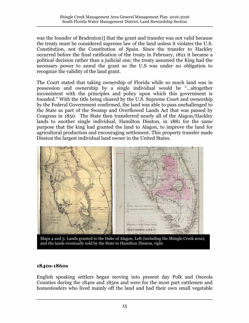
British Period 1763-1783 During the British period beginning in 1763, the region experienced migration from the Creek and Yamasee. Many of the surviving members of the coastal tribes relocated to Cuba with the Spanish when the British took over. In 1765 the Treaty of Picolata (today Palatka) recognized all of the interior of Florida belonging to the Lower Creek Indians (the Seminoles), a territory that would have followed a line from the west bank of the St. John’s River following it to its source then south to the edge of the Everglades and along the edge south to Cape Sabal on the southern tip of the Florida Peninsula. The coastal areas were specifically ceded by the Creeks to the British, with British law recognizing that the lands of Florida were the legal possessions of the Creeks. Second Spanish Period (retrocession) 1783-1821 Throughout the Second Spanish Period the surviving Costas from the interior, and some who moved back from Cuba, worked for Spanish fishing villages. The second Spanish period (1783-1821) was more active in the region. The Spanish Monarchy felt their hold on the territory was tenuous following the departure of the British with unregulated migration from the north, so they began granting generous land grants to encourage settlement and economic development by immigrants who would swear loyalty to Spain. The interior land that had been recognized as being Seminole land by the British, had also been guaranteed to remain with the Seminoles by the Treaty of Pensacola in 1784, and again by the Treaty of Walnut Hills in 1793. The Duke of Alagon Land Grant In 1818, just before the end of the Second Spanish period, the Spanish king granted over 12 million acres to the Duke of Alagon in what was the largest land grant in Florida that would have included Shingle Creek and most of the rest of central Florida west of the St. John’s River and north of Lake Okeechobee (Maps 4 and 5). The land was given away because the Duke had assured the king that if he had possession of it he would work with various private enterprises to see the land settled and improved for agricultural production. The Duke promptly sold the land to Richard S. Hackley, of Virginia, who in turn leased some of it to a private corporation in 1836. The treaty that ceded Florida to the United States included a written declaration as an exhibit that declared the land grant void, but at the time the Spanish king had just become a constitutional monarch, rather than an absolute monarch; and was limited in powers and could not exercise eminent domain to take private property without compensating the owner and having the action ratified by the Spanish Cortes. After years of being contested by the Territory, and then the State of Florida, the U.S. Supreme Court decided in 1853 [John Doe vs Braden (Braden
Shingle Creek Management Area General Management Plan 2016-2026 South Florida Water Management District, Land Stewardship Section
15
was the founder of Bradenton)] that the grant and transfer was not valid because the treaty must be considered supreme law of the land unless it violates the U.S. Constitution, not the Constitution of Spain. Since the transfer to Hackley occurred before the final ratification of the treaty in February, 1821 it became a political decision rather than a judicial one; the treaty assumed the King had the necessary power to annul the grant so the U.S was under no obligation to recognize the validity of the land grant. The Court stated that taking ownership of Florida while so much land was in possession and ownership by a single individual would be “…altogether inconsistent with the principles and policy upon which this government is founded.” With the title being cleared by the U.S. Supreme Court and ownership by the Federal Government confirmed, the land was able to pass unchallenged to the State as part of the Swamp and Overflowed Lands Act that was passed by Congress in 1850. The State then transferred nearly all of the Alagon/Hackley lands to another single individual, Hamilton Disston, in 1881 for the same purpose that the king had granted the land to Alagon, to improve the land for agricultural production and encouraging settlement. This property transfer made Disston the largest individual land owner in the United States.
1840s-1860s English speaking settlers began moving into present day Polk and Osceola Counties during the 1840s and 1850s and were for the most part cattlemen and homesteaders who lived mainly off the land and had their own small vegetable
Maps 4 and 5: Lands granted to the Duke of Alagon, Left (including the Shingle Creek area); and the lands eventually sold by the State to Hamilton Disston, right

Shingle Creek Management Area General Management Plan 2016-2026 South Florida Water Management District, Land Stewardship Section
16
plots. The government would routinely grant 160 acre tracts to single men or heads of households through successive acts of Congress, such as the Armed Occupation Act of 1842. This act granted 160 acres to anyone who submitted a permit to the regional land office to build and live in a house on the parcel and cultivate at least 5 acres of it for at least 5 years. Many settlers were veterans of the Second Seminole War who had familiarized themselves with choice parcels during their routine patrols. These early settlers were few and far between, the Armed Occupation Act of 1842 only authorized 1,250 homesteads for the entire peninsula south of Palatka. Tourism and Settlement in the 1870s The 1870s and reconstruction brought a railroad line from Sanford to Tampa and through the new town of Kissimmee on Lake Tohopekaliga. The land around the lakes had been essentially depopulated for 40 years since the first part of the Second Seminole War in the mid-1830s, and as a result the land and waters supported healthy game and fish populations. Kissimmee was the end of the line for many southbound tourists; a frontier town perched on the edge of a vast wilderness. Several adventure books and articles in Harpers and Field and Stream opened the interior country around Kissimmee to tourists and sportsmen from the Northern U.S. and from Europe.
Early settlers moving into the pinelands of Orange County

Shingle Creek Management Area General Management Plan 2016-2026 South Florida Water Management District, Land Stewardship Section
17
These adventure seekers were catered to through the Tropical Hotel which was right off the main pier on Lake Toho. A stay at the Tropical cost $3.50, little steam launches could be rented for $10 to $15 per day, a sailboat was $3 to $6 per day, and a guide was $1 or more per day. An out of state hunting license was $25 and included no restrictions on the type and quantity of game taken, everything from panthers to bears to manatees were fair game with the license. Some of these excursions would go up into Shingle Creek which, with massive cypress swamps, appeared to be the very embodiment of Florida wilderness. A settlement by the name of Shingle Creek was founded 4.3 miles to the northwest of Kissimmee (Map 6). By 1890 it had a population of 149, and 154 by 1900. The settlement primarily provided services for farmers and ranchers in the area between Kissimmee and Lake Apopka.
Map 6: The Shingle Creek area in 1882, with the location of the settlement of Shingle Creek shown. The present-day management area is overlaid in green.

Shingle Creek Management Area General Management Plan 2016-2026 South Florida Water Management District, Land Stewardship Section
18
A remarkably precise natural communities map completed in 1879 (Maps 7a and 7b), shows the pre-logging, pre-ranching, and pre-drainage detail of the area prior to extensive settlement. With the current Management Area boundary overlaid, it shows the historic extent of the floodplain swamp and the surrounding pinelands. Map 7a. An 1879 Fl0rida map showing natural communities

Shingle Creek Management Area General Management Plan 2016-2026 South Florida Water Management District, Land Stewardship Section
19
Map 7b. Detail of an 1879 Fl0rida map showing natural communities with a present day Shingle Creek Management Area boundary overlay

Shingle Creek Management Area General Management Plan 2016-2026 South Florida Water Management District, Land Stewardship Section
20
Hamilton Disston Drainage Projects 1881-1895
Hamilton Disston was an entrepreneur from Philadelphia who organized the Florida Land and Improvement Company and the Atlantic and Gulf Coast Canal and Okeechobee Company. The state entered into an agreement with Disston in 1881 where Disston purchased four million acres of odd numbered sections of a nine million acre drainage district that included most of the interior peninsula of Florida, south of Kissimmee. Disston paid 25 cents per acre and was also entitled to half of the remaining sections upon their successful reclamation. Railroad companies also received a large portion of the remaining even numbered sections because the legislature had promised them 4,000 to 10,000 acres for every mile of railroad constructed. It was the general policy of the railroad companies and Disston to sell off the extra land to settlers and other investors. Disston began his reclamation operation by constructing a large steam-powered bucket chain dredge barge that dug a six foot deep canal 37’ wide at 12 linear feet per hour. The barge automatically built up a levee on either side as it moved through the prairies. The dredge began a canal connecting Lake Tohopekaliga and Lake Cypress in the summer of 1882 with a crew of 12. Disston employed the steamer Roseada to move the dredge. Progress was aided by having lake water steadily pushing the barge forwards as it made its way towards Lake Cypress. By May 1883 the canal was finished and a steady current of 2½ miles per hour had drained Lake Tohopekaliga by 5 feet and drained 40,000 acres of land. The lowering of Lake Toho also lowered the outfall of Shingle Creek, which lowered the water table of its floodplain and increased the velocity of the creek. President Chester A. Arthur visited the area during a fishing vacation in April, 1883. Before heading back to Washington he visited a sugar plantation that had been constructed on the creek near its mouth on Lake Toho where the marshes had been drained and converted into sugarcane production.
Hamilton Disston and his steam dredge

Shingle Creek Management Area General Management Plan 2016-2026 South Florida Water Management District, Land Stewardship Section
21
20th Century Despite the drainage, the area remained prone to flooding. The chronic flooding problems led to successive requests to both the State and Federal governments for aid in establishing better flood abatement infrastructure.
Flooding in the 1880s
Early 20th century photo of Shingle Creek

Shingle Creek Management Area General Management Plan 2016-2026 South Florida Water Management District, Land Stewardship Section
22
Shingle Creek was first channelized in the 1920’s by the Taft Drainage District (now defunct). Since then, Shingle Creek swamp has steadily become a wetland influenced by stormwater. As development and agriculture encroach, more canals and stormwater ponds were connected to the creek system for drainage (Maps 8a, 8b, and 8c). To better manage the increased demand for drainage, the Valencia Water Control District (originally Valencia Drainage District) was established in 1970. Valencia Water Control District provides drainage for approximately 4800 acres north of the Management Area through a series of ponds, structures, and several miles of canals. All of the water from this system drains into the northwest section of the swamp and, at minimum, has changed the hydroperiod of this section of the swamp. Other alterations affecting the swamp have include logging, construction of powerline roads, development of the surrounding landscape, and years of exposure to treated wastewater (suspended in 1986). These have affected the swamp’s hydrology, water quality, and integrity (see detail in Table 1). Despite the alterations, the swamp still plays an important role for water supply and flood control purposes and in providing wildlife habitat and improved water quality functions. In 1981, the Florida Legislature established the Save Our Rivers program for the five water management districts to acquire environmentally sensitive land. The legislation produced the Water Management Lands Trust Fund and empowered the water management districts to acquire lands needed to manage, protect, and conserve the state's water resources. Acquired lands are to be managed and restored to their natural state. The Shingle Creek Save Our Rivers project was designated for potential acquisition in November, 1985. Acquisition in the project area began in 1991 and as of Dec. 2004 the District has acquired approximately 2,424 acres through direct acquisition and through partnerships with Orange County (Map 9).

Shingle Creek Management Area General Management Plan 2016-2026 South Florida Water Management District, Land Stewardship Section
23
Shingle Creek History – Table 1 (Van Horn, 1997) i. Y
EAR
ACTIVITY EFFECT ON SWAMP
1920’s Upper Shingle Creek channelized by Taft Drainage District. Isolated creek from swamp.
1920’s Berm breaks cut in western bank Allowed exchange of water between creek and swamp during high stage periods; may drain swamp..
1920’s-40’s Cypress & hardwood harvesting occurred until the 1940’s.
Surface water runoff increased, increasing swamp turbidity.
1960's Main channel north of Florida turnpike channelized.
Enhanced water conveyance to the south through the creek channel to meet drainage needs of surrounding urban area.
Late 1970’s Two sewage treatment plants,
Two sewage treatment plants began to discharge treated effluent directly into Shingle Creek.
Resulted in high nitrogen and phosphorus concentrations within the swamp (O'Dell, 1994).
1972 Orlando Utilities Commission built two power line roads through the swamp.
Obstructed sheet flow across swamp.
1980 North-South powerline road extended southward; 3 culverts installed to improve sheet flow in that area.
Extension of powerline road extended the barrier to sheetflow; culvert installation was first attempt to enhance sheetflow.
1982 Breedlove & Associates studied area for vegetation community shifts and ecological signs of stress.
Conclusion: Shingle Creek Swamp is in good condition.
Mid 1980's Valencia Water Control District installs plug in its C1 canal.
Attempt to increase water inflow into the northwest corner of Shingle Creek Swamp that was diverted because of drainage improvements of the C1 Canal.
Mid 1980's Rapid infiltration basins (1) constructed at southwest edge of swamp in Orange County.
Increased flow through groundwater infiltration into western half of swamp.
1986 All wastewater discharges directly into the Creek were stopped (discharge from rapid infiltration basins still allowed).
Water quality remained somewhat degraded, in spite of declines in nitrogen and phosphorus concentrations (O'Dell 1 994). However, water met Class III standard concentrations, meaning creek waters were safe for public recreation, fishing, and wildlife (Camp et al. 1991, District Hydrolab-unpublished data 1992-1993).
1989
U.S. Army Corps of Engineers-General Design Memorandum proposed projects for providing flood control, as well as lengthening the hydroperiod of swamp.
Conclusion: the swamp is overdrained; project not feasible and the Army Corps of Engineers dropped proposals from consideration in 1992.
1991
Orange County Utilities contracts with Camp Dresser and McKee to increase discharge capacity of the rapid infiltration basins to meet discharge needs of the Orlando area.
Conclusion: Water quality within the swamp was degraded by stormwater, unnatural water depths & hydroperiod. CDM concluded that increasing discharge from the RIB's (located in the southwest portion of the swamp) would not further degrade the swamp because increases of stormwater inflow did not affect the southwest corner.
1992-93 SFWMD Study
Conclusion: Loblolly bay trees in the northwest section of the swamp (Orange County) were dying from the extended hydroperiod and increases in water depth on west side of the north-south power line road.
1994 Hunter’s Creek developer placed two culverts placed at the south end of the north-south power road as mitigation.
Improve west to east sheetflow at southern end of swamp within Orange County.
1995
As mitigation for the Southern Connector of the Central Florida Beltway, the District installed a 100-ft. swale at the north end of the north-south power road.
Effects not yet quantified, but swale is intended to reduce water level and duration in the northwest corner of the swamp and enhance sheetflow from west to east across the powerline road. Field surveys and bay tree regeneration suggest that the project works according to design.
1. A Rapid Infiltration Basin is a retention pond designed to receive stormwater or treated effluent. Through gradual percolation into the groundwater, biological processes within the pond and groundwater provide additional treatment of the effluent.

Shingle Creek Management Area General Management Plan 2016-2026 South Florida Water Management District, Land Stewardship Section
24
Map 8a, 8b, and 8c. 1944 (left), 1969 (middle, Orange County only), and 1984 (right, Orange County only) aerial photos with present-day Shingle Creek Save Our Rivers boundary overlay

Shingle Creek Management Area General Management Plan 2016-2026 South Florida Water Management District, Land Stewardship Section
25
Map 9. Aerial Photo

Shingle Creek Management Area General Management Plan 2016-2026 South Florida Water Management District, Land Stewardship Section
26
4. Resource Inventory Policy 140-25(3)(e) Inventories of natural and historic resources shall be performed to provide information for effective land management planning, natural community maintenance and ecological restoration. Floral and faunal species are inventoried, and natural communities are mapped by Land Stewardship personnel, volunteers, or private contractors. The data helps District land managers with resource management planning. Inventory data is on file within the Land Stewardship Section. Land Stewardship shares natural areas and species data with the Florida Natural Areas Inventory through a Memorandum of Understanding. Floral and faunal inventories of the Management Area were included in the environmental assessment initiated shortly after acquisition to determine the presence of listed species and serve as baselines. Additional surveys have been completed with species’ lists being updated regularly by volunteers, contractors, and District staff. Archeological inventories were conducted by the Department of State, Division of Historical Resources and described in subsequent reports (Section 4.5). 4.1 Hydrology Policy 140-25(1) The basis for the Land Stewardship Program is the protection and management of natural hydrologic resources. The Shingle Creek basin is approximately 112 square miles in size and is adjacent to the Boggy Creek, Reedy Creek, and Lake Tohopekaliga basins (Map 10a and 10b). The basin lies within the Osceola Plain; a broad terrace bounded by the Lake Wales Ridge to the west and the Eastern Valley to the east, both of which are marine scarps (Maps 11a and 11b). The basin is located in the upper third of the Osceola Plain and is southwest of a small ridge in Orange County called the Orlando Ridge. Although the Osceola Plain locally has little relief and a general elevation of 50 to 70 feet National Geodetic Vertical Datum, elevations within the upland islands of the Management Area reach 82 feet.

Shingle Creek Management Area General Management Plan 2016-2026 South Florida Water Management District, Land Stewardship Section
27
Map 10a. Historic Basin Map of Shingle Creek

Shingle Creek Management Area General Management Plan 2016-2026 South Florida Water Management District, Land Stewardship Section
28
Map 10b. Local Hydrologic Basins

Shingle Creek Management Area General Management Plan 2016-2026 South Florida Water Management District, Land Stewardship Section
29
Map 11a. Regional Major Geomorphic Features

Shingle Creek Management Area General Management Plan 2016-2026 South Florida Water Management District, Land Stewardship Section
30
Map 11b. Regional Topography

Shingle Creek Management Area General Management Plan 2016-2026 South Florida Water Management District, Land Stewardship Section
31
Shingle Creek begins its 23-mile journey to Lake Tohopekaliga as a canal in western Orlando near West Highway 50 in the Pine Hills area. The Taft Drainage District, no longer in existence, dug the canal nearly eight decades ago. Since then, the upper portion of Shingle Creek has become an intricate network of canals, culverts, and structures that drain adjacent stormwater ponds, wetlands, lakes, and commercial and residential land. Shingle Creek serves as the major flood water conveyance in western Orlando and southwest Orange County and remains in its channelized state along the Management Area almost to the Osceola County line. Because of its proximity to Orlando and rapidly developing parts of Orange and Osceola Counties, the Management Area’s hydrology is highly complex and altered. Major features affecting its hydrology include:
Valencia Water Control District drainage system
Utility roads bisecting the swamp
District-installed geoweb swale
Berm breaks in the spoil berm along the canal. The Valencia Water Control District (VWCD) plays a considerable role in the management of water within the Management Area. Formed in 1970, VWCD regulates the drainage within a 4800-acre area, captured in 9 miles of canals and funneled through a 600-foot spreader swale at the northwest corner of the main swamp. This has likely increased the historic flow in the northwest portion of the swamp keeping this area permanently inundated. More importantly, VWCD influences the swamp’s hydrologic dynamics. Greater amounts of stormwater entering the swamp have caused broader, faster fluctuations in the swamp’s hydroperiod (particularly in the northwest section) and prolonged inundation (Exum, 2004). A second hydrologic alteration is the utility roads that cut through the swamp. In 1972 the Orlando Utilities Commission installed two utility roads in the swamp, bisecting the swamp north-south and east-west. The roads blocked sheetflow, and hydroperiods increased throughout the swamp upstream of the roads, i.e. west of the north-south road, and north of east-west road. Consequently, plant communities became wetter, and less hydrophytic species, e.g. loblolly bay trees (Gordonia lasianthus) and pond pine trees (Pinus serotina), began to die. In response, the District conducted biological and hydrologic assessments of the swamp and concluded that the western portion of the swamp was inches higher than the swamp portion on the east side of the utility road. To correct the imbalance, the District installed a stabilized, high water crossing for a 100-ft section of the north-south utility road in the Management Area. Finally, breaks or cuts have formed in the spoil berm along the Shingle Creek canal. (It is unknown if they formed naturally or if they were dug out; likely a combination of both.) In the five-mile section of canal along the eastern

Shingle Creek Management Area General Management Plan 2016-2026 South Florida Water Management District, Land Stewardship Section
32
Management Area boundary, about 30 breaks allow the flow of water between the canal and the swamp. Because the canal was dredged lower than the grade of the adjacent swamp, the water generally flows out of the swamp and into the canal, potentially draining the swamp below its historical normal pool. However, because of the system’s other hydrologic alterations, i.e. the increased stormwater input from the VWCD, it does not appear that the canal overdrains the swamp enough to harm it ecologically. It is likely that the effects from the breaks are limited to the areas adjacent to the canal. Regional influences and alterations within the Management Area have combined to drastically modify the historic hydrology. Much of the pre-development hydrologic patterns and functions no longer exist. The site floods more rapidly, more deeply, and more extensively. While it stays wetter longer, it paradoxically drains more quickly, probably because of the creek channelization and berm cuts, thus resulting in an altered hydrology (Exum, 2004). 4.2 Soils There are four distinct soil categories within the Management Area as defined by the Natural Soil Landscape Positions soil classification system: flatwood soils, flats soils, sand depression soils, and muck depression soils (Map 12). This classification system groups South Florida soils into 12 categories based on hydrology and soil morphology that reflect the local relative topography, hydrology, and vegetation of the area. Soil classification descriptions are included as Appendix B. Soil Contamination and Excavation Sites Throughout the acquisition process, District environmental assessments have been completed and have revealed no known areas of soil contamination (i.e. cattle dipping vats, chemical dumping) or excavation within the Management Area.

Shingle Creek Management Area General Management Plan 2016-2026 South Florida Water Management District, Land Stewardship Section
33
Map. 12. Soils

Shingle Creek Management Area General Management Plan 2016-2026 South Florida Water Management District, Land Stewardship Section
34
Map 13. Natural Communities: Florida Natural Areas Inventory

Shingle Creek Management Area General Management Plan 2016-2026 South Florida Water Management District, Land Stewardship Section
35
4.3 Natural Communities Eight natural community types, as classified by the Florida Natural Areas Inventory, comprise the Management Area: basin marsh, basin swamp, depression marsh, dome swamp, mesic flatwoods, mesic hammock, wet flatwoods, and wet prairie (Map 13). Community condition varies depending on previous and current land use, hydrologic alteration, exotic infestation, and current management activities. Descriptions are included as Appendix C. 4.4 Wildlife The Florida Fish and Wildlife Conservation Commission (FWC) has identified the area in and around the Management Area as a “Biodiversity Hotspot” and a “Priority Wetland for Listed Species” (Cox et al, 1994; Kautz et al, 1994). “Biodiversity Hotspots” are areas that support 5 or more wildlife species whose populations are declining on a statewide basis and contain unique flora, fauna, & natural communities (Cox et al, 1994). “Priority Wetland for Listed Species” represents wetland habitats critical for one to three wetland-dependent species of vertebrates listed as endangered, threatened, or species of special concern (Kautz et al, 1994). To date the District has recorded 106 bird, 9 mammal, 27 reptile, 13 amphibian, 20 fish, and 48 butterfly species within the Management Area (Appendix D). At least 11 species considered rare, endangered, threatened, or of special concern have been observed on the area. 4.5 Cultural Resources Policy 140-25(3)(j) Archaeological and historic resources are protected by site identification and inter-agency coordination with the Florida Division of Historical Resources. Land Stewardship planning shall include an analysis of archaeological data accompanied by appropriate public education opportunities. One archaeological site registered in the Florida Master Site File is within the Management Area. The site may date back several thousands of years and has been recommended for further investigation (State of Florida, 1983). A nearby site, discovered during the development of Hunter’s Creek, contained thousands of artifacts 4,000 to 8,000 years old and was possibly an ancient hunt camp (Ost, 1987). The District plans to continue research on the site based on the availability of funding and safeguard the integrity of cultural resources, primarily through prohibiting ground disturbing activities. Management activities that could include ground disturbance are planned to avoid impacting areas known to contain archaeological and historical sites.

Shingle Creek Management Area General Management Plan 2016-2026 South Florida Water Management District, Land Stewardship Section
36
5. Natural Resource Management Policy 140-23 The Land Stewardship Program mission is to provide natural resource protection and management while allowing compatible multiple uses on designated public lands. Resource management includes all applied activities that manipulate, modify, and control natural features within the Management Area. All lands that were acquired through the Save Our Rivers program are managed and maintained in an environmentally acceptable manner and, to the extent practicable, restored and protected in their natural state and condition. Management responsibilities are defined by statute and are directed by best management practices. Goals and objectives for the Management Area clarify resource management guidelines necessary to fulfill the District’s land stewardship responsibilities. Land Stewardship resource management activities include the implementation of projects to restore a more natural hydrologic regime, the application of vegetation control activities to restore natural forest structure and composition, the continuation of an aggressive exotic plant control program, the application of a prescribed burn program to maintain fire dependent plant communities, and the implementation of re-forestation activities where necessary to restore upland forest communities. 5.1 Restoration Projects Policy 140-25(1) The basis for the Land Stewardship Program is the protection and management of natural hydrologic resources. Policy 140-25(1)(c) Where feasible, an attempt shall be made to restore a more natural hydroperiod on tracts where the drainage patterns have been altered. At-grade Crossings In 1972, the Orlando Utilities Commission built dirt roads through Shingle Creek swamp for power lines. Although several culverts were installed in the roads, the roads altered sheet flow and hydrology in the adjacent areas of the swamp. In the 1980’s the Valencia Water Control District increased stormwater discharge in the northwest section of the swamp, further extending the hydroperiod in that area. As a result, less hydrophytic species (i.e. loblolly bay trees, pond pine) began to die. As partial mitigation for wetland impacts caused by the Southern Connector in Orlando, in 1995 the District replaced a 100-foot section of the north-south road and added a swale. The swale enhanced sheetflow and reduced the hydroperiod in the northwest section of the swamp. Field observations show

Shingle Creek Management Area General Management Plan 2016-2026 South Florida Water Management District, Land Stewardship Section
37
seedling and juvenile bay trees returning to areas that previously experienced tree mortality due to prolonged inundation (District, 1997). 5.1.1 Mitigation The District receives mitigation funds that are used for the preservation, restoration, and management of several Land Stewardship Section lands in accordance with Section 373.414(1)(b), F.S. The District received mitigation funds for the Management Area from 1992 through 2002 for several offsite development projects. The District uses mitigation funding for specific activities and management, consistent with District developed plans. The District also received Central Florida Beltway Mitigation Funding through prior legislation. As directed by the legislation, the District developed conceptual mitigation plans that outline various restoration projects and acquisitions within the Shingle Creek project and other areas. The plans are formally known as the 1) Shingle Creek Swamp Mitigation Plan (District, 1992), and 2) the Conceptual Mitigation Plan for the Central Florida Beltway, S.R. 429, Part C (District, 2000); both are on file at the District’s headquarters and the Orlando Service Center. 5.1.2 Monitoring Policy 140-25(3)(f)(2) Monitoring shall be conducted to identify landscape changes resulting from management activities. Tracking environmental response to management and restoration activities provides valuable information on progress toward restoration objectives. Information obtained by monitoring specific sites assists land managers in making sound ecological choices for each unique parcel. Monitoring has focused on documenting vegetative changes from restoration of the area’s hydroperiod. Baseline inventories have been established, and two permanent photo monitoring stations were installed that will enable panoramic photos to be taken to document changes over time. District staff monitors and documents hydrologic and vegetative changes within the Management Area. Hydrologic monitoring began shortly after the District acquired land within the project in 1992. The District installed eight stage recorders and staff gauges along the powerline roads to monitor suspected disparities among the sub-basins and to model the hydrology within the Management Area. The analysis resulted in the construction of the at-grade crossing on the north-south powerline road (1995) which, as required by the Florida Department of Environmental Protection, established seven photo monitoring points throughout the swamp. In 2000, this photo-point data collection ceased in accordance with the project’s permit. The two panoramic photo monitoring points are located in a pine island and a pine/cypress

Shingle Creek Management Area General Management Plan 2016-2026 South Florida Water Management District, Land Stewardship Section
38
transition area. Hydrologic monitoring continues at all recorders, and data is kept on the District’s “DB Hydro” database. The District also monitors water quality throughout its 16-county area. One monitoring site is located in lower Shingle Creek in Osceola County. Various water quality parameters are gathered monthly and evaluated, including flow and stage data from recorders in the Management Area. The information is also stored in the District’s “DB Hydro” database and is used to monitor long-term trends. 5.2 Vegetation Management Policy 140-25(2)(d) Where practicable, an attempt shall be made to restore and maintain desirable vegetation to promote habitat diversity in areas where invasive exotic vegetation, grazing practices, or improved land uses have substantially altered the historic landscape. Policy 140-25(3)(l) Mechanical equipment may be used in conjunction with prescribed burning and other management tools to control vegetation and restore habitat structure. Vegetation management is a program component where the composition and/or structure of a vegetative community is physically altered to meet a management objective. The vegetation management needs are identified annually by the regional land manager. The techniques used in vegetation management include mowing, shredding, roller-chopping, timber thinning, and planting. These techniques are applied to one or more management objectives that may include:
Restoring a degraded vegetative community
Improving an area’s suitability as wildlife habitat
Exotic species control or weed management
Fuel management in relation to prescribed burning or minimizing wildfires
Clearing for maintenance or project management purposes
The District continues to use mechanical means to restore or maintain natural communities in the Management Area. Portions of the property, particularly the upland buffers, benefit from routine mechanical treatments in conjunction with prescribed fire. Adjacent development and hydrologic changes have made prescribed fire difficult to conduct in some areas. Mechanical treatments are applied to these areas to maintain and perpetuate the fire-dependent natural communities that buffer the floodplain swamp.

Shingle Creek Management Area General Management Plan 2016-2026 South Florida Water Management District, Land Stewardship Section
39
5.2.1 Exotic/Invasive Plants Policy 140-25(2)(c) Management practices will strive to identify existing infestations and implement appropriate control or eradication measures. Policy 140-25(3)(b) Exotic plant control in all management areas shall strive to attain a level of success where periodic maintenance eliminates the infestation or reduces the coverage of exotic plants. South Florida’s subtropical climate provides an excellent growth environment for the rapid spread of exotic plants that can cause extensive alterations to natural ecosystems. Environmental changes caused by extensive hydroperiod alterations have been an important factor in exotic plant invasion. Exotic plant infestation can result in partial or total displacement of native plants, loss of wildlife habitat, and the degradation of public use areas. Land Stewardship targets Category I and II non-native plant species as identified in the Florida Exotic Pest Plant Council’s biennially updated list of Florida’s Most Invasive Species (http://www.fleppc.org/). Category I species include non-native plants that invade and disrupt Florida native plant communities. Category II plants have the potential to invade and disrupt natural successional processes. Both Category I and II exotics are considered invasive and a threat to the function and ecological stability of Florida’s natural communities. Invasive and exotic plant control measures include a combination of herbicide application, biological control, prescribed fire, roller chopping, mowing, and physical removal. Selection of control measures is dependent upon species type, environmental factors, and natural communities impacted. Private contractors conduct exotic plant control activities in coordination with District staff. Exotic plant control is conducted primarily by a contracted crew of applicators selected through a competitive bid process. District field technicians also provide supplemental support especially on small or widely distributed infestations. Treatments are scheduled so that each unit is covered annually and schedules are adjusted based on current conditions and available funding. Areas of treatment are scheduled based on groundwater conditions, time of last treatment, virulence of infestation, public use, and in accordance with other management operations. All treatments follow herbicide best management practices and use the best available science. Treatment dates, locations, and herbicide are noted and recorded in a GIS database.

Shingle Creek Management Area General Management Plan 2016-2026 South Florida Water Management District, Land Stewardship Section
40
Table 2. Category I Exotics Observed in the Management Area
Common Name Scientific Name EPPC
Category
Air potato Dioscorea bulbifera I
Brazilian pepper Schinus terebinthifolius I
Caesar’s weed Urena lobata I
Camphor tree Cinnamomum camphora I
Chinese tallow Sapium sebiferum I
Cogon grass Imperata cylindrica I Guava Psidium guajava I Hydrilla Hydrilla verticillata I Lantana Lantana camara I Primrose willow Ludwigia peruviana I
Japanese climbing fern Lygodium japonicum I
Old World climbing fern Lygodium microphyllum I Natal Grass Melinis repens I Sword Fern Nephrolepis cordifolia I
Paragrass Urochloa mutica I
Torpedo grass Panicum repens I
Water hyacinth Eichhornia crassipes I
Wild taro Colocasia esculenta I
5.2.2 Rare, Threatened and Endangered Species Policy 140-25(2)(b) Particular emphasis shall be placed on the identification, protection and management of rare, threatened and endangered species. Listed species are those plants and animals considered rare within a specific geographic area by the U.S. Fish and Wildlife Service, the Florida Fish and Wildlife Conservation Commission, Florida Natural Areas Inventory, or the Florida Department of Agriculture and Consumer Services. The plant list of the Management Area (Appendix D) contains several listed species (reproduced in Table 3).

Shingle Creek Management Area General Management Plan 2016-2026 South Florida Water Management District, Land Stewardship Section
41
Table 3. Plants occurring on the Shingle Creek Management Area that are Listed by the Florida Department of Agriculture and Consumer Services as Threatened (T), Endangered (E), or Commercially Exploited (C) as of December, 2015
Common Name Scientific Name Status
Threadroot orchid Harrisella porrecta T
Catesby's Lily Lilium catesbaei T
Cinnamon Fern Osmunda cinnamomea C
Royal Fern Osmunda regalis C
Blue Butterwort Pinguicula caerulea T
Yellow Butterwort Pinguicula lutea T
Yellow Fringed Orchid Platanthera ciliaris T
Lady’s-tresses Spiranthes sp. T/E Hooded Pitcherplant Sarracenia minor T
Cardinal Wild-pine Tillandsia fasciculata E
Giant Wild-pine Tillandsia utriculata E
Land Stewardship establishes appropriate fire and hydrologic regimes, and controls invasive exotics in natural communities with the intent of perpetuating listed plant species. District public use rules aid in the protection of native habitat and specifically prohibit destroying, defacing, or removing any natural resource or native plant on District lands. In this manner, listed plants are given lawful protection and environmental conditions suitable for their growth and reproduction. Several listed bromeliad species occurring in the Management Area may be threatened by the exotic Mexican weevil (Metamasius callizona) that have caused destruction of native bromeliads in other south Florida locations. Two species of once abundant bromeliads, Tillandsia utriculata and Tillandsia fasciculata, have been placed on the state’s list of endangered plant species as a direct result of this weevil. Land Stewardship staff conduct periodic surveillance of areas of potential infestations to assess management needs. 5.2.3 Forest Resources Policy 140-25(3)(h) Sustainable use of forest resources shall be conducted where these activities adhere to a series of environmental criteria (see 1999 Forest Management Plan) that meet Land Stewardship Program goals. Timber contractors will be required to meet silvicultural Best Management Practices (BMP) developed for Florida forests. Policy 140-25(5)(C)(3) Timber sales will be conducted to improve forest health or to support specific forest management goals.

Shingle Creek Management Area General Management Plan 2016-2026 South Florida Water Management District, Land Stewardship Section
42
District policy designates its properties as multiple-use resources, which include timber harvesting. However, such activity must be compatible with Land Stewardship goals and objectives and meet strict environmental criteria:
The area planned for silvicultural rotation is currently in an “improved” or disturbed state (i.e. bahia pasture, existing pine plantation)
The site to be planted is not scheduled for future hydrologic restoration, or the site to be harvested is scheduled for hydrologic restoration and existing timber will be lost as a result of flooding
The area does not contain any valuable resources (e.g. endangered species) that may be harmed by changes in land use
Forest operations would not require major road construction or improvement for accessing and processing timber, particularly within or across wetlands or other sensitive plant communities
The area to be managed currently requires maintenance (i.e., burning, mowing)
District costs would be reduced as a result of inclusion in the forest management plan
The area contains timber that requires salvage following fire and/or insect or disease damage, and could be subject to a sanitation harvest with minimal environmental impact
The area provides special needs for endangered species (e.g., red-cockaded woodpecker) management that requires timber stand improvement
Harvest or planting will not create an aesthetically unpleasant scene or an impediment to public use
Timber harvests will return forests to a more natural structure and improve forest health
There are currently no sites within the Management Area that meet District criteria for timber harvest. 5.2.4 Range Resources Policy 140-25(3)(i) Range management and grazing will be considered on improved or native ranges when the introduction of cattle will not conflict with other natural resource management and public use goals. The District does not anticipate utilizing the property for grazing or agricultural activities due to the limited grazing potential and high quality wetlands that occur within the Management Area.

Shingle Creek Management Area General Management Plan 2016-2026 South Florida Water Management District, Land Stewardship Section
43
5.3 Fire Policy 140-25(5)(c)(3) Prescribed fire will be a primary management tool on District lands and will be applied within fire-maintained communities at appropriate intervals. The majority of natural communities on District lands rely on frequent fire to maintain their vegetative characteristics and biodiversity. Wildfires no longer occur with historical frequency or extent, and this has altered natural community structure and function. Prescribed fire attempts to mimic the benefits of natural wildfires that historically reduced fuel loads, recycled soil nutrients, and maintained natural communities by inhibiting hardwood encroachment and stimulating fire-adapted plant growth and reproduction. The Land Stewardship Program recognizes the benefits of fire and has integrated prescribed fire planning and application into its land management strategy. 5.3.1 Fire History The District contacted the Florida Forest Service (FFS) for fire data on the Management Area prior to District ownership. While the FFS is aware of fire activity within the Management Area (primarily wildfires), no dates, locations, and acreage were available. (Michael Coker, FFS, personal communication, June 2003). The District began its prescribed fire planning for the Management Area in 1998 when sufficient property was acquired to develop feasible burn units. Fire data, including dates and locations of prescribed and wildfires, is maintained in GIS to produce historical burn maps of the property (Map 14).

Shingle Creek Management Area General Management Plan 2016-2026 South Florida Water Management District, Land Stewardship Section
44
Map 14. Fire History

Shingle Creek Management Area General Management Plan 2016-2026 South Florida Water Management District, Land Stewardship Section
45
5.3.2 Prescribed Fire Planning The Land Stewardship Section bases all fire management plans on ecological research and professional experience. Fire frequency schedules for each natural community consider recommendations provided in The Natural Communities of Florida (Florida Natural Areas Inventory, 2010). To mimic historic fire conditions, Land Stewardship emphasizes growing season burns (April-September) where practical. Natural firebreaks are utilized where possible to promote historic fire patterns, avoid soil disturbance, and reduce hydrologic flow disruption created by fire lines. The success of listed species requirements are elements of prescribed fire planning. Application of fire, with appropriately timed herbicide treatments, is used as a tool for control of invasive and nuisance plants. Burns are executed using methods as defined by the Prescribed Burning Act of 1990, Section 590.026, Florida Statutes. This legislation and associated administrative rules outline accepted forestry burn practices and are administered through the Florida Forest Service. Land Stewardship has a three person prescribed fire crew in the Upper Lakes Land Management Region and utilizes other cooperating agency staff to conduct burns. All Land Stewardship staff on the fire crew have completed the state certified burn course to ensure safety and proper technique. Fuel reduction and habitat enhancement are the primary objectives for utilizing prescribed fire on the Management Area. Each fire-dependent natural community is burned within specified intervals as determined by Land Stewardship staff. Annual planning is performed to assure that the appropriate fire intervals are maintained to keep burn units in rotation.
Prescribed Fire and Carbon Sequestration
The District currently stores carbon on the lands it manages in vegetation and organic soils. Each year, the amount of carbon increases as young forests grow and marshes steadily fix carbon into peat. This is also known as carbon sequestration. It is important to manage the District’s land resources in a manner to maximize the amount of carbon that is sequestered, while minimizing carbon dioxide and other greenhouse gas emissions. Prescribed fire is a tool that, if used under the right conditions and with the right frequency, can increase the rate at which a fire-dependent natural community can grow and store carbon. Following a burn there is a subsequent spike in primary productivity caused by a release of nutrients and exposure of more surface area to sunlight, as well as a post-burn swelling of both above and below ground carbon stores. Some prescribed fire guidelines for maximizing carbon storage that the District follows include:
Burning at a return interval of 3 to 5 years when possible.

Shingle Creek Management Area General Management Plan 2016-2026 South Florida Water Management District, Land Stewardship Section
46
Implementing a proper mop-up phase of the prescribed fire to extinguish smoldering fuels to reduce unnecessary carbon and nitrous oxide releases.
Avoiding muck fires and conditions that lead to muck fires as they release large quantities of carbon and nitrous oxide.
Keeping fuel density low to avoid the possibility of massive carbon releases in the event of a wildfire.
5.3.3 Wildfire Suppression Policy 140-25(3)(d) The Florida Forest Service will be notified of all wildfires on District lands. Land Stewardship will provide initial suppression when commensurate personnel and equipment are available. Wildfires ignited by lightning are a common occurrence throughout Florida, and the Management Area receives numerous lightning strikes as indicated by past wildfires. It is District policy, and state law, that the Florida Forest Service is notified when a wildfire occurs on Land Stewardship managed properties. The Land Stewardship staff assigned to the area will respond to and, if appropriate, begin suppression of area wildfires when detected. The Florida Forest Service will be called immediately and a fire assessment made. 5.4 Wildlife Management A primary objective in the stewardship of the Management Area is to maintain healthy fish and wildlife populations. Wildlife management is directed toward production of native species diversity consistent with the biological community types present. The Land Stewardship Section accomplishes this in several ways: Performing land management activities that maintain and/or improve native
wildlife habitat Conducting specific management beneficial to protected species Following management guidelines for listed species protection as determined
by the Multi-species Recovery Plan for the Threatened and Endangered Species of South Florida, Volume 1, (U.S. Fish and Wildlife Service. 1999)
Reducing non-native wildlife species populations where appropriate Maintaining a master file of confirmed and potential wildlife species Management occurs through the actions mentioned above, primarily through the application of regular prescribed fire and the control of exotic species. Additionally, the District conducts various plant and animal inventories through volunteers, staff, and private contractors to evaluate the health and dynamics of the Management Area’s natural communities.

Shingle Creek Management Area General Management Plan 2016-2026 South Florida Water Management District, Land Stewardship Section
47
Table 4. Biological Assessments & Inventories
Survey Type Performed by Date
Vegetation/community analysis Dennis Breedlove, & Associates 1982
Hydrologic/flood control U. S. Army Corps of Engineers 1989
Biological/hydrologic Dames & Moore 1989
Water quality Camp, Dresser, & McKee 1991
General site inspection District 1991
Biological/hydrologic District 1994
Vegetative Photo monitoring District 1999 (a)
Bird Surveys Volunteer Biologist 2000 (b)
Plant Inventory Native Plant Society, Tarflower
Chapter 2000
Butterfly Surveys Volunteers 2000 (c)
Herpetological Survey Glatting, Jackson, et al. 2004
Vegetative Survey Glatting, Jackson, et al. 2004
(a) Five-year annual monitoring from 1994 – 1999 as required by DEP permit for at-grade crossing (b) Birds surveys conducted by Lorne Malo, biologist, for one year (c) Butterfly surveys conducted by Randy Snyder and Mary Keim for one year
5.4.1 Game Management Policy 140-25(4)(b)(4) Florida Fish and Wildlife Conservation Commission regulations shall govern hunting in areas opened for such use. The District has not identified hunting in the Management Area as an appropriate public use due to the Management Area’s size and its proximity to homes, schools, and major roads. 5.4.2 Exotic/Invasive Fauna Exotic animal species are those non-native species that are harmful to native wildlife, that negatively impact native vegetation or seriously interfere with management objectives. The Land Stewardship’s goal for wildlife pest management is to reduce populations to minimize impacts to natural plant and animal communities. When population control measures are warranted, land managers consult with the Commission to determine effective and appropriate control techniques. The effects of pest population control efforts are monitored by periodic site evaluations.
Shingle Creek Management Area General Management Plan 2016-2026 South Florida Water Management District, Land Stewardship Section
48
The feral hog is an exotic species that occur within the Management Area. Disturbance caused by this species negatively impacts natural communities and interferes with land management operations. Although valued by some members of the public as a game animal, wild hogs are an exotic species and the hogs’ high fecundity, adaptability, rooting behavior, omnivorous diet, and ability to quickly colonize areas raises serious environmental concerns. Their disruption of soil and vegetation alter natural communities and can be especially damaging in sensitive habitats that are slow to recover. Land management objectives are affected when rooting disturbance disrupts prescribed burns by preventing the spread of fire. Areas of disturbed soil are also more susceptible to exotic plant invasion. Soil rooting can create perilous conditions on hiking trails, and hog foraging can have a detrimental impact on small animal populations, ground-nesting birds, and infrastructure. Currently, feral hog populations in the Management Area and associated impacts appear to be minimal. Conditions will continue to be monitored and if necessary a no-cost District hog control agent will be assigned to the property. 5.4.3 Rare, Threatened and Endangered Species Policy 140-25(2)(b) Particular emphasis shall be placed on the identification, protection and management of rare, threatened and endangered species. Several species listed as endangered, threatened, or of special concern by state and federal agencies occur within the Management Area, including gopher tortoise (Gopherus polyphemus), wood stork (Mycteria americana), and Sherman’s fox squirrel (Sciurus niger shermani) (Table 5). Eastern indigo snakes (Drymarchon corais couperi) may also occur (Exum, 2004). Additionally, the Florida Fish and Wildlife Conservation Commission has classified most of the Management Area as a Regional Biodiversity Hotspot. Hotspots represent areas which have high overlap for declining species of wildlife plus known occurrences of rare flora, fauna, and natural communities (Cox et al., 1994). Impacts to these species from planned land management and recreational activities are taken into account when planning and performing land management functions. District land management activities including prescribed burning, hydrologic restoration, exotic vegetation eradication, understory control, and selective forest thinning improve natural environmental characteristics that benefit listed species as well as a variety of other indigenous wildlife.
Shingle Creek Management Area General Management Plan 2016-2026 South Florida Water Management District, Land Stewardship Section
49
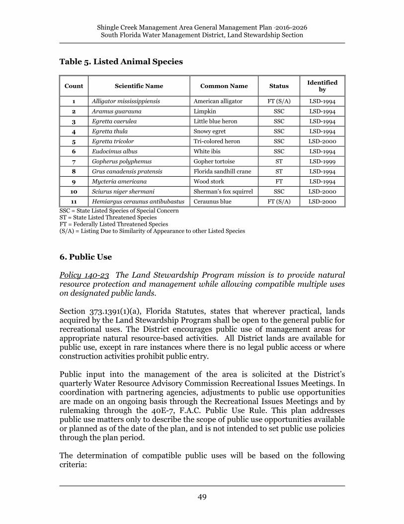
Table 5. Listed Animal Species
Count Scientific Name Common Name Status Identified
by
1 Alligator mississippiensis American alligator FT (S/A) LSD-1994
2 Aramus guarauna Limpkin SSC LSD-1994
3 Egretta caerulea Little blue heron SSC LSD-1994
4 Egretta thula Snowy egret SSC LSD-1994
5 Egretta tricolor Tri-colored heron SSC LSD-2000
6 Eudocimus albus White ibis SSC LSD-1994
7 Gopherus polyphemus Gopher tortoise ST LSD-1999
8 Grus canadensis pratensis Florida sandhill crane ST LSD-1994
9 Mycteria americana Wood stork FT LSD-1994
10 Sciurus niger shermani Sherman’s fox squirrel SSC LSD-2000
11 Hemiargus ceraunus antibubastus Ceraunus blue FT (S/A) LSD-2000
SSC = State Listed Species of Special Concern ST = State Listed Threatened Species FT = Federally Listed Threatened Species (S/A) = Listing Due to Similarity of Appearance to other Listed Species
6. Public Use Policy 140-23 The Land Stewardship Program mission is to provide natural resource protection and management while allowing compatible multiple uses on designated public lands. Section 373.1391(1)(a), Florida Statutes, states that wherever practical, lands acquired by the Land Stewardship Program shall be open to the general public for recreational uses. The District encourages public use of management areas for appropriate natural resource-based activities. All District lands are available for public use, except in rare instances where there is no legal public access or where construction activities prohibit public entry. Public input into the management of the area is solicited at the District’s quarterly Water Resource Advisory Commission Recreational Issues Meetings. In coordination with partnering agencies, adjustments to public use opportunities are made on an ongoing basis through the Recreational Issues Meetings and by rulemaking through the 40E-7, F.A.C. Public Use Rule. This plan addresses public use matters only to describe the scope of public use opportunities available or planned as of the date of the plan, and is not intended to set public use policies through the plan period. The determination of compatible public uses will be based on the following criteria:

Shingle Creek Management Area General Management Plan 2016-2026 South Florida Water Management District, Land Stewardship Section
50
Consistency with the reason the lands were acquired
Restrictions and/or prohibitions imposed by easements, leases, reservations, adjacent land ownership, and other conditions of the purchase agreement
Infrastructure and support facility requirements, such as fences, gates, signage, entry design, stabilized off-road parking, trails, campsites, maintenance, and other operational and budgetary impacts
Opportunities for persons with disabilities
Limitations on use resulting from endangered species, other sensitive natural resources, archeological resources, or land management practices
Public health, safety and welfare
Environmental education program opportunities A wide variety of recreational activities are appropriate and encouraged in the Management Area (Map 15) including hiking, fishing, birding, canoeing, nature appreciation, geocaching, and biking. User information concerning recreational activities is located at the District’s regional service centers and West Palm Beach headquarters, and at each entrance to the Management Area. Information may also be obtained at: www.sfwmd.gov and selecting Recreation. Approximately 5 miles of interior roadway, hiking trails, three public access points, and a picnic pavilion on the East Pine, provide access for public use. The Management Area trail system covers a range of habitats from cypress swamp to pine flatwoods. It spans two access points (Hunters Creek Middle School, and The Vistas) and canoe access to Shingle Creek. To further expand the trail system, boardwalks would be needed in the northwestern portion of the site connecting to the access point at the Marriott Trail and at the Middle School Trail to provide access to the adjacent West Pine Island. The trail adjacent to the Hunter’s Creek Middle School is also a featured stop of the Everglades Trail, a series of 20 trailheads from Orlando to Everglades National Park. As the headwaters of the Everglades, Shingle Creek empties into the Upper Kissimmee Chain of Lakes, which flows into the Kissimmee River, Lake Okeechobee, and ultimately the Everglades itself. The trailheads, like the one at Shingle Creek, illustrate the extent, diversity, and interconnection of the Everglades ecosystem. The Everglades Trail was initiated by U. S. Senator Bob Graham and created cooperatively by the Office of Greenway and Trails, The Nature Conservancy, the Florida Department of Environmental Protection, and other agencies. The District is also exploring the creation of a canoe trail in cooperation with the Office of Greenway and Trails and local interests. A designated canoe launch has been established near the Middle School trailhead. Water levels in the creek fluctuate greatly and canoeing is dependent upon creek depth and navigability.

Shingle Creek Management Area General Management Plan 2016-2026 South Florida Water Management District, Land Stewardship Section
51
Map 15. Public Use

Shingle Creek Management Area General Management Plan 2016-2026 South Florida Water Management District, Land Stewardship Section
52
6.1 Resource Protection Policy 140-25(1)(d) Public use shall not result in detrimental impacts to water resources. When a public use activity produces detrimental effects on water resources, it shall be discontinued until an evaluation determines that such use is compatible. Policy 140-25(3)(g) Resource protection shall be provided by professional law enforcement services through funded and unfunded contractual agreements to safeguard the public and protect natural and cultural resources on District-managed natural areas. Policy 140-25(4)(b)(1) Public use regulations are set forth in 40E-7.511, Florida Administrative Code, to implement Section 373.1391(1)(b), Florida Statutes. Accordingly, the District shall publish and make available to the public a "Public Use Guide" for designated land management areas. Regulations that govern activities within the Management Area are in the District’s 40E-7 Public Use Rule. The 40E-7 rules are available online and at agency headquarters in West Palm Beach. Allowed activities include hiking, fishing, canoeing, biking, and nature study. Management of public activities on District lands requires a commitment to resource protection while simultaneously promoting appropriate public uses. The District emphasizes the enforcement of pertinent rules and regulations to protect natural resources and also provide a safe recreational opportunity. The resource protection program integrates contractual law enforcement to protect the natural resources and District assets. As part of the District’s enhanced patrol contract with Florida Fish and Wildlife Conservation Commission, law enforcement officers conduct regular patrols throughout the year, increasing their presence during hunting seasons and at other times when public use is high. Law enforcement surveillance protects natural and cultural resources, deters illegal activity, and safeguards the public. Patrols are conducted with 4-wheel drive vehicles, all-terrain vehicles, aircraft, and on foot. The District’s law enforcement coordinator and the regional land manager review biweekly reports and meet with officers to structure patrols based on resource needs. Resource protection is also enhanced by the presence and continual maintenance of posted boundary signs. The Management Area has been fenced where needed and the perimeter is posted in highly visible areas and where entry is likely.

Shingle Creek Management Area General Management Plan 2016-2026 South Florida Water Management District, Land Stewardship Section
53
6.2 Environmental Education Educational programs are developed and implemented on select management areas by cooperators interested in promoting increased visitor awareness and appreciation of natural areas and cultural resources. A central theme to these programs is the vital role of water management in high quality and biologically productive lands. The Land Stewardship Program encourages educational partnerships through memorandums of understanding and contractual agreements. The District has developed a Memoranda of Understanding with Orange County Schools that provide local schools special access to the Management Area through District-owned property contiguous with the Hunter’s Creek Middle School. Area students will be able to conduct scientific experiments, nature study, etc., and assist District staff with land management activities. In turn, the District has gained public access through school grounds during non-school hours and holidays. 7. Administration Administration of Land Stewardship Program conservation lands is directed through the Land Stewardship Section in the District’s Land Resources Bureau. Policy decisions, planning and budgeting, procurement of personnel and equipment, contract administration, and issues of program development are administrative tasks coordinated through the Section. Input is provided from the public and regional land managers located at District Service Centers over the 16-county area. Regional land stewards handle regular administrative duties from their field locations to assure quick response to local concerns and management issues. Administrative activities for the Management Area are handled through the St. Cloud Field Station and through the District’s headquarters in West Palm Beach. 7.1 Planning and Budgeting Planning is a major component of the Land Stewardship Section and is critical to maintain proper program focus, direction, and coordination with other agencies. Planning is accomplished by section planning staff in coordination with land management staff. Policy 140-25(6)(b) General Management Plan: Provides a description of recommended management and is required for each Land Stewardship Management Area. The GMP follows a designated format and is updated every ten years. General Management Plans are developed that detail strategies to guide management activities on individual project areas. These plans define goals and

Shingle Creek Management Area General Management Plan 2016-2026 South Florida Water Management District, Land Stewardship Section
54
objectives, identify major management issues, and describe management activities. Each plan is subject to a draft revision period where public comment and professional review is requested prior to plan approval. Each plan is revised on a ten-year cycle by planning team staff. Policy 140-25(5) The District will secure dedicated funding sources, personnel and other resources to support program goals and objectives. Project funding needs and sources for cooperative management agreements with government and non-government entities will be identified during acquisition. A cooperative management agreement will designate a lead manager and identify whether District funding is required. The principal source of funding for land management operations on the Management Area has been derived from mitigation funds and ad valorem tax revenue. For the Shingle Creek Management Area, the District derives its operational funds primarily from Central Florida Beltway Mitigation. The funding has been used to accomplish mitigation alternatives outlined in the Beltway Conceptual Mitigation Plans. Budget planning begins in October during the work planning process for the following fiscal year (October-September). Overall funding availability generally determines management activities. Budget distribution among the District’s five land management regions is based on a programmatic prioritization of management activities. Operational funds are distributed to most effectively accomplish the management objectives of each management area. The continued operation and maintenance of the Management Area includes costs to cover staffing, ongoing operational and land management expenses, and capital refurbishment/replacement of aging infrastructure. Capital infrastructure needs are determined by its condition and the anticipated continued serviceability over the next fiscal year. Priorities for capital refurbishment/replacement are made on a District-wide basis. The operational and land management budget for FY 2016 are included in Table 6, below. Utilities and operational expenses include supplies, electric service, business travel, and safety equipment. Public use costs are generally the maintenance costs of public use facilities. Base level funding needs may increase in the future in response to increasing operational expenses including fuel costs and contracted exotic plant control needs and equipment and infrastructure repairs.

Shingle Creek Management Area General Management Plan 2016-2026 South Florida Water Management District, Land Stewardship Section
55
Table 6. Operational and Land Management Funds Budgeted for Fiscal Year 2016.
2016
Shingle Creek MA
Budget
Contracted LM Svcs
$ 0.00
Utilities and Operational Expenses $ 14,180
Equipment and Infrastructure Maintenance $ 13,000
Exotic Species Control (non-
capital)
$ 105,000
Vegetation Management
$ 10,000
Public Use
$ 5,800
Site Security
$ 30,000
Total $ 177,980
7.2 Infrastructure Policy 140-25(3)(k) Infrastructure support shall be developed and maintained to provide safe access for responsible management and public use on District lands. Such infrastructure may include access points, roads, trails, signs, utilities, and minimal public facilities. In addition to District funds, the development of adequate infrastructure for public use and management activities has received support from the Orlando Utilities Commission, primarily from its regular maintenance of the powerline corridors. Current Management Area infrastructure includes three entrances, perimeter posting, firelines, hiking trails and roads, a picnic shelter, a bridge and boardwalk at the Hunters Creek Middle School entrance, wooden foot bridges, and a boardwalk at the western entrance, all of which require regular maintenance. 7.3 Personnel and Equipment The Land Stewardship Section is separated into five geographic regions, each assigned a Senior Scientist (Land Manager), one to three land management technicians, and on some areas, based on need a Scientist III position. A Section Leader provides direct oversight and supervision for the land managers. Additional leadership and assistance come from the Land Stewardship Section Administrator, Wildlife and Public Use Section, and other support personnel at District headquarters in West Palm Beach, FL. Management of the Shingle Creek property is the primary responsibility of the Shingle Creek Scientist III position, as well as the Upper Lakes Senior Scientist

Shingle Creek Management Area General Management Plan 2016-2026 South Florida Water Management District, Land Stewardship Section
56
and land management technician. Additional management input and support comes from District planning and field station personnel. Staff has access to tools, supplies, equipment, four-wheel drive vehicles, vessels, fire suppression trucks, all-terrain vehicles, swamp buggies, an airboat, a dump truck, tractors, and a road grader. The District’s St. Cloud Field Station crew and equipment, as well as leased equipment, are also available to assist in the Management Area on a limited basis. 7.4 Volunteers and Alternative Work Force Policy 140-25(5)(d)(1) Volunteers, interns and alternative work forces will be used when possible to supplement existing staff and services. Section 373.1391(3) F.S. encourages the District to use volunteers for land stewardship and other services. The District recognizes the merits of volunteerism and welcomes participation in activities appropriate for public involvement. In Fiscal Year 2015, District lands benefited from 15,131 volunteer hours, or $326,981 worth of volunteer services (using a $21.61/hour Florida average for the value of volunteer service). Land management objectives are also occasionally met by alternative work forces. When available, alternative work forces can be used for projects that demand manual labor and have low technical skill requirements. Volunteer projects on the Management Area to date include Shingle Creek trash clean-ups, plant inventories (Native Plant Society), bird surveys, butterfly surveys, and bird box projects with local Scouts. 7.5 Contractual Management Policy 140-25(5)(a). The private sector may be solicited to furnish certain management-related facilities and services through the execution of leases and agreements. These leases/agreements will assure mutual benefits to both the District and private parties and be consistent with the program management objectives. Effective operation and management of District properties requires the services and cooperation of private organizations, other governmental agencies, and volunteers. Contractual management is authorized through a management agreement signed by both the District and contracting entity with the document defining responsibilities of each party. The District has established contractual management agreements to assist with management of the Shingle Creek Save Our Rivers project:

Shingle Creek Management Area General Management Plan 2016-2026 South Florida Water Management District, Land Stewardship Section
57
Contract#3600000000-A12: Enhanced Patrols The District contracted with the Florida Fish and Wildlife Conservation Commission for enhanced law enforcement services. These services cover areas throughout the District and include supplemental patrols on the Management Area. The District’s resource protection coordinator schedules patrols with input from the Management Area’s land manager and the Commission. Contract# 4600001341: Cooperative Management Agreement The District has developed a partnership with Osceola County and the City of Kissimmee to address management needs of jointly acquired parcels within the Osceola County portion of the Project. This agreement provides for a 50/50 management cost share between the District and the local partners. 7.6 Management Review Policy 140-22(j) Section 373.591, Florida Statutes, mandates the District to solicit input on current management programs through professional peer reviews. A land management review team is identified for each project area with a General Management Plan. The composition of the review teams are defined by statute (§ 373.591, Fla. Stat.) and include state and private entities that are charged with reviewing management activities to assure they are consistent with acquisition intent and program objectives. Management assessments are conducted based on of the goals and objectives defined in the area’s general management plan and are scored on a scale of 1 to 5 with a 1 meaning the management is insufficient and a 5 meaning the management is extremely effective. If the review team determines that management is insufficient in any area, defined as attaining an average score of less than 3.0, then the District is to provide a written explanation to the review team along with proposed corrective actions. A management review was conducted in November 2015. The review team provided comments on the condition of the land and the management of the site. Positive comments were received on the land management practices implemented and the availability of public use facilities and outreach information on the Shingle Creek Management Area. These comments focused on the District’s consistent use of prescribed fire and the dedication and performance of the land management staff. The review also included comments by several team members that additional staffing and increased funding would be beneficial for the overall management and the expansion of public use opportunities provided on the property. There were individual comments that additional plant surveys should be conducted and that the District should continue to add additional public recreational amenities on the Management Area.

Shingle Creek Management Area General Management Plan 2016-2026 South Florida Water Management District, Land Stewardship Section
58
The team also rated the land management sufficiency grouped under the broader categories of Natural Resources; Resource Management; Resource Protection, Multiple Use, Assessments; and Public Use, Budget, Goals and Objectives. The average score for each evaluation criteria is identified on the graphs below and indicate the review team felt the Management Area was being properly managed.

Shingle Creek Management Area General Management Plan 2016-2026 South Florida Water Management District, Land Stewardship Section
59
22.5
33.5
44.5
5
Sw
am
ps
Fla
twoo
ds
Lis
ted
Pla
nts
Lis
ted
An
imals
Arc
hae
olo
gic
al
Sites
His
tori
ca
l S
ites
Shingle Creek Management Area Natural Resources
2015ManagementSufficiency
2
2.5
3
3.5
4
4.5
5
Rx F
ire
: M
ain
t.of
Natu
ral
Co
mm
s.
Rx F
ire
:F
requ
ency
Re
sto
ratio
n:
Hydro
logic
Re
sto
ratio
n:
Wetland
s
Re
sto
ratio
n:
Up
lan
ds
Wild
life
Ha
bitat
No
n-G
am
e
Initia
l E
xotics
Co
ntr
ol
Re
tre
atm
ent
Fre
qu
ency
Shingle Creek Management Area Resource Management
2015ManagementSufficiency
2015 Land Management Review Results
Shingle Creek Management Area General Management Plan 2016-2026 South Florida Water Management District, Land Stewardship Section
60
2
2.5
3
3.5
4
4.5
5
Ga
tes
Sig
na
ge
Fe
ncin
g
Po
ach
ing
Vandalis
m
Du
mpin
g
Pa
tro
ls
Tim
be
rM
ana
gem
ent
Re
sou
rce
Pre
se
rva
tio
n
Re
sou
rce
Inven
tories
Mo
nito
rin
g
Shingle Creek Management Area Resource Protection, Multiple Use, Assessments
2015ManagementSufficiency
2
2.5
3
3.5
4
4.5
5
Acc
ess
Recr
eational
Opport
uni
ties
Inte
rpre
tive
faci
llitie
s
Pers
onnel
Opera
tions
&M
ain
tenance
Budget
Cap. Im
pro
vem
ents
Budget
Goals
and
Obje
ctiv
es:
Pre
sence
Goals
and
Obje
ctiv
es: b
ein
g
adhere
d to
Shingle Creek Management AreaPublic Use, Budget, Goals and Objectives
2015ManagementSufficiency
Shingle Creek Management Area General Management Plan 2016-2026 South Florida Water Management District, Land Stewardship Section
61
8. References Cited Coker, Michael. June, 2003. Forest Area Supervisor, Florida Forest Service.
Personal communication. Cox, J., R. Kautz, M. MacLaughlin, and T. Gilbert. 1994. Closing the Gaps In
Florida’s Wildlife Habitat Conservation System. Office of Environmental Services, Florida Game and Freshwater Fish Water Commission. [Electronic version]
website: http://myfwc.com/oes/habitat_sec/Closing_Gaps.pdf Exum, J. H. 2004. Shingle Creek Herpetological Survey, Orange County,
Florida. Glatting, Jackson, Kercher, Anglin, Lopez. Orlando, FL. Florida Exotic Pest Plant Council. [Electronic version] website: http://www.fleppc.org/Plantlist/03list.htm Florida Department of Agriculture and Consumer Services. 2003. Notes on
Florida’s Endangered and Threatened Plants. Division of Plant Industry. Gainesville, FL. [Electronic version] website: http://www.doacs.state.fl.us/pi/enpp/botany/images/Notes2003.pdf
Florida Fish and Wildlife Conservation Commission. 2015. Website
https://public.myfwc.com/FWRI/EagleNests/nestlocator.aspx Florida Natural Areas Inventory and Department of Natural Resources. 2010.
Guide to the Natural Communities of Florida. Tallahassee, Florida. Kautz, R., J. Cox, M. MacLaughlin, and J. Stys. 1994. Mapping Wetland
Habitats of High Priority to Endangered and Threatened Species in Florida. Office of Environmental Services, Florida Game and Freshwater Fish Water Commission. [Electronic version]
website: http://myfwc.com/oes/habitat_sec/Closing_Gaps.pdf Mejeur, R. S. 2004. Summary Report of Findings, Shingle Creek Vegetation
Study. Glatting, Jackson, Kercher, Anglin, Lopez. Orlando, FL. Ost, Laura. (1987, July 23). Dig Might Have Found State’s Oldest Structure. The
Orlando Sentinel, pp. A-1, A-8. Post, John M., Jr., 2002. WRAP Analyses for the Shingle Creek Enhancement
Project. Florida’s Turnpike Enterprise, Florida Department of Transportation (submitted to the U. S. Army Corps of Engineers, August, 2002; available through the Orlando Service Center).

Shingle Creek Management Area General Management Plan 2016-2026 South Florida Water Management District, Land Stewardship Section
62
Robbins, Becky. April, 1994. Shingle Creek Swamp Mitigation Plan. South Florida Water Management District.
Robbins, B., S. Lin. March, 1994. Shingle Creek Swamp Mitigation Project, Hydrologic and Biological Assessments Conducted to Evaluate Enhancement Project Designs. South Florida Water Management District.
South Florida Water Management District. October, 2001. Central Florida
Beltway, Western Beltway, State Road 429, Part C, Conceptual Mitigation Plan. Land Stewardship Division, South Florida Water Management District.
South Florida Water Management District. 2009. Recreational Guide,
[Electronic Version] website: http://my.sfwmd.gov/portal/page/portal/xrepository/sfwmd_repository_pdf/recreation_guide_09.pdf
State of Florida. 1983. Florida Master Site File. Department of State, Division of
Historical Resources, Tallahassee, FL. USFWS. 2007. National Bald Eagle Management Guideline. United States Fish
and Wildlife Service. Washington D.C. U.S. Fish and Wildlife Service. 1998. Multi-Species Recovery Plan for the
Threatened and Endangered Species of South Florida, Volume 1: The Species. Technical/Agency Draft. U.S. Fish and Wildl. Serv. Publications Unit, Shepherdstown, West Virginia. [Electronic version]
website: http://verobeach.fws.gov/Programs/Recovery/vbms5.html Valencia Water Control District. District literature available to the public upon
request; also GIS data provided with permission. Van Horn, Mia. 1997. Shingle Creek Conceptual Management Plan. South
Florida Water Management District. Virginia Tech, Department of Fisheries and Wildlife Sciences. 1996b. (DRAFT) – Taxonomy Species EAGLE, BALD Species Id ESIS109001 Date 14 MAR
96. Endangered Species Information System Fish and Wildlife Information Exchange. [Electronic version] website: http://fwie.fw.vt.edu/WWW/esis/lists/e109001.htm
White, W. A. 1970. The Geomorphology of the Florida Peninsula. Fla. Dept.
Natural Resource Geological Bull. No. 51 (available through Florida Environments Online. [Electronic version]

Shingle Creek Management Area General Management Plan 2016-2026 South Florida Water Management District, Land Stewardship Section
63
Appendix A. Land Stewardship Program Goals and Policies
ARTICLE II. LAND STEWARDSHIP Sec. 140-21. Scope. This policy shall apply to all lands managed by the Land Stewardship Program, including property acquired with Save Our Rivers, Preservation 2000 or mitigation funding. Nothing in this policy shall negate any statute, administrative rule, or other policy requirement. This policy may be reviewed and approved by the District Governing Board at five-year intervals or earlier and updated as required. Public comment may be solicited as part of the review process. (R.M. No. 139) Sec. 140-22. Purpose. (a) This policy establishes a commitment to the responsible management of District lands in a manner consistent with legislative directives and the District's mission. (b) In 1981, the Florida Legislature established the "Save Our Rivers" program (SOR) for the five water management Districts to acquire water resource lands. This legislation (Section 373.59, Florida Statutes) produced the Water Management Lands Trust Fund, empowering the water management Districts to acquire lands needed to protect, manage, and conserve the state's water resources. Preservation 2000 (P2000), enacted by the Legislature in 1990, also added land acquisition funds to the Save Our Rivers program. The 1999 Florida Forever Act consolidated the legislative directives of SOR/P2000 and expanded the funding to take over when P2000 terminates. The 1999 legislation authorized funds to be appropriated for acquisition, management, maintenance and capital improvements, including perimeter fencing, signs, control of invasive exotic species, controlled burning, habitat inventory and restoration, law enforcement, access roads and trails, and minimum public accommodations. (c) Land acquired by the District's Save Our Rivers program and managed by the Land Stewardship program must satisfy several requirements set forth in Sections 373.139 and 373.1391, Florida Statutes. Section 373.139, Florida Statutes, declares it necessary for the public health and welfare that water and water-related resources be conserved and protected. The acquisition of real property for this objective shall constitute a public purpose for which public funds may be budgeted. (d) Section 373.1391(1)(a), Florida Statutes, states that lands titled to the water management districts shall be managed and maintained to the extent practicable to ensure a balance between public access, general public recreational purposes, and restoration and protection of their natural state and condition. (e) Section 373.1391(1)(b), Florida Statutes, states, in part, that "Whenever practicable, such lands shall be open to the general public for recreational uses. General public recreational uses shall include, but not be limited to, fishing, hunting, horseback riding, swimming, camping, hiking, canoeing, boating,

Shingle Creek Management Area General Management Plan 2016-2026 South Florida Water Management District, Land Stewardship Section
64
diving, birding, sailing, jogging, and other related outdoor activities to the maximum extent possible considering the environmental sensitivity and suitability of those lands." (f) Section 373.1391(1)(d), Florida Statutes, states that the District shall first consider using soil and water conservation Districts to administer agricultural leases. (g) Section 373.1391(3), Florida Statutes, encourages each District to use volunteers to provide land management and other services. (h) Section 373.1391(4), Florida Statutes, encourages each District to enter into cooperative land management agreements with state agencies or local governments to provide the coordinated and cost-effective management of lands. (i) Section 373.1391(5), Florida Statutes, authorizes water resource and supply projects, stormwater management projects, linear facilities, and sustainable agriculture and forestry where it is compatible with the natural resource values and the public interest and is consistent with the project management plan, the proposed use is appropriately located on the property and other lands have been considered, and the titleholder of the property has been properly compensated. (j) Section 373.591, Florida Statutes, mandates the District to solicit input on current management programs through professional peer reviews. (R.M. No. 139) Sec. 140-23. Statements of Policy. The Land Stewardship Program mission is to provide natural resource protection and management while allowing compatible multiple uses on designated public lands. The mission statement, together with requirements set forth in the Florida Statutes, provide three primary goals for the District Land Stewardship Program, each of which is linked to sections in this Land Stewardship Policy document: (1) Conservation and protection of water resources (section 140-25(1)). (2) Protection and/or restoration of land to its natural state and condition: a. Restoration and Protection of Natural Communities (section 140-25(2)); and b. Resource Operations and Maintenance (section 140-25(3)). (3) Provide public use (section 140-25(4)). (R.M. No. 139) Sec. 140-24. Definitions. For the purpose of this article, the following words and terms shall have the meanings respectively ascribed: Archaeological/Historic Resources means any prehistoric or historic district site, building, object, or property of historic, architectural, or archaeological value relating to the history, government, and culture of a historic or pre-historic people. Best Management Practice (BMP) means the best available technology or process that is practical and achieves the desired goal or objective. Capital Improvement means activities relating to the restoration, public access, recreational uses and necessary services for land and water areas, including the initial removal of invasive plants, and the construction, improvement,

Shingle Creek Management Area General Management Plan 2016-2026 South Florida Water Management District, Land Stewardship Section
65
enlargement or extension of facilities' signs, fire lines, access roads, and trails. Such activities shall be identified prior to the acquisition of a parcel or the approval of a project. Cooperating Agencies means two or more agencies working together to operate a specific management area. Cooperative Management Agreement means an agreement between two or more agencies outlining the respective duties and responsibilities of each agency in the management of a specific tract of land. Critical Habitat means areas designated for the survival and recovery of state/federally listed rare, threatened, endangered or other sensitive species. Desirable Vegetation means native plant species that are appropriate for a specific community type and provide benefits to wildlife in the form of food, cover and nesting. Habitat Diversity means richness and variety of native plant communities within a particular area of the landscape. Hydroperiod means flooding duration, depth, and timing that influences species composition, ecosystem structure and function. Interim Land Management means management of non-natural areas that provides revenue without impacting long-term water-development projects. Invasive/Exotic Vegetation means certain plants that displace native species and adversely affect wildlife habitat, water quality, recreation, and biological diversity. Lead Manager means the prime managing entity designated for a given tract of land; generally provides the on-site staff. Management Area means a single tract or combination of tracts under one management program. Mitigation means, for purposes of this policy, the actual acquisition, restoration, creation, or enhancement of wetlands to compensate for permitted wetland impacts. Mitigation Banking means wetland acquisition, restoration, creation or enhancement undertaken expressly to provide compensation in advance of wetland losses from development activities. Multiple-Use means the management of renewable resources for a variety of purposes such as recreation, range, timber, wildlife habitat, and water resource development. Prescribed Fire means burning of vegetative fuels using controlled application of fire within specified environmental conditions. Primary Resource Lands means lands having high water resource, fish, wildlife, and recreational values requiring acquisition or protection. Regional Mitigation Area means, for purposes of this policy, permitted wetland impacts offset through payment for the acquisition, restoration and perpetual management of a Save Our Rivers identified and duly noticed project. Responsible Management means level of management described in the General Management Plan. Sustainable Use means to provide continued use of a natural resource without degradation or loss of that resource.

Shingle Creek Management Area General Management Plan 2016-2026 South Florida Water Management District, Land Stewardship Section
66
Water Resource Buffer means that portion of a Preservation 2000 or Save Our Rivers project necessary to protect the aquatic environment. Wildlife Corridor means a connection between natural areas that allows the safe movement of wildlife. (R.M. No. 139) Cross references: Definitions and rules of construction, § 100-2. Sec. 140-25. Responsibilities. The Land Stewardship Program is responsible for: (1) Water Resource Protection. The basis for the Land Stewardship Program is the protection and management of natural hydrologic resources. The following policies guide implementation of this objective:
a. Acquired lands shall be managed to provide water resource-related benefits.
b. Land uses or activities that significantly or permanently alter or degrade the quality, quantity and/or natural movement of ground or surface water are not allowed unless they are a part of a regional water management system.
c. Where feasible, an attempt shall be made to restore a more natural hydroperiod on tracts where the drainage patterns have been altered.
d. Public use shall not result in detrimental impacts to water resources. When a public use activity produces detrimental effects on water resources, it shall be discontinued until an evaluation determines that such use is compatible.
e. Water resource lands designated as necessary to implement the Central and Southern Florida "Restudy" Project shall, upon acquisition, become the responsibility of the (Interim) Land Management Program, and follow the guidelines set forth under Section 373.1391(5), Florida Statutes. (2) Restoration and Protection of Natural Communities:
a. The Land Stewardship Program will encourage the acquisition of large or regionally significant areas that protect important natural resources and provide wildlife corridors.
b. Particular emphasis shall be placed on the identification, protection and management of rare, threatened and endangered species.
c. The planting of invasive exotic plant species shall be prohibited in all management areas. Management practices will strive to identify existing infestations and implement appropriate control or eradication measures.
d. Where practicable, an attempt shall be made to restore and maintain desirable vegetation to promote habitat diversity in areas where invasive exotic vegetation, grazing practices, or improved land uses have substantially altered the historic landscape. (3) Resource Operations and Maintenance:
a. Lands acquired for natural and/or hydrologic resource benefits shall be managed to conserve and protect those resources.
b. Exotic plant control in all management areas shall strive to attain a level of success where periodic maintenance eliminates the infestation or reduces the coverage of exotic plants.

Shingle Creek Management Area General Management Plan 2016-2026 South Florida Water Management District, Land Stewardship Section
67
c. Prescribed fire will be a primary management tool on District lands and will be applied within fire-maintained communities at appropriate intervals.
d. The Division of Forestry will be notified of all wildfires on District lands. Land Stewardship will provide initial suppression when commensurate personnel and equipment are available.
e. Inventories of natural and historic resources shall be performed to provide information for effective land management planning, natural community maintenance and ecological restoration.
f. Evaluation and monitoring of management activities shall be conducted to improve program effectiveness and efficiency.
1. Research shall evaluate the environmental response of certain management activities to assist staff in making appropriate management decisions.
2. Monitoring shall be conducted to identify landscape changes resulting from management activities.
3. Legislative-mandated management reviews will provide input from professional peers. g. Resource protection shall be provided by professional law
enforcement services through funded and unfunded contractual agreements to safeguard the public and protect natural and cultural resources on District-managed natural areas.
h. Sustainable use of forest resources shall be conducted where these activities adhere to a series of environmental criteria (see 1999 Forest Management Plan) that meet Land Stewardship Program goals. Timber contractors will be required to meet silvicultural Best Management Practices (BMP) developed for Florida forests.
i. Range management (grazing) will be considered on improved or native ranges when the introduction of cattle will not conflict with other natural resource management and public use goals.
j. Archaeological and historic resources are protected by site identification and inter-agency coordination with the Florida Division of Historical Resources. Land stewardship planning shall include an analysis of archeological data accompanied by appropriate public education opportunities.
k. Infrastructure support shall be developed and maintained to provide safe access for responsible management and public use on District lands. Such infrastructure may include access points, roads, trails, signs, utilities, and minimal public facilities.
l. Mechanical equipment may be used in conjunction with prescribed burning and other management tools to control vegetation and restore habitat structure. m. Agricultural developments previously existing on acquired natural areas may be maintained if management of these developments is consistent with other land stewardship goals. (4) Public Use and Environmental Education:
a. Public use of management areas that is consistent with other management goals shall be encouraged. Public use that may have detrimental

Shingle Creek Management Area General Management Plan 2016-2026 South Florida Water Management District, Land Stewardship Section
68
impacts on sensitive environmental resources shall be restricted until an evaluation determines such use is compatible. A public use compatibility assessment will be included in the General Management Plan completed for each management area and will be based on the following criteria:
1. Consistency with the reason the lands were acquired. 2. Restrictions and/or prohibitions imposed by easements, leases,
reservations, adjacent land ownership, conditions of the purchase agreement, and any other agreements concerning the property.
3. Infrastructure and support facility requirements, such as fences, gates, signage, entry design, stabilized off-road parking, trails, campsites, maintenance, and other operational and budgetary impacts.
4. Opportunities for persons with disabilities. 5. Limitations resulting from endangered species, other sensitive
natural resources, archaeological resources, or land management practices.
6. Public health, safety and welfare. 7. Environmental education program opportunities.
b. Public Use Regulation: 1. Public use regulations are set forth in 40E-7.511, Florida
Administrative Code, to implement Section 373.1391(1)(b), Florida Statutes. Accordingly, the District shall publish and make available to the public a "Public Use Guide" for designated land management areas. The Public Use Guide will be adopted by the Governing Board at a public meeting advertised in accordance with Chapter 120, Florida Statutes.
2. Rules and regulations governing the public use of each management area shall be enforced by agencies with appropriate law enforcement jurisdiction.
3. Pursuant to Section 373.609, Florida Statutes, the District shall seek the cooperation of every state and county attorney, sheriff, police officer, and appropriate city and county official in the enforcement of the provisions set forth according to 40E-7.511, Florida Administrative Code.
4. Florida Fish and Wildlife Conservation Commission regulations shall govern hunting in areas opened for such use.
(5) Implementation Strategies. The District will secure dedicated funding sources, personnel and other resources to support program goals and objectives. Project funding needs and sources for cooperative management agreements with government and non-government entities will be identified during acquisition. A cooperative management agreement will designate a lead Manager and identify whether District funding is required.
a. The private sector may be solicited to furnish certain management-related facilities and services through the execution of leases and agreements. These leases/agreements will assure mutual benefits to both the District and private parties and be consistent with the program management objectives.
b. Mitigation: 1. Mitigation Banking: Mitigation banking provides an
opportunity to accomplish large-scale restoration that may otherwise go

Shingle Creek Management Area General Management Plan 2016-2026 South Florida Water Management District, Land Stewardship Section
69
unfunded. Pursuant to Section 373.4135, Florida Statutes, the District is encouraged to develop mitigation banks. Land managers will evaluate opportunities in their regions to implement mitigation banks that are consistent with the guidelines established in the Joint State and Federal Mitigation Bank Review Team Process for Florida.
2. Regional Mitigation Areas: The acquisition, restoration and management of District lands as mitigation shall be consistent with Chapter 2000-133, amending Sections 373.414 and 373.4135, Florida Statutes. This includes the establishment of Memorandums of Agreement (MOA) that include restoration plans, success criteria, and monitoring requirements. The MOAs will be used to implement mitigation using full-cost accounting, public noticing, and approval by the Governing Board for use as a mitigation area. The mitigation shall meet restoration objectives as provided in the General Management Plan. c. Revenue Generation:
1. Private concessions and/or agreements with non-profit organizations will be considered to implement needed services through concession contracts.
2. Entrance and user fees, permits, licenses and/or advance reservations may be required where considered necessary by the managing agency.
3. Timber sales will be conducted to improve forest health or to support specific forest management goals.
4. Grazing leases will be encouraged on selected rangeland to generate revenue or to provide services that offset program management costs. d. Volunteers and Interns:
1. Volunteers, interns and alternative work forces will be used when possible to supplement existing staff and services.
2. Any volunteer services must meet the standards and procedures prescribed by the District (Risk Management Manual, Volume 1).
(6) Program Components: a. Management Assessment: A brief summary of the management issues
completed when the site is identified for acquisition. b. General Management Plan (GMP): Provides a description of
recommended management and is required for each Land Stewardship Management Area. The GMP follows a designated format and is updated every five years.
c. Activity Plan (AP): Provides a detailed implementation strategy for specific activities such as prescribed burning, exotic removal and restoration. The plan shall be developed by the lead Manager in consultation with the cooperating agencies for each major tract of land (or group of tracts) to be operated as a single management unit. The AP may be included in the GMP and is updated when necessary.

Shingle Creek Management Area General Management Plan 2016-2026 South Florida Water Management District, Land Stewardship Section
70
d. Annual Work Plan (AWP): Summarizes activities corresponding with annual budget development and is prepared by the Operations Section of the Land Stewardship Program.
e. Reporting: Summaries of management activities for each management area will be reported quarterly within the District and annually as part of the Florida Forever Work Plan. (R.M. No. 139) Secs. 140-26--140-40. Reserved.

Shingle Creek Management Area General Management Plan 2016-2026 South Florida Water Management District, Land Stewardship Section
71
Appendix B. Soil Descriptions
Flatwood Soils Flatwood soils are poorly drained non-hydric, upland soils with sandy marine sediments throughout the profile. The seasonal high water table can range from six to 18 inches below the soil surface for three to six months annually. Natural communities typical of flatwood soils on the Management Area are mesic flatwoods. Typical natural vegetation of flatwood soils is scattered slash pine (Pinus elliotti) and an understory dominated by saw palmetto (Serenoa repens) and grasses. Flat Soils Flat (previously referred to as slough) soils are poorly drained hydric soils with sandy marine sediments throughout the profile. Flats are located between the flatwoods and topographic depressions and are generally regarded as transition areas, e.g. a wet prairie or a slough. Generally, the seasonal high water table begins in June and ends from September or thereafter with inundation periods dependent upon seasonal rainfall or large storm events. Management Area wet prairie communities best represent this classification; wet prairies are dominated by expanses of grasses, sedges, and rushes with scattered pines or cypress. Sand Depression Soils Sand depression soils are very poorly drained hydric soils that typically have sandy marine sediments throughout the profile. Often, these areas are depressions adjacent to flatwoods. The seasonal high water table can range from one foot below to two feet above the soil surface for seven to 10 months annually. Wetland communities dominate this landscape position. Within the Management Area, cypress (Taxodium spp.) and hardwood swamps represent this soil class. Muck Depression Soils Muck depression soils are very poorly drained hydric soils that have an organic surface layer underlain by sandy marine sediments. These areas are often depressions adjacent to Flatwood soil-types. The seasonal high water table can range from six inches below to two feet above the soil surface for seven to eleven months annually. Wetland communities dominate this soil type. Examples within the MA include hardwood swamps dominated by bald cypress (Taxodium distichum), pond cypress (Taxodium ascendens), or red maple (Acer rubrum). Water Areas This classification represents areas that are permanently inundated, with depths usually two feet or more. No soil series or ecological community is associated with this classification. In the Management Area, the Shingle Creek canal and the historical Shingle Creek channel best represent this category.

Shingle Creek Management Area General Management Plan 2016-2026 South Florida Water Management District, Land Stewardship Section
72
Appendix C. Natural Communities Basin Marsh – basin with peat or sand substrate; seasonally inundated; statewide excluding Keys; occasional fire; largely herbaceous; maidencane, sawgrass, bulltongue arrowhead, pickerelweed, Baker’s cordgrass, white water lily, coastalplain willow. Basin Swamp – typically large basin wetland with peat substrate; seasonally inundated; still water or with water output; Panhandle to central peninsula; occasional or rare fire; forest of cypress/tupelo/mixed hardwoods; pond cypress, swamp tupelo. Depression Marsh – small, isolated, often rounded depression in sand substrate with peat accumulating toward center; surrounded by fire-maintained community; seasonally inundated; still water; statewide excluding Keys; frequent or occasional fire; largely herbaceous; maidencane, sawgrass, pickerelweed, longleaf threeawn, sand cordgrass, peelbark St. John’s wort. Dome Swamp – small or large and shallow isolated depression in sand/marl/limestone substrate with peat accumulating toward center; occurring within a fire-maintained community; seasonally inundated; still water; statewide excluding Keys; occasional or rare fire; forested, canopy often tallest in center; pond cypress, swamp tupelo. Mesic Flatwoods – flatland with sand substrate; mesic; statewide except extreme southern peninsula and Keys; frequent fire (2-4 years); open pine canopy with a layer of low shrubs and herbs; longleaf pine and/or slash pine, saw palmetto, gallberry, dwarf live oak, wiregrass. Mesic Hammock – flatland with sand/organic soil; mesic; primarily central peninsula; occasional or rare fire; closed evergreen canopy; live oak, cabbage palm, southern magnolia, pignut hickory, saw palmetto. Wet Flatwoods – flatland with sand substrate; seasonally inundated; statewide except extreme southern peninsula and Keys; frequent fire (2-4 years for grassy wet flatwoods, 5-10 years for shrubby wet flatwoods); closed to open pine canopy with grassy or shrubby understory; slash pine, pond pine, large gallberry, fetterbush, sweetbay, cabbage palm, wiregrass, toothache grass. Wet Prairie – flatland with sand or clayey sand substrate; usually saturated but only occasionally inundated; statewide excluding extreme southern peninsula; frequent fire (2-3 years); treeless, dense herbaceous community with few shrubs; wiregrass, blue maidencane, cutthroat grass, wiry beaksedges, flattened pipewort, toothache grass, pitcherplants, coastalplain yellow-eyed grass.

Shingle Creek Management Area General Management Plan 2016-2026 South Florida Water Management District, Land Stewardship Section
73
Appendix D. Species List Key: (E)Endangered, (T)Threatened, (C)Commercially exploited;
= Category I Invasive Exotic species
Plants
Total Count
GENUS SPECIES COMMON NAME Status
Fed State
1 Acer rubrum Red Maple
2 Acrostichum danaeifolium Leather Fern
3 Agalinus sp. Foxglove
4 Aletris lutea Yellow Colic-root
5 Alternanthera philoxeroides Alligator-weed
6 Ambrosia artemisiifolia Ragweed
7 Ampelopsis arborea Pepper Vine
8 Amphicarpum muhlenbergianum Blue Maidencane
9 Andropogon glomeratus Bushy Bluestem
10 Aristida purpurea Purple Three-awn
11 Andropogon virginicus Broom Grass
12 Andropogon virginicus v. glaucus Chalky Bluestem
13 Aristida spiciformis Three-awngrass
14 Aristida stricta Wiregrass
15 Asclepias curassavica Scarlet Milkweed
16 Asclepias longifolia Longleaf milkweed
17 Asclepias pedicellata Savanna Milkweed
18 Asimina reticulata Pawpaw, Dog Banana
19 Aster carolinianus Climbing Aster
20 Aster elliotti Elliott's Aster
21 Axonopus sp. Carpet Grass
22 Axonopus furcatus Big Carpetgrass
23 Azolla caroliniana Carolina Mosquitofern
24 Baccharis halimifolia Saltbush
25 Bacopa caroliniana Lemon Bacopa
26 Bacopa monnieri Smooth Water-hyssops
27 Bejaria racemosa Tarflower
28 Bidens alba Spanish Needle
29 Bidens mitis Beggar-ticks
30 Bigelowia nudata Rayless Goldenrod
31 Blechnum serrulatum Swamp Fern
32 Boehmeria cylindrica False Nettle
33 Buchnera americana American bluehearts
34 Bulbostylis ciliatifolia Capillary Hairsedge
35 Burmannia biflora Northern Bluethread
36 Callicarpa americana Beautyberry
37 Campsis radicans Trumpet Vine
38 Carex sp. Sedge

Shingle Creek Management Area General Management Plan 2016-2026 South Florida Water Management District, Land Stewardship Section
74
39 Carex glaucescens Southern Waxy Sedge
40 Carphephorus carnosus Chaffhead
41 Carphephorus corymbosus Coastalplain Chaffhead
42 Carphephorus ordoratissumus Vanilla Plant; Deer-tongue
43 Ceanothus sp.
44 Centella asiatica Spadeleaf
45 Centella erecta Coinwort
46 Centrosema virginianum Spurred butterfly pea
47 Cephalanthus occidentalis Buttonbush
48 Ceratopteris thalictroides Water Horn Fern
49 Chamaecrista nictitans Partridge pea
50 Cinnamomum camphora Camphor Tree
51 Cirsium horridulum Thistle
52 Cladium jamaicense Saw-grass
53 Cleome hassleriana Pinkqueen Spiderflower
54 Clitoria mariana Atlantic pigeonwings
55 Colocasia esculenta Wild Taro
56 Commelina diffusa Dayflower
57 Conyza sp. Horseweed
58 Coreopsis leavenworthii Tickseed
59 Crotalaria rotundifolia Rabbitbells
60 Cuphea carthagenensis Columbia Waxweed
61 Cynodon dactylon Bermuda Grass
62 Cyperus spp. Flatsedges
63 Cyperus drumondii Flat Sedge
64 Cyperus odoratus Flat Sedge
65 Desmodium sp. Tick-trefoil
66 Dichanthelium sp. Panic Grass
67 Dichanthelium scabriusculum Woolly rosette grass
68 Dichromena colorata White-top Sedge
69 Diodia virginiana Buttonweed
70 Dioscorea bulbifera Air Potato
71 Drosera brevifolia Dwarf sundew
72 Drosera capillaris Pink Sundew
73 Dulichium arundinaceum Three-way Sedge
74 Echinochloa walteri Coast cockspur
75 Eichhornia crassipes Water Hyacinth
76 Eleocharis sp. Spikerush
77 Elephantopus elatus Florida Elephant's Foot
78 Eragrostis elliottii Elliott's lovegrass
79 Erechtites hieracifolia Fireweed
80 Erigeron quercifolius Oakleaf Fleabane
81 Erigeron vernus Fleabane
82 Eriocaulon decangulare Tenangle Pipewort

Shingle Creek Management Area General Management Plan 2016-2026 South Florida Water Management District, Land Stewardship Section
75
83 Eryngium yuccifolium Button Snakeroot
84 Eupatorium capillifolium Dog Fennel
85 Eupatorium mohrii Dog Fennel
86 Eupatorium rotundifolium False Soarhound
87 Euthamia minor Flat-topped Goldenrod
88 Fimbristylis sp. Fringe-rushes
89 Fuirena sp. Umbrella-grass
90 Fuirena scirpoidea Southern umbrellasedge
91 Galactia elliottii Elliott's Milk-pea
92 Galium tinctorium Stiff marsh Bedstraw
93 Gaylussacia dumosa Dwarf Huckleberry
94 Geranium caroliniaum Crane's Bill
95 Gordonia lasianthus Loblolly Bay
96 Gratiola hispida Rough Hedgehyssop
97 Gymnopogon sp. Skeleton Grass
98 Habenaria quinqueseta Spider Orchid
99 Habenaria sp. Rein Orchid
100 Hydrilla verticillata Hydrilla
101 Hedyotis procumbens Innocence
102 Hydrocotyle umbellata Pennywort
103 Hypericum brachyphyllum Coastalplain St. John's-wort
104 Hypericum cistifolium St. John's Wort
105 Hypericum crux-andreae St. Peter's Wort
106 Hypericum hypericoides St. Andrews Cross
107 Hypericum myrtifolium Hypericum
108 Hypericum mutilum Dwarf St. John's Wort
109 Hypericum reductum Matted Sandweed
110 Hypericum tetrapetalum St. Peter's Wort
111 Hypoxis spp. Yellow-star Grass
112 Hypoxis juncea Yellow-star Grass
113 Ilex cassine Dahoon Holly
114 Ilex glabra Gallberry
115 Imperata cylindrica Cogongrass
116 Iris hexagona Iris
117 Itea virginica Virginia Willow
118 Juncus effusus Soft Rush
119 Juncus marginatus Rush
120 Juncus repens Creeping rush
121 Lachnanthes caroliana Redroot
122 Lachnocaulon sp. Bog Buttons
123 Lachnocaulon anceps Bog Buttons
124 Lachnocaulon minus Bog Buttons
125 Lantana camara Lantana
126 Lechea minor Pinweed

Shingle Creek Management Area General Management Plan 2016-2026 South Florida Water Management District, Land Stewardship Section
76
127 Lemna minor Duck Weed
128 Lepidium virginicum Poorman's Pepper
129 Liatris sp. Blazing star
130 Lilium catesbaei Southern Red Lily T
131 Limnobium spongia American Spongeplant
132 Limnophila sessiliflora Asian Marshweed
133 Linaria canadensis Blue or Oldfield Toadflax
134 Liquidambar styraciflua Sweet Gum
135 Lobelia paludosa White Lobelia
136 Ludwigia sp.
137 Ludwigia alternifolia Seedbox
138 Ludwigia maritima Seaside primrose-willow
139 Ludwigia octovalvis Mexican primrosewillow
140 Ludwigia peruviana Water Primrose
141 Ludwigia repens Red Ludwigia
142 Ludwigia suffruticosa Headed Seedbox
143 Lycopodium sp. Club Moss
144 Lycopus rubellus Water-hoarhound
145 Lygodesmia aphylla Roserush
146 Lygodium japonicum Japanese Climbing Fern
147 Lygodium microphyllum Old World Climbing Fern
148 Lyonia fruticosa Staggerbush
149 Lyonia lucida Shiny Lyonia
150 Magnolia virginiana Sweet Bay
151 Melia azedarach Chinaberry; Chineseberry
152 Melinis repens Natalgrass
153 Melothria pendula Creeping Cucumber
154 Micranthemum umbrosum Baby Tears
155 Mikania scandens Climbing Hempweed
156 Momordica charantia Wild Balsam Apple
157 Myrica cerifera Wax Myrtle
158 Myrica cerifera var. pumila Wax Myrtle
159 Myriophyllum sp. Watermilfoil
160 Nephrolepis sp. Sword Fern
161 Nymphaea odorata Fragrant Water-lily
162 Nymphoides aquatica Floating Hearts
163 Nyssa sylvatica var. biflora Swamp Tupelo, Blackgum
164 Oenothera simulans Southern Beeblossom
165 Oldenlandia uniflora Oldenlandia
166 Orontium aquaticum Golden Club/Neverwet
167 Osmunda cinnamomea Cinnamon Fern CE
168 Osmunda regalis Royal Fern CE
169 Oxalis stricta Common Yellow Oxalis
170 Oxypolis filiformis Water dropwort

Shingle Creek Management Area General Management Plan 2016-2026 South Florida Water Management District, Land Stewardship Section
77
171 Panicum anceps Beaked panicgrass
172 Panicum hemitomon Maidencane
173 Panicum longifolium
174 Panicum repens Torpedograss
175 Panicum rigidulum Redtop panicgrass
176 Panicum verrucosum Warty panicgrass
177 Parthenocissus quinquefolia Virgina Creeper; Woodbine
178 Paspalum notatum Bahia Grass
179 Paspalum setaceum Thin paspalum
180 Paspalum urvillei Vasey Grass
181 Passiflora incarnata Passion-flower
182 Peltandra virginica Green Arum
183 Persea borbonia Red Bay
184 Persea palustris Swamp Bay
185 Phlebodium aureum Golden Polpody
186 Phyla nodiflora Frog-fruit, Carpetweed
187 Physostegia purpurea False Dragonhead
188 Piloblephis rigida Wild Pennyroyal
189 Pinguicula caerulea Blue butterwort T
190 Pinguicula lutea Yellow butterwort T
191 Pinus elliotti Slash Pine
192 Pinus palustris Longleaf Pine
193 Pinus serotina Pond Pine
194 Pityopsis graminifolia Silk-grass
195 Platanthera ciliaris Yellow Fringed Orchid
196 Pluchea sp. Camphorweed
197 Pluchea foetida Stinking camphorweed
198 Pluchea odorata Camphorweed/Fleabane
199 Pluchea longifolia Longleaf camphorweed
200 Pluchea rosea Marsh Fleabane
201 Polygala incarnata Procession flower
202 Polygala lutea Bog Batchelor's Button
203 Polygala nana Wild bachelor’s button
204 Polygala rugelii Yellow Batchelor's Button
205 Polygala setacea Coastal-plain Milkwort
206 Polygonum hydropiperoides Wild Water-pepper
207 Polygonum punctatum Dotted Smartweed
208 Polypodium polypodiodes Resurrection Fern
209 Polypremum procumbens Rustweed; Juniper Leaf
210 Pontederia cordata Pickerelweed
211 Praxelis clematidea Praxelis
212 Proserpinaca sp. Mermaid-weed
213 Psidium cattleianum Strawberry Guava
214 Psidium guajava Common Guava

Shingle Creek Management Area General Management Plan 2016-2026 South Florida Water Management District, Land Stewardship Section
78
215 Pteridium aquilinum Bracken Fern
216 Pterocaulon virgatum Wand Blackroot
217 Ptilimnium cappillaceum Mock Bishop's-weed
218 Quercus geminata Sand live oak
219 Quercus laevis Turkey oak
220 Quercus laurifolia Swamp Laurel Oak
221 Quercus minima Dwarf live oak
222 Quercus nigra Water Oak
223 Quercus virginiana Live Oak
224 Rhexia mariana Pale Meadow Beauty
225 Rhexia nuttallii Nuttall's Rhexia
226 Rhus copallinum Winged Sumac
227 Rhynchospora sp. Beakrush
228 Rhynchospora chalarocephala Loosehead beaksedge
229 Rhynchospora chapmanii Chapman's beaksedge
230 Rhynchospora fascicularis Fascicled beaksedge
231 Rhynchospora intermedia Pinebarren beaksedge
232 Rhynchospora inundata Horned beaksedge
233 Rhynchospora microcarpa Southern beaksedge
234 Rhynchospora microcephala Beaksedge
235 Rhynchospora rariflora Fewflower beaksedge
236 Ricinus communis Castorbean
237 Rubus argutus Sawtooth blackberry
238 Rubus betulifolius Blackberry
239 Sabal palmetto Cabbage Palm
240 Sabatia difformis Lance-leaf Rose-gentian
241 Saccharum giganteum Sugarcane plumegrass
242 Sacciolepis striata American cupscale
243 Sagittaria graminea Grassy Arrowhead
244 Sagittaria lancifolia Bull-tongue Arrowhead
245 Sagittaria latifolia Duck Potato
246 Salix caroliniana Carolina Willow
247 Salvinia minima Water Spangles
248 Sambucus canadensis Elderberry
249 Sapium sebiferum Chinese Tallow
250 Sarracenia minor Hooded pitcherplant T
251 Saururus cernuus Lizard's Tail
252 Schinus terebinthifolius Brazilian Pepper
253 Schizachyrium sp. Bluestem
254 Schizachyrium sanguineum Crimson bluestem
255 Schizachyrium scoparium Little bluestem
256 Mimosa quadrivalvis Sensitive Briar
257 Scirpus cyperinus Woolgrass
258 Scleria ciliata Fewflower nutrush

Shingle Creek Management Area General Management Plan 2016-2026 South Florida Water Management District, Land Stewardship Section
79
259 Scleria reticularis Netted nutrush
260 Scleria triglomerata Whip nutrush
261 Scoparia dulcis Sweet broom
262 Scutellaria integrifolia Helmet flower
263 Serenoa repens Saw Palmetto
264 Sericocarpus tortofolius Dixie whitetop aster
265 Sesbania punicea Purple Sesban
266 Sida rhombifolia Tea Weed, Cuban Jute
267 Sisyrinchium angustifolium Narrowleaf Blue-eyed Grass
268 Sisyrinchium atlanticum Blue-eyed Grass
269 Smilax auriculata Earleaf Greenbrier
270 Smilax laurifolia Catbrier
271 Smilax rotundifolia Roundleaf Greenbrier
272 Solanum americanum Common Nightshade
273 Solanum capsicoides Soda Apple
274 Solidago spp. Goldenrod
275 Sonchus asper Sow Thistle
276 Sorghastrum secundum Lopsided indiangrass
277 Spartina sp. Cord Grass
278 Spartina bakeri Sand cordgrass
279 Spiranthes sp. Ladies' Tresses T/E
280 Sporobolus sp. Dropseed Grass
281 Sporobolus indicus Smutgrass
282 Stachys floridana Florida Hedgenettle
283 Stillingia sylvatica Queen's delight
284 Symphyotrichum adnatum Scaleleaf aster
285 Symphyotrichum carolinianum Climbing aster
286 Symphyotrichum subulatum Annual saltmarsh aster
287 Taxodium ascendens Pond Cypress
288 Taxodium distichum Bald Cypress
289 Tephrosia hispidula Sprawling hoarypea
290 Tillandsia fasciculata Wild Pine; Giant Air Plant E
291 Tillandsia recurvata Small Ball Moss
292 Tillandsia setacea Wild Pine
293 Tillandsia usneoides Spanish Moss
294 Tillandsia utriculata Wild Pine E
295 Toxicodendron radicans Poison Ivy
296 Tradescantia ohiensis Spiderwort
297 Typha angustifolia Narrowleaf Cattail
298 Typha latifolia Broadleaf cattail
299 Urena lobate Caesar-weed
300 Urochloa mutica Paragrass
301 Utricularia purpurea Purple Bladderwort
302 Utricularia subulata Zigzag bladderwort

Shingle Creek Management Area General Management Plan 2016-2026 South Florida Water Management District, Land Stewardship Section
80
303 Vaccinium corymbosum Highbush Blueberry
304 Vaccinium darrowii Darrow's Blueberry
305 Vaccinium myrsinites Shiny Blueberry
306 Verbena brasiliensis Brazilian Vervain
307 Vicia acutifolia Sand Vetch
308 Viola sp. Violet
309 Viola lanceolata Long-leaf Violet
310 Vitis munsoniana Muscadine Grape
311 Vitis rotundifolia Muscadine Grape
312 Woodwardia areolata Netted Chain Fern
313 Woodwardia virginica Virginia Chain Fern
314 Xyris sp. Yellow-eyed grass
315 Xyris caroliniana Yellow-eyed grass
316 Yucca filamentosa Adam's Needle
317 Stenanthium densus Crow-poison
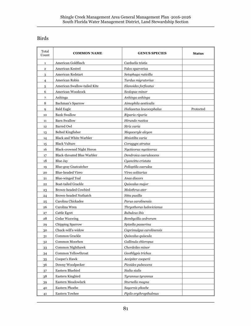
Shingle Creek Management Area General Management Plan 2016-2026 South Florida Water Management District, Land Stewardship Section
81
Birds
Total Count
COMMON NAME GENUS SPECIES Status
1 American Goldfinch Carduelis tristis
2 American Kestrel Falco sparverius
3 American Redstart Setophaga ruticilla
4 American Robin Turdus migratorius
5 American Swallow-tailed Kite Elanoides forficatus
6 American Woodcock Scolopax minor
7 Anhinga Anhinga anhinga
8 Bachman's Sparrow Aimophila aestivalis
9 Bald Eagle Haliaeetus leucocephalus Protected
10 Bank Swallow Riparia riparia
11 Barn Swallow Hirundo rustica
12 Barred Owl Strix varia
13 Belted Kingfisher Megaceryle alcyon
14 Black and White Warbler Mniotilta varia
15 Black Vulture Coragyps atratus
16 Black-crowned Night Heron Nycticorax nycticorax
17 Black-throated Blue Warbler Dendroica caerulescens
18 Blue Jay Cyancitta cristata
19 Blue-gray Gnatcatcher Polioptila caerulea
20 Blue-headed Vireo Vireo solitarius
21 Blue-winged Teal Anas discors
22 Boat-tailed Grackle Quiscalus major
23 Brown-headed Cowbird Molothrus ater
24 Brown-headed Nuthatch Sitta pusilla
25 Carolina Chickadee Parus carolinensis
26 Carolina Wren Thryothorus ludovicianus
27 Cattle Egret Bubulcus ibis
28 Cedar Waxwing Bombycilla cedrorum
29 Chipping Sparrow Spizella passerina
30 Chuck-will's-widow Caprimulgus carolinensis
31 Common Grackle Quiscalus quiscula
32 Common Moorhen Gallinula chloropus
33 Common Nighthawk Chordeiles minor
34 Common Yellowthroat Geothlypis trichas
35 Cooper's Hawk Accipiter cooperii
36 Downy Woodpecker Picoides pubescens
37 Eastern Bluebird Sialia sialis
38 Eastern Kingbird Tyrannus tyrannus
39 Eastern Meadowlark Sturnella magna
40 Eastern Phoebe Sayornis phoebe
41 Eastern Towhee Pipilo erythropthalmus

Shingle Creek Management Area General Management Plan 2016-2026 South Florida Water Management District, Land Stewardship Section
82
42 European Starling Sturnus vulgaris
43 Fish Crow Corvus ossifragus
44 Florida Sandhill Crane Grus canadensis ST
45 Glossy Ibis Plegadis falcinellus
46 Gray Catbird Dumetella carolinensis
47 Great Blue Heron Ardea herodias
48 Great Crested Flycatcher Myiarchus crinitus
49 Great Egret Casmerodius albus
50 Greater Yellowlegs Tringa melanoleuca
51 Green Heron Butorides striatus
52 Ground Dove Columbina passerina
53 Hairy Woodpecker Picoides villosus
54 Hermit Thrush Catharus guttatus
55 Hooded Merganser Lophodytes cucullatus
56 House Wren Troglodytes aedon
57 Indigo Bunting Passerina cyanea
58 Killdeer Charadrius vociferus
59 Limpkin Aramus guarauna SSC
60 Little Blue Heron Egretta caerulea SSC
61 Loggerhead Shrike Lanius ludovicianus
62 Mottled Duck Anas fulvigula
63 Mourning Dove Zenaida macroura
64 Norther Harrier Circus cyaneus
65 Northern Bobwhite Colinus virginianus
66 Northern Cardinal Cardinalis cardinalis
67 Northern Flicker Colaptes auratus
68 Northern Mockingbird Mimus polyglottos
69 Northern Parula Parula americana
70 Northern R-W Swallow Stelgidopteryx serripennis
71 Northern Waterthrush Seiurus noveboracensis
72 Orange-crowned Warbler Vermivora celata
73 Osprey Pandion haliaetus
74 Palm Warbler Dendroica palmarum
75 Pileated Woodpecker Dryocopus pileatus
76 Pine Warbler Dendroica coronata
77 Prairie Warbler Dendroica discolor
78 Prothonotary Warbler Protonotaria citrea
79 Purple Martin Progne subis
80 Red-bellied Woodpecker Merlanerpes carolinus
81 Red-eyed Vireo Vireo olivaceus
82 Red-Shouldered Hawk Buteo lineatus
83 Red-tailed Hawk Buteo jamaicencis
84 Red-winged Blackbird Agelaius phoeniceus
85 Rock Dove Columba livia
86 Ruby-crowned Kinglet Regulus calendula

Shingle Creek Management Area General Management Plan 2016-2026 South Florida Water Management District, Land Stewardship Section
83
87 Ruby-throated Hummingbird Archilochus colubris
88 Sedge Wren Cistothorus platensis
89 Sharp-shinned Hawk Accipiter striatus
90 Snowy Egret Egretta thula SSC
91 Summer Tanager Piranga rubra
92 Swamp Sparrow Melospiza georgiana
93 Tree Swallow Iridoprocne bicolor
94 Tri-colored Heron Egretta tricolor SSC
95 Tufted Titmouse Parus bicolor
96 Turkey Vulture Cathartes aura
97 White Ibis Eudocimus albus SSC
98 White-eyed Vireo Vireo griseus
99 Wild Turkey Meleagris gallopavo
100 Wood Duck Aix sponsa
101 Wood Stork Mycteria americana FT
102 Yellow-bellied Sapsucker Sphyrapicus varius
103 Yellow-billed Cuckoo Coccyzus americanus
104 Yellow-rumped Warbler Dendroica coronata
105 Yellow-throated Vireo Vireo flavifrons
106 Yellow-throated Warbler Dendroica dominica

Shingle Creek Management Area General Management Plan 2016-2026 South Florida Water Management District, Land Stewardship Section
84
Mammals
Total Count
GENUS SPECIES COMMON NAME Status
1 Dasypus novemcinctus Armadillo
2 Didelphis virginiana Opossum
3 Lutra canadensis River Otter
4 Lynx rufus Bobcat
5 Odocoileus virginianus White-tailed deer
6 Procyon lotor Raccoon
7 Sciurus carolinensis Eastern gray squirrel
8 Sciurus niger shermani Sherman's fox squirrel SSC
9 Sigmodon hispidus Cotton rat

Shingle Creek Management Area General Management Plan 2016-2026 South Florida Water Management District, Land Stewardship Section
85
Butterflies
Total Count
GENUS SPECIES COMMON NAME Status
1 Agraulis vanillae Gulf fritillary
2 Anartia jatrophae White peacock
3 Ancloxpha numitor Least skipper
4 Ascia monuste phileta Great southern white
5 Atrytone logan Delaware skipper
6 Calpodes ethlius Brazilian skipper
7 Calycopis cecrops Red-banded hairstreak
8 Copaeodes minimus Southern skipperling
9 Danaus eresimus tethys Soldier
10 Danaus gilippus berenice Queen
11 Danaus plexippus Monarch
12 Epargyreus clarus Silver-spotted skipper
13 Erynnis horatius Horace's duskywing
14 Erynnis zarucco Zarucco duskywing
15 Euphyes vestris Dun skipper
16 Eurema daira daira Barred yellow
17 Eurema lisa Little yellow
18 Eurema nicippe Sleepy orange
19 Eurytides marcellus floridensis Zebra Swallowtail
20 Heliconius charitonius tuckeri Zebra longwing
21 Hemiargus ceraunus antibubastus Ceraunus blue FT (S/A)
22 Hermeuptychia sosybius Carolina satyr
23 Hylephila phyleus Fiery skipper
24 Lerema accius Clouded skipper
25 Limenitis archippus floridensis Viceroy
26 Nathalis iole Dainty sulfer
27 Neonympha areolata Georgia satyre
28 Oligoria maculata Twin-spot skipper
29 Panoquina ocola Ocola skipper
30 Papilio cresphontes Giant swallowtail
31 Papilio glaucus australis Eastern tiger swallowtail
32 Papilio palamedes Palamedes swallowtail
33 Papilio polyxenes asterius Black swallowtail
34 Papilio troilus ilioneus Spicebush swallowtail
35 Phoebis sennae eubule Cloudless sulfur
36 Phyciodes phaon Phaon crescent
37 Phyciodes tharos tharos Pearl crescent
38 Poanes aaroni howardi Aaron's skipper
39 Polites themistocles Tawny-edged skipper
40 Polites vibex Whirlabout

Shingle Creek Management Area General Management Plan 2016-2026 South Florida Water Management District, Land Stewardship Section
86
41 Pontia protodice Checkered white
42 Pyrgus communis Common checkered
43 Pyrgus oileus Tropical checkered skipper
44 Strymon melinus melinus Gray hairstreak
45 Thorybes bathyllus Southern cloudywing
46 Urbanus dorantes Dorantes longtail
47 Urbanus proteus Long-tailed skipper
48 Vanessa atalanta rubria Red admiral

Shingle Creek Management Area General Management Plan 2016-2026 South Florida Water Management District, Land Stewardship Section
87
Fish
Total Count
GENUS SPECIES COMMON NAME Status
1 Amia calva Bowfin
2 Dorosoma petenense Threadfin shad
3 Elassoma evergladei Everglades pygmy sunfish
4 Enneacanthus gloriosus Bluespotted sunfish
5 Erimyzon sucetta Lake chubsucker
6 Esox niger Chain pickerel
7 Fundulus seminolis Seminole killifish
8 Gambusia affinis Mosquitofish
9 Jordanella floridae Flagfish
10 Labidesthes sicculus Brook silverside
11 Lepisosteus platyrhincus Florida gar
12 Lepomis gulosus Warmouth
13 Lepomis macrochirus Bluegill
14 Lepomis marginatus Dollar sunfish
15 Lepomis microlophus Redear sunfish
16 Lepomis punctatus Spotted sunfish
17 Lucania goodei Bluefin killifish
18 Micropterus salmoides Largemouth bass
19 Notemigonus crysoleucas Golden shiner
20 Poecilia latipinna Sailfin molly

Shingle Creek Management Area General Management Plan 2016-2026 South Florida Water Management District, Land Stewardship Section
88
Amphibians
Total Count
GENUS SPECIES COMMON NAME Status
1 Acris gryllus dorsalis Florida cricket frog
2 Amphiuma means Two-toed amphiuma
3 Bufo quercicus Oak toad
4 Bufo terrestris Southern toad
5 Eleutherodactylus planirostris planirostris Greenhouse frog
6 Eurycea quadridigitata Dwarf salamander
7 Gastrophryne carolinensis carolinensis Eastern narrowmouth toad
8 Hyla cinera Green treefrog
9 Hyla femoralis Pinewoods treefrog
10 Hyla squirella Squirrel treefrog
11 Rana grylio Pig frog
12 Rana sphenocephala Southern leopard frog
13 Siren lacertina Greater siren

Shingle Creek Management Area General Management Plan 2016-2026 South Florida Water Management District, Land Stewardship Section
89
Reptiles
Total Count
GENUS SPECIES COMMON NAME Status
1 Agkistrodon piscivorus conanti Florida cottonmouth
2 Alligator mississippiensis American alligator FT (S/A)
3 Anolis carolinensis Green anole
4 Anolis sagrei sagrei Brown anole
5 Apalone ferox Florida softshell turtle
6 Cemophora cemophora coccinea Florida scarlet snake
7 Chelydra serpentina Common snapping turtle
8 Coluber constrictor priapus Southern black racer
9 Diadophis punctatus punctatus Southern ringneck snake
10 Elaphe guttata guttata Corn snake; red rat snake
11 Elaphe obsoleta quadrivittata Yellow rat snake; chicken snake
12 Eumeces inexpectatus Southeastern five-lined skink
13 Farancia abacura abacura Eastern mud snake
14 Gopherus polyphemus Gopher tortoise ST
15 Kinosternon baurii Striped mud turtle
16 Nerodia fasciata pictiventris Florida water snake
17 Nerodia taxispilota Brown water snake
18 Pseudemys floridana peninsularis Peninsula cooter
19 Pseudemys nelsoni Florida redbelly turtle
20 Scincella lateralis Ground skink
21 Seminatrix pygaea Black swamp snake
22 Sistrurus miliarius barbouri Dusky pigmy rattlesnake
23 Sternotherus odoratus Common musk turtle
24 Storeria dekayi victa Florida brown Snake
25 Terrapene carolina bauri Florida box turtle
26 Thamnophis sauritus sackenii Peninsula ribbon snake
27 Thamnophis sirtalis sirtalis Eastern garter snake