scotch creek wildlife area 2009 management plan … · scotch creek wildlife area 2009 management...
TRANSCRIPT

1
SCOTCH CREEK WILDLIFE AREA
2009 MANAGEMENT PLAN UDATE Washington Department of Fish and Wildlife
______________________________________________________________________________
Land Management Summary
This is an update to the 2006 Scotch Creek
Wildlife Area Management Plan that
provides management direction for the
Scotch Creek, Mineral Hill, Pogue
Mountain, Tunk Valley, Chesaw, and the
Charles and Mary Eder units in Okanogan
County. The plan identifies needs and
guides activities on the area based on the
Washington Department of Fish and
Wildlife (WDFW) Mission of “Sound
Stewardship of Fish and Wildlife” and its
underlying statewide goals and objectives
as they apply to local conditions.
The primary goal and specific reason for purchasing the property is to establish a viable sharp-tailed
grouse population on and adjacent to the Scotch Creek Wildlife Area. Other management goals for
the Scotch Creek Wildlife Area are to preserve habitat and species diversity for wildlife resources,
maintain healthy populations of game and non-game species, protect and restore native plant
communities, and provide diverse opportunities for the public to encounter, utilize, and appreciate
wildlife and wild areas.
Plans are updated annually as habitat and species conditions change, as new regulations and
scientific knowledge develop, as public issues and concerns evolve, and as administration of
wildlife areas change. This management plan update also includes 2008 accomplishments, new
issues, new land management strategies and performance measures for 2009. For a complete
copy of the 2006 management plan, and updates, go to:
http://wdfw.wa.gov/lands/wildlife_areas/management_plans/
Updates/Changes since 2008
The Department of Fish and Wildlife
successfully completed the acquisition
of phase two, on the Charles and Mary
Eder unit near Oroville in 2008. This
3,000-acre purchase brings the total
acreage on this unit to 6,300 acres.
Primary management objectives here
will be the protection of a large
wintering deer herd, and provide a
Inside Land Management Summary 1
Updates/Changes 1
New Issues 3
Major Stewardship Accomplishments 4
Status Report of 2008 Performance Measures 8
New Strategies 9
2009 Performance Measures 9
Citizens Advisory Group Input 10
Information for BPA’s Wildlife Mitigation 11
2
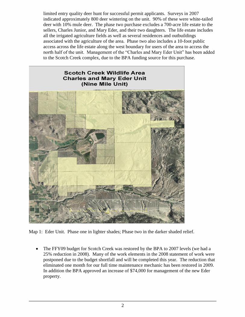
limited entry quality deer hunt for successful permit applicants. Surveys in 2007
indicated approximately 800 deer wintering on the unit. 90% of these were white-tailed
deer with 10% mule deer. The phase two purchase excludes a 700-acre life estate to the
sellers, Charles Junior, and Mary Eder, and their two daughters. The life estate includes
all the irrigated agriculture fields as well as several residences and outbuildings
associated with the agriculture of the area. Phase two also includes a 10-foot public
access across the life estate along the west boundary for users of the area to access the
north half of the unit. Management of the “Charles and Mary Eder Unit” has been added
to the Scotch Creek complex, due to the BPA funding source for this purchase.
Map 1: Eder Unit. Phase one in lighter shades; Phase two in the darker shaded relief.
The FFY09 budget for Scotch Creek was restored by the BPA to 2007 levels (we had a
25% reduction in 2008). Many of the work elements in the 2008 statement of work were
postponed due to the budget shortfall and will be completed this year. The reduction that
eliminated one month for our full time maintenance mechanic has been restored in 2009.
In addition the BPA approved an increase of $74,000 for management of the new Eder
property.

3
A wildfire occurred on Pogue Mountain in July of 2008. The “Green Lake Fire” started
at a residence in Salmon Creek and quickly spread up and over Pogue Mountain,
consuming about 754 acres of wildlife area lands. Portions of the fire were 100% tree
killed, while other areas burned as a ground fire and only pockets of thick timber were
consumed. I had just completed the forest management plan for this
unit but unfortunately was unable to get it thinned before the wildfire. Plans are to
salvage log and thin green stands of timber in 2009. A second fire, the Happy Hill fire
(450 acres) was accidentally started about one month later by a DNR vehicle driving
through tall dry grass. Tall dry grass and a hot catalytic converter is a bad combination.
We completed re-hab work on both fires in the fall of 2008 including 3.5 miles of fence
repair and seeding a native grass mix on 10 acres of dozer and hand lines.

4
Major Stewardship Accomplishments
We successfully re-seeded 95 acres of old agricultural fields on Happy Hill in 2008 to a
mix of native grasses and forbs. This shrub-steppe restoration project was phase two of a
cost-share grant (2006) from the Natural Resources Conservation Service (NRCS). It
required a summer-long program to prepare the seedbed, with a fall dormant seeding last
November. The seed mix included; bluebunch wheatgrass, Sandbergs bluegrass, Idaho
fescue, snow buckwheat, yarrow, blue flax, and antelope bitterbrush.
Maintenance on over 120,000 seedling trees and shrubs that have been planted over the
years include hand-pulling weeds, mowing to reduce competition, fertilizer applications
and installation of rodent guards to insure survival and increased growth rates. These
activities take place both in the spring and fall. Approximately 30 acres are maintained
and this year included 500 Water Birch seedlings re-planted along Scotch Creek in the
Corrals area.
5
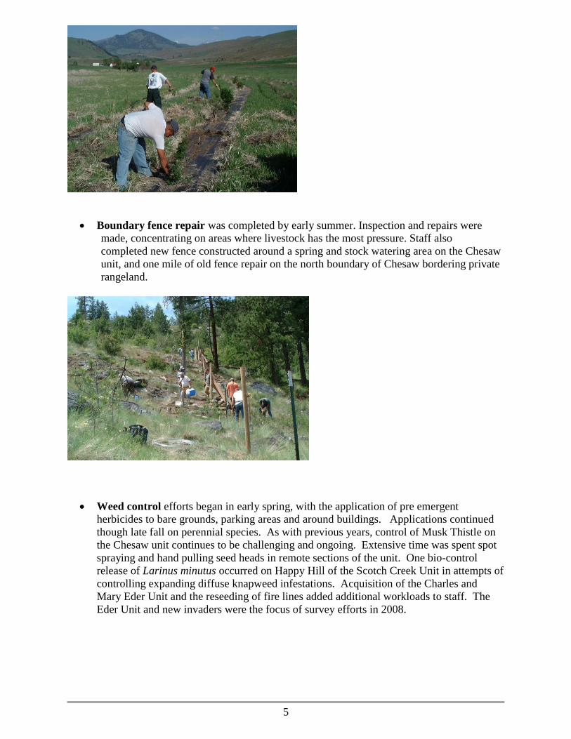
Boundary fence repair was completed by early summer. Inspection and repairs were
made, concentrating on areas where livestock has the most pressure. Staff also
completed new fence constructed around a spring and stock watering area on the Chesaw
unit, and one mile of old fence repair on the north boundary of Chesaw bordering private
rangeland.
Weed control efforts began in early spring, with the application of pre emergent
herbicides to bare grounds, parking areas and around buildings. Applications continued
though late fall on perennial species. As with previous years, control of Musk Thistle on
the Chesaw unit continues to be challenging and ongoing. Extensive time was spent spot
spraying and hand pulling seed heads in remote sections of the unit. One bio-control
release of Larinus minutus occurred on Happy Hill of the Scotch Creek Unit in attempts of
controlling expanding diffuse knapweed infestations. Acquisition of the Charles and
Mary Eder Unit and the reseeding of fire lines added additional workloads to staff. The
Eder Unit and new invaders were the focus of survey efforts in 2008.
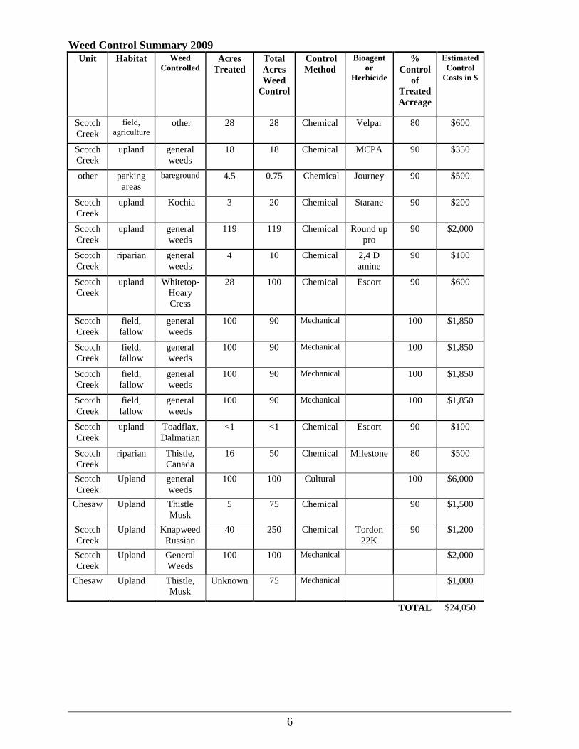
6
Weed Control Summary 2009
Unit Habitat Weed
Controlled Acres
Treated
Total
Acres
Weed
Control
Control
Method
Bioagent
or
Herbicide
%
Control
of
Treated
Acreage
Estimated
Control
Costs in $
Scotch
Creek
field,
agriculture other 28 28 Chemical Velpar 80 $600
Scotch
Creek
upland general
weeds
18 18 Chemical MCPA 90 $350
other parking
areas
bareground 4.5 0.75 Chemical Journey 90 $500
Scotch
Creek
upland Kochia 3 20 Chemical Starane 90 $200
Scotch
Creek
upland general
weeds
119 119 Chemical Round up
pro
90 $2,000
Scotch
Creek
riparian general
weeds
4 10 Chemical 2,4 D
amine
90 $100
Scotch
Creek
upland Whitetop-
Hoary
Cress
28 100 Chemical Escort 90 $600
Scotch
Creek
field,
fallow
general
weeds
100 90 Mechanical 100 $1,850
Scotch
Creek
field,
fallow
general
weeds
100 90 Mechanical 100 $1,850
Scotch
Creek
field,
fallow
general
weeds
100 90 Mechanical 100 $1,850
Scotch
Creek
field,
fallow
general
weeds
100 90 Mechanical 100 $1,850
Scotch
Creek
upland Toadflax,
Dalmatian
<1 <1 Chemical Escort 90 $100
Scotch
Creek
riparian Thistle,
Canada
16 50 Chemical Milestone 80 $500
Scotch
Creek
Upland general
weeds
100 100 Cultural 100 $6,000
Chesaw Upland Thistle
Musk
5 75 Chemical 90 $1,500
Scotch
Creek
Upland Knapweed
Russian
40 250 Chemical Tordon
22K
90 $1,200
Scotch
Creek
Upland General
Weeds
100 100 Mechanical $2,000
Chesaw Upland Thistle,
Musk
Unknown 75 Mechanical $1,000
TOTAL $24,050

7
Sharp-tailed Grouse Lek counts in 2008:
Scotch Creek: 54 (three leks)
Tunk Valley: 69 (five leks)
Chesaw: 20 (one lek)
Scotch Creek Wildlife Area
0
50
100
150
200
250
300
350
400
450
500
1970 1975 1980 1985 1990 1995 2000 2005
Es
tim
ate
d p
op
ula
tio
n s
ize
Acquisition
Suplementation
We were successful in acquiring two grants for work to begin in 2009. The Coulee Trail
grant will provide new trailhead parking at Fish Lake on the Sinlahekin WLA to the
north, and near Hess Lake on the Scotch Creek Wildlife Area to the south. The 7.5-mile
trail will follow existing roads and trails through the Coulee Creek drainage but will be
improved with turnpikes over wet areas and trail clearing and grubbing where needed.
This grant from the Washington Wildlife Recreation Program (WWRP) will start in July.
A second grant from the NRCS will enhance habitat on the Coulee Creek acquisition.
Plans include 100 acres to be restored to native shrub-steppe, 1.5 miles of new stock
fence, and the planting of 3,000 trees and shrubs. Work should start in April of this year.

8
Status Report of 2008 Performance Measures
Key performance measures are identified each year to monitor progress and identify any issues
that might interfere with planned priority activities. This information will be used to delete, add
or alter priority strategies for 2009.
2008 Performance Measure Status of Performance
Measure
Explanation of Progress/
2009 Related Activity/
Comments
Shrub-steppe restoration. Summer
fallow 95 acres and fall dormant
seeding of native grasses and forbs
on the Happy Hill, LLC acquisition
on Scotch Creek. This is phase two
of the Wildlife Habitat Incentives
Program (WHIP) grant received in
2006.
Completed Complete
Riparian restoration. Maintain all
previously planted trees and shrubs
to insure a high survival rate.
Include 500 new water birch
transplants where needed.
Completed. It appears
we had poor survival due
to the long hot months of
July, August and
September.
Complete. 300 water birch
have been ordered for 2009.
100 of these will be grown-out
for fall planting below the
corrals to increase survival.
100 for Chesaw, and 100 for
Tunk Valley.
Continue to survey and boundary
fence repairs on all units. Inspect
and repair in early spring as much
of the 70 miles boundary fence as
feasible on all units. Install or
replace wildlife area boundary signs
as needed.
Completed Continue boundary fence
repairs. We anticipate with
many other projects in „09 that
fence repair may be difficult
to keep up with.
Make improvements to the
irrigation pond/sediment trap.
Place ecology blocks along the
south shore to narrow the pond, and
allow for more efficient dredging.
Also pour small concrete slab
around pump station for weed
control, and install a fish ladder to
allow in-stream passage of brook
trout.
Completed the concrete
slab, but other
improvements were
postponed due to lack of
funding.
Plans and permits are in hand.
This will be the first project of
2009. BPA cultural resources
staff requested to be present
during excavation.
Continue with weed management
plan. Plans for 2008 include 40
See weed control
summary above.
We fell short on these goals in
2008. Plans for 2009 are in

9
acres of white-top, 200 acres of
Russian knapweed, and 20 acres
Canadian thistle on Scotch Creek.
40 acres of houndstounge and 125
acres of musk thistle on Chesaw.
10 acres of Russian knapweed on
Pogue Mountain and 40 acres on
Tunk Valley.
performance measures.
Restore proper hydraulic function
to Scotch Creek below the head
quarters. Start the construction
phase on a new meandering channel
to mimic natural conditions, and a
2-year plan to eliminate the reed
canary grass invasion.
Not attempted due to
funding cuts. We are
planning to proceed in
the spring of 2009.
Construction is scheduled to
start in the spring of 2009. If
the conditions allow, we will
attempt to mow the reed
canary grass for the entire
summer, in preparations of
Round-up spraying in
September.
Develop ½ acre irrigated shrub
planting on the Boyce property.
Utilize the existing irrigation
system, branch off with a drip-
irrigated plot, and install deer fence
to protect young plants. This will
be subject to funding (remaining
O&M budget).
Not completed due to
funding cuts.
We will attempt this project in
the fall of 2009.
Apply for three RCO grants for
2009 funding. 1) Ninemile access
development. 2) Coulee Creek trail
system. 3) Pogue Mountain pre-
commercial thinning.
Successful in getting
funding for the Coulee
Creek trail system. We
dropped the Ninemile
access development due
to extreme costs
associated with a new
bridge and approach.
Pogue Mountain thinning
may still be funded.
We will start work in July
2009 on the trail system.
Pogue Mountain thinning is
still pending.
New Strategies
The wildlife area plan identifies many strategies or activities to address the agencies strategic
plan goals and objectives, why the area was purchased, habitat conditions, species present and
public issues and concerns. The following updated strategies have been added to respond to
previously unaddressed or new issues or changes on the wildlife area. New strategies may also
be in response to adaptive management as staff evaluate the impacts of past management
activities.
No new strategies

10
2009 Performance Measures
Performance measures for the Scotch Creek Wildlife Area are listed below. Accomplishments
and progress toward desired outcomes will be monitored and evaluated annually.
1) Shrub-steppe restoration. Summer fallow 100 acres and fall dormant seeding of native
grasses and forbs on the Coulee Creek acquisition. This is part of the WHIP grant received
in 2008 and will be cost shared with the NRCS. Also includes 1.5 miles of new fence, and
3,000 trees and shrubs planted along Coulee Creek.
2) Develop two trailheads and improve 7.5 miles of trail through the Coulee Creek drainage.
This is funded with an RCO grant for 2009.
3) Riparian restoration. Maintain all previously planted trees and shrubs to insure a high
survival rate. Include 300 new water birch transplants (100 each for Scotch Creek, Chesaw,
and Tunk Valley). Also includes the development of one ½ acre irrigated shrub planting on
the Boyce Property. We will utilize the existing irrigation system, branch off with a drip-
irrigated plot, and install deer fence to protect young plants.
4) Continue to survey and boundary fence repairs on all units. Inspect and repair in early spring
as much of the 70 miles boundary fence as feasible on all units. Install or replace wildlife
area boundary signs as needed.
5) Make improvements to the irrigation pond/sediment trap. Place ecology blocks along the
south shore to narrow the pond, and allow for more efficient dredging. Also pour small
concrete slab around pump station for weed control, and install a fish ladder to allow in
stream passage of brook trout.
6) Continue with weed management plan. Plans for 2009 include 40 acres of white-top, 200
acres of Russian knapweed, 20 acres Canadian thistle, and 60 acres of general Ag weeds on
Scotch Creek. 40 acres of houndstounge and 125 acres of musk thistle on Chesaw. 10 acres
of Russian knapweed on Pogue Mountain and 40 acres on Tunk Valley. Also includes 10
acres houndstounge and 20 acres Russian knapweed on the Eder Property.
7) Restore proper hydraulic function to Scotch Creek below headquarters. Start the
construction phase on a new meandering channel to mimic natural conditions, and a 2-year
plan to eliminate the reed canary grass invasion.
8) Survey and post the life estate boundaries and critical property boundaries on the Eder Unit
to improve public identification of public land boundaries. Carsonite location markers will
be used where stock fence is not needed.
9) Advertise and surplus to the public, the residence and barn on the Boyce acquisition.
Citizens Advisory Group Input
There was one CAG meeting which occurred on February 26, 2009. Those in attendance were:
Tom Windsor, Okanogan Valley BCH; Tom Scott OT Irrigation District; Hugh Jensen, Self;
Jerry Barnes, OC Cattlemen's Assoc.; and Rick Lind. WDFW employees were Jim Olson, Brian
Dupont, Dale Swedburg, and Justin Haug. We only have one per year due to the lack of interest
from the other 13 members contacted.
It was suggested that we set up photo points on wildfire areas to monitor the fire
response.
The CAG supports increases in management funding to keep pace with increases in
acreage due to recent acquisitions.

11
Cattleman‟s association member suggested a grazing pilot project on Scotch Creek areas
similar to what is happening in SE Washington.
CAG supports salvage logging on Pogue Mountain. “The area needs active management
to reduce fuels and enhance restoration”.
Information for BPA’s Wildlife Mitigation Program
The Washington Department of Fish and Wildlife and Bonneville Power Administration (BPA)
have been partners in mitigating (compensating) the loss of fish and wildlife resources resulting
from construction of dams and subsequent inundation of habitat on the Columbia River since the
early 1990s. Under the Northwest Electric Power and Conservation Act, BPA has a duty to
protect, mitigate, and enhance fish and wildlife and their habitats affected by the development
and operation of the Federal Columbia River Power System (FCRPS). WDFW agreed that by
funding the mitigation BPA earned credit in the currency of habitat units or HUs. BPA applies
the HUs it earns against the HUs lost as reflected in habitat loss assessments WDFW and other
wildlife managers developed to estimate and document the impact of the construction of FCRPS
dams in Washington.
Mitigation has been accomplished through fee title acquisition of new lands (includes
enhancements etc.) and funding enhancement, protection, and operations and maintenance
(O&M) measures on publicly owned lands managed by WDFW and/or Washington Department
of Natural Resources (WDNR).
The Scotch Creek Wildlife Area was approved as a wildlife mitigation project in 1996 and BPA
funded habitat enhancement efforts to meet mitigation objectives have been underway since the
spring of 1997. Scotch Creek is a complex of six separate management units located in
Okanogan County in North Central Washington State. The project is located within the
Columbia Cascade Province (Okanogan sub-basin) and partially addresses adverse impacts
caused by the construction of Chief Joseph and Grand Coulee hydroelectric dams. With the
addition of the Eder acquisition in 2008, the total size of all wildlife area units is 19,860 acres.
This is a combination of BPA acquired lands and state purchases through the Washington
Wildlife and Recreation program.
The long-term management goal for the Scotch Creek Wildlife Area is to preserve habitat and
species diversity, maintain healthy populations, protect and restore native plant communities, and
provide diverse opportunities for the public to encounter, utilize, and appreciate wildlife and wild
areas. The monitoring and evaluation efforts consider the Columbian sharp tailed grouse species
first and foremost because this species provided the justification for the acquisition of the
wildlife area and its subsequent management.
Habitat Evaluation Procedure (HEP) was developed by the US Fish and Wildlife Service
(USFWS) to quantify the quality and abundance of available habitat for selected wildlife species.
HEP is based on ecological principles and the assumption that habitat for selected wildlife
species can be described as a numerical value based on a Habitat Suitability Index (HSI). This
value is derived from an evaluation of the ability of key habitat components to supply the
resource needs of focal species of fish and wildlife. The HSI values (ranging from 0.0 for no
value to a maximum of 1.0) are multiplied by the area of available habitat to obtain Habitat Units
(HUs), which are for mitigation purposes, the „currency‟ used to measure/compare habitat losses

12
and gains (Schroeder et al. 2008). Completion of baseline and periodic (preferably at 5-year
intervals) HEP is a fundamental requirement for management of the mitigation areas.
BPA Management Activities: for 2009
Biological objective 1: Enhance shrub-steppe, riparian and forest habitats.
Work element 1.1: Re-store native shrub-steppe habitat in degraded rangeland, or
abandoned agricultural fields
Methods: The Scotch Creek project has successfully restored over 3,000 acres of
agricultural conversion lands back to a native shrub-steppe habitat over the past
18 years. These fields are primarily non-native crested or intermediate
wheatgrass, invaded by diffuse knapweed, Russian knapweed, whitetop, St Johns
wort, and other noxious weeds. Restoration begins with Roundup sprays to kill
all vegetation present. We start the cultivation with deep plowing to bury the
weed seeds if the soils are deep, or start by disking with a rolling plow. Continue
a summer fallow program throughout the summer and finish by packing to get a
firm, level seedbed. Dormant seeding occurs in early November with a Tye range
drill, insuring that native grass seed is planted in the top 1/2 inch of soil. Where
shallow soils are present and absent of native bunchgrasses and forbs, try a variety
of methods to improve habitat conditions. This may include planting plugs, no-till
drilling of a native seed mix, aerial seeding or a combination of methods.
Work element 1.2: Riparian tree and shrub planting on all streamside and mesic
habitats
Methods: Plant nursery grown native plant materials along stream banks,
springs, and wet areas on all units. Also includes habitat plantings where
irrigation is available on the Boyce acquisition. Includes replacing mortalities
from previous plantings or increasing diversity and could occur in spring or fall
during dormancy. May include the use of mechanical planters or planting bars,
and the initial maintenance of watering, fertilizing and weed control to insure
their survival. Also may include the use of a fabric weed barrier where
competition is intense and/or a 7 foot tall deer fence to prevent browsing damage
where needed.
Work Element 1.3: Maintain extant shrub & tree plantings (>100,000), shrub-
steppe habitat and herbaceous seeding (>3,000 acres) on all units of the wildlife area
Methods: Maintain previously developed habitat enhancements by chemical,
mechanical or cultural control of undesirable vegetation. To insure success of tree
and shrub planting efforts, a continuing annual maintenance schedule will be
followed. Insure rodent control by applying tree guards to protect seedlings, and
weed control (primarily hand pull) to reduce competition. Mowing will also
reduce competition and provide sunlight. Fertilizer and watering applications may
be needed to increase survival the first year. Temporary deer fencing or repellant
13
may be used, and replant or reseed as needed. Result will be successful
establishment of seedlings and improved habitat condition.
Work element 1.4: Develop up to six ½-acre shrub/tree plots to utilize existing
water delivery system on the Boyce acquisition
Methods: Plant approximately 600 native trees and shrubs in each of six ½-acre
plots over the next three years and utilize the existing water line to develop a drip
irrigation system on the new Boyce acquisition. Protect plant survival with
temporary deer exclosure fencing and hand weeding. The preferred method is to
use hand augers to excavate the hole. This provides the root systems the ability to
expand into loose soil and eliminate any “J” rooting caused by a shallow hole.
Rocky soils preclude the use of augers and a hand-planting bar will be used to
open the soil. A slow release fertilizer tablet is placed with each plant and soil
lightly compacted around the roots. “Tree guards” are placed around the base of
each plant to reduce rodent damage.
Work element 1.5: Weed control on all units of the Scotch Creek Wildlife Area
complex
Methods: Undesirable plant removal will follow Integrated Pest Management
techniques. Cultural, biological, mechanical and chemical methods will be
considered for each species we want to remove and the best method or
combination of methods for the particular situation will be used. This is a
continuing element to improve habitat quality over the next three years. The
strategy outlined in the Okanogan sub-basin plan calls for assisting in long-term
development of an implementation of a Comprehensive Weed Control
Management Plan in cooperation with local weed boards. We are working
closely with the Okanogan county weed control board by participated in their
“Coordinated Weed Management Area Plan”. This is a group who meets monthly
and is comprised of one representative from each of the state and federal agencies
and county government to plan long-term weed control efforts. Weed control
strategies include: Produce and implement weed management plan to include
weed identification and inventory, risk/threat, control priorities, and monitoring.
Coordinate weed efforts with federal, state and local entities to improve efficacy
and minimize costs. Mow Russian knapweed patches in July, and treat with
herbicides in November on Scotch Creek and Tunk Valley units. Search and
destroy new invaders and “B” designate weed species, including Dalmatian
toadflax, scotch thistle, musk thistle, and whitetop on all units. Increase control
efforts on Houndstounge on Chesaw, Eder and Pogue Mountain units. Continue
to use Integrated Pest Management strategies, including biological control,
chemicals, mechanical and cultural methods, to control invasive weeds. Continue
to control weeds along all roads on the SCWA - TBD miles of roads to reduce the
spread of weeds. Map all weed locations using GPS to create GIS layers showing
locations of weeds and to assist in monitoring weed control efforts. We have
successfully obtained a contract with the Okanogan County jail to allow use of
trustee work crews to cut and pull weeds.

14
Work element 1.6: Fuels reduction and habitat enhancements in forested habitats
on Scotch Creek, Pogue Mountain and Chesaw units
Methods: Overstocked Ponderosa Pine forests pose a risk of stand replacing
wildfires as seen on a portion of the Pogue Mountain unit in the summer of 2008.
For habitat protection and enhancement all timbered stands on the Scotch Creek
units need thinning of both small commercial and non-commercial timber. A
prescription to save and enhance the largest diameter trees will be followed while
removing the overcrowded condition of smaller commercial trees to be sold. This
will be followed by pre-commercial thinning of small non-commercial conifer
trees while protecting woody browse species for mule deer food and cover. May
include labor costs to pile and burn small saplings on steep slopes or inaccessible
terrain.
Biological objective 2: Maintain viable Sharp-tailed grouse population
Work Element 2.1: Monitor and Evaluate Mitigation project
Methods: This work element will help fund M&E efforts on all WDFW
mitigation projects by collecting habitat and wildlife data on mitigation projects
including lek surveys. Data collected will be used to assess effects of habitat
maintenance, weed control and enhancement efforts on focal species. Analysis of
data will guide adaptive management strategies implemented on wildlife area.
Work Element 2.2: Monitor known existing Sharp-tailed grouse leks on Scotch
Creek and Chesaw units. Also search for new or satellite leks on or adjacent to
wildlife area
Methods: Male sharp-tailed grouse congregate during the spring on relatively
traditional breeding sites, usually referred to as “leks” or “lek complexes”.
Females visit these sites during the peak of the breeding season to “select” and
copulate with males. These lek surveys are designed to be consistent with similar
surveys being conducted on an annual basis in all western states with populations
of sharp-tailed grouse. Sharp-tailed grouse leks usually are difficult to observe.
Lek counts will consist of a complete count of birds (flushing) at least two times
per season on the wildlife area. Counts will be spaced at least 10 days apart
between 10 March and 25 May. The peak of activity (female attendance and
breeding) is early April in most years. Flushing will be accomplished with at least
two observers or one person with a trained dog, as peripheral birds often will not
flush if the observer is too far away. Lek counts will be conducted when the
weather is good (wind < 10 MPH, no precipitation, temperatures > 20 F, >50%
bare ground). Counts that are abnormally low (dropped dramatically from
previous year) will be repeated. These counts may be caused by disturbance from
predators, people, or unknown factors.

15
In addition to visiting known lek sites, we will search all adjoining lands and
potential sites for sharp-tail use. Lek searches are extremely important because of
lek movements, satellite leks, vacant leks, and new leks. The inferences related to
populations ultimately will depend as much on the quality of lek searches as on
the quality of lek counts. In this pursuit, information about lek absence is equally
as important as information about lek presence. Searches will be conducted by
“listening” for displaying males at points along roads, trails, ridges, or fence lines.
The sound that can be heard best is the low “coo” note produced. Under perfect
conditions, this noise can be heard up to 2 km. The listening points will be a
maximum of 0.5 miles apart and initiated about 0.75 hours before sunrise and
continued for two hours. The listening periods lasting at least five minutes at
each station. These searches will include private lands when access permission
has been granted.
Biological objective 3: Increase Mule Deer use of the project area
Work element 3.1: Forest stand improvement on all units of the Scotch Creek
Wildlife Area complex
Methods: Conduct, in cooperation with the Mule Deer Foundation and others,
prescribed fuels treatment, e.g., thinning and logging on all forested habitats
within the Scotch Creek Wildlife Area complex to improve Mule deer habitat
quality. We are currently working on a plan to implement a stand improvement
timber sale on about 700 acres of ponderosa pine forest on Pogue Mountain. This
includes salvage logging on about 400 acres that burned in the summer of 2008.
The objective is to advance the ponderosa pine stands to a late seral stage by
removing dense stands of young growth pine and increase spacing, and to avoid
another stand replacing wildfire. By opening up the forest floor we will promote
herbaceous growth and browse species for mule deer food and cover. A tractor
mounted wood chipper will be used to thin pole thickets of young ponderosa pine.
May also include slash piling and burning in inaccessible or steep slopes.
Biological objective 4: Implement management activities and schedules
Work element 4.1: Expand and maintain nest boxes
Methods: Western and mountain bluebirds occupy the grasslands of all Scotch
Creek units. They depend on the primary excavators to create cavities for next
building. Fewer natural nest sites are now available because of changing land use
and those natural sites being occupied by two aggressive introduced species, the
house sparrow and the European starling. Bluebird nest boxes currently in use
will be cleaned out of old nest material annually to reduce nest parasites like mites
and blowflies. This practice also keeps the level of the nest and young out of the
reach of potential nest predators.
Work element 4.2: Equipment/vehicle maintenance and/or replacement

16
Methods: To efficiently access and perform habitat enhancement activities, the
equipment and vehicles need to be adequately maintained. This includes
scheduled fluids changed, chassis lubricated, and worn parts replaced. Vehicles
need replaced after reaching expected lifespan to reduce annual maintenance
costs. One ½ Ton pickup should be replaced in 2009.
Work element 4.3: Maintain Informational signs and reader boards
Methods: Signs are posted to inform users of property boundaries, regulatory
items including sharp-tailed grouse hunting closure and vehicle restrictions on
road use. Reader boards inform the public about resource needs, the reason for
purchase and biological information on sharp-tail grouse biology. These signs
and structures need attention and replaced when faded or damaged.
Work element 4.4: Community Outreach
Methods: Meetings with the SCWA Citizens Advisory Group are held at least
twice per year to inform the public of department activities and report on the
progress of the project. Additional meetings are requested with community
groups, sportsmen‟s clubs, and the county weed control board. It is important to
include the public and solicit comments when planning activities.
Work element 4.5: Assess Habitat Conditions
Methods: Photo points and vegetation data collection sites will be established
and mapped for each unit. Staff will assess seeding and planting survival success
of all enhancement efforts, and collect nested frequency and cover data on key
plant species and exotic vegetation. Monitoring and evaluation protocol is being
developed for all the wildlife mitigation areas (see M&E section).
Work element 4.6: Administrative duties and professional development
Methods: Administrative duties are critical to keeping the project on course and
meeting timelines. Procurement, budgeting, supervising, planning, monitoring,
and reporting are essential for success of the project. Increased knowledge of
staff is important through seminars and training for adapting to new techniques
and research.
Work element 4.7: Monitor Recreational Use
Methods: Interview hunters as they exit the area to determine hunter success. It
is important to contact as many upland bird hunters as possible before they head
into the field to warn them of the closed season for sharp-tailed grouse. Incidental
take while pursuing legal game is a concern of WDFW. Record all recreational
use, including non-hunter use of the area.
Work element 4.8: Maintain Infrastructure

17
Methods: Maintain all buildings, wells, fences and gates, spring developments and other
infrastructure to safely operate and manage the wildlife area. Well-maintained
infrastructure will prolong the life of all structures. Also as soon as conditions allow in
the spring, we will survey the entire boundary fence on all units of the wildlife area (60
miles) and repair to prevent trespass livestock use on the area. One residence and one
barn on the new Boyce acquisition will be advertised to the public, and sold to the highest
bidder to be dismantled and removed. The bid will close on September 4th, and
demolition is to be completed by the end of 2009.
Work element 4.9: Maintain existing project roads/parking areas across all units
Methods: Continued maintenance of graveled road surfaces on the project area
with grading, adding gravel and shaping drainage ditches and water bars where
needed. Parking area maintenance includes signs, and fence repair, litter pickup,
and grading when necessary. An on-going need includes development of a fenced
parking area with a reader board and regulatory signs on the new
Okanogan/Simikameen purchase.
Biological objective 5: Produce Inventory or Assessment.
Work element 5.1: Assess Habitat Conditions
Methods: Photo points and vegetation data collection sites will be established
and mapped for each enhancement project. Pre and post data will be collected
and photos will be taken. Staff will collect nested frequency and cover data on
key plant species and exotic vegetation, and assess seeding and planting survival
success of all enhancement efforts.
Work element 5.2: Produce annual update to Wildlife Area Management Plan
BPA Monitoring and Evaluation
The Washington Department of Fish and Wildlife strives to manage its wildlife areas to protect
and provide habitat to achieve healthy and diverse fish and wildlife populations, and provide
compatible recreational opportunities. Effective management of fish and wildlife, and habitats
upon which they depend, requires an adaptive approach. The Northwest Power Planning
Council has stated, “Management actions must be taken in an adaptive, experimental manner
because ecosystems are inherently variable and highly complex. This includes using
experimental designs and techniques as part of management actions, and integrating monitoring
and research with those management actions to evaluate their effects on the ecosystem.”
Monitoring and evaluation are critical in this process because they provide the information
necessary to evaluate management activities in the past and to improve management activities in
the future.
Because of the large number of wildlife areas and expansive acreage managed by the WDFW,
monitoring of habitat will take place on a 5-year rotation, except for reference sites, which will
be monitored annually. Breeding bird surveys will be conducted during the same year habitat
data is collected, and likely annually, at least until annual variance in numbers is assessed. Small
mammal surveys will be conducted every five years, using techniques that have already been
18
established (West et al. 2007). Although surveys of reptiles and amphibians are also possible,
our experience so far has been that observations of reptiles are relatively infrequent, and
therefore difficult to quantify. Consistency of data collection will be improved by having the
same individuals collect data on multiple wildlife areas within a year.
Preliminary surveys have been conducted on many of the wildlife areas enabling a brief
assessment of data collected to this point. Not all wildlife areas have been surveyed at this stage,
primarily because of the time and money required to initiate surveys. In addition, other
techniques have been used that are species-specific, such as surveys of traditional display
grounds (leks) of sharp-tailed grouse and greater sage-grouse, aerial surveys of ungulates, counts
of pellets, and other miscellaneous surveys (Schroeder et al. 2008). Although these techniques
are different than standard breeding bird point counts, they are still standard and well-referenced
in scientific literature. A substantial portion of the data has been summarized, including an
examination of long-term trends (Schroeder et al. 2008). Habitat data is generally available only
for HEP transects at this stage. Future data analyses will focus on comparison of treatment sites
with reference sites and with the probabilistic Jaccard (Chao 2004) as a way of measuring
species similarity between sites. The specific list of tasks includes the following:
1. Conduct habitat/wildlife surveys on systematic basic.
2. Monitor habitat/wildlife response due to burns.
3. Monitor habitat/wildlife response to specific restoration efforts.
4. Monitor infestations and treatments of noxious weeds.
5. Compile habitat/wildlife data in databases for subsequent storage and analysis.
6. Analyze habitat – wildlife relationships in reference to management targets.
7. Re-evaluate management direction in terms of updated species-habitat evaluations
(adaptive management).
Funding Strategy:
The Scotch Creek Wildlife Area is funded primarily through the BPA mitigation program. The
2009 contract is #39276, and the project is #1996-094-01.
Cost share is provided by WDFW through game surveys, science division expertise, engineering
and construction shop help and advice, and periodic capitol projects.
Grant opportunities are also pursued. For the past three years we have secured habitat money
with WHIP to restore shrub-steppe and riparian habitats. WWRP grant received include the
Scotch Creek Coulee Creek trail project scheduled for 2009.
Want to see the full plan?
Go to:
http://wdfw.wa.gov/lands/wildl
ife_areas/management_plans/
Contacts:
WDFW Ephrata Office, Matt Monda
(509) 754-4624
Wildlife Area Manager, Jim Olson
(509) 826-4430