scanlon creek management plan - legislative assembly of ... · scanlon creek conservation area...
TRANSCRIPT
Scanlon Creek Conservation Area Management Plan Page i
2009
Cop
y fo
r arc
hive
pur
pose
s. P
leas
e co
nsul
t orig
inal
pub
lishe
r for
cur
rent
ver
sion
. C
opie
à d
es fi
ns d
’arc
hiva
ge.
Veu
illez
con
sulte
r l’é
dite
ur o
rigin
al p
our l
a ve
rsio
n ac
tuel
le.

Cop
y fo
r arc
hive
pur
pose
s. P
leas
e co
nsul
t orig
inal
pub
lishe
r for
cur
rent
ver
sion
. C
opie
à d
es fi
ns d
’arc
hiva
ge.
Veu
illez
con
sulte
r l’é
dite
ur o
rigin
al p
our l
a ve
rsio
n ac
tuel
le.
Scanlon Creek Conservation Area Management Plan Page i
Table of Contents Table of Contents..................................................................................................................................... i
Executive Summary................................................................................................................................... iii Background............................................................................................................................................ iii Community input ................................................................................................................................... iii Management issues ................................................................................................................................ iv Management goals and objectives .......................................................................................................... v Management plan direction..................................................................................................................... v Business plan direction .......................................................................................................................... vi Authority Resolution............................................................................................................................. vii
Section I: Background Report..................................................................................................................... 1 Introduction............................................................................................................................................. 1 Site location and brief description .......................................................................................................... 2 Geology................................................................................................................................................... 2 Human history and settlement ................................................................................................................ 2 Climate.................................................................................................................................................... 6 Soils......................................................................................................................................................... 6 Hydrology ............................................................................................................................................... 8 Ecosystems.............................................................................................................................................. 8 Wildlife ................................................................................................................................................. 11 Development and infrastructure............................................................................................................ 12 Public Use of Scanlon Creek Conservation Area ................................................................................. 14 Landscape influences ............................................................................................................................ 15
Section II: Development of the revised plan............................................................................................. 18 Introduction........................................................................................................................................... 18 LSRCA Visioning Exercise .................................................................................................................. 18 Ryerson University Student Project...................................................................................................... 20 User survey, 2004 ................................................................................................................................. 20 Public workshop, 2004.......................................................................................................................... 20 Public workshop, 2008.......................................................................................................................... 22
Important values of the conservation area held by workshop participants....................................... 22 Issues workshop participants wish addressed ................................................................................... 24
Summer 2008 user questionnaire.......................................................................................................... 25 Public workshop, 2009.......................................................................................................................... 26 Steering committee ............................................................................................................................... 27 Future evaluation and review of management plans............................................................................. 27
Section III: Management Plan .................................................................................................................. 29 Introduction........................................................................................................................................... 29 Goals and objectives ............................................................................................................................. 29 Permitted uses ....................................................................................................................................... 29 Boundary management ......................................................................................................................... 32 Water Resources Management ............................................................................................................. 33 Infrastructure Management................................................................................................................... 33
Trails ................................................................................................................................................. 34 Picnic tables and benches.................................................................................................................. 36 Washroom facilities and potable water............................................................................................. 36
Cop
y fo
r arc
hive
pur
pose
s. P
leas
e co
nsul
t orig
inal
pub
lishe
r for
cur
rent
ver
sion
. C
opie
à d
es fi
ns d
’arc
hiva
ge.
Veu
illez
con
sulte
r l’é
dite
ur o
rigin
al p
our l
a ve
rsio
n ac
tuel
le.

Scanlon Creek Conservation Area Management Plan Page ii
Group camping.................................................................................................................................. 37 Off-leash area.................................................................................................................................... 37 Discovery play garden ...................................................................................................................... 37 Sculptures.......................................................................................................................................... 37 Buildings ........................................................................................................................................... 38 Roads and parking lots...................................................................................................................... 38
Vegetation and wildlife management ................................................................................................... 39 Marketing.............................................................................................................................................. 40 Revenue generation............................................................................................................................... 41 Programming......................................................................................................................................... 41 Friends of Scanlon Creek Conservation Area....................................................................................... 42
Section IV: Business Plan......................................................................................................................... 43 Introduction........................................................................................................................................... 43 Management plan goals and objectives ................................................................................................ 43 Historic Revenues ................................................................................................................................. 46
Gate fees and permits........................................................................................................................ 46 Municipal Special Capital................................................................................................................. 46 Facility rentals................................................................................................................................... 47
Budget projection.................................................................................................................................. 48 Projected Revenues............................................................................................................................... 49
Lake Simcoe Clean Up Fund ............................................................................................................ 49 Landowner Environmental Assistance Program............................................................................... 49 Ontario Trillium Foundation............................................................................................................. 49 Ministry of Health Promotion........................................................................................................... 49 Evergreen Foundation....................................................................................................................... 49 Municipal special capital .................................................................................................................. 50 Private sector partnerships ................................................................................................................ 50 Gate fees and permits........................................................................................................................ 50 Volunteers and donations.................................................................................................................. 50
Expenses ............................................................................................................................................... 51 Administration and visitor services .................................................................................................. 51 Capital development ......................................................................................................................... 52 Maintenance...................................................................................................................................... 52 Resource management ...................................................................................................................... 52
Implementation schedule ...................................................................................................................... 53 2009................................................................................................................................................... 53 2010................................................................................................................................................... 55 2011................................................................................................................................................... 58 2012................................................................................................................................................... 60 2013................................................................................................................................................... 62
References................................................................................................................................................. 65 Appendix 1. Detailed expenses to achieve management plan objectives................................................. 67 Appendix 2. Detailed projected revenues to achieve management plan objectives ................................. 68
Cop
y fo
r arc
hive
pur
pose
s. P
leas
e co
nsul
t orig
inal
pub
lishe
r for
cur
rent
ver
sion
. C
opie
à d
es fi
ns d
’arc
hiva
ge.
Veu
illez
con
sulte
r l’é
dite
ur o
rigin
al p
our l
a ve
rsio
n ac
tuel
le.

Executive Summary
Scanlon Creek Conservation Area Management Plan Page iii
Executive Summary The Scanlon Creek Conservation Area Management Plan provides direction for the future management of Scanlon Creek Conservation Area. The Management Plan has been written in four sections: a Background Report which summarizes and synthesizes information on the natural and cultural heritage of the property and its current levels of development and public use; a Development of the Revised Plan section which describes the public consultation process and input received during plan review, as well as outlining the process and timeline for future plan review; a Management Plan which identifies long- and short-term goals for the management of the property, and priorities for implementation; and a Business Plan which provides a description and schedule of implementation priorities, coupled with projections of revenues and expenses over a five year period.
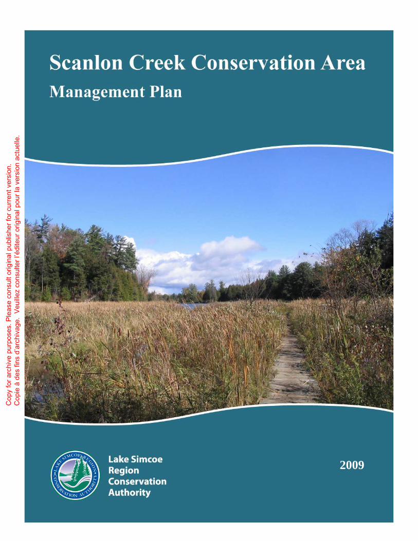
Background Scanlon Creek Conservation Area is a 292 hectare (722 acre) property in the municipalities of Bradford West Gwillimbury and East Gwillimbury, and in the West Holland River watershed. Much of the property is relatively inaccessible wetland habitat, and public use tends to be restricted to the 119 hectare (294 acre) main parcel, accessible from the 9th Line of Bradford West Gwillimbury. This part of the conservation area includes upland and ravine forests, conifer plantations, a section of Scanlon Creek and a 4 hectare (10 acre) reservoir with a dam. This property also includes over 10 kilometres of hiking trails, two picnic pavilions, the Professor EA Smith Natural Resources Educational Centre, Scanlon Creek Nature Centre and the Lake Simcoe Region Conservation Authority (LSRCA) works yard. This property first came into public ownership in 1962 as the Bradford Conservation Area. Its first management plan, developed in 1967, provided a vision for the property as a multi-purpose recreation and conservation facility. Directions in the original management plan included plans for extensive development of parking lots, roads, campgrounds, and equestrian facilities. The management plan was revised in 1979, and management of the property was re-directed to provide more of an emphasis on conservation and stewardship actions. Direction in the revised plan included reforestation of extensive areas of retired agricultural fields, as well as acquisition of extensive areas of remnant wetland in the Holland Marsh. In 2003, review of the management plan began again, initially as an internal LSRCA process. By 2004, the public were engaged in the plan review through a series of open houses and questionnaires.
Community input Consultation has played an extremely important role in the review of the management plan. Consultation allows users an opportunity to reflect on their values and use of the property, changes they have seen in the conservation area and their community over the years and their visions for the property in the future. Formal public consultation throughout the process has included workshops at the conservation area in spring and fall of 2004, and winter of 2008 and 2009. Questionnaires were circulated in 2004 and 2008, and a user survey was conducted in the conservation area in summer 2007. Additional consultation with LSRCA staff and informal discussions with conservation area users further informed the development of the management plan.
Cop
y fo
r arc
hive
pur
pose
s. P
leas
e co
nsul
t orig
inal
pub
lishe
r for
cur
rent
ver
sion
. C
opie
à d
es fi
ns d
’arc
hiva
ge.
Veu
illez
con
sulte
r l’é
dite
ur o
rigin
al p
our l
a ve
rsio
n ac
tuel
le.
Executive Summary
Scanlon Creek Conservation Area Management Plan Page iv
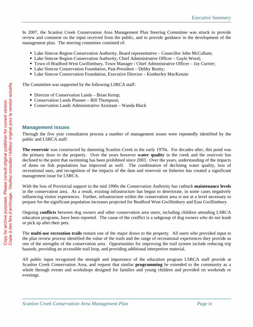
In 2007, the Scanlon Creek Conservation Area Management Plan Steering Committee was struck to provide review and comment on the input received from the public, and to provide guidance in the development of the management plan. The steering committee consisted of:
� Lake Simcoe Region Conservation Authority, Board representative – Councillor John McCallum; � Lake Simcoe Region Conservation Authority, Chief Administrative Officer – Gayle Wood; � Town of Bradford West Gwillimbury, Town Manager / Chief Administrative Officer – Jay Currier; � Lake Simcoe Conservation Foundation, Past-President – Debby Beatty; � Lake Simcoe Conservation Foundation, Executive Director – Kimberley MacKenzie
The Committee was supported by the following LSRCA staff:
� Director of Conservation Lands – Brian Kemp; � Conservation Lands Planner – Bill Thompson; � Conservation Lands Administrative Assistant – Wanda Black
Management issues Through the five year consultation process a number of management issues were repeatedly identified by the public and LSRCA staff: The reservoir was constructed by damming Scanlon Creek in the early 1970s. For decades after, this pond was the primary draw to the property. Over the years however water quality in the creek and the reservoir has declined to the point that swimming has been prohibited since 2003. Over the years, understanding of the impacts of dams on fish populations has improved as well. The combination of declining water quality, loss of recreational uses, and recognition of the impacts of the dam and reservoir on fisheries has created a significant management issue for LSRCA. With the loss of Provincial support in the mid 1990s the Conservation Authority has cutback maintenance levels in the conservation area. As a result, existing infrastructure has begun to deteriorate, in some cases negatively influencing visitor experiences. Further, infrastructure within the conservation area is not at a level necessary to prepare for the significant population increases projected for Bradford West Gwillimbury and East Gwillimbury. Ongoing conflicts between dog owners and other conservation area users, including children attending LSRCA education programs, have been reported. The cause of the conflict is a subgroup of dog owners who do not leash or pick up after their pets. The multi-use recreation trails remain one of the major draws to the property. All users who provided input to the plan review process identified the value of the trails and the range of recreational experiences they provide as one of the strengths of the conservation area. Opportunities for improving the trail system include reducing trip hazards, providing an accessible trail loop, and providing additional interpretive material. All public input recognized the strength and importance of the education program LSRCA staff provide at Scanlon Creek Conservation Area, and request that similar programming be extended to the community as a whole through events and workshops designed for families and young children and provided on weekends or evenings.
Cop
y fo
r arc
hive
pur
pose
s. P
leas
e co
nsul
t orig
inal
pub
lishe
r for
cur
rent
ver
sion
. C
opie
à d
es fi
ns d
’arc
hiva
ge.
Veu
illez
con
sulte
r l’é
dite
ur o
rigin
al p
our l
a ve
rsio
n ac
tuel
le.

Executive Summary
Scanlon Creek Conservation Area Management Plan Page v
Management goals and objectives After broad-based consultation with users of the conservation area, and other residents of the Lake Simcoe watershed, the Scanlon Creek Conservation Area Management Plan Steering Committee developed the following goals and objectives for the conservation area:
Scanlon Creek Conservation Area will be managed to provide an example of proper land and water stewardship. Opportunities for nature-based education and recreation will be provided while maintaining a balance between public use and the conservation of nature.
More specifically, LSRCA aims to:
• Maintain and enhance the recreational trails system; • Improve the water quality and fish habitat in Scanlon Creek, with particular emphasis on the Scanlon
Creek reservoir; • Expand educational programming from its existing base of school-oriented programs to engage a broader
cross section of our watershed; • Engage the public more fully in the planning and management of the conservation area through the
establishment of a Friends of Scanlon Creek Conservation Area; • Establish a user fee policy that is equitable and that at the same time provides sustainable base funding for
the on-going operation, maintenance and development of the conservation area.
Management plan direction Further to the goals and objectives described above, the Management Plan has identified the following projects and programs to address the management issues:
� LSRCA will develop a plan to improve water quality and quantity in the Scanlon Creek watershed; � An Environmental Assessment will be undertaken on the dam and reservoir to examine ways of improving
natural heritage values and wildlife habitat; � The historic Scanlon farmhouse will be refurbished to provide office space for the Lake Simcoe
Conservation Foundation and community resource space; � The existing workshop facilities will be renovated and converted to office space for staff of LSRCA’s
Watershed Stewardship and Forestry departments; � The existing gatehouse will be refurbished; � The arboretum near the gatehouse will be upgraded and improved, including the re-establishment of an
interpretive trail, and replacement of labels on trees as necessary; � Trails at Scanlon Creek Conservation Area will continue to provide a range of recreational challenges and
opportunities by providing a variety of trails – ranging from accessible, to multi-use, to remote recreational trails;
� LSRCA will also establish a nature trail that will include interpretive signs and displays; � A discovery play garden, will be built near the picnic pavilion to provide safe, nature-based recreational
opportunities for children and their families; � Internal access roads in the conservation area will be upgraded; � Improvements will be made to the Head of Trails kiosk; � If interest dictates, LSRCA will provide a fenced and gated ‘dogs off leash area’ to allow users to run their
pets off-leash; � LSRCA will provide nature-based programs such as interpretive hikes, recreational events and wildlife
identification workshops on a seasonal basis to interested conservation area users; � LSRCA will work with interested users of the conservation area to start a Friends of Scanlon Creek
Conservation Area;
Cop
y fo
r arc
hive
pur
pose
s. P
leas
e co
nsul
t orig
inal
pub
lishe
r for
cur
rent
ver
sion
. C
opie
à d
es fi
ns d
’arc
hiva
ge.
Veu
illez
con
sulte
r l’é
dite
ur o
rigin
al p
our l
a ve
rsio
n ac
tuel
le.

Executive Summary
Scanlon Creek Conservation Area Management Plan Page vi
� LSRCA will increase the marketing of Scanlon Creek Conservation Area using the slogan “Wildness Close to Home”; and,
� During this period of investment, LSRCA will remove the existing fee box on the gatehouse but will provide donation boxes in the parking lots.
� LSRCA will retrofit and upgrade the Education Centre to improve energy efficiency and reduce ongoing maintenance costs
Business plan direction The Business Plan identifies priorities for implementation, and provides a schedule for the period 2009 – 2013 coupled with projections of revenues and expenses over a five year period. Initial effort will be expended on refurbishing existing infrastructure such as the Scanlon farmhouse, the arboretum, the gatehouse and the picnic pavilions, as well as conducting an environmental assessment on the dam, and developing a stewardship plan for Scanlon Creek’s watershed. After existing infrastructure is refurbished, new infrastructure including a discovery play garden, an interpretive nature trail, an accessible nature trail, and a designated off-leash area will be developed. Ongoing through this period will be development and expansion of nature-based programming for the public, the establishment of a Friends of Scanlon Creek, and upgrades to existing trails and outhouses. After the Environmental Assessment of the dam and the watershed stewardship plan are developed, projects within and outside the conservation area to improve aquatic habitats will be implemented. Preliminary projections of the cost to implement these projects and programs total approximately $1.3 Million over the period 2009 – 2013, as well as the need for approximately 1.5 additional FTE. To achieve this goal LSRCA will need to attract new sources of funding and in-kind support. Funding may include municipal special capital, government and non-government funding programs, private sector sponsorships and volunteer time and donations from the public. LSCRA will work with the Lake Simcoe Conservation Foundation to develop a fundraising plan to attract this funding.
Cop
y fo
r arc
hive
pur
pose
s. P
leas
e co
nsul
t orig
inal
pub
lishe
r for
cur
rent
ver
sion
. C
opie
à d
es fi
ns d
’arc
hiva
ge.
Veu
illez
con
sulte
r l’é
dite
ur o
rigin
al p
our l
a ve
rsio
n ac
tuel
le.
Executive Summary
Scanlon Creek Conservation Area Management Plan Page vii
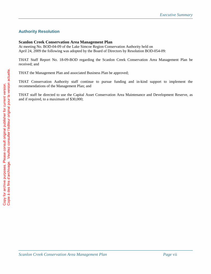
Authority Resolution Scanlon Creek Conservation Area Management Plan At meeting No. BOD-04-09 of the Lake Simcoe Region Conservation Authority held on April 24, 2009 the following was adopted by the Board of Directors by Resolution BOD-054-09: THAT Staff Report No. 18-09-BOD regarding the Scanlon Creek Conservation Area Management Plan be received; and THAT the Management Plan and associated Business Plan be approved; THAT Conservation Authority staff continue to pursue funding and in-kind support to implement the recommendations of the Management Plan; and THAT staff be directed to use the Capital Asset Conservation Area Maintenance and Development Reserve, as and if required, to a maximum of $30,000;
Cop
y fo
r arc
hive
pur
pose
s. P
leas
e co
nsul
t orig
inal
pub
lishe
r for
cur
rent
ver
sion
. C
opie
à d
es fi
ns d
’arc
hiva
ge.
Veu
illez
con
sulte
r l’é
dite
ur o
rigin
al p
our l
a ve
rsio
n ac
tuel
le.

Background Report
Scanlon Creek Conservation Area Management Plan Page 1
Section I: Background Report
Introduction Since 1951, Lake Simcoe Region Conservation Authority (LSRCA) has provided a leadership role in the protection and restoration of the environmental health of the Lake Simcoe watershed. LSRCA is mandated under the provincial Conservation Authorities Act to “establish and undertake, in the area over which it has jurisdiction, a program designed to further the conservation, restoration, development and management of natural resources other than gas, oil, coal and minerals.” In order to meet this mandate, the Conservation Authority works with government, non-profit and community partners to support a number of programs including watershed-level analysis, modelling and planning; forestry and private land stewardship programs; and a system of conservation areas. Conservation areas have represented a significant resource for residents in the watershed and beyond and have enhanced the open space and outdoor recreation opportunities offered by local municipalities. The protection of these lands as well as the access for public use is seen as one of the most important contributions the Authority makes to the communities it serves. As the watershed continues to urbanize the role of conservation areas and other natural areas in the landscape will become even more critical. To date Lake Simcoe Region Conservation Authority has acquired over 1350 hectares (3335 acres) of conservation lands with the financial support of Regional and local municipalities, the province, private donations, and other conservation organizations. These lands include significant natural areas such as valleys, forests, and wetlands which provide a range of recreational opportunities to the public, from strict natural heritage protection, to more intensive recreational and educational facilities such as those provided at Scanlon Creek Conservation Area. At 292 ha, Scanlon Creek Conservation Area is the largest conservation area in the LSRCA watershed and has been enjoyed by the public since 1963 for its educational program, trails, beach, and other recreational opportunities. Over the years, changes in staffing levels, infrastructure and recreational features as well as increasing population, changing demographics, shifts in public expectations and additions to the property base have led to new challenges and opportunities in managing this conservation area. The purpose of a conservation area management plan is to establish long- and short-term goals, and to develop strategies by which the goals can be achieved. They should be flexible enough to address unforeseen issues which may arise in the future and should be integrated with the overall goals and objectives of the Conservation Authority as well as the landscape within which the property is situated. Successful management planning requires a full understanding and appreciation of the site’s natural history features, usage levels and patterns, and the constraints influencing the use of the area. This background report provides a summary of the history and evolution in management and associated human and wildlife use of Scanlon Creek Conservation Area since acquisition. This reference document will act as a baseline of information for future conservation area management and can be used in subsequent stages of the management plan review.
Cop
y fo
r arc
hive
pur
pose
s. P
leas
e co
nsul
t orig
inal
pub
lishe
r for
cur
rent
ver
sion
. C
opie
à d
es fi
ns d
’arc
hiva
ge.
Veu
illez
con
sulte
r l’é
dite
ur o
rigin
al p
our l
a ve
rsio
n ac
tuel
le.

Background Report
Scanlon Creek Conservation Area Management Plan Page 2
Site location and brief description The 292 hectare (722 acre) Scanlon Creek Conservation Area is situated in lots 16 to 21 Concession IX and lot 18 Concession X of the Township of Bradford West Gwillimbury, Simcoe County and lot 125 Concession I of the Township of East Gwillimbury, Regional Municipality of York (Fig. 1). The area is approximately 4 km north of the Town of Bradford West Gwillimbury and is within 45 km of the City of Toronto. Scanlon Creek Conservation Area consists of five tracts. Most public use of the property occurs on the main tract which can be accessed from the 9th Line. This tract contains upland and ravine forests, a portion of Scanlon Creek and a reservoir, 10 km of hiking trails, picnic areas and pavilions, a group camping area, the Prof. E.A. Smith Natural Resources Outdoor Education Centre, and a day-use Nature Centre. Directly north of the 10th Line is former farmland that has been the focus of reforestation and habitat stewardship projects since acquisition. To the east of the railway track lie the nature reserve portions of Scanlon Creek Conservation Area. Primarily wetland in nature, these parcels range from cattail marsh to deciduous swamp and have no visitor use facilities developed on them.
Geology1 Scanlon Creek Conservation Area lies within the Lake Simcoe basin physiographic region. This area is thought to be part of the valley of the ancient Laurentian River. Before the Wisconsinan glaciation, southern Ontario had very different topography, including rivers as precursors to the present day Great Lakes. The Laurentian River, one of the largest of these, drained through the area which contains present day Lake Michigan and Georgian Bay before crossing York Region to present day Lake Ontario, eventually draining into the precursor of the St Laurence River. Although the advance of the glaciers during the ice age obliterated the river, its valley provided a naturally low relief in the landscape, which the advancing glaciers tended to follow. The relatively soft substrate in this pre-glacial river valley also provided ideal conditions for the pooling of the melting ice water, eventually developing into the proglacial Lakes Algonquin and Iroquois, and the present day Great Lakes and Lake Simcoe. The Lake Simcoe basin physiographic region was part of the area flooded by Lake Algonquin. The floor of this valley is now dominated by lacustrine sands, silts and clays. Glacial melt waters cut deep spillways throughout this basin, including the valley through which Scanlon Creek flows.
Human history and settlement2 The Lake Simcoe basin, including the Holland River, has long played an important role in the culture and economy of native and European people living in Ontario. The Hurons, though centred on Georgian Bay, had villages along the west side of Lake Simcoe, including Cook’s Bay. These villages were sustained by agriculture and needed to be relocated periodically as soil nutrients became depleted. Archaeological evidence suggests that at least one such village was located on the 11th Concession of Bradford West Gwillimbury. The Holland River was also an important travel corridor for natives hunting and trading between Georgian Bay and Lake Ontario. The ‘carrying place’ trail which extended between Georgian Bay and Lake Ontario took advantage of the Holland River between Cook’s Bay and the Oak Ridges Moraine. In addition, Holland Marsh was likely a congregation point for native hunters during waterfowl migrations.
1 Based on Deane (1950) and Chapman and Putnam (1966) 2 Based on Miles and Co. (1878), Trigger (1976) and Bradford West Gwillimbury Local History Association (2005)
Cop
y fo
r arc
hive
pur
pose
s. P
leas
e co
nsul
t orig
inal
pub
lishe
r for
cur
rent
ver
sion
. C
opie
à d
es fi
ns d
’arc
hiva
ge.
Veu
illez
con
sulte
r l’é
dite
ur o
rigin
al p
our l
a ve
rsio
n ac
tuel
le.

LakeOntario
GeorgianBay
LakeSimcoe
^
^
^
^
^
^ ^
Toronto
MarkhamRichmond
Hill
Barrie
Aurora
NewmarketBradford
Hwy. 401
Hwy. 2
Hwy. 9
Hwy. 11
Hwy. 5
Hwy. 400
Hwy. 2
8
Hwy. 89
Hwy. 35
Hwy. 27
Hwy. 26
Hwy. 48
Hwy. 8
Hwy. 118
Hwy. 50
Hwy. 6
Hwy. 24
Q E W
Hwy. 93
Hwy. 36
Hwy. 121
Hwy. 12
Hwy. 10
Hwy. 69Hw
y. 45
Hwy. 115Hwy. 7
Hwy. 4
Hwy. 47
Hwy. 404
Hwy. 7 & 12Hwy. 46
Hwy. 169
Hwy. 92
Hwy. 25
Hwy. 86
Hwy. 90
D V P
Hwy. 4
03
Hwy. 97
Hwy. 134
Hwy. 10 & 24
Hwy. 136
Hwy. 91
Hwy. 410
Hwy. 12 & 48
Hwy. 409
Hwy. 507 & 36
Hwy. 106
Hwy. 2
8 & 11
5
Hwy. 25
Hwy. 12
Hwy. 403
Hwy. 6
Hwy. 24 Q E W
Hwy. 7
Hwy. 28
Hwy. 24
Hwy. 7
Hwy. 169
Hwy. 6
Hwy. 7
Hwy. 2Hwy. 35
Hwy. 36
Hwy. 121
Hwy. 12
Hwy. 10
Hwy. 48
Hwy. 7
Hwy. 11
Hwy.
121
Hwy.
11
Hwy. 27
Hwy. 7
Hwy. 25
®Scale
1 : 2,50010 0 105 Kilometers
Figure 1Regional Setting
The information on this map has been compiled from various sources. While every effort has been made to accurately depict the information,data / mapping errors may exist. This map has been produced for illustrative purposes only.© Queens Printer for Ontario, 2007. Reproduced with PermissionLSRCA GIS Services Draft printed October 2004
LegendScanlon CreekConservation AreasLake Simcoe WatershedWaterbodyWatercourseRoad
Cop
y fo
r arc
hive
pur
pose
s. P
leas
e co
nsul
t orig
inal
pub
lishe
r for
cur
rent
ver
sion
. C
opie
à d
es fi
ns d
’arc
hiva
ge.
Veu
illez
con
sulte
r l’é
dite
ur o
rigin
al p
our l
a ve
rsio
n ac
tuel
le.

Background Report
Scanlon Creek Conservation Area Management Plan Page 4
The wildlife, particularly beaver, inhabiting the area attracted the attention of Iroquois hunters to the south. As they tried to expand their territory north of Lake Ontario to expand their fur trading empire they came into conflict with the resident Hurons. This area became one of the fronts in the Iroquois-Huron wars of the 1600s, evidence of which has been found within Bradford West Gwillimbury somewhat to the west of the conservation area. In 1818 a treaty for these lands was signed between the Chippewas and the government of Upper Canada. The area was surveyed in 1819 and settlers began moving in that year, with additional immigrants in the early 1820s. The property which is currently Scanlon Creek Conservation Area was settled in 1824 by the Scanlon family who immigrated to the area from Ireland. These properties started to come into LSRCA possession starting in 1963 as the ‘Bradford Conservation Area’ with the acquisition of 39 hectares of farmland from Lewis Coombs (the Coombs tract; Fig. 2). This was expanded with the purchase of additional upland area as well as the Scanlon Creek valley from the Scanlon, Brown and Lee families in 1965 and 1966. Additional acquisitions from Samuel Lee in 1971 and Olive Lee in 1975 incorporated wetland habitat into the property (Lee tract 2). The wetland component was expanded again in 1980 with the purchase of approximately 150 acres of marsh from Allan Studholme. The most recent addition to the conservation area was the Collings tract which was acquired in 2006 in partnership with the Nature Conservancy of Canada. In 1967 a Master Development Plan was created for the area then known as the Bradford Conservation Area to direct the Holland Valley Conservation Authority in meeting their vision of the property as a multi-purpose recreation and conservation facility. This plan proposed the development of a fairly extensive system of trails with associated parking lots and picnic facilities, reforestation of part of the property, the development of the reservoir and camping facilities, as well as the development of crop demonstration sites and equestrian facilities on the abandoned farmland3. This Master Plan also recommended changing the name of the property to the Scanlon Creek Conservation Area to better reflect the social history of the site. In 1979 the Master Plan was revised to refocus the property to one which provided “an example of proper resource management techniques while providing for educational and recreational uses”. Management changes identified by this plan included the reforestation of the farmland, and expansion and improvement of the existing trail system, construction of a platform at the reservoir, and emphasis on supporting the Prof E.A. Smith Natural Resources Outdoor Education Centre and the acquisition of additional adjacent natural areas4.
3 Canadian Mitchell Associates (1967) 4 South Lake Simcoe Conservation Authority (1979)
Cop
y fo
r arc
hive
pur
pose
s. P
leas
e co
nsul
t orig
inal
pub
lishe
r for
cur
rent
ver
sion
. C
opie
à d
es fi
ns d
’arc
hiva
ge.
Veu
illez
con
sulte
r l’é
dite
ur o
rigin
al p
our l
a ve
rsio
n ac
tuel
le.

LEE(1966)
LEE(1971.1975)
Scanlon(1965)
Brown(1966)Coombes
(1963)
Collings2006)
Studholme(1966)
10
11
9
YONGE
12
North
20
Bathurst
South
Hochreiter
Middle
ARTESIAN INDUSTRIAL
SUNRISE
10
®500 0 500250 m
Location Map
Figure 2Property Acquisition
^ YorkDurham
Simcoe
KawarthaLakesLake
Simcoe
Legend
The information on this map has been compiled from various sources. While every effort has been made to accurately depict the information,data / mapping errors may exist. This map has been produced for illustrative purposes only.© Queens Printer for Ontario, 2007. Reproduced with PermissionLSRCA GIS Services Draft printed October 2004
WatercourseRoadLot & ConcessionScanlon CreekConservation Area
Cop
y fo
r arc
hive
pur
pose
s. P
leas
e co
nsul
t orig
inal
pub
lishe
r for
cur
rent
ver
sion
. C
opie
à d
es fi
ns d
’arc
hiva
ge.
Veu
illez
con
sulte
r l’é
dite
ur o
rigin
al p
our l
a ve
rsio
n ac
tuel
le.

Background Report
Scanlon Creek Conservation Area Management Plan Page 6
Climate Scanlon Creek Conservation Area is in the Simcoe and Kawartha Lakes climatic region5. Over the past thirty years, precipitation in Bradford has averaged 794 mm per year, of which an average of 674 mm has been rainfall. Average annual temperature over this period has been 6.8 °C, with average minimums of -13.3 °C (typically in February) and average maximums of 26.5 °C in July and August6. Climate change projections suggest that over the next twenty to thirty years this region may experience an increase in precipitation in the spring and fall (by as much as 5-10%), but a decrease of approximately the same amount in the summer. Average annual temperatures are also expected to increase in this time period, potentially by as much as 1 °C7.
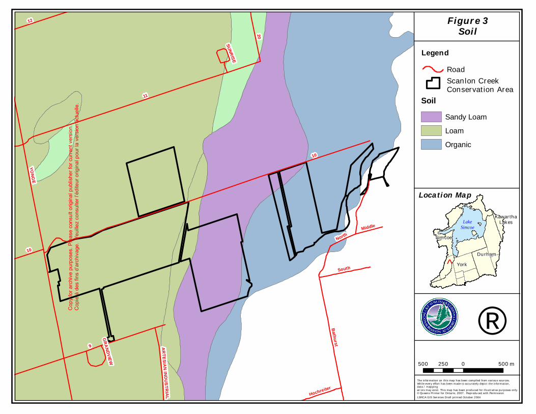
Soils This conservation area includes a mix of well- and poorly drained soils8 (Fig. 3). The open wetland areas immediately adjacent to the Holland River are underlain by organic soil. This low-lying area has almost always been saturated with water since the last glacial event, allowing organic debris to accumulate rather than decompose. This partially decomposed organic matter increases the water holding capacity of the soil and has allowed the development of the Holland Marsh. The heavily forested parcel immediately east of the railway tracks lies in a depressional area where Granby sandy loam has accumulated. Granby sandy loam is composed of a layer of porous soil less than one metre deep over a layer of clay. This layering of soil textures in a flat region such as this tends to promote a perched water table, allowing the development of swamp conditions in this parcel. Bordering these low-lying areas are proglacial beaches and shore cliffs. The ridge near the railway track is an example of such a beach ridge. The topography in this area is moderately sloping, except where Scanlon Creek has cut a deep valley in the landscape. These upland portions of the conservation area tend to be underlain by Bondhead loam soils. The drainage is typically good and the soil is porous and slightly stony. This relatively fertile and easy to work soil allowed this area to be farmed prior to acquisition.
5 Brown et al. (1981) 6 Based on Environment Canada’s Canadian Climate Normals database 7 Colombo et al. (2007) 8 Hoffman et al. (1962)
Cop
y fo
r arc
hive
pur
pose
s. P
leas
e co
nsul
t orig
inal
pub
lishe
r for
cur
rent
ver
sion
. C
opie
à d
es fi
ns d
’arc
hiva
ge.
Veu
illez
con
sulte
r l’é
dite
ur o
rigin
al p
our l
a ve
rsio
n ac
tuel
le.
10
11
9
YONGE
12
North
20
Bathurst
South
Hochreiter
Middle
ARTESIAN INDUSTRIAL
SUNRISE
GRANDVIEW
10
®500 0 500250 m
Location Map
Figure 3Soil
^ YorkDurham
Simcoe
KawarthaLakesLake
Simcoe
Legend
The information on this map has been compiled from various sources. While every effort has been made to accurately depict the information,data / mapping errors may exist. This map has been produced for illustrative purposes only.© Queens Printer for Ontario, 2007. Reproduced with PermissionLSRCA GIS Services Draft printed October 2004
Road
Soil
Scanlon CreekConservation Area
Sandy LoamLoamOrganic
Cop
y fo
r arc
hive
pur
pose
s. P
leas
e co
nsul
t orig
inal
pub
lishe
r for
cur
rent
ver
sion
. C
opie
à d
es fi
ns d
’arc
hiva
ge.
Veu
illez
con
sulte
r l’é
dite
ur o
rigin
al p
our l
a ve
rsio
n ac
tuel
le.
Background Report
Scanlon Creek Conservation Area Management Plan Page 8
Hydrology Scanlon Creek runs west to east through the main tract of the conservation area. Drainage in this parcel is via overland flow on the steep slopes, groundwater flow, and a few small tributaries that feed the creek (Fig. 4). Although the volume of water in this creek is often low, particularly in the summer, in the early days of settlement there was enough flow in this system to support a grist mill and six sawmills. Although all traces of these mills are now gone, a stone from the grist mill remains on display near the Education Centre. In 1970 the Authority constructed an earthen berm and concrete spillway at one of the historic dam sites to allow the development of a 4 hectare reservoir with a beach for fishing and swimming. Water quality has long been a concern in this reservoir9, with conditions generally getting worse over the years10. A combination of point- and non-point sources of pollution upstream in the watershed cause the creek to often exceed Provincial guidelines for nitrogen, phosphorus, biological oxygen demand and E. coli. Water quality concerns came to a head in the late 1990s with a report from a visitor that a pet had gotten sick after drinking the water. In 2003 these ongoing concerns with water quality led the Conservation Authority to permanently close the beach to swimming. Scanlon Creek drains into the West Holland River just outside the conservation area boundary. The flat and poorly drained conditions at the junction of the east and west branches of the Holland River have allowed the development of the Holland Marsh, an extensive wetland that once covered much of this area. The easternmost portions of the conservation area still remain as marsh habitat, driven by the poorly drained soil in the area.
Ecosystems11 Ecosystems at Scanlon Creek Conservation Area include a mix of forest, wetland, open aquatic, and manicured areas; existing as a result of variations in topography and underlying soil conditions, management history, and natural processes such as succession and competition (Fig. 5). The valley bottom associated with Scanlon Creek supports white cedar-dominated forests. These forests can include a mix of yellow birch and white ash as subdominants. Along the sides of the ravine, forests tend to be dominated by eastern hemlock and sugar maple with American beech, white birch, white cedar, ironwood, white ash, and basswood. Since the cessation of farming on this land, the upland portions of the property have become reforested, through both active restoration and natural succession. Extensive second growth deciduous forest, composed of sugar maple, white ash, red oak, beech, hemlock and bitternut hickory, and plantations consisting of mixes of red pine, white pine, white spruce, and others provide a mix of forest habitat to the property.
9 South Lake Simcoe Conservation Authority (1979) 10 Based on LSRCA internal reports and discussions with staff 11 Based on LSRCA (2008b)
Cop
y fo
r arc
hive
pur
pose
s. P
leas
e co
nsul
t orig
inal
pub
lishe
r for
cur
rent
ver
sion
. C
opie
à d
es fi
ns d
’arc
hiva
ge.
Veu
illez
con
sulte
r l’é
dite
ur o
rigin
al p
our l
a ve
rsio
n ac
tuel
le.

10
11
9
YONGE
12
North
20
Bathurst
South
Hochreiter
Middle
ARTESIAN INDUSTRIAL
SUNRISE
GRANDVIEW
10
®500 0 500250 m
Location Map
Figure 4Hydrology
^ YorkDurham
Simcoe
KawarthaLakesLake
Simcoe
Legend
The information on this map has been compiled from various sources. While every effort has been made to accurately depict the information,data / mapping errors may exist. This map has been produced for illustrative purposes only.© Queens Printer for Ontario, 2007. Reproduced with PermissionLSRCA GIS Services Draft printed October 2004
5 metre contourWatercourseRoad
750 ha catchment watershed boundaryScanlon Creek Conservation Area
Cop
y fo
r arc
hive
pur
pose
s. P
leas
e co
nsul
t orig
inal
pub
lishe
r for
cur
rent
ver
sion
. C
opie
à d
es fi
ns d
’arc
hiva
ge.
Veu
illez
con
sulte
r l’é
dite
ur o
rigin
al p
our l
a ve
rsio
n ac
tuel
le.

10
11
9
YONGE
12
20
North
Bathurst
South
Hochreiter
Middle
ARTESIAN INDUSTRIAL
SUNRISE
GRANDVIEW
10
®525 0 525262.5 m
Location Map
Figure 5Ecosystems
^ YorkDurham
Simcoe
KawarthaLakes
LakeSimcoe
The information on this map has been compiled from various sources. While every effort has been made to accurately depict the information,data / mapping errors may exist. This map has been produced for illustrative purposes only.© Queens Printer for Ontario, 2007. Reproduced with PermissionLSRCA GIS Services Draft printed October 2004
LegendOld fieldRed pine plantationWhite pine plantationBlack locust thicketArboretumHawthorn woodlandWhite cedar forestWhite ash forestSugar maple - oak forestSugar maple - hickory forestWhite pine - sugar maple forestWhite cedar - white birch forestSugar maple - hemlock forestCattail marshCattail marshOpen waterBlack ash swampWhite cedar - black ash swamp
Cop
y fo
r arc
hive
pur
pose
s. P
leas
e co
nsul
t orig
inal
pub
lishe
r for
cur
rent
ver
sion
. C
opie
à d
es fi
ns d
’arc
hiva
ge.
Veu
illez
con
sulte
r l’é
dite
ur o
rigin
al p
our l
a ve
rsio
n ac
tuel
le.

Background Report
Scanlon Creek Conservation Area Management Plan Page 11
Some younger forests on the property are still in early stages of succession. These communities tend to be dominated by white ash and include species such as hawthorn, apple, staghorn sumac and European buckthorn. Small old-field communities dominated by goldenrods, asters, and non-native grasses are scattered throughout the property, the largest of which is in the northern tract. As well, a few open manicured areas are associated with the picnic pavilions, educational centres, and group camping sites. The easternmost portion of the conservation area lies within Holland Marsh, a large wetland feature that has been identified both as provincially significant wetland and provincially significant area of natural and scientific interest. Closest to the river the habitat is dominated by cattail communities, sometimes interspersed by patches of shrubs. Further away from the river, where the land gets a bit higher and soil slightly more porous, swamps composed of black ash, red maple, sugar maple and white cedar become dominant. Several watershed rare species, including the sedges Carex bromoides and Carex woodii can be found here, as can the provincially protected Butternut (Endangered). Throughout the property, and generally associated with forest edges and trails, can be found a number of non-native invasive species such as garlic mustard, European buckthorn, and tartarian honeysuckle.
Wildlife12 The size of the property and diversity of ecosystems within its boundaries provides opportunities for a wide variety of wildlife species at Scanlon Creek Conservation Area. Small forests in the upland areas of the conservation area provide habitat for species such as northern cardinals, American robins, song sparrows, black-capped chickadees, gray catbirds, yellow warblers, blue jays, pine warblers, spring peepers, gray treefrogs and American toads. The ravine along Scanlon Creek, and the adjacent large deciduous forests provide habitat for ovenbirds, pileated woodpeckers, white-breasted nuthatches, winter wrens, red-eyed vireos, eastern wood pewees, great-crested flycatchers, black-throated green warblers, and yellow-bellied sapsuckers. Open grassy or shrubby areas support breeding bird communities dominated by willow flycatchers, field sparrows, European starlings, chipping sparrows and brown-headed cowbirds. The mix of swamp and marsh within the Holland Marsh wetland complex creates habitat for northern waterthrushes, veery, rose-breasted grosbeaks, red-winged blackbirds, mallards, Canada geese, American bitterns, common yellowthroats, yellow warblers, northern leopard frogs, green frogs and bull frogs. The reservoir provides breeding habitat for Canada geese and wood ducks, and foraging habitat for belted kingfishers, great blue herons, double-crested cormorants, trumpeter swans and osprey. During spring migration waterfowl frequent this reservoir as well. Throughout much of the property mammals which are typical of natural areas in rural landscapes, including deer, raccoons, red fox, coyotes, Virginia opossums, and porcupine can also be found. The nature reserve tracts are particularly important habitat for species such as deer, ruffed grouse, and wild turkey which are relatively sensitive to the presence of people and dogs.
12 Based on LSRCA (2008b)
Cop
y fo
r arc
hive
pur
pose
s. P
leas
e co
nsul
t orig
inal
pub
lishe
r for
cur
rent
ver
sion
. C
opie
à d
es fi
ns d
’arc
hiva
ge.
Veu
illez
con
sulte
r l’é
dite
ur o
rigin
al p
our l
a ve
rsio
n ac
tuel
le.

Background Report
Scanlon Creek Conservation Area Management Plan Page 12
Scanlon Creek is considered a coldwater system as it provides habitat for the sensitive mottled sculpin. Historically, the creek and reservoir also held largemouth bass, white suckers, yellow perch, and northern pike, as well as stocked rainbow trout13. Before the installation of the water control structure, Scanlon Creek had annual spawning runs of suckers14. Throughout this range of habitat types can be found quite a few watershed rare species, including black tern, yellow rail, American bittern, red-bellied woodpecker, yellow-bellied sapsucker, black-throated green warbler and sharp-shinned hawk.
Development and infrastructure Infrastructure at Scanlon Creek Conservation Area is primarily limited to facilities that support non-consumptive day-use, limited overnight camping, and that support the operations of the educational programs. The main entrance to the conservation area is along an unpaved gravel road accessed from the 9th Concession. Additional access to the northern picnic area and the Studholme tract is provided from the 10th Concession (Fig. 6). Approximately 5 km of internal gravel roads in the conservation area provide access to the picnic pavilions, reservoir and hiking trails. These roads are available to users during the summer or, in the off-season, with a reservation of the facilities. A mix of gravel and grassed parking lots are provided at the picnic pavilions, reservoir, education facilities and head of trails. Approximately 10 km of trails cris-cross the conservation area. The trails have a natural surface for most of their length but sections consist of limestone crushings, boardwalks and bridges. The trail system links the various parts of the conservation area and provides a range of recreational opportunities, from fairly short flat trails, to longer more challenging hikes. Picnic tables, fire pits, and barbeques are dispersed throughout the conservation area. A picnic pavilion was build on the bluffs south of the beach area and provides a panoramic view of the upper reaches of the Holland River and Cook’s Bay. The picnic area north of the reservoir consists of an open grass area with tables, a picnic shelter, and a large 50 car parking lot. A group camping area near the southern pavilion provides a relatively rustic place for youth groups such as Boy Scouts and Girl Guides to enjoy overnight activities. However changes to the Safe Drinking Water Act prompted LSRCA to decommission the drinking water service to these sites. The four hectare reservoir maintains a summer holding elevation of 227 m.a.s.l. which is regulated by a concrete and earth dam constructed by the Authority in 1970. To support the use of this area for swimming and picnicking, the Authority built a changing station and imported enough sand to create a beach. Since the closure of swimming at the reservoir however these facilities have remained unused.
13 South Lake Simcoe Conservation Authority (1979); Lake Simcoe Region Conservation Authority (1986) 14 Canadian Mitchell Associates Ltd. (1967)
Cop
y fo
r arc
hive
pur
pose
s. P
leas
e co
nsul
t orig
inal
pub
lishe
r for
cur
rent
ver
sion
. C
opie
à d
es fi
ns d
’arc
hiva
ge.
Veu
illez
con
sulte
r l’é
dite
ur o
rigin
al p
our l
a ve
rsio
n ac
tuel
le.

PicnicPavillion
PicnicPavillion
NatureCentre
EducationCentre
10
YONGE
9
®190 0 19095 m
Location Map
Figure 6Infrastructure
^ YorkDurham
Simcoe
KawarthaLakesLake
Simcoe
Legend
The information on this map has been compiled from various sources. While every effort has been made to accurately depict the information,data / mapping errors may exist. This map has been produced for illustrative purposes only.© Queens Printer for Ontario, 2007. Reproduced with PermissionLSRCA GIS Services Draft printed October 2004
TrailWatercourseRoadBuildingScanlon CreekConservation Area
Paved RoadC
opy
for a
rchi
ve p
urpo
ses.
Ple
ase
cons
ult o
rigin
al p
ublis
her f
or c
urre
nt v
ersi
on.
Cop
ie à
des
fins
d’a
rchi
vage
. V
euill
ez c
onsu
lter l
’édi
teur
orig
inal
pou
r la
vers
ion
actu
elle
.
Background Report
Scanlon Creek Conservation Area Management Plan Page 14
The educational centre was built in 1978 to provide conservation education to area school children, and named after E.A. Smith, a life-long conservationist and long-term member of the Board of the Holland Valley Conservation Authority. Originally built to accommodate 40 students, the building was expanded in the early 1990s to provide room for 60 students and their teachers. Programs are offered to grades 4 to 8 which cover life sciences, history and recreational themes and are designed to connect kids with nature using both hands-on activities and interactive programs. Facilities in the building include dormitories, a library and nature room, laboratory, green houses, classrooms, kitchen, and dining facilities. In the early 1990s an additional facility, the day-use Nature Centre, was built. This facility has two classrooms as well as washrooms to support day-use by school groups or other organizations. Each year the Professor E.A. Smith Natural Resources Educational Centre and the day-use Nature Centre each serve roughly 4000 students from the York Region District School Board and York Catholic District School Board. The farm buildings on the original Coombes farm were acquired with the property and were the basis of the current workshop and maintenance facilities. Environment Canada also maintains a weather station here. In addition, the Coombes farmhouse was for years used as housing for the Conservation Area Superintendent. When that position ceased to exist the Authority rented the house as a residential unit. More recently however as water quality in the well has declined and drinking water regulations have become more strict, this house has remained unused. The permanent buildings on site are serviced with hydro and telephone. An attempt has been made to blend these services with the natural setting by burying cables and the judicious placing of hydro transformers. A comprehensive water treatment system has been installed to service the Prof. E.A. Smith Natural Resources Outdoor Education Centre and the Nature Centre in accordance with Provincial water quality regulations.
Public Use of Scanlon Creek Conservation Area According to recent user surveys of Scanlon Creek Conservation Area15, individual users of the conservation area generally fall into one of two categories. The first are visitors from the Bradford area and tend to be long-term users of the site. They typically visit regularly throughout the year, including both weekdays and weekends. Their primary recreational use of the property is nature appreciation or dog walking. Many of these users walk or bike to the site. A second user group is those coming from more than 30 km away. Typically visiting on weekends, these users will picnic, fish, and enjoy the trails. These visitors tend to come less frequently and tend to limit their visits to the summer months; 13% of visitors surveyed were first time users of the site. Despite these differences in origin and time of use, most users are young families with children who come to Scanlon Creek Conservation Area for a combination of picnicking, hiking, and nature appreciation. In addition to individual users, approximately 25% of the visitors to Scanlon Creek Conservation Area come for group events. These groups tend to use the camping and picnic pavilions between April and October. Campers using Scanlon Creek Conservation Area tend to be youth groups (predominantly Guides and Scouts) coming from Bradford, Newmarket, or other surrounding communities. Users of the picnic pavilions tend to be church or other community groups coming from these communities as well as more distant areas such as North York, Toronto, and Orillia.
15 LSRCA (2004) and Sharma (2007)
Cop
y fo
r arc
hive
pur
pose
s. P
leas
e co
nsul
t orig
inal
pub
lishe
r for
cur
rent
ver
sion
. C
opie
à d
es fi
ns d
’arc
hiva
ge.
Veu
illez
con
sulte
r l’é
dite
ur o
rigin
al p
our l
a ve
rsio
n ac
tuel
le.

Background Report
Scanlon Creek Conservation Area Management Plan Page 15
In the past the reservoir was the main draw to the property as people came to swim, picnic, or fish. Since the closure of the swimming facilities however this visitor group has decreased and local trail users have become the largest user group. Although hunting has never been permitted in the conservation area, the Holland Marsh Provincial Wildlife Area, which is located immediately to the north of the conservation area, is heavily used for waterfowl hunting. Primary access for the wildlife management area is from the 10th line; the Studholme tract, which is on the south side of the road, often experiences spillover from the Provincial wildlife area.
Landscape influences No protected area can effectively be managed without an understanding of the influences of the property on the surrounding landscape and vice-versa. Scanlon Creek Conservation Area lies partially within the Holland Marsh. Holland Marsh has been recognized for its ecological significance in a number of studies16. This large wetland complex provides habitat for large numbers of fish, waterfowl, and colonial water birds including some provincially rare species. It also acts as a filter, reducing contaminant levels in Holland River before it enters Lake Simcoe, as well as adding to the character and farm economy of the area. One of the major recreational uses of the marsh is during the fall migratory game bird season. Hunters using this area include a mix of local residents and people traveling north from Toronto. Although hunting is prohibited in the conservation area, some of the people coming to hunt in the Holland Marsh Wildlife Management Area hunt in the Studholme tract as well. Associated with this non-sanctioned use are the creation of unofficial trails through the marsh and the deposition of garbage. One of the most obvious impacts the surrounding landscape has is on water quality in Scanlon Creek. The conservation area is at the downstream end of a 20 km2 watershed. Water quality has long been a concern in the creek17, but over the years it has degraded to the point that the reservoir had to be closed to swimming and the bad smell coming off the water is one of the most frequent complaints of visitors. Water quality concerns in the creek include high levels of nitrogen, phosphorus, suspended sediments, and E. coli. Although at least some of these contaminants come from a suspected point source of pollutants upstream, the relative lack of forest cover along the Scanlon Creek suggest that non-point source pollutants may be a factor as well. Forthcoming regulations and plans under the Lake Simcoe Protection Act may provide additional mechanisms for addressing some of the suspected point- and non point- source pollution in the Scanlon Creek watershed. Impacts from within the property, including dog feces, no doubt also contribute to poor water quality. The impacts of the contaminants are exacerbated by the relatively low flow in the creek throughout much of the year, driven by a lack of storage capacity in the upper reaches of the watershed. In the future, the impacts of the surrounding landscape on the conservation area can only be expected to increase. The Bradford area has been designated as one of Ontario’s Places to Grow18 and both Bradford West Gwillimbury and East Gwillimbury expect to experience a more than doubling of their population in the next 20 years. Much of this growth is slated to occur in the 10 km catchment area of the conservation area19 (Fig. 7). East Gwillimbury has slated the community of Queensville to increase by approximately 20,000 people; most living in 16 E.g., Ecologistics Ltd (1982), Power et al. (1984) and Hanna (1984) 17 South Lake Simcoe Conservation Authority (1979) 18 Ministry of Public Infrastructure Renewal (2006) 19 Town of East Gwillimbury (1997); J. Ross Raymond & Associates Ltd and PLANSCAPE (2000)
Cop
y fo
r arc
hive
pur
pose
s. P
leas
e co
nsul
t orig
inal
pub
lishe
r for
cur
rent
ver
sion
. C
opie
à d
es fi
ns d
’arc
hiva
ge.
Veu
illez
con
sulte
r l’é
dite
ur o
rigin
al p
our l
a ve
rsio
n ac
tuel
le.

Background Report
Scanlon Creek Conservation Area Management Plan Page 16
low to medium residential housing. The community of Bradford is slated to grow by about 15,000, many of whom will be located within easy access of the conservation area. Zoning plans in the Bradford West Gwillimbury Official Plan suggest that within the next 20 years Scanlon Creek Conservation Area will go from being a protected area in a rural landscape, to one in a suburban landscape bordered on the south by medium density housing, light commercial, and/or manufacturing facilities.
Cop
y fo
r arc
hive
pur
pose
s. P
leas
e co
nsul
t orig
inal
pub
lishe
r for
cur
rent
ver
sion
. C
opie
à d
es fi
ns d
’arc
hiva
ge.
Veu
illez
con
sulte
r l’é
dite
ur o
rigin
al p
our l
a ve
rsio
n ac
tuel
le.

Picn icPavil l ion
Picn icPavil l ion
NatureCentre
Educat i onCentre
Figure 7Landscape Influences
Legend
Location Map
^ YorkDurham
Simcoe
KawarthaLakesLake
Simcoe
®2,000 0 2,0001,000 m
The information on this map has been compiled from various sources. While every effort has been made to accurately depict the information,data / mapping errors may exist. This map has been produced for illustrative purposes only.© Queens Printer for Ontario, 2007. Reproduced with PermissionLSRCA GIS Services Draft printed October 2004
Rail
Provincially Significant Wetland
Natural Area Protection
Road
Holland Marsh ProvincialWildlife Area
Proposed Road
Scanlon CreekConservation Area
Existing Urban Area
Environmental Protection Area
Watercourse
Open Space
Area of Natural and Scientific Interest
Proposed Urban Area
Cop
y fo
r arc
hive
pur
pose
s. P
leas
e co
nsul
t orig
inal
pub
lishe
r for
cur
rent
ver
sion
. C
opie
à d
es fi
ns d
’arc
hiva
ge.
Veu
illez
con
sulte
r l’é
dite
ur o
rigin
al p
our l
a ve
rsio
n ac
tuel
le.

Development of the revised plan
Scanlon Creek Conservation Area Management Plan Page 18
Section II: Development of the revised plan
Introduction Four years after its acquisition, the first management plan was written for the then Bradford Conservation Area. This plan provided direction for the Holland Valley Conservation Authority to develop the property as a multi-purpose recreation and conservation facility. The South Lake Simcoe Conservation Authority revised the management plan in 1979 to provide focus for the conservation area as an example of proper resource management techniques while providing for educational and recreational uses. Since that time various attempts have been made to revise and update the operation of this conservation area, but despite several concepts being developed, and some implemented, no formal review of the conservation area management plan was undertaken until 2003. In 2003, LSRCA began a more systematic approach to management plan review, including workshops with LSRCA staff, with conservation area users, and a survey sent to the residents of Bradford in their community newspaper. In 2007, expanded support from LSRCA’s municipal partners allowed the Authority to hire a full time Conservation Lands Planner to facilitate this project. The establishment of the Scanlon Creek Conservation Area Management Plan Steering Committee in December 2007 provided additional resources to assist in the completion of this project. Since 2004, consultation with conservation area users has been an important part of the management plan review. Consultation allows users an opportunity to reflect on their values and use of the property, changes they have seen in the conservation area and their community over the years, and their visions for the property in the future. This consultation, as well as focused consultation with LSRCA technical, education and field services staff and major funding partners has provided much of the direction in the current proposed management plan.
LSRCA Visioning Exercise In 2003, LSRCA management conducted an internal visioning exercise which included an assessment of the Strengths, Weaknesses, Opportunities and Threats present at Scanlon Creek.
Cop
y fo
r arc
hive
pur
pose
s. P
leas
e co
nsul
t orig
inal
pub
lishe
r for
cur
rent
ver
sion
. C
opie
à d
es fi
ns d
’arc
hiva
ge.
Veu
illez
con
sulte
r l’é
dite
ur o
rigin
al p
our l
a ve
rsio
n ac
tuel
le.

Development of the revised plan
Scanlon Creek Conservation Area Management Plan Page 19
Strengths � Land base / size � Trails � Partnerships education that exist – school
board staff � Varied natural features � Location � Road access / good � Education program is generally mission
based � Well known � History � Community support / partnerships � Basis for innovative financing � Best example of cost recovery � Self supporting � Successful � Positive client satisfaction � Facilities are established � High profile � Year round operation � Diversity � Huge untapped potential
Weaknesses � Under used � Beach � Proximity to town (vandalism, party spot,
illegal access) � Poor / old signage � Age deteriorating facilities � Lack of recent capital investment � Facilities not energy efficient � Lack of drinking water � Conflicting user groups � Poor road conditions � No communications plan (mission-based) � Lack of programming dollars � Public programming � No public transportation � Poor water quality / quantity � Weak partnerships � Few volunteers � Limited staff resources � No current master plan / vision � Does not demonstrate good stewardship � $10 000 of wells to be capped – contingent
liability � No routine maintenance program � Junk - surplus
Opportunities � Expanded public education (Nature Centre) � Expanded partnerships – colleges,
universities, pond restoration – remove the dam
� Demonstration projects – increase public consultation / participation
� Home of festivals – displays – drawing card, educational / interpretive signs
� Weekend programs / workshops � Watershed – based learning facility – public
– seminars � Centre for – Mission based education,
volunteerism (work experience), fundraising � Expanded partnerships (road) � Encouraging user groups to develop
opportunities � Invite outside groups / rental income � Innovative financing
Threats � Uncontrolled access � Bradford bypass � Water taking / upstream pollution � Lack of maintenance numbers � Aging workforce � Knowledge is not documented � Long term educational funding � Water quantity � West Nile � Public apathy � Another round of budget cuts “economic
stability” stable funding � Public outcry / backlash
Cop
y fo
r arc
hive
pur
pose
s. P
leas
e co
nsul
t orig
inal
pub
lishe
r for
cur
rent
ver
sion
. C
opie
à d
es fi
ns d
’arc
hiva
ge.
Veu
illez
con
sulte
r l’é
dite
ur o
rigin
al p
our l
a ve
rsio
n ac
tuel
le.
Development of the revised plan
Scanlon Creek Conservation Area Management Plan Page 20
Ryerson University Student Project In 2005, Urban Planning students at Ryerson university submitted a Visioning document to LSRCA as part of a class project. This document included an assessment and recommendation of existing and anticipated challenges facing the conservation area, including external pressures, usership, and internal evolution. Some of the recommendations they provided to address these issues included: providing input to subdivision design, develop a series of nature walks and interpretive programs, improved branding and marketing, development of an off-leash area, improved signage, and pond rehabilitation.
User survey, 2004 In 2004, LSRCA created a survey for Scanlon Creek Conservation Area users, available at the gate and through the Bradford West Gwillimbury Times. A total of 78 people responded to the survey. The majority of the respondents visited Scanlon regularly (either daily, weekly, or monthly) with almost half of the visits taking place in the afternoon. Although summer was the most popular time to visit the site, nearly half of those polled visited the conservation area year-round. Almost 85% of the respondents lived within twenty kilometers of the Conservation Area and many wanted to see greater community involvement in conservation area management. Nearly 90 per cent of those polled identified Scanlon’s trails system as the site’s most enjoyable feature and listed passive recreation activities as their primary reason for visiting the area. When asked what improvements or additional facilities could be added to enhance visitation experiences at Scanlon Creek, respondents requested improved trail maintenance, groomed cross country ski trails, more picnic tables, benches, foot bridges and interpretive signs, fully serviced washrooms, a children’s play area, nature-themed public educational programs, and biking trails. Improved water quality also ranked high among those surveyed, whether to enhance wildlife habitat or fishing and swimming opportunities on site. A few people also suggested acquiring adjacent lands and establishing a buffer strip to protect Scanlon from future development. Most of the respondents indicated that the conservation area was adequately maintained, but there were a number of people who expressed concerns over the state of the site’s roads, washrooms, trails and the beach front. Concerns were also voiced regarding pet waste. Requests were made for updated signs showing where the user is on the trail map, as well as information on trail lengths and difficulty levels. Visitors would also welcome signs promoting visitor etiquette (i.e. no litter, please scoop pet waste, etc.) and environmental stewardship. When considering future revenue generating strategies to offset operating costs, 60% of the survey respondents said that they favored a per car fee, 44% said they would support an annual pass for members and 40% were open to a per car fee - depending on price. Participants encouraged the Conservation Authority to explore partnering opportunities with the Town of Bradford West Gwillimbury, as well as community fundraising initiatives.
Public workshop, 2004 Following the user survey, an open house was held at the Professor E.A. Smith Educational Centre at Scanlon Creek Conservation Area on October 24th 2004. Close to thirty people attended, who were divided into three focus
Cop
y fo
r arc
hive
pur
pose
s. P
leas
e co
nsul
t orig
inal
pub
lishe
r for
cur
rent
ver
sion
. C
opie
à d
es fi
ns d
’arc
hiva
ge.
Veu
illez
con
sulte
r l’é
dite
ur o
rigin
al p
our l
a ve
rsio
n ac
tuel
le.

Development of the revised plan
Scanlon Creek Conservation Area Management Plan Page 21
groups to solicit their thoughts on site maintenance and enhancement, resolving conflicting uses and developing a 10-year vision for the conservation area. TRAILS: � Summer mowing of trails to keep trails open e.g. cemetery trails and below the workshop � Cutting back of brush and trees along trails e.g. upper trails � Improved maintenance of minor trails e.g. north side of pond � Pack winter trails after heavy snow falls � Improvement of wet areas on north trail e.g. adding limestone material � Signage noting distances along trails � Put up new up-to-date signs at head of trails � Keep them natural, do not pave them � Ask sponsors to fund site maintenance � Perhaps businesses would be interested in leasing trails - and then charge skiers for specific trail use � It would be great if there was a walking/cycling path linking Bradford to Scanlon Creek HEALTH/SAFETY: � Park security issue at north end of park e.g. bush parties � Park security (nature centre parking lot) - break-ins � Garbage in park - more garbage cans � Garbage left behind by anglers around the reservoir e.g. Styrofoam containers, corn cans, etc. DOG WALKERS: � Need to encourage them to be responsible for their pets and to pick up their pet’s waste. � Enforcement doesn’t work � Improved signage promoting dog clean-up... look to Pickering, Claremont, Greenwood, Brougham as examples
that appear to be working � Put article/adds in paper � Consider separate (off-leash) area off of the 10th Line � Do not exclude any user groups � Consider separate trails for hikers, cyclists, skiers, and dog walkers because the woodchips used to dry trails for
hikers can interfere with a bicycle’s gears... walkers punch holes into ski trails... and many people are frightened of loose dogs
REVENUE: � Need to come up with ways to generate revenue � Nobody at gate, nobody asking for membership � 20 people doesn’t warrant staffed gatehouse � Consider passive recreation vs festivals (although, some nature-related events like “Hike Day Ontario/Fall
Colours Hike would be welcome.) � Yearly Memberships - by the car load � Adopt an Acre/Blue Jay/fish program to provide another opportunity for giving financial support � Perhaps a portion of municipal taxes could be directed to Scanlon. � Whatever visitation fees might be established, Scanlon Creek must remain accessible to all watershed residents
- including those with little/fixed incomes. CLEAN WATER TO SWIM IN AND/OR FISH IN: � The beach is a great place to picnic, there aren’t many places to picnic in Bradford
Cop
y fo
r arc
hive
pur
pose
s. P
leas
e co
nsul
t orig
inal
pub
lishe
r for
cur
rent
ver
sion
. C
opie
à d
es fi
ns d
’arc
hiva
ge.
Veu
illez
con
sulte
r l’é
dite
ur o
rigin
al p
our l
a ve
rsio
n ac
tuel
le.

Development of the revised plan
Scanlon Creek Conservation Area Management Plan Page 22
� If the dam is removed and/or the beach reverts back to wetland, visitors would really appreciate a pool on the less sensitive highlands because the Town’s pool is over crowded.
NATURAL HERITAGE FEATURES: � More wildlife - enhanced habitat - purchase more land and naturalize it. � Is Scanlon part of a “green belt”? could it be part of a link to Bradford West Gwillimbury? � Purchase lands to link to Ducks Unlimited Sanctuary CONNECTING PEOPLE WITH NATURE: Land & Animals � Offer weekend programs for the general public e.g. adults, families, kids on various nature themes like bird
banding, edible wildlife, the weather, etc. � Establish a kids club � Adopt an “open-air living zoo” concept where people can safely interact with the animals e.g. a chickadee
feeding station where the birds will feed out of your hand, construct blinds to view wildlife, set up bird houses � Provide more natural history information (bring in native animals as teaching tools) � Turn the nature centre into a year-round visitor’s centre with a speaker’s series, weekend/week night public
programmes, a small tuck shop, and volunteer program e.g. Friends of Scanlon � Establish a Scanlon Explorers Series... with monthly meetings/activities for different age groups and interests
e.g. junior naturalists, wildlife gardeners, artists in nature, moms & tot walks, music in the park, video club, trail crew, etc.
� Outdoor children’s play area/exploratory stations e.g. like those at the Royal Botanical Gardens � Increase general awareness across the watershed, focusing on Bradford � Establish a regular column promoting each season’s treasures i.e. pollywogs, trilliums, migrating birds, etc. � Offer retreats � Publicity: “Scanlon Corner” column in Bradford West Gwillimbury Times with Corporate Sponsor � Volunteer Opportunities - student community - how do we get around insurance issue? � People offering to assist with maintenance. � Friends of Scanlon - seasonal program - is it time to restart it? OTHER: � Improve road maintenance e.g. main driveway � Explore possibility of composting toilets for park use to get around potable water issue.
Public workshop, 2008 On February 24, 2008 a second public workshop was held at the Scanlon Creek Nature Centre to re-engage the public in the plan review process, and to determine if public perception had altered significantly since 2004. After advertising in local papers, in the conservation area, and sending written invitations to neighbouring landowners and past participants to public consultation efforts, approximately 50 people attended the workshop, most of whom had not participated in previous consultation.
IMPORTANT VALUES OF THE CONSERVATION AREA HELD BY WORKSHOP PARTICIPANTS
NATURE APPRECIATION AND EDUCATION � It’s a place you can feel part of nature � Experiential education � Continuing education on nature, it’s a seed to grow learning about being land stewards � The York Simcoe Naturalist Club used to meet here, owls were banded here
Cop
y fo
r arc
hive
pur
pose
s. P
leas
e co
nsul
t orig
inal
pub
lishe
r for
cur
rent
ver
sion
. C
opie
à d
es fi
ns d
’arc
hiva
ge.
Veu
illez
con
sulte
r l’é
dite
ur o
rigin
al p
our l
a ve
rsio
n ac
tuel
le.

Development of the revised plan
Scanlon Creek Conservation Area Management Plan Page 23
� The facilities to support Scouts, Guides, etc � A place to showcase the preservation of our natural heritage � Keeping kids in touch with our heritage AESTHETICS � Peace and quiet, solitude � Can reconnect to nature and our roots � Hearing the sounds of nature � Peace and quiet, serenity � Stress reduction � An oasis among urban sprawl � Undeveloped � No commercialization, no gift shop � Unpaved roads and trails (it feels like an escape) � The pond and dam FRIENDLY, SAFE PLACE � A good place to develop community spirit � Families feel comfortable and safe here � Safe walking trails � People are generally quiet and care for the property RECREATION AND ACCESSIBILITY � It’s a natural place to be physically active � Proximity, it’s wildness close to home � It’s open year round, and accessible in winter � A good dog place � The variety of terrain � Diverse recreational opportunities (hiking, running, birdwatching, photography, star gazing, fishing, camping,
BBQs) � It’s inexpensive � No mandatory user fees � It’s well maintained � Safe and accessible trails DIVERSITY � The different atmosphere in different parts of park � The diversity of flora and fauna, variety of habitats � Beavers in the pond � Swans and geese on the pond NATURE CONSERVATION � Seems a good balance between use and natural habitat � A management philosophy of leaving nature alone � Like the ‘untouched’ feeling of the park � The unused ‘nature reserve’ portion � The preservation of the natural ecosystem
Cop
y fo
r arc
hive
pur
pose
s. P
leas
e co
nsul
t orig
inal
pub
lishe
r for
cur
rent
ver
sion
. C
opie
à d
es fi
ns d
’arc
hiva
ge.
Veu
illez
con
sulte
r l’é
dite
ur o
rigin
al p
our l
a ve
rsio
n ac
tuel
le.

Development of the revised plan
Scanlon Creek Conservation Area Management Plan Page 24
ISSUES WORKSHOP PARTICIPANTS WISH ADDRESSED Attendees at the workshop were asked to identify issues that, if addressed, could improve users’ experiences at Scanlon Creek, and potential actions to resolve those issues. After brainstorming, attendees were given stickers numbered 1 to 5, and asked to identify which should be the highest priorities to be addressed in management planning (5 being highest, others decreasing in priority; note that score is not intended to ‘total’ to anything). Issue Scorewater quality 84
upstream pollution 17deterioration of lake and beach 15
trails 39wheelchair acessibility 13organize volunteers 13trails too wet in spring and fall 10leave gates open longer 6overgrown trails on north side of lake 6close gate to make more pedestrian friendly 4dog poop 1
programming 30organize volunteers 13need to attract more young people 12look for delivery partners 11fees 9adult education 8promote 'lights out' and other events 2
amenities 8sledding hill 23fence line needs repair 3composting toilets 3washroom facilities 2energy 15energy efficient fixtures 10
signage 4 Other issues which came up during the discussion, but were not ranked as a priority by the attendees were: � Keep going (i.e. the status quo) � More guided tours � More public ‘fun’ days, seasonal activities � Seminars, movies for the community (on wildlife found at Scanlon) � More programs for younger kids � Promote family BBQs � Snowshoe races and other activities for kids � Take part in winterfest weekend � Establish a solar energy demonstration site � Improve energy efficiency of lighting � Advertise the park more � Become more proactive about bringing people in
Cop
y fo
r arc
hive
pur
pose
s. P
leas
e co
nsul
t orig
inal
pub
lishe
r for
cur
rent
ver
sion
. C
opie
à d
es fi
ns d
’arc
hiva
ge.
Veu
illez
con
sulte
r l’é
dite
ur o
rigin
al p
our l
a ve
rsio
n ac
tuel
le.

Development of the revised plan
Scanlon Creek Conservation Area Management Plan Page 25
� Recognize there’s a fine line between marketing and use levels � Leave some trails a little bit overgrown � There’s garbage on the trails � Not enough garbage cans � Head of trails sign needs to be repaired � Need to expand nature signage on the trails � Snowmobiles and ATVs are using the north parcel illegally � Too many false starts in management planning in the past – the process has no credibility
Summer 2008 user questionnaire In July 2008 an additional questionnaire was mailed to the Scanlon Creek Conservation Area mailing list, and provided on the LSRCA website, to collect detailed information about specific management options resulting from earlier consultation and discussions with the steering committee. Eighteen responses were received to this questionnaire Responses to questions regarding the acceptability of the behaviour of dogs and their owners reinforced anecdotal information received by LSRCA staff over the years. Although dog walkers appeared to feel it is appropriate for dogs to be off-leash in the conservation area, a sizeable proportion of non-dog walkers felt strongly that it is not. Respondents to the survey indicated both disturbance to wildlife and disturbance to other users as problems associated with off-leash dogs. While some dog walkers recognized the importance of controlling their dogs, and put them on a leash as soon as they see or hear other people, some respondents reported being chased and jumped on while using the trails. The majority of the dog walkers responded positively to the suggestion of a designated off-leash area, some indicating that they may use it rather than walk their dogs on the trails. When provided public programming options in the questionnaire, the greatest interest indicated was for wildlife identification workshops and nature hikes. Secondary to these nature-based interests were more social interests such as movie nights, BBQs and sleigh rides. Of lesser interest were hands on stewardship programs such as tree planting or birdhouse building. Some respondents however indicated that they would rather there weren’t any organized events at the conservation area, concerned that increased numbers of users may interfere with their enjoyment of the trails. Interestingly, no respondents indicated an expectation of events being provided for free. Rather, they indicated a willingness to pay from $5 - $15 for events. Most respondents did not feel there was a need for additional signage at Scanlon Creek Conservation Area. However, they recognized that as long-term users they have become quite familiar with the property, and that new users might require improved trail maps indicating trail lengths, names, difficulty, etc. Several people did recommend however that we provide additional interpretive signage identifying the species of trees and wildflowers in the conservation area. When asked what a fair access fee to Scanlon Creek Conservation Area might be, responses ranged from free to $10, with $5 being the most frequent response. Some argued that outdoor recreation is “an essential activity for health” and that access to the property should ideally be provided free of charge. Most recognized however that fees are necessary and that simply further scaling back maintenance and services is unacceptable. There seemed to be some level of agreement that the most equitable way to fund the conservation area is through a combination of per vehicle gate fees and annual passes. Private sector donations and sponsorships also ranked highly as an acceptable revenue generation tool. Some respondents recommended that residents of Bradford should have their fees subsidized and that non-residents should pay a higher fee, or that the cost of the conservation area be borne entirely by taxes.
Cop
y fo
r arc
hive
pur
pose
s. P
leas
e co
nsul
t orig
inal
pub
lishe
r for
cur
rent
ver
sion
. C
opie
à d
es fi
ns d
’arc
hiva
ge.
Veu
illez
con
sulte
r l’é
dite
ur o
rigin
al p
our l
a ve
rsio
n ac
tuel
le.

Development of the revised plan
Scanlon Creek Conservation Area Management Plan Page 26
The importance of the reservoir is one issue that the respondents were virtually unanimous on. Largely though, values seen at the reservoir are aesthetic rather than functional in nature. Thus the perceived value of the reservoir as a feature to sit beside ranked higher than its perceived value as wildlife habitat. The suggestion that LSRCA decommission the dam and convert the reservoir to a creek or wetland system, was not well received; in fact people seemed to prefer doing nothing to pursuing these options. More preferable were approaches that would maintain the pond feature, yet improve water quality and quantity, either through outreach to upstream landowners or applying Phoslock and allowing fish passage past the dam. Over half of the respondents to the survey indicated an interest in joining a Friends organization. Projects respondents indicated an interest in tended to be hands-on in nature, including participating in workdays or assisting with habitat stewardship projects.
Public workshop, 2009 On Feb 22, 2009 a final public open house was held at Scanlon Creek Conservation Area to provide the public an opportunity to review and comment on the draft management plan. After advertising in local papers, in the conservation area, and sending written invitations to neighbouring landowners and past participants to public consultation efforts, approximately 20 people attended the workshop. After a summary presentation about the conservation area and the draft management plan, participants divided themselves into one of three focus groups: infrastructure and trails, water quality or programming. The following comments were received from the focus groups. THE RESERVOIR � The dam should be removed to promote fish habitat � If the pond were removed some people would stop coming to Scanlon Creek. FRIENDS OF SCANLON CREEK � Interest was high in getting involved in volunteer days to work on trails or fix buildings. � Friends group could be best started by networking with long term users and highly involved people within the
community. PUBLIC EVENTS � Interpretive days led by naturalists � Family hikes � An art program � Artisans and craftsmen � Races, music or movies in the park � ‘Scanlon Day’ in Bradford � Events for the various cultural groups in the Town (e.g. Portuguese day, Italian Day, Dutch Day). MARKETING � School newsletters � Providing more public events � Providing the trail guide to Welcome Wagon � Putting an insert in local papers.
Cop
y fo
r arc
hive
pur
pose
s. P
leas
e co
nsul
t orig
inal
pub
lishe
r for
cur
rent
ver
sion
. C
opie
à d
es fi
ns d
’arc
hiva
ge.
Veu
illez
con
sulte
r l’é
dite
ur o
rigin
al p
our l
a ve
rsio
n ac
tuel
le.

Development of the revised plan
Scanlon Creek Conservation Area Management Plan Page 27
ACCESS FEES � Providing a pass to all residents of Bradford (similar to the pass for Willow Beach to all residents of Georgina) � A low-cost season pass ($36/yr), some people would pay that low amount as a ‘donation’, but might not buy a
more expensive pass � A tiered structure with stickers being provided for ‘supporters of’ or ‘friends of’ Scanlon Creek for an annual
donation of $50-$100. These stickers should be made available somewhere close by, such as the gatehouse or Scanlon farmhouse
� ‘Pay and display’ per hour might be a more fair way to charge for access, rather than a flat rate per day TRAILS � Designate a ski trail loop � Improve the boardwalk. � Provide numbered posts throughout the property with interpretive pamphlets people can pick up rather than a
series of interpretive panels DESIGNATED OFF LEASH AREA � Off leash area good idea � May need to be larger
Steering committee Since December 2007, the Scanlon Creek Conservation Area Management Plan Steering Committee has directed the development of the Scanlon Creek Conservation Area management plan. This committee has met periodically to review input received from the public and from LSRCA staff, to examine the costs and benefits associated with potential management directions, and to provide recommendations on the final management plan. This plan was then forwarded to the LSRCA Board of Directors for formal Authority approval. The steering committee consisted of: � Lake Simcoe Region Conservation Authority, Board representative – Councillor John McCallum; � Lake Simcoe Region Conservation Authority, Chief Administrative Officer – Gayle Wood; � Town of Bradford West Gwillimbury, Town Manager / Chief Administrative Officer – Jay Currier; � Lake Simcoe Conservation Foundation, Past-President – Debby Beatty; � Lake Simcoe Conservation Foundation, Executive Director – Kimberley MacKenzie The Committee was supported by the following LSRCA staff: � Director of Conservation Lands – Brian Kemp; � Conservation Lands Planner – Bill Thompson; � Conservation Lands Administrative Assistant – Wanda Black
Future evaluation and review of management plans The current management plan includes two parts: a Management Plan which provides long- and short-term goals for the management of the conservation area, and a Business Plan which provides a description and schedule of implementation priorities, coupled with projections of revenues and expenses over a five year period. At the end of each five year operational period, both the Management Plan and the Business Plan will be evaluated to determine their continued relevance to conservation area operations. If it is determined that either of these plans is outdated, they will be reviewed and updated. LSRCA may also opt to update the management plan and / or
Cop
y fo
r arc
hive
pur
pose
s. P
leas
e co
nsul
t orig
inal
pub
lishe
r for
cur
rent
ver
sion
. C
opie
à d
es fi
ns d
’arc
hiva
ge.
Veu
illez
con
sulte
r l’é
dite
ur o
rigin
al p
our l
a ve
rsio
n ac
tuel
le.

Development of the revised plan
Scanlon Creek Conservation Area Management Plan Page 28
business plan outside the five-year review period if necessary. Plan evaluation will include an assessment of the property’s ecological integrity, management effectiveness, financial situation, as well as a review of the relevance of stated goals and objectives. LSRCA will continue to collect monitoring data on the health of terrestrial and aquatic ecosystems at Scanlon Creek Conservation Area. This will include aquatic resource monitoring sites, invasive species inventories, breeding bird and other wildlife inventories, and data required for forest management plan updates. This will be supplemented by data on changes in infrastructure and user levels to determine how management of the conservation area and development in the local landscape has impacted the ecological integrity of the conservation area. Management effectiveness of the conservation area will be evaluated by assessing to what extent the objectives of the conservation area have been met, the adequacy of staffing resources and infrastructure, and to what extent expected outcomes (e.g. increases in visitor use, advancement of LSRCA mandate) were achieved. This assessment will include surveys of the users of Scanlon Creek Conservation Area, as well as interviews with core staff The Business Plan evaluation will include an assessment of real revenues and expenses over the five-year operational period, and a comparison to projected revenues and expenses. This evaluation will be used to refine the Business Plan for the succeeding five-year period. The results of these evaluations will be provided to a steering committee made up of either the major partners contributing to the management of the conservation area, or a sub-committee of the LSRCA Board, to determine plan review needs. If the committee determines that the goals, objectives, challenges or infrastructure needs have changed substantially, one or both parts of the plan will be reviewed. Major revisions to the management plan, including those that address complex issues, would further restrict public use of the property, or would require substantial investments in infrastructure will include broad-based public consultation and approval of the plan by the LSRCA Board. Amendments to resolve less complicated issues may be made without broad-based public consultation, but would be subject to Board approval. Updates to the Business Plan to identify, prioritize, and resource implementation needs for the successive five year operational period will not require public consultation.
Cop
y fo
r arc
hive
pur
pose
s. P
leas
e co
nsul
t orig
inal
pub
lishe
r for
cur
rent
ver
sion
. C
opie
à d
es fi
ns d
’arc
hiva
ge.
Veu
illez
con
sulte
r l’é
dite
ur o
rigin
al p
our l
a ve
rsio
n ac
tuel
le.

Management plan
Scanlon Creek Conservation Area Management Plan Page 29
Section III: Management Plan
Introduction This Management Plan provides the basis and long-term direction for the management of Scanlon Creek Conservation Area. It is based on an identification of the constraints and capabilities provided by the property (Section I), and extensive public and internal consultation (Section II).
Goals and objectives Scanlon Creek Conservation Area will be managed to provide an example of proper land and water stewardship. Opportunities for nature-based education and recreation will be provided while maintaining a balance between public use and the conservation of nature. More specifically, LSRCA aims to:
• Maintain and enhance the recreational trails system; • Improve the water quality and fish habitat in Scanlon Creek, with particular emphasis on the Scanlon
Creek reservoir; • Expand educational programming from its existing base of school-oriented programs to engage a broader
cross section of our watershed; • Engage the public more fully in the planning and management of the conservation area through the
establishment of a Friends of Scanlon Creek Conservation Area; • Establish a user fee policy that is equitable and that at the same time provides sustainable base funding for
the on-going operation, maintenance and development of the conservation area.
Permitted uses Permitted uses in Scanlon Creek Conservation Area are defined by Provincial Regulation under the Conservation Authorities Act (see Box 1). In many cases conflicts between users are a result of the contravention of one or more of these regulations. One of the most frequent violations of the permitted uses, and most common sources of conflict between users, is associated with the requirement to keep dogs leashed at all times. Although Scanlon Creek Conservation Area is extremely popular with dog walkers20, repeated comments during the consultation period21 identified off leash dogs and owners not removing dog waste as important issues to be addressed in the management plan. LSRCA will better enforce regulations prohibiting off-leash animals in Scanlon Creek Conservation Area with an increased presence of LSRCA staff, including enforcement staff, in the conservation area, and through expanded partnerships with the South Simcoe Police Service and municipal bylaw enforcement officers. Increased enforcement will be complemented with increased education and partnerships with conservation area users.
20 Sharma, 2007 21 Sharma, 2007; LSRCA, 2004; LSRCA, 2008a
Cop
y fo
r arc
hive
pur
pose
s. P
leas
e co
nsul
t orig
inal
pub
lishe
r for
cur
rent
ver
sion
. C
opie
à d
es fi
ns d
’arc
hiva
ge.
Veu
illez
con
sulte
r l’é
dite
ur o
rigin
al p
our l
a ve
rsio
n ac
tuel
le.

Management plan
Scanlon Creek Conservation Area Management Plan Page 30
This partnership will include an assessment of the feasibility of providing a designated and fenced area for off-leash dogs. LSRCA will work in partnership with conservation area users, the Town of Bradford West Gwillimbury, and the local pet industry to identify possible locations and funding sources for such a facility. Scanlon Creek Conservation Area also experiences non-permitted uses in the form of hunting, particularly in the more remote sections of the property. LSRCA will clearly sign the Studholme, Collings, Lee and north tracts (Fig. 2) as ‘no hunting’, and will request that the responsible Conservation Officer include those properties in their enforcement rounds during hunting season. There are occasional occurrences of unauthorized use of ATVs and snowmobiles at Scanlon Creek Conservation Area, particularly in the north and Lee tracts, which has caused rutting and compaction of soil and the destruction of vegetation. LSRCA will clearly sign these properties as ‘no motorized vehicles’ and fence these tracts as necessary.
Cop
y fo
r arc
hive
pur
pose
s. P
leas
e co
nsul
t orig
inal
pub
lishe
r for
cur
rent
ver
sion
. C
opie
à d
es fi
ns d
’arc
hiva
ge.
Veu
illez
con
sulte
r l’é
dite
ur o
rigin
al p
our l
a ve
rsio
n ac
tuel
le.
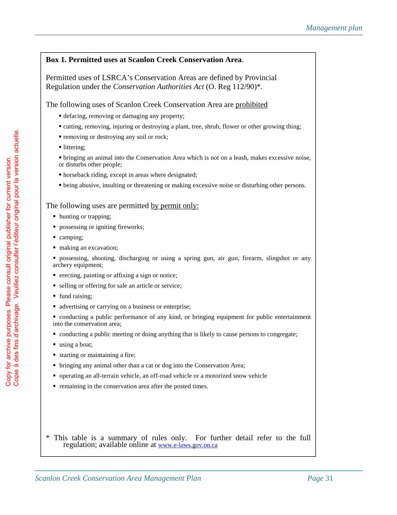
Management plan
Scanlon Creek Conservation Area Management Plan Page 31
Box 1. Permitted uses at Scanlon Creek Conservation Area. Permitted uses of LSRCA’s Conservation Areas are defined by Provincial Regulation under the Conservation Authorities Act (O. Reg 112/90)*. The following uses of Scanlon Creek Conservation Area are prohibited
� defacing, removing or damaging any property;
� cutting, removing, injuring or destroying a plant, tree, shrub, flower or other growing thing;
� removing or destroying any soil or rock;
� littering;
� bringing an animal into the Conservation Area which is not on a leash, makes excessive noise, or disturbs other people;
� horseback riding, except in areas where designated;
� being abusive, insulting or threatening or making excessive noise or disturbing other persons.
The following uses are permitted by permit only: � hunting or trapping;
� possessing or igniting fireworks;
� camping;
� making an excavation;
� possessing, shooting, discharging or using a spring gun, air gun, firearm, slingshot or any archery equipment;
� erecting, painting or affixing a sign or notice;
� selling or offering for sale an article or service;
� fund raising;
� advertising or carrying on a business or enterprise;
� conducting a public performance of any kind, or bringing equipment for public entertainment into the conservation area;
� conducting a public meeting or doing anything that is likely to cause persons to congregate;
� using a boat;
� starting or maintaining a fire;
� bringing any animal other than a cat or dog into the Conservation Area;
� operating an all-terrain vehicle, an off-road vehicle or a motorized snow vehicle
� remaining in the conservation area after the posted times.
* This table is a summary of rules only. For further detail refer to the full
regulation; available online at www.e-laws.gov.on.ca
Cop
y fo
r arc
hive
pur
pose
s. P
leas
e co
nsul
t orig
inal
pub
lishe
r for
cur
rent
ver
sion
. C
opie
à d
es fi
ns d
’arc
hiva
ge.
Veu
illez
con
sulte
r l’é
dite
ur o
rigin
al p
our l
a ve
rsio
n ac
tuel
le.
Management plan
Scanlon Creek Conservation Area Management Plan Page 32
Boundary management LSRCA will retain surveys of all the boundaries of the conservation area on file, and will ensure that all boundaries are clearly marked. LSRCA will inspect boundaries semi-annually for encroachments. As necessary, LSRCA will implement a program to resolve and remediate impacts from boundary encroachments in partnership with the conservation area’s neighbours. This program may include community education, letters, site visits, and community clean up days where necessary. As a designated Place to Grow22, the Town of Bradford West Gwillimbury is expected to double in size in the next 20 years. This development may include an increase in industrial or residential units immediately adjacent to the southern boundary of the conservation area. As this land becomes developed, LSRCA will lobby the Town to implement building setbacks from the conservation area (per Section 4.4.7 of the Town’s Official Plan) and will ensure that adequate fencing exists along the property boundary to prevent uncontrolled access to the conservation area. Specific access points will be identified and provided to allow non-motorized access from this development to the conservation area. If the area between the conservation area and future development is maintained as an agricultural land use (as is indicated in the current Official Plan23), LSRCA will offer to work with the landowner to reforest this strip of land as a contribution to regional green space and as a buffer for Scanlon Creek Conservation Area. If the adjacent property is developed as a residential subdivision, LSRCA may develop programming directed at new residents, such as backyard naturalization, introduction to bird watching, or take a child fishing events. Social events such as community BBQs or clean up days may also be provided. LSRCA will also work to promote constructive relations with conservation area neighbours. This may include involving them in relevant aspects of planning and management, providing them with trail guides and free initial one-year memberships when they move to the area, inviting them to join the Friends of Scanlon Creek, or establishing a fund dedicated to cross-boundary stewardship projects. Scanlon Creek Conservation Area is located within one of LSRCA’s priority securement areas24, and as such may see its property base expand. LSRCA will continue to pursue land securement opportunities in the Holland Marsh wetland complex, particularly those adjacent or near to Scanlon Creek Conservation Area or the Holland Marsh Provincial Wildlife Area. Priority will be given to those lands that are within a significant natural heritage feature and are thus eligible for tax exemption. Securement of land may be through a number of mechanisms, including purchase, donation, conservation easement, bequest, or combination of the above. All securement initiatives will be on a willing buyer - willing seller condition, and conditional upon available funding, with value to be determined by fair market appraisal.
22 As described in MPIR, 2006 23 J. Ross Raymond & Associates Ltd and PLANSCAPE. 2000 24 LSRCA, 2006
Cop
y fo
r arc
hive
pur
pose
s. P
leas
e co
nsul
t orig
inal
pub
lishe
r for
cur
rent
ver
sion
. C
opie
à d
es fi
ns d
’arc
hiva
ge.
Veu
illez
con
sulte
r l’é
dite
ur o
rigin
al p
our l
a ve
rsio
n ac
tuel
le.

Management plan
Scanlon Creek Conservation Area Management Plan Page 33
Water Resources Management Scanlon Creek and the 4 ha reservoir are both one of the largest draws to the property and one of the largest management challenges for the Conservation Authority. Declining water quality in the reservoir has required its closure to swimming, and a degradation of overall visitor experience. Furthermore, the online nature of the reservoir degrades fish habitat by fragmenting migration corridors and increasing water temperature. LSRCA will develop a plan to improve water quality and quantity in the Scanlon Creek watershed. This plan will identify both point and non-point sources of stress to the aquatic ecosystem, and provide recommendations to address the challenges. This plan will be implemented in partnership with neighbouring landowners, interested residents and users of the conservation area, and the Town of Bradford West Gwillimbury. Where necessary, the Ontario Ministry of the Environment will be relied upon to enforce legislation and regulations designed to protect aquatic ecosystems. An Environmental Assessment will be undertaken on the dam and reservoir in the conservation area to examine opportunities to improve natural heritage values and wildlife habitat. The Environmental Assessment will conform to the requirements of the Environmental Assessment Act and other relevant legislation and will include a baseline environmental inventory, an identification of alternative habitat restoration measures, and a detailed environmental assessment of the preferred alternative. Alternatives to be examined will include the construction of a by-pass channel, construction of bottom draw on the dam, and dam removal, as well as others proposed by consultants undertaking the work. Regardless of the restoration alternative that is ultimately chosen, LSRCA will develop additional interpretive materials, including signs, to take advantage of the education and stewardship values of the fisheries and water quality improvement projects. This may include the development of new trails, bridges or boardwalks, and may include their incorporation into nature trails or stewardship demonstration tours.
Infrastructure Management LSRCA may develop additional infrastructure at Scanlon Creek Conservation Area to support the goals and objectives described in this management plan. Priority for development may be given to areas currently in grassland or shrub habitat. Any developments would be subject to the requirements of the Environmental Assessment Act, the Fisheries Act, regulations under the Conservation Authorities Act and other relevant legislation, and would be subject to a site assessment to mitigate detrimental impacts on the values of the conservation area. All new infrastructure will be designed and constructed to meet the standards of the Accessibility for Ontarians with Disabilities Act as they become available.
Cop
y fo
r arc
hive
pur
pose
s. P
leas
e co
nsul
t orig
inal
pub
lishe
r for
cur
rent
ver
sion
. C
opie
à d
es fi
ns d
’arc
hiva
ge.
Veu
illez
con
sulte
r l’é
dite
ur o
rigin
al p
our l
a ve
rsio
n ac
tuel
le.

Management plan
Scanlon Creek Conservation Area Management Plan Page 34
TRAILS Trails at Scanlon Creek Conservation Area will be maintained, designed, and constructed to meet the guidelines of sustainable and universally accessible trails25. Universally accessible trails are not necessarily ‘barrier free’ or ‘handicapped accessible’; rather they represent a trail system that meets the range of abilities and interests of the widest possible range of users. LSRCA will endeavour to provide this range of challenges and opportunities by providing a variety of trails – ranging from accessible, to multi-use, to remote recreational trails (Fig. 8). Accessible trails will be designed, constructed and maintained to a standard such that users with mobility restrictions (such as those reliant on wheelchairs or walkers) can make use of them. This will include maintaining grades less than 3%, a maximum surface pitch of 2%, a minimum width of 2.5m, cleared to a height of 2.5m, with a trail base composed of crusher fines (with additional lime) where necessary to increase trail firmness. Boardwalks may be incorporated in areas of extreme wetness. Accessible trails will be inspected monthly for trail condition and barriers (e.g. washouts, hazard trees, and downed woody debris) Multi-use trails will be designed, constructed and maintained such that they meet the needs and interests of the majority of hikers, bikers, skiers and dog walkers while minimizing impacts on species and ecosystems. They will be maintained to a minimum width of 2.5 m, cleared to a height of 2.5 m, with a base of compacted soil. Trip hazards and wet areas along trails will be managed by topdressing with wood chips, crusher fines, corduroy or boardwalks as necessary. Steep areas on multi-use trails may be managed by providing stairs, climbing ropes, or retained as a challenge. Multi-use trails will be inspected monthly for trail condition and barriers (e.g. washouts, hazard trees and downed woody debris) Remote recreational trails will be maintained to a minimum width of 1.5m, cleared to a height of 2.5m. These trails will have a natural base; however trip hazards and wet areas may be managed by topdressing with wood chips or using corduroy as necessary. Steep areas along these trails will be designed to provide a challenge to users while reducing soil erosion. Remote recreational trails will be inspected annually for trail condition and barriers (e.g. washouts, hazard trees, and downed woody debris) and mown if necessary. One remote recreational trail loop will designated a snowshoe trail (Fig. 8). In the winter, conservation area users will be encouraged to use this trail loop on snowshoe only. Existing trails will be upgraded as necessary to reduce sedimentation or erosion into the watercourse and reservoir. Upgrades may include re-grading trails, topdressing with wood chips, limestone, corduroy or boardwalks, or replacing culverts with footbridges. Scanlon Creek Conservation Area’s trail system will be inspected annually for the development of unofficial trails, or for trail segments which expose trail users to safety risks. If trail closures become necessary to protect natural heritage values or visitor safety, they will include the erection of interpretive signage allowing trail users to know the reason for closure, and that trail closure is intentional rather than the result of a lack of maintenance.
25 As defined by the Trails for all Ontarians Collaborative (2006)
Cop
y fo
r arc
hive
pur
pose
s. P
leas
e co
nsul
t orig
inal
pub
lishe
r for
cur
rent
ver
sion
. C
opie
à d
es fi
ns d
’arc
hiva
ge.
Veu
illez
con
sulte
r l’é
dite
ur o
rigin
al p
our l
a ve
rsio
n ac
tuel
le.

10
9
YONGE
ARTESIAN INDUSTRIAL
GRANDVIEW
10
^
Figure 8Conceptual Plan
This product was produced by the Lake Simcoe Region Conservation Authority and some information depicted on this map may have been compiled from various sources.While every effort has been made to accurately depict the information, data / mapping errors may exist. This map has been produced for illustrative purposes only.© LAKE SIMCOE REGION CONSERVATION AUTHORITY, 2009. All Rights ReservedThe following datasets: roads are © Queens Printer for Ontario, 2009. Reproduced with Permission
Location map
LegendTrail system
accessiblemulti-useremote
concep_trailsnature
interpretive trailsnowshoe trailInternal roads
InfrastructureArboretumOffleash area (option)Discovery play gardenBuildingsParking
0 100 200 300 400Meters
Cop
y fo
r arc
hive
pur
pose
s. P
leas
e co
nsul
t orig
inal
pub
lishe
r for
cur
rent
ver
sion
. C
opie
à d
es fi
ns d
’arc
hiva
ge.
Veu
illez
con
sulte
r l’é
dite
ur o
rigin
al p
our l
a ve
rsio
n ac
tuel
le.

Management plan
Scanlon Creek Conservation Area Management Plan Page 36
LSRCA will establish nature trails (Fig. 8) that will include interpretive signs and displays regarding representative trees, wildflowers and habitat types that are visible from the trail, as well as information on the history, ecology, management, and restoration of the property. Where topography allows, these trails will be maintained as ‘accessible trails’. The nature trails may also include the development of additional recreational infrastructure such as bridges, boardwalks, or scenic overlooks to maximize exposure to, and visual impact of, significant natural heritage features while minimizing recreational impacts. LSRCA will work with the Town of Bradford West Gwillimbury to improve the connection of non-motorized recreational trails between the conservation area and the Town. Access to the conservation area from future residential developments adjacent to the property will also be provided along designated trails. A head of trails kiosk will be developed in the Nature Centre parking lot. This kiosk will include a trail map indicating trail lengths and difficulty, notice board of coming events, rules and regulations of the conservation area, and interpretive material suited for a central location. Signage along the accessible and multi-use trails will be provided to notify users which trail they are on, their position relative to access points and other trails, and geographic (i.e. UTM) location. Simcoe County emergency response personnel will be given copies of trail maps of the conservation area, clearly indicating access points and drivable portions of trails, locations of trail signs as described above, as well as copies of all gate keys and contact information for key LSRCA staff.
PICNIC TABLES AND BENCHES LSRCA will provide picnic tables at the picnic pavilions, nature centre, education centre, and near the creek rehabilitation demonstration site. Picnic tables will be either permanently affixed to a concrete slab and constructed of metal with a wooden top and benches, or moveable and constructed of 2”x6” lumber. LSRCA will ensure that at least 25% of picnic tables are barrier free. Benches will be provided and maintained at strategic locations along the nature trails. Benches will either permanently affixed to a concrete slab and constructed of metal with a wooden top, or moveable and constructed entirely of wood.
WASHROOM FACILITIES AND POTABLE WATER LSRCA will maintain public washroom facilities at the picnic pavilions, nature centre, group campsite, and near the reservoir. When replacement becomes necessary, LSRCA will replace these structures with low maintenance and/or composting facilities. If, at some point in the future municipal services become available to the conservation area, LSRCA will provide potable water at picnic pavilions and campsites. At such time, flush washroom facilities may be constructed near the south picnic pavilion.
Cop
y fo
r arc
hive
pur
pose
s. P
leas
e co
nsul
t orig
inal
pub
lishe
r for
cur
rent
ver
sion
. C
opie
à d
es fi
ns d
’arc
hiva
ge.
Veu
illez
con
sulte
r l’é
dite
ur o
rigin
al p
our l
a ve
rsio
n ac
tuel
le.
Management plan
Scanlon Creek Conservation Area Management Plan Page 37
GROUP CAMPING LSRCA will continue to provide group camping facilities in the main tract of Scanlon Creek Conservation Area. These facilities will include an open grassy area for tents (mown as necessary), washroom facilities and potable water as it becomes available in the conservation area. If interest dictates, an additional group camping facility may be developed in the north tract of the conservation area to provide a more ‘remote’ camping experience for youth groups.
OFF-LEASH AREA If interest dictates, LSRCA will provide a designated ‘dogs off leash area’ to allow users to let their pets run off-leash. The area designated will be chosen in consultation with conservation area users and the local pet industry and will be selected to minimize impacts on conservation area features and reduce, to the extent possible, conflicts between dog walkers and non dog walkers. The area chosen will be fenced and gated, and signs will be posted indicating the rules of the off-leash area and the rules regarding dogs in the rest of the conservation area. Dogs will continue to be permitted in the remainder of the conservation area; however LSRCA staff and municipal bylaw enforcement officers will increase their presence in the conservation area to ensure that regulations regarding leash requirements and waste removal are observed. Signs reminding dog walkers of their responsibilities will be erected in all parking lots and at the designated off-leash area. Where such signs already exist, they will be repainted to remind users of these responsibilities. Baggies and garbage receptacles will be located in all parking lots and at the designated off leash area.
DISCOVERY PLAY GARDEN A ‘discovery play garden’, will be built near the picnic pavilion to provide safe, nature-based recreational opportunities for children and families using the picnic pavilion, nature trail or group camp ground (Fig. 8). Unlike traditional playgrounds, discovery play gardens incorporate elements of vegetation, landscape design, natural elements such as soil and water, in addition to play structures. The overall intent of discovery play gardens is to promote a sense of wonder and discovery in children and engage them in interacting with the natural world around them. The specific details of the discovery play garden will be designed and built with input from children, teenagers, educators, and interested community groups.
SCULPTURES LSRCA will partner with residents of Bradford West Gwillimbury to erect sculptures in the conservation area. Any sculpture so erected would have natural or cultural relevance, would be selected through a juried process, and would be subject to LSRCA approval. Sculptures would be restricted to areas already supporting built infrastructure (e.g. near the Scanlon farmhouse, near conservation area entrances, parking lots, picnic pavilions or the dam).
Cop
y fo
r arc
hive
pur
pose
s. P
leas
e co
nsul
t orig
inal
pub
lishe
r for
cur
rent
ver
sion
. C
opie
à d
es fi
ns d
’arc
hiva
ge.
Veu
illez
con
sulte
r l’é
dite
ur o
rigin
al p
our l
a ve
rsio
n ac
tuel
le.

Management plan
Scanlon Creek Conservation Area Management Plan Page 38
BUILDINGS LSRCA will continue to provide educational services to school groups, local organizations, and interested individuals through the use of the Prof. E.A. Smith Natural Resources Outdoor Education Centre and the day-use Nature Centre. However, over the course of the next 10 to 20 years, LSRCA will need to make significant upgrades to the Education Centre, including a new roof, new windows, new lighting, improved ventilation, new washroom fixtures, and noise reduction in common areas26. Although not anticipated in the short term, LSRCA may ultimately relocate these facilities elsewhere on the property to better separate school groups and other user groups. Facility relocation may ultimately include an expansion of infrastructure to support greater public use of the conservation area. If need dictates, and resources permit LSRCA will convert the washroom and concession building near the reservoir to additional classroom space for use by the education program. The two existing picnic pavilions will be repaired and upgraded as necessary to support their continued use. Repairs may include repairing the roofs and floors, and removing BBQ and fire pits from the south pavilion. Free-standing BBQs will be erected near the picnic pavilions and reservoir. The historic Scanlon farmhouse will be refurbished to provide office space for the Lake Simcoe Conservation Foundation and community resource space. This may include drilling a new well, upgrading heat and telecommunications infrastructure, and other repairs to meet the needs of the building’s tenants and requirements of the Building Code. Funding for this project will be pursued in partnership with the Conservation Foundation. LSRCA will work with the Town of Bradford and heritage conservancy organizations to determine the historical value of the Scanlon farm house, and if appropriate, to have it designated as a heritage building. The existing workshop facilities at the conservation area (Fig. 8) will be renovated and converted to office space for staff of LSRCA’s Watershed Stewardship and Forestry departments. This may include drilling a new well, upgrading heat and telecommunications infrastructure, and other repairs to meet the needs of the buildings’ tenants and requirements of the Building Code. All building renovations will include an assessment of opportunities to increase energy efficiency or to generate electricity on site (e.g. through photovoltaics or wind turbines). The existing gatehouse will be refurbished prior to instituting a vehicle pass requirement. Refurbishment will include repainting, replacement of broken windows and the installation of a gate. Additional heritage buildings may be transported to this property from elsewhere in the Town as they become available, pending financial sustainability and an assessment of how they contribute to the management of the property.
ROADS AND PARKING LOTS Access roads in the conservation area (Fig. 8) will be re-graded or top-dressed semi-annually. As necessary, LSRCA may apply dust reduction compound to roads to prevent erosion. LSRCA may also introduce traffic calming mechanisms to the roads if necessary.
26 TSH Engineering (2008)
Cop
y fo
r arc
hive
pur
pose
s. P
leas
e co
nsul
t orig
inal
pub
lishe
r for
cur
rent
ver
sion
. C
opie
à d
es fi
ns d
’arc
hiva
ge.
Veu
illez
con
sulte
r l’é
dite
ur o
rigin
al p
our l
a ve
rsio
n ac
tuel
le.

Management plan
Scanlon Creek Conservation Area Management Plan Page 39
Gravel parking lots (Fig. 8) will be re-graded or top-dressed semi-annually. Each gravel parking lot will include reserved parking for wheelchair users, maintained to a standard consistent with accessible trails. Grass parking lots will remain as overflow parking and will be mown on an as-needed basis. LSRCA will examine ways of improving energy efficiency of the lighting in the parking lots. This may include putting timers or motion detectors on existing light standards or replacing existing light standards with solar-powered lights. Signs will be erected at junctions in the road network clearly directing visitors to the Head of Trails, picnic pavilions, Education Centre, Nature Centre, and other parking lots. If user levels dictate, LSRCA will construct an additional section of internal road along the south boundary of the property to promote separation between school groups and the general public. Should this happen, a small additional parking lot would be created near the Head of Trails for use by hikers and other trail users. Snow will be removed from the entrance road up to the gate at the Nature Centre, and from the parking lots and walkways at the Nature Centre, Education Centre, workshop and farmhouse as necessary.
Vegetation and wildlife management Some of the most significant wildlife and habitat values in the conservation area exist in the more remote and relatively inaccessible parcels27. The Studholme, Collings, and Lee tracts will continue to be managed as nature reserves. Although use of and access to these tracts will not be prohibited, no trails or formal access points will be provided. Fencing and signage may be erected as necessary to prevent unauthorized use of these tracts. The north tract may continue to be the focus of forest restoration and management efforts as resources permit. Although this tract may be the site of additional infrastructure in the future, no development will be permitted without an assessment of potential impacts on existing natural heritage values. Forest management at Scanlon Creek Conservation Area will include the removal of hazard trees as necessary28, as well as management to promote the conversion of conifer plantations to deciduous or mixed forests, and to reduce the overall contrast between forest compartments on this property. Specific direction regarding forest management is provided by a Forest Management Plan (2007 – 2016), which identifies the appropriate silvicultural techniques to manage the property for recreation and wildlife habitat. Updates to that Forest Management Plan shall be consistent with the goals and objectives for the property as identified in this Conservation Area Management Plan. With the relocation of watershed stewardship and forestry staff to the conservation area, LSRCA may increase the stewardship interpretive values at the conservation area. This may include enhanced interpretation of existing stewardship efforts (including forest and wetland management) as well as the development and interpretation of new stewardship demonstrations. These demonstrations may include on-line pond rehabilitation, alternative reforestation techniques, or other wildlife habitat or water quality enhancement projects, pending resources and appropriate site conditions. Infrastructure to support interpretation may include a section of nature trail and the erection of interpretive signs.
27 LSRCA, 2008b 28 Guidelines for the identification and removal of hazard trees is provided by the LSRCA hazard tree management strategy (LSRCA, 2009)
Cop
y fo
r arc
hive
pur
pose
s. P
leas
e co
nsul
t orig
inal
pub
lishe
r for
cur
rent
ver
sion
. C
opie
à d
es fi
ns d
’arc
hiva
ge.
Veu
illez
con
sulte
r l’é
dite
ur o
rigin
al p
our l
a ve
rsio
n ac
tuel
le.

Management plan
Scanlon Creek Conservation Area Management Plan Page 40
The arboretum near the gatehouse will be upgraded and improved, including the re-establishment of an interpretive trail, and replacement of labels on trees as necessary. Additional native tree specimens may be included in the arboretum as appropriate. Additional interpretive materials indicating the relative values of native and non-native species, wildlife habitat and forestry values, and silviculture of the various species may be included to enhance the value of this feature as a stewardship demonstration. Only native species of trees or other vegetation will be planted for forestry or wildlife habitat. Priority will also be given to native species when selecting plants for landscape or ornamental purposes. LSRCA will also manage the property to control the spread of non-native invasive species. Management will include annual inspections of the spread and dominance of non-natives. Any aggressive invasive species29 occurring in small numbers will be controlled using recommendations based on the best available science. Direction for control of widespread aggressive invasive species will be provided under an approved Forest Management Plan. Where necessary, LSRCA will coordinate volunteer work days to control widespread aggressive invasive plant species. LSRCA may also control the spread of poison ivy where necessary, using recommendations based on the best available science. When conflicts between wildlife and the users or facilities of the conservation area occur, priority will be given to wildlife use of the property. This may in extreme cases include re-routing of trails. However, when other resolutions are not available, the humane removal of nuisance wildlife such as beaver may be permitted when necessary to protect infrastructure such as trails or bridges.
Marketing LSRCA will increase the marketing of Scanlon Creek Conservation Area to existing and new residents of southern Simcoe County and northern York Region, through the development of trail maps, brochures, and an enhanced page on the LSRCA website outlining the range of recreational opportunities provided at the conservation area. The new marketing approach will bear the slogan “Wildness Close to Home”; reflecting comments received during public consultation and the increasing importance of this property in a suburbanizing landscape. LSRCA will make particular effort to outreach to new residents of Bradford, Sharon and Queensville to raise their awareness of the existence of Scanlon Creek Conservation Area and the Wildness Close to [their new] Home. Marketing materials will also be provided to visitors to Bradford West Gwillimbury, through partnerships with the local tourism industry and visitor information centres in York Region and Simcoe County. Despite the ethnic diversity in the GTA, usership at Scanlon Creek Conservation Area tends to be predominantly Caucasian. LSRCA will undertake focused marketing to the ethnic communities within the GTA, raising their awareness of recreational features such as hiking trails, picnic pavilions, the proposed discovery play garden, and the reservoir and creek. As public educational and recreational programming becomes established at Scanlon Creek Conservation Area, LSRCA may develop a marketing strategy specific to these programs.
29 As defined by Urban Forest Associates Inc (2002)
Cop
y fo
r arc
hive
pur
pose
s. P
leas
e co
nsul
t orig
inal
pub
lishe
r for
cur
rent
ver
sion
. C
opie
à d
es fi
ns d
’arc
hiva
ge.
Veu
illez
con
sulte
r l’é
dite
ur o
rigin
al p
our l
a ve
rsio
n ac
tuel
le.

Management plan
Scanlon Creek Conservation Area Management Plan Page 41
Revenue generation LSRCA will require users accessing the property with a vehicle to purchase a vehicle access permit. Fee prices for the permit will be set at a level commensurate with similar recreation areas elsewhere in the Golden Horseshoe and may be revised on an annual basis to ensure fair market value is being received. LSRCA will also develop an annual pass, allowing individuals to pre-pay for unlimited access during one calendar year. As necessary, LSRCA will enforce ‘no parking’ regulations on the entrance road south of the gate. Reservation fees for use of the education facilities, campsites and picnic pavilions will also be required. LSRCA will set the fees at a level commensurate with similar recreation areas elsewhere in the Golden Horseshoe. Fees may be revised on an annual basis to ensure fair market value is being received. LSRCA may provide group memberships to community groups who assist in the development and management of the conservation area. LSRCA may also pursue options to provide memberships or coupons as marketing tools, or to provide bulk permits to interested municipalities in the watershed. Notwithstanding the above, the requirements for access permits will not be implemented immediately. Rather, in the short term, LSRCA will remove the existing fee box on the gatehouse and the sign describing the current fee schedule, and will provide a donation box in the parking lots near the Education Centre, Nature Centre, picnic pavilions, and reservoir. Donation boxes will be accompanied by signs sharing LSRCA’s vision for the property, identifying investments being made, and providing information on how users can contribute (including through the donation box). An annual supporter’s program will be developed wherein donors would receive a tax receipt and a sticker identifying them as a “Supporter of Scanlon Creek” for a $100 donation. Access fees will not be required until the Authority and its partners have invested in upgrades to facilities and services for 2 to 3 years. Any implementation of access fees will be preceded by a three-month period of public notice. LSRCA will develop a donations and naming policy for its conservation areas. The policy will identify facilities and programs that will be eligible for naming recognition, donations required, and ways naming can be incorporated tastefully into a natural setting. Any revenue generated at Scanlon Creek Conservation area will be retained for use in this and other conservation areas in the Lake Simcoe watershed. Any surplus revenues from this property will be dedicated to other conservation areas which do not generate revenue, to a conservation area stabilization fund to support the area in years with decreased revenue, or will be used to support LSRCA’s land securement program.
Programming Educational Services will continue to be one of the primary uses of Scanlon Creek Conservation Area, including the continued use and maintenance of the Prof. E.A. Smith Natural Resources Outdoor Education Centre and day-use Nature Centre. Programming will be expanded however, as interest dictates and resources permit, to provide organized educational and recreational events for the public at large. LSRCA will provide nature-based programs such as interpretive hikes and wildlife identification workshops on a seasonal basis to interested conservation area users. These programs may be provided by LSRCA staff, or by outside experts, and may be reliant on partnerships with organizations with complementary mandates. LSRCA
Cop
y fo
r arc
hive
pur
pose
s. P
leas
e co
nsul
t orig
inal
pub
lishe
r for
cur
rent
ver
sion
. C
opie
à d
es fi
ns d
’arc
hiva
ge.
Veu
illez
con
sulte
r l’é
dite
ur o
rigin
al p
our l
a ve
rsio
n ac
tuel
le.

Management plan
Scanlon Creek Conservation Area Management Plan Page 42
may also develop directed programs for senior’s clubs or other community groups to allow them to have enhanced use of the conservation area. The relocation of LSRCA’s stewardship and forestry staff to Scanlon Creek Conservation Area may provide an opportunity for workshops or other forms of programming related to forestry or stewardship. Programs may include workshops, guided or self-guided tours, or participation in volunteer workdays. Additional stewardship demonstration projects may be established on the property to support these programs. Programming may also be provided by the Town of Bradford West Gwillimbury or other organizations, to whom the facilities at Scanlon will be made available. Reduction in facility rental fees may be provided if the public programming provided is consistent with the objectives of the conservation area. A fee structure for programs provided by LSRCA will be developed to ensure that programming is either revenue neutral or revenue positive. Minimum numbers required for each program will be identified and pre-registration will be required. Excess revenues from popular public programming may be used to off-set costs of programs which are consistent with the objectives of LSRCA but which have lower public demand.
Friends of Scanlon Creek Conservation Area LSRCA will work with interested users of the conservation area to start a Friends of Scanlon Creek Conservation Area. Although the specific mandate, projects and terms of reference will be developed in collaboration with initial members, projects a Friends organization may get involved with include work days to build or maintain infrastructure, habitat stewardship projects, or assisting in fund raising to support management of the conservation area. One initial priority for working with a Friends organization is in planning and developing a discovery play garden.
Cop
y fo
r arc
hive
pur
pose
s. P
leas
e co
nsul
t orig
inal
pub
lishe
r for
cur
rent
ver
sion
. C
opie
à d
es fi
ns d
’arc
hiva
ge.
Veu
illez
con
sulte
r l’é
dite
ur o
rigin
al p
our l
a ve
rsio
n ac
tuel
le.

Business plan
Scanlon Creek Conservation Area Management Plan Page 43
Section IV: Business Plan
Introduction The purpose of a conservation area management plan is to establish long- and short-term goals for the management of the property, and priorities for implementation. The Business Plan component is a description and schedule of implementation priorities and responsibilities, coupled with projections of revenues and expenses over a five year period. In addition to revenues and expenses, this business plan will identify potential funding sources and will provide guidance for LSRCA management in implementing the Scanlon Creek Conservation Area management plan.
Management plan goals and objectives After broad-based consultation with users of the conservation area, and other residents of the Lake Simcoe watershed, the Scanlon Creek Conservation Area Management Plan Steering Committee developed the following goals and objectives for the conservation area:
Scanlon Creek Conservation Area will be managed to provide an example of proper land and water stewardship. Opportunities for nature-based education and recreation will be provided while maintaining a balance between public use and the conservation of nature.
More specifically, LSRCA aims to:
• Maintain and enhance the recreational trails system;
• Improve the water quality and fish habitat in Scanlon Creek, with particular emphasis on the Scanlon Creek reservoir;
• Expand educational programming from its existing base of school-oriented programs to engage a broader cross section of our watershed;
• Engage the public more fully in the planning and management of the conservation area through the establishment of a Friends of Scanlon Creek Conservation Area;
• Establish a user fee policy that is equitable and that at the same time provides sustainable base funding for the on-going operation, maintenance and development of the conservation area.
To these ends, priorities for investing in capital and programming for the period 2009 – 2013 have been identified (Table 1).
Cop
y fo
r arc
hive
pur
pose
s. P
leas
e co
nsul
t orig
inal
pub
lishe
r for
cur
rent
ver
sion
. C
opie
à d
es fi
ns d
’arc
hiva
ge.
Veu
illez
con
sulte
r l’é
dite
ur o
rigin
al p
our l
a ve
rsio
n ac
tuel
le.

Business plan
Scanlon Creek Conservation Area Management Plan Page 44
Table 1. Scanlon Creek Conservation Area management plan implementation priorities 2009 2010 2011 2012 2013 � Improve head of trails sign � Develop watershed restoration plan � Conduct environmental assessment on reservoir rehabilitation � Provide upgrades to maple trail and secondary trails in the ravine � Provide additional benches � Repair pavilion D � Refurbish gate house � Refurbish farm house � Upgrade internal roads � Refurbish arboretum � Improve marketing � Provide donation boxes � Start nature programs � Start Friends group
� Build off leash area for dogs � Begin watershed restoration � Begin reservoir rehabilitation � Provide upgrades to evergreen trail and secondary trails south of ravine � Provide additional benches � Begin replacing outhouses � Begin construction of discovery play garden � Repair pavilion G � Continue to upgrade internal roads � Evaluate / refine programming
� Continue watershed restoration � Continue reservoir rehabilitation � Provide upgrades to kingfisher trail and secondary trails near cemetery � Provide additional benches � Develop nature trail � Continue replacing outhouses � Evaluate / refine programming
� Continue watershed restoration � Provide upgrades to secondary trails north of the reservoir � Develop accessible trail � Continue replacing outhouses
� Continue watershed restoration � Develop accessible trail � Continue replacing outhouses � Hire gate house staff � Evaluate and review management plan and business plan
Cop
y fo
r arc
hive
pur
pose
s. P
leas
e co
nsul
t orig
inal
pub
lishe
r for
cur
rent
ver
sion
. C
opie
à d
es fi
ns d
’arc
hiva
ge.
Veu
illez
con
sulte
r l’é
dite
ur o
rigin
al p
our l
a ve
rsio
n ac
tuel
le.

Business plan
Scanlon Creek Conservation Area Management Plan Page 45
Table 2. Revenues and expenses for materials and supplies to implement Scanlon Creek Conservation Area management plan priorities.
2009 2010 2011 2012 2013 TotalRevenues (cash)Bradford West Gwillimbury $9,000 $5,000 $2,000 $4,000 $0 $20,000Donations $249,000 $280,000 $30,000 $5,000 $5,000 $569,000LSCUF $117,000 $64,000 $64,000 $44,000 $44,000 $333,000LEAP $10,000 $11,000 $11,000 $6,000 $6,000 $44,000Municipal levy $5,000 $7,200 $7,920 $8,662 $9,928 $38,710Municipal special capital $46,800 $78,000 $39,500 $36,500 $13,500 $214,300Ontario Trillium Foundation $1,000 $27,780 $39,040 $23,880 $0 $91,700User fees $4,187 $4,790 $6,496 $7,206 $7,967 $30,646Total Revenues $441,987 $477,770 $199,956 $135,248 $86,395 $1,341,357
Revenues (in-kind)Bradford West Gwillimbury $17,000 $17,000Danube Seniors Centre $900 $900 $900 $2,700Landscape design $1,000 $1,000Total in kind $18,900 $900 $900 $0 $0 $20,700
ExpensesAdministration $12,987 $9,290 $10,246 $10,956 $16,717 $60,196Capital development $314,900 $387,180 $106,940 $64,880 $9,000 $882,400Maintenance $5,000 $7,200 $8,670 $9,412 $10,678 $40,960Resource management $128,000 $75,000 $75,000 $50,000 $50,000 $378,000Total Expenses $460,887 $478,670 $200,856 $135,248 $86,395 $1,361,557
Balance $0 $0 $0 $0 $0 $0
Cop
y fo
r arc
hive
pur
pose
s. P
leas
e co
nsul
t orig
inal
pub
lishe
r for
cur
rent
ver
sion
. C
opie
à d
es fi
ns d
’arc
hiva
ge.
Veu
illez
con
sulte
r l’é
dite
ur o
rigin
al p
our l
a ve
rsio
n ac
tuel
le.

Business plan
Scanlon Creek Conservation Area Management Plan Page 46
Historic Revenues Revenues to support the development, operation and maintenance of Scanlon Creek Conservation Area have traditionally come from four major sources (Fig. 9): municipal special capital investments, gate fees and permits, donations, and facility rentals. In addition, levies from our municipal partners provide the critical base funding to employ staff and administration.
0
5000
10000
15000
20000
25000
30000
35000
40000
2002 2003 2004 2005 2006 2007
misc fees
day camp fees
facility rentals
donations
municipal special capital
gate fees and permits
Figure 9. Revenues at Scanlon Creek Conservation Area, displayed by revenue source, from 2002 - 2007
GATE FEES AND PERMITS Fees charged to users of Scanlon Creek Conservation Area have always played a significant part in the conservation area’s revenue stream. In 2002 and earlier, Scanlon Creek Conservation Area had a staffed gatehouse with an attendant collecting fees, since that time gate fees have been on an honour system, and revenues from the gate have dropped by approximately 60%. Reservation fees for the group camp sites and picnic pavilions have remained in force and currently provide approximately one-fifth of the revenue received at Scanlon Creek Conservation Area.
MUNICIPAL SPECIAL CAPITAL LSRCA’s municipal partners periodically provide ‘special capital’ funding to support the implementation of specific projects that advance the Authority’s mandate. In the past, special capital investments made at Scanlon Creek include investments in upgrades to the Nature Centre, to the trails, and to build a fence. In 2007 and 2008 special capital investments were used to develop this conservation area management plan / business plan.
Cop
y fo
r arc
hive
pur
pose
s. P
leas
e co
nsul
t orig
inal
pub
lishe
r for
cur
rent
ver
sion
. C
opie
à d
es fi
ns d
’arc
hiva
ge.
Veu
illez
con
sulte
r l’é
dite
ur o
rigin
al p
our l
a ve
rsio
n ac
tuel
le.

Business plan
Scanlon Creek Conservation Area Management Plan Page 47
Additional contributions from Bradford West Gwillimbury in 2008 have been directed to additional trail upgrades.
FACILITY RENTALS Until 2005, the Scanlon family farmhouse had been rented as a residential unit, providing a significant source of income to Scanlon Creek Conservation Area. However, with declining water quality in the well and more strict regulations regarding drinking water, LSRCA was forced to cease renting this property. This has caused a significant decrease in revenues since 2005.
Cop
y fo
r arc
hive
pur
pose
s. P
leas
e co
nsul
t orig
inal
pub
lishe
r for
cur
rent
ver
sion
. C
opie
à d
es fi
ns d
’arc
hiva
ge.
Veu
illez
con
sulte
r l’é
dite
ur o
rigin
al p
our l
a ve
rsio
n ac
tuel
le.

Business plan
Scanlon Creek Conservation Area Management Plan Page 48
Budget projection The budget projection predicts a five-year financial outlook for Scanlon Creek Conservation Area. The model compares the conservation area’s most consistent source of funds with projected one-time and recurring costs. As depicted below (Table 3), Scanlon Creek Conservation Area’s current budget cost projection suggests that staffing levels and revenues generated on the property will fall well short of what would be necessary to implement the management plan.
Table 3. Projected surplus (shortfall) in funding and staffing to implement the Scanlon Creek Conservation Area management plan, for the period 2009 – 2013
$ FTE $ FTE $ FTE $ FTE $ FTERevenues $6,050 2.00 $6,300 2.00 $6,950 2.00 $7,600 2.00 $26,875 2.00Expenses $460,887 3.06 $478,670 2.77 $200,856 2.90 $135,248 3.00 $86,395 3.63
Balance ($454,837) (1.06) ($472,370) (0.77) ($193,906) (0.90) ($127,648) (1.00) ($59,520) (1.63)
20132009 2010 2011 2012
Cop
y fo
r arc
hive
pur
pose
s. P
leas
e co
nsul
t orig
inal
pub
lishe
r for
cur
rent
ver
sion
. C
opie
à d
es fi
ns d
’arc
hiva
ge.
Veu
illez
con
sulte
r l’é
dite
ur o
rigin
al p
our l
a ve
rsio
n ac
tuel
le.

Business plan
Scanlon Creek Conservation Area Management Plan Page 49
Projected Revenues To address the projected funding shortfall identified in this business plan, LSRCA will need to attract new sources of funding and in-kind support. Funding may include municipal special capital, government and non-government funding programs, private sector sponsorships and volunteer time and donations from the public.
LAKE SIMCOE CLEAN UP FUND The Lake Simcoe Clean-Up Fund (LSCUF) is a Federal funding program designed to provide financial and technical support to implement projects intended to improve water quality and fish habitat in Lake Simcoe. Projects at Scanlon Creek Conservation Area that would be eligible for LSCUF funding include the development and implementation of a watershed restoration plan, and an Environmental Assessment and rehabilitation of the reservoir. LSCUF can fund up to two thirds of the total cost of these projects, including salaries, operating expenses, and professional services, with funding applications accepted twice a year. LSRCA will apply to LSCUF funding to support the implementation of the water quality and fish habitat improvement projects.
LANDOWNER ENVIRONMENTAL ASSISTANCE PROGRAM The Landowner Environmental Assistance Program (LEAP) is a funding program administered by LSRCA to provide funding and technical assistance to landowners undertaking projects to improve water quality in Lake Simcoe. The implementation of projects identified by the watershed plan and the rehabilitation of the reservoir would be eligible to receive up to 50% funding (to a maximum for each project) from LEAP.
ONTARIO TRILLIUM FOUNDATION The Ontario Trillium Foundation (OTF) provides funding to community-based initiatives supporting the environment, arts and culture, human and social services and sports and recreation. Although neither Conservation Authorities nor municipalities are eligible to become recipients of OTF grants, they may receive grants as part of a “collaborative” effort with community groups. Ontario Trillium Foundation will provide support up to $375,000 over five years through it’s ‘community grants’ program. Projects at Scanlon which may be eligible for this funding include trail upgrades, the discovery play garden, water quality improvement projects as well as the coordination of nature-based programming and the Friends group. LSCRA will work with the Lake Simcoe Conservation Foundation (LSCF) and other interested community groups to develop a funding proposal to OTF to support these projects.
MINISTRY OF HEALTH PROMOTION The Ontario Ministry of Health Promotion’s Communities in Action Fund (CIAF) program is intended to increase physical activity of Ontarians and improve the health and economic benefits of trails. The Ministry of Health Promotion will fund Conservation Authorities and their collaborators up to 60% of the cost of projects that contribute to increased levels of physical activity through outdoor sport, recreation, and trail usage. LSCRA will work with the LSCF to engage other interested community groups and develop a funding proposal to CIAF to support these projects.
EVERGREEN FOUNDATION The Evergreen Foundation works with community groups, municipal governments, landowners, foundations, and non-governmental organizations for the restoration of parks and natural areas. Projects such as the discovery play garden, reservoir rehabilitation and watershed restoration projects may be eligible for Evergreen funding if implemented in partnership with community groups such as the Friends of Scanlon Creek or the South Simcoe Streams Network. Funding deadlines and eligibility criteria vary amongst Evergreens program areas. LSRCA may submit applications to Evergreen for their support on a project-specific basis.
Cop
y fo
r arc
hive
pur
pose
s. P
leas
e co
nsul
t orig
inal
pub
lishe
r for
cur
rent
ver
sion
. C
opie
à d
es fi
ns d
’arc
hiva
ge.
Veu
illez
con
sulte
r l’é
dite
ur o
rigin
al p
our l
a ve
rsio
n ac
tuel
le.

Business plan
Scanlon Creek Conservation Area Management Plan Page 50
MUNICIPAL SPECIAL CAPITAL Special capital funding from LSRCA’s partner municipalities will remain an important part of the funding formula for Scanlon Creek Conservation Area. Municipal special capital will be utilized in upgrading signs, built infrastructure such as the gate house, picnic pavilions and washrooms, in signs and trail markers, and in providing seed funding to attract the funding agencies described above. Municipal support may also include in-kind assistance, such as that provided by Bradford West Gwillimbury in 2008 in upgrading the internal roads.
PRIVATE SECTOR PARTNERSHIPS Opportunities may exist to engage the private sector in providing funding or in-kind support of Scanlon Creek Conservation Area. In particular, LSRCA and LSCF will approach the private sector for support in the rehabilitation of the Scanlon farmhouse and the reservoir. LSRCA will also work with LSCF to develop a donations and naming policy which will identify facilities and programs that will be eligible for recognition naming, donations required, and ways naming can be incorporated tastefully into a natural setting.
GATE FEES AND PERMITS Although LSRCA does not expect to collect gate fees until 2013, we do not anticipate a significant drop from current gate fee revenues resulting from the migration to donation boxes rather than self-serve permits. In 2013, when the gate house is scheduled to be staffed again, revenues should increase to reflect the collection of fees from all users. Projections for revenues from gate fees and reservations of picnic pavilions and group camp sites are predicted to grow proportional to the local population. As of 2008, LSRCA charges a sliding scale for access permits, ranging from $1 to $4 depending on time of visit and age of visitor. Prior to the re-institution of access permits, fee levels at this and other conservation areas will be revised to ensure that they remain at a level commensurate with similar recreation areas elsewhere in the Golden Horseshoe. Similar revisions may occur upon the review of this business plan in 2014, and annually thereafter. LSRCA will also develop an annual pass, allowing individuals to pre-pay for unlimited access during one calendar year. The fee for this pass will also be set at a level commensurate with similar recreation areas elsewhere in the Golden Horseshoe.
VOLUNTEERS AND DONATIONS One of the goals of the Scanlon Creek Conservation Area management plan is to engage the public more fully in the planning and management of the conservation area, an involvement that in some cases will include donations of time and money. A user survey conducted as part of the management plan review found that over half of respondents were interested in participating as members of a Friends of Scanlon Creek Conservation Area, becoming involved in projects such as work days and habitat stewardship projects. These volunteers may become available to assist LSRCA in trail stewardship, invasive species management, and the implementation of the water quality and fisheries rehabilitation projects. LSRCA will also partner with volunteers from the community involved in the South Simcoe Streams Network to support the implementation of the Scanlon Creek watershed restoration plan.
Cop
y fo
r arc
hive
pur
pose
s. P
leas
e co
nsul
t orig
inal
pub
lishe
r for
cur
rent
ver
sion
. C
opie
à d
es fi
ns d
’arc
hiva
ge.
Veu
illez
con
sulte
r l’é
dite
ur o
rigin
al p
our l
a ve
rsio
n ac
tuel
le.

Business plan
Scanlon Creek Conservation Area Management Plan Page 51
Expenses Operational expenses at Scanlon Creek Conservation Area can be divided into four broad categories: administration, resource management, capital improvements, and maintenance (Fig. 10).
0
5000
10000
15000
20000
25000
2002 2003 2004 2005 2006 2007
resource management
infrastructure development
maintenance
administration and visitor services
Figure 10. Expenses at Scanlon Creek Conservation Area, displayed by functional area, from 2002 - 2007
ADMINISTRATION AND VISITOR SERVICES Administration of Scanlon Creek Conservation Area includes the general administrative duties that support and enhance the operations of the conservation area, including communication and marketing, human resource management, budget formulation and tracking, and oversight of procurement and contracting activities. This functional area also provides visitor services and maintains partnerships with external stakeholders.
Cop
y fo
r arc
hive
pur
pose
s. P
leas
e co
nsul
t orig
inal
pub
lishe
r for
cur
rent
ver
sion
. C
opie
à d
es fi
ns d
’arc
hiva
ge.
Veu
illez
con
sulte
r l’é
dite
ur o
rigin
al p
our l
a ve
rsio
n ac
tuel
le.

Business plan
Scanlon Creek Conservation Area Management Plan Page 52
CAPITAL DEVELOPMENT As a result of shrinking revenues in the 2002 – 2007 periods, LSRCA has been able to make only limited investment in capital assets at Scanlon Creek Conservation Area. There have been periodic improvements however to the trail system and to the Nature Centre, supported by municipal special capital. Priorities for capital improvements in the period 2009 – 2013 include refurbishing the Scanlon farmhouse, gatehouse, picnic pavilions, hiking trails, head of trails, outhouses and internal roads. In addition, LSRCA anticipates developing a discovery play garden, an off-leash area for dogs and nature trail at Scanlon Creek in this five year operational period. In addition to the capital upgrades scheduled for the conservation area itself, a recent consultant’s report30 has identified nearly $1 Million in upgrades recommended for the Education Centre over the next 20 years.
MAINTENANCE The maintenance functional area at Scanlon Creek Conservation Area performs all activities that prolong the lives of the conservation area’s diverse assets. These activities include repair work, preventive maintenance, and general upkeep of the grounds and trails. It is anticipated that general maintenance needs will increase over time as user levels increase, and as LSRCA brings Scanlon Creek up to proposed maintenance standards. In addition, additional maintenance will be necessary to maintain the new and upgraded infrastructure to an acceptable standard.
RESOURCE MANAGEMENT The Resource Management functional area refers to the management of natural heritage features in the conservation area. Activities include inventory and monitoring of native and non-native plant and animal species, forest management and the conservation and restoration of wildlife habitat.
30 TSH Engineers (2008)
Cop
y fo
r arc
hive
pur
pose
s. P
leas
e co
nsul
t orig
inal
pub
lishe
r for
cur
rent
ver
sion
. C
opie
à d
es fi
ns d
’arc
hiva
ge.
Veu
illez
con
sulte
r l’é
dite
ur o
rigin
al p
our l
a ve
rsio
n ac
tuel
le.

Business plan
Scanlon Creek Conservation Area Management Plan Page 53
Implementation schedule Lake Simcoe Region Conservation Authority staff will implement the projects and programs identified in the Scanlon Creek Conservation Area management plan as described below31. Oversight on implementation, and direction on fundraising and external partnerships, will be provided by an ad-hoc leadership committee made up of representatives of the Conservation Authority, the Lake Simcoe Conservation Foundation, the Town of Bradford West Gwillimbury, with additional members invited as necessary.
2009
Administration and Visitor Services Donation box � Construct donation boxes for the 4 parking lots � Field services will be responsible for achieving this objective � Estimated cost: $1800 � Funding source: municipal special capital (100%) Nature programs � Provide 4 nature programs, including seasonal guided nature hikes and other as interest dictates � Review participation rates and interest level of participants to inform 2010 programs � Volunteer coordinator will be responsible for achieving this objective � Estimated cost: $1000 � Funding source: municipal special capital (100%) Friends organization � Facilitate the development of a volunteer ‘Friends’ group � Volunteer coordinator will be responsible for achieving this objective � Estimated cost: $1000 � Funding source: municipal special capital (100%) Property taxes � Continue to pay municipal property taxes � Director of Conservation Lands will be responsible to ensure taxes paid � Estimated cost: $3587 � Funding source: user fees (100%) Improved marketing � Develop and print a Scanlon Creek Conservation Area trail map brochure � Add TODS highway signs to Highway 400 � The Conservation Lands Planner and Corporate Communications will be responsible for achieving this
objective � Estimated cost: $3600 � Funding source: Bradford West Gwillimbury (80%), user fees (20%)
31 Expenses related to materials and to staffing have been treated as separate items. Staffing needs summarized on an annual basis
Cop
y fo
r arc
hive
pur
pose
s. P
leas
e co
nsul
t orig
inal
pub
lishe
r for
cur
rent
ver
sion
. C
opie
à d
es fi
ns d
’arc
hiva
ge.
Veu
illez
con
sulte
r l’é
dite
ur o
rigin
al p
our l
a ve
rsio
n ac
tuel
le.

Business plan
Scanlon Creek Conservation Area Management Plan Page 54
Improved enforcement � Increase enforcement of off-leash and other regulations � Enforcement officers will be responsible for achieving this objective � Estimated cost: $2000 � Funding source: municipal special capital (100%) Capital development Trail upgrades � Upgrades to the maple trail (total length 1.5km). Approximately 100m to be built up to deal with exposed
roots or compacted or eroded soil � Minor repairs to secondary trails through the ravine (total length approx 800m) � Install interpretive kiosk at head of trails � Install 3 additional benches � Create a lookout platform near pavilion D � Field services will be responsible for meeting this objective � Estimated cost: $5500 � Funding source: Bradford West Gwillimbury (100%); Danube Senior’s Leisure Centre (benches in-kind) Picnic pavilion repairs � Provide a new roof, fascia, and floor to pavilion ‘D’ (the ‘lookout pavilion’) � Replace existing built-in BBQ pits with freestanding charcoal grills � The Director of Conservation Lands and Field services will be responsible for selecting a contractor(s) to
repair the picnic pavilion � Field Services will be responsible for erecting charcoal grills � Estimated cost: $16,000 � Funding source: municipal special capital (100%) Refurbish gate house � Provide a new roof, new siding and new windows to existing gate house � Field Services will be responsible for achieving this objective � Estimated cost: $2000 � Funding source: municipal special capital (100%) Refurbish farmhouse / workshop � Begin to refurbish Scanlon farmhouse to provide office space and meeting space as described in the Business
Case32 � Begin to refurbish workshop to provide additional staff office space as described in the Business Case � The Director of Conservation Lands will be responsible for achieving this objective � Estimated cost: $250,000 � Funding source: private sector donations (100%) Maintain roads and parking lots � Maintain existing roads, and upgrade road from Nature Centre to Pavilion D � Field Services will be responsible for achieving this objective � Estimated cost: $37,000 � Funding source: municipal special capital ($20,000), Bradford West Gwillimbury in-kind ($17,000) 32 LSRCA (2008c)
Cop
y fo
r arc
hive
pur
pose
s. P
leas
e co
nsul
t orig
inal
pub
lishe
r for
cur
rent
ver
sion
. C
opie
à d
es fi
ns d
’arc
hiva
ge.
Veu
illez
con
sulte
r l’é
dite
ur o
rigin
al p
our l
a ve
rsio
n ac
tuel
le.

Business plan
Scanlon Creek Conservation Area Management Plan Page 55
Signs � Update Education Centre sign � Provide new direction and regulation signs � Director of Conservation Lands will be responsible for achieving this objective � Estimated cost: $3500 � Funding source: municipal special capital (100%) Maintenance Grounds and trails maintenance � Annual workload to maintain property including mowing lawns, garbage removal, hazard tree management � Field Services will be responsible for achieving this objective � Estimated cost: $5000 � Funding source: municipal levy Resource management Watershed stewardship � Develop a subwatershed stewardship plan to improve water quality in Scanlon Creek � Watershed stewardship staff will be responsible for achieving this objective � Estimated cost: $2000 � Funding source: Lake Simcoe Clean Up Fund (100%) Pond rehabilitation � Conduct an Environmental Assessment on the Scanlon pond and associated dam � Conservation Lands Planner will be responsible for selecting consultant to achieve this objective � Estimated cost: $125,000 � Funding source: LSCUF (70%), LEAP (20%), Ontario Trillium Foundation (10%) Staffing requirements � Field services: 2.2 FTE (2008 complement 1.1 FTE) � Volunteer coordinator: 0.2 FTE (2008 complement 0.0 FTE) � Conservation lands planner: 0.1 FTE (2008 complement 0.5 FTE) � Enforcement officer: 0.1 FTE (2008 complement 0.0 FTE)
2010
Administration and Visitor Services Nature programs � Provide 4 nature programs, including seasonal guided nature hikes and other as interest dictates � Review participation rates and interest level of participants to inform 2011 programs � Volunteer coordinator will be responsible for achieving this objective � Estimated cost: $1000 � Funding source: municipal special capital (100%)
Cop
y fo
r arc
hive
pur
pose
s. P
leas
e co
nsul
t orig
inal
pub
lishe
r for
cur
rent
ver
sion
. C
opie
à d
es fi
ns d
’arc
hiva
ge.
Veu
illez
con
sulte
r l’é
dite
ur o
rigin
al p
our l
a ve
rsio
n ac
tuel
le.
Business plan
Scanlon Creek Conservation Area Management Plan Page 56
Friends organization � Support the operations of the volunteer ‘Friends’ group � Volunteer coordinator will be responsible for achieving this objective � Estimated cost: $1000 � Funding source: municipal special capital (100%) Property taxes � Continue to pay municipal property taxes � Director of Conservation Lands will be responsible to ensure taxes paid � Estimated cost: $4190 � Funding source: user fees (100%) Marketing � Print additional Scanlon Creek Conservation Area trail maps as necessary � Maintain TODS highway signs � The Director of Conservation Lands will be responsible for achieving this objective � Estimated cost: $1100 � Funding source: user fees (100%) Improved enforcement � Continue enforcement of off-leash and other regulations � Enforcement officers will be responsible for achieving this objective � Estimated cost: $2000 � Funding source: municipal special capital (100%) Capital development Off leash area � Build, sign and fence a designated area for off-leash dogs � The Director of Conservation Lands and Field services will be responsible for selecting a contractor(s) to
achieve this objective � Estimated cost: $12,500 � Funding source: municipal special capital (100%) Trail upgrades � Upgrades to the evergreen trail (total length 2.5 km). Approximately 300m to be built up to deal with exposed
roots or compacted or eroded soil � Minor repairs to secondary trails south of the access road (total length approx 1.2 km) � Repair or replace existing boardwalk where necessary � Install interpretive kiosk near pavilion D � Install 3 additional benches � Field services will be responsible for meeting this objective � Estimated cost: $9,780 � Funding source: Bradford West Gwillimbury ($2000); Ontario Trillium Foundation ($7,780), Danube Senior’s
Leisure Centre (benches in-kind) Washroom upgrade � Replace vault toilets near Head of Trails with lower maintenance facility � Field services will be responsible for meeting this objective
Cop
y fo
r arc
hive
pur
pose
s. P
leas
e co
nsul
t orig
inal
pub
lishe
r for
cur
rent
ver
sion
. C
opie
à d
es fi
ns d
’arc
hiva
ge.
Veu
illez
con
sulte
r l’é
dite
ur o
rigin
al p
our l
a ve
rsio
n ac
tuel
le.

Business plan
Scanlon Creek Conservation Area Management Plan Page 57
� Estimated cost: $30,000 � Funding source: municipal special capital (100%) Discovery play garden � Hire a consultant to coordinate development of discovery play garden � Coordinate a number of community visioning events to assist with design of discovery play garden � Coordinate a number of community builds to build discovery play garden � Director of Conservation Lands will be responsible for selecting contractor, Volunteer Coordinator will be
responsible for coordinating public input, Field Services will be responsible for coordinating build � Estimated cost: $50,000 � Funding source: Donations (60%), Ontario Trillium Foundation (30%), Evergreen Foundation (10%) Picnic pavilion repairs � Provide a new roof and fascia to pavilion ‘G’ � Erect additional charcoal grills as necessary � The Director of Conservation Lands and Field services will be responsible for selecting a contractor(s) to
repair the picnic pavilion � Field services will be responsible for erecting charcoal grills � Estimated cost: $11,000 � Funding source: municipal special capital (100%) Refurbish farmhouse / workshop � Continue to refurbish Scanlon farmhouse to provide office space and meeting space � Continue to refurbish workshop to provide additional staff office space � The Director of Conservation Lands will be responsible for achieving this objective � Estimated cost: $250,000 � Funding source: private sector donations (100%) Maintain roads and parking lots � Maintain existing roads, and upgrade road from gatehouse to workshop � Field Services will be responsible for achieving this objective � Estimated cost: $20,000 � Funding source: municipal special capital (100%) Maintenance Grounds and trails maintenance � Annual workload to maintain property including mowing lawns, garbage removal, hazard tree management,
off leash area maintenance � Field Services will be responsible for achieving this objective � Estimated cost: $5750 � Funding source: municipal levy (100%) Capital maintenance � Annual workload to maintain capital assets � Field Services will be responsible for achieving this objective � Estimated cost: $2200 � Funding source: municipal levy (100%)
Cop
y fo
r arc
hive
pur
pose
s. P
leas
e co
nsul
t orig
inal
pub
lishe
r for
cur
rent
ver
sion
. C
opie
à d
es fi
ns d
’arc
hiva
ge.
Veu
illez
con
sulte
r l’é
dite
ur o
rigin
al p
our l
a ve
rsio
n ac
tuel
le.

Business plan
Scanlon Creek Conservation Area Management Plan Page 58
Resource management Watershed stewardship � Implement subwatershed stewardship projects in partnership with neighbouring landowners � Watershed stewardship staff will be responsible for achieving this objective � Estimated cost: $50,000 � Funding source: Lake Simcoe Clean Up Fund (90%), LEAP (10%) Pond rehabilitation � Begin first stage of pond rehabilitation and/or dam removal as directed by Environmental Assessment � Conservation Lands Planner and Watershed Stewardship staff will be responsible for achieving this objective � Estimated cost: $25,000 � Funding source: LSCUF (80%), LEAP (20%) Staffing requirements � Field services: 2.2 FTE � Volunteer coordinator: 0.3 FTE � Conservation lands planner: 0.1 FTE � Enforcement officer: 0.1 FTE
2011
Administration and Visitor Services Nature programs � Provide 6 nature programs, including seasonal guided nature hikes and other as interest dictates � Review participation rates and interest level of participants to inform 2012 programs � Volunteer coordinator will be responsible for achieving this objective � Estimated cost: $1000 � Funding source: municipal special capital (100%) Friends organization � Support the continued operations of the volunteer ‘Friends’ group � Volunteer coordinator will be responsible for achieving this objective � Estimated cost: $1000 � Funding source: municipal special capital (100%) Property taxes � Continue to pay municipal property taxes � Director of Conservation Lands will be responsible to ensure taxes paid � Estimated cost: $4846 � Funding source: user fees (100%) Marketing � Print additional Scanlon Creek Conservation Area trail maps as necessary � Maintain existing TODS highway signs, and add two south of Bradford
Cop
y fo
r arc
hive
pur
pose
s. P
leas
e co
nsul
t orig
inal
pub
lishe
r for
cur
rent
ver
sion
. C
opie
à d
es fi
ns d
’arc
hiva
ge.
Veu
illez
con
sulte
r l’é
dite
ur o
rigin
al p
our l
a ve
rsio
n ac
tuel
le.

Business plan
Scanlon Creek Conservation Area Management Plan Page 59
� The Director of Conservation Lands will be responsible for achieving this objective � Estimated cost: $1400 � Funding source: user fees (100%) Improved enforcement � Continue enforcement of off-leash and other regulations � Enforcement officers will be responsible for achieving this objective � Estimated cost: $2000 � Funding source: municipal special capital (100%) Capital development Trail upgrades � Upgrades to the kingfisher trail (total length 3 km). Approximately 300m to be built up to deal with exposed
roots or compacted or eroded soil � Minor repairs to secondary trails near the cemetery (total length approx 2.5 km) � Erect 6 interpretive panels along interpretive nature trail � Create 300 m of additional boardwalk to showcase pond rehabilitation � Install 3 additional benches � Field services will be responsible for meeting this objective, with assistance from Conservation Lands Planner
and Corporate Communications in designing interpretive panels � Estimated cost: $21,940 � Funding source: Bradford West Gwillimbury ($2000); Ontario Trillium Foundation ($19,940), Danube
Senior’s Leisure Centre (benches in-kind) Washroom upgrade � Replace vault toilets near pavilion D with lower maintenance facility � Field services will be responsible for meeting this objective � Estimated cost: $30,000 � Funding source: municipal special capital (100%) Discovery play garden � Coordinate a number of community events to review and expand design of discovery play garden � Coordinate a number of community builds to expand facility � Volunteer Coordinator will be responsible for coordinating public input, Field Services will be responsible for
coordinating build � Estimated cost: $50,000 � Funding source: Donations (60%), Ontario Trillium Foundation (30%), Evergreen Foundation (10%) Maintain roads and parking lots � Maintain existing roads, and upgrade road from pavilion D to the pond � Field Services will be responsible for achieving this objective � Estimated cost: $4,000 � Funding source: municipal special capital (100%) Maintenance Grounds and trails maintenance
Cop
y fo
r arc
hive
pur
pose
s. P
leas
e co
nsul
t orig
inal
pub
lishe
r for
cur
rent
ver
sion
. C
opie
à d
es fi
ns d
’arc
hiva
ge.
Veu
illez
con
sulte
r l’é
dite
ur o
rigin
al p
our l
a ve
rsio
n ac
tuel
le.

Business plan
Scanlon Creek Conservation Area Management Plan Page 60
� Annual workload to maintain property including mowing lawns, garbage removal, hazard tree management, off leash area maintenance
� Field Services will be responsible for achieving this objective � Estimated cost: $6250 � Funding source: municipal levy (85%), user fees (15%) Capital maintenance � Annual workload to maintain capital assets � Field Services will be responsible for achieving this objective � Estimated cost: $2400 � Funding source: municipal levy (100%) Resource management Watershed stewardship � Implement subwatershed stewardship projects in partnership with neighbouring landowners � Watershed stewardship staff will be responsible for achieving this objective � Estimated cost: $50,000 � Funding source: Lake Simcoe Clean Up Fund (90%), LEAP (10%) Pond rehabilitation � Continue pond rehabilitation and/or dam removal as necessary � Conservation Lands Planner and Watershed Stewardship staff will be responsible for achieving this objective � Estimated cost: $25,000 � Funding source: LSCUF (80%), LEAP (20%) Staffing requirements � Field services: 2.3 FTE � Volunteer coordinator: 0.3 FTE � Conservation lands planner: 0.1 FTE � Enforcement officer: 0.1 FTE
2012
Administration and Visitor Services Nature programs � Provide 8 nature programs, including seasonal guided nature hikes and other as interest dictates � Review participation rates and interest level of participants to inform 2013 programs � Volunteer coordinator will be responsible for achieving this objective � Estimated cost: $1000 � Funding source: municipal special capital (100%) Friends organization � Support the continued operations of the volunteer ‘Friends’ group � Volunteer coordinator will be responsible for achieving this objective
Cop
y fo
r arc
hive
pur
pose
s. P
leas
e co
nsul
t orig
inal
pub
lishe
r for
cur
rent
ver
sion
. C
opie
à d
es fi
ns d
’arc
hiva
ge.
Veu
illez
con
sulte
r l’é
dite
ur o
rigin
al p
our l
a ve
rsio
n ac
tuel
le.

Business plan
Scanlon Creek Conservation Area Management Plan Page 61
� Estimated cost: $1000 � Funding source: municipal special capital (100%) Property taxes � Continue to pay municipal property taxes � Director of Conservation Lands will be responsible to ensure taxes paid � Estimated cost: $5556 � Funding source: user fees (100%) Marketing � Print additional Scanlon Creek Conservation Area trail maps as necessary � Maintain existing TODS highway signs � The Director of Conservation Lands will be responsible for achieving this objective � Estimated cost: $1400 � Funding source: user fees (100%) Improved enforcement � Continue enforcement of off-leash and other regulations � Enforcement officers will be responsible for achieving this objective � Estimated cost: $2000 � Funding source: municipal special capital (100%) Capital development Trail upgrades � Construct accessible trail loop south of the main access road � Minor repairs to secondary trails north of the creek (total length approx 1.5 km) � Erect 2 additional interpretive panels along interpretive nature trail � Create 250 m of additional boardwalk as necessary to showcase pond rehabilitation � Field services will be responsible for meeting this objective, with assistance from Conservation Lands Planner
and Corporate Communications in designing interpretive panels � Estimated cost: $27,880 � Funding source: Bradford West Gwillimbury ($4000); Ontario Trillium Foundation ($23,880) Washroom upgrade � Replace vault toilets near pavilion G with lower maintenance facility � Field services will be responsible for meeting this objective � Estimated cost: $30,000 � Funding source: municipal special capital (100%) Maintenance Grounds and trails maintenance � Annual workload to maintain property including mowing lawns, garbage removal, hazard tree management,
off leash area maintenance, road maintenance � Field Services will be responsible for achieving this objective � Estimated cost: $8750 � Funding source: municipal levy (70%), municipal special capital (20%), user fees (10%)
Cop
y fo
r arc
hive
pur
pose
s. P
leas
e co
nsul
t orig
inal
pub
lishe
r for
cur
rent
ver
sion
. C
opie
à d
es fi
ns d
’arc
hiva
ge.
Veu
illez
con
sulte
r l’é
dite
ur o
rigin
al p
our l
a ve
rsio
n ac
tuel
le.

Business plan
Scanlon Creek Conservation Area Management Plan Page 62
Capital maintenance � Annual workload to maintain capital assets � Field Services will be responsible for achieving this objective � Estimated cost: $2600 � Funding source: municipal levy (100%) Resource management Watershed stewardship � Implement subwatershed stewardship projects in partnership with neighbouring landowners � Watershed stewardship staff will be responsible for achieving this objective � Estimated cost: $50,000 � Funding source: Lake Simcoe Clean Up Fund (90%), LEAP (10%) Staffing requirements � Field services: 2.5 FTE � Volunteer coordinator: 0.3 FTE � Conservation lands planner: 0.1 FTE � Enforcement officer: 0.1 FTE
2013
Administration and Visitor Services Nature programs � Provide 10 nature programs, including seasonal guided nature hikes and other as interest dictates � Review participation rates and interest level of participants to inform future programs � Volunteer coordinator will be responsible for achieving this objective � Estimated cost: $1000 � Funding source: municipal special capital (100%) Friends organization � Support the continued operations of the volunteer ‘Friends’ group � Volunteer coordinator will be responsible for achieving this objective � Estimated cost: $1000 � Funding source: municipal special capital (100%) Property taxes � Continue to pay municipal property taxes � Director of Conservation Lands will be responsible to ensure taxes paid � Estimated cost: $6317 � Funding source: user fees (100%) Marketing � Print additional Scanlon Creek Conservation Area trail maps as necessary
Cop
y fo
r arc
hive
pur
pose
s. P
leas
e co
nsul
t orig
inal
pub
lishe
r for
cur
rent
ver
sion
. C
opie
à d
es fi
ns d
’arc
hiva
ge.
Veu
illez
con
sulte
r l’é
dite
ur o
rigin
al p
our l
a ve
rsio
n ac
tuel
le.

Business plan
Scanlon Creek Conservation Area Management Plan Page 63
� Maintain existing TODS highway signs � The Director of Conservation Lands will be responsible for achieving this objective � Estimated cost: $1400 � Funding source: user fees (100%) Improved enforcement � Continue enforcement of off-leash and other regulations � Enforcement officers will be responsible for achieving this objective � Estimated cost: $2000 � Funding source: municipal special capital (100%) Plan evaluation and review � Initiate 5 year review of management plan and business plan � Conservation Lands Planner will be responsible for achieving this objective, with assistance from Director of
Conservation Lands, Field Services, and Volunteer Coordinator � Estimated cost: $5000 � Funding source: municipal special capital (100%) Collect gate fees � Staff the gate house to collect entrance fees � Field services will be responsible for achieving this objective � Estimated cost: $2000 � Funding source: municipal special capital (100%) Maintenance Grounds and trails maintenance � Annual workload to maintain property including mowing lawns, garbage removal, hazard tree management,
off leash area maintenance, road maintenance � Field Services will be responsible for achieving this objective � Estimated cost: $9750 � Funding source: municipal levy (70%), municipal special capital (20%), user fees (10%) Capital maintenance � Annual workload to maintain capital assets � Field Services will be responsible for achieving this objective � Estimated cost: $2900 � Funding source: municipal levy (100%) Resource management Watershed stewardship � Implement subwatershed stewardship projects in partnership with neighbouring landowners � Watershed stewardship staff will be responsible for achieving this objective � Estimated cost: $50,000 � Funding source: Lake Simcoe Clean Up Fund (90%), LEAP (10%)
Cop
y fo
r arc
hive
pur
pose
s. P
leas
e co
nsul
t orig
inal
pub
lishe
r for
cur
rent
ver
sion
. C
opie
à d
es fi
ns d
’arc
hiva
ge.
Veu
illez
con
sulte
r l’é
dite
ur o
rigin
al p
our l
a ve
rsio
n ac
tuel
le.
Business plan
Scanlon Creek Conservation Area Management Plan Page 64
Staffing requirements � Field services: 2.8 FTE � Volunteer coordinator: 0.3 FTE � Conservation lands planner: 0.3 FTE � Enforcement officer: 0.1 FTE
Cop
y fo
r arc
hive
pur
pose
s. P
leas
e co
nsul
t orig
inal
pub
lishe
r for
cur
rent
ver
sion
. C
opie
à d
es fi
ns d
’arc
hiva
ge.
Veu
illez
con
sulte
r l’é
dite
ur o
rigin
al p
our l
a ve
rsio
n ac
tuel
le.

References
Scanlon Creek Conservation Area Management Plan Page 65
References Bradford West Gwillimbury Local History Association. 2005. Governor Simcoe slept here: the legacy of West Gwillimbury. Friesen’s Corporation. Altona, MB. Brown, D.M., G.A. McKay and L.J. Chapman. 1981. The climate of southern Ontario. Environment Canada, Atmospheric Environment Service. Climatological Studies number 5. Ottawa, ON. Canadian Mitchell Associates. 1967. Report and master plan for the development of Bradford Conservation Area. Prepared for Holland Valley Conservation Authority. Chapman, L.J. and Putnam, D.F. 1966. The physiology of southern Ontario (2nd ed). University of Toronto Press. Toronto, ON. Colombo, S.J., D.W. McKenney, K.M. Lawrence and P.A. Gray. 2007. Climate change projections for Ontario: practical information for policymakers and planners. Ontario Ministry of Natural Resources, Applied Research and Development Branch. Climate Change Research Report CCRR-05. Sault Ste. Marie, ON. Deane, R.E. 1950. Pleistocene geology of the Lake Simcoe district, Ontario. Geological Survey of Canada memoir no. 265. King's Printer. Ottawa, ON. Ecologistics Limited. 1982. Environmentally significant areas study. Prepared for South Lake Simcoe Conservation Authority. Environment Canada. 2007. Canadian Climate Normals 1971-2000. Available online at http://www.climate.weatheroffice.ec.gc.ca/climate_normals/results_e.html Hanna, R. 1984. Life science areas of natural and scientific interest in site district 6-8: a review and assessment of significant natural areas in site district 6-8. OMNR, Central Region, Richmond Hill. SR OFER 8411. Hoffman, D. W., Wicklund, R. E. and Richards, N.R. 1962. Soil Survey of Simcoe County, Ontario. Ontario Soil Survey report no. 29. Research Branch, Canada Department of Agriculture and the Ontario Agricultural College. J. Ross Raymond & Associates Ltd and PLANSCAPE. 2000. Official Plan of the Town of Bradford West Gwillimbury (2002 Office Consolidation). Lake Simcoe Region Conservation Authority. 1986. Scanlon Creek reservoir trapnet studies, September 1985, 1986. Unpublished report. Lake Simcoe Region Conservation Authority. 2004. Scanlon Creek CA Visitor Survey. Unpublished report Lake Simcoe Region Conservation Authority. 2006. Natural heritage system land securement project (2006 – 2010). Lake Simcoe Region Conservation Authority. 2008a. Scanlon Creek Conservation Area user survey summary report. Unpublished report
Cop
y fo
r arc
hive
pur
pose
s. P
leas
e co
nsul
t orig
inal
pub
lishe
r for
cur
rent
ver
sion
. C
opie
à d
es fi
ns d
’arc
hiva
ge.
Veu
illez
con
sulte
r l’é
dite
ur o
rigin
al p
our l
a ve
rsio
n ac
tuel
le.
References
Scanlon Creek Conservation Area Management Plan Page 66
Lake Simcoe Region Conservation Authority. 2008b. Scanlon Creek Conservation Area natural heritage inventory Lake Simcoe Region Conservation Authority. 2008c. Scanlon Creek Conservation Area: a showcase for environmental restoration, protection and education Lake Simcoe Region Conservation Authority. 2009. Hazard tree management strategy (draft) Miles & Co. 1878. Illustrated Historical Atlas of the County of York and the Township of West Gwillimbury and Town of Bradford in the County of Simcoe, Ont. Toronto, ON. Ministry of Public Infrastructure Renewal. 2006. Growth Plan for the Greater Golden Horseshoe. Approved by the Lieutenant Governor in Council, Order-in-Council no. 1221/2006. Power, M., Sherrard, S., Bruinse, B., Hall, C., Gromarfy, M., Leggiadro, C. and Austin, S. 1984. Wetland Data Record & Evaluation- Holland Marsh Wetlands. Ontario Ministry of Natural Resources. Sharma, C.A. 2007. Forest user/use survey. Unpublished report prepared for Lake Simcoe Region Conservation Authority. South Lake Simcoe Conservation Authority. 1979. Master Plan: Scanlon Conservation Area. TSH Engineering. 2008. Facility condition assessment. Report submitted to LSRCA. Town of East Gwillimbury. 1997. Town of East Gwillimbury Official Plan. Official Plan amendment no. 95. Trails for all Ontarians. 2006. Ontario’s best trails: Guidelines and best practices for the design, construction and maintenance of sustainable trails for all Ontarians. Available online at www.abilitiescentre.org Trigger, B. 1976. The children of Aataentsic: a history of the Huron people to 1660. McGill-Queens University Press. Montreal QC. Urban Forest Associates Inc. 2002. Invasive Exotic Species Ranking for Southern Ontario
Cop
y fo
r arc
hive
pur
pose
s. P
leas
e co
nsul
t orig
inal
pub
lishe
r for
cur
rent
ver
sion
. C
opie
à d
es fi
ns d
’arc
hiva
ge.
Veu
illez
con
sulte
r l’é
dite
ur o
rigin
al p
our l
a ve
rsio
n ac
tuel
le.

Appendix I
Scanlon Creek Conservation Area Management Plan Page 67
Appendix 1. Detailed expenses to achieve management plan objectives
Total$ FTE $ FTE $ FTE $ FTE $ FTE $
Administration Donation box $1,800 0.04 $1,800Nature programs $1,000 0.09 $1,000 0.11 $1,000 0.13 $1,000 0.17 $1,000 0.22 $5,000Friends organization $1,000 0.13 $1,000 0.07 $1,000 0.07 $1,000 0.07 $1,000 0.07 $5,000Gate staff 0.50 $0Plan evaluation and review $5,000 0.25 $5,000Facility reservations 0.01 0.01 0.01 0.01 0.01 $0Property taxes $3,587 $4,190 $4,846 $5,556 $6,317 $24,496Improved marketing $3,000 0.13 $500 $500 $500 $500 $5,000TODS signs $600 $600 $900 $900 $900 $3,900Enforcement $2,000 0.10 $2,000 0.10 $2,000 0.10 $2,000 0.10 $2,000 0.10 $10,000Total Admin $12,987 0.50 $9,290 0.28 $10,246 0.31 $10,956 0.35 $16,717 1.14 $60,196
InfrastructureBuild off leash area $13,000 0.05 $13,000Accessible trails $14,400 0.07 $14,400Multi use trails $1,000 0.02 $3,000 0.02 $3,000 0.03 $7,000Remote trails $1,000 0.05 $1,000 0.00 $1,000 0.01 $2,840 0.06 $5,840Interpretive nature trail $7,200 0.09 $2,400 $9,600Head of Trails $2,500 0.07 $2,500 0.07 $5,000Benches $900 0.02 $900 0.02 $900 0.02 $2,700Washroom upgrade $30,000 $30,000 $30,000 $90,000Discovery play garden $50,000 0.09 $50,000 0.09 $5,000 0.04 $5,000 0.04 $110,000Pavilion repairs $15,000 0.01 $10,000 0.01 $25,000Refurbish gate house $2,000 0.01 $2,000 $4,000Refurbish farmhouse / workshop $250,000 $250,000 $500,000Maintain roads and parking lots $37,000 $20,000 $4,000 $2,000 $2,000 $65,000Lookout platform $1,000 0.00 $2,500 0.01 $3,500BBQs $1,000 $1,000 $1,000 $3,000Education Centre sign $2,500 $2,500Direction and regulation signage $500 0.02 $500Trail direction signs $500 $500Boardwalks $3,280 0.04 $9,840 0.09 $8,240 0.13 $21,360Total Infrastructure $314,900 0.20 $387,180 0.30 $106,940 0.31 $64,880 0.31 $9,000 0.04 $882,900
MaintenanceMaintain off leash area 0.01 $750 0.01 $750 0.01 $750 0.01 $2,250Boundary inspections $0 0.01 $0 0.01 $0 0.01 $0 0.01 $0 0.01 $0Grounds and trail maintenance $5,000 1.75 $5,000 1.85 $5,500 1.95 $6,000 2.05 $7,000 2.15 $28,500Capital maintenance 0.1 $2,200 0.1 $2,420 0.1 $2,662 0.1 $2,928 0.1 $10,210Total Maintenance $5,000 1.86 $7,200 1.97 $8,670 2.07 $9,412 2.17 $10,678 2.27 $40,960
Resource managementWatershed plan $2,000 0.35 $2,000Watershed restoration $50,000 0.09 $50,000 0.09 $50,000 0.09 $50,000 0.09 $200,000Pond environmental assessment $125,000 0.04 $125,000Pond rehabilitation $25,000 0.04 $25,000 0.04 $50,000Upgrade arboretum $1,000 0.04 0.02 0.02 0.02 0.02 $1,000Natural heritage monitoring 0.07 0.07 0.07 0.07 0.07 $0Total Resource Management $128,000 0.50 $75,000 0.21 $75,000 0.21 $50,000 0.17 $50,000 0.17 $378,000
Total $460,887 3.06 $478,670 2.77 $200,856 2.90 $135,248 3.00 $86,395 3.63 $1,362,057
20132009 2010 2011 2012
Cop
y fo
r arc
hive
pur
pose
s. P
leas
e co
nsul
t orig
inal
pub
lishe
r for
cur
rent
ver
sion
. C
opie
à d
es fi
ns d
’arc
hiva
ge.
Veu
illez
con
sulte
r l’é
dite
ur o
rigin
al p
our l
a ve
rsio
n ac
tuel
le.

Appendix II
Scanlon Creek Conservation Area Management Plan Page 68
Appendix 2. Detailed projected revenues to achieve management plan objectives
2009 2010 2011 2012 2013 TotalBradford West GwillimburyImproved marketing $3,000 $3,000Trail direction signs $500 $500Lookout platform $1,000 $2,500 $3,500Maintain roads and parking lots $17,000 $17,000Interpretive kiosk $2,500 $2,500Trail upgrades $2,000 $2,500 $2,000 $6,500Accessible trail $4,000 $4,000Total Bradford West Gwillumbury $26,000 $5,000 $2,000 $4,000 $0 $37,000
DonationsBenches $900 $900 $900 $2,700Refurbish farmhouse / workshop $250,000 $250,000 $500,000Discovery play garden $30,000 $30,000 $5,000 $5,000 $70,000Total donations $250,900 $280,900 $30,900 $5,000 $5,000 $572,700
Lake Simcoe Clean Up FundWatershed plan $2,000 $2,000Pond rehabilitation $20,000 $20,000 $40,000Watershed restoration $44,000 $44,000 $44,000 $44,000 $176,000Pond environmental assessment $115,000 $115,000Total LSCUF $117,000 $64,000 $64,000 $44,000 $44,000 $333,000
LEAPPond environmental assessment $10,000Pond rehabilitation $5,000 $5,000 $10,000Watershed restoration $6,000 $6,000 $6,000 $6,000 $24,000Total LEAP $10,000 $11,000 $11,000 $6,000 $6,000 $34,000
Municipal levyGrounds and trail maintenance $5,000 $5,000 $5,500 $6,000 $7,000 $28,500Capital maintenance $2,200 $2,420 $2,662 $2,928 $10,210Total municipal levy $5,000 $7,200 $7,920 $8,662 $9,928 $38,710
Municipal special capitalDonation box $1,800 $1,800Plan evaluation and review $5,000 $5,000Improved marketing $500 $500 $500 $500 $2,000Friends organization $1,000 $1,000 $1,000 $1,000 $1,000 $5,000Nature programs $1,000 $1,000 $1,000 $1,000 $1,000 $5,000Enforcement $2,000 $2,000 $2,000 $2,000 $2,000 $10,000Refurbish gate house $2,000 $2,000 $4,000Education Centre sign $2,500 $2,500Direction and regulation signage $500 $500Maintain roads and parking lots $20,000 $20,000 $4,000 $2,000 $2,000 $48,000Build off leash area $13,000 $13,000Washroom upgrade $30,000 $30,000 $30,000 $90,000Pavilion repairs $15,000 $10,000 $25,000BBQs $1,000 $1,000 $1,000 $3,000Total Municipal special capital $46,800 $78,500 $39,500 $36,500 $13,500 $214,800
Cop
y fo
r arc
hive
pur
pose
s. P
leas
e co
nsul
t orig
inal
pub
lishe
r for
cur
rent
ver
sion
. C
opie
à d
es fi
ns d
’arc
hiva
ge.
Veu
illez
con
sulte
r l’é
dite
ur o
rigin
al p
our l
a ve
rsio
n ac
tuel
le.

Scanlon Creek Conservation Area Management Plan Page 69
2009 2010 2011 2012 2013 TotalTrillilum FoundationUpgrade arboretum $1,000 $1,000Head of Trails $2,500 $2,500Accessible trails $10,400 $10,400Trail upgrades $1,500 $2,000 $2,840 $6,340Discovery play garden $20,000 $20,000 $40,000Interpretive nature trail $7,200 $2,400 $9,600Boardwalks $3,280 $9,840 $8,240 $21,360Total Trillium foundation $1,000 $27,280 $39,040 $23,880 $0 $91,200
User FeesProperty taxes $3,587 $4,190 $4,846 $5,556 $6,317 $24,496TODS signs $600 $600 $900 $900 $900 $3,900Maintain off leash area $750 $750 $750 $2,250Total User Fees $4,187 $4,790 $6,496 $7,206 $7,967 $30,646
Total Revenues $460,887 $478,670 $200,856 $135,248 $86,395 $1,352,057
Appendix II
Cop
y fo
r arc
hive
pur
pose
s. P
leas
e co
nsul
t orig
inal
pub
lishe
r for
cur
rent
ver
sion
. C
opie
à d
es fi
ns d
’arc
hiva
ge.
Veu
illez
con
sulte
r l’é
dite
ur o
rigin
al p
our l
a ve
rsio
n ac
tuel
le.