sandeep khanwalkar state coordinator: crops & livelihoods ... khandwalkar.pdf · sandeep...
TRANSCRIPT

Sandeep Khanwalkar
State Coordinator: Crops & Livelihoods
Madhya Pradesh Rural Livelihoods Project

MP Rural Livelihoods Project
Project Goal: Sustainable enhancement of livelihoods of rural poor in selected districts of Madhya PradeshMadhya Pradesh
Purpose :- Effective programmes and policies that sustainably enhance the livelihoods of poor rural people implemented in tribal districts of Madhya Pradesh.

Project Period & Area of Operation
Start up date: 30 June 2004
I st Phase : 3 years
30 June 2004 to 30 June 200730 June 2004 to 30 June 2007
822 villages in 8 districts
II nd Phase : 5 years
1 July 2007 to 30 June 2012
Approx 4000 villages in 8 districts

Project Approach
• Gram Sabha (village assembly) central to village development - planning, implementation & monitoring
• Micro planning by the village level institutions and associated common interest groups
• Poverty targeting through well being ranking by the gram sabha
• Poverty targeting through well being ranking by the gram sabha
• Direct transfer of untied grant to the village assembly• Project team in the role of a facilitator• Focus on capacity building of primary stakeholders� Developing new & expanding existing opportunities for
alternative / supplementary livelihoods by identifying gaps in existing resource & socio economic situation
� Convergence with other programmes

Convergence with NREG - Why� NREGS - step towards the realization of the right to work. � It is also expected to enhance people’s livelihoods on a
sustained basis, by developing the economic and social infrastructure.
� The choice of works seeks to address the causes of chronic poverty such as drought, deforestation and soil erosion.
� MPRLP designated as implementation Agency for NREGS � MPRLP designated as implementation Agency for NREGS by State Govt. – use our own process of implementation
� Great opportunity to enhance Livelihood of Poor Families
� Investment of Project Fund in other priority area� Demonstration of models of integration� Matches project philosophy� Project expertise� Strong ground preparation� Land less families & Livelihood Opportunity

Convergence with NREG - Strategy
� The strategy crafted out keeping in view the factors that underlie the resource condition and needs of the people. needs of the people.
� Two approaches
� Integrated watershed management in selected clusters based on resource condition
� Soil & moisture conservation intervention based on Household planning (local need & demand) in remaining clusters

Sub Schemes under NREGS
� Kapialdhara: construction of open well, farm pond
� Nandan Falodhyan: Developing orchards
� Shaill Pern: Wasteland development
� Bhoomi Shilp: Field bunding and land development� Bhoomi Shilp: Field bunding and land development
� Vanya: to promote sericulture
� Sahastradhara: irrigation channel construction
� Minakshi: to promote fish farming
� Repair of minors

Brief Profile of Mandla district
� Mandla is situated in the east-central part of Madhya Pradesh
� Mandla has been richly endowed with dense forests. dense forests.
� The geographic area is 8771 square km.
� The population is 8,94,236.
� There are 9 blocks 4 Tehsils and 1247 villages.
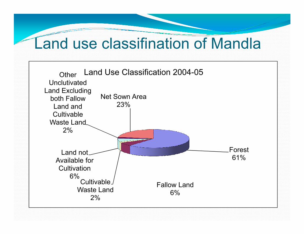
Land use classifination of Mandla
Other Unclutivated
Land Excluding both Fallow Land and Cultivable
Net Sown Area23%
Land Use Classification 2004-05
Forest61%
Fallow Land6%
Cultivable Waste Land
2%
Land not Available for Cultivation
6%
Cultivable Waste Land
2%

Rainfall
� Rainfall ranges between 1200 to 1600 mm annually
Month wise Rainfall Data (mm)
Jan Feb Mar Apr May June
5.2 17.8 23.5 4.1 13.4 149.4
July Aug Sep Oct Nov Dec
61.1 412.2 144.1 57.1 1.2 0

Constraints and Opportunity
Particulars Constraint Opportunity
Production Low and low rate of adoption of
improved practices
Good soil, improved crop varieties
Rainfall Short duration, high intensity Overall quantum is good, availability of
moisture for longer duration, area available
for water harvesting structure
Soil depth High rate of top soil erosion Traditional conservation practice and good
soil depth in planes
Soil type Good quality soil, traditional conservation Soil type Good quality soil, traditional conservation
practices
Market support No or poor market support, market is
not poor sensitive
Linkages can be developed if organic
farming is promoted
Information No proper information dissemination
mechanism according to farmer
demand, Low literacy rate.
Dependency only on traditional
knowledge
Various government porgramme which
provides information in different
mode/mediums.
Cash flow Irregular, high debt, limited cash crops,
no banking services
SHG movement, NREGS, Government
schemes
Infrastructure Remote location BRGF, PMGSY, NREGS

Water Harvesting and Agricultural Development
� NREGS provides opportunity to create infrastructure which can be used for livelihood generation.
� It provides wages to labour and assets is output of labour.
Land development, Field bunding, open well, farm � Land development, Field bunding, open well, farm pond, gully plugging, catchment treatment, stop dam etc can be done using planned approach
� These infrastructure will contribute in overall production which will lead to sustainable agriculture


Cross Section AnalysisSystem Hilly area is covered
with good forest in some
part and some parts it is
degrading
Upland Upland Mid up Land Medium land Low land
Soil texture Black cotton in some
area, loamy
Loamy and Murom with
some gravels in some
area
Loamy, murom with,
and clay
Loamy and clay
in some parts
Clay, black cotton
soil in majority of
area
Clay and black
cotton soil in
majority of area
Soil depth Mix of good, shallow
and average
shallow Shallow to moderate Moderate Good soil depth Good soil depth
soil moisture
duration
Good up to October Good up to October Good up to
November
Good up to Mid
Feb
Good throughout
year
Good throughout
year
Fertility status Moderate Not very good Not very good moderate Good to high high
Cropping system Forest crops, grasses,
some degrades patches
Grasses, shrubs, fallow
land, nizer, miner millets,
upland paddy single crop
fallow land system is
being practices
Double crop system:
mostely rice based
system: rice/maize,
lentil, gram, pea:
mostly traditional
Double crop
system: rice
based farming
system mostly
Rice,
Mono crop
Rice,on bund pigeon
pea
Mono crop rice
bund pigeon pea
being practices mostly traditional
varieties
Rice,
lentil/wheat
Constraints/
Problem
Soil erosion in degraded
area,
Shallow soil depth with
poor soil quality
Soil erosion
Poor quality soil
Shallow soil depth
High rate of moisture loss
Poor management of
nutrients received from
forest
Soil erosion
High rate of
moisture loss
Limited availability of
nutrients in soil
Low productivity
Low production
Small plot size
Use of
traditional
practices for
production
Low production
Small plot size
Use of traditional
practices for
production
Water logging
Low production
Small plot size
Use of traditional
practices for
production
Water logging
Poor drainage
Opportunities Rich biomass from
forest
Availability of nutrients
from forest if managed
properly
Support in maintaining
eco system
Receives good quantity of
nutrient and bio mass
from upper ridges
If proper conservation
practices are adopted
than production can be
enhanced
Fodder for livestock
Bio mass
Labour
Traditional
conservation
practices
Fodder for livestock
Bio mass
Labour
Traditional
conservation
practices
Fodder for
livestock
Bio mass
Labour
Traditional
conservation
practices
Fodder for livestock
Moisture availability
Bio mass
Labour
Traditional
conservation
practices
Fodder for livestock
Good quality soil
and land
Round the year
availability of
moisture and water

Kapildhara
Objective
To collect sub surface flow of water in form of Dug wells, farm pond, small pond and the like.
Why this sub scheme?
It is seen that due to the presence of basalt layer, the It is seen that due to the presence of basalt layer, the ground water recharge capacity of the region is very low.
Farm Pond and Open Wells provides an opportunity to extract sub surface flow of the region without exploiting its ground water reserve.
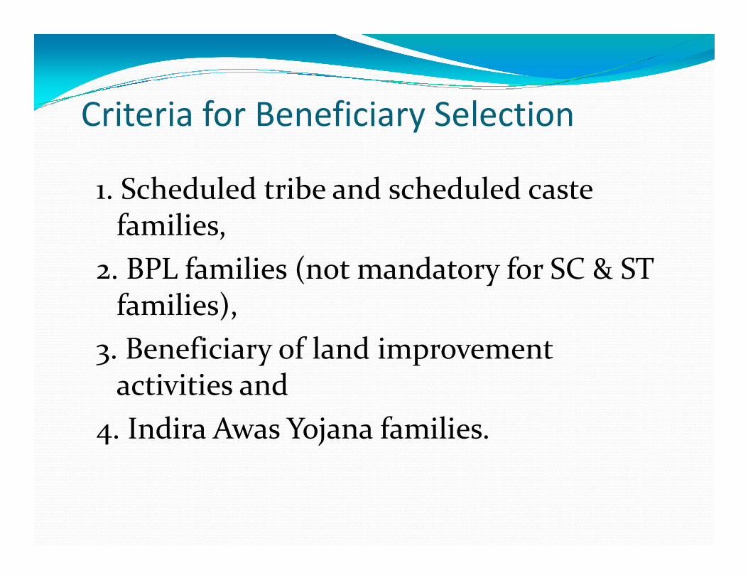
Criteria for Beneficiary Selection
1. Scheduled tribe and scheduled caste families,
2. BPL families (not mandatory for SC & ST families), families),
3. Beneficiary of land improvement activities and
4. Indira Awas Yojana families.

Steps for implementation of Kapildhara
�Selection of beneficiary
�Selection, recommendation and approval of workapproval of work
�Preparation of estimates and approval
�Construction of structure

Design
and cost
estimates
Type of land strata Diameter in
Meter
Depth in
Meter
Lining in
Meter
Basalt 5.00 12.00 3.00
Rocks other than Basalt 4.00 12.00 3.00
Brick linking in Alluvium 2.5 20.00 20.00
RCC Lining in Alluvium
(Ring Well)
2.00 10.00 10.00
Well recharge pit for open well: 3X3X3 meter; cost estimate
Rs. 3500/ RP
Sand
Sand
Bolder
Pipe
Recharge pit

Farm Pond: For One Hectare Cross section of Farm Land
Details Length Width Depth Quantity
Excavation work 15X15+6X6
3.00 meter
391.5 M3
2
Hard soil (50%) 391.5X1/2 196.75 M3
Hard Murom (50%) 391.5X1/2 196.75 M3
Inlet - outlet
9 M
12M
18 M
21 M
21 M
12 M
3 M


Assets created through NREGS
Sub
scheme
Particular/ sub
scheme
No. of
villages
No. of
families
covered
Quantity Area Expenditure
In Rs.
Kapildhara No. of Farm
ponds59 64 64 32 ha
irrigation at
least once
2070129
least once
No. of Wells 23 23 23 Ha
Bhumi
Shilp
Area coverage
under bunding
256
91.48 ha 790109
CPW
constructed
7988 running
meters.966566
Gulley plugging 660 no.s and
1387.10rm.672746.5
Nandan
FalodyanAonla, Guava, Lemon,
Custurd apple, Jack
Fruit
209 HH 12270 78 Ha. 24,000,00

Results� With average water available for 2 meter in each well of 15 meter
diameter additional potential for irrigation created is 39.28 m3. Thus total additional irrigation potential created 903.57 m3
� By constructing a total 64 farm ponds additional water availability estimated is roughly 25056 M3.
� This will help in conserving more water within the village boundary and increase duration of sub soil moisture which will definitely contribute in production of crops. contribute in production of crops.
� With the help of water lifting devices cropping pattern is changing
� Farmers, who got support through these interventions, are now taking two crops with assured irrigation.
� The initiative taken under NREGS produced varied degree of outcomes mainly increased areas for water conservation and harvesting which can be used for agriculture production.

Outcome
� Soil moisture increased.
� Increased irrigated area.
� Farmers who have got farm pond or well are taking at least two assured crops in a year.
� Farmers risk bearing ability increased. Shift in � Farmers risk bearing ability increased. Shift in vegetable cultivation is one strong indicator
� It helps in taking new crops i.e. mulberry based sericulture, Vegetable farming etc.
� It also generates more wage employment in the district.

Lessons learnt
� The most important learning is how to convince community that is living in high rainfall area to go for conservation measures.
� There is a need to immediately work on enhancing awareness on conservation of surface water even if there is good or bad rainfall.
� Regarding planning aspect it should be based on resource availability and need of community and linkages or importance with livelihoods interventions then only assured community participation and management is possible.then only assured community participation and management is possible.
� All the activities related to conservation should be done on cluster basis using the analysis done by various technical agencies like ground water board, irrigation department, etc. This will support in preparing logical plans as per requirement of the area.
� All resource development should be linked with production activities which are directly related to livelihoods of the family.
� After construction and repair of these resources additional support to use them for productive purpose is must.
� Productive link analysis is must. After this analysis we must discuss this with beneficiaries to make them understand importance of input made on it.

Strategies for upscaling
� Prepare shelf of project for construction of farm ponds, open well, well recharging structures. Make presentation in the Gram Sabha for approval. After that get approval from three tier PRI system. Ensure fund release as per demand and time plan from Zila Panchayat.
� Capacity building of stakeholders on productive aspect � Capacity building of stakeholders on productive aspect related to this activity.
� Orientation of field functionaries
� Ensuring more funds are available for this activity at village level
� Sharing of learning at various forums for wider circulation.
� Documentation of success stories.

ThanksThanks