safer seas 2020 - maritimecyprus.com
TRANSCRIPT

NTS
B/S
PC- 2
1-01
SAFER SEAS DigestLessons Learned from Marine Accident Investigations
2020

MissionThe National Transportation Safety Board (NTSB) is an independent
Federal agency charged by Congress with investigating every civil aviation
accident in the United States and significant accidents in other modes of
transportation — marine, railroad, highway, and pipeline.
The NTSB determines the probable cause of the accidents and issues
safety recommendations aimed at preventing future accidents. In addition,
the NTSB carries out special studies concerning transportation safety and
coordinates the resources of the Federal Government and other organizations
to provide assistance to victims and their family members impacted by
major transportation disasters.
AVIATION HIGHWAY MARINE RAILROAD PIPELINE

A Message from the Chair
The 42 marine accidents included in Safer Seas Digest 2020 involved contact with fixed objects, sinkings, collisions, fires, explosions, floodings,
groundings, and capsizings. The vessels involved ranged from the small dive boat Conception, on which the loss of life nevertheless rivaled the worst maritime disasters of recent years, to a US Navy destroyer—the second such investigation completed in the last 2 years.
The accidents recounted here resulted in numerous injuries, significant property damage, and worst of all, the loss of crewmembers and passengers. In the fire aboard the Conception alone, 34 lost their lives. This year also saw the conclusion of the investigation of the collision that took 11 lives aboard the Fitzgerald.
These tragedies remind us that whether we are serving in the nation’s armed forces, scuba diving for recreation, fishing on a trawler, or keeping commodities flowing on tankers and freighters, we are all reliant on the safety measures that must be in place before we step aboard.
The NTSB investigates the voyages that go wrong to ensure that future voyages go right, and, drawing from the findings of these accident investigations, we recommend safety improvements to prevent recurrences. It is up to the marine industry and its regulators in the US Coast Guard to act on these recommendations and lessons learned to improve marine safety.
The safety issues examined in the 2020 edition of Safer Seas include:• Navigating through bridges• Standard operating procedures• Smoke detection• Voyage planning and dynamic risk assessment• Effective communication• Operating in high-water/high-current conditions• Lithium-ion battery hazards• Crew training• Vessel speed• Storage of flammable or combustible materials• Closing ventilation inlets during a fire• Effective hull inspection and maintenance• Inspection of control linkages• Fatigue
This digest is organized around NTSB investigations that closed in 2020. They represent a snapshot within the ongoing cycle of accidents, NTSB investigations, and safety improvements that ensures that lessons learned result in changes.
The Coast Guard is integral to the NTSB’s marine investigations. Our relationship is an outstanding example of government collaboration focused on saving lives and improving safety. Every accident presented in this report was supported in a variety of ways by the men and women of the Coast Guard, and my sincerest thanks go out to every one of them who assisted us this year. The Coast Guard units that worked with the NTSB in these accidents are listed on page 104.
With every investigation we learn new safety lessons to prevent or mitigate future losses, but only when marine stakeholders at all levels of the industry apply these lessons. I hope that Safer Seas Digest 2020 provides the marine industry with essential information to better understand the safety issues confronting it.
Sincerely,
Jennifer Homendy NTSB Chair

NTSB SAFER SEAS DIGEST 2020Lessons Learned from Marine Accident Investigations2
SAFER SEAS DigestAbbreviations
AB able seamanAIS automatic identification systemARPA automatic radar plotting aidBNWAS bridge navigational watch alarm systemBRM bridge resource managementBSEE Bureau of Safety and Environmental Enforcement CCTV closed-circuit televisioncfs cubic feet per secondCIC combat information centerCO commanding officerCOLREGS Convention on the International Regulations for Preventing Collisions at SeaCPA closest point of approachECDIS Electronic Chart Display and Information SystemECS electronic charting systemEOT engine order telegraphEPIRB emergency position indicating radio beaconGPS global positioning systemhp horsepowerJOOD junior officer of the deckmph miles per hourNOAA National Oceanic and Atmospheric AdministrationOOD officer of the deckOSRV oil spill response vesselPIC person in chargepsi pounds per square inchPV valve pressure/vacuum valverpm revolutions per minuteSMS safety management systemSOG speed over groundSOP standard operating procedureTSMS towing safety management systemVDR voyage data recorderVTS Vessel Traffic ServiceXO executive officer
On the cover: The Conception after the fire (see page 68).
Back cover: Damage to the workboat Gibson (see page 54).

NTSB SAFER SEAS DIGEST 2020Lessons Learned from Marine Accident Investigations 3
Table of ContentsA Message from the Chair . . . . . . . . . . . . . . . . . . . . . . . . . . . . . . . . . . . . 1
Capsizing/Sinking Workboat MSRC 8-1 4 Fishing Vessel Misty Blue 6
Collision Fishing Vessels American Eagle and Koorale 8 Containerships Marcliff and APL Guam 10 Bulk Carrier Century Queen and Towing Vessel Kaytlin Marie 12 Towing Vessels Dixie Vandal and Trinity 14 US Navy Destroyer Fitzgerald and Containership ACX Crystal 16 Heavy Lift Vessel Hawk, Unnamed Barge, and Destroyer Delbert D Black 20 Tows Pushed by Towing Vessels Miss Dixie and D.& R. Boney 22 Towing Vessel St. Rita and Tow and Moored Barges 24
Contact Tanker American Liberty – Multiple Vessels 26 Barge Breakaway – Webbers Falls Dam 28 Towing Vessel Bettye M. Jenkins 30 Towing Vessel Chad Pregracke 32 Tanker Dank Silver 34 Towing Vessel DeJeanne Maria 36 Towing Vessel Dewey R 38 Towing Vessel Edna T. Gattle 40 Tugboat G.M. McAllister 42 Crane Barge U1510, Pushed by Towing Vessel Goose Creek 44 Crane Barge Mr Ervin, Pushed by Towing Vessel Kristin Alexis 46 Towing Vessel Leviticus 50 Towing Vessel Lindberg Crosby 52 Towing Vessel Mary Lucy Lane – Workboat Gibson 54 Cruise Ship Norwegian Epic 56 Towing Vessel Rivers Wilson 58 Towing Vessel William C 60 Barge YD 71 62
Fire/Explosion Barge Alaganik 64 Fishing Vessel Ariel 66 Small Passenger Vessel Conception 68 Multiple Recreational Vessels – Jackson County Park Marina 74 Barge IB1940 76 Bulk Carrier St. Clair 78
Flooding Towing Vessels Chattie Sue Smith, Mary Fern, Mary-R, and Unnamed
Deck Barge 80 Towing Vessels Mangilao and Chamorro 82 Fishing Vessel Pacific1 84 Towing Vessel Tom Bussler 86
Grounding/Stranding Fishing Vessel Freyja 88 Recreational Vessel Silver Lining 90
Hull/Machinery/Equipment Damage Cargo Vessel Fairchem Filly 92
Other Liftboat Kristin Faye 94
Lessons Learned . . . . . . . . . . . . . . . . . . . . . . . . . . . . . . . . . . . . . . . . . . . 96Vessel Particulars . . . . . . . . . . . . . . . . . . . . . . . . . . . . . . . . . . . . . . . . . . 100Table and Map of Accident Locations . . . . . . . . . . . . . . . . . . . . . . . . . 102Acknowledgment . . . . . . . . . . . . . . . . . . . . . . . . . . . . . . . . . . . . . . . . . 104Who has the Lead: USCG or NTSB? . . . . . . . . . . . . . . . . . . . . . . . . . . . 105Table of Figures . . . . . . . . . . . . . . . . . . . . . . . . . . . . . . . . . . . . . . . . . . . 106NTSB Office of Marine Safety . . . . . . . . . . . . . . . . . . . . . . . . . . . . . . . . 108
Vessel Group Key CARGO FISHING
GOVERNMENT OFFSHORE SUPPLY
PASSENGER RECREATIONAL
TANKER TOWING/BARGE
OTHER

NTSB SAFER SEAS DIGEST 2020Lessons Learned from Marine Accident Investigations4
Caps
izin
g/Si
nkin
g VESSEL GROUP
OTHER
Capsizing and Sinking of Workboat MSRC 8-1Boothville Anchorage, Lower Mississippi River, mile 18, near Boothville, Louisiana
ACCIDENT DATEJanuary 16, 2019ACCIDENT IDDCA19PM014
REPORT NUMBERMAB 20/27ISSUEDJuly 2, 2020
Figure 1. MSRC 8-1 after salvage postaccident.
Figure 2. Louisiana Responder preaccident. Source: MSRC.
Figure 3. CG 45707 tows the overturned MSRC 8-1. Source: BSEE.
About 1038 local time on January 16, 2019, the workboat MSRC 8-1, which operated from the OSRV Louisiana Responder, capsized
during an oil spill boom deployment exercise in the Lower Mississippi River near Boothville, Louisiana (mile 18), trapping both of its crew inside. While the OSRV’s crew and the Coast Guard worked to rescue the trapped MSRC 8-1 crew, the boat sank. One crewmember died in the sinking; the other crewmember was not found and is presumed dead. The MSRC 8-1 was declared a constructive total loss with damage estimated at $250,000. A sheen of oil was sighted on the water after the vessel sank; no other pollution was reported.The 210-foot-long Louisiana Responder was to perform the monthly exercise at the Boothville Anchorage, where most of the vessel’s exercises took place. Seven MSRC land-based responders, led by a senior master responder, and a BSEE observer joined the OSRV and conducted a pre-exercise safety briefing with the crew. They discussed assigned tasks, the expected river current conditions (“3.5 plus knots, at least”), and that they all had stop work authority should a safety concern arise.
Figure 4. J-configuration deployment of oil spill boom by MSRC OSRV (right) and 32-foot workboat (left) during Deepwater Horizon oil spill response in May 2010. Source: Munson Manufacturing, Inc.
To deploy the 660-foot inflatable oil spill boom in a J-configuration, one end of the boom was attached to the stern of the OSRV, while the MSRC 8-1 towed the other end abreast of the OSRV. The master responder operated the workboat, and the newest member of the team served as the deckhand. While company management considered the operator and deckhand of the MSRC 8-1

NTSB SAFER SEAS DIGEST 2020Lessons Learned from Marine Accident Investigations 5
trained and proficient, there was little detail as to what training was conducted and what performance criteria were used to evaluate personnel to make that determination.About 0910, the OSRV was anchored, and at 0935, the MSRC 8-1 took the 155-foot towline for the boom. Observed by the operator, the deckhand secured the towline to a bitt near the boat’s port bow using a few turns of the line, then ran the remainder back to the H-bitt just aft of amidships using a series of half eights to secure an estimated 55 feet of the towline on top of the bitt. This allowed for quick release of a slack line by sliding it off the top of the bitt.The operator then backed away from the OSRV, allowing the MSRC 8-1 to keep tension on the boom as it was paid out and inflated on deck. The boom deployed as expected, and a boom pennant line was secured to the OSRV’s stern. The MSRC 8-1 crew began the J-configuration by moving directly forward, thus slackening the boom towline. The deckhand then untied the towline from the bitt on the bow and as she walked the line down the port side, the MSRC 8-1 turned “a few degrees to port,” and, seconds later, came to starboard quickly, putting the boat perpendicular to the current. The towline “snapped at” the deckhand, and she dropped the line and ran into the cabin.The towline was tending directly off the boat’s port side from the top of the H-bitt with tension on it. The static force that the towline exerted on the H-bitt, combined with the force of the current broadside to the MSRC 8-1’s underwater hull, attached framework, and large rudders, created a heeling moment, which rolled the boat to port quickly (tripped it), overcoming its inherent stability and capsizing it. Although the towline was rigged for ease of release, the speed of the capsizing and the line tension prevented this.
Figure 5. H-bitt on a workboat of the same design as MSRC 8-1, with towline secured to the bitt.
Figure 6. The forces of the current and boom towline acting to capsize the MSRC 8-1.
Figure 7. Waterwash from the CG 45707 and the combined current flow over the stern of the MSRC 8-1. Source: Munson Manufacturing, Inc.
The master sounded the man overboard alarm, then informed the Coast Guard of the capsizing. The OSRV’s rescue boat was launched, and over the next 20 minutes, more responders arrived on scene, including a pilot boat, a Coast Guard helicopter with a rescue swimmer, and Coast Guard response boat CG 45707. Despite several attempts, including the swimmer going beneath the boat in 43°F water, responders were unable to rescue the trapped crewmembers.
The crew of the OSRV retrieved the boom to pull the MSRC 8-1 to the OSRV’s stern. The CG 45707 attempted to assist, but the strength, direction and effects of the river current, combined with the boat’s waterwash, caused very dynamic conditions that made it difficult.
All the boom was retrieved, but complications prevented responders from reeling in the boom towline. Also, as the MSRC 8-1 was pulled closer to the OSRV’s stern, it was affected by turbulent eddies and started to fishtail and roll. Following a “pop” sound, the boat moved “sideways,” and the retrieving operation was stopped. It was later determined the boat’s change in orientation likely caused the boom towline to fall off the H-bitt. The boat then quickly sank by its stern about 1122. The investigation found that the arrangement of the towline and H-bitt on the MSRC 8-1 made the transitioning of the boom from directly astern of the OSRV into the J-configuration inherently dangerous in the prevailing current. The company conducted a postaccident analysis and modified each of its similar boats with a towline guide on the stern and buoyancy collar at the waterline to reduce the capsizing hazard, conducted risk assessments, and enhanced procedures and training in its SMS.
The probable cause of the capsizing of the workboat MSRC 8-1 was the boat becoming perpendicular to a strong river current, for an undetermined reason, while tethered to the oil spill response vessel Louisiana Responder. Contributing to the accident was the unforeseen risk associated with conducting the exercise in a strong current, which also contributed to the severity of the outcome by hampering rescue efforts.

NTSB SAFER SEAS DIGEST 2020Lessons Learned from Marine Accident Investigations6
Caps
izin
g/Si
nkin
g VESSEL GROUP
FISHING
Capsizing and Sinking of Fishing Vessel Misty BlueAtlantic Ocean, 9 miles southeast of Nantucket, Massachusetts
ACCIDENT DATEDecember 4, 2017ACCIDENT IDDCA18FM005
REPORT NUMBERMAB 19/01ISSUEDFebruary 6, 2019
Figure 8. Misty Blue in June 2017 in Fairhaven, Massachusetts. Source: Enoch MacDonough.
On December 4, 2017, at 1806 local time, the uninspected fishing vessel Misty Blue was harvesting clams 9 miles southeast of Nantucket,
Massachusetts, when the port clam tank began flooding and the vessel subsequently capsized and sank. Two crewmembers were trapped on board and perished when the vessel sank; the other two crewmembers managed to escape and were rescued by a nearby fishing vessel. Oil sheens were observed.At 2300 on December 2, the Misty Blue departed Fairhaven, Massachusetts, for clam-fishing grounds
southeast of Nantucket Island, with a captain, mate, and two deckhands. The following morning about 1000, the vessel arrived in the Old South Shoal area and deployed the clam pump hose, the clam dredge, and its tow line. They also used the stabilizers to dampen the vessel’s rolling motion. The captain stated that from the first dredge tow to the accident about 30 hours later, the only problem noted was that the fuel filter for the engine driving the clam pump kept getting airlocked, which the crew addressed about every 35 minutes.

NTSB SAFER SEAS DIGEST 2020Lessons Learned from Marine Accident Investigations 7
The vessel had two clam tanks, port and starboard, able to hold 8 loaded cages each (16 total). On December 4 at 1752, the crew hauled the dredge and dumped the catch into the shaker/sorter on the aft main deck to start loading a seventh cage into the starboard tank, for a total of 14 cages aboard. The captain turned the vessel to starboard and noticed a slight port list. He instructed the deckhands to remove the port tank’s plywood hatch covers, and they saw it was unexpectedly flooded. The captain unsuccessfully tried to correct the list by turning to port, increasing throttle, and adjusting the port stabilizer and outrigger. The mate took the helm, and both deckhands began searching for the point of water ingress while the captain went below deck to check all spaces, but he did not find any other flooding.By 1759, the vessel’s portside scuppers were submerged, and waves were breaking over the port gunwale. The captain instructed the crew to prepare for abandoning the vessel, and the mate radioed the nearby fishing vessel Enterprise for help. The captain mustered the crew in the galley to don survival suits, but water began entering the spaces through a door from the aft deck. The junior deckhand donned his survival suit and exited out of the wheelhouse’s starboard door. The captain saw the port gunwale completely under water and shouted to the mate and senior deckhand, “Get out! Get out!” before he also exited through the starboard door with his suit partially donned. Neither the mate nor the senior deckhand escaped before the vessel rolled to port, capsized, and immediately sank at 1806. The captain and junior deckhand managed to enter the vessel’s liferaft after it automatically deployedThe Coast Guard received a signal from the vessel’s floatfree EPIRB and dispatched multiple search-and-rescue assets to the area. The Enterprise retrieved the captain and junior deckhand. The Coast Guard suspended search-and-rescue operations at 2000 on December 5, the same date the Misty Blue was located on the seafloor. Due to adverse conditions, divers did not return until December 18, when they recovered the bodies of the mate and the senior deckhand from inside the galley.
The vessel underwent several modifications during its lifetime. Its last stability analysis in 2009 took place several years before the current owner modified the vessel (without a new stability analysis). However, a post-sinking stability analysis of the vessel found that the Misty Blue, as configured and loaded at the time of the sinking, would have “likely” met the intact stability criteria for a vessel of similar size and service. Given that the vessel likely had a stability margin, the reported flooding of the port clam tanks would have been the initiating event that sank the vessel. The analysis also “found that even small amounts of water on deck would significantly reduce stability of the vessel” and that the Misty Blue’s freeing port area was “relatively small.” The investigation
determined that off-center flooding, water trapped on deck, and dynamic forces from wind and seas led to the sinking. Underwater examination of the wreckage revealed the exterior of the vessel was intact with no breaches; the deck door to the galley was found closed; the watertight doors between the lazarette and shaft alley and from shaft alley to the engine room were found open, as was the non-watertight door from the engine room to tool room. Additionally, two watertight bulkhead cable penetrations below deck were not properly sealed or made watertight. The open doors and, to a lesser degree, non-watertight cable penetrations, would have allowed progressive flooding between spaces.
The probable cause of the capsizing and sinking of fishing vessel Misty Blue was flooding of the port clam tank from an undetermined point of ingress, which led to a decreased freeboard and a list allowing boarding seas to be trapped on deck, thereby decreasing the vessel’s stability. Contributing to the sinking was the relatively small freeing port area of the vessel, which likely increased water accumulation on deck.
Figure 9. Plan view of Misty Blue’s tank layout and freeing port locations. The clam tanks are highlighted in yellow. Source: Coast Guard; annotated by NTSB.

NTSB SAFER SEAS DIGEST 2020Lessons Learned from Marine Accident Investigations8
Collis
ion VESSEL GROUP
FISHING
Collision between Fishing Vessels American Eagle and KooralePacific Ocean, approximately 1,475 nautical miles northeast of American Samoa
ACCIDENT DATEJune 17, 2019ACCIDENT IDDCA19FM039
REPORT NUMBERMAB 20/22ISSUEDMay 22, 2020
Figure 10. Below: Still image captured from the bow CCTV camera aboard the American Eagle.
Figure 11. Damage sustained to both vessels. Bow of American Eagle (left) and Koorale (right). Source: American Eagle Fishing, LLC.
On June 17, 2019, about 1704 local time, the commercial fishing vessels American Eagle and Koorale were fishing in the eastern Pacific Ocean,
1,475 miles northeast of American Samoa. While pursuing the same school of tuna, the two vessels collided. Both vessels sustained damages but were able to return to port. No pollution or injuries to the 33 crewmembers aboard the American Eagle or the 19 aboard the Koorale were reported. Damage to the vessels was estimated at $8.3 million.
The Koorale departed Pago Pago, American Samoa, on May 31, and the American Eagle departed Pago Pago on June 1. Both vessels headed to the high seas fishing grounds near the island of Kiribati, just north of the equator. Both vessels were rigged for tuna fishing and were US-flagged, taking advantage of Coast Guard manning
exemptions that allowed for licensed positions, other than the master (captain), to be temporarily filled by foreign nationals holding current credentials from other countries. The senior officers on both the American Eagle and Koorale consisted of a US-licensed captain, referred to on board as the “navigator,” and a foreign-licensed fishmaster. After the accident, the captains and fishmasters reported to investigators that the fishmasters directed the vessel when under way to fishing locations and while fishing. Many of the fishing vessels in the area, including the American Eagle and Koorale, cooperated in a “code group,” exchanging fishing information multiple times a day and following a set of unwritten rules, including that whichever vessel was first to a school of fish and in position to set their nets had first opportunity to harvest.Two days before the accident, both the Koorale and American Eagle spotted and pursued the same school of fish. The two fishmasters communicated by radio to determine who had rights to the school of fish, but the conversation turned into an argument: the American Eagle fishmaster said that the Koorale fishmaster “just start[ed] yelling,” while the Koorale fishmaster said his counterpart “insult[ed] me.”

NTSB SAFER SEAS DIGEST 2020Lessons Learned from Marine Accident Investigations 9
On the morning of the accident, both vessels set their gear on different schools of fish but caught nothing. Throughout the morning and early afternoon, the Koorale and American Eagle searched for schools of tuna. About 1630, both the Koorale and American Eagle spotters located the same school of tuna, and both vessels began their pursuit. As the two vessels raced to the same school and toward each other, no attempts were made to communicate. Both fishmasters cited the reason for this was their intense interaction with insults and yelling 2 days prior. Neither captain stepped in to communicate because of the unofficial hierarchy on board the vessel, where the fishmasters directed the vessel while fishing.
Figure 12. Estimated locations of the vessels and fish (not to scale) approximately 10 minutes prior to the collision.
Figure 13. Koorale after collision. Source: Coast Guard.
Although the Koorale fishmaster was aware of the American Eagle, he maintained his vessel’s course and speed, assuming the American Eagle was going to veer off. Similarly, the American Eagle fishmaster could see the Koorale coming east toward the school of tuna and thought “it was a race” to the school. Both vessels’ fishmasters believed their vessels were in position to set their nets and that, according to their “code group” rules, the other vessel should have given way. Regardless of the “code group” rules, the international navigation rules should have guided their interaction. The two vessels were in a crossing situation, and the American Eagle, having the Koorale on its starboard side, should have given way (Rule 15). Neither vessel took action until the last moments when the collision could not be avoided. Had the captains and fishmasters followed the international collision regulations or communicated to make arrangements, a collision could have been avoided.
Figure 14. American Eagle approaching berth in Pago Pago, American Samoa, after collision. Source: American Eagle Fishing, LLC.
About 1704, the American Eagle and Koorale collided, with the American Eagle’s starboard bow making contact with the port side of the Koorale. The American Eagle’s bow crushed down the port side of the Koorale’s wheelhouse. The vessels came together for several seconds and then separated. Neither vessel was taking on water, and both eventually were able to return to port unassisted and under their own power.
The probable cause of the collision between the fishing vessels American Eagle and Koorale was both vessels’ captains and fishmasters not following international collision regulations or communicating to make arrangements while pursuing the same school of fish.

NTSB SAFER SEAS DIGEST 2020Lessons Learned from Marine Accident Investigations10
Collis
ion VESSEL GROUP
CARGO
Collision between Containerships Marcliff and APL GuamYL-4 Anchorage, Port of Yokohama, Tokyo Bay, Japan
ACCIDENT DATEMarch 21, 2019ACCIDENT IDDCA19FM028
REPORT NUMBERMAB 20/19ISSUEDApril 29, 2020
Figure 15. Damage to APL Guam. Source: Coast Guard.
Figure 16. Below: Damage to Marcliff bow, starboard side, and container. Source: Coast Guard.
At 2327 local time on March 21, 2019, the containership Marcliff was outbound from the Port of Yokohama, Japan, when it collided with
the containership APL Guam, which was inbound to an anchorage at the port. After the initial collision, the Marcliff then collided with the containership Hansa Steinburg, which was anchored nearby. No pollution or injuries were reported. Damages to the three vessels were estimated at $1,178,200.About 2300 on March 21, a pilot was at the conn of the APL Guam. As it approached Yokohama anchorage YL-4, he reduced speed to half ahead. About the same time, the Marcliff got under way from a pier at the port and proceeded outbound through the Yokohama Passage. The master had the conn of the Marcliff while the third mate operated the EOT and a helmsman took the wheel.The APL Guam pilot intended to bring the vessel to the assigned anchoring position after passing between two anchored vessels, the tanker Shinsei Maru to port and the Hansa Steinburg to starboard. The distance between the anchored vessels was about 0.45 nautical miles. As the APL Guam continued toward its designated anchorage, its speed was slowly decreasing. At 2318, the pilot ordered the engine to stop, and the vessel further slowed to 6 knots before the pilot ordered dead slow ahead again. At 2322, as the Marcliff approached the end of the Yokohama Passage, the master ordered a starboard turn to maneuver his vessel through the YL-4 anchorage. This course would also bring the Marcliff between the Shinsei Maru and the Hansa Steinburg, opposite the inbound APL Guam. The master stated that he intended to pass the APL Guam starboard to starboard. The APL Guam master told investigators that he had not expected the Marcliff to turn to the south-southeast (toward his vessel) but expected it to continue along the axis of the Yokohama Passage until it reached the main shipping channel. However, the master and the pilot saw the Marcliff make its turn and, at 2324, the pilot requested “one long blast” on APL Guam’s whistle. According to the APL Guam third mate, the prolonged blast was intended “to catch the attention of the Marcliff.”

NTSB SAFER SEAS DIGEST 2020Lessons Learned from Marine Accident Investigations 11
The pilot then ordered the rudder to hard starboard and the engine to slow ahead. Because the vessels were in a crossing situation and the APL Guam was on the starboard side of the Marcliff, by international convention, the Marcliff was required to keep out of the way of the APL Guam and avoid crossing ahead of it. When it became apparent that the Marcliff was not taking appropriate action to avoid collision, the APL Guam crew sounded multiple short blasts of the ship’s whistle. The master then determined that a collision was imminent, took the conn from the pilot, and ordered the engine to stop and then to crash astern. These orders likely lessened the severity of the accident by slowing the speed at which the two vessels impacted. About 1 minute before the collision, the Marcliff master ordered a 10-degree turn to port. The Marcliff master should have altered course to starboard to avoid crossing ahead of the APL Guam. A turn to starboard would have been predictable by the APL Guam pilot and bridge team and resulted in a port-to-port meeting between the vessels. Thus, the master’s turn to port (and his intention to pass starboard to starboard) would have been unexpected by the pilot and bridge team on the APL Guam. The Marcliff master did not appear to recognize the dangerous situation that was developing until 2325:51. The Marcliff master told investigators that, about 2326, he knew that a collision was unavoidable and ordered the vessel “steady” to lessen the impact. At 2326:37, the APL Guam’s bow struck the starboard-side bow of the Marcliff. The collision altered the Marcliff’s course to port, and its forward momentum carried it toward the Hansa Steinburg. At 2327, the Marcliff’s bow struck the starboard bow of the anchored Hansa Steinburg. Following the collisions, the Marcliff and APL Guam were maneuvered to safety while the APL Guam pilot reported the collision to Tokyo Bay vessel traffic service.
Figure 17. Right: Accident timeline. Vessels drawn approximately to scale; positions compiled from AIS and VDR data.
Both vessels were equipped with AIS, and therefore each crew had access to information about the other ship, including its name, course, and speed. However, neither ship contacted the other ship via VHF radio to attempt to resolve the developing situation. Communications may have prevented this accident either through early coordination of passing arrangements or by alerting the other vessel to the emergency.
The probable cause of the collision between the containerships Marcliff and APL Guam was the Marcliff master’s attempt to pass between the APL Guam and the anchored Hansa Steinburg with insufficient safe maneuvering room. Contributing to the accident was a lack of communication between the Marcliff bridge team and the APL Guam pilot and bridge team to establish their maneuvering intentions.
Figure 18. Damage to Hansa Steinburg starboard-side bow. Source: Coast Guard.
Early Communication Between Bridge TeamsEarly communication can be an effective measure in averting close-quarters situations. The use of VHF radio can help to dispel assumptions and provide bridge teams with the information needed to better assess each vessel’s intentions.

NTSB SAFER SEAS DIGEST 2020Lessons Learned from Marine Accident Investigations12
Collis
ion VESSEL GROUP
CARGO • TOWING
Collision between Bulk Carrier Century Queen and Towing Vessel Kaytlin MarieLower Mississippi River, mile 126, near Hahnville, Louisiana
ACCIDENT DATEJune 8, 2019ACCIDENT IDDCA19FM038
REPORT NUMBERMAB 20/30ISSUEDJuly 28, 2020
Figure 19. Kaytlin Marie, preaccident. Source: Jeff L. Yates.
Figure 20. Below: Century Queen, preaccident. Source: C. Bustraan.
Figure 21. Both vessels shortly after the collision. Source: Coast Guard.
On June 8, 2019, about 1215 local time, the upbound bulk carrier Century Queen, with a crew of 21, and the downbound towing vessel Kaytlin Marie,
with 7 crewmembers on board, collided on the Lower Mississippi River at mile 126 near Hahnville, Louisiana, while transiting through a river bend. Three injuries were reported aboard the Kaytlin Marie, which spilled a reported 8,954 gallons of diesel fuel into the river. Damage to the Century Queen ($383,990) and the Kaytlin Marie ($991,208) amounted to $1,375,198.The Century Queen was heading upriver to load rice in Reserve, Louisiana (mile 138.6), with a New Orleans–Baton Rouge Steamship Pilots Association pilot on board. Prior to reaching Hahnville, the Century Queen met several vessels port to port, before the pilot eased over toward the right descending bank to avoid the higher current on the opposite bank. The river was rising, and the current was about 5.4 mph. The weather was clear with light winds.Meanwhile, the Kaytlin Marie was heading down river as a light boat (no barges) to Waggaman, Louisiana (mile 110), to pick up barges destined for Mobile, Alabama. On the way, the Kaytlin Marie followed about 0.5 miles behind the towboat Repentance, which was
pushing one barge, along the left descending bank, before approaching the bend at Hahnville.At 1208, the operator on the Repentance called the pilot on the Century Queen by radio. The two agreed on a starboard-to-starboard passing.About 1209, the Kaytlin Marie made a course change to starboard, heading across the river toward the right descending bank, directly for the point at Hahnville. At 1213, the Repentance and the Century Queen passed each other, starboard to starboard. At the same time, the Kaytlin Marie and the Century Queen were about 0.6 miles apart.After passing the Repentance, the Century Queen continued to make incremental course changes to port. The Kaytlin Marie continued altering its course to starboard toward the right descending bank, as the towboat and bulk carrier headed almost directly toward each other.As the downbound vessel, the Kaytlin Marie was obligated to propose the passing arrangement. However, first radio contact between the Century Queen and Kaytlin Marie did not occur until 1214:26, when the Century Queen’s pilot called regarding passing

NTSB SAFER SEAS DIGEST 2020Lessons Learned from Marine Accident Investigations 13
arrangements. The Kaytlin Marie pilot stated that he did not normally call to initiate passing arrangements while navigating in a light boat condition. Similarly, the pilot on the Century Queen told investigators it was not normal to call light boats, given their multiple numbers and various directions on the river. At this point, the vessels were 0.46 miles apart as the distance between them was closing. The towboat’s heading had not changed. Although he answered the radio call, the pilot of the Kaytlin Marie did not respond to the proposed passing agreement. He stated that it was the first time he realized that the Century Queen intended a starboard-to-starboard passing and that it was standard procedure for downbound vessels to have the right-of-way and for ships to round the bend at Hahnville in the middle of the river. Assumptions by both vessels as to the intent of the other created a dangerous situation. Early communication by either vessel would have ensured what should have been a safe starboard-to-starboard passing within a half-mile-wide section of the river. The Kaytlin Marie pilot increased his turn to starboard toward the right descending bank. The Century Queen increased port rudder to 20 degrees until 1214:58, when the pilot gave a “midship” command, followed immediately with “stop engines” (1215:01) and “hard starboard” (1215:04).
Figure 22. Kaytlin Marie embedded in the Century Queen’s bulbous bow. Source: Coast Guard.
At 1215:08, the Century Queen’s bulbous bow struck the Kaytlin Marie amidships at about a 90-degree angle, and the towboat was pushed sideways up-current. The bulker’s bow was torn open for about 6 feet, and the void space was filled with some of the diesel fuel released from the towboat’s punctured fuel tanks. The Kaytlin Marie’s pilot was pinned by furniture that had come loose, and refrigerators in the galley that broke free pinned two deckhands, one of whom suffered internal injuries; the other had a minor injury.
The probable cause of the collision between the bulk carrier Century Queen and the towing vessel Kaytlin Marie was the lack of early and effective communications to confirm a passing arrangement between the two vessels.
Establishing Passing Arrangements in Sufficient TimeWhen meeting or overtaking a vessel on the Western Rivers, especially within a bend where high-water conditions can increase the risk of collision, it is critical to establish early communications rather than make assumptions about the intentions of approaching vessels. Rules of the Road must supersede local practices or habits, such as light boats and deep draft vessels typically not contacting each other.
Figure 23. Tracklines of the vessels during the last 7 minutes prior to the collision. The Century Queen is represented in red, the Kaytlin Marie in green, and the Repentance in black. Background source: Google Maps.

NTSB SAFER SEAS DIGEST 2020Lessons Learned from Marine Accident Investigations14
Collis
ion VESSEL GROUP
TOWING
Collision of Dixie Vandal Tow with Moored Trinity and TowHouston Ship Channel, mile 44, Kinder Morgan Pasadena Liquids Terminal; Pasadena, Texas
ACCIDENT DATEMarch 15, 2019ACCIDENT IDDCA19FM026
REPORT NUMBERMAB 20/12ISSUEDMarch 17, 2020
Figure 24. Damaged shoreside cargo hose and deformed piping at the manifold at the Kinder Morgan facility.
Figure 25. Right: Damage to the Trinity’s starboard side from the impact of barge Kirby 29751.
Figs. 24 & 25 Source: Kinder Morgan Pasadena Liquids Terminal.
At 0408 local time on March 15, 2019, the towing vessel Dixie Vandal, pushing a partially loaded fuel barge upbound through the Houston Ship
Channel, struck the towing vessel Trinity and one of its barges, which were moored and preparing to discharge cargo at the Kinder Morgan Pasadena Liquids Terminal in Pasadena, Texas. The contact caused the Trinity and its tow to shift about 100 feet upriver, breaking the cargo hoses and mooring lines and damaging the facility. About a half-gallon of jet fuel discharged into the channel.
No injuries were reported by the crew of five aboard the Dixie Vandal nor by the Trinity’s crew of four. Damage to the facility and barges amounted to $630,230.About 0100, the Dixie Vandal and tank barge Kirby 29751 got under way toward the Port of Houston to unload the barge’s cargo of marine gas oil with a captain, a pilot, and three tankermen. The pilot, who was on watch, had begun his 12-hour shift the evening before at 1800, about 12 hours before the accident, and had been awake since 1600 that day.

NTSB SAFER SEAS DIGEST 2020Lessons Learned from Marine Accident Investigations 15
About 0400, the Dixie Vandal and tow were approaching Crown Bend, upcoming just north of the Kinder Morgan facility, intending to pass the facility on the tow’s port side. Docked at the facility was the Trinity and barges Kirby 29051 and EBL 2997.Playback from the Dixie Vandal’s ECS showed that about 0407:30, as the Dixie Vandal and tow was proceeding around the left-hand turn by the basin, it began turning off course to port and reached the maximum ECS display value of 30 degrees to port at 0407:47. At 0408:31, at a speed of about 6.5 mph, the forward port corner of the lead barge, Kirby 29751, contacted the starboard side of the Trinity and then struck the forward port corner of the barge Kirby 29051. The pilot did not recall making this sudden course change, nor did he recall hearing the BNWAS alarm on the bridge; after the accident, he told investigators that he believed he had dozed off. If the BNWAS motion sensors did not detect motion for 40 seconds, an audible alarm would sound in the wheelhouse, and about a minute later, if there
was still no motion detected, the general alarm would ring throughout the vessel. There was no evidence to suggest the system was deactivated or inoperable at the time of the incident. Therefore, it is likely that the sensors detected motion in the wheelhouse just before the pilot fell asleep or while he was drifting off to sleep within the time frame of the setpoints of the BNWAS system, because the BNWAS system did not sound in the wheelhouse nor did the general alarm sound throughout the vessel before the collision.Fatigue has been recognized as a leading cause of accidents in the transportation industry. There is evidence that fatigue can adversely impact operator performance. Cognitive function, alertness, and performance are all affected by a circadian process that is optimal on a “day-oriented” schedule. The pilot had been awake for about 12 hours at the time of the accident and had been on watch for about 10 of those hours. He reported that he did not feel fatigued that night. Company policy stated that if the pilot was feeling tired during his watch, he could have contacted the sleeping captain to assist or called the company to provide a relief, but he did not. Self-reported alertness is often deceptive. Individuals are often not able to judge their own levels of fatigue. Additionally, while the captain had evaluated the pilot for watch readiness and believed the pilot was “upbeat and well aware of what was going on,” the accident took place 10 hours following that subjective evaluation.
Figure 26. Left: Aerial view of the Kinder Morgan Pasadena Liquids Terminal with a towing vessel and two barges moored in a similar arrangement to the Trinity, Kirby 29051, and EBL 2997. Background source: Google Earth, annotated by NTSB.
Figure 27. Towing vessel Dixie Vandal under way in Houston after the accident.
Shift work adds more complexity to the circadian process, because individuals have a harder time acclimating when switching shifts when a crewmember’s entire schedule is flipped from day to night. The accident pilot had more than a week to adjust to the 1800–0600 night shift, but his work/rest schedule was moved in direct opposition to what was considered “normal” for him and his circadian process was likely affected, resulting in fatigue and thus reducing performance.
The probable cause of the collision of the Dixie Vandal’s tow with the moored Trinity and tow was the fatigued pilot falling asleep near the end of his 12-hour watch while maneuvering in the Houston Ship Channel, resulting in the loss of control of the vessel. Contributing to the pilot’s fatigue was the extended length of duty through the night and early morning hours and his use of an over-the-counter antihistamine.
Managing Crew Work/Rest HoursCompanies should monitor the watch schedules of their crews to ensure that they are properly rested and afforded proper work/rest schedules. Crewmembers should be encouraged to request assistance from other crewmembers if they feel fatigued.

NTSB SAFER SEAS DIGEST 2020Lessons Learned from Marine Accident Investigations16
Collis
ion VESSEL GROUP
GOVERNMENT • CARGO
Collision between US Navy Destroyer Fitzgerald and Philippine-Flag Containership ACX CrystalSagami Nada Bay off Izu Peninsula, Honshu Island, Japan
ACCIDENT DATEJune 17, 2019ACCIDENT IDDCA17PM018
REPORT NUMBERMAR 20/02ISSUEDAugust 3, 2020
Figure 28. US Navy Destroyer Fitzgerald. Source: US Navy.
Figure 29. Post-collision damage to the Fitzgerald’s starboard side. Source: US Navy.
About 0130 local time on June 17, 2017, the US Navy Destroyer Fitzgerald, with 315 persons on board, was heading in a southerly direction,
bound for the Philippines, and crossing the track of the ACX Crystal, a Philippine-flag containership operated by Sea Quest Ship Management, Inc., with 20 crewmembers on board eastnortheastbound for Tokyo Bay. As the distance between the two ships continuously decreased, neither vessel radioed the other. Seconds before the collision, the watch officers on both vessels attempted to maneuver the vessels to avoid impact, but the actions were too late, and the ships collided. Seven Fitzgerald crewmembers died in the accident, and three crewmembers suffered serious injuries. The destroyer sustained more than $300 million in damage. The ACX Crystal sustained damage to its bow; no injuries were reported.
On the morning of the accident, the Fitzgerald’s bridge watchstanding complement included six persons, including the OOD, who was directly responsible for the safe navigation and general operation of the ship. The Fitzgerald’s first- and second-in-command―the CO and the XO―had left the bridge the evening before. The CO’s night orders for the transit doubled the standard allowable deviation from the predetermined trackline before the OOD was required to notify him, allowing the OOD more leeway in contact avoidance. In addition, the OOD was instructed to call the CO if other vessels had a CPA of less than 3 miles. The destroyer’s CIC watch, which provided navigational input to the bridge watch, also included six persons.As the Fitzgerald proceeded southbound out of the Sagami Nada, it approached an area where it would

NTSB SAFER SEAS DIGEST 2020Lessons Learned from Marine Accident Investigations 17
be crossing the path of vessels transiting the coast of Japan and heading to and from Tokyo Bay. One of the many vessels transiting in the same area was the Philippine-flag container ship ACX Crystal. From midnight until the accident, the bridge was staffed by the vessel’s second officer, who was in charge of the navigation watch, and an AB. About midnight on June 17, the ACX Crystal was eastbound near the southern tip of the Izu Peninsula, transiting at a speed of about 18 knots. Travelling nearly parallel to the ACX Crystal was the Singapore-flag container ship Wan Hai 266, also headed to Tokyo Bay and about 2 miles north off the ACX Crystal’s port side. The Maersk Evora was also traveling nearly parallel to the ACX Crystal, approximately 4 miles south and astern of the ACX Crystal. Per US Navy practice at the time of the accident, the Fitzgerald was equipped with AIS but was not transmitting data to other vessels. To track the destroyer’s position electronically, other vessels had to rely on visual means, radar, and ARPA. About 0108, when the Fitzgerald was about 12 miles away from the container ship, the Fitzgerald OOD first noticed two vessels on the radar. She said she tried
to “hook” or electronically acquire the vessels—only acquired radar images will provide informational data such as AIS—but had trouble doing so. The OOD was likely acquiring the ACX Crystal and the Maersk Evora, with only intermittent identification of the Wan Hai 266. When the Fitzgerald was about 10 miles away from the ACX Crystal, the OOD could visually see the ship’s lights through the bridge windows. According to the CIC surface warfare coordinator―the person monitoring and coordinating the overall surface picture, including all surface radar targets―he scanned his scope for contacts and initially saw nothing. About 0115, the second officer on the ACX Crystal began a scheduled course change. At 0119, when the course change was completed, the Fitzgerald was about 6.5 miles away, still approaching from the north off the container ship’s port bow. The second officer said he visually spotted a green light at a distance of about 3 miles, which later was determined to be the Fitzgerald. The Fitzgerald OOD told investigators that when the nearer vessel (of the two on radar) was about 4 miles away, the destroyer’s ARPA provided a CPA of 0.75 miles, with that vessel crossing astern of the Fitzgerald.
The OOD used ARPA to acquire and track two eastbound vessels to starboard in this period. The closest vessel was the ACX Crystal, and the second vessel was the Maersk Evora. The OOD discussed the Fitzgerald’s distance to the two eastbound vessels with the JOOD, who until this time in the transit had predominantly been performing lookout duties and training a new conning officer. The JOOD said she told the OOD to slow the destroyer’s speed, but that the OOD replied that a slowdown would make the situation worse. The OOD told investigators that she thought about turning to starboard and going astern of both vessels but decided against this maneuver because that course would take the destroyer closer toward land. At this time, the vessel was 8.2 miles offshore from the Izu Peninsula. According to the Fitzgerald’s deck log, at 0122, a course change was ordered to 200 degrees (from 190 degrees). The reason for this course change was not revealed during postaccident interviews. A study performed by the NTSB determined that the Fitzgerald would have passed 0.5 nautical miles ahead of the ACX Crystal if the Fitzgerald had remained on a course of 190 degrees instead of changing to 200 degrees.
Figure 30. Containership ACX Crystal, post-collision. Source: Sea Quest Management. Figure 31. NTSB reconstruction of the paths of the Fitzgerald, Wan Hai 266, ACX Crystal, and Maersk Evora. Background source: Google Earth.

NTSB SAFER SEAS DIGEST 2020Lessons Learned from Marine Accident Investigations18
Collis
ion About the same time, when the destroyer was about
3 miles away, the second officer on the ACX Crystal went to the port side of the bridge and flashed a signal light in the direction of the Fitzgerald. The second officer told investigators that there was no reply to his signaling light. He said he was expecting the Fitzgerald to turn because the ACX Crystal was the stand-on vessel in this crossing situation with the Fitzgerald to port. At 0130:32, with the Fitzgerald traveling at 22.1 knots and the ACX Crystal at 18.4 knots, the vessels collided. Neither the Fitzgerald nor the ACX Crystal bridge teams sounded any alarms or made any announcements to warn their crews of the impending collision.The ACX Crystal’s bow penetrated the Fitzgerald’s hull and superstructure, trapping numerous crewmembers aboard the destroyer, and the vessel took on a 7-degree starboard list. Seven crewmembers, trapped in their berthing compartment, perished. The destroyer sustained damage in excess of $300 million. No one was injured on board the ACX Crystal, but the container ship sustained damage to its bow and forward compartments. The cost to repair the ACX Crystal was not reported to investigators.
Figure 32. A comparison of radar screens from different vessels before the collision. Left: Screen capture from the Wan Hai 266 electronic navigation software, about 6 minutes before the collision. Right: Screen capture from the ACX Crystal electronic navigation software (radar and ARPA), at the same time. (Vessel names have been added to screen images.)
Safety Issues
Insufficient training. The surface warfare supervisor missed several critical targets, and the OOD, who was in charge of the bridge personnel, made some poor navigational decisions and did not request support from the CIC. Further, the tactical action officer (in charge of the CIC) did not ensure that her personnel supported the bridge team.Fatigue. The ship scheduled multiple events on the day before the accident that required the participation of much of the crew, including key watchstanders on the accident watch. All of these watchstanders had little or no sleep before heading to watch. Further, the accident occurred just prior to a time period considered to be a circadian low (roughly 0200–0600), when the
body is normally more fatigued and prone to diminished alertness and degraded performance. AIS Signals. The Fitzgerald was equipped with AIS, a maritime navigation safety communications system that automatically transmits vessel information to other vessels, allowing early detection of a target. On the day of the accident, the Fitzgerald was not transmitting its data, although it was receiving information about other vessels in the area. To track the destroyer’s position electronically, other vessels had to rely on visual means or radar. The destroyer was built by design to present a smaller target on radar displays than other (non-military) vessels of similar size. The destroyer’s radar signature appeared significantly smaller than that of a comparable merchant
vessel of the same size on the radar on the ACX Crystal, the container ship with which it later collided.Failure of both vessels to follow required actions in accordance with COLREGS. As the Fitzgerald proceeded in a southbound direction on the evening of the accident, the OOD picked up three contacts—the ACX Crystal, the Maersk Evora, and the Wan Hai 266—off the destroyer’s starboard bow at approximately 12 miles. The three vessels were on parallel paths heading east-northeasterly. Per the COLREGS, when two vessels are crossing, the vessel that has the other on its starboard side shall keep out of the way of the other vessel.

NTSB SAFER SEAS DIGEST 2020Lessons Learned from Marine Accident Investigations 19
Figure 33. Postaccident damage to the ACX Crystal’s bow. Source: Japan Transport Safety Board.
The Fitzgerald had all three vessels, the ACX Crystal, the Maersk Evora, and the Wan Hai 266 on its starboard side, and therefore was the giveway vessel to all three ships. Instead, the bridge team on the Fitzgerald continued ahead, ultimately crossing ahead of the Wan Hai 266 and placing the destroyer in the path of the ACX Crystal, which resulted in the collision. As a potential collision situation was developing, the second officer on board the ACX Crystal, the stand-on vessel, did not take sufficient action when it became apparent that the give-way vessel was not taking enough action to avoid collision.Fitzgerald commanding officer not adequately assessing the hazard presented by the vessel’s transit. The Fitzgerald OOD was supported by 6 bridge and 20 CIC personnel, and the vessel was manned in accordance with the US Navy’s at-sea policy. However, there was no briefing among bridge crewmembers to discuss the navigation transit, tracks, or likely high-traffic areas. The vessel’s path leading up to the accident crossed major shipping routes off the coast of Japan; however, the risk of transiting through areas known for heavy traffic was not addressed. To mitigate this risk,
the CO should have assigned a senior officer the bridge to assist with navigating traffic. Insufficient oversight and directive by the US Navy. The Fitzgerald’s schedule leaving port to comply with certification requirements and to return to its deployment schedule provided little rest for the crew on the day before the accident. The Navy had no fatigue mitigation program or standards for ensuring shipboard crews had adequate rest. The Navy was required to assess and certify that the operating procedures and watchstander qualification system aboard the Fitzgerald were effective, but the crew’s navigation decisions on the night of the accident indicate the Navy’s assessment and certification process requires review.
The probable cause of the collision between US Navy Destroyer Fitzgerald and container ship ACX Crystal was the Fitzgerald’s bridge team’s failure to take early and substantial action to avoid collision as the give-way vessel in a crossing situation. Contributing was ineffective communication and cooperation among the Fitzgerald crew on the bridge and in the combat information center, and the Fitzgerald commanding officer’s insufficient planning for the hazards of the vessel’s intended transit. Also contributing was the Navy’s ineffective oversight of the Fitzgerald in the areas of operations scheduling, crew training, and fatigue mitigation. Also contributing to the accident was the ACX Crystal watch officer’s lack of early detection of the Navy vessel and insufficient actions to avoid collision once in doubt as to the destroyer’s intentions.
Safety Recommendations
As a result of its investigation into this accident, the NTSB issued four new safety recommendations. The NTSB found that the Fitzgerald bridge team, on the give-way vessel, did not take early and substantial action to avoid collision with the stand-on ACX Crystal, and recommended that the US Navy review and revise fleetwide training and qualification requirements for OODs related to collision regulations. The NTSB made a similar recommendation to Sea Quest Ship Management, Inc., the operator of the ACX Crystal, to provide additional training to navigation officers on collision avoidance regulations, radar, and automatic radar plotting aid. Additionally, the NTSB found that communication and cooperation among the Fitzgerald crew on the bridge and in the CIC were ineffective and recommended that the Navy review and revise its BRM training to promote a cohesive team environment and improve communication. Further, the NTSB found that the absence of an AIS signature broadcast from the Fitzgerald likely contributed to the lack of its early detection by the ACX Crystal bridge team and recommended that the Navy instruct vessels to broadcast automatic identification system information at all times while near commercial vessel traffic.
To see the current status of NTSB safety recommendations visit the Safety Recommendations page on our website at www.ntsb.gov.

NTSB SAFER SEAS DIGEST 2020Lessons Learned from Marine Accident Investigations20
Collis
ion VESSEL GROUP
CARGO • TOWING • OTHER
Collision of Heavy Lift Vessel Hawk with Unnamed Barge and Destroyer Delbert D BlackPascagoula River near the Ingalls Shipbuilding yard in Pascagoula, Mississippi
ACCIDENT DATEMarch 29, 2019ACCIDENT IDDCA19FM029
REPORT NUMBERMAR 20/03ISSUEDJanuary 22, 2020
At 1012 local time on March 29, 2019, while under way and attempting to turn, the heavy lift vessel Hawk and its oversized cargo—a floating
drydock—collided with an electrical testing barge and the destroyer Delbert D Black, which were moored at the Ingalls Shipbuilding complex on the Pascagoula River in Pascagoula, Mississippi. Shipyard workers on the destroyer at the time of the accident reported minor injuries. Fifteen gallons of non-PCB mineral oil from electrical transistors on the barge were discharged into the river. Damage to the floating drydock, barge, destroyer, and the Ingalls pier was estimated at $15–$20 million.About 0700 on March 29, the Hawk had arrived at the pilot station off the Mississippi coast, and at 0755, three pilots boarded the ship. Upon boarding, the first two pilots (pilot 1 and pilot 2) met the vessel’s master on the sea bridge forward, where the ship was being controlled, while the third pilot (pilot 3) proceeded to the main bridge aft. After conducting a master/pilot exchange and setting up a portable pilot unit, pilot 1 took the conn of the Hawk.
Figure 34. Below: Hawk with floating drydock cargo postaccident. Right: Illustration of the Hawk without cargo. Source: OHT Management AS.
About a half hour later, after heavy fog cleared, pilot 1 steered the vessel into the Pascagoula ship channel to begin an inbound transit to an anchorage known as the “Deep Hole” just off the southwest corner of the Ingalls facility. The Hawk proceeded at a speed of about 11 knots as it entered the Mississippi Sound, then slowed to about 8 knots as it entered the Pascagoula Upper Sound Channel about 0936, where two tugboats made up to the ship’s stern on the port and starboard sides. A third tug ran alongside the heavy lift vessel, standing off the port bow. As the Hawk approached within about 2 miles to the anchorage, the master warned the pilots that the vessel was slow in reducing speed and recommended reducing speed. However, pilot 1 was reluctant to reduce the vessel’s engine speed over concerns that he would have less rudder control and that the vessel would be set down onto the port side of the channel. The pilot instead opted to use the tugboats made up to the stern to slow the Hawk, eventually ordering back full on both tugboats. The transit plan required the Hawk to

NTSB SAFER SEAS DIGEST 2020Lessons Learned from Marine Accident Investigations 21
make a port turn just prior to arriving at the Deep Hole, but pilot 2 told investigators that “we knew we had a speed problem before the turn.” The vessel did not slow as pilot 1 expected, and the tugboats made up to the stern did not have enough power to sufficiently reduce the Hawk’s speed prior to making the turn. Ahead of the Hawk, the Delbert D Black, a destroyer under construction for the US Navy, was moored at the southeast end of the Ingalls Shipbuilding facility, port side to the dock. A barge carrying an electrical load bank was moored outboard the destroyer, and electrical cables had been rigged from the load bank to the ship’s switchboards. The Delbert D Black’s generators were online at the time of the accident and providing power to the barge load bank. As the ship approached the barge, pilot 1 ordered the tugboats to sound their whistles and ordered the Hawk’s crew to drop the port anchor in an attempt to arrest the forward motion of the vessel. At 1012, the starboard side of the drydock on the Hawk struck the electrical testing barge, puncturing the side of the drydock. An electrical fire broke out on the barge and was extinguished by shipyard workers. The force of the impact drove the barge into the side of the destroyer’s hull, creating a breach at the waterline that resulted in flooding in berthing and equipment spaces on the ship. A steel beam on the barge driven into the destroyer’s weather decks caused damage to a boat davit and superstructure bulkhead.
Figure 35. Right: Accident trackline reconstructed from AIS data. The lower left is a broad view of the Mississippi Sound, with the red rectangle showing the area enlarged in the upper right. Background source: adapted from NOAA chart 81054.
After the initial collision, the stern of the Hawk continued to swing. Pilot 3 ordered a tugboat to pull on the port stern to check the swing, but the towing line parted before the tugboat could come up to full speed. The Hawk began moving astern until the aft starboard corner of the drydock struck the starboard bow of the Delbert D Black, causing indentations in the hull and deck plating along the deck edge.
The probable cause of the collision of the heavy lift vessel Hawk with a docked barge and the destroyer Delbert D Black was the speed at which the conning pilot was operating the Hawk while attempting to turn and anchor in a shipyard basin.
Figure 36. Below: Damage to the Delbert D Black's starboard hull (left) and bow (right).

NTSB SAFER SEAS DIGEST 2020Lessons Learned from Marine Accident Investigations22
Collis
ion VESSEL GROUP
TOWING
Collision between Miss Dixie Tow and D.& R. Boney TowLower Mississippi River, mile 104, New Orleans, Louisiana
ACCIDENT DATEFebruary 13, 2019ACCIDENT IDDCA19FM017
REPORT NUMBERMAB 20/06ISSUEDFebruary 5, 2020
Figure 37. The towing vessel Miss Dixie docked in New Orleans after the accident.
Figure 38. The AEP 7235 lying across the 005492 after the collision.
At 1917 local time on February 13, 2019, the towing vessel Miss Dixie was transiting downbound with a crew of four and pushing five barges on the Lower
Mississippi River near New Orleans, Louisiana, when it collided with the upbound towing vessel D.& R. Boney, which was pushing nine barges. Several barges broke loose from their tows and were subsequently gathered up by the crews of the towing vessels. No injuries or pollution were reported. The cost of damages to four barges was $294,530.The twin-propeller Miss Dixie departed Baton Rouge, Louisiana, on the Mississippi River, en route to New Orleans with five loaded barges. The D.& R. Boney, with a crew of eight, departed a fleeting area near Poydras, Louisiana, and was proceeding upriver with nine loaded barges. The Miss Dixie’s captain came on watch at 1800. About 1912, the vessel was maneuvering around a sharp turn between mile 105 and 104, near Nine Mile Point, where the current created an eddy around the bend, which pushed the bow of the Miss Dixie’s tow to the starboard
side, and the vessel’s speed dropped from 10 mph to about 6 mph. The captain stated that in this area, it was “standard procedure” to meet “on the two whistles,” meaning that the vessels would pass each other starboard side to starboard side. The Miss Dixie was lined up to meet two northbound tows: the Mary Parker and the D.& R. Boney. At 1915, after passing the Mary Parker near mile 104, the Miss Dixie’s captain noticed that the vessel was not responding to his steering and propulsion commands and he was unable to execute the sharp turn as expected. About the same time, a deckhand in the engine room observed smoke in the area of the port main engine clutch and smelled rubber burning. The captain rang the general alarm, contacted the D.& R. Boney, and requested to pass the upbound vessel port side to port side. The captain of the D.& R. Boney said, “I sure wish you’d go for the two [whistle], but all right, I’ll shoot her over.” Fifteen seconds later, the D.& R. Boney’s captain took evasive action and broadcasted that he was “backing like hell.”

NTSB SAFER SEAS DIGEST 2020Lessons Learned from Marine Accident Investigations 23
The Miss Dixie deckhands returned to the engine room, and, finding no flames, they opened the engine room doors to ventilate the space and clear the smoke. None of the crew reported hearing any fire or smoke alarms during the incident, and it was later determined the clutch was the source of the smoke At 1917, the captain of the Miss Dixie broadcasted over VHF radio that he had “lost an engine,” and, about 30 seconds afterwards, the lead barge in the Miss Dixie’s tow collided with the lead barge of the D.& R. Boney’s tow. Immediately after the collision, the Coast Guard VTS contacted nearby vessels to assist and subsequently closed the river at 1922 between miles 101 and 106. After the accident, based on the location of the smoke and the reduction of power from the port propeller, the crew believed that the clutch had been slipping and overheating, which reduced thrust to the port propeller. Without sufficient thrust from the port propeller, the captain was unable to effectively control the tow. A postaccident inspection by a service representative found that the port clutch had excessive wear, would slip, and was only 40% operational. The air-actuated clutch was designed to transfer torque from the engine to the
propeller by inflating a rubber air tube within a steel ring, forcing friction shoes onto the rotating assemblies, which would rotate the propeller at a proportional speed to the engine. Heat is generated by a slipping clutch, producing smoke from the overheating of components in the clutch system, such as the rubber tube, and results in a reduction of power being transferred to the propeller. Without records to show any previous maintenance or inspections of the port and starboard clutches aboard the Miss Dixie, the condition of the units at the time of the accident was unknown. The clutches were not inspected over the 6 months of ownership, and the owner had not developed periodic inspection or maintenance procedures per manufacturer’s guidance associated with the clutches, which are critical components of the propulsion system.
The probable cause of the collision between the tows of the towing vessels Miss Dixie and D.& R. Boney was the lack of an effective maintenance program aboard the Miss Dixie, resulting in excessive and undetected wear of the port clutch, which compromised the vessel’s maneuverability.
Inspection of Propulsion System Clutch AssembliesOwners and operators should ensure that all critical equipment associated with propulsion systems, such as clutches, are included in preventative maintenance systems and that they follow the manufacturer’s maintenance and inspection interval recommendations.
Figure 39. Left and below: Simplified towing arrangements of the Miss Dixie and the D.& R. Boney on the evening of the accident (not to scale).
Figure 40. Damage to port bow of the AEP 7235.
Figure 41. Above: Port clutch assembly steel rings removed from the Miss Dixie during postaccident inspection. Below: Condition of the port engine clutch friction pads aboard the Miss Dixie after the accident.

NTSB SAFER SEAS DIGEST 2020Lessons Learned from Marine Accident Investigations24
Collis
ion VESSEL GROUP
TOWING
Collision of Towing Vessel St. Rita and Tow with Moored Barges, and Subsequent SinkingLower Mississippi River, mile 132, near New Orleans, Louisiana
ACCIDENT DATEMarch 7, 2019ACCIDENT IDDCA19FM022
REPORT NUMBERMAB 20/11ISSUEDMarch 16, 2020
Figure 42. The St. Rita under way before the accident. Source: M. Haury.
On March 7, 2019, about 1430 local time, the towboat St. Rita was shifting the hopper barge LTD 14161 across the Mississippi River to the
Cooper Consolidated La Place fleeting area, about 23 miles west of New Orleans, Louisiana, when the towboat collided with moored barges and became pinned against a barge block broadside to the current, heeled over, and sank. The five crewmembers on board abandoned the St. Rita by climbing aboard the LTD 14161 and were later rescued by a Good Samaritan towing vessel. No pollution or injuries were reported. The submerged vessel was considered a total constructive loss and was valued at $1.5 million. Throughout the morning, the St. Rita was shifting barges in the La Place fleeting area. About 1300, the towboat captain received orders to remove the empty hopper
barge LTD 14161 from a group of barges (called Block 2) moored on the right descending bank and move it to the left descending bank where they were building a tow. The Mississippi River was experiencing high-water conditions in the area, with nearby river gages over flood stage. The LTD 14161 was located on the head of Block 2, a row of barges on the upriver part of the block, facing the current. The deckhands made fast a single headline from the towboat onto the port side of the LTD 14161, and the captain positioned the towboat so that the barge was on its hip (the barge’s position in the block prevented him from facing up with two wires). He had difficulty moving the barge because the current kept pushing it back against the other barges of Block 2.
Figure 43. Below: The St. Rita, post-salvage, sitting atop a barge. Source: Coast Guard.

NTSB SAFER SEAS DIGEST 2020Lessons Learned from Marine Accident Investigations 25
After about 15 minutes, the deckhands were able to release the wires from the barge to the block. With the LTD 14161 now completely free, the St. Rita began moving into the faster current in the center of the river. The captain knew that the crew’s difficulty breaking the barge from its mooring was due to the strong current, yet he started his transit across the head of the block where the current was strongest, rather than push farther up, closer to the upriver Block 1 (about 1,200 feet upstream of Block 2), where the current was not as strong, which would have given him more room to maneuver or to fall back in the current. The captain intended to directly cross the river, but to do so he had to point upstream. When he turned to starboard to avoid taking the same path as another fleet towing vessel, the Roger D, which was crossing the river ahead, the current overwhelmed his tow and swept it onto the head of the barge block. The captain of the St. Rita said that he was aware that the Roger D was nearby but chose not to call the towing vessel via VHF prior to getting under way. His assumption that the other vessel would continue heading upriver would have been dispelled if he had called the Roger D. He then could have waited to move free of Block 2 with his barge, rather than attempt to change the tow’s heading to keep clear of the Roger D while coping with a strong current.
The LTD 14161 collided with the barges moored at the head of Block 2 and became pinned against their bows. The St. Rita’s starboard side was pushed against the LTD 14161 by the current, and it immediately began listing to port. About 1420, the captain sounded the general alarm and announced over VHF that the towboat was “going over.” He ordered the crew to abandon the vessel to the LTD 14161. The captain’s sounding of the general alarm when he felt he was losing control gave the crew additional time to muster and a warning of the dangerous situation. This action mitigated the occurrence of serious injury and loss of life.The captain of the towing vessel Rod C heard the St. Rita’s distress call on his VHF radio, approached the LTD 14161, and the crewmembers boarded his vessel. Shortly after, the line from the St. Rita to the LTD 14161 parted. The vessel sank and settled at the bottom of the river about 1430.
The St. Rita’s captain had over two decades of experience on towboats but had only recently started fleet operations. He began working on the vessel in October 2018, and at that time, he was evaluated for his suitability to captain a tow via a “check ride” aboard another vessel. Based on the captain’s limited experience in fleeting operations, it would have been beneficial for the company to ensure that his check ride was by a seasoned captain familiar with fleeting operations and in a fleeting area with heavy currents and greater vessel traffic.
The probable cause of the collision of towing vessel St. Rita and tow with moored barges and subsequent sinking was the captain’s inexperience in executing a fleeting operation on a single headline in heavy river current conditions in close proximity to the head of a block.
Check RidesA check ride is a practical evaluation in which a new captain demonstrates proficiency and experience in a specific route and/or type of towing. Owners/operators of towing vessels should consider having a check ride for a captain that simulates scenarios that are comparable to the routes and operations in which the captain will be serving.
Figure 44. A barge similar to the LTD 14161. Source: Cooper Consolidated, LLC. Figure 45. Approximate trackline of the towing vessel Roger D as it approached the St. Rita and Block 2. Background source: Google Maps.

NTSB SAFER SEAS DIGEST 2020Lessons Learned from Marine Accident Investigations26
Cont
act VESSEL GROUP
TANKER
Collision of Tanker American Liberty with Multiple VesselsLower Mississippi River, mile 139.5 near Reserve, Louisiana
ACCIDENT DATEMay 16, 2019ACCIDENT IDDCA19FM034
REPORT NUMBERMAB 20/39ISSUEDDecember 10, 2020
Figure 46. American Liberty before the accident. Source: Jeff Thoreson.
Figure 47. Below: American Liberty making contact with moored barges. Source: ADM security camera.
On May 16, 2019, at 2042 local time, the fully laden product tanker American Liberty got under way with a pilot on the Lower Mississippi River, at mile
140.2 near Reserve, Louisiana, when the bridge team lost control of the vessel in the fast current, and made contact with moored vessels, barges, and wharfs along the left descending bank from miles 139.5 to 138.7 as it moved down river. Four injuries and no pollution were reported. There was a reported $40.5 million in damages to the vessels, barges, and terminals. The American Liberty was a US-flagged, 601-foot-long product tanker propelled by a 10,966-hp slow-speed diesel engine directly driving a right-hand-turning propeller. The vessel was moored starboard-side-to a petroleum facility on the river’s left descending bank, with the bow pointed up river. After loading gasoline cargo, the American Liberty, with 23 crewmembers on board, prepared to get under way to sea. A pilot boarded, and the master/pilot exchange was completed at 2014; they did not address the river’s fast current, although both the master and the pilot were aware that the current pushed down toward the wharfs. The agreed-upon undocking plan was to turn the vessel down river counter-clockwise off the berth. Two assist tugs were in position–the Josephine Anne with one line on the port bow and the Vera Bisso with no lines on the port quarter.The pilot issued rudder and engine commands to the assist tugs from both bridge wings. The master relayed the pilot’s helm and engine commands to the third mate, who operated the EOT and monitored rudder orders. The helmsman was an able seaman.
At 2028, the pilot began to work the vessel off the wharf with the assistance of the tugs. Once the vessel’s stern was reported clear by about 125 feet, the pilot stopped the engine, ordered rudder midship, and came inside the wheelhouse. At 2034, the vessel was halfway through the turn and perpendicular to the bank. The pilot then released the Vera Bisso, thereby losing one of the tools he had to position the ship and control its movement in the fast current, and shortly after issued a slow ahead order. On the left bank, down river over the next mile, were four wharfs and a fleeting area, followed by a fifth wharf.Over the next several minutes, the pilot gave a series of engine and helm orders to maneuver past the first two wharfs down river; however, the vessel was too close to the left bank and, at 2041, contacted a barge moored at the third wharf.At 2043, after ordering full astern, the master ordered the starboard anchor let go and the engine room evacuated. At 2045:38, the tanker contacted the moored cargo vessel Ever Grace at the fourth wharf. At 2051, the American Liberty contacted three strings of moored hopper barges at a fleeting area, which broke loose. The master and pilot agreed to attempt to secure the vessel on the fifth wharf, during which the tanker contacted the wharf’s mooring dolphins and catwalk. The vessel and eight hopper barges were held against the bank and wharf with the assistance of three tugs, while the pilot and master worked to come along portside to the wharf.Both the pilot and the master stated the ship’s rpm did not rise quickly enough for the slow ahead order as the vessel topped around. The engine manufacturer found that the engine appeared to have reached its load limit beginning with the order and its rate of acceleration was lowered, but the engine appeared to have performed as expected. The investigation found that the pilot gave orders to the bridge crew that were often ignored or circumvented by the master. The pilot’s situational awareness was further diminished when the master changed the EOT four times during the undocking without informing him, so he continued to give engine orders without

NTSB SAFER SEAS DIGEST 2020Lessons Learned from Marine Accident Investigations 27
knowing what the EOT was set at. The bridge crew also frequently did not verbally acknowledge the pilot’s orders. Crewmembers should acknowledge and repeat orders to ensure that the orders were understood and are responsible for responding to the conn to clarify misunderstood commands. A pilot cannot be expected to successfully maneuver a vessel if orders are not being followed or contrary orders are being executed without their knowledge.
The probable cause of the contact of the tank vessel American Liberty and multiple vessels, barges, and wharfs was poor bridge resource management and miscommunication between the pilot and the master, which led to the bridge team’s delay in carrying out an engine order and caused a delay in the vessel attaining sufficient speed to conduct an undocking maneuver in high river conditions. Contributing to the accident was the decision to release the assisting tugs before the undocking maneuver was completed.
Time Verbal Order Response Statement Action2033:25 Pilot: “stop engines.” Master: “stop the engine.”
Mate: “stop engine.”EOT: stop.
2034:24 Pilot: “dead slow ahead.” Mate: “dead slow ahead.” EOT: dead slow ahead.2035:09 Pilot: “bring her up to slow when you –
whenever you can.”Master: “yeah we’re probably going to need a little while especially ** [with the current].
2035:41 EOT: slow ahead. Active limitation cancelled.
2036:38 Pilot: “give me whatever you can give me cap… and get a little speed here.”
Master: “yeah we should be good.” EOT: half ahead.
2037:23 Master: “we’re at full.” Pilot: “full?”
EOT: full ahead.
2037:48 Pilot: “stop engines.” Mate: “stop engine.” Mate: “stop engine captain.”
EOT: stop.
2038:10 Master: “we need the engine. We need to go.”
2038:11 Pilot: “yeah give me slow ahead.” EOT: full ahead.
Figure 48. From where the American Liberty was moored, there were five wharfs on the left descending bank down river. All vessels were moored starboard-side-to, bow pointed upriver. Shown is the vessel’s AIS track (red dots) getting under way, turning counterclockwise, moving bow first down river, and contacting vessels and wharfs along the left descending bank, as indicated by the red triangles. Not to scale. Background Source: Google Maps.
Figure 49. Left: Excerpt from a table of the pilot and master’s engine orders, and the engine changes. Verbal orders and engine response indicator alarms are captured from the VDR; engine order/reply speeds are captured from the engine event log.
Bridge Resource Management (Communications)The pilot and the bridge team should share the same mental model for the maneuver and fully understand the planned tasks. Communications should be open, involve discussion of the intended maneuvers, and should continue throughout the evolution. Clear orders and commands should be acknowledged and carried out promptly.

NTSB SAFER SEAS DIGEST 2020Lessons Learned from Marine Accident Investigations28
Cont
act VESSEL GROUP
TOWING
Barge Breakaway and Contact with Webbers Falls DamArkansas River, mile 367, Webbers Falls, Oklahoma
ACCIDENT DATEMay 23, 2019ACCIDENT IDDCA19FM035
REPORT NUMBERMAB 20/28ISSUEDJuly 13, 2020
Figure 50. Below: Close-up of Dennis Collins pushing A F 15 and A F 12 in high-water conditions as seen in figure 51. Source: Coast Guard.
Figure 51. Muskogee, Oklahoma, where the Grand River meets the Arkansas River. Photograph taken three days after the breakaway, at 1600 on May 25, when the Arkansas River stage and flow in Muskogee were 46.28 feet and 595,000 cfs. Source: Coast Guard.
About 1200 local time on May 23, 2019, two loaded barges, the MTC 7256 and LTD 11140, struck the Webbers Falls Dam. The barges had broken away
the previous day from a fleeting area on the Grand River in Muskogee, Oklahoma, during historic flood waters and high river current. The two barges were total constructive losses. No pollution was reported. Total damages exceeded $4.7 million, including the amount spent to remove the barges and repair the dam ($3,956,249). From April 30 to May 21, very heavy rainfall in excess of 15 inches fell in southern Kansas and northern Oklahoma, resulting in major and record flooding for many rivers. While the Muskogee, Oklahoma, area where the casualty occurred had a lower rainfall, the area still experienced severe flooding because the upriver basins all received heavy rainfall and forced a release of the excess water into the Grand River.
On April 30, 2019, the 95-foot-long towing vessel Dennis Collins, departed the Tulsa Port of Catoosa, Oklahoma, on the Verdigris River, with two barges, A F 15 and A F 12. Concerned by the high water, the Dennis Collins captain moved the tow to a remote section on the Verdigris River until May 13, when he next moved the vessel to a fleeting area on the Arkansas River at Muskogee.
Early in the morning on May 21, the Arkansas River near Muskogee rose above flood stage of 28 feet. The Dennis Collins backed up about 1,000 feet into the nearby Grand River and attached two lines from the A F 15 to the barge MTC 7256, which was secured abreast of the LTD 11140. The LTD 11140 was secured to a mooring cell anchored in the riverbank with two fleet mooring wires.
A R K A N S A S R I V E R
G R A N D R I V E R
Oakley Terminal
Power lines
Current
Dennis Collins and A F 15 and A F 12

NTSB SAFER SEAS DIGEST 2020Lessons Learned from Marine Accident Investigations 29
In the next 26 hours, water released from the Fort Gibson Dam caused the Grand River current to increase and the level to rise by at least 9 feet. Early on May 22, both rivers rose above major flood stage. The crew secured the LTD 1140 with a third fleet wire, and the captain kept the towing vessel’s engines in reverse at clutch speed to reduce the current’s strain on the mooring wires.At 1213 on May 22, the Muskogee gage reported a level of 37.76 feet, and all three shore wires securing the LTD 11140 to the mooring cell broke. The upriver wire parted first, and the other wires parted seconds later. It is likely that the strain was not distributed evenly between the three wires, resulting in one line taking a large portion, or all the load, if the others had become slack. Once one line failed, the strain would be placed on the next line with the least amount of slack, which would also fail, until the breakaway occurred.The captain increased the engine speed to hold the barges in, but the Dennis Collins and all four barges slowly moved down river. The captain ordered the crew to let go the lines connecting the A F 15 with the MTC 7256. Within about 3 minutes, the Dennis Collins’ antennas struck power lines crossing the river, disabling the wheelhouse equipment. The captain maneuvered the Dennis Collins and its two barges across the river and successfully tied up to three empty barges already moored near the mouth of the Grand River on the opposite bank. The MTC 7256 and LTD 11140 continued to drift down river.
Figure 52. Barges MTC 7256 and LTD 11140 shortly before striking Webbers Falls Dam. Source: KJRH-TV.
The port captain for the Muskogee Oakley Terminal caught the barges with the towboat Legacy and secured them to trees on the bank across from the terminal. About 7 hours later, with the river stage at 39.94 feet, the MTC 7256 and LTD 11140 broke away a second time, carrying the mooring lines and trees down the Arkansas River. At 1200 on May 23, the barges struck the Webbers Falls Lock and Dam 16. Both barges were pinned against four of the dam gates, and the rushing river forced the upriver sides of the hopper barges downward, filling them with water until each sank.
Figure 53. Map of area of the McClellan-Kerr Arkansas River Navigation System. Inset: Where the MTC 7256 and LTD 11140 struck the Webbers Falls Dam, as indicated by the red triangle.Background source: Google Maps Bottom inset: Google Earth.
The probable cause of the barge breakaway and contact with the Webbers Falls Dam was the force of the river current acting on the moored vessels at the Grand River fleeting area, which exceeded the capacity of the mooring wires, due to the extreme rise and flow of water in the Grand River as the Fort Gibson dam released major amounts of water in a short period of time.

NTSB SAFER SEAS DIGEST 2020Lessons Learned from Marine Accident Investigations30
Cont
act VESSEL GROUP
TOWING
Contact of Bettye M. Jenkins Tow with Bunge Grain FacilityLower Mississippi River, mile 361, near Vidalia, Louisiana
ACCIDENT DATEFebruary 15, 2019ACCIDENT IDDCA19FM018
REPORT NUMBERMAB 20/01ISSUEDJanuary 14, 2020
Figure 54. Preaccident image of the Bettye M. Jenkins. Source: towboatgallery.com.
Figure 55. Right: The damaged Bunge grain conveyor and barge T9353, four days after contact. Source: Bunge Grain Facility.
On February 15, 2019, about 0130 local time, the towboat Bettye M. Jenkins was pushing two loaded barges upbound on the Lower Mississippi
River, 1.4 miles south of Vidalia, Louisiana. While maneuvering across the river about 2 miles down river of the Natchez Bridge, the lead barge, T9353, struck the Bunge grain facility pier and pilings. No pollution or injuries were reported. Damage to the facility was estimated at $3,336,718.
About 0100, the Bettye M. Jenkins left the Bellewood fleeting area 2 miles below the Natchez Bridge on the left descending bank, pushing a string of two loaded rock barges upriver. The T9353 was the lead barge. The gage at Natchez, Mississippi, read 49.1 feet at the time of the accident, 1.1 feet above flood stage.The towboat Clark Todd was farther down river of the fleeting area pushing a string of two barges up the river and making 5–6 knots over ground. The pilot on the

NTSB SAFER SEAS DIGEST 2020Lessons Learned from Marine Accident Investigations 31
Clark Todd hugged the right descending bank, where there was less current, in order to line up with the west span of the Natchez Bridge. The Bettye M. Jenkins hugged the left descending bank to avoid the extreme high current in the middle of the river until about 0120, when the captain started to cross the river below the bridge, perpendicular to the current, to line up to pass beneath the west span of the Natchez Bridge. After turning into the river, the Bettye M. Jenkins captain contacted the Clark Todd pilot on VHF channel 13, and they agreed to a passage where the Bettye M. Jenkins intended to turn ahead of the Clark Todd and head upriver to proceed under the west span of the Natchez Bridge. According to the Clark Todd’s pilot, the Bettye M. Jenkins lingered in the middle of the river while crossing. After notifying the crew of the Bettye M. Jenkins by radio, the Clark Todd passed ahead of the Bettye M. Jenkins about 0136. The Bettye M. Jenkins was about 300–400 feet astern of the Clark Todd when the captain attempted to turn to starboard and head for the west span of the bridge, but stated he had difficulty making the turn upriver (to starboard) as it was against/into the high current. During the turn, the river current set the tow further downstream (to port). About 0140, the lead barge, T9353, struck the northernmost mooring piling at the Bunge facility, all lines parted between the two barges, and the lead barge broke free and drifted downstream inside the pilings and onto the vertical dolphins, damaging them. Because the river’s current was unusually high at the time of the accident, both the Bettye M. Jenkins and the Clark Todd aimed for the west span of the Natchez Bridge, where the current was typically slower. The Bettye M. Jenkins captain needed to cross the river to get to the west span. He could have avoided a difficult turn back upriver on the right descending bank had he crossed at a shallower angle in the high current instead of his normal track perpendicular to the river. The initial plan agreed upon by both vessels was for the Bettye M. Jenkins to pass ahead of the Clark Todd. However, the Bettye M. Jenkins took longer than
expected to cross the river since the tow was set farther downstream, resulting in the Bettye M. Jenkins attempting to turn upriver after the Clark Todd passed ahead of it. Because they had to wait for the Clark Todd to clear ahead of them, they turned later than originally planned. The late turn left the tow too close to the Bunge facility, which the lead barge contacted, parting the tow’s lines.
The probable cause of the contact of the Bettye M. Jenkins tow with the Bunge grain facility was the captain’s decision to attempt to pass ahead of an upbound tow while crossing a river in strong current during high-water conditions.
High-River Current OperationsExtreme high current poses unique hazards for vessels working on and/or transiting inland rivers. Mariners should thoroughly assess the impact of high current on all aspects of operations, including securing barges, passage planning, and boat handling.
Figure 56. The Bunge facility, including silos, conveyor, and mooring pilings. Source: Google Earth.
Figure 57. Select positions of the Clark Todd and the Bettye M. Jenkins. Data source: US Coast Guard Navigation Center; background source: Google Maps.

NTSB SAFER SEAS DIGEST 2020Lessons Learned from Marine Accident Investigations32
Cont
act VESSEL GROUP
TOWING
Contact of Chad Pregracke Tow with Old Highway 80 BridgeLower Missisippi River, mile 435, near Vicksburg, Mississippi
ACCIDENT DATEFebruary 27, 2019ACCIDENT IDDCA19FM021
REPORT NUMBERMAB 20/09ISSUEDFebruary 27, 2020
Figure 58. Below: Chad Pregracke under way before the accident. Source: Marquette Transportation.
Figure 59. Barges broke away from the Chad Pregracke after the tow struck pier 3 of the Old Highway 80 bridge. Source: Coast Guard.
On February 27, 2019, about 0704 local time, the towing vessel Chad Pregracke, pushing 30 loaded grain barges down the Mississippi River, was
coming out of a bend and lining up to pass under two adjacent bridges in Vicksburg, Mississippi, when the tow set toward the left descending bank and into a pier supporting the Old Highway 80 Bridge. The tow broke apart, one barge sank, and three barges were damaged. The vessel’s nine crewmembers remained on board and began gathering barges. No pollution or injuries were reported. Total damage to the barges was estimated at $800,000.
On the morning of February 27, the Chad Pregracke, with a captain and pilot, was en route to Baton Rouge, Louisiana, pushing 30 loaded grain barges, six across by five long. The Mississippi River current at Vicksburg was 4–5 mph, and the river gage was 48 feet and rising. The Lower Mississippi River near mile 435 was under an extreme high-water safety advisory. The pilot on board had joined the vessel only two days before the transit and was specifically assigned to the vessel because of his experience transiting through Vicksburg in high-water conditions. As part of its voyage, the tow would pass through the Vicksburg bridges at mile 435, which included the Old Highway 80 Bridge (a railway bridge) and the Interstate 20 bridge, which was built with piers spaced to match the adjacent and upriver Old Highway 80 Bridge piers. The location of the Old Highway 80 Bridge and the geography of the approach made it difficult for downbound tows to pass under the span, particularly in high water. The Vicksburg bridges are more difficult to transit than others because of the increased risk associated with the approach that includes the sharp bend at mile 433, leaving pilots only 1.1 miles from the end of the bend to line up their tows to pass under the bridge. At extreme high water, bends and their associated cross currents and eddies pose a hazard to navigation. In addition, high water on the day of the accident, measuring 48 feet at Vicksburg, produced fast currents that increased the risk of contact while navigating a tow under the bridge.The pilot confirmed that the 1,173-foot-long tow complied with high-water measures adopted by the

NTSB SAFER SEAS DIGEST 2020Lessons Learned from Marine Accident Investigations 33
industry to mitigate the risk of southbound transits through the Vicksburg bridges. He was comfortable with the tow configuration, and the tow averaged 333 hp per barge, which met the Coast Guard’s 280-hp-per-barge minimum guideline to transit. At 0400, the pilot held up the tow on the left descending bank, waiting for daylight as called for by the voluntary guidelines. The tow got under way at 0634. As the pilot steered through the bend at mile 433, he lined up the tow to pass between the 800-foot bridge span supported by piers 3 and 4. Anticipating a set to port, he steered for pier 4 on the right side of the span. He used the Chad Pregracke’s engines and rudders to swing the bow to starboard and align the tow to pass through the span. With the pivot point closer to the aft end of the tow (about one-third of the tow’s length from towboat’s stern), the force acting on this smaller lever to steer the tow was not enough to overcome the force of the cross-currents acting on the larger lever of the tow (the remaining two-thirds of the tow’s length), and the current turned the head of the tow and pushed it to port.
The current set the tow to the left side of the river despite the pilot’s efforts to head towards the right side of the span. The tow, moving down river at 11.5 knots, was set down onto pier 3 at a 10-degree angle to the pier. The tow contacted the pier between its third and fourth barges and broke apart. Although the tow configuration met the Coast Guard’s recommended guidelines for mitigating the risk of a bridge strike and the pilot had high-water experience, the pilot could not overcome the effect of the current on the tow. One barge sank immediately, and another’s bow was submerged. Two other barges were damaged but remained afloat. The Coast Guard closed the river to traffic. A total of 26 towboats and 354 barges were delayed until the morning of March 1, when the Coast Guard re-opened the area for vessel traffic.
Figure 60. A drawing of the Old Highway 80 Bridge looking down river. The red triangle indicates the location of the bridge strike.
Figure 61. Right: Trackline of the Chad Pregracke and its 30 barges over the last 9 minutes leading up to the bridge strike. Background source: Google Earth. Inset: Chad Pregracke as recorded on Rose Point at 07:03:54 CST.
The probable cause of the contact of the downbound Chad Pregracke tow with pier 3 of the Old Highway 80 Bridge was the pilot’s misjudgment of the effects of the river current acting on the tow while navigating the bend before the bridge at Vicksburg in high-water conditions.

NTSB SAFER SEAS DIGEST 2020Lessons Learned from Marine Accident Investigations34
Cont
act VESSEL GROUP
TANKER
Contact of Tanker Dank Silver with Sunshine BridgeLower Mississippi River, mile 167.4, St. James Parish, Louisiana
ACCIDENT DATEJune 16, 2019ACCIDENT IDDCA19FM040
REPORT NUMBERMAB 20/23ISSUEDJune 1, 2020
Figure 62. Dank Silver under way before the accident. Source: Hannes van Rijn/FleetMon.
Figure 63. Sunshine Bridge looking down river from the berth where the Dank Silver undocked.
On June 16, 2019, about 1322 local time, the bulk liquid cargo vessel Dank Silver was transiting downbound on the Mississippi River, near
Donaldsonville, Louisiana, when it struck the fender of the western pier to the main (channel) span of the Sunshine Bridge. No pollution or injuries to the 19 crewmembers on board the Dank Silver were reported. Damage to the vessel was about $1.05 million, and damage to the bridge was estimated at $3.5 million. On June 13, 2019, the double-hulled tanker Dank Silver arrived at the Shell Oil Convent Refinery on the left descending bank of the Mississippi River, and docked facing upriver. After loading gasoline cargo, the vessel readied for departure—as a foreign-flagged vessel, the Dank Silver was required to carry a state pilot when under way on the Mississippi River. At 1212 on June 16, a New Orleans-Baton Rouge Steamship Pilots Association pilot boarded the Dank Silver to provide guidance to the ship’s master for undocking and to direct the tanker’s movement down river. The tanker needed to turn about 180 degrees to head down river before passing beneath the Sunshine Bridge,
0.8 miles away. The pilot planned to turn the vessel directly off the dock, using two tugs with a combined hp of 9,400. However, due to the strength limitations of the Dank Silver’s bitts and chocks, the forward tug would only provide about two-third power. Reduced power from the tug reduced the speed that the tanker could be turned, so the turn took longer to complete than if the pilot had used another tug in a different location to provide more force. Investigators reviewed similarly sized tankers that had recently undocked from the same berth. All had used three tugs for the maneuver, with combined hp ranging from 11,020 to 13,200.The pilot stated that the current was as he had anticipated, and that he had undocked many ships at this berth and tankers under similar current conditions. However, because the pilot decided to turn the ship immediately off the dock rather than heading up river to turn, he had less distance to gain control of the movement of the ship above the bridge. When investigators examined AIS from six tankers that had recently undocked from the same berth, they found that all maneuvered up river before turning and heading down river toward the bridge.

NTSB SAFER SEAS DIGEST 2020Lessons Learned from Marine Accident Investigations 35
It appeared that the pilot never gained control of the ship despite multiple adjustments to rudder and engine speed. During parts of the maneuver, thrust from the propeller was stopped, so the pilot’s rudder changes had less effect on turning the ship. The tanker was essentially drifting in the strong current, as the ship’s speed through water was minimal or negative while its speed over the ground was substantially higher as the current moved the vessel to the right of the pilot’s intended track. Given the negative or low speeds through the water, using greater propeller thrust earlier would have improved the ship’s response to rudder inputs.The forward part of Dank Silver’s starboard side struck the western pier to the channel span of the Sunshine Bridge. The strike caused about $3.5 million in damage to the bridge fendering system. Four of the tanker’s water ballast tanks (outboard of the cargo tanks) sustained deformation damages to their hull plating and internals, but damage did not reach the cargo tanks. Additionally, the hull plating comprising one of the ballast tanks was breached. It cost almost $1.05 million to repair the damage to the Dank Silver.
The probable cause of the tank vessel Dank Silver’s contact with the Sunshine Bridge was the pilot’s decision to turn the vessel off the dock instead of going up river to gain sufficient steerageway to maneuver down river through the bridge.
Figure 64. Course of the Dank Silver from ECDIS data. Background source: Google Maps.
Figure 65. Left and middle: Two photos showing the Dank Silver striking the Sunshine Bridge. Source: Crescent Towing. Right: Damage to the fendering system for the western pier of the Sunshine Bridge, from the north. Source: Louisiana Department of Transportation and Development.

NTSB SAFER SEAS DIGEST 2020Lessons Learned from Marine Accident Investigations36
Cont
act VESSEL GROUP
TOWING
Contact of Towing Vessel DeJeanne Maria with Submerged Dredge PipeLower Mississippi River, mile 0, Head of Passes, near Pilottown, Louisiana
ACCIDENT DATEApril 15, 2019ACCIDENT IDDCA19FM030
REPORT NUMBERMAB 20/17ISSUEDApril 15, 2020
Figure 66. DeJeanne Maria under way before the accident. Source: Denet Towing.
Figure 67. DeJeanne Maria during recovery. Punctures to the vessel’s hull are visible. Source: Central Maritime, L.L.C.
On April 15, at 0044, the DeJeanne Maria struck the end of a submerged dredge pipeline on the Mississippi River in Pass A Loutre, 2 miles south
of Pilottown, Louisiana, while pushing two spud barges to the Gulf of Mexico. Following the contact, the three crewmembers abandoned the vessel to its barges and were rescued by a Good Samaritan vessel. The DeJeanne Maria later sank. There were no reported injuries, but 70 gallons of diesel fuel were discharged, and damage to the vessel was estimated at $650,000.At the time of the accident, the US Army Corps of Engineers was responding to active shoaling in the Mississippi River. In October 2018, the commercial dredge R S Weeks began dredging at the Head of Passes,
pumping sediment deposited by hopper dredges through nearly 7 miles of dredge pipe to the Mississippi River Delta. The New Orleans District of the Corps of Engineers had alerted mariners that there would be dredging equipment, dredge pipeline, and support vessels in the area.In December, the R S Weeks relocated, and Weeks Marine employees disconnected the 29-inch-diameter pipeline. They let the pipeline sink to the bottom of the river, marked it, and surveyed the area to document the depth of water above the submerged pipeline. Survey results showed the pipeline was at a depth of 24 feet. Over the next few weeks, the hopper dredges continued to deposit sediment in the area, burying the pipeline.

NTSB SAFER SEAS DIGEST 2020Lessons Learned from Marine Accident Investigations 37
Figure 68. Punctures to the vessel’s hull are visible. Source: Central Maritime, L.L.C.
On April 13, 2019, Weeks Marine employees attempted to lift the pipeline with a crane barge in preparation to reconnect to the R S Weeks but were unsuccessful because of the amount of dredge spoils deposited on top of the submerged line. Though the pipe did not reach the surface, the lift likely raised the end of the pipe such that when the crane released it, the pipe dropped to or remained on top of the sediment. On April 14, a bathymetric survey determined that hopper dredges had deposited an estimated 16–20 feet of dredged material, covering the dredge pipes. The survey showed water depths of 6.8–10 feet but did not identify the end of the pipeline attempted to be lifted the day before.In the late evening of April 14 at 2320, the DeJeanne Maria, a 55-foot towing vessel, departed Venice, Louisiana, pushing two 130-foot-long spud barges. The towboat was drawing 6 feet, while each barge had a draft of 1.5 feet. The DeJeanne Maria entered the dredging area about 0037 on April 15. The captain had traveled through the same area the week before on another vessel and steered the tow close to a buoy line that he knew marked the submerged pipeline.
The captain experienced a strike on the starboard side and then found flooding in the engine room. With the vessel listing to starboard, the captain and the two deckhands abandoned the vessel to one of the barges. The DeJeanne Maria sank after about 10 minutes, except for its bow, which was held above the water by the port cable connected to the barge.After another towing vessel took the barges in tow, the DeJeanne Maria sank and remained on the bottom of Pass A Loutre until it was salvaged on April 25, 2019. The vessel incurred a 2-foot-by-7-inch hole in the starboard-side shell plating of the engine room and starboard fuel tank, and a 10-by-7-inch hole in the lower starboard-side shell plating of the engine room.
The submerged object that damaged the DeJeanne Maria was not discovered until 3 weeks later, when, on the afternoon of May 6, 2019, a Weeks Marine towing vessel struck what was identified a few hours later as the end of the submerged pipeline. The end of the pipe was located only 5 feet beneath the river’s surface and 1,035 feet from where the DeJeanne Maria was recovered from the bottom of the river. The buoy marking the end of the submerged pipe was floating 75 feet downstream.
The probable cause of the contact between the towing vessel DeJeanne Maria and a submerged dredge pipeline end was the last bathymetric survey not detecting the hazard, which had been brought to just below the surface due to an unsuccessful lift the day before.
Figure 69. Left and below: End of the submerged pipeline and its buoy. Source: Weeks Marine.

NTSB SAFER SEAS DIGEST 2020Lessons Learned from Marine Accident Investigations38
Cont
act VESSEL GROUP
TOWING
Contact of Dewey R Tow with CSX Railroad Bridge Protection CellChicago Sanitary and Ship Canal, CSX Railroad Bridge, mile 312.3, Summit, Illinois
ACCIDENT DATEApril 13, 2019ACCIDENT IDDCA19FM031
REPORT NUMBERMAB 20/21ISSUEDMay 12, 2020
Figure 70. Location of the Chicago Sanitary and Ship Canal where the Dewey R and tow attempted to pass through the CSX Railroad Bridge, and location of a barge moored at the cement facility, similar to the barge that was moored at the time of the accident. The protection cell that was struck is circled. Background source: Google Maps.
About 0123 on April 13, 2019, the Dewey R, with a crew of eight, was pushing a tow at mile 312.3 on the Chicago Sanitary and Ship Canal in
Summit, Illinois, when the lead barge, ATC 3404, struck a protection cell on the south side of the CSX Railroad Bridge. The protection cell was displaced about 4 feet and impacted the southern concrete pier of the bridge. There were no reports of injuries, pollution, or water ingress. The cost of repairs to the barge was $162,104, and the estimated cost of repairs to the bridge protection cell and bridge pier was $813,980.On April 12, 2019, the Dewey R departed a fueling facility in Joliet, Illinois, pushing the loaded tank barges ATC 3404 and ATC 3421 northbound on the Chicago Sanitary and Ship Canal to a fuel terminal in Chicago. The two barges were strung out with the ATC 3404 as the lead
barge, and the ATC 3421 directly behind it, made up to the Dewey R. The pilot took over the watch at midnight on April 13 and expected to arrive at the fuel terminal at 0230. The vessel’s speed was approximately 5.75 mph against the estimated 1 mph current as the Dewey R and tow approached the CSX Railroad Bridge. The bridge had four spans, with the navigable channel spanned by a truss with a horizontal opening of 133.7 feet and a vertical clearance of 19.5 feet. The west end of the truss span was supported by a concrete pier that was protected by two protection cells (one on the south side, and one on the north side) and a composite fendering system, consisting of vertical fenders attached to the protection cells and horizontal rub rails on the channel side of the piers.
Figure 71. Below: Postaccident condition of the south side of the CSX Railroad Bridge.

NTSB SAFER SEAS DIGEST 2020Lessons Learned from Marine Accident Investigations 39
Figure 72. Damage to tank barge ATC 3404.
The pilot lowered the vessel’s moveable wheelhouse as the tow approached the CSX Railroad Bridge, reducing his visibility forward and over the tank barges. The pilot also shut off and lowered the radars, which eliminated his ability to obtain bearing and distance for collision avoidance, as well as to detect other vessels and obstacles.The pilot stated that as he neared the bridge, his attention was fixed on a barge moored approximately 1,000 feet beyond it (north) on the starboard side, which prompted him to maneuver the tow to port, out from the center of the channel before passing beneath the bridge in an effort to pass farther away from the moored barge after clearing the bridge. This heading change brought the head of the tow closer to the bridge’s south-side protection cell.As he had done in the past, the pilot attempted to use the vessel’s spotlights that were mounted on the retractable wheelhouse to locate the protection cell of the bridge and use it as a visual aid to navigate through the span. However, the use of the spotlights with the lowered wheelhouse reduced his visibility, rather than improving it, due to the glare reflecting off the light gray decks of
his tow’s barges strung out ahead. Additionally, at the time, there were several shiny surfaces reflecting light off the side of a train passing over the CSX Railroad Bridge, which adversely affected the pilot’s visibility from the wheelhouse and further distracted him.The company’s TSMS manual included bridge transit procedures, but those procedures did not require look-outs to be posted at the head of the tow during bridge transits. Instead, it was at the discretion of the operator to post look-outs in “any situation deemed appropriate.” A crewmember was available, but the pilot chose not to use him as a look-out. A crewmember posted at the head of the lead barge could have spotted the protection cell and communicated its location relative to the tow while the pilot focused on safely navigating through the bridge.
At 0123, the bow of the lead barge struck the protection cell on the south side of the bridge at a speed of 5.75 mph. The southern protection cell was displaced over 4 feet in the direction of the pier, and several pieces of its fendering system had been dislodged and were no longer in place. The south corner of the bridge’s concrete pier was also damaged.
The probable cause of the contact of the Dewey R’s lead barge with the south-side protection cell for the CSX Railroad Bridge was the pilot’s departure from the centerline of the channel as the tow approached the bridge without a forward look-out to monitor the transit.
Safe Transits Through BridgesOperators should exercise extreme caution when maneuvering through bridges and should consider assigning additional personnel to perform look-out duties and monitor the transit.
Figure 73. Below: Graphic of CSX Railroad Bridge, as seen from the south, showing the navigable channel on the right side. Background source: US Army Corps of Engineers.
Figure 74. Below: Towing vessel Dewey R docked after the accident, with the wheelhouse in the lowered position.

NTSB SAFER SEAS DIGEST 2020Lessons Learned from Marine Accident Investigations40
Cont
act VESSEL GROUP
TOWING
Contact of Towing Vessel Edna T. Gattle and Tow with Union Pacific Railway BridgeAtchafalaya River, mile 41.5, near Krotz Springs, Louisiana
ACCIDENT DATEApril 24, 2019ACCIDENT IDDCA19FM032
REPORT NUMBERMAB 20/16ISSUEDApril 14, 2020
On April 24, 2019, about 2348, the towing vessel Edna T. Gattle was pushing the barge Terral 2 downbound on the Atchafalaya River through
the Union Pacific Railway Bridge at mile 41.5, near Krotz Springs, Louisiana, when the captain lost control of the tow and the vessel and barge made contact with the bridge and piers. As a result, the barge suffered $26,748 in damages, and the bridge sustained $500,000 in damages and was out of service for 3 days. No injuries or pollution were reported.On April 24, at 1920, the vessel left Simmesport, Louisiana, en route to Amelia, Louisiana, pushing a spud barge, the 200-foot-long Terral 2, with an excavator stowed on deck. The spud barge’s air draft was 45 feet, which exceeded the vertical clearance of the Union Pacific Railway Bridge by 25.8 feet and required the captain to call the bridge tender to request a bridge opening. The captain first radioed the bridge tender at 2307 near mile 37 to request a bridge opening, but radio reception was weak at that time. He called again near mile 38 (about 3.3 miles from the bridge) and had good reception. The tow’s speed was 15 mph. The bridge tender called his dispatcher at 2313:54 for permission; the dispatcher answered at 2317. In 28 bridge openings over the preceding month, it took a median 18 minutes between a vessel’s first call to the bridge tender and the bridge opening. On the evening of the accident, it took 27 minutes, which was 9 minutes longer than the average, but still within the second quartile of logged data. Therefore, the time to open the bridge for the Edna T. Gattle, although longer than average, was not unusual.
At 2328, the Edna T. Gattle reached the US-190 highway bridge, and the railway bridge, which was about a half mile away, had not yet opened, so the captain throttled back, since he knew the bridge would not have time to open before he reached it at the vessel’s speed of 7.5 mph. The company did not include decision points in their operations procedures for the Union Pacific Railway Bridge transit; therefore, the captain did not have a set location to stop and reassess the approach to the bridge once he realized that it would not be open. Had the captain slowed or stopped earlier at a planned and specified decision point before the bridge, he would have had more time and distance to make his second approach correctly. The captain called the bridge tender a third time about 2330, and the tender instructed him to stand by. The captain estimated the current at 4.5–5 mph, and the Edna T. Gattle was set to starboard as it slowed down. At 2337, the bridge opened, and the captain was given permission to proceed. As he continued backing down, the captain attempted to move to port using flanking rudders but was unsuccessful because of the current. The vessel began moving astern about 2339, and the captain continued to back up the river (against the current). By the time the captain began his second approach, the vessel and tow were about 150 feet to starboard of the vessel’s original approach and were not lined up on the 130-foot opening of the swing bridge, so the captain made an approach on the bridge at a much steeper angle, beginning at 2345. With a strong current pushing the vessel to starboard, the captain was unable to recover and make a better final approach.
Figure 75. Left: The Edna T. Gattle’s approach to the Union Pacific Railway Bridge. The track is shown as a white line. 1. At 2328, the Edna T. Gattle and tow passed under the US 190 Bridge, with a speed over ground of 7.5 mph. 2. At 2336, the vessel was set to starboard while backing down, with a speed over ground of 1.8 mph. 3. At 2339, the vessel began backing up river. 4. At 2345, with the bridge fully open, the captain started his second approach. 5. At 2348, the tow contacted the Union Pacific Railway Bridge, with a speed over ground of 13.7 mph.

NTSB SAFER SEAS DIGEST 2020Lessons Learned from Marine Accident Investigations 41
At 2348, the starboard quarter of the barge hit the bridge pier, then bounced to port. The port bow of the Edna T. Gattle hit the swing span pedestal. As the barge was swept under the bridge, the spud and excavator struck the swing span. The tow forced the bridge to move in a counterclockwise motion, almost back to its closed position. Damage to the bridge closed it to train traffic until temporary repairs were completed on April 27, allowing trains to pass at a reduced speed.
The probable cause of the Edna T. Gattle and tow’s contact with the Union Pacific Railway Bridge was the captain allowing the tow to proceed beyond a safe decision point without confirming the status of the bridge opening, given the high river current.
Bridge Transit Decision PointsDecision points in passage plans describe places or times when vessels must take action to avoid hazardous conditions. Such decision points should allow enough time and distance to safely execute a contingency plan. Passages that include lift and swing bridges must anticipate and account for delayed openings, especially in high-current scenarios.
Figure 76. The Union Pacific Railway Bridge as viewed from the approach of the Edna T. Gattle. Background source: US Army Corps of Engineers.
Figure 77. Depiction (not to scale) of the Edna T. Gattle and tow as the vessel approached and struck the Union Pacific Railway Bridge, forcing the bridge to swing counterclockwise to an almost-closed position. 1. The Edna T. Gattle and its tow approached the swing span and called the bridge tender at 2307 to request an opening. The bridge was fully open at 2337, and the Edna T. Gattle began its second approach at 2345. 2. The Edna T. Gattle and its tow were not lined up on the openings of the bridge, so at 2348, the barge hit the bridge pier, then bounced to port. The port bow of the vessel hit the swing span pedestal. As the barge was swept under the bridge, the spud and excavator struck the swing span. 3. After being struck, the swing span of the bridge rotated counterclockwise to an almost-closed position. The barge being pushed by the Edna T. Gattle took on water through multiple holes and fractures to the port bow corner and starboard aft bulkheads.
Figure 78. The towboat Edna T. Gattle. Source: Terral River Services, Inc.
Figure 79. Below: A repaired gear within the pedestal. The new bolts are shown circled in yellow.
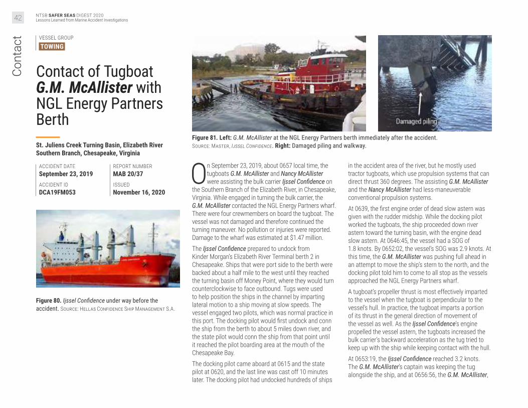
NTSB SAFER SEAS DIGEST 2020Lessons Learned from Marine Accident Investigations42
Cont
act VESSEL GROUP
TOWING
Contact of Tugboat G.M. McAllister with NGL Energy Partners BerthSt. Juliens Creek Turning Basin, Elizabeth River Southern Branch, Chesapeake, Virginia
ACCIDENT DATESeptember 23, 2019ACCIDENT IDDCA19FM053
REPORT NUMBERMAB 20/37ISSUEDNovember 16, 2020
Figure 80. Ijssel Confidence under way before the accident. Source: Hellas Confidence Ship Management S.A.
Figure 81. Left: G.M. McAllister at the NGL Energy Partners berth immediately after the accident. Source: Master, Ijssel Confidence. Right: Damaged piling and walkway.
On September 23, 2019, about 0657 local time, the tugboats G.M. McAllister and Nancy McAllister were assisting the bulk carrier Ijssel Confidence on
the Southern Branch of the Elizabeth River, in Chesapeake, Virginia. While engaged in turning the bulk carrier, the G.M. McAllister contacted the NGL Energy Partners wharf. There were four crewmembers on board the tugboat. The vessel was not damaged and therefore continued the turning maneuver. No pollution or injuries were reported. Damage to the wharf was estimated at $1.47 million.The Ijssel Confidence prepared to undock from Kinder Morgan’s Elizabeth River Terminal berth 2 in Chesapeake. Ships that were port side to the berth were backed about a half mile to the west until they reached the turning basin off Money Point, where they would turn counterclockwise to face outbound. Tugs were used to help position the ships in the channel by imparting lateral motion to a ship moving at slow speeds. The vessel engaged two pilots, which was normal practice in this port. The docking pilot would first undock and conn the ship from the berth to about 5 miles down river, and the state pilot would conn the ship from that point until it reached the pilot boarding area at the mouth of the Chesapeake Bay. The docking pilot came aboard at 0615 and the state pilot at 0620, and the last line was cast off 10 minutes later. The docking pilot had undocked hundreds of ships
in the accident area of the river, but he mostly used tractor tugboats, which use propulsion systems that can direct thrust 360 degrees. The assisting G.M. McAllister and the Nancy McAllister had less-maneuverable conventional propulsion systems. At 0639, the first engine order of dead slow astern was given with the rudder midship. While the docking pilot worked the tugboats, the ship proceeded down river astern toward the turning basin, with the engine dead slow astern. At 0646:45, the vessel had a SOG of 1.8 knots. By 0652:02, the vessel’s SOG was 2.9 knots. At this time, the G.M. McAllister was pushing full ahead in an attempt to move the ship’s stern to the north, and the docking pilot told him to come to all stop as the vessels approached the NGL Energy Partners wharf.A tugboat’s propeller thrust is most effectively imparted to the vessel when the tugboat is perpendicular to the vessel’s hull. In practice, the tugboat imparts a portion of its thrust in the general direction of movement of the vessel as well. As the Ijssel Confidence’s engine propelled the vessel astern, the tugboats increased the bulk carrier’s backward acceleration as the tug tried to keep up with the ship while keeping contact with the hull.At 0653:19, the Ijssel Confidence reached 3.2 knots. The G.M. McAllister’s captain was keeping the tug alongside the ship, and at 0656:56, the G.M. McAllister,

NTSB SAFER SEAS DIGEST 2020Lessons Learned from Marine Accident Investigations 43
caught between the dock and the side of the ship, struck the piling of the easternmost mooring dolphin and then the walkway. The G.M. McAllister’s captain told investigators that at this point, the tug was not pushing the ship any longer, but rather, the Ijssel Confidence was pulling the tug. Nine other similar cargo vessels undocked from the Kinder Morgan berths and used the turning basin between June 2 and November 6, 2020. The Ijssel Confidence was the only ship to use two conventional tugboats. In addition, the Ijssel Confidence’s speed exceeded the average speed of the other ships by over one knot and was too moving fast for the tugboats to work effectively. Although the docking pilot was aware that the conventional tugboats were less maneuverable than tractor tugboats, he neglected to take into account the tugboats’ reduced effectiveness and the additive effect the tugs had on the ship’s speed, nor did he discuss his plan for the undocking evolution with the tugboat captains. In addition, the G.M. McAllister captain and the docking pilot agreed that there had been gaps in their communication; had they both communicated better, and had the ship proceeded in a speed more appropriate for the tugboats, this accident could have been avoided.
The probable cause of the contact of the G.M McAllister with the NGL Energy Partners berth was the docking pilot backing down the river toward the turning basin at a speed at which the assist tugboats could not be effectively used. Contributing to the accident was insufficient communication, before and during the maneuver, between the docking pilot and the G.M. McAllister captain.
Figure 82. Top right: Ijssel Confidence docked after the accident.
Figure 83. Right: Detailed satellite image of the area where the G.M. McAllister contacted the NGL Energy Partners wharf. Background source: Google Earth.

NTSB SAFER SEAS DIGEST 2020Lessons Learned from Marine Accident Investigations44
Cont
act VESSEL GROUP
TOWING • TOWING
Contact of Crane Barge U1510, Pushed by Towing Vessel Goose Creek, with Overhead PowerlinesElizabeth River, Chesapeake, Virginia
ACCIDENT DATEJune 20, 2019ACCIDENT IDDCA19FM041
REPORT NUMBERMAB 20/24ISSUEDJune 11, 2020
Figure 84. NOAA chart 12253, which the crew used to navigate on board the Goose Creek. The powerlines are circled in red. Annotated by NTSB.
Figure 85. View from Goose Creek 's wheelhouse after the accident facing north towards Gilmerton Bridge and no. 120 transmission tower on the left (west) with the Manitowoc crane (centered) and Heidi C (right) moored to crane barge U1510. Source: Coast Guard.
At 1134 local time on June 20, 2019, the crane barge U1510 (with three persons on board), being pushed by the towing vessel Goose Creek (with
three crewmembers on board), struck three overhead power transmission lines while transiting to Precon Marine on the southern branch of the Elizabeth River in Chesapeake, Virginia. No pollution or injuries were reported. Damage to the powerlines and crane barge was estimated at $226,204. At 0600 on June 20, 2019, the Goose Creek departed Ireland Marine with a captain, engineer, and deckhand, en route to Craney Island, Virginia. The captain did not possess a valid Coast Guard credential for his position, and there is no indication that the company attempted to verify that he had the proper credentials. At Craney Island, the crew secured the Goose Creek face-up to the U1510’s bow. The superintendent, construction worker, and crane operator on board the crane barge made their final preparations for the 9.5-mile transit to Precon Marine, where they planned to offload the crane to a larger barge. The crane operator lowered
the boom to an angle of 22 degrees, about 10 feet above the towboat’s house, to provide for adequate clearance when passing under the Gilmerton Bridge about a half mile before Precon Marine (the barge’s air draft was approximately 98 feet). The superintendent and a construction worker planned to follow the tow throughout the three-hour transit in the company’s workboat, Heidi C. There were two sections of overhead high-voltage transmission lines that crossed the river along the voyage route after the Gilmerton Bridge. The vertical clearance of these lines was marked on the crew’s onboard NOAA chart for the area: 152 feet for the northern section (lines no. 120), and 161 feet for the southern section (lines no. 164). Although the company did not have voyage planning procedures or policies, the individuals involved in the transit had a pre-transit discussion, establishing that the superintendent on board the Heidi C would provide direction to the construction workers on board the U1510 for the offloading of the crane.

NTSB SAFER SEAS DIGEST 2020Lessons Learned from Marine Accident Investigations 45
The tow got under way, with the crane’s boom and cab facing aft towards the wheelhouse. After maneuvering through the Gilmerton Bridge and Norfolk Southern no. 7 Railroad Bridge at 1125, the crane operator and spotters on the barge prepared to raise the boom and block assembly. The superintendent on the Heidi C communicated over the radio the location where the tow should spud down, then instructed the crane operator to “boom up and grab the spud.” The crane operator asked the captain which spud to pick up, to which the captain stated he did not have a preference. While the two spotters prepared the rigging and slings for the spud, he began to raise the boom to pick up the aft starboard spud, but did not rotate the crane, and from this position, he could not see the upcoming powerlines. A couple of minutes later, a nearby vessel radioed the crew to warn them to “watch the height of the crane’s boom with the overhead powerlines.” The captain immediately radioed employees on board the U1510 and Heidi C, inquiring about the crane’s boom height, but did not take any action to slow the tow. The deckhand reported that the first set of powerlines had a vertical clearance of 152 feet, which the captain then relayed over VHF. The superintendent saw the second set of transmission lines, no. 164, and responded over the radio that “the tow would have about 200 yards of clearance” (horizontal distance from the second set of transmission lines) and they were “good to go.” The crane operator announced over the radio that he had “200 feet of stick out.” The crane boom’s angle indicator read 67 degrees postaccident, indicating the air draft was approximately 195 feet at the time of the accident, which exceeded the charted 152-foot vertical clearance of lines no. 120 by 43 feet. Although aware that the construction workers intended to raise a spud and warned of the nearby powerlines, the captain allowed the workers to raise the crane boom. About 1134, the crane’s boom contacted lines no. 120, and arc flashes and “cannon like-booms” were observed. All three transmission lines subsequently parted and fell into the river. There were no reported injuries, and the tow safely moored outside of the channel.
The captain did not conduct effective voyage planning because he did not consider all overhead obstructions and identify his tow’s air draft restrictions for each obstruction along the intended route prior to getting under way. Additionally, had the company established a TSMS that included requirements for calculating a tow’s air draft and identifying all operational restrictions along the route, the crew would have been less likely to raise the boom while transiting.
The probable cause of the contact of the towing vessel Goose Creek’s tow, crane barge U1510, with the overhead powerlines was the tow’s captain not identifying the risk of raising the boom as the tow approached the powerlines due to the lack of company oversight, demonstrated by the company not implementing a towing safety management system or hiring a properly credentialed mariner to operate the vessel.
Navigation AssessmentsRegardless of requirements, planning and preparation before a tow commences is critically important, including the identification of charted authorized overhead vertical clearance along the route. Overhead powerlines pose a risk to vessels and tows with high air drafts. Owners and operators should develop voyage plans that assess operational risks and hazards, to include air draft relative to overhead powerlines and bridges along the intended route.
Figure 86. Towing vessel Goose Creek and crane barge U1510 spudded down in Chesapeake, Virginia, after the accident. Inset (not to scale) depicts the crane boom elevation when stowed at 22° and as determined after the accident with an angle of 67°. Source: Coast Guard; illustration by NTSB.

NTSB SAFER SEAS DIGEST 2020Lessons Learned from Marine Accident Investigations46
Cont
act VESSEL GROUP
TOWING • TOWING
Contact of Crane Barge Mr Ervin, Pushed by Towing Vessel Kristin Alexis, with Sunshine BridgeLower Mississippi River, mile 167.4, St. James Parish, about 30 miles down river of Baton Rouge, Louisiana
ACCIDENT DATEOctober 12, 2019ACCIDENT IDDCA19FM003
REPORT NUMBERMAB 20/29ISSUEDJuly 16, 2020
Figure 87. Kristin Alexis under way before the accident. Source: Bill Feig.
On October 12, 2018, about 0141 local time, the towing vessel Kristin Alexis was transiting with the crane barge Mr Ervin upbound on the Lower
Mississippi River near St. James, Louisiana, when the crane struck the deck of the Sunshine Bridge while passing under the west channel span. No pollution or injuries to the six crewmembers on board the Kristin Alexis were reported. The bridge was completely closed to vehicular traffic for 49 days while repairs were made, which resulted in significant traffic impacts. Damage to the bridge was $6.7 million, while crane damage was estimated at $8,500.
The Kristin Alexis was working under a 13-month charter contract with Cooper Consolidated, in which Marquette Transportation Company Gulf-Inland, LLC, completed work orders for Cooper Consolidated. On October 11, 2018, about 2300, the Cooper Consolidated dispatcher informed the captain that their next job was to move the derrick-type crane barge Mr Ervin upriver from a fleeting facility in Convent (mile 161.5) to another facility in Darrow (mile 175). This voyage required them to transit under the Sunshine Bridge.
Figure 88. Screenshots of the Kristin Alexis’ Rose Point at 0139 (left) and at 0140 (right). The vertical clearance for the Sunshine Bridge is circled in red.
Figure 89. Vertical clearance of the Sunshine Bridge’s west (left) and channel (right) spans, as indicated postaccident by the Rose Point display on board the Kristin Alexis, which showed the same clearance for each span (132.9 feet).

NTSB SAFER SEAS DIGEST 2020Lessons Learned from Marine Accident Investigations 47
Figure 90. The Kristin Alexis and crane barge Mr Ervin configuration. Source: Coast Guard.
The Mr Ervin’s air draft, including the stowed crane and barge, was about 136 feet. In preparation for this job, Cooper Consolidated obtained the current river stage (18.37 feet) at Donaldsonville, Louisiana, and calculated the minimum vertical clearance of the Sunshine Bridge to be “151 or 152 feet,” and, using the crane barge’s air draft and the bridge’s minimum vertical clearance, concluded that the barge had sufficient overhead clearance to transit through the bridge’s channel span. None of these measurements were relayed to the captain or pilot. At 2330, the Kristin Alexis arrived alongside the Mr Ervin and the captain positioned the Kristin Alexis “face up” to the barge’s stern to push it. The captain completed Marquette’s required Short Voyage Plan, on which he recorded “37”—the air draft (in feet) of the towboat—in the allocated space. He did not enter the air draft of the
crane barge. The captain had pushed three different crane barges several times with the Kristin Alexis, and the Mr Ervin had also been towed several times over the past five months. However, review of the Short Voyage Plan forms for all of the towboat’s voyages for the past year showed the value for “air” to all be 37 feet, the air draft of the Kristin Alexis, indicating that company captains did not understand that the crane’s air draft value should be the maximum air draft for a tow. Had the company conducted routine spot checks on the voyage forms, they would have known that the forms were being filled out incorrectly. About 2350, the tow proceeded up river toward the Sunshine Bridge, about 6 miles away. The pilot entered the wheelhouse to prepare to relieve the captain and assume the 0000–1200 watch. About 0030, the captain and the pilot completed their watch
exchange, as well as the company’s Fleet Crew Change Protocol checklist, which included several items that they checked off but did not discuss, including river stage and conditions, and upcoming operational procedures, such as bridge transits. They did not discuss any expectations the captain (or company) had as to which span the pilot should use, the air draft of the crane, or the bridge clearances along the route. The captain and pilot would have had to calculate the overhead clearance above the crane, which required accurate air draft and river gage measurements, to ensure that the tow could safely navigate through the bridge. However, neither the captain nor the pilot knew the accurate air draft for the crane barge on the day of the accident (the captain believed it was 130 feet), and the pilot did not check the river gage. They also did not verify the vertical clearance of the bridge.

NTSB SAFER SEAS DIGEST 2020Lessons Learned from Marine Accident Investigations48
Cont
act At 0030, the vessel was close to the right descending
bank, approaching the bridge at a speed of 4 knots. The pilot had no visibility on the starboard side, which faced the left descending bank, so he planned to maneuver the tow so that it would pass beneath the center of the west span of the bridge. The company expected towing vessels to transit through a bridge’s channel span but had no written guidance instructing its crews as much, so the pilot was unaware of this expectation. The tow continued its transit until about 0141, when the top of the crane’s A-frame struck the west span, and the crane became lodged under the bridge, halting the tow. The Kristin Alexis was equipped with GPS, an AIS, a radar, and a Rose Point electronic charting system. Since the crane’s pedestal caused radar echo and blocked the radar view, the pilot used the vessel’s Rose Point, which
inaccurately indicated that both the channel and west spans of the Sunshine Bridge had a vertical clearance of 132.9 feet (only the channel span was 132.9 feet). The crew also occasionally consulted NOAA chart 11370, which listed only one vertical clearance for the bridge (133 feet). The pilot erroneously assumed that the air draft of the crane barge was 130 feet and he would therefore have 2–2.9 feet of overhead clearance to safely transit under the west span. However, a postaccident survey of the bridge showed that the minimum vertical clearance was 128.8 feet for the west span (about 7 feet lower than the reported crane barge’s 136-foot air draft). The vessel’s electronic chart system, which pulled data from NOAA charts, did not reflect the actual minimum vertical clearance for that span of the Sunshine Bridge.
The probable cause of the Mr Ervin crane barge striking the Sunshine Bridge was the inadequate voyage planning and watch turnover between the captain and pilot, resulting in the pilot transiting beneath the bridge’s west span instead of its channel span. Contributing to the accident was the lack of company oversight. Also contributing to the accident was the charted information for the bridge used by the pilot, which did not reflect the actual vertical clearance of the west span.
Figure 91. Below: Crane barge Mr Ervin faced up to the Kristin Alexis. Source: Coast Guard.
Figure 92. Forward view from the Kristin Alexis’ wheelhouse. The crane’s pedestal blocks most of the starboard view, while the crane bucket blocks a portion of the forward view ahead. Source: Coast Guard.
Figure 93. Excerpt of NOAA chart 11370 used by the crew. The vertical (133 feet) and horizontal clearances (750 feet) of the Sunshine Bridge are shown circled in red. Source: NOAA; annotated by NTSB.
Crane pedestal
Bucket
Top of A-frame area of crane that struck bridge
Crane bucket or "grab"

NTSB SAFER SEAS DIGEST 2020Lessons Learned from Marine Accident Investigations 49
Figure 94. Sunshine Bridge span vertical clearances. The right descending bank is the west bank, and the left descending bank is the east bank. Source: Corps of Engineers.
Figure 95. Vertical clearances of the Sunshine Bridge’s west span measured shortly after the accident. The impact location is marked with a red triangle. Source: Forte and Tablada; annotated by NTSB.
Safety RecommendationsAs a result of its investigation into this accident, the NTSB issued three new safety recommendations. The NTSB found that Marquette Transportation Company’s voyage planning guidance was insufficient and recommended that the company develop a detailed voyage plan with specific information concerning/about all known risks, including calculated overhead clearance limitations for tows. Additionally, the NTSB also found that the company was not adequately verifying that crews understood and implemented the safety management system on board the vessel and recommended that the company develop a detailed audit plan to verify that the bridge transit procedures and watch handovers are understood and effectively used by captains and pilots.Further, the NTSB found that contrary to NOAA guidance, when there are multiple navigable spans for a bridge, NOAA navigational charts do not consistently list vertical clearances for each span. Navigational aids should provide mariners with a simple and precise way to navigate and not increase workload or cause confusion. Therefore, the NTSB issued one new recommendation to NOAA to review and update bridge data and charts to include vertical clearance information for all navigable bridge spans.
To see the current status of NTSB safety recommendations visit the Safety Recommendations page on our website at www.ntsb.gov.

NTSB SAFER SEAS DIGEST 2020Lessons Learned from Marine Accident Investigations50
Cont
act VESSEL GROUP
TOWING
Contact of Leviticus Tow with Plaquemine Point ShipyardLower Mississippi River, mile 208.5, near Sunshine, Louisiana
ACCIDENT DATEMarch 7, 2019ACCIDENT IDDCA19FM023
REPORT NUMBERMAB 20/25ISSUEDJune 16, 2020
Figure 96. Trackline of Leviticus leading up to the contact with the barges moored at the Plaquemine Point Shipyard, based on the vessel’s AIS data. According to the passing arrangement, Plaquemine Ferry Landing is where the tow would have met the Atalanta T. Source: Marine Traffic; Google Earth; Annotated by NTSB.
Figure 97. Plaquemine Point Shipyard immediately after the accident during major flood stage; inset shows the same area in January 2019. Source: Coast Guard. Inset: Google Earth; annotated by NTSB.
On March 7, 2019, at 1020 local time, the towing vessel Leviticus was pushing six barges downbound on the Lower Mississippi River at mile
208.5 near Sunshine, Louisiana, with a crew of eight on board. While transiting through a river bend, the lead barges of the tow contacted barges moored at the Plaquemine Point Shipyard, breaking free a total of 11 barges. The 27 shipyard workers on board the barges were able to evacuate before contact; 10 sustained minor injuries. All barges were later recovered, and no pollution was reported. Damage to the shipyard ($520,000) and the tow ($19,500) amounted to an estimated $539,500. On the morning of the accident, the river was at major flood stage, and the previous day, the Coast Guard had issued a high-water safety advisory. The six barges were loaded with crude oil and in a two-string configuration. Combined, the towboat and tow were 1,047 feet long and 108 feet wide, with the deepest draft at 9 feet for the Leviticus.
About 1000, the Leviticus was traveling at 12.7 mph under the direct supervision of the captain, who was training the steersman to use the vessel’s steering and propulsion systems. The pilot was also in the wheelhouse. At 1007, as the steersman was beginning to round the bend at Plaquemine Point (mile 209), the captain had the steersman call the pilot on the upbound tankship Atalanta T to arrange a starboard-to-starboard passing arrangement. The plan was to meet just below the Plaquemine Ferry Landing at mile 207.9. The arrangement required the tow to stay near the left descending bank when rounding the point, where the river current was slower than in the main channel. The area was hazardous with unpredictable eddies: too close to the point, the tow could get stuck in the eddy; too far, the tow could be carried by the main channel current and slide toward the bend in the path of the Atalanta T. The meeting arrangement also required the Atalanta T to slow its speed and move near the right descending bank to allow the Leviticus to make a safe starboard-to-starboard pass.

NTSB SAFER SEAS DIGEST 2020Lessons Learned from Marine Accident Investigations 51
The captain and the pilot coached the steersman as he independently steered the tow to “hold the point.” At 1016, the captain noticed the Atalanta T in the middle of the river and had the steersman request the Atalanta T move closer to the right descending bank. When the Atalanta T pilot noticed the Leviticus starting to slide toward the right descending bank, he proposed switching to a port-to-port pass. However, the captain instructed the steersman to decline and remain with the planned pass. If the Leviticus did not have an upbound vessel to pass, the captain and the steersman could have maintained a safer distance from eddies on the left descending bank. Monitoring and meeting the upbound Atalanta T added extra pressure on the captain and the steersman and decreased the margin of error while transiting the bend. The high-water conditions should have heightened the captain’s attention in anticipation of the dangerous bend. He could have steered the bend himself while having the steersman closely observe the maneuvers. However, in consideration of developing the steersman’s skills, the captain felt that he “didn’t want to mess his confidence up.” At 1019, the captain realized the tow was caught in an eddy and headed toward the Chem Carriers Plaquemine Point Shipyard. The captain had anticipated the eddy, based on his experience, but he described the eddy encountered as extending farther out from the bank and stronger than expected. He gave the steersman a “hard starboard” helm order and then took over the steering and propulsion of the tow to attempt to avoid striking barges moored at the shipyard’s cleaning plant and repair yard.
Figure 98. Leviticus under way before the accident. Source: Jeff L. Yates.
Despite the captain’s efforts, at 1020, the tow’s port lead barge struck a barge at the cleaning plant. Less than a minute later, the tow’s starboard lead barge struck another barge. As a result, all six of the cleaning plant’s barges were knocked free from their moorings, and the tow pushed them down river toward the repair yard. At 1021, the cleaning plant barges hit the repair yard. Five of the repair yard’s barges broke away. About 1025, two of the barges knocked loose from the cleaning plant struck the no. 1 barge anchor buoy at the Banta Mile 208 Fleet.
The probable cause of the contact of the Leviticus tow with the Plaquemine Point Shipyard was the captain’s decision to continue the training of an apprentice mate/steersman while navigating a challenging river bend downbound and meeting upbound traffic in high-water conditions.
Transiting Hazardous Areas When Trainees Operate Towing VesselsTrainers should have heightened attention when trainees are operating a vessel, especially during strong current conditions, navigating dangerous bends, transiting high-traffic areas, and other areas of known risk. When allowing trainees to operate under these circumstances, their experiences and skill levels should be considered. Captains should also encourage trainees to speak up at the earliest time of concern or any time when in doubt. Non-pertinent conversation and other distractions should be avoided.
Figure 99. Screen capture from the Leviticus’ video recorder at 1020 looking forward shows initial impact with the moored barges at the shipyard’s cleaning plant. Source: Kirby Inland Marine.
Figure 100. Screen capture from playback of Leviticus’ navigation system at 1016 shows tow length and predicted positions as the vessel rounds the bend. Position times have been superimposed. Source: Kirby Inland Marine.

NTSB SAFER SEAS DIGEST 2020Lessons Learned from Marine Accident Investigations52
Cont
act VESSEL GROUP
TOWING
Contact of Lindberg Crosby Tow with Interstate 10 BridgeSan Jacinto River, at the Interstate 10 bridge, Channelview, Texas
ACCIDENT DATEFebruary 11, 2019ACCIDENT IDDCA19FM015
REPORT NUMBERMAB 20/02ISSUEDJanuary 17, 2020
Figure 101. Starboard engine pneumatic gear clutch actuator linkage disconnected aboard the Lindberg Crosby as found after the accident. Source: Lindberg Crosby captain.
Figure 102. Towing vessel Lindberg Crosby docked in Houston, Texas, after the accident.
At 1316 local time on February 11, 2019, the towing vessel Lindberg Crosby, with a crew of four, suffered a loss of engine control and struck the
Interstate 10 (I-10) bridge while attempting to dock an empty tank barge at the nearby Southwest Shipyard dock on the San Jacinto River in Channelview, Texas. No pollution or injuries were reported. Damage to the bridge and barge was estimated at $1,595,887.At 1100 on February 11, the 55-foot-long towboat Lindberg Crosby, pushing the 245-foot-long tank barge Shawnee, proceeded up the San Jacinto River towards Southwest Shipyard to have the empty barge cleaned. The captain estimated the ebb current to have been about 1 mph opposing the vessel.The captain was relieved by the relief captain about noon but returned to the wheelhouse about 1245 to maneuver the vessel to the shipyard dock because it was very close to the I-10 bridge. Three protection cells and fendering were installed on the upstream side of the bridge. As the vessel approached its intended berth just south of the I-10 bridge, the captain attempted to slow the vessel by moving the throttles for both engines from ahead to astern. Each propulsion engine’s speed and transmission
were controlled by a pneumatic system that was operated by a throttle lever on the wheelhouse console. Moving the engine throttle levers sent two compressed air signals to each engine: one signal adjusted the engine speed by moving its fuel rack, and the other signal actuated a pneumatic cylinder that was connected to the transmission’s gear shift lever by an adjustable linkage, shifting the engine into ahead, neutral, or astern propulsion. The port engine shifted astern, but unbeknownst to the captain, the starboard engine remained clutched in the ahead direction. As a result, the vessel began to veer to port. When the captain attempted to slow the vessel further by pushing the throttles further astern, the port engine responded with increased rpm astern as expected, but the starboard engine continued to push ahead (at higher rpm), which increased the rate of turn to port. Realizing that there was a problem affecting control of the vessel, the captain attempted to steer the bow of the barge into the rocky shore to stop the tow. Consequently, the barge passed under the eastbound span, and at 1316, the bow of the barge contacted a westbound highway bridge pier column at a speed of 2.9 mph, bringing the tow to rest and damaging the pier column.

NTSB SAFER SEAS DIGEST 2020Lessons Learned from Marine Accident Investigations 53
Immediately after the tow stopped, the captain looked aft and saw wheelwash behind the starboard propeller. He realized that despite putting the starboard engine control in the astern direction, it was still providing propulsion in the forward direction.He stopped the starboard engine, used the port engine to back out from under the bridge, and moored the tow at the shipyard dock. He went to the engine room and found the transmission shifting lever of the starboard engine stuck in the ahead position because the threaded rod of the pneumatic actuating piston had disconnected from the connector affixed to the shifting lever, preventing any direction changes from being transmitted from the wheelhouse throttle levers to the shifting lever on the transmission, resulting in the transmission remaining stuck in the ahead direction. With twin propulsion engines and no positive feedback system to alert the operator that shift commands were not followed, the captain did not immediately discern the loss of starboard engine control. Postaccident tests indicated that there was not a material failure of the pneumatic cylinder or its
components. The design of the piston within the cylinder allowed it to rotate to account for misalignment in various applications. Testing showed that during repeated operation, the piston rod rotated in a direction that would unscrew a threaded connection. To prevent cylinder shaft rotation as it was fitted on the Lindberg Crosby’s transmission, a jam nut was provided to tighten down against the shift lever threaded connector. The most likely cause of the separation of the linkage between the cylinder and the transmission lever was the jam nut becoming loose over time, therefore allowing rotation of the piston rod, resulting in the rod unthreading from the shifting lever connector piece.
The probable cause of the towing vessel Lindberg Crosby contacting a pier column of the Interstate 10 bridge was the undetected loss of starboard engine directional control due to a separation of the control system mechanical linkage to the pneumatic gear clutch, resulting in the engine not shifting in response to the operator’s commands.
Ensuring Jam Nuts and Locking Devices are SecuredMany vessels use mechanical linkages to transmit control commands to critical machinery. Operators of vessels using adjustable linkages that include jam nuts, locking nuts, or other devices should frequently examine the position of the nuts on shafts to verify their security and develop procedures to effectively ensure critical control system components are included in preventative maintenance programs. Component and control system manufacturers should provide guidance/options for passively securing jam nuts, such as locking wire, locking washers, securing tabs, thread-locking insert materials, thread-locking fluid, or other means.
Figure 103. Right: Wheelwash from the Lindberg Crosby’s starboard propeller, circled in yellow, after striking the I-10 bridge. Source: Harris County Sheriff’s Department.
Figure 104. Trackline and location of the Lindberg Crosby when the tow struck the I-10 bridge (marked with red triangle). Background source: Google Earth.
Figure 105. Below: Damaged section of struck pier column under westbound lanes of I-10 bridge.

NTSB SAFER SEAS DIGEST 2020Lessons Learned from Marine Accident Investigations54
Cont
act VESSEL GROUP
TOWING • GOVERNMENT
Contact of Mary Lucy Lane Tow with Markland Locks and Workboat GibsonOhio River, mile 531.5, Markland Locks & Dam, Warsaw, Kentucky (about 30 miles southwest of Cincinnati, Ohio)
ACCIDENT DATEDecember 18, 2019ACCIDENT IDDCA19PM011
REPORT NUMBERMAB 20/18ISSUEDApril 16, 2020
Figure 106. Towing vessel Mary Lucy Lane. Source: Jeff L. Yates.
Figure 107. The Gibson and barge ART 36109 three days after the accident. Source: Coast Guard.
About 1555 on December 18, 2018, the towing vessel Mary Lucy Lane, with eight crewmembers on board and pushing a tow of 12 barges, was
locking southbound at the Markland Locks & Dam (L&D) at mile 531.5 on the Ohio River, when the tow struck the lock’s wall, then its guard wall. Several barges broke loose and continued forward, one of which collided with the moored US Army Corps of Engineers workboat Gibson. No injuries or pollution resulted from the accident. Damage to the Mary Lucy Lane, the barges, and the dam was estimated at $321,943, and the Corps of Engineers estimated the cost to replace the Gibson at $1.8 million.About three months before the accident, the water at the Markland L&D was rising, and with 50 feet of dam opening, the Coast Guard issued a Scheduled Marine Information Broadcast per the Sector Ohio Valley Waterways Action Plan (watch phase), which was broadcast four times per day. At 120 feet of dam opening, because of “extreme high water/extreme high flow conditions,” the Coast Guard convened an organizational
phone conference (action phase). The Coast Guard proactively issued a Marine Safety Information Bulletin about seven weeks before the accident, warning mariners of rapidly rising water conditions. At 0935 on December 18, the 140-foot-long, twin-propeller towing vessel Mary Lucy Lane arrived with its tow of 12 barges (three strings with four barges each) in the vicinity of the Markland L&D. The 930-foot-long, 105-foot-wide tow waited in queue to transit the lock at the upper approach federal mooring cells, about 0.9 miles upriver from the lock. The dam opening was 177 feet, and the river was rising, placing the waterway at action phase. When this area experienced high-water conditions, there were two known hazards, including stronger outdraft, and the potential to strike and/or wrap around the “pocket and protruding point at mile 531” on the left descending bank, thereby increasing the potential for vessel contact with Markland L&D. Information regarding the dam’s flow conditions and indication of outdraft was passed to a tow operator by the lock operator as the tow approached the lock.

NTSB SAFER SEAS DIGEST 2020Lessons Learned from Marine Accident Investigations 55
Figure 108. Corps of Engineers workboat Gibson. Source: Coast Guard.
At 1526, after the lock operator radioed and gave permission to commence approach to the main lock chamber, the pilot on the Mary Lucy Lane got under way. One deckhand was stationed on the port lead barge, and another on the starboard lead barge to aid in the transit. Because “the river was up” and the current swift, the pilot slowed the engines to keep his approach speed at about 3.5 mph. He told investigators he had made the same approach to the Markland L&D in high-water conditions in the past without any issues. However, the tow was far enough from the shore, parallel to the left descending bank, that the lock master activated the dam’s security camera in order to record the tow’s approach. As the tow got closer, its speed increased, so the pilot slowed it by putting the port engine in neutral. Video footage showed that the Mary Lucy Lane was no longer lined up on the inside of the guard wall. The starboard barge deckhand radioed the pilot when the tow was 200 feet from the end of the guard wall. The tow was drawn quickly toward the dam, and the pilot put both engines ahead to move the tow to the forebay. The increasing speed did not correct the approach, so he began alternating the port and starboard engines with ahead and astern commands. Although the pilot was able to get the head of the tow into the forebay, the outdraft caused by the high current pulled the tow toward the dam. When striking the guard wall seemed imminent, the pilot sounded the vessel’s general alarm. At 1541:31, the tow struck the guard wall’s protective bullnose parting the tugboat’s starboard facing and wing wires. The pilot attempted to move the rest of the tow into the forebay and away from potentially being swept into the dam gates, but as the end of the tow was about to clear the guard wall, the center string’s
lead barge struck the shoreside guide wall, and a large chunk of concrete broke off. The towing wires on the portside string parted, and the four portside barges continued forward into the sheltered area behind the guide wall where one struck the moored 40-foot-long Corps of Engineers workboat Gibson.There was a similar downbound accident a day later, indicating that pilots had difficulty transiting the lock safely in the river conditions and with the dam openings at the time. The Coast Guard reopened the lock, prohibiting mooring to the upper approach cells, thereby removing obstructions, allowing a clear approach, and giving southbound tows more time and distance to line-up when conducting locking operations; restricting southbound tows to daylight; and requiring assist boats.
The probable cause of the contact of the Mary Lucy Lane tow with the Markland Locks and workboat Gibson was a strong outdraft above the dam caused by the extreme high flow conditions, which overwhelmed the pilot’s ability to control the Mary Lucy Lane tow before locking.
WAP phases by feet of dam open and water trend at Markland L&DPHASE CONDITIONSN/A
<50 feet dam and risingNormal operations/flow conditions; locking operations normal.
Watch Phase 50 feet+ dam and rising & projected to continue rising rapidly
High-water/increased flow conditions; issue Scheduled Marine Information Broadcast (SMIB).
Action Phase 120 feet+ dam and rising
Extreme high-water/extreme high-flow conditions; Coast Guard, Corps of Engineers, and Central Ohio River Marine Industry Group conference call to evaluate. A Regulated Navigation Area is initiated when the Cincinnati gage reads 45 feet or greater.
Action Phase 120 feet dam and falling
High water/increased flow conditions; continue conference call; monitor conditions and adjust restrictions as appropriate. Consider SMIB.
Recovery Phase 50 feet dam opening and falling
Normal operations/normal flow conditions; continue monitoring river conditions and consider canceling SMIB.
Figure 109. Below: Approximate positions of the Mary Lucy Lane tow and the workboat Gibson about 1555, when the tow contacted the guard wall. Background source: Google Earth.

NTSB SAFER SEAS DIGEST 2020Lessons Learned from Marine Accident Investigations56
Cont
act VESSEL GROUP
PASSENGER
Contact of Cruise Ship Norwegian Epic with San Juan Cruise Port Pier 3Pier 3 east, Old San Juan Cruise Port, San Juan, Puerto Rico
ACCIDENT DATEFebruary 12, 2019ACCIDENT IDDCA19FM016
REPORT NUMBERMAB 20/04ISSUEDJanuary 29, 2020
Figure 110. The Norwegian Epic before the accident. Source: Miami Herald.com.
Figure 111. Above: The Norwegian Epic as it struck the first mooring dolphin and catwalk, which collapsed. Below: The second dolphin and catwalk as it collapsed after being struck. Source: TweetsWithTito@dunard2.
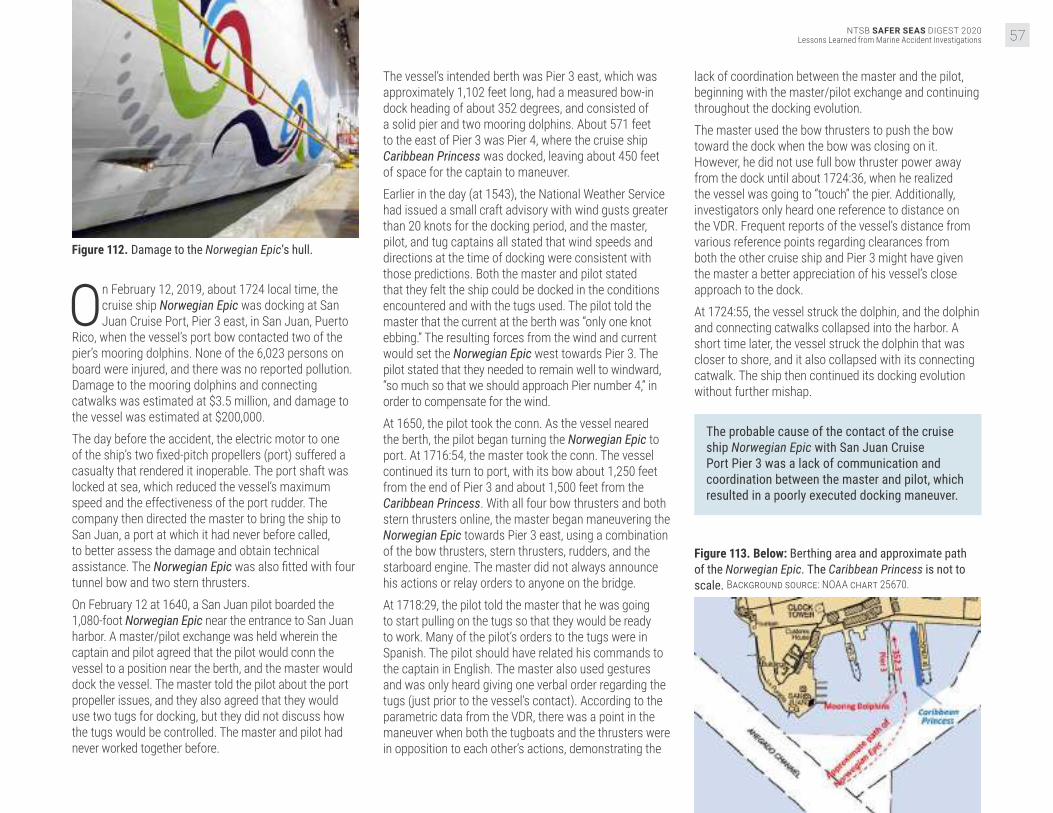
NTSB SAFER SEAS DIGEST 2020Lessons Learned from Marine Accident Investigations 57
Figure 112. Damage to the Norwegian Epic’s hull.
On February 12, 2019, about 1724 local time, the cruise ship Norwegian Epic was docking at San Juan Cruise Port, Pier 3 east, in San Juan, Puerto
Rico, when the vessel’s port bow contacted two of the pier’s mooring dolphins. None of the 6,023 persons on board were injured, and there was no reported pollution. Damage to the mooring dolphins and connecting catwalks was estimated at $3.5 million, and damage to the vessel was estimated at $200,000. The day before the accident, the electric motor to one of the ship’s two fixed-pitch propellers (port) suffered a casualty that rendered it inoperable. The port shaft was locked at sea, which reduced the vessel’s maximum speed and the effectiveness of the port rudder. The company then directed the master to bring the ship to San Juan, a port at which it had never before called, to better assess the damage and obtain technical assistance. The Norwegian Epic was also fitted with four tunnel bow and two stern thrusters. On February 12 at 1640, a San Juan pilot boarded the 1,080-foot Norwegian Epic near the entrance to San Juan harbor. A master/pilot exchange was held wherein the captain and pilot agreed that the pilot would conn the vessel to a position near the berth, and the master would dock the vessel. The master told the pilot about the port propeller issues, and they also agreed that they would use two tugs for docking, but they did not discuss how the tugs would be controlled. The master and pilot had never worked together before.
The vessel’s intended berth was Pier 3 east, which was approximately 1,102 feet long, had a measured bow-in dock heading of about 352 degrees, and consisted of a solid pier and two mooring dolphins. About 571 feet to the east of Pier 3 was Pier 4, where the cruise ship Caribbean Princess was docked, leaving about 450 feet of space for the captain to maneuver.Earlier in the day (at 1543), the National Weather Service had issued a small craft advisory with wind gusts greater than 20 knots for the docking period, and the master, pilot, and tug captains all stated that wind speeds and directions at the time of docking were consistent with those predictions. Both the master and pilot stated that they felt the ship could be docked in the conditions encountered and with the tugs used. The pilot told the master that the current at the berth was “only one knot ebbing.” The resulting forces from the wind and current would set the Norwegian Epic west towards Pier 3. The pilot stated that they needed to remain well to windward, “so much so that we should approach Pier number 4,” in order to compensate for the wind. At 1650, the pilot took the conn. As the vessel neared the berth, the pilot began turning the Norwegian Epic to port. At 1716:54, the master took the conn. The vessel continued its turn to port, with its bow about 1,250 feet from the end of Pier 3 and about 1,500 feet from the Caribbean Princess. With all four bow thrusters and both stern thrusters online, the master began maneuvering the Norwegian Epic towards Pier 3 east, using a combination of the bow thrusters, stern thrusters, rudders, and the starboard engine. The master did not always announce his actions or relay orders to anyone on the bridge. At 1718:29, the pilot told the master that he was going to start pulling on the tugs so that they would be ready to work. Many of the pilot’s orders to the tugs were in Spanish. The pilot should have related his commands to the captain in English. The master also used gestures and was only heard giving one verbal order regarding the tugs (just prior to the vessel’s contact). According to the parametric data from the VDR, there was a point in the maneuver when both the tugboats and the thrusters were in opposition to each other’s actions, demonstrating the
lack of coordination between the master and the pilot, beginning with the master/pilot exchange and continuing throughout the docking evolution.The master used the bow thrusters to push the bow toward the dock when the bow was closing on it. However, he did not use full bow thruster power away from the dock until about 1724:36, when he realized the vessel was going to “touch” the pier. Additionally, investigators only heard one reference to distance on the VDR. Frequent reports of the vessel’s distance from various reference points regarding clearances from both the other cruise ship and Pier 3 might have given the master a better appreciation of his vessel’s close approach to the dock. At 1724:55, the vessel struck the dolphin, and the dolphin and connecting catwalks collapsed into the harbor. A short time later, the vessel struck the dolphin that was closer to shore, and it also collapsed with its connecting catwalk. The ship then continued its docking evolution without further mishap.
The probable cause of the contact of the cruise ship Norwegian Epic with San Juan Cruise Port Pier 3 was a lack of communication and coordination between the master and pilot, which resulted in a poorly executed docking maneuver.
Figure 113. Below: Berthing area and approximate path of the Norwegian Epic. The Caribbean Princess is not to scale. Background source: NOAA chart 25670.

NTSB SAFER SEAS DIGEST 2020Lessons Learned from Marine Accident Investigations58
Cont
act VESSEL GROUP
TOWING
Contact of Towing Vessel Rivers Wilson and Tow with Norfolk Southern Railway BridgeTombigbee River, mile 90, Jackson, Alabama
ACCIDENT DATEMarch 10, 2019ACCIDENT IDDCA19FM025
REPORT NUMBERMAB 20/08ISSUEDFebruary 26, 2020
Figure 114. The Rivers Wilson moored in Mobile, Alabama, after the accident. Source: Coast Guard.
Figure 115. Right: The Rivers Wilson and tow, on the north side of the bridge at sunrise on March 10, after the two starboard barges were recovered. Source: Norfolk Southern.

NTSB SAFER SEAS DIGEST 2020Lessons Learned from Marine Accident Investigations 59
On March 10, 2019, at 0100 local time, the towing vessel Rivers Wilson, with eight crewmembers and pushing six loaded barges, contacted the Norfolk
Southern railway bridge near Jackson, Alabama. As a result, a bridge support was shifted out of position, and the tracks above deflected. Rail traffic was suspended for 27 hours until temporary repairs were made. One crewmember sustained a minor knee injury in the immediate response. No pollution was reported. The crew of the Rivers Wilson, including a captain and a pilot, assembled a six-barge tow just north of Mobile on the Tombigbee River on March 8. The original order was for eight barges, but the captain decided to take only six (three wide by two long), as this was his first trip with the Rivers Wilson. The vessel left the fleeting area about 2040, upbound on the river, averaging 3.5 mph against a current of approximately 8 mph. The pilot came on watch at 2300 on March 9, near mile 84. This was the highest he had ever seen the river while working for the company. He anticipated higher current in the vicinity of the Jackson fleeting area, south of the Norfolk Southern railway bridge, due to narrowing in the river. The pilot stated that if he had been concerned about the current, he would have tied up below the bridge, where he had the option to leave barges in the Jackson fleeting area and make several passes through the bridge while pushing fewer barges. However, he believed that vessel’s speed of 2.5–3 mph over ground when he reached his planned abort point at 2400 was adequate to successfully maneuver the vessel through the bridge. The vessel continued towards the bridge at 1.3–2.4 mph, favoring the right descending bank. The installation of four training dikes above the bridge on the right
descending bank had forced the flow of the river toward the left descending bank, and towboats had to adjust to the shifting current (with the river high, the dikes were underwater). The vessel slowed in the current to 2 mph at 0053, and the lead barge reached the bridge at 0054, still favoring the right descending bank. The pilot noticed he was moving about 1.5 mph to port with no forward way. The lead barges were pointing towards the dikes, and he hoped he could pass over them. He did not accurately anticipate the effect of the high-water conditions and the difficulties presented by the relatively new submerged dikes on the direction/strength of the current. His incomplete understanding of the current, in combination with the misalignment of the bridge with the thalweg and the Rivers Wilson’s lower hp in comparison to the vessel on which he usually worked, resulted in his belief that the tow had enough speed to overcome the effect of the current.At 0058, the port aft barge contacted the bridge pillar (pier 3), and the whole tow pivoted to port. The port aft barge went partially under the bridge, ripping open the barge covers. The lead barge also contacted a pier and was damaged. The Rivers Wilson laid up against pier 3 of the bridge and was unable to extract itself or the barges from the bridge. The pilot sounded the general alarm, and the captain and the bridge tender called the Coast Guard.
The probable cause of the contact between the Rivers Wilson tow and the Norfolk Southern railway bridge was the pilot’s decision to navigate through a bridge that was poorly aligned with the channel with an unfamiliar towing vessel in high water and strong current.
High-current NavigationSeasonal high current poses unique hazards for vessels working on and/or transiting inland rivers. Water flowing over normally exposed terrain and obstacles or man-made structures can change the expected current. Mariners should thoroughly assess the impact of high current on local hazards, such as jetties and bridges, and their effect on navigation.
Figure 116. Select positions of the Rivers Wilson and barges on the Tombigbee River near mile 90 before the accident. Note the training dikes up river of the bridge on the right descending bank. Background source: Corps of Engineers; vessel data: Graestone.
Figure 117. Rail displacement of the Norfolk Southern railway bridge, looking east, with the Rivers Wilson and two barges alongside. Source: Coast Guard.

NTSB SAFER SEAS DIGEST 2020Lessons Learned from Marine Accident Investigations60
Cont
act VESSEL GROUP
TOWING
Contact of William C Tow with Rock Island Railroad Bridge Protection CellDes Plaines River, mile 287.6, Joliet, Illinois
ACCIDENT DATEJanuary 1, 2020ACCIDENT IDDCA20FM010
REPORT NUMBERMAB 20/38ISSUEDNovember 17, 2020
Figure 118. Preaccident image of the William C. Source: Dave D, marinetraffic.com.
Figure 119. View looking down river (south) at the Rock Island Railroad Bridge. Source: http://industrialscenery.blogspot.com/
At 0032 local time on January 1, 2020, the towing vessel William C was pushing a tow of six loaded hopper barges on the Des Plaines River, near Joliet,
Illinois, when the tow’s two forward barges struck a protection cell for the Rock Island Railroad Bridge at mile 287.6. Several tow lines broke, and two barges sustained minor damage. The bridge ceased operations for 10 days, and damages to the bridge’s protection cell were estimated to be greater than $500,000. No injuries or pollution were reported.On the morning of the accident, with the pilot at the helm, the William C and its tow proceeded south with the current, en route to the Illinois Marine Towing Fleet facility at mile 280 of the Des Plaines River. The weather
was good, with 10 miles of visibility and winds from the west at 5 mph, and the current was 3 mph.About 0020, the tow was under the Cass Street Bridge at mile 288.1 of the Des Plaines River, and the pilot was lining up the tow to go through the Jefferson Street Bridge two-tenths of mile away (mile 287.9) at a speed of 5 mph. The flow rate reported by the US Army Corps of Engineers from the Ruby Street Bridge at mile 288.7, located north of the Cass Street Bridge, was 6,500 cfs. Under the Mississippi River and Tributaries Waterways Action Plan 2020, this flow rate was considered “very high flow” but did not require any action to mitigate the risk of the current. The pilot was aware of the condition of the current but stated that he was comfortable with it.

NTSB SAFER SEAS DIGEST 2020Lessons Learned from Marine Accident Investigations 61
While passing through the Cass Street Bridge, the following current in the bend would have been impacting the vessel’s starboard quarter, pushing the tow over to port and the left descending bank. As the pilot attempted to line up the tow to pass through the Jefferson Street Bridge, he realized that he had oversteered to port, so he moved the rudders to maneuver the tow to starboard to line up the vessel with the center of the bridge. Once he believed the vessel was lined up, he returned the rudders to midships, but the current pushed the vessel back to port. Since the bow of the tow was already approaching the Jefferson Street Bridge, the pilot continued his course until the William C had passed through the bridge.Once the vessel had passed through the bridge, there were only about 1,200 feet for the pilot to maneuver the approximately 662-foot-long tow back to the center of the channel before reaching the Rock Island Railroad Bridge protection cell near the left descending bank. The pilot attempted to move the tow to starboard, but since the following current was pushing against the tow, it continued toward the left descending bank.
Figure 120. Bridges through which the William C’s tow transited. Background source: Google Earth.
Realizing the likelihood of impact, the pilot sounded the general alarm and switched both engines into full reverse to slow the vessel’s approach. The tow slowed but did not stop completely. At 0025, the two forward barges struck the northeast bridge’s protection cell, which was pushed into the adjacent floating fenders. After notifying the Coast Guard and determining that the damage to the barges was minimal, the crew proceeded with the tow to the Illinois Marine Towing Fleet facility. The bridge was closed for 10 days pending a damage survey.
The probable cause of the contact with the Rock Island Railroad Bridge protection cell by the William C and tow was the pilot’s inability to correct the tow’s position after completing the transit through the previous bridge, in part due to the higher-than-average current speed.
Figure 121. Left and center: Northeast protection cell for Rock Island Railroad Bridge. Right: View from across the river of damaged protection cell with impact location circled. Source: CSX Transportation.
Figure 122. Preaccident image of the William C. Source: Coast Guard.

NTSB SAFER SEAS DIGEST 2020Lessons Learned from Marine Accident Investigations62
Cont
act VESSEL GROUP
TOWING
Contact of the Barge YD 71 with the James T. Wilson Fishing PierChesapeake Bay, Hampton, Virginia
ACCIDENT DATENovember 17, 2019ACCIDENT IDDCA20FM004
REPORT NUMBERMAB 20/35ISSUEDNovember 2, 2020
Figure 123. The YD 71 aground after breaking free from its mooring and prior to striking the pier. Source: Coast Guard.
On November 17, 2019, about 0904, the barge YD 71 contacted the James T. Wilson Fishing Pier in Hampton, Virginia, after breaking loose from its
mooring. There were no people aboard the barge or on the pier at the time of the accident. The vessel was later extricated from under the pier and towed to a repair yard. No pollution or injuries were reported. Damage to the vessel was estimated at $38,000, and damage to the pier was estimated at $1,277,157. The 100-foot-long deck barge YD 71 had an excavator mounted on its deck and was working as a dredge at the Salt Ponds entrance and estuary project. At the end of the workday on Thursday, November 14, the crew of the attending towboat Capt Dale began mooring the barge about 800 feet offshore outside the Salt Ponds entrance channel where the water depth was 9–10 feet. They discovered a kink in the mooring’s cable pendant, which was normally used to moor barges and therefore decided to moor the YD 71 using the mooring’s hurricane loop, a 12- to 15-foot loop of chain that was shackled through one link of the bottom chain. The hurricane loop was retrieved from below the surface and set on one of the barge’s forward bitts, looping it two or three times in a figure-eight configuration. The mooring’s hurricane loop was shackled to the bottom chain 15 feet below the mooring ball. The shackle’s crown was passed through each bitter end of the hurricane loop. The shackle pin was passed through a link at the bottom chain with the center stud removed and held in place with a nut. The nut was welded to the shackle pin, all the way around to keep it from backing out. After the crew ensured the barge was secured to the mooring, they departed the site for the weekend. Two other barges were moored using the cable pendants as usual practice instead of the hurricane chain loops. The length of the chain from the anchor to the hurricane loop plus the loop itself was approximately 110 feet. From Saturday afternoon, November 16, and continuing through the night, winds blew from the north and north-northwest at 17–28 knots, with gusts to 29 knots (near gale). High tide was at midnight and predicted to be 2.36 feet, while the gage at nearby Fort Monroe
recorded the actual level at 2.82 feet. A weather buoy approximately 10 miles upwind in the Chesapeake Bay recorded consistent waves between 3.9 and 4.6 feet during the same period. Sometime before sunrise on Sunday, November 17, the YD 71 slipped its mooring and drifted south and downwind. It contacted and damaged an entertainment pier 1,200 feet north of the James T. Wilson fishing pier. It then grounded on the rip rap erosion dike at Buckroe Beach, then on the sandy beach just north of the fishing pier sometime before 0541, when the fire department was alerted. Responders and public works staff were not equipped to stop the YD 71’s movement down the beach, and the barge contacted the fishing pier about 0904. The barge was later freed from the pier on Monday, November 18, and taken to a repair yard at Cape Charles, Virginia.
Figure 124. The damaged fishing pier with debris on the deck of the YD 71. Source: Coast Guard.

NTSB SAFER SEAS DIGEST 2020Lessons Learned from Marine Accident Investigations 63
The mooring’s chain and hurricane loop were found intact. Neither the shackle nor its pin connecting the hurricane loop to the chain were found. Therefore, the barge could only slip its mooring if the shackle failed, or if the pin backed out after the weld attaching the nut to the pin failed. It is more likely the weld failed than material failure of the shackle bow or pin occurred. This likely would have occurred over a period of time, with the strain of the 4-foot storm wave action, near gale winds, and/or high tide breaking it free.
The probable cause of the contact between the barge YD 71 and the James T. Wilson Fishing Pier was a shackle pin in the mooring arrangement working itself free in heavy weather, leading to the barge’s uncontrolled drift.
Figure 125. Extract of NOAA Chart 12222, with red arrow showing the assumed path barge YD 71 took from its mooring to the James T. Wilson Fishing Pier. Background source: NOAA.
Figure 126. A representation of the arrangement of the YD 71’s mooring at the time of the accident.
Mooring MaintenanceMoorings for vessels can be single-point failures that can lead to losses for both vessels and nearby infrastructure. Operators should identify failure modes of mooring arrangements and implement controls, including more frequent inspections if necessary, to avoid accidents.

NTSB SAFER SEAS DIGEST 2020Lessons Learned from Marine Accident Investigations64
Fire
/Exp
losi
onVESSEL GROUP
TOWING
Explosion and Subsequent Sinking of Barge AlaganikDelong Dock, Canal Passage, Whittier, Alaska
ACCIDENT DATEJuly 7, 2019ACCIDENT IDDCA19FM042
REPORT NUMBERMAB 20/31ISSUEDAugust 6, 2020
Figure 127. Bent and deformed deck plating forward on the Alaganik 's starboard pontoon after the fire.
Figure 128. Alaganik on fire after the explosion. Source: Coast Guard.
On July 7, 2019, at 2339 local time, an explosion occurred on the barge Alaganik as it was moored port side to the end of the Delong Dock in Whittier,
Alaska. The vessel was serving as a platform for pumping fish cargo ashore from fishing vessels and tenders that came alongside. It also provided diesel fuel and gasoline to the fishing vessels. No cargo operations were ongoing when the explosion occurred. Despite the efforts of shore-based responders to fight the ensuing fire, the vessel eventually sank in 60–80 feet of water. The single crewmember aboard the vessel died in the explosion. About 1,896 gallons of gasoline and diesel fuel stored on board the vessel were consumed by the fire or released into the environment. The vessel was a total loss at an estimated value of $300,000. Pier damage was estimated at $400,000. In July 2019, Whittier Seafood, LLC, chartered the Alaganik for use as a platform for pumping fish ashore.
Due to the large tidal range alongside the Delong Dock, this arrangement allowed fishing vessels and tenders to offload their catch more easily. The charter also required the Alaganik to supply diesel and gasoline fuel to the fishing vessels. The barge was carrying diesel fuel in three of its four fuel cargo tanks, and on the day of the accident, the vessel loaded 1,001 gallons of gasoline from a fuel truck on shore to its fourth tank, located on the forward portside. The transfer was completed at 1635.At 2339 that night, an explosion occurred on the Alaganik. The resulting fire quickly spread to the pier, and fuel that escaped into the water around the barge also burned. The fire engulfed the vessel, along with three boom-crane trucks and other equipment and gear on the pier. Shore-based firefighters responded to fight the fire. A Good Samaritan vessel that had been moored to the dock near the Alaganik got under way, threw a grappling

NTSB SAFER SEAS DIGEST 2020Lessons Learned from Marine Accident Investigations 65
hook over the rail of the barge, and towed it away from the pier. The Alaganik sank shortly thereafter, at 0229. The firefighters continued to fight the fire on the pier and reported that it was extinguished at 0250 on July 8. In the aftermath of the explosion, the crewmember on board the Alaganik could not be located, despite a Coast Guard search for him covering an area of 12 square miles. His body was recovered 8 weeks later in a secluded cove about 400 yards from the dock.Evidence suggests that the initial explosion occurred in the vicinity of the cargo tank that was carrying gasoline. Gasoline is more volatile and has a lower flashpoint than diesel fuel, making it far more dangerous to store, particularly in confined spaces. With a flashpoint of −45 degrees, gasoline forms an ignitable vapor at normal ambient temperatures. By comparison, the flashpoint of diesel fuel is 125 degrees. Further, the vapor density of gasoline is three to four times that of air, and thus the vapor tends to gather in low areas and enclosed spaces. Prior to the evening of the accident, only diesel fuel had been stored in the four fuel cargo tanks on the Alaganik. Following the onload of gasoline, it is likely that escaping gasoline vapor gathered around the portside forward fuel cargo tank. When this vapor ignited, the explosion occurred.
Figure 129. Alaganik before the accident. Source: Vessel owner.
A source of ignition for the fire could not be determined, but arcing between a plug and electrical receptacle, within an electrical motor driving a ventilation fan or a bilge pump, or across a loose wire connection for the various installed equipment were potential sources. While less likely, cigarette smoking materials could also not be ruled out. Just before the explosion, the crewmember, a smoker, was seen walking aft from the bow, where smoking was permitted. Plastic tubing used on the barge’s cargo tank gauge glasses melted during the fire, and there were no automatic shut-off valves fitted to the gauge glasses to prevent the release of additional fuel from the tank to the fire. Various federal regulations contain provisions designed to reduce the dangers of storing gasoline
on fishing vessels; however, none of these regulations applied to the Alaganik, an uninspected barge. Further, as an uninspected vessel, there were no regular evaluations of the vessel by Coast Guard officials to ensure the vessel was fit for the service intended. Regardless of the applicability of regulations or inspections, this accident highlights the need for caution when storing, transporting, or transferring gasoline.
The probable cause of the explosion on board the barge Alaganik was the ignition, from an undetermined source, of gasoline vapor from a fuel cargo tank, which became entrapped within the vessel’s port pontoon compartment.
Storage of Gasoline Aboard VesselsMariners must use extreme caution when storing, transporting, or transferring gasoline because of its high volatility and flammability. Gasoline should only be stored in tanks designed to established standards, and spaces containing these tanks should be designed and ventilated according to established standards, in order to ensure gasoline vapor does not become entrapped. Vessel owners and mariners must ensure that components and equipment near flammable liquids or vapors are properly grounded and intrinsically safe.
Figure 130. Simplified general arrangement of the Alaganik, with fuel amounts in each fuel cargo tank at the time of the accident. Vessel hull dimensions are drawn approximately to scale.

NTSB SAFER SEAS DIGEST 2020Lessons Learned from Marine Accident Investigations66
Fire
/Exp
losi
onVESSEL GROUP
FISHING
Fire Aboard and Subsequent Sinking of Fishing Vessel ArielSheep Bay, Prince William Sound, 10 miles northwest of Cordova, Alaska
ACCIDENT DATEAugust 26, 2019ACCIDENT IDDCA19FM046
REPORT NUMBERMAB 20/13ISSUEDMarch 25, 2020
Figure 131. Below: Ariel on fire at 1912, prior to sinking in Sheep Bay. Source: Coast Guard.
On August 26, 2019, about 1830 local time, the fishing vessel Ariel was transiting Sheep Bay, Prince William Sound, Alaska, when a fire broke
out in the vessel’s engine room. The four crewmembers aboard the Ariel attempted to fight the fire, but they were unsuccessful and abandoned ship into the vessel’s skiff. The Ariel continued to burn and subsequently sank. The crew was rescued by Good Samaritan vessels and returned to port uninjured. About 500 gallons of diesel fuel was aboard the vessel when it sank. The Ariel, valued at an estimated $600,000, was a total loss. The Ariel was transiting Sheep Bay the evening of the accident, with the captain at the helm in the wheelhouse located above the vessel’s cabin. About 1830, the engineer smelled smoke in the cabin and opened the main hatch to the engine room. He saw flames in the vicinity of the generator and alerted the captain and the crew, before grabbing a fire extinguisher to fight the fire.The captain noted that the generator was operating erratically, with the engine rpm fluctuating significantly,
so he shut it down. The fluctuating rpm was likely the result of fuel starvation, suggesting that the fuel line to the generator’s engine was breached. The fuel hoses that ran between the manifold, fuel filter, and generator met Coast Guard material specifications; however, over time a hose could have become worn from contact, its connections could have loosened through vibration, or it could have otherwise failed, allowing fuel to leak into the engine room. Leaking fuel or fuel vapor may have then come into contact with a hot surface, igniting and being the likely origin of the fire.
The captain attempted to slow the main propulsion engine by moving the throttle lever to the idle position. The engine did not slow, however, and the throttle lever returned to its previous ahead position. The captain subsequently shut down the main engine, instructed a deckhand to start the skiff’s motor, and went below to assist with firefighting.The captain shut the main hatch to the engine room, and the crew attempted to fight the fire with portable

NTSB SAFER SEAS DIGEST 2020Lessons Learned from Marine Accident Investigations 67
chemical fire extinguishers through an engine room hatch on the port side of the cabin, which was closer to the apparent source of the fire at the generator below. However, smoke drove them out of the cabin. As they left, they closed the hatch. The captain returned to the wheelhouse and made a Mayday call. The crew also discharged extinguishers into the stacks aft on the deckhouse and into the ventilation inlets on either side of the exterior cabin. The captain and crew determined that it would be unsafe to remain on board, so they dropped the vessel’s anchor and boarded the skiff—standing off the Ariel at a safe distance of about 100 feet.
Figure 132. Ariel moored before the accident. Source: Compass Rose Marine Surveyor
A few minutes later, they heard the automatic Halon fixed fire-extinguishing system discharging. The long delay in the heat-sensor activation of the system, located on the forward bulkhead of the engine room, further indicated that the fire started aft in the space. Shortly after the Halon discharge, the smoke seemed to lessen. The engineer re-boarded the Ariel to close the exterior doors to the cabin. He also stuffed materials into the louvers that covered the engine room ventilation inlets on either side of the deckhouse. However, the fixed-open louvers prevented the space from being completely sealed off, and thus the discharged Halon was allowed to escape, and new air was introduced to the fire. The engineer’s attempt to seal off the ventilation inlet louvers using available materials was commendable but likely too late to prevent the spread of the fire.Not long afterward, the smoke and flames increased, so the engineer re-boarded the skiff, and the crew stood off about 300 feet. The Ariel burned for several hours and sank at 2335 in 275 feet of water. The vessel was fitted with manually operated fuel oil shut-offs in the lazarette and engine room, but the crew was unable to close them before abandoning the vessel. The remaining fuel in the tanks would have continued to feed the fire once the hoses melted.
Closing Ventilation During Fixed Fire-Extinguishing System ActivationFixed fire-extinguishing systems in engineering and other hazardous spaces require a minimum concentration of extinguishing agent to either halt the chemical reaction producing the fire, displace the oxygen feeding the fire, or effect a combination of both. To ensure the effectiveness of the system and prevent the reintroduction of oxygen to the space, ventilation inlets should be designed or modified to be closed remotely or covered.
The probable cause of the fire aboard the fishing vessel Ariel was the ignition of fuel leaking from the generator fuel supply line in the engine room. Contributing to the severity of the fire and the eventual loss of the vessel were the fixed-open inlets for the engine room ventilation, which allowed fire-extinguishing agent to escape and air to enter the space.
Figure 133. Below: General arrangement of the Ariel, with the area where the fire was first reported indicated by the red flame icon.

NTSB SAFER SEAS DIGEST 2020Lessons Learned from Marine Accident Investigations68
Fire
/Exp
losi
onVESSEL GROUP
PASSENGER
Fire Aboard Small Passenger Vessel ConceptionPlatts Harbor, Channel Islands National Park, Santa Cruz Island, 21.5 miles South-Southwest of Santa Barbara, California
ACCIDENT DATESeptember 2, 2019ACCIDENT IDDCA19MM047
REPORT NUMBERMAR 20/03ISSUEDOctober 20, 2020
Figure 134. Small passenger vessel Conception prior to sinking. Source: Truth Aquatics.
Figure 135. Small passenger vessel Conception at sunrise prior to sinking. Source: Ventura County Fire Department.
About 0314 on September 2, 2019, the Coast Guard received a distress call from the Conception, a 75-foot-long small passenger vessel operated
by Truth Aquatics, Inc. The vessel was anchored in Platts Harbor on the north side of Santa Cruz Island, 21.5 nautical miles south-southwest of Santa Barbara, California, when it caught fire. Despite firefighting and search and rescue efforts, the vessel burned to the waterline and sank just after daybreak, and no survivors were found. Thirty-three passengers and one crewmember died. Loss of the vessel was estimated at $1.4 million.Constructed in 1981, the Conception was purpose-built to take recreational divers to dive sites around the Channel Islands, California. For the accident trip the vessel had been chartered to take a group of 33 passengers on a 3-day dive trip from Santa Barbara and was scheduled to depart at 0400 on Saturday, August 31, 2019, and return by 1700 on Monday, September 2. Truth Aquatics encouraged customers to board the vessel the night before early morning
departures, and passengers for the accident voyage began arriving in the evening on August 30, embarking via the main deck. Passengers were instructed to sign a posted manifest upon boarding, store their gear, and then proceed to their bunks below deck. The Conception’s crew, which consisted of a captain, second captain (mate), two deckhands, and two galley hands, embarked between 2200 that night and 0320 the next morning, and the galley hands each went to their bunks on the upper deck and went to sleep after embarking. Once on board, the deck crew began conducting pre-underway checks of the vessel’s equipment. At 0404, the Conception departed Santa Barbara Harbor. Over the next two days, the Conception transited between dive sites around Santa Cruz Island, anchoring at each location to allow the passengers to dive.

NTSB SAFER SEAS DIGEST 2020Lessons Learned from Marine Accident Investigations 69
Figure 136. Conception accident voyage reconstructed from AIS data, with selected diving and anchoring sites at Santa Cruz Island. Background source: Google Earth.
After a night dive on Sunday, September 1, the Conception anchored in Platts Harbor about 2300 for the night. Flashlights, cameras, and flashes that the divers used during the dive were stowed on two aft tables in the salon on the main deck, and some electronics that needed recharging were plugged into nearby 120-volt receptacle outlets. At least one passenger-owned power strip was used to recharge the electronics. Crewmembers conducted a walkthrough of the main deck to check for hazards and stow loose gear before going to bed. The salon’s aft exterior bi-fold doors remained open, as they always were when passengers were on board. Each of the crewmembers went to bed some time before midnight, while a few passengers were still awake in the salon. There were no crewmembers assigned a roving patrol or to monitor the position of the Conception while it rode at anchor. One crewmember reported that after awakening at 0130 and performing general cleaning duties in the salon, he went to bed at 0235 in his bunk on the upper deck.
Figure 137. Photo taken August 31, 2019, of devices plugged in to charge at the port side aft corner of the salon on the Conception. Source: J. Dignam.
When the fire started, 5 crewmembers were asleep in their bunks in the crew berthing on the upper deck, and 1 crewmember and all 33 passengers were asleep in the bunkroom below. A crewmember sleeping in an upper deck berth was awakened by a noise and got up to investigate. He saw a “glow” outside. Realizing that there was a fire rising from the salon compartment directly below, the crewmember alerted the four other crewmembers sleeping on the upper deck. With their passage to the aft deck blocked by fire, crewmembers jumped down to the main deck and attempted to access the salon from the forward windows to assist the passengers and crewmember in the bunkroom below the main deck, but access was blocked by fire, and they were overwhelmed by thick smoke. The captain was able to radio a quick distress message to the Coast Guard before becoming overwhelmed by smoke in the wheelhouse.The five surviving crewmembers jumped overboard. Two crewmembers swam to the stern, re-boarded the vessel, and again tried to access the salon, but the open aft doors remained blocked by fire, so, along with the captain who also had swum to the stern, they launched the vessel’s skiff and picked up the remaining two crewmembers in the water, one of which had a broken leg. The crew transferred to a recreational vessel anchored nearby where the captain continued to radio the Coast Guard for help. Two crewmembers returned in the skiff to the waters around the burning Conception to search for possible survivors.The Coast Guard and other first responder boats and a rescue helicopter began arriving on scene at 0427 and found the Conception fully engulfed in fire. Responders were unable to locate any survivors. Although responders were able to extinguish the fire, the Conception had burned to the waterline, and the vessel sank at 0654, approximately 20 yards from shore in 61 feet of water. The surviving crew were transported to shore, and two were treated for injuries. The remains of all 33 passengers and one crewmember were later recovered, and the cause of death for all was smoke inhalation.

NTSB SAFER SEAS DIGEST 2020Lessons Learned from Marine Accident Investigations70
Fire
/Exp
losi
on
Figure 139. The bunkroom escape hatch, viewed from aft in the salon on the main deck. Source: R. Clevenger, annotated by NTSB.
Figure 140. The escape hatch, viewed from the bunkroom below deck. Source: R. Clevenger, annotated by NTSB.
Figure 138. Conception simple plan and profile views.

NTSB SAFER SEAS DIGEST 2020Lessons Learned from Marine Accident Investigations 71
The wreckage and debris of the Conception was later salvaged and examined by investigators. Very little material remained from the upper deck and main deck. Examination of the recovered wreckage and debris did not yield any physical evidence relevant to the cause and origin of the fire. Although a definitive ignition source could not be determined, the most likely ignition sources include the electrical distribution of the vessel, unattended batteries being charged, improperly discarded smoking materials, or another undetermined ignition source. (Photo source: Federal Bureau of Investigation.)

NTSB SAFER SEAS DIGEST 2020Lessons Learned from Marine Accident Investigations72
Fire
/Exp
losi
on The probable cause of the accident on board the small passenger vessel Conception was the failure of Truth Aquatics, Inc., to provide effective oversight of its vessel and crewmember operations, including requirements to ensure that a roving patrol was maintained, which allowed a fire of unknown cause to grow, undetected, in the vicinity of the aft salon on the main deck. Contributing to the undetected growth of the fire was the lack of a United States Coast Guard regulatory requirement for smoke detection in all accommodation spaces. Contributing to the high loss of life were the inadequate emergency escape arrangements from the vessel’s bunkroom, as both exited into a compartment that was engulfed in fire, thereby preventing escape.
Safety IssuesSmoke detection. In accordance with the fire safety regulations applicable to the Conception in Title 46 Code of Federal Regulations Subchapter T, the only compartment that was required to be fitted with smoke detectors was the passenger bunkroom, since it was the vessel’s only overnight accommodation space. The Conception was equipped with two modular smoke detectors in the bunkroom—one mounted on the overhead of each of the port and starboard aisles. The Conception had no smoke detectors anywhere in the main deck salon area where crewmembers reported seeing the fire. The nearest heat detector was well forward in the galley, a deck above the bunkroom, and was not intended to be utilized as a fire detector for the entire salon. Additionally, all detectors aboard the vessel only sounded locally. Although the Conception met the regulatory compliance for smoke detectors in the bunkroom where the passengers and crewmember slept, the fire above them in the salon would have been well-developed before the smoke activated these detectors.
Figure 141. Conception fire suppression activities. Source: Channel Islands Harbor Patrol.
Roving patrol. NTSB investigators found that, prior to the accident, the Conception and other Truth Aquatics vessels were regularly operating in contravention of the regulations and the vessel’s Certificate of Inspection, which required a roving patrol at night and while passengers were in their bunks to guard against, and give alarm in case of, a fire, man overboard, or other dangerous situations. The NTSB determined that the absence of the roving patrol delayed detection and allowed for the growth of the fire, precluded firefighting and evacuation efforts, and directly led to the high number of fatalities in the accident. During
the investigation, NTSB staff visited other dive boats operating from Southern California ports and harbors and spoke with their owners/operators. During informal discussions, all owners/operators stated that night patrols were assigned whenever passengers were aboard, but the procedures for the patrols varied greatly. When asked by investigators, Coast Guard inspectors stated that they could not verify compliance with the roving patrol requirement, since inspections were not conducted during overnight voyages with passengers embarked.

NTSB SAFER SEAS DIGEST 2020Lessons Learned from Marine Accident Investigations 73
Means of escape. The Conception was designed in accordance with the regulations in Subchapter T at the time of construction. As such, the vessel was required to have at least two emergency egress pathways from all areas accessible to passengers. The Conception had two means of escape from the bunkroom: spiral stairs forward and an escape hatch aft, accessible from either port or starboard aisles by climbing into one of the top aftermost inboard bunks. However, both paths led to the salon, which was filled with heavy smoke and fire, and the salon compartment was the only escape path to exterior (weather) decks. Therefore, because there was fire in the salon, the passengers were trapped, and the crew was not able to reach them. If regulations had required the escape hatch to exit to a space other than the salon, optimally directly to the weather deck, the passengers and crewmember in the bunkroom would have likely been able to escape.
Figure 142. Interior view of Conception bunkroom. Source: Truth Aquatics; annotated by NTSB.
Company oversight. During the investigation, the NTSB found several unsafe practices on company vessels, including a lack of crew training, emergency drills, and the roving patrol. In reviewing the company’s policies and procedures, along with the Coast Guard regulations, it is clear that Truth Aquatics had been deviating from required safe practices for some time. If the company had been actively involved in ensuring the safe practices required by regulations were enforced, most notably the requirement for a roving patrol, they could have identified unsafe practices and fire risks on the Conception and taken corrective action before the accident occurred. SMS. There was no SMS requirement for US-flagged small passenger vessels at the time of the accident, and therefore, Truth Aquatics was not required to have an SMS. Had an SMS been in place at Truth Aquatics, it would have likely included procedures for roving patrols that complied with regulations and a company-involved audit process for identifying and correcting when non-conformities with the patrol requirements existed. Also, following the battery fire that had occurred on another company vessel about a year prior to the accident, SMS postaccident procedures could have led the company to identify battery-charging as a potential risk and take measures to prevent such fires.
Safety Recommendations
As a result of its investigation into this accident, the NTSB issued seven new safety recommendations to the Coast Guard that focused on improving regulations regarding smoke detection, verification of roving patrols, and means of escape aboard all small passenger vessels, including existing vessels. The NTSB also issued two recommendations to industry organizations to share with their members the circumstances of the Conception accident in order to encourage members to voluntarily make changes to improve the safety of their vessels. When properly implemented, an effective tool for safety oversight is a SMS, which is a comprehensive, documented system to enhance safety for a company and its vessels. Regardless of the size of the company, an SMS ensures standardized and unambiguous procedures for each crewmember during both routine and emergency operations. Believing that an SMS is an essential tool for enhancing safety on board all US passenger vessels and that the Coast Guard is the appropriate authority to ensure implementation and enforcement of such a system, the NTSB reiterated the previously issued Safety Recommendation M-12-5 to the Coast Guard to require all operators of US-flagged passenger vessels to implement an SMS. The NTSB also recommended that Truth Aquatics, Inc. develop an SMS to improve the company’s safety practices and minimize further risk.
To see the current status of NTSB safety recommendations visit the Safety Recommendations page on our website at www.ntsb.gov.

NTSB SAFER SEAS DIGEST 2020Lessons Learned from Marine Accident Investigations74
Fire
/Exp
losi
onVESSEL GROUP
RECREATIONAL
Fire at Jackson County Park MarinaLake Guntersville/Tennessee River, Scottsboro, Alabama
ACCIDENT DATEJanuary 27, 2020ACCIDENT IDDCA20FM013
REPORT NUMBERMAB 20/32ISSUEDSeptember 3, 2020
Figure 143. Below, left: Jackson County Park Marina Dock B. Source: Google Maps.
Figure 144. Below, right: Evacuees aboard the two vessels prior to catching fire, drifting toward the end of Dock B. Source: J. Lindsey.
Figure 145. Dock B the day after the fire. The remains of the Dixie Delight are submerged in slip #36.
Slip #36

NTSB SAFER SEAS DIGEST 2020Lessons Learned from Marine Accident Investigations 75
On January 27, 2020, about 0035 local time, fire broke out aboard the Dixie Delight, a 43-foot live-aboard houseboat, tied to Dock B at
Jackson County Park Marina in Scottsboro, Alabama. The owner of the vessel attempted to extinguish the fire and push the burning vessel away from the dock, but the blaze engulfed the Dixie Delight and then spread to neighboring vessels and the wood-framed covered dock. The fire trapped seventeen people on the dock. In the process of attempting to escape, eight people died. An estimated 4,000 gallons of fuel and lube oil were released, with the majority consumed during the fire. The value of Dock B and the 35 vessels destroyed was estimated at more than $500,000.Jackson County Park’s marina included two covered docks that catered to recreational runabouts and houseboats. Dock B extended 420 feet into the lake and had 2 uncovered and 36 covered slips. It was constructed entirely of wood, except for the metal roof. A number of the vessels at the slips had inoperable or laid-up engines and had been tied to the dock for long periods of time; the Dixie Delight, a fiberglass, 43-foot houseboat built in 1974, had been at the marina for 10 years. Both the owner of the vessel at the time of the accident and the previous owner had never operated its engines.
Figure 146. Below: Dixie Delight tied to slip #36 at Jackson County Park Marina prior to the fire. Source: A. Utech, via Facebook.
Figure 147. Satellite image of the marina prior to the fire, with Dock B outlined in yellow. Background source: Google Maps.
About 0035 on the morning of the fire, the Dixie Delight’s owner was awakened by a “popping” sound and discovered the interior of his vessel filled with smoke. He used his vessel’s fire extinguisher, as well as a second fire extinguisher from a neighbor, with little effect. At 0038, the fire was still growing, and the owner called 911. He then woke another neighbor, and the two attempted to remove mooring, electrical, and water lines and push the Dixie Delight from the dock. However, they were prevented by the swiftly growing fire. After the fire engulfed the Dixie Delight, it quickly spread to the neighboring fiberglass vessels and the dock. As the Dixie Delight was in the dock’s first covered slip, the fire blocked the exit to the shore. The remaining occupants of the boats at Dock B gathered at the end of the dock away from the fire. When Scottsboro police officers arrived at 0045, they notified dispatch that the “whole dock was on fire.”One of the 17 people on the dock launched a kayak and paddled safely to shore. The remaining 16 untied and boarded two boats but could not get either boat’s engine
running. Vacant boats fully consumed in flames drifted loose from Dock B; one of these boats collided with a vessel containing four evacuees, which then caught on fire. The four occupants jumped into the 41°F water. Shortly after, another burning vessel collided with the second evacuee vessel containing 12 evacuees, and it immediately caught fire. Five of the occupants jumped in the water. The seven remaining occupants became trapped by the flames and perished in the fire. Of the nine evacuees who abandoned the two vessels, one individual drowned, and the eight others made it to shore. The fire eventually burned itself out with the help of firefighting efforts. All victims were recovered once daylight broke, followed by salvage efforts and pollution mitigation.Marinas should have measures in place to prevent and mitigate accidents for moored boats and their occupants. Although Dock B had been constructed prior to Alabama’s adoption of state fire code safety standards for marinas and boatyards and was therefore exempt from the regulations, there are several existing safety best practices and guidelines created for and used by the marina industry. Annual electrical inspections, employee fire training, biannual fire drills, and the development of a pre-fire plan can better prepare marina staff and boat owners for a vessel or dock fire.
The probable cause of the fire aboard the Dixie Delight and subsequent fire at Dock B was a fire of unknown source, originating aboard the Dixie Delight in the vicinity of the vessel’s electrical panel. Contributing to the severity of the fire and loss of life were the County and marina’s limited fire safety practices.
Marina Fire SafetyThe close proximity of vessels in marinas can cause fires to spread quickly, preventing evacuation. Marina owners should assess their own operations, consult relevant fire safety guidance, and review fire plans in concert with local fire departments. Marina boat owners should familiarize themselves with their marina’s fire plan and review their vessels’ potential fire hazards and firefighting equipment.

NTSB SAFER SEAS DIGEST 2020Lessons Learned from Marine Accident Investigations76
Fire
/Exp
losi
onVESSEL GROUP
TOWING
Explosion aboard Barge IB1940Chicago Sanitary and Ship Canal, Illinois Marine Towing facility, Lemont, Illinois
ACCIDENT DATENovember 4, 2019ACCIDENT IDDCA20FM002
REPORT NUMBERMAB 20/34ISSUEDSeptember 29, 2020
Figure 148. View from nearby facility of the barge IB1940 on the morning of the explosion. Source: Illinois and Michigan Oil Company.
Figure 149. Below: Types of air movers from IMT’s shop used aboard the barge IB1940 on the morning of the explosion. (Photo taken after the explosion and after new bonding straps were attached to air movers.)
Figure 150. Damage of the IB1940 after the explosion shows a distorted portside tank bulkhead and raised tank-top.
About 0930 on November 4, 2019, an explosion occurred aboard the moored tank barge IB1940 at the Illinois Marine Towing (IMT) Heritage Slip on
the Chicago Sanitary and Ship Canal in Lemont, Illinois, about 25 miles from Chicago. The IB1940’s cargo of acetone had been unloaded, and the barge was being prepared for cleaning at the time of the explosion. No injuries or pollution were reported. The barge was declared a total constructive loss, valued at $1,750,000. The double-hulled steel tank barge was designed for the carriage of hazardous bulk liquid products and had three cargo tanks, each fitted with both a tank access hatch and a four-dog, tank-cleaning hatch.On November 1, the IB1940 was shifted to the IMT tank-barge-cleaning facility. IMT had been contracted to remove residual acetone from and ventilate the IB1940’s
cargo tanks via “stripandblow cleaning,” during which a vacuum truck would extract residual liquids from the barge’s cargo tanks, and venturi-type air movers would force fresh air into the cargo tanks and expel any residual vapors. Filtered and dried compressed air was provided to a manifold that ran down the length of the dock. IMT had a three-page SOP that provided guidance for this type of cleaning. Operations at the facility also were required to be completed in accordance with the safety guidelines in the Facility Operations Manual. About 0700 on November 4, the liquid barge manager assigned two technicians and a new temporary worker to the IB1940 cleaning project. Since the two technicians were “seasoned guys,” they did not review the SOP; the temporary worker did not review the SOP because he would only be providing support.

NTSB SAFER SEAS DIGEST 2020Lessons Learned from Marine Accident Investigations 77
The first technician inspected the cargo tanks for acetone and estimated that cargo tank 1 had approximately 300 gallons of residual acetone in it, and cargo tanks 2 and 3 each had approximately 50 gallons in their sumps. He reported the presence of acetone to the shipyard superintendent verbally; however, the liquid barge manager was told there was no acetone left on the barge to strip. About 0900, the second technician and the temporary worker got three recently purchased air movers to begin ventilation. The technician did not inspect the air movers, which had not yet been put in service by IMT, before using them. The technician also could not recall if the movers had bonding straps attached to their frames before use. If the air movers had been properly bonded to the barge, the risk of a static electrical discharge would have been significantly reduced. Additionally, the procedures that were being used by IMT at the time of the accident did not include warnings about properly bonding air movers, and even if they did, the workers did not review the SOP.The second technician inserted the discharge horn of a 6-inch-diameter air mover in cargo tank 3’s 18-inch tank-cleaning access hatch and rested the cast aluminum bell flange on the inward-rotated painted securing dogs. He attached the compressed air connection to the fitting on the side of the air mover.On the pier, the temporary worker opened the valve on the manifold to provide compressed air to the air mover. The technician then placed air movers in the hatches of cargo tanks 2 and 1, compressed air was turned on, and each tank hatch was opened to allow the air from the tanks to vent out. He did not use rope to secure the air movers during installation.
Figure 151. Demonstration of air-mover-installation methods reconstructed after the accident. Left: Smaller (6-inch diameter) air mover without compressed air hose and bonding wire. Right: Larger (11-inch-diameter) air mover connected with compressed air hose and bonding wire with clamp.
At 0929, within minutes of the compressed air supply to the air movers being applied, an explosion occurred. Cargo tank 2 was the likely location of the initial explosion. The source of ignition was most likely a static electrical discharge from the air mover that was resting on the painted dogs of cargo tank 2’s tank-cleaning access hatch. Postaccident testing indicated that resting the air mover on the dogs did not provide a good electrical bond between the air mover housing and the barge. An inadequately bonded air mover would have allowed the accumulation of electrostatic charge generated by the flow of the compressed air stream with water droplets and rust particles. Without a proper bonding connection, a static electrical charge would
likely not safely dissipate to the grounded barge, but could instead accumulate, causing a potential spark hazard.
The probable cause of the explosion aboard the barge IB1940 was the company’s incomplete procedures that did not incorporate the safety instructions included in the Facility Operations Manual regarding the electrical bonding of air movers to barges, resulting in an unbonded air mover being operated in a cargo tank with residual acetone, thereby causing a static electrical discharge, which ignited flammable vapors in the tank.
Bonding of Equipment to Avoid Static Electricity DischargeHazardous cargos with flammable vapors are subject to the risk of explosion. Shipboard and shoreside personnel working aboard vessels and barges carrying such cargos should establish and follow procedures for the bonding of all air-moving equipment when venting tanks.

NTSB SAFER SEAS DIGEST 2020Lessons Learned from Marine Accident Investigations78
Fire
/Exp
losi
onVESSEL GROUP
CARGO
Engine Room Fire aboard Bulk Carrier St. ClairCSX TORCO Iron Ore Terminal, Maumee River, Toledo, Ohio
ACCIDENT DATEFebruary 16, 2019ACCIDENT IDDCA19FM020
REPORT NUMBERMAB 20/15ISSUEDApril 2, 2020
Figure 152. Bulk carrier St. Clair before the accident. Source: American Steamship Company.
Figure 153. Right: A space heater on the workshop bench located in the engine room break area following the fire.
Figure 154. Vessel fire at 2220. Billowing smoke pours from the vessel and the cargo conveyor boom is completely engulfed in flames. Source: Great Lakes Trader Chief Engineer.
Figure 155. Below: View of the fire from the stern at 2249. Source: Great Lakes Trader Chief Engineer.

NTSB SAFER SEAS DIGEST 2020Lessons Learned from Marine Accident Investigations 79
About 2010 local time on February 16, 2019, a fire was reported on the bulk carrier St. Clair while the vessel was laid-up for the winter at the CSX TORCO
Iron Ore Terminal at the mouth of the Maumee River in Toledo, Ohio. No one was on board. The fire was extinguished approximately 36 hours later by shoreside firefighters. No pollution or injuries were reported. The estimated property damage exceeded $150 million. On the day of the incident, the St. Clair was docked for winter lay-up. Its crew had departed over lay-up and a shipkeeper, who was living on board, conducted his routine morning inspection of the vessel. At 0700, 20 employees from H Hansen Industries, a steel fabricator and repair company, arrived at the ship to continue ongoing contracted work and repairs. On that day, the H Hansen crew was going to conduct steel repair in two locations on the ship: (1) the conveyor belt on the port side by the no. 2 cargo hold; and (2) the aft section of no. 6 port ballast tank, which was located within the lower level of the engine room space.When the shipkeeper departed the vessel for the day at 1030 (after informing the foreman), the contractors from H Hansen were engaged in hot work in the no. 6 port ballast tank and the port midships tunnel. They had a fire watch present with fire extinguishers and had placed fire blankets and sandbags on the conveyor belt to prevent a fire from occurring.At 1645, the foreman noted light, white smoke in the engine room near the workshop. He assumed it was residual smoke from the hot work that occurred in the adjacent no. 6 port ballast tank and therefore did not investigate it further. This smoke was most likely emitting from a smoldering hotspot, possibly from a burning piece of wood or trash. In an effort to remove the smoke, he turned on an engine room exhaust fan. At 1800, he reviewed timecards and departed the vessel, leaving the fan on. The movement of air within the engine room may have assisted with accelerating the growth of the smoldering hotspot into a fire.About 2010, smoke was observed coming from the St. Clair by the chief engineer on board a laker docked nearby. With no company policy or procedure requiring
continuous active monitoring of the vessel while it was in lay-up status, the fire was able to expand for approximately 3 hours before the fire department arrived at 2055. Since most watertight doors and access manhole covers to ballast tanks remained open, there was nothing in place to stop or hinder the passage of smoke and fire.Since the only access to the vessel’s interior was blocked by the fire, the firefighters focused on cooling the exterior of the vessel and other vessels docked nearby. Initial efforts to put water on the vessel were hindered by frozen fire hydrants. The fire burned within the engine room spaces, the entire superstructure, and the self-unloading belt throughout the port- and starboard-side conveyor tunnels to the bow, as well as onto the cargo conveyor boom belt above the main deck.Given the location of the hot work and based on the structural damage found during the investigation, the fire appeared to have originated just outside the workshop on the third deck on the starboard side of the engine room where the contractors regularly took their breaks. While numerous possible sources of ignition were identified in this area, the exact source could not be determined. However, there was combustible material in this area, including wood and the lubricants used in the engine room. As the fire grew and became stronger, heat was transferred through the steel deck above and into the spaces on the second deck. At some point as the fire grew, the conveyor belt on the second deck was ignited. After the conveyor belt caught fire, it provided a path for the fire to expand forward to the bow and up into the deckhouse and onto the cargo boom.
The probable cause of the fire aboard the bulk carrier St. Clair was the ignition of combustible material in the vicinity of an engine room workshop likely due to the use of portable space heaters or smoldering smoking materials, which spread to other areas of the vessel. Contributing to the extent of the fire damage was the lack of operating procedures for continuous active monitoring of the vessel while in lay-up status.
Figure 156. Drawing (not to scale) of third deck, showing location of heaters and tarp in the engine room. A red circle identifies the structural fire damage on the third deck.

NTSB SAFER SEAS DIGEST 2020Lessons Learned from Marine Accident Investigations80
Floo
ding
VESSEL GROUP
TOWING
Flooding and Subsequent Sinking of Unnamed Deck Barge and Moored Towing Vessels Chattie Sue Smith, Mary Fern, and Mary-RIllinois River, mile 20.7, Hardin, Illinois
ACCIDENT DATEJuly 5, 2019ACCIDENT IDDCA19FM043
REPORT NUMBERMAB 20/26ISSUEDJune 30, 2020
Figure 157. Clockwise from top: Towing vessels Chattie Sue Smith, Mary Fern, and Mary-R at various times and locations before the sinking. Source: Warren Underwood, Jeff L. Yates.
Figure 158. The unnamed deck barge after the accident. Source: Hex Stone.
On July 5, 2019, about 0600 local time, the towing vessels Chattie Sue Smith, Mary Fern, Mary-R, and an unnamed deck barge sank in the Illinois River
at mile 20.7 while moored at the Jersey County Grain Company facility in Hardin, Illinois. No crewmembers were aboard any of the vessels. Approximately 2,800 gallons of diesel fuel were released into the river and mostly recovered. Damage to the vessels, deck barge, and facility totaled an estimated $920,000.The four vessels at the facility were arranged upriver to down river: the Mary Fern; outboard of it, the Teddi B; off the Mary Fern’s stern was the Mary-R; astern of it was the unnamed barge; and outboard of the barge was the Chattie Sue Smith. Mooring lines and wires connected the towing vessels and barge together, with the Mary Fern and deck barge tied off to steel sheet pile mooring cells. There was no one at the facility or on any of the vessels at the time. On the day of the accident, the river gage was recorded at 31 feet. At 0654, the local fire department was dispatched to the facility after a crewmember aboard a passing vessel reported the vessels sinking. When the vessels’ company personnel and first responders arrived on scene, the Chattie Sue Smith was on its port side, submerged in the water, and the Mary Fern was taking on water and lying against the Teddi B. When company employees
maneuvered the Teddi B away, the Mary Fern capsized and sank in approximately 26 feet of water. The deck barge sank completely where it had been moored, and the Mary-R was partially submerged to the upper part of the wheelhouse.A post-salvage inspection of the deck barge revealed that there were several small holes on the deck that could have allowed rainwater to collect and enter the interior compartments. Additionally, holes found on the sides and bottom of the hull could have allowed continuous flooding. Based on a review of its condition, the holes likely had been present for a significant amount of time and were the source of the barge flooding.
Figure 159. An annotated photo from the vessel company identifies holes on the side shell of the barge near the bottom plating. Source: Hex Stone.

NTSB SAFER SEAS DIGEST 2020Lessons Learned from Marine Accident Investigations 81
The barge was fitted with two submersible bilge pumps powered from shore and activated automatically by float switches (one in each of the midbody compartments). An open manhole on deck provided access for power cords and discharge hoses to the pumps. Following the sinking, one pump was found to be inoperable. The hull side and bottom holes would have required the pumps to dewater the compartments often. The failure of a pump would have allowed its compartment to flood, reducing the barge’s freeboard and thereby submerging other holes that were above the waterline in the side plating—further increasing the rate of flooding. Once the upriver rake of the barge became submerged in the estimated
1- to 2-mph current, flooding would have occurred through the open manhole, and the current would have forced the barge under water. Monitoring the frequency of the bilge pump operation and developing a trend of the volume of water being removed would have indicated the rate of water ingress and assisted in detecting hull leaks not easily visible.
The probable cause of the sinking of the towing vessels Chattie Sue Smith, Mary Fern, and Mary-R, along with a deck barge, was the deteriorated condition of the barge and the infrequent monitoring of the vessels, which allowed the barge to flood and sink, ultimately pulling down the moored towing vessels.
Company Oversight of Inactive VesselsTo protect vessels and the environment, it is good marine practice for owners and operators to conduct regular oversight and maintenance of vessel and barges, even during lay-up periods. Oversight should include periodic testing and maintenance of dewatering equipment.
Figure 160. Left: The mooring arrangement of the three towing vessels at the time of the accident is depicted with approximate positions. Background source: Google Maps.
Figure 161. Below: Mary Fern (capsized on left), Chattie Sue Smith (sunken in center), and Teddi B (upright on right) about 0800 on the morning of the sinking. Source: Hardin Fire Protection District.

NTSB SAFER SEAS DIGEST 2020Lessons Learned from Marine Accident Investigations82
Floo
ding
VESSEL GROUP
TOWING
Flooding and Sinking of Towing Vessel Mangilao Towed by ChamorroPacific Ocean, 800 miles northwest of Guam
ACCIDENT DATEAugust 5, 2019ACCIDENT IDDCA19FM045
REPORT NUMBERMAB 20/33ISSUEDSeptember 24, 2020
On August 5, 2019, about 0439 local time, the towing vessel Mangilao was under tow by the towing vessel Chamorro, about 800 miles northwest of
Guam in the Pacific Ocean, en route to a drydock in Subic Bay, Philippines, in a developing storm. The towline to the unmanned Mangilao parted, and the vessels separated. The Chamorro retraced its route and found the Mangilao taking on water, and the Mangilao eventually sank. The Chamorro continued to the Philippines with its crew of 10. No pollution or injuries were reported. The Mangilao was lost, with an estimated value of $437,227.About 1400 on July 29, the Chamorro, with the Mangilao in tow, departed Apra Harbor, Guam, en route to Subic Bay (about 1,517 miles) with a crew of 10. The Mangilao was towed astern of the Chamorro on a 2-inch wire rope with approximately 1,000 feet extended; a 14-inch-diameter-by-60-foot PolyDac plaited 8-strand hawser; a 1.25-inch chain terminal; and two anchor-type shackles connecting each part—one 35-ton shackle closest to the Chamorro and one 50-ton shackle to the 1.25-inch chain closest to the Mangilao. The 50-ton shackle had a bolt-type shackle pin fitted through smooth bore ears. The shackle had one-quarter-inch nylon rope around it for “cushion,” as there was no thimble connected to the shackle bow. The chain went through the Mangilao’s foredeck closed-bitt chock and was about 6 feet long. While under tow, the shackle was suspended about 8–12 inches above the vessel’s bow fender. The crew monitored the tow regularly during their watches from their departure to the morning of August 4. Throughout the transit, they reported no issues, aside from restricted visibility due to heavy rain and sea conditions. The captain used a weather-routing service, StormGeo, to monitor the weather and obtain routing recommendations. On August 4, StormGeo sent out a special report with a tropical cyclone formation alert. The captain believed that the tow would transit south of it, but the system moved south and became Typhoon Lekima, developing “right over” the tow.
Figure 162. Chamorro (above) and Mangilao (below) under way prior to the accident voyage. Source: Cabras Marine Corporation.
About 0900, the captain reduced the Chamorro’s engine speed and called all hands to the wheelhouse for a safety briefing. He directed the crew to extend the tow wire to about 1,400 feet to provide a smoother ride in the impending weather. Throughout the remainder of the day, they encountered significant winds and reported that the Mangilao was rolling and pitching. On August 5, around 0200, the Mangilao was still rolling and pitching, and around 0340, the chief mate (on watch at the time) reported that he could see the navigation lights on the Mangilao. The second mate began his watch at 0400, but very heavy rain and storm conditions persisted, which prevented him from being able see the Mangilao or its running lights. About 0430, he awakened the chief mate and asked for his assistance in looking for the tow. The second mate checked for radar returns and, seeing nothing, he called the captain to inform him of the situation.

NTSB SAFER SEAS DIGEST 2020Lessons Learned from Marine Accident Investigations 83
At 0440, the captain called the crew on deck to retrieve and secure the tow wire. The wire and the 14-inch tow pendant came aboard, but the shackle closest to the Mangilao was bent and missing its pin. It is likely that the chain from the bitt on the foredeck was not long enough for the attached 50-ton shackle to clear the fendering on the bow. In heavy seas, as the vessel pitched and the bow of the vessel lifted up over the waves, the shackle likely made repeated contact with the fendering and opened, causing the Chamorro’s towline to drop from the Mangilao. At some point, the shackle’s securing cotter pin broke or worked loose, thereby likely allowing the shackle bolt’s securing nut to work loose. Had the chain been longer and the shackle extended out beyond the bow fender, the chain, rather than the shackle, would have contacted the bow, thereby likely preventing the shackle pin securing mechanism from failing.All equipment was secured on the deck by 0530, and the captain commenced the search for the Mangilao. About 0630, the captain spotted the Mangilao about 2 miles away and steered toward it. When they were about 80 feet away, they found the vessel listing to port with the port quarter submerged. The Mangilao appeared to have taken on water in the stern compartment. Because the towline remained intact for the first 4 days of the voyage, it is likely that seas were able to board and began to slowly flood the vessel through fittings on deck (watertight integrity of the vessel was suspect, as evidenced by the company’s plan to replace the watertight doors and hatches). Once the towline to the Mangilao failed, leaving it dead in the water, it is likely that seas more easily boarded the vessel and continued to flood it, and at 0742, the Mangilao sank.
The probable cause of the sinking of the Mangilao was the failure of the Chamorro’s towing arrangement due to the loss of a towline shackle pin, which left the Mangilao adrift and resulted in the ingress of water from boarding seas in a developing typhoon.
Figure 163. Below: Representation of tow plan based on interview with Chamorro captain.
Figure 164. Recovered 50-ton shackle with nylon rope, bent ear, and missing pin. Source: Coast Guard, annotated by NTSB.

NTSB SAFER SEAS DIGEST 2020Lessons Learned from Marine Accident Investigations84
Floo
ding
VESSEL GROUP
FISHING
Flooding and Sinking of Fishing Vessel Pacific1Kashega Bay, Unalaska Island, Alaska
ACCIDENT DATEFebruary 15, 2019ACCIDENT IDDCA19FM019
REPORT NUMBERMAB 20/07ISSUEDFebruary 19, 2020
Figure 165. The fishing vessel Pacific 1 before the accident. Source: Pacific 1 owner.
About 0330 local time on February 15, 2019, the commercial fishing vessel Pacific 1 was engaged in cod fishing in the Bering Sea near Kashega Bay,
Unalaska Island, Alaska, when the vessel began to take on water at the stern. The five crewmembers abandoned the vessel and were rescued by the nearby Good Samaritan vessel Kona Kai. No crewmembers were injured in the accident, and an oil sheen was reported. The vessel sank and was considered a total constructive loss, valued at an estimated $720,000. On the morning of February 10, at approximately 0800, the Pacific 1, with a captain, engineer, and three deckhands, departed Dutch Harbor, Alaska. Over the next two days, the captain and crew baited and set pots and
hauled in their catch. On the afternoon of February 12, the deckhands noticed about a foot of water on the aft main deck that was not clearing as they worked, as well as an increasing list to starboard due to water entering the lazarette. The engineer believed the lazarette bilge suction valve was allowing water to enter the space, so he “tighten[ed] down on the suction valve,” then pumped out the lazarette using the bilge pump in the engine space. The water that had pooled on the aft deck drained off. Therefore, the crew knew that there was a leak somewhere in the lazarette, which required them to regularly pump out the space, but instead of immediately returning to port to locate the leak(s) and conduct necessary repairs, the captain elected to continue to fish.

NTSB SAFER SEAS DIGEST 2020Lessons Learned from Marine Accident Investigations 85
On February 15, about 0330, approximately 6 miles west of McIver Bight, the captain and engineer noticed the vessel had listed slightly to starboard and had water on the aft deck. The captain attempted to clear the standing water on the main deck starboard quarter by turning hard to the opposite side and increasing the propulsion engine throttle. Although fitted, there were no bilge alarms, and the engineer told the captain that he believed seawater was entering the lazarette from an unknown source.
Figure 166. Below: The Pacific 1 top and starboard-side profile view of compartments and tank locations. Although the stability booklet shows the bulbous bow ballast tank filled with sea water, at the time of the accident, this tank was pressed with fresh water. Background source: Pacific 1 Stability Booklet.
The engineer aligned the bilge and emergency pumps to de-water the lazarette but could not keep up with the flooding. After about 20 minutes, he noticed water entering the engine room via a 2-inch electrical conduit pipe that ran through the top of the bulkhead separating the engine room from the lazarette. The captain proceeded to anchor the vessel at the closest safe refuge, McIver Bight. He notified vessels in the area of their situation, as well as the Coast Guard. The nearby Kona Kai transmitted the Pacific 1’s last known location to the Coast Guard before losing communication with the vessel. About 0415, the crew entered the liferaft in survival suits, and the vessel went down by the stern about 0545. The Kona Kai was able to locate and rescue all five crewmembers around 0630.
Based on crew statements describing the vessel as being low and eventually sinking by the stern, the source of the initial flooding was within the lazarette area. Additionally, the seawater observed passing through an electrical conduit pipe between the top of the bulkhead between the lazarette and the engine room indicated that the flooding had filled the lazarette and progressive flooding occurred. The increased seas and weather may have accelerated the flooding that eventually sank the vessel, but it is probable that the leak discovered three days before the accident would have progressed over time, even in more benign conditions. By remaining at sea, the captain put his vessel and crew at risk.
The probable cause of the sinking of the fishing vessel Pacific 1 was the captain’s decision to remain at sea with continuous flooding in the lazarette from an undetermined source, which accelerated and eventually led to progressive flooding.

NTSB SAFER SEAS DIGEST 2020Lessons Learned from Marine Accident Investigations86
Floo
ding
VESSEL GROUP
TOWING
Flooding and Sinking of Towing Vessel Tom BusslerLower Mississippi River, mile 132, near New Orleans, Louisiana
ACCIDENT DATEJanuary 7, 2019ACCIDENT IDDCA19FM013
REPORT NUMBERMAB 20/05ISSUEDFebruary 5, 2020
Figure 167. Below: Simplified layout of the Tom Bussler’s voids and fuel tanks. Pre-existing damage is marked with red circles.
Figure 168. Tom Bussler under way before the accident. Source: Jeff L. Yates
On January 7, 2019, about 2030 local time, the towing vessel Tom Bussler was transiting in light boat condition (no tow) upbound on the Tennessee
River at mile 15 near Calvert City, Kentucky, when the vessel began flooding and quickly sank in the channel. Both crewmembers aboard abandoned the vessel into the river and were rescued by a Good Samaritan vessel. No pollution was reported. Damage to the vessel was estimated at $297,368, and it was scrapped. The Tom Bussler got under way at 1730 to work in the Paducah River Service Fleeting Area at mile 4 on the Tennessee River. The captain was in the wheelhouse and departed the area at 1800 in light boat condition in the dark, transiting at a speed over ground of 5.2 mph upriver to Arkema Chemicals at mile 16.2 to pick up an empty barge. The deckhand was in the crewlocker below the wheelhouse. As the captain approached Wepfer Marine at mile 11, he noticed the bow of the boat going down and reduced the vessel’s speed to 1.5 mph. About 2021, as the
vessel approached mile 14, he noticed the bow of the boat going down further and brought the engines to nearly idle. The deckhand went to the bow, discovered it was “underwater,” and ran to the wheelhouse to tell the captain to steer toward the river bank. About 2025, the vessel began to list to starboard, the generator shut down, and the vessel lost all power. The deckhand and captain escaped the vessel through the wheelhouse’s starboard door just as the Tom Bussler capsized to starboard and sank, bow first, about 2030. The captain surfaced about 20 feet away from the deckhand, and they swam toward the nearby Calvert City Coal Dock. Both men were in the river about 20–25 minutes before a passing Good Samaritan vessel located and recovered them. About 2038, the Coast Guard was alerted to the accident and closed the section of the river to search for the sunken vessel. On January 9 at 0740, the wreck was located resting upright near mile 15 of the Tennessee River; the vessel was salvaged on January 18.
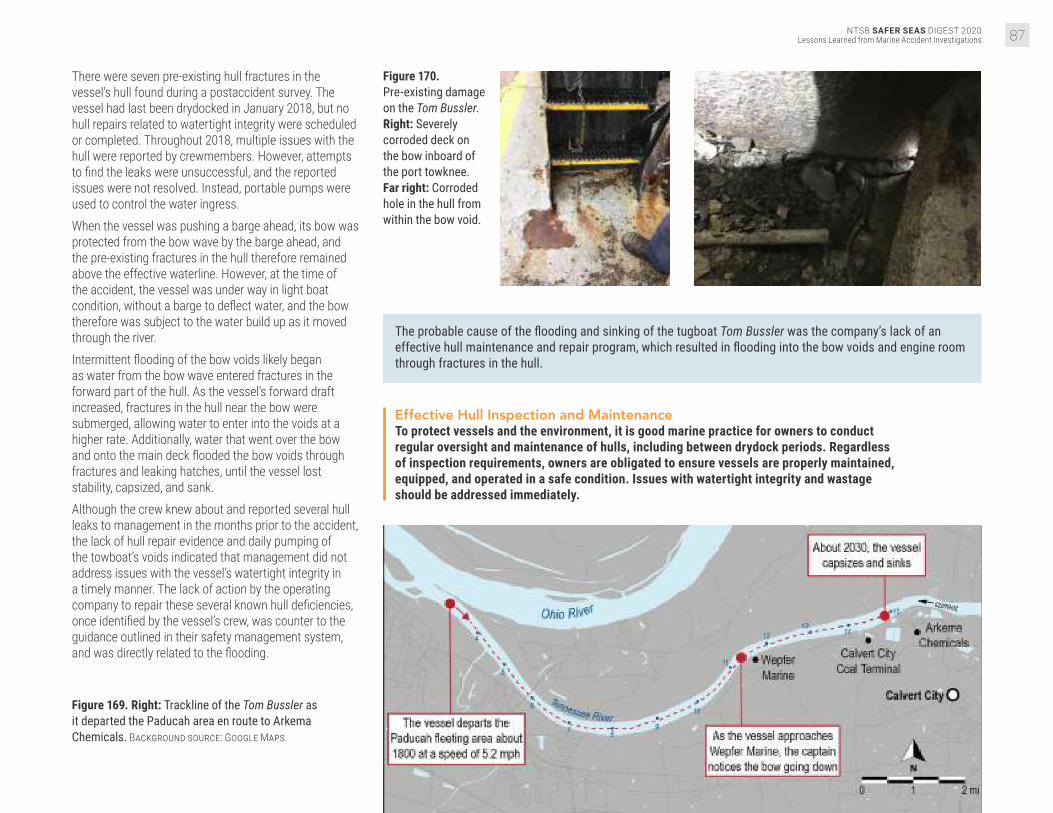
NTSB SAFER SEAS DIGEST 2020Lessons Learned from Marine Accident Investigations 87
There were seven pre-existing hull fractures in the vessel’s hull found during a postaccident survey. The vessel had last been drydocked in January 2018, but no hull repairs related to watertight integrity were scheduled or completed. Throughout 2018, multiple issues with the hull were reported by crewmembers. However, attempts to find the leaks were unsuccessful, and the reported issues were not resolved. Instead, portable pumps were used to control the water ingress. When the vessel was pushing a barge ahead, its bow was protected from the bow wave by the barge ahead, and the pre-existing fractures in the hull therefore remained above the effective waterline. However, at the time of the accident, the vessel was under way in light boat condition, without a barge to deflect water, and the bow therefore was subject to the water build up as it moved through the river. Intermittent flooding of the bow voids likely began as water from the bow wave entered fractures in the forward part of the hull. As the vessel’s forward draft increased, fractures in the hull near the bow were submerged, allowing water to enter into the voids at a higher rate. Additionally, water that went over the bow and onto the main deck flooded the bow voids through fractures and leaking hatches, until the vessel lost stability, capsized, and sank. Although the crew knew about and reported several hull leaks to management in the months prior to the accident, the lack of hull repair evidence and daily pumping of the towboat’s voids indicated that management did not address issues with the vessel’s watertight integrity in a timely manner. The lack of action by the operating company to repair these several known hull deficiencies, once identified by the vessel’s crew, was counter to the guidance outlined in their safety management system, and was directly related to the flooding.
Figure 169. Right: Trackline of the Tom Bussler as it departed the Paducah area en route to Arkema Chemicals. Background source: Google Maps.
Figure 170. Pre-existing damage on the Tom Bussler. Right: Severely corroded deck on the bow inboard of the port towknee. Far right: Corroded hole in the hull from within the bow void.
The probable cause of the flooding and sinking of the tugboat Tom Bussler was the company’s lack of an effective hull maintenance and repair program, which resulted in flooding into the bow voids and engine room through fractures in the hull.
Effective Hull Inspection and MaintenanceTo protect vessels and the environment, it is good marine practice for owners to conduct regular oversight and maintenance of hulls, including between drydock periods. Regardless of inspection requirements, owners are obligated to ensure vessels are properly maintained, equipped, and operated in a safe condition. Issues with watertight integrity and wastage should be addressed immediately.

NTSB SAFER SEAS DIGEST 2020Lessons Learned from Marine Accident Investigations88
Gro
undi
ng/S
trand
ing VESSEL GROUP
FISHING
Grounding of Fishing Vessel FreyjaBering Sea, near Point Tebenkof, Unalaska Island, Alaska
ACCIDENT DATEMarch 9, 2019ACCIDENT IDDCA19FM024
REPORT NUMBERMAB 20/10ISSUEDMarch 2, 2020
Figure 171. Inset: The fishing vessel Freyja before the accident. Source: Monson Fisheries, LLC.
About 0155 local time on March 9, 2019, the commercial fishing vessel Freyja was longline fishing in the Bering Sea near Point Tebenkof,
Unalaska Island, Alaska, when the vessel grounded and remained stranded on the rocks. The four crewmembers abandoned the vessel and swam to a nearby Good Samaritan vessel. The vessel was considered a total loss, with damage estimates at $550,000. There were no reports of injuries or pollution. The crew of the Freyja was based in Kodiak, Alaska, and fished out of Dutch Harbor. The crew included three deckhands (hereinafter referred to as deckhands 1, 2, and 3), in addition to the captain. The crew had been on board the vessel since January 19, 2019, and had been working in the Alaska cod fishery, which had opened on January 1, 2019.
On March 7, the Freyja arrived at Dutch Harbor around 0130 to deliver cod. Once more frozen bait was loaded, the vessel got under way (between 1200 and 1300) to the fishing grounds on the northwest side of Unalaska Island. The captain typically liked the crew to get 6–8 hours of sleep per day, but during the first couple of weeks on this fishing trip, they were “going pretty good and they were getting burned out.” To counter their fatigue, he said that he tried to ensure the crew was getting 4 hours of rest at a time, hoping that they were sleeping at least 3 of those hours, twice a day. However, the captain did not have a formal policy for work and rest that would have ensured the crew had the opportunity for uninterrupted sleep during their off-duty hours.
Figure 172. Below: The Freyja postaccident, on March 18, 2019, along the shore of Point Tebenkof. Source: Coast Guard.

NTSB SAFER SEAS DIGEST 2020Lessons Learned from Marine Accident Investigations 89
Figure 173. Freyja postaccident. Source: Coast Guard.
When others took the opportunity to rest, deckhand 1 was frequently preparing their meals. The captain was unsure how much sleep the deckhand was getting and recalled that, over the week leading up to the accident, the deckhand was often the last one out of his bunk. On the evening of March 8, about 3 hours before the accident, the captain directed the deckhands to alternate watchstanding shifts (each 45–60 minutes) while they moved at about 1.5 knots with a string of baited hooks in the water. The on-watch deckhand was responsible for awakening the relief deckhand. This irregular watchstanding schedule compounded the likelihood of a single point of failure, where, if the on-duty watchstander became incapacitated for any reason, he could not notify his relief, and the wheelhouse would be left unattended. The captain estimated that the Freyja was 1–2 miles offshore when he handed the watch over to deckhand 1, between “2200 or perhaps 2230.” The Freyja was equipped with a bridge watch alarm, which worked by requiring the watchstander to reset the alarm at preset time intervals in order to prevent the watchstander from falling asleep for a prolonged period. If the watchstander did not reset the alarm, audible and visual alarms would activate. Deckhand 1 stated that he believed the alarm was set to sound every 10–15 minutes.Deckhand 1 had about 10 minutes remaining on his watch when he fell asleep. He was awakened, nearly three hours later, when the Freyja struck the rocks on the western side of Driftwood Bay, near Point Tebenkof, about 0130. He was asleep in the wheelhouse for about 2 hours before the Freyja grounded, indicating that the bridge watch alarm either was not set or was not loud enough, or the deckhand was extremely fatigued.
After confirming that there was no flooding or damage, the captain put the vessel in astern propulsion in an attempt to free the Freyja from the rocks, to no avail. During the ongoing attempt to maneuver off the rocks, the generator failed, and the captain lost rudder control and shut down the main engine. The captain then issued a Mayday call over VHF around 0155. A nearby Good Samaritan vessel arrived around 0230, and the crew swam two at a time to the vessel. The grounding occurred at a time where circadian rhythm is at a low. An individual’s strongest sleep drive generally occurs between 0100–0500 and 1300–1500. The fatigue experienced during these circadian lows is exacerbated
when a person is sleep-deprived. If crewmembers were only sleeping 3–4 hours per 24 hours in the weeks before the accident, and then still only sleeping 4–6 hours in the days prior, they likely had an accumulated sleep deficit, resulting in chronic fatigue. The NTSB has investigated several fishing vessel accidents in which fatigue played a primary role. In these accidents, as well as the Freyja grounding (Alaska cod fishery), the economic pressure to operate continuously encourages working longer hours with little to no sleep in order to fill quotas. This open-access, “derby-style” fishing inherently leads to fatigued crew.
The probable cause of the grounding of the fishing vessel Freyja was the failure of the deckhand on watch to monitor the vessel’s track as a result of falling asleep due to an accumulated sleep deficit and the vessel owner’s lack of countermeasures to mitigate crewmember fatigue.
Fatigue CountermeasuresAs the NTSB has previously noted in numerous commercial fishing vessel accidents, crew fatigue is a significant contributing causal factor. An effective way to prevent fatigue among crewmembers is for owners/operators to have measures in place to ensure that crewmembers receive enough rest to adequately perform navigational and lookout duties.
Immersion SuitsMarine safety training and periodic drills are designed to provide crewmembers with the knowledge and skills they need to respond to vessel emergencies. For lifesaving equipment to be effective, vessel owners/captains should ensure that each individual on board is aware of how to don an immersion suit or other personal flotation device, and understands how to use the equipment correctly. It is also the responsibility of each crewmember to ensure that immersion suits are the proper size, in serviceable condition, and readily accessible.
Figure 174. Right: The Freyja’s starboard side, showing structural damage due to grounding. Source: Resolve Magone Marine.

NTSB SAFER SEAS DIGEST 2020Lessons Learned from Marine Accident Investigations90
Gro
undi
ng/S
trand
ing VESSEL GROUP
RECREATIONAL
Grounding and Sinking of Recreational Vessel Silver LiningHood Canal, southwest of Hood Canal Bridge, Puget Sound, Washington
ACCIDENT DATEJuly 23, 2019ACCIDENT IDDCA19FM044
REPORT NUMBERMAB 20/20ISSUEDMay 5, 2020
Figure 175. Silver Lining prior to the accident. Source: David Silver.
On July 23, 2019, at about 1500 local time, the recreational yacht Silver Lining hit a submerged rock southwest of the Hood Canal Bridge in Hood
Canal, Washington. The vessel sustained damage to the hull, propellers, and rudders, and took on water. The eight people on board safely departed the vessel. The flooding could not be controlled, and a salvage company moved the vessel to shallow water, where it later sank. There were no reports of injuries or release of fuel oil into the marine environment. The property damage was determined to be $500,000.The Silver Lining was a privately owned recreational vessel used as a year-round residence. On the day of the grounding, at about 1330 local time, the vessel departed Pleasant Harbor Marina up the Hood Canal for a water tour of the Seattle area with family members on board. The owner was operating the yacht from the flying bridge, which had no GPS. He had a paper navigation chart for reference but was using dead reckoning to navigate.
Figure 176. Silver Lining following the accident. Source: Coast Guard.
About 1500, the vessel was traveling northeast and approaching the Hood Canal Bridge. Before turning to pass through the western span of the bridge, the vessel had to pass the Sisters, two pinnacle rock formations 0.57 miles southwest of the bridge. The southern Sister rock is marked with a fixed day board and a flashing red navigation light maintained by the Coast Guard.
Figure 177. Below: Damage sustained to the port propeller and rudder (left) and starboard propeller and rudder (right) of the Silver Lining following the accident.

NTSB SAFER SEAS DIGEST 2020Lessons Learned from Marine Accident Investigations 91
Figure 178. Silver Lining following the accident. Source: Coast Guard.
The owner of the Silver Lining used the dinghy that was being towed astern on a 100-foot line as a reference point to verify that the vessel had passed the Sisters rocks. After he saw that the dinghy had passed the
number 4 navigation aid marker, he thought it was safe to turn to port. However, based on the charts of the Sisters, at this point the Silver Lining had not yet completely passed the southern Sister, and the northern section of the Sisters was still ahead of the vessel to the port side.Shortly after the vessel started to turn, it grounded on the Sisters. The vessel had a listed draft of 5.5 feet, which was the maximum estimated depth of the area it grounded in at the time, accounting for the tide. It is most likely that the vessel’s starboard propeller first contacted the northern Sister rocks, which shut down the starboard engine. As the vessel proceeded, the keel from midships to the stern contacted the rocks at least three times, causing the vessel to rapidly slow and the damaged hull to take on water. At the same moment, the port propeller also contacted the rocks, causing additional damage and shutting down the port engine. The owner sent his family to shore on the dinghy, and then contacted the Coast Guard.
Figure 179. Below: Damage to the keel of the Silver Lining postaccident.
Figure 180. Map of the Hood Canal Bridge, including an estimated trackline of the Silver Lining’s intended course. Source: NOAA Chart No. 18476, annotated by NTSB.
The owner attempted use both engines to move the vessel, but they shut down when put in gear. He started the port engine, using its cooling system to serve as an emergency bilge pump to dewater the engine room and left to join his family on shore. When first responders arrived about 1615, the owner returned to the vessel and discovered that the port engine had stopped. A Coast Guard station boat arrived on scene at 1637 and tried to dewater the vessel, but about 1700, it sank with just the bow still visible above the surface and still adrift.The vessel had significant damage to the aft section of the keel and hull, and the rudders and propellers were also extensively damaged. The damage would have resulted in flooding of the vessel.
The probable cause of the grounding and sinking of the recreational yacht Silver Lining was the vessel’s operator not properly determining the Silver Lining’s position approaching the west span of the Hood Canal Bridge from the south, resulting in damage and uncontrolled flooding after striking the charted Sisters underwater shoal.

NTSB SAFER SEAS DIGEST 2020Lessons Learned from Marine Accident Investigations92
Hul
l/Mac
hine
ry/E
quip
men
t Dam
age VESSEL GROUP
TANKER
Overpressurization and Rupture of Cargo Tank on Cargo Vessel Fairchem FillyVopak Terminal, Ship dock 5, Houston Ship Channel, Deer Park, Texas
ACCIDENT DATEMay 30, 2019ACCIDENT IDDCA19FM037
REPORT NUMBERMAB 20/14ISSUEDMarch 26, 2020
On May 30, 2019, about 0750 local time, the Marshall Islands-flagged chemical tanker Fairchem Filly, with a crew of 22, experienced
an overpressurization of the number 3 port and starboard cargo tanks while discharging liquid hexene at Vopak Terminal in Deer Park, Texas. The overpressurization resulted in damage to the number 3 port cargo tank and the tank top (deck). All cargo was contained on board the double-hulled vessel, with no pollution or injuries reported. Damage to the Fairchem Filly was estimated at $750,000, and the contaminated cargo was an estimated $100,000 loss. On the morning of the accident, the chief officer, third officer, and pumpman on the took part in the cargo discharge operation to the terminal. The terminal crew consisted of three people: a shift supervisor, a dock supervisor, and a dockman. At 0430, the dock supervisor, who was acting as Vopak’s PIC for the
transfer, met with the chief officer in the tanker’s cargo control room, where they discussed the planned discharge operation. The Vopak PIC provided the chief officer with a UHF radio for communication and disembarked the vessel after completing paperwork.The tanker’s number 1 starboard (1S), 2 starboard (2S), and 3 port and starboard (3P and 3S, respectively) cargo tanks were to be discharged. Tank 1S was approximately 38% full and contained methyl isobutyl ketone in a liquid state. Tanks 2S, 3P, and 3S were each 93% full and contained liquid hexene. All other cargo tanks were empty. The Fairchem Filly utilized nitrogen (supplied by the terminal) to maintain a 2-psi blanket over the hexene during its transfer to the terminal. Vopak distributed nitrogen at 90 psi to the docks, and connected either a 2- or 4-inch shore-supplied hose to vessels for purging and blanketing tanks.
Figure 181. Below: Chemical tanker Fairchem Filly after the accident in Galveston, Texas.

NTSB SAFER SEAS DIGEST 2020Lessons Learned from Marine Accident Investigations 93
Figure 182. Cargo manifold configuration on board the Fairchem Filly at the time of the accident. Source: Vopak.
Vopak’s dockman and the Fairchem Filly’s pumpman connected 6-inch cargo discharge hoses and a 4-inch nitrogen hose to the tanker. The nitrogen hose was connected via a reducer to the vessel’s 6-inch vapor recovery line. To control nitrogen flow, the shore used a 4-inch gate valve, and the vessel used a 6-inch butterfly valve. At 0705, the chief officer started the 3P and 3S cargo pumps from the cargo control room to begin discharging hexene (which was already inerted at about 2-psi in tanks). At this time, the vessel’s 6-inch nitrogen valve was closed, and the 4-inch nitrogen shore valve was said to be about a quarter open. At 0738, the low inert gas pressure alarms for the 3P and 3S tanks sounded in the cargo control room, indicating that the tanks’ pressure had fallen below the low setting of 0.73 psi and the nitrogen blanket was being depleted.
Figure 183. PV valves on board the main deck of the Fairchem Filly.
Unable to contact the Vopak PIC, the chief officer had the pumpman open the ship’s nitrogen valve fully. At 0748, the 3P and 3S tanks registered an “ERROR” alarm, indicating a pressure of over 3.2 psi. About the same time, both the 3P and 3S cargo tanks protective PV valves, which were set to open at 2.9 psi, opened. It was later determined that rapid pressurization of the cargo tanks occurred, exceeding the PV valve capacity and overpressurizing the tanks to 15.8 psi. At 0749, the ship’s crew turned off the cargo pumps, the terminal and the vessel closed their respective valves, and cargo transfer operations ceased.The terminal’s crew had work instructions requiring that a 2-inch nitrogen hose be used to transfer liquid cargo, and the ship’s crew had an onboard manual that
required use a 1-inch hose or orifice for blanketing. However, on the day of the accident, a 4-inch nitrogen hose was connected with no orifice installed, which removed engineered controls designed to limit the flow rate of nitrogen to the cargo tanks safely below their maximum relief capacity. Although the PV valves likely performed as designed, the combined effect of the nitrogen pressure at the dock, the amount that the valves were open, and the larger 4-inch hose resulted in a flow rate larger than their maximum capacity. Since the nitrogen hose connection was improperly configured, without accurate and ongoing throttling of the nitrogen control valves, the risk of overpressurization was constant. Control was accomplished by the ship or terminal personnel by manually adjusting the dock or ship valve at the time of the accident. Therefore, communication between the ship and terminal personnel was critical. The chief mate repeatedly attempted to contact terminal personnel via a handheld radio to request nitrogen, but the Vopak PIC did not answer. Instead of stopping the operation until communications could be restored, the chief officer had the pumpman fully open the nitrogen valve, effectively removing all shipboard throttling control of the nitrogen coming on board.
The probable cause of the overpressurization and rupture of the 3P cargo tank aboard the Fairchem Filly during offloading was the vessel and terminal personnel involved not following policies and procedures related to cargo discharge and nitrogen-blanketing operations. Contributing to the casualty was the lack of effective communication between the vessel and terminal personnel and the decision of the vessel’s PIC to continue discharge operations after being unable to communicate with the terminal.
4-inch connection
Hexene MIBK Nitrogen
6-inch cargo connections

NTSB SAFER SEAS DIGEST 2020Lessons Learned from Marine Accident Investigations94
Oth
er VESSEL GROUP
OFFSHORE SUPPLY
Overturning of the Liftboat Kristin FayeGulf of Mexico, Main Pass Block 64, about 18 miles east of Venice, Louisiana
ACCIDENT DATESeptember 8, 2019ACCIDENT IDDCA19FM050
REPORT NUMBERMAB 20/36ISSUEDNovember 4, 2020
Figure 184. When the captain raised the Kristin Faye’s port crane boom, its center of gravity shifted about 17 feet.
Figure 185. Kristin Faye (right) in an elevated position alongside Platform AQ (left) before the accident. Source: Sanare Energy Partners, LLC.
On September 8, 2019, about 1015 local time, the liftboat Kristin Faye overturned while preparing to conduct work alongside a platform in the Gulf
of Mexico, in Main Pass Block 64, located about 18 miles east of Venice, Louisiana. All three crewmembers abandoned the vessel and were rescued. One person suffered minor injuries during the evacuation. An estimated 120 gallons of diesel fuel were released. The vessel was declared a constructive total loss at an estimated $750,000. The Kristin Faye had three hydraulically driven legs that allowed the vessel to lift out of the water once the pads of the legs were in place on the seafloor, and had two boom cranes on its bow: one to starboard and a larger-capacity crane to port.The morning of the accident, the Kristin Faye headed toward Platform AQ to receive and transfer the repaired 17,000-pound tank it had offloaded several days earlier. The captain maneuvered the liftboat slightly closer to Platform AQ than it had been a few days earlier, so the liftboat could extend a walkway to it. The captain said he was confident that a bottom survey used for the Kristin Faye’s operations at the platform five days earlier still verified the sea bottom clear of hazards or obstructions.
The captain prepared to conduct a preload test, which would determine whether the vessel would remain stable while jacked up in an area where silt deposits, mud ledges, and “can holes” were prevalent. For the test, the captain jacked the boat up above the 35-foot-deep water for an air gap of about 6 feet between the hull and the surface, then let it sit for an hour. He then jacked the boat up to the desired operating height, an air gap of roughly 20 to 25 feet and let it sit for another hour to ensure no further settling or movement. Next, the captain left the wheelhouse and went to the port crane control station to test the crane’s movement to ensure it would clear Platform AQ during operations. The captain moved the crane boom from its stowed horizontal position, brought it completely vertical, and started turning it. Immediately, the Kristin Faye began tilting to port. The captain ran to the wheelhouse, where he attempted to level the hull by raising (retracting) the starboard and aft legs to match the height of the falling port corner. However, the vessel continued to fall to port.Once the port crane boom was moved from its cradle to the vertical position, the 22,500-pound boom’s center of gravity shifted about 17 feet toward its pedestal at the forward port corner of the liftboat. This weight shift increased the weight supported by the forward leg pad until the pad suddenly “punched through” the bottom.

NTSB SAFER SEAS DIGEST 2020Lessons Learned from Marine Accident Investigations 95
The captain estimated that it took less than one minute from the time he first felt the liftboat tilting until the port side was in the water. Unable to get to the bow with the other crewmembers, he initiated emergency calls, donned his lifejacket, jumped into the water, and swam to the safety of a nearby vessel. The two other crewmembers held onto the vessel’s rail until they were rescued with a personnel basket from the Platform AQ. The Kristin Faye and other small liftboats that lack preload tanks and operate in the Gulf of Mexico typically conduct preload tests using only the weight (displacement) of the vessel, including any cargo or equipment. If the vessel does not shift for a time after planting its pads on the seafloor, the procedure assumes the vessel will remain stable. However, a preload test should account for the most extreme loading conditions a liftboat will experience while elevated. For a liftboat without preload tanks, the test should include sufficient weights, appropriately placed to replicate the anticipated load on each pad. For instance, the preload test on the accident day could have included locating the boom, with the tank attached, in the position that would have applied the greatest force on the respective pad.
The probable cause of the overturning of the liftboat Kristin Faye was the company’s inadequate preload procedure that did not account for crane movements or the planned loads (weights) to be lifted, resulting in a “punch through” of one of the vessel’s three legs.
Figure 186. The toppled Kristin Faye after abandonment. Source: Sanare Energy Partners, LLC.
Liftboat Preload TestsPrior to jacking up to expected operating height and commencing operations, liftboat operators should conduct preload tests, with the hull close to the water, that simulate all planned operational loads.

NTSB SAFER SEAS DIGEST 2020Lessons Learned from Marine Accident Investigations96
Lessons LearnedAccident reports issued in 2020 remind us of perennial
safety concerns in accident scenarios such as
bridge strikes, and dramatically demonstrated that new
lithium-ion battery hazards can be every bit as deadly as
the worst storms. The NTSB responds to accident lessons
by issuing and reiterating safety recommendations, until
safety improvements become realities on board vessels,
throughout the organizations that operate them, and in
the Coast Guard’s regulations.
The real world is a peculiar academy. Its lessons are free to
all who would act on them. It is those who do not attend
(or attend to) accident lessons who most risk paying a
steep price—not necessarily only a financial one.
It is our hope that captains, mariners, pilots, and personnel
ashore learn to view their operation through the eyes of an
investigator. What lessons might investigators find if your
vessel were in an accident? Have previous investigations
yielded mitigations?
We hope that this collection of lessons learned in the
investigations closed in 2020 helps readers to take a step
back and view their own operation with a cold, critical eye,
then return to their day-to-day routines ready to take the
appropriate action.
Navigating Through Bridges
Bridge strikes were the most common accident investigated and reported on by the NTSB in 2020. Restricted maneuvering room, unusual currents, low clearance heights, and obscured sight lines can all combine to make bridge transits more difficult. During high-water conditions, these factors are exacerbated by increased and varying currents and reduced ability to control speed. When transiting familiar waterways, complacency can set in, leading to reduced attentiveness when operating near bridges. Mariners are advised to always plan for and take caution during bridge transits, regardless of familiarity, taking special note of the environmental conditions and special maneuvering considerations of the vessel.
Inadequate planning for a bridge transit was a factor in the Kristin Alexis–Mr Ervin, Rivers Wilson, Edna T. Gattle, Silver Lining, Dewey R, and Dank Silver accidents.Hazardous conditions while navigating through a bridge were a factor in the William C, Rivers Wilson, Chad Pregracke, and Edna T Gattle accidents.
Standard Operating Procedures
Improper operation of equipment, poor maintenance, and ineffective action to prevent or mitigate an emergency can often be traced to the absence of standardized procedures or the failure to follow standard procedures. At a minimum, specific written procedures should be developed for planned vessel operations, the regular maintenance and testing of equipment, and potential emergencies such as fire, flooding, and man overboard. Once procedures have been implemented, owners and operators should ensure crewmembers are thoroughly trained in and adhere to the procedures. By actively involving themselves in ensuring procedures are followed, owners and operators can identify and correct when non-conformities exist and mitigate future risk.
Inadequate standard operating procedures were a factor in the Goose Creek, IB1940, Jackson County Park Marina, Kristin Alexis–Mr Ervin, Kristin Faye, St. Clair, and Conception accidents.Failure to follow standard operating procedures was a factor in the Fairchem Filly, Fitzgerald, and Conception accidents.
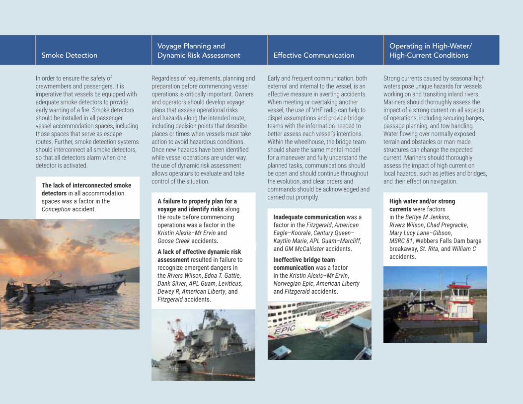
NTSB SAFER SEAS DIGEST 2020Lessons Learned from Marine Accident Investigations 97
Smoke Detection
In order to ensure the safety of crewmembers and passengers, it is imperative that vessels be equipped with adequate smoke detectors to provide early warning of a fire. Smoke detectors should be installed in all passenger vessel accommodation spaces, including those spaces that serve as escape routes. Further, smoke detection systems should interconnect all smoke detectors, so that all detectors alarm when one detector is activated.
The lack of interconnected smoke detectors in all accommodation spaces was a factor in the Conception accident.
Voyage Planning and Dynamic Risk Assessment
Regardless of requirements, planning and preparation before commencing vessel operations is critically important. Owners and operators should develop voyage plans that assess operational risks and hazards along the intended route, including decision points that describe places or times when vessels must take action to avoid hazardous conditions. Once new hazards have been identified while vessel operations are under way, the use of dynamic risk assessment allows operators to evaluate and take control of the situation.
A failure to properly plan for a voyage and identify risks along the route before commencing operations was a factor in the Kristin Alexis–Mr Ervin and Goose Creek accidents. A lack of effective dynamic risk assessment resulted in failure to recognize emergent dangers in the Rivers Wilson, Edna T. Gattle, Dank Silver, APL Guam, Leviticus, Dewey R, American Liberty, and Fitzgerald accidents.
Effective Communication
Early and frequent communication, both external and internal to the vessel, is an effective measure in averting accidents. When meeting or overtaking another vessel, the use of VHF radio can help to dispel assumptions and provide bridge teams with the information needed to better assess each vessel’s intentions. Within the wheelhouse, the bridge team should share the same mental model for a maneuver and fully understand the planned tasks, communications should be open and should continue throughout the evolution, and clear orders and commands should be acknowledged and carried out promptly.
Inadequate communication was a factor in the Fitzgerald, American Eagle–Koorale, Century Queen–Kaytlin Marie, APL Guam–Marcliff, and GM McCallister accidents. Ineffective bridge team communication was a factor in the Kristin Alexis–Mr Ervin, Norwegian Epic, American Liberty and Fitzgerald accidents.
Operating in High-Water/ High-Current Conditions
Strong currents caused by seasonal high waters pose unique hazards for vessels working on and transiting inland rivers. Mariners should thoroughly assess the impact of a strong current on all aspects of operations, including securing barges, passage planning, and tow handling. Water flowing over normally exposed terrain and obstacles or man-made structures can change the expected current. Mariners should thoroughly assess the impact of high current on local hazards, such as jetties and bridges, and their effect on navigation.
High water and/or strong currents were factors in the Bettye M Jenkins, Rivers Wilson, Chad Pregracke, Mary Lucy Lane–Gibson, MSRC 81, Webbers Falls Dam barge breakaway, St. Rita, and William C accidents.

NTSB SAFER SEAS DIGEST 2020Lessons Learned from Marine Accident Investigations98
Less
ons
Lear
ned
Lithium-ion Battery Hazards
Lithium-ion batteries are used extensively in cell phones, cameras, computers, and other equipment, and are increasingly found in marine applications, including propulsion systems. The proliferation of these energy sources presents some risk, however. Auto-ignition of lithium-ion batteries have been reported throughout all modes of transportation and have the potential to start larger fires. Devices with lithium-ion batteries should not be left unattended, particularly while charging, and owners and operators should develop procedures for the storage and emergency disposal of such batteries.
The unmonitored charging and storage of lithium-ion batteries may have been a factor in the Conception accident.
Crew Training
When training new crewmembers, it is important to thoroughly explain the systems and procedures used aboard a vessel and to conduct practical training that simulates scenarios comparable to the operations in which a crewmember will be serving. Additionally, trainers should maintain heightened attention and consider a trainee’s experiences and skill level when allowing the trainee to operate a vessel in difficult circumstances.
Ineffective crew training was a factor in the Conception, St. Rita, Leviticus, and Fitzgerald accidents.
Vessel Speed
When maneuvering in restricted or busy waterways, vessel speed can be a tight balancing act. Vessels must operate at a slow enough speed to safely navigate through the waterway and traffic while still keeping sufficient waterflow over the rudder to maintain effectiveness. While conning a vessel, operators must consider the size and maneuverability of the vessel, traffic and environmental conditions, and the status of tugboats and assist vessels. During difficult docking or manuevering situations, operators should consider employing additional tugboats.
Vessel speed was a factor in the Hawk, GM McCallister, and Fitzgerald accidents.
Storage of Flammable or Combustible Materials
When storing flammable or combustible materials or liquids, operators should pay close attention to potential heat or ignition sources and any special storage requirements. Gasoline is particularly dangerous to store due to its high volatility and flammability. Gasoline should only be stored in tanks designed to established standards, and spaces containing these tanks should be designed and ventilated according to established standards, to ensure gasoline vapor does not become entrapped. Vessel owners and mariners must also ensure that components and equipment near flammable liquids or vapors are properly grounded and intrinsically safe.
The improper storage of gasoline was a factor in the Alaganik accident, and the storage of combustible materials near a heat source was a factor in the St. Clair accident.

NTSB SAFER SEAS DIGEST 2020Lessons Learned from Marine Accident Investigations 99
Closing Ventilation Inlets During a Fire
Fixed fire-extinguishing systems in engineering and other hazardous spaces require a minimum concentration of extinguishing agent to either halt the chemical reaction producing the fire, displace the oxygen feeding the fire, or effect a combination of both. To ensure the effectiveness of the system and prevent the reintroduction of oxygen to the space, all ventilation inlets should be designed or modified to be closed remotely or covered by the vessel’s crew.
In the Ariel accident, fixed-open ventilation inlets allowed a fire to continue and grow, despite the efforts of the crew to cover the openings.
Effective Hull Inspection and Maintenance
To protect vessels and the environment, it is good marine practice for owners and operators to conduct regular oversight and maintenance of hulls, including between drydock periods. Regardless of inspection requirements, owners are obligated to ensure vessels are properly maintained, equipped, and operated in a safe condition. Issues with watertight integrity and wastage should be addressed immediately.
An ineffective hull maintenance and repair program was a factor in the Tom Bussler and Miss Dixie–D&R Boney accidents.The deteriorated condition of a barge was a factor in the Chattie Sue Smith accident.
Inspection of Control Linkages
Operators of vessels using adjustable linkages that include jam nuts, locking nuts, or other devices should frequently examine the position of the linkages to verify their security and develop procedures to effectively ensure critical control system components are included in preventative maintenance programs. Component and control system manufacturers should provide guidance/options for passively securing jam nuts and shackle pins, such as locking wire, locking washers, securing tabs, thread-locking insert materials, thread-locking fluid, or other means.
The failure of a critical linkage was a factor in the Lindberg Crosby accident.
Fatigue
Fatigue is a longstanding issue that has plagued all sectors of the marine industry (indeed all sectors of transportation), and the 2020 reporting period was no different. Failing to get adequate sleep is a high-risk practice that leads to accidents. To prevent fatigue among crewmembers, companies should monitor the watch schedules of their crews to ensure that they are properly rested and are afforded proper work/rest schedules. Crewmembers also should be encouraged to request assistance from other crewmembers if they feel fatigued.
Fatigue was a factor in the Freyja, Fitzgerald, and Dixie Vandal accidents.
" With every investigation we learn new safety lessons to prevent or mitigate future losses, but only when marine stakeholders at all levels of the industry apply these lessons ."Jennifer Homendy, NTSB Chair

NTSB SAFER SEAS DIGEST 2020Lessons Learned from Marine Accident Investigations100
Vessel ParticularsACCIDENT VESSEL GROUP/TYPE FLAG LENGTH DRAFT BEAM/WIDTH
PERSONS ON BOARD
PAGE NUMBER
ACX Crystal CARGO • Containership Philippines 730.3 ft (222.6 m) 39.4 ft (12 m) 98.8 ft (30.1 m) 21 18
Alaganik TOWING • Barge United States 98 ft (29.9 m) 24 ft (7.32 m) 2.5 ft (0.8 m) 1 66
American Eagle FISHING • Fishing vessel United States 258.4 ft (78.8 m) 45.6 ft (14 m) 22.2 ft (6.75 m) 33 10
American Liberty TANKER • Bulk liquid cargo vessel United States 601.3 ft (183.3 m) 105.7 ft (32.2. m) 36.8 ft (11.2 m) 24 28
APL Guam CARGO • Containership United States 505.2 ft (154 m) 82 ft (25 m) 31.2 ft (9.5 m) 21 12
Ariel FISHING • Fishing vessel United States 50 ft (15.2 m) 5.5 ft (1.7 m) 15.5 ft (4.7 m) 4 68
Bettye M. Jenkins TOWING • Towing vessel United States 56 ft (17 m) 6 ft (1.8 m) 36 ft (11 m) 2 32
Century Queen CARGO • Bulk carrier Panama 449 ft (137 m) 10.5 ft (3.2 m) 75 ft (23 m) 21 14
Chad Pregracke TOWING • Towing vessel United States 173 ft (52.7 m) 11 ft (3.4 m 48 ft (14.6 m) 9 34
Chamorro TOWING • Towing vessel United States 105 ft (32 m) 12.5 ft (3.8 m) 30 ft (9.1 m) 10 84
Chattie Sue Smith TOWING • Towing vessel United States 46.5 ft (14.2 m) 5.5 ft (1.7 m) 20 ft (6.1 m) 0 82
Conception PASSENGER • Small passenger vessel United States 75 ft (23 m) 26 ft (7.9 m) 4 ft (2.1 m) 39 70
D.& R. Boney TOWING • Towing vessel United States 128 ft (39 m) 9.5 ft (2.9 m) 42 ft (12.8 m) 8 24
Dank Silver CARGO • Bulk liquid cargo vessel Marshall Islands 600.6 ft (183.1 m) 40.9 ft (12.5 m) 105.5 ft (32.2 m) 19 36
DeJeanne Maria TOWING • Towing vessel United States 55 ft (16.8 m) 23 ft (7 m) 6 ft (1.8 m) 3 38
Delbert D Black OTHER • Destroyer Undesignated 509.5 ft (155.3 m) 66.4 ft (20.2 m ) 32.5 ft (9.9 m) 350* 22
Dewey R TOWING • Towing vessel United States 136 ft (41.5 m) 10 ft (3 m) 40 ft (12.2 m) 8 40
Dixie Delight (and others) RECREATIONAL • Houseboat N/A Various Various Various 18 76
Dixie Vandal TOWING • Towing vessel United States 71.2 ft (21.6 m) 10.2 ft (3.1 m) 24.2 ft (7.4 m) 5 16
Edna T. Gattle TOWING • Towing vessel United States 98.8 ft (30.1 m) 32 ft (9.8 m) 10.2 ft (3.1 m) 6 42
Fairchem Filly TANKER • Chemical tanker Marshall Islands 479 ft (146 m) 19 ft (5.8 m) 78.7 ft (24 m) 22 94
Fitzgerald GOVERNMENT • US Navy Destroyer United States 504.5 ft (153.8 m) 32.5 ft (9.9 m) 66.4 ft (20.2 m) 315 18
Freyja FISHING • Fishing vessel United States 58 ft (17.7 m) 8.3 ft (2.5 m) 20 ft (6.1 m) 4 90
G.M. McAllister TOWING • Tugboat United States 110 ft (33.5 m) 16 ft (4.9 m) 33 ft (10.1 m) 4 / 23 44
Gibson GOVERNMENT • Corps of Engineers workboat United States 40 ft (12.2 m) 3 ft (0.9 m) 16 ft (4.9 m) 0 56
Goose Creek TOWING • Towing vessel United States 65 ft (19.8 m) 8.9 ft (2.7 m ) 23 ft (7 m) 3 46
Hansa Steinburg CARGO • Containership Liberia 575.6 ft (175.4 m) 90 ft (27.4 m) 35.8 ft (10.9 m) Unknown 14
Hawk CARGO • Heavy lift vessel Norway 732 ft (223.1 m) 182.1 ft (55.5 m) 33.1 ft (10.1 m) 35 22
IB1940 TOWING • Barge United States 200 ft (61 m) 35 ft (10.7 m) N/A 0 78
Kaitlyn Marie TOWING • Towing vessel United States 126 ft (38.4 m) 10 ft (3 m) 34 ft (10.5 m) 7 14
Koorale FISHING • Fishing vessel United States 182.1 ft (55.5 m) 40 ft (12.2 m) 15.2 ft (4.6 m) 19 10
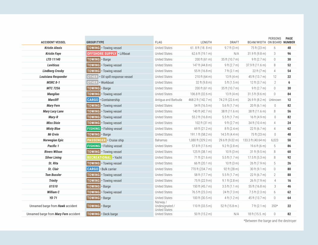
NTSB SAFER SEAS DIGEST 2020Lessons Learned from Marine Accident Investigations 101
ACCIDENT VESSEL GROUP/TYPE FLAG LENGTH DRAFT BEAM/WIDTHPERSONS ON BOARD
PAGE NUMBER
Kristin Alexis TOWING • Towing vessel United States 61. 8 ft (18. 8 m) 9.7 ft (3 m) 75 ft (23 m) 6 48
Kristin Faye OFFSHORE SUPPLY • Liftboat United States 62.6 ft (19.1 m) N/A 31.9 ft (9.8 m) 3 96
LTD 11140 TOWING • Barge United States 200 ft (61 m) 35 ft (10.7 m) 9 ft (2.7 m) 0 30
Leviticus TOWING • Towing vessel United States 147 ft (44.8 m) 9 ft (2.7 m) 37.9 ft (11.6 m) 8 52
Lindberg Crosby TOWING • Towing vessel United States 55 ft (16.8 m) 7 ft (2.1 m) 22 ft (7 m) 4 54
Louisiana Responder OTHER • Oil spill response vessel United States 210 ft (64 m) 13 ft (4 m) 45 ft (13.7 m) 12 22
MSRC 8-1 OTHER • Workboat United States 32 ft (9.8 m) 5 ft (1.5 m) 12 ft (3.7 m) 2 6
MTC 7256 TOWING • Barge United States 200 ft (61 m) 35 ft (10.7 m) 9 ft (2.7 m) 0 30
Mangilao TOWING • Towing vessel United States 106.8 ft (32.6 m) 13 ft (4 m) 31.5 ft (9.6 m) 0 84
Marcliff CARGO • Containership Antigua and Barbuda 468.2 ft (142.7 m) 74.2 ft (22.6 m) 26.9 ft (8.2 m) Unknown 12
Mary Fern TOWING • Towing vessel United States 54 ft (16.5 m) 5.6 ft (1.7 m) 20 ft (6.1 m) 0 82
Mary Lucy Lane TOWING • Towing vessel United States 140 ft (42.7 m) 38 ft (11.6 m) 38 ft (11.6 m) 8 56
Mary-R TOWING • Towing vessel United States 55.2 ft (16.8 m) 5.5 ft (1.7 m) 16 ft (4.9 m) 0 82
Miss Dixie TOWING • Towing vessel United States 102 ft (31 m) 9 ft (2.7 m) 34 ft (10.4 m) 4 24
Misty Blue FISHING • Fishing vessel United States 69 ft (21.2 m) 8 ft (2.4 m) 22 ft (6.7 m) 4 62
Mr Ervin TOWING • Barge United States 191.1 ft (58.2 m) 14.5 ft (4.4 m) 75 ft (23 m) 0 48
Norwegian Epic PASSENGER • Cruise ship Bahamas 1,080 ft (329.2 m) 29.6 ft (9.02 m) 133.3 ft (40.64 m) 6,023 58
Pacific1 FISHING • Fishing vessel United States 57.8 ft (17.6 m) 9.2 ft (2.8 m) 19.6 ft (6 m) 5 86
Rivers Wilson TOWING • Towing vessel United States 125 ft (38.1 m) 10 ft (3 m) 31 ft (9.5 m) 8 60
Silver Lining RECREATIONAL • Yacht United States 71 ft (21.6 m) 5.5 ft (1.7 m) 17.5 ft (5.3 m) 8 92
St. Rita TOWING • Towing vessel United States 66 ft (20.1 m) 10 ft (3 m) 26 ft (7.9 m) 5 26
St. Clair CARGO • Bulk carrier United States 770 ft (234.7 m) 92 ft (28 m) 30 ft (9.1 m) 0 80
Tom Bussler TOWING • Towing vessel United States 58 ft (17.7 m) 5.5 ft (1.7 m) 22 ft (6.7 m) 2 88
Trinity TOWING • Towing vessel United States 75 ft (22.9 m) 9.1 ft (2.8 m) 26 ft (7.9 m) 4 16
U1510 TOWING • Barge United States 150 ft (45.7 m) 3.5 ft (1.1 m) 55 ft (16.8 m) 3 46
William C TOWING • Towing vessel United States 76.5 ft (23.3 m) 24 ft (7.3 m) 7.5 ft (2.3 m) 6 62
YD 71 TOWING • Barge United States 100 ft (30.5 m) 4 ft (1.2 m) 45 ft (13.7 m) 0 64
Unnamed barge from Hawk accident TOWING • BargeNorway / Undesignated / United States
110 ft (33.5 m) 52 ft (15.8 m ) 7 ft (2.1 m) 350* 22
Unnamed barge from Mary Fern accident TOWING • Deck barge United States 50 ft (15.2 m) N/A 18 ft (15.5. m) 0 82
*Between the barge and the destroyer

NTSB SAFER SEAS DIGEST 2020Lessons Learned from Marine Accident Investigations102
Table and Map of Accident LocationsPAGE ACCIDENT VESSELS VESSEL TYPE ACCIDENT LOCATION CAPSIZING/LISTING 4 Louisiana Responder / MSRC 8-1 OTHER • Oil spill response vessel / Workboat Boothville Anchorage, Lower Mississippi River, mile 18, near Boothville, Louisiana6 Misty Blue FISHING • Fishing vessel Atlantic Ocean, 9 miles southeast of Nantucket, Massachusetts COLLISION 8 American Eagle / Koorale FISHING • Fishing vessel / Fishing vessel Pacific Ocean, approximately 1,475 nautical miles northeast of American Samoa10 APL Guam / Marcliff / Hansa Steinburg CARGO • Containership / Containership / Containership YL-4 Anchorage, Port of Yokohama, Tokyo Bay, Japan12 Century Queen / Kaitlyn Marie CARGO • Bulk carrier / TOWING • Towing vessel Lower Mississippi River, mile 126, near Hahnville, Louisiana14 Dixie Vandal / Trinity TOWING • Towing vessel / Towing vessel Houston Ship Channel, mile 44, Kinder Morgan Pasadena Liquids Terminal, Pasadena, Texas16 Fitzgerald / ACX Crystal GOVERNMENT • US Navy destroyer / CARGO • Containership Sagami Nada Bay off Izu Peninsula, Honshu Island, Japan20 Hawk / Unnamed barge / Delbert D Black CARGO • Heavy lift vessel / TOWING • Barge / OTHER • Destroyer Pascagoula River near the Ingalls Shipbuilding yard, Pascagoula, Mississippi22 Miss Dixie / D.& R. Boney TOWING • Towing vessel / Towing vessel Lower Mississippi River, mile 104, New Orleans, Louisiana 24 St. Rita TOWING • Towing vessel Lower Mississippi River, mile 132, near New Orleans, Louisiana CONTACT 26 American Liberty / Mutliple vessels TANKER • Bulk liquid cargo vessel Lower Mississippi River, mile 139.5, near Reserve, Louisiana28 Barge Breakaway (Webber Falls Dam) TOWING • Barges Arkansas River, mile 367, Webbers Falls, Oklahoma30 Bettye M. Jenkins TOWING • Towing vessel Lower Mississippi River, mile 361, near Vidalia, Louisiana32 Chad Pregracke TOWING • Towing vessel Lower Mississippi River, mile 435, near Vicksburg, Mississippi 34 Dank Silver TANKER • Bulk liquid cargo vessel Lower Mississippi River, mile 167.4, St. James Parish, Louisiana36 DeJeanne Maria TOWING • Towing vessel Lower Mississippi River, mile 0, Head of Passes, near Pilottown, Louisiana 38 Dewey R TOWING • Towing vessel Chicago Sanitary and Ship Canal, CSX Railroad Bridge, mile 312.3, Summit, Illinois40 Edna T. Gattle TOWING • Towing vessel Atchafalaya River, mile 41.5, near Krotz Springs, Louisiana42 G.M. McAllister TOWING • Tugboat St. Juliens Creek Turning Basin, Elizabeth River Southern Branch, Chesapeake, Virginia44 Goose Creek / U1510 TOWING • Towing vessel / Barge Elizabeth River, Chesapeake, Virginia46 Kristin Alexis / Mr Ervin TOWING • Towing vessel / Barge Lower Mississippi River, mile 167.4, St. James Parish, about 30 miles down river of Baton Rouge, Louisiana50 Leviticus TOWING • Towing vessel Lower Mississippi River, mile 208.5, near Sunshine, Louisiana52 Lindberg Crosby TOWING • Towing vessel Interstate 10 bridge, San Jacinto River, Channelview, Texas54 Mary Lucy Lane / Gibson TOWING • Towing vessel / GOVERNMENT • Corps of Engineers workboat Ohio River, mile 531.5, Markland Locks & Dam, Warsaw, Kentucky56 Norwegian Epic PASSENGER • Cruise ship Pier 3 east, Old San Juan Cruise Port, San Juan, Puerto Rico58 Rivers Wilson TOWING • Towing vessel Tombigbee River, mile 90, Jackson, Alabama60 William C TOWING • Towing vessel Des Plaines River, mile 287.6, Joliet, Illinois62 YD 71 TOWING • Barge Chesapeake Bay, Hampton, Virginia FIRE/EXPLOSION 64 Alaganik TOWING • Barge Delong Dock, Canal Passage, Whittier, Alaska66 Ariel FISHING • Fishing vessel Sheep Bay, Prince William Sound, 10 miles northwest of Cordova, Alaska68 Conception PASSENGER • Small passenger vessel Platts Harbor, Santa Cruz Island, 21.5 miles South-Southwest of Santa Barbara, California74 Dixie Delight (Jackson County Park Marina) RECREATIONAL • Houseboat Lake Guntersville/Tennessee River, Scottsboro, Alabama76 IB1940 TOWING • Barge Chicago Sanitary and Ship Canal, Illinois Marine Towing facility, Lemont, Illinois78 St. Clair CARGO • Bulk carrier CSX TORCO Iron Ore Terminal, Maumee River, Toledo, Ohio FLOODING 80 Chattie Sue Smith / Mary Fern / Mary-R / Unnamed barge TOWING • Towing vessel / Towing vessel / Towing vessel / Barge Illinois River, mile 20.7, Hardin, Illinois82 Mangilao / Chamorro TOWING • Towing vessel / Towing vessel Pacific Ocean, 800 miles northwest of Guam84 Pacific1 FISHING • Fishing vessel Kashega Bay, Unalaska Island, Alaska86 Tom Bussler TOWING • Towing vessel Tennessee River, mile 15, near Calvert City, Kentucky GROUNDING/STRANDING 88 Freyja FISHING • Fishing vessel Bering Sea, near Point Tebenkof, Unalaska Island, Alaska90 Silver Lining RECREATIONAL • Yacht Hood Canal, southwest of Hood Canal Bridge, Puget Sound, Washington HULL/MACHINERY/EQUIPMENT DAMAGE 92 Fairchem Filly TANKER • Chemical tanker Vopak Terminal, Ship dock 5, Houston Ship Channel, Deer Park, Texas OTHER 94 Kristin Faye OFFSHORE SUPPLY • Liftboat Gulf of Mexico, Main Pass Block 64, about 18 miles east of Venice, Louisiana

NTSB SAFER SEAS DIGEST 2020Lessons Learned from Marine Accident Investigations 103

NTSB SAFER SEAS DIGEST 2020Lessons Learned from Marine Accident Investigations104
AcknowledgmentFor each marine accident the NTSB investigated, investigators from the Office of Marine Safety worked closely with the Coast Guard Office of Investigations and Casualty Analysis in Washington, DC, and with the following Coast Guard units:
ACCIDENT VESSEL COAST GUARD UNIT
Alaganik . . . . . . . . . . . . . . . . . . . . . . . . . . . . . . . . . . Coast Guard Sector Anchorage American Eagle / Koorale . . . . . . . . . . . . . . . . . . . . . . . . . . . . Coast Guard Sector Honolulu and Marine Safety Detachment American Samoa American Liberty / Mutliple vessels . . . . . . . . . . . . . . . . . . . . . . . . Coast Guard Sector New Orleans APL Guam / Marcliff / Hansa Steinburg . . . . . . . . . . . . . . . . . . . . . . Coast Guard Activities Far East Ariel . . . . . . . . . . . . . . . . . . . . . . . . . . . . . . . . . . . . Coast Guard Marine Safety Unit Valdez Barge Breakaway (Webber Falls Dam) . . . . . . . . . . . . . . . . . . . . . . . Coast Guard Marine Safety Detachment Fort Smith Bettye M. Jenkins . . . . . . . . . . . . . . . . . . . . . . . . . . . . . . . Coast Guard Marine Safety Detachment Vicksburg Centry Queen / Kaitlyn Marie . . . . . . . . . . . . . . . . . . . . . . . . . . Coast Guard Sector New Orleans Chad Pregracke . . . . . . . . . . . . . . . . . . . . . . . . . . . . . . . . Coast Guard Marine Safety Detachment Vicksburg Chattie Sue Smith / Mary Fern / Mary-R / Unnamed deck barge . . . . . . . . . . . . . Coast Guard Marine Safety Unit Upper Mississippi River Conception . . . . . . . . . . . . . . . . . . . . . . . . . . . . . . . . . Coast Guard Sector Los Angeles / Long Beach Dank Silver . . . . . . . . . . . . . . . . . . . . . . . . . . . . . . . . . Coast Guard Sector New Orleans DeJeanne Maria . . . . . . . . . . . . . . . . . . . . . . . . . . . . . . . Coast Guard Sector New Orleans Dewey R . . . . . . . . . . . . . . . . . . . . . . . . . . . . . . . . . . . Coast Guard Sector Chicago Dixie Delight (Jackson County Park Marina) . . . . . . . . . . . . . . . . . . . . . Coast Guard Sector Ohio Valley and Marine Safety Detachment Nashville Dixie Vandal / Trinity . . . . . . . . . . . . . . . . . . . . . . . . . . . . . . Coast Guard Sector Houston/Galveston Edna T. Gattle . . . . . . . . . . . . . . . . . . . . . . . . . . . . . . . . Coast Guard Marine Safety Unit Baton Rouge Fairchem Filly . . . . . . . . . . . . . . . . . . . . . . . . . . . . . . . . Coast Guard Sector Houston/Galveston Fitzgerald / ACX Crystal . . . . . . . . . . . . . . . . . . . . . . . . . . . . Coast Guard Activities Far East Freyja. . . . . . . . . . . . . . . . . . . . . . . . . . . . . . . . . . . . Coast Guard Sector Dutch Harbor and Sector Anchorage G.M. McAllister . . . . . . . . . . . . . . . . . . . . . . . . . . . . . . . Coast Guard Sector Virginia Goose Creek / U1510 . . . . . . . . . . . . . . . . . . . . . . . . . . . . . Coast Guard Sector Hampton Roads Hawk / Unnamed barge / Delbert D Black . . . . . . . . . . . . . . . . . . . . . . Coast Guard Sector Mobile IB1940 . . . . . . . . . . . . . . . . . . . . . . . . . . . . . . . . . . . Coast Guard Marine Safety Unit Chicago Kristin Alexis / Mr Ervin . . . . . . . . . . . . . . . . . . . . . . . . . . . . Coast Guard Sector Baton Rouge Kristin Faye . . . . . . . . . . . . . . . . . . . . . . . . . . . . . . . . . Coast Guard Sector New Orleans Leviticus . . . . . . . . . . . . . . . . . . . . . . . . . . . . . . . . . . Coast Guard Marine Safety Unit Baton Rouge Lindberg Crosby . . . . . . . . . . . . . . . . . . . . . . . . . . . . . . . Coast Guard Sector Houston/Galveston Louisiana Responder / MSRC 8-1 . . . . . . . . . . . . . . . . . . . . . . . . . Coast Guard Sector New Orleans Mangilao / Chamorro . . . . . . . . . . . . . . . . . . . . . . . . . . . . . Coast Guard Sector Guam Mary Lucy Lane / Gibson . . . . . . . . . . . . . . . . . . . . . . . . . . . . Coast Guard Sector Ohio Valley and Marine Safety Unit Paducah Miss Dixie / D.& R. Boney . . . . . . . . . . . . . . . . . . . . . . . . . . . . Coast Guard Sector New Orleans Misty Blue . . . . . . . . . . . . . . . . . . . . . . . . . . . . . . . . . . Coast Guard Marine Safety Unit New Bedford Norwegian Epic . . . . . . . . . . . . . . . . . . . . . . . . . . . . . . . . Coast Guard San Juan Pacific1 . . . . . . . . . . . . . . . . . . . . . . . . . . . . . . . . . . Coast Guard Marine Safety Detachment Dutch Harbor / Coast Guard Sector Anchorage Rivers Wilson . . . . . . . . . . . . . . . . . . . . . . . . . . . . . . . . Coast Guard Sector Mobile Silver Lining . . . . . . . . . . . . . . . . . . . . . . . . . . . . . . . . . Coast Guard Sector Puget Sound St Rita . . . . . . . . . . . . . . . . . . . . . . . . . . . . . . . . . . . Coast Guard Sector New Orleans St. Clair . . . . . . . . . . . . . . . . . . . . . . . . . . . . . . . . . . . Coast Guard Marine Safety Unit Toledo Tom Bussler . . . . . . . . . . . . . . . . . . . . . . . . . . . . . . . . . Coast Guard Marine Safety Unit Paducah William C . . . . . . . . . . . . . . . . . . . . . . . . . . . . . . . . . . Coast Guard Marine Safety Unit Chicago YD 71 . . . . . . . . . . . . . . . . . . . . . . . . . . . . . . . . . . . . Coast Guard Sector Hampton Roads

NTSB SAFER SEAS DIGEST 2020Lessons Learned from Marine Accident Investigations 105
Who has the Lead: USCG or NTSB?
In a memorandum of understanding (MOU) signed June 17, 2021, the NTSB and the US Coast Guard agreed that when both agencies investigate a marine casualty, one agency will serve as the lead federal agency for the investigation. The NTSB Chair and the Coast Guard Commandant, or their designees, will determine which agency will lead the investigation.
The NTSB may lead the investigation of major marine casualties, defined in the MOU as involving another transportation mode; serious threat of, or presumed loss of six or more lives on a passenger vessel; serious threat of, or presumed loss of 12 or more lives on a commercial vessel; serious threat of, or presumed high loss of life beyond the vessel(s) involved; significant safety issues relating to the infrastructure of the maritime transportation system or the environment by hazardous materials; safety issues of a recurring character; or significant safety issues relating to Coast Guard statutory missions, specifically aids to navigation, search and rescue, and marine safety.
Figure 187. NTSB Chair Jennifer Homendy, with staff and Coast Guard Captain Jason Neubauer, gives a press briefing during the Conception investigation.
Figure 188. Below: Admiral Karl Schultz, Commandant of the Coast Guard, and former NTSB Chair Robert Sumwalt sign a MOU that ensures continued Coast Guard-NTSB collaboration.

NTSB SAFER SEAS DIGEST 2020Lessons Learned from Marine Accident Investigations106
Table of Figures1. MSRC 8-1 after salvage. . . . . . . . . . . . . . . . . . . . . . . . . . . . . . . . . . 42. Louisiana Responder preaccident. . . . . . . . . . . . . . . . . . . . . . . . . . . 43. CG 45707 tows the overturned MSRC 8-1. . . . . . . . . . . . . . . . . . . . 44. J-configuration deployment of oil spill boom. . . . . . . . . . . . . . . . . 45. H-bitt on a workboat of the same design as MSRC 8-1. . . . . . . . 56. The forces acting to capsize the MSRC 8-1. . . . . . . . . . . . . . . . . . 57. Waterwash from the CG 45707 and the combined current flow
over the stern of the MSRC 8-1. . . . . . . . . . . . . . . . . . . . . . . . . . 58. Misty Blue in June 2017. . . . . . . . . . . . . . . . . . . . . . . . . . . . . . . . . . . 69. Plan view of Misty Blue. . . . . . . . . . . . . . . . . . . . . . . . . . . . . . . . . . . . 710. Still image from the CCTV camera aboard the American Eagle. 811. Damage sustained to American Eagle and Koorale. . . . . . . . . . . 812. Estimated locations of the vessels and fish. . . . . . . . . . . . . . . . 913. Koorale after collision. . . . . . . . . . . . . . . . . . . . . . . . . . . . . . . . . . . . 914. American Eagle after collision. . . . . . . . . . . . . . . . . . . . . . . . . . . . 915. Damage to APL Guam. . . . . . . . . . . . . . . . . . . . . . . . . . . . . . . . . . 1016. Damage to Marcliff and container. . . . . . . . . . . . . . . . . . . . . . . 1017. Accident timeline compiled from AIS and VDR data. . . . . . . . . 1118. Damage to Hansa Steinburg starboard-side bow. . . . . . . . . . . . 1119. Kaytlin Marie, preaccident. . . . . . . . . . . . . . . . . . . . . . . . . . . . . . . 1220. Century Queen, preaccident. . . . . . . . . . . . . . . . . . . . . . . . . . . . . . 1221. Both vessels shortly after the collision. . . . . . . . . . . . . . . . . . . . 1222. Kaytlin Marie embedded in the Century Queen’s bow. . . . . . . . 1323. Tracklines of the vessels prior to the collision. . . . . . . . . . . . . . 1324. Damaged shoreside cargo hose and deformed piping. . . . . . . 1425. Damage to the Trinity’s starboard side. . . . . . . . . . . . . . . . . . . 1426. Kinder Morgan Pasadena Liquids Terminal. . . . . . . . . . . . . . . . . 1527. Towing vessel Dixie Vandal. . . . . . . . . . . . . . . . . . . . . . . . . . . . . 1528. US Navy Destroyer Fitzgerald. . . . . . . . . . . . . . . . . . . . . . . . . . . . 1629. Post-collision damage to the Fitzgerald’s starboard side.. . . . . 1630. Container ship ACX Crystal, post-collision. . . . . . . . . . . . . . . . . 1731. Paths of the Fitzgerald, Wan Hai 266, ACX Crystal, and
Maersk Evora. . . . . . . . . . . . . . . . . . . . . . . . . . . . . . . . . . . . . . . . 1732. A comparison of radar screens from different vessels before
the collision. . . . . . . . . . . . . . . . . . . . . . . . . . . . . . . . . . . . . . . . 1833. Postaccident damage to the ACX Crystal. . . . . . . . . . . . . . . . . . 1934. Hawk with floating drydock cargo postaccident and illustration
of the Hawk without cargo. . . . . . . . . . . . . . . . . . . . . . . . . . . . . 2035. Accident trackline reconstructed from AIS data. . . . . . . . . . . . . 2136. Damage to the Delbert D Black's starboard hull and bow. . . . 2137. The towing vessel Miss Dixie after the accident. . . . . . . . . . . . 2238. The AEP 7235 laying across the 005492 after the collision. . . 22
39. Simplified towing arrangements of the Miss Dixie and the D.& R. Boney on the evening of the accident. . . . . . . . . . . . . 23
40. Damage to port bow of the AEP 7235. . . . . . . . . . . . . . . . . . . . 2341. Above: Port clutch assembly steel rings removed from the
Miss Dixie. Below: Condition of the port engine clutch friction pads after the accident. . . . . . . . . . . . . . . . . . . . . . . . 23
42. The St. Rita under way before the accident. . . . . . . . . . . . . . . . . 2443. The St. Rita, post-salvage. . . . . . . . . . . . . . . . . . . . . . . . . . . . . . . 2444. A barge similar to the LTD 14161. . . . . . . . . . . . . . . . . . . . . . . . . 2545. Approximate trackline of the Roger D as it approached the
St. Rita and Block 2. . . . . . . . . . . . . . . . . . . . . . . . . . . . . . . . . . . 2546. American Liberty before the accident. . . . . . . . . . . . . . . . . . . . . 2647. American Liberty making contact with moored barges. . . . . . . 2648. The American Liberty’s AIS track and contacting vessels and
wharfs. . . . . . . . . . . . . . . . . . . . . . . . . . . . . . . . . . . . . . . . . . . . . . 2749. Excerpt from a table of the pilot and master’s engine orders,
and the engine changes. . . . . . . . . . . . . . . . . . . . . . . . . . . . . . 2750. Dennis Collins pushing the A F 15 and A F 12 in high-water. . . 2851. Muskogee, Oklahoma, where the Grand River meets the
Arkansas River. . . . . . . . . . . . . . . . . . . . . . . . . . . . . . . . . . . . . . . 2852. Barges MTC 7256 and LTD 11140 shortly before striking
Webbers Falls Dam. . . . . . . . . . . . . . . . . . . . . . . . . . . . . . . . . . . 2953. Map of the McClellan-Kerr Arkansas River Navigation System.
Inset: Where the MTC 7256 and LTD 11140 struck the Webbers Falls Dam. . . . . . . . . . . . . . . . . . . . . . . . . . . . . . . . . . 29
54. Preaccident image of the Bettye M. Jenkins. . . . . . . . . . . . . . . 3055. Damaged Bunge grain conveyor and barge T9353. . . . . . . . . . . 3056. The Bunge facility. . . . . . . . . . . . . . . . . . . . . . . . . . . . . . . . . . . . . . 3157. Select positions of the Clark Todd and the Bettye M. Jenkins. 3158. Chad Pregracke under way before the accident. . . . . . . . . . . . 3259. Barges broke away from the Chad Pregracke after the tow
struck the bridge. . . . . . . . . . . . . . . . . . . . . . . . . . . . . . . . . . . . . 3260. A drawing of the Old Highway 80 Bridge looking down river. . 3361. Trackline of the Chad Pregracke and its 30 barges.
Inset: Chad Pregracke as recorded on RosePoint. . . . . . . . . 3362. Dank Silver under way before the accident. . . . . . . . . . . . . . . . . 3463. Sunshine Bridge looking down river from the berth where the
Dank Silver undocked. . . . . . . . . . . . . . . . . . . . . . . . . . . . . . . . 3464. Course of the Dank Silver from ECDIS data. . . . . . . . . . . . . . . . 3565. Left and middle: Two photos showing the Dank Silver striking
the Sunshine Bridge. Right: Damage to the fendering system for the western pier of the Sunshine Bridge, from the north. 35
66. DeJeanne Maria under way before the accident. . . . . . . . . . . . . 3667. DeJeanne Maria during recovery. . . . . . . . . . . . . . . . . . . . . . . . . . 36
68. Punctures to the vessel’s hull. . . . . . . . . . . . . . . . . . . . . . . . . . . . 3769. End of the submerged pipeline and its buoy. . . . . . . . . . . . . . . . 3770. Location of the Chicago Sanitary and Ship Canal where the
Dewey R and tow attempted to pass through the CSX Railroad Bridge, and location of a barge moored at the cement facility, similar to the barge that was moored at the time of the accident. . . . . . . . . . . . . . . . . . . . . . . . . . . . . . . . . . 38
71. Postaccident condition of the CSX Railroad Bridge. . . . . . . . . 3872. Damage to tank barge ATC 3404. . . . . . . . . . . . . . . . . . . . . . . . 3973. Graphic of CSX Railroad Bridge, as seen from the south,
showing the navigable channel on the right side. . . . . . . . . . . 3974. Towing vessel Dewey R docked after the accident, with the
wheelhouse in the lowered position. . . . . . . . . . . . . . . . . . . . 3975. The Edna T. Gattle’s approach to the Union Pacific Railway
Bridge. The track is shown as a white line. . . . . . . . . . . . . . . 4076. The Union Pacific Railway Bridge as viewed from the approach
of the Edna T. Gattle. . . . . . . . . . . . . . . . . . . . . . . . . . . . . . . . . . 4177. Depiction of the Edna T. Gattle and tow as the vessel
approached and struck the Union Pacific Railway Bridge. . . 4178. The Edna T. Gattle. . . . . . . . . . . . . . . . . . . . . . . . . . . . . . . . . . . . . . 4179. A repaired gear within the pedestal. . . . . . . . . . . . . . . . . . . . . . 4180. Ijssel Confidence under way before the accident. . . . . . . . . . . . 4281. G.M. McAllister after the accident. Right: Damaged piling and
walkway. . . . . . . . . . . . . . . . . . . . . . . . . . . . . . . . . . . . . . . . . . . 4282. Ijssel Confidence docked after the accident. . . . . . . . . . . . . . . 4383. Satellite image of the area where the G.M. McAllister
contacted the NGL Energy Partners wharf. . . . . . . . . . . . . . . . 4384. NOAA chart 12253, which the crew used to navigate on board
the Goose Creek. . . . . . . . . . . . . . . . . . . . . . . . . . . . . . . . . . . . . . 4485. View from Goose Creek's wheelhouse after the accident. . . . . 4486. Towing vessel Goose Creek and crane barge U1510 spudded
down after the accident. Inset depicts the crane boom elevation when stowed and at an angle of 67°. . . . . . . . . . . . 45
87. Kristin Alexis under way before the accident. . . . . . . . . . . . . . . 4688. Screenshots of the Kristin Alexis’ Rose Point at 0139 and at
0140.. . . . . . . . . . . . . . . . . . . . . . . . . . . . . . . . . . . . . . . . . . . . . 4689. Vertical clearance of the Sunshine Bridge’s spans as indicated
postaccident by the Rose Point display on board the Kristin Alexis. . . . . . . . . . . . . . . . . . . . . . . . . . . . . . . . . . . . . . . 46
90. The Kristin Alexis and crane barge Mr Ervin configuration. . . . 4791. Crane barge Mr Ervin faced up to the Kristin Alexis. . . . . . . . . 4892. Forward view from the Kristin Alexis’ wheelhouse. . . . . . . . . . . 4893. Excerpt of NOAA chart 11370 used by the crew. . . . . . . . . . . . . 4894. Sunshine Bridge span vertical clearances. . . . . . . . . . . . . . . . . . 49

NTSB SAFER SEAS DIGEST 2020Lessons Learned from Marine Accident Investigations 107
95. Vertical clearances of the Sunshine Bridge’s west span measured shortly after the accident. . . . . . . . . . . . . . . . . . . . . 49
96. Trackline of Leviticus leading up to the contact with the barges moored at the Plaquemine Point Shipyard. . . . . . . . . 50
97. Plaquemine Point Shipyard immediately after the accident; inset shows the same area in January 2019. . . . . . . . . . . . . . 50
98. Leviticus before the accident. . . . . . . . . . . . . . . . . . . . . . . . . . . . 5199. Screen capture from the Leviticus’ video recorder. . . . . . . . . . . 51100. Screen capture from Leviticus’ navigation system.. . . . . . . . . 51101. Starboard engine pneumatic gear clutch actuator linkage
disconnected aboard the Lindberg Crosby as found after the accident. . . . . . . . . . . . . . . . . . . . . . . . . . . . . . . . . . . . . . . . . . . . . 52
102. Towing vessel Lindberg Crosby after the accident. . . . . . . . . 52103. Wheelwash from the Lindberg Crosby’s starboard propeller. 53104. Trackline and location of the Lindberg Crosby when the tow
struck the I-10 bridge. . . . . . . . . . . . . . . . . . . . . . . . . . . . . . . . . 53105. Damaged section of struck pier column under westbound
lanes of I-10 bridge. . . . . . . . . . . . . . . . . . . . . . . . . . . . . . . . . . 53106. Towing vessel Mary Lucy Lane. . . . . . . . . . . . . . . . . . . . . . . . . . 54107. The Gibson and barge ART 36109 after the accident. . . . . . . 54108. Corps of Engineers workboat Gibson. . . . . . . . . . . . . . . . . . . . . 55109. Approximate positions of the Mary Lucy Lane tow and the
workboat Gibson when the tow contacted the guard wall. . . 55110. The Norwegian Epic before the accident. . . . . . . . . . . . . . . . . . 56111. Above: The Norwegian Epic as it struck the first mooring
dolphin and catwalk. Below: The second dolphin and catwalk as it collapsed after being struck. . . . . . . . . . . . . . . . 56
112. Damage to the Norwegian Epic’s hull. . . . . . . . . . . . . . . . . . . . 57113. Berthing area and approximate path of the Norwegian Epic.
The Caribbean Princess is not to scale. . . . . . . . . . . . . . . . . . . 57114. The Rivers Wilson moored in Mobile, Alabama, after the
accident. . . . . . . . . . . . . . . . . . . . . . . . . . . . . . . . . . . . . . . . . . . . . 58115. The Rivers Wilson and tow after the two starboard barges
were recovered. . . . . . . . . . . . . . . . . . . . . . . . . . . . . . . . . . . . . . . 58116. Select positions of the Rivers Wilson and barges on the
Tombigbee River before the accident. . . . . . . . . . . . . . . . . . . . 59117. Rail displacement of the Norfolk Southern railway bridge,
looking east, with the Rivers Wilson and two barges alongside. . . . . . . . . . . . . . . . . . . . . . . . . . . . . . . . . . . . . . . . . . 59
118. Preaccident image of the William C. . . . . . . . . . . . . . . . . . . . . 60119. View looking down river at the Rock Island Railroad Bridge. . 60120. Bridges through which the William C’s tow transited. . . . . . . . 61121. Left and center: Northeast protection cell for Rock Island
Railroad Bridge. Right: View from across the river of damaged protection cell. . . . . . . . . . . . . . . . . . . . . . . . . . . . . . . 61
122. Preaccident image of the William C.. . . . . . . . . . . . . . . . . . . . . 61
123. The YD 71 aground after breaking free from its mooring and prior to striking the pier. . . . . . . . . . . . . . . . . . . . . . . . . . . . . . . . 62
124. The damaged fishing pier with debris on the deck of the YD 71. . . . . . . . . . . . . . . . . . . . . . . . . . . . . . . . . . . . . . . . . . . . . . . 62
125. Extract of NOAA Chart 12222, showing the assumed path of barge YD71. . . . . . . . . . . . . . . . . . . . . . . . . . . . . . . . . . . . . . . . . . 63
126. A representation of the arrangement of the YD 71’s mooring at the time of the accident. . . . . . . . . . . . . . . . . . . . . . . . . . . . 63
127. Bent and deformed deck plating forward on the Alaganik's starboard pontoon after the fire. . . . . . . . . . . . . . . . . . . . . . . . 64
128. Alaganik on fire after the explosion. . . . . . . . . . . . . . . . . . . . . . 64129. Alaganik before the accident. . . . . . . . . . . . . . . . . . . . . . . . . . . . 65130. Simplified general arrangement of the Alaganik at the time of
the accident. . . . . . . . . . . . . . . . . . . . . . . . . . . . . . . . . . . . . . . . 65131. Ariel on fire at 1912, prior to sinking in Sheep Bay. . . . . . . . . . 66132. Ariel moored before the accident. . . . . . . . . . . . . . . . . . . . . . . . 67133. General arrangement of the Ariel, with the area where the fire
was first reported indicated by the red flame icon. . . . . . . . . 67134. Small passenger vessel Conception prior to sinking. . . . . . . . 68135. Small passenger vessel Conception prior to sinking. . . . . . . . 68136. Conception accident voyage reconstructed from AIS data. . . 69137. Electronic devices plugged in to charge in the Conception. . . 69138. Conception simple plan and profile views. . . . . . . . . . . . . . . . 70139. The bunkroom escape hatch. . . . . . . . . . . . . . . . . . . . . . . . . . . . 70140. The escape hatch, viewed from the bunkroom below deck. . 70141. Conception fire suppression activities. . . . . . . . . . . . . . . . . . . . 72142. Interior view of Conception bunkroom. . . . . . . . . . . . . . . . . . . . 73143. Jackson County Park Marina Dock B. . . . . . . . . . . . . . . . . . . . . 74144. Evacuees aboard the two vessels prior to catching fire. . . . . 74145. Dock B the day after the fire. . . . . . . . . . . . . . . . . . . . . . . . . . . 74146. Dixie Delight prior to the fire. . . . . . . . . . . . . . . . . . . . . . . . . . . . 75147. Satellite image of the marina prior to the fire. . . . . . . . . . . . . . 75148. View from nearby facility of the barge IB1940 on the morning
of the explosion. . . . . . . . . . . . . . . . . . . . . . . . . . . . . . . . . . . . . . 76149. Types of air movers from IMT’s shop used aboard the barge
IB1940. . . . . . . . . . . . . . . . . . . . . . . . . . . . . . . . . . . . . . . . . . . . 76150. Damage of the IB1940 after the explosion. . . . . . . . . . . . . . . 76151. Demonstration of air-mover-installation methods. . . . . . . . . 77152. Bulk carrier St. Clair before the accident. . . . . . . . . . . . . . . . . . 78153. A space heater in the engine room following the fire. . . . . . . 78154. Billowing smoke pours from the vessel and the cargo
conveyor boom is completely engulfed in flames. . . . . . . . . . 78155. View of the fire from the stern. . . . . . . . . . . . . . . . . . . . . . . . . . . 78156. Drawing of third deck, showing location of heaters and tarp
in the engine room. . . . . . . . . . . . . . . . . . . . . . . . . . . . . . . . . . 79
157. Towing vessels Chattie Sue Smith, Mary Fern, and Mary-R at various times and locations before the sinking. . . . . . . . . . . . 80
158. The unnamed deck barge after the accident. . . . . . . . . . . . . . 80159. Holes on the side shell of the barge. . . . . . . . . . . . . . . . . . . . . . 80160. The mooring arrangement of the three towing vessels. . . . . . 81161. Mary Fern, Chattie Sue Smith, and Teddi B on the morning of
the sinking. . . . . . . . . . . . . . . . . . . . . . . . . . . . . . . . . . . . . . . . . . . 81162. Chamorro and Mangilao prior to the accident voyage. . . . . . . 82163. Representation of Chamorro tow plan. . . . . . . . . . . . . . . . . . . 83164. Recovered 50-ton shackle with nylon rope, bent ear, and
missing pin. . . . . . . . . . . . . . . . . . . . . . . . . . . . . . . . . . . . . . . . . . 83165. The Pacific 1 before the accident. . . . . . . . . . . . . . . . . . . . . . . . 84166. The Pacific 1 top and starboard-side profile view of
compartments and tank locations. . . . . . . . . . . . . . . . . . . . . . 85167. Simplified layout of the Tom Bussler’s voids and fuel tanks. 86168. Tom Bussler before the accident. . . . . . . . . . . . . . . . . . . . . . . . 86169. Trackline of the Tom Bussler as it departed the
Paducah area. . . . . . . . . . . . . . . . . . . . . . . . . . . . . . . . . . . . . . . . 87170. Pre-existing damage on the Tom Bussler. . . . . . . . . . . . . . . . 87171. The Freyja before the accident. . . . . . . . . . . . . . . . . . . . . . . . . . 88172. The Freyja postaccident. . . . . . . . . . . . . . . . . . . . . . . . . . . . . . . . 88173. Freyja postaccident. . . . . . . . . . . . . . . . . . . . . . . . . . . . . . . . . . . 89174. The Freyja’s starboard side, showing structural damage. . . . 89175. Silver Lining prior to the accident. . . . . . . . . . . . . . . . . . . . . . . . 90176. Silver Lining following the accident. . . . . . . . . . . . . . . . . . . . . . 90177. Damage sustained to propellers and rudders of the Silver
Lining. . . . . . . . . . . . . . . . . . . . . . . . . . . . . . . . . . . . . . . . . . . . . 90178. Silver Lining following the accident. . . . . . . . . . . . . . . . . . . . . . 91179. Damage to the keel of the Silver Lining postaccident. . . . . . . 91180. Map of the Hood Canal Bridge, including an estimated
trackline of the Silver Lining’s intended course. . . . . . . . . . . . 91181. Chemical tanker Fairchem Filly after the accident. . . . . . . . . 92182. Cargo manifold configuration on board the Fairchem Filly. . . 93183. PV valves on board the main deck of the Fairchem Filly. . . . 93184. When the captain raised the Kristin Faye’s port crane boom,
its center of gravity shifted about 17 feet. . . . . . . . . . . . . . . 94185. Kristin Faye before the accident. . . . . . . . . . . . . . . . . . . . . . . . . 94186. The toppled Kristin Faye after abandonment. . . . . . . . . . . . . . 95187. NTSB Board Member and staff with Coast Guard Captain
during the Conception investigation. . . . . . . . . . . . . . . . . . . 105188. Coast Guard-NTSB Memorandum of Understanding
signing. . . . . . . . . . . . . . . . . . . . . . . . . . . . . . . . . . . . . . . . . . . 105189. NTSB investigator disembarks from the Fairchem Filly. . . . 108190. NTSB investigator watches as the wreckage of the
Conception is pulled from the water. . . . . . . . . . . . . . . . . . . 108

NTSB SAFER SEAS DIGEST 2020Lessons Learned from Marine Accident Investigations108
NTSB Office of Marine Safety
The Office of Marine Safety (MS) investigates major marine casualties on or under the territorial waters of the United States, including accidents involving US-flagged merchant vessels worldwide or a casualty involving both a US public vessel and a nonpublic vessel.
In addition, the office investigates selected catastrophic marine accidents and those of a recurring nature. The Coast Guard conducts preliminary investigations of all marine accidents and notifies the NTSB for major marine casualties. To accomplish its work, MS is organized into two divisions: Investigations and Product Development.
Figure 189. At right: An NTSB investigator disembarks from the Fairchem Filly.
Figure 190. Below: An NTSB investigator watches as the wreckage of the Conception is pulled from the water.

NTSB SAFER SEAS DIGEST 2020Lessons Learned from Marine Accident Investigations 109
The NTSB is the independent federal agency tasked by Congress
with investigating highway, marine, rail, pipeline, and civil aviation accidents,
determining their probable causes, and making safety recommendations
aimed at preventing future accidents.
National Transportation Safety Board 490 L’Enfant Plaza, SW • Washington, DC 20594
(202) 314-6000 • www.ntsb.gov
www.twitter.com/ntsb
www.instagram.com/ntsbgov
www.facebook.com/ntsbgov
www.youtube.com/user/ntsbgov
www.flickr.com/ntsb
www.linkedin.com/company/ntsb

www .ntsb .gov