residential patterns in the ancient israelite city
TRANSCRIPT

Urban land use and residential patterns havereceived a great deal of scholarly attention (e.g. Ley1983; Clark 1982 and many others). The vastmajority of the studies have, naturally, concentratedon modern (‘industrial’) cities. The most notableresearch on land use in pre-industrial cities isSjoberg’s influential work (1960). This study wasfollowed by other works, which both criticized (e.g.Wheatley 1963) and supported it (e.g. Abbott1974). Many introductions to urban geography,however, still follow the basic concepts outlined bySjoberg (e.g. Johnson 1967, 175–177; Jones andEyles 1977, 141–144; Basham 1978, 47–49; Clark1982, 50–51; Ley 1983, 18–20; Short 1984, 7–9;Efrat 1995, 35–36), even if they mention some ofthe critics (e.g. Ley 1983, 18–19; Johnson 1967,175; Basham 1978, 49). It should also be noted thatmost of the research concerning the pre-industrialcity was conducted on relatively modern towns(mediaeval or later), though archaeologicalexamples were cited.
It is the aim of the present paper to examine res-idential patterns and land-use in the ancientIsraelite city. These patterns will be examined inrelation to Sjoberg’s model (as the dominant viewregarding the nature of the pre-industrial city),and the possible contribution of archaeologicalresearch to this, and similar studies, will also bediscussed.1
Theoretical background: residential patterns
in the pre-industrial city
In his most influential work, Gideon Sjoberg (1960)claimed that the pre-industrial city is characterizedby a specific residential/land-use pattern, in whichthe wealthy and most prominent governmental andreligious structures are situated in the centre (hestresses that the ‘central area’ is “often coterminouswith the physical center, but not necessarily so” p.96); the disadvantaged members of the city livetoward the periphery, while the poorest live in sub-urbs (pp. 95–103). This view is accepted by manyscholars.
Jones and Eyles (1977, 141–144) accept Sjoberg’smodel as a description of the pre-industrial city, andrefer to the division of society into elite and lowerclass, and to its spatial arrangement of core-periph-ery. Ley (1983, 18–20) is aware of Sjoberg’sdeficiencies, but regards it as a “standard againstwhich individual cities are assessed”. Jones (1990,192) also wrote “in the traditional pre-industrial citydisparities of wealth meant a rich city centre and apoor relegated to the outskirts”, and a similardescription appears in many introductory books(e.g. Efrat 1995, 35–36; Short 1984, 7–9; Clark1982, 50–51; Johnson 1967, 176; Clark 1993, 253).
While the above analysis is accompanied by manyhistorical and archaeological examples, Sjoberg and
LEVANT 35 2003 Pp. 123–138
123
Residential Patterns in the Ancient Israelite City
Avraham Faust
The Institute of Archaeology, Martin (Szusz) Department of Land of Israel Studies, Bar-IlanUniversity, Ramat-Gan 52900, Israel
It is the aim of the present paper to examine residential and land use patterns in the ancientIsraelite city. These patterns are examined in various Iron Age II cities in the Kingdoms of Israeland Judah in relation to Sjoberg’s influential model of ‘the pre-industrial city’. The analysisreveals that while some towns conform with this famous model, many others do not. The paper, byobserving the changes that took place in residential and land-use patterns in some cities throughtime, and in light of archaeology’s unique ability to view long-term processes, attempts to explainthe differences, and to find the reasons that lie behind these patterns.

others give a clear and persuasive explanation for thepattern. First of all, at times, “values operate defin-ing residence in historic center as most prestigeful,location on the periphery as least so” (Sjoberg 1960,98; see also Jones and Eyles 1977, 32–34). But sincesocial values alone cannot account for the differ-ences between the pre-industrial and industrialcities, he raises additional explanations. Since trans-portation was limited, and assuming that the upperclass would like to maintain its status, “they mustisolate themselves from the non-elite and be cen-trally located to ensure ready access to headquartersof the governmental, religious and educational orga-nization. The highly valued residence, then, is wherefullest advantage may be taken of the city’s strategicfacilities... Residence in or near this high-status areareinforces one’s social position. This locale is, more-over, the best protected sector of the city... whereasresidence on the urban periphery is hazardous intimes of war or in the face of recurrent banditry”(Sjoberg 1960, 99). Jones (1990, 192) claimed thatthis pattern “reflected the fact that power, and allthat went with it, was concentrated at the core, thepoint of greatest accessibility, of control, wherewealth was created in the market or the bourse” (seealso Johnson 1967, 176). In addition, distancing thelower class, along with some of its professions(butchering, tanning, etc.), ‘improved’ ecologicalconditions in the centre (Sjoberg 1960, 99).
This situation differs greatly, of course, from thatof the industrial city. According to Sjoberg (1960,103) “the feudal city’s land use configuration is inmany ways the reverse of that in the highly industri-alized communities. The latter’s advancedtechnology fosters, and is in turn furthered by, ahigh degree of social and spatial mobility that isinimical to any rigid social structure... economicorganization in industrial cities both require and per-mit considerable specialization in land use. Forexample, rapid transit enables the urbanite to live farremoved from his place of work”.
Jones (1990, 193) agrees and claims that “thechanges brought about by industrialization trans-formed this pattern; it turned the city inside out”. Bythis, he means that in the last century “those whocould afford it have fled from the pressure and pollu-tion of industry to the salubrious suburb, leaving thosewho worked in the mill to live in its shadow and underits pall. This was the genesis of today’s division intoinner and outer city...” (1990, 194). Jones and Eyles(1977, 144) write that the “empty core and the grada-tion upward and outward of socio-economic class isthe basis on which present Western industrial modelsare built. It has turned the pre-industrial city insideout”.
While Sjoberg’s model was supported by otherscholars and studies (see also Abbott’s 1974 study ofMoscow; and Clark and Slack 1976, 3–4 for anothercritical but, relatively, positive evaluation), it alsocame under heavy criticism. This is not the place todeal with all the criticism on Sjoberg’s work. He wascriticized for the importance he gave to the presenceof a literate elite as the single best criterion to distin-guish cities from other types early settlements, whichBlanton defined (1976, 251) as “clearly a cross-cul-tural error of no small magnitude” (see also Wheatley1963, 165–166). Various other studies have examinedthe situation in various places and concluded, inmany cases, that Sjoberg’s model does not fit theirtest-cases. Warnes (1973) examined the situation inChorley in 1851 and showed Sjoberg’s expected sta-tus gradient not to be present. Langton’s (1975)study of Newcastle also exhibits fundamental differ-ences from the model, and Davey and Doucet (1975,341) concluded that their study of Hamilton showedthat it “did not conform either to the sort of prein-dustrial city described by Sjoberg, nor to the idealtypes of modern industrial places”. An analysis ofCharleston, although supporting much of Sjoberg’sclaims, also revealed his model to be “much morepartial”, and that there is not only one type of pre-industrial city (Radford 1979, 407). London andFlanagan observed (1976, 55–57) that while someregions conform to the model (North America), oth-ers do not (Europe). Coming geographically closer toour region, Stone (1997, 19) wrote that “the relianceof elites on the groups they represent dictated that(contra Sjoberg 1960: 97–98) they be embeddedwithin the residential districts housing those they rep-resented”.2 It is also evident that in someMesopotamian cities the palace and the temple – thetwo ‘centres’ – were located in different parts of thecity (e.g. Postgate 1992, 137, 140).3 Many othershave also showed Sjoberg’s model to be an oversim-plification and overextension (Wheatley 1963;Langton 1975, esp. pp. 21–23; Radford 1979, 392;for more criticisms and evaluations, Cox 1964[quoted by Radford 1964, 392, note 2]; Burke 1975).However, Sjoberg’s model is still most influential(Radford 1979, 392). Blanton (1976, 250) defined itas “the most widely read work on pre-industrialcities”, and Abu-Lughod (1976, 19) observed that “itis significant that perhaps the most influential book tohave come out in comparative urbanism during thepresent generation has been Gideon Sjoberg’s ThePreindustrial City”.
It should be stressed that most of the studieswhich examined Sjoberg’s model were conducted onrelatively recent/modern case-studies, mainly in thewestern world (Radford 1979, 392, 393, 407). The
124 LEVANT 35 2003
A. FAUST Residential Patterns in the Ancient Israelite City 125
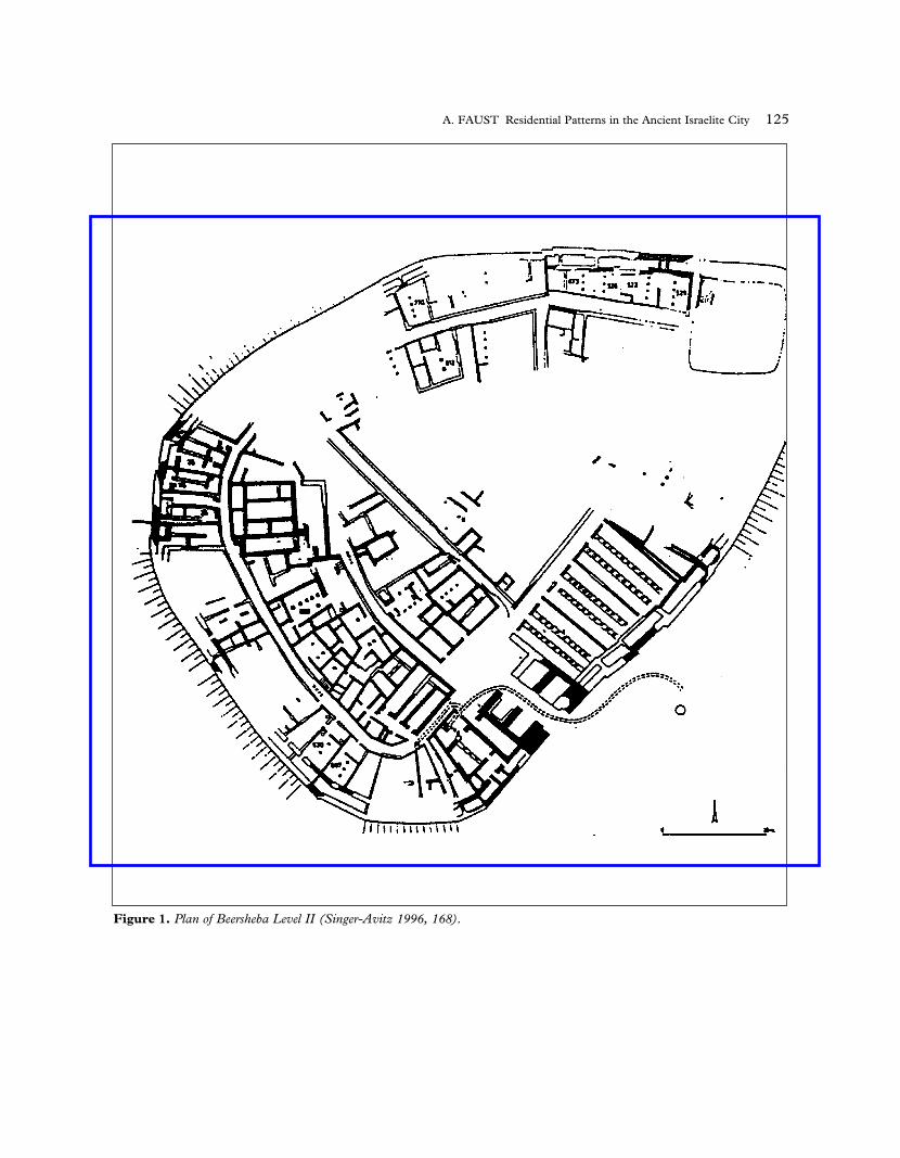
Figure 1. Plan of Beersheba Level II (Singer-Avitz 1996, 168).
present paper examines residential patterns and landuse in ancient Israelite cities of the Iron Age II.
Land use and residential patterns in Iron Age
Israelite cities
The archaeological finds
For various reasons only small areas of most Israelitecities have been excavated, which limits discussionof urban patterns (Mazar 1990, 437). Several havebeen exposed to a relatively large degree, and a fewothers exhibit changes in land use patterns throughthe Iron Age, hence providing evidence for Iron Ageurban planning (Shiloh 1970; 1978; 1987; Herzog1992; Faust, forth. b), and providing sufficient datafor the present discussion. In the following sectionsome observations on the nature of residential pat-
terns and land-use in several Iron Age cities will bepresented and used as the basis for discussion.4
Beersheba (Fig. 1)
The Iron Age site at Tel Beersheba was excavated toa very large extent (e.g. Aharoni 1973), thereforepermitting an examination of land use patterns.During the IA II period, the site served as an admin-istrative centre for the kingdom of Judah (Herzog1992, 258; Mazar 1990, 463–464). Beersheba LevelII represents the last Iron Age urban settlement atthe site, dated to the eighth century BCE. An analy-sis of various excavated structures led Singer-Avitz(1996, 172) to conclude that the wealthy populationlived in the centre, while poorer segments of thepopulation lived on the periphery of the site. In spiteof some differences, Singer-Avitz’s basic conclusionsare supported by a subsequent analysis by the pre-sent author (Faust 1999c, 85–91; forth. b; c). It
126 LEVANT 35 2003
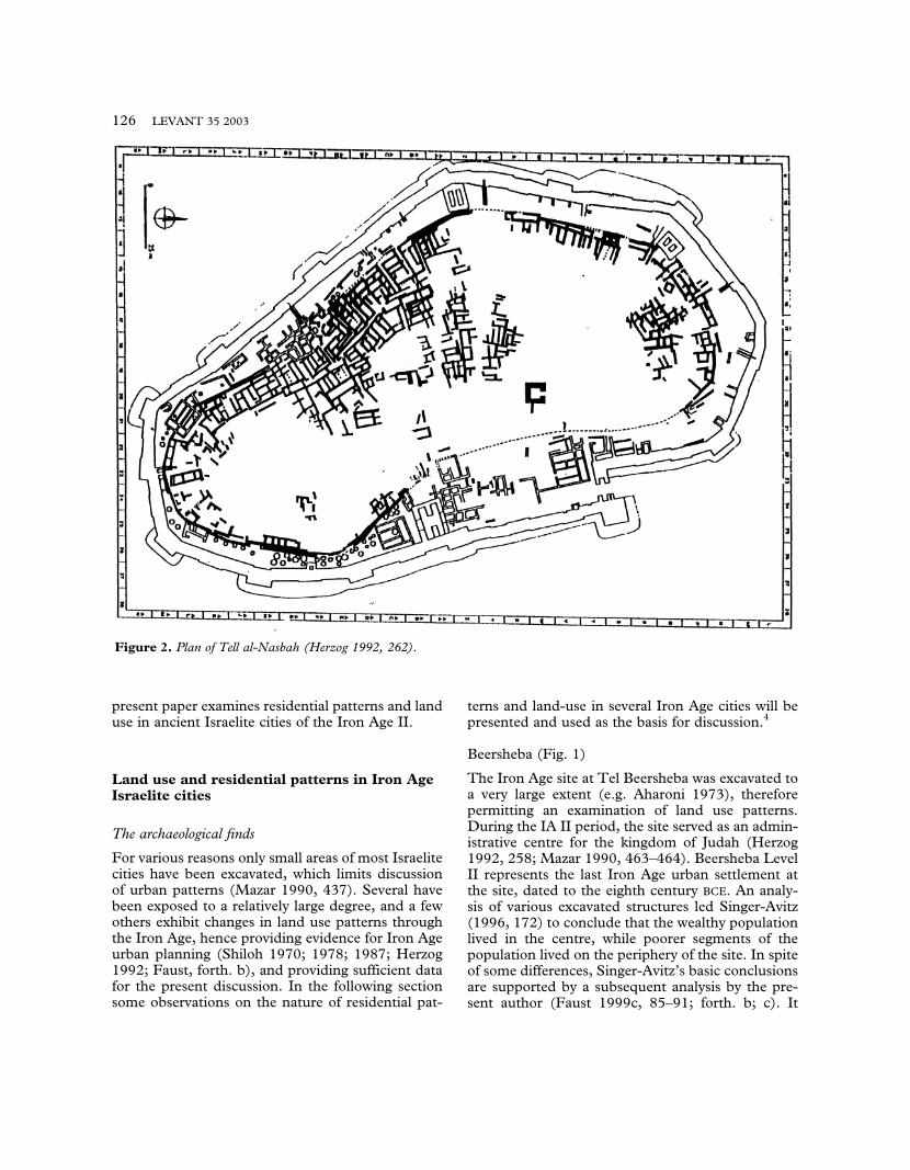
Figure 2. Plan of Tell al-Nasbah (Herzog 1992, 262).
should be noted, however, that several rich dwellingswere also discovered near the city gate, along withpublic structures.5
There are no indications of any major changeswhich took place at the site during Iron Age II, i.e.,from the time the settlement became an urban cen-tre in the tenth century BCE,6 until it was destroyed,and it seems the same pattern prevailed throughoutthe period (e.g. Herzog 1992, 258).
Tell al-Nasbah (Mizpah) (Fig. 2)
The site was excavated to a very large extent(McCown 1947), and although the data recordingand publication does not meet modern standards(e.g. Zorn 1993), the large exposure enables discus-sion of land use and residential patterns. Initially,the site was a provincial town in the kingdom ofJudah (Herzog 1992, 26). Later, however, due togeo-political circumstances, its military importancegrew, and during the ninth century BCE the cityexperienced changes (e.g. Herzog 1997, 239; Zorn1999). During the first phase the city was composedmainly of small dwellings, built with minimal plan-ning, and was surrounded with a casemate wall(Zorn 1993; McClellan 1984). The only majorchange which took place during the ninth century
was a new massive city wall that was erected some5–20 m. outside the former wall. The area betweenthe two walls was added to the city, and it was there-fore enlarged significantly. In addition, a new citygate was built, along with an adjacent public quarter(Herzog 1997, 239). Several large four-room build-ings were probably built along the periphery of thesite at this stage (e.g. Branigan 1966; Herzog 1997,237; contra Zorn 1993).
Zorn (1993, 153–154) claims that most of thelarger buildings were built in the periphery, andtherefore asks “was this area considered to be themost valuble/desirable to live in?”. If one adds thelarge four-room houses to Zorn’s analysis (Zornhimself considered them to be later in date andtherefore did not include them), then this pattern iseven clearer (it should be stressed that since Tell al-Nasbah did not suffer any major destruction duringthe Iron Age II, this situation reflects only the laststage in the existence of the Iron Age city).
Hazor (Figs 3 and 4)
The site was excavated on a relatively large scale(e.g. Yadin et al. 1958; 1960; 1989; Ben Tor 1996;1997). The site probably served as an administrativecentre in the kingdom of Israel (Herzog 1992, 250).
A. FAUST Residential Patterns in the Ancient Israelite City 127
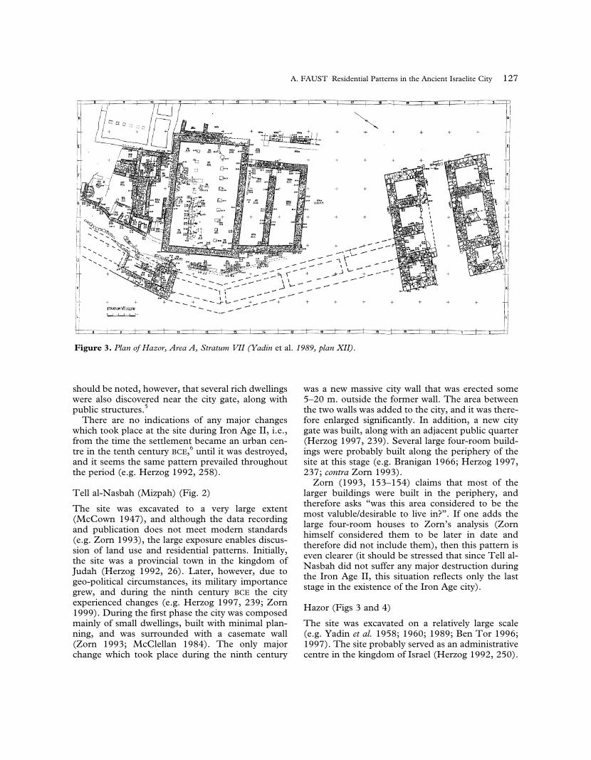
Figure 3. Plan of Hazor, Area A, Stratum VII (Yadin et al. 1989, plan XII).

The first Iron Age urban settlement was establishedduring the tenth century BCE. Not very much isknown about the city plan, and no overall urban pat-terns can be discussed. However, the changes thatoccurred in Area A throughout the Iron Age II,along with our knowledge of the city’s development,are revealing.
During the tenth century (Strata Xb–Xa) a citygate, accompanied by a casemate wall, was erectedin Area A, defining the city to the east. Not far fromthe gate a small portion of a residential neighbor-hood was excavated (Yadin et al. 1989, 32 ff., planVIII). The houses were built according to a planwhich is typical of sites in northern Israel (e.g. Faust2000, 9–10, 12–13, 18–19), and it is reasonable toassume that they were occupied by a local popula-tion who had lived in the region before theformation of the new state (and perhaps were forcedto settle at the site, see Faust 1999a; forth. a). Thesame situation continued without major changesuntil the mid(?)-ninth century. At this time(Stratum VIII), the city expanded. Although thecity gate structure and city wall continued to exist
(though it functioned mainly for storage: Yadin etal. 1959, 6; Geva 1989, 97), major changes tookplace in the vicinity (Yadin et al. 1959; Yadin et al.1989, 39, plan XI), and a large pillared buildingwas erected there. This new structure was probablyused as a storehouse (Yadin et al. 1958, 5–8).During stratum VII the public structure continuedto function and private structures were built nearby(Fig. 3; Yadin et al. 1989, plan XII; see already planXI). Another major change took place in stratum VI(eighth century BCE) (e.g. Yadin et al. 1989, 41,plan XII). The public building had been partiallydestroyed and abandoned at the end of stratum VII,and private houses were built in its place (Fig. 4).7
The area continued to serve as a residential neigh-borhood until the city was destroyed in the secondhalf of the eighth century BCE (end of stratum V).
At least some public structures were built in thenew parts of the town, which were added after thecity expanded (e.g. area G; Yadin et al. 1989; Geva1989, 96). It is to them, probably, that the functionsof the structures, which were removed from theolder part of the town, were transferred.
128 LEVANT 35 2003
Figure 4. Plan of Hazor, Area A, Stratum VI (Yadin et al. 1989, plan XIII).

Jerusalem
Jerusalem poses problems for any attempt at a largescale archaeological exposure (for the reasons, see,e.g. Naaman 1996), but the combined evidencefrom the various excavations enables a limited dis-cussion (especially the data from Shiloh’s, Avigad’sand Kenyon’s excavations, e.g. Shiloh 1984; Ariel2000; Avigad 1980; Geva 2000; Kenyon 1967;1974; Franken and Steiner 1990; and many others).On the basis of the archaeological finds, we knowthat during Iron Age II, probably during the eighthcentury, and possibly earlier, the city expanded sig-nificantly (Broshi 1974; Geva 1979; 2000; Ariel andDe Groot 1997; 2000).
Despite the lack of large scale exposure, there issome data concerning changes in land use in IronAge II Jerusalem. Area G, one of the major excava-
tion areas in the oldest area of the city, exhibitssuch changes. Most of the area is filled with a largemonumental structure, known as the stepped stonestructure. While the foundation date (and form) ofthis monumental structure is hotly debated (e.g.Steiner 1998; Cahill 1998), it is agreed that itexisted during the early stages of Iron Age II.Although the nature of the building for which thestepped stone structure served as a basis/founda-tion is not clear, there is a consensus that it was alarge monumental building of a ‘royal’ character.The impressive foundation of this building, i.e., thestepped stone structure, stood above the groundlevel for a long period, until, at a later stage, privatebuildings were built on it. The fact that thesebuildings were built on top of the stepped stonestructure – apparently a ‘royal’ structure – is anindication of major changes which took place at the
A. FAUST Residential Patterns in the Ancient Israelite City 129
Figure 5. Plan of the north-west quarter at Tell Bait Mirsim (Shiloh 1970, 187, fig. 4).

130 LEVANT 35 2003
Figure 6. Plan of Shiqmona (Elgavish 1994, 49).

time in the character of this area. According toAuld and Steiner (1996, 42, 65–66) this is an indi-cation of the rise in power of merchants, who, theysuggest, inhabited these new structures (it shouldbe noted that the identification of the inhabitantsas merchants is doubtful), which were built as aresult of overcrowding in the city.8 At any event,whatever was the fate of the monumental buildingatop the stepped stone structure, it is certain thatthe area went through a change of land use, and anarea of formerly public character had turned into,at least partially, a residential area.
Tell Bait Mirsim (Fig. 5)
This is a town which was excavated on a relativelylarge scale (Albright 1943). The city probably func-tioned as a provincial town in the kingdom of Judah(Herzog 1992, 261). It was composed mainly ofsmall dwellings, with a few public buildings (a citygate and wall, and probably some others; Barkai1993). At the centre of the town there was a large,seemingly public building or a fort of some sort(Albright 1943, 48–49). It is impossible to observemajor differences in the quality of dwellings betweenthe two neighborhoods which were excavated, andalmost all dwellings seems to have belonged to thelower or middle–lower class. There is, however, oneexception. The most impressive building excavatedin Tell Bait Mirsim is the so-called ‘west tower’. It isquite clear that the structure did not serve anydefensive purposes, but was rather a dwelling(Holladay 1992, 316–317; Shiloh 1970, 186). Thishouse, as is indicated by its name, is built on theedge of the city, actually protruding from the citywall (Fig. 5).
Shiqmona (Fig. 6)
The 0.8 hectares site (Elgavish 1994, 28) was exca-vated to a relatively small extent – about a quarter ofthe Iron Age city was investigated (Elgavish 1994,51). A feature, however, is a large and impressivefour-room dwelling which was built during the ninthcentury over part of the tenth century city wall/tower(Fig. 6; although it is not clear whether the wall con-tinued to function during the ninth century BCE, norhow exactly the tenth century BCE dwelling whichexisted at the spot functioned; Elgavish 1994,49–51, 59–61).
Analysis of residential patterns in the Israelite city
The picture which emerges from the scattered evi-dence is quite interesting. A site like Beersheba, whichdid not experience any change during the Iron Age IIperiod, exhibits a centre-periphery dichotomy
throughout the period (although the term ‘centre’includes, in our opinion, the area near the city gate);the centre with its public structures was inhabited bythe rich, while the periphery housed the less wealthymembers of society. At Tell al-Nasbah, however, thesituation was different. Although it is possible that thecentre of town was occupied by larger buildings in theearly phase of the Iron Age II period (see the large andlong walls in the central part of the town plan in Fig.2), rich and public structures were later (once thetown was enlarged) erected on the periphery of thesite. It is highly likely that a similar situation existed inTell Bait Mirsim, where it is possible that a publicbuilding was built in the centre (unlike the vast major-ity of public structures which are more typical near thegate, see Faust 1999c, 99), but where a magnificentlarge building was erected later on the extreme periph-ery, i.e., over the city wall. A similar pattern was,seemingly, observed in Shiqmona.
Changes in land use and residential patterns werealso observed quite clearly in Hazor and Jerusalem. Inthe former, the state had built a public building overan area which formerly housed private buildings. If thecharacter of the buildings indeed indicate that theywere inhabited by non-Israelites (following Faust2000), it is clear how the state could conduct such anact quite easily. The important feature, however, isthat later the storehouse ceased to exist and its func-tion was probably transferred to another location onthe tell. The area was gradually filled again bydwellings, most of which were of poor character(Faust 1999b; 2000). It should be noted that Hazorexpanded significantly during the Iron Age II, and thisexpansion probably enabled many changes: the publicbuilding was transferred to a new location and the areawhere it stood was later reused by private people.9 Asimilar picture emerges from our limited knowledge ofJerusalem’s urban patterns. Again, an area that wasinitially used for public functions gradually becamemore domestic in character. In Jerusalem, too, thisprocess followed the expansion of the city, and proba-bly occurred only later.
The pattern observed can be summarized as fol-lows: the initial stage of a typical Iron Age city wasone in which rich and public structures were built inthe centre and near the gate, and the poorer seg-ments inhabited the periphery. While some cities didnot experience any changes, and the same patternpersisted to the end of the Iron Age (e.g. Beersheba),many others did experience changes, which involvedthe erection of rich and/or public buildings at a newlocation (Tell Bait Mirsim, Tell al-Nasbah,Shiqmona and Hazor), and (some of) the area wherethey initially stood became a residential neighbor-hood (e.g. Hazor, Jerusalem).
A. FAUST Residential Patterns in the Ancient Israelite City 131

Discussion: Sjoberg’s model and the Israelite
city
Rather than repeating past discussions and assessingSjoberg’s model in general, we wish to examine theimplications for the validity and generality of themodel using the archaeological evidence fromancient Israel presented above.
A) Centre–periphery dichotomy
Initially, we should examine the dichotomy of cen-tre–periphery and its equation with rich–poor: as wehave seen, some cities clearly exhibit a picture whichis similar to Sjoberg’s model. Beersheba is perhapsthe best example. Other towns and cities, however,present a different reality. We can see a pattern inwhich areas of public character located in centralplaces are gradually replaced by structures of a moreresidential character (e.g. Jerusalem and Hazor),sometimes, at least, inhabited by the lower class. Inaddition, we can observe a tendency through time toerect new rich structures and public buildings nearthe periphery (Tell al-Nasbah, Tell Bait Mirsim,Shiqmona and Hazor). This pattern does not accordwith Sjoberg’s model, but since some cities do con-form to his model (Beersheba and to some extentother sites, e.g. Tell Bait Mirsim), we should askourselves what was the difference between the vari-ous sites. It seems that the major difference betweenBeersheba on the one hand, and Tell al-Nasbah,Hazor and Jerusalem on the other, lay in the factthat the sites in the latter group grew in size duringthe period discussed here. It appears that this expan-sion allowed the inhabitants of the better areas, tofind even better and more spacious places to live –this is true both of the private people and of the statestructures. The areas which were left were eventually(partially) taken over by the less dominant elementsof society.
This means that while we are not (yet?) in a posi-tion to assess the values accorded to various spacesand ideas by the population of these cities (followingSjoberg, above; see also Jones and Eyles 1977,32–34; Wheatley 1971; but see Faust 2001), it isreasonable to assume that this society did not accordmuch value to historical location (see Sjobergabove). It is likely that quality of life played a majorrole, and therefore people preferred to move to a bet-ter place when possible. The exact processes whichbrought about the changes in land use and residen-tial pattern will be discussed briefly below; here Iwould like to return to Sjoberg’s influential model.
It seems this model does accurately describe thereality in many instances, perhaps even in the
majority of pre-industrial examples (see also theexamples cited by Sjoberg et al.). In the presentcase study, however, this situation was only a start-ing point. When (or if) a city expands, many of itswealthy inhabitants would prefer to move to thenew, clean, and more spacious areas. This wouldhappen, of course, unless there were values thatprevented them from leaving their ‘family estate’ orthe like (and, as mentioned above, this seeminglywas not the case in urban centres in ancient Israel).This observation is strengthened by the fact that,even in cities which did not grew in size, a similarpattern was observed, though on a much smallerscale (e.g. Tell Bait Mirsim and perhaps alsoShiqmona).10 It should be remembered that manyof the pre-industrial cities, and those in ancientIsrael included, were quite small. Beersheba, forexample, was about 1.1 hectare, most sites variedfrom 3 to 10 hectares, and rarely exceeded this size(Jerusalem in the late Iron Age, with some 60–100hectares is the most notable exception in ancientIsrael, e.g. Barkay 1988). Communication/trans-portation, which were considered by Sjoberg as amajor rationale for the elite’s preference to stay atthe centre, were therefore not so difficult or com-plicated, as to prevent such movement; especiallywhen taking into account the fact that much of theadministration had moved too. Moreover, as willbe discussed further, it is more likely that theadministration was the first to move. Since Sjobergmaintained that the elite needed to be close to theadministration, then his own rationale wouldrequire them to follow the administration. Thecentre–periphery/rich–poor model, therefore, is notcharacteristic of all pre-industrial cities.
B) Land-use dynamics
These changes can be equated with somewhat simi-lar development in more ‘modern’ cities, and themotives for the changes can be considered.
The processes described above indicate that theancient Israelite city experienced changes in resi-dential pattern and land-use (in contrast to theprevalent view of the pre-industrial city). Similarprocesses (in very general terms) are known from‘modern’ cities (these are the processes to whichSjoberg and others have contrasted what they con-sidered to be the pattern of the pre-industrial city).It is widely known that in many cases in moderncities it is the periphery that is regarded as thehome of the rich, while the inner city is thedwelling of the poor (Ley 1983, e.g. 36–39,213–216, 253 ff. and others; Short 1984, 128–130,etc.). There is disagreement as to the exact pattern
132 LEVANT 35 2003
of population distribution in the modern city,whether concentric or sectoral (e.g. Short 1984,128–131; Morrill 1970, 163–167), but it is clearthat in many but not all cases the suburbs areregarded as a better location, and the inner city asleast so. Various reasons have been raised toexplain this process, e.g. the deterioration of hous-ing in the older parts of the city. While this reasonseems not to account for the phenomenon (Ley1983, 253–254, and references), suffice it here tounderstand the most basic components of thisprocess, as most details are quite different fromthese in the ancient city. This mechanism, in a verysimplistic way, is as follows: once some of thewealthy leave their neighborhoods in the centre, forwhatever reasons, and move to another place, anew population moves in, usually of a lower socio-economic standing (modern ‘filtering’; e.g.Rubenstein 1994, 482). Conditions become lessfavorable for the remaining original population,and the ‘reputation’ of the neighborhood also dete-riorates with the standard of living, thereforecausing more to leave. This process brings in addi-tional poor people, and the process is repeated overand over again. While this very simplistic descrip-tion partially explains the situation in moderncities, it bears some basic implications for under-standing of the processes in the pre-industrial city,despite differences.
One of the major differences between ancient andmodern cities lies in the expanding nature of mod-ern cities, where suburban areas are added anddeveloped, and attract wealthy populations fromthe city centre (and starts the process describedabove). Ancient cities, were, in most cases, limitedin their size, confined within the city walls.Expansion outside city walls happened in manyinstances, including ancient Israel (e.g. Jerusalem;Shiloh 1984, 28; at least before the area was encom-passed by a wall, see Reich and Shukron 1998), butdue to security problems this was not seen as adesired location, and no rich people were likely tomove there (it is likely that these extramural neigh-borhoods should be viewed as a earlier and moremoderate version of modern squatters; e.g. Jonesand Eyles 1977, 206–210; see also Short 1984,22–24; 122–123; Clark 1993, 287; see, in thisregard, Shiloh 1984, 28, who refers to “the con-struction of poor, simple dwellings on the rockterrace east of the city-wall, outside the fortifiedcity” of Jerusalem). The important variable is,therefore, size and expansion possibilities. Once theancient city had the opportunity to expand, the newareas (if defended by the city wall), or at least someof them, were seen as more spacious, and therefore
attracted population and the process started. It isvery likely that the first to move were not the richand wealthy as such, but rather the administration,who, in the case study discussed, indeed needed thenew spaces to fill its growing needs (the Iron II wasa period of demographic and economic growth;Broshi and Finkelstein 1992). As we have seen,Sjoberg stressed the importance, for the rich popu-lation, of living in close proximity to theadministrative centres in order to maintain their sta-tus. While Sjoberg used this argument to explainwhy the rich would stay in the centre, the sameargument explains why, when the administrationmoves, so would the rich and wealthy. This explainswhy the process had started: the administration, fol-lowed by the rich, moved to the new areas, and,gradually, (some of) the area formerly occupied bythem falls out of use. This situation was used (attimes) by populations of lower socioeconomicstanding, who settled in this area, and changed itscharacter (for a similar processes in modern cities,see, e.g. Rubenstein 1994, 482 ff., 509–510; Efrat1994, 159–160; Short 1984, 128).
These mechanisms operated in the ancientIsraelite city. Once (or if) new and secure areasopened up (within the expanded city wall), the gov-ernmental structures and rich population left theirformer neighborhoods. These abandoned areasgradually filled up with other people who tookadvantage of whatever they could. When thisprocess did take place, these areas became, even inthe pre-industrial city, an ‘inner city’ or ‘transi-tional’ zones, with some of its ‘modern’implications.
This observation also indicates that thedichotomy between the pre-industrial and indus-trial cities, though correct in many of itsobservations, is not as all-encompassing as onemight think. It seems, in this regard at least, as ifWirth’s (1965, 50) famous observation that “... therise of cities in the modern world is undoubtedlynot independent of the emergence of modernpower-driven machine technology, mass produc-tion, and capitalistic enterprise. But different as thecities of earlier epochs may have been by virtue oftheir development in a preindustrial and precapital-istic order from the great cities of today, they were,nevertheless, cities” has at least some validity (seealso Wheatley 1963, 172–173).
Discussion and conclusions
As we have seen, urban centres in Iron Age Israelexperienced changes in residential and land use pat-
A. FAUST Residential Patterns in the Ancient Israelite City 133

terns throughout their centuries long existence. Attimes, these changes resulted in a pattern which isvery different from the dominant view of pre-indus-trial urban land use. While the latter views thesituation in the ancient city as a static division ofcore and periphery, which can be equated with therich and the poor, the Iron Age reality is much morecomplex: while some cities do conform withSjoberg’s model, many others do not. Moreover, itseems as if the mechanisms and processes whichoperated in the pre-industrial city are sometimesvery similar to those which operated in the indus-trial one, and the reality is not necessarily the‘reverse’, or ‘inside out’ as was claimed by Sjobergand others.
It seems that the important variable is urbangrowth and expansion.11 When the situation is sta-tic, and the city remains confined to its originalcity walls, few changes occur (though Tell BaitMirsim is an exception). When a city grew in size,and its walls were enlarged to incorporate newareas, it is likely that the administration would beamongst the first to make use of the new areas(some of it was probably already inhabited asextramural quarters, probably by poor people, butother parts were more likely empty. It is probablethat administrative needs were among the motivesfor the expansion in the first place). This movewould be followed by the wealthy. The newlyvacant area in the city centre would be filled withother segments of society, and the urban patternchanged. It should be noted that if the walled citydid not expand, even if extramural quarters werebuilt, the administration and the wealthy wouldnot leave the safety of the city wall, and thesequarters would be more like those of modernsquatters. Only when the walled city is enlarged,can the processes described above mature – verymuch like the processes in the modern city, whichare also a result of growth (although, due to bettersecurity, the expansion need not be surrounded bya wall).
It is appropriate to comment on the use ofarchaeological evidence in our context, and on theimportance of archaeological perspectives on suchquestions in general. Archaeological ‘examples’were used by some of the authors who acceptedSjoberg’s model. Jones and Eyles (1977,142–143), for example, refer to Angkor Thom,and to the Mayan city. From the latter they sug-gest that there was an intermediate stratum in thesociety (though the study corresponds withSjoberg’s analysis), and they observe that “thecore was certainly a ceremonial centre, with its
grouped pyramids, courts, plazas, and avenues,but around these were several zones suggesting agrading of the elite downward until the residencebecome uniformly small and nondescript”. This is,indeed, the prevalent view in regard to the ancientMayan city, starting with Diego de Landa’s six-teenth century description of a Yucatan Mayantown (Tozzer 1941, 62), which is followed bymany modern studies, e.g. by Morley andBrainerd (1983, 19) who observe that “The com-mon people lived on the outskirts of the town andvillages, and... the distance of a man’s house fromthe central plaza may have depended on his posi-tion in the social scale” (see also Thompson 1954,67; and many additional references in Arnold andFord 1980, 713–714; note, however, that this con-centric model has been rejected by Arnold andFord’s [1980] study of Tikal, though without anydirect reference to Sjoberg’s model). At any event,there is no doubt that many ancient sites con-formed with Sjoberg’s model, and it is very likelythat many, or even most, of the examples quotedby various scholars in favour of the model are cor-rect (although, even if all of them are correct it isnot enough to prove the model to be correct).
There is one issue which I believe casts somedoubt on many such examples. Sjoberg maintainsthat the ‘centre’ need not necessarily be the physicalcentre (above), and there is no doubt that he is cor-rect. Uncritical use of archaeological data istherefore problematic. Since any town plan wouldinclude a centre of some sort, and since any ‘centre’would suffice to deem the plan to be in accordancewith the model, then (almost) any plan can be usedto prove the model to be right. This seems to be animproper analytic procedure.
As is widely known, one of archaeology’sstrengths lies in its ability to view long termprocesses. And this is the way archaeological datashould be used; only a ‘multi layered’ picture willexpose changes in residential patterns and land usewithin the city. If one would examine each periodseparately, it might be possible to identify the cen-tre at each period, and to declare that all planscorrespond with the model. Only when the plansare compared, is it possible to discern the dynam-ics and the changes which took place in the samecity through time. Such an enterprise wasattempted in the present study, and revealed thechanges which took place in the Israelite city, andthus the changing patterns of land use in the pre-industrial city. It also indicates that some realitiesare much more complex than the one described bySjoberg.
134 LEVANT 35 2003
Notes
1 It should be noted that ‘the Islamic city model’ (e.g.Bonine 1983, 284) in which the ‘residences are arrangedand organized into quarters or neighborhoods, whichoften can be based on ethnic groups, sects or minorities’,seems to predate Islam in the Middle East (Bonine 1983,285–287; see also Bonine 1977; Stern 1989; 1991; but seeSjoberg 1960, 100–103). While it is true that ethnicenclaves were indeed found in early contexts (e.g.Emberling 1997, 323), this seems not to be characteristicof most Iron Age cities (in Hazor, for example, it might bepossible to identify more than one ethnic group [Faust2000], but this seems to be an exception, and whetherthese groups lived in different quarters or not, is yet to beestablished). At the present (limited) state of knowledge,therefore, the Islamic, or Middle Eastern, model, seemsirrelevant for Iron Age Israel and will not be discussedhere. If our understanding of ethnic reality in those siteschanges, than this model will deserve closer attention.2 Stone’s (1997) study concentrated on the Mesopotamiancity-states, but is built upon other examples, especially theYoruba of West Africa and late medieval Islam. It seemsStone’s model of ‘consensual societies’ has some virtue,and in these cases reality indeed differed from the one dis-cussed by Sjoberg (see also note 1 above). It shouldtherefore be noted that despite the fact that ancientIsraelite society exhibits some clear similarities with this‘model’, apparently the Israelite city did not (spatially atleast) conform to it (or not completely; note, e.g. the factthat inner walls dividing districts are not only rare inancient Israel, but when they exist they seem to have sep-arated different social classes – e.g. de Vaux 1965, 72–73;note that this contrasts the situation in Stone 1997, 19).Moreover, Stone (1997, 15) explicitly connected thismodel with city-states. At any event, the applicability ofStone’s model deserves additional research.3 This is not always the case in ancient Mesopotamia, anda pattern in which there is only one centre that includesboth structures seems to be prevalent (Postgate 1992,140–141; Kubba 1987, 57). Relating to and explaining thedifferent patterns is beyond the scope of the present paper.4 Not all excavated Iron Age sites yielded informationwhich is relevant for the present discussion. In Samaria,for example, although the acropolis was excavated to arelatively large extent, we have hardly any informationconcerning the rest of the city (e.g. Reisner et al. 1924;Crowfoot et al. 1942). The data from Tell al-Farcah (N),important as it is for the study of socio-economicprocesses (de Vaux 1965, 72–73), seems also to be insuf-ficient for the present analysis (Chambon 1984). Thechanges that took place in Lachish during the transitionfrom stratum III to stratum II, interesting as they are,seem to result from an historical event, and not from along term process (Ussishkin 1993), and are of lessimportance for the present discussion. It should also benoted that while the ancient Israelite city in general, andtown planning in Iron Age Israel in particular, hasreceived a great deal of scholarly attention (e.g. Fritz1995), the question discussed here was not usuallyaddressed at all.
5 This is not the place to discuss the methods of identify-ing wealth in the archaeological record, or of evaluatingprevious attempts of doing so (such explicit attempts arerare in the archaeology of ancient Israel; for an exception,see Singer-Avitz 1996). It seems, however, that thebest (though not the only) indicator of wealth is architec-ture, as can be learnt from various studies conductedthroughout the world, including the Middle East (e.g.Blanton 1994; Crocker 1985, 52; Kemp 1977, 137; Smith1987, 301, 327; Smith et al. 1989; Kramer 1982, 130,135–136, and many others). For an explicit and detaileddiscussion of social stratification in the ancient Israelitecity see Faust 1999b; and especially Faust, forth. c. Whenreferring to ‘rich’, ‘poor’, etc., the present paper relies onthese studies.6 The present paper follows the traditional Iron Agechronology (for the current debate see, e.g. Finkelstein1995; 1996; 1998; Mazar 1997; Ben Tor and Ben Ami1998; Bunimovitz and Faust 2001). It should be notedthat the result of this debate bears no meaning whatsoeverto the conclusions of this paper.7 For the process, see Geva 1989, 48, 71, 114; for thesocio-economic standing of the occupants of the variousdwellings, see Faust 1999b; it is possible that a new store-house was built nearby, but this is not yet clear; for thisand for the entire process, see Yadin et al. 1989, 40–41,plan XIII.8 Auld and Steiner date the changes to the seventh centuryBCE. Others date it, roughly, to the tenth century BCE (e.g.Ariel and De Groot 2000, 158), therefore viewing thesechanges as very early in comparison.9 It seems that the changes occurred only after the cityexpanded, and not in tandem with it. While this remarkbears no implication for the issue discussed here, it mightbe important for other studies of urban development.10 The situation in Beersheba is different, and no suchchanges were observed at this site. This could be a merechance of discovery, and it is possible that in the futuresuch a pattern will be observed. It is more likely, however,that due to Beersheba’s administrative character, orderand planning was more strictly kept, and nobody wasallowed to built over the city wall (for Beersheba’s posi-tion, see Faust, forth. b).11 According to Postgate (1992, 137–140), at times,palaces in Mesopotamian cities were also built in newparts of the city. Note, however, that the situation differedfrom the present discussion, as the temple, in some cases,remained in its original place.
Acknowledgments
I would like to thank Dr Shimon Stern and Dr Aren M.Maeir for reading and commenting on earlier drafts of thispaper. The responsibility for any mistake or error, is, ofcourse, mine alone. The preparation and publication ofthis paper was supported by a grant from the MemorialFoundation for Jewish Culture. I wish to thank the IsraelExploration Society for permission to reprint the figures;the sources are acknowledged.
A. FAUST Residential Patterns in the Ancient Israelite City 135

Bibliography
Abbott, W.F. (1974) Moscow in 1897 as a PreindustrialCity: A Test of the Inverse Burgess Zonal Hypothesis.American Sociological Review 39, 542–550.
Abu-Lughod, J. (1976) The legitimacy of comparisons incomparative urban studies. Pp. 17–39 in J. Walton andL.H. Masotti (eds) The city in comparative perspective.Sage: New York.
Aharoni, Y. (1973) Beer-Sheba. I. Tel Aviv University: TelAviv.
Albright, W.F. (1943) The Excavation of Tell Beit Mirsim.III. AASOR 21–22.
Ariel, D.T. ed. (2000) City of David Excavations, FinalReport. V. (Qedem 40). The Hebrew University:Jerusalem.
Ariel, D.Z. and De Groot, A. (1997) The IsraeliteSettlement outside the Walls of the City of David. Pp.9–12 in A. Faust and E. Baruch (eds) New Studies onJerusalem, Proceedings of the Third Conference. Bar-IlanUniversity, The Rennert Center: Ramat-Gan.(Hebrew).
——– (2000) The Iron Age Extramural Occupation at theCity of David and Additional Observations on theSiloam Channel. Pp. 155–169 in D.T. Ariel (ed.)Excavations at the City of David 1978–1985. V.Extramural Areas. The Hebrew University: Jerusalem.
Arnold, J.E. and Ford, A. (1980) A statistical examinationof settlement patterns at Tikal, Guatemala. AmericanAntiquity 45, 713–726.
Auld, G. and Steiner, M. (1996) Jerusalem. I. From theBronze Age to the Maccabees. The Lutterworth Press:Cambridge.
Avigad, N. (1980) Discovering Jerusalem. Thomas Nelson:Nashville.
Barkay, G. (1988) Jerusalem as a Primate City. Pp.124–125 in S. Bunimovitz et al. (eds) Settlements,Population and Economy in the Land of Israel inAntiquity. Tel Aviv University: Tel Aviv. (Hebrew).
——– (1993) A Group of Stamped Handles from Judah.Eretz-Israel 23, 113–128.
Basham, R. (1978) Urban Anthropology, The Cross CulturalStudy of Complex Society. Mayfield Publishing: Palo-Alto.
Ben Tor, A. (1996) The Yigal Yadin MemorialExcavations at Hazor: Aims and Preliminary Results of1990–1992 Seasons. Eretz-Israel 25, 67–81 (Hebrew).
——– ed. (1997) Hazor V. Israel Exploration Society:Jerusalem.
Ben-Tor, A. and Ben-Ami, D. (1998) Hazor and theArchaeology of the Tenth Century BCE. IEJ 48, 1–37.
Blanton, R.E. (1976) Anthropological Studies of Cities.Annual Review of Anthropology 5, 249–264.
——– (1994) Houses and Households, A Comparative Study.Plenum: New York and London.
Bonine, M.E. (1977) From Uruk to Casablanca:Perspectives on the Urban Experience of the MiddleEast. Journal of Urban History 3, 141–180.
——– (1983) Cities of the Middle East and North Africa.Pp. 281–322 in Brunn, S.D. and Williams, J.F. (eds)
Cities of the World: World Regional Urban Development.Harper and Row: New York.
Branigan, K. (1966) The Four-Room Buildings of Tellen-Nasbeh. IEJ 16, 206–208.
Broshi, M. (1974) The Expansion of Jerusalem in theReigns of Hezekiah and Mannasseh. IEJ 24, 21–26.
Broshi, M. and Finkelstein, I. (1992) The Population ofPalestine in Iron Age II. BASOR 287, 47–60.
Bunimovitz, S. and Faust, A. (2001) Chronological sepa-ration, geographical segregation or ethnic demarcation?Ethnography and the Iron Age low chronology. Bulletinof the American Oriental Society 322, 1–10.
Burke, P. (1975) Some reflections on the pre-industrialcity. Urban History Yearbook, pp. 13–20.
Cahill, J. (1998) David’s Jerusalem: It is There, TheArchaeological Evidence Proves it. Biblical ArchaeologyReview 24/4, 34–41.
Chambon, A. (1984) Tel el-Farcah. I. Editions Recherchesur les Civilisations: Paris.
Clark, A.N. (1993) The Penguin Dictionary of Geography.Penguin: Harmondsworth.
Clark, D. (1982) Urban Geography. Croom Helm:London.
Clark, P. and Slack, P. (1976) English Towns in Transition1500–1700. Oxford University Press: London.
Cox, O.C. (1964) The pre-industrial city reconsidered.Social Q 5, 133–144.
Crocker, P.T. (1985) Status Symbols in the Architectureof el-’Amarna. JEA 71, 52–65.
Crowfoot, J.W., Kenyon, K.M., and Sukenik, E.L. (1942)The Buildings at Samaria (Samaria-Sebaste. 1). PalestineExploration Fund: London.
Davey, I. and Doucet, M. (1975) The Social Geographyof a Commercial City, c. 1853 (appendix). Pp.319–342 in M. Katz (ed.) The People of Hamilton,Canada West: Family and Class in a Mid-NineteenthCentury City. Harvard University Press: Cambridge,Mass.
Efrat, E. (1995) Elements of Urban Geography. Achiasaf:Tel Aviv. (Hebrew).
Elgavish, J. (1994) Shiqmona, on the seacoast of MountCarmel. Israel Exploration Society: Tel Aviv.(Hebrew).
Emberling, G. (1997) Ethnicity in Complex Societies:Archaeological Perspectives. Journal of ArchaeologicalResearch 5, 295–344.
Faust, A. (1999a) From Hamlets to Monarchy: A Viewfrom the Countryside on the Formation of the IsraeliteMonarchy. Cathedra 94, 7–32. (Hebrew).
——– (1999b) Socioeconomic Stratification in an IsraeliteCity: Hazor VI as a Test Case. Levant 31, 179–190.
——– (1999c) The Social Structure of the Israelite Societyduring the 8th–7th Century BCE according to theArchaeological Evidence. Ph.D. dissertation. Bar-IlanUniversity, Ramat-Gan. (Hebrew).
——– (2000) Ethnic Complexity in Northern Israel dur-ing the Iron Age II. PEQ 132, 2–27.
——– (2001) Doorway orientation, settlement planningand cosmology in ancient Israel during Iron Age II.Oxford Journal of Archaeology 20, 129–155.
136 LEVANT 35 2003

——– (forth. a) Abandonment, Urbanization,Resettlement and the Formation of the Israelite State.Near Eastern Archaeology.
——– (forth. b) Accessibility, defense, and town planningin Iron Age Israel. Tel Aviv.
——– (forth. c) The Israelite Society in the Period of theMonarchy: an Archaeological Perspective. Yad Ben-Zvi:Jerusalem. (Hebrew).
Finkelstein, I. (1995) The date of the settlement of thePhilistines in Canaan. Tel Aviv 22, 213–239.
——– (1996) The Archaeology of the United Monarchy:an Alternative View. Levant XXVIII, 177–187.
——– (1998) Bible archaeology or the Archaeology ofPalestine in the Iron Age? a Rejoinder. Levant XXX,167–174.
Franken, H.J., and Steiner, M.L. (1990) Excavations inJerusalem 1961–1967. II. The Iron Age ExtramuralQuarter on the South-East Hill. Oxford University Press:Oxford.
Fritz, V. (1995) The City in Ancient Israel. SheffieldAcademic Press: Sheffield.
Geva, H. (1979). The Western Boundary of Jerusalem atthe End of the Monarchy. IEJ 29, 84–91.
——– ed. (2000) Jewish Quarter Excavations in the Old Cityof Jerusalem. I. Israel Exploration Society: Jerusalem.
Geva, S. (1989) Hazor, Israel: an Urban Community of the8th Century BCE. B.A.R International Series 543. Oxford.
Herzog, Z. (1992) Settlement and Fortification Planningin the Iron Age. Pp. 231–274 in A. Kempinski and R.Reich (eds) The Architecture of Ancient Israel. IsraelExploration Society: Jerusalem.
——– (1997) Archaeology of the City: Urban Planning inAncient Israel and its Social Implication. Tel AvivUniversity: Tel Aviv.
Holladay, J.S. (1992) House, Israelite. Anchor BibleDictionary. III. Pp. 308–318. Doubleday: New York.
——– (1995) The kingdoms of Israel and Judah: Politicaland Economic Centralization in the Iron Age IIA–B (ca.1000–750 bce). Pp. 368–398 in T.E. Levy (ed.) TheArchaeology of Society in the Holy Land. LeicesterUniversity Press: London.
Johnson, J.H. (1967). Urban Geography. An IntroductoryAnalysis. Pergamon: London.
Jones, E. (1990) Metropolis: The world’s great cities, OxfordUniversity Press: Oxford.
Jones, E. and Eyles J. (1977) An Introduction to SocialGeography. Oxford University Press: Oxford.
Kemp, B.J. (1977) The City of el-Amarna as a Source forthe Study of Urban Society in Ancient Egypt. WorldArchaeology 9(2), 123–139
Kenyon, K. (1967) Jerusalem, Excavating 3000 Years ofHistory. Thames and Hudson: London.
——– (1974) Digging Up Jerusalem. Ernest Benn: London.Kramer, C. (1982) Village Ethnoarchaeology, Rural Iran in
Archaeological Perspective. Academic Press: New York.Kubba, S.A.A. (1987) Mesopotamian Architecture and
Town Planning, from the Mesolithic to the end of the Proto-Historic Period c. 10,000–3500 BC. BAR InternationalSeries 367. Oxford.
Langton, J. (1975) Residential Patterns in Pre-industrialCities: Some Case Studies from Seventeenth CenturyBritain. Transactions of the Institute of British Geographers65, 1–27.
Ley, D. (1983) A Social Geography of the City. Harper andRow: New-York.
London, B. and Flanagan, W.G. (1976) ComparativeUrban Ecology: a Summary of the Field. Pp. 41–66 inJ. Walton and L.H. Massoti (eds) The City inComparative Perspective. Sage: New York.
Mazar, A. (1990) Archaeology of the Land of the Bible,10,000–586 BCE. Doubleday: New York.
——– (1997) Iron Age Chronology: a Reply to I.Finkelstein. Levant XXIX, 157–167.
McClellan, T.L. (1984) Town Planning at Tell en-Nasbeh. ZDPV 100, 53–69.
McCown, C.C. (1947) Tell en-Nasbeh. I. Archaeologicaland Historical Results. American Schools of OrientalResearch: New Haven.
Morley, S.G. and Brainerd, G.W. (1983) The AncientMaya. Stanford University Press: Stanford.
Morrill, R.L. (1970) The Spatial Organization of Society.Duxbury: Belmont, California.
Naaman, N. (1996) The contribution of the Amarna let-ters to the debate on Jerusalem’s political position in thetenth century BCE. BASOR 304, 17–27.
Postgate, J.N. (1992) Early Mesopotamia, Society andEconomy at the Dawn of History. Cambridge UniversityPress: Cambridge.
Radford, J.P. (1979) Testing the Model of the Pre-Industrial City: The Case of Ante-bellum Charleston,South Carolina. Transactions of the Institute of BritishGeographers. N.S. 4, 392– 410.
Reisner, G.A., Fisher, C.S. and Lyon, D.G. (1924)Harvard Excavations at Samaria (1908–1910). 1–2.Harvard University: Cambridge, Mass.
Rubenstein, J.M. (1994) The Cultural Landscape: anIntroduction to Human Geography. Macmillan: NewYork.
Shiloh, Y. (1970) The Four Room House – Its Situationand Function in the Israelite City. IEJ 20, 180–190.
——– (1978) Elements in the Development of TownPlanning in the Israelite City. IEJ 28, 36–51.
——– (1984) City of David. I. Qedem 19. The HebrewUniversity: Jerusalem.
——– (1987) The Casemate Wall, the Four Room House,and the Early Planning in the Israelite City. BASOR268, 3–15.
Short, J.R. (1984) An Introduction to Urban Geography.Routledge and Kegan Paul: London.
Singer-Avitz, L. (1996) Household Activities inBeersheba. Eretz-Israel 25, 166–174. (Hebrew).
Sjoberg, G. (1960) The Preindustrial City, Past and Present.Free Press: New York.
Smith, M.E. (1987) Household Possessions and Wealth inAgrarian States – Implications for Archaeology. Journalof Anthropological Archaeology VI, 297–335.
Smith, M.E., Aguirre, P., Heath-Smith, C., Hirst, K.,O’mack, S. and Price, J. (1989) Architectural Patterns
A. FAUST Residential Patterns in the Ancient Israelite City 137

at Three Aztec-Period Sites in Morelos, Mexico.Journal of Field Archaeology 16, 185–203.
Steiner, M. (1998) David’s Jerusalem: It’s Not There,Archaeology Proves Negative. Biblical ArchaeologyReview 24/4, 26–33.
Stern, S. (1989) Vorislamische Grundrissformen nachaltjudischen quellen. Erdkunde 43/3, 225–227.
——– (1991) Urban Layout According to AncientHebrew Sources Compared with Middle Eastern CityPatterns. Pp. 133–141 in Y. Katz, Y. Ben-Arieh and Y.Kaniel (eds) Historical-Geographical Studies in theSettlement of Eretz-Israel. Yad Ben-Zvi: Jerusalem.(Hebrew).
Stone, E. (1997) City States and Their Centers, TheMesopotamian Example. Pp. 15–26 in D.L. Nicholsand T.H. Charlton (eds) The Archaeology of City-States:Cross-Cultural Approaches. Smithsonian InstitutionPress: Washington and London.
Thompson, J.E.S. (1954) The Rise and Fall of MayaCivilization. University of Oklahoma Press: Norman.
Tozzer, A.M. (1941) Landa’s Relaction de las Cosas deYucatan: a Translation. Papers of the Peabody Museumof Archaeology and Ethnology 18: Cambridge MA.
Ussishkin, D. (1993), Lachish. Pp. 897–911 in E. Stern(ed.) NEAAHL. Israel Exploration Society: Jerusalem.
Vaux, R. de (1965) Ancient Israel, its Life and Institutions.Darton, Longman and Todd: London.
Warnes, A.M. (1973) Residential Patterns in an EmergingIndustrial Town. Pp. 169–189 in Social Patterns inCities. Institute of British Geographers special publica-tion No. 5. London.
Wheatley, P. (1963) What the Greatness of a City is Saidto Be. Pacific Viewpoint 4, 163–188.
——– (1971) The Pivot of the Four Quarters: a PreliminaryEnquiry into the Origins and Character of the AncientChinese City. Edinburgh University Press: Edinburgh.
Wirth, L. (1965) Urbanism as a Way of Life. Pp. 46–63 inP.K. Hatt and A.J. Reiss (eds) Cities and Society. FreePress: Glencoe.
Yadin, Y., Aharoni, Y., Amiran, R., Dothan, T.,Dunayevsky, I. and Perrot, J. (1958) Hazor. I. Anaccount of the first season of excavations. James A. deRothschild Expedition at Hazor. Magnes Press:Jerusalem and OUP: Oxford.
Yadin, Y., Aharoni, Y., Amiran, R., Dothan, T.,Dunayevsky, I. and Perrot, J. (1960) Hazor. II. Anaccount of the second season of excavations. James A. deRothschild Expedition at Hazor. Magnes Press:Jerusalem and OUP: Oxford.
Yadin, Y., Ben-Tor, A. eds (1989) Hazor. III–IV, Text.An account of the third and fourth seasons of excavations,1957–1958. James A. de Rothschild Expedition atHazor. Israel Exploration Society: Jerusalem.
Zorn, J. (1993) Tell en-Nasbeh: A Re-evaluation of theArchitecture and Stratigraphy of the Early Bronze Age, IronAge and Later Periods. Ph.D. dissertation, University ofCalifornia, Berkeley.
——– (1999) A Note on the Date of the ‘Great Wall’ ofTell en-Nasbeh: a Rejoinder. Tel Aviv 26, 146–150.
138 LEVANT 35 2003