research for integrated catchment...
TRANSCRIPT
Research for Integrated Catchment Management
Report to Landcare Research New Zealand Ltd. on the use of Research to Support
Integrated Catchment Management in the Motueka River Catchment
by
Dr. Thomas Dunne Professor, School of Environmental Science and Management
University of California at Santa Barbara Santa Barbara, California, USA
Dr. Gene E. Likens Director, Institute of Ecosystem Studies
Millbrook, New York, USA
February 2000
Table of Contents Integrated Catchment Management – The Challenge and the Opportunity ..................................................................................1 Elements of a transferable research approach to serve the needs of ICM ..................................................................................7 Significant resource management issues in the Motueka Catchment ................................................................................................9 Key Research Opportunities .......................................................................................................11
1. Defining the nature and status of historical information on Motueka Catchment from early settlement by humans to the present time .........................12 2. Defining the ground and surface water supply ..........................................................12 3. Defining sources and dispersal of sediment ..............................................................13 4. Defining the nature and spatial distribution of aquatic habitat .................................14 5. Defining the nature, distribution, and functioning of riparian zones ........................15 6. Defining the nature of water quality in the Motueka Catchment and the
export of nutrients and contaminants to Tasman Bay ...........................................16 Summary of Research Issues ......................................................................................................17 Objectives, Outcomes and Tasks for Major Research Opportunities .........................................20
1. Defining the nature and status of historical information on Motueka Catchment from early settlement by humans to the present time ..............................20
2. Defining the ground and surface water supply ................................................................23 3. Defining sources and dispersal of sediment ....................................................................26 4. Defining the nature and spatial distribution of aquatic habitat .......................................28
5. Defining the nature, distribution, and functioning of riparian zones ..............................30 6. Defining the nature of water quality in the Motueka Catchment and the export of nutrients and contaminants to Tasman Bay ................................................31
Disadvantages of using the Motueka Catchment for an ICM .....................................................33 Observations about Key Linkages to Foster and Create in any Integrated Assessment ......................................................................................................................35 The Value of a Banner Issue .......................................................................................................35 Observations about Key Skills Required for ICM ......................................................................36 Literature Cited ...........................................................................................................................37 Appendix .....................................................................................................................................39
1
Integrated Catchment Management -- The challenge and the opportunity
Things change! The human population may increase by as much as 1.5 times in New Zealand in the next 30 years (The State of New Zealand’s Environment 1997), and is likely to place disproportionate stress on the natural resources of the Nelson area because of this area’s favorable climate and outstanding aesthetic qualities. Except for steep slopes and current agricultural lands, the areas available for intensive land use are relatively limited and occur primarily along the coast. As a result, the potential for serious habitat degradation in highly productive terrestrial and marine areas could be large, as judged by international examples, unless careful planning and management are undertaken. Thus, an important task for environmental research is to develop understanding and methods that will allow resource owners and managers and other policy makers to maintain landscapes in sustainably productive and attractive condition. Such potential for change in the upcoming decades also needs to be placed within the perspective of major issues of environmental change occurring throughout the globe, such as climate change, change in biodiversity, strengthening of ENSO, toxification of ecosystems, stratospheric ozone depletion, and urbanization (e.g. Likens 1992, Ayensu et al. 1999). These changes will affect New Zealand to a greater or lesser extent than elsewhere, but because of New Zealand’s low human population density and the nation’s commitment to sustain high environmental quality, there is a unique opportunity for New Zealand to provide an important “reference point” in the South Pacific as part of any global network established for monitoring environmental change. Thus research of the kind referred to above can also involve important contributions to the global efforts to design a sustainable planet. To date most assessments of environmental change and most attempts at prediction of environmental change have been attempted at small catchment scales of a few hundred hectares or smaller, and have often been aimed at rehabilitation of a thoroughly degraded river basin. Assessments of large and diverse catchments have been avoided because of the increased complexity, and therefore difficulty, of integrating results for large, complex landscapes, particularly those in which change has been subtle and not catastrophic. Yet, from a management and policy perspective, decisions are usually formulated and applied to larger areas, including some (such as the Motueka River Basin) which are in good condition and where the problem is to develop equitable and defensible methods of allocating resources before conflicts become intense and the system degrades under the pressure. Integrated Catchment Management (ICM) is an approach to the maintenance of sustainable, productive, and attractive environmental conditions over large, and therefore diverse, administrative units through methods that are as objective and equitable as human institutions can make them with current levels of understanding. The approach is administered at the scale of river catchments because virtually all administrative units in New Zealand coincide with river catchments, and many of the conflicts about environmental resources and many of the unproductive impacts of human use of land are transmitted through the hydrologic cycle and the river systems of catchments to the nearshore marine environment. Such impacts, for example, include the flushing of biologically active contaminants to productive estuaries and bays, the transmission of pests and diseases along rivers through alteration of riparian vegetation, increased pollutant washoff from the land, and changes in streamflow availability through flow regulation or consumption. Even for processes that are not topographically controlled, such as
2
the spread of many pests, catchments are convenient census units, especially when they coincide with administrative units or planning units for other issues related to water.
Integrated Catchment Management recognizes that changes which generate these impacts or conflicts are being made simultaneously at many diverse locations throughout a catchment, and that the results are transmitted downstream through the convergent stream channel network. Thus, many administrative decisions about natural resources affected by water flows and transported constituents must be made in a catchment context that recognizes the spatially diverse and often competing influences on the resources of interest. If these conflicts are to be resolved and consensus built to conserve the entire system in a sustainably productive condition, new forms of knowledge and new methods for environmental prediction are needed from research scientists.
Integrated Catchment Management, incorporating the research which it requires, is extremely challenging to do for large, complex areas but offers exciting opportunities for developing the knowledge that is critical for informed or “smart” management policies and decisions. Abundant examples exist showing the inadequacy of compartmentalized or “piecemeal” approaches to environmental regulation or decision-making, yet that is the norm throughout the world. Thus, we believe that a more holistic, ecosystem approach applied to ICM for the Motueka Catchment is a much better strategy for Landcare’s efforts to develop knowledge for the public good. Although it is scientifically challenging, we enthusiastically support Landcare’s proposal to initiate ICM in the Motueka Catchment. We urge Landcare to take a leadership role in putting together an integrated and coordinated study to develop knowledge about air/land/freshwater/sea water interactions from the ridge tops to the sea for the Motueka Catchment. We believe that leadership in this complex issue would be for the greater good of New Zealand as we believe that leadership will be absolutely essential for demonstrating the utility of any successful ICM. A research methodology to support ICM, developed in the Motueka Catchment, could be transferred to other catchments and implemented efficiently. The specific issues are not likely to be identical to those of the Motueka Catchment and Tasman Bay, but there are many transferable aspects of the approach, such as: • the community development of conceptual models, • the construction of consistent and interactive data bases, • the exploration of historical archives and other records to define the history of the landscape
and its ecosystems, • the use of simulation models to predict change and to explore various management scenarios,
and • the explicit linkage of biophysical analysis with socio-economic and cultural analyses and
processes. However, it is not sufficient to say “we want to do an integrated study.” It will take strong leadership, conceptual models, and unusual cooperation between scientists from various disciplines, and between scientists and members of the management community and the public to achieve a truly integrated “ridge tops to the sea” management approach.
In this document, we outline the most important opportunities for incorporating research into ICM in the Motueka Catchment. We emphasize the research issues that are most likely to be
3
transferable to other parts of New Zealand and overseas, and which promise to contribute most effectively to the global body of knowledge on effective resource management. As a basis for this report:
• We first reviewed documents describing: the state of environmental research and national
aspirations in New Zealand, the geography of the Tasman Bay region, and descriptions of debates about resource management in Tasman District.
• We then spent several days surveying the Motueka Catchment by air and road. • We attended four meetings with various interest groups in the Catchment [farmers, other
residents and their community leaders from the upper valley; berry farmers, other residents, and community leaders from the downstream plains; representatives of iwi and economic sector groups in the Catchment; and members of the marine resources industry working in Tasman Bay] and four other meetings with freshwater and marine scientists from the Cawthron Institute.
• We then attended three days of meetings with scientists and science managers from Landcare and other Crown Research Institutes.
• Throughout our stay in the region, we met frequently with the technical staff of the Tasman District Council, and reviewed their data sources and facilities.
• Finally, we have relied on our own experience in conducting and reviewing catchment research on several continents, often in association with resource managers, non-governmental organizations, and community groups.
Because our backgrounds are in the biophysical sciences and we are not facile in the vocabulary of the social and administrative sciences, we are likely to have under-represented our belief in the importance of a strong connection between biophysical science, management decision-making, policy development, and other activities required for informed and equitable ICM. Thus, if our report seems to give less weight to these connections it is only because our vocabularies make it easier for us to present specific examples from the natural sciences. However, we firmly believe that an appropriate beginning has been made in the Motueka “experiment” to motivate research that can directly and efficiently serve the community interests that we heard expressed at several meetings of interest groups in the region.
Having been involved in several projects aimed at integrating research results into resource management, we stress that even more energy needs to be invested in designing how the research results are to be used in decision making, and which research results are necessary for the resource management decisions that have to be made. The purpose of Integrated Catchment Management is management, and the research that it requires, whether biogeophysical or social, will have to be done at the level of detail and with the specific focus on issues required to manage a catchment. Similarly, any expression of the research results in the form of mathematical simulation models (which we think will be necessary) will have to be designed with the minimum, appropriate degree of complexity and parameterization in order to assure their use in catchment management.
We heard interesting presentations from Landcare sociologists about how research should be designed to accomplish this, and we recommend that their suggestions be incorporated explicitly into the work plans for some of the research that we recommend below. Significant amounts of time will have to be invested in this activity by the natural scientists, who then will
4
have to tailor their research efforts to provide, at a minimum, the kinds of answers called for by the end users of the research. Accomplishing this goal of developing research that is used effectively would be a major breakthrough in resource management, and the discussions that we heard of this problem seem to prepare Landcare Research NZ Ltd. for a leadership position in this endeavour, both nationally and internationally.
On the other hand, it must be recognized that research, whether in academia, government institutes, or in industry, has a history of generating unexpected results, as well as simply providing calibrations and specific answers to generally agreed upon questions. Thus, it should not be seen as diversionary or a failure if at least some of the research designed in the process of ICM does not meet current expectations. There will be other ways to measure whether or not the research is excellent and important. Balancing the need for focus on the immediate, generally agreed-upon questions against the value of following up findings that emerge unexpectedly during the research will provide an important test of scientific leadership and communication.
Fortunately, there are significant research issues concerning the hydrologic and biogeochemical behavior of large, heterogeneous catchments in a constantly transient state to challenge and retain the interest of good researchers in these fields. A variable number of conceptual and mathematical simulation models based on empirical studies will be needed in the application of ICM to the biophysical and socio-economic operations of any particular catchment. The models probably will need to be nested in the sense that some will be coarse-grained and over-arching, while other models will represent single features or processes at higher resolution and finer scale. An important part of the design of individual applications of ICM will be the discussion and early agreement about the nature and resolution of useful modeling efforts.
Elements of a transferable research approach to serve the needs of ICM Integrated Catchment Management, developed and demonstrated in the Motueka Catchment, would have several elements that could be transferred efficiently to other catchments. These include: • Consultation with relevant, interested communities about significant issues • Definition by researchers of the issues that are researchable by currently tractable scientific
methods and which issues remain in the realm of ‘trans-science’ (i.e. are issues that can be defined scientifically, but not answered scientifically)
• Collaborative design of the research with specific attention paid to how the research will be conducted and incorporated into the collaborative learning process among all participants (including resource owners and users, managers, and policy makers)
• Communal definition of conceptual models of how significant catchment-scale mechanisms operate, interact, and exert their cumulative downstream effects
• Recognition that each catchment has a history of change that has been recorded and interpreted by various specialists. The changes reflect both natural processes (climate change, large floods, etc.) and anthropogenic processes (deforestation, river control and valley-floor drainage, agricultural innovations, invasion of alien species, etc.). They may be recorded as oral traditions, land or aerial photographs, land ownership and permit records, or biogeophysical signals, such as layers of floodplain or marine sediment incorporating pollen, macro fossils, or distinctive chemicals. In any research for ICM there is a good chance that a
5
concerted effort to marshal this historical information about the state of the catchment at various times in the past can help with (a) checking model predictions of when they applied to past environmental conditions, and (b) envisioning states of the catchment which the community may wish to foster.
• Formalization of conceptual models into mathematical simulation models of the catchment behavior, community values, etc. This model-building phase should not be delayed until years after data collection, but initiated as statements of hypotheses that can be tested and refined during the data collection phase. Furthermore, the types of models used need to be appropriate to the specific task of ICM. This need does not necessarily mean that all models developed or borrowed must be elaborate or articulated at levels of detail valued in the literature of the environmental sciences. The models should be designed to assimilate data that can reasonably be expected to become available in typical implementations of ICM. Careful attention needs to be paid to modeling what is needed by resource owners, managers, policy makers, and other interest groups (with interests that are not necessarily economic). This issue is one of the trickiest activities to manage in a balanced way in research for ICM, but some form of modeling is going to be necessary to generalize experience and to utilize it to envision future scenarios.
• Field data collection programmes and collation of databases for defining catchment-scale biophysical processes as well as social and economic processes.
• Use of the formalized understanding to explore scenarios of change and variability, and to provide estimates for management and policy making.
Significant resource management issues in the Motueka Catchment At the time of this writing, Landcare Research NZ Ltd., in conjunction with the Tasman District Council, continues to canvas opinions from the regional community about issues that concern them. An earlier, similar exercise was invested by the Council in the development of the Regional Plan for the district, and an even earlier Water Management Plan (Fenemor et al. 1989). Other ideas about resource issues that are significant to the broader national community are discernible in the report on “The State of New Zealand’s Environment” (1997) and in the Ministry for the Environment draft report “Making Every Drop Count: The National Agenda for Sustainable Water Management Action Plan.” Thus, despite the fact that this process of consultation is unfinished, it is possible to recognize at least some of the management issues that concern the regional and national community in the Motueka Catchment and similar ones elsewhere. We recognize that the following issues are likely to be significant components of any plan for integrated catchment management in the Motueka Basin. • Water issues. There are conflicting opinions about the influence of forestry on the total
amount of streamflow and groundwater recharge, the influence of groundwater pumping from the valley floor on the streamflow, and the minimum streamflow needed to sustain the trout fishery at current levels in the face of drought and permitted water withdrawals from the channels. Downstream residents and marine resource managers are concerned about the influence of floods in stratifying the Tasman Bay and transporting sediments and chemical and microbial contaminants to shellfish harvesting zones.
6
• Sediment issues. There are conflicting opinions on the wisdom of gravel harvesting, on the risk to channel habitat from sediment sources in timberlands; and the marine resource managers need information on short-term and long-term sedimentation in the Bay.
• Water quality issues. Although stream water quality in the Motueka Catchment is generally good, there is concern among some residents and marine resource managers about nitrogen and microbial loads in the downstream reaches and the Bay. Specific sources have not yet been identified, but the pastoral industry and the irrigated berry fields are suspected, although direct human sources have not yet been investigated.
• Aquatic biota. There are diametrically opposed views on the reasons for a widely acknowledged decline in the Motueka Catchment’s famous trout fishery. Populations of native fish and of invertebrate biota are receiving attention as an increasing number of scientists and community groups are joining iwi in placing great value on the older, more diverse biota of the Basin. The significance of the marine biota is also growing because of the shellfish industry in the Bay, and is already raising questions about the role of the Catchment in disturbing the nearshore marine ecology.
• Riparian zones. There is a rising interest among some residents and river users about the condition of the riparian zones along river channels. There is little agreement or even information about the distribution of various riparian zone conditions, their effect on water quality and the quality and functioning of aquatic ecosystems, or their role in providing habitat for birds and other terrestrial biota. No consensus has yet developed about preferred conditions for the riparian zones in various parts of the Catchment.
• Catchment-Bay interactions: Iwi and a few other users of the Bay appear to have had a long-standing concern about the potential for deleterious effects on the Bay, but this issue is now likely to grow in significance as the human population and its activity in the area increase, and as marine resource managers intensify their exploitation of parts of the Bay affected by the Motueka River plume and the longer-term dispersal of sediment that alters the form of the Bay itself.
Key Research Opportunities Some of these concerns reflect related processes. For example, the effects of erosion on trout habitat, imbalances in the supply and harvesting of gravel from the channels, and sediment delivery that alters the form of the estuary and bay involve related components of the sediment budget for the entire river basin. Concerns about the effects of forestry on groundwater recharge and river flow, about streamflow requirements for trout, about groundwater pumping, and about freshwater effects on the Bay are all interacting aspects of the water budget. Thus, some of the issues of concern can be grouped into a small set of research tasks as follows: 1. Defining the nature and status of historical information on Motueka Catchment from early
settlement by humans to the present time. Large amounts of useful anecdotal and archived historical information exist in the memories and writings of Catchment residents. It is imperative to assemble, organize, and quality control this information in order to provide a context and guide for developing conceptual models of the Catchment’s functioning, and for the design of monitoring and research programs.
7
In addition it will be important to establish a monitoring network throughout the Catchment to assess current conditions and future changes. Among the variables that should be monitored are: air temperature, solar radiation, visibility, streamflow, dissolved and suspended matter concentrations in stream water, precipitation amount and chemistry, etc.
Finally, there are opportunities to gather information about previous environmental conditions within the Catchment from analyses of sediment cores taken from wetlands and coastal regions. 2. Defining the ground and surface water supply Rainfall and evaporation vary strongly across the Motueka Basin, and therefore so do groundwater recharge and contributions to streamflow. The available water supply in both the groundwater and the streamflow at any location in the Basin is affected by natural geographical controls (such as rainstorm tracks, topography, and sunshine) and by anthropogenic activities such as alteration of the vegetation cover and pumping from groundwater in the network of valley floors close to stream channels.
A spatially distributed mathematical model of these interactions would provide a planning tool for decisions about water allocation and about competition between uses of water in distant parts of the Basin. It could also provide marine agencies with information about the volumes and timing of freshwater inflows to the Bay. Such a model would explicitly represent the relations between rainfall, evapotranspiration, storage of water in the soil, and its flow to groundwater, stream channels and the Bay. It would also represent the flow of water through the channel system so that the temporal variation of streamflow could be predicted for both floods and critical low-flow periods. The effects of pumping on local groundwater flow fields and abstractions of flow from the channel could be simulated by a companion model, already used in the Basin, connected to the output from the whole-basin model. 3. Defining sources and dispersal of sediment The issues that have arisen concerning sediment include: turbidity (resulting from the concentration of fine, often organic-rich particles); the filling of channel pools with medium-sized sand in certain reaches; changes in bed elevation and gravel-bar volume at various places through the channel network; bank erosion; channel-bed mobility in fish habitat; catastrophic sedimentation on scallop beds; and changes in the supply of sediment to the Bay causing long-term changes in the texture of the substrate and the form of the Bay itself as a result of erosion and deposition. All of these variations are interrelated aspects of the mobilization, transport, and storage of sediments of various grain sizes from different parts of the Catchment. Their quantification and analysis, and their approximate prediction can be accomplished through the construction of a sediment budget. The terrestrial and marine sediment budgets would have to be defined separately because they require different techniques and models, but they could be linked in a straightforward manner through the flux at the mouth of the Catchment (Note this is not the same place as the lowermost position at which the Motueka River is gauged.)

8
5. Defining the nature and spatial distribution of aquatic habitat
Current estimates of the effect of flow alteration on the availability of aquatic habitat for trout are based on analyses at one or two reaches in the channel network. There is an opportunity for a strong integration of the physical environmental analyses outlined above (water flows and sediment budget) with the aquatic biology studies. The physical analyses can provide the spatial and temporal contexts for reach-scale studies of fish and invertebrate populations. They can also provide a means of extrapolating the results of such studies to the entire catchment through stratification of sample sites and correlations of the biological results with physical characteristics that can be rapidly mapped. Linking of habitat predictions to physical controls creates a capacity for prediction of the biological consequences should critical habitat factors change. The linkage to physical habitat thus provides a substrate on which analyses of other biotic and management processes (food availability, stocking, fishing pressure) can be designed.
For example, current estimates of the amount of trout habitat and its susceptibility to natural and anthropogenic environmental change appear to be based on an application of the In-stream Fish Incremental Methodology (IFIM) to channel morphology in the mainstem Motueka in the Woodstock gauge reach. This is a reasonable first step, but it highlights the question of how much habitat of what quality exists throughout the entire channel network. Although we do not know in detail the habitat requirements for trout or any other local species, it seems likely (even from the IFIM analysis) that stream discharge, flow depth or pool volume, flow velocity, and substrate texture are useful indicators of habitat quality. Geomorphological theory and experience elsewhere suggests that each of these characteristics probably varies systematically through the channel network, with perturbations of the patterns imposed by recent floods and perhaps localized sediment inputs from landslides and timber harvest.
A spatial model of habitat distribution and quality for freshwater species could be developed by linking habitat requirements of various species with characteristics such as streamflow, depth, velocity, substrate particle size, shade, and perhaps other factors that could be mapped throughout the Catchment. Such a physical model of habitat then could be used to calculate the consequences of changes such as flow reduction, sedimentation of pools or the channel bed, or changes in riparian shade. The important new facility would be a catchment-wide assessment of the amount of habitat of various types. Linking of habitat predictions to physical controls creates a capacity for prediction of the biological consequences should critical habitat factors change. The linkage to physical habitat thus provides a substrate on which analyses of other biotic and management processes (food availability, stocking, fishing pressure) can be designed. 5. Defining the nature, distribution, and functioning of riparian zones
Riparian zones provide habitat for terrestrial fauna such as birds, and through their supply
of shade, organic debris, and bank complexity they can enhance aquatic habitat. The nature and use of the riparian zone by landowners can also modulate influxes of sediment, nutrients, and microbial contaminants to the stream. There needs to be an assessment of controls on the distribution and biological significance of the various types of riparian zone in the Motueka Catchment. Mapping of a typology of these zones could be followed by surveys to define how
9
their structure and function provide habitat for terrestrial and aquatic fauna, and to design field studies of the degree to which they filter material inputs to the stream channel network.
A simulation model then could be constructed of the relationship between the species composition, density and age-structure of trees in the riparian zone and the evolving biological function and water-quality buffering of the zones if some land-use change or rehabilitation programme were to occur.
6. Defining the nature of water quality in the Motueka Catchment and export of nutrients and
contaminants to Tasman Bay A variety of land uses, such as forestry, dairying, and wilderness conservation, exist in the Motueka Basin and affect water quality. It is important to quantify how these land-use practices affect the transport of dissolved and suspended nutrients and sediments to Tasman Bay, where they can impact marine ecosystems and the harvest of fish and shell fish. Currently, there is much concern about maintaining high-quality water for drinking and other uses throughout the Catchment, as well as for the protection of high-quality and diverse stream ecosystems. Increased human habitation and activities within the Catchment have a high potential to accelerate the export of nutrients and contaminants to the Bay. This potential heightens the need for greater knowledge about the flows of water, sediments, dissolved substances and biota and thus the critical control points among the air-land-freshwater-Bay water interactions. These are complex issues that connect the physical and chemical state of the Catchment and associated waters with their biological diversity and functions and resulting socio-economic considerations. Summary of Research Issues These issues could be summarized for the Motueka Catchment in the two questions framed in the overlapping ellipses in Figure 1. The smaller ellipses represent respectively the terrestrial catchment and Tasman Bay with their geographical overlap reflecting the lower Motueka River. An over-arching question in the left-hand ellipse is: “What maintains the biodiversity and productivity of the terrestrial catchment and its waterways, including the biophysical and socio-economic conditions for human living, the productive sector, conservation lands, introduced species, and pests?” The right-hand ellipse focusing on the Bay encapsulates the question: “What maintains the productivity and biodiversity of the nearshore marine environment and the lower river?” The over-arching question and related, more specific questions will be keenly interesting to local groups in the domain represented by each ellipse. Both of these smaller ellipses are circumscribed by a larger ellipse that represents the interests and needs of both the responsible administrative unit (in this case the Tasman District Council) and of other groups such as the national government and conservation organizations that may not be represented locally.
The diagram focuses attention on the inextricable linkages between these two questions because answers to the first question, and management of the Catchment to favor certain preferred conditions, will have immediate consequences for the second question. Of course, for purposes of sequencing research or assigning primary responsibilities, the two ellipses can be separated, so long as attention is given to the lower river in both studies, and to the rich potential for co-design of studies and transfer of information between research teams. For Landcare
10
Research New Zealand Ltd., the most immediate research opportunity lies in the terrestrial ellipse. But the significance of the terrestrial research for understanding the nearshore marine environment suggests that encouraging leaders of other institutions to adopt the principle portrayed in Figure 1 could efficiently serve the needs of administrative councils and other stakeholders with broad responsibilities or interests.
In summary, we believe that there is an extraordinary opportunity for designing environmental science to be conducted in the context of socio-economic and decision-making processes. Landcare Research New Zealand Ltd. could take a leadership role in stimulating collaborative exploration and use of relevant research among other agencies, administrative bodies, and representatives of traditional inhabitants, the productive sector, and other interest groups. Once developed in the Motueka Catchment, the design of research for Integrated Catchment Management could be transferred to other catchments, and new local issues could be assimilated efficiently before implementation.
In the remainder of this report, we outline several opportunities for terrestrial research that Landcare Research NZ, Ltd. could initiate and lead, in some cases in partnership with other agencies. The first task: conducting a formalized survey of the history of past states of the Catchment, should be a part of any investigation prefacing ICM. The magnitude and duration of this task would vary with the complexity of a catchment’s history and the wealth of historical information, but would probably not expand beyond one year in each location. The other suggestions are for studies that would typically extend over a four-year period, but could be planned in two-year increments. Examples 1 and 6, however, would require the installation of monitoring equipment, and therefore would require the earliest start-up to accumulate a record for analysis and to inform the other studies within the time scale of the projects outlined here. Objectives, Outcomes and Tasks for Major Research Opportunities 1. Defining the nature and status of historical information on Motueka Catchment from
early settlement by humans to the present time.
A major and critically important task during the first year of this study will be to collect, assemble and organize all existing information on the Motueka Catchment that may have relevance to the proposed study. This effort should be done in a thorough and integrated way by focusing on issues identified at the outset of the study and using a conceptual diagram (Figure 2) as a guide. Assembly of these data would occur concurrently with the development of conceptual models and mathematical/computer simulation models so that effects of historical land-use changes can be assessed more quantitatively.
Objective: To collect, organize and evaluate all relevant historical data on the Motueka Catchment and relevant areas of Tasman Bay. Outcomes: (1) These data would provide an historical perspective on the effects of different land uses within the Catchment and provide baseline information against which future changes could be compared; (2) These data would provide an assessment of what is being monitored within the Catchment, where monitoring is occurring currently, and what gaps exist in variables monitored and their distribution throughout the Catchment. Monitoring data should be used actively as part
11
of the ongoing study, and thus would be helpful in identifying and clarifying critical questions, as well as providing information for evaluating temporal changes; (3) These data would provide some historical assessment of the ecological and biogeochemical impact of the Motueka River on Tasman Bay. Tasks: (i) Historical records from individuals and groups should be interrogated, including newspapers,
diaries, correspondence, photographs, museum holdings, District records, and oral histories, particularly from Maori. Considering the magnitude of this task it would be helpful to “mine” these historical data sources by focusing on finding ‘answers’ to specific questions, e.g.
– land use in 1899, 1950, 1999 (tobacco would be a good case study) – trout and eel populations in 1899, 1950, 1999 – condition of riparian zones in 1899, 1950, 1999 – channel morphology in 1899, 1950, 1999 – alien species in 1899, 1950, 1999 – biotic diversity in 1899, 1950, 1999
– hillslope erosion [specific times/major events] – floods/droughts [specific times/major events].
The investigators should, of course, also keep an eye open for records of surprising, perhaps forgotten, events and conditions.
(ii) Different forms of quality control need to be applied to these historical data, including cross checking of data sources, and statements about uncertainty need to be developed to the extent possible.
(iii) These historical data need to be assembled using GIS and other appropriate technologies to facilitate visualization, assessment and manipulation.
(iv) All current monitoring efforts need to be collated and assessed. The Tasman District Council (1995) has already put considerable thought into monitoring activities to support their responsibilities under the Resource Management Act. With the assistance of Joseph Thomas of the Tasman District Council, we have assembled a preliminary map of current monitoring activities and locations in the Motueka Catchment (Figure 3). To this map should be added the location of all other monitoring efforts, e.g. precipitation and streamwater chemistry and so forth. Using this map and the study questions as a guide, a comprehensive monitoring program should be designed and implemented for the Catchment. As an indication of other data that may prove useful: we understand that there are precipitation collectors operated throughout the Catchment by farmers and other landowners. These collections could provide valuable additional data for any monitoring network. We suggest that these persons be contacted, possibly provided some simple equipment, training, and a standardized protocol to enhance quality control, and as a result their data could be added to the database for the Catchment. In addition to adding more information throughout the Catchment, inclusion of these volunteers would be an excellent way of attracting their interest and involvement in the activities of the ICM.
12
(v) Develop an integrated effort to obtain cores of sediment from wetlands within the Catchment, locations near the mouth of the river, near-shore sites in the Bay, and other suitable areas for paleoecological study and reconstructions.
Key Performance Indicators: These efforts would capture information from local individuals, groups and communities and elicit their cooperation and involvement. This involvement would be an important step in developing integration and agreement about management efforts to be applied throughout the Catchment. Information about changes in the Catchment over time and an assessment about what would need to be measured systematically with time could provide important models for use in large, complex catchments elsewhere in New Zealand and overseas. 2. Defining the ground and surface water supply Objective: To develop a model of surface and groundwater flows that can be used to calculate the influence of climatic inputs, catchment properties, land-use effects, and withdrawals of water from groundwater systems and channels of the Motueka River Basin. The model would be capable of connecting to other simulations of local groundwater flow fields and channel hydraulics in fish-bearing streams. Outcome: New Zealand would have a transferable model of how land and water management policies interact with catchment geography to affect the availability of water for the economic sector and other ecosystem needs. The model would also allow calculations of the magnitude and frequency of freshwater loading of Tasman Bay by the Motueka River. The research would build on previous hydrologic research on land-cover hydrology, to which New Zealand is a prominent contributor. Tasks: (i) A spatially distributed rainfall-runoff model would be implemented for the Motueka
Catchment, based on digital representations of the factors known to control the disposition of water in the hydrologic cycle. These would include: measured and expected patterns of rainfall, evapotranspiration computed from weather records, topography, and land cover; soil water-holding properties; groundwater flow system dimensions; stream channel network properties; and water withdrawals.
Such a model could be constructed as a hypothesis, using the sparse available data and modifications of any one of a number of widely available models for spatially distributed, continuous hydrologic simulation. It then could be continually refined with data collected during the empirical field-research phase of the project. Thus, during a 4-year research period, the model could evolve gradually from a crude estimation to a more accurate and precise prediction tool.
(ii) A considerable effort would be required to compile the necessary databases for such a model, but this task should be initiated only after choice, development, or modification of the model, and agreement about the amount and nature of the necessary data.
(iii) The model would be implemented in a GIS framework that would allow output in the form of maps of water sources and streamflows for each reach in the network, graphs of
13
seasonal variability of streamflow at any point in the channel network under a range of environmental and economic scenarios.
(iv) The model output could be connected to other easily generated data to calculate aquatic habitat values, fluxes of dissolved and suspended constituents, and the availability of water for withdrawal from the channel.
(v) The model would be checked initially against historical records of rainfall and streamflow that have been accumulated for many years by the Tasman District Council and NIWA. Other data, recorded during fieldwork and data collection for the project, could be used in a progressive effort to test and refine the model over several years.
(vi) The study would take advantage of and enhance the utility of hydrologic investigations that already have been carried out in New Zealand (Maimai, Big Bush, Moutere, Waitakere Catchments, Waiwhera groundwater recharge study), but would have to include a field program to intensify the definition of the hydrologic components, especially as they vary in different parts of the Motueka Basin. Thus, for example, the rainfall gauging would need to be extended; measurements of groundwater recharge already being conducted at Waiwhera would need to be replicated elsewhere in the Catchment; and some groundwater wells would need to be installed at various depths in representative locations.
Key Performance Indicators (i) A critical performance indicator would be that community leaders would eventually agree
about the way that interacting hydrologic processes are represented in the model, and would have confidence in its utility in regulatory and economic decision-making. Attention to transparency in the model building and use and to effective visualization of the output would be critical in this process.
(ii) Resource management agencies would have a planning tool for decisions about water allocation and about competition between uses of water in distant parts of the Basin, based explicitly on a model, credible to all interested parties, that accounts for these interactions within the range of environmental conditions found in the Basin.
(iii) Marine scientists and agencies would be able to compute expected volumes and timing of freshwater inflows to the Bay.
(iv) Managers of freshwater aquatic resources could examine in a quantitative manner how the availability of habitat is linked to the condition of the Catchment and competing water uses.
(v) The effects of pumping on local groundwater flow fields and abstractions of flow from the channel could be simulated by a companion model, already used in the Basin, and connected to the output from the whole-basin model.
3. Defining sources and dispersal of sediment Objective: To quantify the sources and fluxes of sediment of various grain sizes in the Catchment and Bay, taking account of natural processes, land and riparian zone management, and engineered sediment transfers.

14
Outcome: New Zealand would have a transferable method for analyzing sediment sources and transfers in a consistent and reproducible manner that could be used to resolve conflicts about these issues. The method is applicable to concerns about water quality, removal of sediment from rivers, land-use changes, riparian zone rehabilitation, aquatic ecosystem productivity, and many other resource management issues. The research would extend the method of sediment-budget analysis, to which Landcare Research NZ Ltd. personnel are already prominent contributors. Tasks:
A sediment budget is an accounting of the sources and disposition of sediment as it
travels from its point of origin to its eventual outlet from a drainage basin. Conceptual models and techniques for constructing sediment budgets are now practiced widely (Reid and Dunne 1996), and for the terrestrial budget a number of good records (land and aerial photos, channel cross-section surveys, flow and sediment concentration records, gravel provenance studies, floodplain soil surveys) are available in the Motueka Catchment. (i) The main tasks in the early phase of the project would be to accumulate evidence from
aerial photographs, sediment sampling of rivers, and similar direct measurements to estimate the transport and grain sizes of sediment from various sources over the past few decades.
(ii) Statistical models of these transport rates might be developed, for example between flow and suspended sediment concentration, flow and bed load transport, and landslide supply and rainfall for various vegetation communities and land conditions.
(iii) Imbalances in the sediment fluxes result in storage or the removal of material from storage. These changes in storage indicate either continuing sediment sources that may be subject to control, or places where sedimentation would occur in some future disturbance.
(iv) Changes in storage can be investigated by sediment borings in floodplains, footslopes, and similar depositional sites, and by accumulating surveys of channel cross sections. The eventual product should be an approximate, but quantitative model of sediment sources, fluxes, and sedimentation to be expected from certain distributions of land use, taking into account the roles of large floods, landslides and other catastrophic disturbances. We do not know what charts, aerial photos, and bottom samples exist for defining the
marine part of the sediment budget, but it is likely that a lower degree of resolution is necessary in that case. Key Performance Indicators
At the end of the sediment budgeting exercise, there should be general agreement about
the approximate magnitude of various sediment sources, as they vary through time, and about the role of large catastrophic events (such as large rainstorms occurring soon after timber harvest.)
People should be able to understand and reconcile differences in observations of the behavior of sediments of various sizes in different parts of the Catchment, and there should be general agreement on what geotechnical information can be used as an equitable basis for

15
regulation of land-management practices, gravel harvesting, and other disturbances of the catchment-scale sedimentation regime.
There should be a warning system for large sediment influxes to the shellfish harvest grounds in the Bay, and enough understanding of the sources of that sediment for defensible regulation of the competing demands of land and Bay users, including the value of forest and agricultural engineering and riparian management practices.
There should be enough understanding of the sediment sources to guide river training and riparian zone management.
4. Defining the nature and spatial distribution of aquatic habitat Objective: To create a spatially registered model of the amount, quality, and distribution of habitat for various vertebrate and invertebrate aquatic species as determined by flow, channel, and sediment characteristics. The role of these characteristics would be linked to the ecological requirements of various species and would reflect both natural factors and land management. Outcome: New Zealand would have a transferable method of assessing the amount of habitat for various aquatic species and for predicting and regulating how the amount of habitat might be affected by changes in flow, channel form, sedimentation, and riparian structure and function. Tasks: (i) The first step that could be taken is to extend the characterization of habitat, so that it
could be mapped efficiently throughout the Catchment. IFIM is the best available technology for doing this, but it is slow to perform and therefore must be confined to a relative few, thoroughly characterized reaches. Even so, the number of characterized sites (reaches) could be significantly increased beyond what is currently available and then could be distributed to sample systematically a wide range of conditions throughout the network.
(ii) From those sites, simpler indices of habitat quality could be developed (e.g. flow depth and slope, or bed-particle size, and shelter from predation or fast current) that scale with catchment characteristics such as drainage area or stream order.
(iii) These habitat characteristics then also would be related to the results of the other modules suggested above. For example, predictions of flow in various parts of the network at various seasons would be used for predicting habitat availability and quality under various scenarios. The sediment budget analysis might predict that intensive timber harvest increases the risk of pool filling and substrate fining, or drop in dissolved oxygen for some period of time and for some part of the channel network. An important question then would be whether these indices of habitat quality (or the original IFIM-generated index) correlate well with the availability of any organism, and if not why not.
(iv) If the correlation with habitat availability exists, there are grounds for analyzing risks to habitat and expectable changes in habitat-limited populations. Linking of habitat predictions to physical controls creates a capacity for prediction of the biological consequences should critical habitat factors change. The linkage to physical
16
habitat thus provides a substrate on which analyses of other biotic and management processes (food availability, stocking, fishing pressure) can be designed.
5. Defining the nature, distribution, and functioning of riparian zones Objectives: (1) To develop a typology of riparian zones and to map it throughout the Catchment as a first assessment of the current distribution and condition of riparian functions, and (2) to construct a simulation model of the projected geographic and functional evolution of riparian zones under various management scenarios. Outcome: New Zealand would have a transferable simulation model for projecting the spatial distribution and ecological functioning of riparian zones as they are affected by land management. The model would represent the distributions of both native and invasive plants and animals. Tasks:
Mapping of a typology of riparian zones from aerial photographs calibrated from systematic field observations.
(i) Field surveys and monitoring to define the population dynamics of plants in riparian
zones, including their spatial expansion where appropriate. (ii) Quantitative field surveys to define how the structure and function of various types of
riparian zone provide habitat for terrestrial and aquatic fauna. (iii) Design of field studies of the degree to which riparian zones of various types filter
material (suspended and dissolved) inputs to the stream channel network. (v) Simulation modeling of the relationship between the density and age-structure of trees
and shrubs in the riparian zone and the evolving biological function and water-quality buffering of the zones if some land-use change or rehabilitation programme were to occur.
Key Performance Indicators
A methodology would be available for planning where and how to revitalize the ecological
functions of riparian zones while meeting the economic needs of landowners. 6. Defining the nature of water quality in the Motueka Catchment and the export of nutrients
and contaminants to Tasman Bay. Knowledge about flows of nutrients and toxic chemicals will be critical for evaluating ecosystem function (e.g. productivity), excess nutrient enrichment (eutrophication), and toxification (pollution) throughout the Motueka Catchment. Integrating and evaluating this information for use in the ICM will be a challenging task, particularly given the size and complex topography of the Catchment, and the variety of its land use.
17
Objectives: (1) To develop a conceptual model of all potential inputs, outputs and key ecosystem processes for each land-use type within the Motueka Catchment, (2) to determine the integrated effect of different land uses in the Catchment on the quality of water leaving the Catchment, and (3) to integrate water quality models and water supply models (e.g. Thorrold et al 1999) to simulate the estimated biogeochemical effects of resource use scenarios. Outcomes: Integration of comprehensive land-use biogeochemical information would be central to a successful ICM on the Motueka Catchment and would provide useful guidance for study and management of large, complicated catchments elsewhere in New Zealand. Mass balance output information from the Catchment would be vital information regarding chemical inputs to Tasman Bay, particularly since the Motueka River presumably represents such a relatively large input to the Bay. The potential economic impacts of such knowledge about these inputs on marine ecosystems and industries, such as scallop harvesting, is very large. Tasks: (i) Collect, assemble, quality control and organize all available historical data relevant to this
conceptual biogeochemical model and determine where critical gaps in data exist. (ii) Develop an integrated research and monitoring program to measure the important
biogeochemical fluxes and linkages among land-use types and for the entire Catchment. In some cases data over several years ( >5) will be required to establish meaningful temporal trends.
(iii) Establish quantitative relationships and develop models for nutrient and pollutant fluxes for the various land-use types and the entire Catchment (much to be gained from the literature here) and relate to water supply models.
(iv) Construct a comprehensive mass balance for key nutrients such as C, N, P and Si and selected contaminants for each land-use type and for the Catchment as a whole.
(v) Determine what the major linkages are between different riparian plant species and water quality.
(vi) Determine how the quality of river water at the mouth of the valley quantitatively integrates and reflects the linkages of ecosystem process within the catchment above, i.e. is the whole catchment water quality “value” really more than the sum of the parts?
Adams (1999) has provided a useful framework and preliminary data from the literature for the Motueka Basin. The quantification of the various inputs, outputs, processes and pools she identifies will be important tasks to be completed, but will not be repeated here. Inputs include precipitation, fertilization, irrigation and N-fixation. Outputs include removals in crops or tending, gaseous losses (denitrification, volatilization of ammonia), leaching (leaching to groundwater or losses in streamwater) and runoff (nutrients carried in overland flow). She only refers to N and P and no mention is made of cloudwater inputs. Cloudwater may be an important source of nitrogen for alpine regions, such as in the upper regions of the Motueka Catchment, in the Southern Hemisphere (Weathers and Likens 1998). Studies should be initiated to evaluate this potentially important input. Similar evaluations as to the state and flux of toxic chemicals and pathogens will represent particularly challenging tasks, but will be important to the integrated assessment for management regarding health of ecosystems and of humans.
18
Key Performance Indicators:
Key metrics of the success of the water quality study would include:
– high water quality within the Catchment to support healthy aquatic ecosystems, including productive fisheries – a viable corridor between fresh and saltwater habitats for migrating fish
– high-quality water within the Catchment for drinking, swimming, boating and other recreational uses, and agricultural and industrial uses, i.e. sustaining the health of the ecosystem
– export of high quality water to Tasman Bay – valid benchmarks for evaluating future changes in water quality Disadvantages of using the Motueka Catchment for an ICM Opinions were expressed that the Motueka Catchment was not desirable for use in an ICM because human impacts have not been large. It is our opinion that human impacts currently are large but are not seriously detrimental. We believe that they will be large enough in the future to provide interesting and useful “experiments” regarding changes in land use and their effects in the Motueka Catchment. Thus, in the Motueka Catchment the challenge is to develop a means of maintaining and perhaps improving a system that has many attractive and productive features, but which could be damaged if efficient and equitable methods are not found for managing change. The proposed research project would be aimed at both obtaining the knowledge necessary to do this and learning how such knowledge can be most productively applied in a particular social and economic context. The methodology would be exportable to other catchments where it could be implemented efficiently and relatively cheaply.
The large size and complexity of the Motueka Catchment is both a distinct disadvantage as well as an advantage. If an ICM were to be done successfully on a catchment of this complexity, it not only would be a major scientific achievement but also would provide a model for studying complex catchments elsewhere. With very few exceptions (e.g. Powell 2000, Pickett et al. 1997) we are unaware of any efforts of this magnitude and complexity elsewhere.
Observations about Key Linkages to Foster and Create in any Integrated
Assessment We have argued above for a truly integrated approach among the cooperating scientists in order to obtain new ICM knowledge about the Motueka Catchment. This integrated approach will need to be guided by a conceptual model and by strong leadership. How can such an integrated approach work among partners from different CRIs, Councils and local communities? We don’t know precisely, but offer a model used effectively in the United States by the National Science Foundation for large cooperative efforts among scientists from different federal agencies, universities, and private institutions. The model is simple and consists of: (1) a single, integrated proposal, prepared jointly by the cooperating scientists under the banner of a single, integrated conceptual model; (2) a single (or sometimes more than one) Principal Investigator (presumably
19
the scientific leader for the project); and (3) separate budgets for each of the cooperating institutions. This model works well in the U.S. and might here for the Motueka Catchment study. The Value of a Banner Issue Given the complexity and difficulty of implementing and executing truly integrated catchment studies toward the goal of successful management, it will be necessary to have several critical ingredients:
1) a clear vision, including a conceptual model for the project 2) strong, intellectual and possibly charismatic leadership 3) an enthusiastic and talented, multidisciplinary team 4) a “banner” or “flagship” issue as a major rallying point for the project
It seems to us that one good opportunity for developing a banner issue is related to
bioinvasions of alien species and maintaining healthy biodiversity within the Catchment. The details of how this issue might be developed is clearly up to Landcare Research NZ Ltd., but focusing on invasions and biodiversity of land and water ecosystems could have great value to New Zealand and elsewhere. Moreover, we believe that the Motueka Catchment should provide a good subset of the various problems and challenges throughout New Zealand. A central question for resource managers and policy makers is: How does one manage for healthy biodiversity and productivity over entire landscapes? Including biodiversity of groundwater would add an exciting new dimension, as such studies would contribute significantly to new international efforts. Also there is some potential for experimental study at the landscape scale, within the Catchment, such as genetically modified organisms to control possums or Old Man’s Beard. Such a banner issue for the Motueka Catchment study would be important scientifically and also would provide knowledge about the management of an important (real world) environmental issue.
Observations about Key Skills Required for ICM It would be very difficult, if not presumptuous on our part given our brief visit, to evaluate the professional skills and skill gaps within Landcare Research NZ Ltd. and potential partners in the Motueka ICM study. Instead we suggest what skills should be represented in the integrated team. We believe the following are minimal professional skills needed for the study: Biogeochemist Land use/soil hydrologist
Geomorphologist Hydrogeologist Catchment-scale hydrologic modeler Plant ecologist
Soil ecologist Agricultural economist
20
Aquatic ecologist Microbial ecologist Marine ecologist Fisheries biologist Sociologist Systems modeler GIS Manager Data Manager Environmental engineer Statistician Current deficiencies in expertise could be solved by bringing in postdocs, visiting scientists, consultants, new staff, etc. to work on the project.
21
Literature Cited Adams, M. B. 1999. Nitrogen and phosphorus balances as affected by land use: Motueka River
Basin Case Study. Landcare Report, 18 pp. and Appendix. Ayensu, E. van R. Claasen, M. Collins, A. Dearing, L. Fresco, M. Gadgil, H. Gitay, G. Glaser, C.
Juma, J. Krebs, R. Lenton, J. Lubchenco, J. McNeeley, H. Mooney, P. Pinstrup-Andersen, M. Ramos, P. Raven, W. Reid, C. Samper, J. Sarukhan, P. Schei, J. Galizia Tundisi, R. Watson, Xu Guanhau and A Zakri. 1999. International Ecosystem Assessment. Science 286:685-686.
Fenemor, A. D. and others. 1989. Motueka and Riwaka catchments: Water Management Plan. Nelson Regional Water Board, 75 pp.
Likens, G. E. 1992. An Ecosystem Approach: Its Use and Abuse. Excellence in Ecology, Book 3. Ecology Institute, Oldendorf-Luhe, Germany.
Pickett, S.T.A., W. R. Burch, Jr., S. E. Dalton, T. W. Foresman, J. M. Grove and R. Rowntree. 1997. A conceptual framework for the study of human ecosystems in urban areas. Urban Ecosystems 1(4):185-191.
Powell, J. 2000. Measuring success in watershed management: applications to central Europe. Water Resources IMPACT 2(1):11-15.
Reid, L. M. and T. Dunne. 1996. Rapid Evaluation of Sediment Budgets. Catena Verlag, Reiskirchen, Germany, 164 p.
Tasman District Council. 1995. A Strategy for Monitoring the State of the Environment in Tasman District. Tasman District Council, Richmond, 43 pp.
The State of New Zealand’s Environment. 1997. The Ministry for the Environment. Wellington, New Zealand.
Thorrold, B. and five others. 1999. Catchment scale effects of land use and management on nutrient loss. In Best Soil Management Practices for Production (Eds. L. D. Currie and others). Occasional Report No. 12. Fertilizer and Lime Research Centre, Massey University, Palmerston North, pp 223-229.
Weathers, K. C. and G. E. Likens. 1997. Clouds in southern Chile: An important source of nitrogen to nitrogen-limited ecosystems? Environ. Sci. Technol. 31(1): 210-213.
Young, R. and J. Hayes. 1999. Trout energetics and effects of agricultural land use on the Pomahaka Trout Fishery. Cawthron Report No. 455, Cawthron Institute, Nelson, NZ.

22
List of Figures 1. Over-arching resource questions in the Motueka area. 2. Conceptual model of linkages between catchment management issues and biophysical
processes in the Motueka Catchment. 3. Current monitoring activities and locations within the Motueka Catchment. 4. Land cover map (1996) of the Motueka Catchment (from Tasman District Council) Appendix Short resumes for each author.
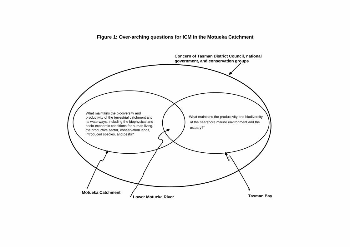
Figure 1: Over-arching questions for ICM in the Motueka Catchment
What maintains the biodiversity andproductivity of the terrestrial catchment andits waterways, including the biophysical andsocio-economic conditions for human living,the productive sector, conservation lands,introduced species, and pests?
What maintains the productivity and biodiversity
of the nearshore marine environment and the
estuary?”
Motueka CatchmentLower Motueka River Tasman Bay
Concern of Tasman District Council, national government, and conservation groups
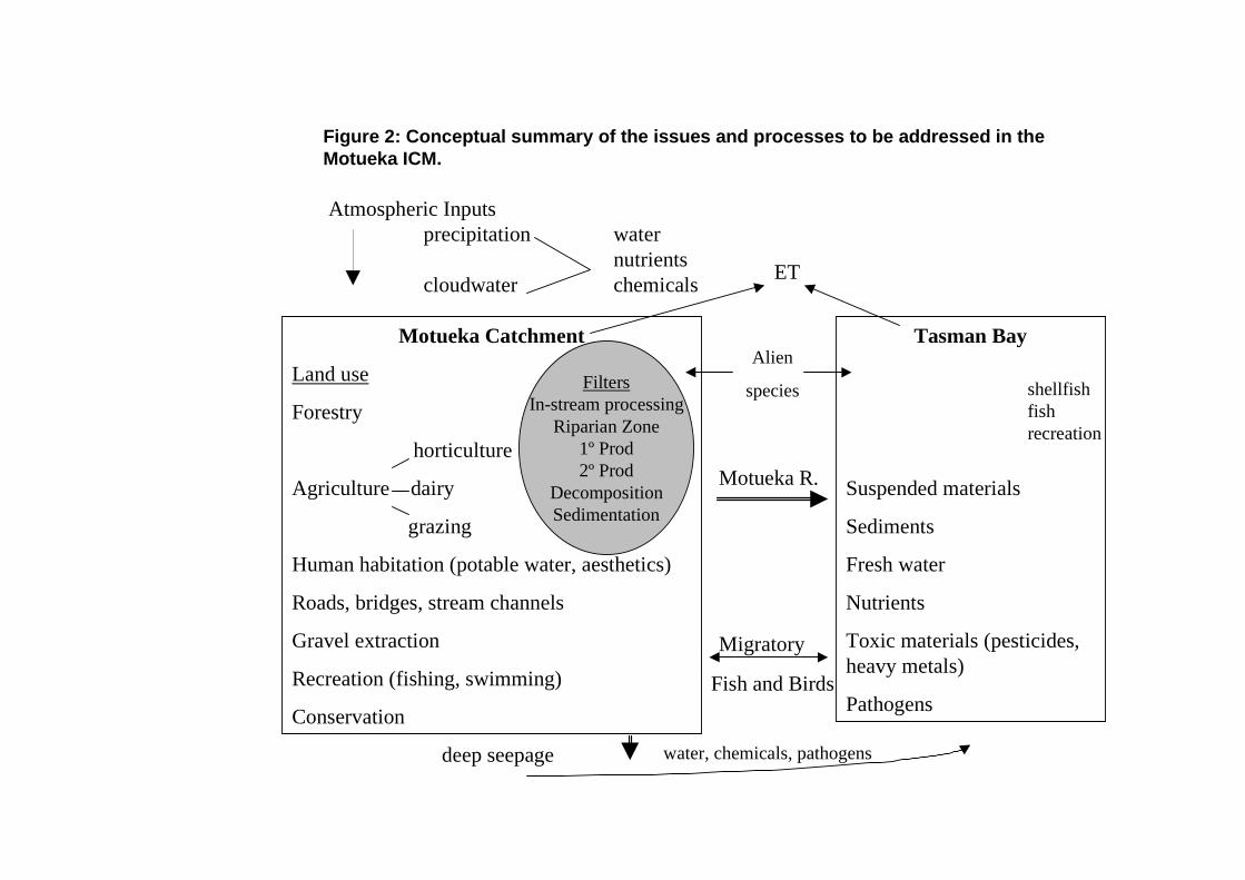
Figure 2: Conceptual summary of the issues and processes to be addressed in theMotueka ICM.
ET
Migratory
Fish and Birds
Atmospheric Inputsprecipitation water
nutrientscloudwater chemicals
Motueka Catchment
Land use
Forestry
horticulture
Agriculture dairy
grazing
Human habitation (potable water, aesthetics)
Roads, bridges, stream channels
Gravel extraction
Recreation (fishing, swimming)
Conservation
FiltersIn-stream processing
Riparian Zone1º Prod2º Prod
DecompositionSedimentation
Alien
species
deep seepage water, chemicals, pathogens
Tasman Bay
Suspended materials
Sediments
Fresh water
Nutrients
Toxic materials (pesticides,heavy metals)
Pathogens
shellfishfishrecreation
Motueka R.
Thomas Dunne, University of California Santa Barbara: Resume
Thomas Dunne is a Professor of Environmental Science and Management, and of Geological Sciences at the University of California Santa Barbara. He conducts field and theoretical studies of drainage-basin, hillslope, and fluvial geomorphology, and in the application of hydrology and geomorphology to landscape management and hazard analysis. While working for the USDA Agricultural Research Service (1966-1969) and McGill University (1971-1973), he conducted research on the effects of topography, soil characteristics, and vegetation on runoff processes under rainfall and snowmelt in Vermont and Canada. While teaching at the University of Nairobi (1969-1971), he initiated a long-running research interest in African environments, including experimental studies of runoff and ero-sion processes, and statistical studies and field surveys of the effects of land use on hillslope erosion and river-basin sediment yields. He also conducted occasional studies of reservoir sedimentation, water quality, and erosion due to charcoal production and grazing. Between 1969 and 1991, this work was supported by various foundations, the United Nations, the US National Science Foundation, and Kenya government agencies. While teaching in the Department of Geological Sciences at the University of Washington (1973-1995), he studied landsliding and debris flows; drainage-basin sediment budgets in natural and managed forests; tephra erosion and debris-flow sedimentation on active volcanoes; and sediment transport and channel morphology in sand-bed and gravel-bed river channels. He also conducted several studies related to resource management, such as the impacts of gravel harvesting on the river-channel sedimentation and morphology; impacts of timber harvest on erosion and sedimentation; and effects of flow diversion and reservoir management on sedimentation. The work was funded by the National Science Foundation, US Geological Survey, US Forest Service, and the State of Washington He now leads an Interdisciplinary Science Team, participating in the NASA Earth Observing System, that studies hydrology, sedimentation, biogeochemistry, and environmental change in the Amazon River Basin of low-land Brazil and Bolivia and the Andes Range of Bolivia. His particular scientific roles in the project involves: field measurements of soil and rock properties, of runoff and erosion processes in the lowlands and the Andes, sediment transport and floodplain sedimentation, and modeling of streamflow and sedimentation throughout the whole basin employing data from ground networks and satellites. With students at the University of California, he also conducts experimental studies of erosion in Mediterranean California, and of sediment transport and sedimentation in the Sac-ramento River Valley and at the Los Alamos National Laboratory. He has gained experience of geomorphic and hydrologic processes related to development projects through research and consultancies in many parts of the world, and has expressed some of that experience in teaching courses, advising government agencies, writing papers, and co-authoring two textbooks on the application of hydrol-ogy and geomorphology to resource management. Professor, Donald Bren School of Environmental Science and Management, and Department of Geological Sciences, 4670 Physical Sciences North, University of California, Santa Barbara, CA 93106. Tel: 805-893-7557; Fax: 805-893-7612; Email: [email protected] EDUCATION B.A. 1964 Cambridge Univ., UK (Geography) Ph.D. 1969 Johns Hopkins Univ. (Geography) . HONORS Fulbright Scholar, 1964; Robert E. Horton Award, American Geophysical Union, 1987; Elected to National Academy of Sciences, 1988; Elected Fellow, American Geophysical Union, 1989; Guggenheim Fellowship, 1989; Elected to American Academy of Arts and Sciences, 1993; Elected to California Academy of Sciences, 1996; National Research Council Wolman Distinguished Lecturer, 1997; National Academy of Sciences G. K. Warren Prize for Fluviatile Geology, 1998.
1
SELECTED PUBLICATIONS T. Dunne and L. B. Leopold, Water in Environmental Planning, W. H. Freeman Co., San Francisco, 818 pp.,
1978. Reid, L.M. and T. Dunne, Rapid evaluation of sediment budgets; Geo-Ecology Texts, Catena Verlag, Reiskirchen,
Germany, 164 pp, 1996. T. Dunne, T. R. Moore and C. H. Taylor, Recognition and prediction of runoff producing zones in humid regions,
Hydrological Sciences Bulletin, 20, 305-327, 1975. T. Dunne, A. G. Price and S. C. Colbeck, The generation of runoff from subarctic snowpacks, Water Resources
Research, 12, 677-685, 1976. T. Dunne, Evaluation of erosion conditions and trends, In: Guidelines for Watershed Management, (ed. S. H.
Kunkle), FAO Conservation Guide 1, 53-83, U.N. Food and Agriculture Organization, Rome, 1977. T. Dunne, Intensity and controls of soil erosion in Kajiado District, Kenya, Reports of the Kenya Wildlife
Management Project, U.N. Food and Agriculture Organization, Rome, 67 pp., 1977. T. Dunne, Field studies of hillslope flow processes, Chapter 7, In: Hillslope Hydrology, (ed. M. J. Kirkby), Wiley,
London, 227-293, 1978. T. Dunne, Rates of chemical denudation of silicate rocks in Kenya, Nature, 274, 244-246, 1978. W. E. Dietrich and T. Dunne, Sediment budget for a small catchment in mountainous terrain, Zeitschrift für
Geomorphologie, Supplement Band 29, 215-230, 1978. T. Dunne, Sediment yield and land use in tropical catchments, Journal of Hydrology, 42, 281-300, 1979.
Reproduced in Erosion and Sediment Yield, Benchmark Papers in Geology, 63 (eds. J. B. Laronne and M. P. Mosley), Hutchinson Ross Pub. Co., Stroudsburg PA, 266-285, 1982.
D. Western and T. Dunne, Environmental aspects of settlement site decisions among pastoral Maasai, Human
Ecology, 6, 75-98, 1979. T. Dunne, W. E. Dietrich and M. J. Brunengo, Rapid evaluation of soil erosion and soil lifespan in the grazing lands
of Kenya, International Assoc. of Hydrol. Sciences, Pub. 128, 421-428, 1979. L. M. Reid, T. Dunne, and C. J. Cederholm, Application of sediment budget studies to the evaluation of logging road
impact; J. Hydrol. (NZ) , 20, 49-62, 1981. W. E. Dietrich, T. Dunne, N. F. Humphrey and L. M. Reid, Construction of sediment budgets for drainage basins,
Sediment Budgets and Routing in Forested Drainage Basins, U.S. Forest Service General Technical Report PNW-141, Pacific Northwest Forest and Range Expt. Sta., 5-23, 1982.
W. E. Dietrich, D. M. Windsor, and T. Dunne, Geology, climate, and hydrology of Barro Colorado Island, In: The
Ecology of a Tropical Forest: Seasonal Rhythms and Long-term Changes, (eds. E. G. Leigh, A. S. Rand, and D. M.Windsor), Smithsonian Institution Press, Washington, D.C., 21-46, 1982.
A. K. Lehre, B. D. Collins, and T. Dunne, Post-eruption sediment budget for the North Fork Toutle River drainage,
June 1980-June 1981, Zeitschrift für Geomorphologie, Suppl. Bd. 46, 143-163, 1983. L. M. Reid and T. Dunne, Sediment production from forest road surfaces, Water Resour. Res., 20, 1753-1762,
1984.
2
R. H. Meade, T. Dunne, et al., Storage and remobilization of suspended sediment in the Lower Amazon River of Brazil, Science, 228, 488-490, 1985.
B. D. Collins, and T. Dunne, Erosion of tephra from the 1980 eruption of Mount St. Helens, Geological Society of
America Bulletin, 97, 896-905, 1986. T. Dunne, Geomorphological contributions to flood-control planning; In Flood Geomorphology (Eds. V. R. Baker,
R. C. Kochel, and P. C. Patton), Wiley & Sons, NY, 421-438, 1988. B. D. Collins and T. Dunne, Gravel transport, gravel harvesting, and channel-bed degradation in rivers draining the
Southern Olympic Mountains, Washington, USA, Environmental Geology and Water Science, 13, 213-224, 1989.
J. E. Richey, L. A. K. Mertes, T. Dunne, and five others, Sources and routing of the Amazon River floodwave;
Global Biogeochemical Cycles, 3, 191-204, 1989. B. D. Collins and T. Dunne, Fluvial geomorphology and river-gravel mining, Spec. Pub. 98, Division of Mines and
Geology, California Department of Conservation, 29 p., 1990. T. Dunne, Hydrology, mechanics, and geomorphic implications of erosion by subsurface flow; In Groundwater
Geomorphology (Eds. C. G. Higgins and D. R. Coates) Geological Society of America Special Paper 252, 1-40, 1990.
T. Dunne, Stochastic aspects of the relations between climate, hydrology and landforms; Trans. Japanese
Geomorphological Union, 12, 1-24, 1991. K. X Whipple and T. Dunne, Debris-flow fans in Owens Valley, California, Geol. Soc. Amer. Bull., 104, 1992. W. E. Dietrich and T. Dunne, The channel head; In Channel Networks: A Geomorphological Perspective (Eds.
K. J. Beven and M. J. Kirkby), John Wiley & Sons, Chichester UK, 175-220, 1993. L.A.K. Mertes, T.Dunne, and L.A Martinelli, Channel-floodplain geomorphology along the Solimoes-Amazon
River, Brazil, Geological Society of America Bulletin, 108, 1089-1107,1996. L. Benda and T. Dunne, Stochastic forcing of sediment supply to channel networks by landsliding and debris flow:
Water Resources Research, 33, 2849-2863,1997. L. Benda and T. Dunne, Stochastic forcing of sediment storage and transport in channel networks; Water Resources
Research, 33, 2865-2880, 1997. T. Dunne, L.A.K. Mertes, R.H. Meade, J.E. Richey, and B.R. Forsberg, Exchange of sediment between the channel and floodplain of the Amazon River in Brazil, Geological Society of America Bulletin, 110, 2-19, 1998. L. Benda, D. J. Miller, T. Dunne, G.H. Reeves, and J.K. Agee, Dynamic landscape systems: pp. 261-288 in: Ecology
and Management of Streams and Rivers in the Pacific Northwest Ecoregion (edited by R. Naiman and R. Bilby), Springer Verlag, New York, 705 pp., 1998.
T. Dunne, Hydrologic science…. on a planet… in landscapes… in the future, In Hydrologic Science: Taking Stock and Looking Forward, pp. 10-43, National Academy Press, Washington DC, 138 pp., 34,
795-808, 1998. T. Dunne, Critical data requirements for prediction of erosion and sedimentation in mountain drainage basins, Jour.
American Water Resources Association, 34, 795-808, 1998.