removal of the ver mill weir on the sienne river
TRANSCRIPT

AFB, 2018
Removal of the Ver mill weir on the Sienne River
■ The location
Country France
River basin Seine - Normandie
Region(s) Normandie
Département(s) Manche
Commune(s) Ver
Regulatory context Not applicable
European directive references
Water-body ref.: HR336B
Natura 2000 site ref.: Not applicable
ROE (obstacle) code 4702
■ The operation
Category Restoration
Type of operation Partial or total weir/dam removal
Type of environment Intermediate river zone
Issues at stake (water, biodiversity, climate)
River continuity
Start of operation October 2010
End of operation October 2010
Length of river affected by the works
1 700 m
■ River in the restored sector
Name Sienne River
Distance to source 55 km
Mean width 18 m
Mean gradient 1.00‰
Mean discharge 8 cubic metres per second
■ Aims of the project owner• Compliance with regulations (Art. L. 432-6 Envir. code).
• Restore river continuity between the Airou tributary and the English Channel.
■ Environment and pressuresThe Sienne is a coastal river, 80 kilometres long, that flows into the English Channel in the harbour of the town of Re-gnéville. Its basin covers a surface area of 580 square kilo-metres. The area is essentially agricultural, dominated by grazing and fodder crops (maize) with some grain crops. The soil is fairly impermeable (orthogneiss and granite) with relatively steep slopes in a rather hilly area. Farm fields represent a sizeable percentage of the land cover, however the intensity of the pressures exerted on aquatic environments is limited. The chemical quality of water is rather high and the main disturbances are hydromorpho-logical due to the presence of transversal structures. The Sienne is fragmented and fish have a difficult time acces-sing the upper reaches and the tributaries.
Partial or total weir/dam removal
The Sienne valley with the Ver mill weir in the foreground. April 2006.
Fabi
en G
oulm
y –
FDPP
MA
50
The Sienne is mentioned in Lists 1 and 2 of Ar-ticle L. 214-17 of the Environmental code for migratory fish, including Atlantic salmon, sea lampreys, river lampreys, brown trout, sea trout and eels.
Approximately 40 transversal structures exist along the river, representing one structure every two kilometres on average. Most of these struc-tures serve no economic purpose and half are in ruins.
The Ver mill, built centuries ago, had not served an economic purpose for decades. The mill weir, 1.7 metres high, was in very poor condition. A night club exists on the left bank.
Just upstream of the Ver mill is the confluence with the Airou Stream, the main tributary com-prising spawning redds for salmon designated as a Natura 2000 site, primarily due to the presence of freshwater pearl mussels and Atlantic salmon.
Scan 25 ®- © IGN
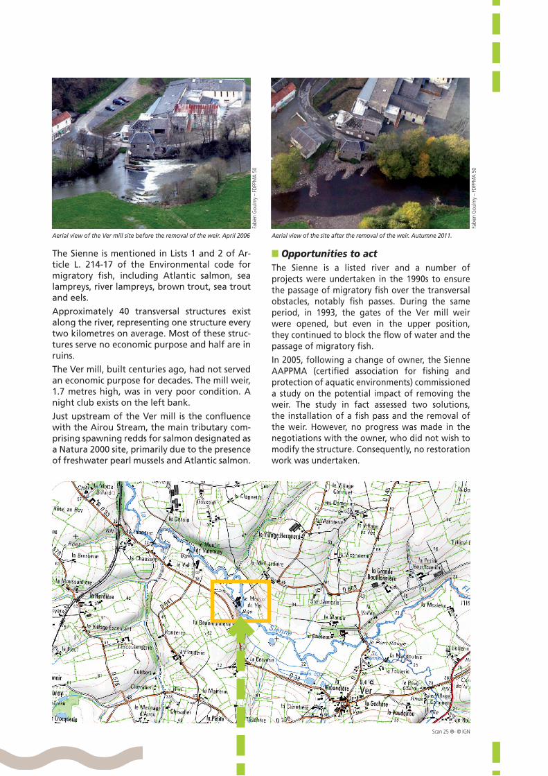
Aerial view of the site after the removal of the weir. Autumne 2011.
Fabi
en G
oulm
y –
FDPP
MA
50
■ Opportunities to actThe Sienne is a listed river and a number of projects were undertaken in the 1990s to ensure the passage of migratory fish over the transversal obstacles, notably fish passes. During the same period, in 1993, the gates of the Ver mill weir were opened, but even in the upper position, they continued to block the flow of water and the passage of migratory fish.
In 2005, following a change of owner, the Sienne AAPPMA (certified association for fishing and protection of aquatic environments) commissioned a study on the potential impact of removing the weir. The study in fact assessed two solutions, the installation of a fish pass and the removal of the weir. However, no progress was made in the negotiations with the owner, who did not wish to modify the structure. Consequently, no restoration work was undertaken.
Aerial view of the Ver mill site before the removal of the weir. April 2006
Fabi
en G
oulm
y –
FDPP
MA
50

AFB, 2018
In 2009, the mill was purchased by a new owner. The State services and the Water agency explained to the new owner the situation with the structure and the issues at hand in the sector. The owner accepted the removal of the structure given the safety issues (the dilapidated condition) as well as the regulatory and economic context (the publication of a new river classification in 2012, taking into account new species in the design of fish passes (Art. L. 214-17 of the Environmental code). The owner relinquished his water rights in November 2010.
monitoring dealt with the spawning redds of sea lampreys and with the hydromorphological com-partment (topography, flow patterns, substrate measurements, etc.).
The Departmental federation for fishing and the protection of aquatic environments for the Manche department monitors each year salmon popula-tions, including an index on the abundance of juve-nile salmon.
In 2012, the geomorphology (erosion dynamics, stream power, etc.) was monitored by an intern from the University of Caen. The Intermunicipal board for the development and maintenance of the Sienne (SIAES) undertook photographic monitoring of the changes in the riverbed and the banks for the first three years following the project*.
■ Outcome of the project and outlookThe removal of the Ver mill weir made possible a re-turn to a natural riverbed in the formerly impoun-ded reach, over a distance of 1.7 kilometres.
The elimination of the reservoir resulted in an ar-ray of diverse flow patterns of running water. For example, seven riffles reappeared, alternating with rapids and more lentic flow patterns. The return of the riffles has made available a surface area of 2 400 square metres suitable as spawning habitats for fish species.
Partial or total weir/dam removal
Reactivation of sediment transport in the former impoundment following removal of the weir. May 2013.
Rom
uald
Gén
oël -
SIA
ES
An Atlantic salmon attempting to overcome the Ver mill weir. Autumn 2009.
Ass
ocia
tion
Hyd
rosc
ope
■ Works and developmentsThe Ver mill weir was completely removed. The rubble of the stone weir was used on the right bank to create groynes to centre flood waters. The project included maintenance of the riparian vegetation upstream. A nearby pond was restored to replace the mill pond that had been used by the local fire department. Finally, fences and watering points were set up on neighbouring lands.
■ Regulatory approachNot applicable.
■ Post-restoration managementNo particular management measures were planned.
■ MonitoringIn 2010, before the demolition, the Seine-Norman-die Water agency established a monitoring point (physical-chemical quality, macro-invertebrates, diatoms) 200 metres upstream of the weir. This monitoring point is checked every two months for the physical-chemical data and every two years on average for the hydrobiological data.
Post-works monitoring was carried out one mon-th, six months and one year after the demolition, directly by Onema and the Water agency. This
* For more information, see the “Monitoring” section in the fact sheet on the Wetlands portal.

The removal of the weir also significantly improved the upstream migration conditions (wounds, delays, etc.) for salmonids, eels and sea lampreys between the English Channel and the Airou tributary. In 2012, 13 spawning redds for sea lampreys were observed on the site of the former impoundment, thus confirming the suitability of the habitats made available following the elimination of the structure.
The discovery of riffles in the sector entailed the creation of a monitoring point for the abundance index of salmon juveniles (IAS index). In 2011, the index stood at 49 at the monitoring point (high status). That represents significant progress for the monitoring point because the index was zero (no riffles) prior to the removal of the weir. These results indicate effective restoration of continuity for fish. The areas upstream of the Ver mill are now available and the suitability of the reproduction habitats in the former impoundment is also manifest.
An increase in fishing activities has also been obser-ved in the sector, due notably to the increase in the salmon population.
However, the improvement in the passage of migra-tory fish at the Ver mill is limited by the existence of other structures blocking movement in the river. There remain two or three structures that make passage dif-ficult or impossible for fish and block their access to spawning redds upstream and in the tributaries.
The physical-chemical monitoring revealed an im-provement in the oxygenation of the river waters and the river effectively achieved good physical-che-mical status in 2011. Samples of benthic macro-inver-tebrates taken in the years following the removal of the weir indicate very high habitat quality.
Geomorphologically speaking, the Sienne would appear to have returned to a more natural hydraulic gradient. Post works, major quantities of coarse sedi-ment reappeared on the site of the former impound-ment. This sediment has been and continues to be transported by two-year winter floods. The river has
also recommenced natural adjustment via lateral erosion in the concavity sections of meanders.
In 2010, the Seine-Normandie Water agency launched a study to obtain a comprehensive and shared assess-ment of the hydraulic structures in the Sienne basin. The study contained proposals for work on struc-tures to restore river continuity, taking into account local environmental, economic and social issues, while also assessing the value of maintaining the structures. The overall objective of the study was to look at a strategy to restore river continuity in the Sienne basin, taking into account the heritage value of the structures.
■ Promotion of the projectThe SIAES, in conjunction with Onema, prepared a technical fact sheet on the removal of the weir.
http : / / sd-2 .arch ive-host . com/membres /up/ 4517356054702344/Note_moulin_de_Ver_Complet.pdf
A number of visits to the project site were orga-nised, notably for river technicians in nearby river basins as well as for elected officials and the local population.
The Normandie CATER (Water and river technical group) also produced a video during the project.
https://www.youtube.com/watch?v=Uut23nc6q8g
■ Costs In euros ex. VAT
Studies 21 423
Purchase of land 0
Works and developments 30 985
Promotion 0
Total cost of project 52 408
Financial partners and funding:Seine-Normandie Water agency (90%), Basse-Normandie Regional council (5%), Sienne AAPPMA (certi-fied association for fishing and protection of aquatic environments) (5%)
Technical partners:Sienne AAPPMA, National agency for water and aquatic environments (Onema), Intermunicipal board for the development and maintenance of the Sienne (SIAES), Seine-Normandie Water agency, Manche departmental territorial and maritime directorate, University of Caen
Project owner Private owner
Contacts Romuald GenoëlIntermunicipal board for the development and maintenance of the Sienne (SIAES) [email protected]
Arnaud RichardAFB - Normandie regional office - Hauts-de-France [email protected]