recreational boating strategy - yorke peninsula council
TRANSCRIPT
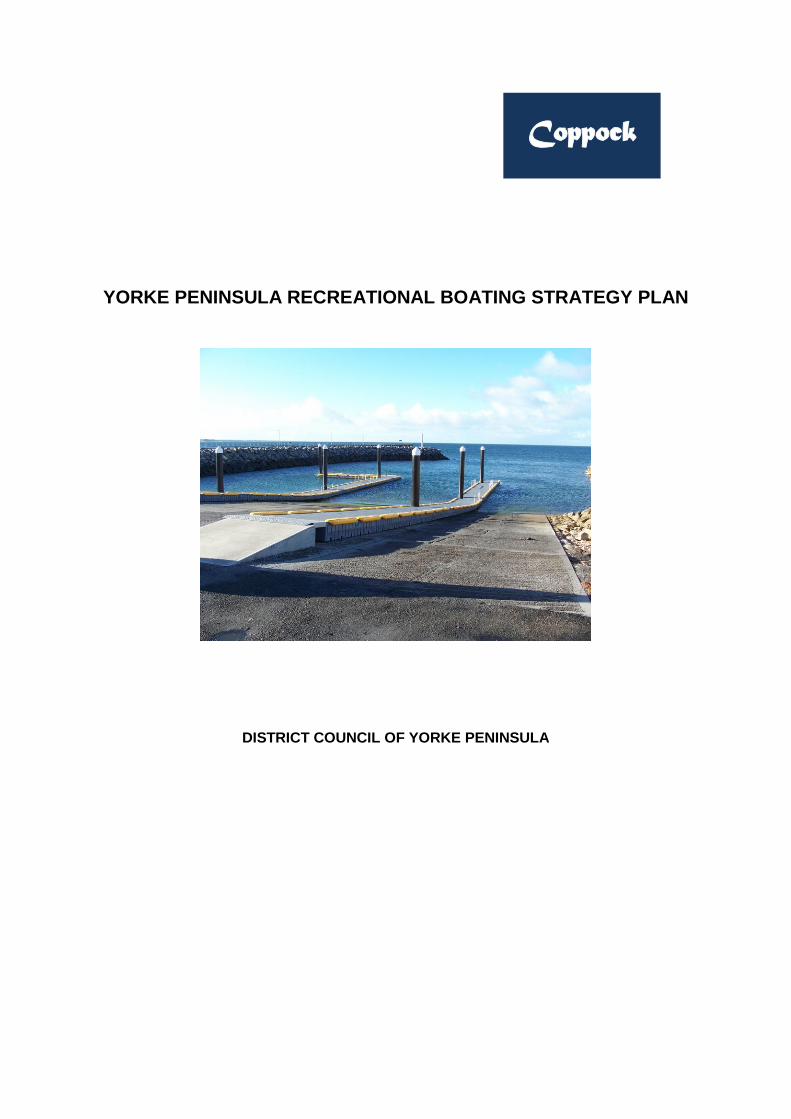
YORKE PENINSULA RECREATIONAL BOATING STRATEGY PLAN
DISTRICT COUNCIL OF YORKE PENINSULA
Coppock
Coppock & Associates
i
CA11-005-REP-002, Rev O
1 May 2012
Coppock & Associates Pty Ltd, 2012
Limitations Statement
The sole purpose of this report and the associated services performed by Coppock & Associates Pty Ltd (“the
Company”), is to prepare a consolidated strategy plan for the improvements to existing recreational boating facilities
within the District Council of Yorke Peninsula (‘the Client’) in accordance with the scope of services set out in the
contract between the Company and the Client.. That scope of services was defined by the requests of the Client,
by the time and budgetary constraints imposed by the Client.
In preparing this report, the Company has relied upon and presumed accurate certain information (or absence
thereof), relative to the existing boating facilities provided by the Client, government officials and authorities, and
others identified herein. Except as otherwise stated in the report, the Company has not attempted to verify the
accuracy or completeness of any such information.
No warranty or guarantee, whether express or implied, is made with respect to the data reported, or to the findings,
observations and conclusions expressed in this report. Further, such data, findings, observations and conclusions
are based solely upon information provided by the Client in existence at the time of the preparation of this report.
This report has been prepared on behalf of, and for the exclusive use of the Client, and is subject to and issued in
connection with the provisions of the agreement between the Company and the Client.
The Company accepts no liability or responsibility whatsoever for, or in respect of any use of or reliance upon this
report by any third party.
Revision History
Revision Date Comment Approved by
A 18/09/11 Draft issue G J Coppock
B 16/11/11 First issue for Client review G J Coppock
C 18/03/12 Revised for final approval G J Coppock
O 01/05/12 For Implementation G J Coppock
Coppock & Associates
CA11-005-REP-002, Rev O iii
1 May 2012
CONTENTS
Section Page
1 INTRODUCTION AND BACKGROUND 1
1.1 Introduction 1
1.2 Objectives of the Strategy Plan 1
1.3 Terms of Reference 1
2 RECREATIONAL BOATING ON YORKE PENINSULA 2
2.1 Visitors to Yorke Peninsula 2
2.2 Population projections 2
2.3 Vessel registrations 3
3 EXISTING RECREATIONAL BOATING FACILITIES 7
3.1 Existing recreational boating facilities 7
3.2 Condition assessment of existing facilities 9
3.3 Utilisation of existing facilities 10
3.4 Upgrading works committed 10
3.5 Other works committed 11
3.6 Previous studies 11
4 THE STRATEGY 12
4.1 Introduction 12
4.2 Classification of boating facilities 12
4.3 Boating safety 13
4.4 The strategy 13
5 RECOMMENDATIONS 22
Tables
Table 2.1 Visitation data for period 2005–2009 2
Table 2.2 Regional population data for period 2005–2009 2
Table 2.3 Combined population and visitation data for period 2005–2009 3
Table 2.4 Recreational vessel registrations (2007–2011) 3
Table 2.5 South Australian vessel registrations – 2011 3
Table 2.6 Analysis of vessel use by hull type – 2011 4
Table 2.7 Vessel registrations by regional postcode (Yorke Peninsula Council
area) – 2011 5
Table 2.8 Participation of SA resident recreational fishers by Statistical Division
(2002–2008) 5
Table 3.1 Existing recreational boating facilities and classifications 8
Coppock & Associates
CA11-005-REP-002, Rev O iv
1 May 2012
Table 3.2 Utilisation of existing recreational launching facilities 10
Table 3.3 Aids to navigation – Audit of selected facilities 11
Table 4.1 Category 2/3 facilities 14
Table 4.2 Category 1 facilities with a high priority for upgrading 15
Table 4.3 Yorke Peninsula recreational boating facilities improvement strategy 15
Table 4.4 Yorke Peninsula recreational boating facilities improvements – Priority
grouping 18
Figures
Figure 3.1 Existing recreational boating facilities 7
Appendices
Appendix A References
Appendix B Utilisation Survey
Appendix C Condition Assessment Survey
Coppock & Associates
CA11-005-REP-002, Rev O 1
1 May 2012
1 Introduction and background
1.1 Introduction
Following extensive community consultation, the Recreational Boating Strategy Plan for Yorke
Peninsula was prepared by Kinhill Pty Ltd in December 1997 on behalf of the District Council of
Yorke Peninsula (the Council), and the then Marine Facilities Section of Transport SA. The terms of
reference for the Strategy Plan was to produce a planning strategy for recreational boating facilities
which addressed the need for such facilities as a positive benefit to the community generally,
provided for recreational usage, and attracted tourism in addition to interface with new development
opportunities as may exist in the Council area.
The Strategy Plan is however now some 15 years old, and while the broader planning principles are
still valid, upgrading of the Strategy Plan is now required to capture current community requirements
and to re-evaluate the use of facilities, the need for new facilities, and the prioritisation of such works.
This report has been prepared by Coppock & Associates Pty Ltd in response to an invitation by the
Council to undertake a review of the existing Strategy Plan, and to prepare a revised strategic
planning report to form the basis for the future direction with regards to planning, development and
expenditure funding on recreational boating facilities within the Council area.
1.2 Objectives of the Strategy Plan
The objectives of this revision of the Strategy Plan for recreational boating on Yorke Peninsula have
been defined as being:
to survey the current facilities and their suitability for recreational boating use;
to provide satisfactory facilities for recreational boating users and recreational fishers, the level of
facilities and services commensurate with the nature and frequency of use;
to provide a level of infrastructure that can be promoted to the recreational boating and fishing
fraternity, both within South Australia and interstate;
to set out in detail a 10 year development and action programme to enable Council and other
organisations and agencies to methodically develop new facilities where there is a demonstrated
requirement, improve those already existing so as to service the Peninsula’s coastal waters, and
to attract local and external funding to achieve these objectives.
1.3 Terms of Reference
The scope of work for this project is to produce a Strategy Plan for recreational boating facilities that
addresses the benefits of such facilities to the general community, encourages recreational usage,
and provides tourist attractions. The facilities should also complement new developments that may
exist or become established on Yorke Peninsula.
The terms of reference for the development of the Strategy Plan are to:
examine the boating facilities currently available to the community by physical inspection and
review of existing information;
assess recreational boating trends for the region and whether sufficient facilities exist to meet
existing community needs and potential future demand;
consider planning and infrastructure issues;
identify where new recreational boating facilities should be located and where existing facilities
should be upgraded;
identify the key priorities for inclusion into the Strategy Plan’s 10 year action programme.
Coppock & Associates
CA11-005-REP-002, Rev O 2
1 May 2012
2 Recreational boating on Yorke Peninsula
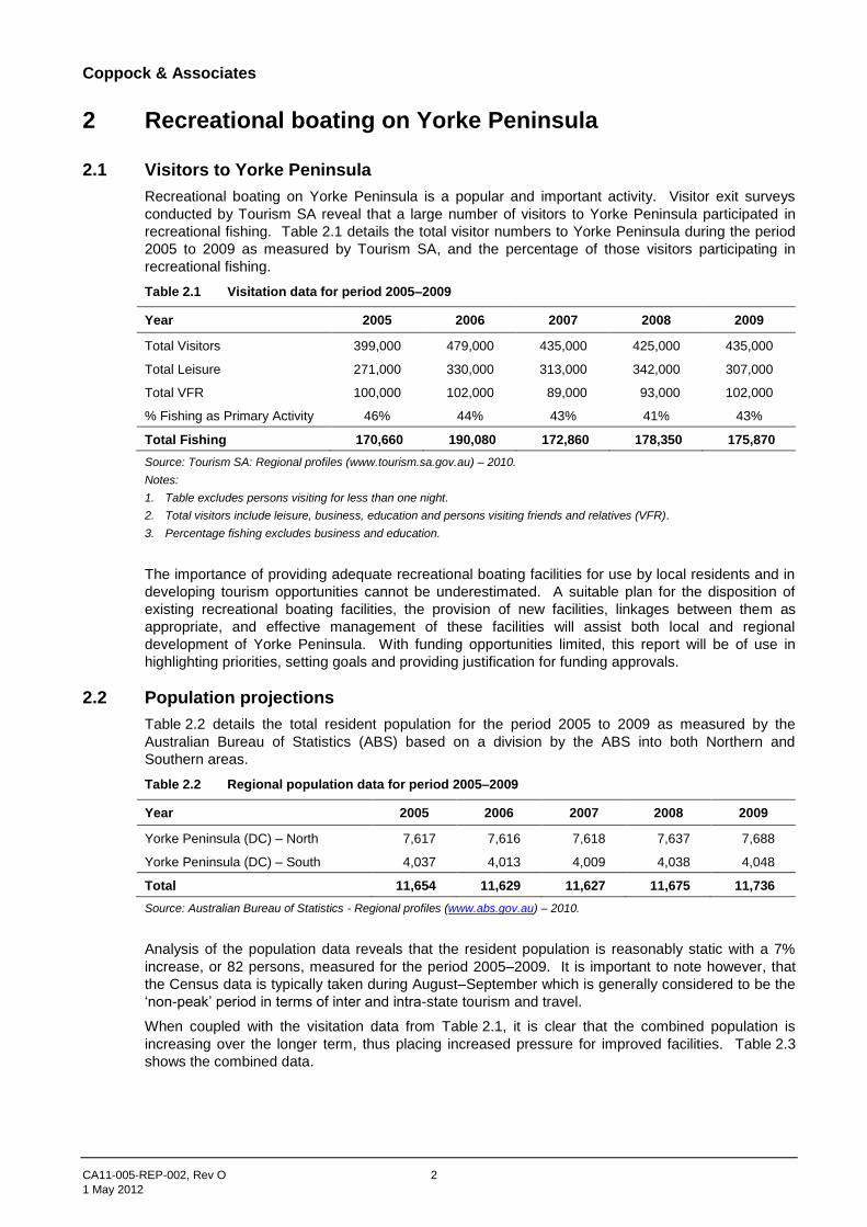
2.1 Visitors to Yorke Peninsula
Recreational boating on Yorke Peninsula is a popular and important activity. Visitor exit surveys
conducted by Tourism SA reveal that a large number of visitors to Yorke Peninsula participated in
recreational fishing. Table 2.1 details the total visitor numbers to Yorke Peninsula during the period
2005 to 2009 as measured by Tourism SA, and the percentage of those visitors participating in
recreational fishing.
Table 2.1 Visitation data for period 2005–2009
Year 2005 2006 2007 2008 2009
Total Visitors 399,000 479,000 435,000 425,000 435,000
Total Leisure 271,000 330,000 313,000 342,000 307,000
Total VFR 100,000 102,000 89,000 93,000 102,000
% Fishing as Primary Activity 46% 44% 43% 41% 43%
Total Fishing 170,660 190,080 172,860 178,350 175,870
Source: Tourism SA: Regional profiles (www.tourism.sa.gov.au) – 2010.
Notes:
1. Table excludes persons visiting for less than one night.
2. Total visitors include leisure, business, education and persons visiting friends and relatives (VFR).
3. Percentage fishing excludes business and education.
The importance of providing adequate recreational boating facilities for use by local residents and in
developing tourism opportunities cannot be underestimated. A suitable plan for the disposition of
existing recreational boating facilities, the provision of new facilities, linkages between them as
appropriate, and effective management of these facilities will assist both local and regional
development of Yorke Peninsula. With funding opportunities limited, this report will be of use in
highlighting priorities, setting goals and providing justification for funding approvals.
2.2 Population projections
Table 2.2 details the total resident population for the period 2005 to 2009 as measured by the
Australian Bureau of Statistics (ABS) based on a division by the ABS into both Northern and
Southern areas.
Table 2.2 Regional population data for period 2005–2009
Year 2005 2006 2007 2008 2009
Yorke Peninsula (DC) – North 7,617 7,616 7,618 7,637 7,688
Yorke Peninsula (DC) – South 4,037 4,013 4,009 4,038 4,048
Total 11,654 11,629 11,627 11,675 11,736
Source: Australian Bureau of Statistics - Regional profiles (www.abs.gov.au) – 2010.
Analysis of the population data reveals that the resident population is reasonably static with a 7%
increase, or 82 persons, measured for the period 2005–2009. It is important to note however, that
the Census data is typically taken during August–September which is generally considered to be the
‘non-peak’ period in terms of inter and intra-state tourism and travel.
When coupled with the visitation data from Table 2.1, it is clear that the combined population is
increasing over the longer term, thus placing increased pressure for improved facilities. Table 2.3
shows the combined data.
Coppock & Associates
CA11-005-REP-002, Rev O 3
1 May 2012
Table 2.3 Combined population and visitation data for period 2005–2009
Year 2005 2006 2007 2008 2009
Total Residents 11,654 11,629 11,627 11,675 11,736
Total Leisure + VFR 371,000 432,000 402,000 435,000 409,000
Total 382,654 443,629 413,627 446,675 420,736
Annual Change Nos 60,975 (30,002) 33,048 (25,939)
% Annual change 15.9 (6.8) 8.0 (5.8)
Source: Tourism SA: Regional profiles (www.tourism.sa.gov.au) – 2010 Australian Bureau of Statistics - Regional profiles (www.abs.gov.au) – 2010.
2.3 Vessel registrations
A comparison of total recreational vessels in South Australia between 1996 and 2011 indicates that
there has been a general increase in registrations.
Table 2.4 shows the recreational vessel registrations between 2007 to the present measured at
30 June of each year.
Table 2.4 Recreational vessel registrations (2007–2011)
Year 2007 2008 2009 2010 2011
Total Registrations 55,250 55,281 54,179 56,892 58,004
Annual Change Nos 31 (1,102) 2,713 1,112
% Annual change 0.06 (1.99) 5.01 1.95
Source: SA Department of Transport & Infrastructure – September 2011.
Table 2.5 shows total vessel registrations in South Australia, while Table 2.6 shows the use of these
registered vessels by hull type.
Table 2.5 South Australian vessel registrations – 2011
Hull type Registered nos. % Registrations
Sailing vessel 1,894 3.27
Cabin cruiser 2,484 4.28
Half cabin 12,327 21.25
Catamaran/trimaran 175 0.30
Cuddy cabin 221 0.38
Houseboat 791 1.36
Hovercraft 13 0.02
Hydroplane 11 0.02
Inflatable 498 0.86
Personal water craft 2,668 4.60
Motor yacht 0 0
Open boat 16,906 29.15
Runabout 13,821 23.83
Raft/punt 394 0.68
Traditional riverboat 213 0.37
Ski boat 5,028 8.67
Other 560 0.97
Total 58,004 100.00
Source: SA Department of Transport & Infrastructure – September 2011 Note: Vessel registrations as at 30 June 2011.
Coppock & Associates
CA11-005-REP-002, Rev O 4
1 May 2012
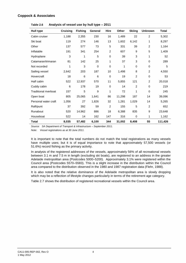
Table 2.6 Analysis of vessel use by hull type – 2011
Hull type Cruising Fishing General Hire Other Skiing Unknown Total
Cabin cruiser 1,188 2,355 230 16 1,489 22 2 5,302
Ski boat 119 274 146 13 1,602 6,142 1 8,297
Other 137 577 73 5 331 39 2 1,164
Inflatable 191 341 254 2 607 9 5 1,409
Hydroplane 3 1 5 0 39 3 1 52
Catamaran/trimaran 81 142 25 1 37 3 0 289
Not recorded 1 3 0 0 1 0 0 5
Sailing vessel 2,642 203 187 10 1,498 8 2 4,550
Hovercraft 18 6 6 0 19 2 0 53
Half cabin 522 12,937 570 11 5,855 121 2 20,018
Cuddy cabin 6 178 19 0 14 2 0 219
Traditional riverboat 157 5 9 1 72 1 0 245
Open boat 805 25,065 1,641 86 11,298 187 14 39,096
Personal water craft 1,056 27 1,826 32 1,281 1,029 14 5,265
Raft/punt 37 392 59 2 155 5 2 652
Runabout 520 14,962 886 18 6,388 835 9 23,648
Houseboat 522 14 162 147 316 0 1 1,162
Total 8,035 57,482 6,100 344 31,002 8,408 55 111,426
Source: SA Department of Transport & Infrastructure – September 2011.
Note: Vessel registrations as at 30 June 2011.
It is important to note that the total numbers do not match the total registrations as many vessels
have multiple uses; but it is of equal importance to note that approximately 57,500 vessels (or
51.6%) record fishing as the primary activity.
In analysis of the registered addresses of the vessels, approximately 56% of all recreational vessels
between 3.1 m and 7.5 m in length (excluding ski boats), are registered to an address in the greater
Adelaide metropolitan area (Postcodes 5000–5200). Approximately 3.1% were registered within the
Council area (Postcodes 5570–5583). This is a slight increase in the distribution within the Council
area compared to the distribution observed in the 1980 and 1987 registration data (Flehr, 1988).
It is also noted that the relative dominance of the Adelaide metropolitan area is slowly dropping
which may be a reflection of lifestyle changes particularly in terms of the retirement age category.
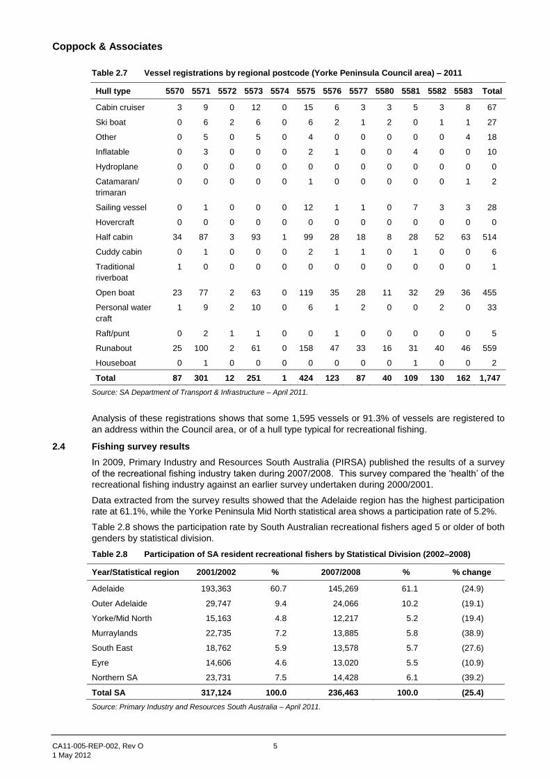
Table 2.7 shows the distribution of registered recreational vessels within the Council area.
Coppock & Associates
CA11-005-REP-002, Rev O 5
1 May 2012
Table 2.7 Vessel registrations by regional postcode (Yorke Peninsula Council area) – 2011
Hull type 5570 5571 5572 5573 5574 5575 5576 5577 5580 5581 5582 5583 Total
Cabin cruiser 3 9 0 12 0 15 6 3 3 5 3 8 67
Ski boat 0 6 2 6 0 6 2 1 2 0 1 1 27
Other 0 5 0 5 0 4 0 0 0 0 0 4 18
Inflatable 0 3 0 0 0 2 1 0 0 4 0 0 10
Hydroplane 0 0 0 0 0 0 0 0 0 0 0 0 0
Catamaran/
trimaran
0 0 0 0 0 1 0 0 0 0 0 1 2
Sailing vessel 0 1 0 0 0 12 1 1 0 7 3 3 28
Hovercraft 0 0 0 0 0 0 0 0 0 0 0 0 0
Half cabin 34 87 3 93 1 99 28 18 8 28 52 63 514
Cuddy cabin 0 1 0 0 0 2 1 1 0 1 0 0 6
Traditional
riverboat
1 0 0 0 0 0 0 0 0 0 0 0 1
Open boat 23 77 2 63 0 119 35 28 11 32 29 36 455
Personal water
craft
1 9 2 10 0 6 1 2 0 0 2 0 33
Raft/punt 0 2 1 1 0 0 1 0 0 0 0 0 5
Runabout 25 100 2 61 0 158 47 33 16 31 40 46 559
Houseboat 0 1 0 0 0 0 0 0 0 1 0 0 2
Total 87 301 12 251 1 424 123 87 40 109 130 162 1,747
Source: SA Department of Transport & Infrastructure – April 2011.
Analysis of these registrations shows that some 1,595 vessels or 91.3% of vessels are registered to
an address within the Council area, or of a hull type typical for recreational fishing.
2.4 Fishing survey results
In 2009, Primary Industry and Resources South Australia (PIRSA) published the results of a survey
of the recreational fishing industry taken during 2007/2008. This survey compared the ‘health’ of the
recreational fishing industry against an earlier survey undertaken during 2000/2001.
Data extracted from the survey results showed that the Adelaide region has the highest participation
rate at 61.1%, while the Yorke Peninsula Mid North statistical area shows a participation rate of 5.2%.
Table 2.8 shows the participation rate by South Australian recreational fishers aged 5 or older of both
genders by statistical division.
Table 2.8 Participation of SA resident recreational fishers by Statistical Division (2002–2008)
Year/Statistical region 2001/2002 % 2007/2008 % % change
Adelaide 193,363 60.7 145,269 61.1 (24.9)
Outer Adelaide 29,747 9.4 24,066 10.2 (19.1)
Yorke/Mid North 15,163 4.8 12,217 5.2 (19.4)
Murraylands 22,735 7.2 13,885 5.8 (38.9)
South East 18,762 5.9 13,578 5.7 (27.6)
Eyre 14,606 4.6 13,020 5.5 (10.9)
Northern SA 23,731 7.5 14,428 6.1 (39.2)
Total SA 317,124 100.0 236,463 100.0 (25.4)
Source: Primary Industry and Resources South Australia – April 2011.
Coppock & Associates
CA11-005-REP-002, Rev O 6
1 May 2012
In the commentary by the researchers, the decline in participation by recreational fishers is in the lower age groups (5 years–29 years) in comparison with the older age demographic (30 years–60+ years) and in on-shore fishing rather than off-shore fishing. The commentators suggest that this decline may be due to greater involvement of the younger age groups with alternative forms of entertainment, increased economic pressures and career development, with the older age demographic adopting a stronger ‘work-life’ balance as they move towards retirement.
This commentary is supported by the increase in recreational vessel registrations as shown in Table 2.4.

Coppock & Associates
CA11-005-REP-002, Rev O 7
1 May 2012
3 Existing recreational boating facilities
3.1 Existing recreational boating facilities
The consultants visited all the existing recreational boating facilities on Yorke Peninsula during the
period 7 June–10 June 2011 (refer Figure 3.1). These facilities, some thirty-three in all, represent
approximately 10% of the total recreational boating facilities in South Australia.
Figure 3.1 Existing recreational boating facilities
The condition of these facilities had been previously assessed (Rusk PPK, 1996 and Kinhill, 1997) but
due to the age of the assessments a visual inspection was undertaken of these facilities with the
assessed condition reported at Appendix C.
Coppock & Associates
CA11-005-REP-002, Rev O 8
1 May 2012
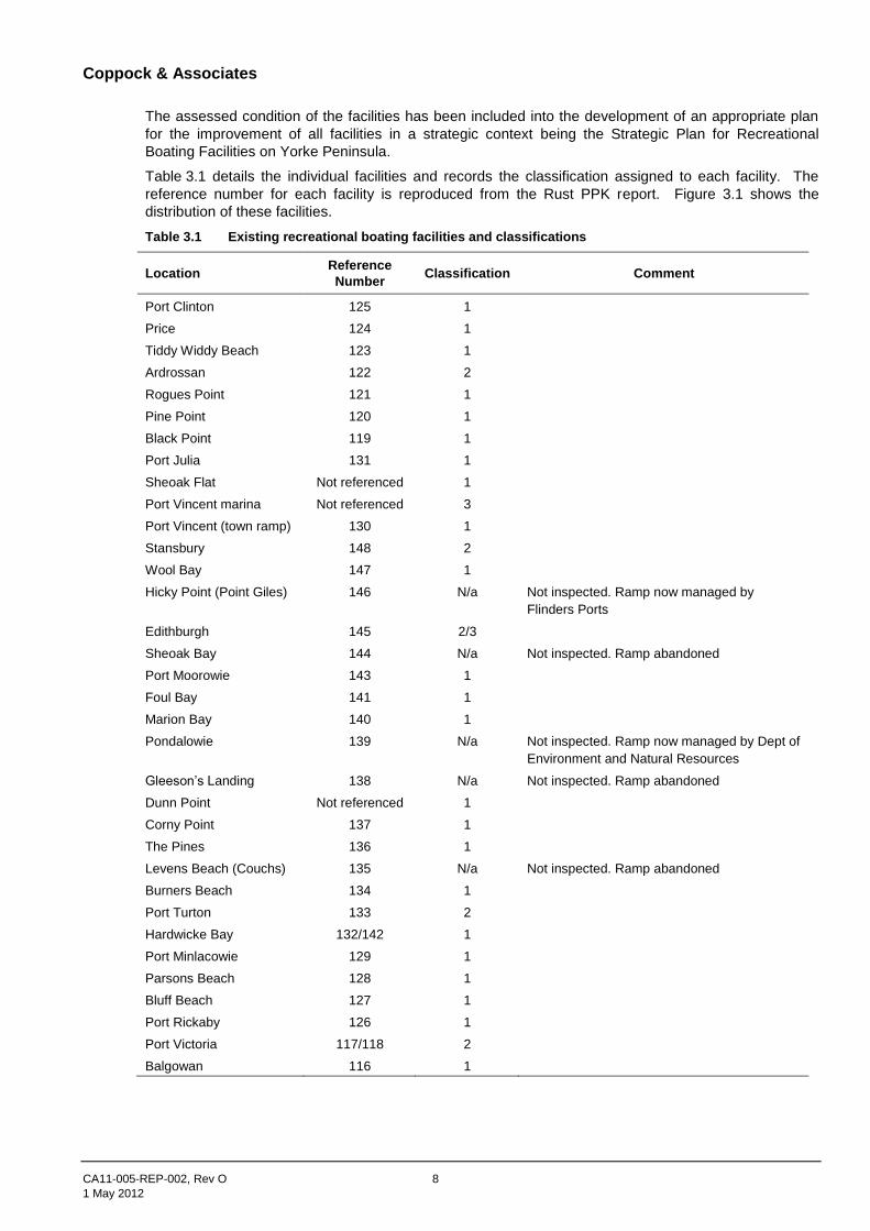
The assessed condition of the facilities has been included into the development of an appropriate plan
for the improvement of all facilities in a strategic context being the Strategic Plan for Recreational
Boating Facilities on Yorke Peninsula.
Table 3.1 details the individual facilities and records the classification assigned to each facility. The
reference number for each facility is reproduced from the Rust PPK report. Figure 3.1 shows the
distribution of these facilities.
Table 3.1 Existing recreational boating facilities and classifications
Location Reference
Number Classification Comment
Port Clinton 125 1
Price 124 1
Tiddy Widdy Beach 123 1
Ardrossan 122 2
Rogues Point 121 1
Pine Point 120 1
Black Point 119 1
Port Julia 131 1
Sheoak Flat Not referenced 1
Port Vincent marina Not referenced 3
Port Vincent (town ramp) 130 1
Stansbury 148 2
Wool Bay 147 1
Hicky Point (Point Giles) 146 N/a Not inspected. Ramp now managed by
Flinders Ports
Edithburgh 145 2/3
Sheoak Bay 144 N/a Not inspected. Ramp abandoned
Port Moorowie 143 1
Foul Bay 141 1
Marion Bay 140 1
Pondalowie 139 N/a Not inspected. Ramp now managed by Dept of
Environment and Natural Resources
Gleeson’s Landing 138 N/a Not inspected. Ramp abandoned
Dunn Point Not referenced 1
Corny Point 137 1
The Pines 136 1
Levens Beach (Couchs) 135 N/a Not inspected. Ramp abandoned
Burners Beach 134 1
Port Turton 133 2
Hardwicke Bay 132/142 1
Port Minlacowie 129 1
Parsons Beach 128 1
Bluff Beach 127 1
Port Rickaby 126 1
Port Victoria 117/118 2
Balgowan 116 1
Coppock & Associates
CA11-005-REP-002, Rev O 9
1 May 2012
3.2 Condition assessment of existing facilities
The assessed condition for each facility is shown at Appendix C, and in general terms the facilities were
found to be in reasonable condition with the following major issues observed and reported:
General cracking of the ramp surfaces with cracking ranging from moderate (2–5 mm width) to
severe (>10 mm width). No major displacement of the ramp surface was observed.
General degradation of fenders, breasting poles and the like.
Displacement at the toe of ramps and undermining due to the practice of ‘power retrieval’ where a
vessel is driven onto its trailer rather than conventional hand or power winching.
Localised loss of water depth beyond the toe of individual ramps; again attributed to the practice of
‘power retrieval’.
Lack of adequate protection from wind or wave activity to launching ramps serving more populous
regional townships.
Lack of navigation assistance including navigation markers or lead poles.
Lack of rubbish collection and disposal systems.
Each of these issues is addressed in this review of the Yorke Peninsula Recreational Boating Strategy
Plan.
3.3 Condition assessment of existing facilities
The assessed condition for each facility is shown at Appendix C, and in general terms the facilities were
found to be in reasonable condition with the following major issues observed and reported:
General cracking of the ramp surfaces with cracking ranging from moderate (2–5 mm width) to
severe (>10 mm width). No major displacement of the ramp surface was observed.
General degradation of fenders, breasting poles and the like.
Displacement at the toe of ramps and undermining due to the practice of ‘power retrieval’ where a
vessel is driven onto its trailer rather than conventional hand or power winching.
Localised loss of water depth beyond the toe of individual ramps; again attributed to the practice of
‘power retrieval’.
Lack of adequate protection from wind or wave activity to launching ramps serving more populous
regional townships.
Lack of navigation assistance including navigation markers or lead poles.
Lack of rubbish collection and disposal systems.
Each of these issues is addressed in this review of the Yorke Peninsula Recreational Boating Strategy
Plan.
3.4 Condition assessment of existing facilities
The assessed condition for each facility is shown at Appendix C, and in general terms the facilities were
found to be in reasonable condition with the following major issues observed and reported:
General cracking of the ramp surfaces with cracking ranging from moderate (2–5 mm width) to
severe (>10 mm width). No major displacement of the ramp surface was observed.
General degradation of fenders, breasting poles and the like.
Displacement at the toe of ramps and undermining due to the practice of ‘power retrieval’ where a
vessel is driven onto its trailer rather than conventional hand or power winching.
Localised loss of water depth beyond the toe of individual ramps; again attributed to the practice of
‘power retrieval’.
Lack of adequate protection from wind or wave activity to launching ramps serving more populous
regional townships.
Lack of navigation assistance including navigation markers or lead poles.
Lack of rubbish collection and disposal systems.
Coppock & Associates
CA11-005-REP-002, Rev O 10
1 May 2012
Each of these issues is addressed in this review of the Yorke Peninsula Recreational Boating Strategy
Plan.
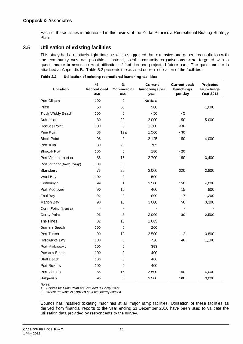
3.5 Utilisation of existing facilities
This study had a relatively tight timeline which suggested that extensive and general consultation with
the community was not possible. Instead, local community organisations were targeted with a
questionnaire to assess current utilisation of facilities and projected future use. The questionnaire is
attached at Appendix B. Table 3.2 presents the advised current utilisation of the facilities.
Table 3.2 Utilisation of existing recreational launching facilities
Location
%
Recreational
use
%
Commercial
use
Current
launchings per
year
Current peak
launchings
per day
Projected
launchings
Year 2015
Port Clinton 100 0 No data
Price 50 50 900 1,000
Tiddy Widdy Beach 100 0 <50 <5
Ardrossan 80 20 3,000 150 5,000
Rogues Point 100 0 1,200 <30
Pine Point 88 12a 1,500 <30
Black Point 98 2 3,125 150 4,000
Port Julia 80 20 705
Sheoak Flat 100 0 150 <20
Port Vincent marina 85 15 2,700 150 3,400
Port Vincent (town ramp) 100 0
Stansbury 75 25 3,000 220 3,800
Wool Bay 100 0 500
Edithburgh 99 1 3,500 150 4,000
Port Moorowie 90 10 400 15 800
Foul Bay 92 8 800 17 1,200
Marion Bay 90 10 3,000 50 3,300
Dunn Point (Note 1) - - - - -
Corny Point 95 5 2,000 30 2,500
The Pines 82 18 1,665
Burners Beach 100 0 200
Port Turton 90 10 3,500 112 3,800
Hardwicke Bay 100 0 728 40 1,100
Port Minlacowie 100 0 353
Parsons Beach 100 0 400
Bluff Beach 100 0 400
Port Rickaby 100 0 400
Port Victoria 85 15 3,500 150 4,000
Balgowan 95 5 2,500 100 3,000
Notes: 1. Figures for Dunn Point are included in Corny Point. 2. Where the table is blank no data has been provided.
Council has installed ticketing machines at all major ramp facilities. Utilisation of these facilities as
derived from financial reports to the year ending 31 December 2010 have been used to validate the
utilisation data provided by respondents to the survey.
Coppock & Associates
CA11-005-REP-002, Rev O 11
1 May 2012
3.6 Upgrading works committed
The South Australian Boating Facility Advisory Committee (SABFAC) considers applications for funding
assistance for upgrading, replacement or new facilities for recreational boating in the State and makes
recommendations to the Minister for Planning, Transport and Infrastructure in this regard.
At the time of this report, the Consultants were not aware of commitments by SABFAC for the provision
of funding for recreational boating facilities on Yorke Peninsula. We do however understand that a
preliminary application for the upgrading of the launching facility at Black Point has been made by the
Black Point Progress Association.
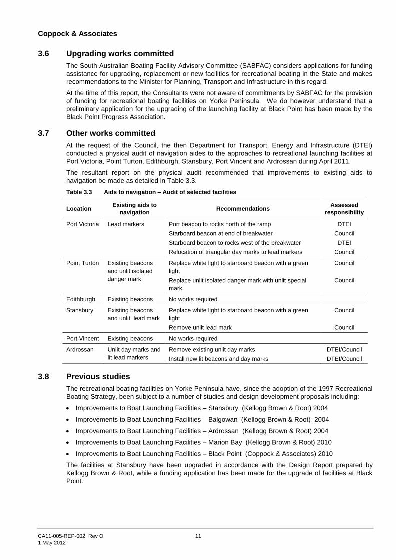
3.7 Other works committed
At the request of the Council, the then Department for Transport, Energy and Infrastructure (DTEI)
conducted a physical audit of navigation aides to the approaches to recreational launching facilities at
Port Victoria, Point Turton, Edithburgh, Stansbury, Port Vincent and Ardrossan during April 2011.
The resultant report on the physical audit recommended that improvements to existing aids to
navigation be made as detailed in Table 3.3.
Table 3.3 Aids to navigation – Audit of selected facilities
Location Existing aids to
navigation Recommendations
Assessed
responsibility
Port Victoria Lead markers Port beacon to rocks north of the ramp
Starboard beacon at end of breakwater
Starboard beacon to rocks west of the breakwater
Relocation of triangular day marks to lead markers
DTEI
Council
DTEI
Council
Point Turton Existing beacons
and unlit isolated
danger mark
Replace white light to starboard beacon with a green
light
Replace unlit isolated danger mark with unlit special
mark
Council
Council
Edithburgh Existing beacons No works required
Stansbury Existing beacons
and unlit lead mark
Replace white light to starboard beacon with a green
light
Remove unlit lead mark
Council
Council
Port Vincent Existing beacons No works required
Ardrossan Unlit day marks and
lit lead markers
Remove existing unlit day marks
Install new lit beacons and day marks
DTEI/Council
DTEI/Council
3.8 Previous studies
The recreational boating facilities on Yorke Peninsula have, since the adoption of the 1997 Recreational
Boating Strategy, been subject to a number of studies and design development proposals including:
Improvements to Boat Launching Facilities – Stansbury (Kellogg Brown & Root) 2004
Improvements to Boat Launching Facilities – Balgowan (Kellogg Brown & Root) 2004
Improvements to Boat Launching Facilities – Ardrossan (Kellogg Brown & Root) 2004
Improvements to Boat Launching Facilities – Marion Bay (Kellogg Brown & Root) 2010
Improvements to Boat Launching Facilities – Black Point (Coppock & Associates) 2010
The facilities at Stansbury have been upgraded in accordance with the Design Report prepared by
Kellogg Brown & Root, while a funding application has been made for the upgrade of facilities at Black
Point.
Coppock & Associates
CA11-005-REP-002, Rev O 12
1 May 2012
4 The Strategy
4.1 Introduction
The broad strategy for recreational boating on Yorke Peninsula as proposed in the original 1997
Strategy Plan, was influenced by the investigations, facility inspections and a limited amount of
community consultation, revolved around two distinct principles, namely:
Adequate and appropriate access to beach or ramp launching should be provided for all local
residents and local visitors.
There should be a number of strategically located all weather/all tide facilities within the Council
area to cater for broader boating safety, both launching and retrieval, and sheltering or casual
visitation.
These basic principles are still valid and serve as the basis of the review of the original (1997)
Strategy Plan.
The strategy is further influenced by technological developments within the boating industry including
the rapid adoption of global positioning systems, improved marine radio communications,
advancements in vessel hulls and propulsion and improvements to trailer design allowing “power
drive retrievals”.
In addition, the introduction of daily catch limits and more recently the proposed introduction of
marine exclusion zones and reserves, may considerably impact on the size of the recreational fishing
catch and thus participation rates.
4.2 Classification of boating facilities
In accordance with the State Boating Strategy, a three-tiered hierarchy of recreational boating
facilities was adopted during the preparation of the 1997 Recreational Boating Strategy Plan. This
hierarchy was based on the facilities and services provided as:
Category 1
Good weather ramp/beach launching facility with few additional facilities which would:
mostly serve the local community (both full-time residents and visitors)
be of relatively low capital cost and low maintenance
have non-extensive parking or other facilities
be provided with signage and hard waste collection.
Such facilities would generally be adjacent to small local settlements/communities and accessed via
local roads.
Category 2
All weather ramp with adequate parking, lighting, navigation aids etc. which would:
serve the local community and a more extensive tourist market
be of higher capital cost and possibly higher maintenance cost (depending on design)
be provided with rigging area and services including lighting, water and hard waste collection
be a safety resource for rescue and storm shelter
possibly be extensive in development and disruptive to coastal processes.
Category 3
Enclosed harbour providing mooring facilities for cruising and local yachts which would:
serve the wider recreational boating market
be of high capital cost and possibly higher maintenance cost (depending on design)
provide appropriate servicing for cruising vessels
be a recreational boating resource and cruising destination.
Coppock & Associates
CA11-005-REP-002, Rev O 13
1 May 2012
It is expected that Category 2 and 3 facilities would generally be associated with larger coastal towns
with reasonable extensive tourist accommodation facilities such as caravan parks, rental properties,
hotels/motels and be accessed by sealed roadways. Larger towns where adequate provisioning
exists would accommodate the larger Category 3 facilities.
4.3 Boating safety
As identified in the 1997 Strategy Plan, the majority of recreational fishing and/or boating trips are of
a relatively short distance, but can be up to 8 hours duration. This has been confirmed by responses
to the questionnaire referred to under Section 3.3.
It is also recognised that the waters around Yorke Peninsula can be susceptible to sudden change,
making boating conditions hazardous. The continuance of Yorke Peninsula to attract visitors for
recreational boating and fishing, sufficient facilities must be available to ensure relatively safe and
convenient boating is possible.
It is noted that since the implementation of the 1997 Strategy Plan, safe boating havens to Category
2/3 standards have been constructed at Port Vincent, Stansbury, Edithburgh and Point Turton, while
improvements have been made at Ardrossan and Port Victoria.
In considering boating safety within the broader strategic context, boating safety issues can be
addressed by consideration of:
access roads onto beaches (generally for tractor or four-wheel drive use only) being adequately
consolidated or sealed to minimise the incidence of vehicles becoming bogged and to minimise
environmental damage;
beach ramps being wide enough and have adequate manoeuvring space to enable safe handling
of trailers;
protected ramps having sufficient weather protection and water depth for all weather/all tide use;
protected ramps having adequate tie-up areas/walkways/pontoons for safe and efficient
launching and retrieval of vessels;
the more popular and all weather protected ramps having adequate navigation aids, marker
poles, lead lights/beacons to enable vessels to safely navigate in the area of the facility;
on-shore facilities such as car parking areas, wash down/ motor flushing areas, access roads etc.
are safely and conveniently laid out;
the provision of a series of protected recreational boating facilities around the coastline within the
Council area which can provide shelter from hazardous sea conditions.
Based on the above, it can be readily seen that general convenience and safety issues are very
interrelated and, with appropriate consideration, can lead to improved local and regional boating
safety.
4.4 The strategy
The recreational boating strategy for Yorke Peninsula is based on the above safety considerations
within the relevant category of each facility and seeks to:
1. Build on existing facilities wherever possible.
2. Upgrade a series of strategic sites around Yorke Peninsula into category 2/3 facilities.
3. Assign priorities to those areas assessed most in need of improvement or requiring new
facilities, but with emphasis given to boating safety.
4. Include as high priority, all necessary investigations that need to be undertaken in order to
progress the broader strategy.
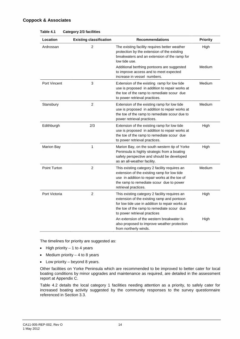
With this context it is considered that the following sites be designated as category 2/3 facilities (refer
Table 4.1).
Coppock & Associates
CA11-005-REP-002, Rev O 14
1 May 2012
Table 4.1 Category 2/3 facilities
Location Existing classification Recommendations Priority
Ardrossan 2 The existing facility requires better weather
protection by the extension of the existing
breakwaters and an extension of the ramp for
low tide use.
Additional berthing pontoons are suggested
to improve access and to meet expected
increase in vessel numbers.
High
Medium
Port Vincent 3 Extension of the existing ramp for low tide
use is proposed in addition to repair works at
the toe of the ramp to remediate scour due
to power retrieval practices.
Medium
Stansbury 2 Extension of the existing ramp for low tide
use is proposed in addition to repair works at
the toe of the ramp to remediate scour due to
power retrieval practices.
Medium
Edithburgh 2/3 Extension of the existing ramp for low tide
use is proposed in addition to repair works at
the toe of the ramp to remediate scour due
to power retrieval practices.
High
Marion Bay 1 Marion Bay, on the south western tip of Yorke
Peninsula is highly strategic from a boating
safety perspective and should be developed
as an all-weather facility.
High
Point Turton 2 This existing category 2 facility requires an
extension of the existing ramp for low tide
use in addition to repair works at the toe of
the ramp to remediate scour due to power
retrieval practices.
Medium
Port Victoria 2 This existing category 2 facility requires an
extension of the existing ramp and pontoon
for low tide use in addition to repair works at
the toe of the ramp to remediate scour due
to power retrieval practices
An extension of the western breakwater is
also proposed to improve weather protection
from northerly winds.
High
High
The timelines for priority are suggested as:
High priority – 1 to 4 years
Medium priority – 4 to 8 years
Low priority – beyond 8 years.
Other facilities on Yorke Peninsula which are recommended to be improved to better cater for local
boating conditions by minor upgrades and maintenance as required, are detailed in the assessment
report at Appendix C.
Table 4.2 details the local category 1 facilities needing attention as a priority, to safely cater for
increased boating activity suggested by the community responses to the survey questionnaire
referenced in Section 3.3.

Coppock & Associates
CA11-005-REP-002, Rev O 15
1 May 2012
Table 4.2 Category 1 facilities with a high priority for upgrading
Location Recommendations
Port Clinton Repair of the degraded ramp surface is strongly recommended.
Price Sealing of the ramp head and the car/trailer park together with repairs to the staging
jetty structure including replacement of handrails to meet current safety regulations.
Tiddy Widdy Beach This beach access ramp is unsealed and is reportedly mainly disused. Consider
abandonment of this facility.
Black Point Replace badly degraded ramp and extend to improve usability. Provide turning bay at
lower level at new head of ramp. Widen access road for two-way traffic and improve
pedestrian access.
Foul Bay Provision of side ramp protection to reduce undermining and formalisation of the
car/trailer parking area.
Corny Point While the provision of a sealed access road/ramp at Dunn Point has improved access,
the facilities at Corny Point consist of several informal access tracks over the coastal
dunes. Such uncontrolled access is causing a loss of the dunes and consideration is
to be given to a single formal launch facility.
Burners Beach Consideration to be given to relocation of the ramp (towards Point Soutar) to improve
accessibility and boating safety.
Balgowan While upgraded by the provision of a small breakwater and improved car/trailer
parking, this facility requires replacement of fendering and the provision of a berthing
pontoon.
Table 4.3 summarises the total improvement strategy recommended for recreational boating facilities
within the Council area, while Table 4.4 categorises the recreational boating facilities into priority
groupings.
Table 4.3 Yorke Peninsula recreational boating facilities improvement strategy
Location Classification
Recommendations Priority Existing Proposed
Port Clinton 1 1 Investigate possibility of dredging a channel to
improve access in emergency situations.
Repair degraded ramp surface.
Medium
High
Price 1 1 Investigate possibility of dredging the sand bar at
the mouth of the tidal creek to improve access.
Seal the car/trailer parking area and the ramp head.
Repair timber sections to the staging jetty and
replace handrails to current requirements or
consider removal of the staging jetty.
Medium
Medium
High
Tiddy Widdy
Beach
1 1 Consider abandonment of facility due to low
utilisation.
Provide sealed access to the beach.
Delineate car/trailer parking area.
High
Medium
Low
Ardrossan 2 3 The existing facility requires better weather
protection by the extension of the existing
breakwaters and an extension of the ramp for low
tide use.
Additional berthing pontoons are suggested to
improve access and to meet expected increase in
vessel numbers.
Investigate provision of moorings.
High
Medium
Medium

Coppock & Associates
CA11-005-REP-002, Rev O 16
1 May 2012
Location Classification
Recommendations Priority Existing Proposed
Rogues Point 1 1 Extend ramp for better low water use.
Waste collection bins and signage to be provided.
Low
Medium
Pine Point 1 1 Extend ramp for better low water use.
Delineate car parking and rigging areas.
Medium
Medium
Black Point 1 1 Widen access road to enable two-way traffic.
Reconstruct existing ramp. Provide turning area at
base of cliff. Provide improved pedestrian access.
High
Port Julia 1 1 Repair existing ramp.
Delineate rigging and car parking areas.
Medium
Low
Sheoak Flat 1 1 Car/trailer area to be graded and sealed.
Rigging and car parking areas to be delineated.
Waste collection and signage to be provided.
Medium
Medium
Medium
Port Vincent
(marina)
3 3 Repair existing ramp surface.
Extend toe of ramp to provide better low water use
and repair scour to toe of ramp due to power
retrieval techniques.
Medium
Medium
Port Vincent
(town ramp)
1 1 Consider transfer of ownership to Port Vincent
Yacht Club.
Medium
Stansbury 2 2 Repair existing ramp surface.
Extend toe of ramp to provide better low water use
and repair scour to toe of ramp due to power
retrieval techniques.
Medium
Medium
Wool Bay 1 1 Repair existing ramp surface.
Provide foreshore protection.
Grade and seal car/trailer parking area.
Provide waste collection and signage.
Medium
Medium
Medium
Medium
Edithburgh 2 2 Repair existing ramp surface.
Extend toe of ramp to provide better low water use
and repair scour to toe of ramp due to power
retrieval techniques.
Medium
High
Port Moorowie 1 1 Extend toe of ramp for better low water use.
Regrade and seal manoeuvring area at head of
ramp.
Consideration to be given to public lighting of
car/trailer parking area.
Medium
Medium
Medium
Foul Bay 1 1 Repair existing ramp.
Provide side wall protection to prevent undermining.
High
High
Marion Bay 1 2 Provide upgrade facilities in accordance with design
development report including provision of new ramp
defined car and car/trailer parking areas, and
foreshore protection.
High
Dunn Point 1 1 Formalise car and trailer parking areas.
Provide waste collection and signage.
Low
Medium
Corny Point 1 1 Investigate a new location for beach access
roadway to improve beach access and minimise
current environmental damage.
High
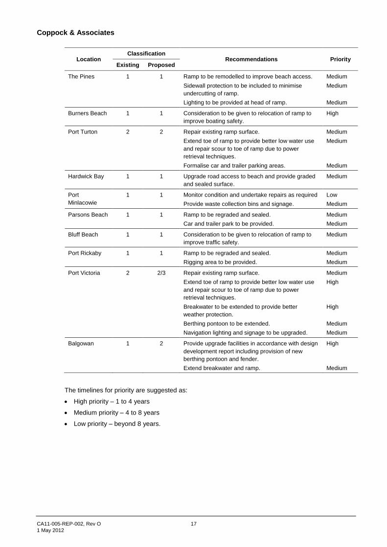
Coppock & Associates
CA11-005-REP-002, Rev O 17
1 May 2012
Location Classification
Recommendations Priority Existing Proposed
The Pines 1 1 Ramp to be remodelled to improve beach access.
Sidewall protection to be included to minimise
undercutting of ramp.
Lighting to be provided at head of ramp.
Medium
Medium
Medium
Burners Beach 1 1 Consideration to be given to relocation of ramp to
improve boating safety.
High
Port Turton 2 2 Repair existing ramp surface.
Extend toe of ramp to provide better low water use
and repair scour to toe of ramp due to power
retrieval techniques.
Formalise car and trailer parking areas.
Medium
Medium
Medium
Hardwick Bay 1 1 Upgrade road access to beach and provide graded
and sealed surface.
Medium
Port
Minlacowie
1 1 Monitor condition and undertake repairs as required
Provide waste collection bins and signage.
Low
Medium
Parsons Beach 1 1 Ramp to be regraded and sealed.
Car and trailer park to be provided.
Medium
Medium
Bluff Beach 1 1 Consideration to be given to relocation of ramp to
improve traffic safety.
Medium
Port Rickaby 1 1 Ramp to be regraded and sealed.
Rigging area to be provided.
Medium
Medium
Port Victoria 2 2/3 Repair existing ramp surface.
Extend toe of ramp to provide better low water use
and repair scour to toe of ramp due to power
retrieval techniques.
Breakwater to be extended to provide better
weather protection.
Berthing pontoon to be extended.
Navigation lighting and signage to be upgraded.
Medium
High
High
Medium
Medium
Balgowan 1 2 Provide upgrade facilities in accordance with design
development report including provision of new
berthing pontoon and fender.
Extend breakwater and ramp.
High
Medium
The timelines for priority are suggested as:
High priority – 1 to 4 years
Medium priority – 4 to 8 years
Low priority – beyond 8 years.
Coppock & Associates
CA11-005-REP-002, Rev O 18
1 May 2012
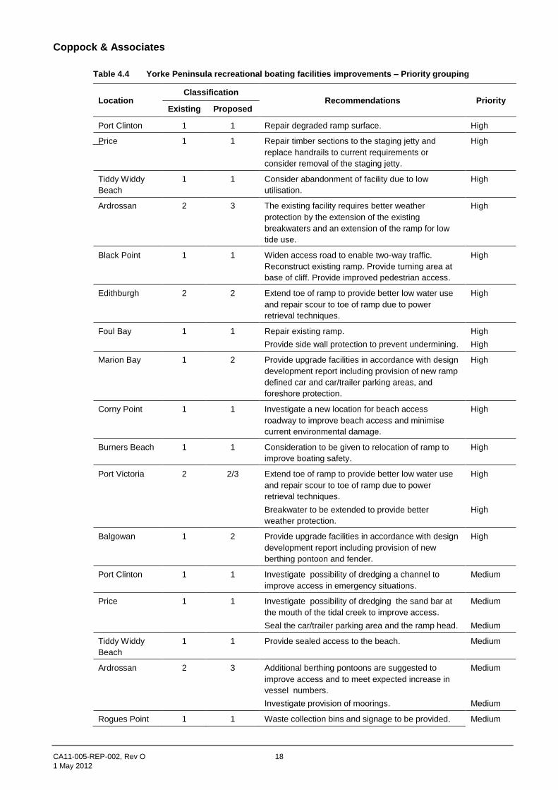
Table 4.4 Yorke Peninsula recreational boating facilities improvements – Priority grouping
Location Classification
Recommendations Priority Existing Proposed
Port Clinton 1 1 Repair degraded ramp surface. High
Price 1 1 Repair timber sections to the staging jetty and
replace handrails to current requirements or
consider removal of the staging jetty.
High
Tiddy Widdy
Beach
1 1 Consider abandonment of facility due to low
utilisation.
High
Ardrossan 2 3 The existing facility requires better weather
protection by the extension of the existing
breakwaters and an extension of the ramp for low
tide use.
High
Black Point 1 1 Widen access road to enable two-way traffic.
Reconstruct existing ramp. Provide turning area at
base of cliff. Provide improved pedestrian access.
High
Edithburgh 2 2 Extend toe of ramp to provide better low water use
and repair scour to toe of ramp due to power
retrieval techniques.
High
Foul Bay 1 1 Repair existing ramp.
Provide side wall protection to prevent undermining.
High
High
Marion Bay 1 2 Provide upgrade facilities in accordance with design
development report including provision of new ramp
defined car and car/trailer parking areas, and
foreshore protection.
High
Corny Point 1 1 Investigate a new location for beach access
roadway to improve beach access and minimise
current environmental damage.
High
Burners Beach 1 1 Consideration to be given to relocation of ramp to
improve boating safety.
High
Port Victoria 2 2/3 Extend toe of ramp to provide better low water use
and repair scour to toe of ramp due to power
retrieval techniques.
Breakwater to be extended to provide better
weather protection.
High
High
Balgowan 1 2 Provide upgrade facilities in accordance with design
development report including provision of new
berthing pontoon and fender.
High
Port Clinton 1 1 Investigate possibility of dredging a channel to
improve access in emergency situations.
Medium
Price 1 1 Investigate possibility of dredging the sand bar at
the mouth of the tidal creek to improve access.
Seal the car/trailer parking area and the ramp head.
Medium
Medium
Tiddy Widdy
Beach
1 1 Provide sealed access to the beach. Medium
Ardrossan 2 3 Additional berthing pontoons are suggested to
improve access and to meet expected increase in
vessel numbers.
Investigate provision of moorings.
Medium
Medium
Rogues Point 1 1 Waste collection bins and signage to be provided. Medium
Coppock & Associates
CA11-005-REP-002, Rev O 19
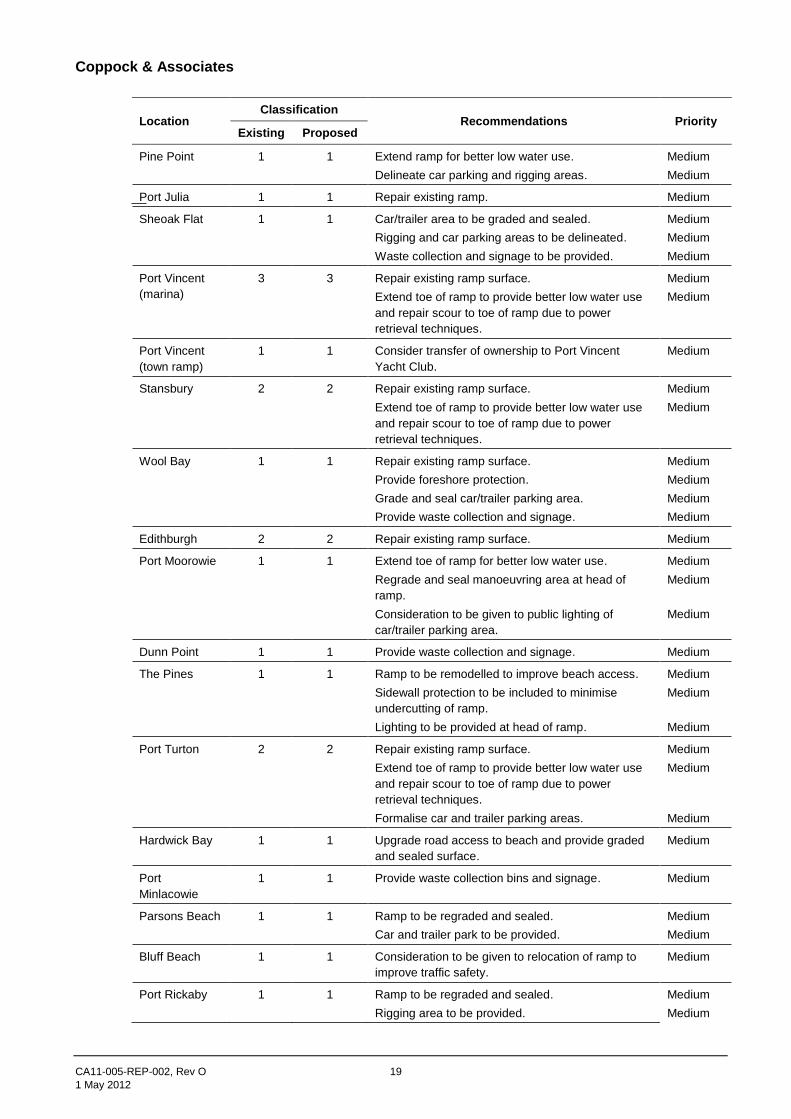
1 May 2012
Location Classification
Recommendations Priority Existing Proposed
Pine Point 1 1 Extend ramp for better low water use.
Delineate car parking and rigging areas.
Medium
Medium
Port Julia 1 1 Repair existing ramp. Medium
Sheoak Flat 1 1 Car/trailer area to be graded and sealed.
Rigging and car parking areas to be delineated.
Waste collection and signage to be provided.
Medium
Medium
Medium
Port Vincent
(marina)
3 3 Repair existing ramp surface.
Extend toe of ramp to provide better low water use
and repair scour to toe of ramp due to power
retrieval techniques.
Medium
Medium
Port Vincent
(town ramp)
1 1 Consider transfer of ownership to Port Vincent
Yacht Club.
Medium
Stansbury 2 2 Repair existing ramp surface.
Extend toe of ramp to provide better low water use
and repair scour to toe of ramp due to power
retrieval techniques.
Medium
Medium
Wool Bay 1 1 Repair existing ramp surface.
Provide foreshore protection.
Grade and seal car/trailer parking area.
Provide waste collection and signage.
Medium
Medium
Medium
Medium
Edithburgh 2 2 Repair existing ramp surface. Medium
Port Moorowie 1 1 Extend toe of ramp for better low water use.
Regrade and seal manoeuvring area at head of
ramp.
Consideration to be given to public lighting of
car/trailer parking area.
Medium
Medium
Medium
Dunn Point 1 1 Provide waste collection and signage. Medium
The Pines 1 1 Ramp to be remodelled to improve beach access.
Sidewall protection to be included to minimise
undercutting of ramp.
Lighting to be provided at head of ramp.
Medium
Medium
Medium
Port Turton 2 2 Repair existing ramp surface.
Extend toe of ramp to provide better low water use
and repair scour to toe of ramp due to power
retrieval techniques.
Formalise car and trailer parking areas.
Medium
Medium
Medium
Hardwick Bay 1 1 Upgrade road access to beach and provide graded
and sealed surface.
Medium
Port
Minlacowie
1 1 Provide waste collection bins and signage. Medium
Parsons Beach 1 1 Ramp to be regraded and sealed.
Car and trailer park to be provided.
Medium
Medium
Bluff Beach 1 1 Consideration to be given to relocation of ramp to
improve traffic safety.
Medium
Port Rickaby 1 1 Ramp to be regraded and sealed.
Rigging area to be provided.
Medium
Medium
Coppock & Associates
CA11-005-REP-002, Rev O 20
1 May 2012
Location Classification
Recommendations Priority Existing Proposed
Port Victoria 2 2/3 Repair existing ramp surface.
Berthing pontoon to be extended.
Navigation lighting and signage to be upgraded.
Medium
Medium
Medium
Balgowan 1 2 Extend breakwater and ramp. Medium
Tiddy Widdy
Beach
1 1 Delineate car/trailer parking area. Low
Rogues Point 1 1 Extend ramp for better low water use. Low
Port Julia 1 1 Delineate rigging and car parking areas. Low
Dunn Point 1 1 Formalise car and trailer parking areas. Low
Port
Minlacowie
1 1 Monitor condition and undertake repairs as required. Low
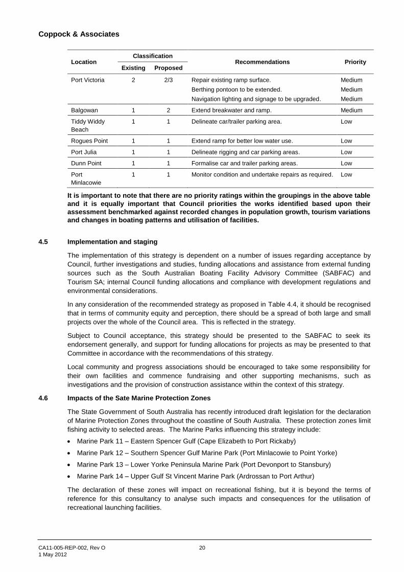
It is important to note that there are no priority ratings within the groupings in the above table
and it is equally important that Council priorities the works identified based upon their
assessment benchmarked against recorded changes in population growth, tourism variations
and changes in boating patterns and utilisation of facilities.
4.5 Implementation and staging
The implementation of this strategy is dependent on a number of issues regarding acceptance by
Council, further investigations and studies, funding allocations and assistance from external funding
sources such as the South Australian Boating Facility Advisory Committee (SABFAC) and
Tourism SA; internal Council funding allocations and compliance with development regulations and
environmental considerations.
In any consideration of the recommended strategy as proposed in Table 4.4, it should be recognised
that in terms of community equity and perception, there should be a spread of both large and small
projects over the whole of the Council area. This is reflected in the strategy.
Subject to Council acceptance, this strategy should be presented to the SABFAC to seek its
endorsement generally, and support for funding allocations for projects as may be presented to that
Committee in accordance with the recommendations of this strategy.
Local community and progress associations should be encouraged to take some responsibility for
their own facilities and commence fundraising and other supporting mechanisms, such as
investigations and the provision of construction assistance within the context of this strategy.
4.6 Impacts of the Sate Marine Protection Zones
The State Government of South Australia has recently introduced draft legislation for the declaration
of Marine Protection Zones throughout the coastline of South Australia. These protection zones limit
fishing activity to selected areas. The Marine Parks influencing this strategy include:
Marine Park 11 – Eastern Spencer Gulf (Cape Elizabeth to Port Rickaby)
Marine Park 12 – Southern Spencer Gulf Marine Park (Port Minlacowie to Point Yorke)
Marine Park 13 – Lower Yorke Peninsula Marine Park (Port Devonport to Stansbury)
Marine Park 14 – Upper Gulf St Vincent Marine Park (Ardrossan to Port Arthur)
The declaration of these zones will impact on recreational fishing, but it is beyond the terms of
reference for this consultancy to analyse such impacts and consequences for the utilisation of
recreational launching facilities.

Coppock & Associates
CA11-005-REP-002, Rev O 21
1 May 2012
It is recommended however, that Council monitors the present utilisation of facilities by the use of
existing ticketing machines and the cooperation of progress associations and community groups to
record the use of facilities without ticketing machines to gauge the impact on recreational fishing by
the introduction of the marine protection zones.

Coppock & Associates
CA11-005-REP-002, Rev O 22
1 May 2012
5 Recommendations
It is recommended that the Council give consideration to the following:
1. Acceptance of this Strategy Report as the basis for the ongoing upgrading of recreational
boating facilities within the Council area on Yorke Peninsula.
2. Make a general submission to the South Australian Boating Facility Advisory Committee
seeking overall acceptance of the Strategy as an ongoing basis for improvements to
recreational boating facilities on Yorke Peninsula.
3. Undertake the necessary investigations, design and drawings, detailed costings and approvals
to enable applications to be made to the South Australian Boating Facility Advisory Committee
for the upgrading, replacement of existing facilities, or the provision of new facilities as
determined by Council in accordance with this Strategy.
4. Promote the Strategy through progress associations, community groups, boating clubs and
fishing associations and to further encourage the community to support the Strategy with
assistance as necessary and appropriate.
5. Undertake a mid-term review (5 year) of the implementation of the Strategy benchmarked
against recorded changes in population growth, tourism variations and changes in boating
patterns and utilisation of facilities.

Coppock & Associates
CA11-005-REP-002, Rev O
1 May 2012
Appendix A References

Coppock & Associates
CA11-005-REP-002, Rev O A-1
1 May 2012
Appendix A References
1. Australian Bureau of Statistics: Census information
2. Tourism SA: Tourism data
3. Department of Transport and Infrastructure: Vessel registration data
4. District Council of Yorke Peninsula: Development Plan (2011)
5. Primary Industry & Resources South Australia: Recreational fishing survey (2009)
6. South Australian Boating Facility Advisory Committee: Guidelines for the planning, design and
construction of boat launching facilities
7. Kinhill: Yorke Peninsula Recreational Boating Strategy (1997)
8. Rust PPK: Report on the adequacy of boat ramp facilities (1996)
Coppock & Associates
CA11-005-REP-002, Rev O
1 May 2012
Appendix B Utilisation Survey
Coppock & Associates
CA11-005-REP-002, Rev O B-1
1 May 2012
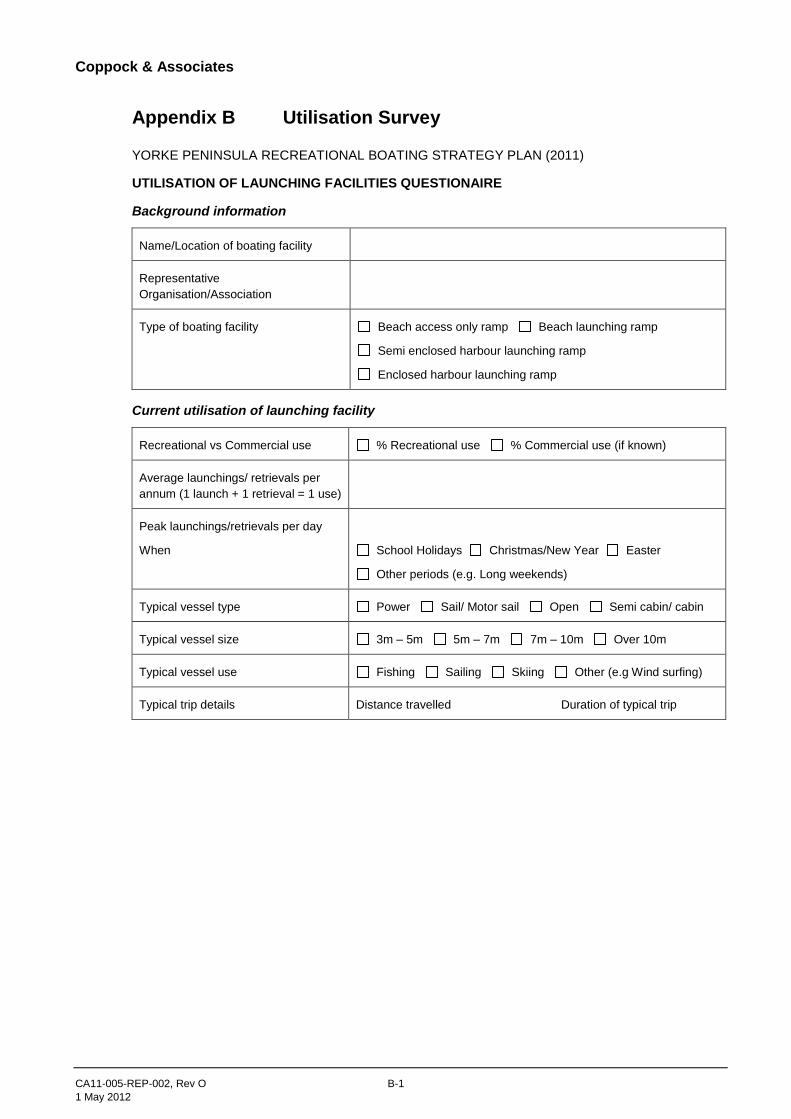
Appendix B Utilisation Survey
YORKE PENINSULA RECREATIONAL BOATING STRATEGY PLAN (2011)
UTILISATION OF LAUNCHING FACILITIES QUESTIONAIRE
Background information
Name/Location of boating facility
Representative
Organisation/Association
Type of boating facility Beach access only ramp Beach launching ramp
Semi enclosed harbour launching ramp
Enclosed harbour launching ramp
Current utilisation of launching facility
Recreational vs Commercial use % Recreational use % Commercial use (if known)
Average launchings/ retrievals per
annum (1 launch + 1 retrieval = 1 use)
Peak launchings/retrievals per day
When
School Holidays Christmas/New Year Easter
Other periods (e.g. Long weekends)
Typical vessel type Power Sail/ Motor sail Open Semi cabin/ cabin
Typical vessel size 3m – 5m 5m – 7m 7m – 10m Over 10m
Typical vessel use Fishing Sailing Skiing Other (e.g Wind surfing)
Typical trip details Distance travelled Duration of typical trip
Coppock & Associates
CA11-005-REP-002, Rev O B-2
1 May 2012
UTILISATION OF LAUNCHING FACILITIES QUESTIONAIRE (cont)
Population & Accommodation
Resident population
Peak population
When
School Holidays Christmas/New Year Easter
Other periods (e.g. Long weekends)
Average duration of visitor stays
Accommodation use
(Where do visitors stay)
Hotels/Motels Caravan parks Guest houses inc. B&Bs
Family & Friends Other (e.g. Rental accommodation)
Typical vessel type Power Sail/ Motor sail Open Semi cabin/ cabin
Typical vessel size 3m – 5m 5m – 7m 7m – 10m Over 10m
Typical vessel use Fishing Sailing Skiing Other (e.g Wind surfing)
Anticipated use of launching facility (future use)
Recreational vs Commercial use % Recreational use % Commercial use (if known)
Expected future launchings/ retrievals
per annum (1 launch + 1 retrieval = 1
use)
1 – 5 years 5 – 10 years
Expected peak launchings / retrievals
per day
When
School Holidays Christmas/New Year Easter
Other periods (e.g. Long weekends)
Expected vessel type Power Sail/ Motor sail Open Semi cabin/ cabin
Expected vessel size 3m – 5m 5m – 7m 7m – 10m Over 10m
Expected vessel use Fishing Sailing Skiing Other (e.g Wind surfing)

Coppock & Associates
CA11-005-REP-002, Rev O
1 May 2012
Appendix C Condition Assessment Survey
Coppock & Associates
CA11-005-REP-002, Rev O C-1
1 May 2012
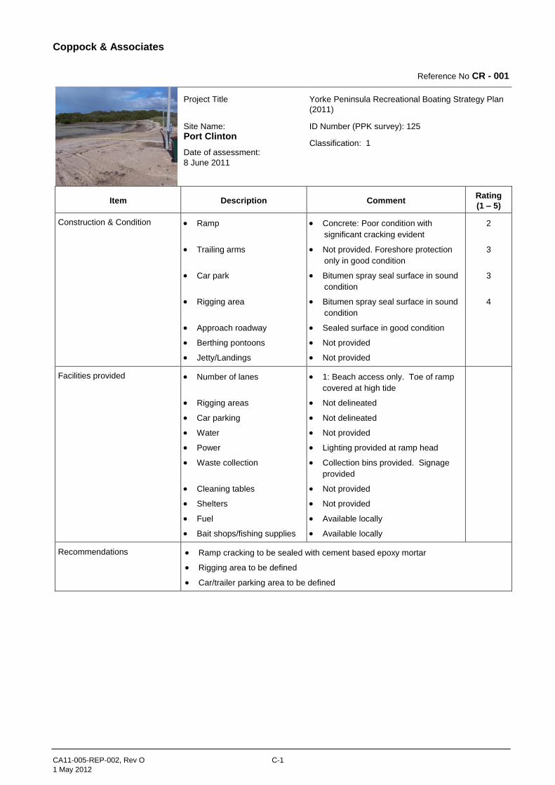
Reference No CR - 001
Project Title
Site Name:
Port Clinton
Date of assessment:
8 June 2011
Yorke Peninsula Recreational Boating Strategy Plan
(2011)
ID Number (PPK survey): 125
Classification: 1
Item Description Comment Rating
(1 – 5)
Construction & Condition Ramp
Trailing arms
Car park
Rigging area
Approach roadway
Berthing pontoons
Jetty/Landings
Concrete: Poor condition with
significant cracking evident
Not provided. Foreshore protection
only in good condition
Bitumen spray seal surface in sound
condition
Bitumen spray seal surface in sound
condition
Sealed surface in good condition
Not provided
Not provided
2
3
3
4
Facilities provided Number of lanes
Rigging areas
Car parking
Water
Power
Waste collection
Cleaning tables
Shelters
Fuel
Bait shops/fishing supplies
1: Beach access only. Toe of ramp
covered at high tide
Not delineated
Not delineated
Not provided
Lighting provided at ramp head
Collection bins provided. Signage
provided
Not provided
Not provided
Available locally
Available locally
Recommendations Ramp cracking to be sealed with cement based epoxy mortar
Rigging area to be defined
Car/trailer parking area to be defined
Coppock & Associates
CA11-005-REP-002, Rev O C-2
1 May 2012
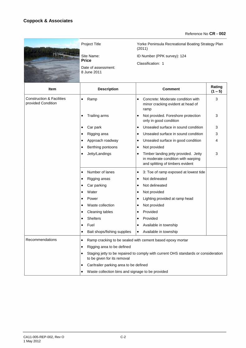
Reference No CR - 002
Project Title
Site Name:
Price
Date of assessment:
8 June 2011
Yorke Peninsula Recreational Boating Strategy Plan
(2011)
ID Number (PPK survey): 124
Classification: 1
Item Description Comment Rating
(1 – 5)
Construction & Facilities
provided Condition Ramp
Trailing arms
Car park
Rigging area
Approach roadway
Berthing pontoons
Jetty/Landings
Concrete: Moderate condition with
minor cracking evident at head of
ramp
Not provided. Foreshore protection
only in good condition
Unsealed surface in sound condition
Unsealed surface in sound condition
Unsealed surface in good condition
Not provided
Timber landing jetty provided. Jetty
in moderate condition with warping
and splitting of timbers evident
3
3
3
3
4
3
Number of lanes
Rigging areas
Car parking
Water
Power
Waste collection
Cleaning tables
Shelters
Fuel
Bait shops/fishing supplies
3: Toe of ramp exposed at lowest tide
Not delineated
Not delineated
Not provided
Lighting provided at ramp head
Not provided
Provided
Provided
Available in township
Available in township
Recommendations Ramp cracking to be sealed with cement based epoxy mortar
Rigging area to be defined
Staging jetty to be repaired to comply with current OHS standards or consideration
to be given for its removal
Car/trailer parking area to be defined
Waste collection bins and signage to be provided

Coppock & Associates
CA11-005-REP-002, Rev O C-3
1 May 2012
Reference No CR - 003
Project Title
Site Name:
Tiddy Widdy Beach
Date of assessment:
8 June 2011
Yorke Peninsula Recreational Boating Strategy Plan
(2011)
ID Number (PPK survey): 123
Classification: 1
Item Description Comment Rating
(1 – 5)
Construction & Condition Ramp
Trailing arms
Car park
Rigging area
Approach roadway
Berthing pontoons
Jetty/Landings
Nil: Beach access point only
Not provided. Foreshore dunes in
reasonable condition. No evidence of
significant or recent erosion
Unsealed graded surface in
reasonable condition
Unsealed graded surface in
reasonable condition
Unsealed graded surface in poor
condition
Not provided
Not provided
1
2
2
1
Facilities provided Number of lanes
Rigging areas
Car parking
Water
Power
Waste collection
Cleaning tables
Shelters
Fuel
Bait shops/fishing supplies
1: Beach access only
Not delineated
Not delineated
Not provided
Lighting not provided
Not provided
Not provided
Minor shelter provided
Available in township
(Price/Ardrossan)
Available in township
(Price/Ardrossan)
Recommendations Formal beach access ramp to be provided
Rigging area to be defined
Car/trailer parking area to be defined
Waste collection bins and signage to be provided
Coppock & Associates
CA11-005-REP-002, Rev O C-4
1 May 2012
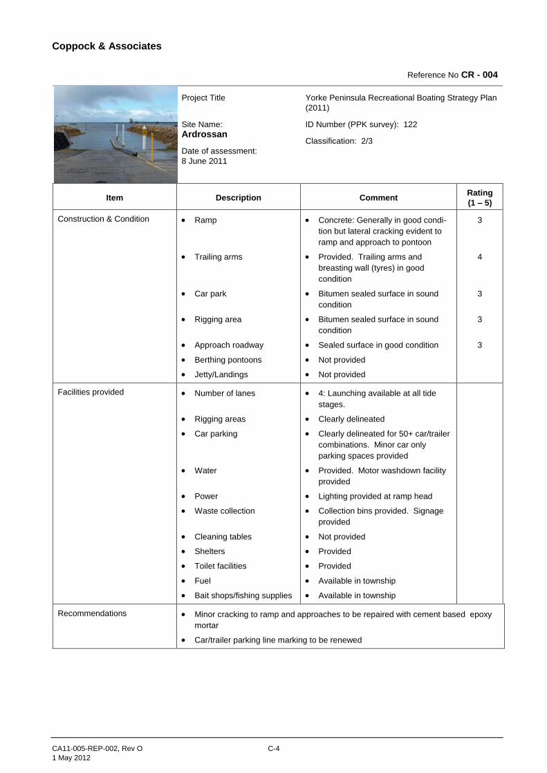
Reference No CR - 004
Project Title
Site Name:
Ardrossan
Date of assessment:
8 June 2011
Yorke Peninsula Recreational Boating Strategy Plan
(2011)
ID Number (PPK survey): 122
Classification: 2/3
Item Description Comment Rating
(1 – 5)
Construction & Condition Ramp
Trailing arms
Car park
Rigging area
Approach roadway
Berthing pontoons
Jetty/Landings
Concrete: Generally in good condi-
tion but lateral cracking evident to
ramp and approach to pontoon
Provided. Trailing arms and
breasting wall (tyres) in good
condition
Bitumen sealed surface in sound
condition
Bitumen sealed surface in sound
condition
Sealed surface in good condition
Not provided
Not provided
3
4
3
3
3
Facilities provided Number of lanes
Rigging areas
Car parking
Water
Power
Waste collection
Cleaning tables
Shelters
Toilet facilities
Fuel
Bait shops/fishing supplies
4: Launching available at all tide
stages.
Clearly delineated
Clearly delineated for 50+ car/trailer
combinations. Minor car only
parking spaces provided
Provided. Motor washdown facility
provided
Lighting provided at ramp head
Collection bins provided. Signage
provided
Not provided
Provided
Provided
Available in township
Available in township
Recommendations Minor cracking to ramp and approaches to be repaired with cement based epoxy
mortar
Car/trailer parking line marking to be renewed
Coppock & Associates
CA11-005-REP-002, Rev O C-5
1 May 2012
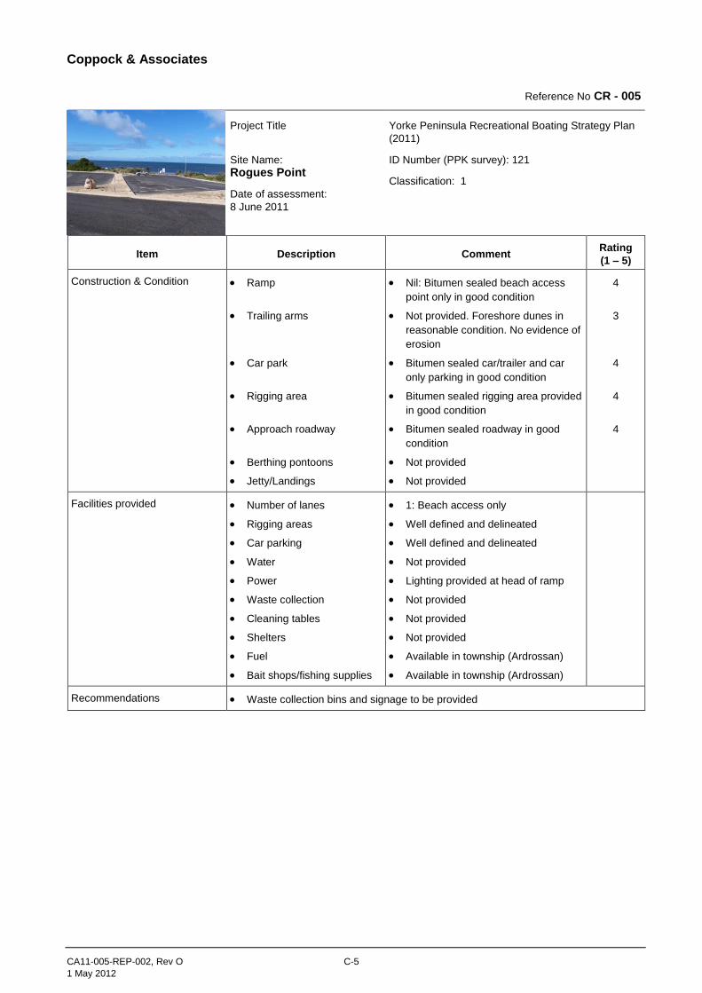
Reference No CR - 005
Project Title
Site Name:
Rogues Point
Date of assessment:
8 June 2011
Yorke Peninsula Recreational Boating Strategy Plan
(2011)
ID Number (PPK survey): 121
Classification: 1
Item Description Comment Rating
(1 – 5)
Construction & Condition Ramp
Trailing arms
Car park
Rigging area
Approach roadway
Berthing pontoons
Jetty/Landings
Nil: Bitumen sealed beach access
point only in good condition
Not provided. Foreshore dunes in
reasonable condition. No evidence of
erosion
Bitumen sealed car/trailer and car
only parking in good condition
Bitumen sealed rigging area provided
in good condition
Bitumen sealed roadway in good
condition
Not provided
Not provided
4
3
4
4
4
Facilities provided Number of lanes
Rigging areas
Car parking
Water
Power
Waste collection
Cleaning tables
Shelters
Fuel
Bait shops/fishing supplies
1: Beach access only
Well defined and delineated
Well defined and delineated
Not provided
Lighting provided at head of ramp
Not provided
Not provided
Not provided
Available in township (Ardrossan)
Available in township (Ardrossan)
Recommendations Waste collection bins and signage to be provided
Coppock & Associates
CA11-005-REP-002, Rev O C-6
1 May 2012
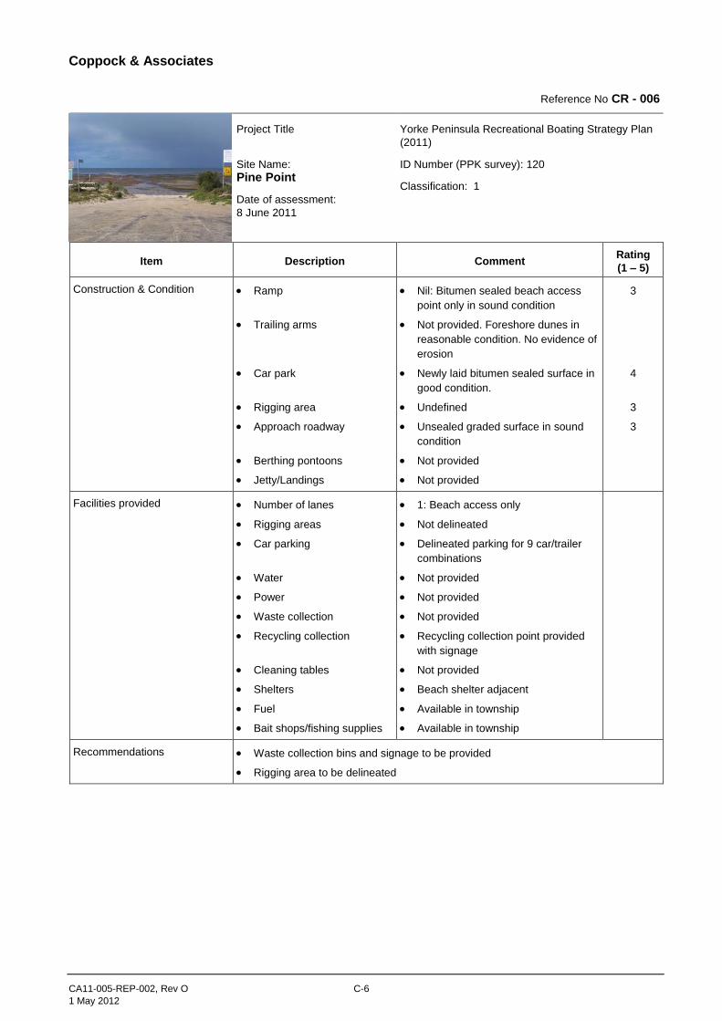
Reference No CR - 006
Project Title
Site Name:
Pine Point
Date of assessment:
8 June 2011
Yorke Peninsula Recreational Boating Strategy Plan
(2011)
ID Number (PPK survey): 120
Classification: 1
Item Description Comment Rating
(1 – 5)
Construction & Condition Ramp
Trailing arms
Car park
Rigging area
Approach roadway
Berthing pontoons
Jetty/Landings
Nil: Bitumen sealed beach access
point only in sound condition
Not provided. Foreshore dunes in
reasonable condition. No evidence of
erosion
Newly laid bitumen sealed surface in
good condition.
Undefined
Unsealed graded surface in sound
condition
Not provided
Not provided
3
4
3
3
Facilities provided Number of lanes
Rigging areas
Car parking
Water
Power
Waste collection
Recycling collection
Cleaning tables
Shelters
Fuel
Bait shops/fishing supplies
1: Beach access only
Not delineated
Delineated parking for 9 car/trailer
combinations
Not provided
Not provided
Not provided
Recycling collection point provided
with signage
Not provided
Beach shelter adjacent
Available in township
Available in township
Recommendations Waste collection bins and signage to be provided
Rigging area to be delineated
Coppock & Associates
CA11-005-REP-002, Rev O C-7
1 May 2012
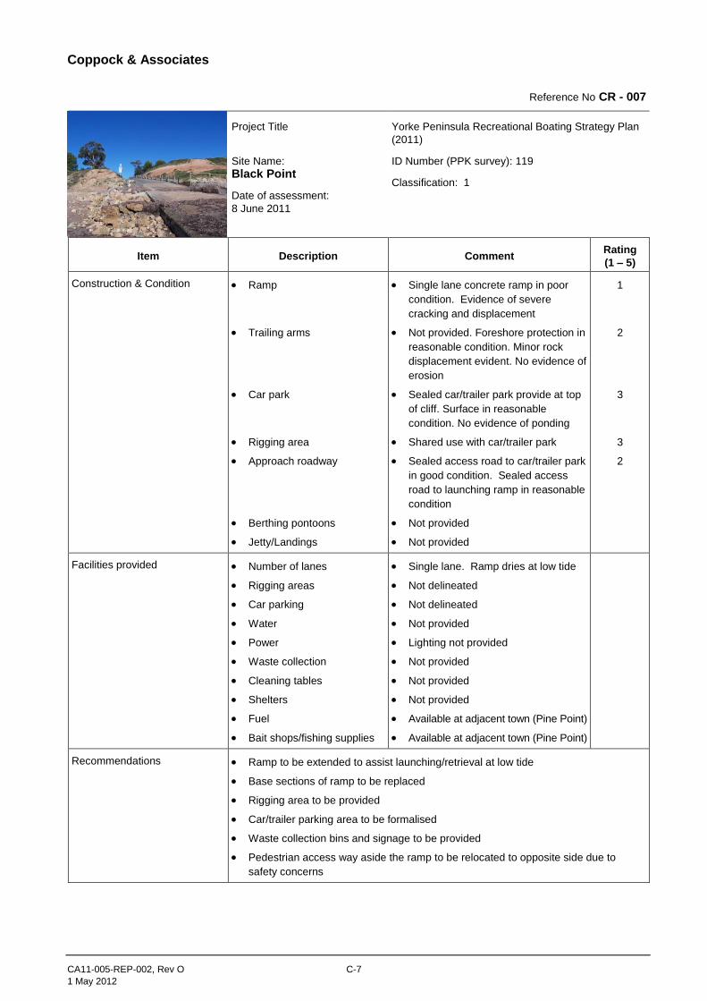
Reference No CR - 007
Project Title
Site Name:
Black Point
Date of assessment:
8 June 2011
Yorke Peninsula Recreational Boating Strategy Plan
(2011)
ID Number (PPK survey): 119
Classification: 1
Item Description Comment Rating
(1 – 5)
Construction & Condition Ramp
Trailing arms
Car park
Rigging area
Approach roadway
Berthing pontoons
Jetty/Landings
Single lane concrete ramp in poor
condition. Evidence of severe
cracking and displacement
Not provided. Foreshore protection in
reasonable condition. Minor rock
displacement evident. No evidence of
erosion
Sealed car/trailer park provide at top
of cliff. Surface in reasonable
condition. No evidence of ponding
Shared use with car/trailer park
Sealed access road to car/trailer park
in good condition. Sealed access
road to launching ramp in reasonable
condition
Not provided
Not provided
1
2
3
3
2
Facilities provided Number of lanes
Rigging areas
Car parking
Water
Power
Waste collection
Cleaning tables
Shelters
Fuel
Bait shops/fishing supplies
Single lane. Ramp dries at low tide
Not delineated
Not delineated
Not provided
Lighting not provided
Not provided
Not provided
Not provided
Available at adjacent town (Pine Point)
Available at adjacent town (Pine Point)
Recommendations Ramp to be extended to assist launching/retrieval at low tide
Base sections of ramp to be replaced
Rigging area to be provided
Car/trailer parking area to be formalised
Waste collection bins and signage to be provided
Pedestrian access way aside the ramp to be relocated to opposite side due to
safety concerns
Coppock & Associates
CA11-005-REP-002, Rev O C-8
1 May 2012
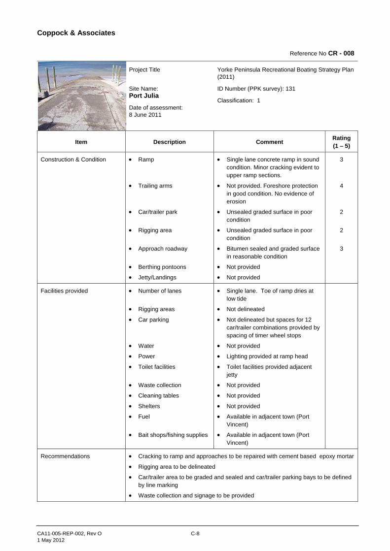
Reference No CR - 008
Project Title
Site Name:
Port Julia
Date of assessment:
8 June 2011
Yorke Peninsula Recreational Boating Strategy Plan
(2011)
ID Number (PPK survey): 131
Classification: 1
Item Description Comment Rating
(1 – 5)
Construction & Condition Ramp
Trailing arms
Car/trailer park
Rigging area
Approach roadway
Berthing pontoons
Jetty/Landings
Single lane concrete ramp in sound
condition. Minor cracking evident to
upper ramp sections.
Not provided. Foreshore protection
in good condition. No evidence of
erosion
Unsealed graded surface in poor
condition
Unsealed graded surface in poor
condition
Bitumen sealed and graded surface
in reasonable condition
Not provided
Not provided
3
4
2
2
3
Facilities provided Number of lanes
Rigging areas
Car parking
Water
Power
Toilet facilities
Waste collection
Cleaning tables
Shelters
Fuel
Bait shops/fishing supplies
Single lane. Toe of ramp dries at
low tide
Not delineated
Not delineated but spaces for 12
car/trailer combinations provided by
spacing of timer wheel stops
Not provided
Lighting provided at ramp head
Toilet facilities provided adjacent
jetty
Not provided
Not provided
Not provided
Available in adjacent town (Port
Vincent)
Available in adjacent town (Port
Vincent)
Recommendations Cracking to ramp and approaches to be repaired with cement based epoxy mortar
Rigging area to be delineated
Car/trailer area to be graded and sealed and car/trailer parking bays to be defined
by line marking
Waste collection and signage to be provided
Coppock & Associates
CA11-005-REP-002, Rev O C-9
1 May 2012
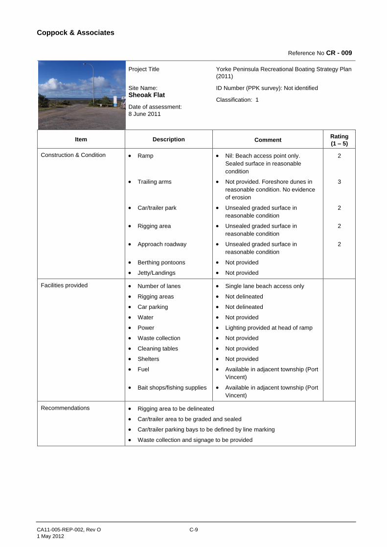
Reference No CR - 009
Project Title
Site Name:
Sheoak Flat
Date of assessment:
8 June 2011
Yorke Peninsula Recreational Boating Strategy Plan
(2011)
ID Number (PPK survey): Not identified
Classification: 1
Item Description Comment Rating
(1 – 5)
Construction & Condition Ramp
Trailing arms
Car/trailer park
Rigging area
Approach roadway
Berthing pontoons
Jetty/Landings
Nil: Beach access point only.
Sealed surface in reasonable
condition
Not provided. Foreshore dunes in
reasonable condition. No evidence
of erosion
Unsealed graded surface in
reasonable condition
Unsealed graded surface in
reasonable condition
Unsealed graded surface in
reasonable condition
Not provided
Not provided
2
3
2
2
2
Facilities provided Number of lanes
Rigging areas
Car parking
Water
Power
Waste collection
Cleaning tables
Shelters
Fuel
Bait shops/fishing supplies
Single lane beach access only
Not delineated
Not delineated
Not provided
Lighting provided at head of ramp
Not provided
Not provided
Not provided
Available in adjacent township (Port
Vincent)
Available in adjacent township (Port
Vincent)
Recommendations Rigging area to be delineated
Car/trailer area to be graded and sealed
Car/trailer parking bays to be defined by line marking
Waste collection and signage to be provided
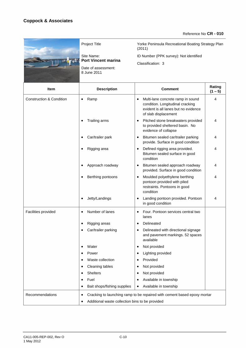
Coppock & Associates
CA11-005-REP-002, Rev O C-10
1 May 2012
Reference No CR - 010
Project Title
Site Name:
Port Vincent marina
Date of assessment:
8 June 2011
Yorke Peninsula Recreational Boating Strategy Plan
(2011)
ID Number (PPK survey): Not identified
Classification: 3
Item Description Comment Rating
(1 – 5)
Construction & Condition Ramp
Trailing arms
Car/trailer park
Rigging area
Approach roadway
Berthing pontoons
Jetty/Landings
Multi-lane concrete ramp in sound
condition. Longitudinal cracking
evident is all lanes but no evidence
of slab displacement
Pitched stone breakwaters provided
to provided sheltered basin. No
evidence of collapse
Bitumen sealed car/trailer parking
provide. Surface in good condition
Defined rigging area provided.
Bitumen sealed surface in good
condition
Bitumen sealed approach roadway
provided. Surface in good condition
Moulded polyethylene berthing
pontoon provided with piled
restraints. Pontoons in good
condition
Landing pontoon provided. Pontoon
in good condition
4
4
4
4
4
4
4
Facilities provided Number of lanes
Rigging areas
Car/trailer parking
Water
Power
Waste collection
Cleaning tables
Shelters
Fuel
Bait shops/fishing supplies
Four. Pontoon services central two
lanes
Delineated
Delineated with directional signage
and pavement markings. 52 spaces
available
Not provided
Lighting provided
Provided
Not provided
Not provided
Available in township
Available in township
Recommendations Cracking to launching ramp to be repaired with cement based epoxy mortar
Additional waste collection bins to be provided
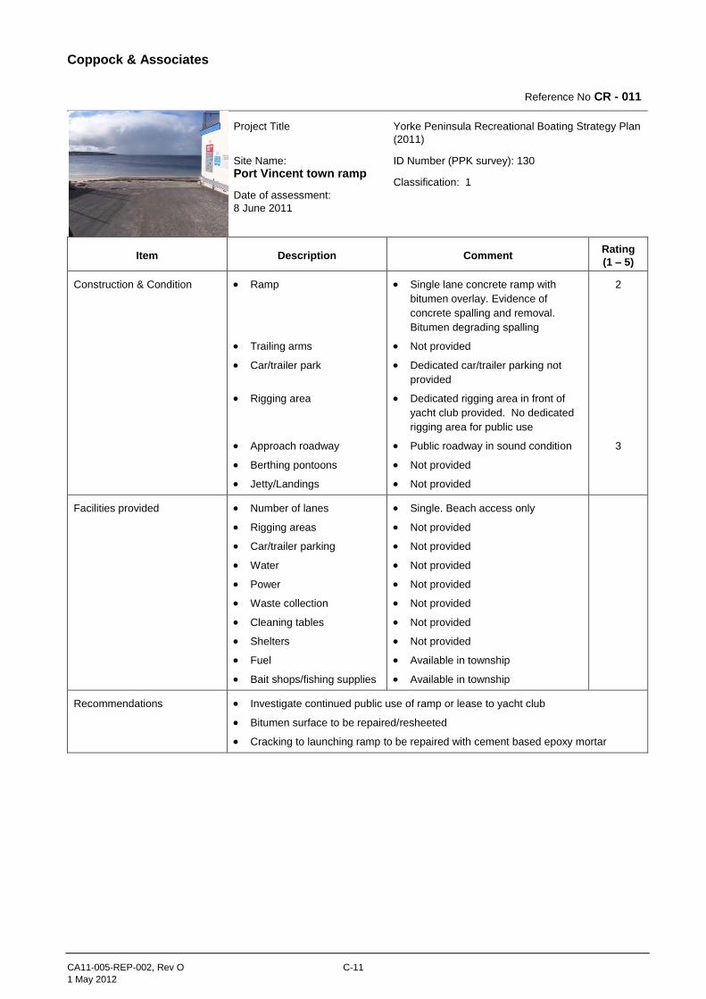
Coppock & Associates
CA11-005-REP-002, Rev O C-11
1 May 2012
Reference No CR - 011
Project Title
Site Name:
Port Vincent town ramp
Date of assessment:
8 June 2011
Yorke Peninsula Recreational Boating Strategy Plan
(2011)
ID Number (PPK survey): 130
Classification: 1
Item Description Comment Rating
(1 – 5)
Construction & Condition Ramp
Trailing arms
Car/trailer park
Rigging area
Approach roadway
Berthing pontoons
Jetty/Landings
Single lane concrete ramp with
bitumen overlay. Evidence of
concrete spalling and removal.
Bitumen degrading spalling
Not provided
Dedicated car/trailer parking not
provided
Dedicated rigging area in front of
yacht club provided. No dedicated
rigging area for public use
Public roadway in sound condition
Not provided
Not provided
2
3
Facilities provided Number of lanes
Rigging areas
Car/trailer parking
Water
Power
Waste collection
Cleaning tables
Shelters
Fuel
Bait shops/fishing supplies
Single. Beach access only
Not provided
Not provided
Not provided
Not provided
Not provided
Not provided
Not provided
Available in township
Available in township
Recommendations Investigate continued public use of ramp or lease to yacht club
Bitumen surface to be repaired/resheeted
Cracking to launching ramp to be repaired with cement based epoxy mortar
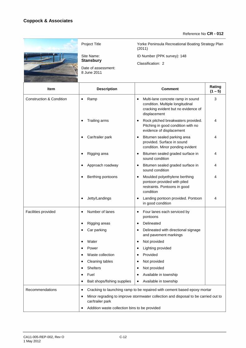
Coppock & Associates
CA11-005-REP-002, Rev O C-12
1 May 2012
Reference No CR - 012
Project Title
Site Name:
Stansbury
Date of assessment:
8 June 2011
Yorke Peninsula Recreational Boating Strategy Plan
(2011)
ID Number (PPK survey): 148
Classification: 2
Item Description Comment Rating
(1 – 5)
Construction & Condition Ramp
Trailing arms
Car/trailer park
Rigging area
Approach roadway
Berthing pontoons
Jetty/Landings
Multi-lane concrete ramp in sound
condition. Multiple longitudinal
cracking evident but no evidence of
displacement
Rock pitched breakwaters provided.
Pitching in good condition with no
evidence of displacement
Bitumen sealed parking area
provided. Surface in sound
condition. Minor ponding evident
Bitumen sealed graded surface in
sound condition
Bitumen sealed graded surface in
sound condition
Moulded polyethylene berthing
pontoon provided with piled
restraints. Pontoons in good
condition
Landing pontoon provided. Pontoon
in good condition
3
4
4
4
4
4
4
Facilities provided Number of lanes
Rigging areas
Car parking
Water
Power
Waste collection
Cleaning tables
Shelters
Fuel
Bait shops/fishing supplies
Four lanes each serviced by
pontoons
Delineated
Delineated with directional signage
and pavement markings
Not provided
Lighting provided
Provided
Not provided
Not provided
Available in township
Available in township
Recommendations Cracking to launching ramp to be repaired with cement based epoxy mortar
Minor regrading to improve stormwater collection and disposal to be carried out to
car/trailer park
Addition waste collection bins to be provided
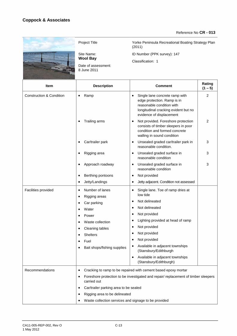
Coppock & Associates
CA11-005-REP-002, Rev O C-13
1 May 2012
Reference No CR - 013
Project Title
Site Name:
Wool Bay
Date of assessment:
8 June 2011
Yorke Peninsula Recreational Boating Strategy Plan
(2011)
ID Number (PPK survey): 147
Classification: 1
Item Description Comment Rating
(1 – 5)
Construction & Condition Ramp
Trailing arms
Car/trailer park
Rigging area
Approach roadway
Berthing pontoons
Jetty/Landings
Single lane concrete ramp with
edge protection. Ramp is in
reasonable condition with
longitudinal cracking evident but no
evidence of displacement
Not provided. Foreshore protection
consists of timber sleepers in poor
condition and formed concrete
walling in sound condition
Unsealed graded car/trailer park in
reasonable condition.
Unsealed graded surface in
reasonable condition
Unsealed graded surface in
reasonable condition
Not provided
Jetty adjacent. Condition not assessed
2
2
3
3
3
Facilities provided Number of lanes
Rigging areas
Car parking
Water
Power
Waste collection
Cleaning tables
Shelters
Fuel
Bait shops/fishing supplies
Single lane. Toe of ramp dries at
low tide
Not delineated
Not delineated
Not provided
Lighting provided at head of ramp
Not provided
Not provided
Not provided
Available in adjacent townships
(Stansbury/Edithburgh
Available in adjacent townships
(Stansbury/Edithburgh)
Recommendations Cracking to ramp to be repaired with cement based epoxy mortar
Foreshore protection to be investigated and repair/ replacement of timber sleepers
carried out
Car/trailer parking area to be sealed
Rigging area to be delineated
Waste collection services and signage to be provided
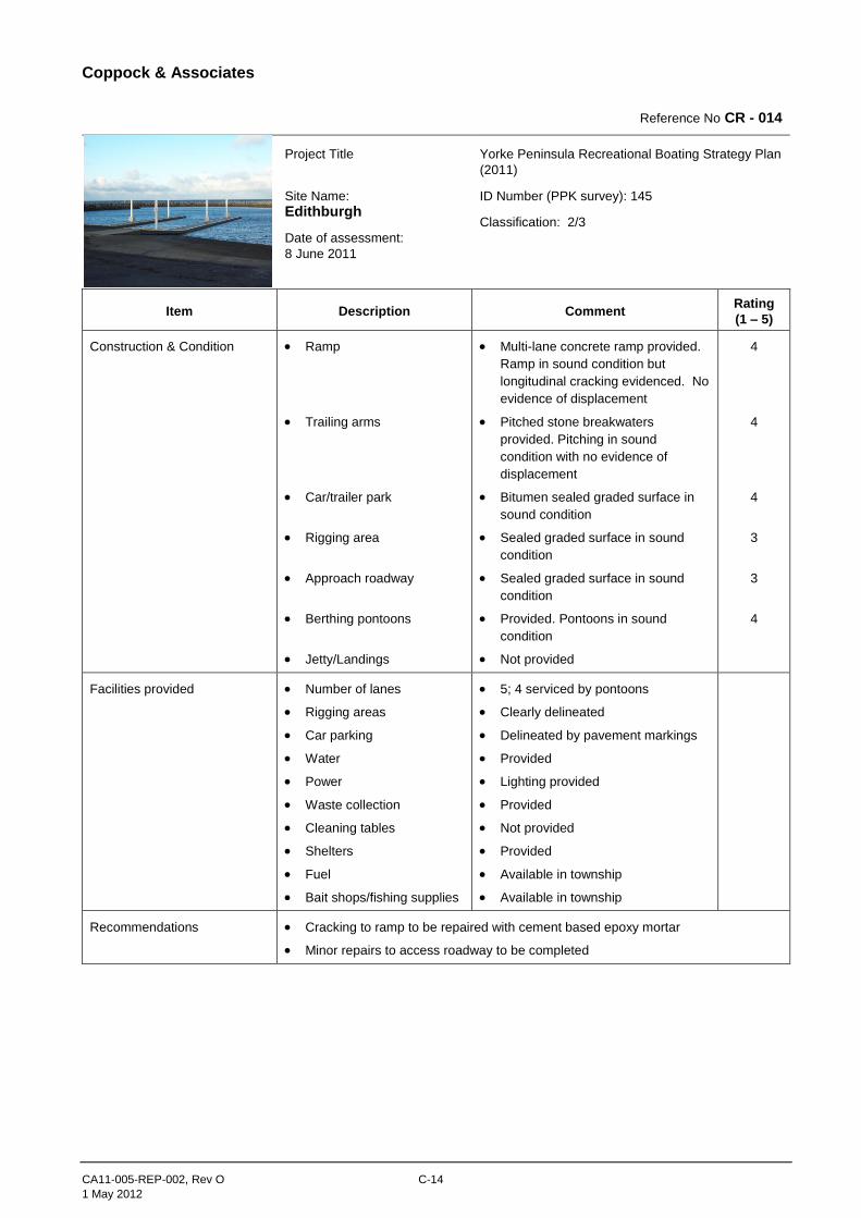
Coppock & Associates
CA11-005-REP-002, Rev O C-14
1 May 2012
Reference No CR - 014
Project Title
Site Name:
Edithburgh
Date of assessment:
8 June 2011
Yorke Peninsula Recreational Boating Strategy Plan
(2011)
ID Number (PPK survey): 145
Classification: 2/3
Item Description Comment Rating
(1 – 5)
Construction & Condition Ramp
Trailing arms
Car/trailer park
Rigging area
Approach roadway
Berthing pontoons
Jetty/Landings
Multi-lane concrete ramp provided.
Ramp in sound condition but
longitudinal cracking evidenced. No
evidence of displacement
Pitched stone breakwaters
provided. Pitching in sound
condition with no evidence of
displacement
Bitumen sealed graded surface in
sound condition
Sealed graded surface in sound
condition
Sealed graded surface in sound
condition
Provided. Pontoons in sound
condition
Not provided
4
4
4
3
3
4
Facilities provided Number of lanes
Rigging areas
Car parking
Water
Power
Waste collection
Cleaning tables
Shelters
Fuel
Bait shops/fishing supplies
5; 4 serviced by pontoons
Clearly delineated
Delineated by pavement markings
Provided
Lighting provided
Provided
Not provided
Provided
Available in township
Available in township
Recommendations Cracking to ramp to be repaired with cement based epoxy mortar
Minor repairs to access roadway to be completed
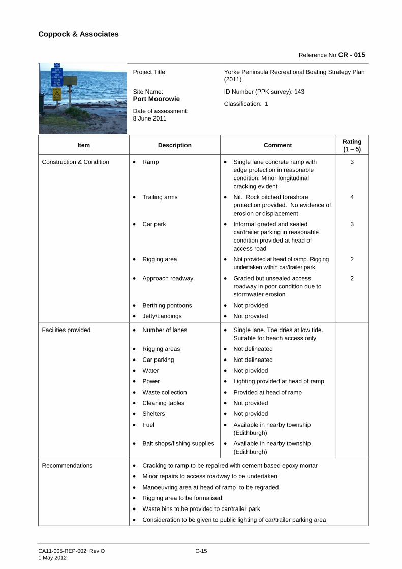
Coppock & Associates
CA11-005-REP-002, Rev O C-15
1 May 2012
Reference No CR - 015
Project Title
Site Name:
Port Moorowie
Date of assessment:
8 June 2011
Yorke Peninsula Recreational Boating Strategy Plan
(2011)
ID Number (PPK survey): 143
Classification: 1
Item Description Comment Rating
(1 – 5)
Construction & Condition Ramp
Trailing arms
Car park
Rigging area
Approach roadway
Berthing pontoons
Jetty/Landings
Single lane concrete ramp with
edge protection in reasonable
condition. Minor longitudinal
cracking evident
Nil. Rock pitched foreshore
protection provided. No evidence of
erosion or displacement
Informal graded and sealed
car/trailer parking in reasonable
condition provided at head of
access road
Not provided at head of ramp. Rigging
undertaken within car/trailer park
Graded but unsealed access
roadway in poor condition due to
stormwater erosion
Not provided
Not provided
3
4
3
2
2
Facilities provided Number of lanes
Rigging areas
Car parking
Water
Power
Waste collection
Cleaning tables
Shelters
Fuel
Bait shops/fishing supplies
Single lane. Toe dries at low tide.
Suitable for beach access only
Not delineated
Not delineated
Not provided
Lighting provided at head of ramp
Provided at head of ramp
Not provided
Not provided
Available in nearby township
(Edithburgh)
Available in nearby township
(Edithburgh)
Recommendations Cracking to ramp to be repaired with cement based epoxy mortar
Minor repairs to access roadway to be undertaken
Manoeuvring area at head of ramp to be regraded
Rigging area to be formalised
Waste bins to be provided to car/trailer park
Consideration to be given to public lighting of car/trailer parking area
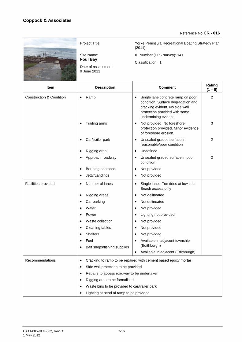
Coppock & Associates
CA11-005-REP-002, Rev O C-16
1 May 2012
Reference No CR - 016
Project Title
Site Name:
Foul Bay
Date of assessment:
9 June 2011
Yorke Peninsula Recreational Boating Strategy Plan
(2011)
ID Number (PPK survey): 141
Classification: 1
Item Description Comment Rating
(1 – 5)
Construction & Condition Ramp
Trailing arms
Car/trailer park
Rigging area
Approach roadway
Berthing pontoons
Jetty/Landings
Single lane concrete ramp on poor
condition. Surface degradation and
cracking evident. No side wall
protection provided with some
undermining evident.
Not provided. No foreshore
protection provided. Minor evidence
of foreshore erosion.
Unsealed graded surface in
reasonable/poor condition
Undefined
Unsealed graded surface in poor
condition
Not provided
Not provided
2
3
2
1
2
Facilities provided Number of lanes
Rigging areas
Car parking
Water
Power
Waste collection
Cleaning tables
Shelters
Fuel
Bait shops/fishing supplies
Single lane. Toe dries at low tide.
Beach access only
Not delineated
Not delineated
Not provided
Lighting not provided
Not provided
Not provided
Not provided
Available in adjacent township
(Edithburgh)
Available in adjacent (Edithburgh)
Recommendations Cracking to ramp to be repaired with cement based epoxy mortar
Side wall protection to be provided
Repairs to access roadway to be undertaken
Rigging area to be formalised
Waste bins to be provided to car/trailer park
Lighting at head of ramp to be provided

Coppock & Associates
CA11-005-REP-002, Rev O C-17
1 May 2012
Reference No CR - 017
Project Title
Site Name:
Marion Bay
Date of assessment:
9 June 2011
Yorke Peninsula Recreational Boating Strategy Plan
(2011)
ID Number (PPK survey): 140
Classification: 1
Item Description Comment Rating
(1 – 5)
Construction & Condition Ramp
Trailing arms
Car/trailer park
Rigging area
Approach roadway
Berthing pontoons
Jetty/Landings
Single lane concrete ramp with
edge protection. Ramp in sound
condition
Not provided. Minor foreshore
protection provided. Foreshore
dunes in reasonable condition but
erosion evident
Sealed graded surface in
reasonable condition
Sealed graded surface in
reasonable condition
Sealed graded surface in sound
condition
Not provided
Jetty with staging/landing located
adjacent ramp
3
2
3
3
3
Facilities provided Number of lanes
Rigging areas
Car parking
Water
Power
Waste collection
Cleaning tables
Shelters
Fuel
Bait shops/fishing supplies
Single lane. Toe dries at low tide.
Beach access only
Not delineated
Not delineated
Not provided
Lighting not provided at ramp head.
Lighting at jetty
Provided at nearby jetty
Not provided
Not provided
Available in township
Available in township
Recommendations Foreshore protection to be provided to protect residual dunes
Ramp to be remodelled to improve access to deeper water
Car/trailer parking area to be formalised
Rigging area to be formalised
Waste bins to be provided at head of ramp
Lighting at head of ramp to be provided
Consideration to be given to relocation of ramp

Coppock & Associates
CA11-005-REP-002, Rev O C-18
1 May 2012
Reference No CR - 018
Project Title
Site Name:
Gleeson’s Landing
Date of assessment:
9 June 2011
Yorke Peninsula Recreational Boating Strategy Plan
(2011)
ID Number (PPK survey): 138
Classification: 1
Item Description Comment Rating
(1 – 5)
Construction & Condition Ramp
Trailing arms
Car park
Rigging area
Approach roadway
Berthing pontoons
Jetty/Landings
Nil: Beach access point only
Not provided.
Unsealed graded surface in
reasonable condition
Not provided
Unsealed graded surface in poor
condition
Not provided
Not provided
1
1
1
1
1
Facilities provided Number of lanes
Rigging areas
Car parking
Water
Power
Waste collection
Cleaning tables
Shelters
Fuel
Bait shops/fishing supplies
Beach access only
Not delineated
Not delineated
Not provided
Not provided
Not provided
Not provided
Not provided
Not available
Not available
Recommendations The use of Gleeson’s landing as a launching site has ceased with the beach access
point not blocked off. The area is now in use as a camping ground offering only basic
facilities.
It is therefore recommended that this facility be removed from the register of launching
sites available on Yorke Peninsula.
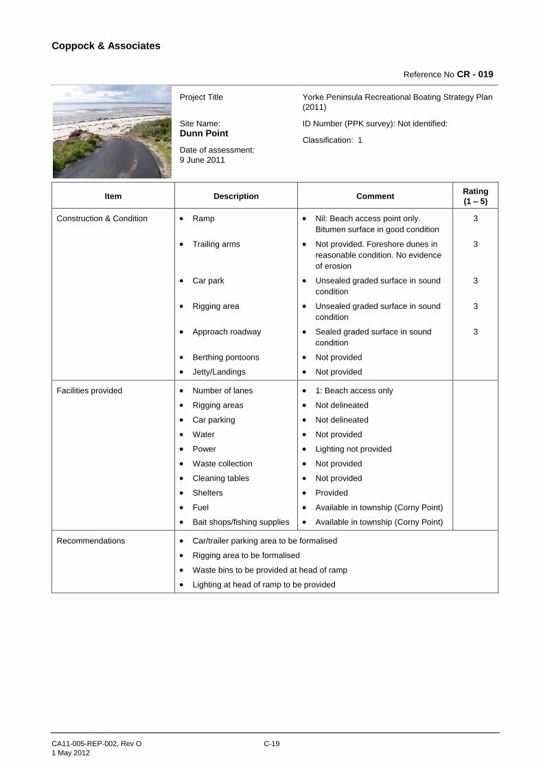
Coppock & Associates
CA11-005-REP-002, Rev O C-19
1 May 2012
Reference No CR - 019
Project Title
Site Name:
Dunn Point
Date of assessment:
9 June 2011
Yorke Peninsula Recreational Boating Strategy Plan
(2011)
ID Number (PPK survey): Not identified:
Classification: 1
Item Description Comment Rating
(1 – 5)
Construction & Condition Ramp
Trailing arms
Car park
Rigging area
Approach roadway
Berthing pontoons
Jetty/Landings
Nil: Beach access point only.
Bitumen surface in good condition
Not provided. Foreshore dunes in
reasonable condition. No evidence
of erosion
Unsealed graded surface in sound
condition
Unsealed graded surface in sound
condition
Sealed graded surface in sound
condition
Not provided
Not provided
3
3
3
3
3
Facilities provided Number of lanes
Rigging areas
Car parking
Water
Power
Waste collection
Cleaning tables
Shelters
Fuel
Bait shops/fishing supplies
1: Beach access only
Not delineated
Not delineated
Not provided
Lighting not provided
Not provided
Not provided
Provided
Available in township (Corny Point)
Available in township (Corny Point)
Recommendations Car/trailer parking area to be formalised
Rigging area to be formalised
Waste bins to be provided at head of ramp
Lighting at head of ramp to be provided
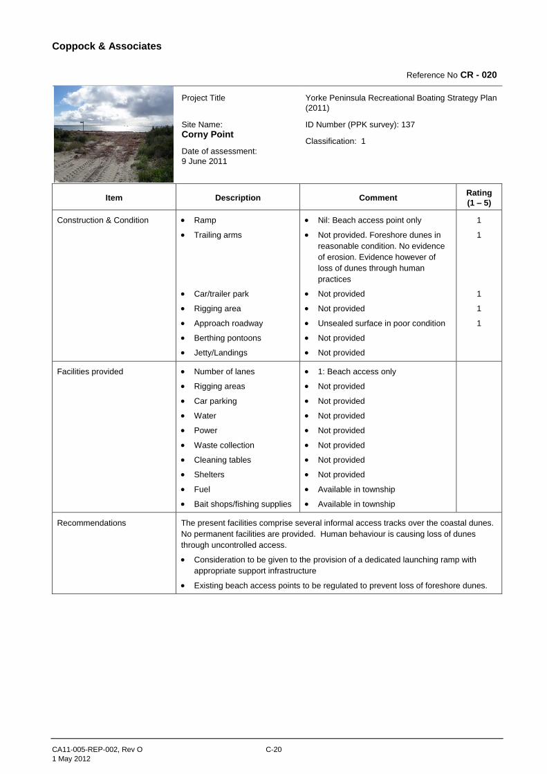
Coppock & Associates
CA11-005-REP-002, Rev O C-20
1 May 2012
Reference No CR - 020
Project Title
Site Name:
Corny Point
Date of assessment:
9 June 2011
Yorke Peninsula Recreational Boating Strategy Plan
(2011)
ID Number (PPK survey): 137
Classification: 1
Item Description Comment Rating
(1 – 5)
Construction & Condition Ramp
Trailing arms
Car/trailer park
Rigging area
Approach roadway
Berthing pontoons
Jetty/Landings
Nil: Beach access point only
Not provided. Foreshore dunes in
reasonable condition. No evidence
of erosion. Evidence however of
loss of dunes through human
practices
Not provided
Not provided
Unsealed surface in poor condition
Not provided
Not provided
1
1
1
1
1
Facilities provided Number of lanes
Rigging areas
Car parking
Water
Power
Waste collection
Cleaning tables
Shelters
Fuel
Bait shops/fishing supplies
1: Beach access only
Not provided
Not provided
Not provided
Not provided
Not provided
Not provided
Not provided
Available in township
Available in township
Recommendations The present facilities comprise several informal access tracks over the coastal dunes.
No permanent facilities are provided. Human behaviour is causing loss of dunes
through uncontrolled access.
Consideration to be given to the provision of a dedicated launching ramp with
appropriate support infrastructure
Existing beach access points to be regulated to prevent loss of foreshore dunes.
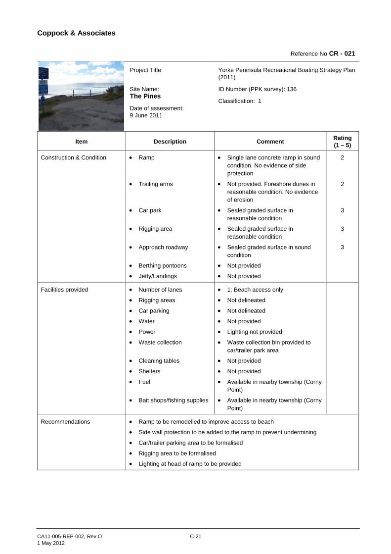
Coppock & Associates
CA11-005-REP-002, Rev O C-21
1 May 2012
Reference No CR - 021
Project Title
Site Name:
The Pines
Date of assessment:
9 June 2011
Yorke Peninsula Recreational Boating Strategy Plan
(2011)
ID Number (PPK survey): 136
Classification: 1
Item Description Comment Rating
(1 – 5)
Construction & Condition Ramp
Trailing arms
Car park
Rigging area
Approach roadway
Berthing pontoons
Jetty/Landings
Single lane concrete ramp in sound
condition. No evidence of side
protection
Not provided. Foreshore dunes in
reasonable condition. No evidence
of erosion
Sealed graded surface in
reasonable condition
Sealed graded surface in
reasonable condition
Sealed graded surface in sound
condition
Not provided
Not provided
2
2
3
3
3
Facilities provided Number of lanes
Rigging areas
Car parking
Water
Power
Waste collection
Cleaning tables
Shelters
Fuel
Bait shops/fishing supplies
1: Beach access only
Not delineated
Not delineated
Not provided
Lighting not provided
Waste collection bin provided to
car/trailer park area
Not provided
Not provided
Available in nearby township (Corny
Point)
Available in nearby township (Corny
Point)
Recommendations Ramp to be remodelled to improve access to beach
Side wall protection to be added to the ramp to prevent undermining
Car/trailer parking area to be formalised
Rigging area to be formalised
Lighting at head of ramp to be provided
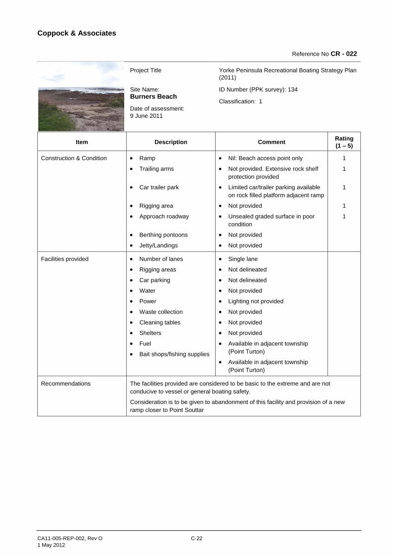
Coppock & Associates
CA11-005-REP-002, Rev O C-22
1 May 2012
Reference No CR - 022
Project Title
Site Name:
Burners Beach
Date of assessment:
9 June 2011
Yorke Peninsula Recreational Boating Strategy Plan
(2011)
ID Number (PPK survey): 134
Classification: 1
Item Description Comment Rating
(1 – 5)
Construction & Condition Ramp
Trailing arms
Car trailer park
Rigging area
Approach roadway
Berthing pontoons
Jetty/Landings
Nil: Beach access point only
Not provided. Extensive rock shelf
protection provided
Limited car/trailer parking available
on rock filled platform adjacent ramp
Not provided
Unsealed graded surface in poor
condition
Not provided
Not provided
1
1
1
1
1
Facilities provided Number of lanes
Rigging areas
Car parking
Water
Power
Waste collection
Cleaning tables
Shelters
Fuel
Bait shops/fishing supplies
Single lane
Not delineated
Not delineated
Not provided
Lighting not provided
Not provided
Not provided
Not provided
Available in adjacent township
(Point Turton)
Available in adjacent township
(Point Turton)
Recommendations The facilities provided are considered to be basic to the extreme and are not
conducive to vessel or general boating safety.
Consideration is to be given to abandonment of this facility and provision of a new
ramp closer to Point Souttar
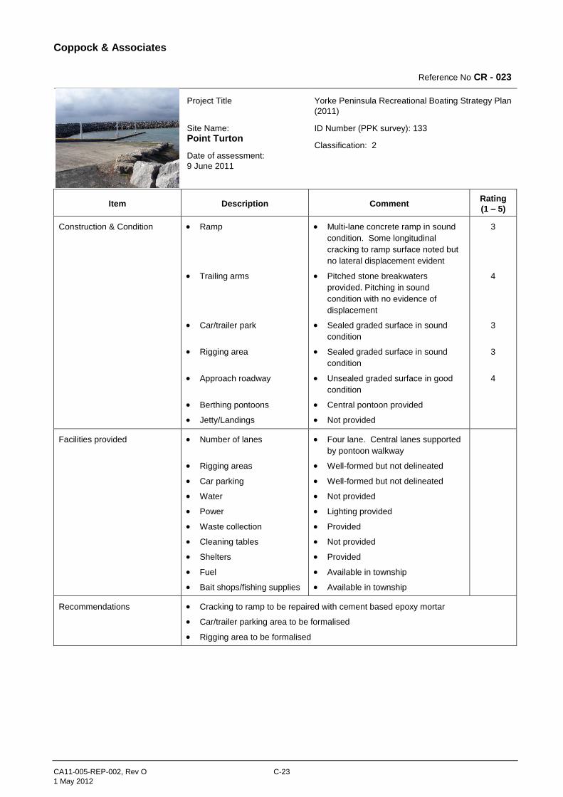
Coppock & Associates
CA11-005-REP-002, Rev O C-23
1 May 2012
Reference No CR - 023
Project Title
Site Name:
Point Turton
Date of assessment:
9 June 2011
Yorke Peninsula Recreational Boating Strategy Plan
(2011)
ID Number (PPK survey): 133
Classification: 2
Item Description Comment Rating
(1 – 5)
Construction & Condition Ramp
Trailing arms
Car/trailer park
Rigging area
Approach roadway
Berthing pontoons
Jetty/Landings
Multi-lane concrete ramp in sound
condition. Some longitudinal
cracking to ramp surface noted but
no lateral displacement evident
Pitched stone breakwaters
provided. Pitching in sound
condition with no evidence of
displacement
Sealed graded surface in sound
condition
Sealed graded surface in sound
condition
Unsealed graded surface in good
condition
Central pontoon provided
Not provided
3
4
3
3
4
Facilities provided Number of lanes
Rigging areas
Car parking
Water
Power
Waste collection
Cleaning tables
Shelters
Fuel
Bait shops/fishing supplies
Four lane. Central lanes supported
by pontoon walkway
Well-formed but not delineated
Well-formed but not delineated
Not provided
Lighting provided
Provided
Not provided
Provided
Available in township
Available in township
Recommendations Cracking to ramp to be repaired with cement based epoxy mortar
Car/trailer parking area to be formalised
Rigging area to be formalised
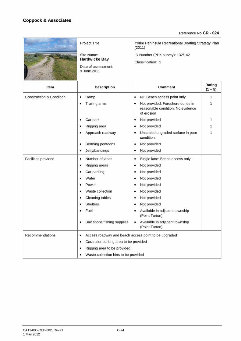
Coppock & Associates
CA11-005-REP-002, Rev O C-24
1 May 2012
Reference No CR - 024
Project Title
Site Name:
Hardwicke Bay
Date of assessment:
9 June 2011
Yorke Peninsula Recreational Boating Strategy Plan
(2011)
ID Number (PPK survey): 132/142
Classification: 1
Item Description Comment Rating
(1 – 5)
Construction & Condition Ramp
Trailing arms
Car park
Rigging area
Approach roadway
Berthing pontoons
Jetty/Landings
Nil: Beach access point only
Not provided. Foreshore dunes in
reasonable condition. No evidence
of erosion
Not provided
Not provided
Unsealed ungraded surface in poor
condition.
Not provided
Not provided
1
1
1
1
1
Facilities provided Number of lanes
Rigging areas
Car parking
Water
Power
Waste collection
Cleaning tables
Shelters
Fuel
Bait shops/fishing supplies
Single lane: Beach access only
Not provided
Not provided
Not provided
Not provided
Not provided
Not provided
Not provided
Available in adjacent township
(Point Turton)
Available in adjacent township
(Point Turton)
Recommendations Access roadway and beach access point to be upgraded
Car/trailer parking area to be provided
Rigging area to be provided
Waste collection bins to be provided
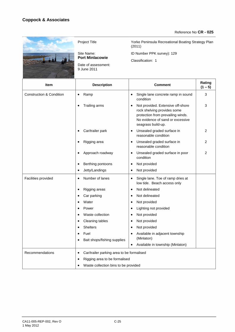
Coppock & Associates
CA11-005-REP-002, Rev O C-25
1 May 2012
Reference No CR - 025
Project Title
Site Name:
Port Minlacowie
Date of assessment:
9 June 2011
Yorke Peninsula Recreational Boating Strategy Plan
(2011)
ID Number PPK survey): 129
Classification: 1
Item Description Comment Rating
(1 – 5)
Construction & Condition Ramp
Trailing arms
Car/trailer park
Rigging area
Approach roadway
Berthing pontoons
Jetty/Landings
Single lane concrete ramp in sound
condition
Not provided. Extensive off-shore
rock shelving provides some
protection from prevailing winds.
No evidence of sand or excessive
seagrass build-up.
Unsealed graded surface in
reasonable condition
Unsealed graded surface in
reasonable condition
Unsealed graded surface in poor
condition
Not provided
Not provided
3
3
2
2
2
Facilities provided Number of lanes
Rigging areas
Car parking
Water
Power
Waste collection
Cleaning tables
Shelters
Fuel
Bait shops/fishing supplies
Single lane. Toe of ramp dries at
low tide. Beach access only
Not delineated
Not delineated
Not provided
Lighting not provided
Not provided
Not provided
Not provided
Available in adjacent township
(Minlaton)
Available in township (Minlaton)
Recommendations Car/trailer parking area to be formalised
Rigging area to be formalised
Waste collection bins to be provided
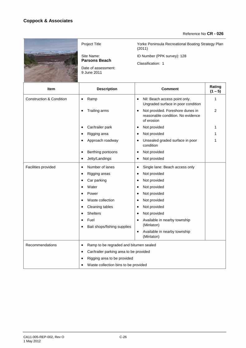
Coppock & Associates
CA11-005-REP-002, Rev O C-26
1 May 2012
Reference No CR - 026
Project Title
Site Name:
Parsons Beach
Date of assessment:
9 June 2011
Yorke Peninsula Recreational Boating Strategy Plan
(2011)
ID Number (PPK survey): 128
Classification: 1
Item Description Comment Rating
(1 – 5)
Construction & Condition Ramp
Trailing arms
Car/trailer park
Rigging area
Approach roadway
Berthing pontoons
Jetty/Landings
Nil: Beach access point only.
Ungraded surface in poor condition
Not provided. Foreshore dunes in
reasonable condition. No evidence
of erosion
Not provided
Not provided
Unsealed graded surface in poor
condition
Not provided
Not provided
1
2
1
1
1
Facilities provided Number of lanes
Rigging areas
Car parking
Water
Power
Waste collection
Cleaning tables
Shelters
Fuel
Bait shops/fishing supplies
Single lane: Beach access only
Not provided
Not provided
Not provided
Not provided
Not provided
Not provided
Not provided
Available in nearby township
(Minlaton)
Available in nearby township
(Minlaton)
Recommendations Ramp to be regraded and bitumen sealed
Car/trailer parking area to be provided
Rigging area to be provided
Waste collection bins to be provided
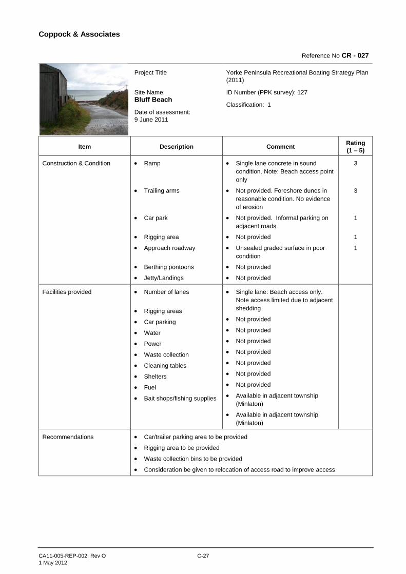
Coppock & Associates
CA11-005-REP-002, Rev O C-27
1 May 2012
Reference No CR - 027
Project Title
Site Name:
Bluff Beach
Date of assessment:
9 June 2011
Yorke Peninsula Recreational Boating Strategy Plan
(2011)
ID Number (PPK survey): 127
Classification: 1
Item Description Comment Rating
(1 – 5)
Construction & Condition Ramp
Trailing arms
Car park
Rigging area
Approach roadway
Berthing pontoons
Jetty/Landings
Single lane concrete in sound
condition. Note: Beach access point
only
Not provided. Foreshore dunes in
reasonable condition. No evidence
of erosion
Not provided. Informal parking on
adjacent roads
Not provided
Unsealed graded surface in poor
condition
Not provided
Not provided
3
3
1
1
1
Facilities provided Number of lanes
Rigging areas
Car parking
Water
Power
Waste collection
Cleaning tables
Shelters
Fuel
Bait shops/fishing supplies
Single lane: Beach access only.
Note access limited due to adjacent
shedding
Not provided
Not provided
Not provided
Not provided
Not provided
Not provided
Not provided
Available in adjacent township
(Minlaton)
Available in adjacent township
(Minlaton)
Recommendations Car/trailer parking area to be provided
Rigging area to be provided
Waste collection bins to be provided
Consideration be given to relocation of access road to improve access
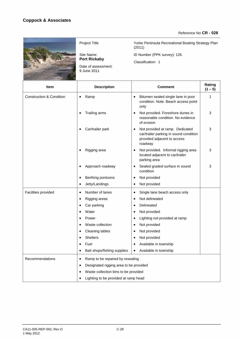
Coppock & Associates
CA11-005-REP-002, Rev O C-28
1 May 2012
Reference No CR - 028
Project Title
Site Name:
Port Rickaby
Date of assessment:
9 June 2011
Yorke Peninsula Recreational Boating Strategy Plan
(2011)
ID Number (PPK survey): 126
Classification: 1
Item Description Comment Rating
(1 – 5)
Construction & Condition Ramp
Trailing arms
Car/trailer park
Rigging area
Approach roadway
Berthing pontoons
Jetty/Landings
Bitumen sealed single lane in poor
condition. Note: Beach access point
only
Not provided. Foreshore dunes in
reasonable condition. No evidence
of erosion
Not provided at ramp. Dedicated
car/trailer parking in sound condition
provided adjacent to access
roadway
Not provided. Informal rigging area
located adjacent to car/trailer
parking area
Sealed graded surface in sound
condition
Not provided
Not provided
1
3
3
3
3
Facilities provided Number of lanes
Rigging areas
Car parking
Water
Power
Waste collection
Cleaning tables
Shelters
Fuel
Bait shops/fishing supplies
Single lane beach access only
Not delineated
Delineated
Not provided
Lighting not provided at ramp
Not provided
Not provided
Not provided
Available in township
Available in township
Recommendations Ramp to be repaired by resealing
Designated rigging area to be provided
Waste collection bins to be provided
Lighting to be provided at ramp head
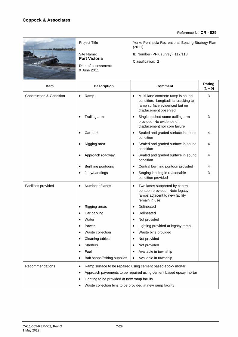
Coppock & Associates
CA11-005-REP-002, Rev O C-29
1 May 2012
Reference No CR - 029
Project Title
Site Name:
Port Victoria
Date of assessment:
9 June 2011
Yorke Peninsula Recreational Boating Strategy Plan
(2011)
ID Number (PPK survey): 117/118
Classification: 2
Item Description Comment Rating
(1 – 5)
Construction & Condition Ramp
Trailing arms
Car park
Rigging area
Approach roadway
Berthing pontoons
Jetty/Landings
Multi-lane concrete ramp is sound
condition. Longitudinal cracking to
ramp surface evidenced but no
displacement observed
Single pitched stone trailing arm
provided. No evidence of
displacement nor core failure
Sealed and graded surface in sound
condition
Sealed and graded surface in sound
condition
Sealed and graded surface in sound
condition
Central berthing pontoon provided
Staging landing in reasonable
condition provided
3
3
4
4
4
4
3
Facilities provided Number of lanes
Rigging areas
Car parking
Water
Power
Waste collection
Cleaning tables
Shelters
Fuel
Bait shops/fishing supplies
Two lanes supported by central
pontoon provided. Note legacy
ramps adjacent to new facility
remain in use
Delineated
Delineated
Not provided
Lighting provided at legacy ramp
Waste bins provided
Not provided
Not provided
Available in township
Available in township
Recommendations Ramp surface to be repaired using cement based epoxy mortar
Approach pavements to be repaired using cement based epoxy mortar
Lighting to be provided at new ramp facility
Waste collection bins to be provided at new ramp facility
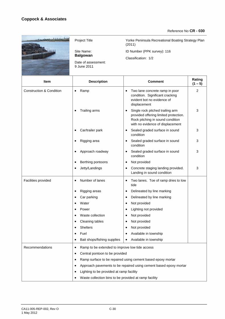
Coppock & Associates
CA11-005-REP-002, Rev O C-30
1 May 2012
Reference No CR - 030
Project Title
Site Name:
Balgowan
Date of assessment:
9 June 2011
Yorke Peninsula Recreational Boating Strategy Plan
(2011)
ID Number (PPK survey): 116
Classification: 1/2
Item Description Comment Rating
(1 – 5)
Construction & Condition Ramp
Trailing arms
Car/trailer park
Rigging area
Approach roadway
Berthing pontoons
Jetty/Landings
Two lane concrete ramp in poor
condition. Significant cracking
evident bot no evidence of
displacement
Single rock pitched trailing arm
provided offering limited protection.
Rock pitching in sound condition
with no evidence of displacement
Sealed graded surface in sound
condition
Sealed graded surface in sound
condition
Sealed graded surface in sound
condition
Not provided
Concrete staging landing provided.
Landing in sound condition
2
3
3
3
3
3
Facilities provided Number of lanes
Rigging areas
Car parking
Water
Power
Waste collection
Cleaning tables
Shelters
Fuel
Bait shops/fishing supplies
Two lanes. Toe of ramp dries to low
tide
Delineated by line marking
Delineated by line marking
Not provided
Lighting not provided
Not provided
Not provided
Not provided
Available in township
Available in township
Recommendations Ramp to be extended to improve low tide access
Central pontoon to be provided
Ramp surface to be repaired using cement based epoxy mortar
Approach pavements to be repaired using cement based epoxy mortar
Lighting to be provided at ramp facility
Waste collection bins to be provided at ramp facility