project concept report - dot home page · december 2009 wetland delineation report iv. ... u.s....
TRANSCRIPT
23 USC § 409 NDDOT Reserves All Objections
WE
TLA
ND
DE
LIN
EA
TIO
N R
EPO
RT
STRUCTURE REPAIR
Project No.
PCN
ABC-1-234(567)890 12345
Structure Repair RP 890
234
Prepared by
NORTH DAKOTA DEPARTMENT OF TRANSPORTATION BISMARCK, NORTH DAKOTA
http://www.dot.nd.gov/
DIRECTOR
Francis G. Ziegler, P.E.
PROJECT DEVELOPMENT DIRECTOR Ronald J. Henke, P.E.
Principal Author: John Doe
December 2009

Structure Repair RP 890 Page i Project No. ABC-1-234(567)890 PCN 12345 December 2009 Wetland Delineation Report
TABLE OF CONTENTS I. Introduction ..................................................................................................................... 1 II. Methods .......................................................................................................................... 1 III. Results ............................................................................................................................ 1 IV. References ...................................................................................................................... 2 V. Delineator’s Credentials ................................................................................................... 2 Tables Table 1, Wetland Table ......................................................................................................... 3 Exhibits Exhibit 1, Project Location Map ............................................................................................. 4 Exhibit 2, Wetland Map ......................................................................................................... 5 Appendices Appendix A, Additional Information for Jurisdictional Requests
Structure Repair RP 890 Page 1 Project No. ABC-1-234(567)890 PCN 12345 December 2009 Wetland Delineation Report
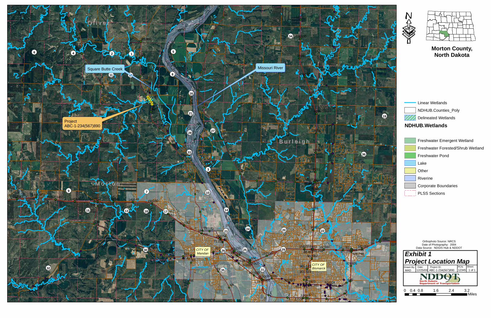
I. Introduction The North Dakota Department of Transportation (NDDOT), in cooperation with the Federal Highway Administration (FHWA), is planning roadway improvements within a project area along ND 234 near Reference Point (RP) 890. Please refer to Exhibit 1, Project Location Map. The project consists of structural repair and incidentals. The project is planned to be built during the 2011 construction season. John Doe of the NDDOT conducted an office wetland delineation for the proposed project on December 25, 2009. Supplementary project area information can be found in Appendix A, Additional Information for Jurisdictional Requests.
II. Methods The office wetland delineation was conducted in accordance with Section II-03.10.01 of the NDDOT Design Manual. Wetland boundaries within the study area were determined by interpreting 2003, 2004, and 2005 aerial photography and referencing the National Wetlands Inventory (NWI) layer and the United States Geological Survey (USGS) topographic layer. The project area was extended to 200 feet on either side of the roadway due to the potential addition of a bypass during project design.
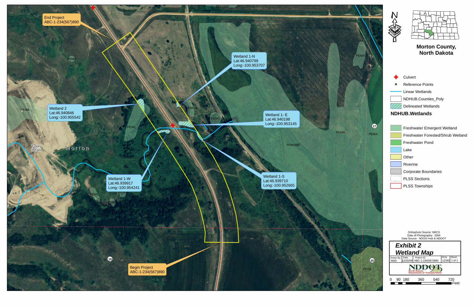
III. Results Five wetlands were identified within the project area. Three of the delineated wetlands (1-S, 1-E, and 1-W) are part of a natural stream, and one of the wetlands (1-N) is a meander cut off from the same stream. The remaining wetland (2) is a natural basin. The USGS topographic layer indicates that the stream delineated within the project area is Otter Creek, which flows into Square Butte Creek, and later into the Missouri River. Please refer to Table 1, Wetland Table. Approximately 0.61 acres of wetlands were delineated within the project area. Some wetlands extended beyond the limits of the project area; however, wetlands were only delineated to the boundary of the project area. Please refer to Exhibit 2, Wetland Map.
Structure Repair RP 890 Page 2 Project No. ABC-1-234(567)890 PCN 12345 December 2009 Wetland Delineation Report
IV. References Cowardin, L. M., V. Carter, F. C. Golet, E. T. LaRoe. 1979. Classification of wetlands
and deepwater habitats of the United States. U.S. Department of the Interior, Fish and Wildlife Service. Available online: http://www.fws.gov/wetlands/_documents/gNS DI/ClassificationWetlandsDeepwaterHabitatsUS.pdf
National Hydric Soils List by State [Electronic Database]. 2009. United States
Department of Agriculture: Natural Resources Conservation Service. Available online: http://soils.usda.gov/use/hydric/lists/state.html
North Dakota Department of Transportation. 2009. NDDOT Design Manual. Available
online: http://www.dot.nd.gov/manuals/design/designmanual/designmanual.htm U.S. Army Corps of Engineers. 1987. US Army Corps of Engineers Wetlands
Delineation Manual. Available online: http://www.wetlands.com/regs/tlpge02e.htm
V. Delineator’s Credentials Education: University of North Dakota – BS Biology
Professional Membership: Society of Wetland Scientists
Wetland Professionals Association
Training: Society of Wetland Scientists – Introduction to Wetlands
Wetland Training Institute – Basic Wetland Delineation Field Practicum
Wetland Training Institute – Wetland Delineation with Emphasis on Soils
and Hydrology
NRCS – Field Indicators of Hydric Soil
NRCS – Regulatory IV - Wetland Delineation, US Army Corps of
Engineers

Structure Repair RP 890 Page 3 Project No. ABC-1-234(567)890 PCN 12345 December 2009 Wetland Delineation Report
Table 1, Wetland Table The office wetland delineation for PCN 12345, Project ID # ABC-1-234(567)890 (Structure Repair RP 890), was conducted on December 25, 2009 by John Doe of the North Dakota Department of Transportation. The wetland delineations were conducted using a combination of NWI maps and aerial photography, assuming a 200 foot buffer around the project area. The project is located within the Painted Woods / Square Butte Creek (10130101) Hydrologic Unit Code (HUC).
Wetland Number Location LONG / LAT
(Dec. Deg.) Cowardin
Classification Wetland
Type
Wetland Size
(acres)
Wetland Feature
1-S T140N, R81W, Section 18
-100.952665 / 46.939710 R4SBF Stream 0.06 Natural
1-E T140N, R81W, Section 18
-100.953145 / 46.940198 R4SBF Stream 0.22 Natural
1-N T140N, R81W, Section 18
-100.953707 / 46.940799 PEMC Meander
Cutoff 0.04 Natural
2 T140N, R81W, Section 18
-100.955542 / 46.940846 PEMC Basin 0.18 Natural
1-W T140N, R81W, Section 18
-100.954241 / 46.939917 R4SBF Stream 0.11 Natural
TOTAL 0.61
M o r t o nM o r t o n
B u r l e i g hB u r l e i g h
O l i v e rO l i v e r
8
16
5
3
10
21
33
23
25
14
28
6 4 2 1
31
18
35
79
13
12
27
34
26
24
30
19
32
36
29
15
20
11
22
17
CITY OF Bismarck
CITY OF Mandan
54321 54321
9
8
7
6
5
4
3
2
8989
68
96
95
94
93
92
91
90
89
88
8786 85 84 83
85
84
83
82
81
80
79
78
77
76
75 72
71
69
99
98
97
96
95
94
93
92
91
90
99
98
97
96
95
94
93
92
91
90
67
66
65
10
921921
926926
924923922920
919
917
925924923922920
919917915914
913912
911
910
909
101
100
101
100
163162161160159
157156
155
154153
152
151
150149148147146145144143
163162161160159
157156
155
154153
152
151
150149148147146145144143
902
901
902
2.9182.773
0.0000.000
0.000
1.072
0.0000.000
71.225
82.973
85.800
92.463
88.998
92.463
88.99867.413
926.799926.867155.026155.026
924.140922.860922.724
926.799
901.523901.523
Linear WetlandsNDHUB.Counties_PolyDelineated Wetlands
NDHUB.Wetlands
Freshwater Emergent WetlandFreshwater Forested/Shrub WetlandFreshwater PondLakeOtherRiverineCorporate BoundariesPLSS Sections
0 0.8 1.6 2.4 3.20.4 Miles
Orthophoto Source: NRCSDate of Photography: 2004
Data Source: NDGIS Hub & NDDOT
Exhibit 1Project Location Map
Drawn By:MAD
Project ID: PCN:Date:12/25/09
Sheet:1 of 1
Morton County,North Dakota
ABC-1-234(567)890 12345
ProjectABC-1-234(567)890
Missouri RiverSquare Butte Creek
M o r t o nM o r t o nT140NR 81W
18
19
17
20
PEM/ABF
PEMA
PFOA
PEMA
PEMCPEMA
PEMA
PEMC
PEMC
PEMC PEMC
PEM/ABF
PEMC
PEMA
PEMA
PEMC
CulvertReference PointsLinear WetlandsNDHUB.Counties_PolyDelineated Wetlands
NDHUB.Wetlands
Freshwater Emergent WetlandFreshwater Forested/Shrub WetlandFreshwater PondLakeOtherRiverineCorporate BoundariesPLSS SectionsPLSS Townships
0 180 360 540 72090 Feet
Orthophoto Source: NRCSDate of Photography: 2004
Data Source: NDGIS Hub & NDDOT
Exhibit 2 Wetland Map
Drawn By:MAD
Project ID: PCN:Date:12/25/09
Sheet:1 of 1
Morton County,North Dakota
ABC-1-234(567)890 12345
Wetland 1-SLat:46.939710Long:-100.952665
Wetland 1- ELat:46.940198Long:-100.953145
Wetland 1-NLat:46.940799Long:-100.953707
Wetland 1-WLat:46.939917Long:-100.954241
Wetland 2Lat:46.940846 Long:-100.955542
Begin ProjectABC-1-234(567)890
End ProjectABC-1-234(567)890

Appendix A Additional Information for Jurisdictional Requests

1 of 2 May 2009
ADDITIONAL INFORMATION FOR WETLAND JURISDICTIONAL REQUESTS ON NDDOT PROJECTS
A. Project Location and Background Information
1. PCN / Project Number: 12345 / ABC-1-234(567)890 a. City: Mandan b. County: Morton c. State: North Dakota
2. Short project description: Structure Repair RP 890 3. Name of nearest waterbody: Square Butte Creek 4. Name of nearest Traditional Navigable Water (TNW): Missouri River 5. Name of watershed or Hydrologic Unit Code (HUC): Painted Woods - Square Butte Creek /
10130101 6. Number of wetlands being considered in this cumulative analysis: 2 (see comments below) 7. Approximate acreage being considered in this cumulative analysis (Total Basin Size): 0.61 ac.
B. Review Performed for Site Evaluation (Check all that apply)
1. Office Determination Date: 12/25/09 2. Field Determination Date:
C. General Information
1. General area conditions: a. HUC watershed size (specify acres or square miles): 40.01 sq. miles b. Average annual rainfall (inches): 16.35
i. Source: High Plains Regional Climate Center c. Average annual snowfall (inches): 32.60
i. Source: High Plains Regional Climate Center
2. Biological characteristics (Field Determination only; list applicable wetland numbers): a. The wetland supports (use space below each to elaborate for applicable wetlands):
i.Riparian buffer characteristics (type, average width): ii.Habitat for:
___ Federally Listed species. Explain findings: ___ Fish/spawn areas. Explain findings: ___ Other environmentally-sensitive species. Explain findings: ___ Aquatic/wildlife diversity. Explain findings:
D. Data Sources (Check all that apply)
_X_ Maps, plans, plots, or plat submitted by or on behalf of the applicant/consultant _X_ Data Sheets prepared/submitted by or on behalf of the applicant/consultant ___ U.S. Geological Survey Hydrologic Atlas ___ USGS NHD data: _X_USGS 8 and 12 digit HUC maps: _X_ U.S. Geological Survey map(s) Cite scale & quad name: 24K - Harmon _X_ USDA Natural Resources Conservation Service Soil Survey
2 of 2 May 2009
Citation: SSURGO, ND GIS Data Hub _X_ National Wetlands Inventory map(s) Cite name/date: USFWS NWI Maps ND GIS Data Hub ___ State/Local wetland inventory map(s) Cite name/date: ___ 100-year Floodplain Elevation is: ______ (National Geodetic Vertical Datum of 1929) _X_ Aerial Photographs Cite name/date: NDDOT / 2004 ___ Applicable/supporting scientific literature: ___ Other information (please specify):
E. Additional Comments Wetlands 1-S, 1-E, and 1-W are all part of the same continuous intermittent stream. Wetland 1-N is a portion of a meander cutoff. The entire region is / are the headwaters of Square Butte Creek, which flows into the Missouri River.