wetland delineation / determination report cover form · wetland delineation / determination report...
TRANSCRIPT
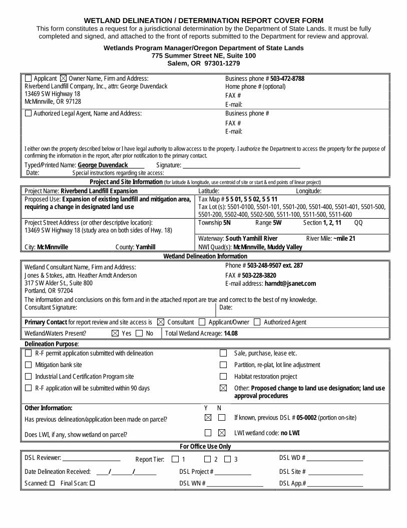
WETLAND DELINEATION / DETERMINATION REPORT COVER FORM This form constitutes a request for a jurisdictional determination by the Department of State Lands. It must be fully completed and signed, and attached to the front of reports submitted to the Department for review and approval.
Wetlands Program Manager/Oregon Department of State Lands 775 Summer Street NE, Suite 100
Salem, OR 97301-1279
Applicant Owner Name, Firm and Address: Riverbend Landfill Company, Inc., attn: George Duvendack 13469 SW Highway 18 McMinnville, OR 97128
Business phone # 503-472-8788 Home phone # (optional) FAX # E-mail:
Authorized Legal Agent, Name and Address: Business phone # FAX # E-mail:
I either own the property described below or I have legal authority to allow access to the property. I authorize the Department to access the property for the purpose of confirming the information in the report, after prior notification to the primary contact. Typed/Printed Name: George Duvendack Signature: Date: Special instructions regarding site access:
Project and Site Information (for latitude & longitude, use centroid of site or start & end points of linear project) Project Name: Riverbend Landfill Expansion Latitude: Longitude: Proposed Use: Expansion of existing landfill and mitigation area, requiring a change in designated land use
Tax Map # 5 5 01, 5 5 02, 5 5 11 Tax Lot (s): 5501-0100, 5501-101, 5501-200, 5501-400, 5501-401, 5501-500, 5501-200, 5502-400, 5502-500, 5511-100, 5511-500, 5511-600
Project Street Address (or other descriptive location): 13469 SW Highway 18 (study area on both sides of Hwy. 18)
Township 5N
Range 5W Section 1, 2, 11 QQ
Waterway: South Yamhill River River Mile: ~mile 21 City: McMinnville County: Yamhill NWI Quad(s): McMinnville, Muddy Valley
Wetland Delineation Information Wetland Consultant Name, Firm and Address: Phone # 503-248-9507 ext. 287 Jones & Stokes, attn. Heather Arndt Anderson 317 SW Alder St., Suite 800 Portland, OR 97204
FAX # 503-228-3820 E-mail address: [email protected]
The information and conclusions on this form and in the attached report are true and correct to the best of my knowledge. Consultant Signature: Date:
Primary Contact for report review and site access is Consultant Applicant/Owner Authorized Agent Wetland/Waters Present? Yes No Total Wetland Acreage: 14.08 Delineation Purpose:
R-F permit application submitted with delineation Sale, purchase, lease etc. Mitigation bank site Partition, re-plat, lot line adjustment Industrial Land Certification Program site Habitat restoration project R-F application will be submitted within 90 days Other: Proposed change to land use designation; land use
approval procedures
Other Information: Y N Has previous delineation/application been made on parcel? If known, previous DSL # 05-0002 (portion on-site)
Does LWI, if any, show wetland on parcel? LWI wetland code: no LWI
For Office Use Only DSL Reviewer: Report Tier: 1 2 3 DSL WD #
Date Delineation Received: / / DSL Project # DSL Site #
Scanned: Final Scan: DSL WN # DSL App.#

Riverbend Landfill Expansion Riverbend Landfill Company, Inc. December 2007
Wetland Delineation Report

Wetland Delineation Report Riverbend Landfill Expansion
Prepared for: Riverbend Landfill Company, Inc.
13469 SW Hwy. 18 McMinnville, OR 97128
Contact: George Duvendack (503) 472-8788 ext. 28
Prepared by:
317 SW Alder Street, Suite 800
Portland, OR 97204 Contact: Heather Arndt Anderson
503/248-9507 ext. 287
December 2007

This document should be cited as: Jones & Stokes. 2007. Wetland Delineation Report. Riverbend Landfill Expansion. December. (J&S 06293.06.) Portland, OR. Prepared for Riverbend Landfill Company, Inc.

December 2007 i
Table of Contents Chapter 1. Introduction .......................................................... 1
1.1. Study Area ............................................................................. 1 1.2. Landscape Setting ................................................................. 2 1.3. Previous and Current Land Uses ........................................... 2
Chapter 2. Methodology ......................................................... 5 2.1. Site-Specific Methodology ...................................................... 5
2.1.1. Wetlands ..................................................................... 5 2.1.2. Other Waters of the State ........................................... 6
2.2. Off-Site Methodology ............................................................. 6 2.2.1. USGS Topographic Maps ........................................... 6 2.2.2. Soil Survey .................................................................. 7 2.2.3. Local Wetlands Inventory and NWI Maps ................... 7 2.2.4. Aerial Photographs ...................................................... 8 2.2.5. Fish Presence or Absence .......................................... 8
2.3. Precipitation ........................................................................... 8
Chapter 3. Wetlands ............................................................. 11 3.1. Delineated Wetlands ............................................................ 13
3.1.1. Wetlands B and C – Herbaceous Wetlands (Creek Overflow) ................................................................... 13
3.1.2. Wetland D – Stormwater Detention Pond.................. 14 3.1.3. Wetlands E, F, and G – Herbaceous Wetlands ......... 14 3.1.4. Wetlands J and K – Seasonally Ponded ................... 15 3.1.5. Wetland N – Emergent with PSS and PFO
Components .............................................................. 16 3.2. Other Waters of the State .................................................... 17
3.2.1. Feature A – South Yamhill River Active Floodplain ... 17 3.2.2. Stream H – Tributary to South Yamhill River ............. 18 3.2.3. Stream I – Tributary to South Yamhill River .............. 18 3.2.4. Ditch L – Ephemeral Hillside Trench ......................... 19 3.2.5. Stream M – Tributary to South Yamhill River ............ 19
Chapter 4. Results and Conclusions .................................. 21 4.1. Required Disclaimer ............................................................. 21

Wetland Delineation Report
Riverbend Landfill Expansion ii
Chapter 5. References .......................................................... 23
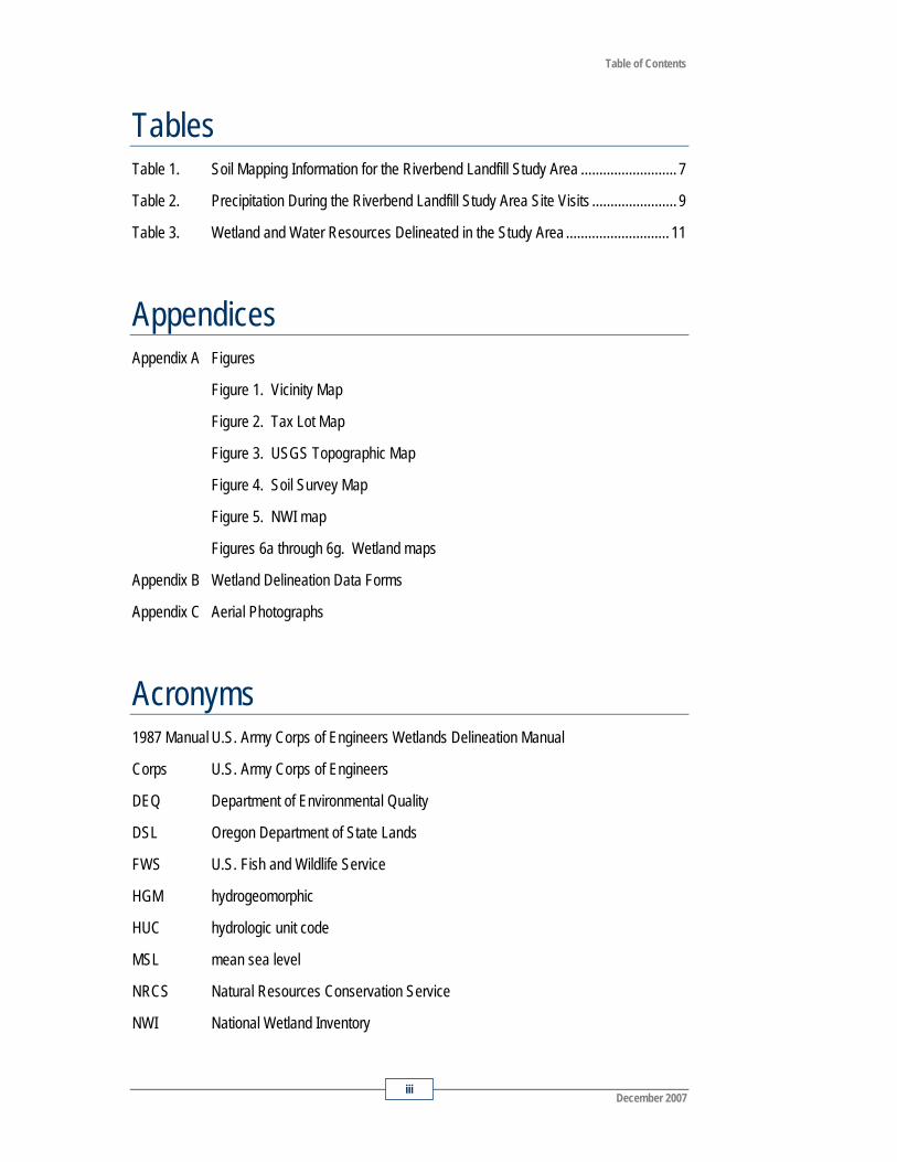
Table of Contents
December 2007 iii
Tables Table 1. Soil Mapping Information for the Riverbend Landfill Study Area .......................... 7
Table 2. Precipitation During the Riverbend Landfill Study Area Site Visits ....................... 9
Table 3. Wetland and Water Resources Delineated in the Study Area ............................ 11
Appendices Appendix A Figures
Figure 1. Vicinity Map
Figure 2. Tax Lot Map
Figure 3. USGS Topographic Map
Figure 4. Soil Survey Map
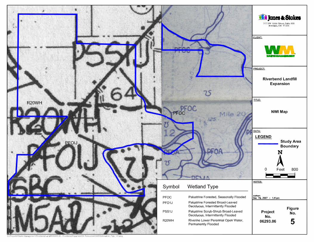
Figure 5. NWI map
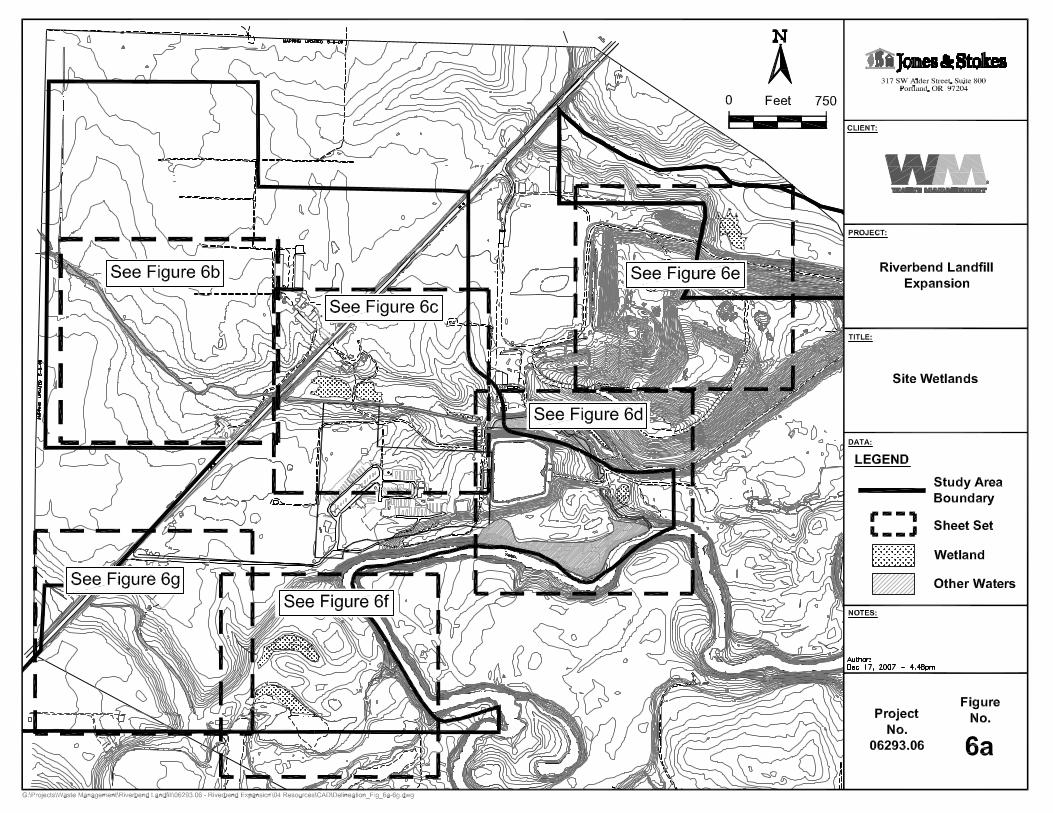
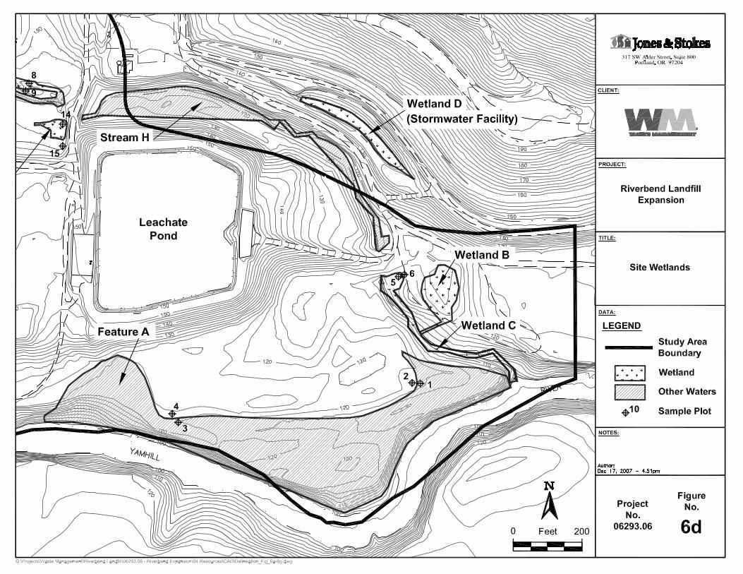
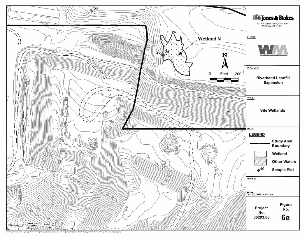
Figures 6a through 6g. Wetland maps
Appendix B Wetland Delineation Data Forms
Appendix C Aerial Photographs
Acronyms 1987 Manual U.S. Army Corps of Engineers Wetlands Delineation Manual
Corps U.S. Army Corps of Engineers
DEQ Department of Environmental Quality
DSL Oregon Department of State Lands
FWS U.S. Fish and Wildlife Service
HGM hydrogeomorphic
HUC hydrologic unit code
MSL mean sea level
NRCS Natural Resources Conservation Service
NWI National Wetland Inventory

Wetland Delineation Report
Riverbend Landfill Expansion iv
OAR Oregon Administrative Rule
OHW ordinary high water
OR 18 Oregon State Route 18
PEM5 palustrine, emergent, permanently flooded
PEMA palustrine, emergent, temporarily flooded
PEMD palustrine, emergent, seasonally flooded, well-drained
PEMF palustrine, emergent, seasonally flooded/saturated
PFO palustrine, forested
PSS palustrine, scrub-shrub
PSS1 palustrine, scrub-shrub, broad-leaved deciduous
PUB palustrine, unconsolidated bottom
PWS Public Works/Safety
R2SB3 riverine, lower perennial, cobble gravel
R2UBH riverine, lower perennial, unconsolidated bottom, permanently flooded
R2US5D riverine, lower perennial, unconsolidated shore, vegetated, seasonally flooded/well drained
R3UBH riverine, upper perennial, unconsolidated bottom, seasonally flooded
RC Recreation Commercial
RFT riverine, flowthrough
RI riverine
USGS U.S. Geological Survey

December 2007 1
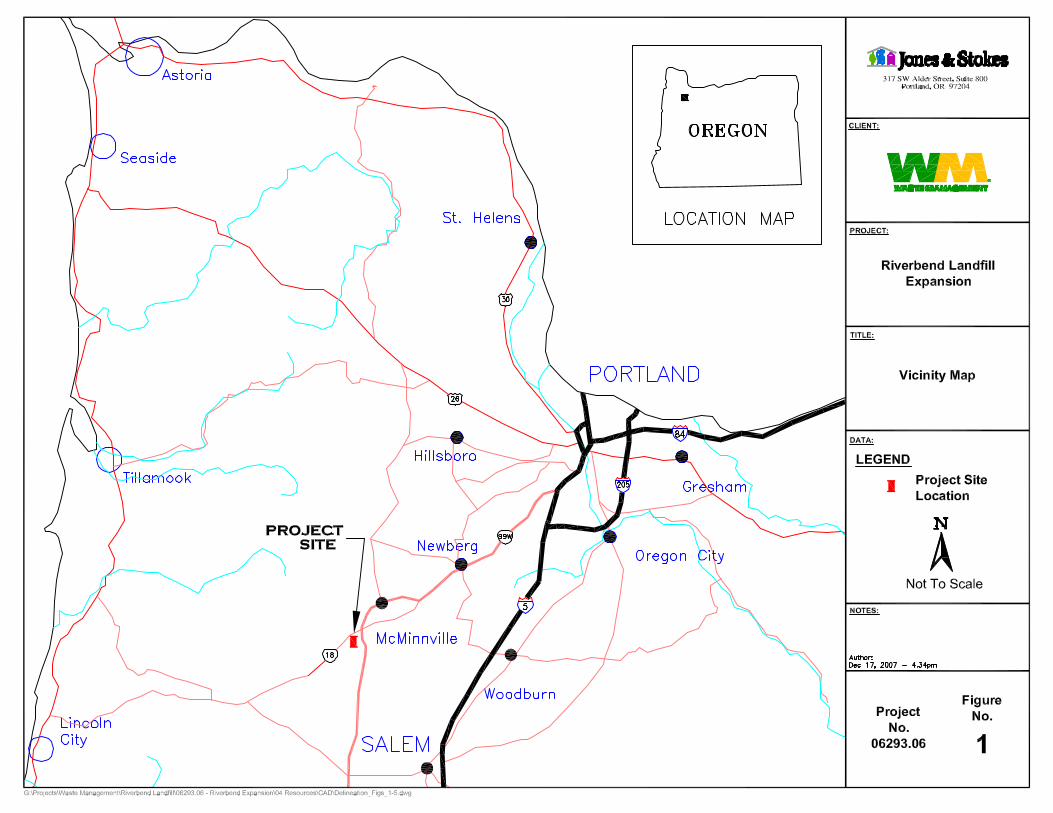
Chapter 1. Introduction Jones & Stokes was retained by Riverbend Landfill Company, Inc. to perform a routine-level wetland delineation for a proposed expansion of the Riverbend Landfill in Yamhill County, Oregon (Appendix A, Figure 1). The purpose of the study was to delineate wetlands and other waters of the State of Oregon/United States within the study area being considered for the landfill expansion. This expansion may require a zoning change to the tax lots that are currently zoned as Recreation Commercial (RC) and Public Works/Safety (PWS).
The approximately 187.45-acre study area includes Riverbend Landfill and the agricultural land on adjacent lots to the northwest of Oregon State Route 18 (OR 18). Jones & Stokes conducted wetland delineation field work on April 11, 13, 18, and 19, 2006; and on March 28, July 6, August 30, and November 5, 2007. Approximately 14.08 acres of wetlands and other waters were identified, including perennial streams (tributaries to the South Yamhill River), herbaceous, scrub-shrub and forested riparian wetlands, and active floodplain.
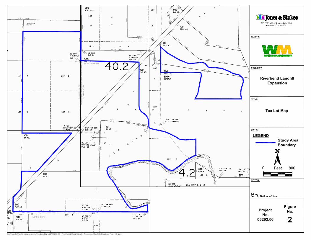
1.1. Study Area The study area is located west and southwest of the existing landfill in Township 5 South, Range 5 West, Sections 1, 2, 11 and 12 (Appendix A, Figure 2), approximately 4 miles southwest of the City of McMinnville, Yamhill County, Oregon. As shown in Figure 2, the study area includes the following tax lots:
Tax Map 5 5 01: 100, 101, 400, 401, 500, and a portion of 200
Tax Map 5 5 02: 400, and a portion of 500
Tax Map 5 5 11: 500, 600, and a portion of 100
Wetland Delineation Report
Riverbend Landfill Expansion 2
The study area lies on both the northwest and southeast sides of OR 18, and is bordered by the South Yamhill River to the south, agricultural land to the west and north, and by the outer boundary of Riverbend Landfill to the east. The study area is located in the South Yamhill River watershed.
The South Yamhill River flows along the southern study area boundary in an easterly direction toward its confluence with the Yamhill River approximately 10 miles to the east. An unnamed perennial stream enters the study area in the northwestern corner and flows in an easterly/southeasterly direction to its confluence with the South Yamhill River in the southeastern corner of the study area.
In the agricultural grassland areas north of OR 18, upland areas are planted in perennial ryegrass (Lolium perenne; FACU) and tall fescue (Festuca arundinacea; FAC-). On the landfill property, tall fescue, common vetch (Vicia sativa; UPL), Canada thistle (Cirsium arvense; FACU), bull thistle (C. vulgare; FACU) and red clover (Trifolium pratense; FACU) dominate the herbaceous layer. Teasel (Dipsacus fullonum; NI), Queen Anne’s lace (Daucus carota; NOL), centaury (Centaurium erythraea; FAC-), English plantain (Plantago lanceolata; FACU+), broadleaf plantain (P. major; FACU+), and dandelion (Taraxacum officinale; FACU) are common throughout the upland areas. Upland areas adjacent to the unnamed tributary to the South Yamhill River are dominated by Himalayan blackberry (Rubus armeniacus; FACU) along the entire study area reach.
1.2. Landscape Setting The study area is located n the Prairie Terraces subregion of the Willamette Valley ecoregion, sitting atop a broad, flat terrace below the western foothills of the Tualatin Mountains (West Hills). It is located in the South Yamhill River watershed (hydrologic unit code [HUC] 1709000804), in the Yamhill subbasin (Willamette Basin).
The study area topography generally slopes gently to the southeast and includes some artificially constructed hills associated with the landfill (e.g., the hill on which the leachate pond is sited). Elevations in the study area vary from 160 feet above mean sea level (MSL) in the northwestern portion to 140 feet MSL at the top-of-bank of the river in the southeastern portion.
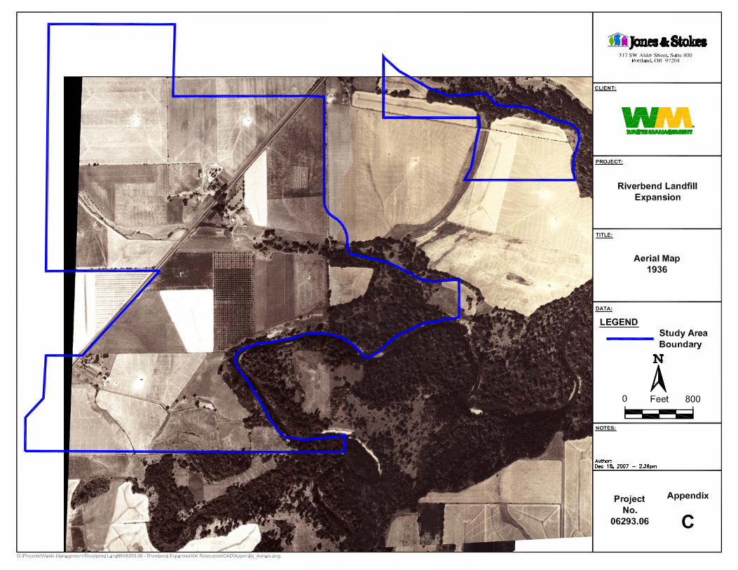
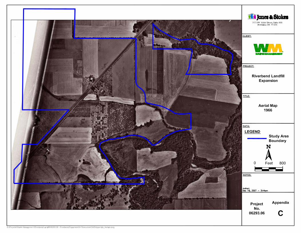
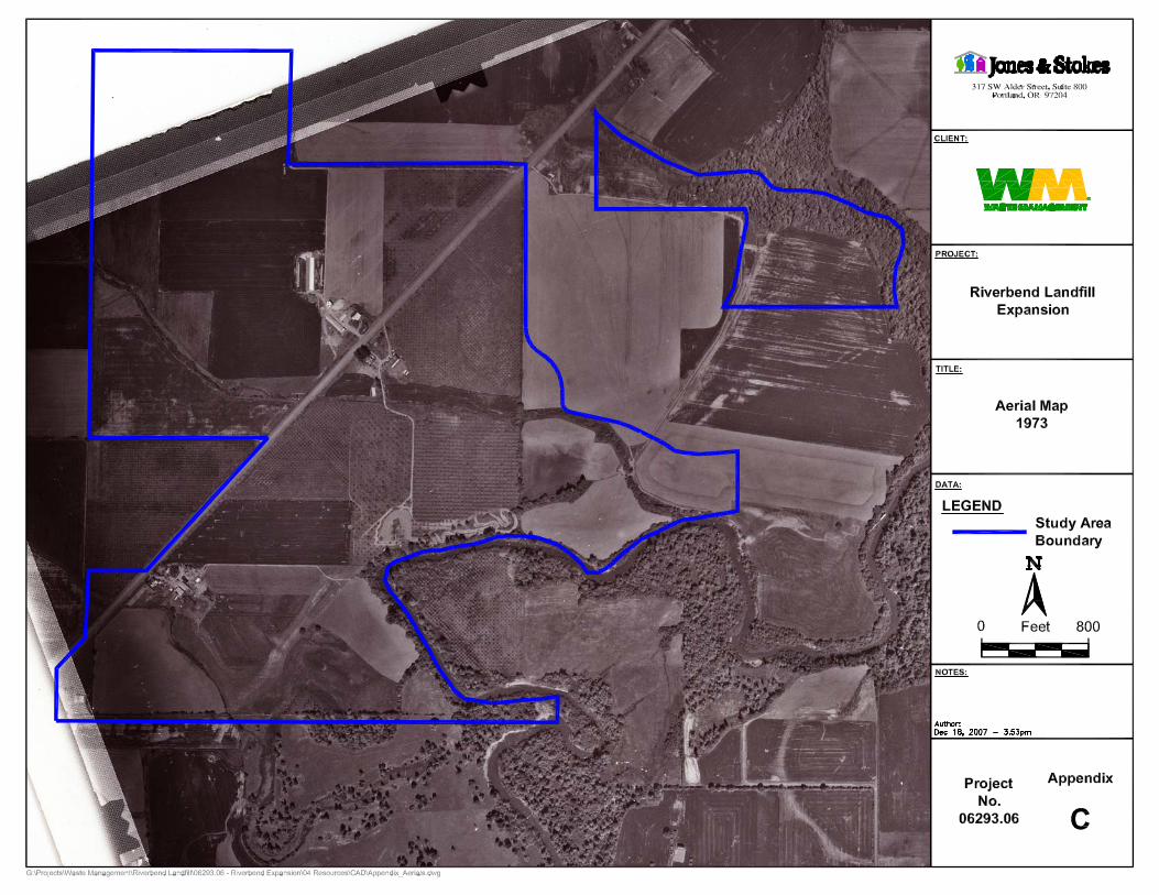
1.3. Previous and Current Land Uses Historic aerial photographs (Section 3.3.4) show that the study area was forested until sometime between the 1930s and 1960s, when it was converted to agricultural uses. Northwest of OR 18, land use is still agricultural. This portion of the site is actively maintained as orchard and hay row crops.

Introduction
December 2007 3
On the southeastern side of OR 18, land use is primarily associated with the landfill. This includes a leachate pond in the southeast, an office building and weigh station adjacent to OR 18, and rows of poplar trees that are irrigated with leachate during the summer (as permitted by Oregon Department of Environmental Quality [DEQ] Solid Waste Permit #345) in the south-central portion of the study area. A mobile home court to the west of the leachate pond will be vacated and removed when its lease with Riverbend Landfill Company, Inc. expires in 3 years.

December 2007 5
Chapter 2. Methodology The wetland delineation was conducted in accordance with the 1987 U.S. Army Corps of Engineers Wetlands Delineation Manual (1987 Manual) (Environmental Laboratory 1987) and supporting technical and guidance documents issued by the U.S. Army Corps of Engineers (Corps) and the Oregon Department of State Lands (DSL). The plant species wetland indicators status and scientific names are from the Combined 1988 National List and 1993 Supplement List of Plant Species That Occur in Wetlands (Region 9) (Reed 1988). Wetland delineation data sheets are in Appendix B.
2.1. Site-Specific Methodology
2.1.1. Wetlands Jones & Stokes delineated the study area using the routine determination methodology outlined in the 1987 Manual (Environmental Laboratory 1987). Fieldwork was performed on April 11, 13, 18, and 19, 2006; and on March 28, July 6, August 30, and November 5, 2007, at which time the boundaries of all wetlands and other waters in the study area were identified and flagged. Data plots were established and standard wetland delineation data forms were used to record vegetation, soils, and hydrology observations from each plot (Appendix B). All identified wetlands were classified according to the U.S. Fish and Wildlife Service (FWS) Classification of Wetlands and Deepwater Habitats of the United States (Cowardin et al. 1979) and the Oregon hydrogeomorphic (HGM) classification system (Adamus et al. 2001).
Wetland boundaries were generally determined by the plant community transition from upland grass/weedy forb communities to hydrophytic species; examination of

Wetland Delineation Report
Riverbend Landfill Expansion 6
soils and hydrology generally confirmed reasonable expectations based on vegetation. In several wetlands, soils and hydrology data were drastically different across the boundary, even when paired data plots were only a few feet apart.
2.1.2. Other Waters of the State In the streams, OHW was generally determined to be the extent of jurisdictional waters. However, in several areas active floodplains exhibited drift lines and depositions of debris several feet above top-of-bank; in this case the jurisdictional boundary was determined to be along the drift line (if other criteria were also met).
Mapping Methods and Accuracy
The boundary flags of all wetlands and other waters of the State/United States and the wetland data plots were professionally land surveyed by Matt Dunkel and Associates to an approximate accuracy of 0.01 foot and digitally mapped using AutoCAD®.
2.2. Off-Site Methodology Prior to fieldwork, potential wetlands in the study area were identified using U.S. Geological Survey (USGS) Topographic Maps (U.S. Geological Survey 1987) (Appendix A, Figure 3), the United States Department of Agriculture Natural Resources Conservation Service (formerly Soil Conservation Service) Soil Survey of Yamhill County Area, Oregon (Soil Conservation Service 1974) (Appendix A, Figure 4) and USFWS National Wetland Inventory (NWI) Maps (U.S. Fish and Wildlife Service 1976 and 1992) (Appendix A, Figure 5). Aerial photographs obtained from the USGS and Riverbend Landfill Company, Inc. were also examined for historic land usage and the presence of potential wetlands and other waters (Appendix C). In order to provide additional information on the hydrologic conditions at the time of the site visit, precipitation data for the day of, day before, and two weeks prior to each field visit were acquired from the National Weather Service website (2006 and 2007).
2.2.1. USGS Topographic Maps The topographic maps (U.S. Geological Survey 1987) show Streams H, I and M in the same locations as noted during field investigations (Appendix A, Figure 3). The map also shows Wetlands J and K, although it shows them as being an oxbow of open water connected by a channel. Due to historic agricultural activities, this hydrology has been altered and now Wetlands J and K more closely resemble ponds.
Methodology
December 2007 7
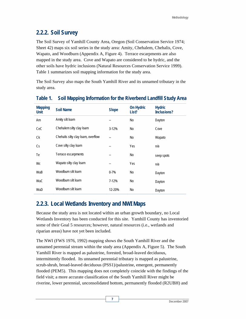
2.2.2. Soil Survey The Soil Survey of Yamhill County Area, Oregon (Soil Conservation Service 1974; Sheet 42) maps six soil series in the study area: Amity, Chehalem, Chehalis, Cove, Wapato, and Woodburn (Appendix A, Figure 4). Terrace escarpments are also mapped in the study area. Cove and Wapato are considered to be hydric, and the other soils have hydric inclusions (Natural Resources Conservation Service 1999). Table 1 summarizes soil mapping information for the study area.
The Soil Survey also maps the South Yamhill River and its unnamed tributary in the study area.
Table 1. Soil Mapping Information for the Riverbend Landfill Study Area Mapping Unit Soil Name Slope On Hydric
List? Hydric Inclusions?
Am Amity silt loam -- No Dayton
CeC Chehalem silty clay loam 3-12% No Cove
Ck Chehalis silty clay loam, overflow -- No Wapato
Cs Cove silty clay loam -- Yes n/a
Te Terrace escarpments -- No seep spots
Wc Wapato silty clay loam -- Yes n/a
WuB Woodburn silt loam 0-7% No Dayton
WuC Woodburn silt loam 7-12% No Dayton
WuD Woodburn silt loam 12-20% No Dayton
2.2.3. Local Wetlands Inventory and NWI Maps Because the study area is not located within an urban growth boundary, no Local Wetlands Inventory has been conducted for this site. Yamhill County has inventoried some of their Goal 5 resources; however, natural resources (i.e., wetlands and riparian areas) have not yet been included.
The NWI (FWS 1976, 1992) mapping shows the South Yamhill River and the unnamed perennial stream within the study area (Appendix A, Figure 5). The South Yamhill River is mapped as palustrine, forested, broad-leaved deciduous, intermittently flooded. Its unnamed perennial tributary is mapped as palustrine, scrub-shrub, broad-leaved deciduous (PSS1)/palustrine, emergent, permanently flooded (PEM5). This mapping does not completely coincide with the findings of the field visit; a more accurate classification of the South Yamhill River might be riverine, lower perennial, unconsolidated bottom, permanently flooded (R2UBH) and
Wetland Delineation Report
Riverbend Landfill Expansion 8
the unnamed tributary would be classified as riverine, upper perennial, unconsolidated bottom, seasonally flooded (R3UBC). The NWI does not map the active floodplain of the South Yamhill River, which could be classified as riverine, lower perennial, unconsolidated shore, vegetated, seasonally flooded/well drained (R2US5D).
The NWI does not map any of the on-site wetlands, only streams. This is inconsistent with the results of the field investigations.
2.2.4. Aerial Photographs Historic aerial photographs of the entire study area are not available; photographs of the southern and western parts of the study area are not available. However, the aerial photographs from 1936, 1966, and 1973 (Appendix C) do reveal that the South Yamhill River and its unnamed perennial tributary have remained in much the same position over the last 70 years. The 1936 historic photograph shows that the area was largely forested, but the 1966 photograph shows that the study area had been in agricultural use at some time in the prior 30 years. Row crops of poplar trees that were observed during the site visit were present in the 1973 and 1966 aerial photographs, but not in the 1936 photograph. The 1973 photograph shows that the landfill had not yet been constructed, and the site was still in agricultural use.
2.2.5. Fish Presence or Absence StreamNet (2007) lists Stream H (Stream # 1232487451575) as rearing and migration habitat for steelhead and Chinook salmon from river mile 0.00 to river mile 0.61. This stretch is entirely located within the study area, southeast of OR 18. However, Stream H is not mapped as essential salmonid habitat (Oregon Department of State Lands 2001). No other waters in the study area are mapped as fish habitat.
2.3. Precipitation Precipitation data for the day of, day before, and the two weeks prior to the wetland delineation site visits are shown in Table 2. These data were obtained from the National Weather Service, McMinnville Weather Station (#355384). At the time of the April 19, 2006 field investigation, precipitation was at 85.6% of normal levels for the water year (30.73 inches observed; 35.91 inches normal from October 1 to April 19). At the time of the March 28, 2007 field investigation, precipitation was at 94.3% of normal levels for the water year (31.20 inches observed; 33.09 inches normal). At the time of the July 6, 2007 field investigation, precipitation was at 97.1% of normal levels for the water year (38.60 inches observed; 39.77 inches normal). At the time of the August 30, 2007 field investigation, precipitation was at 90.2% of normal levels for the water year (35.62 inches observed; 40.26 inches normal). At the time of the November 5, 2007 field investigation, precipitation was

Methodology
December 2007 9
at 102.8% of normal levels for the water year (4.10 inches observed; 3.99 inches normal).
The growing season at this location begins March 22 (Valley Floor, Yamhill County, OR - 5 in 10 years first date above 28o F) (Soil Conservation Service 1974).
Table 2. Precipitation During the Riverbend Landfill Study Area Site Visits
Date of Site Visit
Actual Precipitation on Day of Visit (inches)*
Actual Precipitation One Day Prior to Visit (inches)*
Actual Precipitation Two Weeks Prior to Visit (inches)*
4/11/2006 0.03 0.04 1.24
4/13/2006 0.22 0.00 1.49
4/18/2006 0.00 0.02 0.90
4/19/2006 0.00 0.00 0.90
3/28/2007 0.00 0.04 0.92
7/6/2007 0.00 0.00 0.28
8/30/2007 0.00 0.04 0.73
11/5/2007 0.00 0.00 0.01
Source: National Weather Service 2006, 2007 (McMinnville Station #355384: Latitude N 45° 11’, Longitude W 123° 8’).


December 2007 11
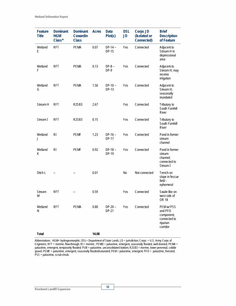
Chapter 3. Wetlands Nine potentially jurisdictional wetlands and five potentially jurisdictional waters of Oregon State/United States were identified in the study area (Appendix A, Figures 6a through 6g). An ephemeral ditch was also identified in the study area, but may not be considered jurisdictional as it is not connected to any other features, does not meet wetland criteria, and appears to only convey water during high precipitation events. The typical vegetation, soils, and hydrology found in these wetland areas are discussed in the following sections and summarized in Table 3 and on the attached wetland delineation data forms (Appendix B).
Table 3. Wetland and Water Resources Delineated in the Study Area Feature Title
Dominant HGM Class*
Dominant Cowardin Class
Acres Data Plot(s)
DSL JD
Corps JD (Isolated or Connected)
Brief Description of Feature
Feature A
RFT PEMD 5.22 DP-1 –DP-4
Yes Connected “Other waters”; active floodplain of South Yamhill River
Wetland B
RFT PEMA 0.30 Yes Connected Prior delineation (DSL#05-0002)
Wetland C
RFT PEMA 0.25 DP-5 –DP-6
Yes Connected Depressional wetland adjacent/connected to river
Wetland D
Depress-ional
PUB 0.24 No Isolated Stormwater pond, excavated from mapped upland soils
Wetland Delineation Report
Riverbend Landfill Expansion 12
Feature Title
Dominant HGM Class*
Dominant Cowardin Class
Acres Data Plot(s)
DSL JD
Corps JD (Isolated or Connected)
Brief Description of Feature
Wetland E
RFT PEMA 0.07 DP-14 – DP-15
Yes Connected Adjacent to Stream H in depressional area
Wetland F
RFT PEMA 0.13 DP-8 – DP-9
Yes Connected Adjacent to Stream H; may receive irrigation
Wetland G
RFT PEMA 1.50 DP-10 – DP-13
Yes Connected Adjacent to Stream H; seasonally inundated
Stream H RFT R2SB3 2.67 Yes Connected Tributary to South Yamhill River
Stream I RFT R2SB3 0.15 Yes Connected Tributary to South Yamhill River
Wetland J
RI PEMF 1.23 DP-16 –DP-17
Yes Connected Pond in former stream channel
Wetland K
RI PEMF 0.92 DP-18 – DP-19
Yes Connected Pond in former stream channel; connected to Stream I
Ditch L -- -- 0.01 No Not connected Trench on slope in fescue field - ephemeral
Stream M
RFT -- 0.59 Yes Connected Swale-like on west side of OR 18
Wetland N
RFT PEMA 0.80 DP-20 –DP-21
Yes Connected PEM w/ PSS and PFO component; connected to riparian corridor
Total 14.08
Abbreviations: HGM= hydrogeomorphic; DSL= Department of State Lands; JD = jurisdiction; Corps: = U.S. Army Corps of Engineers; RFT = riverine, flow-through; RI = riverine ; PEMD = palustrine, emergent, seasonally flooded, well-drained; PEMA = palustrine, emergent, temporarily flooded; PUB = palustrine, unconsolidated bottom; R2SB3 = riverine, lower perennial, cobble gravel; PEMF = palustrine ,emergent, seasonally flooded/saturated; PEM = palustrine, emergent: PFO = palustrine, forested; PSS = palustrine, scrub-shrub.
Wetlands
December 2007 13
3.1. Delineated Wetlands Nine wetlands were identified in the study area (Appendix A, Figures 6a through 6g). Five of the on-site wetlands (Wetlands B, C, E, F and G) are associated with Stream H (perennial tributary to South Yamhill River), and two (Wetlands J and K) are associated with Stream I. Wetland N is associated with an unnamed tributary to the South Yamhill River (this tributary was included in the study area). Wetland D is a cattail-dominated stormwater detention pond and does not appear to be connected to any other wetlands or waters in the study area. Wetlands with similar characteristics are described together.
3.1.1. Wetlands B and C – Herbaceous Wetlands (Creek Overflow)
Wetlands B and C are herbaceous wetlands located along the eastern boundary of the study area (Appendix A, Figure 6d). These depressional areas are contiguous with Stream H. Wetland B had been previously delineated by Jones & Stokes in 2003 as part of a larger delineation for Riverbend Landfill Company, Inc.’s proposed mitigation bank. That delineation has received concurrence from DSL (05-0002). The boundary of Wetland C is documented in sample plots DP-5 and DP-6.
Vegetation – Dense herbaceous vegetation is dominated by reed canarygrass, with sparse Oregon ash (Fraxinus latifolia, FACW) seedlings. As a result, vegetation in these areas meets the hydrophytic vegetation requirement of the 1987 Manual (Environmental Laboratory 1987).
Soils – Soil samples collected had matrix chromas of 10YR 3/2 (very dark grayish brown) with mottles of 10YR 4/6 (dark yellowish brown) and 2.5YR 4/6 (red). Samples were typically silty clay loam. Overall, the soils in the drainages satisfy the hydric soil requirements of the 1987 Manual (Environmental Laboratory 1987).
Hydrology – Wetland hydrology was confirmed by local soil survey mapping, the FAC-neutral test, and landscape position (e.g., the site is a topographically low spot immediately adjacent to a stream). Hydrology most likely is seasonally flooded and recharged by overflow and subsurface flow from the adjacent Stream H. These conditions are indicative of wetland hydrology and meet the hydrology criteria set forth in the 1987 Manual (Environmental Laboratory 1987).
Boundary Determination – The boundaries of Wetlands B and C were determined by topography, presence of hydrophytic vegetation, and redoximorphic features in the soils. Adjacent upland plots had similar vegetation but lacked soil mottles.

Wetland Delineation Report
Riverbend Landfill Expansion 14
3.1.2. Wetland D – Stormwater Detention Pond Wetland D is a constructed stormwater detention pond located northwest of the leachate pond, below a gravel road at the base of the landfill (Appendix A, Figure 6d). It has been excavated from upland (Woodburn series) soils and is not likely to be considered jurisdictional unless it is hydrologically connected to Stream H. During the site visit, evidence of hydrologic connection to the stream was not located. Hydrology may be supported by upslope leachate drainage channels.
No data were taken at this pond due to its artificial nature. However, it has been included in this discussion because it appears on aerial photographs. The boundary was determined and flagged according to level of inundation and obvious topographic characteristics (e.g., swale-like in the southeastern portion). Vegetation was dominated by common cattail (Typha latifolia; OBL) and willow (Salix sp.), with meadow foxtail (Alopecurus pratensis, FACW) dominating the perimeter in the southeast and Himalayan blackberry and Canadian thistle dominating the slopes surrounding the pond on all other sides.
3.1.3. Wetlands E, F, and G – Herbaceous Wetlands Wetlands E, F and G are herbaceous wetlands that are located along Stream H in the central portion of the study area, west of the leachate pond and east of OR 18 (Appendix A, Figure 6c). These wetlands greatly resemble Wetlands B and C, but do not appear to receive their sole hydrologic inputs from Stream H. They are slightly less depressional than Wetlands B and C, and have a very slightly different vegetative composition. Also, these wetlands were inundated at the time of the site visit. Wetlands E, F, and G are documented in sample plots DP-14 and DP-15, DP-8 and 9, and DP-10 through DP-13, respectively.
Vegetation – The herbaceous layer is dominated by meadow foxtail, tall fescue, teasel, and reed canarygrass. In Wetland G, soft rush (Juncus effusus, FACW) was also common. Vegetation in these areas met the hydrophytic vegetation requirement of the 1987 Manual (Environmental Laboratory 1987).
Soils – Soil plots typically had matrix chromas of 10YR 3/3 (dark brown; in the top 8 inches) and 10YR 3/1 (very dark gray) silt loams and silty clay loams with common-to-many mottles of 10YR 3/4 (dark yellowish brown) and 7.5YR 3/4 (dark brown). Overall, the soils within these wetlands satisfy the hydric soil requirements of the 1987 Manual (Environmental Laboratory 1987).
Hydrology – Wetland hydrology was confirmed by the presence of inundation, saturation in the upper 12 inches of the soil profile and free water within 12 inches. Hydrology in this large area is most likely seasonally flooded, recharged by overflow and subsurface flow from the South Yamhill River. These conditions are indicative
Wetlands
December 2007 15
of wetland hydrology and meet the hydrology criteria set forth in the 1987 Manual (Environmental Laboratory 1987).
Boundary Determination – The boundaries of Wetlands E, F, and G were determined by topography, presence of hydrophytic vegetation, and hydric soils. Primary indicators of wetland hydrology such as saturation within top 12 inches of soil profile, high water table, and inundation were also readily observed.
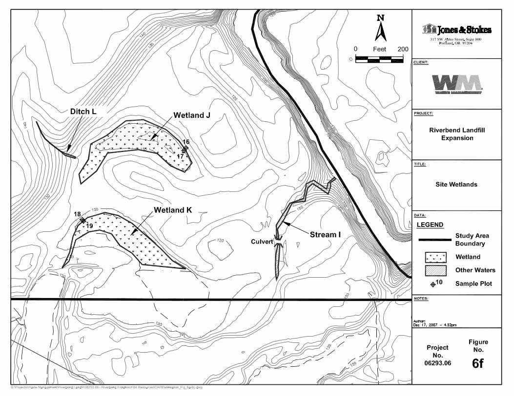
3.1.4. Wetlands J and K – Seasonally Ponded Wetlands J and K were documented during the March 28, 2007 field visit. Wetlands J and K are depressional, herbaceous wetlands located along Stream I in the western portion of the study area, west of the South Yamhill River (Appendix A, Figure 6f). Based on aerial photographs and direct observations, these wetlands appear to be seasonally ponded. They are located in topographically low areas of a managed fescue field, and had been previously flagged (presumably by the farmer) as a “no work” zone (likely due to ponding and/or deep mud). Wetland J was not inundated at the time of the field visit but was unvegetated and muddy. Wetland K contained shallow inundation in the lowest portion and appears to have a seasonal surface water connection with Stream I. Based on the soil survey (Soil Conservation Service 1974) and topographic maps (United States Geologic Survey 1987) Wetland K appears to have historically been part of the oxbow of which Stream I is a remnant. Wetlands J and K are documented in sample plots DP-17 and DP-19, respectively.
Vegetation – Wetlands J and K were mostly unvegetated during the field visit, especially along the wetland boundaries. Best professional judgment was used to make a wetland determination in the absence of vegetation. Queen Anne’s lace (Daucus carota) sprouts were noted in Wetland K but constituted only 10% of the plot’s vegetation; therefore, it was not considered dominant. Wetland K was vegetated in lower portions close to the study area boundary with needle spikerush (Eleocharis acicularis, OBL) and slender rush (Juncus tenuis, FACW-), and evidence of the previous growing season’s curly dock (Rumex crispus, FAC+) and prostrate knotweed (Polygonum aviculare, FACW-) was also apparent. Vegetation in these areas met the hydrophytic vegetation requirement of the 1987 Manual (Environmental Laboratory 1987).
Soils – Soils were markedly reduced immediately below the surface. Footprints in the mud revealed very dark gray colors (10YR 3/1), whereas the surface appeared dark brown (10YR 3/3). Soil plots typically corroborated these preliminary observations, with matrix chromas of 10YR 3/3 (in the top 8 inches) and 10YR 3/1 silt loams and silty clay loams with common-to-many mottles of 10YR 3/4 (dark yellowish brown) and 7.5YR 3/4 (dark brown). Overall, the soils in these wetlands satisfy the hydric soil requirements of the 1987 Manual (Environmental Laboratory 1987).
Wetland Delineation Report
Riverbend Landfill Expansion 16
Hydrology – Wetland hydrology was confirmed by the presence of inundation, saturation in the upper 12 inches of the soil profile, and free water within 12 inches. Hydrology in this large area is most likely seasonally flooded, recharged by overflow and subsurface flow from the South Yamhill River. Saturation is also apparent in aerial photographs. These conditions are indicative of wetland hydrology and meet the hydrology criteria set forth in the 1987 Manual (Environmental Laboratory 1987).
Boundary Determination – The boundaries of Wetlands J and K were determined by topography and an abrupt change in vegetation from managed fescue to bare mud. Primary indicators of wetland hydrology such as saturation within the top 12 inches of soil profile, high water table, and inundation were also observed.
3.1.5. Wetland N – Emergent with PSS and PFO Components Wetland N is located in the northeastern corner of the study area (Appendix A, Figure 6e). It has emergent, palustrine scrub-shrub (PSS) and palustrine forested (PFO) components, with woody vegetation generally increasing toward the riparian corridor of an unnamed tributary to the South Yamhill River. The boundary of Wetland N is documented in sample plots DP-20 and DP-21.
Vegetation – Herbaceous vegetation is dominated by reed canarygrass and soft rush, with thickets of Nootka rose (Rosa nootkana, FAC) and spirea (Spiraea douglasii, FACW) increasing toward the Oregon ash-dominated forested portion of the wetland. Adjacent riparian areas are dominated by Oregon ash and redosier dogwood (Cornus sericea). As a result, vegetation in these areas meets the hydrophytic vegetation requirement of the 1987 Manual (Environmental Laboratory 1987).
Soils – Soil samples collected had matrix chromas of 10YR 3/2 (very dark grayish brown) with and 10YR 3/1 (very dark gray). Samples were typically silt loam. Overall, the soils in the drainages satisfy the hydric soil requirements of the 1987 Manual (Environmental Laboratory 1987) by exhibiting low matrix chromas.
Hydrology – Wetland hydrology was confirmed by local soil survey mapping, the FAC-neutral test, and the presence of oxidized rhizospheres with living roots. Hydrology most likely is seasonally flooded and recharged by overflow and subsurface flow from the adjacent stream. These conditions are indicative of wetland hydrology and meet the hydrology criteria set forth in the 1987 Manual (Environmental Laboratory 1987).
Boundary Determination – The boundary of Wetland N was determined by topography, the presence of hydrophytic vegetation, and redoximorphic features in the soils. Adjacent upland plots had a preponderance of upland vegetation dominated by Canada thistle.

Wetlands
December 2007 17
3.2. Other Waters of the State Five areas of other waters of the State/United States were identified in the study area. These are the active floodplain of the South Yamhill River (Feature A), three perennial tributaries to the South Yamhill River (Streams H, I, and Ditch M) and an ephemeral ditch (Ditch L).
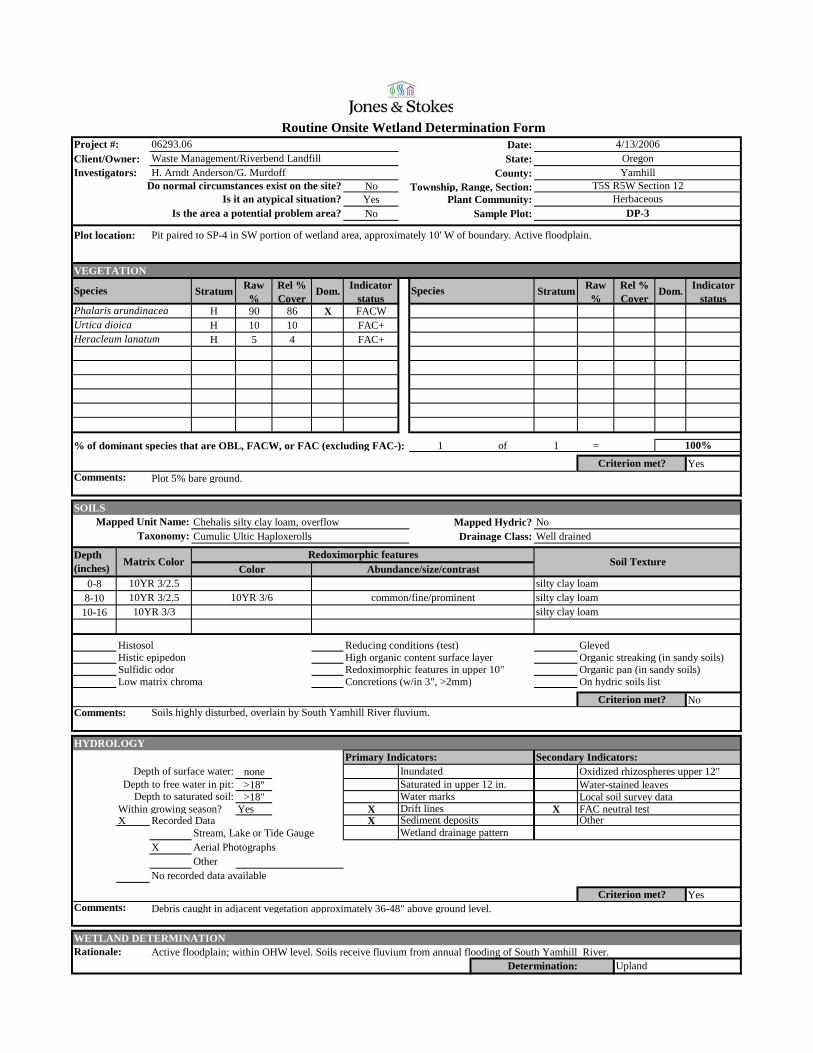
3.2.1. Feature A – South Yamhill River Active Floodplain In the southeastern portion of the study area, the active floodplain (Appendix A, Figure 6d) on the top of the north bank of the South Yamhill River exhibited many wetland characteristics, including abundant evidence of primary hydrology and a vegetation community dominated by hydrophytic species. However, evidence of hydric soils was largely absent from this area. Therefore, the active floodplain does not meet the three required criteria of “wetland” and is mapped as “other waters.” Its Cowardin classification is riverine, lower perennial, unconsolidated shore, vegetated, seasonally flooded well drained (R2US5D), and its HGM classification is riverine, flowthrough (RFT). Sample plots SP-1 through SP-6 document conditions in the active floodplain.
Vegetation – Throughout the floodplain, vegetation is dominated by reed canarygrass (Phalaris arundinacea; FACW), with meadow foxtail (Alopecurus pratensis; FACW) becoming more common in the eastern portion of the floodplain. Oregon ash and Douglas’ hawthorn (Crataegus douglasii; FAC) saplings are common as the floodplain transitions to a teasel- and Himalayan blackberry-dominated upland area. Near the confluence of the South Yamhill River and its unnamed perennial tributary, stinging nettle (Urtica dioica; FAC+) is common in topographically low places. Cow parsnip (Heracleum lanatum; FAC) becomes more common as the floodplain curves to the west. Riparian vegetation on the top of the banks was dominated by various willow species (Salix spp.; FAC to FACW), redosier dogwood and Oregon ash.
Soils – Soils in the active floodplain are typically 10YR 3/2 to 10YR 3/3 (dark grayish brown to dark brown) and 10YR 4/3 (brown) silt loams and silty clay loams with or without redoximorphic features. Where present, mottles were 7.5YR 3/4, 4/4 (dark brown and brown) or 10YR 3/6 (dark yellowish brown) and common. Soils in this area were compared to those immediately adjacent to the wetted edge of the river and exhibited chromas very similar to streambed soils; however soils in the floodplain above the top-of-bank lacked the organic streaking observed in the slightly sandier soils of the river. Due to light soil matrix chromas, the fluvium deposited by annual flooding of the South Yamhill River does not meet the hydric soils criterion; however, due to the nature of active floodplains, this portion of the site may qualify as an “atypical situation” according to the definition presented in the 1987 Manual and the soil criterion may be construed as inconclusive.

Wetland Delineation Report
Riverbend Landfill Expansion 18
Hydrology – Primary indicators of hydrology such as drift lines and sediment deposits were abundant in the active floodplain. Debris carried by flood waters was observed as high as 15 feet up in the trees on the top of the banks, and large amounts of woody debris have been deposited throughout the riparian area along the river and its unnamed perennial tributary (Stream H). These indicators were observed to reach as far as the base of the leachate pond.
Boundary Determination – The boundaries of this feature were determined based on the limits of the primary hydrologic indicators of OHW, which mainly consisted of debris and sediment deposits on vegetation. The OHW line was much further away and higher upslope from the South Yamhill River than expected, but conversations with employees of the landfill revealed that floodwaters reach such high levels on an annual basis.
3.2.2. Stream H – Tributary to South Yamhill River Stream H is an unnamed perennial tributary to the South Yamhill River (Appendix A, Figures 6b and 6c). It enters the study area from the northwest (on the northwest side of Highway 18) and flows in a southeasterly direction to its confluence with the South Yamhill River in the southeastern portion of the study area. The limits of jurisdictional “other waters” was flagged according to the OHW, and the stream is hydrologically connected to adjacent wetlands.
Water depths in Stream H ranged from approximately 12 inches to 24 inches at the time of the site visits. Substrate was cobbles and gravels, with portions having silty or organic substrates. The stream flowed through a deeply incised, v-shaped channel, with steep banks along much of the on-site reaches.
Boundary Determination – Stream H was flagged according to the OHW. Indicators of OHW included scour, sediment deposits, and debris caught in riparian vegetation. In some reaches it was unsafe to access the stream due to very high and steep banks and 10 feet tall/50 feet thick patches of Himalayan blackberry and sweetbriar rose (Rosa eglanteria). In these areas, which were primarily restricted to the road north of the leachate pond, OHW was estimated based on obvious topography (Appendix A, Figure 6b).
3.2.3. Stream I – Tributary to South Yamhill River Stream I is an unnamed perennial tributary to the South Yamhill River (Appendix A, Figure 6f), and based on aerial photographs, appears to be a remnant oxbow of the river. It enters the study area in the south (in the southeastern corner of tax lot 5 5 11 600) and flows in a northeasterly direction to its confluence with the South Yamhill River in the southern portion of the study area. The limits of jurisdictional “other waters” were flagged according to the OHW, which was approximately 5 to 8 feet wide. Stream K appears to be seasonally connected via surface water to Wetland K.
Wetlands
December 2007 19
Water depths in Stream I ranged from approximately 3 inches to 10 inches at the time of the site visits. Substrate was primarily mud and silt. The stream flowed through a deeply incised, v-shaped channel, with steep banks along much of the on-site reaches.
Boundary Determination – Stream I was flagged according to evidence of the OHW mark. Indicators of OHW were scour and sediment deposits. Riparian vegetation was dominated by Himalayan blackberry, redosier dogwood, bigleaf maple (Acer macrophyllum), ninebark (Physocarpus capitatus), and snowberry (Symphoricarpos albus).
3.2.4. Ditch L – Ephemeral Hillside Trench Ditch L appears to be a hillside trench that likely conveys flow to Pond J during high precipitation events. No surface water was observed during field visits, but soil erosion and rilling were noted. Ditch L was unvegetated during field visits on March 28 and August 30, 2007.
Boundary Determination – Ditch L was flagged according to top-of-bank, although this feature will not likely be considered jurisdictional due its lack of wetland characteristics and hydrologic connection to other features.
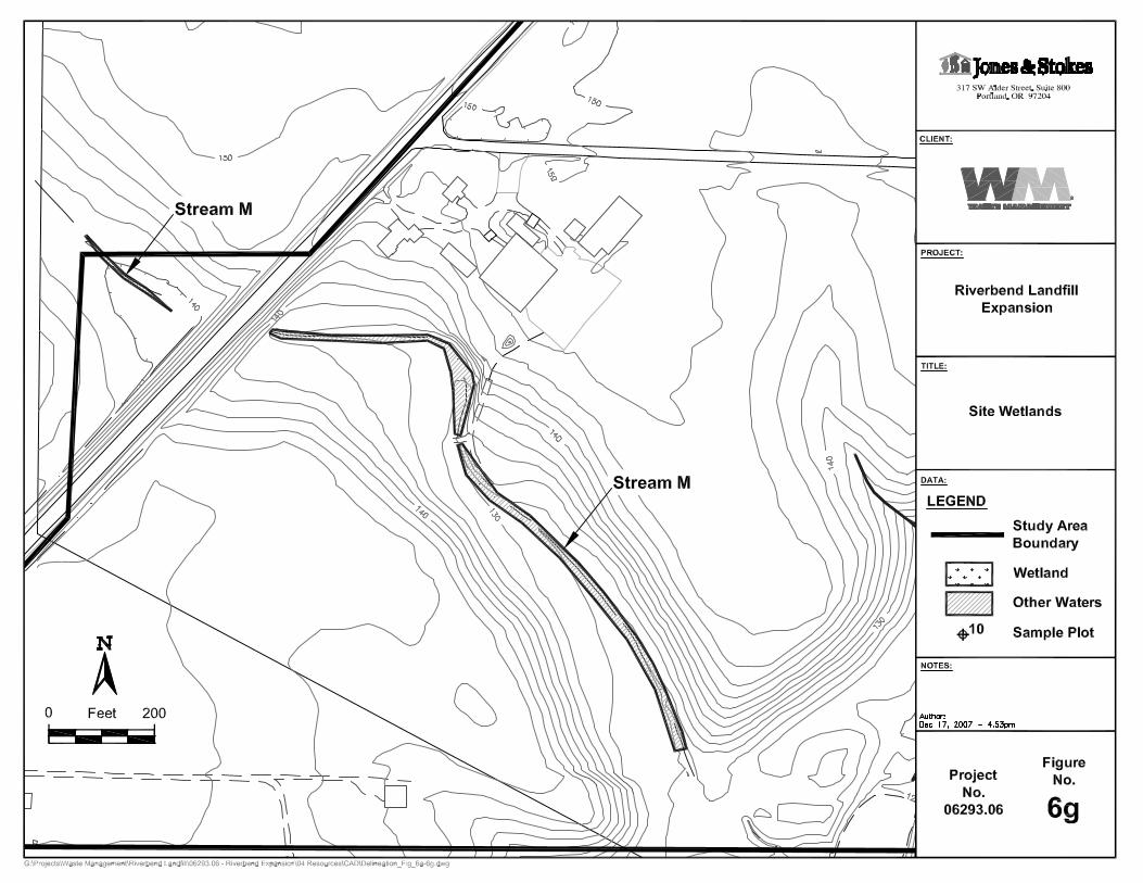
3.2.5. Stream M – Tributary to South Yamhill River Stream M is another unnamed perennial tributary to the South Yamhill River (Appendix A, Figure 6g). It enters the study area from the west (west of tax lot 5 5 11 100) and flows in a southeasterly direction through a culvert beneath OR 18. On the east side of the highway the stream is more swale-like, picking up flow and becoming more channelized as it moves east. On the east side of the highway Stream M is highly degraded due to grazing. It is likely that this feature was a natural stream at one time, but has been ditched since at least the 1930s.
Vegetation was dominated by common cattail, hardstem bulrush (Scirpus acutus), teasel, and reed canarygrass, making the feature easily noticed in a mowed field of orchard grass (Dactylis glomerata). Himalayan blackberry was dominant along the edges closer to the culvert. On the east side of OR 18, the stream is dominated by common cattail and barnyard grass (Echinochloa crus-galli, FACW) with some spirea along the edges.
Boundary Determination –Stream M was flagged according to the hydrophytic vegetation that grew only within the wetted edges of the swale. Bed and bank were not very discernable on either side of the highway, and this was a more reliable indicator of the boundaries of jurisdictional waters of the State/United States.

December 2007 21
Chapter 4. Results and Conclusions Jones & Stokes delineated nine wetlands and five other waters in the Riverbend Landfill study area between April 2006 and November 2007. Included in the approximately 14.08 acres of potentially jurisdictional wetlands and waters are 4.4 acres of emergent wetlands, 0.80 acre of emergent/scrub-shrub/forested wetland, and 0.24 acre of stormwater treatment pond. The remaining 8.64 acres of “other waters” consist of 5.22 acres of active floodplain and 3.42 acres of waters of the state/United States. The extent of each of these areas is shown on Figures 6a through 6g (Appendix A) and summarized in Table 3.
4.1. Required Disclaimer This report documents the investigation, best professional judgment, and conclusions of Jones & Stokes. It is correct and complete to the best of our knowledge. It should be considered a Preliminary Jurisdictional Determination of wetlands and other waters and used at your own risk, unless it has been reviewed and approved in writing by DSL in accordance with Oregon Administrative Rules (OAR) 141-090-0005 through 141-090-0055. If impacts on wetlands and other waters on this property are proposed, this report will also need to be reviewed and approved in writing by the Corps, Portland District, in conjunction with the submittal of a Joint Section 404/Removal-Fill Permit Application.

December 2007 23
Chapter 5. References Adamus, P.R. 2001. Guidebook for Hydrogeomorphic (HGM) – Based Assessment
of Oregon Wetland and Riparian Sites: Statewide Classification and Profiles. Oregon Division of State Lands, Salem, OR.
Cowardin, L.M., Carter, V., Golet, F.C., and E.T. LaRoe. 1979. Classification of Wetlands and Deepwater Habitats of the United States. Government Printing Office, Washington D.C.
Environmental Laboratory. 1987. U.S. Army Corps of Engineers Wetland Delineation Manual. Technical Report Y087-1, Environmental Laboratory, Department of the Army, Waterways Experiment Station, Vicksburg, Mississippi.
National Weather Service website. 2006 URL: <http://www.weather.gov/climate/index.php?wfo=pqr>. Accessed: April 19, 2006.
National Weather Service website. 2007 URL: <http://www.weather.gov/climate/index.php?wfo=pqr>. Accessed: November 6, 2007.
Natural Resources Conservation Service (NRCS). 1999. Hydric Soils List – Yamhill County, Oregon: Detailed Soil Map Legend. Natural Resources Conservation Service. U.S. Department of Agriculture. 33 pp.
Oregon Department of State Lands (DSL). 2001. Essential salmonid habitat. Yamhill County. URL: <http://www.oregon.gov/DSL/PERMITS/docs/maps/yamhill.pdf>. Accessed November 5, 2007.

Wetland Delineation Report
Riverbend Landfill Expansion 24
Reed, P.B., Jr. 1988. National List of Plant Species that Occur in Wetlands Northwest (Region 9). U.S. Fish and Wildlife Service Biological Report 88, and 1993 supplement.
Soil Conservation Service. 1974. Soil Survey of Yamhill Area. Soil Conservation Service. United States Department of Agriculture. 130pp + maps and tables.
StreamNet. 2007. Fish Distribution Data Query URL: <http://query.streamnet.org/Request.cfm?cmd=BuildQuery&NewQuery=BuildCriteria&Required=Run,State,County,Stream&State=4&County=136&ID=1231445452258&DataCategory=23&_Count=1>. Accessed November 5, 2007
StreamNet. 2007 Fish Distribution Map. UPL: <http://map.streamnet.org/website/fishdist/viewer.htm?Layers=0000000000000001&ActiveLayer=15&Query=LocationID%20%3D%20%271231445452258%27&QueryZoom=Yes>. Accessed November 5, 2007.
U.S. Fish and Wildlife Service (FWS) National Wetlands Inventory (NWI). 1992. McMinnville, OR. United States Fish and Wildlife Service. National Wetlands Inventory.
U.S. Fish and Wildlife Service (FWS) National Wetlands Inventory (NWI). 1976. Muddy Valley, OR. United States Fish and Wildlife Service. National Wetlands Inventory.
U.S. Geological Survey. 1987. Microsoft TerraServer. <http://terraserver-usa.com/ImageInfo.aspx?T=2&S=12&Z=10&X=599&Y=6250&W=3&qs=%7cmcminnville%7cor%7c>. Accessed December 1, 2007.

Appendix A Figures


Appendix B Wetland Delineation Forms


Date:Client/Owner: State:
County:NoYes Plant Community:No Sample Plot:
VEGETATION
Stratum Raw %
Rel % Cover
Dom. Indicator status
Stratum Raw %
Rel % Cover
Dom. Indicator status
H 25 28 X FACW H T FAC+H 20 22 X FACW S/S T FACH 20 22 X FACH 10 11 NOL
Cirsium arvense H 10 11 FACU+Allium vineale H 5 6 NIRubus discolor S/S 5 33 X FACUSalix lasiandra S/S 10 67 X FACW+
% of dominant species that are OBL, FACW, or FAC (excluding FAC-): 4 of 5 =
Yes
80%
Includes trace amounts of Rumex crispus and Crataegus douglasii.Criterion met?
Hypericum perforatum
Crataegus douglasiiAgrostis capillaris
Phalaris arundinacea Rumex crispusAlopecurus pratensis
Is it an atypical situation?Is the area a potential problem area?
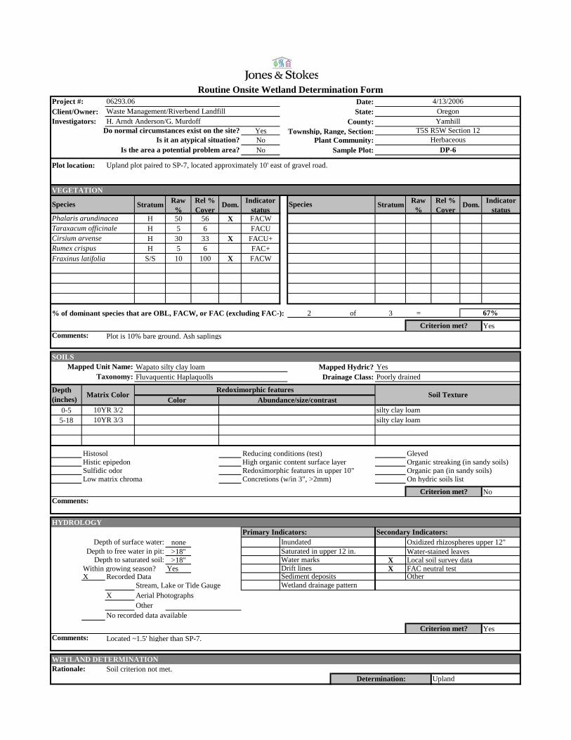
Plot location: Approximately 100' north of South Yamhill River on small hill; near dirt road at edge of floodplain.
Species Species
HerbaceousDP-1
Investigators: H. Arndt Anderson/G. MurdoffDo normal circumstances exist on the site?
YamhillT5S R5W Section 12Township, Range, Section:
Project #: 06293.06Waste Management/Riverbend Landfill
4/13/2006Oregon
Routine Onsite Wetland Determination Form
Comments:
SOILSChehalis silty clay loam, overflow Mapped Hydric? NoCumulic Ultic Haploxerolls Drainage Class: Well drained
0-17
Histosol Reducing conditions (test) GleyedHistic epipedon High organic content surface layer Organic streaking (in sandy soils)Sulfidic odor Redoximorphic features in upper 10" Organic pan (in sandy soils)Low matrix chroma Concretions (w/in 3", >2mm) On hydric soils list
No
HYDROLOGY
none>18" Water-stained leaves>18" Local soil survey data
Within growing season? Yes X FAC neutral testX Recorded Data
Stream, Lake or Tide GaugeX Aerial Photographs
OtherNo recorded data available
Yes
WETLAND DETERMINATIONSoil criterion not met. Active floodplain, but not wetland.
Depth to free water in pit:Depth to saturated soil:
Drift lines
Soils appear to be overlain by fluvium from South Yamhill River. Matrix color and soil texture similar to riverbank soils.
Primary Indicators: Secondary Indicators:Depth of surface water: Inundated Oxidized rhizospheres upper 12"
Taxonomy:Mapped Unit Name:
Redoximorphic features
10YR 4/3 silt loamAbundance/size/contrast
Comments:Criterion met?
Water marks
Depth (inches) Matrix Color
Saturated in upper 12 in.
ColorSoil Texture
UplandDetermination:
Criterion met?Comments:
Other Wetland drainage pattern
Drift lines in adjacent vegetation. Plot located ~10' higher than surrounding floodplain.
Rationale:
Sediment deposits

Date:Client/Owner: State:
County:NoYes Plant Community:No Sample Plot:
VEGETATION
Stratum Raw %
Rel % Cover
Dom. Indicator status
Stratum Raw %
Rel % Cover
Dom. Indicator status
H 20 17 X FACH 40 35 X NOLH 10 9 FACWH 10 9 FACW
Lotus corniculatus H 10 9 FACAllium vineale H 10 9 NIRumex crispus H 5 4 FAC+Cirsium arvense H 10 9 FACU+
H T OBL
% of dominant species that are OBL, FACW, or FAC (excluding FAC-): 1 of 2 =
No
Routine Onsite Wetland Determination Form
Comments:
Project #: 06293.06Waste Management/Riverbend Landfill
4/13/2006Oregon
HerbaceousDP-2
Investigators: H. Arndt Anderson/G. MurdoffDo normal circumstances exist on the site?
YamhillT5S R5W Section 12Township, Range, Section:
Agrostis capillarisDaucus carota
Is it an atypical situation?Is the area a potential problem area?
Plot location: Approximately 100' north of South Yamhill River on small hill; near dirt road at edge of floodplain.
Species Species
Alopecurus pratensisPhalaris arundinacea
Carex obnupta
Criterion met?Includes trace amounts of Carex obnupta.
50%
SOILSChehalis silty clay loam, overflow Mapped Hydric? NoCumulic Ultic Haploxerolls Drainage Class: Well drained
0-1515-17
Histosol Reducing conditions (test) GleyedHistic epipedon High organic content surface layer Organic streaking (in sandy soils)Sulfidic odor Redoximorphic features in upper 10" Organic pan (in sandy soils)Low matrix chroma Concretions (w/in 3", >2mm) On hydric soils list
No
HYDROLOGY
none>18" Water-stained leaves>18" Local soil survey data
Within growing season? Yes FAC neutral testX Recorded Data
Stream, Lake or Tide GaugeX Aerial Photographs
OtherNo recorded data available
No
WETLAND DETERMINATIONNone of the criteria met.
Sediment deposits
UplandDetermination:
Criterion met?Comments:
Other Wetland drainage pattern
Plot taken ~10' higher than surrounding floodplain.
Rationale:
Comments:Criterion met?
Water marks
Depth (inches) Matrix Color
Saturated in upper 12 in.
Abundance/size/contrast
Taxonomy:Mapped Unit Name:
Redoximorphic featuresColor
Soil Texture
10YR 3/2.5 silt loam10YR 3/3 silt loam
Soils overlain by fluvium from South Yamhill River. Matrix color and soil texture matches riverbank soils.
Primary Indicators: Secondary Indicators:Depth of surface water: Inundated Oxidized rhizospheres upper 12"
Depth to free water in pit:Depth to saturated soil:
Drift lines
Date:Client/Owner: State:
County:NoYes Plant Community:No Sample Plot:
VEGETATION
Stratum Raw %
Rel % Cover
Dom. Indicator status
Stratum Raw %
Rel % Cover
Dom. Indicator status
H 90 86 X FACWH 10 10 FAC+H 5 4 FAC+
% of dominant species that are OBL, FACW, or FAC (excluding FAC-): 1 of 1 =
Yes
Routine Onsite Wetland Determination Form
Comments:
Plot location: Pit paired to SP-4 in SW portion of wetland area, approximately 10' W of boundary. Active floodplain.
Species
Project #: 06293.06Waste Management/Riverbend Landfill
4/13/2006Oregon
Investigators: H. Arndt Anderson/G. MurdoffDo normal circumstances exist on the site?
YamhillT5S R5W Section 12Township, Range, Section:
Is it an atypical situation?Is the area a potential problem area?
HerbaceousDP-3
Species
Heracleum lanatum
Phalaris arundinaceaUrtica dioica
Criterion met?Plot 5% bare ground.
100%
SOILSChehalis silty clay loam, overflow Mapped Hydric? NoCumulic Ultic Haploxerolls Drainage Class: Well drained
0-88-10
10-16
Histosol Reducing conditions (test) GleyedHistic epipedon High organic content surface layer Organic streaking (in sandy soils)Sulfidic odor Redoximorphic features in upper 10" Organic pan (in sandy soils)Low matrix chroma Concretions (w/in 3", >2mm) On hydric soils list
No
HYDROLOGY
none>18" Water-stained leaves>18" Local soil survey data
Within growing season? Yes X X FAC neutral testX Recorded Data X
Stream, Lake or Tide GaugeX Aerial Photographs
OtherNo recorded data available
Yes
WETLAND DETERMINATIONActive floodplain; within OHW level. Soils receive fluvium from annual flooding of South Yamhill River.
Sediment deposits
UplandDetermination:
Criterion met?Comments:
Other Wetland drainage pattern
Debris caught in adjacent vegetation approximately 36-48" above ground level.
Rationale:
Comments:Criterion met?
Water marks
Depth (inches) Matrix Color
Saturated in upper 12 in.
Abundance/size/contrast
Taxonomy:Mapped Unit Name:
Redoximorphic featuresColor
Soil Texture
10YR 3/2.5 silty clay loam
silty clay loam10YR 3/2.5 common/fine/prominent silty clay loam10YR 3/6
Soils highly disturbed, overlain by South Yamhill River fluvium.
Primary Indicators: Secondary Indicators:Depth of surface water: Inundated Oxidized rhizospheres upper 12"
Depth to free water in pit:Depth to saturated soil:
Drift lines
10YR 3/3

Date:Client/Owner: State:
County:NoYes Plant Community:No Sample Plot:
VEGETATION
Stratum Raw %
Rel % Cover
Dom. Indicator status
Stratum Raw %
Rel % Cover
Dom. Indicator status
H 25 14 X FACWH 30 16 X NOLH 60 32 X FACUH 15 8 FACW
Carex deweyana H 15 8 FACUDipsacus fullonum H 20 11 FACCirsium arvense H 5 3 FACU+Unidentified herb H 15 8 NOL
S/S 35 100 X FACU
% of dominant species that are OBL, FACW, or FAC (excluding FAC-): 1 of 4 =
No
25%
Unidentified herb assumed to be a composite based on last year's persistent inflorescence, and is estimated to have an indicator status of FAC- to NOL.
Rubus discolor
Criterion met?
Alopecurus pratensisDactylis glomerata
Phalaris arundinaceaHypericum perforatum
Is it an atypical situation?Is the area a potential problem area?
Plot location: Plot taken approximately 3 feet up from wetland boundary.
Species Species
HerbaceousDP-4
Investigators: H. Arndt Anderson/G. MurdoffDo normal circumstances exist on the site?
YamhillT5S R5W Section 12Township, Range, Section:
Project #: 06293.06Waste Management/Riverbend Landfill
4/13/2006Oregon
Routine Onsite Wetland Determination Form
Comments:
SOILSChehalis silty clay loam, overflow Mapped Hydric? NoCumulic Ultic Haploxerolls Drainage Class: Well drained
0-44-17
Histosol Reducing conditions (test) GleyedHistic epipedon High organic content surface layer Organic streaking (in sandy soils)Sulfidic odor Redoximorphic features in upper 10" Organic pan (in sandy soils)Low matrix chroma Concretions (w/in 3", >2mm) On hydric soils list
No
HYDROLOGY
none>18" Water-stained leaves>18" Local soil survey data
Within growing season? Yes FAC neutral testX Recorded Data
Stream, Lake or Tide GaugeX Aerial Photographs
OtherNo recorded data available
No
WETLAND DETERMINATIONNone of the criteria met.
Depth to free water in pit:Depth to saturated soil:
Drift lines
Soils overlain by fluvium from South Yamhill River. Matrix color and soil texture matches riverbank soils.
Primary Indicators: Secondary Indicators:Depth of surface water: Inundated Oxidized rhizospheres upper 12"
Taxonomy:Mapped Unit Name:
Redoximorphic features
10YR 3/3 silt loam
indicator status of FAC to NOL.
10YR 3/2 silt loamAbundance/size/contrast
Comments:Criterion met?
Water marks
Depth (inches) Matrix Color
Saturated in upper 12 in.
ColorSoil Texture
UplandDetermination:
Criterion met?Comments:
Other Wetland drainage pattern
Drift lines in adjacent vegetation.
Rationale:
Sediment deposits

Date:Client/Owner: State:
County:YesNo Plant Community:No Sample Plot:
VEGETATION
Stratum Raw %
Rel % Cover
Dom. Indicator status
Stratum Raw %
Rel % Cover
Dom. Indicator status
H 70 70 X FACWH 20 20 X FACH 10 10 FACU+
S/S 30 86 X FACWRubus discolor S/S 5 14 FACU
% of dominant species that are OBL, FACW, or FAC (excluding FAC-): 3 of 3 =
Yes
Routine Onsite Wetland Determination Form
Comments:
Project #: 06293.06Waste Management/Riverbend Landfill
4/13/2006Oregon
HerbaceousDP-5
Investigators: H. Arndt Anderson/G. MurdoffDo normal circumstances exist on the site?
YamhillT5S R5W Section 12Township, Range, Section:
Phalaris arundinaceaDipsacus fullonum
Is it an atypical situation?Is the area a potential problem area?
Plot location: Plot located at Wetland C edge in low spot on NE side of creek, east of leachate pond, approximately 50' south of gravel road.
Species Species
Fraxinus latifoliaCirsium arvense
Criterion met?Ash are saplings.
100%
SOILSWapato silty clay loam Mapped Hydric? YesFluvaquentic Haplaquolls Drainage Class: Poorly drained
0-44-10
10-18
Histosol Reducing conditions (test) GleyedHistic epipedon High organic content surface layer Organic streaking (in sandy soils)Sulfidic odor X Redoximorphic features in upper 10" Organic pan (in sandy soils)Low matrix chroma Concretions (w/in 3", >2mm) X On hydric soils list
Yes
HYDROLOGY
none>18" Water-stained leaves>18" X Local soil survey data
Within growing season? Yes X FAC neutral testX Recorded Data X
Stream, Lake or Tide GaugeX Aerial Photographs
OtherNo recorded data available
Yes
WETLAND DETERMINATIONAll three criteria met.
Sediment deposits
WetlandDetermination:
Criterion met?Comments:
Other: Landscape positionWetland drainage pattern
Low spot between creek top-of-bank and road.
Rationale:
Comments:Criterion met?
Water marks
Depth (inches) Matrix Color
Saturated in upper 12 in.
Abundance/size/contrast
Taxonomy:Mapped Unit Name:
Redoximorphic featuresColor
Soil Texture
10YR 3/2 common/medium/faint silty clay loam10YR 3/4
silty clay 10YR 3/310YR 3/2&4/2 many/coarse/distinct silty clay loam10YR 3/4
Platy/blocky soil structure.
Primary Indicators: Secondary Indicators:Depth of surface water: Inundated Oxidized rhizospheres upper 12"
Depth to free water in pit:Depth to saturated soil:
Drift lines
10YR 3/2 common/coarse/faint
Date:Client/Owner: State:
County:YesNo Plant Community:No Sample Plot:
VEGETATION
Stratum Raw %
Rel % Cover
Dom. Indicator status
Stratum Raw %
Rel % Cover
Dom. Indicator status
H 50 56 X FACWH 5 6 FACUH 30 33 X FACU+H 5 6 FAC+
Fraxinus latifolia S/S 10 100 X FACW
% of dominant species that are OBL, FACW, or FAC (excluding FAC-): 2 of 3 =
Yes
67%
Plot is 10% bare ground. Ash saplingsCriterion met?
Rumex crispusCirsium arvense
Phalaris arundinaceaTaraxacum officinale
Is it an atypical situation?Is the area a potential problem area?
Plot location: Upland plot paired to SP-7, located approximately 10' east of gravel road.
Species Species
HerbaceousDP-6
Investigators: H. Arndt Anderson/G. MurdoffDo normal circumstances exist on the site?
YamhillT5S R5W Section 12Township, Range, Section:
Project #: 06293.06Waste Management/Riverbend Landfill
4/13/2006Oregon
Routine Onsite Wetland Determination Form
Comments:
SOILSWapato silty clay loam Mapped Hydric? YesFluvaquentic Haplaquolls Drainage Class: Poorly drained
0-55-18
Histosol Reducing conditions (test) GleyedHistic epipedon High organic content surface layer Organic streaking (in sandy soils)Sulfidic odor Redoximorphic features in upper 10" Organic pan (in sandy soils)Low matrix chroma Concretions (w/in 3", >2mm) On hydric soils list
No
HYDROLOGY
none>18" Water-stained leaves>18" X Local soil survey data
Within growing season? Yes X FAC neutral testX Recorded Data
Stream, Lake or Tide GaugeX Aerial Photographs
OtherNo recorded data available
Yes
WETLAND DETERMINATIONSoil criterion not met.
Depth to free water in pit:Depth to saturated soil:
Drift lines
Primary Indicators: Secondary Indicators:Depth of surface water: Inundated Oxidized rhizospheres upper 12"
Taxonomy:Mapped Unit Name:
Redoximorphic features
10YR 3/3 silty clay loam10YR 3/2 silty clay loam
Abundance/size/contrast
Comments:Criterion met?
Water marks
Depth (inches) Matrix Color
Saturated in upper 12 in.
ColorSoil Texture
UplandDetermination:
Criterion met?Comments:
Other Wetland drainage pattern
Located ~1.5' higher than SP-7.
Rationale:
Sediment deposits
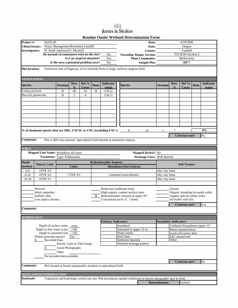
Date:Client/Owner: State:
County:NoYes Plant Community:No Sample Plot:
VEGETATION
Stratum Raw %
Rel % Cover
Dom. Indicator status
Stratum Raw %
Rel % Cover
Dom. Indicator status
H 60 92 X FACUH 5 8 FACU
% of dominant species that are OBL, FACW, or FAC (excluding FAC-): 0 of 1 =
No
Routine Onsite Wetland Determination Form
Comments:
Project #: 06293.06Waste Management/Riverbend Landfill
4/18/2006Oregon
HerbaceousDP-7
Investigators: H. Arndt Anderson/G. MurdoffDo normal circumstances exist on the site?
YamhillT5S R5W Section 2Township, Range, Section:
Lolium perenneDactylis glomerata
Is it an atypical situation?Is the area a potential problem area?
Plot location: Northwest side of Highway 18 on Schmidt Farm in large, uniform ryegrass field.
Species Species
Criterion met?Plot is 40% bare ground. Agricultural field planted in perennial ryegrass.
0%
SOILSWoodburn silt loam Mapped Hydric? NoTypic Palehumults Drainage Class: Well drained
0-88-16
16-18
Histosol Reducing conditions (test) GleyedHistic epipedon High organic content surface layer Organic streaking (in sandy soils)Sulfidic odor X Redoximorphic features in upper 10" Organic pan (in sandy soils)Low matrix chroma Concretions (w/in 3", >2mm) On hydric soils list
Yes
HYDROLOGY
none>18" Water-stained leaves>18" Local soil survey data
Within growing season? Yes FAC neutral testX Recorded Data
Stream, Lake or Tide GaugeX Aerial Photographs
OtherNo recorded data available
No
WETLAND DETERMINATIONVegetation and hydrology criteria not met. Plot documents upland conditions in lowest topographic spot in field.
Sediment deposits
UplandDetermination:
Criterion met?Comments:
Other Wetland drainage pattern
Plot located at lowest topographic position in agricultural field.
Rationale:
Comments:Criterion met?
Water marks
Depth (inches) Matrix Color
Saturated in upper 12 in.
Abundance/size/contrast
Taxonomy:Mapped Unit Name:
Redoximorphic featuresColor
Soil Texture
10YR 3/2 silty clay loam
silty clay loam10YR 3/2 common/coarse/distinct silty clay loam7.5YR 3/3
Primary Indicators: Secondary Indicators:Depth of surface water: Inundated Oxidized rhizospheres upper 12"
Depth to free water in pit:Depth to saturated soil:
Drift lines
10YR 3/1
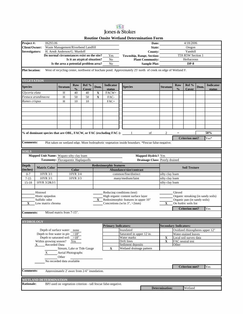
Date:Client/Owner: State:
County:YesNo Plant Community:No Sample Plot:
VEGETATION
Stratum Raw %
Rel % Cover
Dom. Indicator status
Stratum Raw %
Rel % Cover
Dom. Indicator status
H 40 40 X FACW+H 50 50 X FAC-H 10 10 FAC+
% of dominant species that are OBL, FACW, or FAC (excluding FAC-): 1 of 2 =
Yes*
50%
Plot taken on wetland edge. More hydrophytic vegetation inside boundary. *Fescue false-negative.Criterion met?
Rumex crispus
Glyceria elataFestuca arundinacea
Is it an atypical situation?Is the area a potential problem area?
Plot location: West of recycling center, northwest of leachate pond. Approximately 25' north of creek on edge of Wetland F.
Species Species
HerbaceousDP-8
Investigators: H. Arndt Anderson/G. MurdoffDo normal circumstances exist on the site?
YamhillT5S R5W Section 1Township, Range, Section:
Project #: 06293.06Waste Management/Riverbend Landfill
4/18/2006Oregon
Routine Onsite Wetland Determination Form
Comments:
SOILSWapato silty clay loam Mapped Hydric? YesFluvaquentic Haplaquolls Drainage Class: Poorly drained
0-77-15
15-18
Histosol Reducing conditions (test) GleyedHistic epipedon High organic content surface layer Organic streaking (in sandy soils)Sulfidic odor X Redoximorphic features in upper 10" Organic pan (in sandy soils)
X Low matrix chroma Concretions (w/in 3", >2mm) X On hydric soils list
Yes
HYDROLOGY
none>18" Water-stained leaves>18" X Local soil survey data
Within growing season? Yes X FAC neutral testX Recorded Data
Stream, Lake or Tide Gauge XX Aerial Photographs
OtherNo recorded data available
Yes
WETLAND DETERMINATIONBPJ used on vegetation criterion - tall fescue false-negative.
Depth to free water in pit:Depth to saturated soil:
Drift lines
10YR 3/2&3/1
Mixed matrix from 7-15".
Primary Indicators: Secondary Indicators:Depth of surface water: Inundated Oxidized rhizospheres upper 12"
Taxonomy:Mapped Unit Name:
Redoximorphic features
silty clay loam10YR 3/1 many/medium/faint silty clay loam10YR 3/310YR 3/1 common/fine/distinct silty clay loam10YR 3/4
Abundance/size/contrast
Comments:Criterion met?
Water marks
Depth (inches) Matrix Color
Saturated in upper 12 in.
ColorSoil Texture
WetlandDetermination:
Criterion met?Comments:
Other Wetland drainage pattern
Approximately 2' away from 2-6" inundation.
Rationale:
Sediment deposits
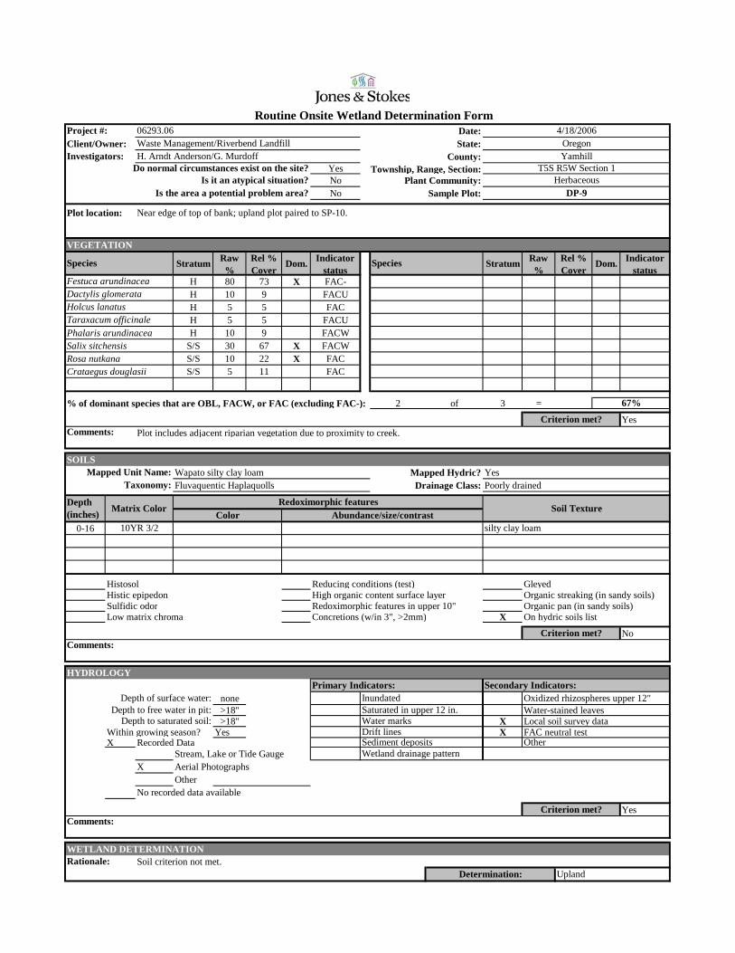
Date:Client/Owner: State:
County:YesNo Plant Community:No Sample Plot:
VEGETATION
Stratum Raw %
Rel % Cover
Dom. Indicator status
Stratum Raw %
Rel % Cover
Dom. Indicator status
H 80 73 X FAC-H 10 9 FACUH 5 5 FACH 5 5 FACU
Phalaris arundinacea H 10 9 FACWSalix sitchensis S/S 30 67 X FACWRosa nutkana S/S 10 22 X FACCrataegus douglasii S/S 5 11 FAC
% of dominant species that are OBL, FACW, or FAC (excluding FAC-): 2 of 3 =
Yes
Routine Onsite Wetland Determination Form
Comments:
Project #: 06293.06Waste Management/Riverbend Landfill
4/18/2006Oregon
HerbaceousDP-9
Investigators: H. Arndt Anderson/G. MurdoffDo normal circumstances exist on the site?
YamhillT5S R5W Section 1Township, Range, Section:
Festuca arundinaceaDactylis glomerata
Is it an atypical situation?Is the area a potential problem area?
Plot location: Near edge of top of bank; upland plot paired to SP-10.
Species Species
Taraxacum officinaleHolcus lanatus
Criterion met?Plot includes adjacent riparian vegetation due to proximity to creek.
67%
SOILSWapato silty clay loam Mapped Hydric? YesFluvaquentic Haplaquolls Drainage Class: Poorly drained
0-16
Histosol Reducing conditions (test) GleyedHistic epipedon High organic content surface layer Organic streaking (in sandy soils)Sulfidic odor Redoximorphic features in upper 10" Organic pan (in sandy soils)Low matrix chroma Concretions (w/in 3", >2mm) X On hydric soils list
No
HYDROLOGY
none>18" Water-stained leaves>18" X Local soil survey data
Within growing season? Yes X FAC neutral testX Recorded Data
Stream, Lake or Tide GaugeX Aerial Photographs
OtherNo recorded data available
Yes
WETLAND DETERMINATIONSoil criterion not met.
Sediment deposits
UplandDetermination:
Criterion met?Comments:
Other Wetland drainage pattern
Rationale:
Comments:Criterion met?
Water marks
Depth (inches) Matrix Color
Saturated in upper 12 in.
Abundance/size/contrast
Taxonomy:Mapped Unit Name:
Redoximorphic featuresColor
Soil Texture
10YR 3/2 silty clay loam
Primary Indicators: Secondary Indicators:Depth of surface water: Inundated Oxidized rhizospheres upper 12"
Depth to free water in pit:Depth to saturated soil:
Drift lines

Date:Client/Owner: State:
County:YesNo Plant Community:No Sample Plot:
VEGETATION
Stratum Raw %
Rel % Cover
Dom. Indicator status
Stratum Raw %
Rel % Cover
Dom. Indicator status
H 20 20 X FAC-H 20 20 X FACWH 25 25 X FACH 20 20 X FACU
Festuca rubra H 15 15 FAC+
% of dominant species that are OBL, FACW, or FAC (excluding FAC-): 2 of 4 =
Yes*
50%
Vegetation very marginal, but less hydrophytic outside boundary and foxtail increases further inside wetland boundary. Plottaken on edge. *Tall fescue false-negative.
Criterion met?
Dactylis glomerataPoa annua
Festuca arundinaceaAlopecurus pratensis
Is it an atypical situation?Is the area a potential problem area?
Plot location: Eastern edge of Wetland G near fence. At southern end of poplar grove.
Species Species
HerbaceousDP-10
Investigators: H. Arndt Anderson/G. MurdoffDo normal circumstances exist on the site?
YamhillT5S R5W Section 1Township, Range, Section:
Project #: 06293.06Waste Management/Riverbend Landfill
4/18/2006Oregon
Routine Onsite Wetland Determination Form
Comments:
SOILSWapato silty clay loam Mapped Hydric? YesFluvaquentic Haplaquolls Drainage Class: Poorly drained
0-88-18
Histosol Reducing conditions (test) GleyedHistic epipedon High organic content surface layer Organic streaking (in sandy soils)Sulfidic odor X Redoximorphic features in upper 10" Organic pan (in sandy soils)
X Low matrix chroma Concretions (w/in 3", >2mm) X On hydric soils list
Yes
HYDROLOGY
none10" X Water-stained leaves5" X Local soil survey data
Within growing season? Yes FAC neutral testX Recorded Data
Stream, Lake or Tide GaugeX Aerial Photographs
OtherNo recorded data available
Yes
WETLAND DETERMINATIONBPJ used for vegetation. Vegetation very marginal but other indicators strong.
Depth to free water in pit:Depth to saturated soil:
Drift lines
Between upper and lower horizon is a 1/4"-thich layer of white substance. Soils very moist and disturbed. Potential
Primary Indicators: Secondary Indicators:Depth of surface water: Inundated Oxidized rhizospheres upper 12"
Taxonomy:Mapped Unit Name:
Redoximorphic features
10YR 2/1 many/medium/distinct silty clay loam7.5YR 3/3
taken on edge. Tall fescue false negative.
10YR 3/3 common/medium/distinct silty clay loam7.5YR 3/4Abundance/size/contrast
Comments:Criterion met?
previously filled wetland.
Water marks
Depth (inches) Matrix Color
Saturated in upper 12 in.
ColorSoil Texture
WetlandDetermination:
Criterion met?Comments:
Other Wetland drainage pattern
At base of slope - receives summer leachate irrigation. 1-2" inundation observed in other portions of wetland.
Rationale:
Sediment deposits

Date:Client/Owner: State:
County:YesNo Plant Community:No Sample Plot:
VEGETATION
Stratum Raw %
Rel % Cover
Dom. Indicator status
Stratum Raw %
Rel % Cover
Dom. Indicator status
H 30 30 X FAC-H 60 60 X FACUH 10 10 FAC
% of dominant species that are OBL, FACW, or FAC (excluding FAC-): 0 of 2 =
No
Routine Onsite Wetland Determination Form
Comments:
Project #: 06293.06Waste Management/Riverbend Landfill
4/18/2006Oregon
HerbaceousDP-11
Investigators: H. Arndt Anderson/G. MurdoffDo normal circumstances exist on the site?
YamhillT5S R5W Section 1Township, Range, Section:
Festuca arundinaceaDactylis glomerata
Is it an atypical situation?Is the area a potential problem area?
Plot location: Eastern edge of Wetland G near fence. At southern end of poplar grove. Paired upland plot to SP-12.
Species Species
Poa annua
Criterion met?
0%
SOILSWapato silty clay loam Mapped Hydric? YesFluvaquentic Haplaquolls Drainage Class: Poorly drained
0-66-16
Histosol Reducing conditions (test) GleyedHistic epipedon High organic content surface layer Organic streaking (in sandy soils)Sulfidic odor Redoximorphic features in upper 10" Organic pan (in sandy soils)Low matrix chroma Concretions (w/in 3", >2mm) X On hydric soils list
No
HYDROLOGY
none15" X Water-stained leaves12" X Local soil survey data
Within growing season? Yes FAC neutral testX Recorded Data
Stream, Lake or Tide GaugeX Aerial Photographs
OtherNo recorded data available
Yes
WETLAND DETERMINATIONSoils and vegetation criteria not met.
Sediment deposits
UplandDetermination:
Criterion met?Comments:
Other Wetland drainage pattern
At base of slope - receives summer leachate irrigation.
Rationale:
Comments:Criterion met?
previously filled wetland.
Water marks
Depth (inches) Matrix Color
Saturated in upper 12 in.
Abundance/size/contrast
Taxonomy:Mapped Unit Name:
Redoximorphic featuresColor
Soil Texture
10YR 3/3 silty clay loam10YR 2/2 silty clay loam
Between upper and lower horizon is a 1/4"-thich layer of white mold. Soils very moist and disturbed. Potential
Primary Indicators: Secondary Indicators:Depth of surface water: Inundated Oxidized rhizospheres upper 12"
Depth to free water in pit:Depth to saturated soil:
Drift lines
Date:Client/Owner: State:
County:YesNo Plant Community:No Sample Plot:
VEGETATION
Stratum Raw %
Rel % Cover
Dom. Indicator status
Stratum Raw %
Rel % Cover
Dom. Indicator status
H 65 65 X FACWH 15 15 FACH 10 10 FACUH 10 10 FAC
Fraxinus latifolia S/S 20 50 X FACWPopulus balsamifera S/S 20 50 X FACPopulus balsamifera T 75 100 X FAC
% of dominant species that are OBL, FACW, or FAC (excluding FAC-): 4 of 4 =
Yes
100%
Criterion met?
Dipsacus fullonumTaraxacum officinale
Alopecurus pratensisRumex obtusifolius
Is it an atypical situation?Is the area a potential problem area?
Plot location: Northern edge of Wetland G, near house in northwest portion of landfill property. In patch of cottonwood trees near gravel
road.
Species Species
Herbaceous/Scrub-shrubDP-12
Investigators: H. Arndt Anderson/G. MurdoffDo normal circumstances exist on the site?
YamhillT5S R5W Section 1Township, Range, Section:
Project #: 06293.06Waste Management/Riverbend Landfill
4/18/2006Oregon
Routine Onsite Wetland Determination Form
Comments:
SOILSWoodburn silt loam Mapped Hydric? NoTypic Palehumults Drainage Class: Well drained
0-18
Histosol Reducing conditions (test) X GleyedHistic epipedon High organic content surface layer Organic streaking (in sandy soils)
X Sulfidic odor X Redoximorphic features in upper 10" Organic pan (in sandy soils)Low matrix chroma Concretions (w/in 3", >2mm) On hydric soils list
Yes
HYDROLOGY
none8" X Water-stained leaves0" Local soil survey data
Within growing season? Yes X FAC neutral testX Recorded Data
Stream, Lake or Tide GaugeX Aerial Photographs
OtherNo recorded data available
Yes
WETLAND DETERMINATIONAll three criteria met.
Depth to free water in pit:Depth to saturated soil:
Drift lines
few/coarse/prominent
Three types of redox.
Primary Indicators: Secondary Indicators:Depth of surface water: Inundated Oxidized rhizospheres upper 12"
Taxonomy:Mapped Unit Name:
Redoximorphic features
10YR 3/4many/fine/prominent7.5YR 3/4
N 3/0 many/coarse/prominent silty clay loam7.5YR 2.5/2Abundance/size/contrast
Comments:Criterion met?
Water marks
Depth (inches) Matrix Color
Saturated in upper 12 in.
ColorSoil Texture
WetlandDetermination:
Criterion met?Comments:
Other Wetland drainage pattern
At edge of inundated area.
Rationale:
Sediment deposits

Date:Client/Owner: State:
County:YesNo Plant Community:No Sample Plot:
VEGETATION
Stratum Raw %
Rel % Cover
Dom. Indicator status
Stratum Raw %
Rel % Cover
Dom. Indicator status
H 20 25 X FACH 25 31 X FACUH 15 19 FACWH 10 13 FACU
Festuca arundinacea H 10 13 FAC-Populus balsamifera S/S 10 100 X FACPopulus balsamifera T 70 100 X FAC
% of dominant species that are OBL, FACW, or FAC (excluding FAC-): 3 of 4 =
Yes
Routine Onsite Wetland Determination Form
Comments:
Project #: 06293.06Waste Management/Riverbend Landfill
4/18/2006Oregon
Herbaceous/Scrub-shrubDP-13
Investigators: H. Arndt Anderson/G. MurdoffDo normal circumstances exist on the site?
YamhillT5S R5W Section 1Township, Range, Section:
Dipsacus fullonumDactylis glomerata
Is it an atypical situation?Is the area a potential problem area?
Plot location: Approximately 20' E of SP-14, ~6" higher.
Species Species
Carex deweyanaAlopecurus pratensis
Criterion met?Bare ground 20%.
75%
SOILSWoodburn silt loam Mapped Hydric? NoTypic Palehumults Drainage Class: Well drained
0-1313-16
Histosol Reducing conditions (test) GleyedHistic epipedon High organic content surface layer Organic streaking (in sandy soils)Sulfidic odor X Redoximorphic features in upper 10" Organic pan (in sandy soils)
X Low matrix chroma Concretions (w/in 3", >2mm) On hydric soils list
Yes
HYDROLOGY
none>16" Water-stained leaves>16" Local soil survey data
Within growing season? Yes FAC neutral testX Recorded Data
Stream, Lake or Tide GaugeX Aerial Photographs
OtherNo recorded data available
No
WETLAND DETERMINATIONHydrology criterion not met.
Sediment deposits
UplandDetermination:
Criterion met?Comments:
Other Wetland drainage pattern
Approximately 6" higher than SP-14.
Rationale:
Comments:Criterion met?
Water marks
Depth (inches) Matrix Color
Saturated in upper 12 in.
Abundance/size/contrast
Taxonomy:Mapped Unit Name:
Redoximorphic featuresColor
Soil Texture
10YR 3/1 silty clay loam10YR 3/1 many/medium/distinct silty clay loam7.5YR 3/4
Very gravelly. Many large roots.
Primary Indicators: Secondary Indicators:Depth of surface water: Inundated Oxidized rhizospheres upper 12"
Depth to free water in pit:Depth to saturated soil:
Drift lines
Date:Client/Owner: State:
County:YesNo Plant Community:No Sample Plot:
VEGETATION
Stratum Raw %
Rel % Cover
Dom. Indicator status
Stratum Raw %
Rel % Cover
Dom. Indicator status
H 85 68 X FACWH 20 16 FACWH 20 16 FACU
S/S 15 100 X FAC
% of dominant species that are OBL, FACW, or FAC (excluding FAC-): 2 of 2 =
Yes
100%
More Juncus effusus outside plot area in wetland. Criterion met?
Rosa pisocarpaDactylis glomerata
Phalaris arundinaceaJuncus effusus
Is it an atypical situation?Is the area a potential problem area?
Plot location: Wetland E, near gravel road on southern side of creek.
Species Species
Herbaceous/Scrub-shrubDP-14
Investigators: H. Arndt Anderson/G. MurdoffDo normal circumstances exist on the site?
YamhillT5S R5W Section 1Township, Range, Section:
Project #: 06293.06Waste Management/Riverbend Landfill
4/19/2006Oregon
Routine Onsite Wetland Determination Form
Comments:
SOILSWapato silty clay loam Mapped Hydric? YesFluvaquentic Haplaquolls Drainage Class: Poorly drained
0-1414-19
Histosol Reducing conditions (test) GleyedHistic epipedon High organic content surface layer Organic streaking (in sandy soils)Sulfidic odor X Redoximorphic features in upper 10" Organic pan (in sandy soils)
X Low matrix chroma Concretions (w/in 3", >2mm) X On hydric soils list
Yes
HYDROLOGY
none12" X Water-stained leaves11" X Local soil survey data
Within growing season? Yes X FAC neutral testX Recorded Data
Stream, Lake or Tide GaugeX Aerial Photographs
OtherNo recorded data available
Yes
WETLAND DETERMINATIONAll three criteria met.
Depth to free water in pit:Depth to saturated soil:
Drift lines
7.5YR 4/6
Primary Indicators: Secondary Indicators:Depth of surface water: Inundated Oxidized rhizospheres upper 12"
Abundance/size/contrast
Taxonomy:Mapped Unit Name:
Redoximorphic features
10YR 3/1 many/coarse/prominent silty clay loam10YR 3/2 many/coarse/prominent silty clay loam7.5YR 4/6
Comments:Criterion met?
Water marks
Depth (inches) Matrix Color
Saturated in upper 12 in.
ColorSoil Texture
WetlandDetermination:
Criterion met?Comments:
Other Wetland drainage pattern
Plot located in concave topographic feature.
Rationale:
Sediment deposits
Date:Client/Owner: State:
County:YesNo Plant Community:No Sample Plot:
VEGETATION
Stratum Raw %
Rel % Cover
Dom. Indicator status
Stratum Raw %
Rel % Cover
Dom. Indicator status
S/S 40 100 X FACUH 50 62 X FACH 30 37 X FACU
% of dominant species that are OBL, FACW, or FAC (excluding FAC-): 1 of 3 =
No
Routine Onsite Wetland Determination Form
Comments:
Project #: 06293.06Waste Management/Riverbend Landfill
4/19/2006Oregon
Herbaceous/Scrub-shrubDP-15
Investigators: H. Arndt Anderson/G. MurdoffDo normal circumstances exist on the site?
YamhillT5S R5W Section 1Township, Range, Section:
Rubus discolorDipsacus fullonum
Is it an atypical situation?Is the area a potential problem area?
Plot location: Wetland E, near gravel road on southern side of creek. Approximately 10' south of SP-16 on road slope.
Species Species
Dactylis glomerata
Criterion met?Plot is 20% moss/bare ground.
33%
SOILSWapato silty clay loam Mapped Hydric? YesFluvaquentic Haplaquolls Drainage Class: Poorly drained
0-16
Histosol Reducing conditions (test) GleyedHistic epipedon High organic content surface layer Organic streaking (in sandy soils)Sulfidic odor X Redoximorphic features in upper 10" Organic pan (in sandy soils)
X Low matrix chroma Concretions (w/in 3", >2mm) X On hydric soils list
Yes
HYDROLOGY
none>16" Water-stained leaves>16" X Local soil survey data
Within growing season? Yes FAC neutral testX Recorded Data
Stream, Lake or Tide GaugeX Aerial Photographs
OtherNo recorded data available
No
WETLAND DETERMINATIONVegetation and hydrology criteria not met.
Sediment deposits
UplandDetermination:
Criterion met?Comments:
Other Wetland drainage pattern
Approximately 1' higher than SP-16.
Rationale:
Comments:Criterion met?
Water marks
Depth (inches) Matrix Color
Saturated in upper 12 in.
Abundance/size/contrast
Taxonomy:Mapped Unit Name:
Redoximorphic featuresColor
Soil Texture
10YR 3/2 common/coarse/prominent silty clay loam7.5YR 3/4
Mixed matrix; likely disturbed from road embankment.
Primary Indicators: Secondary Indicators:Depth of surface water: Inundated Oxidized rhizospheres upper 12"
Depth to free water in pit:Depth to saturated soil:
Drift lines
Date:Client/Owner: State:
County:YesNo Plant Community:No Sample Plot:
VEGETATION
Stratum Raw %
Rel % Cover
Dom. Indicator status
Stratum Raw %
Rel % Cover
Dom. Indicator status
H 50 91 X FAC-H 5 9 FACW-
% of dominant species that are OBL, FACW, or FAC (excluding FAC-): 0 of 1 =
No
0%
Plot is 50% bare ground. Polygonum is sprout.Criterion met?
Festuca arundinaceaPolygonum aviculare
Is it an atypical situation?Is the area a potential problem area?
Plot location: Wetland J, in low portion of managed fescue field. Area has been in agriculture for >70 years.
Species Species
Herbaceous (Agricultural)DP-16
Investigators: H. Arndt Anderson/G. MurdoffDo normal circumstances exist on the site?
YamhillT5S R5W Section 11Township, Range, Section:
Project #: 06293.06Waste Management/Riverbend Landfill
3/28/2007Oregon
Routine Onsite Wetland Determination Form
Comments:
SOILSWapato silty clay loam Mapped Hydric? YesFluvaquentic Haplaquolls Drainage Class: Poorly drained
0-16
Histosol Reducing conditions (test) GleyedHistic epipedon High organic content surface layer Organic streaking (in sandy soils)Sulfidic odor Redoximorphic features in upper 10" Organic pan (in sandy soils)Low matrix chroma Concretions (w/in 3", >2mm) X On hydric soils list
No
HYDROLOGY
none>16" Water-stained leaves>16" X Local soil survey data
Within growing season? Yes FAC neutral testX Recorded Data
Stream, Lake or Tide GaugeX Aerial Photographs
OtherNo recorded data available
No
WETLAND DETERMINATIONNone of the criteria met.
Depth to free water in pit:Depth to saturated soil:
Drift lines
Primary Indicators: Secondary Indicators:Depth of surface water: Inundated Oxidized rhizospheres upper 12"
Abundance/size/contrast
Taxonomy:Mapped Unit Name:
Redoximorphic features
7.5YR 3/2 silty clay loam
Comments:Criterion met?
Water marks
Depth (inches) Matrix Color
Saturated in upper 12 in.
ColorSoil Texture
UplandDetermination:
Criterion met?Comments:
Other Wetland drainage pattern
Rationale:
Sediment deposits
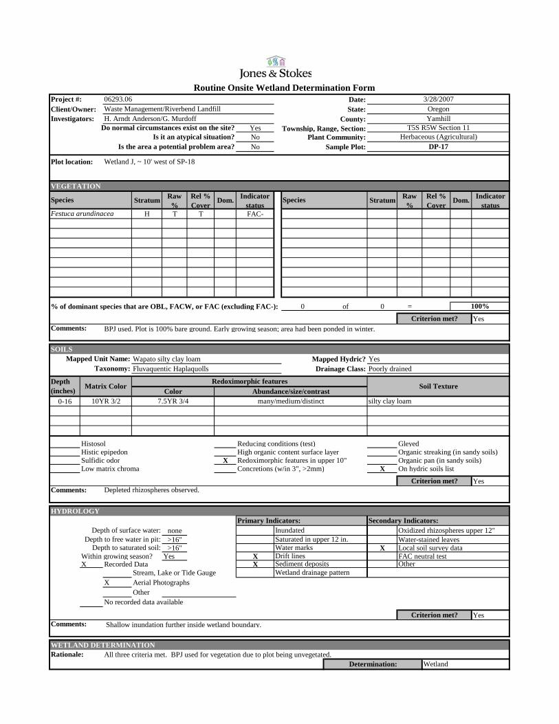
Date:Client/Owner: State:
County:YesNo Plant Community:No Sample Plot:
VEGETATION
Stratum Raw %
Rel % Cover
Dom. Indicator status
Stratum Raw %
Rel % Cover
Dom. Indicator status
H T T FAC-
% of dominant species that are OBL, FACW, or FAC (excluding FAC-): 0 of 0 =
Yes
Routine Onsite Wetland Determination Form
Comments:
Project #: 06293.06Waste Management/Riverbend Landfill
3/28/2007Oregon
Herbaceous (Agricultural)DP-17
Investigators: H. Arndt Anderson/G. MurdoffDo normal circumstances exist on the site?
YamhillT5S R5W Section 11Township, Range, Section:
Festuca arundinacea
Is it an atypical situation?Is the area a potential problem area?
Plot location: Wetland J, ~ 10' west of SP-18
Species Species
Criterion met?BPJ used. Plot is 100% bare ground. Early growing season; area had been ponded in winter.
100%
SOILSWapato silty clay loam Mapped Hydric? YesFluvaquentic Haplaquolls Drainage Class: Poorly drained
0-16
Histosol Reducing conditions (test) GleyedHistic epipedon High organic content surface layer Organic streaking (in sandy soils)Sulfidic odor X Redoximorphic features in upper 10" Organic pan (in sandy soils)Low matrix chroma Concretions (w/in 3", >2mm) X On hydric soils list
Yes
HYDROLOGY
none>16" Water-stained leaves>16" X Local soil survey data
Within growing season? Yes X FAC neutral testX Recorded Data X
Stream, Lake or Tide GaugeX Aerial Photographs
OtherNo recorded data available
Yes
WETLAND DETERMINATIONAll three criteria met. BPJ used for vegetation due to plot being unvegetated.
Sediment deposits
WetlandDetermination:
Criterion met?Comments:
Other Wetland drainage pattern
Shallow inundation further inside wetland boundary.
Rationale:
Comments:Criterion met?
Water marks
Depth (inches) Matrix Color
Saturated in upper 12 in.
Abundance/size/contrast
Taxonomy:Mapped Unit Name:
Redoximorphic featuresColor
Soil Texture
10YR 3/2 many/medium/distinct silty clay loam7.5YR 3/4
Depleted rhizospheres observed.
Primary Indicators: Secondary Indicators:Depth of surface water: Inundated Oxidized rhizospheres upper 12"
Depth to free water in pit:Depth to saturated soil:
Drift lines

Date:Client/Owner: State:
County:YesNo Plant Community:No Sample Plot:
VEGETATION
Stratum Raw %
Rel % Cover
Dom. Indicator status
Stratum Raw %
Rel % Cover
Dom. Indicator status
H 25 56 X FAC+H 20 44 X FACW-
% of dominant species that are OBL, FACW, or FAC (excluding FAC-): 2 of 2 =
Yes
100%
Plot is 55% bare ground. Early growing season; area had been ponded in winter. Criterion met?
Rumex crispusPolygonum aviculare
Is it an atypical situation?Is the area a potential problem area?
Plot location: Wetland K , at edge of pond.
Species Species
Herbaceous (Agricultural)DP-18
Investigators: H. Arndt Anderson/G. MurdoffDo normal circumstances exist on the site?
YamhillT5S R5W Section 11Township, Range, Section:
Project #: 06293.06Waste Management/Riverbend Landfill
3/28/2007Oregon
Routine Onsite Wetland Determination Form
Comments:
SOILSWapato silty clay loam Mapped Hydric? YesFluvaquentic Haplaquolls Drainage Class: Poorly drained
0-1515-18
Histosol Reducing conditions (test) GleyedHistic epipedon High organic content surface layer Organic streaking (in sandy soils)Sulfidic odor Redoximorphic features in upper 10" Organic pan (in sandy soils)Low matrix chroma Concretions (w/in 3", >2mm) X On hydric soils list
No
HYDROLOGY
none>16" Water-stained leaves16" X Local soil survey data
Within growing season? Yes X X FAC neutral testX Recorded Data X
Stream, Lake or Tide GaugeX Aerial Photographs
OtherNo recorded data available
Yes
WETLAND DETERMINATIONSoil criterion not met.
Depth to free water in pit:Depth to saturated soil:
Drift lines
10YR 3/3
Primary Indicators: Secondary Indicators:Depth of surface water: Inundated Oxidized rhizospheres upper 12"
Abundance/size/contrast
Taxonomy:Mapped Unit Name:
Redoximorphic features
10YR 3/1 many/medium/distinct silty clay loam7.5YR 3/3 silt loam
Comments:Criterion met?
Water marks
Depth (inches) Matrix Color
Saturated in upper 12 in.
ColorSoil Texture
UplandDetermination:
Criterion met?Comments:
Other Wetland drainage pattern
Plot taken at edge of pond. Shallow inundation further inside wetland boundary.
Rationale:
Sediment deposits
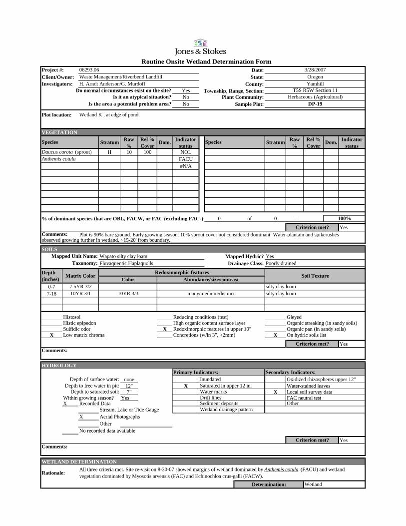
Date:Client/Owner: State:
County:YesNo Plant Community:No Sample Plot:
VEGETATION
Stratum Raw %
Rel % Cover
Dom. Indicator status
Stratum Raw %
Rel % Cover
Dom. Indicator status
H 10 100 NOLFACU#N/A
% of dominant species that are OBL, FACW, or FAC (excluding FAC-): 0 of 0 =
Yes
Routine Onsite Wetland Determination Form
Comments:
Project #: 06293.06Waste Management/Riverbend Landfill
3/28/2007Oregon
Herbaceous (Agricultural)DP-19
Investigators: H. Arndt Anderson/G. MurdoffDo normal circumstances exist on the site?
YamhillT5S R5W Section 11Township, Range, Section:
Daucus carota (sprout)Anthemis cotula
Is it an atypical situation?Is the area a potential problem area?
Plot location: Wetland K , at edge of pond.
Species Species
Criterion met?Plot is 90% bare ground. Early growing season. 10% sprout cover not considered dominant. Water-plantain and spikerushes
observed growing further in wetland, ~15-20' from boundary.
100%
SOILSWapato silty clay loam Mapped Hydric? YesFluvaquentic Haplaquolls Drainage Class: Poorly drained
0-77-18
Histosol Reducing conditions (test) GleyedHistic epipedon High organic content surface layer Organic streaking (in sandy soils)Sulfidic odor X Redoximorphic features in upper 10" Organic pan (in sandy soils)
X Low matrix chroma Concretions (w/in 3", >2mm) X On hydric soils list
Yes
HYDROLOGY
none12" X Water-stained leaves7" X Local soil survey data
Within growing season? Yes FAC neutral testX Recorded Data
Stream, Lake or Tide GaugeX Aerial Photographs
OtherNo recorded data available
Yes
WETLAND DETERMINATION
Sediment deposits
WetlandDetermination:
Criterion met?Comments:
Other Wetland drainage pattern
All three criteria met. Site re-visit on 8-30-07 showed margins of wetland dominated by Anthemis cotula (FACU) and wetland vegetation dominated by Myosotis arvensis (FAC) and Echinochloa crus-galli (FACW).Rationale:
Comments:Criterion met?
Water marks
Depth (inches) Matrix Color
Saturated in upper 12 in.
Abundance/size/contrast
Taxonomy:Mapped Unit Name:
Redoximorphic featuresColor
Soil Texture
7.5YR 3/2 silty clay loam10YR 3/1 many/medium/distinct silty clay loam10YR 3/3
Primary Indicators: Secondary Indicators:Depth of surface water: Inundated Oxidized rhizospheres upper 12"
Depth to free water in pit:Depth to saturated soil:
Drift lines
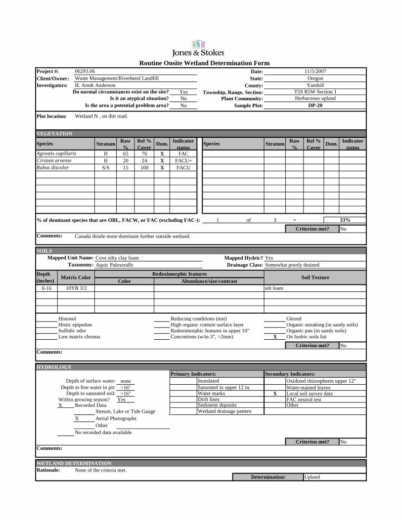
Date:Client/Owner: State:
County:YesNo Plant Community:No Sample Plot:
VEGETATION
Stratum Raw %
Rel % Cover
Dom. Indicator status
Stratum Raw %
Rel % Cover
Dom. Indicator status
H 65 76 X FACH 20 24 X FACU+
S/S 15 100 X FACU
% of dominant species that are OBL, FACW, or FAC (excluding FAC-): 1 of 3 =
No
33%
Canada thistle more dominant further outside wetland.Criterion met?
Rubus discolor
Agrostis capillarisCirsium arvense
Is it an atypical situation?Is the area a potential problem area?
Plot location: Wetland N , on dirt road.
Species Species
Herbaceous uplandDP-20
Investigators: H. Arndt AndersonDo normal circumstances exist on the site?
YamhillT5S R5W Section 1Township, Range, Section:
Project #: 06293.06Waste Management/Riverbend Landfill
11/5/2007Oregon
Routine Onsite Wetland Determination Form
Comments:
SOILSCove silty clay loam Mapped Hydric? YesAquic Palexeralfs Drainage Class: Somewhat poorly drained
0-16
Histosol Reducing conditions (test) GleyedHistic epipedon High organic content surface layer Organic streaking (in sandy soils)Sulfidic odor Redoximorphic features in upper 10" Organic pan (in sandy soils)Low matrix chroma Concretions (w/in 3", >2mm) X On hydric soils list
No
HYDROLOGY
none>16" Water-stained leaves>16" X Local soil survey data
Within growing season? Yes FAC neutral testX Recorded Data
Stream, Lake or Tide GaugeX Aerial Photographs
OtherNo recorded data available
No
WETLAND DETERMINATIONNone of the criteria met.
Depth to free water in pit:Depth to saturated soil:
Drift lines
Primary Indicators: Secondary Indicators:Depth of surface water: Inundated Oxidized rhizospheres upper 12"
Abundance/size/contrast
Taxonomy:Mapped Unit Name:
Redoximorphic features
10YR 3/2 silt loam
Comments:Criterion met?
Water marks
Depth (inches) Matrix Color
Saturated in upper 12 in.
ColorSoil Texture
UplandDetermination:
Criterion met?Comments:
Other Wetland drainage pattern
Rationale:
Sediment deposits
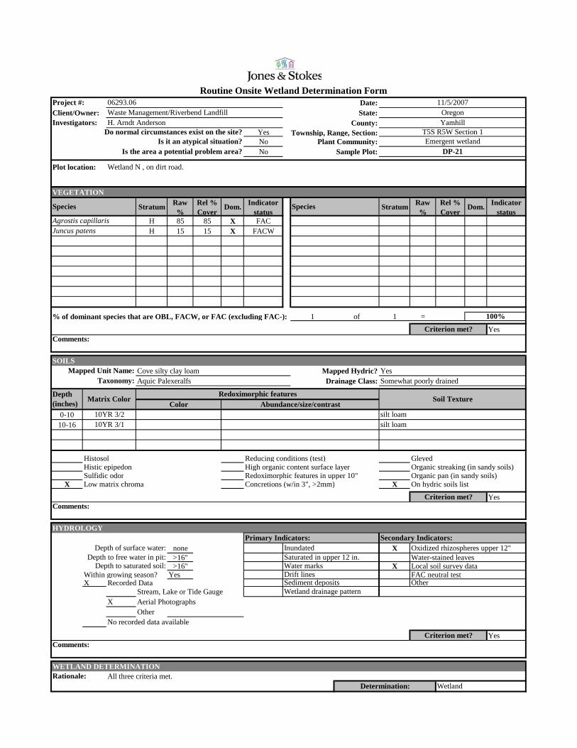
Date:Client/Owner: State:
County:YesNo Plant Community:No Sample Plot:
VEGETATION
Stratum Raw %
Rel % Cover
Dom. Indicator status
Stratum Raw %
Rel % Cover
Dom. Indicator status
H 85 85 X FACH 15 15 X FACW
% of dominant species that are OBL, FACW, or FAC (excluding FAC-): 1 of 1 =
Yes
Routine Onsite Wetland Determination Form
Comments:
Project #: 06293.06Waste Management/Riverbend Landfill
11/5/2007Oregon
Emergent wetlandDP-21
Investigators: H. Arndt AndersonDo normal circumstances exist on the site?
YamhillT5S R5W Section 1Township, Range, Section:
Agrostis capillarisJuncus patens
Is it an atypical situation?Is the area a potential problem area?
Plot location: Wetland N , on dirt road.
Species Species
Criterion met?
100%
SOILSCove silty clay loam Mapped Hydric? YesAquic Palexeralfs Drainage Class: Somewhat poorly drained
0-1010-16
Histosol Reducing conditions (test) GleyedHistic epipedon High organic content surface layer Organic streaking (in sandy soils)Sulfidic odor Redoximorphic features in upper 10" Organic pan (in sandy soils)
X Low matrix chroma Concretions (w/in 3", >2mm) X On hydric soils list
Yes
HYDROLOGY
none X>16" Water-stained leaves>16" X Local soil survey data
Within growing season? Yes FAC neutral testX Recorded Data
Stream, Lake or Tide GaugeX Aerial Photographs
OtherNo recorded data available
Yes
WETLAND DETERMINATIONAll three criteria met.
Sediment deposits
WetlandDetermination:
Criterion met?Comments:
Other Wetland drainage pattern
Rationale:
Comments:Criterion met?
Water marks
Depth (inches) Matrix Color
Saturated in upper 12 in.
Abundance/size/contrast
Taxonomy:Mapped Unit Name:
Redoximorphic featuresColor
Soil Texture
10YR 3/2 silt loam10YR 3/1 silt loam
Primary Indicators: Secondary Indicators:Depth of surface water: Inundated Oxidized rhizospheres upper 12"
Depth to free water in pit:Depth to saturated soil:
Drift lines

Date:Client/Owner: State:
County:YesNo Plant Community:No Sample Plot:
VEGETATION
Stratum Raw %
Rel % Cover
Dom. Indicator status
Stratum Raw %
Rel % Cover
Dom. Indicator status
H 80 80 X FAC-H 20 20 X FAC
% of dominant species that are OBL, FACW, or FAC (excluding FAC-): 1 of 2 =
No
50%
Criterion met?
Festuca arundinaceaDipsacus fullonum
Is it an atypical situation?Is the area a potential problem area?
Plot location: At bottom of slope below turkey pens.
Species Species
Herbaceous uplandDP-22
Investigators: H. Arndt AndersonDo normal circumstances exist on the site?
YamhillT5S R5W Section 1Township, Range, Section:
Project #: 06293.06Waste Management/Riverbend Landfill
11/5/2007Oregon
Routine Onsite Wetland Determination Form
Comments:
SOILSWoodburn silt loam Mapped Hydric? NoTypic Palehumults Drainage Class: Well drained
0-16
Histosol Reducing conditions (test) GleyedHistic epipedon High organic content surface layer Organic streaking (in sandy soils)Sulfidic odor Redoximorphic features in upper 10" Organic pan (in sandy soils)
X Low matrix chroma Concretions (w/in 3", >2mm) On hydric soils list
Yes
HYDROLOGY
none>16" Water-stained leaves>16" Local soil survey data
Within growing season? Yes FAC neutral testX Recorded Data
Stream, Lake or Tide GaugeX Aerial Photographs
OtherNo recorded data available
No
WETLAND DETERMINATIONNone of the criteria met. Plot documents upland conditions in topographically low spot below Landfill office and barns.
Depth to free water in pit:Depth to saturated soil:
Drift lines
Primary Indicators: Secondary Indicators:Depth of surface water: Inundated Oxidized rhizospheres upper 12"
Abundance/size/contrast
Taxonomy:Mapped Unit Name:
Redoximorphic features
10YR 2/2 silt loam
Comments:Criterion met?
Water marks
Depth (inches) Matrix Color
Saturated in upper 12 in.
ColorSoil Texture
UplandDetermination:
Criterion met?Comments:
Other Wetland drainage pattern
Rationale:
Sediment deposits

Appendix C Aerial Photographs