petroleum system of the northern and central bolivian sub...
TRANSCRIPT

Petroleum System of the Northern and Central Bolivian Sub-Andean Zone
P. Baby ORSTOM
Grenoble, Fyance
I. Moretti IFP
Rueil Malmaison, France
B. Guillier
R. Limachi
E. Mendez YPFB
Santa Cvuz, Bolivia
J. Oller Petrolex
Santa Cruz, Bolivia
ORSTOM Quito, Ecuadol M. Specht
Total Paris-LaDefeme, France
Abstract
An coupled study of the kinematics of thrusting and hydrocarbon maturation has been carried out in the
orthern and central sub-Andean belt of Bolivia to define the petroleum potential of the area. In addition to the classic Devonian source rock (Tomachi-Tequeje formations to the north and Iquiri-Limoncito formations in the central area), two other source rock intervals are recognized: the Retama Formation (Upper Devonian-Lower Carboniferous) and the Copacabana Formation (Upper Carboniferous-Lower Permian). These are the most prospective units in northern Bolivia and are of marine origin. The structural style varies from north to south due to variations in the sedimentary column involved in the thrusts. The erogenic front was guided by the northern boundary of a Paleozoic sedimentary wedge. In the Boomerang area, this boundary is oriented obliquely to the regional shortening and controlled the development of a prominent transfer zone. To the north, the thrusts are wider and the amount of shortening increases. The western part of the northern sub-Andean zone is characterized by a very thick Tertiary piggyback basin fill.
Two phases of hydrocarbon maturation are recognized. The first began in Early Carboniferous and affected mostly Devonian strata. Formation of structural traps during this period occurred rarely. The entire basin was then deeply eroded in Permian-Jurassic time, causing any hydrocarbons that may have formed to be lost. The second phase of maturation was contemporaneous with Andean deformation and with the resulting burial under the Tertiary cover in the foreland basin and in piggyback basins on thrust structures. The hydrocarbon expelled during this period may fill the Andean anticlines. The known source rocks are not proven to be gas prone, but current discoveries indicate a high gas to oil ratio that may be due to secondary cracking in the source rock. Because the initial potential of the source rocks is low, expulsion of heavy compounds is expected to be weak.
Resumen
n U estudio combinado de la cinematica de 10s corrimientos y de la maduracion de 10s hidrocarburos ha sido realizado en el sub-Andino norte y centre de Bolivia a fin de definir el potential petrohfero de la
u zona. Ademas de las clasicas rotas madres devdnicas (formaciones Tomachi-Tequeje en el norte y formaciones Iquiri-Limoncito en el centre), dos otras han sido definidas: la Formation Retama (Devonico sup. a
- Carbonifero inf.) y la Formation Copacabana (Carbonifero superior a P&rnico inferior) que presentan el mejor
~ a- 0s ‘potential en el sub-Andino norte. Son de origen marino. El estilo estructural cambia de Norte a Sur, debido a
- rJ:Tf las variaciones de espesor y de litologia en la columna sedimentaria implicada en 10s corrimientos. El frente =------p-J 0- 0-M orogenico fue guiado por el borde norte de una cuiia sedimentaria paleozoica. En la zona de1 Boomerang, este .a -0-J c-0
borde esta orientado oblicuamente en relation con la direction regional de acortamiento y control6 el desar- EEzYzzzo ‘-0
rollo de una prominente zona de transferencia. Hacia el norte, 10s corrimientos son mas anchos y el acor- g- 0-r m-0 n- 6G IL- -
- ‘Baby, P., I. Moretti, B. Guillier, R. Lima&i, E. Mendez, J. Oller, and M. Specht, 1995, 445 Petroleum system of the northern and central Bolivian sub-Andean zone, in A. J. Tankard, R. Sukrez S., and H. J. Welsink, Petroleum basins of South America: AAPG --.g~-$.gfa p$.& . ‘-j-(-J&/
r Memoir 62, p. 445458. Fends DQc~ii 5
446 Baby et al.
tamiento aumenta. La parte oriental del sub-Andino norte se caracteriza por un espeso relleno sedimentario terciario contemporáneo de la deformación andina.
Dos fases de maduración de hidrocarburos han sido reconocidas. La primera empieza al principio del Carbonifero donde la columna sedimentaria paleozoica es espesa; afecta principalmente al Devónico. Las trampas estructurales de este período son muy raras. Entre el Pérmico y el Jurásico, la cuenca ha sido profunda- mente erosionada, y los hidrocarburos generados probablemente han desaparecido. La segunda fase de madu- ración es contemporánea de la deformación andina. Se debe a la fuerte subsidencia y sedimentación terciaria en la cuenca de ante-país y en las cuencas transportadas por los corrimientos. Los hidrocarburos expulsados durante este segundo período pueden haber rellenado anticlinales andinos. No se ha mostrado que las rocas madres conocidas son propensas a generación de gas, pero los hidrocarburos descubiertos indican una alta proporción gas-petroleo. Se interpreta como el resultado de un crácking secundario en la roca madre. EI bajo potencial inicial de las rocas madres hace que la expulsión de los componentes pesados debe ser reducida.
INTRODUCTION As in many compressional areas, the petroleum
potential of the sub-Andean zone of Bolivia depends on the relative timing between structuring and maturation. All the known source rocks are Paleozoic in age. Therefore, a study of the petroleum system requires a study of the geology, the kinematics of thrust emplace- ment, and the kinetics of the various source rock matura- tions. The results of these studies are presented. Differ- ences in the sedimentary columns and structural styles from north to south are emphasized, and the potential source rocks are defined and their maturation docu- mented. In some cases, we address the maximum mount of burial before the Andean deformation; there is considerable uncertainty because of the amount of erosion.
REGIONAL SETTING The sub-Andean zone of Bolivia is a complex foreland
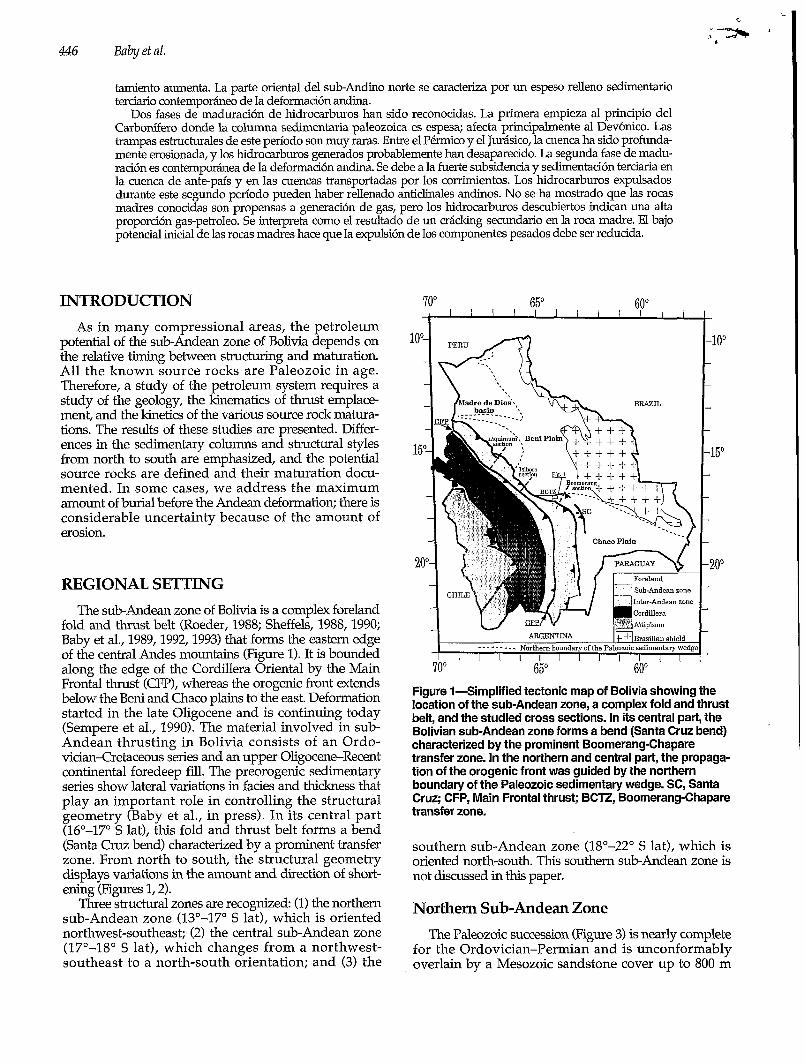
fold and thrust belt (Roeder, 1988; Sheffels, 1988, 1990; Baby et al., 1989,1992,1993) that forms the eastern edge of the central Andes mountains (Figure 1). It is bounded along the edge of the Cordillera Oriental by the Main Frontal thrust (CFP), whereas the orogenic front extends below the Beni and Chaco plains to the east. Deformation started in the late Oligocene and is continuing today (Sempere et al., 1990). The material involved in sub- Andean thrusting in Bolivia consists of an Ordo- vician-cretaceous series and an upper Oligocene-Recent continental foredeep fill. The preorogenic sedimentary series show lateral variations in facies and thickness that play an important role in controlling the structural geometry (Baby et al., in press). In its central part (16"-17" S lat), this fold and thrust belt forms a bend (Santa Cruz bend) characterized by a prominent transfer zone. From north to south, the structural geometry displays variations in the amount and direction of short- ening (Figures 1,2).
Three structural zones are recognized (1) the northern sub-Andean zone (13"-17" S lat), which is oriented northwest-southeast; (2) the central sub-Andean zone (17"-18" S lat), which changes from a northwest- southeast to a north-south orientation; and (3) the
- l oo
-15'
20°
Figure l-Simplified tectonic map of Bolivia showing the location of the sub-Andean zone, a complex fold and thrust belt, and the studied cross sections. In its central part, the Bolivian sub-Andean zone forms a bend (Santa Cruz bend) characterized by the prominent Boomerang-Chapare transfer zone. In the northern and central part, the propaga- tion of the orogenic front was guided by the northern boundary of the Paleozoic sedimentary wedge. SC, Santa Cruz; CFP, Main Frontal thrust; BCTZ, Boomerang-Chapare transfer zone.
southern sub-Andean zone (18"-22" S lat), which is oriented north-south. This southern sub-Andean zone is not discussed in this paper.
Northern Sub-Andean Zone The Paleozoic succession (Figure 3) is nearly complete
for the Ordovician-Permian and is unconformably overlain by a Mesozoic sandstone cover up to 800 m

Petroleunz System of the Northem and Central Bolivian Sub-Andean Zone 447
I sw IAlto Beni piggyback basin NE SNlA FATIMA
O km
-5
- 10
-15 A
sw
Late Paleogene-Neogene Jurasic - Cretaceous Upper Garb.-Lower Perm. Carboniferous Devonian-Silurian-Ordovician Cambrian - Precambrian
NE 5 5
O O km
-5 -5
NE sw
C Figure 2-Cross sections constructed and balanced from field studies and subsurface data. The structural geometry shows important variations from north to south. The preorogenic sedimentary succession shows lateral variations of facies and thickness that are important in controlling the structural geometry. C.F.P., main frontal thrust. See Figure 1 for locations.
thick. Toward the northeast, the thickness of the Ordovi- cian decreases, the Silurian series disappears, and the Devonian, Carboniferous, and Permian successions progressively wedge out. At the top of the preorogenic stratigraphic column, the continental foreland deposits are up to 5000 m thick.
The thrusts are wide, with their wavelengtlw always being more than 10 km (Figure 2A, B). The western part
of the northem sub-Andean zone is characterized by a very thick (6500-7000 m) Tertiary piggyback basin fill (Alto Beni syncline). The main décollement level is at the base of the Paleozoic column (Ordovician shales). The other décollement levels are shallower and are located in Devonian, Carboniferous, and Permian shales. The foredeep basement slopes at 4". The maximum amount of shortening is 135 km.

448 Babyetal.
- ESER".
Figure SGeneralized stratigraphic column for the northern sub-Andean zone of Bolivia. Two main erosional unconformities are present in the Triassic (about 205 Ma) and upper Oligocene (27 Ma) sections. The latter resulted from the beginning of Andean deformation. The Middle Triassic erosion probably occurred during an episode of extension related to the initiation of Gondwana fragmenta- tion. Two prominent nondepositional unconformities are present in the Cretaceous (144-68 Ma) and Paleocene (53-27 Ma) sections.
Central Sub-Andean Zone The preorogenic stratigraphic column is characterized
by a Paleozoic sedimentary wedge (Figure 4). It is a continuous succession, ranging from Ordovician to Carboniferous in age and thinning northward onto the Precambrian-Cambrian Brazilian shield. It is uncon- formably overlain by 500 m of Mesozoic rocks and more than 1600 m of upper OligoceneRecent deposits.
The orogenic front (Figures 1,2C) is characterized by the Boomerang-Chapare transfer zone, which is inter- preted as an oblique ramp. The propagation of the orogenic front was guided by the northern boundary of the Paleozoic sedimentary wedge, which is oriented obliquely to the regional shortening diredion (Baby et al.,
in press). The major décollement is located at the base of the Paleozoic sedimentary wedge which slopes at 10". The maximum amount of shortening is 60 km.
SOURCE ROCKS Due to facies variations, a large number of formation
names have been introduced into the literature. Never- theless, the stratigraphic column has been recently rearranged and published by YPFB-ORSTOM (Sempere, 1990; Oller, 1992). We use this stratigraphic framework to date the source rock formations.
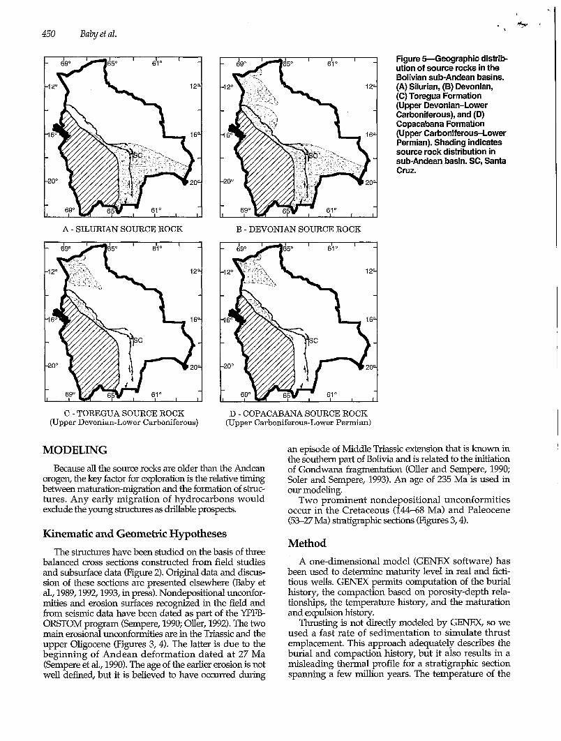
To describe the various source rocks fully, the Yacimientos Petroliferos Fiscales Bolivianos (YPFB) database has been used and augmented with new data collected by sampling outcrops and wells. The classic source rock of the Bolivian sub-Andean zone is the Devonian and probably the Silurian, but two other Paleozoic formations are believed to have some potential. Locally, an Upper Cretaceous source rock (Flora Formation) with limited potential is known in the northern sub-Andean zone.
Silurian The Silurian source rock, of Wenlockian-Prodolian
age (430410 Ma), reflects siliciclastic deposition on a marine platform. The Upper Silurian is known in the southern sub-Andean zone and foreland, in the central part, and in a small part of the northern sub-Andean zone, as shown in Figure 5A. Its thickness increases from north to south, where it is up to 1500 m thick. The few samples available to us do not permit a detailed evalua- tion or even a confirmation of the original petroleum potential of this interval. Nevertheless, marine type II source rock characteristics are used for the modeling procedure to quantify the maturity of a hypothetical Silurian source rock.
Devonian The Devonian succession is Lochkovian-Famenian in
age (410-360 Ma). Its depositional setting was essentially the same as during the Late Silurian (marine platform deposition). Its thickness increases toward the south, where it is 1500 m thick south of the Boomerang. Its regional distribution is shown in Figure 5B. The basin extends northward into Peru and southward into Argentina and Paraguay. The Devonian has been eroded to the northeast; the age of erosion is discussed later. Source rocks include the Tomachi and Tequeje forma- tions in the north and the Iquiri and Limoncito forma- tions in the central part of the basin.
We have not found immature Devonian samples and, consequently, have not determined the kinetic parame ters. Since the depositional environments of the Tomachi and Iquiri formations are the same as the Retama Formation of Carboniferous age, the type Retama section described below is used to model the Upper Devonian source rocks. The Tequeje and Limoncito formations

1000 m
Petroleum Systenz ofthe Northern and Central Bolivian Sub-Andean Zone
N S
7 40 km CAMBRIAN
PRECAMBRIAN
449
Figure Wedimentary wedge of the Boomerang area, in the central sub-Andean zone. The two main erosional unconformi- ties (Triassic and upper Oligocene) and the two prominent nondepositional unconformities (Cretaceous and Paleocene) are also present in this region. See Figure 1 for location.
(Middle-Lower Devonian) correspond to more distal deposits, therefore classic marine type II kerogen charac- teristics have been chosen for the modeling.
Retama Formation The shaly beds of the lower Retama Formation of
Carboniferous age, also called Toregua Formation, show reasonably good potential. Deposition started in the late Famenian (360 Ma) and may have continued to the Visean (327 Ma). The Toregua Formation, corresponding to siliciclastic deposits of a marine platform, is an alterna- tion of shaly and sandy beds which form the potential reservoirs. This formation is present in the Madre de Dios basin and in the northern sub-Andean belt (Figure 5C). It is about 500 m thick.
Retama source rock potential has been proven in the Pando-X1 well (Madre de Dios basin). The total organic carbon (TOC) content exceeds 2 wt. % over a 100-m interval, with a hydrogen index (HI) of more than 600 mg HC/g. All of the shaly beds have some potential (TOC > 1 wt. %).
Kinetic parameters have been determjned on a sample from the Pando-X1 well (HI = 660 mg HC/g and T,, = 445°C) using OPTIUN software (Espitalié et al., 1985).
This T,, value is relatively high, and the maturity level of this sample is not certain. Nevertheless, Rock-Eva1 pyrolysis of old source rocks, such as Devonian source rocks in Algeria, commonly show high Tmax values on immature samples (C. Ducreux, 1993, personal commu- nication). Optical data show a vitrinite reflectance value of 0.5%, which confirms the immaturity of this sample. On this basis, we use the computed kinetic parameters for the modeling.
Copacabana Formation The Copacabana Formation of Permian age is a
marine platform succession formed by an alternation of shallow water (50-m) limestone, shale, and sandstone. Deposition began in the Stephanian (307 Ma) and continued to the Early Permian (270 Ma). It is present in the Madre de Dios basin, in the northern sub-Andean belt, and to a lesser extent in the central zone (Figure 5D). Where it has not been eroded, it is up to 800 m thick.
Rock-Eval pyrolysis confirms the petroleum potential of this formation. Recorded TOC values vary from 1 to 9 wt. %, and the maximum HI is about 440 mg HC/g. Unfortunately, we have insufficient data to define the true thickness of the active source rock interval.
450 Baby et al.
A - SILURIAN SOURCE ROCK B - DEVONIAN SOURCE ROCK
C - TOREGUA SOURCE ROCK (Upper Devonian-Lower Carboniferous)
D - COPACABANA SOURCE ROCK (Upper Carboniferous-Lower Permian)
MODELING Because all the source rocks are older than the Andean
orogen, the key factor for exploration is the relative timing between maturation-migration and the fomtion of struc- tures. Any early migration of hydrocarbons would exclude the young structures as drillable prospects.
Kinematic and Geometric Hypotheses The structures have been studied on the basis of three
balanced cross sections constructed from field studies and subsurface data (Figure 2). Original data and discus- sion of these sections are presented elsewhere (Baby et al., 1989,1992,1993, in press). Nondepositional unconfor- mities and erosion surfaces recognized in the field and from seismic data have been dated as part of the YPFB- ORSTOM program (Sempere, 1990; Oller, 1992). The two main erosional unconformities are in the Triassic and the upper Oligocene (Figures 3, 4). The latter is due to the beginning of Andean deformation dated at 27 Ma (Sempere et al., 1990). The age of the earlier erosion is not well defined, but it is believed to have occurred during
Figure Weographic distrib- ution of source rocks in the Bolivian sub-Andean basins. (A) Silurian, (B) Devonian, (C) Toregua Formation (Upper Devonian-Lower Carboniferous), and (D) Copacabana Formation (Upper Carboniferous-Lower Permian). Shading indicates source rock distribution in sub-Andean basin. SC, Santa Cruz.
an episode of Middle Triassic extension that is known in the southern part of Bolivia and is related to the initiation of Gondwana fragmentation (Oller and Sempere, 1990; Soler and Sempere, 1993). An age of 235 Ma is used in our modeling.
Two prominent nondepositional unconformities occur in the Cretaceous (144-68 Ma) and Paleocene (53-27 Ma) stratigraphic sections (Figures 3,4).
Method A one-dimensional model (GENEX software) has
been used to determine maturity level in real and ficti- tious wells. GENEX permits computation of the burial history, the compaction based on porosity-depth rela- tionships, the temperature history, and the maturation and expulsion history.
Thrusting is not directly modeled by GENEX, so we used a fast rate of sedimentation to simulate thrust emplacement. This approach adequately describes the burial and compaction history, but it also results in a misleading thermal profile for a stratigraphic section spanning a few million years. The temperature of the

- ~ _ _ _ ~~ ~-
c u
Petroleum System of the Northem and Central Bolivian Sub-Andean Zone 451 I
sw ANT. LLlQUlMUNl
ANGOSTO NE SNIA. PELADO QUIQUIBEY SNIA. CHINE SNIA FATIMA SNIA. EVA EVA
PRESENT DAY EVA EVA-1 Oil EVA EVA-2
EVA EVA-3 Oil & Gas CENOZOIC B O Y A - i
MESOZOIC BOYA-2 Gas CARBONIFEROUS
DEVONIAN-ORDOVICIAN PELADO-1 PERMIAN
CAMBRIAN-PRECAMBRIAN PELADO-2
FICTITIOUS WELLS QU IQUIBEY
L Q M - 1
I B I LQM-2
PRE-ANDEAN DEFORMATION
Figure 6-Oil and gas windows in the Lliquimuni balanced cross section. (A) Present day and (B) pre-Andeamdeformation.
deposited sediment is assumed to be constant during the sedimentation process, in contrast to the overthrust sediments, which were already heated. There are two ways to overcome this problem. One can either impose a steady-state solution or artificially increase the surface temperature to simulate a temperature closer to that of the overthrust sediments.
When a steady-state solution is imposed, the relax- ation time is zero. The error resulting from active thrusting is mainly a function of the thrust tluckness and the rate of thrusting. The relationship of this error to the rate of thrusting has been calculated (Endignoux and Wolf, 19901, showing that the error is negligible for normal rates of horizontal displacement. In this study, the uncertainties about the timing of thrust emplacement are so large (a few million years) that it would be inap- propriate to use a more sophisticated approach.
Because thermal data are scare, an average heat flow of 55 mW/m2 has been used for the modeling. No rifting phase has been included. Neither do we have enough data to describe heat flow variations through time. A constant value for the basal heat flow is thus used. There are also uncertainties regarding the amount of Triassic erosion as well as the burial history. These constraints, especially for Silurian and Early Devonian maturation, limit us to a qualitative interpretation.
Maturation has been calculated using kinetic para- meters derived from the Pando well (type Retama) for the Toregua Formation and the Upper Devonian section
and default marine type II characteristics for the Lower- Middle Devonian and Silurian. The maturation of this kerogen is slower than a classic type II kerogen (e.g., Toarcian of the Paris basin in GENEX), resulting in an estimated oil window 800 m deeper than the default value for a gradient of about 25"C/km.
With GENEX software, the expelled quantities are calculated as a function of the saturation in the source rock. An expulsion threshold is defined by the user (Forbes et al., 1991). When the saturation is less than this value, there is no expulsion. An arbitrary value of 15% has been used in this study.
RESULTS
Northern Sub-Andean Zone: Lliquimuni Cross Section
Geometry The northem part of the sub-Andean zone is underex-
plored, with only four wells having been drilled. One of these (LQM-X1) is included on the balanced cross section (Figure 6) and another is located on the Boya trend, 50 km south of the section. The 235-Ma erosional event appears to have stripped up to 800 m of section. Late Oligocene erosion (27 Ma) was more limited; 100 m of erosion is inferred for the missing section.
1
o -
1 y
s2: 5 ; &E
- -
4 y
6
452 Baby et al.
u) .- B HC WINDOWS c
1 i , ¡ , I 1 1
- .- I
i l i l I l I l
\ 400 4 0 6 0 400 3$0 3d0 2$0 200 li0 100 60 O
COPACABANA 0.m. Copacabana
ROCK-EVAL HYDROGEN INDEX
6
B Hydrogen Index S 2 m C (mg HC/g initial TOC)
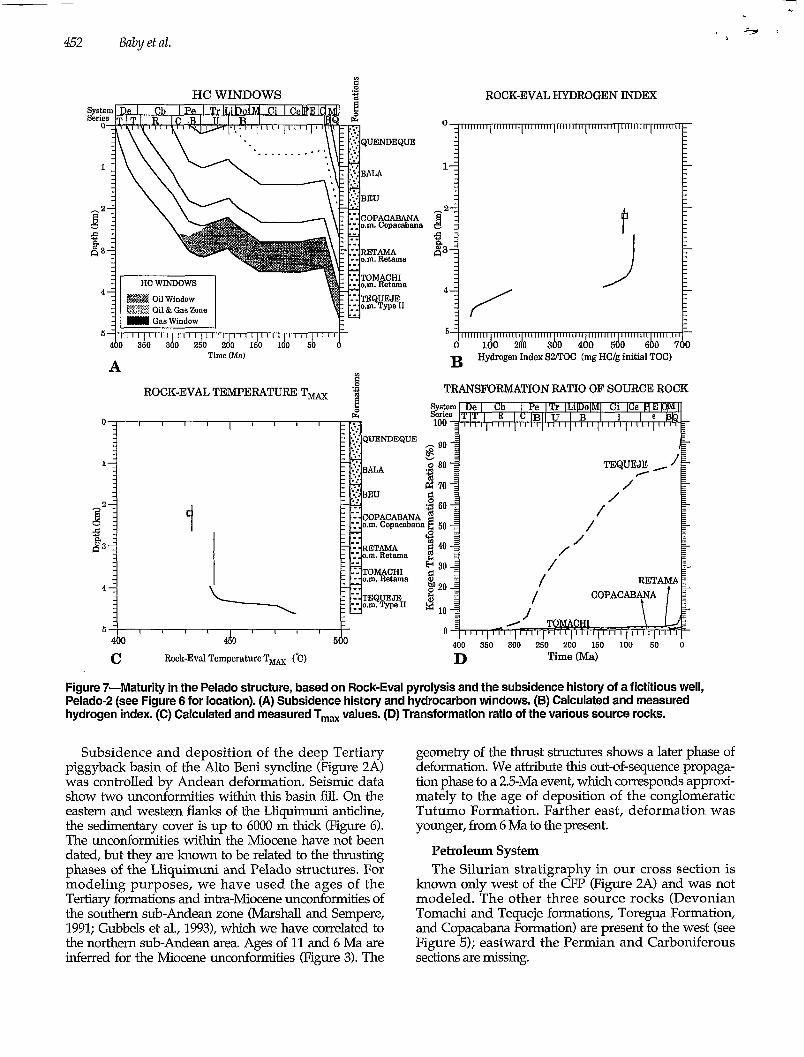
Figure 7-Maturity in the Pelado structure, based on Rock-Eva1 pyrolysis and the subsidence history of a fictitious well, Pelado-2 (see Figure 6 for location). (A) Subsidence history and hydrocarbon windows. (B) Calculated and measured hydrogen index. (C) Calculated and measured Tmax values. (D) Transformation ratio of the various source rocks.
Subsidence and deposition of the deep Tertiary piggyback basin of the Alto Beni syncline (Figure 2A) was controlled by Andean deformation. Seismic data show two unconformities within this basin fill. On the eastern and western flanks of the Lliquimuni anticline, the sedimentary cover is up to 6000 m thick (Figure 6). The unconformities within the Miocene have not been dated, but they are known to be related to the thrusting phases of the Lliquimuni and Pelado structures. For modeling purposes, we have used the ages of the Tertiary formations and intra-Miocene unconformities of the southern sub-Andean zone (Marshall and Sempere, 1991; Gubbels et al., 1993), which we have correlated to the northern sub-Andean area. Ages of 11 and 6 Ma are inferred for the Miocene unconformities (Figure 3). The
geometry of the thrust structures shows a later phase of deformation. We attribute this out-of-sequence propaga- tion phase to a 2.5-Ma event, which corresponds approxi- mately to the age of deposition of the conglomeratic Tutumo Formation. Farther east, deformation was younger, from 6 Ma to the present.
Petroleum System The Silurian stratigraphy in our cross section is
known only west of the CFP (Figure 2A) and was not modeled. The other three source rocks (Devonian Tomachi and Tequeje formations, Toregua Formation, and Copacabana Formation) are present to the west (see Figure 5); eastward the Permian and Carboniferous sections are missing.
Peetrolmm System of the Northern aiid Centual Bolivian Sub-Andean Zone 453
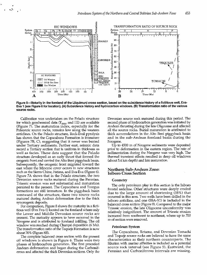
Figure &Maturity in the foreland of the Lliquimuni cross section, based on the subsidence history of a fictitious well, Eva- Eva 1 (see Figure 6 for location). (A) Subsidence history and hydrocarbon windows. (B) Transformation ratio of the various source rocks.
Calibration was undertaken on the Pelado structure for which geochemical data (Tma and HI) are available (Figure 7). The maturation index, especially for the Paleozoic source rocks, remains low along the western anticlines. On the Pelado structure, Rock-Eval pyrolysis has shown that the Copacabana Formation is immature (Figures 7B, C), suggesting that it never was buried under Tertiary sediments. Farther east, seismic data record a Tertiary section that is uniform in thickness as well as facies. These data suggest that the Pelado structure developed as an early thrust that formed the orogenic front and carried the Alto Beni piggyback basin. Subsequently, the orogenic front migrated toward the east where the Miocene cover ocms in new structures such as the Sierra Chine, Fatima, and Eva-Eva (Figure 6). Figure 7A shows that in the Pelado structure, the two Devonian source rocks matured during the Permian. Triassic erosion was not substantial and maturation persisted to the present. The Copacabana and Toregua formations are still immature. In the piggyback basin westward of the structure, these two source rocks matured during Andean deformation due to the thick synorogenic deposits.
For comparison, Figure 8 shows the maturity in a ficti- tiom well (Eva Eva-1) located on the foreland where only the Lower and Middle Devonian source rocks are present. The maturity appears to have occurred in the Neogene and is attributed to foreland infilling. The oil window was reached during Charqui deposition (6 Ma). The transformation ratio of the Tequeje Formation is now about 70% (Figure 8B).
The complete balanced cross section with the present oil windows is shown in Figure 6. There were two phases of hydrocarbon generation. The first preceded Andean deformation and began during the Carbonif- erous and affected the thick Devonian sections. Only the
Devonian source rock matured during this period. The second phase of hydrocarbon generation was initiated by Andean thrusting during the late Oligocene and affected all the source rocks. Burial maturation is attributed to thick accumulations in the Alto Beni piggyback basin and in the sub-Andean foreland basin during the Neogene.
Up to 4500 m of Neogene sediments were deposited prior to deformation in the eastern region. The rate of sedimentation during the Neogene was very high. The thermal transient effects resulted in deep oil windows (about 5.4 km depth) and late maturation.
Northern Sub-Andean Zone: Isiboro Cross Section
Geometry The only petroleum play in this section is the Isiboro
frontal anticline. Other structures were deeply eroded due to the large amount of shortening (58%) that o c m e d in this area. Two wells have been drilled in the Isiboro anticline, and one (SSA-X1) is included in the balanced cross section (Figure 9). Compared to the major Triassic erosion, the late Oligocene unconformity was relatively insigruficant. The amount of Triassic erosion increased from southwest to northeast, where up to 700 m of section were removed.
Petroleum System The Copacabana, Retama, and Devonian Tomachi
and Tequeje source rocks are believed to have the same characteristics as their northern counterparts. The Silurian with marine affinities is included as a potential source rock interval (see Figure 5). Eastward, the Permian and Carboniferous intervals are missing.

454 Baby et al.
1s. 2 IS. 3
I b '. 1
FICTITIOUS WELLS
Figure M i l and gas window in the lsoboro balanced cross section. (A) Present day and (B) predndean deformation.
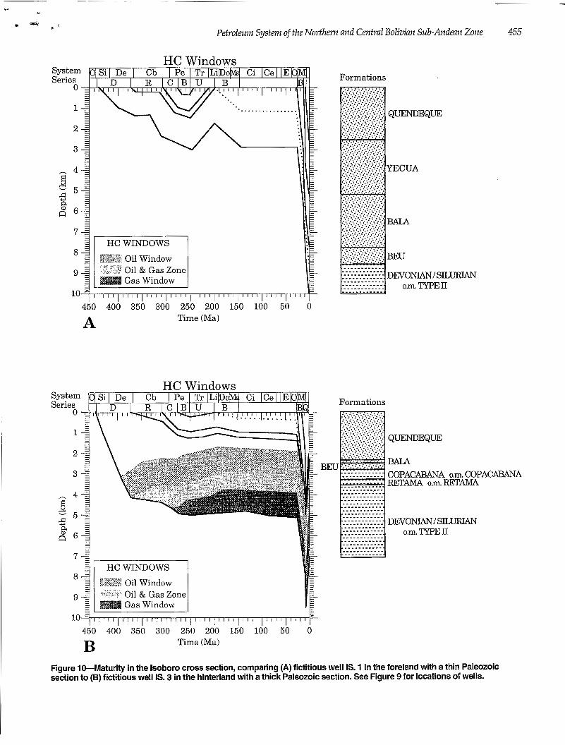
Figure 10 shows a comparison between the maturity along the edge of the external part of the preorogenic basin (well IS. 1) and along its internal part where the Devonian section is thick (well IS. 3).
Two phases of hydrocarbon generation occurred. Figure 9 shows the source rocks that were matured before and during Andean deformation. Maturation of the Silurian and Devonian sections started during the Devonian in the internal part where the Paleozoic is very thick (up to 4000 m). Toward the east, burial resulted from foreland deposition that was contemporaneous with Andean deformation. As in the Lliquimuni cross section, the oil window is relatively deep (up to 5 km) due to the large amount of sedimentation.
Central Sub-Andean Zone: Boomerang Cross Section
Geometry This cross section spans the principal hydrocarbon
province of Bolivia. It is well constrained by subsurface seismic data and by the Santa Rosa X2 and San Juan X2 wells (Figure 11). The Boomerang zone is formed by the deformed border of the Paleozoic sedimentary wedge. Well data permit quantification of late Oligocene erosion;
the Upper Cretaceous section was thinned to about 300 m. Triassic erosion was substantial and removed at least 2 km of Paleozoic deposits.
Petroleum System The Copacabana and Toregua formations are missing
(Figure 5). We used two source rocks in our model: the Devonian (Limoncito and Iquiri formations) and the Silurian. Rock-Eva1 data from the Santa Rosa X2 well record a Tm of about 440°C in the Limoncito Formation, which corresponds to the beginning of the oil window for this type of organic matter (Retama kinetic parameters). The subsidence and maturity measured and calculated on the San Juan X2 well are shown %Figure 12.
Figure 11 sullunarizes these maturation results on the balanced cross section, showing present-day and pre- Andean oil windows. Even before Andean deformation, the Silurian and Lower-Middle Devonian source rocks were mature. Maturation started at the beginning of the Carboniferous and expulsion was completed by the end of the Carboniferous. No structural traps are known for this period, thus limiting exploration opportunities to stratigraphic plays. These source rocks are now in the gas window. During the Andean deformation, only the Upper Devonian section entered the oil window.
c. 4r
1 "; K ¿
Petroleum System of the Northem and Central Bolivian Sub-Andean Zone
HC Windows
.................
&sk-*i Oil Window
lo? 1 1 1 1 1 1 1 1 1 1 1 1 1 1 1 ~ 1 1 1 1 I I I I I I I l I I I I I I 1 I I I I I I I l Il7 450 400 350 300 250 200 150 100 50 O
Time (Ma) A
HC Windows System Series
O
1
Oil & Gas Zone
10
450 400 350 300 250 200 150 100 50 0 Time (Ma) B
Formations
Formations
Figure 10-Maturity in the lsoboro cross section, comparing (A) fictitious well IS. 1 in the foreland with a thin Paleozoic section to (B) fictitious well IS. 3 in the hinterland with a thick Paleozoic section. See Figure 9 for locations of wells.

456
BOOM. 1 BOOM. 2 BOOM. 3
Baby et al.
FICTITIOUS WELLS
A
BOOM.3 BOOM.2 BooM.1 NE SAN JuAN-x2 SANTA ROSA-=
sw
PRESENT, DAY CENOZOIC MESOZOIC
CAMBRIAN-PRECAMBRIAN DEVONIAN-SILURIAN-ORDOVICIAN Oil window
Oil & Gas zone
CARBONIFEROUS
- i * - Gaswindow
I
PRE-ANDEAN DEFORMATION r5 B I
I-- 15 10 km -
Figure 11-Oil and gas windows in the Boomerang balanced cross section. (A) Present day and (B) pre-Andean deformation.
FINAL GAS TO OIL RATIO The present proven reserves show that the sub-
Andean zone, and especially the Boomerang area, are mainly gas prone. AU the major fields (Carasco, Katari, Palometa, Santa Rosa, Sirari, Vivora, and Yapacani) produce gas and condensate. Nevertheless, the source rocks are of marine origin and not gas prone. We attribute this to the very low initial potential of the source rock. Any oil generated has not yet been expelled but rather remains in the source rock where burial and matu- ration continue. Lighter compounds are formed and migrate into the Andean structures.
CONCLUSIONS In the northern and central sub-Andean zone of
Bolivia, the propagation of the orogenic front was guided by the northern boundary of the Paleozoic sedimentary wedge. In the Boomerang area, this boundary is oriented obliquely to the regional shortening and it controlled the
development of a prominent transfer zone. To the north, the thrusts are wider and the amount of shortening increases. The western part of the northem sub-Andean zone is characterized by a thick Tertiary piggyback basin fill.
Geochemical analysis documents four source rocks in the Paleozoic sedimentary wedge: the Retama Formation (Upper Devonian-Lower Carboniferous), the Copaca- bana Formation (Upper Carboniferous-Lower Permian), the Devonian deposits (410-360 Ma), and probably the Silurian section (430410 Ma). Specific kinetic parameters for the Retama Formation show a later maturation compared to other marine type II source rocks. Our modeling emphasizes two phases of hydrocarbon
generation. The first occurred from the Devonian to Carboniferous due to deepening of the Paleozoic basin. Hydrocarbons expelled before the Triassic are believed to have filled stratigraphic traps. Because of the absence of structures and widespread erosion, most of these hydrocarbons have probably been lost. The second phase of maturation is attributed to burial by Tertiary deposi- tion in the foreland and piggyback basins.

- ~~ ~~~~ ~
Petroleum System of the Northern and Central Bolivian Sub-Andean Zone 457
I 4 o o
o
HC Windows System Series
0 -
System Series
O
. . . . . . . . . . .
b
450 400 350 300 250 200 150 100 50 O
HC WINDOWS
$;2$ ;" Oil Window Oil & Gas Zone Gas Window
*y<xY+MA
450 400 350 300 250 200 150 100 50 O
B Time (Ma)
Formations
Formations
TERTIARY
CAJONES ICHOA
Figure 124ubsidence and maturity in the San Juan X2 well (see Figure 11 for location). (A) Burial history and hydrocarbon windows. (B) Hydrogen index versus depth.

458 Baby et al.
Acknowledgments This study resulted from a research convention between YPFB, ORSTOM, and GP. We thank C. Dzicreux ( B E K I P ) for the Rock-Eva1 analyses and kinetic parameters and J. L. Pittion (Total) for the geochemical reszilts interpretation. GENEX is an IFP commercial product marketed by BEICIP. We thank Jim Maloney, Mike Perkins, and mi anonymous reviewer for their comments on an earlim version of this manuscript.
REFERENCES CITED
Baby, P., G. Hérail, J. M. López, O. López, J. Oller, J. Pareja, T. Sempere, and D. Tufiño, 1989, Structure de la zone Subandine de Bolivie: influence de la géométrie des séries sédimentaires antéorogéniques SUT la propagation des chevauchements: Comptes Rendus de l'Académie des Sciences de Paris, Série II, 309, p. 1717-1722.
Geometric and kinematic evolution of passive roof duplexes deduced from cross section balancing: example from the foreland thrust system of the Southern Bolivian subandean zone: Tectonics, v. 11, p. 523-536.
Zubieta, and M. Specht, 1993, Structural synthesis of the Bolivian Subandean zone, in International Symposium on Andean Geodynamics: Orstom, Série "Colloques et Sémi- naires," p. 159-162.
Baby, P., M. Specht, J. Oller, G. Montemurro, B. Colletta, and J. Letouzey, in press, The Boomerang-Chapare transfer zone (recent oil discovery trend in Bolivia): structural interpreta- tion and experimental approach, in F. Rome, ed., Special Publication, EAPG Congress, Moscow: Paris, Editions Technip.
Endignoux, L., and S. Wolf, 1990, Thermal and kinematic evolution of thrust basins: a 2D numerical model, in J. Letouzey, ed., Petroleum and tectonics in mobile belts: Paris, Editions Technip, p. 181-192.
Espitalié, J., G. Deroo, and F. Marquis, 1985. La pyrolyse Rock-Eval et ses applications: revue de l'Institut Français du Petrole: v. 40, p. 563-579 and 755-784.
Forbes, P., P. Ungerer, A. KU~~LIS, F. Riis, and S. Enggen, 1991, Compositional modeling of petroleum generation and expulsion: AAPG Bulletin, v. 75, p. 873-893.
Gubbels, T. L., B. L. backs, and E. Farrar, 1993, High-level surfaces, plateau uplift, and foreland development, Bolivian central Andes: Geology, v. 21, p. 695-698.
Marshall, L. G. ,and T. Sempere, 1991, The Eocene to Pleis- tocene vertebrates of Bolivia and their stratigraphic context: a review, in Fósiles y Facies de Bolivia (1) : Revista Técnica de YPFB (Santa Cruz), v. 12 p. 631-652.
Oller, J., 1992, Cuadro chronoestratigrafico de Bolivia: m p u b lished YPFB document, Santa Cruz, Bolivia.
Oller, J., and T Sempere, 1990, A fluvio-eolian sequence of probable Middle Triassic-Jurassic age in both Andean and Subandean Bolivia, in International Symposium on Andean Geodynamics: Orstom, Série "Colloques et Sémi- naires," p. 237-240.
Roeder, D., 1988, Andean-age structure of Eastern Cordillera (Province of La Paz, Bolivia): Tectonics, v. 5, p. 2339.
Sempere, T., 1990, Cuadros estratigráficos de Bolivia: prop uestas nuevas: Revista Técnica de YPFB (Santa Cruz), v. 11,
Baby, P., G. Hérail, R. Salinas, and T. Sempere, 1992,
Baby, P., B. Gidlier, J. Oller, G. Herail, G. Montemurro, D.
p. 215-227.
c
Sempere, T., G. Hérail, J. Oller, and M. G. Bonhomme, 1990, Late Oligocene-early Miocene major tectonic crisis and related basins in Bolivia: Geology, v. 18, p. 946-949.
Sheffels, B., 1988, Structural constraints on crustal shortening in the Bolivian Andes: Ph.D. dissertation, Massachusetts Institute of Technology, Cambridge, 170 p.
shortening in the central Bolivian Andes: Geology, v. 18, Sheffels, B., 1990, Lower bound on the amount of crustal
p. 812-815. Soler, P., and T. Sempere, 1993, Stratigraphie, géochimie et
sigrufication paléotectonique des roches volcaniques basiques mésozoïques des Andes Boliviennes: Comptes Rendus de l'Académie des Sciences de Paris, 316, Série II, p. 777-784.
Authors' Mailing Addresses P. Baby ORSTOM Laboratoire de Géodynamique des Chaînes Alpines 15, rue Maurice Gignoux 38031 Grenoble France
I. Moretti IFP, BP 311 92305 Rueil Malmaison France
B. Guillier ORSTOM AP. 17 11 06596 Quito Ecuador
R. Limachi E. Mendez WFB C.P. 1659 Santa Cmz Bolivia
J. Oller Petrolex C.P. 3969 Santa Cruz Bolivia
M. Specht Total Cedex 47 92509 Paris-La Defense France