paving the way - frontier group · paving the way • marypirg foundation 7 o ver the past several...
TRANSCRIPT

Pavingthe Way
How Highway Construction HasContributed to Sprawl in Maryland
MaryPIRG Foundation

Pavingthe Way
How Highway Construction HasContributed to Sprawl in Maryland
Brad Heavner
MaryPIRG Foundation
November 2000

ACKNOWLEDGEMENTSThe MaryPIRG Foundation gratefully acknowledges the Maryland Department of Planningand the Maryland State Highway Administration for providing the data which made this reportpossible. Special thanks to Colleen Glennon, Feng Liu, Eric Weller, and Paul Dorsey at thoseagencies for their assistance. Thanks also to Richard Weingroff of the Federal HighwayAdministration.
William Coyne performed much of the numerical and mapping work for this report. Kim Ericsonand Lea Johnston were instrumental in developing the project. Kristen Forsyth (1000 Friendsof Maryland), George Maurer (Chesapeake Bay Foundation), Dan Shawhan (MaryPIRG), andSusan Rakov (Frontier Group) provided editorial review. The work of Dan Pontious (BaltimoreRegional Partnership) was invaluable in the conception, development, production, and reviewof the report. Dan Shawhan and Gigi Kellett also aided in production. Thanks to Kalia Rork(Coyote Communications) for layout.
This report was supported by the Surdna Foundation, Town Creek Foundation, the Abell Foun-dation, the Tides Foundation, the Beldon Fund, and the Clayton Baker Trust.
The author alone bears responsibility for any factual errors. The recommendations are those of MaryPIRG.The views expressed in this report do not necessarily reflect the views of our funders.
© 2000 MaryPIRG Foundation
The MaryPIRG Foundation is a 501(c)(3) organization dedicated to protecting the environ-ment, the rights of consumers, and good government in Maryland. The Foundation’s compan-ion organization, the Maryland Public Interest Research Group, founded in 1973, has 5,000members throughout the state and a student chapter at the University of Maryland’s CollegePark campus.
For more information about MaryPIRG and the MaryPIRG Foundation, please contact us at:
3121 Saint Paul Street, Suite 26Baltimore, MD 21218(410) 467-0439
Or visit our Web site at www.marypirg.org.
For additional copies of this report, send $20 (including shipping) to the address above.
Printed on recycled paper.

EXECUTIVE SUMMARY 5
INTRODUCTION 7
PART ONE: CENTRAL MARYLAND 9
A. HIGHWAY CORRIDORS ARE MORE DEVELOPED THAN NON-CORRIDORS 9B. HIGHWAYS CAME BEFORE DEVELOPMENT 9C. SPRAWL BY COUNTY 10
Montgomery County 12Frederick County 13Howard County 15Prince George’s County 15Anne Arundel County 17Baltimore County 17
PART TWO: EASTERN SHORE 19
A. US-50 CONSTRUCTION 19B. BRIDGE EXPANSION 20C. SPRAWLING CITIES 22
Ocean City 22Salisbury 23Cambridge 24Easton 25
D. CORRIDOR VS. NON-CORRIDOR AREAS 25
PART THREE: FUTURE DEVELOPMENT 26
METHODOLOGY 30
APPENDIX: HIGHWAY CONSTRUCTION DATES 32
NOTES 33
LIST OF TABLESTable 1: Property Development After Highway Construction 9Table 2: Amount of Development in Highway Corridors vs. Non-Corridor Areas 10Table 3: Post-Highway Development in Montgomery County 13Table 4: Post-Highway Development in Frederick County 13
TABLE OF CONTENTS
Paving the WayHow Highway Construction Has Contributed to Sprawl in Maryland
4 MaryPIRG Foundation • Paving the Way
Table 5: Highway Construction in Montgomery, Howard, and Frederick Counties 15Table 6: Post-Highway Development in Prince George’s County 17Table 7: Post-Highway Development in Anne Arundel County 17Table 8: Bridge Expansion and Eastern Shore Property Development 20Table 9: Eastern Shore Property Development and Statewide Population 20Table 10: Ocean City Area Property Development 22Table 11: Salisbury Area Property Development 23Table 12: Cambridge Area Property Development 24Table 13: Eastern Shore Corridor vs. Non-Corridor Development 25Table 14: Bridge Expansion and US-50 Corridor Development 25
LIST OF FIGURESFigure 1: Washington, D.C. Area Land Use 11Figure 2: Baltimore Area Land Use 11Figure 3: Montgomery County Properties Built Before and After Adjacent Segment of Highway 12Figure 4: Frederick County Properties Built Before and After Adjacent Segment of Highway 14Figure 5: Howard County Properties Built Before and After Adjacent Segment of Highway 14Figure 6: Growth in Montgomery, Howard, and Frederick Counties 15Figure 7: Land Use in Prince George’s County, 5-20 Miles from Washington, D.C. 16Figure 8: Prince George’s County Properties Built Before and After Adjacent Segment of Highway 16Figure 9: Anne Arundel County Properties Built Before and After Adjacent Segment of Highway 18Figure 10: Baltimore County Properties Built Before and After Adjacent Segment of Highway 18Figure 11: Land Use in Queen Anne’s, Talbot, and Dorchester Counties 19Figure 12: Eastern Shore Highway Construction and Property Development Rates 19Figure 13: Eastern Shore Property Development and Statewide Population 21Figure 14: Property Development on the Eastern Shore vs. Central Maryland 21Figure 15: Land Use in Wicomico, Somerset, and Worcester Counties 22Figure 16: Ocean City Area 22Figure 17: Ocean City Area Property Development 23Figure 18: Salisbury Area 23Figure 19: Cambridge Area 24Figure 20: Property Development in Cambridge Area Waterfront 24Figure 21: Easton Area 25Figure 22: Easton Area Property Development 25Figure 23: Highway Projects in Study and under Construction 27
TABLE OF CONTENTS (CONT’D)

Paving the Way • MaryPIRG Foundation 5
H ighway construction has been akey factor creating sprawl in Mary-land. Data shows that highways
were built not so much to serve the needsof existing communities and alleviate traf-fic for a stable population, but rather haveallowed migration outward from the cit-ies. They have been the cause of sprawlmore than a solution to congestion.
An analysis of all developed residentialand commercial properties in CentralMaryland and the Eastern Shore in rela-tion to all major highways indicates thathighways act as magnets for development.
The first indicator of this effect is thatmost of the properties lining highwayswere built after the highways had alreadybeen laid. That is, the highways were notbuilt where people lived and worked asmuch as people moved to where the high-ways were built. 75% of the state’s high-ways were built in the 1950s and 1960s.This was followed by the period with thehighest drop in population in Baltimoreand Washington in the 1970s and theperiod of the highest rate of propertydevelopment in the 1970s and 1980s.1
80% of properties within the highwaycorridors of Central Maryland were builtwhen a highway already existed withinfive miles. In the areas served by only oneor two highways, where the effect of thosehighways is easier to measure, thesetrends are most clear:
• In Montgomery County, 93% of alldeveloped properties within fivemiles of I-270 and beyond thebeltway were built after the adjacentsection of the highway was built.After highway construction, propertywas developed in the highwaycorridors 67% faster than in the restof the county.
• In Howard County, 94% of alldeveloped properties in the highwaycorridors had a highway within fivemiles when the properties weredeveloped.
• In Frederick County, 83% of alldeveloped properties in the highwaycorridors had a highway within fivemiles when the property was devel-oped. Land in the highway corridorshas been developed at a rate threetimes faster than in non-corridorareas since the highways were built.2
The second indicator is the fact thathighway corridors are more developedthan areas beyond the immediate vicin-ity of the highways. In the area surround-ing Baltimore 5-20 miles from the city,54% of the land in the corridors is devel-oped, not including roads, while 39% ofnon-corridor land is developed. Sur-rounding Washington, 61% of the corri-dor is developed, compared to 40% of thenon-corridor area. This difference islarger in the areas farther out from thecities, suggesting that highways play agreater role in the sprawling develop-ments at the suburban fringe than theydo in the areas immediately surroundingthe cities.
Given the existence of the highways,it is certainly preferable to have develop-ment in the highway corridors rather thanscattered throughout the outlying re-gions. But it appears that without thehighways, less development would havebeen drawn outward from the cities intothe outlying regions.
This growth is not simply a functionof population pressures. In Montgomery,Howard, and Frederick Counties, duringthe last five years of the highway build-ing boom in those counties and the fiveyears following, the rate of property de-velopment increased sharply as the rateof population growth decreased sharply.
On the Eastern Shore, where one high-way dominates the transportation system,we see an even clearer correlation betweenperiods of highway and bridge construc-tion and periods of increased rates ofproperty development. Each of the ma-jor highway improvements — original
EXECUTIVE SUMMARY
The highwayswere not builtwhere peoplelived andworked asmuch aspeople movedto where thehighways werebuilt.

6 MaryPIRG Foundation • Paving the Way
Given thestrong
evidenceindicating thathighways have
helped toinduce the
current state ofsprawl in
Maryland,future highwayprojects should
be examinedwith a
critical eye.
construction of Route 50, expansion ofthe Bay Bridge, and the Reach the Beachpackage of transportation projects — ap-pear to have spurred property develop-ment on the Eastern Shore. Looking onlyat development surrounding the four big-gest cities on the Eastern Shore, rates ofdevelopment were highest during periodsof local highway construction and theperiods of highway improvements affect-ing the entire region.
There are certainly many factors whichhave contributed to sprawl in Maryland.Local zoning policies, water and sewageinfrastructure, suburban tax incentives,and other policies have all done their partto shape development in the state. Theinfluence of highways on sprawl, how-ever, largely transcends policy differencesamong local jurisdictions. Given thestrong evidence indicating that highwayshave helped to induce the current stateof sprawl in Maryland, future highwayprojects should be examined with a criti-cal eye for their tendency to exacerbatethe problem.
While positive steps have been taken tocurb sprawl and promote “Smart Growth”in Maryland, massive highway construc-tion projects continue to consume largeamounts of taxpayer dollars in the state’s
transportation plans. Highway projects inthe state’s six-year transportation planalready under development carry pricetags totaling over $4.3 billion. The 20-yearplan for the Baltimore region containsover $2.7 billion in highway projects. Thejustification for many of these projects is“to handle expected future traffic needs”and “relief of future congestion in areasof planned future development” in out-lying regions.3
If state and county planners are seri-ous about curbing sprawl, they must re-duce their emphasis on constructing newand wider highways in a futile attempt torelieve traffic congestion and a misguidedeffort to serve sprawling development inMaryland’s outer areas. If the mobility ofMarylanders is truly to be enhanced overthe next twenty years and beyond, countyland use planners and state transporta-tion planners must work together in newways. They must focus on providing effi-cient and affordable public transit andsteer new development into communitieswhere people can accomplish at leastsome of their work, shopping, entertain-ment, and school trips through walking,bicycling, and transit, rather than beingforced by sprawling land use patterns torely solely on their cars.
Paving the Way • MaryPIRG Foundation 7
O ver the past several years sprawlhas emerged as one of the mosthigh-profile quality of life issues
facing the state of Maryland. Residentsof Maryland’s outer suburbs increasinglysee their communities encroached uponand crowded by new subdivisions. Ruralresidents see farmlands and open spacesbulldozed and watch new houses springup like mushrooms after a summer rain.Maryland’s urban anchor, Baltimore City,and increasingly its inner suburbs andthose of Washington, D.C., suffer theconsequences as middle class residentsflee to these new developments in theouter suburbs and rural areas.
Some measures designed to curb thisproblem are beginning to take effect, pri-marily Governor Parris Glendening’s1997 Smart Growth legislative package.That package’s Rural Legacy program hasalready used state dollars to preserve32,000 acres of rural farmland across thestate.4 The state has also implementedanother Smart Growth measure designedto focus state development investmentsin urban and planned “priority fundingareas,” or “smart growth areas.”
Highway and transportation develop-ment, however, has thus far escaped thor-ough scrutiny for its impacts on runawaysprawl and urban divestment. Conse-quently, the concept of highway-inducedsprawl is not currently driving Maryland’stransportation debate. Rather, state andregional transportation plans are weightedheavily toward highway projects, andbusiness and highway-building interestshave raised concerns to state policy mak-ers that more money needs to be madeavailable for highway construction.
The Contribution ofHighways to SprawlThere are many factors which have ledto the current pattern of development inMaryland. We cannot forget that subur-ban towns wanted growth to increase
their tax base, and consciously encour-aged sprawl with their tax and zoningpolicies. Unfortunately, they were oftenmore generous with the tax incentivesthan was in their best interests in the longrun, as most suburban developments havenot paid their own way to cover all thecosts of the increased burden on city ser-vices and infrastructure. Many plannershave also recently concluded that the lowdensity residential patterns they favoredfor so long are not as desirable as oncethought, as problems like loss of openspace, diminished sense of community,dependence on cars, traffic congestion,and degraded air quality begin to out-weigh the benefits of large backyards.
But sprawl is more than a problem oflocal zoning policies. It has also been en-couraged by the state and federal govern-ments through their massive spending onhighways.
Recent research nationally and in otherstates has shown that highway construc-tion often leads to increased developmentof previously undeveloped areas by pro-viding greater access to those areas.
• A 1999 report by the Georgia Con-servancy and the American FarmlandTrust found that “transportationpolicies have had a greater impact onthe direction of metropolitanAtlanta’s growth than any other.”They analyzed land prices to mea-sure the increased value to develop-ers of land near highways, andshowed that highway constructionincreased the value of land withinone mile of the highway by anaverage of $10,000 per acre.5
• A 2000 Brookings Institution reportfound that “changes in metropolitanpatterns are induced by highways.”They concluded that federal highwayfunding has constituted a subsidy tosuburban regions at the cost of urbancenters, leading to “less than optimalurban growth patterns.”6
INTRODUCTION

8 MaryPIRG Foundation • Paving the Way
Decades ofemphasis on
highwayexpansion must
be reversed.
• The Victoria Transport PolicyInstitute found in 1999 that “auto-mobile-oriented transportationincreases per capita land use by ...accommodating low-density devel-opment at the urban periphery(sprawl).” The report then exploredthe many costs of highways’ impactsto land use.7
While the sprawl-inducing effect ofhighways is accepted in planning theoryby most scholars and planners, debate inMaryland has lacked an analysis of con-crete data from this state. This study seeksto fill that gap.
The Lesson to Be LearnedThe transportation debate has tradition-ally been dominated by the question ofhow to alleviate traffic congestion, andthe approach of building more lanes andmore roads to accommodate the currenttraffic load is consistently at the top ofthe pile of competing visions. It is nowclear, however, that we cannot build ourway out of congestion. Increasing thecapacity of our roads facilitates yet moretrips, spreading out subsequent develop-ment and creating the need for more carsdriving more miles. An aggressive rate ofroad building exacerbates the very prob-lem it was intended to alleviate.
This is not a new phenomenon. Forthe past fifty years, highway developmenthas been a central cause of the auto de-pendent structure of our cities, towns, andsuburbs, not just the result of this struc-ture. Transportation projects, such ashighways, are not only undertaken in re-sponse to development, but our choicesin historic transportation projects havefundamentally shaped our land use anddevelopment patterns today. By approv-ing or funding certain transportationprojects, policy makers are significantlyinfluencing where tomorrow’s residentswill live and work.
This understanding should be as em-powering as it is accusatory. Since our
current state is significantly the result ofmassive government spending on trans-portation projects, changes in that spend-ing can help remedy historic ills.
Governor Glendening has taken thefirst steps toward reorienting transporta-tion priorities. He has canceled highwayprojects which do not pass smart growthsafeguards, and has made large increasesin state funding for public transit. Theseefforts are to be applauded, but there isstill a long way to go. Decades of empha-sis on highway expansion must be re-versed to the point where the principleresponse to increases in transportationand access needs is developing projectswhich provide greater availability ofhighway alternatives — such as publictransportation, pedestrian and bicycle fa-cilities, and urban design which createsmore walkable communities.
This must be a coordinated effort be-tween government bodies at all levels.After relying on highways to meet thebulk of our transportation needs for solong, the mutual stimulation betweenhighways and sprawl has tremendousmomentum. County land use plans as-sume continued highway expansion, andstate and regional transportation plansassume continued sprawl. To stem thisdestructive trend, state transportationplanners must work with local land useplanners, and local planners must workacross county lines, to complementchanges in transportation priorities withappropriate land use planning.

Paving the Way • MaryPIRG Foundation 9
W ith two major cities thirty milesapart, Central Maryland hasbeen vulnerable to sprawl
throughout the building booms of recentdecades. But historic transportation poli-cies have only added to this inherentlydifficult situation.
Instead of focusing on efficient and af-fordable public transit between the twocities, governments have spent big onhighways. Rather than investing in urbanrevitalization and new walkable commu-nities served by efficient transit, govern-ments have facilitated flight from thecities to auto-dependent suburbs. Poli-cies favoring these new suburbs havemade Central Maryland one of thenation’s most striking examples of run-away sprawl development. Millions ofacres of open space have been trans-formed into suburbs and subdivisions.
A. Highways CameBefore DevelopmentThe common intuitive understanding ofroad development is that roads are builtto serve the needs of populations thatneed to move between the places wherethey live, work, and shop. Many of ourhighways, however, did not evolve ac-cording to the needs of existing commu-nities. They were built before thosecommunities even existed, and to a largedegree determined where people wouldlive and where their employment andcommercial needs would be met.
Having easy access to other locationsmakes any property attractive to devel-opment. Before highways are built nearfarmland or open space, people withconnections to the cities are reluctant tobuy a home in a newly developed area,even if it offers more space at a lowercost than urban areas. Once rapid mo-bility is established, however, positivesoften outweigh negatives and the land isdeveloped.
PART ONE: CENTRAL MARYLAND
Table 1: Property DevelopmentAfter Highway Construction
Percentage of propertiesin highway corridorsbuilt after adjacent
segment of highway9County
Montgomery 89%Frederick 83%Howard 94%Carroll 68%Carroll — I-70 corridor 85%Baltimore 64%Baltimore — I-83 corridor 86%Prince George’s 66%Anne Arundel 75%
Certainly some Maryland highwayswere built to provide mobility for peoplewho already lived or worked along thecorridor of the highway. But most high-ways were there before the bulk of thedevelopment. 75% of the state’s highwayswere built in the 1950s and 1960s. Thiswas followed by the period with the high-est drop in population in Baltimore andWashington in the 1970s and the periodof the highest rate of property develop-ment in the 1970s and 1980s.8
Throughout Central Maryland, 80%of all properties in the highway corridorsalready had a highway within five milesor a beltway within three miles when theywere developed.
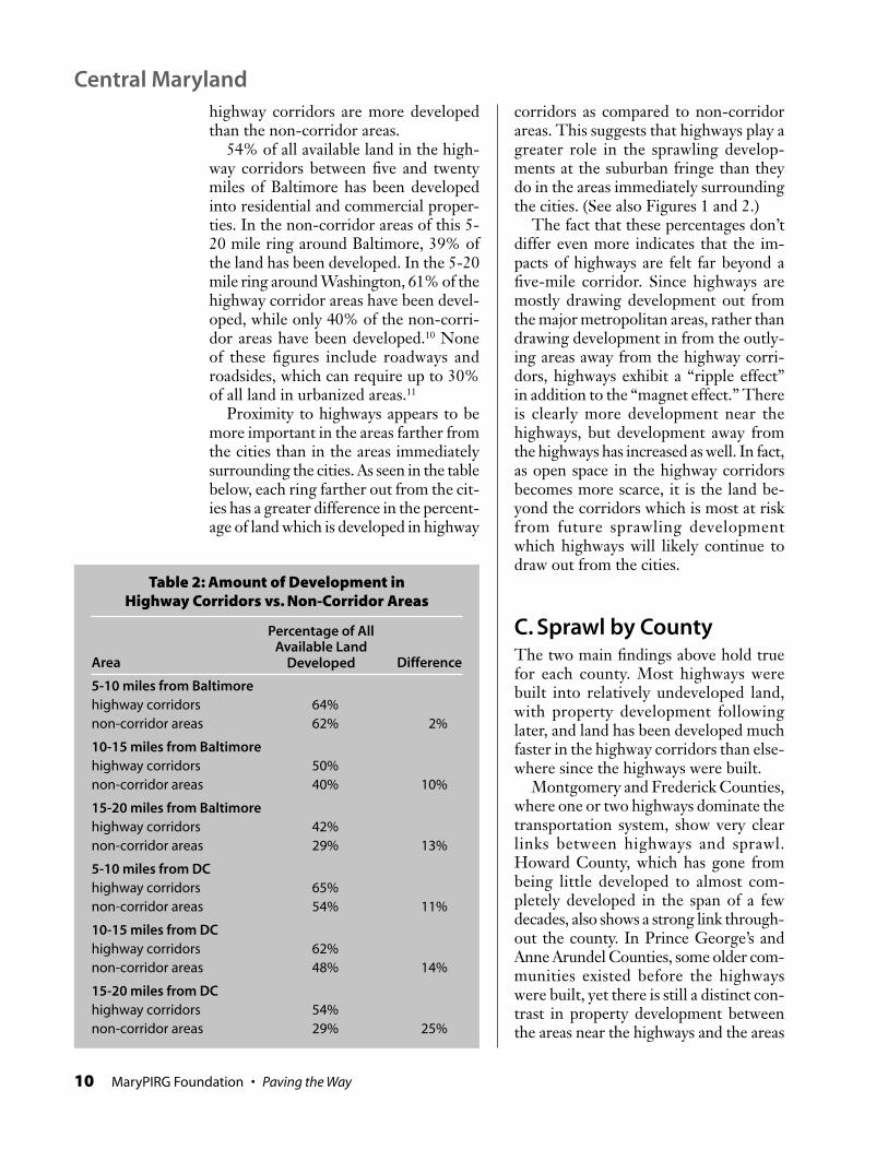
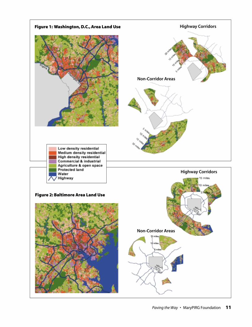
B. Highway CorridorsAre More Developedthan Non-CorridorsBuilding a highway impacts land far fromthe edge or the end of the highway, sinceany area is impacted by improved accessto the nearest major metropolitan area.Comparing the land near highways withareas that are not adjacent to a highway,however, we see that highways have amagnet effect. In Central Maryland, the
Policiesfavoring newsuburbs havemade CentralMaryland oneof the nation’smost strikingexamples ofrunaway sprawldevelopment.
10 MaryPIRG Foundation • Paving the Way
highway corridors are more developedthan the non-corridor areas.
54% of all available land in the high-way corridors between five and twentymiles of Baltimore has been developedinto residential and commercial proper-ties. In the non-corridor areas of this 5-20 mile ring around Baltimore, 39% ofthe land has been developed. In the 5-20mile ring around Washington, 61% of thehighway corridor areas have been devel-oped, while only 40% of the non-corri-dor areas have been developed.10 Noneof these figures include roadways androadsides, which can require up to 30%of all land in urbanized areas.11
Proximity to highways appears to bemore important in the areas farther fromthe cities than in the areas immediatelysurrounding the cities. As seen in the tablebelow, each ring farther out from the cit-ies has a greater difference in the percent-age of land which is developed in highway
corridors as compared to non-corridorareas. This suggests that highways play agreater role in the sprawling develop-ments at the suburban fringe than theydo in the areas immediately surroundingthe cities. (See also Figures 1 and 2.)
The fact that these percentages don’tdiffer even more indicates that the im-pacts of highways are felt far beyond afive-mile corridor. Since highways aremostly drawing development out fromthe major metropolitan areas, rather thandrawing development in from the outly-ing areas away from the highway corri-dors, highways exhibit a “ripple effect”in addition to the “magnet effect.” Thereis clearly more development near thehighways, but development away fromthe highways has increased as well. In fact,as open space in the highway corridorsbecomes more scarce, it is the land be-yond the corridors which is most at riskfrom future sprawling developmentwhich highways will likely continue todraw out from the cities.
C. Sprawl by CountyThe two main findings above hold truefor each county. Most highways werebuilt into relatively undeveloped land,with property development followinglater, and land has been developed muchfaster in the highway corridors than else-where since the highways were built.
Montgomery and Frederick Counties,where one or two highways dominate thetransportation system, show very clearlinks between highways and sprawl.Howard County, which has gone frombeing little developed to almost com-pletely developed in the span of a fewdecades, also shows a strong link through-out the county. In Prince George’s andAnne Arundel Counties, some older com-munities existed before the highwayswere built, yet there is still a distinct con-trast in property development betweenthe areas near the highways and the areas
Percentage of AllAvailable Land
Developed
Table 2: Amount of Development inHighway Corridors vs. Non-Corridor Areas
Area Difference
5-10 miles from Baltimorehighway corridors 64%non-corridor areas 62% 2%
10-15 miles from Baltimorehighway corridors 50%non-corridor areas 40% 10%
15-20 miles from Baltimorehighway corridors 42%non-corridor areas 29% 13%
5-10 miles from DChighway corridors 65%non-corridor areas 54% 11%
10-15 miles from DChighway corridors 62%non-corridor areas 48% 14%
15-20 miles from DChighway corridors 54%non-corridor areas 29% 25%
Central Maryland
Paving the Way • MaryPIRG Foundation 11
Highway Corridors
Non-Corridor Areas
Highway Corridors
Non-Corridor Areas
Figure 1: Washington, D.C., Area Land Use
Figure 2: Baltimore Area Land Use

12 MaryPIRG Foundation • Paving the Way
without any nearby highways. In Balti-more County, property development hasfollowed the highway into the northernpart of the county, but the area has notbeen developed as much as most highwaycorridors due to other limiting factors.
Montgomery CountyThe sprawling suburbs north of Wash-ington in Montgomery County knowncollectively as the technology corridorwere spurred largely by construction ofI-270, which linked the area to the cityin 1954 & 1958. Before the highway wasbuilt, there were very few commercial orresidential properties there. Since con-struction of the highway, the area hasbecome the very picture of sprawl. Thehighway was already there when 93% ofall currently developed properties in theI-270 corridor were built, not includingthe five miles nearest Washington.
In addition to the I-270 corridor, thereare several areas around the edges ofMontgomery County which fall withinthe corridors of highways in other coun-ties. I-70 passes within one mile of the
northern tip of the county, I-95 followsthe southeastern border of the countywithin a mile, and parts of MD-32 arefour miles from the northeastern border.Including these areas, 89% of all proper-ties in Montgomery County highwaycorridors more than five miles fromWashington were built since an adjacentsection of highway was in place.
Since construction of the highways,30% of the available land in the highwaycorridors has been developed, as opposedto 18% in the rest of the county, consti-tuting a 67% faster rate of developmentin the highway corridors. (See Table 3.)
The concentration of growth in the I-270corridor was intentionally encouraged bythe county's “Wedges and Corridors”growth strategy. This strategy has clearlybeen preferable to unplanned, scattereddevelopment, and has allowed the countyto designate 90,000 acres as protectedagricultural and rural open space. Whilean aggressive rate of highway construc-tion and expansion seems to have drawndevelopment outward from Washington,the county has reduced the impacts onopen space through its zoning policies.
Central Maryland
Figure 3: Montgomery County Properties BuiltBefore and After Adjacent Segment of Highway

Paving the Way • MaryPIRG Foundation 13
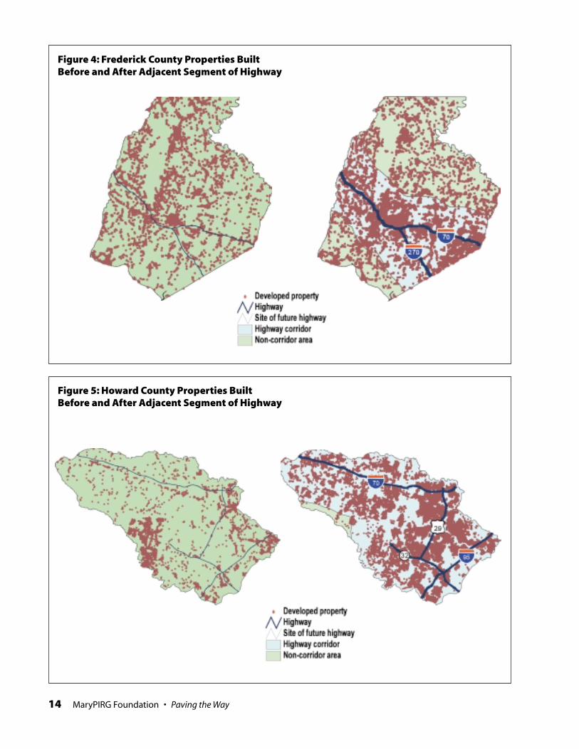
Frederick CountyBefore the construction of I-270 and I-70,Frederick County was an area very dis-tinct from Baltimore and Washington.Since these highway were built, thecounty has increasingly been suburb-anized as commuters have chosen to buildhomes there. (See Figure 4.)
Since the highways in FrederickCounty were built, the rate of develop-ment within the highway corridors has
been three times higher than in the restof the county. In fact, Frederick Countyhas the highest difference between cor-ridor and non-corridor development af-ter highway construction among allCentral Maryland counties. This furtherdemonstrates that highways are a biggerfactor for the sprawling development far-ther out from the major metropolitanareas than they are for the more densedevelopment near the cities.
Highway Corridors 167,765 31,201 9,724 126,840 37,432 30%
Non-Corridor Areas 121,029 22,900 3,952 94,177 16,625 18%
Table 3: Post-Highway Development in Montgomery County (acres)
Tota
l Are
a
Pro
tect
ed L
and
Acr
es D
evel
op
edB
efo
re A
dja
cen
tH
wy.
Seg
men
t
Ava
ilab
le L
and
Aft
er H
wy.
Co
nst
ruct
ion
Acr
es D
evel
op
edA
fter
th
e A
dja
cen
tH
wy.
Seg
men
t
Perc
enta
ge
of T
ota
lA
vaila
ble
Lan
dD
evel
op
ed A
fter
Hw
y. C
on
stru
ctio
n
Tota
l Are
a
Pro
tect
ed L
and
Acr
es D
evel
op
edB
efo
re A
dja
cen
tH
wy.
Seg
men
t
Ava
ilab
le L
and
Aft
er H
wy.
Co
nst
ruct
ion
Acr
es D
evel
op
edA
fter
th
e A
dja
cen
tH
wy.
Seg
men
t
Perc
enta
ge
of T
ota
lA
vaila
ble
Lan
dD
evel
op
ed A
fter
Hw
y. C
on
stru
ctio
n
Table 4: Post-Highway Development in Frederick County (acres)
Highway Corridors 197,516 20,433 10,722 166,361 40,603 24%
Non-Corridor Areas 231,771 40,473 11,197 180,101 14,919 8%
14 MaryPIRG Foundation • Paving the Way
Figure 4: Frederick County Properties BuiltBefore and After Adjacent Segment of Highway
Figure 5: Howard County Properties BuiltBefore and After Adjacent Segment of Highway
Paving the Way • MaryPIRG Foundation 15
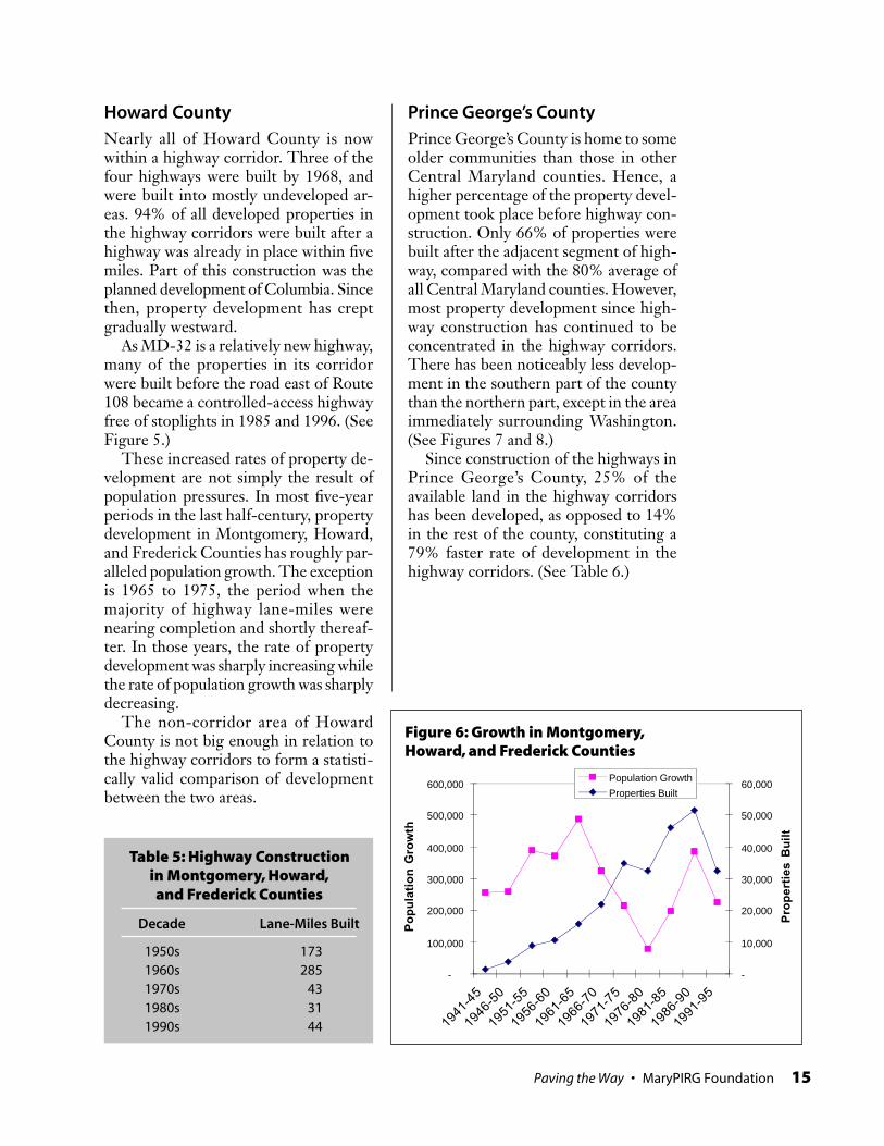
Howard CountyNearly all of Howard County is nowwithin a highway corridor. Three of thefour highways were built by 1968, andwere built into mostly undeveloped ar-eas. 94% of all developed properties inthe highway corridors were built after ahighway was already in place within fivemiles. Part of this construction was theplanned development of Columbia. Sincethen, property development has creptgradually westward.
As MD-32 is a relatively new highway,many of the properties in its corridorwere built before the road east of Route108 became a controlled-access highwayfree of stoplights in 1985 and 1996. (SeeFigure 5.)
These increased rates of property de-velopment are not simply the result ofpopulation pressures. In most five-yearperiods in the last half-century, propertydevelopment in Montgomery, Howard,and Frederick Counties has roughly par-alleled population growth. The exceptionis 1965 to 1975, the period when themajority of highway lane-miles werenearing completion and shortly thereaf-ter. In those years, the rate of propertydevelopment was sharply increasing whilethe rate of population growth was sharplydecreasing.
The non-corridor area of HowardCounty is not big enough in relation tothe highway corridors to form a statisti-cally valid comparison of developmentbetween the two areas.
-
100,000
200,000
300,000
400,000
500,000
600,000
1941
-45
1946
-50
1951
-55
1956
-60
1961
-65
1966
-70
1971
-75
1976
-80
1981
-85
1986
-90
1991
-95
Po
pu
lati
on
Gro
wth
-
10,000
20,000
30,000
40,000
50,000
60,000P
rop
ert
ies
Bu
ilt
Population Growth
Properties Built
Figure 6: Growth in Montgomery,Howard, and Frederick Counties
Prince George’s CountyPrince George’s County is home to someolder communities than those in otherCentral Maryland counties. Hence, ahigher percentage of the property devel-opment took place before highway con-struction. Only 66% of properties werebuilt after the adjacent segment of high-way, compared with the 80% average ofall Central Maryland counties. However,most property development since high-way construction has continued to beconcentrated in the highway corridors.There has been noticeably less develop-ment in the southern part of the countythan the northern part, except in the areaimmediately surrounding Washington.(See Figures 7 and 8.)
Since construction of the highways inPrince George’s County, 25% of theavailable land in the highway corridorshas been developed, as opposed to 14%in the rest of the county, constituting a79% faster rate of development in thehighway corridors. (See Table 6.)
Table 5: Highway Constructionin Montgomery, Howard,and Frederick Counties
Decade Lane-Miles Built
1950s 1731960s 2851970s 431980s 311990s 44

16 MaryPIRG Foundation • Paving the Way
Central Maryland
Figure 8: Prince George’s County Properties BuiltBefore and After Adjacent Segment of Highway
Figure 7: Land Use in Prince George’s County,5–20 Miles from Washington, D.C.

Paving the Way • MaryPIRG Foundation 17
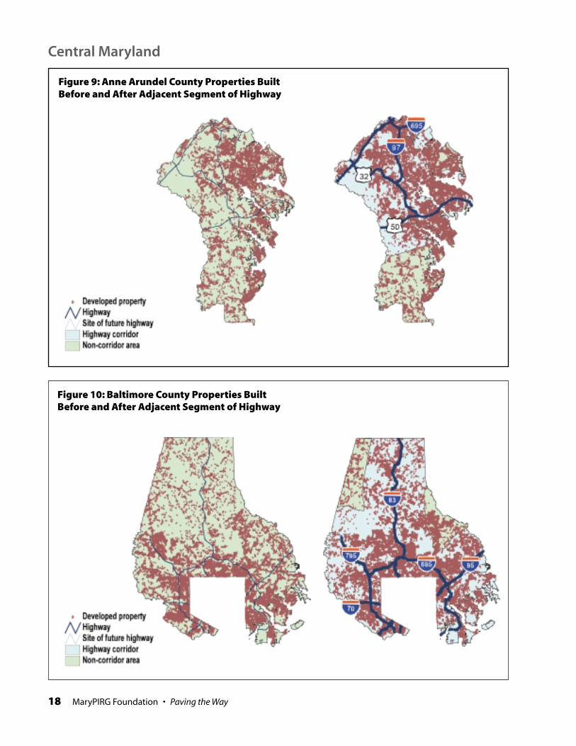
Anne Arundel County75% of Anne Arundel properties werebuilt after the adjacent segment of high-way. Since this is lower than the 80% av-erage of all Central Maryland counties,this suggests that highways were built intoareas that had already been somewhat de-veloped, as compared to the surround-ing counties. However, as the most of thecounty’s lane-miles were built much laterthan in other counties, we might expectthis difference to be even greater. The factthat there is only a 5% difference indi-cates that even newer highways spur in-creased development. (See Figure 9.)
Nearly as much property developmenthas taken place in the non-corridor areasas in the highway corridors since high-way construction in this county. As themap demonstrates, however, most of thisnon-corridor area development was onthe north coast and on the peninsulasouth of Annapolis (beyond the tip of
I-97). There has been relatively little de-velopment in the large area throughoutthe southern section of the county whichis not reached by highways.
Baltimore CountyThere is less sprawl along the I-83 corri-dor in northern Baltimore County thanin other highway corridors, most likelydue to the strict zoning policies of theBaltimore County Department of Plan-ning. But there is evidence that the de-velopment that has taken place there hasbeen spurred by the highway. 86% of theproperties in the I-83 corridor beyond thebeltway were built after the adjacent sec-tion of highway. (See Figure 10.)
The non-corridor areas of BaltimoreCounty are not big enough in relation tothe highway corridors to form a statisti-cally valid comparison of developmentbetween the two areas.
Tota
l Are
a
Pro
tect
ed L
and
Acr
es D
evel
op
edB
efo
re A
dja
cen
tH
wy.
Seg
men
t
Ava
ilab
le L
and
Aft
er H
wy.
Co
nst
ruct
ion
Acr
es D
evel
op
edA
fter
th
e A
dja
cen
tH
wy.
Seg
men
t
Perc
enta
ge
of T
ota
lA
vaila
ble
Lan
dD
evel
op
ed A
fter
Hw
y. C
on
stru
ctio
n
Table 6: Post-Highway Development in Prince George’s County (acres)
Highway Corridors 95,771 24,071 20,363 51,337 12,849 25%
Non-Corridor Areas 141,573 21,793 10,714 109,066 15,688 14%To
tal A
rea
Pro
tect
ed L
and
Acr
es D
evel
op
edB
efo
re A
dja
cen
tH
wy.
Seg
men
t
Ava
ilab
le L
and
Aft
er H
wy.
Co
nst
ruct
ion
Acr
es D
evel
op
edA
fter
th
e A
dja
cen
tH
wy.
Seg
men
t
Perc
enta
ge
of T
ota
lA
vaila
ble
Lan
dD
evel
op
ed A
fter
Hw
y. C
on
stru
ctio
n
Table 7: Post-Highway Development in Anne Arundel County (acres)
Highway Corridor 189,800 26,611 23,087 140,102 42,358 30%
Non-Corridor Areas 84,937 11,687 15,274 57,976 15,371 27%
18 MaryPIRG Foundation • Paving the Way
Figure 9: Anne Arundel County Properties BuiltBefore and After Adjacent Segment of Highway
Figure 10: Baltimore County Properties BuiltBefore and After Adjacent Segment of Highway
Central Maryland
Paving the Way • MaryPIRG Foundation 19
Maryland’s Eastern Shore, the flatcoastal plain between Chesa-peake Bay and the Atlantic
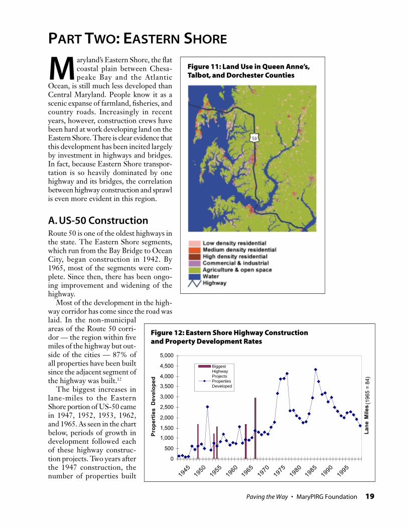
Ocean, is still much less developed thanCentral Maryland. People know it as ascenic expanse of farmland, fisheries, andcountry roads. Increasingly in recentyears, however, construction crews havebeen hard at work developing land on theEastern Shore. There is clear evidence thatthis development has been incited largelyby investment in highways and bridges.In fact, because Eastern Shore transpor-tation is so heavily dominated by onehighway and its bridges, the correlationbetween highway construction and sprawlis even more evident in this region.
A. US-50 ConstructionRoute 50 is one of the oldest highways inthe state. The Eastern Shore segments,which run from the Bay Bridge to OceanCity, began construction in 1942. By1965, most of the segments were com-plete. Since then, there has been ongo-ing improvement and widening of thehighway.
Most of the development in the high-way corridor has come since the road waslaid. In the non-municipalareas of the Route 50 corri-dor — the region within fivemiles of the highway but out-side of the cities — 87% ofall properties have been builtsince the adjacent segment ofthe highway was built.12
The biggest increases inlane-miles to the EasternShore portion of US-50 camein 1947, 1952, 1953, 1962,and 1965. As seen in the chartbelow, periods of growth indevelopment followed eachof these highway construc-tion projects. Two years afterthe 1947 construction, thenumber of properties built
PART TWO: EASTERN SHORE
Figure 11: Land Use in Queen Anne’s,Talbot, and Dorchester Counties
0
500
1,000
1,500
2,000
2,500
3,000
3,500
4,000
4,500
5,000
19451950
19551960
19651970
19751980
19851990
1995
Pro
pe
rtie
s D
ev
elo
pe
d
La
ne
Mil
es
(196
5 =
84)
BiggestHighwayProjectsPropertiesDeveloped
Figure 12: Eastern Shore Highway Constructionand Property Development Rates

20 MaryPIRG Foundation • Paving the Way
jumped to four times the rate of thepreceding years. The 1952-53 construc-tion was followed by a short spurt ofgrowth in which the rate of developmentdoubled in two years. Four years after the1962-65 construction phase, the rate ofdevelopment tripled over a three-yearperiod.13
B. Bridge ExpansionExpansion of the US-50 bridge acrossChesapeake Bay in 1973 provided a fur-ther boost to the rate of development ofproperties on the Eastern Shore of Mary-land. Looking at the properties in thehighway corridor between the four townsalong US-50 on the Eastern Shore, wesee that development jumped uponbridge expansion.
Although the whole state has beengrowing steadily in past decades, the East-ern Shore has absorbed a disproportion-ate share of the property developmentsince expansion of the bridge. The great-est disparity between the rate of EasternShore property development and state-wide population growth occurred duringconstruction of the second span of theBay Bridge and in the first two years itput into service.
Maryland’s population in 1970 was 9%higher than five years earlier. In 1975, this
Eastern Shore
1955 1960 1965 1970 1975 1980 1985 1990 1995
Growth inPropertyDevelopmentPopulationGrowth
Figure 13: Eastern Shore PropertyDevelopment and Statewide Population
Table 8: Bridge Expansionand Eastern Shore
Property Development
21–25 years before 4%
16–20 years before 4%
11–15 years before 5%
6–10 years before 6%
1–5 years before 7%
1–5 years after 12%
6–10 years after 8%
11–15 years after 17%
16–20 years after 15%
21–25 years after 14%
Time Period inReference to
BridgeExpansion
Percentage ofTotal
PropertiesBuilt

Paving the Way • MaryPIRG Foundation 21
Figure 14: Property Development onthe Eastern Shore vs. Central Maryland
-
500
1,000
1,500
2,000
2,500
3,000
3,500
4,000
4,500
1967
1968
1969
1970
1971
1972
1973
1974
1975
1976
1977
1978
1979
1980
1981
Ea
ste
rn S
ho
re
-
5,000
10,000
15,000
20,000
25,000
Ce
ntr
al
Ma
ryla
nd
EasternShore
CentralMaryland
Table 9: Eastern Shore Property Development and Statewide Population
1950 13,142 2,355,000
1955 15,213 16% 2,742,000 16%
1960 18,116 19% 3,113,000 14%
1965 21,737 20% 3,600,000 16%
1970 25,970 19% 3,923,897 9%
1975 33,307 28% 4,139,096 5%
1980 40,606 22% 4,216,975 2%
1985 46,885 15% 4,413,071 5%
1990 56,730 21% 4,797,431 9%
1995 65,070 15% 5,023,650 5%
Year
Number ofDeveloped
Properties onEastern Shore
PercentageChange
MarylandPopulation
PercentageChange
had fallen to 5% growth over five years.At the same time, the rate of property de-velopment on the Eastern Shore rosefrom 19% over five years in 1970 to 28%in 1975. (See Figure 13 and Table 9.)
Expansion of the Bay Bridge appearsto have given a boost to Eastern Shoredevelopment in comparison with devel-opment in Central Maryland. While1970-73, the time of bridge construction,was a period of growth in both Central
Maryland and the Eastern Shore, devel-opment increased more rapidly on theEastern Shore. In Central Maryland, theincrease was sharply reversed in the fol-lowing two years, returning to 4% abovethe 1970 level of development in 1975.On the Eastern Shore, the developmentboom was sustained past 1973. Only in1980 did Eastern Shore developmentreach another low point, when it bot-tomed out at 14% above the 1970 level.

22 MaryPIRG Foundation • Paving the Way
C. Sprawling CitiesThe areas surrounding each of the fourcities on Maryland’s Eastern Shore —Easton, Cambridge, Salisbury, and OceanCity — have seen considerable growth inthe past fifty years. Easton has spread outin all directions, new development aroundCambridge has sprung up to the east oftown along the Choptank River, Salisburyhas grown rapidly, and suburbs have de-veloped out of farmland near Ocean City.In each of these cases, jumps in the rateof development coincided with majorhighway and bridge construction projectswhich increased the accessibility of thecities.
Ocean CityMassive residential developments andstrip shopping centers have sprung up inrecent years in the area surroundingOcean City. Land that was open spacebefore the bridge expansion has been dugup for low density residential neighbor-
Eastern Shore
Figure 16: Ocean City Area
Table 10: Ocean CityArea Property Development
Properties PercentagePeriod Built Change
1951–55 91
1956–60 227 149%
1961–65 278 22%
1966–70 324 17%
1971–75 934 188%
1976–80 1128 21%
1981–85 1738 54%
1986–90 2185 26%
1991–95 2453 12%
hoods. In the eight miles beyond OceanCity, outside of city limits, only 20% ofthe current development existed in 1972.Ten years later, nearly twice as manyproperties were developed. In the five-year period surrounding the opening ofthe second span of the Bay Bridge, thenumber of properties developed nearlytripled from the previous five-year period.
From 1987–91, Governor WilliamDonald Schaefer oversaw a major high-way improvement program on the East-ern Shore known as “Reach the Beach.”The effort included the construction ofinterchanges and overpasses in place of
Figure 15: Land Use in Wicomico,Somerset, and Worcester Counties

Paving the Way • MaryPIRG Foundation 23
Figure 17: Ocean City AreaProperty Development
traffic signals, replacing drawbridges withuninterrupted bridges, and halting tollson the westbound span of the Bay Bridge.The program was designed to give tour-ists from Central Maryland better accessto the Maryland coast, but it appears alsoto have encouraged developers to buildhomes in the new suburbs around OceanCity. From 1986–89, at the same time asthe Reach the Beach effort, the rate ofproperty development rose 170%. It thenfell back to just short of double the 1986rate and has remained at that level since.
SalisburyDevelopment surrounding Salisbury hasspread in all directions as highway im-provements have been made. While muchof the development in the cities of Salis-bury and Fruitland and within one mileof city limits has existed for over thirtyyears, properties in the four miles fartherout from the towns are much newer.
The two fastest growth periods in theSalisbury area correspond with majorhighway improvement projects. From1971–75, as the second span of the BayBridge was being constructed and shortlythereafter, the rate of property develop-ment nearly doubled from the previousfive-year period. From 1986–90, as theReach the Beach improvements were be-ing made, property development aroundSalisbury jumped 123%.
Figure 18: Salisbury Area
Table 11: Salisbury Area PropertyDevelopment
Properties PercentagePeriod Built Change
1961–65 316
1966–70 445 41%
1971–75 863 94%
1976–80 866 0%
1981–85 565 -35%
1986–90 1259 123%
1991–95 928 -26%
24 MaryPIRG Foundation • Paving the Way
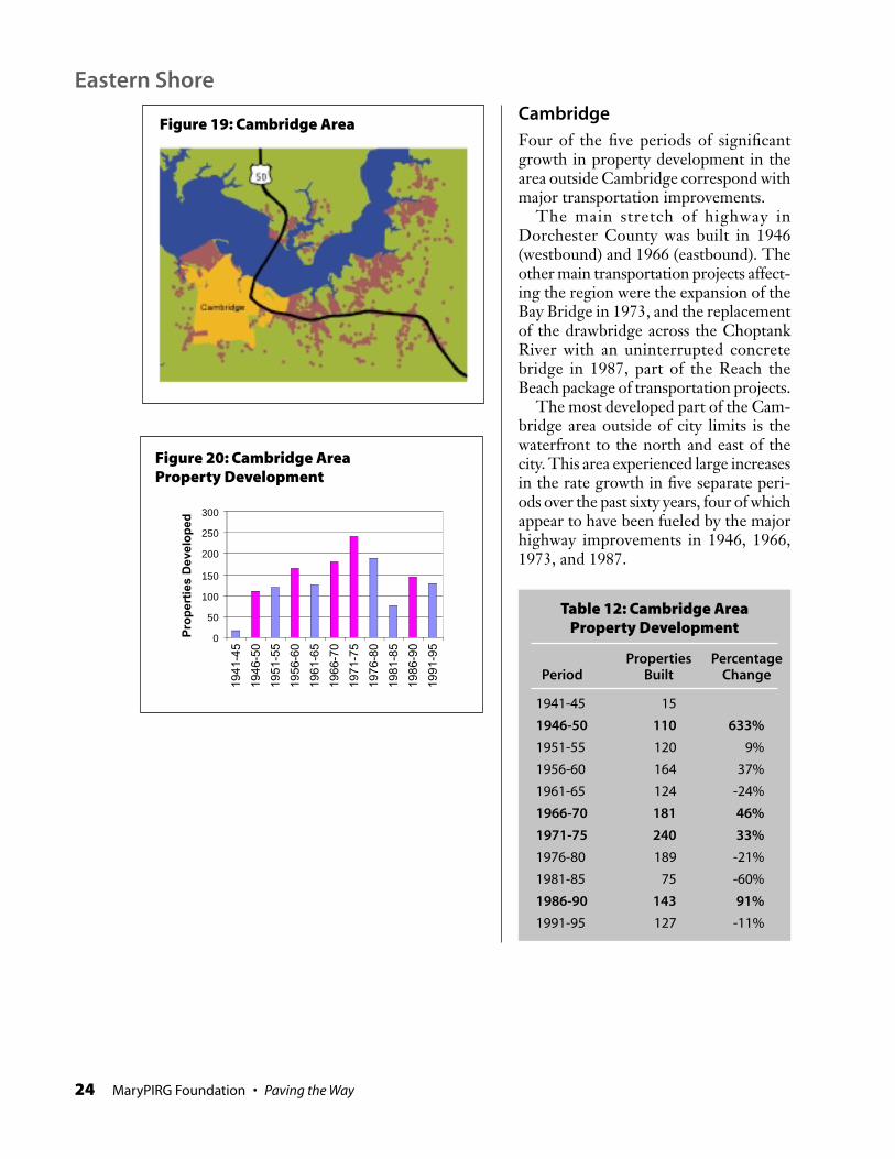
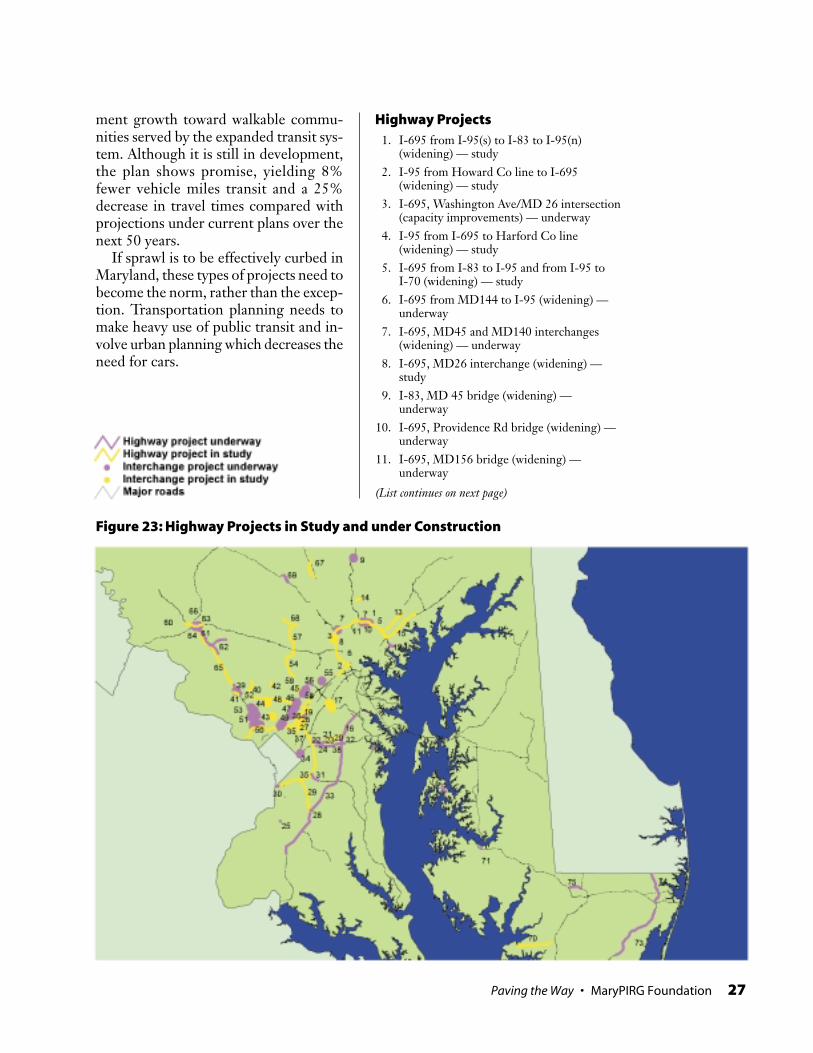
CambridgeFour of the five periods of significantgrowth in property development in thearea outside Cambridge correspond withmajor transportation improvements.
The main stretch of highway inDorchester County was built in 1946(westbound) and 1966 (eastbound). Theother main transportation projects affect-ing the region were the expansion of theBay Bridge in 1973, and the replacementof the drawbridge across the ChoptankRiver with an uninterrupted concretebridge in 1987, part of the Reach theBeach package of transportation projects.
The most developed part of the Cam-bridge area outside of city limits is thewaterfront to the north and east of thecity. This area experienced large increasesin the rate growth in five separate peri-ods over the past sixty years, four of whichappear to have been fueled by the majorhighway improvements in 1946, 1966,1973, and 1987.
Eastern Shore
Figure 19: Cambridge Area
Table 12: Cambridge AreaProperty Development
Properties PercentagePeriod Built Change
1941-45 15
1946-50 110 633%
1951-55 120 9%
1956-60 164 37%
1961-65 124 -24%
1966-70 181 46%
1971-75 240 33%
1976-80 189 -21%
1981-85 75 -60%
1986-90 143 91%
1991-95 127 -11%
Figure 20: Cambridge AreaProperty Development
0
50
100
150
200
250
300
1941
-45
1946
-50
1951
-55
1956
-60
1961
-65
1966
-70
1971
-75
1976
-80
1981
-85
1986
-90
1991
-95
Pro
per
ties
Dev
elo
ped

Paving the Way • MaryPIRG Foundation 25
EastonBoth of the major highway constructionprojects in Talbot County — in 1947 and1962 — appear to have spurred buildingbooms in the area five miles around theCity of Easton. Three years after the 1947construction, the number of propertiesjumped five-fold. After the 1962 con-struction, development in this area rose50% in two years.
D. Corridor vs.Non-Corridor AreasAfter the bridge expansion, more devel-opment took place in the US-50 high-way corridor than the non-corridor areasof the Eastern Shore. Excluding con-struction within the municipalities, 66%of properties in the highway corridorwere built since 1973, while only 54% ofproperties in non-corridor areas weredeveloped after the bridge expansion.
Also, the corridor is currently moredeveloped than the non-corridor areas.22% of the land in the corridor of Route50 outside the cities is developed (not in-cluding roadways and roadside areas).This is double the 11% development innon-corridor regions of the surroundingcounties.
Figure 21: Easton Area
Table 13: Eastern Shore Corridorvs. Non-Corridor Development
Non-Corridor Corridor
Area in Acres 537,179 1,170,911
Protected Acres 58,492 172,510
Developable Acres 478,687 998,401
Developed Acres 106,116 107,306
% Total Area Developed 22.2% 10.7%
Table 14: Bridge Expansion andUS-50 Corridor Development
Total 40,499 29,704
Total since bridge expansion 26,552 66% 15,973 54%
Pro
per
ties
Bu
ilt in
Hig
hw
ay C
orr
ido
r
Perc
ent
of T
ota
l
Pro
per
ties
Bu
iltO
uts
ide
of H
wy.
Co
rrid
or
Perc
ent
of T
ota
l
Figure 22: Easton Area Property Development
0
10
20
30
40
50
60
70
8019
41
1946
1949
1952
1955
1958
1961
1964
1967
Pro
per
ties
Dev
elo
ped

26 MaryPIRG Foundation • Paving the Way
Sprawl has become an issue of majorconcern in Maryland in the pastseveral years. With awareness of
the problem have come some positivesteps to prevent it from worsening as fastas it has in the past two decades. But therole of highway construction in creatingsprawl has not been adequately addressed.If Maryland is to truly curb future sprawldevelopment, we must curb the tendencyto turn to highway projects to solve trans-portation challenges.
Governor Glendening has declaredthat Smart Growth will once again bethe highest priority in his 2001 legisla-tive agenda. Among other ideas in thispackage, he has announced his supportfor increased investment in mass tran-sit. This is a positive step which willsurely have a significant effect on futureproperty development if it is effectivelyimplemented. But attention should bepaid as well to the planned highway con-struction projects which will also beinfluencing where future growth occursand what it looks like. Increases in publictransit funding alongside massive spend-ing on highways will not effectively stopthe sprawl.
At this stage, transportation planningis still primarily being steered by high-way-dominated long range plans. Thestate’s current six-year plan still only puts22% of state funding toward transit pro-grams.14 The plan is dominated byprojects which would likely stimulatemore sprawl development and furtherdeepen the automobile-dependent struc-ture of our cities. Many of these projectshave been under consideration for manyyears and are now nearing completion.Others, however, are still in the engineer-ing study phase. For these projects, thereis time to slow down their developmentwhile giving higher priority to othertransportation options.
In addition to the six-year plan, Mary-land’s longer range planning should bethe focus of renewed scrutiny. The state’s
twenty-year plan contains two projects inparticular which would undoubtedly havemajor impacts on future developmentpatterns. The proposed MD-32 widen-ing in Howard County would create anew highway segment, turning what isnow a two-lane surface road into a con-trolled-access freeway into one of the lastlarge areas of relatively undeveloped landnear the Baltimore-Washington corridor.The proposed I-95 widening, both northand south of Baltimore, would furtherfacilitate long-distance commuting fromareas which have been gradually sprawl-ing for a long time.
Since county planners have beencounting on these highway proposals tomanage our future transportation needs,redirection will not be easy. But good al-ternatives do exist, and can be achievedthrough a collaborative process.
Portland, Oregon’s Land Use, Trans-portation, Air Quality (LUTRAQ) projectshould prove instructive. In the 1980s,the anti-sprawl group 1000 Friends ofOregon put forward an alternative visionto Portland’s Western Bypass, a long-planned project considered by most ob-servers to be a done deal. The proposallooked beyond transportation infrastruc-ture and laid out detailed plans on howpedestrian-friendly neighborhoods couldbe built near transit stations. The OregonDepartment of Transportation includedthe group’s proposal as one of five alter-natives on the Bypass, and ultimatelyfound it favorable to all others, markingwhat may have been the first time a ma-jor transportation question was met witha land use response. Most of the LUTRAQrecommendations are now integrated with-in the Portland region’s forty-year plan.15
Similarly, the Citizens Planning Associa-tion worked with Montgomery County’splanning staff to develop a “BalancedLand Use” plan as an alternative growthscenario for that jurisdiction. The planrelies on boosted transit and coordinatedland use, steering residential and employ-
PART THREE: FUTURE DEVELOPMENT
Paving the Way • MaryPIRG Foundation 27
ment growth toward walkable commu-nities served by the expanded transit sys-tem. Although it is still in development,the plan shows promise, yielding 8%fewer vehicle miles transit and a 25%decrease in travel times compared withprojections under current plans over thenext 50 years.
If sprawl is to be effectively curbed inMaryland, these types of projects need tobecome the norm, rather than the excep-tion. Transportation planning needs tomake heavy use of public transit and in-volve urban planning which decreases theneed for cars.
Figure 23: Highway Projects in Study and under Construction
Highway Projects1. I-695 from I-95(s) to I-83 to I-95(n)
(widening) — study2. I-95 from Howard Co line to I-695
(widening) — study3. I-695, Washington Ave/MD 26 intersection
(capacity improvements) — underway4. I-95 from I-695 to Harford Co line
(widening) — study5. I-695 from I-83 to I-95 and from I-95 to
I-70 (widening) — study6. I-695 from MD144 to I-95 (widening) —
underway7. I-695, MD45 and MD140 interchanges
(widening) — underway8. I-695, MD26 interchange (widening) —
study9. I-83, MD 45 bridge (widening) —
underway10. I-695, Providence Rd bridge (widening) —
underway11. I-695, MD156 bridge (widening) —
underway
(List continues on next page)

28 MaryPIRG Foundation • Paving the Way
12. New highway between MD140 and US50(new construction) — underway
13. US1 from MD43 to MD152 (widening) —study
14. MD145 relocate MD45 to Hunters Run Rd(reconstruction) — study
15. MD7 from MD43 to Campbell Blvd(widening) — underway
16. MD3 from MD32 to US50 (widening) —underway
17. MD32, interchange expansions at MD198,Canine and Samford Rd — underway
18. MD2 from 214 to Virginia Ave (widening)— underway
19. I-95 PG Co line to Howard Co line(widening) — study
20. MD 450 from Stony Brook Dr to MD3(widening) — study
21. MD 450 from Bell Station Rd to StonyBrook Dr (widening) — study
22. MD 450 from Whitfield Chapel to SeaBrook Rd (widening) — underway
23. MD 450 from Seabrook to MD193(reconstruction) — underway
24. MD 450 from MD 193 to Bell Station(reconstruction) — underway
25. MD 228 from MD210 to MattawomanCreek (widening) — underway
26. MD 212 from US1 to I-95 (newconstruction) — underway
27. MD201 (extended) from I-495 to MD198(new construction) — study
28. MD5 interchange improvements at MD373(widening) — underway
29. MD5 from MD301 to I-495 (widening) —study
30. I-95/I-495 Woodrow Wilson Bridge(expansion) — underway
31. MD4 from MD223 to I-95/I-495(widening) — underway
32. MD3 from US50 to MD32 (widening) —underway
33. MD301 from MD301/US50 interchange toLa Plata (widening) — underway
34. US 50 interchange improvements atColumbia Park Rd. (widening) — underway
35. I-95/I-495 corridor from American LegionBr to W. Wilson Br (widening) — study
36. US1 interchange improvements at MD212(widening) — study
37. US1 from College Ave to Sunnyside Ave(widening) — study
38. US50 from MD301 to I-495/I95 (widening)— underway
39. MD355 from 124 to Middlebrook Rd(widening) — underway
40. MD124 from Mid-County Highway toWarfield Rd (reconstruction) — study
41. MD117 from Seneca State Park to 270(intersection widening) — study
42. MD97 from south of Brookeville to northof Brookeville (new construction) — study
43. MD97 at Randolph Rd (interchangeexpansion) — study
44. MD97 at Norbeck Rd/MD28 (interchangeexpansion) — study
45. US29 interchange improvements at StewartLn, Musgrove Rd, Greencastle Rd, andTech Rd — underway
46. US29 at 198 (interchange expansion) —underway
47. US29 at Briggs Chaney Rd (interchangeexpansion) — underway
48. Inter County Connector, between US1 andMD370 (new construction) — study
49. US29 at Randolph Rd (interchangeexpansion) — underway
50. I-95/I-495 throughout MontgomeryCounty and PG County (widening) —study
51. I-270 interchange expansions at variouslocations in Rockville — underway
52. MD117 interchange expansions at I-270(widening) — underway
53. MD28, interchange expansions at MD355/Middle Ln, MD355/MD28, and MD28/MD586/MD911 — study
54. MD32 from MD108 to I-70 (widening) —study
55. MD175 at Snowden River Parkway(interchange expansion) — underway
56. MD32 from US29 to Broken Lane Parkway(widening) — underway
57. MD32 from MD108 to MD26 in CarrollCounty (widening) — study
58. US29, interchange expansion at MD216and at Gorman Rd — underway
59. MD216 from west of I-95 to US29(reconstruction) — study
60. I-70 from MD144 to Mt. Phillip Rd(widening) — study
61. MD85 from Spectrum to English MuffinDr (widening) — study
Highway Projects (continued)
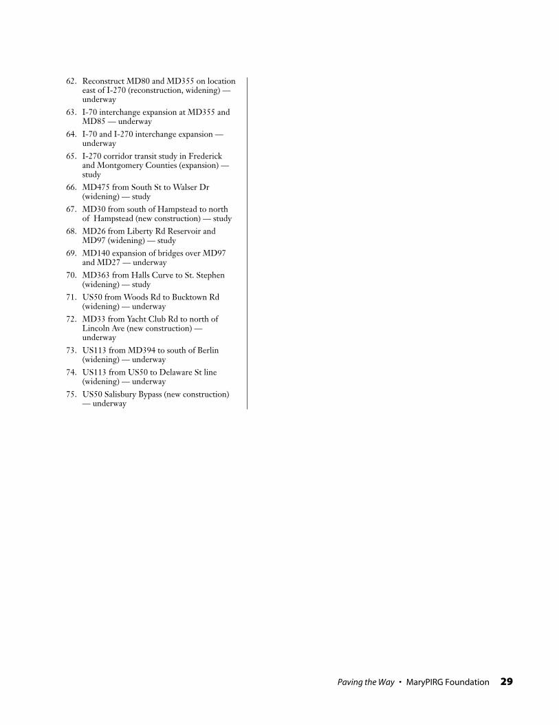
Paving the Way • MaryPIRG Foundation 29
62. Reconstruct MD80 and MD355 on locationeast of I-270 (reconstruction, widening) —underway
63. I-70 interchange expansion at MD355 andMD85 — underway
64. I-70 and I-270 interchange expansion —underway
65. I-270 corridor transit study in Frederickand Montgomery Counties (expansion) —study
66. MD475 from South St to Walser Dr(widening) — study
67. MD30 from south of Hampstead to northof Hampstead (new construction) — study
68. MD26 from Liberty Rd Reservoir andMD97 (widening) — study
69. MD140 expansion of bridges over MD97and MD27 — underway
70. MD363 from Halls Curve to St. Stephen(widening) — study
71. US50 from Woods Rd to Bucktown Rd(widening) — underway
72. MD33 from Yacht Club Rd to north ofLincoln Ave (new construction) —underway
73. US113 from MD394 to south of Berlin(widening) — underway
74. US113 from US50 to Delaware St line(widening) — underway
75. US50 Salisbury Bypass (new construction)— underway

30 MaryPIRG Foundation • Paving the Way
Where is the property developmentdata from?All property maps and calculations werederived from the “MdProperty View”data maintained by the Maryland Depart-ment of Planning. This resource, devel-oped for use by both urban planners andproperty sales professionals, is based onthe Maryland State Department of Assess-ments and Taxation’s parcel database andencoded with geographical informationin GIS format. It contains informationsupplied by Maryland’s 24 county-leveljurisdictions on all properties in the Stateof Maryland, including information onthe size of the property, the year it wasdeveloped, and the type of land use.
Within MdProperty View, we onlylooked at non-agricultural commercialand residential properties. To get this dataset, we excluded the following sets ofproperties:
• Properties with a land use marked asagricultural or marshland.
• Tax-exempt properties larger thanten acres. These are mostly largegovernment tracts of land, in addi-tion to church retreat centers, scoutclub campgrounds, and similarfacilities.
• Properties larger than ten acrescontaining no buildings.
We also excluded all properties whichwere missing information on when theproperty was developed. Unfortunately,this constitutes a substantial portion ofthe data, ranging from 10% to 25% indifferent areas. However, we were unableto identify any bias in the properties withmissing information. There were no dis-tinct geographical clusters, and there wasno trend of older neighborhoods havingmore or less records with incomplete in-formation than newer neighborhoods.We therefore assume that our conclusionsbased on the 75% to 90% of the data withcomplete information are equally appli-
cable to the rest of the data. Propertieswhich the Department of Planning wasunable to locate geographically are alsoexcluded from our analysis, but these con-stitute an insignificant portion of the data.
What defines a highway?This report analyzes only highways whichare controlled access highways, with in-terchanges rather than traffic lights.While major roads with high speed lim-its and few traffic lights are often consid-ered highways and likely have similareffects, the greatest extent of these effectscan best be measured with the most ex-treme example of roads as rapid transit.
The exception is US-50 on the East-ern Shore. Until recently, Route 50 stillhad some traffic lights and significantspeed reductions through the cities. How-ever, the entire history of Route 50 wasconsidered, as it has been the only majorthroughway traversing the Eastern Shore.
What defines a highway corridor?Highway corridors are defined as all ar-eas within five miles of a radial highwayor within three miles of the beltways, ex-cluding the five miles nearest Baltimoreand Washington. Five miles was judgedto be the approximate average limit acommuter would travel perpendicular toa highway in order to take advantage ofthe faster speeds of highways. Since belt-ways do not stretch as far in a consistentdirection, this limit is assumed to be lessfor beltways.
This is not meant to imply that theeffects of highways remain high up tothree or five miles away and then take asteep decline. Rather, we expect there aremeasurable spillover effects of highwaysfar beyond five miles. But a threshold wasneeded in order to have a consistent andmeasurable distinction between the areasnear the highways and those not close toa highway.
Since nearly all of the land within fivemiles of Baltimore and Washington is
METHODOLOGY

Paving the Way • MaryPIRG Foundation 31
within five miles of a highway, there isnot a significant amount of non-corridorarea in these regions to compare to thehighway corridors. To have includedthese rings around the cities would haveweighted the highway corridors towardthe immediate surroundings of the cit-ies, resulting in a near vs. far comparisonrather than a corridor vs. non-corridorcomparison.
What is the date built for the high-ways?Most highways were not built in a singleyear. They were built in segments, some-times with a span of decades from startto finish. The construction year of eachsegment of highway was obtained fromthe Pavement Management Informationdatabase of the Maryland State HighwayAdministration.
For this analysis, we marked the recordfor each developed property with the yearof the first highway segment built withinfive miles (or beltway within three miles).To begin, we selected all properties withinfive miles of the first highway segmentbuilt in Central Maryland and markedthose properties with the year that high-way segment was built. We then selectedall properties within five miles of the sec-ond highway, excluded properties whichhad already been marked with the con-struction year of the first highway, andmarked the remaining properties with theconstruction year of the second segment.This procedure was repeated for all high-way segments in the study area in chro-nological order. The same process wasused for the US-50 segments on the East-ern Shore.
Thus, “adjacent section of highway”everywhere the phrase is used in this re-port refers to the first section of highwaybuilt within five miles of the property(three miles for the beltways). This is notnecessarily the nearest segment of high-way, as another segment may have beenbuilt closer to the property at a later date.
In order to determine whether a high-way existed near the property when theproperty was developed, the first nearbyhighway segment is a more relevant mea-sure than the nearest highway segment.
Since not all highway segments in eachcounty were built at the same time, howwas it determined which properties werebuilt before and after the highways?The before and after highway develop-ment maps are not snapshots of any par-ticular year or range of years. Theyrepresent all currently-developed prop-erties which were built when there wereno highways nearby (before) or when therewas already a highway nearby (after).This was determined by comparing, foreach property, the year the property wasbuilt with the year the first nearby seg-ment of highway was built. Those builtbefore the first nearby section of high-way are in one group and those built af-ter are in the other.
For those properties outside of thehighway corridors, there is, by definition,no nearby segment of highway. Instead,we selected the segment of highwaywhich is the most relevant to each non-corridor area. In most cases, it is the near-est highway segment. In places wherethere are many small highway segmentsin the area, we chose the longest segmentleading from the non-corridor area to-ward the major metropolitan areas.

32 MaryPIRG Foundation • Paving the Way
Montgomery CountyHighway Year Lanes Miles Lane-Miles Type
I-270 1954 4 15.5 62.0 Original Construction
I-270 1958 4 7 28.0 Original Construction
I-495 1964 6 14.4 86.4 Original Construction
I-495 1972 2 4.8 9.6 Widening
I-270 1972 1 3.9 3.9 Widening
I-270 1973 1 7.2 7.2 Widening
I-495 1989 2 3.4 6.8 Widening
I-270 1990 12 0.8 9.6 Reconstruction
I-495 1991 2 3.7 7.4 Widening
I-270 1991 1 14 14.0 Widening
I-270 1997 1 4 4.0 Widening
Frederick CountyHighway Year Lanes Miles Lane-Miles Type
I-270 1953 4 10.1 40.4 Original Contruction
I-70 1954 4 8.6 34.3 Original Contruction
I-70 1958 4 2.1 8.2 Original Contruction
I-70 1968 4 14.7 58.6 Original Contruction
I-70 1973 1 8.6 8.6 Widening
Howard CountyHighway Year Lanes Miles Lane-Miles Type
I-70 1952 4 12.7 50.8 Original Construction
US-29 1953 4 4.2 16.8 Original Construction
US-29 1967 4 5.1 20.4 Original Construction
I-95 1968 8 11.6 92.8 Original Construction
I-70 1968 4 6.8 27.1 Original Construction
I-70 1974 1 13.7 13.7 Widening
MD-32 1985 4 7.4 29.6 Original Construction
US-29 1992 2 2.2 4.4 Widening
US-29 1995 2 2.5 5.0 Widening
MD-32 1995 2 3.0 6.0 Widening
MD-32 1996 4 3.1 12.4 Original Construction
Prince George’s CountyHighway Year Lanes Miles Lane-Miles Type
MD-295 1954 4 12.4 49.4 Original Construction
I-95 1961 6 2.9 17.4 Original Construction
US-50 1961 4 4.9 19.6 Original Construction
I-495 1964 6 25.0 150.0 Original Construction
I-95 1970 8 8.0 64.0 Original Construction
I-495 1971 2 1.8 3.5 Widening
I-95 1972 1 24.0 24.0 Widening
APPENDIX: HIGHWAY CONSTRUCTION DATES

Paving the Way • MaryPIRG Foundation 33
Prince George’s County (cont’d)Highway Year Lanes Miles Lane-Miles Type
US-50 1986 1 1.5 1.5 Widening
US-50 1991 6 9.5 56.9 Original Construction
I-95 1993 1 1.2 1.2 Widening
Anne Arundel CountyHighway Year Lanes Miles Lane-Miles Type
I-32 1950 4 1.1 4.4 Original Construction
I-295 1951 4 9.8 39.2 Original Construction
US-50 1952 4 9.3 37.0 Original Construction
I-295 1954 4 6.2 24.8 Original Construction
I-695 1956 4 1.3 5.3 Original Construction
I-97 1957 4 0.6 2.4 Original Construction
I-695 1961 4 0.8 3.0 Original Construction
I-695 1967 4 0.6 2.4 Original Construction
I-695 1971 4 1.8 7.0 Original Construction
MD-32 1972 4 2.7 10.8 Original Construction
I-97 1972 2 1.8 3.6 Original Construction
US-50 1974 1 4.5 4.5 Widening
I-695 1976 1 1.3 1.3 Widening
MD-32 1985 4 1.2 4.8 Original Construction
I-97 1987 4 5.7 22.6 Original Construction
US-50 1990 6 1.1 6.6 Original Construction
I-97 1990 6 6.2 36.9 Original Construction
I-695 1990 6 1.0 6.0 Reconstruction
I-695 1990 2 1.1 2.2 Widening
MD-32 1991 4 6.5 26.0 Original Construction
US-50 1991 1 4.8 4.8 Widening
US-50 1994 6 6.7 40.2 Original Construction
I-97 1995 6 1.5 9.0 Original Construction
I-97 1997 6 2.9 17.4 Original Construction
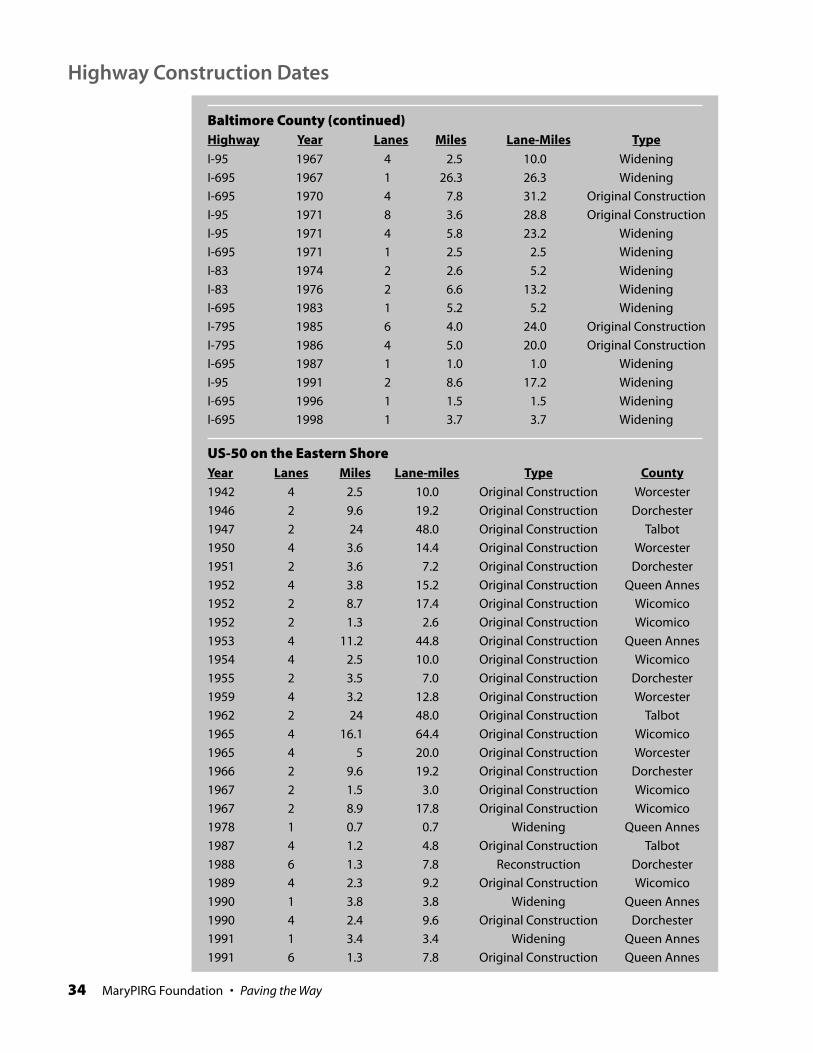
Baltimore CountyHighway Year Lanes Miles Lane-Miles Type
I-95 1955 4 5.1 20.4 Original Construction
I-695 1955 4 4.5 18.0 Original Construction
I-83 1955 4 14.1 56.4 Original Construction
I-695 1959 4 1.1 4.4 Original Construction
I-83 1959 4 8.8 35.2 Original Construction
I-695 1961 4 8.2 32.7 Original Construction
I-695 1962 4 16.2 64.8 Original Construction
I-83 1962 4 4.2 16.8 Original Construction
I-95 1963 6 6.5 39.0 Original Construction
I-70 1967 6 4.8 28.6 Original Construction
34 MaryPIRG Foundation • Paving the Way
Baltimore County (continued)Highway Year Lanes Miles Lane-Miles Type
I-95 1967 4 2.5 10.0 Widening
I-695 1967 1 26.3 26.3 Widening
I-695 1970 4 7.8 31.2 Original Construction
I-95 1971 8 3.6 28.8 Original Construction
I-95 1971 4 5.8 23.2 Widening
I-695 1971 1 2.5 2.5 Widening
I-83 1974 2 2.6 5.2 Widening
I-83 1976 2 6.6 13.2 Widening
I-695 1983 1 5.2 5.2 Widening
I-795 1985 6 4.0 24.0 Original Construction
I-795 1986 4 5.0 20.0 Original Construction
I-695 1987 1 1.0 1.0 Widening
I-95 1991 2 8.6 17.2 Widening
I-695 1996 1 1.5 1.5 Widening
I-695 1998 1 3.7 3.7 Widening
US-50 on the Eastern ShoreYear Lanes Miles Lane-miles Type County
1942 4 2.5 10.0 Original Construction Worcester
1946 2 9.6 19.2 Original Construction Dorchester
1947 2 24 48.0 Original Construction Talbot
1950 4 3.6 14.4 Original Construction Worcester
1951 2 3.6 7.2 Original Construction Dorchester
1952 4 3.8 15.2 Original Construction Queen Annes
1952 2 8.7 17.4 Original Construction Wicomico
1952 2 1.3 2.6 Original Construction Wicomico
1953 4 11.2 44.8 Original Construction Queen Annes
1954 4 2.5 10.0 Original Construction Wicomico
1955 2 3.5 7.0 Original Construction Dorchester
1959 4 3.2 12.8 Original Construction Worcester
1962 2 24 48.0 Original Construction Talbot
1965 4 16.1 64.4 Original Construction Wicomico
1965 4 5 20.0 Original Construction Worcester
1966 2 9.6 19.2 Original Construction Dorchester
1967 2 1.5 3.0 Original Construction Wicomico
1967 2 8.9 17.8 Original Construction Wicomico
1978 1 0.7 0.7 Widening Queen Annes
1987 4 1.2 4.8 Original Construction Talbot
1988 6 1.3 7.8 Reconstruction Dorchester
1989 4 2.3 9.2 Original Construction Wicomico
1990 1 3.8 3.8 Widening Queen Annes
1990 4 2.4 9.6 Original Construction Dorchester
1991 1 3.4 3.4 Widening Queen Annes
1991 6 1.3 7.8 Original Construction Queen Annes
Highway Construction Dates

Paving the Way • MaryPIRG Foundation 35
1. Highway data from Maryland State HighwayAdministration, Pavement Management Informa-tion Database, 2000. Population data fromRobert Famighetti (ed.), World Almanac and Bookof Facts: 1996 (Mahwah, NJ: Funk & Wagnalls,1995).
2. All statistics in this report not otherwise citedare from an analysis by the MaryPIRG Founda-tion of the Maryland Department of Planning’sMdProperty View database, with informationfrom the Maryland State Highway Adminis-tration’s Pavement Management Informationdatabase.
3. $1.7 billion: Maryland State HighwayAdministration, Consolidated TransportationProgram: 2000 State Report on Transportation,FY 2000 – 2005, 17 January 2000. $2.7 billion:Baltimore Regional Transportation Board,Baltimore Regional Transportation Plan. Quotes:“Consolidated Transportation Program.”
4. Maryland Department of Planning, SmartGrowth 2000: What We’ve Done, Where We’reGoing, downloaded from www.op.state.md.us/smartgrowth/smart99.htm, 27 October 2000.
5. American Farmland Trust and the GeorgiaConservancy, An Unlevel Playing Field: HowPublic Policies Favor Suburban Sprawl OverDowntown Development in Metropolitan Atlanta,January 1999.
6. Marlon G. Boarnet and Andrew F. Haughwout,Brookings Institution Center on Urban andMetropolitan Policy, Do Highways Matter?:Evidence and Policy Implications of Highways’Influence on Metropolitan Development, August2000.
7. Todd Litman, Victoria Transport PolicyInstitute, Land Use Impact Costs of Transportation,8 June 1999.
8. See note 1.
9. See methodology for definition of “adjacentsegment of highway.”
10. “Available land” includes all land which doesnot have local, state, or federal protected landstatus, as listed in the Statewide Protected Landsdatabase of the Maryland Department ofNatural Resources.
11. Harry Dimitriou, Urban Transport Planning(New York: Routledge, 1993), 136, as cited inTodd Litman, Victoria Transport PolicyInstitute, Land Use Impact Costs of Transportation,8 June 1999.
12. See methodology for definition of “adjacentsection of highway.”
13. The study area for Easton Shore propertydevelopment includes all counties from QueenAnne’s County south, the area surrounding US-50.
14. State funding for the Mass Transit Adminis-tration (MTA) and the Washington Metropoli-tan Area Transit (WMAT) in the MarylandConsolidated Transportation Plan: StateHighway Administration, Consolidated Transpor-tation Plan: 2000 State Report on Transportation,FY 2000 – 2005, 17 January 2000.
15. 1000 Friends of Oregon, Making the LandUse, Transportation, Air Quality Connection(LUTRAQ) — Freeways or Communities: It’s YourChoice, downloaded from www.friends.org/resources/pdfs/itsyourc.pdf, 30 October 2000;1000 Friends of Oregon, Making the Connections:A Summary of the LUTRAQ Project, February1997.
NOTES