patterned fens of western labrador and adjacent...
TRANSCRIPT
Patterned fens of western Labrador and adjacent Quebec: phytosociology, water chemistry, landform features, and dynamics of surface patterns1
DAVID R. FOSTER Harvard Forest, Harvard University, Petersham, MA 01366, U.S.A.
GEORGE A. KING U.S. Environrnental Protection Agency, Corvallis Environmental Research Laboratory, 200 SW 35th St., Corvallis, OR
97333, U.S.A.
AND
MARY V. SANTELMANN Department of General Science, Oregon State University, 355 Weniger Hall, Corvallis, OR 97331, U.S.A.
Received June 30, 1987
FOSTER, D. R., KING, G . A , , and SANTELMANN, M. V. 1988. Patterned fens of western Labrador and adjacent Quebec: phytosociology, water chemistry, landform features, and dynamics of surface patterns. Can. J. Bot. 66: 2402-2418.
The landforms, vegetation, water chemistry, and stratigraphy of four patterned fens (aapamires) in western Labrador and adjacent Quebec are described in a study investigating the origin and characteristics of surface patterns on northern peatlands. Phytosociological analysis by the relev6 approach, in conjunction with analysis by TWINSPAN, is used to describe 11 floristic noda. The vegetational patterns are largely controlled by depth to the water table. Mire landforms discussed in detail include ice-push ridges, flarks and pools, peat ridges, and mire-margin hummocks. Water chemistry is typical of minerotrophic condi- tions, with pH ranging from 4.4 to 6.7 and calcium concentrations from 20 to 430 pequiv. L-'. The water chemistry, vegeta- tion, and landforms on the mires are compared with other studies from Labrador and circumboreal regions. Stratigraphic results and field observations support the theory that surface patterns on the mire develop slowly through the interplay of bio- logical and hydrological processes, specifically differential rate of peat accumulation controlled by vegetation type and depth to water table. Pool formation apparently involves four steps: ( i ) gradual differentiation of shallow flarks on previously undif- ferentiated mire surface; ( i i ) expansion and deepening of flarks and development of ridges due to differential peat accumula- tion; (iii) degradation of flark vegetation into mud bottoms and open-water pools; and (iv) coalescence, continued expansion, and deepening of open-water areas. Hydrological controls over the rate and extent of pool formation are discussed as a probable explanation of the geographical distribution of patterned mires.
FOSTER, D. R., KING, G . A. , et SANTELMANN, M. V. 1988. Patterned fens of western Labrador and adjacent Quebec: phytosociology, water chemistry, landform features, and dynamics of surface patterns. Can. J. Bot. 66 : 2402-2418. . .
La topographie, la vkgitation, la chimie de l'eau et la stratigraphie de quatre plaines marCcageuses B reliefs dans l'ouest du Labrador et les rkgions frontalikres du Quebec sont dCcrites dans une Ctude dont le but Ctait d'Ctablir l'origine et les caractiris- tiques des motifs superficiels des tourbikres septentrionales. Des analyses phytosociologiques B l'aide de relevCs, conjointe- ment avec des analyses par TWINSPAN, ont kt6 utiliskes pour dCcrire 11 nodus floristiques. Les modkles de vCgCtation sont en grande partie dCterminCs par la profondeur du niveau hydrostatique. Le relief de certains bourbiers est discutC en dktail, dont des sillons formks par des banquises, des flaques et des mares, des sillons de tourbes et des buttes du pourtour des bourbiers. La chimie de l'eau est typiquement celle des conditions minCrotrophes, le pH allant de 4,6 B 6,7 et les concentrations de calcium de 20-430 pequiv. L-I. La chimie de l'eau, la vCgCtation et le relief des bourbiers sont cornparks B d'autres Ctudes faites au Labrador et dans les rkgions circumborCales. Les donnkes stratigraphiques et les observations faltes sur le terrain soutiennent la thCorie que les motifs superficiels des bourbiers sont ClaborCs lentement B la suite d'effets d'accumulation de tourbe qui est dCpendante du type de vigCtation et de la profondeur du niveau hydrostatique. La formation de mares semble indiquer quatre Ctapes: ( i ) la diffkrenciation graduelle de flaques peu profondes B la surface, jusqu'alors indiffCrenciCe, des bourbiers; ( i i ) l'expansion et une augmentation de la profondeur des flaques et le dCveloppement de billons B la suite d'accumulation prkfkrentielle de tourbe; (iii) la dkgradation de la vCgktation des flaques en fonds du boue et en Ctangs; et (iv) la coalescence, l'expansion continue et l'augmentation de la profondeur des secteurs oh skjourne l'eau. Les effets hydrologiques sur le taux et 1'Ctendue de la formation des mares sont proposCs comme une explication probable de la distribution gCogra- phique des bourbiers B reliefs.
[Traduit par la revue]
Introduction south. Surface features such as hummocks, hollows, mud
Boreal and subarctic patterned mires are quite distinct from bottoms, and open-water pools develop as secondary features
the kettlehole "bogs" and swamps found to the south in the on many northern mires and form intricate and prominent
temperate zone, both in their developmental history and in patterns (Sjors 1948). In areas of great moisture surplus, pools
their surface landforms. As a result of moisture surplus and may develop to cover broad areas on both ombrotrophic raised
cool temperatures in northern regions, peat accumulation may bogs and minerotrophic fens (Sjors 1963; Foster and Glaser
be initiated across broad upland regions (paludification; cf. 1986). Furthermore, the developmental sequence of northern
Malmstrom 1932) in addition to mire formation through lake- patterned mires is opposite of that described for most
filling or terrestrialization, processes that predominate in the temperate wetlands: peatland formation is followed by gradual development and expansion of open-water pools in contrast to the infilling of water-bodies and conversionif open-water sites
'This paper is contribution No. 342 from the Limnological to wetland (Auer 1930; Heinselman 1963). However, despite Research Center, University of Minnesota, Minneapolis, MN. the large areal coverage of boreal and subarctic peatlands, Printed in Canada i Imprim6 au Canada
Can
. J. B
ot. D
ownl
oade
d fr
om w
ww
.nrc
rese
arch
pres
s.co
m b
y H
AR
VA
RD
UN
IVE
RSI
TY
HE
RB
AR
IA o
n 08
/19/
11Fo
r pe
rson
al u
se o
nly.
FOSTER ET AL.
LABRADOR SEA
QUEBEC
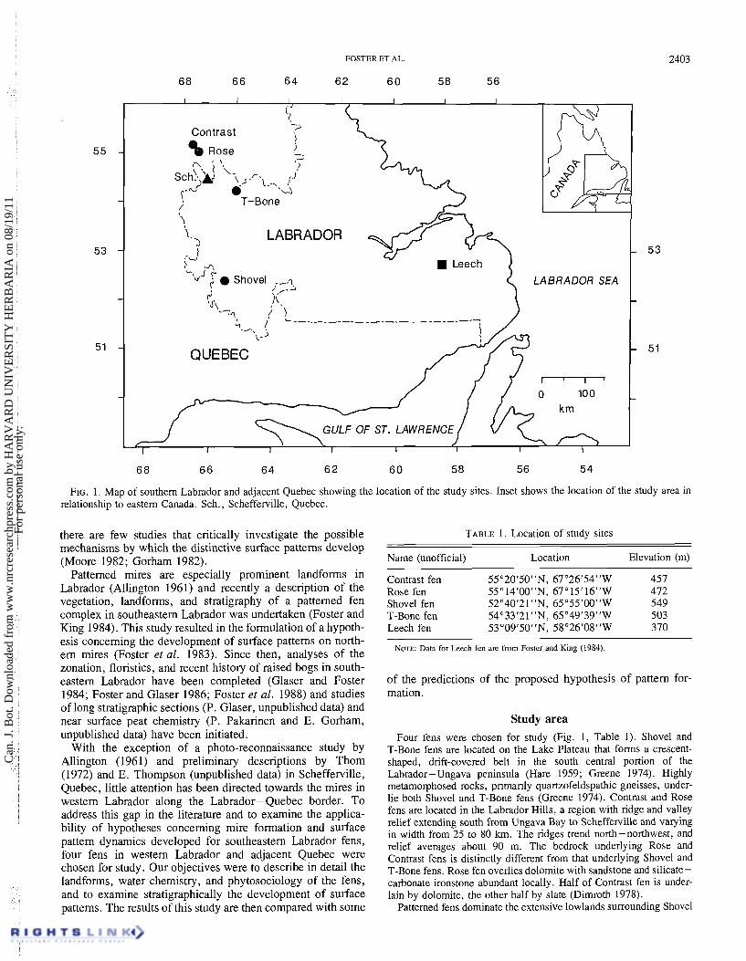
FIG. 1. Map of southern Labrador and adjacent Quebec showing the location of the study sites. Inset shows the location of the study area in relationship to eastern Canada. Sch., Schefferville, Quebec.
there are few studies that critically investigate the possible mechanisms by which the distinctive surface patterns develop (Moore 1982; Gorham 1982).
Patterned mires are especially prominent landforms in Labrador (Allington 1961) and recently a description of the vegetation, landforms, and stratigraphy of a patterned fen complex in southeastern Labrador was undertaken (Foster and King 1984). This study resulted in the formulation of a hypoth- esis concerning the development of surface patterns on north- em mires (Foster et al. 1983). Since then, analyses of the zonation, floristics, and recent history of raised bogs in south- eastern Labrador have been completed (Glaser and Foster 1984; Foster and Glaser 1986; Foster et al. 1988) and studies of long stratigraphic sections (P. Glaser, unpublished data) and near surface peat chemistry (P. Pakarinen and E. Gorham, unpublished data) have been initiated.
With the exception of a photo-reconnaissance study by Allington (1961) and preliminary descriptions by Thom (1972) and E. Thompson (unpublished data) in Schefferville, Quebec, little attention has been directed towards the mires in western Labrador along the Labrador-Quebec border. To address this gap in the literature and to examine the applica- bility of hypotheses concerning mire formation and surface pattern dynamics developed for southeastern Labrador fens, four fens in western Labrador and adjacent Quebec were chosen for study. Our objectives were to describe in detail the landforms, water chemistry, and phytosociology of the fens, and to examine stratigraphically the development of surface patterns. The results of this study are then compared with some
TABLE 1. Location of study sites
Name (unofficial) Location Elevation (m)
Contrast fen 55"20f50"N, 67"26'54"W 457 Rose fen 55"14'00"N, 67"15'16"W 472 Shovel fen 52"40121"N, 65"55'00"W 549 T-Bone fen 54"33'21 "N, 65"49'39"W 503 Leech fen 53"09'50"N, 58'26'08"W 370
NOTE: Data for Leech fen an: from Foster and King (1984).
of the predictions of the proposed hypothesis of pattern for- mation.
Study area Four fens were chosen for study (Fig. 1, Table 1). Shovel and
T-Bone fens are located on the Lake Plateau that forms a crescent- shaped, drift-covered belt in the south central portion of the Labrador-Ungava peninsula (Hare 1959; Greene 1974). Highly metamorphosed rocks, primarily quartzofeldspathic gneisses, under- lie both Shovel and T-Bone fens (Greene 1974). Contrast and Rose fens are located in the Labrador Hills, a region with ridge and valley relief extending south from Ungava Bay to Schefferville and va~ying in width from 25 to 80 krn. The ridges trend north-northwest, and relief averages about 90 m. The bedrock underlying Rose and Contrast fens is distinctly different from that underlying Shovel and T-Bone fens. Rose fen overlies dolomite with sandstone and silicate- carbonate ironstone abundant locally. Half of Contrast fen is under- lain by dolomite, the other half by slate (Dimroth 1978).
Patterned fens dominate the extensive lowlands surrounding Shovel
Can
. J. B
ot. D
ownl
oade
d fr
om w
ww
.nrc
rese
arch
pres
s.co
m b
y H
AR
VA
RD
UN
IVE
RSI
TY
HE
RB
AR
IA o
n 08
/19/
11Fo
r pe
rson
al u
se o
nly.
2404 CAN. 1. BOT. VOL. 66, 1988
fen. The uplands are predominantly covered by closed forests of Picea mariana with a ground cover of Pleurozium schreberi. The other three fens, which are farther north, are surrounded primarily by mineral uplands forested with open lichen woodlands of Picea mari- ana and Cladonia stellaris. h r i x laricina is also common in these woodlands and Picea glauca is present.
The climate of the study region is cold and moist. The three north- em sites have a mean July temperature of about 12.6"C, a mean annual temperature of about -4.8"C (Environment Canada 1982a), and an annual precipitation between 650 and 770 mm (Environment Canada 1984). Shovel fen is slightly warmer and wetter, with a mean July temperature of 13S°C, a mean annual temperature of -3.g°C, and 895 mm of precipitation per year (Environment Canada 1982b). At all four sites summer precipitation is slightly higher than winter precipitation and the growing season is less than 140 days long (Department of Energy, Mines and Resources 1973).
Methods Sites were selected from aerial photographs and topographic maps
based on their geographic distribution, the prominence and pattern of surface features, and accessibility by float plane via nearby lakes. Each fen was mapped from aerial photographs taken at 1000-m alti- tude with scale provided by ground truthing. Cross-sectional profiles of the peat deposits were made for selected sites using a surveyor's transit and thin metal rods. Measurements were taken at 20-m or closer intervals along designated transects.
A piston corer 10 cm in diameter, with serrated teeth for cutting through wood and rhizomes, was used for taking long peat cores (Wright et al. 1983). Monoliths of surface peats (approximately 10 x 10 x 50 cm) were cut with a serrated knife and loose sediments were sampled with a standard 5-cm piston corer. All cores and monoliths were described in the field, wrapped in plastic wrap and plastic pipe, and transported to the laboratory for further analysis. Radiocarbon dates were provided by the Radiocarbon Laboratory, University of Wisconsin, Madison, WI.
The vegetation was sampled using the relevC method to produce a descriptive phytosociological classification (Mueller-Dombois and Ellenberg 1974). This semiquantitative approach is best suited for an initial survey of a little-known vegetation as it (i) provides a descrip- tion and classification of the common vegetation; (ii) enables compar- ison with vegetational data from other regions; (iii) establishes an initial, albeit general, framework for considering the ecological and spatial relationships of species and vegetation types; (iv) reveals effi- ciently the principal direction of variation within the vegetational complex; and (v) permits the generation of working hypotheses concerning the role of environmental factors influencing the vegeta- tion (Birks 1973).
All species were recorded in plots subjectively placed in homo- genous stands. Standard plots were 3 X 3 m but this was modified as necessary in size and shape to accommodate irregular or small land- forms. No attempt was made to assess a minimal area curve as this has been considered by Poore (1955b), Dahl(1956), and Birks (1973) to be of less value than experience and general assessment of the scale of vegetation. Visual estimates of cover were assigned on the 10-point Domin scale (Mueller-Dombois and Ellenberg 1974). Voucher samples of lichens and vascular plants are deposited in the herbarium of the University of Minnesota (MIN). Duplicates of all bryophyte collections are stored in the National Herbarium, National Museum of Canada (CAN). Nomenclature follows Femald (1970) for vascular species, Stotler and Crandall-Stotler (1977) for liverworts, Ireland et al. (1980) for mosses, and Hale and Culberson (1970) for lichens except Cladonia, which follows Ahti (1961).
A phytosociological table was compiled using the FORTRAN
program TWINSPAN (Hill 1979; Gauch 1982). The final groupings of relevCs, characterized solely on similarities in floristic composition, form abstract plant communities or noda (sensu Poore 1955~). Each nodum is characterized by dominant species, which have the greatest cover-abundance within a layer of vegetation, and is distinguished
from the other noda by differential species, i.e., individual species or groups of species that have an affinity to particular vegetation types (Hill 1979). Differential species generally have an intermediate fre- quency of occurrence in the table and are present in greater than 50% of the relevCs that they characterize and less than 10% of the relevCs in other groups (Mueller-Dombois and Ellenberg 1974).
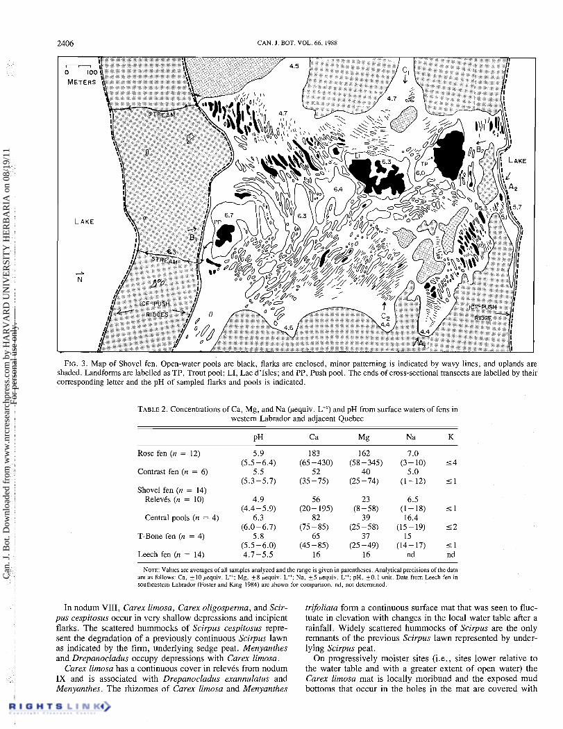
Water samples for chemical analysis were collected from flarks and pools where surface water was present; only relevCs from these land- forms (noda V, VII-XI) have water chemistry data. The pH of surface water was measured in the field using a Radiometer M29b field pH meter (standardized to buffers of pH 4.0 and 7.0).
Samples for cation analysis were collected in acid-washed 60-mL polyethylene bottles (rinsed three times with water from the sampling site), and refrigerated at 4OC upon return from the field. One week before filtration through acid-washed Gelman AIE glass-fiber filters, samples were acidified with Ultrex ultrapure nitric acid (1% by volume). Filters were presoaked for 1 h in 10% HC1; then each was rinsed with 250 mL of 10% HCl followed by 1 L of distilled deion- ized water and two rinses with 5- 10 mL of sample. Each filter was used once. A blank of distilled deionized water was filtered after every 12 samples; blank values (uniformly low) were subtracted from values obtained for samples.
Samples were analyzed for Ca, Mg, and Na on a Varian Techtron 1475 atomic absorption spectrophotometer with an air-acetylene flame. Because K concentrations were below the detection limit in 10 of a subset of 12 samples and < 4 pequiv. L-' in the other 2, the remaining samples were not analyzed for K. Lanthanum was added for Ca and Mg analysis to reduce interference. Although 30 of 37 samples were not visibly colored, the method of standard additions was used (Varion Techtron user manual) to minimize interference from the organic matrix. Each set of major cation analyses was cali- brated with EPA standards; results for the standards were accurate within limits of instrument precision.
Results Water chemistry
The chemistry of surface water from T-Bone, Contrast, and part of Shovel fens resembles that of poor fens (Sjors 1963) in cation concentrations, although these waters are slightly less acid than those of the classical poor fens. Rose fen and the central pool area of Shovel fen are more cation rich (Table 2, Fig. 2). Fourteen samples from Shovel fen were analyzed to compare water chemistry in different parts of the mire. The water flowing into Shovel fen from adjoining mires is acid (pH 4.4-4.7, Fig. 3) and low in Ca (about 20 pequiv. L-I). In pools along transect A, pH rises to 5.1 -5.5 and Ca to 35- 80 pequiv. L-l; in the large flarks and pools along the central axis of the mire, pH is about 6.0-6.7, with Ca concentrations of 75-85 pequiv. L-I (transect B, Fig. 3). These central pools are less acid and have higher Ca concentrations than adjacent Shovel lake (pH 5.7, Ca = 70 pequiv. L-I). The larger pools such as Trout pool, Push pool, and perhaps locations in Lac d'Isles (Fig. 3) have mineral bottoms of primarily silt and sand (see Surface features). From the orientation of the pool patterns (cf. Ivanov 1981) and changes in the chemistry of sur- face water, we infer that relatively dilute water flowing onto Shovel fen from adjoining peatlands to the west flows into Trout pond and Lac d'Isles, where it mixes with mineral- enriched soligenous water before flowing down the axis of the mire (cf. Sjijrs 1948; Du Rietz 1950).
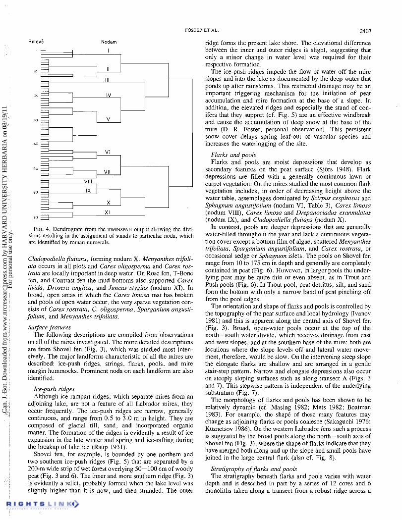
Vegetation Based on the TWINSPAN classification, the relevt data
has been separated into 11 noda in a phytosociological table (Table 3; cf. Birks 1973; Mueller-Dombois and Ellenberg 1974). The steps in the hierarchical dichotomization of the
Can
. J. B
ot. D
ownl
oade
d fr
om w
ww
.nrc
rese
arch
pres
s.co
m b
y H
AR
VA
RD
UN
IVE
RSI
TY
HE
RB
AR
IA o
n 08
/19/
11Fo
r pe
rson
al u
se o
nly.

FOSTER ET AL. 2405
200 400
Ca concn. (pequiv. c') FIG. 2. The relationship between Ca concentrations (pequiv. L-')
and pH for Contrast (0), Rose (A) , T-Bone (@), and Shovel ( A ) fens.
stands are illustrated in the dendrogram from the TWINSPAN
output (Fig. 4) . Each nodum is described below in terms of differential and dominant species and general habitat char- acteristics.
Nodum I: Picea mariana - Abies balsamea - Ptilium crista- castrensis assemblage
This assemblage is differentiated by Abies balsamea, Ptil- ium crista-castrensis, and Ptilidium ciliare. Picea mariana forms a continuous overstory, Ledum groenlandicum predomi- nates in the discontinuous shrub layer, Rubus chamaemorus in the field layer, and Pleurozium schreberi and Sphagnum rus- sowii form the ground cover. Paludified forests composed of this assemblage bordered all the fens. The soil organic layer ranges from 20 to 40 cm in depth.
Nodum II: Sphagnum fuscum - Cladonia assemblage This assemblage is differentiated by a group of oligotrophic
cryptogams including Sphagnumfuscum, Mylia anomala, and Cladonia stellaris. The vascular species Empetrum nigrum and Myrica gale are most common in this assemblage. Picea mariana forms a stunted and discontinuous canopy and Chamaedaphe calyculata and Vaccinium uliginosum are the predominant shrubs. The ground cover is composed of Sphag- num nemoreum, Sphagnum fuscum, Sphagnum russowii, Pleurozium schreberi, and Cladonia rangiferina.
This assemblage occurs most frequently on mire margin hummocks, elevated ridges, and isolated hummocks in the mire center. On these sites the peat surface is raised 30-45 cm above the water table in the adjoining pools and flarks and thereby is largely isolated from soligenous water flow and con- sequently is nutrient poor (Sjors 1946, 1948). Myrica gale, a minerotrophic indicator (Sjors 1948), is restricted to the lower flanks of the ridges.
Nodum III: Vaccinium myrtilloides - Carex pauciflora assemblage
Differential species in this nodum include Carexpauciflora, Cladonia comuta, Clintonia borealis, Dicranum fuscescens,
Dicranum undulatum, Trientalis borealis, and Vaccinium myrtilloides. Stunted Picea and Larix are present in low abun- dance with the shrubs Ledum groenlandicum, Chamaedaphne calyculata, and Vaccinium myrtilloides. Carex trisperma is the prominent herb and Sphagnum russowii dominates the ground layer with Pleurozium schreberi. This assemblage occurs at Rose and Shovel fens on forested peat ridges 20 -40 cm above the water table.
Nodum IV: Carex exilis - Epilobium palustre assemblage Juniperus communis, Sarracenia purpurea, Epilobium
palustre, and Carex exilis are differential species of this assemblage. Chamaedaphne calyculata and Juniperus form an interrupted shrub cover over Carex exilis, Scirpus cespitosus, and Potentilla palustris in the herbaceous layer and the Sphag- num russowii ground cover.
This assemblage dominates low sedge ridges on all of the fens studied and occurs on lawns (sensu Sjors 1948) with nodum V. The ridges are generally quite firm and elevated 15-25 cm above the water in the adjoining mud bottoms and pools.
Nodum V: Scirpus cespitosus - Sphagnum angustifolium - Smilacina trifolia assemblage
This nodum is characterized by a continuous ground cover of Carex exilis, Scirpus cespitosus, and Sphagnum angustifolium, scattered Smilacina trifolia, Aulacomnium palustre, and Carex aquatilis, and low shrub cover of Chamaedaphne calyculata. Differential species include Rubus acaulis, Mitella nuda, and Viola renifolia. This assemblage has the greatest areal extent on the mires and generally occurs on firm sedge peat 10- 20 cm above the water table. In particular, it occupies low ridges and extensive lawns and blankets unpattemed mire slopes.
Nodum VI: Carex oligosperma - Scirpus cespitosus assemblage
This assemblage occupies very low ridges, which, as a result of their undulating surface near the water table, present a diversity of microsites that accommodate a variety of species with different moisture requirements. Carex oligosperma is the only differential species and it occupies low spots between small hummocks of Scirpus cespitosus. Drepanocladus exan- nulatus and Carex limosa also occupy moist depressions, whereas Betula michauxii, Chamadaphne caly culata , and Andromeda glaucophylla are scattered throughout. Cetraria islandica, Picea mariana, and Larix laricina are generally situated on elevated hummocks.
Nodum VII: Betula michauxii - Chamaedaphne calyculata assemblage
Along the upslope margins of ridges, this assemblage occu- pies a fringe that extends from the peat bank 30-50 cm into the open water pool. Shrubs include the dominant species Betula michauxii and the more-ubiquitous Chamadaphne caly- culata, Andromeda glaucophylla, and Kalmia polifolia. Herbs include Carex limosa and Menyanthes trifoliata. Most of the plants are rooted in the firm peat banks of ridges and extend by rhizomes or shoots out into the water. Menyanthes, however, is occasionally rooted in the bottom of pools.
Noda VIII-XI: Flark and mud bottom assemblages These four noda share many of the same species (e.g.,
Scirpus cespitosus, Carex oligosperma, Carex limosa, Drep- anocladus exannulatus, and Menyanthes trifoliata) and occupy progressively moister phases of flark vegetation (sensu Sjors 1948).
Can
. J. B
ot. D
ownl
oade
d fr
om w
ww
.nrc
rese
arch
pres
s.co
m b
y H
AR
VA
RD
UN
IVE
RSI
TY
HE
RB
AR
IA o
n 08
/19/
11Fo
r pe
rson
al u
se o
nly.
2406 CAN. 1. BOT. VOL. 66. 1988
FIG. 3 . Map of Shovel fen. Open-water pools are black, flarks are enclosed, minor patterning is indicated by wavy lines, and uplands are shaded. Landforms are labelled as TP, Trout pool; LI, Lac d'lsles; and PP, Push pool. The ends of cross-sectional transects are labelled by their corresponding letter and the pH of sampled flarks and pools is indicated.
TABLE 2. Concentrations of Ca, Mg, and Na (pequiv. L") and pH from surface waters of fens in western Labrador and adjacent Quebec
Rose fen ( n = 12) 5.9 183 162 7.0 (5.5 -6.4) (65-430) (58-345) (3 - 10) 5 4
Contrast fen ( n = 6 ) 5.5 52 4 0 5.0 (5.3-5.7) (35-75) (25-74) (1-12) 51
Shovel fen ( n = 14) RelevCs ( n = 10) 4.9 56 23 6.5
(4.4-5.9) (20-195) (8-58) (1-18) 5 1 Central pools ( n = 4 ) 6.3 82 3 9 16.4
(6.0-6.7) (75-85) (25-58) (15-19) 5 2 T-Bone fen (n = 4 ) 5.8 65 37 15
(5.5-6.0) (45-85) (25-49) (14-17) 5 1 Leech fen (n = 14) 4.7-5.5 16 16 nd nd
NOTE: Values are avenges of all samples analyzed and the n n g e is given in parentheses. Analytical precisions of the data are as follows: Ca, k 10 pequiv. L-I; Mg, f 8 pequiv. L-I; Na, + 5 pequiv. L-'; pH, k 0 . 1 unit. Data from Leech fen in southeastern Labndor (Foster and King 1984) are shown for comparison. nd, not determined.
In nodum VIII, Carex limosa, Carex oligosperma, and Scir- trifoliata form a continuous surface mat that was seen to fluc- pus cespitosus occur in very shallow depressions and incipient tuate in elevation with changes in the local water table after a flarks. The scattered hummocks of Scirpus cespitosus repre- rainfall. Widely scattered hummocks of Scirpus are the only sent the degradation of a previously continuous Scirpus lawn remnants of the previous Scirpus lawn represented by under- as indicated by the firm, underlying sedge peat. Menyanthes lying Scirpus peat. and Drepanocladus occupy depressions with Carex limosa. On progressively moister sites (i.e., sites lower relative to
Carex limosa has a continuous cover in relevis from nodum the water table and with a greater extent of open water) the IX and is associated with Drepanocladus exannulatus and Carex limosa mat is locally moribund and the exposed mud Menyanthes. The rhizomes of carex limosa and Menyanthes bottoms that occur in the holes in the mat are covered with
Can
. J. B
ot. D
ownl
oade
d fr
om w
ww
.nrc
rese
arch
pres
s.co
m b
y H
AR
VA
RD
UN
IVE
RSI
TY
HE
RB
AR
IA o
n 08
/19/
11Fo
r pe
rson
al u
se o
nly.

Can
. J. B
ot. D
ownl
oade
d fr
om w
ww
.nrc
rese
arch
pres
s.co
m b
y H
AR
VA
RD
UN
IVE
RSI
TY
HE
RB
AR
IA o
n 08
/19/
11Fo
r pe
rson
al u
se o
nly.
FOSTER ET AL. 2407
R e l e v 6 Nodum
FIG. 4. Dendrogram from the TWINSPAN output showing the divi- sions resulting in the assignment of stands to particular noda, which are identified by roman numerals.
Cladopodiellafluitans, forming nodum X. Menyanthes trifoli- ata occurs in all plots and Carex oligosperma and Carex ros- trata are locally important in deep water. On Rose fen, T-Bone fen, and Contrast fen the mud bottoms also supported Carex livida, Drosera anglica, and Juncus stygius (nodum XI). In broad, open areas in which the Carex limosa mat has broken and pools of open water occur, the very sparse vegetation con- sists of ~arexrostrata, C. oligosper~a, ~ ~ a r ~ a n i u m angusti- folium, and Menyanthes trifoliata.
Surface features The following descriptions are compiled from observations
on all of the mires investigated. The more detailed descriptions are from Shovel fen (Fig. 3), which was studied most inten- sively. The major landforms characteristic of all the mires are described: ice-push ridges, strings, flarks, pools, and mire margin hummocks. Prominent noda on each landform are also identified.
Ice-push ridges Although ice rampart ridges, which separate mires from an
adjoining lake, are not a feature of all Labrador mires, they occur frequently. The ice-push ridges are narrow, generally continuous, and range from 0.5 to 3.0 m in height. They are composed of glacial till, sand, and incorporated organic matter. The formation of the ridges is evidently a result of ice expansion in the late winter and spring and ice-rafting during the breakup of lake ice (Raup 1931).
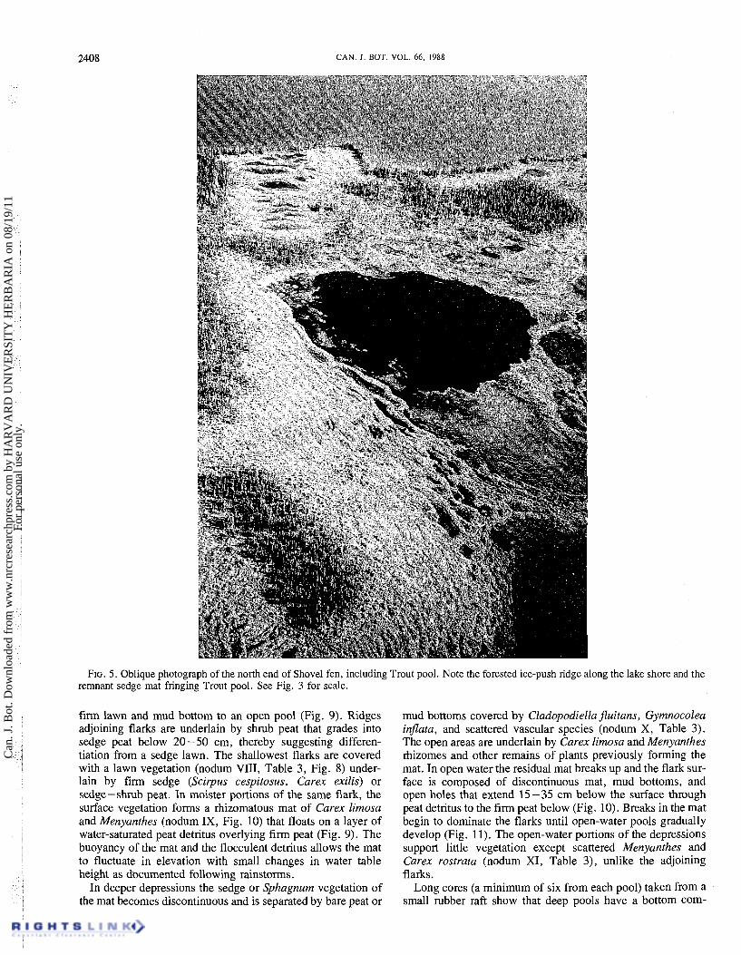
Shovel fen, for example, is bounded by one northern and two southern ice-push ridges (Fig. 5) that are separated by a 200-m wide strip of wet forest overlying 50- 100 cm of woody peat (Fig. 3 and 6). The inner and more southern ridge (Fig. 3) -is evidently a relict, probably formed when the lake level was slightly higher than it is now, and then stranded. The outer
ridge forms the present lake shore. The elevational difference between the inner and outer ridges is slight, suggesting that only a minor change in water level was required for their respective formation.
The ice-push ridges impede the flow of water off the mire slopes and into the lake as documented by the deep water that ponds up after rainstorms. This restricted drainage may be an important triggering mechanism for the initiation of peat accumulation and mire formation at the base of a slope. In addition, the elevated ridges and especially the stand of con- ifers that they support (cf. Fig. 5) are an effective windbreak and cause the accumulation of deep snow at the base of the mire (D. R. Foster, personal observation). This persistent snow cover delays spring leaf-out of vascular species and increases the waterlogging of the site.
Flarks and pools Flarks and pools are moist depressions that develop as
secondary features on the peat surface (Sjors 1948). Flark depressions are filled with a generally continuous lawn or carpet vegetation. On the mires studied the most common flark vegetation includes, in order of decreasing height above the water table, assemblages dominated by Scirpus cespitosus and Sphagnum angustifolium (nodum VI, Table 3), Carex limosa (nodum VIII), Carex limosa and Drepanocladus exannulatus (nodum IX), and Cladopodiella fluitans (nodum X).
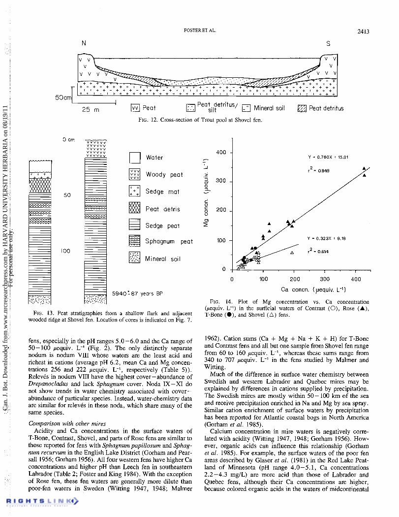
In contrast, pools are deeper depressions that are generally water-filled throughout the year and lack a continuous vegeta- tion cover except a bottom film of algae, scattered Menyanthes trifoliata, Sparganium angustifolium, and Carex rostrata, or occasional sedge or Sphagnum islets. The pools on Shovel fen range from 10 to 175 cm in depth and generally are completely contained in peat (Fig. 6). However, in larger pools the under- lying peat may be quite thin or even absent, as in Trout and Push pools (Fig. 6). In Trout pool, peat detritus, silt, and sand form the bottom with only a narrow band of peat pinching off
- -
from the pool edges. The orientation and shape of flarks and pools is controlled by
the topography of the peat surface and local hydrology (Ivanov 1981) and this is apparent along the central axis of Shovel fen (Fig. 3). Broad, open-water pools occur at the top of the north-south water divide, which receives drainage from east and west slopes, and at the southern base of the mire; both are locations where the slope levels off and lateral water move- ment, therefore, would be slow. On the intervening steep slope the elongate flarks are shallow and are arranged in a gentle stair-step pattern. Narrow and elongate depressions also occur on steeply sloping surfaces such as along transect A (Figs. 3 and 7). This stepwise pattern is independent of the underlying substratum (Fig. 7).
The morphology of flarks and pools has been shown to be relatively dynamic (cf. Masing 1982; Mets 1982; Boatman 1983). For example, the shape of these many features may change as adjoining flarks or pools coalesce (Sakaguchi 1976; Kuznetsov 1986). On the western Labrador fens such a process is suggested by the broad pools along the north -south axis of Shovel fen (Fig. 3), where the shape of flarks indicate that they have merged both along and up the slope and small pools have joined in the large central flark (also cf. Fig. 8).
Stratigraphy of flarks and pools The stratigraphy beneath flarks and pools varies with water
depth and is described in part by a series of 12 cores and 6 monoliths taken along a transect from a robust ridge across a
Can
. J. B
ot. D
ownl
oade
d fr
om w
ww
.nrc
rese
arch
pres
s.co
m b
y H
AR
VA
RD
UN
IVE
RSI
TY
HE
RB
AR
IA o
n 08
/19/
11Fo
r pe
rson
al u
se o
nly.
CAN. J. BOT. VOL. 66, 1988
FIG. 5. Oblique photograph of the north end of Shovel fen, including Trout pool. Note the forested ice-push ridge along the lake shore and the remnant sedge mat fringing Trout pool. See Fig. 3 for scale.
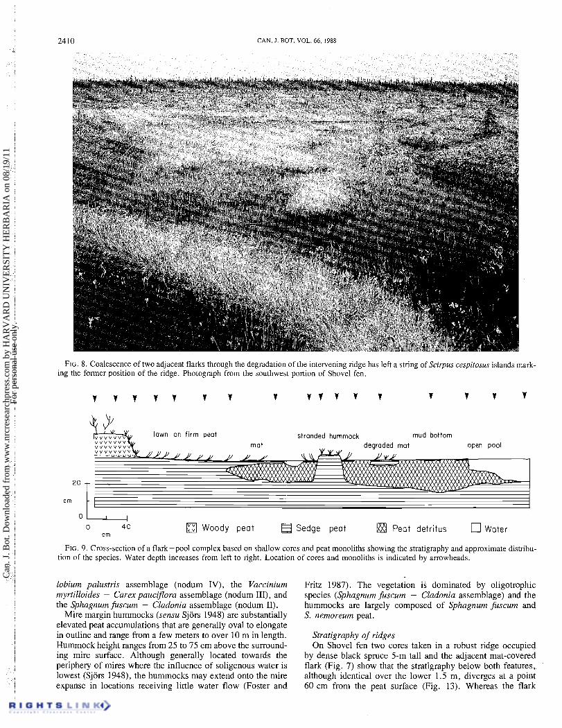
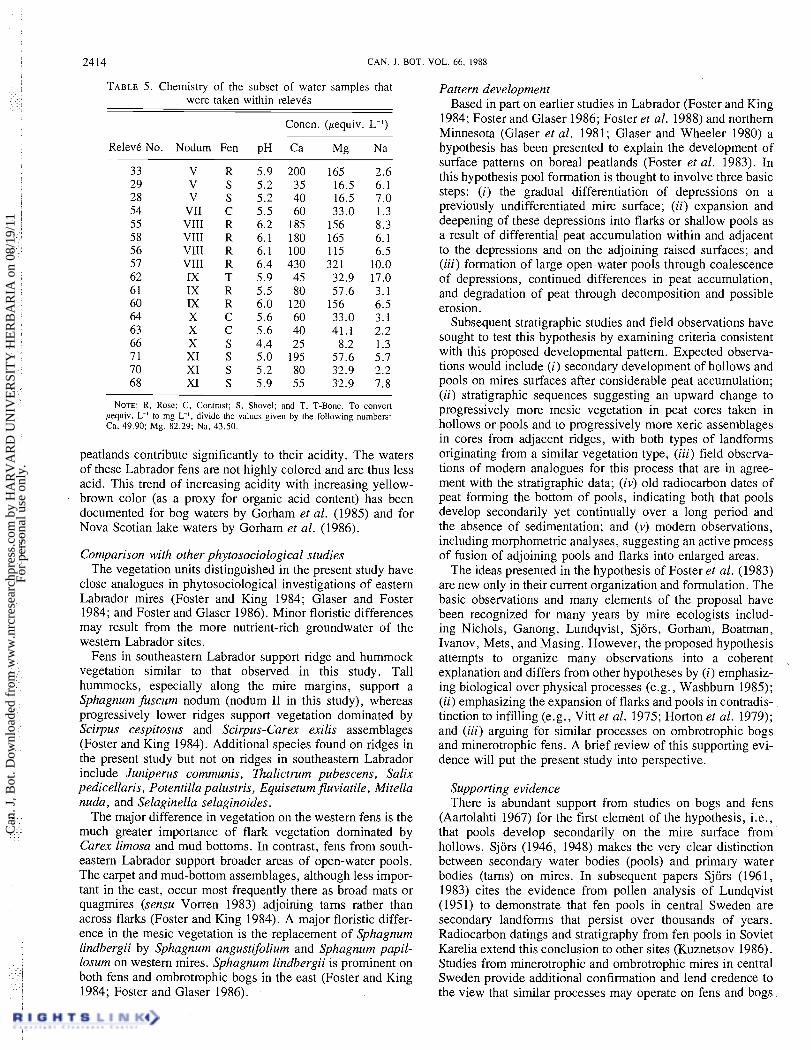
firm lawn and mud bottom to an open pool (Fig. 9). Ridges adjoining flarks are underlain by shrub peat that grades into sedge peat below 20-50 cm, thereby suggesting differen- tiation from a sedge lawn. The shallowest flarks are covered with a lawn vegetation (nodum VIII, Table 3, Fig. 8) under- lain by firm sedge (Scirpus cespitosus, Carex exilis) or sedge-shrub peat. In moister portions of the same flark, the surface vegetation forms a rhizomatous mat of Carex limosa and Menyanthes (nodum IX, Fig. 10) that floats on a layer of water-saturated peat detritus overlying firm peat (Fig. 9). The buoyancy of the mat and the flocculent detritus allows the mat to fluctuate in elevation with small changes in water table height as documented following rainstorms.
In deeper depressions the sedge or Sphagnum vegetation of the mat becomes discontinuous and is separated by bare peat or
mud bottoms covered by Cladopodiella puitans, Gymnocolea inpata, and scattered vascular species (nodum X, Table 3). The open areas are underlain by Carex limosa and Menyanthes rhizomes and other remains of plants previously forming the mat. In open water the residual mat breaks up and the flark sur- face is composed of discontinuous mat, mud bottoms, and open holes that extend 15-35 cm below the surface through peat detritus to the firm peat below (Fig. 10). Breaks in the mat begin to dominate the flarks until open-water pools gradually develop (Fig. 11). The open-water portions of the depressions support little vegetation except scattered Menyanthes and Carex rostrata (nodum XI, Table 3), unlike the adjoining flarks.
Long cores (a minimum of six from each pool) taken from a small rubber raft show that deep pools have a bottom corn-
Can
. J. B
ot. D
ownl
oade
d fr
om w
ww
.nrc
rese
arch
pres
s.co
m b
y H
AR
VA
RD
UN
IVE
RSI
TY
HE
RB
AR
IA o
n 08
/19/
11Fo
r pe
rson
al u
se o
nly.

FOSTER ET AL.
Lac d'lsles
B2
Trout Pool
50cd Peat Frozen peat Mineral soil
50 rn
FIG. 6. Cross-section of Shovel fen along transect B.
u 50 m
peat Minerol soil
FIG. 7. Cross-section of Shovel fen along transect A. The width of the ice-push ridge is slightly exaggerated. Location of cores taken from a ridge and adjacent flark to describe pattern formation is indicated by an arrow.
posed of peat detritus overlying firm peat, or in the case of the largest pools, silt and sand (Figs. 6 and 12). Radiocarbon dates obtained from wood embedded in the bottom of Trout pool and peat detritus from the bottom of a large pool in Rose fen (here- after called Rose fen pool) are 3210 & 80 years BP and 3430 k 70 years BP, respectively (Table 4). The peat 80 cm below the peat detritus - water interface in Rose fen pool is dated at 4510 + 80 years BP.
The radiocarbon dates document the absence of accumula- tion or sedimentation in the pools over the last few thousand years but do not exclude the possibility of active removal of peat or peat detritus through degradation and erosion (cf. Kuznetsov 1986; Foster and Fritz 1987). In addition, the dates document that the flarks and pools are old and quite persistent landforms (cf. Lundqvist 1951; Masing 1982). Recognizing the possibility of actual removal of peat from within the basin,
it must be concluded that the dates provide a maximum age for the origin of the features.
Ridges and mire margin hummocks Ridges, which are elevated -sublinear landforms, are elon-
gated along the slope contours and dam the lower margin of pools and flarks. On the mires investigated, the ridges range from < 1 to 5 m in width, from 10 to 50 cm in height above the surrounding mire surface, and extend up to 35 m in length. The ridges frequently interconnect across the slope but may be broken in spots where two adjacent depressions have coalesced. Prominent plant communities, in order of increasing height above the water table include the Carex oligosperma - Scirpus cespitosus assemblage (nodum VI), the Scirpus cespitosus - Sphagnum angustifolium - Smila- cina trifolia assemblage (nodum V), the Carex exilis - Epi-
Can
. J. B
ot. D
ownl
oade
d fr
om w
ww
.nrc
rese
arch
pres
s.co
m b
y H
AR
VA
RD
UN
IVE
RSI
TY
HE
RB
AR
IA o
n 08
/19/
11Fo
r pe
rson
al u
se o
nly.
2410 CAN. J. BOT. VOL. 66. 1988
FIG. 8. Coalescence of two adjacent flarks through the degradation of the intervening ridge has left a string of Scirpus cespitosus islands mark- ing the former position of the ridge. Photograph from the southwest portion of Shovel fen.
lawn on firm peat stranded hummock mud bottom open pool
Woody peat Sedge peal Peat detritus Water
FIG. 9. Cross-section of a flark-pool complex based on shallow cores and peat monoliths showing the stratigraphy and approximate distribu- tion of the species. Water depth increases from left to right. Location of cores and monoliths is indicated by arrowheads.
lobium palustris assemblage (nodum IV), the Vaccinium myrtilloides - Carex paucifora assemblage (nodum 111), and the Sphagnum fuscum - Cladonia assemblage (nodum 11).
Mire margin hummocks (sensu Sjors 1948) are substantially elevated peat accumulations that are generally oval to elongate in outline and range from a few meters to over 10 m in length. Hummock height ranges from 25 to 75 cm above the surround- ing mire surface. Although generally located towards the periphery of mires where the influence of soligenous water is lowest (Sjors 1948), the hummocks may extend onto the mire expanse in locations receiving little water flow (Foster and
Fritz 1987). The vegetation is dominated by oligotrophic species (Sphagnum fuscum - Cladonia assemblage) and the hummocks are largely composed of Sphagnum fuscum and S. nemoreum peat.
Stratigraphy of ridges On Shovel fen two cores taken in a robust ridge occupied
by dense black spruce 5-m tall and the adjacent mat-covered flark (Fig. 7) show that the stratigraphy below both features, although identical over the lower 1.5 m, diverges at a point 60 cm from the peat surface (Fig. 13). Whereas the flark
Can
. J. B
ot. D
ownl
oade
d fr
om w
ww
.nrc
rese
arch
pres
s.co
m b
y H
AR
VA
RD
UN
IVE
RSI
TY
HE
RB
AR
IA o
n 08
/19/
11Fo
r pe
rson
al u
se o
nly.

FOSTER ET AL. 2411
FIG. 10. Degradation of the Carex limosa mat results in the loss of the underlying floculent material and the formation of a 25 cm deep pool. Photograph taken at Shovel fen.
TABLE 4. Radiocarbon dates from fens in western Labrador and adjacent Quebec
Radiocarbon date Location Depth Material (years BP) Laboratory No.
Basal dates Shovel fen 136- 139 cm Sedge peat 5940 + 80 WIS-1527 Rose fen 143 - 148 cm Shrub peat 4120+80 WIS-1529 Rose fen 190 - 195 cm Sedge peat 4700 + 70 WIS-1531
Pool dates Shovel fen
(Trout pool) Sediment Wood 3210+80 WIS-1526 surface
Rose fen pool Sediment Peat detritus 3430 +70 WIS-1528 surface
Rose fen pool 80 cm below Sedge peat 4510+80 WIS 1530 surface
stratigraphy contains a sequence of sedge peat to peat detritus, the ridge stratigraphy progresses from sedge peat at 60 cm to Sphagnum and shrub peat, and then to an abrupt transition at 15 cm to an uppermost peat dominated by wood and macro- fossils of black spruce.
Discussion Water chemistry of western Labrador and Quebec fens
The chemistry of surface water in the fens is influenced by inputs from groundwater and surface flow, the amount and chemical composition of local precipitation, and by the effects
of climate and local hydrology upon water residence time and rates of peat decomposition (and thus the concentrations of dis- solved organic acids). In the study area, cation concentrations in precipitation are low (Munger and Eisenreich 1983). Because most of these fen waters are not visibly colored, we infer that organic acid concentrations are probably low. The chemistry of surface water in the fens appears to be controlled by two factors: the composition of groundwater flowing into the mire and the proportion of groundwater to more dilute waters from precipitation or surface runoff from adjacent mires.
The relative importance of groundwater contributions of
Can
. J. B
ot. D
ownl
oade
d fr
om w
ww
.nrc
rese
arch
pres
s.co
m b
y H
AR
VA
RD
UN
IVE
RSI
TY
HE
RB
AR
IA o
n 08
/19/
11Fo
r pe
rson
al u
se o
nly.
2412 CAN. I. BOT. VOL. 66, 1988
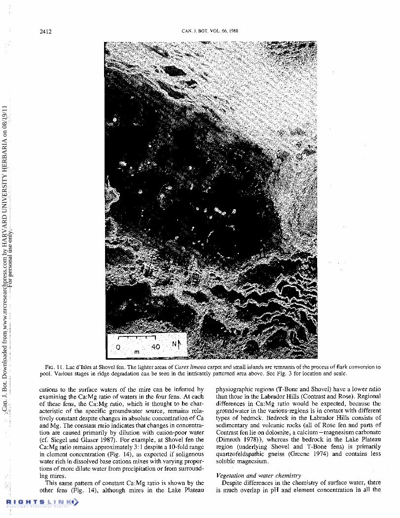
FIG. 11. Lac d'Isles at Shovel fen. The lighter areas of Carex limosa carpet and small islands are remnants of the process of flark conversion to pool. Various stages in ridge degradation can be seen in the intricately patterned area above. See Fig. 3 for location and scale.
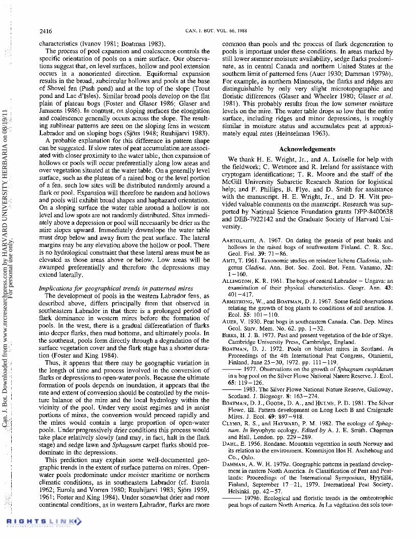
cations to the surface waters of the mire can be inferred by examining the Ca:Mg ratio of waters in the four fens. At each of these fens, the Ca:Mg ratio, which is thought to be char- acteristic of the specific groundwater source, remains rela- tively constant despite changes in absolute concentration of Ca and Mg. The constant ratio indicates that changes in concentra- tion are caused primarily by dilution with cation-poor water (cf. Siege1 and Glaser 1987). For example, at Shovel fen the Ca:Mg ratio remains approximately 3: 1 despite a 10-fold range in element concentration (Fig. 14), as expected if soligenous water rich in dissolved base cations mixes with varying propor- tions of more dilute water from precipitation or from surround- ing mires.
This same pattern of constant Ca:Mg ratio is shown by the other fens (Fig. 14), although mires in the Lake Plateau
physiographic regions (T-Bone and Shovel) have a lower ratio than those in the Labrador Hills (Contrast and Rose). Regional differences in Ca:Mg ratio would be expected, because the groundwater in the various-regions is in contact with different types of bedrock. Bedrock in the Labrador Hills consists of sedimentary and volcanic rocks (all of Rose fen and parts of Contrast fen lie on dolomite, a calcium -magnesium carbonate (Dimroth 1978)), whereas the bedrock in the Lake Plateau region (underlying Shovel and T-Bone fens) is primarily quartzofeldspathic gneiss (Greene 1974) and contains less soluble magnesium.
Vegetation and water chemistry Despite differences in the chemistry of surface water, there
is much overlap in pH and element concentration in all the
Can
. J. B
ot. D
ownl
oade
d fr
om w
ww
.nrc
rese
arch
pres
s.co
m b
y H
AR
VA
RD
UN
IVE
RSI
TY
HE
RB
AR
IA o
n 08
/19/
11Fo
r pe
rson
al u
se o
nly.
FOSTER ET AL.
[$;1 Peat Peat detritus/ 25 m silt (++I Mineral soil Peat detritus
FIG. 12. Cross-section of Trout pool at Shovel fen.
0 crn
woody peat
Sedge mat
Peat detris
Sedge peat
Sphagnum peat
Mineral soil
*-87 years BP
FIG. 13. Peat stratigraphies from a shallow flark and adjacent wooded ridge at Shovel fen. Location of cores is indicated on Fig. 7.
fens, especially in the pH ranges 5.0-6.0 and the Ca range of 50-100 pequiv. L-' (Fig. 2). The only distinctly separate nodum is nodum VIII whose waters are the least acid and richest in cations (average pH 6.2, mean Ca and Mg concen- trations 256 and 222 pequiv. L-', respectively (Table 5)). RelevCs in nodum VIII have the highest cover-abundance of Drepanocladus and lack Sphagnum cover. Noda IX-XI do not show trends in water chemistry associated with cover- abundance of particular species. Instead, water-chemistry data are similar for relevCs in these noda, which share many of the same species.
Comparison with other mires Acidity and Ca concentrations in the surface waters of
T-Bone, Contrast, Shovel, and parts of Rose fens are similar to those reported for fens with Sphagnum papillosum and Sphag- num recurvum in the English Lake District (Gorham and Pear- sall 1956; Gorham 1956). All four western fens have higher Ca concentrations and higher pH than Leech fen in southeastern Labrador (Table 2; Foster and King 1984). With the exception of Rose fen, these fen waters are generally more dilute than poor-fen waters in Sweden (Witting 1947, 1948; Malmer
Ca concn. (yequiv. L-I)
FIG. 14. Plot of Mg concentration vs. Ca concentration (pequiv. L-') in the surficial waters of Contrast (O) , Rose (A), T-Bone (a), and Shovel ( A ) fens.
1962). Cation sums (Ca + Mg + Na + K + H) for T-Bone and Contrast fens and all but one sample from Shovel fen range from 60 to 160 pequiv. L-', whereas these sums range from 340 to 707 pequiv. L-' in the fens studied by Malmer and Witting.
Much of the difference in surface water chemistry between Swedish and western Labrador and Quebec mires may be explained by differences in cations supplied by precipitation. The Swedish mires are mostly within 50- 100 krn of the sea and receive precipitation enriched in Na and Mg by sea spray. Similar cation enrichment of surface waters by precipitation has been reported for Atlantic coastal bogs in North America (Gorham et al. 1985).
Calcium concentration in mire waters is negatively corre- lated with acidity (Witting 1947, 1948; Gorham 1956). How- ever, organic acids can influence this relationship (Gorham et al. 1985). For example, the surface waters of the poor fen areas described by Glaser et al. (1981) in the Red Lake Peat- land of Minnesota (pH range 4.0-5.1, Ca concentrations 2.2-4.3 mg/L) are more acid than those of Labrador and Quebec fens, although their Ca concentrations are higher, because colored organic acids in the waters of midcontinental
Can
. J. B
ot. D
ownl
oade
d fr
om w
ww
.nrc
rese
arch
pres
s.co
m b
y H
AR
VA
RD
UN
IVE
RSI
TY
HE
RB
AR
IA o
n 08
/19/
11Fo
r pe
rson
al u
se o
nly.
2414 CAN. J . BOT. 1
TABLE 5. Chemistry of the subset of water samples that were taken within relevis
RelevC No.
3 3 29 28 54 55 5 8 56 57 62 61 60 64 63 66 7 1 70 68
Concn. (~equiv. L-')
Nodurn Fen pH Ca Mg Na
v v v
VII VIII VIII VIII VIII IX IX IX X X X XI XI XI
NOTE: R, Rose; C, Contnst; S, Shovel; and T, T-Bone. To convert pequiv. L-' to rng L", divide the values given by the following numbers: Ca, 49.90; Mg, 82.29: Na, 43.50.
peatlands contribute significantly to their acidity. The waters of these Labrador fens are not highly colored and are thus less acid. This trend of increasing acidity with increasing yellow- brown color (as a proxy for organic acid content) has been documented for bog waters by Gorham et al. (1985) and for Nova Scotian lake waters by Gorham et al. (1986).
Comparison with other phytosociological studies The vegetation units distinguished in the present study have
close analogues in phytosociological investigations of eastern Labrador mires (Foster and King 1984; Glaser and Foster 1984; and Foster and Glaser 1986). Minor floristic differences may result from the more nutrient-rich groundwater of the western Labrador sites.
Fens in southeastern Labrador support ridge and hummock vegetation similar to that observed in this study. Tall hummocks, especially along the mire margins, support a Sphagnum fiscum nodum (nodum I1 in this study), whereas progressively lower ridges support vegetation dominated by Scilpus cespitosus and Scirpus-Carex exilis assemblages (Foster and King 1984). Additional species found on ridges in the present study but not on ridges in southeastern Labrador include Juniperus communis, Xhalictrum pubescens, Salix pedicellaris, Potentilla palustris, Equisetum fluviatile, Mitella nuda, and Selaginella selaginoides.
The major difference in vegetation on the western fens is the much greater importance of flark vegetation dominated by Carex limosa and mud bottoms. In contrast, fens from south- eastern Labrador support broader areas of open-water pools. The carpet and mud-bottom assemblages, although less impor- tant in the east, occur most frequently there as broad mats or quagmires (sensu Vorren 1983) adjoining tams rather than across flarks (Foster and King 1984). A major floristic differ- ence in the mesic vegetation is the replacement of Sphagnum lindbergii by Sphagnum angustifolium and Sphagnum papil- losum on western mires. Sphagnum lindbergii is prominent on both fens and ombrotrophic bogs in the east (Foster and King 1984; Foster and Glaser 1986).
Pattern development Based in part on earlier studies in Labrador (Foster and King
1984; Foster and Glaser 1986; Foster et al. 1988) and northern Minnesota (Glaser et al . 1981 ; Glaser and Wheeler 1980) a hypothesis has been presented to explain the development of surface patterns on boreal peatlands (Foster et al . 1983). In this hypothesis pool formation is thought to involve three basic steps: (i) the gradual differentiation of depressions on a previously undifferentiated mire surface; (ii) expansion and deepening of these depressions into flarks or shallow pools as a result of differential peat accumulation within and adjacent to the depressions and on the adjoining raised surfaces; and (iii) formation of large open-water pools through coalescence of depressions, continued differences in peat accumulation, and degradation of peat through decomposition and possible erosion.
Subsequent stratigraphic studies and field observations have sought to test this hypothesis by examining criteria consistent with this proposed developmental pattern. Expected observa- tions would include (i) secondary development of hollows and pools on mires surfaces after considerable peat accumulation; (ii) stratigraphic sequences suggesting an upward change to progressively more mesic vegetation in peat cores taken in hollows or pools and to progressively more xeric assemblages in cores from adjacent ridges, with both types of landforms originating from a similar vegetation type, (iii) field observa- tions of modem analogues for this process that are in agree- ment with the stratigraphic data; (iv) old radiocarbon dates of peat forming the bottom of pools, indicating both that pools develop secondarily yet continually over a long period and the absence of sedimentation; and (v) modem observations, including morphometric analyses, suggesting an active process of fusion of adjoining pools and flarks into enlarged areas.
The ideas presented in the hypothesis of Foster et al. (1983) are new only in their current organization and formulation. The basic observations and many elements of the proposal have been recognized for many years by mire ecologists includ- ing Nichols, Ganong, Lundqvist, Sjors, Gorham, Boatman, Ivanov, Mets, and Masing. However, the proposed hypothesis attempts to organize many observations into a coherent explanation and differs from other hypotheses by (i) emphasiz- ing biological over physical processes (e.g., Washburn 1985); (ii) emphasizing the expansion of flarks and pools in contradis- tinction to infilling (e.g., Vitt et al. 1975; Horton et al. 1979); and (iii) arguing for similar processes on ombrotrophic bogs and minerotrophic fens. A brief review of this supporting evi- dence will put the present study into perspective.
Supporting evidence There is abundant support from studies on bogs and fens
(Aartolahti 1967) for the first element of the hypothesis, i.e., that pools develop secondarily on the mire surface from hollows. Sjors (1946, 1948) makes the very clear distinction between secondary water bodies (pools) and primary water bodies (tams) on mires. In subsequent papers Sjors (1961, 1983) cites the evidence from pollen analysis of Lundqvist (1951) to demonstrate that fen pools in central wede en-are secondary landforms that persist over thousands of years. Radiocarbon datings and stratigraphy from fen pools in Soviet Karelia extend this conclusion to other sites (Kuznetsov 1986). Studies from minerotrophic and ombrotrophic mires in central Sweden provide additional confirmation and lend credence to the view that similar processes may operate on fens and bogs
Can
. J. B
ot. D
ownl
oade
d fr
om w
ww
.nrc
rese
arch
pres
s.co
m b
y H
AR
VA
RD
UN
IVE
RSI
TY
HE
RB
AR
IA o
n 08
/19/
11Fo
r pe
rson
al u
se o
nly.

FOSTER ET AL. 2415
(Foster and Fritz 1987; Foster et al. 1988). Boatman and his coworkers (Boatman 1983) come to similar conclusions con- cerning the origin of pool patterns on the large blanket bog "flowes" in southwestern Scotland. To date, however, no comparable evidence of old radiocarbon dates from pools have been reported from North American mires to provide unequi- vocal evidence of the age of these features and their duration on the mire surface. Similarly, there is considerable uncer- tainty concerning the vegetation assemblages involved in the hollow to pool transition or possible geographic variations in this developmental sequence.
The second element of the mire formation hypothesis, namely that pool formation results from reduced peat accumu- lation in depressions relative to the surrounding raised areas, is also supported by experimental and quantitative evidence from numerous studies. Boatman and his coworkers have studied the growth and accumulation of hollow and pool bryophytes, espe- cially Sphagnum cuspidatum (Boatman 1977; Boatman et al. 1981). Their studies suggest that the growth of Sphagnum and the net accumulation of peat in wet hollows and pools is insuf- ficient to keep up with the corresponding accumulation of organic matter on hummocks. Consequently the hollows become progressively lower relative to the water table, thereby providing a positive feedback system for increasing hollow depth and for generating pools. Evidence that the peat accumu- lation rates in carpets or lawns of flarks and hollows is less than that of the hummock communities is provided by some comparative studies (Sonesson 1972; Damman 1979a; Clymo and Hayward 1982; Ilomets 1982). In general, many studies show a positive relationship between height above the water table and peat accumulation. Additional evidence has been provided by Boatman (Armstrong and Boatman 1967; Boat- man 1972, 1977) that depressed rates of plant growth (and therefore peat accumulation) adjacent to depressions lead to gradual expansion of the depressions.
Coalescence of pools, the third element of hypothesis, also has support in the literature. Consider first that if pools on northern mires behaved like primary water bodies they would be progressively filled in by sediment and overgrown margin- ally by mats of vegetation (e.g., Vitt et al. 1975; Horton et al. 1979). Although stratigraphic studies document that this may occur following a pronounced shift to drier conditions (Walker and Walker 1961), many studies provide evidence that under prevailing moist and cool conditions pools expand through flooding of adjacent hollows and coalescence with adjoining pools (Boatman et al. 1981; Ivanov 1981; Mets 1982; Kuznetsov 1986). Sjors (1963) provides photographic and observational support of this process in the Hudson Bay Low- land. Similar evidence and supporting morphometric data have been provided from raised bogs in eastern Labrador (Foster et al. 1988). Uncertainty concerning the extent to which these observations pertain to other regions of Canada provided par- tial motivation for the present study.
Evidence from the present study The observations and stratigraphic data from this study
broadly support the work of other researchers and the hypothe- sis for pattern formation. Relevant data are summarized below.
The stratigraphic and radiometric evidence from Shovel and Rose fens confirms that pattern formation commenced at least 1000-3000 years after mire formation on fens in eastern Canada. Dates from peat and wood on the pool bottoms 3210 and 3430 years BP document that pools are secondary features
of potential great longevity. Sediment of an algal gyttja type, which accumulates on lake bottoms, is lacking in pools. The absence of sediment and the old dates suggest that the pool basins are either stable or erosional.
Comparison of the peat stratigraphy below a flark and the adjacent ridge provide further information on this develop- mental process. Both features have a similar basal stratigraphy and then differentiate in opposing directions consistent with the predictions of the hypothesis. The flark develops through progressively more mesic assemblages whereas the vegetation below the strings become more woody. A transect of cores from a ridge across a flark and into a pool describes the sequence of communities involved in the flark to pool develop- ment in more detail. From the highest to lowest elevation along the transect the vegetation changes from a ridge assemblage across a sharp transition to Carex lirnosa - Scirpus cespitosus lawns, then gradually changes towards open water through carpets of Drepanocladus and discontinuous mud bottoms.
The stratigraphy at depth (> 80 cm) underlying each assem- blage on this gradient is similar and composed of sedge- Sphagnum peat with some wood. Below the firm lawns there is a transition to more mesic and more decomposed peat, whereas a loose unconsolidated detrital material underlies the weak carpets, mud bottoms, and shallow pool margins. Away from the margin of the pool this detrital layer is reduced and gener- ally is comprised of firm and decay-resistant material such as twigs, rhizomes, and wood.
The stratigraphic evidence and zonation of vegetation, as well as extensive observations of the disintegration and break-up of the flark vegetation, suggest a pattern of gradual formation of pools from sedge fen through progressively more mesic stages of flark vegetation. This conclusion from minero- trophic mires in western Labrador would be in essential agree- ment with the ideas proposed for ombrotrophic bogs (Boatman 1983; Ivanov 1981) and recently for minerotrophic fens (Kuznetsov 1986).
The vegetation and stratigraphic data correspond to a sequence in which small depressions, once initiated on the mire surface, become gradually lower relative to the general mire surface and the water table. The vegetation adjusts to these changes and becomes a progressively more mesic assem- blage. In the final stages of carpet vegetation the predominant species, such as Carex limosa, decline in vigor as the site becomes wetter. This leads to the gradual breakup of the Carex mat and replacement by Cladopodiella, Drepanocladus, algae, and Drosera anglica mud bottoms on the bare spots that develop. As the mat degrades further, larger mud bottoms appear and the supporting mat, composed of rhizomes of Carex and Menyanthes, breaks open, exposing the underlying flocculent detritus. This material is readily decomposed or flushed away with runoff and small open-water pools develop.
Because the delicate surface patterning originates from similar assemblages in an apparently relatively homogeneous mire, substratum effects on this process should be relatively minimal. This conclusion is supported by the cross-sectional profiles of the mires. There is no apparent correspondence between the topography of the substratum and the patterning of the mire. The large pools occur on the broad, level peat sur- faces where water collects and outflow would be expected to be low. These observations support the general conclusion that pool formation is largely a function of hydrology, surface char- acteristics, and peat hydraulic conductivity rather than purely physical forces, e.g., gravity, relating primarily to substratum
Can
. J. B
ot. D
ownl
oade
d fr
om w
ww
.nrc
rese
arch
pres
s.co
m b
y H
AR
VA
RD
UN
IVE
RSI
TY
HE
RB
AR
IA o
n 08
/19/
11Fo
r pe
rson
al u
se o
nly.
2416 CAN. 1. BOT. \
characteristics (Ivanov 1981; Boatman 1983). The process of pool expansion and coalescence controls the
specific orientation of pools on a mire surface. Our observa- tions suggest that, on level surfaces, hollow and pool extension occurs in a nonoriented direction. Equiformal expansion results in the broad, subcircular hollows and pools at the base of Shovel fen (Push pond) and at the top of the slope (Trout pond and Lac d'Isles). Similar broad pools develop on the flat plain of plateau bogs (Foster and Glaser 1986; Glaser and Janssens 1986). In contrast, on sloping surfaces the elongation and coalescence generally occurs across the slope. The result- ing sublinear patterns are seen on the sloping fens in western Labrador and on sloping bogs (Sjors 1948; Ruuhijarvi 1983).
A probable explanation for this difference in pattern shape can be suggested. If slow rates of peat accumulation are associ- ated with closer proximity to the water table, then expansion of hollows or pools will occur preferentially along low areas and over vegetation situated at the water table. On a generally level surface, such as the plateau of a raised bog or the level portion of a fen, such low sites will be distributed randomly around a flark or pool. Expansion will therefore be random and hollows and pools will exhibit broad shapes and haphazard orientation. On a sloping surface the water table around a hollow is not level and low spots are not randomly distributed. Sites immedi- ately above a depression or pool will necessarily be drier as the mire slopes upward. Immediately downslope the water table must drop below and away from the peat surface. The lateral margins may be any elevation above the hollow or pool. There is no hydrological constraint that these lateral areas must be as elevated as those areas above or below. Low areas will be swamped preferentially and therefore the depressions may extend laterally.
Implications for geographical trends in patterned mires The development of pools in the western Labrador fens, as
described above, differs principally from that observed in southeastern Labrador in that there-is a prolonged period of flark dominance in western mires before the formation of pools. In the west, there is a gradual differentiation of flarks into deeper flarks, then mud bottoms, and ultimately pools. In the southeast, pools form directly through a degradation of the surface vegetation cover and the flark stage has a shorter dura- tion (Foster and King 1984).
Thus, it appears that there may be geographic variation in the length of time and process involved in the conversion of flarks or depressions to open-water pools. Because the ultimate formation of pools depends on inundation, it appears that the rate and extent of conversion should be controlled by the mois- ture balance of the mire and the local hydrology within the vicinity of the pool. Under very moist regimes and in moist portions of mires, the conversion would proceed rapidly and the mires would contain a large proportion of open-water pools. Under progressively drier conditions this process would take place relatively slowly (and may, in fact, halt in the flark stage) and sedge lawn and Sphagnum carpet flarks should pre- dominate in the depressions.
This prediction may explain some well-documented geo- graphic trends in the extent of surface patterns on mires. Open- water pools predominate under moister maritime or northern climatic conditions, as in southeastern Labrador (cf. Eurola 1962; Eurola and Vorren 1980; Ruuhijarvi 1983; Sjors 1959, 1961; Foster and King 1984). Under somewhat drier and more continental conditions, as in western Labrador, flarks are more
IOL. 66, 1988
common than pools and the process of flark degeneration to pools is important under these conditions. In areas marked by still lower summer moisture availability, sedge flarks predomi- nate, as in central Canada and northern United States at the southern limit of patterned fens (Auer 1930; Damman 19796). For example, in northern Minnesota, the flarks and ridges are distinguishable by only very slight microtopographic and floristic differences (Glaser and Wheeler 1980; Glaser et al . 1981). This probably results from the low summer moisture levels on the mire. The water table drops so low that the entire surface, including ridges and minor depressions, is roughly similar in moisture status and accumulates peat at approxi- mately equal rates (Heinselman 1963).
Acknowledgements
We thank H. E. Wright, Jr., and A. Loiselle for help with the fieldwork; C. Wetmore and R. Ireland for assistance with cryptogam identifications; T. R. Moore and the staff of the McGill University Subarctic Research Station for logistical help; and F. Phillips, B. Flye, and D. Smith for assistance with the manuscript. H. E. Wright, Jr., and D. H. Vitt pro- vided valuable comments on the manucript. Research was sup- ported by National Science Foundation grants DPP-8400638 and DEB-7922142 and the Graduate Society of Harvard Uni- versity.
AARTOLAHTI, A. 1967. On dating the genesis of peat banks and hollows in the raised bogs of southwestern Finland. C. R. Soc. Geol. Finl. 39: 71 -86.
AHTI, T. 1961. Taxonomic studies on reindeer lichens Cladonia, sub- genus Cladina. Ann. Bot. Soc. Zool. Bot. Fenn. Vanamo, 32: 1 - 160.
ALLINGTON, K. R. 1961. The bogs of central Labrador - Ungava: an examination of their physical characteristics. Geogr. Ann. 43: 401 -417.
ARMSTRONG, W., and BOATMAN, D. J. 1967. Some field observations relating the growth of bog plants to conditions of soil aeration. J. Ecol. 55: 101 - 110.
AUER, V. 1930. Peat bogs in southeastern Canada. Can. Dep. Mines Geol. Surv. Mem. No. 62. pp. 1-32.
BIRKS, H. J. B. 1973. Past and present vegetation of the Isle of Skye. Cambridge University Press, Cambridge, England.
BOATMAN, D. J. 1972. Pools on blanket mires in Scotland. In Proceedings of the 4th International Peat Congress, Otaniemi, Finland, June 25-30, 1972. pp. 111-119.
1977. Observations on the growth of Sphagnum cuspidaturn in a bog pool on the Silver Flowe National Nature Reserve. J. Ecol. 65: 119- 126.
1983. The Silver Flowe National Nature Reserve, Galloway, Scotland. J. Biogeogr. 8: 163 -274.
BOATMAN, D. J., GOODE, D. A., and HULME, P. D. 1981. The Silver Flowe. 111. Pattern development on Long Loch B and Craigeazle Mires. J. Ecol. 69: 897-918.
CLYMO, R. S., and HAYWARD, P. M. 1982. The ecology of Sphag- num. In Bryophyte ecology. Edited by A. J. E. Smith. Chapman and Hall, London. pp. 229 -289.
DAHL, E. 1956. Rondane. Mountain vegetation in south Norway and its relation to the environment. Kornrnisjon Hos H. Aschehoug and Co., Oslo.
DAMMAN, A. W. H. 1979a. Geographic patterns in peatland develop- ment in eastern North America. In Classification of Peat and Peat- lands: Proceedings of the International Symposium, Hyytiala, Finland, September 17-21, 1979. International Peat Society, Helsinki. pp. 42 -57.
1979b. Ecological and floristic trends in the ombrotrophic peat bogs of eastern North America. In La vCgCtation des sols tour-
Can
. J. B
ot. D
ownl
oade
d fr
om w
ww
.nrc
rese
arch
pres
s.co
m b
y H
AR
VA
RD
UN
IVE
RSI
TY
HE
RB
AR
IA o
n 08
/19/
11Fo
r pe
rson
al u
se o
nly.
FOSTER ET AL. 2417
beux. Edited by J. M. Gehu. Colloq. Phytosociol. 4: 325 -348. DEPARTMENT OF ENERGY, MINES AND RESOURCES. 1973. The
national atlas of Canada. 4th ed. Macmillan Company of Canada Limited, in association with the Department of Energy, Mines and Resources, Ottawa.
DIMROTH, E. 1978. Labrador Trough area between latitudes 54" 30'N and 56"301N, Quebec (Province). Dep. Nat. Resour. Geol. Rep. No. 193. pp. 1-396.
Du RIETZ, G. E. 1950. Phytogeographical mire excursion to the Billingen-Falbygden district in Vastergotland (southwestern Sweden). 7th International Botanical Congress, Excursion Guide A11 B1.
ENVIRONMENT CANADA. 1982a. Canadian climatic normals. 195 1 - 1980. Temperature and precipitation. Quebec. Atmospheric Environment Service, Environment Canada, Ottawa.
1982b. Canadian climatic normals. 195 1 - 1980. Tempera- ture and precipitation. Atlantic Provinces. Atmospheric Environ- ment Service, Environment Canada, Ottawa.
1984. Climatic atlas climatique-Canada. Map Series 2-Precipitation. Atmospheric Environment Services, Environ- ment Canada, Ottawa.
EUROLA, S. 1962. ~ b e r die regionale Einteilung der siidfinnischen Moore. Ann. Bot. Soc. Zool. Bot. Fenn. Vanamo, 33: 1 -243.
EUROLA, S., and VORREN, K. D. 1980. Mire zones and sections in North Fennoscandia. Aquilo Ser. Bot. 17: 39-56.
FERNALD, M. L. 1970. Gray's manual of Botany. 8th ed. D. Van Nostrand and Company, New York.
FOSTER, D. R., and FRITZ, S. C. 1987. Mire development, pool formation, and landscape processes on patterned fens in Dalarna, central Sweden. J. Ecol. 75: 409-437.
FOSTER, D. R., and GLASER, P. H. 1986. The distribution, vegeta- tion, and recent dynamics of the raised bogs in southern Labrador, Canada. J. Ecol. 74: 47 -7 1.
FOSTER, D. R., and KING, G. A. 1984. Landscape features and devel- opmental history of a patterned mire complex on the Eagle Plateau, southeastern Labrador, Canada. J. Ecol. 72: 1 15 - 143.
FOSTER, D. R., KING, G. A., GLASER, P. H., and WRIGHT, H. E. 1983. Origin of string patterns in northern peatlands. Nature (London), 306: 256-258.
FOSTER, D. R., WRIGHT, H. E., JR., THELAUS, M., and KING, G. A. 1988. Bog development and landform dynamics in central Sweden and southeastern Labrador, Canada. J. Ecol. 76. In press.
GAUCH, H. G. 1982. Multivariate analysis in community ecology. Cambridge University Press, Cambridge, England.
GLASER, P. H., and FOSTER, D. R. 1984. The vascular flora of raised bogs in southeastern Labrador and its significance. Can. J. Bot. 62: 1361 - 1364.
GLASER, P. H., and JANSSENS, J. A. 1986. Raised bogs in eastern North America: transitions in landforms and gross stratigraphy. Can. J. Bot. 64: 395-415.
GLASER, P. H., and WHEELER, G. A. 1980. The development of sur- face patterns in the Red Lake Peatland, northern Minnesota. In Proceedings of the 6th International Peat Congress: The Role of Peatlands in a World of Limited Resources-Energy, Food, Fiber and Natural Areas, Duluth, MN, August 17-23, 1980. pp. 31-35.
GLASER, P. H., WHEELER, G. A., GORHAM, E., and WRIGHT, H. E. 1981. The patterned mires of the Red Lake Peatland, northern Minnesota: vegetation, water chemistry, and landforms. J. Ecol. 69: 575-599.
GORHAM, E. 1956. The ionic composition of some bog and fen waters in the English Lake District. J. Ecol. 44: 129- 141.
1982. Some unsolved problems in peatland ecology. Nat. Can. (Que.), 109: 533-541.
GORHAM, E., and PEARSALL, W. H. 1956. Acidity, specific conduc- tivity and calcium content of some bog and fen waters in northern Britain. J. Ecol. 44: 129- 137.
GORHAM, E., EISENREICH, S. J., FORD, M. S., SANTELMANN, M. V. 1985. The chemistry of bog waters. In Chemical processes in
lakes. Edited by W. Stumm. Wiley Interscience, New York. pp. 339-362.
GORHAM, E., UNDERWOOD, J., MARTIN, F. B., and OGDEN, J. G., 111. 1986. Natural and anthropogenic causes of lake acidification in Nova Scotia. Nature (London), 324: 45 1-453.
GREENE, B. A. 1974. An outline of the geology of labrador. Nfld. Min. Dev. Dep. Mines Energy. Inf. Circ. No. 15.
HALE, M. E., and CULBERSON, W. L. 1970. A fourth checklist of the lichens of the continental United States and Canada. Bryologist, 73: 499-533.
HARE, F. K. 1959. A photo-reconnaissance of Labrador-Ungava. Geogr. Branch Dep. Mines Tech. Surv. Mem. No. 6.
HEINSELMAN, M. L. 1963. Forest sites, bog processes, and peatland types in the glacial Lake Agassiz region, Minnesota. Ecol. Monogr. 33: 327 - 374.
HILL, M. 0. 1979. TWINSPAN - a FORTRAN program for arranging multivariate data into an ordered two-way table by classification of the individuals and attributes. Cornell University, Ithaca, NY.
HORTON, D. G., VITT, D. H., and SLACK, N. G. 1979. Habitats of circumboreal-subarctic sphagna: I. A quantitative analysis and review of species in the Caribou Mountains, northern Alberta. Can. J. Bot. 57: 2283-2317.
ILOMETS, I. 1982. The productivity of Sphagnum communities and the rate of peat accumulation in Estonian bogs. In Peatland eco- systems. Est. Contrib. Int. Biol. Programme No. pp. 102- 116.
IRELAND, R. R., BIRD, C. D., BRASSARD, G. R., SCHOFIELD, W. B., and VITT, D. H. 1980. Checklist of the mosses of Canada. Natl. Mus. Nat. Sci. (Ottawa) Publ. Bot. 8.
IVANOV, K. E. 1981. Water movements in mirelands. Translated by A. Thompson and H. A. P. Ingram. Academic Press, London.
KUZNETSOV, 0. L. 1986. The structure and age of ridge-hollow aapa mire complexes. Publ. Univ. Joensuu. Ser. B2. 79: 73 -79.
LUNDQVIST, G. 195 1. Beskrivning till jordartskarta over Kopparbergs lan. Sver. Geol. Unders. Ca, pp. 1 -2 15.
MALMER, N. 1962. Studies on mire vegetation in the Archean area of southwestern Gotaland (South Sweden). 11. Distribution and regional variation in elementary constituents on some mire sites. Opera Bot. 7: 1 -67.
MALSTROM, C. 1932. Om faran for skogsmarkens forsumpning: Norrland. Medd. Statens Skogsfoersoeksanstalt, 26: 1 - 162.
MASING, V. 1982. The plant cover of Estonian bogs: a structural analysis. In Peatland ecosystems. Est. Contrib. Int. Biol. Pro- gramme No. pp. 50-92.
METS, L. 1982. Changes in a bog pool complex during an observation period of 17 years. In Peatland ecosystems. Est. Contrib. Int. Biol. Programme No. 9. pp. 128- 134.
MOORE, P. D. 1982. Pool and ridge patterns on peat mires. Nature (London), 300: 1 10.
MUELLER-DOMBOIS, D., and ELLENBERG, H. 1974. Aims and methods of vegetation ecology. John Wiley & Sons, Inc., Pub- lishers, New York.
MUNGER, J. W., and EISENREICH, S. J. 1983. Continental-scale variations in precipitation chemistry. Environ. Sci. Technol. 17: 32A-42A.
POORE, M. E. D. 1955a. The use of phytosociological methods in ecological investigations. I. The Braun-Blanquet System. J. Ecol. 43: 226-244.
1955b. The use of phytdsociological methods in ecological investigations. 11. Practical issues involved in an attempt to apply the Braun-Blanquet system. J. Ecol. 43: 245 -269.
RAUP, H. M. 193 1. Formation of peat ridges on shores of Muskeg Lakes in northern Alberta. Rhodora, 33(385): 18-23.
RUUHIJARVI, R. 1983. The Finnish mire types and their regional distribution. In Mires: swamp, bog, fen and moor. Regional studies. Edited by A. J. P. Gore. Ecosystems of the world 4B: 47-67.
SAKAGUCHI, Y. 1976. Characteristics of Ozegahara deposits and climatic changes since Lateglacial in central Japan. Bull. Dep. Geogr. Univ. Tokyo, 8: 1-23.
Can
. J. B
ot. D
ownl
oade
d fr
om w
ww
.nrc
rese
arch
pres
s.co
m b
y H
AR
VA
RD
UN
IVE
RSI
TY
HE
RB
AR
IA o
n 08
/19/
11Fo
r pe
rson
al u
se o
nly.

2418 CAN. I. BOT. VOL. 66, 1988
SIEGEL, D., and GLASER, P. H. 1987. Groundwater flow in a bog- fen complex, Lost River peatland, northern Minnesota. J. Ecol. 75: 743 -754.
SJORS, H. 1946. Myrvegetation i ovre Langanomradet i Jamtland. Ark. Bot. 33A: 1 - 128.
1948. Myrvegetation i Bergslagen. Acta Phytogeogr. Suec. 21: 1-220.
1959. Bogs and fens in the Hudson Bay Lowlands. Arctic, 12: 1-19.
1961. Forest and peatland at Hawley Lake, northern Ontario. Bull. Natl. Mus. Can. No. 171. pp. 1 -3 1.
1963. Bogs and fens on Attawapiskat River, northern Ontario. Bull. Natl. Mus. Can. No. 186. pp. 45-133.
1983. Mires of Sweden. In Mires: swamp, bog, fen and moor. Regional Studies. Edited by A. J. P. Gore. Ecosystems of the World, 4B: 220-253.
SONESSON, M. 1972. Studies in production and turnover of bryo- phytes at Stordalen 1972. Int. Biol. Programme. Swedish Tundra Biome Proj. Tech. Rep. No. 14, pp. 66-75.
STOTLER, R., and CRANDALL-STOTLER, B. 1977. A checklist of the liverworts and hornworts of North America. Bryologist, 80: 405 -428.
THOM, B. G. 1972. The role of spring thaw in string bog genesis. Arctic, 25: 236-239.
VITT, D. H., ACHUFF, P., and ANDRUS, R. E. 1975. The vegetation and chemical properties of patterned fens in the Swan Hills, north central Alberta. Can. J. Bot. 53: 2776 -2795.
VORREN, K.-D. 1983. The Dverbergmyran mire complex, And@ya, northern Norway. In Excursion Guide for Nordic Ecological Council Workshop on Vegetation Dynamics. July 20-24, 1983.
WALKER, D., and WALKER, P. M. 1961. Stratigraphic evidence of regeneration in some Irish Bogs. J. Ecol. 49: 169- 185.
WASHBURN, A. L. 1985. Periglacial problems. 62 Field and theory-lectures in geocryology. Edited by M. Church and 0 . Sleymaker. University of British Columbia Press, Vancouver. pp. 167-202.
WITTING, M. 1947. Katjonbestamningar i Myrvatten. Bot. Not. 100: 287-304.
1948. Preliminart Meddelande om Forsatta Katjonbestarn- ningar i Myrvatten Sommaren 1947. Sven. Bot. Tidskr. 42: 116-134.
WRIGHT, H. E., MANN, D. H., and GLASER, P. H. 1983. Piston corers for peat and lake sediments. Ecology, 65: 657-659.
Can
. J. B
ot. D
ownl
oade
d fr
om w
ww
.nrc
rese
arch
pres
s.co
m b
y H
AR
VA
RD
UN
IVE
RSI
TY
HE
RB
AR
IA o
n 08
/19/
11Fo
r pe
rson
al u
se o
nly.