november 2004 resume-final - co courts · november 2004 resume page 2 of 33 district court, water...
TRANSCRIPT

November 2004 Resume Page 1 of 33
REMINDER
Resumes should be e-filed via LexisNexis along with its application. Link the documents, attaching the resume document in Word format; or, email the
resume to [email protected]
** PLEASE NOTE **
THE COURTS WILL OBSERVE CHRISTMAS ON DECEMBER 24
AND NEW YEAR’S DAY ON DECEMBER 31.
WE WILL BE CLOSED. HAPPY HOLIDAYS EVERYONE!
November 2004 Resume Page 2 of 33
DISTRICT COURT, WATER DIVISION 1, COLORADO November 2004 WATER RESUME TO: ALL PERSONS INTERESTED IN WATER APPLICATIONS IN WATER DIV. 1 Pursuant to C.R.S. 37-92-302, you are notified that the following is a resume of all water right applications and certain amendments filed in the Office of the Water Clerk during the month of November 2004 for each County affected. 04CW277 (94CW45) W. JERRY KOCH and PAULA M. KOCH, 4753 County Road 128, P.O. Box 970, Elizabeth, CO 80107 (303) 646-4201. APPLICATION FOR FINDING OF DILIGENCE, IN ELBERT COUNTY. Name of structure: Koch Pumping Station. Original decree: December 8, 1994, 94CW45, Water Division 1. Legal description: NW 1/4, SW 1/4, S20, T8S, R64W, 6th P.M. Distance from section lines: North end of diversion. 1320 ft. from N and 100 ft. from W. Vacant land, no street address. We have filed all water reports with the Water Commissioner for District 1, Division 1, for the water years 1994-2003 and are preparing to send the report for 2004. Because of good sub-irrigation from Running Creek and fair precipitation, we had not attempted to apply water to beneficial use on our alfalfa crops until the drought year of 2002. Our attempts to irrigate that year were unsuccessful because of abnormally low water levels and flow rates in Running Creek. 04CW278 C704 LLC, c/o Martin Stites, 7400 Orchard Road, Suite 225, Greenwood Village, CO 80111. Telephone: (303) 683-2743. (Anne J. Castle, Leah A. Kukowski, Holland & Hart LLP, Attorneys for Applicant, P.O. Box 8749, Denver, CO 80201.) APPLICATION FOR DETERMINATION OF NONTRIBUTARY AND NOT NONTRIBUTARY WATER RIGHTS, IN ARAPAHOE COUNTY. 2. Claim to Ground Water in the Dawson, Denver, Arapahoe, and Laramie-Fox Hills Aquifers: Applicant is the owner of approximately 2.5 acres located in Arapahoe County and more specifically described in paragraph 7 below (the “Property”). Through this application, Applicant claims all of the ground water in the Dawson, Denver, Arapahoe, and Laramie-Fox Hills aquifers underlying the Property. 3. Wells and Well Permits: Applicant will apply for well permits prior to construction of any wells. Applicant will locate a sufficient number of wells on the Property to withdraw all ground water in the Dawson, Denver, Arapahoe, and Laramie-Fox Hills aquifers underlying the Property. The wells may be constructed at any location on the Property subject to Colo. Rev. Stat. § 37-90-137(4). Applicant may establish a well field for the production of the ground water that is the subject of this application and asserts that it is entitled to well permits for additional wells pursuant to Colo. Rev. Stat. § 37-90-137(10). Wells on the Property may withdraw water associated with contiguous parcels and/or non-contiguous parcels that are currently owned by Applicant or may be purchased by Applicant or Applicant’s successors in interest in the future, if it is determined that such withdrawal can occur pursuant to Rules 11 and 14 of the Statewide Nontributary Ground Water Rules, 4 C.C.R. § 402-7. 4. Total Amount of Water Claimed: Applicant seeks a decree confirming its right to all unappropriated water underlying the Property in the Dawson, Denver, Arapahoe, and Laramie-Fox Hills aquifers. The estimated average annual amounts of withdrawal from the subject aquifers as indicated below, are based upon the Denver Basin Rules, 2 C.C.R. § 402-6. For purposes of this application, Applicant estimates that the following annual amounts are representative of the Dawson, Denver, Arapahoe, and Laramie Fox-Hills aquifers underlying the Property: Dawson Aquifer: 0.22 acre-feet, 20% specific yield, 40 feet average saturated thickness, Denver Aquifer: 0.77 acre-feet, 17% specific yield, 180 feet average saturated thickness, Arapahoe Aquifer: 0.8 acre-feet, 17% specific yield, 191 feet average saturated thickness, Laramie-Fox Hills Aquifer: 0.78 acre-feet, 15% specific yield, 207 feet
November 2004 Resume Page 3 of 33
average saturated thickness. Applicant requests that the annual amounts of withdrawal be adjusted to conform to actual local aquifer characteristics when adequate information is obtained from well drilling or test holes. Applicant claims all nontributary and not nontributary ground water underlying the Property and requests the right to revise the estimated amounts of water available from the subject aquifers upward or downward, based on better or updated data, without the necessity of amending this application or republishing same. Applicant requests confirmation of the ability to withdraw the ground water in the Dawson, Denver, Arapahoe, and Laramie-Fox Hills aquifers from the wells to be constructed in the future in excess of the average annual amount decreed, so long as the sum of the total withdrawals from the aquifer does not exceed the product of the total number of years since the date of issuance of the well permit or the date of this Court’s decree, whichever occurs first, and the amount of average annual withdrawal. Applicant will supplement this application with evidence that the State Engineer has issued or failed to issue, within four months of the filing of the application with this Court, a determination as to the facts of this application. 5. Character of Ground Water: Applicant asserts that the annual withdrawal of the amounts of the Arapahoe and Laramie-Fox Hills aquifer ground water specified above, subject to the terms and conditions proposed herein, will not result in material injury to the vested water rights of others and will not, within 100 years, deplete the flow of the natural stream at an annual rate greater than one-tenth of one percent of the annual rate of withdrawal and the ground water is nontributary as defined in Colo. Rev. Stat. § 37-90-103(10.5). In order to assure that no vested water rights are materially affected by withdrawals of this nontributary ground water, no more than ninety-eight percent of the water withdrawn annually from any of the future wells shall be consumed by Applicant. Applicant asserts that the ground water to be withdrawn from the Dawson and Denver aquifers pursuant to this application is not nontributary ground water pursuant to Colo. Rev. Stat. § 37-90-103 (10.7). Thus, ground water from the Dawson and Denver aquifers will not be used until a plan for augmentation is approved by the Court pursuant to Colo. Rev. Stat. § 37-90-137 (9)(c). Applicant asserts that it is entitled to a decree determining its rights to the water in the Dawson and Denver aquifers underlying the Property prior to the approval of any augmentation plan so long as such a plan is proposed and approved prior to the use of the water from the Dawson or Denver aquifers. 6. Proposed Use of Water: The water withdrawn from the proposed wells will be used for all existing and future beneficial purposes both on and off the Property, including, without limitation, domestic, irrigation, municipal, commercial, industrial, augmentation, fire protection, recreation, livestock watering, dust control, and fish and wildlife. Applicant claims the right to recapture, the right of reuse and successive use and, after use, the right to lease, sell, or otherwise dispose of said water. The right of successive use shall include the use and claiming of credit for any return flows generated, subject only to the provisions of Colo. Rev. Stat. § 37-82-106, and to Applicant’s obligation to consume no more than ninety-eight percent of the nontributary water withdrawn annually from the wells described herein, pursuant to Rule 8 of the Denver Basin Rules. Said water will be produced for immediate application to beneficial use, both on and off the Property, for storage and subsequent application to beneficial use, for exchange purposes, for replacement of depletions, for relinquishment pursuant to Colo. Rev. Stat. § 37-90-137 (9)(b), and for any other augmentation purpose. 7. Description of the Land Overlying the Subject Nontributary Ground Water: The Property consists of approximately 2.5 acres of land located at 6281 South Potomac Street, Centennial, CO, 80111, situated within the NE1/4 of Section 24, Township 5 South, Range 67 West, of the 6th P.M., overlying the Dawson, Denver, Arapahoe, and Laramie-Fox Hills aquifers in Arapahoe County, Colorado. A legal description of the Property is attached as Exhibit 1. A deed evidencing Applicant’s ownership of the Property is attached as Exhibit 2. 8. Name and Address of Owner of Land: Applicant (see above). WHEREFORE, Applicant requests that this Court enter a judgment and decree: Granting the application and awarding the nontributary and not nontributary underground water rights claimed: specifically determining as
November 2004 Resume Page 4 of 33
a matter of hydrological and geological fact that unappropriated ground water from the Arapahoe and Laramie-Fox-Hills aquifers in the estimated amounts specified in paragraph 4 is available for withdrawal by Applicant; that the vested water rights of others will not be materially injured by such withdrawals; and that such withdrawals will not, within 100 years, deplete the flow of a natural stream at an annual rate greater than one-tenth of one percent of the annual rate of withdrawal; specifically determining as a matter of hydrological and geological fact that unappropriated ground water from the Dawson and Denver aquifers in the estimated amounts specified in paragraph 4 is available for withdrawal by Applicant, and that vested water rights of others will not be materially injured by such withdrawal so long as Applicant obtains approval of a plan for augmentation pursuant to Colo. Rev. Stat. § 37-90-137(9)(c) prior to use; specifically determining that Applicant’s full average annual entitlement from the Dawson, Denver, Arapahoe, and Laramie-Fox Hills aquifers may be produced through any combination of wells constructed into those aquifers, and that such wells shall be treated as a well field and operated in order to produce the full allocation of water from each aquifer, specifically determining that Applicant may drill the subject wells at any point within the boundaries of the Property, but no closer than 200 feet to any property boundary, without the necessity of filing any further amendments to this application, republishing, or reopening the decree; specifically determining that the decreed determination of rights to nontributary and not nontributary ground water is a determination of the right to use such water for existing and future uses and that this determination is not subject to the reasonable diligence requirements of Colo. Rev. Stat. § 37-92-301(4); specifically determining that Applicant has the right successively to use and reuse to extinction the ground water which is the subject of this application, including the use in claiming of credit for return flows generated, subject only to the provisions of Colo. Rev. Stat. § 37-82-106 and to Applicant’s obligation to consume no more than ninety-eight percent of the ground water withdrawn annually from the from the Arapahoe and Laramie Fox-Hills aquifers; specifically determining that the return flows resulting from the use of the nontributary water that is the subject of this application can be used to replace out-of-priority depletions under a plan for augmentation; directing that Applicant can withdraw the ground water that is the subject of this application from the wells to be constructed in the future in excess of the average annual amount decreed, so long as the sum of the total withdrawals from the aquifer does not exceed the product of the total number of years since the date of issuance of the well permit or the date of this Court’s decree, whichever occurs first, and the amount of average annual withdrawal; specifically determining that Applicant has given adequate notice that the amounts decreed herein are subject to increase or decrease pursuant to this Court’s retained jurisdiction; directing the State Engineer to issue well permits in conformance with the provisions in this decree for the wells necessary to withdraw the ground water decreed herein and any additional wells required by Applicant to produce its full annual entitlement from the Dawson, Denver, Arapahoe, and Laramie-Fox Hills aquifers, including the right to establish a well field on contiguous or non-contiguous parcels owned by Applicant pursuant to Rules 11 and 14 of the Statewide Nontributary Ground Water Rules, 4 C.C.R. § 402-7; and specifically determining that the right to use the ground water determined by this Court to be available for withdrawal shall be deemed to be a vested property right; directing that the Water Court shall retain jurisdiction as to determination of ground water from the subject wells as is necessary to provide for the adjustment of the average annual amount of withdrawal allowed to conform to actual local aquifer characteristics from adequate information obtained from well drilling or test holes, pursuant to Colo. Rev. Stat. § 37-92-305(11). 04CW279 (96CW802) LLOYD L. LAWRENCE and ROBERTA J. LAWRENCE, 3667 S. Narcissus Way, Denver, CO 80237 (303) 758-7287. APPLICATION FOR FINDING OF DILIGENCE, IN PARK COUNTY. Structure: Well Permit No. 259584. Original decree:
November 2004 Resume Page 5 of 33
CONDITIONAL, June 12, 1998, 96CW802, Water Division 1. Legal description: SW ¼ SE ¼, S18, T10S, R77W, 6th PM, Park County. Distance from section lines: 550 ft. from S and 2370 ft. from E. Street address: 391 Creekside Lane. Subdivision: Fourmile Creek Ranch, Lot 10, Filing 1. 04CW280 (96CW1073) CLIFFORD A. AND MARION KAY PETTEE, 12315 E. Cedar Circle, Aurora CO 80012 (303)344-8766. APPLICATION TO MAKE ABSOLUTE, IN PARK COUNTY. Structure: Pettee Well No. 198611. Original decree: April 6, 1998, 96CW1073, Water Division 1. Legal description: SE 1/4, SE 1/4, S18, T10S, R77W, 6th P.M., Park County. Distance from section lines: 450 ft. from S and 750 ft. from E. Street address: 187 County Road 20, Fairplay, CO 80440. Subdivision: Four Mile Creek Ranch, Lot 16, Filing 2. Appropriation: May 31, 1995. Amount: 15 gpm; 0.033 cfs. Use: Domestic, stock, irrigation. Depth: 140 ft. Outline: July 1998 drilled well: $3,000; April 2003 installed well pump: $2580; installed water lines from well to house: $1050; August 2003 installed hot water lines in floors, 100 gallon pressure tank, 250000 BTU boiler water heater: $19,355; plumbed baths, laundry, kitchen: $7780; expenditures to date: $33,765.00. Water applied to beneficial use: September 27, 2003. Amount 0.033 cfs (15 gpm). Use: Domestic, irrigate 1 acre, stock watering and fire protection. Exempt from administration by the State Engineer pursuant to CRS 37-92-602. Description of place of use where water is applied to beneficial use: Four Mile Creek Ranch, Lot 16, Filing 2, Park County, 187 County Road 20, Fairplay, CO 80440. Owners: Applicants. 04CW281 **VOID** 04CW282 ROY H. MILLER AND JEANETTE M. MILLER, 17541 CR 76, Eaton, CO 80615 (970)454-2868. APPLICATION FOR CHANGE OF WATER RIGHT, IN WELD COUNTY. 2. Decreed structure: Clark Well No. 2-1631. 3. Previous decree: December 4, 1972, Case W-1576, Water Division 1. B. Decreed point of diversion: SW 1/4, NW 1/4, S25, T7N, R66W, of the 6th PM, Weld County, CO at a point 1584 ft S and 60 ft. E of the NW corner of said Section 25. C. Source: groundwater. D. Appropriation date: July 31, 1940. Amount: 0.613 cfs. E. Historic use: This well has been used to irrigate the ground south of the Town Boyd Lateral. There is no way to get the water across this lateral to irrigate ground in the SE 1/4. 4. Proposed change: Change the use of the water to be used as irrigation of approximately 100 acres in the SW 1/4 and S 1/2, NW 1/4, S25, T7N, R66W of the 6th P.M., Weld County, CO. Owners: Applicants. 04CW283 GARY L. STAMPER, P. O. Box 466, Fairplay, Colorado 80440, SACRED LIVING, INC., P. O. Box 731, Fairplay, Colorado 80440, NORTH FORK ASSOCIATES, LLC and the MOUNTAIN MUTUAL RESERVOIR COMPANY, 2525 South Wadsworth Blvd., Suite 306, Denver, Colorado 80227. (c/o David C. Lindholm, Esq., P.O. Box 18903, Boulder, Colorado 80308-1903). APPLICATION FOR UNDERGROUND WATER RIGHTS, APPROVAL OF A PLAN FOR AUGMENTATION AND EXCHANGE RIGHT, IN PARK COUNTY. APPLICATION FOR UNDERGROUND WATER RIGHTS: 1. Names of Wells and Permit, Registration or Denial Numbers: Stamper/Sacred Living Well No. 1 (Permit No. 103442). Stamper/Sacred Living Well Nos. 2 and 3. 2. Legal Descriptions of the Wells: The Stamper/Sacred Living Well No. 1 is located in the NE 1/4 NW 1/4 NE 1/4 of Section 4, Township 10 South, Range 77 West, 6th P.M., Park County, Colorado, at a point approximately 400 feet from the North Section line and 1,750 feet from the East Section line of said Section 4. The Stamper/Sacred Living Well No. 2 will be located in the NE 1/4 NW 1/4 NE 1/4 of Section 4, Township 10 South, Range 77 West, 6th P.M., Park County, Colorado, at a point approximately 150 feet from the North Section line and 1,500 feet from the East Section line of said Section 4. The Stamper/Sacred Living Well No. 3 will be located in the NE 1/4 NW 1/4 NE 1/4 of Section 4,

November 2004 Resume Page 6 of 33
Township 10 South, Range 77 West, 6th P.M., Park County, Colorado, at a point approximately 150 feet from the North Section line and 1,800 feet from the East Section line of said Section 4. 3.A. Source of Water: Ground water which is tributary to the Middle Fork of the South Platte River. 3.B. Depth of Depth of Stamper/Sacred Living Well No. 1: 80 feet. Depth of Stamper/Sacred Living Well Nos. 2 and 3: 250 feet, approximate. 4.A. Dates of Appropriation: Stamper/Sacred Living Well No. 1: March 19, 1981. Stamper/Sacred Living Well Nos. 2 and 3: November 22, 2004. 4.B. How Appropriation was Initiated: Issuance of a well permit by the Colorado Division of Water Resources and the filing of this Application. 4.C. Dates Water Applied to Beneficial Use: Stamper/Sacred Living Well No. 1: February 12, 1982. Stamper/Sacred Living Well Nos. 2 and 3: N/A. 5. Amount Claimed: Stamper/Sacred Living Well No. 1: 15 gallons per minute, Absolute. Stamper/Sacred Living Wells Nos. 2 and 3: 15 gallons per minute, Conditional, for each well. 6. Uses: Domestic, commercial, irrigation, stock watering and fire protection purposes. 7. Name and Address of Owner of Land on which the Wells are or will be Located: Gary L. Stamper, as above described. 8. Remarks: The Permit for the Stamper/Sacred Living Well No. 1 was originally issued pursuant to C.R.S. Section 37-92-602. Upon approval of the plan for augmentation being requested, a new well permit application for the Well will be submitted to the State Engineer, along with a request that Permit No. 103442 be cancelled. APPLICATION FOR APPROVAL OF A PLAN FOR AUGMENTATION AND EXCHANGE RIGHT: 1. Names of Structures to be Augmented: a. The wells described in Claim No. 1. 2. Water Rights to be Used for Augmentation Purposes. a. Stamper/Sacred Living have entered into a contract with North Fork Associates, LLC to purchase 7.4 shares of the capital stock of the Mountain Mutual Reservoir Company, ("MMRC"). The 7.4 shares represent the right to receive 0.232 of an acre foot of augmentation water per year from the water rights and storage facilities MMRC holds for the benefit of its shareholders, as more particularly described below. b. The water rights which MMRC owns for the benefit of its shareholders to be used in this plan for augmentation are summarized as follows: i. Guiraud 3T Ditch. MMRC owns 2.868 cubic feet per second of the water rights decreed to the Guiraud 3T Ditch as follows: Adjudication Appropriation Date Date Amount Oct. 18, 1889 July 1, 1867 20 cfs (Original Adjudication, Water District 23) The Guiraud 3T Ditch headgate is located on the South bank of the Middle Fork of the South Platte River in the NE 1/4, Section 8, Township 11 South, Range 76 West, 6th P.M., Park County, Colorado, at a point whence the Northeast Corner of the NE 1/4 of said Section 8 bears North 63� 35' East, 1,305 feet. Originally decreed for irrigation uses, this water right has been subject to various change proceedings. Past decrees have determined the average annual consumptive use under the Guiraud 3T Ditch to be 21.82 acre feet per 1.0 cfs. ii. Lower Sacramento Creek Reservoir No. 1. North Fork Associates owns a 25.2 percent interest in the Lower Sacramento Creek Reservoir No. 1. The Reservoir has been constructed and holds the following decree for domestic, municipal, commercial, industrial, irrigation, fish and wildlife propagation, recreational and all other beneficial purposes, including exchange to compensate for depletions in the South Platte River or its tributaries: Adjudication Appropriation Amount Date Date (AF) 1974: Case No. W-7741-74 July 25, 1974 40 The Reservoir is located in the NE 1/4 NW 1/4, Section 32 and the SE 1/4 SW 1/4, Section 29, Township 9 South, Range 77 West, 6th P.M., Park County, Colorado. Releases from the Reservoir are made pursuant to the decrees issued in Case Nos. 84CW250 and 85CW465. Guiraud 3T Ditch water owned by MMRC is stored in the Reservoir pursuant to an exchange decreed in Case No. 96CW287. 3. Statement of Plan for Augmentation, Covering all Applicable Matters under C.R.S.

November 2004 Resume Page 7 of 33
Sections 37-92-103(9), 302(1)(2) and 305(8): a. Gary L. Stamper ("Stamper"), owns a 10 acre parcel of land that is located in the NE 1/4 NW 1/4 NE 1/4 of Section 4, Township 10 South, Range 77 West, 6th P.M., Park County, Colorado, and is depicted on the attached Exhibit "A." Sacred Living, Inc. has a contract to purchase a portion of the property. A single family residence is currently located on the property. Sacred Living Inc. proposes to construct a second building for a physical therapy clinic, as well as a riding arena. A commercial nursery and landscaping business is operated on the property by Stamper. The water supply for the existing and new uses will be obtained from the Stamper/Sacred Living Well Nos. 1, 2 and 3. b. Wastewater from all in-building uses of water will be treated utilizing non-evaporative septic systems with soil absorption leach fields. Return flows will be to the Middle Fork of the South Platte River. c. Based on engineering studies of similar developments, it is assumed that the maximum average occupancy for the single family residence will be 3.5 persons and that the per capita daily water usage will not exceed 80 gallons as an annual average. The proposed commercial building will have an average occupancy of five people per day for a total of 260 days per year, with per capita daily water usage being 50 gallons as an average. The irrigation demand for the nursery and landscaping business is estimated to be 4,500 gallons per week. This plan assumes that there will be an average of four horses on site at all times. Water requirements for horses are 10 gallons per animal per day. The total volume of water anticipated to be required is approximately 0.66 of an acre foot per year. d. Depletions associated with water which is used inside the single family residence and the proposed commercial building will be based on a ten percent (10%) consumption factor. Consumption of irrigation water will be eighty percent (80%) of the volume of water applied. All of the water supplied to horses is assumed to be consumed. Maximum stream depletions are not anticipated to exceed 0.232 of an acre foot per year. e. The required volume of augmentation water will be provided by MMRC from the sources described in Paragraph No. 2, supra. f. In order to assure that sufficient augmentation water will be available to augment the anticipated stream depletions, 0.0106 of a cubic foot per second of the Guiraud 3T Ditch priority, yielding 0.232 of an acre foot of water per year, will be reserved for use in this plan for augmentation. g. Whenever possible, depletions to the stream system which occur during the period May through September, inclusive, will be continuously augmented by MMRC forgoing the diversion of a portion of its Guiraud 3T Ditch direct flow water rights. During times when the Guiraud 3T Ditch is not in priority and during the months of October through April, inclusive, depletions will be augmented by releasing water from the Lower Sacramento Creek Reservoir No. 1. A portion of the Guiraud 3T Ditch priority will be stored in the Lower Sacramento Creek Reservoir No. 1 pursuant to the exchange decreed in Case No. 96CW287. h. Due to the small volume of annual stream depletions projected to occur under this plan, instantaneous stream depletions will be aggregated and replaced by one or more releases from storage of short duration. Transportation charges from the point where water is released from MMRC's facilities to the stream system, to the point of replacement, will be computed on the basis of 0.13 percent per mile. i. Out-of-priority depletions associated with the water uses described herein will be included in the reports which MMRC presently makes to the State water officials for other plans for augmentation which utilize MMRC augmentation water supplies. On the basis of the submitted reports, not only for this plan but other plans administered by MMRC, and in accordance with the directives of the Division Engineer, MMRC will make the required release of augmentation water by properly documenting the in-stream delivery of replacement water from the Guiraud 3T Ditch or the release of storage water from the Lower Sacramento Creek Reservoir No. 1. j. Applicants seek changes in the decree for the Guiraud 3T Ditch so that 0.0106 of a cubic foot per second of said Decree can be assigned as an in-stream augmentation credit to offset depletions from the subject wells. Applicants also seek judicial confirmation that the Guiraud 3T Ditch water can be stored in the Lower Sacramento Creek Reservoir No. 1, and that storage water available to them in the Lower Sacramento Creek Reservoir No. 1 can be utilized for replacement and augmentation purposes. k. Since the point of depletion associated with water usage at the subject
November 2004 Resume Page 8 of 33
development is upstream of the point of delivery of augmentation water from the Guiraud 3T Ditch, Stamper/Sacred Living assert an appropriative right of substitute supply and exchange pursuant to C.R.S. Sections 37-80-120 and 37-92-302(1)(a). The reach of the exchange shall extend from the historic point of diversion for the Guiraud 3T Ditch in the NE 1/4 of Section 8, Township 11 South, Range 76 West, 6th P.M.; thence up the Middle Fork of the South Platte River to the point where depletions impact the Middle Fork in the NE 1/4 NE 1/4 of Section 3, Township 10 South, Range 77 West, 6th P.M. The exchange will operate to replace depletions to the flow of water in the stream system as the depletions occur. The exchange will be administered with a priority date of November 22, 2004, at a maximum flow rate of 0.001 of a cubic foot per second. l. Stamper/Sacred Living believe and assert that the depletions associated with the wells described herein, combined with depletions associated with other augmentation plans filed subsequent to 1980, will result in less than a one percent depletive effect on the instream flow water right held by the Colorado Water Conservation Board on the Middle Fork of the South Platte River that was decreed in Case No. 80CW67. 4. Names and Addresses of Owners of Land on which New Structures will be Located: Gary L. Stamper, as above described. WHEREFORE, Stamper/Sacred Living request the entry of a decree approving this Application, specifically determining that the source and location of delivery of augmentation water are sufficient to eliminate material injury to vested water rights. Stamper/Sacred Living also request a determination that the wells described herein can be operated without curtailment so long as out-of-priority stream depletions are replaced as proposed herein. Stamper/Sacred Living further request the entry of an Order directing the State Engineer to issue permits for the construction and use of the subject wells. (8 pages and a 1 page exhibit). 04CW284 DANA AND SHEILA RODENBAUGH, 36 Cedar Trail, Woodland Park, CO 80863 (719)685-2252. APPLICATION FOR UNDERGROUND WATER RIGHT, IN TELLER COUNTY. 2. Well Permit No. 133259-A. 3. Legal description of well: SE ¼, SW ¼, S22, T12S, R69W, 6th PM, Teller County, CO. Distance from section lines: 165 ft from S and 1857 ft from W. Street address: 36 Cedar Trail, Woodland Park, CO 80863. Subdivision: Aspen Hills, Lot 35. 4.A. Source: run off. B. Depth: 440 ft. 5.A. Date of appropriation: 01/03/92. B. How appropriation was initiated: permit application. C. Date water applied to beneficial use: 01/09/92. 6. Amount claimed: 2.0 gpm, ABSOLUTE. Proposed use: household. 04CW285 LORENZINI FARMS INC., 10222 Road Y, Weldona, Colorado (970) 645-2485 c/o Kim R. Lawrence of LIND LAWRENCE & OTTENHOFF, LLP, 1011 11th Avenue, Greeley, CO, 80631 (970)356-9160. APPLICATION FOR CHANGE OF WATER RIGHTS AND PLAN FOR AUGMENTATION, IN MORGAN COUNTY. 2. Application for Water Right. 2.1. Name of Structure: Lorenzini Augmentation Well No. 1. 2.2. Legal Description of Point of Diversion. At Covelli Well No. 11070 located in the NW¼ NW¼ of Section 33, Township 5 North, Range 59 West of the 6th P.M., Morgan County, Colorado, at a point 40 feet south and 930 feet east of the NW corner of said Section 33. 2.3. Source of Water: The South Platte River and its tributaries. 2.4. Date of Initiation of Appropriation: November 1, 2004. 2.4.1. How appropriation was initiated. Filing of application. 2.5. Amount Claimed. 1.79 c.f.s., conditional. 2.6. Augmentation, replacement and exchange. 3. Change of Water Rights. Weldon Valley Ditch Company (1 share). 3.1. Previous Decrees. The Weldon Valley Ditch was decreed in Case No. 433 in the Weld County District Court, Weld County, State of Colorado, on November 21, 1895 with appropriation date of October 26, 1881 for 165 c.f.s. from the South Platte River. The decreed use is for irrigation. The decreed headgate location is on the north bank of the South Platte River in the SW¼ NW¼ SE¼ of Section 13, Township 4 South, Range 61 West of the 6th P.M., Weld County, Colorado. 3.2. Historical Use: The share was historically and is used to irrigate 10 acres in the SW1/4 of Section 33, Township 5 North, Range 59 West of the 6th P.M.,
November 2004 Resume Page 9 of 33
Morgan County, Colorado. All the lands irrigated are below the Weldon Valley Ditch. The crops grown were typical agronomic crops for the area consisting of sugar beets, corn, and alfalfa. The historic average consumptive use for the shares is estimated to be 25 acre feet based on the period 1990 to 2002. Surface and ground water returns will be maintained for all calls senior to the date of the filing of this application. 3.3. Proposed Change: Applicant seeks to change the use of the share to include augmentation, replacement and exchange, as well as the decreed irrigation use, with the right to totally consume the consumable portion of the water, either by first use, successive use, or disposition. Applicant anticipates using the share for direct irrigation, but in times applicant does not have sufficient water to replace well depletions, applicant may use part or the entire share for replacement by direct release to the river or by recharge. 4. Change of Water Rights. Riverside Irrigation Company (3 Private Rights). 4.1. Previous Decrees. 4.1.1. Reservoir Priority No. 24, with an appropriation date of April 1, 1902, which was decreed on January 15, 1914, in CA2142, for 700 million cubic feet of water or 16,070 acre-feet for irrigation purposes, to be diverted through the inlet canal at a rate of 500 c.f.s. 4.1.2. Reservoir Priority No. 45, with an appropriation date of August 1, 1907, decreed on January 15, 1914, in CA2142, for 1,805 million cubic feet of water or 41,437 acre-feet for irrigation purposes, to be diverted through the inlet canal at a rate of 1,000 c.f.s. 4.1.3. Reservoir Priority No. 77, usually referred to as the “rod decree,” with an appropriation date of October 25, 1910, decreed on January 15, 1914 in CA8429. The decree grants the right to a sufficient amount of water to fill Riverside Reservoir, together with the water granted under Reservoir Priority Nos. 24 and 45, to a specified depth above the bottom of its outlet tubes. This storage right has been made absolute to a depth of 33.55 feet above the bottom of the outlet tubes of Riverside Reservoir, to be diverted at a rate not to exceed 1,000 c.f.s from the South Platte River through the inlet canal. 4.1.4. Reservoir Priority No. 24R, with a priority date of 12:00 Noon, December 31, 1929, which has decreed on June 8, 1965 in CA16704. This decree awarded the right to measure up to an additional 56,325 acre-feet of water into Riverside Reservoir for the purpose of refilling it, subject to the capacity of the reservoir and its inlet canal, to be diverted through the inlet canal at a rate not to exceed 1,000 c.f.s. 4.2. Historical Use: The rights were historically and are used to irrigate 160 acres in the SW1/4 of Section 33, Township 5 North, Range 59 West of the 6th P.M., Morgan County, Colorado. The crops grown were typical agronomic crops for the area consisting of sugar beets, corn, and alfalfa. The historic average consumptive use for the rights are estimated to be 8 acre feet based on the period 1990 to 2002. Surface and ground water returns will be maintained for all calls senior to the date of the filing of this application. 4.3. Proposed Change: See ¶3.3 5. Decreed Name of Structures to be Augmented: Covelli Well No. 11070; Well No. 3-P5918F; Smith Well No. 12276-F; Well No. 3-6042-F; Lorenzini Well No. 1-14631; Lorenzini Well No. 2-14632. 6. Previous Decrees. 6.1. A decree was entered in the Water Court, Water Division No. 1, and Case No. W-5730 on February 17, 1976 for Covelli Well No. 11070 located in the NW¼ NW¼ of Section 33, Township 5 North, Range 59 West of the 6th P.M., Morgan County, Colorado, at a point 40 feet south and 930 feet east of the NW corner of said Section 33, with a date of appropriation of July 14, 1955 in the amount of 1.79 c.f.s. for irrigation of 100 acres in the NW¼ of Section 33, Township 5 North, Range 59 West of the 6th P.M., Morgan County, Colorado. 6.2. A decree was entered in the Water Court, Water Division No. 1, and Case No. W-3125 on April 2, 1974 for Well No. 3-P5918F located in the NE¼ NW¼ of Section 33, Township 5 North, Range 59 West of the 6th P.M., Morgan County, Colorado, at a point 60 feet south and 1400 feet east of the NW corner of said Section 33, with a date of appropriation of July 28, 1964 in the amount of 2.22 c.f.s. for irrigation of 160 acres in the NW¼ of Section 33, Township 5 North, Range 59 West of the 6th P.M., Morgan County, Colorado. 6.3. A decree was entered in the Water Court, Water Division No. 1, and Case No. W-2452 on February 7, 1973 for Smith Well No. 12276-F located in the NE¼ NE¼ of Section 33, Township 5 North, Range 59 West of the 6th P.M., Morgan County, Colorado, at a point 650 feet south and 20 feet west of the
November 2004 Resume Page 10 of 33
NE corner of said Section 33, with a date of appropriation of August 5, 1963 in the amount of 1.88 c.f.s. for irrigation of 40 acres in the NE¼ NE¼ of Section 33, Township 5 North, Range 59 West of the 6th P.M., Morgan County, Colorado. 6.4. A decree was entered in the Water Court, Water Division No. 1, and Case No. W-4620 on June 17, 1974 for Well No. 3-6042-F located in the NW¼ NE¼ of Section 33, Township 5 North, Range 59 West of the 6th P.M., Morgan County, Colorado, at a point 150 feet south and 1880 feet west of the NE corner of said Section 33, with a date of appropriation of August 31, 1964 in the amount of 2.00 c.f.s. for irrigation of 100 acres in the NE¼ of Section 33, Township 5 North, Range 59 West of the 6th P.M., Morgan County, Colorado. 6.5. A decree was entered in the Water Court, Water Division No. 1, and Case No. W-4284 on September 22, 1975 for Lorenzini Well No. 1-14631 located in the SE¼ NE¼ of Section 33, Township 5 North, Range 59 West of the 6th P.M., Morgan County, Colorado, at a point 1332 feet south and 55 feet west of the NE corner of said Section 33, in the amount of 1.55 c.f.s. and for Lorenzini Well No. 2-14632 located in the SE¼ NE¼ of Section 33, Township 5 North, Range 59 West of the 6th P.M., Morgan County, Colorado, at a point 1665 feet south and 30 feet west of the NE corner of said Section 33, in the amount of 1.1 c.f.s. both with a date of appropriation of August 4, 1955 and for irrigation of 110 acres in the NE¼ of Section 33, Township 5 North, Range 59 West of the 6th P.M., Morgan County, Colorado. 7. Historical Use. The wells have been used for irrigation of 340 acres in the N½ of Section 33, Township 5 North, and Range 59 West of the 6th P.M., in Morgan County, Colorado along with contribution from 31 shares of the Weldon Valley Ditch Company. 8. Plan for Augmentation. 8.1. Groundwater Consumptive Use. To determine the consumptive use of ground water diverted by irrigation wells, the Presumptive Depletion Factor (PDF) method will be used. The consumptive use calculations use irrigation application efficiencies for flood of 55% and 80% for sprinkler irrigation. Lorenzini Well No. 1-14631 and Lorenzini Well No. 2-14632 are used for flood irrigation and the other wells are used for sprinkler irrigation. The historical volumes diverted from the wells for the time period of 1974 to 2002 were derived from cropping records of Groundwater Appropriators of the South Platte River Basin, Inc. (GASP) through a Penman-Monteith consumptive use equation. The crop irrigation water requirement was estimated using the Penman-Monteith evapotranspiration model. Meteorological data was gathered from the Northern Colorado Water Conservancy District weather station in Wiggins, Colorado. The water balance approach first calculated ETO as a function of meteorological data and soil water holding capacity with consideration to available water within a specific soil texture. A resistance factor or Single crop coefficient (KC) is then applied to the ETO to result in the evapotranspiration rate of the specified crop. The result was the crop IWR. Detailed cropping information was used for the time period of 1982 to 2004. The IDS CU Model was used in establishing the consumptive use of the ground water is included with the request. Integrated Decision Support System at Colorado State University model is available at www.ids.colostate.edu. The wells were not used in 2003 or 2004. 8.2. Stream Depletion Analysis. To determine the timing of the stream depletions caused by the diversion and consumptive use of ground water by the wells included in this request the Alluvial Water Accounting System (AWAS) model was used using the “Alluvial Aquifer” boundary condition option (AWAS-Alluvial Aquifer). AWAS was developed by the Integrated Decision Support System at Colorado State University. The AWAS-Alluvial Aquifer model is a linear approximation for the estimation of stream depletions that use the Glover formula with representation of an impervious alluvial aquifer boundary. AWAS-Alluvial Aquifer uses four aquifer input parameters for each well or recharge site. They are: 1) X – Distance from well to river; 2) W – Distance from the aquifer boundary to the well and the distance from the well to the well to the river; 3) T- Transmissivity of the alluvial aquifer (in gallons per day/foot) between the well and the river; 4) T- Transmissivity of the alluvial aquifer (in gallons per day/foot) between the well and the river. The transmissivity for each individual well was calculated using a grid of the transmissivity lines created by the USGS. The well tool then used a harmonic mean across
November 2004 Resume Page 11 of 33
the aquifer through the well location to determine the transmissivity for the irrigation well. These parameters for each individual well may be found in Table 2. The parameters were created within ArcView using the Transmissivity Interpolator Toolbar created by IDS at CSU. The location of the stream depletions is assumed to be perpendicular to the river from the well head. Map 1 displays the location of the recharge sites from the Weldon Valley Ditch Company Recharge Application. The well parameters are as follows. Reg No. X (ft) W (ft) T (GPD/ft) SY
01 6130 3,845 5,892 97,000 0.201 6133 4,140 6,834 92,200 0.201 8408 6,299 7,749 92,200 0.201 5924 5,298 7,900 95,400 0.201 7503 5,958 8,428 97,100 0.201 7504 5,639 8,271 99,700 0.2
8.3. Replacement. The replacement water sources available to replace out-of-priority stream depletions include 1) recharge accretions from the Weldon Valley Ditch Company Recharge Project 02CW377; 2) recharge accretions attributable to the ownership of 5 Riverside private rights; 3) 3 Riverside private rights; 4) 1 share of Weldon Valley Ditch Company; 5) augmentation well 11070. Replacement water deliveries will be provided to the South Platte River to replace stream depletions from irrigation use of the wells whenever there is a senior call. Water stored in Riverside Reservoir will be released from Riverside Reservoir through the outlet canal to the South Platte River to replace out-of-priority stream depletions. The augmentation well will have totalizing flow meter which will be read when the pumping of the well for augmentation begins and every month while the well is being used for augmentation. Withdrawals for augmentation are considered to be 100% consumptive. The augmentation well water will be delivered to the South Platte River via seep drains approved by the Water Commissioner and Division Engineer. The AWAS-Alluvial Aquifer methodology outlined above will be used to compute the stream depletions occurring to the South Platte River from the augmentation well. 8.4. Accounting. Accounting for the augmentation plan will be compiled monthly. The plan will be administered on a daily basis, and the accounting for the past month’s operation will be completed in the following month. Reports will be electronically mailed to the Division Engineer in Greeley. 9. Name and Address of Owners of Structures: Applicant and the Weldon Valley Ditch Company, Rick Lorenzini, President, P.O. Box 626, Weldona, Colorado 80653. 04CW286 THE CITY OF AURORA, Colorado, a municipal corporation of the Counties of Adams, Arapahoe, and Douglas, acting by and through its Utility Enterprise (“Aurora”), 15151 East Alameda Parkway, Aurora, Colorado 80012. [303-739-7370] (Duncan, Ostrander, & Dingess, P.C., 4600 South Ulster Street, Suite 1111, Denver, Colorado 80237-2875. 303-779-0200.) APPLICATION TO MAKE ABSOLUTE A PORTION OF A CONDITIONAL WATER RIGHT, IN PARK COUNTY. 2. NAME OF WATER RIGHT: Furman Ranch Exchange. 3. BACKGROUND: A. In 2003, Aurora purchased from the City of Thornton (“Thornton”) several water rights that are located or that originate in the Upper South Platte drainage basin in Park County. B. One of the water rights acquired from Thornton was the Furman Ranch Exchange, decreed in Case No. 88-CW-262, entered February 8, 1991. The original decree authorized a right of substitution and exchange of water adjudicated in the Furman Ranch change case from the confluence of Tarryall Creek and the South Platte River to Spinney Mountain Reservoir, in an amount of 300 cfs, conditional. C. In 1997, Thornton filed a diligence application that resulted in a decree, entered on November 10, 1998, finding that a flow of 7.2 cfs of the decreed exchange had been made absolute by completion of the appropriation, and the remainder of the decreed right was continued conditional. D. Because of its aforementioned
November 2004 Resume Page 12 of 33
acquisition, Aurora now is the owner of this decreed water right and now files this application for making a portion of the decreed conditional water right absolute. 4. DECREED CONDITIONAL WATER RIGHTS: A. Date of Original Decree: February 8, 1991, Case No. 88-CW-262, District Court Water Division 1, Colorado. B. Appropriation Date: December 28, 1988. C. Uses: All municipal purposes, including but not limited to, domestic, manufacturing, industrial, commercial, power generation, mechanical, fire protection, sewage treatment, street sprinkling, watering of parks, lawns, gardens and other public spaces, irrigation, recreation, piscatorial, wildlife preservation, and aesthetic purposes and for replacement, adjustment, and regulation of storage and delivery systems of Aurora’s users among themselves and with others. See Decree in Case No. 88-CW-262, paragraph 9. D. Description of Exchange Points: (1) Confluence of Tarryall Creek and the South Platte River: Located in the NE ¼, NW ¼, Section 16, Township 11 South, Range 71 West of the 6th P.M., Park County, Colorado. (2) Spinney Mountain Reservoir: The dam of said reservoir is located on the South Platte River and has its abutment in Section 25, Township 12 South, Range 74 West of the 6th P.M., Park County, Colorado. 5. CLAIM TO MAKE ABSOLUTE: A. On June 1 and June 2, 1999, during the present diligence period, Thornton operated the Furman Ranch Exchange at the rate of 12.3 cfs. See Accounting Summary, City of Thornton, attached as Exhibit A hereto. Such water was used for those purposes described in paragraph 4C, above. This rate of flow is 5.1 cfs greater than the decreed absolute rate of 7.2 cfs. B. Accordingly, Aurora, the successor in interest to this water right, claims that an additional 5.1 cfs rate of flow has been made absolute by reason of completion of the appropriation and seeks a finding to that effect. 6. CANCELLATION OF REMAINING CONDITIONAL APPROPRIATIVE RIGHTS OF EXCHANGE: Aurora has determined that it has no evident need for the remainder of the decreed conditional right of substitution and exchange. Thus, Aurora requests a decree in this matter finding as follows: Additional Rate of Flow Made Absolute: 5.1 cfs (for a total of 12.3 cfs). Conditional Rate of Flow Cancelled: 287.7 cfs. WHEREFORE, Applicant respectfully requests that the Court make absolute the appropriative rights of exchange described herein, and find that the remaining portion of the appropriative right of exchange shall be cancelled. Applicant further requests this Court also grant such additional relief that the Court deems necessary and appropriate to further the purposes of the findings herein requested. 04CW287 HARVEST FELLOWSHIP CHURCH, c/o Clyde Ray, 10915 East 160th Avenue, Brighton, Colorado 80601. 303-287-6484. (Robert E. Schween, P.C., 8231 South Winnipeg Circle, Aurora, CO 80016. 303-690-8451, Fax: 303-690-8459. [email protected].) APPLICATION FOR NONTRIBUTARY GROUNDWATER RIGHTS IN THE LARAMIE-FOX HILLS AQUIFER, IN ADAMS COUNTY. 2. Well Permits: Well permit applications for the wells to be constructed pursuant to this application and subsequent decree will be applied for at such time as Applicant is prepared to construct such wells pursuant to the terms of the decree to be entered in this matter. 3. Names, Description, and Estimated Depths of Wells: A. The wells which will withdraw ground water from each aquifer underlying the land described in paragraph 10 below will be located on Applicant's property, consisting of 10 acres, more or less, in the SE ¼, Section 2, Township 1 South, Range 67 West of the 6th P.M., in Adams County, Colorado. See Exhibit A, General Location Map, Exhibit A-1, Site Location Map, and Exhibit B, Property Legal Description, attached hereto. B. Applicant requests the right to construct such wells anywhere on the tract to recover the entire allowable annual amounts from the aquifer as claimed herein or as determined by the Court pursuant to its retained jurisdiction. C. The estimated depth to the base of the aquifer at the location of Applicant's property is as described in the Denver Basin Rules, 2 CCR 402-6. Actual well completion depth will comply with the well permit, but may vary slightly from the permitted depth depending on the topography at any particular location. 4. Source of Water Rights: Nontributary Ground Water. The ground water contained in the
November 2004 Resume Page 13 of 33
Laramie-Fox Hills aquifer at this location is not-nontributary ground water as defined at § 37-90-103 (10.7), C.R.S. Applicant may obtain a well permit, withdraw, and fully consume such nontributary ground water, except that Applicant must relinquish two-percent (2%) of such ground water withdrawn to the stream system, as required by the Denver Basin Rules. Such relinquishment may be by any means selected by the Applicant. 5. Background: Applicant files this application for water rights pursuant to § 37-92-203, C.R.S., as a water matter concerning nontributary ground water. Applicant is the owner of the overlying land as described herein. 6. Date of Initiation of Appropriation: Not Applicable. 7. Right to Ground Water Claimed Herein: A. Applicant seeks a decree for all ground water determined to be available from the named aquifer underlying the tract of land described herein based upon a statutory aquifer life of 100 years. B. Applicant asserts that withdrawal in the average annual amount determined to be available from the named aquifer can be made pursuant to § 37-90-137(4), C.R.S., without causing material injury to the vested rights of others. 8. Estimated Amount and Rate of Withdrawal: A. Estimated Average Annual Amount Available: The estimated average annual amount of withdrawal available from the named aquifer underlying Applicant’s property, as indicated below, is based upon interpretations of information contained in the Denver Basin Rules, 2 C.C.R. 402-6. Aquifer Acres Thickness Sp. Yield Av. Ann. Amount Laramie-Fox Hills 10.0 190 Feet 15 % 2.85 AF Note: The final average annual amount available will depend upon the actual hydrogeology and the legal entitlement of Applicant to all ground water in the subject aquifer underlying Applicant’s described property. B. Average Pumping Rates: The average pumping rate for wells to be completed into the named aquifer is expected to be about 250 gpm. Applicant requests that the pumping rates for each well may be as great as necessary to withdraw the full annual allocation of water from the named aquifer. 9. Well Fields: Applicant has the right to withdraw all of the legally available ground water in the Laramie-Fox Hills aquifer underlying the property described in Paragraph 11 below, through any well(s) initially permitted in such aquifer and any additional well(s) which may become part of the Applicant's well field. Applicant requests that the initial well(s) permitted, along with any additional well(s) completed into the same aquifer, shall be treated as a well field. As additional wells are constructed, well permit applications will be filed in accordance with § 37-90-137(10), C.R.S. 10. Proposed Uses: A. Applicant requests the right to use all ground water subject to this application. Such water is to be used, reused, successively used and, after use, leased, sold or otherwise disposed of for the following beneficial purposes: domestic, in-facility uses, religious, irrigation, recreational, fish and wildlife propagation, fire protection, storage, and any other beneficial purposes, to be used on or off the land described in Paragraph 11. B. Such water will be produced for immediate application to said uses, for storage and subsequent application to said uses, for exchange purposes, for replacement of stream depletions resulting from the use of water from other sources, and for augmentation purposes. 11. Description of the Land Overlying Subject Ground Water: The property overlying the ground water claimed herein consists of a tract of land with a total acreage of 10.0 acres, more or less, located in Adams County, and generally described as follows: A Tract of land located in the SW ¼, SE ¼, Section 2, Township 1 South, Range 67 West of the 6th P.M., in Adams County, also known as 10915 East 160th Avenue, Brighton, Colorado.See General Location Map, Exhibit A, Site Location Map, Exhibit A-1, and Property Legal Description, Exhibit B. 12. Jurisdiction: The Water Court has jurisdiction over the subject matter of this application pursuant to §§ 37-92-302(2) and 37-90-137(6), C.R.S. 13. Name of Owner of the Land on Which Structures are Located: The owner of the overlying land area described herein, is the Applicant, Harvest Fellowship Church. 14. Additional Remarks: A. Applicant requests the Court enter a decree granting: (1) A quantification and adjudication of the ground water rights in the aquifer named herein to which Applicant is entitled to develop and use; (2) The right to withdraw more than the average annual amount estimated in paragraph 5B above pursuant to Rule 8A of the

November 2004 Resume Page 14 of 33
Statewide Rules, 2 C.C.R. 402-7; and (3) The right to revise the above estimate of the average annual amount available for withdrawal upward or downward, based on better or revised data, without the necessity of amending this application or republishing same. B. In compliance with House Bill 93-1060 (§ 37-92-302(2)(b), C.R.S.), Applicant hereby certifies that it is the owner of the overlying land area described herein, free and clear of all liens and encumbrances. Accordingly, no notice of the filing of this application is required, other than the standard notice procedures followed with respect to applications filed in the Water Court. WHEREFORE, Applicant Harvest Fellowship Church requests a ruling and decree granting the application herein and awarding the ground water right claimed herein as a final water right, except as to those issues for which jurisdiction of the Court will be specifically retained, so that the State Engineer may issue well permits for such well(s) as Applicant requests under this decree, subject to the limitations described in such ruling and decree. Further, Applicant requests that the ruling and decree find that -- (1) Applicant has complied with § 37-90-137(4), C.R.S., and ground water is legally available for withdrawal from the named aquifers through wells to be located on the Applicant's property; (2) Jurisdiction is to be retained with respect to the average annual amount of withdrawal specified herein to provide for the adjustment of such amount to conform to actual local aquifer characteristics from adequate information obtained from wells or test holes drilled on or near Applicant's property, pursuant to § 37-92-305(11), C.R.S.; (3) Applicant or its successors may construct wells into the Laramie-Fox Hills aquifer anywhere on the subject property, so long as statutory well spacing requirements are met, without the necessity of filing any further amendments to this application, republishing this application, or reopening the decree to be awarded; (4) Vested or conditionally decreed water rights of others will not be materially injured by the withdrawals proposed herein; (5) In accordance with § 37-92-305(11), C.R.S., no findings of reasonable diligence are required to maintain the water rights applied for herein; and (6) The nature and extent of the water rights claimed herein are defined by § 37-90-137(4), C.R.S., and the withdrawals sought to be made are based upon an aquifer life of 100 years and upon the quantity of ground water, exclusive of any artificial recharge, underlying the land shown on Exhibit A and described in Exhibit B hereto. FURTHER, Applicant requests this Court grant such other relief as it deems proper in the premises. 04CW288 SHADOW MOUNTAIN ESTATES, LLC, c/o Dwight Bainbridge, Manager, 7803 East Stroh Road, Parker, Colorado 80136. (David C. Lindholm, Esq., P.O. Box 18903, Boulder, Colorado 80308-1903). APPLICATION FOR A FINDING OF REASONABLE DILIGENCE. IN JEFFERSON COUNTY. 1. Name of Conditional Exchange: Shadow Mountain Estates Exchange. 2. Description of Conditional Water Right: A. Date of Original Decree: November 10, 1998. Case No.: 97CW372. Court: District Court, Water Division 1. B. Summary of the Exchange and the Legal Description of the Upstream and Downstream Points: The Shadow Mountain Estates Exchange involves the exchange of a portion of the "firm" yield of consumptive use water available from the Mountain Mutual Reservoir Company ("MMRC") portfolio of water rights, as more particularly described in the Decrees entered in Case No. 97CW372, and Case No. 2001CW293, dated July 16, 2003, to the point of depletion for the wells described in the plan for augmentation approved in 97CW372. This is an upstream movement of water. Stream segments impacted by the exchange are portions of Bear Creek, Turkey Creek and North Turkey Creek. The downstream point of the exchange is the confluence of Bear Creek and the South Platte River. The reach of the exchange extends up Bear Creek to the confluence of Bear Creek and Turkey Creek at Bear Creek Lake in Section 5, Township 5 South, Range 69 West, 6th P.M., Jefferson County, Colorado; thence up Turkey Creek to the confluence of South Turkey Creek and North Turkey Creek in the NW 1/4 NW 1/4 of Section 27, Township 5 South, Range 70 West, 6th P.M.; and thence up North Turkey Creek to the point where depletions from the wells described in the Decree entered in Case No. 97CW372 impact North Turkey Creek in the SE 1/4 of Section 8, Township 6 South, Range 71 West, 6th P.M. C. Source: Consumptive use water decreed to the Warrior Ditch,
November 2004 Resume Page 15 of 33
the Harriman Ditch and the Soda Lakes Reservoir Nos. 1 and 2, and water stored in Spinney Mountain Reservoir. Reference is made to the Decrees entered in Case Nos. 97CW372 and 2001CW293 for a complete description of the MMRC water that is exchanged. D. Date of Appropriation: November 26, 1997. E. Amount: 0.001 of a cubic foot per second, Conditional. The annual volume of water exchanged is limited to 0.408 of an acre foot per year. F. Use of the Water: Augmentation, replacement, substitution and exchange purposes. All such uses have been decreed in prior cases in which MMRC has been an applicant or a co-applicant. 3. Outline of What Has Been Done Toward Completion of the Appropriation and Application of Water to a Beneficial Use as Conditionally Decreed: Shadow Mountain Estates, LLC is the successor in interest to the majority of the property covered by the plan for augmentation decreed in Case No. 97CW372. The property was acquired as a result of a foreclosure proceeding. The previous land owner expended considerable efforts on subdividing the subject property. The Plat of the subdivision has been approved by Jefferson County but not yet recorded due to continuing issues associates with the foreclosure. Lot sales cannot commence until the recording process is completed. A well that was in existence at the time the augmentation plan in Case No. 97CW372 was filed has continuously been used to serve a single family residence since the Decree in 97CW372 was issued. Depletions from the well have been augmented using MMRC replacement water in accordance with the Decree. It is believed that in excess of $350,000.00 has been spent on the above referenced activities since 1998. WHEREFORE, Applicant requests that the Court find that diligence has been demonstrated on the completion of the conditional exchange and enter an Order continuing the conditional status of the exchange right for another diligence period. (4 pages). 04CW289 SEAN K. FOREY, 201 Mill St., P.O. Box 1185, Morrison, CO 80465. (303-324-8848. APPLICATION FOR FINDING OF DILIGENCE, IN JEFFERSON COUNTY. 2. Forey Pumping Plant.3.A. Date of original decree: February 17, 1998, Case No. 98CW018, Water Division No. 1. Legal description: SW ¼, SE ¼ S35, T4S, R70W of 6th PM. Distance from section lines: 140 ft from S and 600 ft from E. Street address: 201 Mill St., Morrison, CO 80465. Subdivision: Morrison, Lot all, Block 1. Appropriation date: November 12, 1998, Amount: 0.033 cfs, 15 gpm, COND. Use: Irrigation on two acres. 4. Outline: Complete installation of underground irrigation system. Pumping station complete including all electrical irrigated two acres when available for the last six years. 04CW290 (94CW241, 86CW399) BOULDER COUNTY Department of Parks and Open Space, c/o Pete Conovitz, Water Resource Specialist, P.O. Box 471, Boulder, Colorado 80306 (303-441-3950). Direct all pleadings to: Clark G. Edwards, HUTCHINSON BLACK AND COOK, LLC, 921 Walnut, Suite 200, Boulder, CO 80302. APPLICATION FOR FINDING OF DILIGENCE, IN BOULDER COUNTY. 2. Name of Structure: Boulder County Fairgrounds Reservoir. 3. Description of Water Right: A. Date of original Decree: February 10, 1989, in Case No. 86CW399, District Court in and for Division No. 1. B. The legal description of the structure is: the SW¼ SW¼, Section 4, T. 2 N., R. 69 W., 6th P.M., Boulder County. The outlet is located on the north dike, 960 feet N. of the S. line and 960 feet E. of the W. line, Section 4. C. The source of water: St. Vrain Creek via Beckwith Ditch and Boulder County Fairgrounds Reservoir Inlet Ditch. D. Appropriation date: October 15, 1986. The amount of water: 54 acre feet, conditional. E. Use of water: Recreational, including boating, fishing and fish propagation; agricultural, including irrigation of approximately 120 acres in the SW¼ SW¼, Section 4, T. 2 N., R. 69 W., and W½ NW¼, Section 9, T. 2 N., R. 69 W., 6th P.M., Boulder County. F. Depth: (N/A). 4. Detailed outline of work done toward completion or for completion of the appropriation and application of water to a beneficial use as conditionally decreed. Applicant has incurred costs associated with operating and maintaining the pump at the Fairgrounds Reservoir in order to discharge water back to the St. Vrain at a total cost of $2,338.03 since 1999. Applicant has

November 2004 Resume Page 16 of 33
continued to pay a $500 annual carriage fee to the Beckwith Ditch for the right to transport foreign water in the ditch, a total of $3,500 since 1998. Applicant has continued to pay assessments associated with its ownership of 1.66 Beckwith Ditch shares that have historically irrigated the land around the Reservoir. Applicant has made improvements to the trail and landscaping adjacent to the Reservoir. Applicant has incurred engineering and legal consultation fees toward completion and appropriation of water and beneficial use under the decree. Applicant prays for a finding of reasonable diligence with respect to the above-referenced conditional water rights under Colo. Rev. Stat. § 37-92-301. 04CW291 (94CW242, 86CW400) BOULDER COUNTY Department of Parks and Open Space, c/o Pete Conovitz, Water Resource Specialist, P.O. Box 471, Boulder, Colorado 80306 (303-441-3950). Direct all pleadings to: Clark G. Edwards, HUTCHINSON BLACK AND COOK, LLC, 921 Walnut, Suite 200, Boulder, CO 80302. APPLICATION FOR FINDING OF DILIGENCE, IN BOULDER COUNTY. 2. Name of Structure: Boulder County Fairgrounds Reservoir Inlet Ditch. 3. Description of Water Right: A. Date of original Decree: February 10, 1989, in Case No. 86CW400, District Court in and for Division No. 1. B. The legal description of the structure is: Boulder County Fairgrounds Reservoir Inlet Ditch receives water from Beckwith Ditch, which diverts from St. Vrain Creek in the SE¼ NW¼, Section 5, T. 2 N., R. 69 W., 6th P.M., Boulder County, at a point approximately 2250 feet S. of the N. line and 2210 feet E. of the W. line, Section 5. C. The source of water: St. Vrain Creek. D. Appropriation date: October 15, 1986. The amount of water: 5cfs, conditional. E. Use of water: Recreational, including boating, fishing and fish propagation; agricultural, including irrigation of approximately 80 acres in the SW¼ SW¼, Section 4, T. 2 N., R. 69 W., and W½ NW¼, Section 9, T. 2 N., R. 69 W., 6th P.M., Boulder County. F. Depth: (N/A). 4. Detailed outline of work done toward completion or for completion of the appropriation and application of water to a beneficial use as conditionally decreed. Applicant has incurred costs associated with operating and maintaining the pump at the Fairgrounds Reservoir in order to discharge water back to the St. Vrain at a total cost of $2,338.03 since 1999. Applicant has continued to pay a $500 annual carriage fee to the Beckwith Ditch for the right to transport foreign water in the ditch, a total of $3,500 since 1998. Applicant has continued to pay assessments associated with its ownership of 1.66 Beckwith Ditch shares that have historically irrigated the land around the Reservoir. Applicant has made improvements to the trail and landscaping adjacent to the Reservoir. Applicant has incurred engineering and legal consultation fees toward completion and appropriation of water and beneficial use under the decree. WHEREFORE, Applicant prays for a finding of reasonable diligence with respect to the above-referenced conditional water rights under Colo. Rev. Stat. § 37-92-301. 04CW292 CASTLE PINES NORTH METROPOLITAN DISTRICT, 7404 Yorkshire Drive, Castle Rock, CO 80104, c/o Austin Hamre, Duncan, Ostrander & Dingess, P.C., 4600 South Ulster Street, Suite 1111, Denver, CO 80237; ph.: 303.779.0200. CASTLE PINES METROPOLITAN DISTRICT, 5880 Country Club Drive, Castle Rock, CO 80104, c/o Stephen H. Leonhardt, Scott A. Clark, Burns, Figa & Will, P.C.; 6400 South Fiddlers Green Circle, Ste. 1030, Englewood, CO 80111; ph.: 303.796.2626. APPLICATION FOR CONDITIONAL WATER RIGHTS, STORAGE RIGHTS, GROUND WATER RIGHTS AND APPROPRIATIVE RIGHTS OF EXCHANGE IN DOUGLAS COUNTY. II. Synopsis: Applicants seek conditional water rights for the diversion of surface water and tributary ground water which they may use directly or following storage in Plum Creek Reservoir and/or storage in Denver Basin aquifers. Applicants also seek to confirm appropriative rights of exchange that will allow them to divert reusable water attributable to the exercise of other water rights they own, the return flows from which return to East Plum Creek, and will allow them to recapture water attributable to the exercise of the water rights claimed herein. Both of the Applicants are
November 2004 Resume Page 17 of 33
metropolitan districts that own and maintain water service facilities to provide water service to the inhabitants of their service areas. Water diverted and stored pursuant to the requested rights will be used by and for the benefit of the Applicants and those they serve. Water diverted and stored pursuant to the requested rights may also be used pursuant to trade, exchange, or similar agreements with other water supply entities. The boundaries of the two Applicant Districts are depicted on the map attached hereto as Exhibit A. III. Name and Legal Description of Structures: A. Well No. G-1: In the SE ¼, SW ¼, Section 21, Township 7 South, Range 67 West, 6th P.M., 565 feet from the South Section Line, 1911 feet from the West Section Line, Douglas County, Colorado. B. Well No. G-2: In the SE ¼, SW ¼, Section 21, Township 7 South, Range 67 West, 6th P.M., 465 feet from the South Section Line, 2183 feet from the West Section Line, Douglas County, Colorado. C. Well No. G-4: Located in the SE ¼, SW ¼, Section 21, Township 7 South, Range 67 West, 6th P.M., 90 feet from the South Section Line, 1,480 feet from the West Section Line, Douglas County, Colorado. D. Well No. G-5: Located in the SW ¼, SW ¼, Section 21, Township 7 South, Range 67 West, 6th P.M., 450 feet from the South Section Line, 1,120 feet from the West Section Line, Douglas County, Colorado. E. Well No. G-6: Located in the SW ¼, SW ¼, Section 21, Township 7 South, Range 67 West, 6th P.M., 480 feet from the South Section Line, 790 feet from the West Section Line, Douglas County, Colorado. F. Well No. G-7: Located in the NE ¼, SW ¼, Section 20, Township 7 South, Range 67 West, 6th P.M., 2,370 feet from the South Section Line, 2,130 feet from the West Section Line, Douglas County, Colorado. G. Well No. G-8: Located in the NE ¼, SW ¼, Section 20, Township 7 South, Range 67 West, 6th P.M., 2,300 feet from the South Section Line, 1,790 feet from the West Section Line, Douglas County, Colorado. H. Castle Pines Diversion Point S-1: Located in the SE ¼, SW ¼, Section 21, Township 7 South, Range 67 West, 6th P.M., 20 feet from the South Section Line, 1,530 feet from the West Section Line, Douglas County, Colorado. I. Castle Pines Diversion Point S-2: Located in the NE ¼, SW ¼, Section 20, Township 7 South, Range 67 West, 6th P.M., 2,540 feet from the South Section Line, 2,590 feet from the West Section Line, Douglas County, Colorado. J. Plum Creek Reservoir: Located in the N ½, SW ¼, the SE ¼, SW ¼, and the W ½, W ½, SW ¼, Section 20, Township 7 South, Range 67 West, 6th P.M., Douglas County, Colorado. K. Plum Creek Reservoir Outlet: Located in the NW ¼, SW ¼, Section 20, Township 7 South, Range 67 West, 6th P.M., 2,500 feet from the South Section Line, 500 feet from the West Section Line, Douglas County, Colorado. L. Plum Creek Wastewater Authority (“PCWA”) Outfall: Located in the SW ¼, SW ¼, Section 21, Township 7 South, Range 67 West, 6th P.M., 770 feet from the South Section Line, 100 feet from the West Section Line, Douglas County, Colorado. IV. Claim for Conditional Ground Water Rights: A. Points and Rates of Diversion: 1. Well No. G-4: 1,000 gpm 2. Well No. G-5: 1,000 gpm 3. Well No. G-6: 1,000 gpm 4. Well No. G-7: 1,000 gpm 5. Well No. G-8: 1,000 gpm These points of diversion will be located within 100 feet of the stream, their depletions of the stream will be instantaneous, and they will be administered as surface headgates. B. Source: East Plum Creek and tributaries thereto upstream of each point of diversion. C. Depth of Wells: Approximately 100 feet. V. Claim for Conditional Surface Water Rights: A. Points and Rates of Diversion: 1. Castle Pines Diversion Point S-1: 40 cfs 2. Castle Pines Diversion Point S-2: 40 cfs B. Source: East Plum Creek and tributaries thereto upstream of each point of diversion. VI. Claim for Conditional Storage Rights: A. Place of Storage: Plum Creek Reservoir, an off-channel reservoir. B. Amount: 1. Active capacity: 1,700 acre feet, with right to fill and successively refill. 2. Dead storage: Approximately zero. C. Points of diversion and rates of fill: 1. Castle Pines Diversion Point S-1: 40 cfs. 2. Castle Pines Diversion Point S-2: 40 cfs. 3. Well No. G-1: 2,000 gpm. 4. Well No. G-2: 2,000 gpm. 5. Well No. G-4: 1,000 gpm. 6. Well No. G-5: 1,000 gpm. 7. Well No. G-6: 1,000 gpm. 8. Well No. G-7: 1,000 gpm. 9. Well No. G-8: 1,000 gpm. D. Reservoir depth: 50 feet. E. Surface area at high water line: 50 acres. F. Source: East Plum Creek and tributaries thereto upstream of each point of diversion. G. The water diverted pursuant to the appropriations
November 2004 Resume Page 18 of 33
described in this application may also be stored in the Denver Basin aquifers underlying the two Applicant Districts. This area is depicted on the attached Exhibit A. The underground storage of other water owned or controlled by Applicants in these aquifers has been decreed or is being adjudicated in Case Nos. 96CW174, 02CW297, and 04CW153. The storage in and withdrawal from Denver Basin aquifers of water diverted pursuant to the appropriations confirmed by this application will be subject to terms and conditions comparable to those contained in the Applicants’ existing decrees for such aquifer storage in Case Nos. 96CW174 and 02CW297. VII. Claim for Conditional Appropriative Rights of Exchange: A. “Exchange-From” Points – substitute supplies will be released from the following Exchange-From Points and diverted by exchange at the Exchange-To Points set forth below: 1. PCWA Outfall 2. Plum Creek Reservoir Outlet B. Exchange-To Points and maximum rate of diversion by exchange: 1. Well No. G-1: 2,000 gpm 2. Well No. G-2: 2,000 gpm 3. Well No. G-4: 1,000 gpm 4. Well No. G-5: 1,000 gpm 5. Well No. G-6: 1,000 gpm 6. Castle Pines Diversion Point S-1: 10 cfs C. Source of substitute supply: The Applicants’ water released at the Exchange-From points will be reusable water attributable to the exercise of rights to withdraw and use nontributary and not-nontributary Denver Basin aquifer ground water underlying their boundaries, water diverted from East Plum Creek pursuant to the priorities decreed in Case No. 85CW479, as well as water diverted pursuant to the appropriations confirmed herein. VIII. Appropriation Information: A. Date of Appropriation: October 21, 2004, for all of the conditional rights identified above. B. How Appropriation Was Initiated: By the overt acts of: (1) Applicants’ developing and filing this application; (2) The posting of signs and preliminary location activities upon the land commencing on October 18, 2004; (3) Performing preliminary engineering analyses of the unappropriated water available for diversion by the rights claimed in this application and related issues; (4) Analyses and determinations by each of the Applicants that the water developed by these appropriations is needed for the reasonably anticipated development within their boundaries; and (5) Approval of a Joint Resolution on October 18, 2004, and October 21, 2004, by the Boards of Directors of both Applicant Districts stating their intent to appropriate the above-described water rights and authorizing the initiation and prosecution of the necessary legal proceedings to confirm such appropriations. C. Date Water Applied to Beneficial Use: Not applicable; the water rights claimed herein are conditional. IX. Uses: Water derived from any and all of the rights claimed herein will be used by the Applicants for municipal and domestic purposes including, but not limited to: fire protection; irrigation of lawns, gardens, parks, golf courses, private and municipal facilities; domestic, municipal, agricultural, sanitary, commercial, manufacturing, mechanical and industrial uses; recreational purposes; creation and maintenance of wetlands; stock watering; fish and wildlife propagation; dust suppression; revegetation; storage and maintenance of storage reserves; reservoir evaporation replacement; augmentation, exchange and replacement purposes; for use, reuse, successive uses, disposition following initial use, and use to extinction. X. Places of Use: The water derived from the above described rights will be used within the Applicants’ respective service areas as those areas may exist from time to time, and in any area capable of being served by these diversion and storage points by use pursuant to trade, exchange and other agreements with other water supply entities. Applicants’ current boundaries are depicted on the map attached as Exhibit A. XI. Names and Addresses of Owners of Land on which Structures will be Located: A. Plum Creek Wastewater Authority, 5880 Country Club Drive, Castle Rock, CO 80108 is the owner of the land on which the following structures are or will be located: G-1, G-2, G-7, G-8, S-2, Plum Creek Reservoir and its outlet. B. Douglas County Board of Commissioners, 100 Third Street, Castle Rock, CO 80104 is the owner of the land on which the following structures are or will be located: G-4, G-5, G-6, S-1 and the confluence of the PCWA Outfall with East Plum Creek. XII. Remarks: A. Prior to constructing each of the points of diversion and storage identified in Paragraphs IV.A., V.A., and VI.A. above, Applicants will acquire a sufficient property interest in the land on which such
November 2004 Resume Page 19 of 33
structure will be located. B. The ownership of the water rights and structures described in this application will be the subject of a separate agreement between the Applicant Districts, and this application is neither intended to describe, nor to request a determination of, any ownership issues between the Applicant Districts. C. Wells G-1 and G-2 were decreed in Case No. 85CW479 as being within such proximity of the stream as to result in their stream depletions being instantaneous, and they are to be administered as surface headgates. Wells G-4 through G-8 will also be located within such proximity as to cause similarly instantaneous stream depletions, and Applicants claim the right to have these wells administered as surface headgates. Because these wells will be operated in priority or pursuant to the exchanges described herein, no plan for augmentation is necessary. D. In addition to water diverted pursuant to the appropriations described herein, the water stored in Plum Creek Reservoir will include the recapture of reusable return flows released upstream at the PCWA Outfall and any outdoor use return flows that reach East Plum Creek upstream of the diversion point being used for recapture. Such recapture may occur at any of the diversion points identified in Paragraph VI.C. Applicants’ recapture of outdoor use return flows will be in accordance with the decree in Case No. 85CW479. E. Both of the Applicant Districts own and operate integrated systems for the diversion, treatment, distribution and use of water. The water rights described in this application comprise a single, integrated project that is a component of the integrated systems of each of the Applicant Districts. Diligence on any portion of these Districts’ systems shall constitute effort toward diligent completion of the integrated project described herein. XIII. Prayers For Relief: A. Applicants request this Court enter a decree confirming the appropriations of water rights made by Applicants as described above. B. Applicants further request this Court grant such additional relief as it deems necessary and appropriate to further the purposes of the rights requested herein. (9 pages) 04CW293 CASTLE PINES NORTH METROPOLITAN DISTRICT, 7404 Yorkshire Drive, Castle Rock, CO 80104, c/o Austin Hamre, Duncan, Ostrander & Dingess, P.C., 4600 South Ulster Street, Suite 1111, Denver, CO 80237; ph.: 303.779.0200. CASTLE PINES METROPOLITAN DISTRICT, 5880 Country Club Drive, Castle Rock, CO 80104, c/o Stephen H. Leonhardt, Scott A. Clark, Burns, Figa & Will, P.C.; 6400 South Fiddlers Green Circle, Ste. 1030, Englewood, CO 80111; ph.: 303.796.2626. APPLICATION FOR CHANGE OF WATER RIGHTS, IN DOUGLAS COUNTY. 2. Decreed Names of Water Rights for Which Change is Sought: a. Well No. G-1. i. Location: In the SE ¼, SW ¼, Section 21, Township 7 South, Range 67 West, 6th P.M., 565 feet from the South Section Line, 1911 feet from the West Section Line, Douglas County, Colorado. ii. Source: The alluvium of East Plum Creek. iii. Depth: Approximately 100 feet below ground surface. iv. Pumping Rate: 2,000 g.p.m., conditional. b. Well No. G-2. i. Location: In the SE ¼, SW ¼, Section 21, Township 7 South, Range 67 West, 6th P.M., 465 feet from the South Section Line, 2183 feet from the West Section Line, Douglas County, Colorado. ii. Source: The alluvium of East Plum Creek. iii. Depth: Approximately 100 feet below ground surface. iv. Pumping Rate: 2,000 g.p.m., conditional. The foregoing conditional water rights are sometimes referred to hereafter as the Subject Water Rights. These wells have not yet been constructed, and no diversions have yet been made pursuant to these water rights. 3. From Previous Decrees: a. Case No. 85-CW-479, Water Division 1. i. This decree, entered on November 12, 1993, confirmed the conditional water rights claimed by the Applicants in three (3) alluvial wells along East Plum Creek, Well Nos. G-1, G-2, and G-3. Well Nos. G1, G-2 and G-3 were decreed alternate points of diversion for one another, and the total appropriation of 6,000 gpm may be withdrawn from any combination of those wells. ii. Under the decree, these East Plum Creek water rights can be used for municipal and all beneficial uses, including for storage and subsequent use, substitution and exchange purposes, and replacement and augmentation purposes. iii. Well No. G-3 was subsequently conveyed to a
November 2004 Resume Page 20 of 33
third party, along with one-third of the claimed total conditional appropriation from the three wells. Well G-3 and the third party’s share of the total appropriation are not part of this change of water rights application. b. Previous Changes: Changes to the Subject Water Rights have been decreed in: i. Case No. 96-CW-174, Water Division 1. This decree, entered on June 3, 2002, authorized storage by injection into the Denver Basin aquifers underlying the Castle Pines Metropolitan District’s service area, and recapture and use by Castle Pines Metropolitan District for all previously decreed beneficial purposes. ii. Case No. 02-CW-297, Water Division 1. This decree, entered on November 26, 2004, authorized storage by injection into the Denver Basin aquifers underlying the Districts’ service areas, and recapture and use by the Applicants for all previously decreed beneficial purposes. 4. Proposed Changes: Applicants seek alternate points of diversion for the Subject Water Rights, and an additional place of storage of the water diverted pursuant thereto. The pumping rate and decreed uses will remain unchanged. a. Alternate Points of Diversion: i. Well No. G-4: A. Location: Located in the SE ¼, SW ¼, Section 21, Township 7 South, Range 67 West, 6th P.M., 90 feet from the South Section Line, 1,480 feet from the West Section Line, Douglas County, Colorado. B. Depth: Approximately 100 feet. C. Pumping Rate: 1000 gpm. ii. Well No. G-5: A. Location: Located in the SW ¼, SW ¼, Section 21, Township 7 South, Range 67 West, 6th P.M., 450 feet from the South Section Line, 1,120 feet from the West Section Line, Douglas County, Colorado. B. Depth: Approximately 100 feet. C. Pumping Rate: 1000 gpm. iii. Well No. G-6: A. Location: Located in the SW ¼, SW ¼, Section 21, Township 7 South, Range 67 West, 6th P.M., 480 feet from the South Section Line, 790 feet from the West Section Line, Douglas County, Colorado. B. Depth: Approximately 100 feet. C. Pumping Rate: 1000 gpm. iv. Well No. G-7: A. Location: Located in the NE ¼, SW ¼, Section 20, Township 7 South, Range 67 West, 6th P.M., 2,370 feet from the South Section Line, 2,130 feet from the West Section Line, Douglas County, Colorado. B. Depth: Approximately 100 feet. C. Pumping Rate: 1000 gpm. v. Well No. G-8: A. Location: Located in the NE ¼, SW ¼, Section 20, Township 7 South, Range 67 West, 6th P.M., 2,300 feet from the South Section Line, 1,790 feet from the West Section Line, Douglas County, Colorado. B. Depth: Approximately 100 feet. C. Pumping Rate: 1000 gpm. vi. Castle Pines Diversion Point S-1: A. Location: Located in the SE ¼, SW ¼, Section 21, Township 7 South, Range 67 West, 6th P.M., 20 feet from the South Section Line, 1,530 feet from the West Section Line, Douglas County, Colorado. vii. Castle Pines Diversion Point S-2: A. Location: Located in the NE ¼, SW ¼, Section 20, Township 7 South, Range 67 West, 6th P.M., 2,540 feet from the South Section Line, 2,590 feet from the West Section Line, Douglas County, Colorado. b. Alternate Place of Storage: Plum Creek Reservoir, for which the Applicants seek a conditional right of storage in a separately filed application. i. Location: Located in the N ½, SW ¼, the SE ¼, SW ¼, and the W ½, W ½, SW ¼, Section 20, Township 7 South, Range 67 West, 6th P.M., Douglas County, Colorado. ii. Capacity: 1700 acre-feet, all active. iii. Rate of fill: 4000 gpm. iv. Depth: 50 feet. v. Area at high water line: 50 acres c. Alternate Well Design: Well Nos. G-1 and G-2 may be designed and constructed as vertical wells as an alternative to the design described in the decree in Case No. 85-CW-479. 5. Comments: Except for the changes identified above, the Subject Water Rights will be subject to all of the limitations, terms and conditions contained in the decree entered in Case No. 85CW479, and to the terms and conditions decreed in Case Nos. 96CW174 and No. 02CW297 to the extent applicable to Applicants’ use of the Subject Water Rights. 6. Names and Addresses of Owners of the Land on Which Structures Will be Located, Upon Which Water is or Will be Stored, or Upon Which Water is or Will be Placed to Beneficial Use: a. Plum Creek Wastewater Authority, 5880 Country Club Drive, Castle Rock, CO 80108 is the owner of the land on which the following structures will be located: G-1, G-2, G-7, G-8, S-2, Plum Creek Reservoir and its outlet. b. Douglas County Board of Commissioners, 100 Third Street, Castle Rock, CO 80104 is the owner of the land on which the following structures will be located: G-4, G-5, G-6 and S-1. c. Water Stored in Denver Basin Aquifers and Placed to Use Within the
November 2004 Resume Page 21 of 33
Service Areas of the Applicants: The water involved herein may be used on lands or placed in storage under lands owned by any landowner within the Applicants’ corporate boundaries, or others to whom water may be supplied by Applicants pursuant to agreement. The names of such landowners are too numerous to list. (7 pages) 04CW294 RICHARD SNOW, 8500 E. Warren Ave., Denver, Colorado 80231, (303) 750-1703 through his attorney Attorneys: Petrock & Fendel, P.C., James J. Petrock, Atty. Reg. #2881, Scott M. Huyler, Atty. Reg. #27342, 700 Seventeenth Street, Suite 1800, Denver, Colorado 80202 Telephone: (303) 534-0702. APPLICATION FOR UNDERGROUND WATER RIGHTS FROM NONTRIBUTARY AND NOT NONTRIBUTARY SOURCES, IN THE NONTRIBUTARY LOWER DAWSON, DENVER, ARAPAHOE AND LARAMIE-FOX HILLS AND THE NOT NONTRIBUTARY UPPER DAWSON AQUIFERS, IN ELBERT COUNTY. 2. Well Permits: Well permits will be applied for prior to construction of the wells. 3. Legal Description of Wells and Subject Property: The property which is the subject of this application is approximately 43 acres of land located in part of the NW1/4 of Section 23, T7S, R65W of the 6th P.M., as more particularly described and shown on Attachment A hereto. The wells which will withdraw the subject groundwater will be located at any location on the Subject Property subject to Section 37-90-137(4), C.R.S. 4. Source of Water Rights: The source of the groundwater to be withdrawn from the Lower Dawson, Denver, Arapahoe and Laramie-Fox Hills aquifers underlying the Subject Property is nontributary groundwater as described in 37-90-103(10.5), C.R.S. The groundwater to be withdrawn from the Upper Dawson aquifer is not nontributary as described in 37-90-137(9)(c), C.R.S. 5.Estimated Amounts: The estimated average annual amounts of withdrawal available from the subject aquifers as indicated below, are based upon the Denver Basin Rules, 2 C.C.R. 402-6. For purposes of this application, Applicant estimates that the following annual amounts are representative of the aquifers underlying the Subject Property: Saturated Estimated Aquifer Thickness Annual Amount Upper Dawson 179 feet 15 acre-feet Lower Dawson 48 feet 4 acre-feet Denver 238 feet 17 acre-feet Arapahoe 236 feet 17 acre-feet Laramie-Fox Hills 180 feet 11 acre-feet Applicant will reserve part of the Upper Dawson aquifer water which may be available for use through exempt wells pursuant to Section 37-92-602, C.R.S. 6. Well Fields: Applicant requests that this Court determine that Applicant has the right to withdraw all of the legally available groundwater lying below the Subject Property, through the wells requested herein and any additional wells which may be completed in the future as Applicant's well fields. As additional wells are constructed, applications will be filed in accordance with 37-90-137(10), C.R.S. 7. Proposed Use: The water will be used and reused for domestic, industrial, commercial, irrigation, livestock watering, recreational, fire protection, and augmentation purposes. 8. Jurisdiction: The Water Court has jurisdiction over the subject matter of this application pursuant to 37-92-302(2), and 37-90-137(6), C.R.S. 9. Remarks: A. Applicant claims the right to withdraw more than the average annual amounts estimated in paragraph 5 above pursuant to Rule 8A of the Statewide Rules, 2 C.C.R. 402-7. B.Although Applicant has estimated the amounts of water available for withdrawal from the subject aquifers, Applicant requests the right to revise the estimates upward or downward, based on better or revised data, without the necessity of amending this application or republishing the same. WHEREFORE, Applicant prays that this Court enter a Decree: 10. Granting the application herein and awarding the water rights claimed herein as final water rights, except as to those issues for which jurisdiction of the Court will be specifically retained; 11. Specifically determining that: A. Applicant has complied with 37-90-137(4), C.R.S., and water is
November 2004 Resume Page 22 of 33
legally available for withdrawal by the wells proposed herein. B.The groundwater in the Lower Dawson, Denver, Arapahoe and Laramie-Fox Hills aquifers is nontributary groundwater. The groundwater in the Upper Dawson aquifer is not nontributary and that water will not be withdrawn until a plan for augmentation is approved by the Court;C. Vested or conditionally decreed water rights of others will not be materially injured by the withdrawals of groundwater proposed herein and no findings of diligence are required to maintain these water rights. 04CW295 RICHARD SNOW, 8500 E. Warren Ave., Denver, CO 80231, (303) 750-1703 through his attorney Attorneys: Petrock & Fendel, P.C., James J. Petrock, Atty. Reg. #2881, Scott M. Huyler, Atty. Reg. #27342, 700 Seventeenth Street, Suite 1800, Denver, Colorado 80202 Telephone: (303) 534-0702. APPLICATION FOR UNDERGROUND WATER RIGHTS FROM NONTRIBUTARY AND NOT NONTRIBUTARY SOURCES, IN THE NONTRIBUTARY LOWER DAWSON, DENVER, ARAPAHOE AND LARAMIE-FOX HILLS AND THE NOT NONTRIBUTARY UPPER DAWSON AQUIFERS, IN DOUGLAS COUNTY 2. Well Permits: Well permits will be applied for prior to construction of the wells. 3. Legal Description of Wells and Subject Property: The property which is the subject of this application is approximately 36 acres of land, being Lot 8, Fox Creek, which is located in part of the SW1/4 of Section 25 and the E1/2 E1/2 of Section 26, T7S, R66W of the 6th P.M., as shown on Attachment A hereto. The wells which will withdraw the subject groundwater will be located at any location on the Subject Property subject to Section 37-90-137(4), C.R.S., 4. Source of Water Rights: The source of the groundwater to be withdrawn from the Lower Dawson, Denver, Arapahoe and Laramie-Fox Hills aquifers underlying the Subject Property is nontributary groundwater as described in 37-90-103(10.5), C.R.S. The groundwater to be withdrawn from the Upper Dawson aquifer is not nontributary as described in 37-90-137(9)(c), C.R.S.5.Estimated Amounts: The estimated average annual amounts of withdrawal available from the subject aquifers as indicated below, are based upon the Denver Basin Rules, 2 C.C.R. 402-6. For purposes of this application, Applicant estimates that the following annual amounts are representative of the aquifers underlying the Subject Property: Saturated Estimated Aquifer Thickness Annual Amount Upper Dawson 104 feet 7 acre-feet Lower Dawson 69 feet 5 acre-feet Denver 216 feet 13 acre-feet Arapahoe 279 feet 17 acre-feet Laramie-Fox Hills 197 feet 10 acre-feet Applicant will reserve part of the Upper Dawson aquifer water which may be available for use through exempt wells pursuant to Section 37-92-602, C.R.S. 6. Well Fields: Applicant requests that this Court determine that Applicant has the right to withdraw all of the legally available groundwater lying below the Subject Property, through the wells requested herein and any additional wells which may be completed in the future as Applicant's well fields. As additional wells are constructed, applications will be filed in accordance with 37-90-137(10), C.R.S. 7.Proposed Use: The water will be used and reused for domestic, industrial, commercial, irrigation, livestock watering, recreational, fire protection, and augmentation purposes. 8. Jurisdiction: The Water Court has jurisdiction over the subject matter of this application pursuant to 37-92-302(2), and 37-90-137(6), C.R.S. 9.Remarks: A. Applicant claims the right to withdraw more than the average annual amounts estimated in paragraph 5 above pursuant to Rule 8A of the Statewide Rules, 2 C.C.R. 402-7. B. Although Applicant has estimated the amounts of water available for withdrawal from the subject aquifers, Applicant requests the right to revise the estimates upward or downward, based on better or revised data, without the necessity of
November 2004 Resume Page 23 of 33
amending this application or republishing the same. WHEREFORE, Applicant prays that this Court enter a Decree: 10. Granting the application herein and awarding the water rights claimed herein as final water rights, except as to those issues for which jurisdiction of the Court will be specifically retained;11. Specifically determining that: A. Applicant has complied with 37-90-137(4), C.R.S., and water is legally available for withdrawal by the wells proposed herein. B. The groundwater in the Lower Dawson, Denver, Arapahoe and Laramie-Fox Hills aquifers is nontributary groundwater. The groundwater in the Upper Dawson aquifer is not nontributary and that water will not be withdrawn until a plan for augmentation is approved by the Court; C. Vested or conditionally decreed water rights of others will not be materially injured by the withdrawals of groundwater proposed herein and no findings of diligence are required to maintain these water rights. 04CW296 (90CW201) ARAPAHOE COUNTY WATER AND WASTEWATER AUTHORITY,13031 East Caley Avenue, Englewood, Colorado 80111, 303-790-4830 (c/o Stephen T. Williamson, Law Office of Stephen T. Williamson, P.O. Box 850, 813 Main Street Louisville, CO 80027 303-666-4060). APPLICATION FOR FINDINGS OF REASONABLE DILIGENCE, IN ARAPAHOE AND DOUGLAS COUNTIES. Applicant seeks findings of reasonable diligence for the following conditional underground and surface water rights adjudicated in Case No. 90CW201, Water Division No. 1, by decree entered November 4, 1998. The names and descriptions of said water rights are as follows: 2.1. AWSD-CW-1 Well: located in the SE 1/4 of the NE 1/4 of Section 23, Township 5 South, Range 67 West of the 6th P.M., Arapahoe County, Colorado, at a point approximately 50 feet from the East Line and 1,400 feet from the North line of said Section 23. The source of water for said underground water right is the alluvium of Cottonwood Creek, a tributary of Cherry Creek. 2.2. AWSD-LT-1 Well: located in the SW 1/4 of the NE 1/4 of Section 24, Township 5 South, Range 67 West of the 6th P.M., Arapahoe County, Colorado, at a point approximately 2,250 feet from the East line and 2,000 feet from the North line of said Section 24. The source of water for said underground water right is the alluvium of Lone Tree Creek, a tributary of Cherry Creek. 2.3. AWSD-WM-1 Well: located in the SW 1/4 of the SW 1/4 of Section 30, Township 5 South, Range 66 West of the 6th P.M., Arapahoe County, Colorado, approximately 1,300 feet from the West line and 10 feet from the South line of said Section 30. The source of water for said underground water right is the alluvium of Windmill Creek, a tributary of Cherry Creek. 2.4. AWSD-WM-2 Well: located in the SE 1/4 of the NW 1/4 of Section 30, Township 5 South, Range 66 West of the 6th P.M., Arapahoe County, Colorado, at a point approximately 1,750 feet from the West line and 2,100 feet from the North line of said Section 30. The source of water for said underground water right is the alluvium of Windmill Creek, a tributary of Cherry Creek. 2.5. AWSD-LT-2 Well: located in the SW 1/4 of the NE 1/4 of Section 24, Township 5 South, Range 67 West of the 6th P.M., Arapahoe County, Colorado, at a point approximately 2,250 feet from the East line and 2,500 feet from the North line of said Section 24. The source of water for said underground water right is the alluvium of Lone Tree Creek, a tributary of Cherry Creek. 2.6. Lone Tree Surface Diversion: located in the SW 1/4 of the NE 1/4 of Section 24, Township 5 South, Range 67 West of the 6th P.M., Arapahoe County, Colorado, at a point approximately 2,250 feet from the East line and 2,200 feet from the North line of said Section 24. The source of water is Lone Tree Creek. 2.7. Cottonwood Diversion Structure No. 1: located in the SE 1/4 of the NE 1/4 of Section 23, Township 5 South, Range 67 West of the 6th P.M., Arapahoe County, Colorado, approximately 50 feet from the East line and 1,450 feet from the North line of said Section 23. The source of water is Cottonwood Creek. 2.8. Windmill Diversion Structure No. 1: located in the SW 1/4 of the SW 1/4 of Section 30, Township 5 South, Range 66 West of the 6th P.M., Arapahoe County, Colorado, at a point approximately 1300 feet from the East line and 100 feet from the South line of said Section 30. The source of water is Windmill Creek. 2.9. Windmill Diversion Structure
November 2004 Resume Page 24 of 33
No. 2: located in the SE 1/4 of the NW 1/4 of Section 30, Township 5 South, Range 66 West of the 6th P.M., Arapahoe County, Colorado, at a point approximately 1,850 feet from the West line and 2,100 feet from the North line of said Section 30. The source of water is Windmill Creek. 2.10. The amount decreed for each conditional water right described in paragraphs 2.1 through 2.9 is 2.67 c.f.s., conditional. 2.11. The date of appropriation for each conditional water right described in paragraphs 2.1 through 2.8 is April 23, 1990. The date of appropriation for the conditional water right described in paragraph 2.9 is September 3, 1993. 2.12. Each conditional water right described in paragraphs 2.1 through 2.9 is decreed for multiple uses, including irrigation and all municipal uses, including domestic, commercial, industrial, recreation and fire protection purposes, and including the right to use, either directly or by exchange, for replacement of depletions, for exchange and substitution purposes, and for augmentation purposes, all within the present and future service area of the applicant. 3. Applicant seeks findings of reasonable diligence for the conditional appropriative right of substitution and exchange adjudicated in Case No. 90CW201. Said exchange is described as follows: 3.1. Amount: 10 cubic feet per second, year around. 3.2. Appropriation Date: April 23, 1990. 3.3. Description of exchange: Water from Applicant’s reusable wastewater treatment plant return flows, lawn irrigation and land application return flows, consumptive use credits, Cherry Creek Reservoir Releases and direct discharge of Applicant’s wells or water distribution system will be exchanged to the points of diversion identified in paragraph 2 herein, in accordance with the terms and conditions contained in the decree in Case No. 90CW201. 4. A detailed list of work done toward completion or for completion of the appropriations and application of water to a beneficial use as conditionally decreed includes, but is not limited to, the following: 4.1. Pursuant to paragraph 7.5 of the decree in Case No. 90CW201 and C.R.S. 37-92-301(4)(b), the “conditional water rights decreed herein are part of a unified, integrated system which will provide water within the applicant’s service area. For purposes of demonstrating diligence, work on one feature of the project or system shall be considered in finding that reasonable diligence has been shown in the development of all water rights conditionally decreed herein, and shall constitute diligence toward development of each of the conditional water rights decreed herein.” 4.2 Applicant obtained a permit for AWSD-LT-1 Well (Well Permit No. 52389-F), and constructed the well in February of 1999, with drilling costs of approximately $20,128. Applicant reserves the right to claim some portion of this water right absolute as more information becomes available. Applicant has not yet constructed the other structures described above and has not operated the exchange described above, and does not claim any portion of said rights absolute at this time. 4.3 In March of 2001, Applicant’s consultants prepared and submitted to the Division Engineer an analysis of lawn irrigation return flows on Windmill Creek pursuant to Applicant’s decree in Case No. 86CW388(A). Said return flows will provide in part physical and legal water supply for AWSD-WM-1 Well, AWSD-WM-2 Well, Windmill Diversion Structure No. 1 and the Windmill Diversion Structure No. 2. 4.4 In April of 2002, Applicant’s consultants prepared and submitted to the Division Engineer an analysis of lawn irrigation return flows throughout Applicant’s service area pursuant to the decree in Case No. 86CW388(A). Said return flows will provide in part physical and legal water supply for all of the structures described above. 4.5 Applicant is a member of the Upper Cherry Creek Water Association (“UCCWA”). The conditional water rights described herein are included in the UCCWA’s regional plan for augmentation, which is pending court approval in Case No. 01CW284. Applicant has spent tens of thousands of dollars during the diligence period on engineering and legal fees in participating in the UCCWA regional plan. 4.6 Applicant is developing a nonpotable water system, which may be served in part by the structures described herein. Applicant is in the process of preparing a Nonpotable Water System Plan, and has spent over $89,000 in engineering costs on said plan to date. Applicant has constructed some of the facilities necessary for to operate a nonpotable system. 4.7 In November, 2001, Arapahoe County voters approved a $65,000,000 bond issue
November 2004 Resume Page 25 of 33
which will in large part be used to fund improvements to Applicant’s water system. 4.8 Applicant prepared a Potable Water System 2002 Master Plan Update. 4.9 Applicant was awarded a decree in Case No. 97CW395, decree entered December 6, 2000, which contains findings of reasonable diligence for Applicant’s conditional water rights decreed in Case No. 86CW388(A). Said water rights are also part of Applicant’s integrated water system. 4.10 Applicant has redrilled and relocated several of its wells and designed and built pipelines that will provide substitute supplies for the augmentation plan decreed in Case No. 90CW201 for the structures described in paragraph 2 above and for the conditional exchange described in paragraph 3 above (for example, see Case No. 01CW154). 4.11 Applicant is an objector in numerous water court cases involving Cherry Creek in which it seeks to protect its decreed water rights, including the conditional water rights described herein.
04CW297 ARLIS M. SPRAGUE, 520 SCR 31, Berthoud, CO 80513 (Kim R. Lawrence, Lind, Lawrence & Ottenhoff, 1011 Eleventh Avenue, Greeley, Colorado 80631), APPLICATION FOR FINDING OF REASONABLE DILIGENCE, IN LARIMER COUNTY. 2. Name of Structure: Sprague Pond No. 1 3. Conditional Water Right: a. Original Decree: Entered in Case No. 97-CW-360, on November 13, 1998, Water Court, Water Division No. 1. b. Location: The dam is located in the Northwest Quarter of Section 27, Township 4 North, Range 70 West, 1742 feet east and 300 feet south of the Northwest Corner of said section. c. Source: Meadow Hollow Stream, a tributary of the Little Thompson River. d. Appropriation Date: November 3, 1997. e. Amount: 50 acre-feet, conditional. f. Use: Irrigation of 100 acres of applicants’ property in the Southeast Quarter of the Northwest Quarter of Section 22 and the East one-half of the Southwest Quarter of Section 22 and the East one-half of the Northwest Quarter of Section 27 all in Township 4 North, Range 70 West of the 6th P.M., Larimer County, Colorado and for stock watering, fire protection, recreation, piscatorial and wildlife purposes. 4. Name of Structure: Sprague Pond No. 2 5. Conditional Water Right: a. Original Decree: Entered in Case No. 97-CW-360, on November 13, 1998, Water Court, Water Division No. 1. b. Location: The dam is located in the Northwest Quarter of Section 27, Township 4 North, Range 70 West, 1650 feet east and 1320 feet south of the Northwest Corner of said section. c. Source: Meadow Hollow Stream, a tributary of the Little Thompson River. d. Appropriation Date: November 3, 1997. e. Amount: 50 acre-feet, conditional. f. Use: Irrigation of 100 acres of applicants’ property in the Southeast Quarter of the Northwest Quarter of Section 22 and the East one-half of the Southwest Quarter of Section 22 and the East one-half of the Northwest Quarter of Section 27 all in Township 4 North, Range 70 West of the 6th P.M., Larimer County, Colorado and for stock watering, fire protection, recreation, piscatorial and wildlife purposes. 6. Outline of what has been done toward Completion: Applicant has diverted and stored water in Sprague Pond No. 1 and placed that water to beneficial use and has expended close to $100,000.00 towards the ponds and an irrigation system to be used in conjunction therewith. 7. Claim to make absolute and for diligence: Applicant hereby requests that the appropriation for 50 acre-feet for Sprague Pond No. 1 be made absolute for stock watering, fire protection, recreation, piscatorial and wildlife purposes and remain conditional for irrigation as described in paragraph 3 and that the appropriation for 50 acre-feet for Sprague Pond No. 2 remain conditional for all of the uses described in paragraph 5.
04CW298 ARLIS M. SPRAGUE, 520 SCR 31, Berthoud, CO 80513 (Kim R. Lawrence, Lind, Lawrence & Ottenhoff, 1011 Eleventh Avenue, Greeley, Colorado 80631), APPLICATION FOR FINDING OF REASONABLE DILIGENCE, IN LARIMER COUNTY. 2. Name of Structure: Sprague Spring No. 1 3. Conditional Water Right: a. Original Decree: Entered in Case No. 96-CW-1087, on July 14, 1998, Water Court, Water Division No. 1. b. Legal Description of Point of Diversion: In the Northwest Quarter of the Northwest Quarter of Section 22, Township 4 North,
November 2004 Resume Page 26 of 33
Range 70 West of the 6th P.M., Larimer County, Colorado, at a point 100 feet south and 200 feet east of the Northwest corner of said section. c. Source: Tributary water in Meadow Hollow Creek. d. Appropriation Date: March 11, 1980. e. Amount: 115 g.p.m. (0.255 c.f.s.) of which 30 g.p.m. is absolute and 85 g.p.m. is conditional. f. Use: Livestock watering. 4. Outline of what has been done toward Completion: Applicant has diverted water when in priority for the stated beneficial use. Due to the drought conditions and lack of time during which the right was in priority, Applicant has been unable to divert more than the 30 g.p.m which has been decreed as absolute. 5. Claim for Diligence: Applicant hereby requests that the remaining 85 g.p.m. continue as a conditional right.
04CW299 SEARLE RANCH INC., c/o Stan Searle, 2500 East Highway 105, Monument, CO 80132-8366 (Steven T. Monson, Felt, Monson & Culichia, LLC, 319 N. Weber St., Colorado Springs, CO 80903, (719) 471-1212). APPLICATION FOR UNDERGROUND WATER RIGHTS, IN EL PASO AND DOUGLAS COUNTIES . A. Well Permits. Well permit applications for the wells to be drilled pursuant to this application and subsequent decree will be applied for prior to drilling wells into the Denver Basin aquifers which are the subject of this application. B. Legal Description of Wells. All wells will be located on the Applicant's property, consisting of approximately 231 acres within the East half of Section 9 , Township 11 South, Range 66 West of the 6th principal meridian, El Paso County, Colorado ("Applicant's Property"). The Applicant's Property is more particularly described in the attached Exhibit A legal description. No exact location is requested for the proposed wells, as that information will be provided when the well permit applications are submitted. Attached as Exhibit B is a plat of the Applicant’s property. C. Water Source. 1. Not Nontributary. The ground water that will be withdrawn from the Dawson Aquifer of the Denver Basin underlying the Applicant's Property is not nontributary. Pursuant to C.R.S. 37-90-137(9)(c), the augmentation requirements for wells in the Dawson aquifer will require the replacement of actual stream depletions to the extent necessary to prevent any injurious effect. 2. Nontributary. The ground water that will be withdrawn from the Denver, Arapahoe and Laramie-Fox Hills Aquifers of the Denver Basin underlying the Applicant's Property is nontributary. D. Estimated Rates of Withdrawal and Ground Water Available. 1. Estimated Rates of Withdrawal. The pumping rates for wells to be completed to each aquifer are estimated to be between 15 gpm and 350 gpm. The actual pumping rates for each well will vary according to aquifer conditions and well production capabilities. The Applicant requests the right to withdraw ground water at rates of flow necessary to withdraw the entire decreed amounts, which may be less than or exceed the above estimates. The actual depth of each well to be constructed within the respective aquifers will be determined by actual aquifer conditions. 2. Estimated Average Annual Amounts of Ground Water Available. Applicant requests an absolute water right for the withdrawal of all legally available ground water in the Denver Basin aquifers underlying Applicant's Property. Said amounts may be withdrawn over the 100 year life of the aquifers as set forth in C.R.S. §37-90-137(4), or withdrawn over a longer time based on local governmental regulations. The estimated average annual amounts of ground water available for withdrawal from the underlying Denver Basin aquifers will be based upon the Denver Basin Rules. Applicant estimates that the following values and average annual amounts are representative of the Denver Basin aquifers underlying Applicant's Property: Saturated Specific Annual Ave. Thickness Yield Withdrawal Aquifer Acres (Feet) (%) (Acre Feet) Dawson 231 435 20 201 Denver 231 560 17 220 Arapahoe 231 265 17 104 Laramie-Fox 231 205 15 71 Hills
November 2004 Resume Page 27 of 33
Pursuant to C.R.S. §37-92-305(11), the Applicant further requests that the Court retain jurisdiction to finally determine the amount of water available for appropriation and withdrawal from each aquifer. The Applicant may exclude from the Dawson Aquifer quantification an amount of water for four additional exempt well permits under C.R.S. §37-92-602. E. Requested Uses. The Applicant requests the right to use the ground water for beneficial uses upon the Applicant’s Property consisting of domestic, commercial (i.e., in home occupations), irrigation, stock water, recreation, wildlife, fire protection, central water supply for such uses, and also for exchange and augmentation purposes. The Applicant also requests that the nontributary water may be used, reused, and successively used to extinction, both on and off the Applicant's Property subject, however, to the relinquishment of the right to consume no more than two percent of such nontributary water withdrawn. Applicant may use such water by immediate application or by storage and subsequent application to the beneficial uses and purposes stated herein. Provided, however, Applicant shall not be entitled to construct a well or use water from the not nontributary Dawson aquifer until a decreed augmentation plan has been entered by this Court, covering the stream depletions from such not nontributary aquifers in accordance with C.R.S. §37-90-137(9)(c). F. Well Field. Applicant requests that it be permitted to produce the full legal entitlement from the respective Denver Basin aquifers underlying Applicant's Property through any combination of wells constructed into each aquifer on the Applicant's Property. Applicant requests that these wells be treated as a well field. Applicant requests that it be entitled to withdraw an amount of ground water in excess of the average annual amount decreed from the Denver Basin aquifers underlying Applicant's Property, so long as the sum of the total withdrawals from all the wells in the aquifer does not exceed the product of the number of years since the date of issuance of the original well permit or the date of entry of a decree herein, whichever occurs first, multiplied by the average annual volume of water which Applicant is entitled to withdraw from the aquifer underlying Applicant's Property. G. Description of Land Overlying Subject Ground Water. The land overlying the ground water which is the subject of this application consists of approximately 231 acres within the East half of Section 9 , Township 11 South, Range 66 West of the 6th principal meridian, El Paso County, Colorado. The Applicant's Property is more particularly described in the Exhibit A legal description attached hereto. H. Name and Address of Owner of Land Upon Which Wells are to Be Located. The Applicant, as set forth in Section I above, is the owner of the property on which the wells are to be located. III. PLAN FOR AUGMENTATION. A. Structures to be Augmented. The structures to be augmented consist of up to a maximum of 46 wells completed or to be completed in the not nontributary Dawson aquifer of the Denver Basin underlying the Applicant's Property, including any replacement wells. Applicant requests the right to have a central well system as an alternative for all or part of the water allotment for the individual wells. Two exempt wells are in place on Applicant’s Property being Well Permit Nos. 198116 and 215996, which exempt wells may be incorporated into Applicant’s development or they may be re-permitted as non-exempt structures under this plan for augmentation. B. Water Rights to be Used for Augmentation. The water rights to be used for augmentation are during pumping the return flows of the not nontributary Dawson aquifer wells to be pumped as set forth in this plan for augmentation, together with water rights from the nontributary Arapahoe and Laramie-Fox Hills aquifer for post pumping depletions hereunder. C. Statement of Plan for Augmentation. The 46 augmented wells are to be used for the water supply for up to 46 single family residences upon the Applicant's property. The maximum annual diversions from the wells shall not exceed 1.0 acre feet per well for a total of 46 annual acre feet for all 46 wells. The Applicant's consultant has operated the State Engineer's Denver Basin Ground Water Flow Model for the determination of stream depletions from the Dawson aquifer pumping. The actual stream depletions during the plan term are a maximum of 24.38 percent of the Dawson Aquifer well pumping, assuming 300 years of withdrawal under this plan. The actual stream depletions will therefore be a maximum of 0.24
November 2004 Resume Page 28 of 33
annual acre feet per residence with a total depletion under this plan of approximately 11 annual acre feet. Attached hereto as Exhibit C are the Dawson Aquifer stream depletion factors under the ground water flow model. Waste water from the in-house residential uses will be disposed of through non-evaporative septic systems that is determined to have return flows to the tributary stream system of ninety percent of the in-house residential pumping of 0.3 annual acre foot per unit. In-house consumptive use is ten percent of diversions and return flows for each in-house residential use will therefore be ninety percent of the above 0.3 annual acre feet of pumping, or 0.27 acre feet per residence. Total return flows from the in-house use from 46 wells or residences will be 12.42 annual acre feet. These return flows will augment the tributary stream system in excess of the maximum actual stream depletion amount of approximately 11 annual acre feet and will prevent material injury to other vested water rights. Applicant's use of the remaining pumping allotment will be for stock watering, recreational use, wildlife, commercial (i.e., in home occupation), fire protection, and/or for the irrigation of lawns, gardens and landscaping. Applicant also believes that fifteen percent of irrigation water would accrue to the stream as return flows which could be used for additional augmentation. The irrigation return flows are not to be used as part of this augmentation plan, but Applicant preserves his claim to those return flows and does not waive his rights thereto. The total number of augmented units and the total pumping per well may vary depending upon the development considerations for the property, provided that the total annual pumping of 46 annual acre feet shall not be exceeded and septic return flows from in-house use, as calculated above, shall equal or exceed the maximum stream depletions. This Application is being filed in Water Divisions 1 and 2 because depletions may occur to both divisions. The return flows set forth above will accrue to the South Platte River system where most depletions occur. Applicant requests that the total amount of depletions to both the South Platte River and the Arkansas River systems be replaced to the South Platte River as set forth herein, and for a finding that those replacements are sufficient. For the replacement of post-pumping depletions, Applicant will reserve up to 13,800 acre feet of water from the nontributary Laramie-Fox Hills and Arapahoe aquifers underlying the Applicant's Property, less the amount of actual stream depletions replaced during the plan pumping period. Applicant also reserves the right to substitute other legally available augmentation sources for such post pumping depletions upon further approval of the Court under its retained jurisdiction. Applicant claims that post pumping depletions will be noninjurious and do not need to be replaced. Under the Court's retained jurisdiction the Applicant reserves the right in the future to prove that post pumping depletions will be noninjurious. The reserved nontributary water will be used to replace any injurious post pumping depletions. Upon entry of a decree in this case, the Applicant will be entitled to file for and receive well permits for up to 46 Dawson aquifer wells for the uses in accordance with this Application. IV. ADDITIONAL PROVISIONS. Additional provisions are as follows: 1. Applicant requests a finding that it has complied with C.R.S. §37-90-137(4), and that the ground water requested herein is legally available for withdrawal by the requested nontributary wells and by the requested not nontributary wells upon the entry of a decree approving an augmentation plan pursuant to C.R.S. §37-90-137(9)(c). 2. The term of this augmentation plan is for 300 years, however the length of the plan for a particular well or wells may be extended beyond such time provided the total plan pumping allocated thereto is not exceeded. Post pumping stream depletions accrue to a particular well or wells only to the extent related to that well’s actual pumping. 3. Applicant will comply with C.R.S. §37-90-137(9)(b) requiring the relinquishment of the right to consume no more than two percent of the amount of the nontributary ground water withdrawn. 4. The Court will retain jurisdiction over this matter to provide for the adjustment of the annual amount of ground water withdrawals to be allowed in order to conform to actual local aquifer characteristics from adequate information obtained from well drilling or test holes. 5. Before any wells are constructed, applications for well permits will be filed with the State Engineer's office, and well permits shall be granted in accordance with the
November 2004 Resume Page 29 of 33
decree pursuant to this Application. 6. The Applicant requests a finding that vested water rights of others will not be materially injured by the withdrawals of ground water and the proposed plan for augmentation. 7. The wells shall be installed and metered as reasonably required by the State Engineer. Each well shall be equipped with a totalizing flow meter and Applicant shall submit diversion records to the Division Engineer on an annual basis or as otherwise requested by the Division Engineer. The Applicant shall also provide accountings to the Division Engineer and Water Commissioner as required by them to demonstrate compliance under this plan of augmentation. 8. The Applicant intends to waive the 600 feet well spacing requirement for the wells to be located upon the Applicant’s Property. 9. There are encumbrances of record on the Applicant’s property and Applicant will comply with the lienholder notice provisions set forth in C.R.S. §37-92-302(2)(b) and will supply proof of compliance to the Court. WHEREFORE, the Applicant requests that its Application for Underground Water Rights and Plan for Augmentation, as stated and set forth herein, be granted and a decree entered, and for such other and further relief as the Court deems appropriate. 04CW300 (96CW1049) AHI LONGMONT, INC., a Delaware corporation, c/o Allen & Company, c/o Kim Wieland, 711 5th Avenue, New York, New York, 10022, 212-832-8000. (Wallace H. Grant, Grant, Grant & Goiran LLP, 436 Coffman Street, Suite 200, P.O. Box 908, Longmont, CO 80502-0908, (303) 776-3100.) APPLICATION FOR FINDING OF DILIGENCE, IN BOULDER COUNTY. 2. Name of structure is: Oleson No. 2 Reservoir. 3. Describe conditional water right (as to each structure) giving the following from the Referee’s Ruling and Judgment and Decree. 4. a. Date of Original Decree: June 11, 1982. b. Case No. W-9490-78. c. Court: Water Division 1. d. Legal description: Location: The right abutment lies at a point from which the NW corner of Section 13, Township 2 North, Range 70 West of the 6th P.M. bears North 44 º 30’ West 1,600 feet and the axis bears North 35 º 57’ East 1,510 feet to the left abutment. The reservoir high water line includes lands located in the NW ¼, NW ¼ and NE ¼, NW ¼, Section 13, Township 2 North, Range 70 West, 6th P.M. e. Source: Unnamed draw, tributary to St. Vrain Creek. f. Appropriation date: June 6, 1978. g. Amount 300 acre feet, CONDITIONAL. H. Use: Irrigation and domestic. i. Depth: N/A. 5. Provide a detailed outline of what has been done toward completion or for completion of the appropriation and application of water to a beneficial use as conditionally decreed, including expenditures: Applicant has cleaned inlet and outlet facilities, installed new culverts, and built up and improved dams and holding structures, at a total cost of approximately $4,000.00. 6. If claim to make absolute water applied to beneficial use: N/A. 7. Names and addresses of owners of reputed owner of the land upon which any new diversion or storage structure or modification to any existing diversion or storage structure is or will be constructed or upon which water is or will be stored, including any modification to the existing storage pool: N/A. 04CW301 (96CW1050) AHI LONGMONT, INC., a Delaware corporation, c/o Allen & Company, c/o Kim Wieland, 711 5th Avenue, New York, New York, 10022, 212-832-8000. (Wallace H. Grant, Grant, Grant & Goiran LLP, 436 Coffman Street, Suite 200, P.O. Box 908, Longmont, CO 80502-0908, (303) 776-3100.) APPLICATION FOR FINDING OF DILIGENCE, IN BOULDER COUNTY. 2. Name of structure is: Oleson No. 1 Reservoir. 3. Describe conditional water right (as to each structure) giving the following from the Referee’s Ruling and Judgment and Decree. a. Date of Original Decree: June 11, 1982. b. Case No. W-9491-78. c. Court: Water Division 1. d. Legal description: Location: The left abutment leas at a point from which the Northwest corner of Section 14, Township 2 North, Range 70 West of the 6th PM bears N 78 deg, 35’ West 1,515 feet and the axis bears South 9 deg 29” East 1,175 feet to the right abutment. The reservoir high water line includes lands located in the NW ¼, NW ¼ Section 14, Township 2 N, R 70 W, 6th PM. e. Source: Unnamed draw, tributary to St. Vrain
November 2004 Resume Page 30 of 33
Creek. f. Appropriation date: June 6, 1978. g. Amount: 477 acre feet, CONDITIONAL. h. Use: Irrigation and domestic. i. Depth: N/A. 4. Provide a detailed outline of what has been done toward completion or for completion of the appropriation and application of water to a beneficial use as conditionally decreed, including expenditures: Applicant has cleaned inlet and outlet facilities, installed new culverts, and built up and improved dams and holding structures, at a total cost of approximately $4,000.00. 5. If claim to make absolute Water applied to beneficial use: N/A. 6. Names and addresses of owners of reputed owner of the land upon which any new diversion or storage structure or modification to any existing diversion or storage structure is or will be constructed or upon which water is or will be stored, including any modification to the existing storage pool: N/A. 04CW302 (96CW1051) AHI LONGMONT, INC., a Delaware corporation, c/o Allen & Company, c/o Kim Wieland, 711 5th Avenue, New York, New York, 10022, 212-832-8000. (Wallace H. Grant, Grant, Grant & Goiran LLP, 436 Coffman Street, Suite 200, P.O. Box 908, Longmont, CO 80502-0908, (303) 776-3100.) APPLICATION FOR FINDING OF DILIGENCE, IN BOULDER COUNTY. 2. Name of structure is: Oleson No. 3 Reservoir. Describe conditional water right (as to each structure) giving the following from the Referee’s Ruling and Judgment and Decree. a. Date of Original Decree: June 11, 1982. b. Case No. W-9492-78. c. Court: Water Division 1. d. Legal description: The right abutment lies at a point from which the North ¼ corner of Section 13, Township 2 N, Range 70 W of the 6th PM bears South 27 deg 22’ East 1,580 feet and whose axis bears North 35 deg 06’ East 850 feet to the left abutment. The reservoir high water line includes lands located in the NW ¼ SW ¼ and NE ¼ SW ¼, Section 12, Township 2 N, R 70 W, 6th PM. e. Source: Unnamed draw, tributary to St. Vrain Creek. f. Appropriation Date: June 6, 1978. g. Amount: 232 acre feet, CONDITIONAL. h. Use: Irrigation and domestic. i. Depth: N/A. Provide a detailed outline of what has been done toward completion or for completion of the appropriation and application of water to a beneficial use as conditionally decreed, including expenditures: Applicant has cleaned inlet and outlet facilities, installed new culverts, and built up and improved dams and holding structures, at a total cost of approximately $4,000.00. 5. If claim to make absolute Water applied to beneficial use: N/A. 6. Names and addresses of owners of reputed owner of the land upon which any new diversion or storage structure or modification to any existing diversion or storage structure is or will be constructed or upon which water is or will be stored, including any modification to the existing storage pool: N/A. AMENDED APPLICATIONS 03CW211 VEEMAN DAIRY, 17340 CR 370, Sterling, Colorado 80751. Telephone: (970) 522-3718 c/o Kim R. Lawrence, LIND, LAWRENCE & OTTENHOFF, LLP, 1011 11th Avenue, Greeley, CO, 80631, (970)356-9160. AMENDMENT TO APPLICATION FOR WATER RIGHTS, CHANGE OF WATER RIGHTS AND PLAN FOR AUGMENTATION, IN LOGAN, MORGAN and WASHINGTON COUNTIES. 2. The Application is amended as follows. All other portions of the application remain the same. 3. Name of Structure: Veeman Dairy Well. The location of the well is corrected as follows. 3.1. Legal Description of Diversion Point: In the NE3 SW3 SE3 of Section 6, Township 8 North, Range 51 West of the 6th P.M., Logan County, Colorado. APPLICATION FOR CHANGE OF WATER RIGHTS 4. Decreed Name of Structures: Well No. 1-0704, Well No. 2-5856-F, Well No. 3-9323-F, Well No. 4-9324-F, Well No. 5-10563, Well No. 6-10564-F, hereinafter the “wells.” 5. Previous Decree: A decree was entered in Case No. W-1249 on November 1, 1972 adjudicating the wells as follows. The irrigated acres are all located in Sections 5, 6 and 7, Township 8 North, Range 51 West of the 6th P.M., Logan County, Colorado.
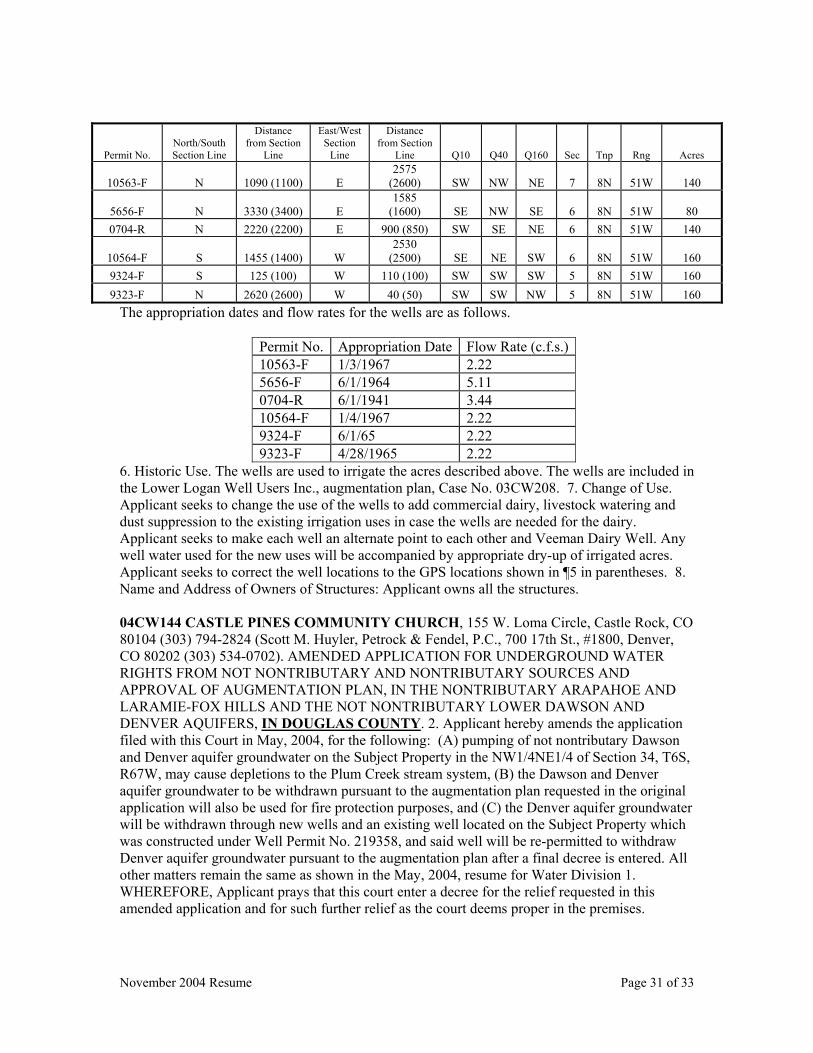
November 2004 Resume Page 31 of 33
The appropriation dates and flow rates for the wells are as follows.
Permit No. Appropriation Date Flow Rate (c.f.s.)10563-F 1/3/1967 2.22 5656-F 6/1/1964 5.11 0704-R 6/1/1941 3.44 10564-F 1/4/1967 2.22 9324-F 6/1/65 2.22 9323-F 4/28/1965 2.22
6. Historic Use. The wells are used to irrigate the acres described above. The wells are included in the Lower Logan Well Users Inc., augmentation plan, Case No. 03CW208. 7. Change of Use. Applicant seeks to change the use of the wells to add commercial dairy, livestock watering and dust suppression to the existing irrigation uses in case the wells are needed for the dairy. Applicant seeks to make each well an alternate point to each other and Veeman Dairy Well. Any well water used for the new uses will be accompanied by appropriate dry-up of irrigated acres. Applicant seeks to correct the well locations to the GPS locations shown in ¶5 in parentheses. 8. Name and Address of Owners of Structures: Applicant owns all the structures. 04CW144 CASTLE PINES COMMUNITY CHURCH, 155 W. Loma Circle, Castle Rock, CO 80104 (303) 794-2824 (Scott M. Huyler, Petrock & Fendel, P.C., 700 17th St., #1800, Denver, CO 80202 (303) 534-0702). AMENDED APPLICATION FOR UNDERGROUND WATER RIGHTS FROM NOT NONTRIBUTARY AND NONTRIBUTARY SOURCES AND APPROVAL OF AUGMENTATION PLAN, IN THE NONTRIBUTARY ARAPAHOE AND LARAMIE-FOX HILLS AND THE NOT NONTRIBUTARY LOWER DAWSON AND DENVER AQUIFERS, IN DOUGLAS COUNTY. 2. Applicant hereby amends the application filed with this Court in May, 2004, for the following: (A) pumping of not nontributary Dawson and Denver aquifer groundwater on the Subject Property in the NW1/4NE1/4 of Section 34, T6S, R67W, may cause depletions to the Plum Creek stream system, (B) the Dawson and Denver aquifer groundwater to be withdrawn pursuant to the augmentation plan requested in the original application will also be used for fire protection purposes, and (C) the Denver aquifer groundwater will be withdrawn through new wells and an existing well located on the Subject Property which was constructed under Well Permit No. 219358, and said well will be re-permitted to withdraw Denver aquifer groundwater pursuant to the augmentation plan after a final decree is entered. All other matters remain the same as shown in the May, 2004, resume for Water Division 1. WHEREFORE, Applicant prays that this court enter a decree for the relief requested in this amended application and for such further relief as the court deems proper in the premises.
Permit No. North/South Section Line
Distance from Section
Line
East/West Section
Line
Distance from Section
Line Q10 Q40 Q160 Sec Tnp Rng Acres
10563-F N 1090 (1100) E 2575
(2600) SW NW NE 7 8N 51W 140
5656-F N 3330 (3400) E 1585
(1600) SE NW SE 6 8N 51W 80 0704-R N 2220 (2200) E 900 (850) SW SE NE 6 8N 51W 140
10564-F S 1455 (1400) W 2530
(2500) SE NE SW 6 8N 51W 160 9324-F S 125 (100) W 110 (100) SW SW SW 5 8N 51W 160 9323-F N 2620 (2600) W 40 (50) SW SW NW 5 8N 51W 160
November 2004 Resume Page 32 of 33
04CW173 RITCHEY LAND AND CATTLE, 13821 Sable Blvd., Route 3, Brighton, CO 80601 (303)419-5031. AMENDED APPLICATION, IN MORGAN COUNTY. 2. An application for change of water right was filed on July 15, 2004. This amendment will correct the legal description of the location of use for Bliss Well No. 1-9509 and will add Bliss Well No. 3-14641. 3. Decreed Name of Structure: Bliss Well No. 1-9510, Bliss Well No. 2-9509 and Bliss Well No. 3-14641. 4. Previous Decrees: Bliss Well No. 1-9510, Bliss Well No. 2-9509 and Bliss Well No. 3-14641 were decreed in Case m W-1553 on December 26, 1972 with an appropriation date of May 21, 1966 for Bliss Well No. 1-9510, May 10, 1966 for Bliss Well No. 2-9509 and April 3, 1951 for Bliss Well No. 3-14641 for 1.96 c.f.s., 1.93 c.f.s. and 2.02 c.f.s. The source for each well is groundwater. The decreed point of diversion for Bliss Well No. 1-9510 is in the SW ¼ of the SE ¼ of Section 29, Township 4 North, Range 60 West of the 6th P.M., Morgan County Colorado at a point 1267 feet north of the south section line and 1366 feet west of the east section line. The decreed point of diversion for Bliss Well No. 1-9509 is in the SW ¼ of the NE ¼ of Section 29, Township 4 North, Range 60 West of the 6th P.M., Morgan County at a point 1715 feet south of the north section line and 1802 feet west of the east section line. The decreed point of diversion for Bliss Well No. 3-14641 is in the SE ¼ of the NE ¼ of Section 29, Township 4 North, Range 60 West of the 6th P.M., Morgan County, Colorado at a point 2310 feet south of the north section line and 888 feet west of the east section line. 5. Historic Use: Bliss Well No. 1-9510 was decreed for irrigation of 160 acres in the SE ¼ of the NE ¼ of Section 29, Bliss Well No. 2-9509 was decreed for the irrigation of 160 acres in the NE ¼ of the NE ¼ of Section 29 and Bliss Well No. 3-14641 was decreed for irrigation of 160 acres in the NE ¼ of Section 29. 6. Proposed Change: This application will correct the decreed legal description of the location of the acres irrigated by each well so that it is consistent with the legal description of the acres that are currently and have historically been irrigated by each well and the legal description of the acres for the wells on their permits. 7. Legal Description of Irrigated Acres: A. Bliss Well No. 1-9510: 140 acres in the SE ¼ of Section 29, Township 4 North, Range 60 West of the 6th P.M., Morgan County Colorado. B. Bliss Well No. 2-9509: 160 acres in the NE ¼ and part of the NW ¼ of Section 29, Township 4 North, Range 60 West of the 6th P.M., Morgan County Colorado. C. Bliss Well No. 3-14641: 160 acres in the NE ¼ and part of the NW ¼ of Section 29, Township 4 North, Range 60 West of the 6th P.M., Morgan County Colorado. Bliss Well No. 2-9509 and Bliss Well No. 3-14641 are used together for the irrigation of the 160 acres in the NE ¼. A portion of the 160 acres is located in the NW ¼. 8. Name and Address of Owners of Structures: Ritchey Land and Cattle. 04CW264 LIVENGOOD HILLS AND WINCHESTER PINES LOT OWNERS, AND JERALD AND SHERRILL FIFIELD, ET AL., c/o 13614 N. Winchester Way, Parker, CO 80134 (303) 841-1703 (Scott M. Huyler, Petrock & Fendel, P.C., 700 17th St., #1800, Denver, CO 80202 (303) 534-0702). AMENDED APPLICATION FOR UNDERGROUND WATER RIGHTS FROM NOT NONTRIBUTARY AND NONTRIBUTARY SOURCES, IN THE NONTRIBUTARY ARAPAHOE AND LARAMIE-FOX HILLS AQUIFERS, IN DOUGLAS COUNTY. 2. The original application was filed with this Court in October 2004, and requests the adjudication of nontributary Arapahoe and Laramie-Fox Hills aquifer groundwater underlying approximately 197.4 acres of land located in the W1/2 W1/2 of Section 5 and the E1/2 and N1/2 NW1/4 of Section 6, T6S, R65W of the 6th P.M. The original application referenced the Subject Property as being in the N1/2NE1/4 of Section 6 when it should reference the N1/2 NW1/4 of Section 6. Also, Applicants are adding one additional 2.4 acre lot being Lot 75, Livengood Hills, Filing 3, and revising the acreage and legal descriptions as described and shown on the revised Attachment A and B hereto. The total acreage of the Subject Property is now approximately 201.2 acres. All other matters remain the same as shown in the October, 2004, resume for Water Division 1. WHEREFORE, Applicants pray that this court enter a decree for the relief requested
November 2004 Resume Page 33 of 33
in this amended application and for such further relief as the court deems proper in the premises. THE WATER RIGHTS CLAIMED BY THESE APPLICATIONS MAY AFFECT IN PRIORITY ANY WATER RIGHTS CLAIMED OR HERETOFORE ADJUDICATED WITHIN THIS DIVISION AND OWNERS OF AFFECTED RIGHTS MUST APPEAR TO OBJECT WITHIN THE TIME PROVIDED BY STATUTE OR BE FOREVER BARRED. YOU ARE HEREBY NOTIFIED that any party who wishes to oppose an application, or an amended application, may file with the Water Clerk, P. O. Box 2038, Greeley, CO 80632, a verified Statement of Opposition, setting forth facts as to why the application should not be granted, or why it should be granted only in part or on certain conditions. Such Statement of Opposition must be filed by the last day of JANUARY 2005 (forms available on www.courts.state.co.us or in the Clerk’s office), and must be filed as an Original with triplicate copies and include $70.00 filing fee. A copy of each Statement of Opposition must also be served upon the Applicant or Applicant’s Attorney and an affidavit or certificate of such service of mailing shall be filed with the Water Clerk.