northaven trail phase 2 - wordpress.com · city of dallas trail network master plan ... northaven...
TRANSCRIPT

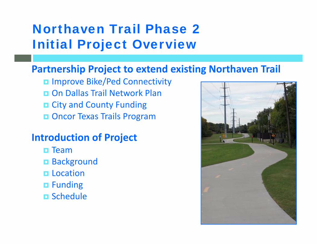
Northaven Trail Phase 2Initial Project Overview
Partnership Project to extend existing Northaven Trail Improve Bike/Ped Connectivity On Dallas Trail Network Plan City and County Funding Oncor Texas Trails Program
Introduction of Project Team Background Location Funding Schedule

Project Made Possible By…
Oncor Electric – Texas Trails ProgramCouncil Member Jennifer Gates – City of Dallas Council District 13Council Member Lee Kleinman – City of Dallas Council District 11Commissioner Mike Cantrell – Dallas County Commissioner District 2Commissioner Dr. Elba Garcia – Dallas County Commissioner District 4City of Dallas Park BoardFriends of Northaven Trail…and many other project partners

Dallas County (Project Manager):Commissioner Districts #2, #4Department of Public Works
City of Dallas:Council Districts #13, #11, #6Park & Recreation Public Works & TransportationStreets DepartmentDWU
Consultants:Urban Engineers GroupLa Terra Studio
Current and Potential Project PartnersPartnering = Trust + Commitment + Shared Vision
Community:Friends of Northaven TrailBicycle Friendly North DallasNearby Property OwnersChurchesYMCAGeneral Public
Other Agencies/Entities: Oncor, TxDOT, NTTA, DART, Utilities

Creating a Sense of PlaceProviding Safe &
Convenient Access
Promoting a healthy lifestyle
More Than A “Trail”
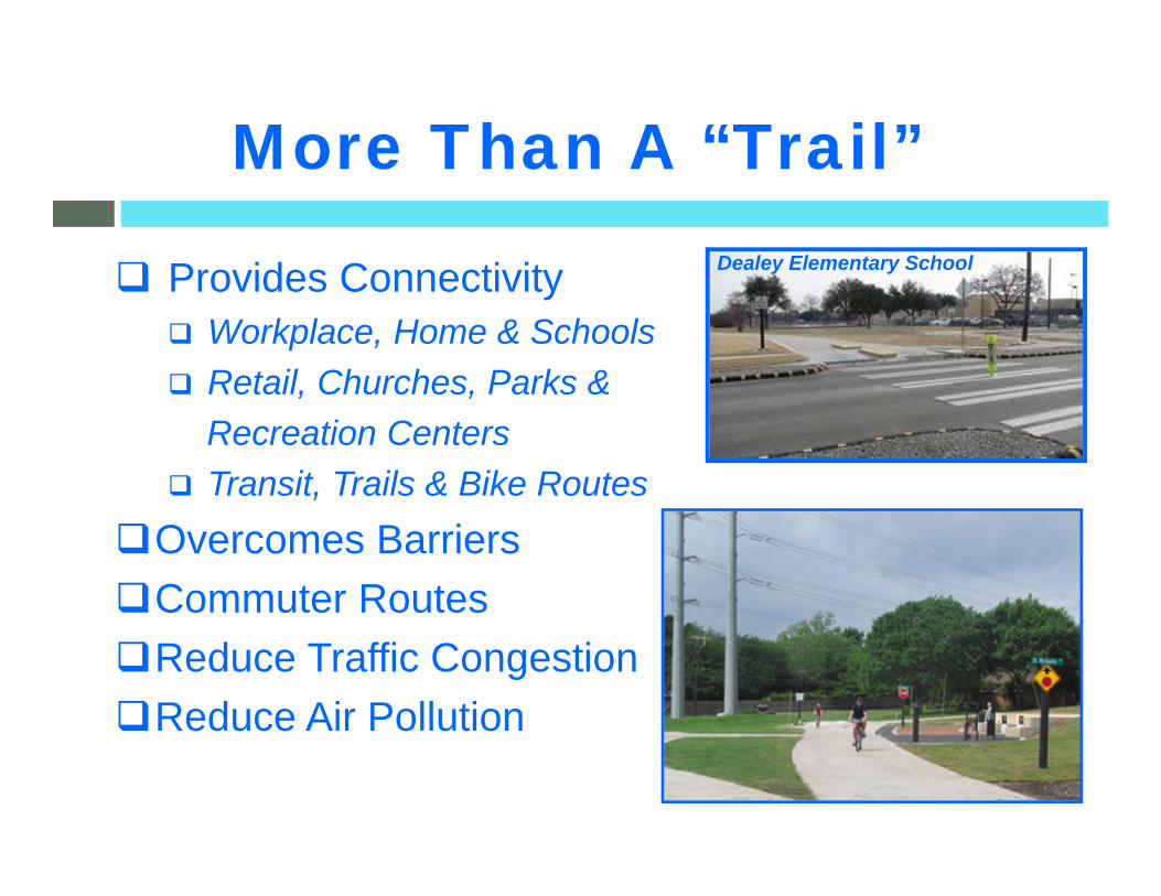
Provides Connectivity Workplace, Home & Schools Retail, Churches, Parks &
Recreation Centers Transit, Trails & Bike Routes
Overcomes BarriersCommuter RoutesReduce Traffic CongestionReduce Air Pollution
More Than A “Trail”Dealey Elementary School

Benefits of Trail Development
Research on trail impacts found that trails… Improve health and wellbeing Enhance sense of community Reduce crime and vandalism Raise property valuesSources: American Trails, Rails to Trails Conservancy, Urban Land,
National Association of Realtors and National Association of Homebuilders

Benefits of Trail Development
Valuable form of alternative transportation Recreational amenity that accommodates
multiple types of trail users Strong trail system is a Quality of Life asset
often attractive to relocating corporations Enhancing sense of place for neighborhoods
“I live by Northaven Trail”

Northaven Trail Milestones
2005 Northaven Trail Included in the adopted City of Dallas Trail Network Master Plan
2008 City of Dallas submitted project proposal in Dallas County MCIP 5th Call for Projects
2009 Phase I (Preston to Valleydale) initial planning and design begins
2010 County MCIP funding commitments &2011 approved for Northaven Trail
2012 Phase I completed by City of Dallas
2012 Initial planning efforts on Phase 2 until design funding available
2012, Nov – City Bond Election Approved funding for Northaven Trail Phase 2
Design funding programmed in FY 2014
Construction funding in FY 2016
2013, Fall – Funding available to begin design
NorthavenTrail Corridor

East‐West Bike/Ped Corridor Primarily within property owned by Oncor Electric• Over 11 mile route from Elm Fork to White Rock Creek• Existing Phase I (Preston to Valleydale): Over 2 miles completed in 2012
• Access to Parks, Schools, Churches, JCCFuture Connections
• Trails East of US 75: White Rock Creek, Cottonwood Creek, future SoPac• West of IH 35E: Elm Fork Athletic Complex, LB Houston facilities, Campion Trail
Overall Northaven Trail Corridor Overview
Northaven Phase INorthaven Phase I
BIKE/PED PROJECTS:Completed ProjectsPlanned Projects
Phase 2
Northaven Phase 2 Proposed AlignmentProject Limits:Preston Rd to DART at Walnut Hill/Denton
SoPac Trail Phase 4SoPac Trail Phase 4
CottonwoodTrailCottonwoodTrail
White Rock Creek TrailWhite Rock Creek Trail
Future Phase 3Harry Hinesto Elm Fork
Future Phase 3Harry Hinesto Elm Fork
EFAC (Elm Fork Athletic Complex)
LB Houston Golf Course& TennisCourts
LB Houston NatureTrails
To White Rock Lake
Off‐RoadBikeTrails
MossParkHarry Hines
Ped Bridge & Wide Sidewalks
Harry HinesPed Bridge & Wide Sidewalks
Town North YMCA
RoyalPark
NorthavenPark
JCC
Denton Dr Phase 1Denton Dr Phase 1
Northaven Phase 2(Subject to Change)

Northaven Phase 2 Project Overview Map(Trail Alignment Subject to Change)
From existing trail (Phase I) at Preston Road to Walnut Hill/Denton DART Station (Green Line)Total length: approximately 6.25 miles
Middle segment of overall Northaven Trail Corridor
Connections: Schools, Parks, Churches, Community Facilities, DART, Retail/Commercial
Preston R
dRoyal Ln
Walnut Hill Ln
Northaven Rd
Midw
ay Rd
Marsh Ln
Northaven Trail Phase 2Proposed Alignment(subject to change)with options being studied

• Oncor Texas Trails Program• Licensing Agreement between City and Oncor allowing use as Park facility
(e.g. existing Phase I – Preston Rd to Valleydale Dr)
• Various Oncor requirements to allow trail use on property• Trail width and offset from towers• Allowed amenities & associated requirements• Lighting generally not allowed• Maintenance and other requirements…• Some requirements have changed since Northaven Phase I
• Existing uses within Oncor property (e.g. power stations, parking)may require options outside of Oncor property• Trail easements and/or use of adjacent alleyways• Sidewalks/On‐street bike facilities near DART Green Line light rail station
Trail to be primarily within Oncor property

Various City Departments for trail facility, roadway crossings,stormwater drainage, alleyway adjustments, etc…
Friends of Northaven Trail Trail facility and opportunities for amenities
TxDOT Modifications for crossing Preston Road (SH 289)
NTTA Separated facility for trail users on the existing
Northaven Road bridge over Dallas North Tollway (DNT) DART
Station access and possible adjustments to bus stops Franchise Utility Providers (AT&T, Atmos, Oncor, TWC, etc…)
Possible utility relocations Shared access to utilities located in alleyways
Additional Coordination
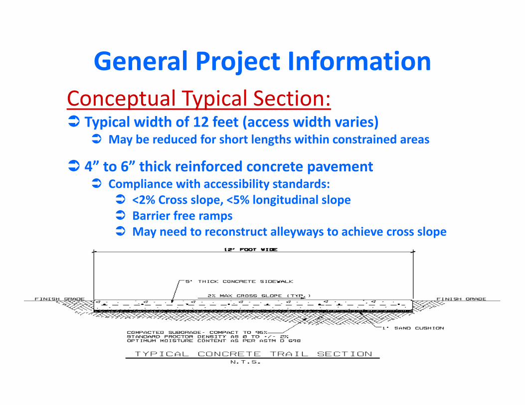
Conceptual Typical Section: Typical width of 12 feet (access width varies)
May be reduced for short lengths within constrained areas
4” to 6” thick reinforced concrete pavement Compliance with accessibility standards:
<2% Cross slope, <5% longitudinal slope Barrier free ramps May need to reconstruct alleyways to achieve cross slope
General Project Information

*County Major Capital Improvement Program (MCIP) funding eligible for up to 50% of basictransportation infrastructure items***
Additionally Dallas County currently has $1,739,400 pending anequal funding match from the City and/or Others** towardsbasic transportation infrastructure items***
Current Estimated Project FundingSource FY 2012 FY 2014 FY 2016 TOTAL
City (Park,(2012 Bond)
$50,000 $256,590 $1,454,010 $1,760,600
County MCIP* $50,000 $256,590 $1,454,010 $1,760,600
Totals: $100,000 $513,180 $2,908,020 $3,521,200
Funding for Future Phases Pending Funding Match
**Funding match may also be from Regional, State or Federal funding grants orprivate donations facilitated by the City.
*** Amenities can be incorporated into MCIP project as City‐only costs

Ongoing Conceptual (30%) Design/Master Plan Study entire 6.25 mile length in greater detail Confirm initial segment length
To be completed with currently available funding Identify/define future phases
Limits and estimated costs
Phased approachbased on funding availability

Extent of Initial Segment with Current Available Funding More detail at Spring 2014 Public Workshop Challenging conditions compared to typical trails
Possible alleyway modifications to meet accessibility standards Alleys needed to pass by existing parking, sub‐stations within Oncor property Shared use to preserve existing rear driveway access to/from alley
Turnouts along alleyways could help avoid conflicts
Street crossings and new traffic control devices Creek and drainage ditch crossings Curvilinear path similar to Northaven Phase I
Influenced by required trail offset distances from Oncor towers and reaching good locations for street crossings
Balancing Amenities and Trail Length Basic trail item costs shared by City/County Amenity costs from City funding and/or Others (donations, funding grants)

Potential Funding Opportunities
Future City Bond Program Transportation Alternatives Program (TAP)
Federal funding program for transportation alternatives such as trails 2014 Call for Projects
For North Central Texas Region (12‐Counties) only $28M available Maximum award of $3.0M (requires minimum $750,000 local match)
Construction can begin in FY 2016
Private Donations Funding or easements for basic trail infrastructure
Coordinate through City of Dallas as match to County funding
Amenities Friends of Northaven Trail in coordination with City of Dallas
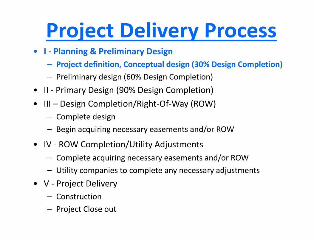
• I ‐ Planning & Preliminary Design– Project definition, Conceptual design (30% Design Completion)– Preliminary design (60% Design Completion)
• II ‐ Primary Design (90% Design Completion)• III – Design Completion/Right‐Of‐Way (ROW)
– Complete design– Begin acquiring necessary easements and/or ROW
• IV ‐ ROW Completion/Utility Adjustments– Complete acquiring necessary easements and/or ROW– Utility companies to complete any necessary adjustments
• V ‐ Project Delivery– Construction– Project Close out

Current Progress/Upcoming Activities
Consultant Selection Initial Planning
Public Meeting/Introductory Overview of ProjectOngoing Conceptual Design/Master Plan
(Field Survey, Drainage Analysis, Crossings, Traffic Signal Analysis, Conceptual Schematics, Cost Estimates, Phasing Plan)
Stakeholder MeetingsPublic Workshop
Park Board Approval of Master PlanBegin Preliminary Design
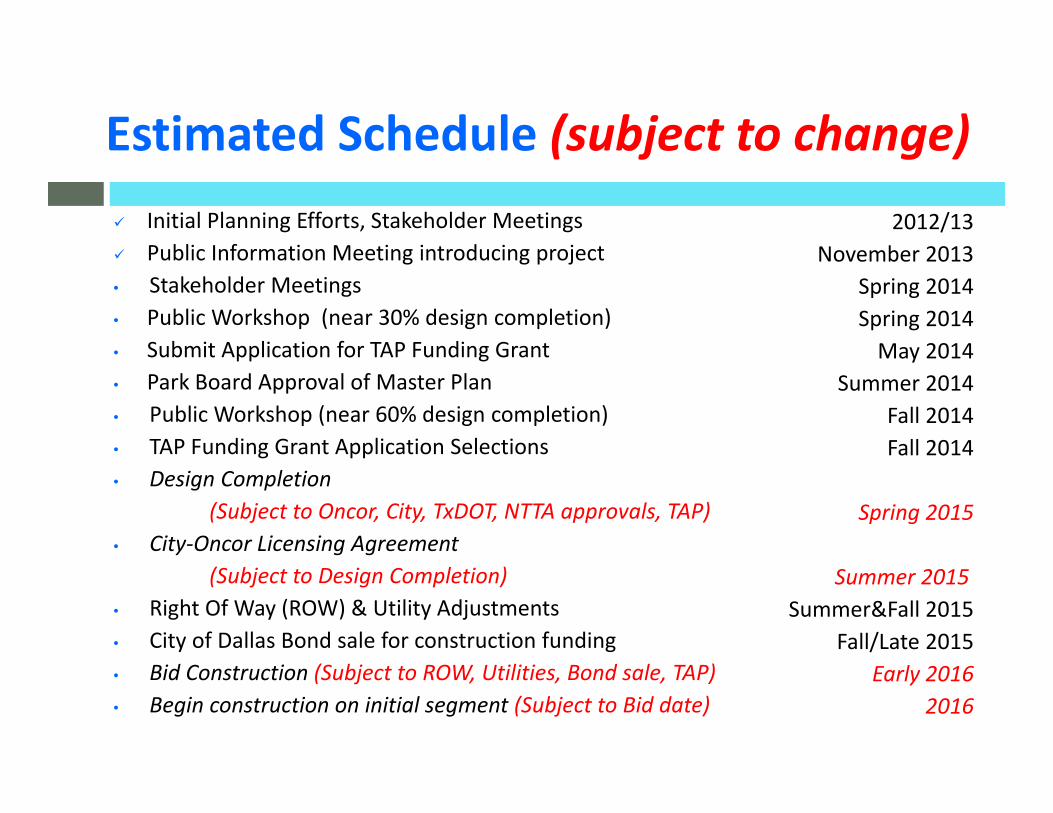
Initial Planning Efforts, Stakeholder Meetings Public Information Meeting introducing project• Stakeholder Meetings • Public Workshop (near 30% design completion)• Submit Application for TAP Funding Grant • Park Board Approval of Master Plan • Public Workshop (near 60% design completion)• TAP Funding Grant Application Selections • Design Completion
(Subject to Oncor, City, TxDOT, NTTA approvals, TAP) • City‐Oncor Licensing Agreement
(Subject to Design Completion)• Right Of Way (ROW) & Utility Adjustments • City of Dallas Bond sale for construction funding• Bid Construction (Subject to ROW, Utilities, Bond sale, TAP)• Begin construction on initial segment (Subject to Bid date)
Estimated Schedule (subject to change) • 2012/13
• November 2013• Spring 2014• Spring 2014
• May 2014• Summer 2014
• Fall 2014• Fall 2014
• Spring 2015
• Summer 2015• Summer&Fall 2015
• Fall/Late 2015• Early 2016
• 2016