monitoring ecosystem restoration treatments in the rocky ... · rocky mountain trench of...
TRANSCRIPT

MONITORING ECOSYSTEMRESTORATION TREATMENTS IN THE
ROCKY MOUNTAIN TRENCH
SITE ESTABLISHMENT REPORT
PREPARED BYHillary Page
AndMarlene M. Machmer
Pandion Ecological Research Ltd.
January 2003
COLUMBIA BASINFISH & WILDLIFECOMPENSATION
PROGRAM
www.cbfishwildlife.org

Restoration Treatment Monitoring in the Rocky Mountain Trench: Site Establishment Report
Pandion Ecological Research Ltd. ii
Summary
In June of 2002, the Columbia Basin Fish and Wildlife Compensation Program (CBFWCP) and
the Ministry of Water, Land and Air Protection (WLAP) initiated year one of a multi-year field
study designed to monitor the effects of ecosystem restoration treatments on overstory and
understory vegetation characteristics. This report summarizes activities associated with year one
(2002): sample plot establishment and pre-treatment monitoring at three sites located in the
Rocky Mountain Trench of southeastern British Columbia.
Restoration monitoring sites were established at Gina Lake (15 km east of Wasa) in the north
Trench, and at Hatchery Ridge (20 km east of Cranbrook) and Rock’s Pasture (32 km south of
Newgate Provincial Park) in the south Trench. Fifteen plots were permanently located and
systematically sampled at each of the three sites, according to general methods outlined in
Machmer et al. (2002). Understory sampling (% cover by species, species composition and
richness) was conducted from July 10-17, 2002. Overstory sampling (% crown closure, and tree
density by species, diameter, and decay class in nested fixed radius plots) and forage production
assessments were completed from September 5-11, 2002. The data were entered into EXCEL
spreadsheets for easy import into an ACCESS relational database. A summary of pre-treatment
vegetation conditions is provided for each site. Post-treatment sampling is scheduled to occur on
all three sites.
Acknowledgements
This project was conducted by Hillary Page, Jakob Dulisse and Marlene Machmer and
photographs in the report were taken by Jakob Dulisse. Ian Parfitt (CBFWCP) prepared the
maps and Dave Lewis and Larry Ingham (CBFWCP) placed production cages at each of the
sites. We would like to thank the following individuals for their assistance with this project:
Doug Adama, Greg Anderson, Phil Burke, Craig DeMaere, Reg Newman, Darrell Regimbald,
and Irene Teske. Finally we would also like to thank John Krebs for administering the project
and the CBFWCP and the Habitat Conservation Trust Fund (HCTF) for providing the funding.

Restoration Treatment Monitoring in the Rocky Mountain Trench: Site Establishment Report
Pandion Ecological Research Ltd. iii
Table of Contents
Summary ......................................................................................................................................... ii
Ackmowledgements........................................................................................................................ ii
Table of Contents........................................................................................................................... iii
1. Introduction................................................................................................................................ 1
2. Methods ..................................................................................................................................... 3
2.1 Study area ............................................................................................................................ 3
2.2 Restoration objective monitoring......................................................................................... 9
2.2.1 Restoration objective 1 ............................................................................................... 9
2.2.2 Restoration objective 2 ............................................................................................. 10
2.2.3 Restoration objective 3 ............................................................................................. 11
2.2.4 Restoration objective 4 ............................................................................................. 11
2.3 Data entry........................................................................................................................... 12
2.4 Data summary and analysis ............................................................................................... 12
3. Results and Observations......................................................................................................... 12
3.1 General site descriptions.................................................................................................... 12
3.1.1 Gina Lake pasture ..................................................................................................... 13
3.1.2 Hatchery Ridge pasture............................................................................................ 13
3.1.3 Rocks pasture ............................................................................................................ 13
3.2 Overstory characteristics.................................................................................................... 13
3.2.1 Gina Lake pasture..................................................................................................... 13
3.2.2 Hatchery Ridge pasture ........................................................................................... 17
3.2.3 Rocks pasture ........................................................................................................... 17
3.3 Understory characteristics.................................................................................................. 18
3.3.1 Gina Lake pasture..................................................................................................... 18
3.3.2 Hatchery Ridge pasture ........................................................................................... 19
3.3.2 Rock's pasture .......................................................................................................... 20
4. Recommendations.................................................................................................................... 21
4.1 Gina Lake pasture............................................................................................................. 21
4.2 Hatchery Ridge pasture .................................................................................................... 22
4.3 Rocks pasture.................................................................................................................... 22

Restoration Treatment Monitoring in the Rocky Mountain Trench: Site Establishment Report
Pandion Ecological Research Ltd. iv
4.4 General recommendations .................................................................................................. 23
5. Literature Cited ........................................................................................................................ 24
List of Appendices
Appendix 1. List of EXCEL raw data files and their descriptions (RW-CD format)................... 27
Appendix 2. Scanned photos (RW-CD format)............................................................................ 27
Appendix 3. Names and descriptions of EXCEL spreadsheets in the “Summary Data” file (RW-
CD format) .................................................................................................................................... 27
Appendix 4. Northern Goshawk (Accipeter gentilis antricapillus) nest location (Sensitive
Information) .................................................................................................................................. 28
Appendix 5. Locations of the three monitoring sites…………………………………………..29
List of Tables
Table 1. Tree descriptions by layer used for overstory measurement ............................................ 9
Table 2. Summary of pre-treatment overstory characteristics at three restoration sites sampled in
2002............................................................................................................................................... 16
Table 3. Summary of pre-treatment densities (stems/hectare) of layer 1, 2 and 31 trees (total trees
and dead trees only) at three restoration sites sampled in 2002.................................................... 16
Table 4. Summary of pre-treatment densities (stems/hectare) of layer 41 trees (regeneration/germinants) at three restoration sites sampled in 2002................................................................. 16
Table 5. Summary of pre-treatment understory cover characteristics by functional group at three restoration sites sampled in 2002......................................................................................... 19
Table 6. Summary of pre-treatment understory production (kg/ha) characteristics by functional group at three restoration sites sampled in 2002 ......................................................... 19
List of Figures
Figure 1. Gina Lake pasture (site 1) located in the Invermere Forest District................................ 4
Figure 2. Hatchery Ridge pasture (site 2) located in the Cranbrook Forest District. ..................... 5
Figure 3. Rocks pasture (site 3) located in the Cranbrook Forest District...................................... 6
Figure 4. Layout of overstory (a) and understory (b) sampling plots............................................. 8
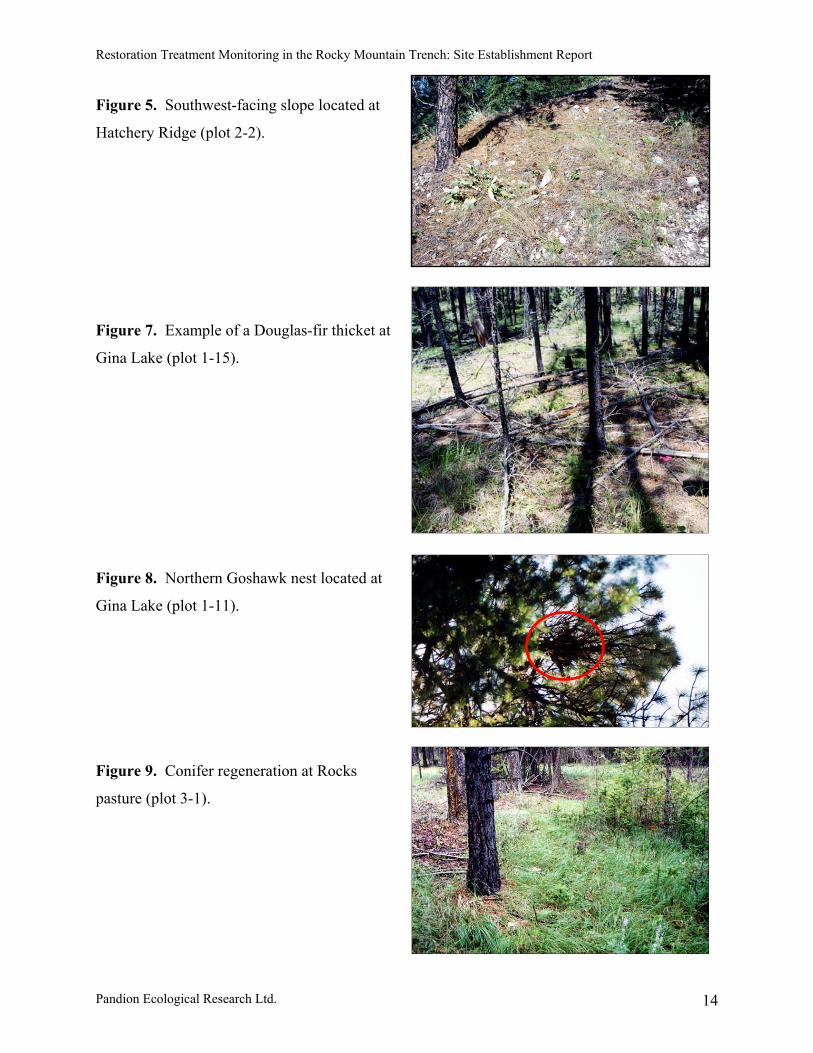
Figure 5. Southwest-facing slope located at Hatchery Ridge (plot 2-2)....................................... 14
Figure 6. Stem diameter distributions for pre-treatment layers 1a, 1, 2 and 3 at three restoration
sites sampled in 2002.................................................................................................................... 15
Figure 7. Example of a Douglas-fir thicket at Gina Lake (plot 1-15)........................................... 14

Restoration Treatment Monitoring in the Rocky Mountain Trench: Site Establishment Report
Pandion Ecological Research Ltd. v
Figure 8. Northern goshawk nest located at Gina Lake (plot 1-11).............................................. 14
Figure 9. Conifer regeneration at Rocks Pasture (plot 3-1) .......................................................... 14

Restoration Treatment Monitoring in the Rocky Mountain Trench: Site Establishment Report
Pandion Ecological Research Ltd. 1
1. Introduction
An estimated 250,000 ha of Crown land within the Ponderosa Pine (PP) and Interior Douglas-fir
(IDF) biogeoclimatic zones of the Rocky Mountain Trench and adjoining side valleys are
classified as fire-maintained (i.e., Natural Disturbance Type 4; Province of British Columbia
1995, Gayton 1997). Prior to European settlement, these ecosystems experienced frequent
(every 7–50 years), low intensity fires (Leiberg 1899, Cooper 1960, Arno et al. 1995). Recurrent
fires promoted the development of fire-tolerant overstories of mature ponderosa pine (Pinus
ponderosa Douglas ex Lawson & Lawson var. ponderosa), Douglas-fir (Pseudotsuga menziesii
var. glauca (Beissn.) Franco), and western larch (Larix occidentalis Nutt.), with sparse conifer
regeneration, and a vigorous understory of bunchgrasses, shrubs and forbs (Arno et al. 1995,
Daigle 1996).
NDT4 ecosystems have undergone dramatic changes in structure and function partially attributed
to fire suppression and concomitant forest ingrowth and encroachment (Daigle 1996, Gayton
1997, Rocky Mountain Trench Ecosystem Restoration Steering Committee 2000, Bai et al.
2001). Gayton (1997) estimates that 1% of grassland and open forest habitats in the Rocky
Mountain Trench are lost annually due to ingrowth or encroachment. This rate is equivalent to
approximately 3,000 ha per year, and is comparable to estimates from other parts of B.C.
exhibiting similar changes (Bai et al. 2001). As a result of this conversion, domestic livestock
and native ungulates are exerting increasing pressure on a declining land base as they compete
for forage. Remaining grassland habitats are being further degraded by noxious weeds which
may out-compete native vegetation and reduce residual forage quantity and quality. Densely
stocked stands also pose an increased risk of severe insect outbreaks and catastrophic crown fires
(Powell et al. 1998, Rocky Mountain Trench Ecosystem Restoration Steering Committee 2000).
To mitigate these changes, land management agencies in the East Kootenay Trench are currently
undertaking ecosystem restoration or habitat enhancement programs intended to restore NDT4
ecosystems. The Trench Restoration Program is the most extensive restoration terrestrial
initiative in B.C. An estimated 135,000 ha is planned for restoration (Rocky Mountain Trench
Ecosystem Restoration Steering Committee 2000). The primary objective of this program is to

Restoration Treatment Monitoring in the Rocky Mountain Trench: Site Establishment Report
Pandion Ecological Research Ltd. 2
remove excess immature and understory trees in order to create an ecologically appropriate
mosaic of NDT4 habitats on Crown land. This mosaic is intended to mimic the historical
landscape under natural conditions when fire was an integral part of the ecosystem (Rocky
Mountain Trench Ecosystem Restoration Steering Committee 2000).
Ecosystem restoration is typically achieved through a three-phase process. In phase one,
ingrown forest stands are thinned to between 20 and 70% of their basal area. Site conditions and
stand history dictate what type of tree removal (harvesting, spacing or slashing) is carried out
(Arno et al. 1996; Powell et al. 1999). Phase two involves periodic prescribed burning to kill
tree seedlings and smaller undesirable trees, while minimizing fire damage to mature trees. In
phase three, sites are rested to allow regenerated stems to grow to a height where they can
withstand low-intensity burns. This final phase may coincide with a partial harvest of mature
stems on the site. Because of the variable history of each site, pre-treatment conditions dictate
what type and combination of treatments is carried out in any given area.
Although dry forest restoration treatments are being applied in several areas across western
North America (e.g., Arizona, Colorado, Montana, Washington and British Columbia),
associated monitoring tends to examine a narrow set of treatment effects (review in Machmer et
al. 2002). Furthermore, while prescribed burning has been studied extensively, less attention has
been given to ecological impacts of thinning treatments used to restore stand structure prior to
fire re-introduction (Smith and Arno 1999). Treatment phases should be monitored in isolation
to ensure that restoration goals and objectives are being met, as well as to obtain information that
will fine-tune future restoration efforts (Ritchie and Harksen 1999).
This project is in response to a Request for Proposals from the Columbia Basin Fish & Wildlife
Compensation Program (CBFWCP) and the Ministry of Water, Land & Air Protection
(MWLAP). Specific objectives of the project were to (1) establish three permanent monitoring
sites within the Trench, and (2) collect data on pre-treatment vegetation overstory and understory
conditions at each site and summarize. Post-treatment re-assessments are planned for each site.

Restoration Treatment Monitoring in the Rocky Mountain Trench: Site Establishment Report
Pandion Ecological Research Ltd. 3
2. Methods
Methods are based on those described in “An Effectiveness Monitoring Plan (EMP) for NDT4
Ecosystem Restoration in the East Kootenay Trench” (Machmer et al. 2002), with modifications
based on discussions with John Krebs (CBFWCP). The following four restoration objectives
outlined in the EMP were chosen for monitoring purposes:
Restoration Objective 1:
Reduce tree density, increase tree size, and achieve a tree species composition that falls within
the historical range of variability for treated areas (based on aspect, slope, topography, moisture).
Restoration Objective 2:
Maintain or increase fire-adapted native understory vegetation in treated areas.
Restoration Objective 3:
Minimize the establishment and spread of non-native plant species, particularly noxious species,
in treated areas.
Restoration Objective 4:
Maintain or increase forage production in treated areas.
2.1 Study area
Three treatment sites were selected for this project (hereafter referred to as sites 1, 2 and 3
respectively):
(1) Gina Lake pasture (209 ha in the Invermere Forest District; IDFdm2);
(2) Hatchery Ridge pasture (117 ha in the Cranbrook Forest District; IDFdm2); and
(3) Rocks pasture (451.8 ha in the Cranbrook Forest District; IDFdm2).
Maps of each site showing the layout of numbered sampling plots are provided in Figures 1, 2
and 3, respectively.

900
55 22 500m N
55 23 000m N
55 23 500m N5 94 500m E 5 95 000m E 5 95 500m E
1-11
1-10
1-8 1-15
1-14
1-13
1-12
1-1
1-2
1-3
1-4
1-5
1-6
1-7
1-9
Figure 1. Gina Lake pasture (site 1) located in the Invermere Forest DistrictColumbia Basin Fish and Wildlife Compensation Program -- June 12, 2003
Monitoring Location
Treatment Unit Boundary
0 100 200 300 400 500 m
Scale: 1:10,000 - Projection: UTM Zone 11 - Datum: NAD 83
4

800
54 81 500m N
54 82 000m N
54 82 500m N
6 08 500m E 6 09 000m E 6 09 500m E 6 10 000m E
2-1
2-2
2-3
2-4
2-52-6 2-7
2-8
2-92-10
2-112-12
2-132-14
2-15
Figure 2. Hatchery Ridge pasture (site 2) located in the Cranbrook Forest DistrictColumbia Basin Fish and Wildlife Compensation Program -- June 12, 2003
Monitoring Location
Treatment Unit Boundary
Rock Outcrop
0 100 200 300 400 500 m
Scale: 1:10,000 - Projection: UTM Zone 11 - Datum: NAD 83
5

800
54 30 500m N
54 31 000m N
54 31 500m N
6 29 500m E 6 30 000m E 6 30 500m E
3-1
3-2
3-3
3-4
3-5
3-63-73-83-93-103-11
3-12
3-13
3-14 3-15
Figure 3. Rocks pasture (site 3) located in the Cranbrook Forest DistrictColumbia Basin Fish and Wildlife Compensation Program -- June 12, 2003
Monitoring Location
Treatment Unit Boundary
0 100 200 300 400 500 m
Scale: 1:10,000 - Projection: UTM Zone 11 - Datum: NAD 83
6

Restoration Treatment Monitoring in the Rocky Mountain Trench: Site Establishment Report
Pandion Ecological Research Ltd. 7
Burlott’s pasture (located within the same range unit as Rock’s pasture) was originally selected
as site 3, but it was eliminated based on consultation with CBFWCP, due to recent harvesting
activity. An SP/SMP has been completed for each site, and partial overstory removal (via
logging and/or slashing) followed by prescribed burning (broadcast or sloop) is planned for each
site over the next 1−3 years.
Fifteen plots (see Figure 4a) were systematically established at each of the three sites, avoiding
areas that were heavily disturbed or unrepresentative of the rest of the block. At Gina Lake,
monitoring plots were superimposed on existing timber cruise plots located at 200 intervals.
Two of the plots were offset slightly to avoid a road and an open marshy area, respectively. Plot
establishment at Hatchery Ridge was limited by available space, and plots were therefore located
only 100 m apart. The first plot at Rocks pasture was located at a random distance and bearing,
with subsequent plots spaced at 100 m intervals. Plot locations were recorded using a Trimble
Pathfinder Global Positioning System (GPS) and plot locations (UTMs) are provided in
Appendix 1.
Plot centers were permanently marked using an 8” galvanized spike and two spray-painted
washers. Three 11.28 m transects (see Figure 4b) were established radiating out from each plot
center to form a spoke separated by 120o. The first bearing was randomly selected, with
subsequent bearings determined by adding 120° and 240°, respectively. The second and third
transects followed in a clockwise position (from plot center, facing north) to complete the spoke
(Figure 4b). All bearings were recorded and entered into a database (Appendix 1). Four
Daubenmire frame locations were permanently marked on each transect (4 frames/transect = 12
total/plot). Daubenmire frames were located on the left hand side of the transect at meters 3, 5, 7
and 9. The left hand corner located on the transect was permanently marked with an 8”
galvanized spike and 1 spray painted washer. Each spike was flagged and numbered and the
flagging will have to replaced periodically.

Restoration Treatment Monitoring in the Rocky Mountain Trench: Site Establishment Report
Pandion Ecological Research Ltd. 8
Figure 4. Layout of overstory (a) and understory (b) sampling plots adapted from DeLong et al.
(2001).

Restoration Treatment Monitoring in the Rocky Mountain Trench: Site Establishment Report
Pandion Ecological Research Ltd. 9
2.2 Restoration objective monitoring
2.2.1 Restoration objective 1
Objective: Reduce tree density, increase tree size, and achieve a tree species composition that
falls within the historical range of variability for treated areas (based on aspect, slope,
topography, moisture, etc.) (Machmer et al. 2001).
Response Variables: Crown closure, tree density, diameter and species composition.
Overstory plot layout conformed to methods developed by the BC Forest Service Permanent
Sample Plot procedures (BCMOF 2000) and DeLong et al. (2001), with some modifications, to
ensure that large trees and snags were adequately sampled. Fifteen nested, fixed-radius plots
(Figure 4a) were established to sample each layer as follows: layer 1 (1.78 m radius), layer 2, 3
and 4 (3.99 m radius), layer 1 mature (11.28 m radius), and layer 1 dominant/veteran (25 m
radius) (Table 1). Tree species, diameter (diameter at breast height in cm), decay class, and
evidence of insects or diseases were recorded for each tree in layers 1, 2 and 3. A tally was made
by species (live/dead) for layer 4. A spherical densiometer was used to measure percent crown
closure at plot center. At five randomly selected plots in each block, four photos were taken
from plot center facing N, S, E, W, respectively (n = 20 photos per site). Photos were taken at
ground level, due to difficulty in framing pictures of the overstory. Visual changes to the
overstory will be documented by tracking changes in crown closure and stem density within
plots. Photos were scanned and are provided in Appendix 2.
Table 1. Tree descriptions by layer used for overstory measurement.
Layer number Layer name Layer description1 dominant/veteran >30 cm dbh1 mature 12.5 – 30 cm dbh2 pole 7.5 – 12.49 cm dbh3 sapling 1.3 m height and < 7.5 cm dbh4 regeneration < 1.3 m height4 germinant seedlings < 2 years old

Restoration Treatment Monitoring in the Rocky Mountain Trench: Site Establishment Report
Pandion Ecological Research Ltd. 10
2.2.2 Restoration objective 2
Objective: Maintain or increase fire-adapted native vegetation (grass, herb, shrub) in treated
areas.
Response Variables: Grass, herb and shrub cover by species, species richness and composition.
Understory plot layout conformed to methods developed by DeLong et al. (2001) and Powell et
al. (1998), with modifications made based on the specific goals of this project. Three 11.28 m
transects (Fig. 4b) were established radiating out from each plot center to form a spoke separated
by 120°. Understory vegetation cover and composition data were collected in Daubenmire
frames (Daubenmire 1959). In each frame, % herb and grass cover by species was recorded.
Species richness was recorded by plot, and species diversity (by plot and overall) was
determined using the Shannon-Weiner diversity index (H=-Pilog[PI]) (Bonham 1983).
To assess plant vigor, flowering culm counts were conducted for bunchgrasses (see Page 2002).
Bunchgrasses chosen for monitoring are species considered historically common in NDT4 stands
and include: rough fescue (Festuca campestris Rydb.), Idaho fescue (Festuca idahoensis Elmer),
bluebunch wheatgrass (Pseudoroegneria spicata (Pursh) A. Löve), Junegrass (Koeleria
macrantha (Ledeb. J.A. Schultes f.), Richardson’s needlegrass (Stipa richardsonii Link.),
needle-and-thread grass (Stipa comata Trin.&Rupr.), and stiff needlegrass (Stipa occidentalis
Thurb. ex S. Wats. var. pubescens Maze, Tayor and MacBryde).
The line-intercept method (Bonham 1983) was used to estimate shrub cover along each 11.28 m
spoke. All shrub species intersecting the three transects were recorded to the nearest centimeter.
Canopy cover rather than foliar cover was used to determine plant ‘interception’ (i.e., the outside
perimeter of the plant). At this time, percent cover of domestic and native ungulate feces was
also recorded, to provide an indication of animal use.

Restoration Treatment Monitoring in the Rocky Mountain Trench: Site Establishment Report
Pandion Ecological Research Ltd. 11
2.2.3 Restoration objective 3
Objective: Minimize the establishment and spread of non-native plant species, particularly
noxious species, in treated areas.
Response variables: Number of species, cover, and noxious weed density (if cover <5%).
Non-native vegetation cover by species was estimated in Daubenmire frames in each of the 15
plots per site (Figure 4b). If weed cover (noxious and nuisance weeds) was less than 5%,
individual plants in the Daubenmire frames were counted to provide a density measure.
Additionally, flowering culm counts were recorded for non-native, invasive grasses (e.g.,
cheatgrass [Bromus tectorum L.], Japanese brome [Bromus japonicus Thunb.]) to assess their
vigor and health.
2.2.4 Restoration objective 4
Objective: Maintain or increase forage production in treated areas.
Response variables: Total production, utilization (caged versus uncaged).
Fifteen caged and fifteen uncaged clip plots (1 each per plot) were established to estimate
production and utilization at each site. Total annual forage production was measured in a 0.5 m2
(70.7 cm x 70.7 cm) quadrat randomly located on an 11.28 m production transect (one of the
transect spokes from the previous objectives) in each of the 15 permanently marked plots per
site. Production quadrats will be rotated among transects in subsequent years to avoid the
confounding effects of destructive sampling. Herbaceous vegetation and current annual growth
of shrubs were clipped to ground level in early September, after peak growth was reached.
Kinninick spp. was not clipped, as it is not of direct interest for ecosystem restoration. Samples
were separated into bunchgrass, other grass, forb, weed, sedge (Carex spp.) and shrub bags, and
stored in paper bags. They were air-dried and later oven-dried at 70°C for 48 hours to a constant
mass, and weighed to the nearest 0.1 mg. One production cage was randomly established in each
treatment plot (concurrent with plot establishment) and was clipped at the same time as
production quadrats. A 0.5 m2 (70.7 cm x 70.7 cm) area was clipped to ground level within each

Restoration Treatment Monitoring in the Rocky Mountain Trench: Site Establishment Report
Pandion Ecological Research Ltd. 12
cage. Locations of caged and uncaged quadrats are provided in a database (Appendix 1) along
with other plot information.
2.3 Data entry
Raw data were entered into EXCEL spreadsheets (Appendix 1) in a format that permits easy
import into ACCESS. Species codes and life-form identifications used were provided by the
Ministry of Forests Research Branch. Data collected for this project will eventually be housed in
an ACCESS database used by the Research Branch. An example of such a database is provided
in Appendix 1, courtesy of Craig DeMaere and Dr. Reg Newman at the Ministry of Forests
Research Branch in Kamloops. Raw data file names and descriptions are provided in Appendix 1
of this document.
2.4 Data summary and analysis
Data were summarized in EXCEL spreadsheets (Appendix 3) and summary statistics were
calculated using SAS (1999). Data were summarized by species and by functional/descriptive
group (e.g., shrubs, forbs, grasses, etc.). Due to inherent variability at sites sampled, understory
cover data had very large variances (Appendix 3) and these data will require transformation
(arcsine or square root) prior to undertaking inter-year comparisons using ANOVA.
3. Results and observations
3.1 General site descriptions
All three pastures are located in the IDFdm2 biogeoclimatic subzone (Kootenay dry mild interior
Douglas-fir variant; Braumandl and Curran 1992). Zonal IDFdm2 sites have climax stands of
Douglas-fir with an understory dominated by pinegrass and shrubs. Common shrubs include
birch-leaved spiraea (Spiraea betulifolia Pall. ssp. lucida (Dougl. ex Greene) Taylor &
MacBryde), common juniper (Juniperus communis L.), soopolallie (Shepherdia canadensis (L.)
Nutt.), Saskatoon (Amelanchier alnifolia Nutt.), and common snowberry (Symphoricarpos albus
(L.) Blake). Soils at all three sites are classified as Orthic Eutric Brunisols (Lacelle 1990).
Eutric Brunisols are strongly calcareous and low in organic matter (National Research Council of
Canada 1998).

Restoration Treatment Monitoring in the Rocky Mountain Trench: Site Establishment Report
Pandion Ecological Research Ltd. 13
3.1.1 Gina Lake pasture
Gina Lake pasture is in the (01) site series and is located on relatively level ground (mean slope
= 7%) with few slopes and gullies.
3.1.2 Hatchery Ridge pasture
Hatchery Ridge pasture is in the (01), 03(02) site series and variable topography (slopes range
from 7−45% with an average of 25%) contributes to the variation in moisture regimes at this site.
Steep southwest-facing slopes appear to be prone to erosion and disturbance, as suggested by the
fragile cryptogrammic crust that often forms the only observed ground cover (Figure 5). The site
also has a significant amount of bare soil (mean = 8.5%; SD = 19%; Appendix 1). Several
bedding areas were found on southwest-facing slopes in the eastern portion of the block. These
are likely used extensively by bighorn sheep (Ovis canadensis), elk (Cervas elaphus), and white-
tailed deer (Odocoileus virginiana).
3.1.3 Rocks pasture
Rocks pasture is in the 01(02) site series. It is relatively level (range of 0−49% and mean slope of
12%) with greater slopes found in the western portion of the block. There are scattered rocky
outcrops throughout this site covered in crust lichens.
3.2 Overstory characteristics
3.2.1 Gina Lake pasture
The overstory at Gina Lake pasture is characterized by closed canopy, small-diameter lodgepole
pine and Douglas-fir (layers 2 and 3) with only very few veteran (layer 1a) or dominant (layer 1)
ponderosa pine scattered throughout the block (Table 2 and Figure 6a). Layer 3 stem densities
are high (Table 3), due largely to the presence of several Douglas-fir thickets (Figure 7) with
little to no understory vegetation. Conifer regeneration comprised of 10% lodegpole pine and
90% Douglas-fir is also abundant at this site. Average crown closure is 53% and endemic levels
of mountain pine beetle were observed in this block (Table 2).
Restoration Treatment Monitoring in the Rocky Mountain Trench: Site Establishment Report
Pandion Ecological Research Ltd. 14
Figure 5. Southwest-facing slope located at
Hatchery Ridge (plot 2-2).
Figure 7. Example of a Douglas-fir thicket at
Gina Lake (plot 1-15).
Figure 8. Northern Goshawk nest located at
Gina Lake (plot 1-11).
Figure 9. Conifer regeneration at Rocks
pasture (plot 3-1).

Restoration Treatment Monitoring in the Rocky Mountain Trench: Site Establishment Report
Pandion Ecological Research Ltd. 15
Figure 6. Stem diameter distributions for pre-treatment layers 1a, 1, 2 and 3 at three restorationsites sampled in 2002.
0
30
60
90
120
150
180
<5 <10 <15 <20 <25 <30 <35 <40 <45 <50 <55 <60 60+
Diameter (dbh in cm)
No.
of s
tem
s
0
30
60
90
120
150
<5 <10 <15 <20 <25 <30 <35 <40 <45 <50 <55 <60 60+
Diameter (dbh in cm)
No.
of s
tem
s
0
30
60
90
120
<5 <10 <15 <20 <25 <30 <35 <40 <45 <50 <55 <60 60+
Diameter (dbh in cm)
No.
of s
tem
s
(a) Gina Lake pasture
(b) Hatchery Ridge pasture
(c) Rocks pasture

Restoration Treatment Monitoring in the Rocky Mountain Trench: Site Establishment Report
Pandion Ecological Research Ltd. 16
Table 2. Summary of pre-treatment overstory characteristics at three restoration sites sampled in 2002.
Site Crown closure Species composition
% % Fd %Py %Pl %Lw % diseased treesmean SD mean SD mean SD mean SD mean SD mean SD
Gina Lake 53 11 37 41 21 22 42 37 0 0 2 5Hatchery Ridge 47 20 89 13 11 13 0 0 0 0 20 21Rock’s Pasture 58 8 69 24 21 13 0 0 10 24 4 5
Table 3. Summary of pre-treatment densities (stems/hectare) of layer 1, 2 and 31 trees (total trees and dead trees only) at threerestoration sites sampled in 2002.
Site layer 1(dom/vets)
layer 1 dead(dom/vets)
layer 1(mature)
layer 1 dead(mature)
layer 2(pole)
layer 2 dead(pole)
layer 3(sapling)
layer 3 dead(sapling)
mean SD mean SD mean SD mean SD mean SD mean SD mean SD mean SD
Gina Lake 18 21 0 0 550 203 38 32 320 281 71 111 1280 913 200 306Hatchery Ridge 78 42 3 5 325 233 7 12 73 116 14 38 173 377 229 439Rock’s Pasture 76 32 6 5 458 277 39 38 113 188 14 38 693 1008 543 8921 Layers as defined in Table1.
Table 4. Summary of pre-treatment densities (stems/hectare) of layer 41 trees (regeneration/germinants) at three restoration sites sampled in 2002.
Site regen (live) regen (dead) germinants (live) germinants (dead)
mean SD mean SD mean SD mean SDGina Lake 5227 9327 40 83 600 828 0 0Hatchery Ridge 0 0 0 0 0 0 0 0Rock’s Pasture 1553 4903 373 595 0 0 0 01 Layers as defined in Table1.

Restoration Treatment Monitoring in the Rocky Mountain Trench: Site Establishment Report
Pandion Ecological Research Ltd. 17
One large ponderosa pine had an active Northern Goshawk (Accipiter gentilis atricapillus) nest
with two young in summer 2002 (Figure 8). Nest location information is given in Appendix 4.
3.2.2 Hatchery Ridge pasture
Of the three sites sampled, Hatchery Ridge had the lowest crown closure (mean = 47%, SD =
20%; Table 2), the highest density and distribution of veteran/dominant layer 1 trees (mean = 78
sph, SD = 42 sph; Table 3), and the lowest densities of layer 2 and 3 trees (Table 3 and Figure
6b). Trees at this site are widely spaced, although higher density patches can be found on upper
benches at the eastern end of the block. Overstory tree species composition is comprised of
Douglas-fir and ponderosa pine (Table 2). In contrast to the other two sites, no conifer
regeneration or germination was found at Hatchery Ridge (Table 4), likely due to its very dry
southwest aspect exacerbated by recent drought conditions.
Approximately 20% of trees at Hatchery Ridge are affected by resinosus (Table 3). It is most
prevalent in trees greater than 30 cm in diameter and resin occurs at heights greater than 2 m.
Basal resinosus is a symptom of Armillaria root disease, but when found at heights above 2 m, it
is likely a sign of accelerated growth which results in a split in the cork cambium (Emile Begin,
Forest Health Officer, Invermere Forest District, per. comm.). The SP/SMP for Hatchery Ridge
indicates unconfirmed Armillaria root rot on site, however our observations on resinosus height
do not support this conclusion.
3.2.3 Rocks Pasture
Douglas-fir, ponderosa pine and western larch comprise the overstory at Rocks pasture (Table 2).
This site has relatively high crown closure (Table 2), and moderate densities of layer 1 (mature),
2 and 3 trees relative to the other sites (Table 3 and Figure 6c). Rock’s pasture is more mesic,
which likely explains the presence of western larch at this site. It also has fairly extensive conifer
regeneration (Table 4; Figure 9). Considerable regeneration mortality and an absence of
germinating trees are likely due to recent drought conditions.

Restoration Treatment Monitoring in the Rocky Mountain Trench: Site Establishment Report
Pandion Ecological Research Ltd. 18
3.3 Understory Characteristics
3.3.1 Gina Lake pasture
The Gina Lake understory is dominated primarily by grasses and forbs (Table 5). Extensive
pinegrass cover (9.3%, SD=13%, Appendix 3) is likely due to the relatively high canopy closure
and presence of Douglas fir thickets. Pinegrass (Calamagrostis rubescens Buckl.) is a
rhizomatous perennial that remains abundant under shade and is prevalent under dense fir
canopies (Steele and Geier-Hayes 1993). Kinninick spp. (another indicator of mesic closed
forest conditions) was the only other species that formed greater than 5% cover at this site (8.5%,
SD=16%, Appendix 3). Noxious or nuisance weeds were not recorded in the block or observed
along the periphery.
Bunchgrass cover is lowest at Gina Lake, likely due to reduced light and the competitive effects
of pinegrass at this site. Page (2002) found an inverse relationship between pinegrass and
bunchgrass prior to restoration treatments in the Trench. Gina Lake also had the lowest species
richness (13.4 species, SD=5.4 species) and diversity (mean = 0.85, SD = 0.16) of the three sites
(Appendix 3).
Production values at Gina Lake were the lowest of the three sites, averaging 98.9 kg/ha (Table
6). A third of the total production was attributed to bunchgrass, and pinegrass produced
comparable amounts of forage as well. Higher bunchgrass production (relative to crown closure)
is likely related to the tufted growing habit of these species and the fact that they experience
renewed growth in the fall, after a period of summer dormancy. Estimates for Gina Lake are
slightly lower than those obtained by Gayton (1997) for the East Kootenay Trench (i.e., 75 –
125kg/ha and 150 – 350kg/ha for closed and open forests, respectively). Production estimates
for Gina Lake were also lower than those found by Page (2002) at ungrazed sites in the IDF (i.e.,
131kg/ha) and significantly lower than those reported by Ross (2001) for dry open forest sites in
the IDF (i.e., average of 750kg/ha). No livestock grazing was observed at Gina Lake during the
growing season.

Restoration Treatment Monitoring in the Rocky Mountain Trench: Site Establishment Report
Pandion Ecological Research Ltd. 19
Table 5. Summary of pre-treatment understory cover characteristics by functional/descriptive group at three restoration sites sampled in 2002.
Gina Lake Hatchery Ridge RocksUnderstory component mean SD mean SD mean SD
Bunchgrass Cover1 (%) 6.7 8.8 17.7 8.9 8.7 7.5
Grass Cover2 (%) 14.7 4.3 8.6 11.4 15.4 9.1
Forb Cover (%) 22.3 18.4 29.7 13.0 21.1 18.2
Carex Cover (%) 3.0 2.3 0.7 0.3 2.4 2.7
Shrub Cover (%) 3.0 1.7 0.5 1.2 7.8 7.1
Weed cover3 0 0 2.3 3.6 1.3 3.8
Conifer cover2 (%) 1.5 2.6 0 0 0.8 2.0
1 Includes native bunchgrasses considered historically common listed on page 9.2 Includes any native grass that is not classified as a bunchgrass.3Includes any introduced or weedy species listed by the MoF/MoAFF Noxious and Nuisance Weed List.
Table 6. Summary of pre-treatment understory production (kg/ha) characteristics by functional/descriptive group at three restoration sites sampled in 2002.
Gina Lake Hatchery Ridge Rocks
Production (kg/ha) mean SD mean SD mean SD
Bunchgrass1 33.1 68.0 66.1 67.8 28.6 65.2
Grass2 40.6 40.9 5.4 19.1 43.5 68.6
Forbs 11.5 23.1 71.1 112.7 13.1 32.6
Shrubs 11.9 21.6 2.6 9.7 71.5 84.9
Carex spp. 1.8 5.1 0 0 2.7 5.3
Weeds3 0 0 1.2 5.0 0.1 0.4
Total 98.9 80.6 146.3 112.9 160.7 98.01 Includes native bunchgrasses considered historically common listed on page 9.2 Includes any native grass that is not classified as a bunchgrass.3Includes any introduced or weedy species listed by the MoF/MoAFF Noxious and Nuisance Weed List.
3.3.2 Hatchery Ridge
The understory at Hatchery Ridge is characterized by extensive bunchgrass and forb cover and
very little shrub cover (Table 5). The dominant bunchgrass is bluebunch wheatgrass (3.5%, SD=
7.6%; Appendix 3) and the dominant forb is arrow-leaved balsam root (Balsamorhiza sagittata

Restoration Treatment Monitoring in the Rocky Mountain Trench: Site Establishment Report
Pandion Ecological Research Ltd. 20
(Pursh) Nutt.). Very little shrub cover is found at this site (Table 5), and native ungulates likely
rely on the bunchgrass community for winter forage.
Hatchery Ridge had the highest species richness (mean = 19 species, SD = 5.5 species) and
diversity (mean = 1.00, SD = 0.16; Appendix 3). Non-native species are common throughout the
block, and include japanese brome, cheatgrass and sulphur cinquefoil (Potentilla recta L.).
There are also several non-native, highly invasive species on the periphery of the block, the most
common being common hound’s tongue (Cynoglossum officinale L.).
Production levels at Hatchery Ridge averaged 146.3 kg/ha (Table 6). These estimates are
comparable to measures reported by Gayton (1997) and Page (2002) and significantly lower than
estimates made by Ross (2001). The bulk of total production was attributed to forbs and
bunchgrasses, with relatively little shrub production. No livestock grazing was permitted on this
site during the growing season, however cattle were observed in the block on September 10,
2002.
3.3.3 Rocks Pasture
Understory species composition at Rocks pasture is similar to Gina Lake. The site has extensive
forb and grass cover (Table 5), but the only grass species comprising greater than 5% cover is
pinegrass (7.8%, SD = 14%, Appendix 3). Bunchgrass cover is relatively high, given this
extensive cover of pinegrass (Table 5).
Shrub cover at Rocks pasture is high (Table 5), and it is comprised mainly of Oregon grape
(Mahonia aquifolium (Pursh) Nutt.) (mean = 5.3%, SD = 6.0%; Appendix 3), with a minor
component of birch-leaved spirea (Spiraea betulifolia Pall. ssp. Lucida). Non-native species
cover is negligible and no significant invasions were observed along the periphery. Rocks
pasture had intermediate levels of species richness (mean = 17, SD = 6.6) and diversity (mean =
0.98, SD = 0.18; Appendix 3).
Production was comparatively high at this site (160.7 kg/ha; Table 6), relative to the other two
sites and to other estimates for the trench (Gayton 1997; Page 2002). Total production was

Restoration Treatment Monitoring in the Rocky Mountain Trench: Site Establishment Report
Pandion Ecological Research Ltd. 21
comprised mainly of shrubs and grasses (pinegrass), and no livestock grazing was observed at
this site during the growing season.
4. Recommendations
4.1 Gina Lake pasture
Gina Lake is likely to benefit from restoration activities including thinning and prescribed
burning. Thinning will likely remove the majority of the pole-sized trees and some slashing will
be required for the Douglas-fir thickets and sapling trees. A subsequent prescribed fire should
largely eliminate conifer regeneration at this site. To allow for fine fuel build-up and ensure an
effective burn, Gina Lake pasture should be rested from livestock grazing one year prior to
burning.
Risk of weed invasion associated with prescribed fire is minimal at this site, due to a lack of non-
native species currently found there. Post-treatment increases in non-native species cover occur
primarily on highly compacted soils (Page 2002), so to further minimize the risk of weed
invasion and damage to the native plant community, existing roads in this block should be used.
If disturbance is minimized during treatment, desirable plant species composition will likely be
achieved quickly because the historical bunchgrass community has maintained a foothold.
Nevertheless, pinegrass cover and production may increase in the short term. It is hypothesized
that increased light associated with thinning will alter the moisture regime in favor of drought-
tolerant native bunchgrasses, and give them a competitive advantage over pinegrass.
Production levels are expected to decline significantly in the first few years post-restoration
(Page 2002), but should then recover and exceed pre-treatment levels (Ross 2001). The time
needed for recovery will largely depend on weather (i.e., drought) and land management.
Grazing should be restricted at this site after burning to allow the plant community to respond
with minimal disturbance and accelerate the recovery process.

Restoration Treatment Monitoring in the Rocky Mountain Trench: Site Establishment Report
Pandion Ecological Research Ltd. 22
Gina Lake has high ungulate winter range capability due to high potential bunchgrass and
palatable shrub production. The latter has been reduced by ingrowth and restoration treatments
should enhance the site capability of Gina Lake in the long-term.
Northern Goshawks in the East Kootenay tend to breed in mature forest stands with moderate to
high crown closure (49% ± 2.4%), multi-layered canopies, and relatively open understories
(Machmer 2002). Restoration treatment will reduce overstory canopy closure (currently
averaging 53%) and is therefore likely to negatively impact the goshawk nest site active in 2002.
It is not known whether this site has been used perennially for breeding or whether there are
alternate nest sites nearby that form part of an overall goshawk “nesting area”. It is
recommended that an intensive search of the treatment area and surrounding stands (for alternate
goshawk nests, sign and evidence of activity) be conducted in April 2003, prior to proceeding
with harvesting treatment. If other nest sites are found and/or further goshawk activity is noted,
consideration should be given to modifying the treatment area boundaries and prescription to
accommodate this nest area.
4.2 Hatchery Ridge pasture
The Hatchery Ridge SP/SMP states that this site will be subject to thinning followed by
prescribed burning. The significant presence of non-native species in and along the periphery of
this block suggests a cautious approach may be warranted. Prescribed burning could exacerbate
non-native species invasion, which would likely offset the benefit of restoration activities in the
short and long term. Lack of conifer regeneration at this site also suggests that a prescribed burn
may not be warranted.
The plant community would benefit from thinning activities if disturbance is minimized in
certain areas of this block (e.g., the upper benches used as bedding areas in the eastern half of the
pasture). Steep slopes in this block are susceptible to erosion and should not be disturbed or
subject to road construction. Furthermore, conifer thinning is not needed on these steep slopes.
The bunchgrass and palatable shrub community on the upper benches of this block should
respond well to restoration thinning. Production levels in these areas will likely decline

Restoration Treatment Monitoring in the Rocky Mountain Trench: Site Establishment Report
Pandion Ecological Research Ltd. 23
immediately post-thinning, but should recover to pre-treatment levels relatively quickly. Site
recovery will also depend on post-restoration grazing management. Livestock grazing on
restored grassland sites can “alter amounts, spatial patterns, and composition of nutrient
accumulation in soil and can directly affect the species composition and ecosystem structure of
grasslands. Heavy grazing can increase carbon allocation to leaves, decrease root biomass, and
ultimately lower nutrient inputs into the soil" (Fuhlendorf et al. 2002). Restricting livestock
grazing at this site for 1-2 years post-treatment will likely accelerate its rate of recovery.
4.3 Rocks pasture
Topography and current plant species composition at Rocks Pasture make this block ideally
suited to restoration activities. Restoration thinning should shift the overstory closer to its
historic structure and prescribed burning should largely eliminate the current widespread conifer
regeneration at this site. Similar to Gina Lake, the lack of non-native species at this site suggests
that a prescribed burn is relatively low-risk in terms of weed invasion. Livestock grazing should
be restricted prior to burning to allow for fine fuel build-up and effective burning.
Because this site has a higher average cover of pinegrass, it is likely to require more time to
achieve a desirable plant species composition. Fortunately, existing bunchgrasses should benefit
from restoration activities as well. As with the other two blocks, livestock grazing should be
restricted for 1-2 years after thinning and burning to allow the plant community to respond
without disturbance.
4.4 General recommendations
All three sites are suited to some type of restoration prescription. As important as the SP/SMP is
post-restoration activity stand management. Management should take into account current
weather conditions (e.g., severity of drought) and early monitoring results. It is essential to
monitor these sites one year after mechanical treatment and in the longer term (i.e., post-
mechanical treatment years 3, 5 and 10 if restoration burning is not planned, or post-prescribed
burn treatment years 1, 3, 5 and 10; see Machmer et al. 2002). This will provide feedback with
respect to the attainment of short- and longer term site-specific objectives and permit some
refinement of practices in order to meet broader program-level restoration goals.

Restoration Treatment Monitoring in the Rocky Mountain Trench: Site Establishment Report
Pandion Ecological Research Ltd. 24
5. Literature Cited
Arno, S.F., M.G. Harrington, C.E. Fiedler, and C.E. Carlson. 1996. Using Silviculture andPrescribed Fire to Reduce Fire Hazard and Improve Health in Ponderosa Pine Forests. Pp. 114-118 In Proceedings of the 17th Annual Forest Vegetation Management Conference, Redding,California.
Arno, S.F., J.H. Scott, and M.J. Hartwell. 1995. Age-Class Structure of Old Growth PonderosaPine/Douglas-Fire Stands and Its Relationship to Fire History. USDA For. Serv. ResearchPaper INT-RP-481.
Bai, Y., N. Walsworth, B. Roddan, D.A. Hill, K. Broersma, and D. Thompson. 2001.Quantifying tree encroachment in rangelands using image classification and pattern detection.Poster Presentation. Society for Range Management 54th Annual Meeting. Kona-KailuaHawaii.
Begin, Emile. 2002. Forest Health Officer. Invermere Forest District. B.C. Ministry of Forests.Personal communication.
Bonham, C. 1983. Measurements for Terrestrial Vegetation. John Wiley & Sons. New York,NY. 338p.
Braumandl, T.F. and M.P. Curran. 1992. A field guide for site identification and interpretationfor the Nelson Forest Region. B.C. Ministry of Forests, Research Branch, Land ManagementHandbook Number 20, Victoria, B.C. 311p.
British Columbia Ministry of Forests. 2000. Resources Inventory Committee – Growth and Yield– Standards and Procedures. B.C. Ministry of Forests, Victoria, B.C.
Cooper, C.F. 1960. Production of native and introduced grasses in the ponderosa pine region ofArizona. Journal of Range Management 13: 214-215.
Daigle, P. 1996. Fire in the dry interior of British Columbia. Extension Note 8. B.C. Ministry ofForests Research Program. Victoria, B.C.
Daubenmire, R. 1959. A canopy-coverage method of vegetational Analysis. Northwest Science33: 43–64.
Delong, D. 2001. Old growth restoration monitoring in the Interior Douglas-fir zone. TerrestrialEcosystem Restoration Program Application for Funding, Fiscal Year 2001-2002.
Fuhlendorf, S.D., H. Zahng, T.R. Tunnell, D.M. Engle, A.F. Cross. 2002. Effects of Grazing onRestoration of Southern Mixed Prairie Soils. Restoration Ecology 10: 401-407.
Gayton, D. 1997. Preliminary calculation of excess forest ingrowth and resulting forage impactin the Rocky Mountain Trench. B.C. Ministry of Forests, Nelson Region.

Restoration Treatment Monitoring in the Rocky Mountain Trench: Site Establishment Report
Pandion Ecological Research Ltd. 25
Leiberg, J.B. 1899. The Bitteroot Forest Reserve. Pp. 253–282 In 19th Anniversary Report, PartV, U.S. Geological Survey, Washington, D.C.
Machmer, M.M. 2002. Northern Goshawk inventory and breeding habitat assessment in theInvermere Enhanced Forest Management Pilot Project Area. Project Summary Report No. 14,Invermere Forest District, Invermere, B.C. 7p.
Machmer, M.M., H.N. Page and C. Steeger. 2002. East Kootenay Trench RestorationEffectiveness Monitoring Plan. Report prepared by Pandion Ecological Research Ltd. for theHabitat Branch, Ministry of Water, Land and Air Protection and Forest Renewal B.C.Terrestrial Ecosystem Restoration Program, Victoria, B.C. 50p.
National Research Council of Canada. 1998. The Canadian System of Soil Classification.Agricultural and Agri-Food Canada Publication 1646. (Revised). 187p.
Page, H. 2002. Monitoring Restoration Effectiveness in Fire-Maintained Ecosystems of the EastKootenay. M.Sc. Thesis, Dept. of Rangeland and Wildlife Management, University of Alberta,Edmonton, AB. 136p.
Powell, G.W., D. White, D. Smith, B. Nyberg. 1998. Monitoring Restoration of Fire-Maintained
Ecosystems in the Invermere Forest District. Interim Working Plan. B.C. Ministry of Forests,Research Branch.
Province of British Columbia. 1999. Identified Wildlife Management Strategy. Volume I. ForestPractices Code of B.C. Victoria, B.C.
Province of British Columbia. 1995. Biodiversity Guidebook. Forest Practices Code of B.C.B.C. Ministry of Forests. Victoria, B.C.
Ritchie, M.W. and K.A. Harcksen. 1999. Long-term interdisciplinary research on the GoosenestAdaptive Management Area, Klamath National Forest, California. The Forestry Chronicle 75:453–456.
Rocky Mountain Trench Ecosystem Restoration Steering Committee. 2000. Fire-maintainedecosystem restoration in the Trench: a blueprint for action. February 2000. 16p.
Ross, T. 2001. East Kootenay Trench Restoration Program. Plant Community ResponseFollowing Dry Forest Ecosystem Restoration. Report prepared by Ross Range andReclamation Services for the Rocky Mountain Trench Natural Resources Society and ForestRenewal B.C., Cranbrook, B.C.
SAS Institute Inc. 1999. SAS/STAT guide for personal computers. Version 8. SAS Institute,Cary, NC.

Restoration Treatment Monitoring in the Rocky Mountain Trench: Site Establishment Report
Pandion Ecological Research Ltd. 26
Smith, H.Y. and S.F. Arno. 1999. Eighty-eight years of change in a managed ponderosa pineforest. Gen. Tech. Rep. RMRS-GTR-23. USDA For. Serv., Rocky Mountain Research Station,Ogden, UT. 55p.
Steele, R. and K. Geier-Hayes. 1993. The Douglas-fir/Pinegrass Habitat Type in Central Idaho:Succession and Management. Gen. Tech. Rep. INT-GTR-298, USDA For. Serv.,Intermountain Research Station, Ogden, UT.

Restoration Treatment Monitoring in the Rocky Mountain Trench: Site Establishment Report
Pandion Ecological Research Ltd. 27
Appendix 1. List of EXCEL raw data files and their descriptions (RW-CD format).
File/Folder Name DescriptionFMER_composite1 Includes plot location and ID information, as well as understory species
composition raw data (species richness, species canopy cover, floweringculm and weed density).
FMER_overstory1 Includes all overstory data (tree species, diameter at breast height, height,decay class, presence of insects and disease)
FMER_production1 Includes all production data. Production values are classified byvegetation groups (e.g., shrubs and bunchgrass).
FMER_database This ACCESS database is an example of one used by the Ministry ofForestry Research Branch.
Appendix 2. Scanned photos (RW-CD format).
Appendix 3. Names and descriptions of EXCEL spreadsheets in the “Summary Data” file (RW-
CD format).
Spreadsheet Name DescriptionOverstory Includes summary tabulations for all overstory characteristics by plot and
site.
Understory Includes summary tabulations of understory cover by species, plot andsite.
Richness &Diversity
Includes summary tabulations of species richness and diversity by plotand site.

Restoration Treatment Monitoring in the Rocky Mountain Trench: Site Establishment Report
Pandion Ecological Research Ltd. 28
Appendix 4. Northern Goshawk (Accipiter gentilis atricapillus) nest information and map
(Sensitive Information)

Creston
Fernie
Sparwood
Invermere
Kimberley
Elkford
Cranbrook
Ri
Goat
R
ootenay
Koocanusa
Elk
Riv
er
Bull
Riv
er
St Mary Rive r
Kootenay
Lake
Horsethief Creek
verW
hiteR
iver
Fin
lay
Creek
M
oyie
River
Appendix 5. Locations of the three monitoring sites
Gina Lakes
HatcheryRidge
Rocks Pasture
Columbia Basin Fish and Wildlife Compensation Program -- June 04, 2003
Monitoring Site
0 10 20 30 40 50 km
Scale: 1:1,000,000 - Projection: UTM Zone 11 - Datum: NAD 83
ALBERTA
USA
29