upper rocky arroyo restoration project
TRANSCRIPT

Lakeside Ranger District
Apache-Sitgreaves National Forests
Rapid Assessment Report
September 2014
Upper Rocky ArroyoRestorat ion Project
Upper Rocky ArroyoRestorat ion Project
Submitted by: Bruce Greco and Mark Sensibaugh

2
3 Introduction
6 Utilizing Historic Reference Condition Data
8 Methods
11 Results
11 Tree Densities and Species Composition
13 Fire History
15 Current Stand Conditions: General Observations in Relation to Historic Evidence
15 Ponderosa Pine Dominated Sites
18 Woodland Species Sites
19 Drainages and Riparian Areas
19 Considerations and Possible Treatments
23 References
26 Appendices
26 A: Historical Context
26 Historical Context of the Upper Rocky Arroyo Restoration Project Area
27 The White Mountain Stewardship Contract (2004-2014) and Recent Management Factors
28 Blue Ridge Demonstration Project
31 B: Old Tree Characteristics
32 C. Plot Data Summary
33 D. Plot Data Photo Summary: (SEE PHOTO FILE ON DATA DISK).
33 E. Historic Frequent Fire Study Results:
Table of Contents

3
The Upper Rocky Arroyo Restoration Project (URAR) is located on the Lakeside Ranger District, Apache-Sitgreaves National Forest (ASNF). The URAR project area covers a landscape of approximately 30,860 acres and is one of the ASNF’s “Bridge the Gap” Projects identified in 2013 to help accelerate restoration treatments, to:
• Continue to provide restoration treatments on large, “at risk” landscapes,• Provide wood fiber from tree thinning activities for wood-products industries in the White Moun-
tain area, • Help “bridge the gap” of treating large landscapes to reduce the threat of unwanted wildfire or
other disturbances, while the larger 4FRI analysis is being completed, and• Ensure watershed function and integrity is not adversely affected.
Introduction
FIGURE 1

4
The project area is dominated primarily by ponderosa pine (Pinus ponderosa), with Gambel oak (Quercus gambelii), alligator juniper (Juniperus deppeana), Utah juniper (Juniperus osteosperma), one-seed juniper ( Juniperus monosperma), piñon pine (Pinus edulis), white fir (Abies concolor), Douglas-fir (Pseudotsuga menziesii), and aspen (Populus tremuloides) present as lesser species. The landscape is predominately relatively flat terrain interrupted by distinctive ephemeral drainages generally flowing northward in the Silver Creek Watershed with several volcanic cinder cones across the area. Generally, three Poten-tial Natural Vegetation Types (PNV) are represented on the URA area, which include ponderosa pine, Madrean pine-oak, and piñon-juniper.
The Ecological Restoration Institute (ERI) was invited by the ASNF to collect site-specific historical ecological data for the URAR Project area to establish site-specific reference conditions (forest conditions that were in place 130–140 years ago when frequent fire was still a dominant component of the ecolog-ical system). These reference conditions would be used by the interdisciplinary team (IDT) as a point of reference for forest restoration project planning. To meet this need, ERI worked with the Lakeside Ranger District Ranger and staff to identify priority areas where data would be collected to establish reference conditions. ERI placed 49 individual study plots within the project area (Figure 1). The entire plot data collection was completed through a Rapid Assessment process and is documented in Appendix C of this report (Plot Data Summary Appendix C).
Data on other ecological conditions were not collected as part of this effort; however, some of these data, such as fire history, are available from other sources (see Historical Context, Appendix A) and included in this report.

5
The term “reference conditions” is not well defined in ecological literature. One approach is to define refer-ence conditions in the context of regionally representative conditions that are indicative of minimum or no anthropogenic stress. In this report, it is described as the “sustainable” condition of the environment prior to, or in the absence of, major human disturbances, and is used to describe a desired ecological state in describing or planning ecological outcomes. Reference conditions are developed from site-specific data and are limited to the spatial extent and sample area of that study. However, reference conditions can be established for a variety of systems at different scales (ponderosa pine reference conditions within URAR versus ponderosa pine reference conditions across the state of Arizona).
Evaluating reference conditions helps describe attributes of ecosystem structure, composition, and func-tion that were associated with resilient and sustainable systems and can be used to inform ecological restoration objectives and implementation strategies. The natural range of variability (NRV) can be esti-mated by pooling reference conditions across sites within a forest type. Reference conditions for a forest type typically vary from site to site due to differences in factors such as soil, elevation, slope, aspect, and micro-climate and is manifested by variances in fire effects, tree densities, patterns of tree establishment and persistence, and numbers and dispersion of snags and logs. (USFS GTR-310). Natural variability in the composition and structure across sites in these forests results from and drives spatial differences in fire effects, plant species compositions, tree establishment patterns and densities, and the number and distri-bution of snags, logs, and woody debris. Recognition of within-and-among site variability is paramount for developing localized restoration objectives.
Plot data, which captures vegetative information associated with pre-European settlement conditions (reference conditions), collected over an area such as the URAR can be described as being within a range of historic or natural variation. For example, the historic range of variation (HRV) for ponderosa pine forests on URAR data plots averaged between 3–66 trees per acre. Determining the HRV of an area helps land managers visualize and describe what the forest structure looked like before frequent surface fires were disrupted across the project area. Reference information should serve as an aid in making informed decisions consistent with the evolutionary range of variability associated with individual forest types.
Species in a forest ecosystem evolved under its characteristic disturbance regime, resulting in a natural range of variability or the range of ecological and evolutionary conditions appropriate to an ecosystem (Landres and others 1999). Planning for proposed restoration treatments should include an understanding of forest reference conditions, or conditions known to be within the range of healthy ecosystem variability, in order to guide ecosystems back to resilient conditions where forest structure and functions are main-tained over time.
The natural range of variability is a “best” estimate of a resilient and functioning ecosystem because it reflects the evolutionary ecology (low intensity, frequent fire systems) of these forests. Natural range of variability is therefore a powerful science-based foundation for developing a framework for restoring the composition and structure of forests (Moore and others 1999).
Reference Condit ions, Historical/Natural Range of Variabil i ty (HRV)

6
Utilizing Historic Reference Condition Data
When developing restoration options and objectives, one can utilize multiple sources of historic infor-mation to understand reference conditions including Historical/Natural Ranges of Variability (ranges of reference conditions for a specific ecosystem and time period), evidence-based data (natural archives of on-site data, dendrochronology, fire scars, etc.) and historical documentation (photos, interviews, journals, publications, etc.). These sources can be very helpful in understanding the ecological/evolutional processes for a given site or landscape.
Historical perspectives help inform the understanding of the dynamic nature of landscapes and provide a frame of reference for assessing modern patterns and processes by comparing existing conditions against HRV. According to Swetnam and others (1999), “Reference conditions may be used, along with current condition assessments, social and economic considerations, and other practical constraints, for the setting of achievable and sustainable management goals.” The location, presence or absence, and species composition of stumps, snags, downed logs, and old trees, associated with historic frequent fire condi-tions, are reference conditions that provide a degree of unequivocal evidence of historical forest structure and composition. In southwestern ponderosa pine ecosystems, it has been repeatedly demonstrated that frequent, low intensity fires were primarily responsible for the maintenance of sustainable ecosystem conditions during historical (pre-settlement) times (Covington and Moore 1994).
In order to make informed decisions and determine the strategies that drive restoration treatments, it is helpful to know as much as possible about past forest conditions, especially the “reference conditions” that existed before forest structure and function were altered by Euro-American settlers. “Such conditions were not unchanging, but they sustained themselves across what has been called the ‘natural range of variability.’ They formed the ‘evolutionary environment’ of southwestern ponderosa pine trees––a fairly stable envi-ronment, in other words, in which … tree species and many other plants and animals evolved and adapted. Restoring conditions similar to those of the evolutionary environment is not a matter of trying to return to the past; rather, it is the only way to assure the long-term health of these forests into the future” (Falk 1990). By investigating multiple lines of historic evidence in comparison with current conditions, it will help establish a frame of reference for guiding desired outcomes.

7
It is important to emphasize that reference conditions are not the same as restoration goals. Some types of reference information—like understory vegetation, wildlife and the specific climatic conditions—are not available. Reference conditions alone do not provide a recipe for forest management, but they can help establish restoration and management objectives, informed by historical conditions. Reference conditions can help to:
1. Define what the original or ecologically sustainable condition (composition, structure, process, function) was compared to the present;
2. Determine what factors caused degradation (or departure from historic conditions); 3. Define what needs to be done to restore the ecosystem; 4. Develop criteria for measuring success of restoration treatments; and 5. Help in identifying ecological conditions that will restore ecological resilience in the face of
changing climate and fire regimes (Egan and Howell 2001; ASNF LMP 2013). The objective of the Rapid Assessment process, and providing the analysis of the data, is to inform management strategies that will facilitate the resumption of historical processes and functions, and enable a greater degree of ecosys-tem resiliency and sustainability. The rapid assessment data was utilized with other lines-of-evidence (primarily fire history data and associated research on frequent fire ponderosa pine ecological systems) to establish forested reference conditions. The importance of these data is captured in Forest Service Manual (FSM) 2000 – National Forest Resource Management, Chapter 2020 – Ecological Restoration and Resilience, section 2020.6 – Principles; where it states “Apply the following guiding principles when planning and implementing restoration projects: ….3. Knowledge of past and current ecosystem dynamics, current and desired conditions, climate change projections, and human uses is funda-mental to planning restoration activities.”
In all cases, restoration treatment objectives need to be site-specific, but area-specific reference conditions can be a particularly powerful tool when multiple lines of evidence are used to create a more complete picture than one type of evidence alone. The Ecological Restoration Institute (ERI) understands that returning to exact historical (pre-settlement) conditions on every acre is not practical, nor necessarily an achievable goal. There are multiple considerations including economic, cultural, social, or management factors that must be considered in determining restoration and treatment objectives and outcomes.

8
As part of the Rapid Assessment data collection on the URAR, the estimates of Historic Ranges of Vari-ability (HRV) and Reference Conditions were determined primarily from physical evidence observed on each plot, but also derived from examining multiple lines of evidence based on historical ecology techniques such as written and oral historical records, historical photographs, early forest inventories and research, and dendrochronological studies. (Egan and Howell 2001), (See Appendix A: Historical Context of URAR).
The URAR Rapid Assessment study included establishing 49 randomly selected plots within the proj-ect area, with emphasis on the terrain where management activities are more likely to occur (Figure 2). The study plots were 1 acre in size and were laid out in a square pattern (209 feet x 209 feet). Primarily, the northwest corner of each plot was located with a handheld GPS unit and was marked with rebar as
Methods
This photo shows evidence associated with the frequent fire forest. Evidence includes live trees greater than 130 years old (blue arrow), down logs from older trees (orange arrows), old cut stumps (red arrows), and old snags (green arrow). All tree species greater than 130 years old that are present on Study Plots (ponderosa pine, alligator juniper, Utah juniper, and Gamble oak) are included as evidence.
PHOTO 1
9
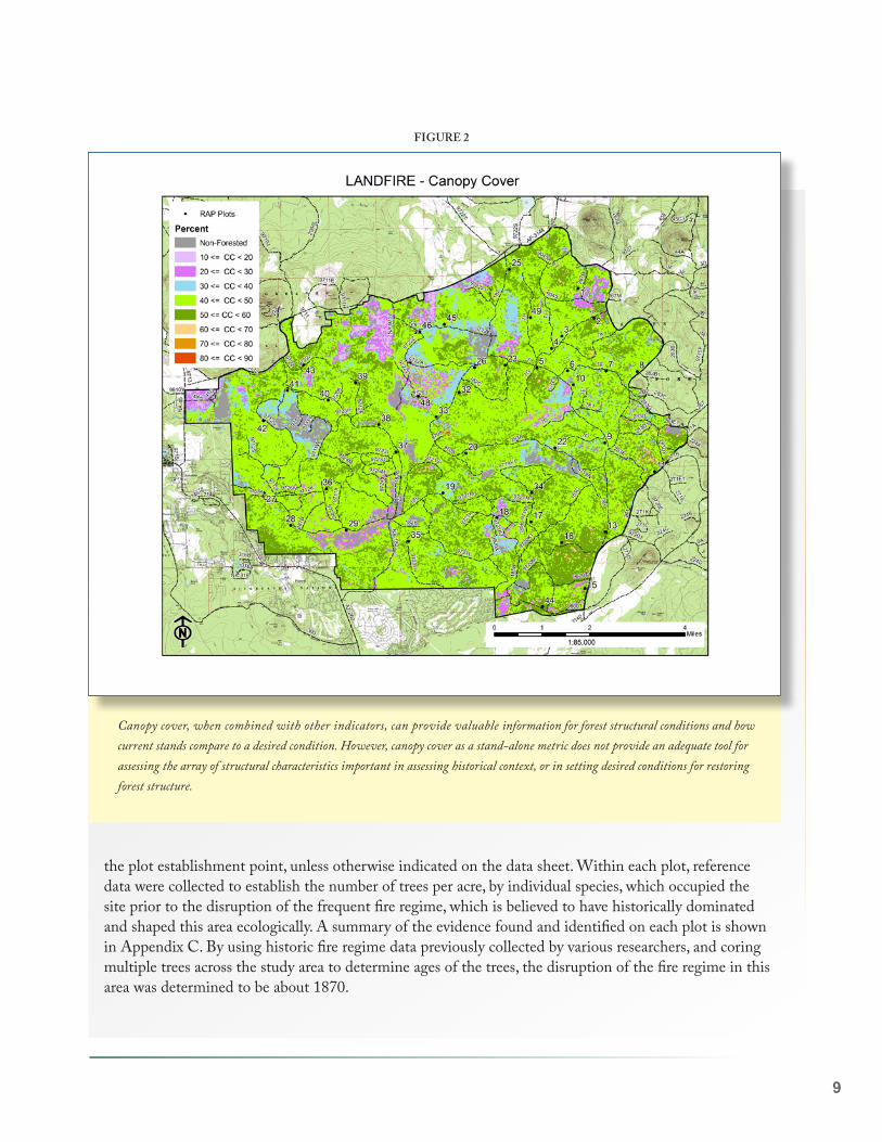
the plot establishment point, unless otherwise indicated on the data sheet. Within each plot, reference data were collected to establish the number of trees per acre, by individual species, which occupied the site prior to the disruption of the frequent fire regime, which is believed to have historically dominated and shaped this area ecologically. A summary of the evidence found and identified on each plot is shown in Appendix C. By using historic fire regime data previously collected by various researchers, and coring multiple trees across the study area to determine ages of the trees, the disruption of the fire regime in this area was determined to be about 1870.
Canopy cover, when combined with other indicators, can provide valuable information for forest structural conditions and how current stands compare to a desired condition. However, canopy cover as a stand-alone metric does not provide an adequate tool for assessing the array of structural characteristics important in assessing historical context, or in setting desired conditions for restoring forest structure.
FIGURE 2

10
To reconstruct structural characteristics of frequent fire stand densities, physical remains of old, dead trees (snags, stumps, downed logs, and stump holes) were located within the plots. Living trees in the plots were examined to determine if they germinated prior to the disruption of the frequent fire regime. The process for determining live trees associated with the frequent fire ecosystem, involved establishing a minimum age for these trees. Based on a review of previous fire history studies, it was determined that the minimum age was 144 years old (trees that had germinated in 1870 or earlier).
We then extracted increment cores from old, live (144 years old minimum) ponderosa pine trees on-site to establish a diameter that would represent the minimum age of pre-settlement trees. We utilized an 18-inch diameter at breast height (DBH) for ponderosa pine trees, a 10- inch diameter for Gamble oak and an 8-inch diameter minimum for alligator juniper trees, if the trees showed old tree characteristics, as pre-settlement age-diameter relationships. To account for possible diameter variation that might occur due to elevation, aspect, or other site conditions, we also extracted cores from a few trees at representative plots across the study area to confirm that the age-diameter determination was accurate for each species.
All live trees with a DBH greater than that for a 144-year-old tree that possessed old-tree characteris-tics (Appendix B) were counted as live trees associated with a frequent fire ecological system. These live, frequent fire system trees and tree evidences were tallied by species and density. In some previous studies, questions have been raised about the ability to accurately identify all the historical evidence with this rapid assessment reconstruction process. From one such study by Huffman and others titled “Ponderosa Pine Forest Reconstruction: Comparisons with Historical Data” (2001), the authors determined that forest structures are readily identified in the field after 90-plus years. In this study, missed trees resulted in an underestimated number of about 5.7% (about 1.7 trees per 30 trees).
In addition to collecting data on tree reference conditions (trees per acre and species), four photos were taken at each plot to provide information on current forest structure, composition, and condition (ground vegetation and downed woody material). Also at each plot, data was collected on basal area (BA), presence or absence of dwarf mistletoe, estimated canopy cover (%), and general observations on historical stand structure and plot conditions. Specific data on the following ecological characteristics or conditions was not collected: trees per acre, tree heights, tree size distribution, downed woody material, soils, or understo-ry vegetation. Additionally, we did not attempt to physically reconstruct the spatial arrangement of trees. The Terrestrial Ecosystem Unit (TES) from the report of the TES of the ASNF (USDA – FS 1986) was reviewed to help understand the vegetative structure characteristics of each plot and adjacent areas.

11
Results
Tree Densities and Species Composition
Within the 49 plots sampled, the pre-settlement trees per acre (TPA) ranged from a low of three to a high of 66. The overall average for the areas sampled was 28.5 TPA (with a 95% Confidence Interval of 24.9–32.1 TPA (Figure 3)). The historic tree densities were generally much lower than the current tree densities found across the project area. Based on the collected data, there was not a significant difference in vegeta-tive structure and historical tree density characteristics between the various TES units (Figure 4).
On the 49 study plots, most of the historic trees (trees that were in place prior to 1870) were ponderosa pine. A small number of pre-settlement Gambel oak and a variety of juniper species (alligator, Utah and one-seed) were present along the northern portion of the URAR Project area, on Blue Ridge and Spring-er Mountain areas, but with lesser amounts scattered throughout the project. The project area has some dry mixed conifer species located on north aspects of the cinder cones. Very few evidences of aspen were observed throughout the project, but predictably found in higher elevations in the southern portion of the project area; it appears that aspen was not widespread historically. However, it is likely that historical frequent fire conditions were more beneficial to aspen development than current conditions, and it is likely that restoration treatments, especially the re-introduction of fire to the landscape, will promote aspen regeneration in some areas.
Historical structures (trees older than 140 years) ranged from 3 to a high of 66 trees per acre (TPA) on the URAR plots. The average number of historical structures was 28.5 TPA which is similar to other frequent-fire sites in Northern Arizona.
FIGURE 3

12
Quantitative data was not collected on current stand conditions (current tree densities, heights, diameters, regeneration, species composition, etc.), but observations and comments were made at each plot to provide a general assessment. Current stand conditions can be summarized from the forest inventory and stand examination data at the Lakeside Ranger District office. Field Notes, observations and estimations, were made at each plot and can be found in the Plot Summary Data Summary document (Appendix C).
Tree data summary for URAR:
• Only ponderosa pine, Gamble oak, and juniper (alligator, Utah and one-seed) species were found on plots ◦ All of these tree species were not represented in all plots ◦ Ponderosa pine was present in all plots
• Ponderosa pine historical, frequent fire tree density ranged from 3–66 trees per acre (TPA)• The average ponderosa pine historical, frequent fire, tree density was 24 TPA
◦ The average oak historical, frequent fire tree density was 3 TPA ◦ o The average juniper historical, frequent fire tree density was 1–2 TPA (1.2)
• The total historical, frequent fire trees (all species) per acre averaged 28 TPA ◦ Historical, frequent fire tree density (all species) ranged from 3–66 TPA
Range of Pre-Settlement Trees: Pre-Settlement (Pre 1870) Evidence provides an excellent view of how vegetative structure became established; primarily in groups, with significant interspace between the groups that was free of regeneration due to maintenance by frequent fire. Approximately 90% of the study plots were within a Historic Range of Variability of 9 – 40 trees per acre.
PHOTO 2

13
Fire is the primary disturbance agent in many southwestern forests, and fire regimes are central to understanding an ecosystem’s reference conditions and natural range of variability (Fulé and others 2003). Prior to human-influenced changes to the characteristic fire regime, the composition, struc-ture, and spatial pattern in frequent-fire forests were maintained by frequent, low-severity fire through a functional relationship between pattern and process; that is, frequent low-severity fires resulted in forest structures that facilitated continued low-severity fire (Fitzgerald 2005). Ponderosa pine and dry mixed-conifer forests are characterized by a frequent low-severity fire regime with historic mean fire return intervals ranging from 2–24 years (Swetnam and Baisan 1996).
Frequent low-severity fire favors shade intolerant and fire-resistant tree species and open forest condi-tions with discontinuous crowns and minimal fuels build-up, often with tree groups separated by open interspaces with grass-forb-shrub communities. In contrast, longer fire return intervals permit seedling development to larger, more fire-resistant tree sizes and favor survival of less fire-resistant species (Fulé and Laughlin 2007).
Over time, shifting mosaics of tree groups and individual trees of varying ages were maintained within a grass-forb-shrub matrix by relationships among the severity and frequency of fire, presence of surface fuels (fuels on or near the surface of the ground), and tree regeneration sites that escaped fire (Larson and Churchill 2012). Extended fire-free periods may allow tree regeneration in areas not typically fire “safe” (Fulé and others 2009), resulting in temporal shifting of tree locations where new cohorts develop to fire-resistant sizes.
The historical spatial mosaic of tree groups, scattered individual trees, and openings in frequent-
Fire History
In the absence of fire, this ponderosa pine regeneration has grown to fire-resistant sizes. If frequent fire continued to occur prior to the trees attaining fire-resistant size, the seedlings would likely not have survived.
PHOTO 3
14
fire forests was maintained by interactions among the locations and types of fuels, the frequency and severity of fire, and tree regeneration and mortality patterns. (Reynolds and others 2013). Fire further shapes tree spatial patterns at varying scales through its influence on seedling survival, with variability in the severity, seasonality, and frequency of fire (Cooper 1960; Pearson 1950; Stephens and Fry 2005). Also, there was indication that historical frequent fires played a significant role in the structural development of the stands on the north sides of Elk Springs Draw and other drainages southeast of Morgan Flat.
Past disturbances (such as the McNary and Chipmunk fires) created large areas of continuous even-aged structure. There is now an excellent opportunity to re-establish the new vegetation on trajectories toward development of key compositional and structural elements by designing group structure and interspaces during treatment prescription development.
Existing conditions will influence treatment prescriptions, timing and options. Within the majority of the untreated or lightly treated stands, fire alone cannot be used to meet desired conditions, as managed fire may result in more variable forest density, sizes of groups, and greater distribution of age classes. It appeared that managed fire can be used over large areas of the URAR project area where adequate mechanical treatments have been implemented (as was evidenced by previous prescribed burns), but many areas are in need of mechanical thinning and current conditions will limit the use of fire as a stand-alone treatment to restore HRV characteristics. Depending on existing conditions, achieving the desired outcomes may require multiple treatments (e.g., mechanical treatments and fire) over long time periods.
There was compelling evidence throughout the URAR project that the absence of fire either after thinning treatments or frequent burning after initial prescribed burns has greatly facilitated dense regeneration of all species on many sites, greatly exceeding the HRV. This should be a significant factor when considering objectives, prescriptions, timing and sequence of treatments.
Alligator juniper sprouting from cutting and burning is prolific and will require a specific long-term strategy to halt the spread of this species across larger areas. Howev-er, research has shown that alligator juniper may be eliminated in ponderosa pine forests in which under-burns occur at 3–7-year intervals (Kallender 1959). This frequency of fire will facilitate utilization of root reserves in the tree and will effectively aid in its mortality.
15
Ponderosa pine, Gamble oak, alligator juniper, and Utah juniper were the dominant tree species identified on the URAR project area. Several minor species (such as one-seed juniper, Rocky Mountain juniper, piñon-pine, Douglas-fir, white fir, southwestern white pine and aspen) are present in some areas of this project area, but were not encountered on any of the Rapid Assessment plots. All of the dominant tree species were encountered, but not all of these species were represented on all plots. These dominant tree species were also present historically, as old, large trees and evidences were located in multiple locations.
Live, large and old trees of the dominant tree species representative within the URAR project area are present, either in groups or individually placed. We assessed these “large-old” trees by methods of measur-ing bole or root collar diameters, depending on species, by observing old tree characteristics (Appendix B), and by utilizing an increment borer to determine the age of the tree. “Old” is relative to the trees species (Swetnam and Brown 1992): about 200 years in ponderosa pine (Kaufmann 1996), and 150 years in junipers and oaks. “Large” is also relative to tree species, but it can be roughly divided into two diameter groups: large trees in woodlands and large trees in forests. Large trees in woodlands are approximately 10 inches in diameter with some alligator juniper in excess of 36 inches in diameter and are made up primar-ily of piñon, juniper, and oak. Large trees in ponderosa pine dominated forests are generally 20 inches and greater in diameter. Generally, multiple-age classes in all species are represented across the project area.
Ponderosa Pine Dominated Sites
The most significant vegetative condition of the project area is the current tree density, which, in conjunc-tion with the associated increased fuel loading and hazard, represents ecosystem health concerns and vulnerability to facilitate severe insect outbreaks and destructive, high-intensity crown fire. These condi-tions, if left untreated, will continue to degrade, ultimately resulting in a potentially undesirable consequence.
Current stand densities are significantly greater than historic conditions across the project area. Areas that have been mechanically thinned under the White Mountain Stewardship Contract have greatly reduced tree densities, but reference conditions (less than 66 TPA) are very uncommon. Historic group structure characteristics are also uncommon in treated areas due to the application of spacing-based objectives imbedded on basal area reduction prescriptions being applied. Previous emphasis of thinning from below and implementing set diameter limits have precluded the opportunity to achieve an uneven aged, group-like structure with adequate interspaces to approximate the HRV structure, composition and function within the foreseeable future in most areas.
Where the vegetative structure has been reduced due to harvest, much of the interspace has been lost (filled-in with tree regeneration) due to the absence of fire that has facilitated episodic regeneration survival of all common species present. Where managed fire has been applied following mechanical thin-ning treatments, prolific regeneration is common in the interspace component of most stands. Where periodic managed fire (3–7 year frequency) has occurred, future management options are greater for achieving restoration objectives and vegetative structure within HRV.
Current Stand Conditions: General Observations in Relation to Historic Evidence

16
However, most site characteristics that support the productivity are such that future managed vegetative stocking could easily exceed HRV, but the potential tradeoffs should be carefully considered. For example, we observed several stands on the southern portion of the project where only a minimum of 20–24 histor-ic evidences were found. These stands are on very productive sites that were commonly even-aged, less than 100 years old, with closed canopies, and carrying in excess of 180 BA. Some of these stands appeared to have similar characteristics: they evolved from historic, group-with-interspace dominated sites, had an interruption of frequent fire regimes, experienced significant stand replacing wildfire events, and were followed by an episodic regeneration event. Even though previous thinning and management investment has occurred, these stands are prone to crown-dominated fire events if further thinning (designed to reduce tree-crown continuity) followed by frequent fire reintroduction does not occur.
On many sites there is evidence of past dwarf mistletoe infection in the large, old trees due to the appearance of deformity in the tree boles, limbs and canopy (witches brooms, canopy thick-ness, multiple limb concentra-tions, mortality, etc.). However, it is notable that where mechanical thinning has occurred, there is little evidence of mistletoe fruit-ing bodies, etc., in the understory, even considering the 6-year life cycle of the pathogen. Localized mistletoe infections are most common, and have created pock-ets of dead trees that could even-
tually serve as regeneration sites. Some evidence of localized bug-killed groups also exist, from an endemic presence of a variety of insects.
In general, current stand conditions were estimated to range from 60 to more than 1,500 TPA, with all diameter classes represented through multiple age cohorts. There are 10 to 80 times as many trees across the landscape than we estimate were present in the historic, frequent-fire regime period. The age class diversity has shifted toward younger trees, due to a dramatic increase in the number of younger trees and encroachment of Gamble oak and juniper species. In addition to a significantly higher density of trees, some study plots demonstrated a shift in the species composition, with increased Gamble oak and juniper species where thinning has not been followed by periodic (3–7 years) managed fire. Similar to what has been documented for ponderosa pine forest vegetation dynamics in the Southwest (Arnold 1950; Laugh-lin and others 2005, 2011; Moore and Deiter 1992), the current stand densities have been associated with
PHOTO 4

17
a general encroachment of open areas by tree species and an overall reduction in understory vegetation (grasses, forbs, and shrubs). We observed species richness to be low on most plots. Increased shading from dense regeneration within the project has also reduced the amount of understory grass, forb and shrub layers that provide important food and hiding cover for wildlife, compared to what we know about histor-ical conditions (Vankat 2013). Another effect of the high density of trees, that we observed, is the presence of an average 1 to 2-inch litter layer (sometimes this layer exceeds 5–6 inches) that virtually eliminates any current problems with soil erosion; however, it also precludes the development of robust ground vegetation (Cooper 1960; Korb and Springer 2003). We also noted a general increase in the amount of downed dead woody material, compared to what we know existed with frequent fire forest conditions.
Evaluating vegetative characteristics such as canopy base height, can help assess current stand conditions.

18
Tree groups have changed due to larger dense pockets of younger trees today, and the separation of the tree groups by open, non-tree areas is limited. Historically, there were more uneven aged tree groups, and currently there are even-aged tree groups as well as dense tree groups that have several cohorts. Canopy cover was estimated to be in the 60–70 percent cover range for the majority of the sample sites. This is an indication of the large number of trees and lack of open areas. The average BA was 120 sq. ft. in the sampled plots, but we encountered areas where the BA was in excess of 250 sq. ft. Our observations of what the historic structure looked like and how current conditions vary from historic frequent fire condi-tions are captured in a series of photos taken on the study plots (Appendix D).
In summary, current conditions are very likely due to the disruption of the historic frequent fire regime during the last 130–140 years. As widely observed in forests across the Southwest, this has likely result-ed in the dramatic increase in the number of trees per acre, a substantial decrease in the abundance and species of understory vegetation, and a loss of plant vigor and structure. The lack of frequent fire has also lowered the canopy base height, promoting the increased potential for crown fire development. Histor-ically, much of the project area likely had a higher percentage of ground cover composed of grasses along with other understory species, including legumes and forbs. As the tree densities increased, understory plant cover declined. Prior to the exclusion of fire, the low density of trees within the interspaces promot-ed much higher forage production.
Woodland Species Sites
Alligator, one-seed, Utah, and Rocky Mountain juniper, piñon pine and Gambel Oak with scattered ponderosa pine occur mostly along the northern fringe of the URAR area. Utah and one-seed juniper most commonly are found in dense stands, but single trees were intermixed as elevations increase toward the Southern portion of the project area, except in the southwestern portion of the project area along Blue Ridge. Piñon-pines are generally intermixed as single trees, and no “old or large” trees were observed. Gambel oak was observed in various size groves throughout the woodland “zone” and historic evidences were common, suggesting the species has remained a dominant part of the vegetative structure in the area.
Historic evidences of alligator juniper, both live and dead, provided an impressive view of this species dominating certain areas for hundreds of years. Alligator juniper is noted for its slow growth rate. It ceases growth when moisture conditions are unfavorable but begins growing again with adequate moisture. This characteristic greatly enhances the ability of alligator juniper to survive in harsh, arid environments typical on the northern portion of the project area. A diameter growth rate of approximately 0.6 inches (1.5 cm) per decade is typical for young trees, with growth slowing to 0.4 inches (0.1 cm) per decade after the tree reaches 170 years of age (Medina 1987).
In comparison to historic evidence located on the URAR Project area, Piñon-juniper woodlands have been increasing in extent and densities, since pre-settlement times. It is evident that Alligator and Utah

19
juniper, and other species have encroached into adjacent grasslands. A decrease in fire frequency and graz-ing patterns has often been cited as the probable cause of this increase (White 1965). Some past mechan-ical management efforts (pushing, chaining, burning, etc.) on the northern fringe of the project area have largely focused on removing the juniper “invasion,” but with mixed results. On several locations where juniper species had been mechanically cut or where fire had impacted the tree, sprouting was common in trees generally below 6 inches in diameter at breast height (DBH). In ponderosa pine-woodland transition areas, there has been significant pine regeneration that occurred during recent past episodic events (30–40 years ago). These sites are void of additional pine regeneration, and where thinning treatments (primar-ily firewood harvest) has occurred, significant sprouting and new alligator regeneration has occurred. In consideration of historical frequent-fire effects in the area, re-introduction of frequent fire (3–7 year inter-vals) should be effective in maintaining, and possibly increasing, pine regeneration. If fire is not re-intro-duced on a periodic basis, it is probable that juniper species will continue to dominate these sites.
Drainages and Riparian Areas
Most intermittent drainages, including wet-bottom areas, have been encroached predominately by ponderosa pine. On the drier drainages (Elk Springs Draw, etc.), bunch-grass (Arizona fescue) and blue-grass species historically carried frequent fire into the vegetative structure by prevailing southwesterly winds, seen by evidence of multiple fire scars on every stump examined along the north and easterly slopes of the drainages.
Considerations and Possible Treatments
The intent of this assessment is not to provide specific management direction, but rather to compare historic conditions in relation to current conditions as an informational tool to consider in the strategic analysis of the URAR Project. Based on what we found with the historical conditions, we recommend the following considerations:
1. Previous harvest activities across the URAR Project area have reduced stand densities, based on past decisions identifying the desired objectives and outcomes. In many cases those treatments resulted in the perpetuation of an even-aged structure (reduction in structure heterogeneity) and the retention of an interlocking tree canopy that a) does not mitigate crown fire spread, b) limits the ability to facilitate HRV outcomes of an increased group-interspace effect and c) has propelled regeneration establishment due to the absence of managed fire. However, in view of the historical site potential, we concur with the decision and objective of accelerating subsequent treatments in the near future to achieve objectives that promote resilience, function and restoration of the project area.

20
2. The option of returning to pre-settlement conditions across the entire landscape is unrealistic. However, to address current fire and forest health concerns, it would be reasonable to consider restoring a signif-icant amount of the URAR project area with elements of the historical composition, spatial structure, and age distribution within the tree-dominated landscape. The “Restoration Framework” descriptions and “Implementation Recommendations” identified in the Rocky Mountain Research Station General Technical Report RMRS-GTR-310 (which closely relate to the Region 3 Desired Conditions Frame-work for ponderosa pine and dry mixed conifer restoration), provides an appropriate set of objectives to accomplish as part of restoring the project area. The project specific HRV data provided in ERI’s URAR Project Report and the implementation recommendations in GTR-310 can be combined to develop sound management objectives and prescriptions.
3. Consider reducing tree density closer to historical conditions in order to reduce fire, insect, and disease risks, and to improve overall ecosystem health and resiliency. The attached (Appendix E) historical (frequent fire) stand data could be considered as a reference in determining the desired future condi-tions and as a baseline for monitoring. If the historical average density of 3–66 trees per acre is too open for other management objectives, then adjust accordingly (e.g., adjust to 2–3 times the historical density). However, consider the historical conditions as they relate to resiliency (e.g., climate change), soil type, and re-establishing a more frequent fire regime. Further action of allowing fire to play a more natural role in the ecosystem, and maintaining the ability to re-enter the stands for subsequent treat-ments are important factors. The creation of adequate openings and interspaces will be critical to the establishment of understory vegetation that will allow managers to use fire as a maintenance/management tool and expand ecologi-cal benefits of the sites by improving wildlife habitats, food webs, nutrient cycling, etc. Creating canopy gaps will also reduce the risk for crown fire potential. Regardless of the historic tree group configurations we encountered, the one constant throughout the project area was the presence of openings between these tree groups, historically. Open areas were a key element of a properly func-tioning frequent fire ponderosa pine ecosystem in this area. The re-establishment of openings and their associated diverse ground vegetation will also benefit the wildlife community. We saw little mortality in large, old tree groups. There was a correlation between density of tree group crowns and surface fuels and lack of grasses. Consider strategic placement of restoration treatments to capitalize on the use of managed fire, under appropriate conditions, across broad landscapes.
4. Consider the re-introduction of frequent fire as a management tool for the project area. It will be essential to develop a strategy for using fire as a management tool to meet project objectives, including tree group placement and maintenance of interspaces across the project area. If openings are created and tree densities are reduced, there will be rapid re-establishment and growth of conifer regenera-tion, juniper, oak and other shrub species. Fire or some other form of treatment (mechanical) will be needed on a frequent basis to eliminate a return to current conditions and to allow grasses and forbs to

21
become established in the open areas. The re-establishment of a frequent fire program will help reduce the downed woody material, establish and maintain the open areas and diverse ground vegetation, and maintain forest resiliency. It will raise crown base height, mitigate the establishment of dense pockets of regeneration, and minimize large fire impacts. Based on historical occurrence of episodic regenera-tion establishment (1820, 1875, 1890, 1920, 1975, 2002, etc.) effective use of periodic fire will be criti-cal in managing regeneration density and placement. Low-intensity fires that consume surface fuels and raise crown base heights without affecting stand structure may reduce potential for crown fire while doing little to restore ecosystem health (Sensibaugh 2014). However, due to the presence of recent harvest-generated slash, increased regeneration, dense stocking and ladder fuels, some areas will require treatment timing mitigation for removal of fuels (slash, piles) and mitigation of the regeneration (through localized fire use or thinning) prior to addi-tional harvest or introduction of broad-scale managed fire. There will also be a need to monitor invasive/noxious weed populations prior to utilizing fire treat-ments. Although we did not encounter much aspen within the project area, the application of more frequent fire to the landscape should benefit the re-establishment of aspen in those areas where remnants exists.
5. Consider the possible adverse effects of incorporating a diameter cap on the ability to meet restoration goals given the current stand conditions. The need to re-establish groups and interspaces (openings), restore seeps, springs, and riparian areas, and to manage encroached grasslands are critical goals that might not be adequately met with a diameter cap. Arbitrary diameter caps can have unintended conse-quences such as interfering with the restoration of herbaceous openings and more natural spatial distri-bution of groups of trees important for wildlife habitat and forest health; also where unnaturally dense stands of larger post-settlement trees predominate, caps can limit fuel reduction efforts and therefore limit the re-establishment of surface fire (Abella and others 2006, Sanchez-Meador 2009). Utilizing a diameter cap can eliminate age groups from an existing stand (thinning from below), and its use trends toward even-aged management (Triepke and others 2011).
6. Promote the development of uneven aged tree groups. The existing stand conditions with multiple cohorts of pine regeneration provide an excellent opportunity to develop uneven aged tree groups. This recommendation along with those above will have positive effects on habitat improvement by providing more habitat diversity, structural variability, and opportunities for the expansion of food webs. Where trees are spatially aggregated, maintain interlocking or nearly interlocking crowns in mature and old groups and provide for variable tree spacing within groups; avoid thinning old tree groups.

22
7. Reduce or eliminate the tree encroachment into meadows and riparian corridors that has occurred since the disruption of the frequent fire regime. We noticed a significant amount of tree encroachment into these areas, which has reduced their historic function and role in habitat diversity, watershed function and forest heterogeneity. ERI recom-mends utilizing historic, frequent fire tree evidence as a guide to establish tree densities in these areas, by incorporating a 1:1, or a 1:1.5 replacement ratio.
8. Where spatial heterogeneity is desired, consider combinations of burns, intermedi-ate and free thinning, and individual tree or small group selection cutting methods to create a heterogeneous structure of groups, single trees, and grass-forb-shrub interspac-es. Once heterogeneity is established, consider maintaining the desired structure and spatial pattern with fire and/or single tree and small group selection harvest. Use histor-ical evidence and biophysical capabilities to determine a site’s mean and range (mini-mum, maximum) of trees per group and numbers and spacing of tree groups per area. Vary treatment prescriptions (cutting and/or fire) to create a mosaic of groups of trees, scattered single trees, and grass-forb-shrub interspaces. Manage young tree groups to create future variable tree spacing and interlocking crowns. Thin young tree-groups to facilitate development of desired within-group char-acteristics (e.g., variable tree spacing and interlocking or nearly interlocking crowns) in mid to old-aged tree groups. Grass-forb-shrub interspaces are generally larger on dry sites.
9. As basalt soils are dominant throughout the area, it was apparent that surface-rock outcrops played an important role, historically, in vegetative structure development. These areas appear to be sites that naturally limited fire impacts, potentially provided microsite attributes regarding increased moisture, and ultimately provided an adequate site for regeneration success. Considerations regarding future objectives of managing within the HRV, facilitating group structure retention or development, managing for uneven-aged characteristics, and the interaction of managed fire on these and adja-cent sites are important factors to consider prior to developing broad-scale treatment prescriptions involving these areas.

23
Abella, S.R., W.W. Covington, P.Z. Fulé. 2006. Diameter caps for thinning southwestern ponderosa pine forests: viewpoints, effects, and tradeoffs. Journal of Forestry 104 (8): 407-414
Arnold, J.F. 1950. Changes in ponderosa pine bunch grass ranges in Arizona resulting from pine regenera-tion and grazing. Journal of Forestry 48: 118-126
Cooper, C.F. 1960. Changes in vegetation, structure, and growth of southwestern pine forests since white settlement. Ecological Monographs 30: 129-164.
Covington, W.W., P.Z. Fulé, M.M. Moore, S.C. Hart, T.E. Kolb, J.N. Mast, S.S. Sackett, M.R. Wagner. 1997. Restoration of ecosystem health in southwestern ponderosa pine forests. Journal of Forestry 95:23-29.
Falk, D.A. 1990. Discovering the past, creating the future. Restoration and Management Notes 8(2):71–72.
Fitzgerald, S.A. 2005. Fire ecology of ponderosa pine and the rebuilding of fire-resilient ponderosa pine ecosystems. Pp. 197-225 In Ritchie, M.W.; Maguire, D.A.; Youngblood, A. (tech. coords.). Proceed-ings of the Symposium on Ponderosa Pine: Issues, Trends, and Management. General Technical Report PSW-GTR-198. U.S. Department of Agriculture, Forest Service, Pacific Southwest Research Station, Albany, CA. 281 pp.
Fulé, P.Z., J.E. Crouse, T.A. Heinlein, M.M. Moore, W.W. Covington, G. Vankamp. 2003. Mixed-severity fire regime in high-elevation forest of the Grand Canyon, Arizona, USA. Landscape Ecology 18:465-486.
Fulé, P.Z., and D.C. Laughlin. 2007. Wildland fire effects on forest structure over an altitudinal gradient, Grand Canyon National Park, USA. Journal of Applied Ecology 44:136-146.
Fulé, P.Z., J.E. Korb, R. Wu. 2009. Changes in forest structure of a mixed-conifer forest, southwestern Colorado, USA. Forest Ecology and Management 258(7):1200-1210.
Huffman, D.W., A.J. Sanchez-Meador, and B. Greco. 2012. Fact Sheet: Canopy Cover and Forest Condi-tions. Ecological Restoration Institute, Northern Arizona University.
Kallender, H.R. 1959. Controlled burning in ponderosa pine stands of the Fort Apache Indian Reserva-tion. In: Humphrey, R.R. (compiler). Your range—its management. Special Report No. 2. Tucson, AZ: University of Arizona, Agricultural Extension Service: 20-22. [4743]
Korb, J.E., and J.D. Springer. 2003. Understory Vegetation. In: Friederici P. (ed.) Ecological restoration of southwestern ponderosa pine forests. Washington DC: Island Press.
References

24
Landres, P.B., P. Morgan, F.J. Swanson. 1999. Overview of the use of natural variability concepts in managing ecological systems. Ecological Applications 9:1179–1188.
Larson, A.J., and D. Churchill. 2012. Tree spatial patterns in fire-frequent forests of western North Amer-ica, including mechanisms of pattern formation and implications for designing fuel reduction and resto-ration treatments. Forest Ecology and Management 267:74-92.
Laughlin, D.C., J.D. Bakker, P.Z. Fule. 2005. Understory plant community structure in lower montane and subalpine forests, Grand Canyon national Park, USA. Journal of Biogeography 32: 2083-2102.
Medina, A.L. 1987. Woodland communities and soils of Fort Bayard, southwestern New Mexico. Journal of the Arizona-Nevada Academy of Science. 21: 99-112. [3978]
Moore, M. M., and D.A. Deiter. 1992. Stand density index as a predictor of forage production in northern Arizona pine forests. Journal of Range Management 45(3) 267-271.
Moore, M.M., W.W. Covington, P.Z. Fulé. 1999. Evolutionary environment, reference conditions, and ecological restoration: A southwestern ponderosa pine perspective. Ecological Applications 9:1266-1277.
Reynolds, R.T., A.J. Sánchez Meador, J.A. Youtz, T. Nicolet, M.S. Matonis, P.L. Jackson, D.G. DeLo-renzo, A.D. Graves. 2013. Restoring composition and structure in Southwestern frequent-fire forests: A science-based framework for improving ecosystem resiliency. General Technical Report, RMRS-GTR-310. Fort Collins, CO: U.S. Department of Agriculture, Forest Service, Rocky Mountain Research Station. 76 p.
Sensibaugh, M., and D.W. Huffman. 2014. Fact Sheet: Managing Naturally Ignited Wildland Fire to Meet Fuel Reduction and Restoration Goals in Frequent-Fire Forests. Ecological Restoration Institute, Northern Arizona University. 4 p.
Swetnam, T.W., and C.H. Baisan. 1996. Historical fire regime patterns in the southwestern United States since AD 1700. Pp. 11-32 in C.D. Allen (ed.). 2nd La Mesa Fire Symposium; Los Alamos, NM. Gener-al Technical Report RM-GTR-286. U.S. Department of Agriculture, Forest Service, Rocky Mountain Forest and Range Experiment Station, Fort Collins, CO. 216 pp.
Swetnam, T.W., C.W. Allen, J.L. Betancourt. 1999. Applied historical ecology: using the past to manage for the future. Ecological Applications. 9(4): 1189-1206

25
Triepke, F.J., B.J. Higgins, R.N. Weisz, J.A. Youtz, T. Nicolet. 2011. Diameter caps and forest restoration—Evaluation of a 16-inch cut limit on achieving desired conditions. USDA Forest Service Forestry Report FR-R3-16-3. Southwestern Region, Regional Office, Albuquerque, NM. 31 pp
Vankat, J.L. 2013. Vegetation dynamics on the mountains and plateaus of the American Southwest, Plant and Vegetation 8, DOI 10.1007/978-94-007-6149-0_4, Springer Science+Business Media Dordrecht 2013.
White, L.D. 1965. The effects of a wildfire on a desert grassland community. Master’s Thesis [5552]. Tucson, AZ: University of Arizona. 107 p.

26
A. Historical Context
Historical Context of the Upper Rocky Arroyo Restoration Project Area
Well documented accounts of ecological conditions in the ponderosa pine forests of northern Arizona, including the White Mountains, by early explorers in 1540 (letter, Coronado to Mendoza, Aug. 3, 1540) and also by later groups conducting scientific trips in the White Mountains area, consistently describe “a vast forest of gigantic pines intersected frequently with open glades, sprinkled all over with moun-tains, meadows, and wide savannahs, to a wide-range of frequency and richness of grasses.” With almost 150 years of various increased impacts, in most cases, these historic landscapes have been greatly altered. Detailed accounts of ecological conditions in the White Mountains area in the mid-1880s highlight “a mature forest with an overstory of trees aged in excess of 150 years old. The overwhelming impression that one gets from the older Indians and white pioneers of the Arizona pine region is that the entire forest was once more open and park-like than it is today; the forests were open, devoid of under-growth, and consisted in the main of mature trees, with practically no forest cover. Reproduction was present but not abundant, and in many areas was markedly deficient” (2).
In Arizona’s White Mountains, many stands within ponderosa pine forests had been more open before the influx of settlers during the late 19th century, as documented by ERI (8). Research indicated that some pre-settlement ponderosa stands consisted of 20 to 40 large pines per acre, with abundant grass cover and open space beneath the tall canopy. Contemporary ponderosa pine forests in the southwestern U.S. commonly reached stand densities of 300 to 500 trees per acre of relatively small diameter trees.
In 1873, Lt. George Wheeler recorded his observation that “grass throughout the White Mountains was sparse, primarily a thin layer of perennial grasses, although it rarely approaches a turf.” Coronado (Winship 1899) spoke “feelingly” of the difficulty of crossing the White Mountains, due to the lack of feed for their livestock, “… Of which we had great need, because our horses were so weak and feeble when they arrived” (3).
Research of frequent fire occurrence continues to indicate that fires started by lightning or Native peoples in the White Mountains, played a significant role in the development of the ponderosa forests, meadow integrity and interspace within the forest mosaic. Weaver (1951) analyzed the fire scars on sections of stumps collected at various sites in the area. “The most frequently burned tree showed an average interval of 4.8 years between fires, while the longest average interval between fires exhibited by any sample tree was 11.9 years” (4). Weaver’s findings are consistent with data collected by researchers from the Ecological Restoration Institute (ERI) from sites along the Mogollon Rim (2013). For example, the pre-settlement (pre-1870) fire history for the Black Mesa mixed conifer study site, which analyzed 133 fire scar samples, showed that the composite mean fire occurrence interval ranged from 2–8.5 years.
Despite the frequency of surface fires, large crown fires were apparently rare. A fairly thorough search of the early literature failed to identify a single report of a large crown fire over 1,000 acres in Arizona
Appendices

27
before 1900. Wheeler (1878) reported that on the higher reaches of the Little Colorado River, “For less than 2 miles the grass is of the old crop, then begins the new and juicy growth of the year subsequent to the burning over by fires set by the Indians” (2). Lightning ignited fires undoubtedly were paramount as the main cause of wide-spread, frequent, low-intensity fires throughout the White Mountains, but docu-mentation by Bell (1870) suggested the Apache Indians utilized fire extensively for a variety of objectives. Holsinger (1902) was convinced that, “These prehistoric aborigines must have exerted a marked influence upon the vegetation of the country. Their fires, and those of the historic races, unquestionably account for the open condition of the forest … these forests show, in certain localities, all classes of regrowth. The forests within their (Apache) domain … show a regrowth gradating into many past decades” (5).
These frequent fires helped keep seedlings at bay while encouraging grasses to thrive in the many open spaces between established groups of trees. Fire evidence from fire-scarred trees indicates that turn-of-the-century grazing practices and effective fire suppression had virtually eliminated surface fires by early 1900s. With the reduction in grass cover, fires could gain no foothold with which to travel through the forest.
The Black Mesa Forest reserve was established in 1898, and fire suppression was a key duty of forest offi-cers. The age distribution of trees has been largely influenced by the extensive evidence/role of fire and the apparent infrequent occurrence of specific weather-related conditions necessary for the establishment of pine regeneration. Groups of large, old trees generally date from about 1839 and most are about 22–30 inches DBH. From study plots in the Pinetop, AZ area, Cooper (1957) found that “there were definite age classes that originated about 1875, about 1890, and possibly in other years; but on the whole, there was little regeneration between 1839 and 1909. Many of the present small pole stands started in 1909 and were followed by the extensive 1919 seedling establishment. Several older (age) classes can be clearly distinguished. Many trees became established in 1820 and others about 1975. A surprising number of the very large veterans in the old-growth forest can be dated about 1685.”
“Early studies suggested that frequent fires were restricting the forests to produce no more than 40% of their potential growth, due to basal area restrictions. It is clear that the growth of pre-settlement forests did not reach their maximum potential productivity of the site. Natural fire thinned some sapling stands too severely, and killed occasional large trees. Growth of young pines has actually declined due to fire suppression, and overcrowding” (2).
The White Mountain Stewardship Contract (2004-2014) and Recent Management Factors
Ponderosa pine is the dominant forest type throughout the Upper Rocky Arroyo Restoration Project area (URA), and like ponderosa forests throughout much of the Southwest, these fire-adapted ecosystems have been altered from the effects of a century or more of fire exclusion, logging, and historically unregulated grazing. Current forest conditions in some areas have, in recent years, generally reverted from dense even-aged stocking and are on a trajectory towards historic ranges of natural variability due to mechanical and

28
thinning treatments and re-introduction of prescribed fire. However, many forested areas are typified by overstocked stands containing 10 to 20 times the historic tree density, decreased tree vigor, a sporadic understory, and a susceptibility to uncharacteristic crown fire.
Since the formation of the Black Mesa Forest Reserve in 1898, various timber harvesting efforts have been employed through the years to improve the health and condition of the forest structure, as well as provide timber to help supply a robust woods products industry. A variety of harvesting systems, prescrip-tions, and management objectives through the years have created a wide array of forest conditions, in contrast to the historic range of variation in the forest composition and structure.
Blue Ridge Demonstration Project
The Natural Resources Working Group (NRWG) was formed in the mid-1990s as a result of a series of discussions between various elected officials, agency leaders, and environmental representatives due to concerns of forest conditions and the onslaught of unprecedented wildfires. One of the NRWG’s first significant projects was a demonstration of various approaches to restoration and fuel reduction in a wildland-urban interface (WUI) area known as Blue Ridge, on the Lakeside Ranger District, Apache-Sitgreaves National Forests. The development of a demonstration site on Blue Ridge, as well as design and layout of treatment alternatives, was conducted in close collaboration between ASNF staff and the various stakeholders of the NRWG. Particular attention was paid to engaging the environmental activist commu-nity by implementing one treatment alternative based on guidelines developed by a consortium of regional environmental groups. The agency also signaled willingness to compromise with environmental groups by instituting a 16-inch diameter cap on treatments within the Blue Ridge Demonstration Project.
The demonstration also illustrated for many NRWG members the connections between utilization capac-ity and the ability to get restoration work done. Because of diminished local markets for small-diameter material, two initial offerings on the Blue Ridge projects received no bids. Treatments were implemented only after the project was scaled back and outside funds were obtained to conduct the thinning activities.
The Blue Ridge Demonstration Project began as the 17,000-acre Blue Ridge–Morgan Ecosystem Management Area on the Lakeside Ranger District of the Apache-Sitgreaves National Forests. It served as a demonstration of forest restoration activities through the implementation of three different treatment approaches across 7,000 acres and was developed collaboratively between the Natural Resources Working Group and the Apache-Sitgreaves National Forests.
The Environmental Assessment for the area was approved in 1997. In April 1997, the decision was made on the prescriptions and in September 1997 sections that included 1,000 acres were marked for thinning. The Morgan timber sale consisted of 650 acres and was the first section treated in 1997. The Morgan timber sale proceeded smoothly because the pulp mill in Snowflake, AZ was still paying for and utiliz-ing Small Diameter Timber (SDT). In 1997 the pulp mill quit taking wood material and converted to a paper recycle mill. This presented a problem for the project because no bids were made on the remaining

29
sections; there was no place to take SDT and the contracts stipulated removal of slash and SDT (6).
Three treatments and a control area were planned in the project:
• The USFS used a goshawk prescription, which is designed to protect and retain yellow pine by removing competing younger trees a distance of ? to one crown diameter, and creating foraging areas averaging 60–80 basal area (Technical Advisory Committee 2000). The USFS plan was designed to maintain viable habitat for the Mexican spotted owl and the northern goshawk. It involved leaving protective dense habitat around nesting sites then thinning more extensively in other areas. In what could be considered an example of the move from an extractive to a service-ori-ented approach, the USFS first had to contract for pre-commercial thinning. In 2000 the USFS paid $878,000 for the removal of trees less than 5 inches in diameter (4,900 acres); the creation of fuel breaks (200 acres); biodiversity monitoring (5,600 acres); and the introduction of prescribed burns.
• The Ecological Restoration Institute (ERI) at Northern Arizona University used a “pre-settlement restoration” prescription based on Ecological Restoration Marking Guidelines (7). The objective was to restore pre-settlement ponderosa pine forest structure, recreating as far as possible, the density, spatial distribution and variability of trees at the time of disruption of the frequent fire regime. The concept was to approximate historic conditions, when stands comprising predominately of large, old ponderosa pine tree groups, interspaces present between the groups, and a variety of tree age and sizes located throughout the forest. However, the ERI prescription was modified and agreement was made to start with a less rigorous thinning program to the site to avoid the need to go back and amend the existing environmental analysis done under NEPA guidelines.
• The third prescription was to be a “natural process restoration” prescription developed from guide-lines proposed by environmental community representatives. The management technique prescribed by environmental NGOs, termed “natural processes restoration” focused on getting fire back in the system while maintaining viable wildlife habitat and a higher density forest (6).Natural process restoration was designed to go slower than other treatments, to be more cautious and conservative in thinning from below, and to retain a higher percentage of younger and smaller trees (Technical Advisory Committee 2000). However, local environmental groups did not have knowledge or expe-rience in developing a prescription, so they solicited the assistance of the Southwest Forest Alliance. The Southwest Forest Alliance did not have the time to work on their section (marking) and had difficulties coming up with the prescription (Collins 2004).
In 2004, the Apache-Sitgreaves National Forest requested bids for the White Mountains Stewardship (WMS) Project—a 10-year, 150,000 acre project that would offer 5,000 to 20,000 acres of forest lands to contractors each year. Thus, to date, subsequent task orders, or units, have been treated throughout the URAR Project area, in addition to the Blue Ridge Demonstration Project. In several areas, the Desired

30
Condition of vegetative composition, structure and function has not been achieved and additional treat-ments involving mechanical thinning and managed fire are needed to meet the desired objectives.
In summary, the White Mountain Stewardship (WMS) Contract has treated many areas previously identified in the original NEPA documents needing Restoration treatments. There are additional acreag-es needing treatments, as well as re-entry into some WMS units to complete harvest objectives to meet desired outcomes. Limited wood-product industries, the economy, area impacts from the Rodeo-Chedeski and Wallow fires, and general capacity and funding limitations to meet the hazard reduction needs and provide wood-fiber, have all contributed to the current conditions that need restoration treatments in the URAR Project area.
(1) Abrams, J.B., and S. Burns. 2007. Case Study of a Community Stewardship Success: The White Mountain Stewardship Contract. ERI—Issues in Forest Restoration. Ecological Restoration Institute, Northern Arizona University.
(2) Cooper, C.F. 1960. Changes in vegetation, structure, and growth of southwestern pine forests since white settlement. Ecological Monographs, 30(2):129-164.
(3) Winship, G.P. 1896. The Coronado expedition, 1540–1542. Bur. Amer. Ethnology 14th Annual rept., Part I: 329-637.
(4) Weaver, H. 1951. Fire as an ecological factor in the southwestern ponderosa pine forests. Journal of Forestry 49:93-98
(5) Holsinger, S.J. 1902. The boundary line between the desert and the forest. Forestry & Irrigation. 8:21-27
(6) Eagar Arizona Case Study, December 1-4, 2003, Dr. Toddi Steelman and Ginger Kunkel
(7) Covington, W.W. et.al. 1999. Ecological restoration marking guidelines for ponderosa pine restoration areas. Ecological Restoration Institute, Northern Arizona University.
(8) Friederici, P. (Ed.). 2003. Ecological Restoration of Southwestern Ponderosa Pine Forests. Washington, DC: Island Press.

31
B: Old Tree Characteristics
In addition to DBH, the following characteristics were utilized to help establish the pre-settlement trees in each plot:
Crown Shape: Transitional trees (trees that are trending toward old age; 150–200 years) have an ovoid shape—flattened top, full and rounded crowns. Old trees (>200 years) are flattened on the top, “bonsai” shape, sparse and open, and may be lopsided.
Live Crown Ratio: Transitional trees have moderate live crown ratio; perhaps half the trunk, beginning to self-prune. Old trees have small live crown ratio; often fire-pruned.
Branches: Transitional trees have dying fine branches in the interior of the crown, longer branches thick-ening. Old trees have few, but large branches.
Trunk shape: Transitional trees are beginning to loose taper. Old trees are columnar.
Bark: Transitional trees have orange or gray flakes with dark edges, shallow fissures, becoming smoother. Old trees have smooth, small flakes, pale orange or gray.
Likely Injuries: Transitional trees have relatively few injuries; possibly healed or mostly healed fire scars, lightning scars, and mistletoe. Old trees have fire scars, dead tops, broken branches, lightning scars, rot, burls, and exposed roots.

32
C. Plot Data Summary
The following spreadsheet displays the density and type of historic evidences found on each plot. The evidences are coded as follows: L = live tree, C = cut stump, S = snag, LG = log, and SH is a stump hole.
PIPO QUGA JUDEPlot # L S C LG SH Total L S C LG SH Total L S C LG SH Total Grand Total
1 1-‐1 0 1 1 1 0 3 0 0 0 0 0 0 0 0 0 0 0 0 32 1-‐2 0 0 37 6 0 43 0 1 7 0 0 8 1 0 0 0 0 1 523 1-‐3 1 0 15 3 0 19 0 0 0 2 0 2 0 0 0 0 0 0 214 1-‐4 28 0 18 2 0 48 0 0 0 0 0 0 0 0 0 0 0 0 485 1-‐5 3 11 2 5 0 21 2 2 2 0 0 6 0 0 1 0 0 1 286 1-‐6 29 1 14 3 1 48 0 0 0 0 0 0 0 0 0 0 0 0 487 1-‐7 1 0 14 0 5 20 1 0 0 0 0 1 0 0 0 0 0 0 218 1-‐7 8 0 41 0 0 49 0 0 1 0 0 1 0 0 0 0 0 0 509 2-‐1 8 0 10 2 3 23 0 0 0 0 0 0 0 0 0 0 0 0 23
10 2-‐2 0 0 15 1 4 20 0 0 0 0 0 0 0 0 0 0 0 0 2011 2-‐3 4 0 38 2 0 44 0 0 0 0 0 0 0 0 0 0 0 0 4412 2-‐4 0 2 55 9 0 66 0 0 0 0 0 0 0 0 0 0 0 0 6613 2-‐5 0 0 16 1 1 18 0 0 0 0 0 0 0 0 0 0 0 0 1814 2-‐6 2 1 34 3 0 40 3 0 0 0 0 3 0 0 0 0 0 0 4315 2-‐7 2 0 10 0 0 12 0 0 0 0 0 0 0 0 0 0 0 0 1216 2-‐8 1 1 29 2 7 40 3 0 3 0 0 6 0 0 0 0 0 0 4617 3-‐1 10 2 11 5 3 31 0 0 0 0 0 0 0 0 0 0 0 0 3118 3-‐2 7 1 23 3 2 36 1 0 0 0 0 1 0 0 0 0 0 0 3719 3-‐3 8 11 0 1 2 22 0 0 0 0 0 0 0 0 0 0 0 0 2220 3-‐4 1 1 24 1 1 28 2 0 7 0 0 9 0 0 0 0 0 0 3721 3-‐5 6 0 21 3 1 31 0 0 5 0 0 5 0 0 0 0 0 0 3622 3-‐6 8 3 28 6 1 46 0 0 0 0 0 0 0 0 0 0 0 0 4623 3-‐7 3 0 11 5 0 19 11 1 2 0 0 14 0 0 0 0 0 0 3324 3-‐8 1 0 6 5 0 12 0 3 0 0 0 3 1 0 0 0 0 1 1625 3-‐9 2 1 1 0 0 4 2 0 0 0 0 2 20 0 0 0 0 20 2626 3-‐10 15 0 4 1 0 20 0 0 3 0 0 3 1 0 9 0 0 10 3327 4-‐1 8 0 5 0 0 13 0 0 4 0 0 4 0 0 0 0 0 0 1728 4-‐2 16 0 3 1 0 20 0 0 8 2 0 10 2 0 0 0 0 2 3229 4-‐3 8 0 9 5 0 22 2 0 3 1 0 6 0 0 0 0 0 0 2830 4-‐4 20 0 8 0 0 28 0 0 0 0 0 0 0 0 0 0 0 0 2831 4-‐5 10 0 4 1 0 15 2 0 7 0 0 9 0 0 0 0 0 0 2432 B-‐1-‐1 4 0 16 2 0 22 3 3 3 0 0 9 0 0 0 0 0 0 3133 B-‐1-‐2 5 4 4 0 10 23 0 0 0 0 0 0 0 0 0 0 0 0 2334 B-‐1-‐3 1 0 25 3 1 30 0 0 0 0 0 0 0 0 0 0 0 0 3035 B-‐1-‐4 3 0 11 2 3 19 0 0 0 0 0 0 0 0 0 0 0 0 1936 B-‐1-‐5 1 0 0 1 6 8 1 0 1 1 3 6 5 0 2 4 0 11 2537 B-‐2-‐1 0 0 10 1 8 19 0 0 0 0 0 0 0 0 0 0 0 0 1938 B-‐2-‐2 4 0 13 5 1 23 0 0 0 0 0 0 0 0 0 0 0 0 2339 B-‐2-‐3 0 0 10 3 8 21 0 0 0 0 0 0 0 0 0 0 0 0 2140 B-‐2-‐4 2 0 3 10 0 15 5 4 1 0 0 10 4 0 3 0 0 7 3241 B-‐2-‐5 1 5 3 0 6 15 0 1 2 0 0 3 0 0 0 0 0 0 1842 B-‐2-‐6 1 0 0 2 0 3 2 0 0 0 0 2 8 0 2 2 0 12 1743 B-‐2-‐7 1 0 7 0 2 10 0 0 0 0 0 0 3 0 3 0 0 6 1644 B-‐3-‐1 0 0 25 1 1 27 3 1 0 0 0 4 0 0 0 0 0 0 3145 B-‐3-‐2 1 0 4 3 0 8 2 3 7 0 0 12 4 0 0 0 0 4 2446 B-‐3-‐3 1 1 19 0 0 21 1 0 1 0 0 2 3 0 0 0 0 3 2647 B-‐3-‐4 0 2 0 0 0 2 0 0 0 0 0 0 0 0 0 0 0 0 2 48 B-‐3-‐5 3 0 1 6 12 22 0 2 0 1 3 6 0 0 0 0 0 0 2849 B-‐3-‐6 6 0 16 2 0 24 0 0 0 0 0 0 0 0 0 0 0 0 24
244 48 674 118 89 1173 46 21 67 7 6 147 52 0 20 6 0 78 1398 1398 total28.53061224 avg
L 342 24.46352 % 12.5 Standard deviationS 69 4.935622 % PIPO 1173 83.91 % 2-‐66 rangeC 761 54.43491 % QUGA 147 10.52 % 24.9-‐32.1 lower and upper 95%LG 131 9.370529 % JUDE 78 5.579 %SH 95 6.795422 % 1398
1398

33
The chart shows the presettlement fire history of the Black Mesa RD mixed-conifer study site. Horizontal lines are wood samples from individual trees and vertical marks are fire scars from 133 samples from stumps, logs, snags & live trees. * Fire scars represent 103 individual fire years between 1670 and 1879 A.D. * The composite mean fire occurrence interval ranged from 2 – 8.5 years
D. Plot Data Photo Summary: (SEE PHOTO FILE ON DATA DISK).
E. Historic Frequent Fire Study Results:

34
Chart depicting changes in species composition and density post-1870 exclusion of frequent fire.
35
The Ecological Restoration Institute is dedicated to the
restoration of fire-adapted forests and woodlands. ERI provides
services that support the social and economic vitality of
communities that depend on forests and the natural resources
and ecosystem services they provide. Our efforts focus on science
-based research of ecological and socio-economic issues related
to restoration as well as support for on-the-ground treatments,
outreach and education.
Ecological Restoration Institute, P.O. Box 15017, Flagstaff, AZ
86011, 928.523.7182, FAX 928.523.0296, www.nau.edu/eri
Prepared by:
Bruce Greco, [email protected]
Mark Sensibaugh, [email protected]
The authors acknowledge and appreciate the significant support from Heath Norton (Design & Layout), Tayloe Dubay (Editing), Anastasia
Begley, Haley Flenner and Kaitlin Vandaveer (Data Compilation & Printing).
NAU is an equal opportunity provider.
This research was funded by a grant from the USDA Forest Service.

36