minutes - city of fremantle · michael patroni christine roberts the following member/s of the...
TRANSCRIPT

MINUTES
Planning Committee
Wednesday, 4 October 2017, 6.00pm

TABLE OF CONTENTS
ITEM NO SUBJECT PAGE
DECLARATION OF OPENING / ANNOUNCEMENT OF VISITORS 1
NYOONGAR ACKNOWLEDGEMENT STATEMENT 1
IN ATTENDANCE 1
APOLOGIES 1
LEAVE OF ABSENCE 1
RESPONSE TO PREVIOUS PUBLIC QUESTIONS TAKEN ON NOTICE 1
PUBLIC QUESTION TIME 2
DEPUTATIONS / PRESENTATIONS 2
DISCLOSURES OF INTEREST BY MEMBERS 3
LATE ITEMS NOTED 3
CONFIRMATION OF MINUTES 3
TABLED DOCUMENTS 3
DEFERRED ITEMS (COMMITTEE DELEGATION) 3
REPORTS BY OFFICERS (COMMITTEE DELEGATION) 4
PC1710-1 PEARSE STREET, NO. 42 (LOT 501), NORTH FREMANTLE - ADDITIONS AND ALTERATIONS TO AN EXISTING OFFICE, WAREHOUSE, SHOWROOM AND INDUSTRY-COTTAGE BUILDING - (SP DA0336/17) 4
PC1710-2 HALE STREET, NO. 10A (LOT 700), BEACONSFIELD - TWO STOREY SINGLE HOUSE AND CONVERSION OF EXISTING BUILDING TO ANCILLARY DWELLING- (CJ DA0333/17) 15
PC1710-3 ELLEN STREET, NO. 83 (LOT 100), FREMANTLE- TWO STOREY DETACHED ADDITION TO EXISTING GROUPED DWELLINGS- (CJ DA0361/17) 24
PC1710-4 THOMPSON ROAD, NO. 1 (LOT 2), NORTH FREMANTLE - TWO STOREY ADDITIONS AND ALTERATIONS TO EXISTING SINGLE HOUSE - (CJ DA0264/17) 31

PC1710-5 DUFFIELD AVENUE NO.1B (STRATA LOT 4), BEACONSFIELD - PARTIAL CHANGE OF USE TO FAMILY DAY CARE - (JL DA0380/17) 43
PC1710-6 SCHEDULE OF APPLICATIONS DETERMINED UNDER DELEGATED AUTHORITY - 50
REPORTS BY OFFICERS (COUNCIL DECISION) 51
PC1710-7 DRAFT LOCAL PLANNING POLICY (3.17) - HILTON LOCAL CENTRE - ADOPTION FOR PUBLIC ADVERTISING 51
PC1710-8 IN PRINCIPLE CONSIDERATION FOR VEHICLE ACCESS AND SCHEME AMENDMENT FOR 2-8 HARVEST ROAD, NORTH FREMANTLE 63
CONFIDENTIAL MATTERS 71
CLOSURE OF MEETING 71
Summary Guide to Citizen Participation and Consultation 72
MINUTES ATTACHMENTS 1

Minutes - Planning Committee 4 October 2017
Page 1
PLANNING COMMITTEE
Minutes of the Planning Committee held in the Council Chambers, Fremantle City Council
on 4 October 2017 at 6.00 pm.
DECLARATION OF OPENING / ANNOUNCEMENT OF VISITORS
The Presiding Member declared the meeting open at 6.02 pm.
NYOONGAR ACKNOWLEDGEMENT STATEMENT
"We acknowledge this land that we meet on today is part of the traditional lands of the Nyoongar people and that we respect their spiritual relationship with their country. We also acknowledge the Nyoongar people as the custodians of the greater Fremantle/Walyalup area and that their cultural and heritage beliefs are still important to the living Nyoongar people today."
IN ATTENDANCE
Cr Jon Strachan Presiding Member / South Ward Cr Bryn Jones North Ward Cr Simon Naber City Ward Cr Ingrid Waltham Deputy Presiding Member / East Ward Cr Jeff McDonald Hilton Ward Cr Hannah Fitzhardinge Beaconsfield Ward / Deputy Mayor Mr Paul Garbett Director Planning & Strategic Projects Ms Julia Kingsbury Manager Development Approvals Ms Tahnee Bunting Strategic Planner Ms Michelle Gibson Minute Secretary There were approximately 20 members of the public and no members of the press in attendance.
APOLOGIES
Dr Brad Pettitt Mayor
LEAVE OF ABSENCE
Nil
RESPONSE TO PREVIOUS PUBLIC QUESTIONS TAKEN ON NOTICE
Nil

Minutes - Planning Committee 4 October 2017
Page 2
PUBLIC QUESTION TIME
Nil
DEPUTATIONS / PRESENTATIONS
The following member/s of the public spoke in favour of the Officer’s Recommendation for item PC1710-1: Michael Patroni Christine Roberts The following member/s of the public spoke against the Officer’s Recommendation for item PC1710-1: Pim Robberechts The following member/s of the public spoke in favour of the Officer’s Recommendation for item PC1710-2: Robert Guthrie Phil Stejskal The following member/s of the public spoke in favour of the Officer’s Recommendation for item PC1710-3: Tom Roberts The following member/s of the public spoke in favour of the Officer’s Recommendation for item PC1710-4: Bruce Blackall Hugh Wetters The following member/s of the public spoke against the Officer’s Recommendation for item PC1710-4: Nathan Steele The following member/s of the public spoke in favour of the Officer’s Recommendation for item PC1710-5: Kerry Lynch Sandra Taylor

Minutes - Planning Committee 4 October 2017
Page 3
The following member/s of the public spoke against the Officer’s Recommendation for item PC1710-5: Antoinette Ryan
DISCLOSURES OF INTEREST BY MEMBERS
Statements made by Elected Members in relation to conflicts of Interest: Cr Hannah Fitzhardinge and Cr Ingrid Waltham stated in relation to item number PC1710-2 that they knew the owner of the property but did not consider that this affected their impartiality. Cr Strachan stated in relation to item numbers PC1710-2, PC1710-4 and PC1710-5 that he had visited the application sites and spoken with the applicants and neighbours but did not consider that this affected his impartiality.
LATE ITEMS NOTED
Nil
CONFIRMATION OF MINUTES
MOVED: Cr J Strachan That the minutes of the Planning Committee dated 6 September 2017 as listed in the Council agenda dated 11 October 2017 be confirmed as a true and accurate record. CARRIED: 6/0
For Against
Cr Jon Strachan Cr Simon Naber Cr Bryn Jones Cr Hannah Fitzhardinge Cr Ingrid Waltham Cr Jeff McDonald
TABLED DOCUMENTS
Document by Dr Michael Krieser & Dr Marissa Cumper - Item PC1710-2 Map - area to be used for Family Day Care - Item PC1710-5
DEFERRED ITEMS (COMMITTEE DELEGATION)
The following items are subject to clause 1.1 and 2.1 of the City of Fremantle Delegated Authority Register Nil.

Minutes - Planning Committee 4 October 2017
Page 4
REPORTS BY OFFICERS (COMMITTEE DELEGATION)
The following items are subject to clause 1.1 and 2.1 of the City of Fremantle Delegated Authority Register
PC1710-1 PEARSE STREET, NO. 42 (LOT 501), NORTH FREMANTLE - ADDITIONS AND ALTERATIONS TO AN EXISTING OFFICE, WAREHOUSE, SHOWROOM AND INDUSTRY-COTTAGE BUILDING - (SP DA0336/17)
Meeting Date: 4 October 2017 Responsible Officer: Manager Development Approvals Decision Making Authority: Committee Attachments: 1: Revised development plans 2: Site Photos SUMMARY
Approval is sought for additions and alterations to an existing building at No. 42 Pearse Street, North Fremantle (subject site). The application is referred to the Planning Committee (PC) due to submissions received raising relevant planning concerns which cannot be addressed via the imposition of relevant planning conditions. The application also seeks the following discretionary assessments against Local Planning Scheme No. 4 (LPS4):
land use
onsite car parking The application is recommended for conditional approval. PROPOSAL
Detail Approval is sought for additions and alterations to an existing Office, Warehouse, Showroom and Industry-Cottage building at the subject site. The application includes:
The removal of partition walls on the ground floor and reconfiguring the ground floor layout.
Extending a portion of the eastern wall to increase the ground floor area from 946m2 to 1,041m2.
Removing the existing mezzanine level and adding a first floor which will consist of three Offices.
Increase in gross lettable area for Industry-Cottage (‘D’ use) from 140m2 to 502m2.
Reduction in gross lettable area dedicated to Warehouse and Showroom from 271m2 to 142m2 and 474m2 to 299m2 respectively.

Minutes - Planning Committee 4 October 2017
Page 5
The proposed gross lettable area of each land use in the proposed layout is as follows:
Office: 314m2
Warehouse: 142m2
Showroom: 299m2
Industry-Cottage: 502m2 Two portions of the first floor addition which are proposed outside of the existing building envelope will project beyond the front wall and cantilever above the front setback area of the ground level, providing shelter for eight car parking bays. Amended plans were provided by the applicant to clarify the building’s proposed ground floor configuration and the square meterage of the gross lettable area dedicated to each proposed land use. A copy of the amended plans is contained as Attachment 1 of this report. Site/application information Date received: 5 July 2017 Owner name: James Holt, Thomas Holt and Christine Roberts Submitted by: Space Agency Scheme: Mixed Use (R35/R40) Heritage listing: North Fremantle Heritage Area Existing land use: Office, Warehouse, Showroom, Industry-Cottage Use class: Office, Warehouse, Showroom, Industry-Cottage Use permissibility: P, P, A, D
CONSULTATION
External referrals Western Australian Planning Commission (WAPC)

Minutes - Planning Committee 4 October 2017
Page 6
The application was not formally required to be referred to the WAPC, based upon previous advice provided from a past planning application lodged for the subject site where the WAPC advised that the proposed Metropolitan Region Scheme (MRS) Amendment 1210/41 for the Stirling Highway/Curtin Avenue realignment does not appear to affect this site. Community The application was advertised in accordance with Schedule 2, clause 64 of the Planning and Development (Local Planning Schemes) Regulations 2015. The advertising period concluded on 31 July 2017, with one submission received. The following issues were raised (summarised):
The increase in floor area and the reduction of onsite car parking bays will cause parking issues in Pearse Street where parking is already at a premium.
The nil front setback and balcony addition will impact on the light and privacy on my adjoining balcony and tenancy.
Sight lines from cars exiting the adjoining property will be obscured due to vegetation proposed in the front setback area of the subject site.
In response to the objections above, both properties are commercial and there are no specific requirements for privacy between commercial properties. Regardless the balconies both overlook Pearse Street and are not considered to present any unacceptable overlooking to the south. Secondly, a landscaping plan will be conditioned to be provided to the City to address sight line concerns and future landscaping. This condition will enable the City to limit any vegetation within 1.5m of a vehicle access point to be no greater than 750mm in height. Car parking is discussed further in this report. OFFICER COMMENT
Statutory and policy assessment The proposal has been assessed against the relevant provisions of LPS4 and a discretionary assessment is sought in regard to the following:
Land use
Onsite car parking The above matters are discussed below. Background The site is located in the street block bound by Pearse Street to the west, Jackson Street to the south and Queen Victoria Street/Stirling Highway to the east. The site has a land area of approximately 1369m2 and is currently an Office/Warehouse/Showroom/Industry-Cottage. A summary of the site’s planning history is provided in the following points:
On 3 December 2010, the City granted conditional planning approval for a partial change of use from warehouse and store to exhibition centre, office and cottage industry (DA0602/10).
At its meeting of 2 May 2012, the PC resolved to grant conditional planning approval for a partial change of use to showroom (DA0069/12).
On 10 October 2016, the City refused planning approval for the partial change of use to a Health Studio (gym) (DA0187/16).

Minutes - Planning Committee 4 October 2017
Page 7
Local Planning Scheme No. 4 Land use ‘Office’ is a ‘P’ use in the Mixed Use Zone which means that the use is permitted. Industry-Cottage is a ‘D’ use in the Mixed Use Zone, which means that the use is not permitted unless the Council has exercised its discretion and had regard to the matters to be considered in the Planning and Development Regulations 2015. Regard has been given to the following matters:
(a) The aims and provisions of this Scheme and any other local planning scheme operating within the Scheme area
(m) The compatibility of the development with its setting including the relationship of the development on adjoining land or on other land in the locality including but not limited to, the likely effect of the height, bulk, scale, orientation and appearance of the development
(n) The amenity of the locality including the following: (i) Environmental impacts of the development (ii) The character of the locality (iii) Social impacts of the development
(p) Whether adequate provision has been made for the landscaping of the land to which the application relates and whether any trees or other vegetation on the land should be preserved
(t) The amount of traffic likely to be generated by the development, particularly in relation to the capacity of the road system in the locality and the probable effect on traffic flow and safely
(y) Any submissions received on the application. The proposed development is considered to address the above matters for the following reasons:
The development incorporates multiple uses within the Mixed Use Zone. The uses are all considered consistent with the objectives of this zone in that the development provides the locality with an increased diversity in activity of a non-intensive, small scale.
Modifications resulting from the proposed additional floor area have been assessed against the relevant planning requirements of LPS4. Impacts of bulk are negligible given the proposal complies with height requirements of LPS4 and the increase in the gross lettable area is mostly internal to the building.
The additional floor area dedicated to the Industry-Cottage use is not considered to be intensive in noise or activity and therefore not considered to result in detrimental impacts on the amenity of the locality.
The additional Industry-Cottage floor area is not considered to create adverse social impacts for the locality.
The application has been advertised, with the summarised content of submission included above.
Car parking The subject site currently accommodates eight (8) on-site car parking bays. The number of on-site car bays is maintained as eight (8) in a new parking configuration.
Land use Type Requirement Proposed Extent of Variation
Office Car parking 11 8 car bays 22 car bay

Minutes - Planning Committee 4 October 2017
Page 8
(314m2) Delivery bay 1 (communal) 3 delivery bays (communal)
shortfall (3 additional bays to the existing requirement) Nil
Warehouse (142m2)
Car parking 2
Delivery bay 1
Showroom (299m2)
Car parking 6
Delivery bay 1
Industry-Cottage (502m2)
Car parking 11
Land use Bicycle rack requirement Provided
Office (314m2)
2 Class 1 or 2 bicycle parking facilities
2 rooms dedicated to bicycle storage
The current Office, Cottage Industry, Showroom and Warehouse uses and current floor area would require 19 car parking bays in accordance with LPS4 where eight (8) bays currently exist on site. The application proposes a reduction in the floor area of Showroom and Warehouse uses on the site and an increase in the Office and Cottage Industry uses. Subsequently the existing car parking bay shortfall for the Showroom and Warehouse uses has been reduced however the additional Office and Cottage Industry areas results in an increased requirement for car parking. The proposed increase in the Office and Cottage Industry land uses are not considered to intensify the demand for car parking on the site and the additional three bay shortfall is supported for the following reasons:
The site is located approximately 400m from the North Fremantle Train Station which provides rail services to and from Fremantle and the Perth Central Business District (CBD) and connecting rail network. Further, it is also located within 80m of the Stirling Highway, which provides bus services on routes 103, 107 and two high frequency bus routes being 998 and 999.
The uses are not considered to result in a large number of visitors travelling to and from the site, therefore reducing the level of traffic and competition for parking in the surrounding streets.
Pearse Street provides 15 on street car bays as identified in Council’s previous report for the site being DA0602/10. This still remains the case, with no changes since 2010 when DA0602/10 was written.
The provision of parking on site is constrained by the location of the existing warehouse which has a nil setback to the northern, eastern and southern lot boundaries. The only location available for car parking is the front setback area between Pearse Street and the western side of the existing structure. Given these site characteristics, there is no opportunity for the provision of additional car bays on site.
A condition of approval will be included to ensure the areas designated as Class 2 bicycle parking rooms are fitted with Class 3 bicycle racks. STRATEGIC IMPLICATIONS

Minutes - Planning Committee 4 October 2017
Page 9
Strategic Community Plan 2015-25
Increase the number of people working in Fremantle
Increase in commercial development within 800m of Fremantle train station
Increase the net lettable areas of office space FINANCIAL IMPLICATIONS
Nil LEGAL IMPLICATIONS
Nil OFFICER'S RECOMMENDATION
MOVED: Cr J Strachan Planning committee acting under delegation 2.1: APPROVE, under the Metropolitan Region Scheme and Local Planning Scheme No. 4, for additions and alterations to an existing building at No. 42 (Lot 501) Pearse Street, North Fremantle, subject to the following condition(s):
1. This approval relates only to the development as indicated on the approved plans, dated 13 September 2017. It does not relate to any other development on this lot and must substantially commence within four years from the date of this decision letter.
2. All storm water discharge shall be contained and disposed of on site or
otherwise approved by the Chief Executive Officer, City of Fremantle.
3. Prior to the issue of a building permit, detailed drainage plans shall be submitted to the City’s Infrastructure & Project Delivery Department.
4. Prior to occupation of the development approved as part of DA0336/17,
on plans dated 13 September 2017, storm water drainage works must be completed and maintained in accordance with the approved plans to the satisfaction of the Chief Executive Officer, City of Fremantle.
5. Prior to the issue of a building permit, a detailed landscaping plan which
limits the height of proposed vegetation to no higher than 750mm within the 1.5 metres of the site’s vehicle access points, includes information relating to species selection, reticulation, details of existing vegetation to be retained, and treatment of landscaped surfaces (i.e. mulch, lawn, synthetic grass etc), shall be submitted to and approved by the Chief Executive Officer, City of Fremantle.
6. Prior to the occupation of the development approved as part of
DA0336/17, on plans dated 13 September 2017, landscaping approved as required in condition 5 shall be completed in accordance with the approved plans or any approved modifications thereto to the satisfaction

Minutes - Planning Committee 4 October 2017
Page 10
of the Chief Executive Officer, City of Fremantle. All landscaped areas are to be maintained on an ongoing basis for the life of the development on the site to the satisfaction of the Chief Executive Officer, City of Fremantle.
7. Prior to practical completion, the three rooms identified ‘bikes’ on approved plans are to comply with the Class 2 bicycle parking facility definitions, as per the Austroads Cycling Aspects to Austroads Guides, to the satisfaction of the Chief Executive Officer, City of Fremantle.
8. Prior to occupation of the development approved as part of DA0336/17
on plans dated 13 September 2017, the car parking and loading area(s), and vehicle access shown on the approved site plan, including the provision of disabled car parking, shall be constructed, drained, and line marked and provided in accordance with Clause 4.7.1(a) of the City of Fremantle Local Planning Scheme No.4, to the satisfaction of the Chief Executive Officer, City of Fremantle.
9. This development approval does not relate to any works within the road
reserve of Pearse Street.
10. Where any of the preceding conditions has a time limitation for compliance, if any condition is not met by the time requirement within that condition, then the obligation to comply with the requirements of any such condition (other than the time limitation for compliance specified in that condition), continues whilst the approved development continues.
Advice Note(s):
i. The approval of the new / revised vehicle access has been granted based on the plans as submitted by the applicant to the City of Fremantle showing existing infrastructure and trees within the road verge and road. Should it transpire that this existing infrastructure was not accurately depicted on the plan it is the responsibility of the applicant to either;
submit amended plans to the City of Fremantle for consideration, or
submit a request to the City for removal or modification of the infrastructure. This request will be considered independently of any Planning Approval granted, and this Planning Approval should not be taken as approval for removal or modification of any infrastructure within the road reserve.
ii. This approval relates to the subject site and does not authorise the
removal or modification of verge infrastructure and/or verge trees within the verge area. Written approval is to be obtained for removal or

Minutes - Planning Committee 4 October 2017
Page 11
modification of verge infrastructure and/or verge trees within the verge area from the relevant City of Fremantle department or relevant service authority, before construction commences. Please refer to the City’s Tree Planting and Vehicle Crossings Policies (SG28 and MD0015) for further information.
iii. In the event that such an approval is not forthcoming from the relevant
City of Fremantle department or relevant service authority prior to the commencement of this development, this planning approval will be incapable of implementation. For further queries relating to verge infrastructure modifications please contact the Infrastructure Engineering department via [email protected] or 9432 9999.
iv. Fire separation for the proposed building works must comply with Part
3.7.1 of the Building Code of Australia.
v. In regards to condition 3 and 4, details about the stormwater drainage design intended for the proposed development shall be submitted to the City of Fremantle’s Infrastructure Engineering department (Principal Engineer) for review and approval by the City. The Infrastructure Engineering department can be contacted via [email protected] or 9432 9999.
Details should include catchment area, drainage calculations and information about the existing drainage connection.
The applicant shall use an ARI of 1 in 20 years for 15 minutes, for storm water design purposes.
Cr J Strachan MOVED an amendment to the Officer's Recommendation to include the following condition: 11. Notwithstanding Condition 1, the use of Areas 1 and 2b referred to as part of
DA0336/17, on plans dated 13 September 2017 is approved as ‘Industry – Light’ in accordance with the Land Use definitions of LPS4.
CARRIED: 6/0
For Against
Cr Jon Strachan Cr Simon Naber Cr Bryn Jones Cr Hannah Fitzhardinge Cr Ingrid Waltham Cr Jeff McDonald

Minutes - Planning Committee 4 October 2017
Page 12
COMMITTEE DECISION
Cr J Strachan put the amended Recommendation as follows: Planning committee acting under delegation 2.1: APPROVE, under the Metropolitan Region Scheme and Local Planning Scheme No. 4, for additions and alterations to an existing building at No. 42 (Lot 501) Pearse Street, North Fremantle, subject to the following condition(s):
1. This approval relates only to the development as indicated on the approved plans, dated 13 September 2017. It does not relate to any other development on this lot and must substantially commence within four years from the date of this decision letter.
2. All storm water discharge shall be contained and disposed of on site or
otherwise approved by the Chief Executive Officer, City of Fremantle. 3. Prior to the issue of a building permit, detailed drainage plans shall be
submitted to the City’s Infrastructure & Project Delivery Department. 4. Prior to occupation of the development approved as part of DA0336/17,
on plans dated 13 September 2017, storm water drainage works must be completed and maintained in accordance with the approved plans to the satisfaction of the Chief Executive Officer, City of Fremantle.
5. Prior to the issue of a building permit, a detailed landscaping plan which
limits the height of proposed vegetation to no higher than 750mm within the 1.5 metres of the site’s vehicle access points, includes information relating to species selection, reticulation, details of existing vegetation to be retained, and treatment of landscaped surfaces (i.e. mulch, lawn, synthetic grass etc), shall be submitted to and approved by the Chief Executive Officer, City of Fremantle.
6. Prior to the occupation of the development approved as part of DA0336/17, on plans dated 13 September 2017, landscaping approved as required in condition 5 shall be completed in accordance with the approved plans or any approved modifications thereto to the satisfaction of the Chief Executive Officer, City of Fremantle. All landscaped areas are to be maintained on an ongoing basis for the life of the development on the site to the satisfaction of the Chief Executive Officer, City of Fremantle.
7. Prior to practical completion, the three rooms identified ‘bikes’ on
approved plans are to comply with the Class 2 bicycle parking facility definitions, as per the Austroads Cycling Aspects to Austroads Guides, to the satisfaction of the Chief Executive Officer, City of Fremantle.

Minutes - Planning Committee 4 October 2017
Page 13
8. Prior to occupation of the development approved as part of DA0336/17 on plans dated 13 September 2017, the car parking and loading area(s), and vehicle access shown on the approved site plan, including the provision of disabled car parking, shall be constructed, drained, and line marked and provided in accordance with Clause 4.7.1(a) of the City of Fremantle Local Planning Scheme No.4, to the satisfaction of the Chief Executive Officer, City of Fremantle.
9. This development approval does not relate to any works within the road
reserve of Pearse Street. 10. Where any of the preceding conditions has a time limitation for
compliance, if any condition is not met by the time requirement within that condition, then the obligation to comply with the requirements of any such condition (other than the time limitation for compliance specified in that condition), continues whilst the approved development continues.
11. Notwithstanding Condition 1, the use of Areas 1 and 2b referred to as
part of DA0336/17, on plans dated 13 September 2017 is approved as ‘Industry – Light’ in accordance with the Land Use definitions of LPS4.
Advice Note(s):
i. The approval of the new / revised vehicle access has been granted based on the plans as submitted by the applicant to the City of Fremantle showing existing infrastructure and trees within the road verge and road. Should it transpire that this existing infrastructure was not accurately depicted on the plan it is the responsibility of the applicant to either;
submit amended plans to the City of Fremantle for consideration, or
submit a request to the City for removal or modification of the infrastructure. This request will be considered independently of any Planning Approval granted, and this Planning Approval should not be taken as approval for removal or modification of any infrastructure within the road reserve.
ii. This approval relates to the subject site and does not authorise the
removal or modification of verge infrastructure and/or verge trees within the verge area. Written approval is to be obtained for removal or modification of verge infrastructure and/or verge trees within the verge area from the relevant City of Fremantle department or relevant service authority, before construction commences. Please refer to the City’s Tree Planting and Vehicle Crossings Policies (SG28 and MD0015) for further information.
iii. In the event that such an approval is not forthcoming from the relevant
City of Fremantle department or relevant service authority prior to the commencement of this development, this planning approval will be

Minutes - Planning Committee 4 October 2017
Page 14
incapable of implementation. For further queries relating to verge infrastructure modifications please contact the Infrastructure Engineering department via [email protected] or 9432 9999.
iv. Fire separation for the proposed building works must comply with Part
3.7.1 of the Building Code of Australia. v. In regards to condition 3 and 4, details about the stormwater drainage
design intended for the proposed development shall be submitted to the City of Fremantle’s Infrastructure Engineering department (Principal Engineer) for review and approval by the City. The Infrastructure Engineering department can be contacted via [email protected] or 9432 9999.
Details should include catchment area, drainage calculations and information about the existing drainage connection. The applicant shall use an ARI of 1 in 20 years for 15 minutes, for storm water design purposes.
MOVED: Cr J Strachan CARRIED: 6/0
For Against
Cr Jon Strachan Cr Simon Naber Cr Bryn Jones Cr Hannah Fitzhardinge Cr Ingrid Waltham Cr Jeff McDonald

Minutes - Planning Committee 4 October 2017
Page 15
PC1710-2 HALE STREET, NO. 10A (LOT 700), BEACONSFIELD - TWO STOREY SINGLE HOUSE AND CONVERSION OF EXISTING BUILDING TO ANCILLARY DWELLING- (CJ DA0333/17)
Meeting Date: 4 October 2017 Responsible Officer: Manager Development Approvals Decision Making Authority: Committee Attachments: 1: Development plans 2: Site photos SUMMARY
Approval is sought for the addition of a two storey Single house and the conversion of an existing building into an Ancillary dwelling at No. 10a Hale Street, Beaconsfield. The application is referred to Planning Committee as objections were received that cannot be satisfied through conditions of approval, and the development seeks the following discretions under the Local Planning Scheme No. 4 (LPS4), local planning policies and the Residential Design Codes (R-Codes):
Building height
Parking
Sightlines
Lot boundary setbacks (boundary wall)
Lot boundary setbacks
Visual privacy
Ancillary dwelling The application is recommended for conditional approval. PROPOSAL
Detail Approval is sought for the following works:
Demolition of landscaping and existing outbuildings.
Addition of two storey building (Single house) comprising:
o Carport
o Two bedrooms
o Two bathrooms
o Kitchen/living
o Store
o Rainwater tanks
o Conversion of existing Single house into Ancillary dwelling comprising:
o One bedroom
o Kitchenette
o Study

Minutes - Planning Committee 4 October 2017
Page 16
Store
Landscaping works for outdoor living, including retention of mature tree
Visitor car bay The applicant has confirmed via email that the existing house is proposed to be an Ancillary dwelling. A copy of the development plans is included as Attachment 1. Site/application information Date received: 3 July 2017 Owner name: Robert Guthrie and Patricia Cowcher Submitted by: Philip Stejskal Architecture Scheme: Residential R25 Heritage listing: Not listed Existing land use: Single house Use class: Single house Use permissibility: P
CONSULTATION
External referrals Nil required. Community The application was advertised in accordance with Schedule 2, clause 64 of the Planning and Development (Local Planning Schemes) Regulations 2015, as discretion was sought against the provisions of the R-Codes. The advertising period concluded on 10 August 2017, and one (1) submission was received. The following issues were raised (summarised):

Minutes - Planning Committee 4 October 2017
Page 17
Building height will impact on views and be higher than dwellings in the area.
Height discretion wasn’t permitted on other properties.
Design of building isn’t consistent with others.
Overlooking from eastern facing window.
Visitor bay is in an inappropriate location and will not be suitable for use.
Lack of setback to lane will mean building will be very imposing.
Tradesmen will obstruct laneway and should use Hale Street. In response to the comments above, Officers provide the following comments:
Building height, visual privacy, lot boundary setbacks and parking will be discussed further in the report below.
The lot boundary setback to the east (laneway), meets the Deemed-to-comply requirements of the R-Codes.
Behaviour of tradesmen is not a relevant planning consideration. Any obstructions of roadways and/or verges will require additional approvals from the City.
OFFICER COMMENT
Statutory and policy assessment The proposal has been assessed against the relevant provisions of LPS4, the R-Codes and relevant Council local planning policies. Where a proposal does not meet the Deemed-to-comply requirements of the R-Codes, an assessment is made against the relevant Design principles of the R-Codes. Not meeting the Deemed-to-comply requirements cannot be used as a reason for refusal. In this particular application the areas outlined below do not meet the Deemed-to-comply or policy provisions and need to be assessed under the Design principles:
Building height
Parking
Sightlines
Lot boundary setbacks (boundary wall)
Lot boundary setbacks
Visual privacy
Ancillary dwelling The above matters are discussed below. Background The subject site is located at 10A Hale Street, Beaconsfield and is zoned ‘Residential’ with a coding of R25. The site is not listed on the City’s Heritage List or Municipal Heritage Inventory (MHI). A search of the property file has revealed no relevant planning history for the site.

Minutes - Planning Committee 4 October 2017
Page 18
Building height
Element Requirement Provided Extent of Variation
External wall height 6m 6- 6.8m Up to 0.8m
While the building is required to be assessed as having a pitched roof under the requirements of the R-Codes, for three of its elevations, it appears as a concealed roof design. All portions of the building are below 7m, which if assessed using this requirement, would meet the deemed to comply requirements. Notwithstanding this, the proposed external wall height is not considered to create a significant adverse impact on the amenity of adjoining properties, and therefore meets the Design principles of the R-Codes for the following reasons:
The proposed height follows the natural contour of the land, and provides internal stepped floors to ensure minimal site work.
Excavation is proposed to assist in reducing the bulk of the building.
It is acknowledged that there are views of significance (i.e. the ocean) to the west. Notwithstanding this, instead of building across the lot which has the potential to significantly obstruct views (even with a compliant build), the applicant has chosen to build in an east-west orientation, ensuring a large central corridor on site remains clear of building and allowing views from the area where the property to the east has openings and balconies. The circles in blue below indicate where balconies are located on second and loft levels for properties across the lane.
Figure 1: Views of significance sightlines
The building is setback from the southern boundary, ensuring that any open spaces or openings on the southern site are afforded access to ventilation.

Minutes - Planning Committee 4 October 2017
Page 19
Much of the northern area of the property to the south is occupied by vehicle parking and covered space, rather than sensitive openings and/or outdoor living areas.
The area of greatest discretion is at the lowest part of the lot which assists in minimising the impact on neighbours. The portion of the building abutting Delamere Lane has the least discretion, with the remainder of the building falling away with the natural topography of the lot.
It is noted that a building with a 9m roof pitch or a 7m concealed roof would have significantly greater impact than the proposed building design.
Parking
Element Requirement Provided Extent of Variation
Car bay 3 2 1
The proposed number of car bays is considered meet the Design principles of the R-Codes for the following reasons:
While there is an Ancillary dwelling proposed on site, there is only a total of three (3) bedrooms for the whole development.
There are a number of marked bays along Hale Street, which is the main access point for the development.
There are a number of bus routes within walking distance from the lot, along Lefroy and Hampton Roads.
Sightlines
Element Requirement Provided Extent of Variation
Visitor bay Truncated or reduced in height between 0.75m within 1.5m of vehicle access point
Full height wall with permeable material
Required
At ground level of the new building, the plans show a semi open structure which forms part of the entry to the dwelling. It is considered that by improving the permeability of this structure within the vicinity of the bay or by truncating it, that sightlines would be improved significantly. A condition of approval is recommended to improve sightlines for this bay. Lot boundary setbacks (Boundary wall)
Element Requirement Provided Extent of Variation
South (store) 1m Nil 1m
The proposed single storey boundary wall for the storeroom is considered to meet the Design principles of the R-Codes and the additional criteria of LPP2.4 for the following reasons:
The wall will not restrict access to northern sunlight.
The wall will not impact on major openings.

Minutes - Planning Committee 4 October 2017
Page 20
The wall will abut a highly vegetated area on the adjoining site and will not have a significant impact on adjoining open spaces.
The wall will not impact on the adjoining properties ability to access ventilation.
The store wall will not be significant in building bulk for the neighbour. Lot boundary setbacks
Element Requirement Provided Extent of Variation
South 2.5m 1.1m 1.4m
The reduced southern lot boundary setback is considered to meet the Design principles of the R-Codes for the following reasons:
The wall does not include major openings and therefore does not result in an impact the privacy of adjoining neighbours.
The building’s reduced setback ensures that there is a large outdoor living area in the centre of the site, protecting the privacy of occupants and neighbours, by screening it from view.
The reduced setback assists in protecting a view corridor for properties to the east.
Sensitive areas on the adjoining property are not significantly impacted, with the northern part of the site occupied by car parking and covered spaces.
The uncovered outdoor living area of the southern site is oriented to the south west corner, ensuring it is largely unaffected by any shadow from the proposed development.
The setback still allows for ventilation to the southern property.
Building bulk is minimised by the slope of the land and the proposal for the building height to follow this slope.
Visual privacy
Element Requirement Provided Extent of Variation
Outdoor living (decking) – west elevation
7.5m 1.6m (south) 3.5m (west)
5.9m 4m
The proposed upper floor outdoor living area of the new dwelling is screened on its southern side, but not its western elevation. This results in overlooking to the west and south. The overlooking to the south is considered to meet the Design principles of the R-Codes for the following reasons:
The view is oblique rather than direct, caused by the southern elevation being screened.
The southern property is single storey, and the northern most portion of the site is covered by solid roofing.
No major openings will be impacted by the view south. As the property directly to the west has an area of open yard at the rear, it is considered necessary to restrict any vision to this portion of the site. A condition of approval is recommended.

Minutes - Planning Committee 4 October 2017
Page 21
Ancillary dwelling
Element Requirement Provided Extent of Variation
Ancillary dwelling Max plot ratio 70m2 97m2 27m2
The proposed plot ratio area of the Ancillary dwelling is considered to meet the Design principles of the R-Codes for the following reasons:
It is ancillary to the main Single house which has a plot ratio area of approximately 120m2 and is significantly smaller in bulk and scale.
The Ancillary dwelling is proposed in the existing building on site.
The Ancillary dwelling is linked to the main house and uses the same entry points for vehicles and visitors.
The Ancillary dwelling and house have a shared visitor car bay off the laneway.
Both dwellings on site are not separated by any fencing, meaning that outdoor spaces are shared between the two.
The Ancillary dwelling does not have its own dedicated laundry, and occupants will need to use the one in the main house.
The combination of the two buildings on site, are not considered to significantly compromise the amenity of surrounding properties.
STRATEGIC IMPLICATIONS Strategic Community Plan 2015-25
Increase the number of people living in Fremantle
Protect current tree canopy cover in Fremantle
Provide for and seek to increase the number and diversity of residential dwellings in the City of Fremantle
Green Plan 2020
1. An existing mature tree is shown to be retained on site. FINANCIAL IMPLICATIONS
Nil LEGAL IMPLICATIONS
Nil OFFICER'S RECOMMENDATION/COMMITTEE DECISION
MOVED: Cr J Strachan The Planning committee acting under delegation 2.1: APPROVE, under the Metropolitan Region Scheme and Local Planning Scheme No. 4, two storey Single house and conversion of existing building to Ancillary dwelling at No. 10a (Lot 700) Hale Street, Beaconsfield, subject to the following condition(s):

Minutes - Planning Committee 4 October 2017
Page 22
1. This approval relates only to the development as indicated on the approved plans, dated 3 July 2017. It does not relate to any other development on this lot and must substantially commence within four years from the date of this decision letter.
2. All storm water discharge shall be contained and disposed of on site or
otherwise approved by the Chief Executive Officer, City of Fremantle. 3. Prior to the issue of a building permit, the wall of the Single house shall be
truncated or reduced to 0.75m height within 1.5m of vehicle access points and street corners in order to provide adequate sight lines or otherwise comply with Clause 5.2.5 C5 of the Residential Design Codes to the satisfaction of the Chief Executive Officer, City of Fremantle.
4. Prior to occupation of the development the outdoor living area (upper floor
balcony) located on the west elevation, shall be screened in accordance with Clause 5.4.1 C1.1 of the Residential Design Codes by either:
a) fixed obscured or translucent glass to a height of 1.60 metres above
floor level, or b) fixed with vertical screening, with openings not wider than 5cm and
with a maximum of 25% perforated surface area, to a minimum height of 1.60 metres above the floor level, or
c) a minimum sill height of 1.60 metres as determined from the internal floor level, or
d) an alternative method of screening approved by the Chief Executive Officer, City of Fremantle.
The required screening shall be provided and maintained to the satisfaction of the Chief Executive Officer, City of Fremantle.
5. Prior to occupation of the development hereby approved, the boundary
wall located on the west elevation shall be of a clean finish in any of the following materials:
• coloured sand render, • face brick, • painted surface, • other approved finish
and be thereafter maintained to the satisfaction of the Chief Executive Officer, City of Fremantle.
6. Where any of the preceding conditions has a time limitation for compliance, if any condition is not met by the time requirement within that condition, then the obligation to comply with the requirements of any such condition (other than the time limitation for compliance specified in that condition), continues whilst the approved development continues.

Minutes - Planning Committee 4 October 2017
Page 23
Advice Note i. The City strongly encourages deep planting zones that should be uncovered,
contain a retained or planted tree to Council’s specification, have a minimum dimension of 3.0m and at least 50% is to be provided on the rear 50% of the site.
CARRIED: 6/0
For Against
Cr Jon Strachan Cr Simon Naber Cr Bryn Jones Cr Hannah Fitzhardinge Cr Ingrid Waltham Cr Jeff McDonald

Minutes - Planning Committee 4 October 2017
Page 24
PC1710-3 ELLEN STREET, NO. 83 (LOT 100), FREMANTLE- TWO STOREY DETACHED ADDITION TO EXISTING GROUPED DWELLINGS- (CJ DA0361/17)
Meeting Date: 4 October 2017 Responsible Officer: Manager Development Approvals Decision Making Authority: Committee Attachments: 1: Development plans
2: Site Photos
SUMMARY
Approval is sought for a detached studio and garage addition at No. 83 Ellen Street, Fremantle. The application is referred to Planning Committee as objections were received that cannot be dealt through conditions of approval and the following discretions are sought against the Residential Design Codes (R-Codes):
Lot boundary setbacks
Visual privacy
Vehicle sightlines The application is recommended for conditional approval. PROPOSAL
Detail Approval is sought for a two storey building at the rear of an existing Grouped dwelling site at No. 83 Ellen Street, Fremantle. The structure includes vehicle parking on the ground floor and a studio and toilet facility on the upper floor. The building is not proposed to be an Ancillary dwelling. Development plans are included as attachment 1. Site/application information Date received: 19 July 2017 Owner name: Anthea Taylor Submitted by: Tom Roberts Scheme: Residential R25 Heritage listing: Not listed Existing land use: Grouped dwelling Use class: Grouped dwelling Use permissibility: D

Minutes - Planning Committee 4 October 2017
Page 25
CONSULTATION
External referrals Nil required. Community The application was advertised in accordance with Schedule 2, clause 64 of the Planning and Development (Local Planning Schemes) Regulations 2015, as discretion was sought against the R-Codes. The advertising period concluded on 21 August 2017, and seven (7) submissions were received. The following issues were raised (summarised):
Overlooking from upper floor will affect privacy.
Wording of title of development should be corrected - not an addition is a freestanding building.
New building is close to boundary.
Overshadowing a concern.
Unsafe access from and to garage along Girton Lane involving reversing significant distance.
Increase in traffic along lane.
Drainage and run off a concern for garage.
Damage may be done to lane during construction.
Trades will obstruct access to lane during construction.
No structures or persons should encroach over boundary. In response to the above, the following comments are provided by officers:
Visual privacy, lot boundary setbacks and vehicle sightlines are assessed below where they do not meet deemed-to-comply requirements.
Title of proposal has been amended to clarify the addition is detached from the existing building on site.
Overshadowing and site works (excavation) meet deemed-to-comply requirements.

Minutes - Planning Committee 4 October 2017
Page 26
Vehicular access has been assessed and is deemed to be safe by Traffic Officers at the city for the following reasons:
o Traffic will be self-regulating due to low volumes.
o There are two entry points for the lane from Ellen Street. One of these is
available for reversing into and turning to be in a forward facing direction prior to entry back onto Ellen Street, allowing vehicles to enter the street in forward gear.
Retention of stormwater is a standard requirement which is recommended to be conditioned.
Construction management is not dealt with by planning legislation and any obstructions may require further approvals.
The proposed development has been shown to be wholly within the lot boundaries. OFFICER COMMENT
Statutory and policy assessment The proposal has been assessed against the relevant provisions of LPS4, the R-Codes and relevant Council local planning policies. Where a proposal does not meet the Deemed-to-comply requirements of the R-Codes, an assessment is made against the relevant Design principles of the R-Codes. Not meeting the Deemed-to-comply requirements cannot be used as a reason for refusal. In this particular application the areas outlined below do not meet the Deemed-to-comply or policy provisions and need to be assessed under the Design principles:
Lot boundary setbacks
Visual privacy
Vehicle sightlines The above matters are discussed below. Background The subject site is located at 83 Ellen Street, Fremantle and is zoned ‘Residential’ with a coding of R25. The site is not listed on the City’s Heritage List or Municipal Heritage Inventory (MHI). No. 83 Ellen Street has legal rights of access over Girton Lane. A search of the property file has revealed no relevant planning history. Lot boundary setbacks (west)
Element Requirement Provided Extent of Variation
Upper floor (studio) 1.8m 1m Up to 0.8m
The proposed setback of the upper floor is considered meet the Design principles of the R-Codes for the following reasons:
The opening and balcony assist in providing surveillance over the laneway.
There will not be any significant restriction on access to sunlight or ventilation for major openings or outdoor living areas as the area of reduced setback abuts an area used for vehicle parking (garage) on the adjoining property.
Overshadowing will not be impacted by the reduced setback to the west.

Minutes - Planning Committee 4 October 2017
Page 27
Visual privacy is assessed below, and supported as views are obstructed to sensitive areas.
Building bulk is not significant, particularly as much of the Garage level is excavated into site.
Visual privacy
Element Requirement Provided Extent of Variation
Balcony and studio windows (west)
7.5m 1-2m 5.5-6.5m
The proposed balcony and large windows on the upper floor of the studio detached addition are not setback or screened in accordance with the deemed-to-comply requirements of the codes. The balcony and windows are supported without screening for the following reasons:
The laneway is not a sensitive area, and overlooking actually provides an additional element of surveillance for safety.
Other areas that may be overlooked include garage roof or open parking areas. Any outdoor living areas that have the potential to be overlooked are screened by these existing structures.
There is a solid panel proposed on the southern elevation to protect the outdoor living area to the south. A condition of approval is recommended to ensure this panel is not translucent.
Vehicle sightlines
Element Requirement Provided Extent of Variation
Sightlines Truncated or reduced to 0.75m in height within 1.5m of vehicle access point
1m 0.5m
As the proposal is for the vehicles parked in the driveway to reverse out of (or into) the parking space, it is considered imperative to protect sightlines for vehicles using the garage and for others using the lane. A condition of approval is recommended to ensure compliance with this requirement. STRATEGIC IMPLICATIONS Green Plan 2020
1. The proposed addition is specifically located to ensure the retention of mature vegetation.
FINANCIAL IMPLICATIONS
Nil LEGAL IMPLICATIONS
Nil

Minutes - Planning Committee 4 October 2017
Page 28
OFFICER'S RECOMMENDATION
MOVED: Cr J Strachan The Planning committee acting under delegation 2.1: APPROVE, under the Metropolitan Region Scheme and Local Planning Scheme No. 4, two storey detached addition to existing Grouped dwellings at No. 83 (Lot 100) Ellen Street, Fremantle, subject to the following condition(s): 1. This approval relates only to the development as indicated on the approved
plans, dated 19 July 2017. It does not relate to any other development on this lot and must substantially commence within four years from the date of this decision letter.
2. All storm water discharge shall be contained and disposed of on site or
otherwise approved by the Chief Executive Officer, City of Fremantle.
3. Prior to the issue of a building permit, the wall of the garage shall be truncated or reduced to 0.75m height within 1.5m of vehicle access points and street corners in order to provide adequate sight lines or otherwise comply with Clause 5.2.5 C5 of the Residential Design Codes to the satisfaction of the Chief Executive Officer, City of Fremantle.
4. Prior to occupation of the development approved as part of DA0361/17, on
plans dated 19 July 2017 the deck located on the south elevation, shall be screened in accordance with Clause 5.4.1 C1.1 of the Residential Design Codes by either: a) fixed obscured or translucent glass to a height of 1.60 metres above floor
level, or b) fixed with vertical screening, with openings not wider than 5cm and with a
maximum of 25% perforated surface area, to a minimum height of 1.60 metres above the floor level, or
c) a minimum sill height of 1.60 metres as determined from the internal floor level, or
d) an alternative method of screening approved by the Chief Executive Officer, City of Fremantle.
The required screening shall be provided and maintained to the satisfaction of the Chief Executive Officer, City of Fremantle.
5. Where any of the preceding conditions has a time limitation for compliance, if any condition is not met by the time requirement within that condition, then the obligation to comply with the requirements of any such condition (other than the time limitation for compliance specified in that condition), continues whilst the approved development continues.

Minutes - Planning Committee 4 October 2017
Page 29
Cr B Jones MOVED an amendment to the Officer's Recommendation to remove Condition 3. CARRIED: 6/0
For Against
Cr Jon Strachan Cr Simon Naber Cr Bryn Jones Cr Hannah Fitzhardinge Cr Ingrid Waltham Cr Jeff McDonald
Cr I Waltham MOVED an amendment to the Officer's Recommendation to include the following advice note:
i. The owner/occupant is encouraged to take care when exiting the garage due to the proximity of the neighbouring garage.
CARRIED: 6/0
For Against
Cr Jon Strachan Cr Simon Naber Cr Bryn Jones Cr Hannah Fitzhardinge Cr Ingrid Waltham Cr Jeff McDonald
COMMITTEE DECISION Cr J Strachan put the amended Recommendation as follows: The Planning committee acting under delegation 2.1: APPROVE, under the Metropolitan Region Scheme and Local Planning Scheme No. 4, two storey detached addition to existing Grouped dwellings at No. 83 (Lot 100) Ellen Street, Fremantle, subject to the following condition(s): 1. This approval relates only to the development as indicated on the approved
plans, dated 19 July 2017. It does not relate to any other development on this lot and must substantially commence within four years from the date of this decision letter.
2. All storm water discharge shall be contained and disposed of on site or
otherwise approved by the Chief Executive Officer, City of Fremantle.

Minutes - Planning Committee 4 October 2017
Page 30
3. Prior to occupation of the development approved as part of DA0361/17, on plans dated 19 July 2017 the deck located on the south elevation, shall be screened in accordance with Clause 5.4.1 C1.1 of the Residential Design Codes by either: a) fixed obscured or translucent glass to a height of 1.60 metres above floor
level, or b) fixed with vertical screening, with openings not wider than 5cm and with a
maximum of 25% perforated surface area, to a minimum height of 1.60 metres above the floor level, or
c) a minimum sill height of 1.60 metres as determined from the internal floor level, or
d) an alternative method of screening approved by the Chief Executive Officer, City of Fremantle.
The required screening shall be provided and maintained to the satisfaction of the Chief Executive Officer, City of Fremantle.
4. Where any of the preceding conditions has a time limitation for compliance, if any condition is not met by the time requirement within that condition, then the obligation to comply with the requirements of any such condition (other than the time limitation for compliance specified in that condition), continues whilst the approved development continues.
Advice note:
i. The owner/occupant is encouraged to take care when exiting the garage due to the proximity of the neighbouring garage.
CARRIED: 6/0
For Against
Cr Jon Strachan Cr Simon Naber Cr Bryn Jones Cr Hannah Fitzhardinge Cr Ingrid Waltham Cr Jeff McDonald

Minutes - Planning Committee 4 October 2017
Page 31
PC1710-4 THOMPSON ROAD, NO. 1 (LOT 2), NORTH FREMANTLE - TWO STOREY ADDITIONS AND ALTERATIONS TO EXISTING SINGLE HOUSE - (CJ DA0264/17)
Meeting Date: 4 October 2017 Responsible Officer: Manager Development Approvals Decision Making Authority: Committee Attachments: 1: Development plans
2: Heritage comments 3: Site Photos
SUMMARY
Approval is sought for two storey additions and alterations to an existing Single house. The proposal is referred to the Planning Committee (PC) due to the nature of some discretions being sought and comments received during the notification period that cannot be addressed through conditions of approval. The applicant seeks the following discretionary assessments against the Residential Design Codes (R-Codes), Local Planning Scheme No. 4 (LPS4) and local planning policies:
Primary street setback and streetscape
Building height (external wall height)
Solar access for adjoining sites
Building design and heritage
Lot boundary setback (boundary walls)
Boundary fence
Visual privacy The proposal is considered to have an unacceptable impact on the heritage significance of the place, the streetscape and on the amenity of the neighbouring properties and is therefore recommended for refusal. PROPOSAL
Detail Approval is sought to extend the existing single storey house by adding a two storey addition. The proposed works include:
Two storey rear additions, including alterations to existing roof line.
Workshop with rooftop terrace addition. The applicant lodged amended plans dated 25 August 2017, which increased the southern lot boundary (side) setback to meet deemed-to-comply requirements, and reduced the height of the rear boundary fence. Site/application information Date received: 29 May 2017

Minutes - Planning Committee 4 October 2017
Page 32
Owner name: Ian and Annika Kramer Submitted by: Nathan Steele Scheme: Residential R25 Heritage listing: Level 3 Existing land use: Single house Use class: Single house Use permissibility: P
CONSULTATION
External referrals Nil required. Community The application was advertised in accordance with Schedule 2, clause 64 of the Planning and Development (Local Planning Schemes) Regulations 2015, as discretions were sought against the R-Codes, LPS4 and local planning policies. The advertising period concluded on 26 June 2017, and one (1) submission was received. The following issues were raised (summarised):
Boundary walls and screening will result in overshadowing of garden and outdoor living area.
Excavation and construction works will impact on neighbouring properties.
Development exceeds maximum roof pitch and should be considered a wall.
Privacy from upstairs bedroom, terrace and balconies.
Shadow is not accurate.
Shadow impacts living spaces and active outdoor living areas of property. In relation to the comments made in submissions, the following response is provided:

Minutes - Planning Committee 4 October 2017
Page 33
Visual privacy, building height and overshadowing is assessed in the report below.
Notwithstanding the Officers recommendation for refusal, construction management is dealt with via other legislation and it is the responsibility of the applicant to adhere to these requirements.
OFFICER COMMENT
Statutory and policy assessment The proposal has been assessed against the relevant provisions of LPS4, the R-Codes and relevant Council local planning policies. Where a proposal does not meet the Deemed-to-comply requirements of the R-Codes, an assessment is made against the relevant Design principles of the R-Codes. Not meeting the Deemed-to-comply requirements cannot be used as a reason for refusal. In this particular application the areas outlined below do not meet the Deemed-to-comply or policy provisions and need to be assessed under the Design principles:
Primary street setback and streetscape
Building height (external wall height)
Solar access for adjoining sites
Building design and heritage
Lot boundary setback (boundary walls)
Boundary fence
Visual privacy The above matters are discussed below. Background The subject site is located within the block on Thompson Road between Harvest Road and Hevron Street in North Fremantle. The site is 372m2 and is zoned Residential R25 under LPS4. The site is heritage listed, and has a management category under the Municipal Heritage Inventory (MHI) of level 3. It is also located within the North Fremantle Heritage Area. Primary street setback and streetscape
Element Requirement Provided Extent of Variation
Upper floor setback
7m (for walls greater than 4m in height)
6.5m 0.5m
4m from main roof ridge
1.9m 2.1m
Viewed as single storey house from street
Upper floor visible Required
LPP 2.9 Residential Streetscape Policy allows variations to the setback requirement, subject to the following: i. The proposed setback of the building is consistent with the setback of buildings of
comparable height within the prevailing streetscape

Minutes - Planning Committee 4 October 2017
Page 34
The following diagram includes the four (4) properties which can be considered part of the prevailing streetscape as defined by LPP 2.9. The buildings with an external wall height greater than 4m in the streetscape have street setbacks as indicated in Figure 1 below.
Figure 1: Setback of buildings with walls greater than 4m The ‘X’ in the diagram above indicates that the building does not have a comparable wall height. As there is only one building with a lesser setback than proposed, it is not considered that the proposed setback is comparable with the prevailing streetscape.
ii. The proposed setback of the building does not result in a projecting element into an
established streetscape vista by virtue of the road and/or lot layout in the locality or the topography of the land Topography or road/lot layout can on occasion assist with mitigating the impact of a reduced setback by either screening the discretion, or perhaps reducing the bulk of the building. It is not considered that the road layout or the topography is particularly unusual and the subject site is not particularly disadvantaged for these reasons, nor does it assist in reducing the potential impact of the discretion.
iii. The proposed setback of the building will facilitate the retention of a mature,
significant tree deemed by the Council to be worth of retention. The mature tree shown on the existing plans is shown to be removed as part of this development.
iv. Where there is no prevailing streetscape
As noted above, there is a prevailing streetscape that exhibits buildings setback to the required distance or further.

Minutes - Planning Committee 4 October 2017
Page 35
v. Where the proposed development is on a lot directly adjoining a corner lot, Council will consider a reduced setback that considered the setback of the corner lot in addition to buildings in the prevailing streetscape. While the subject site abuts a corner site, the adjoining corner property also has Thompson Road as its primary street and is the only example of a reduced setback in the streetscape. This clause is intended to be used in conjunction with consideration of other buildings in the streetscape (i.e. contributes to the prevailing streetscape, even though it may not front the same street), and as it is the only example, varying the setback is not considered appropriate in this instance.
In addition to the policy criteria above the proposal is also not considered to meet the design principles of 5.1.2 of the R-Codes for the following reasons:
The proposal is not consistent with the established streetscape as detailed in the LPP 2.9 assessment above.
The reduced setback is not required to provide sufficient space at the rear for open space and landscaping or to allow for vehicle parking.
The reduced setback is not required to accommodate easements. In addition to the standard setback requirements in local planning areas, LPP 2.9 provides another element of protection to existing heritage properties. This is done by requiring that upper floor additions are setback behind the main roof ridge and retain the impression of a single storey building from the street. In this case, the upper floor should be setback even further behind the prescribed setback distance of 7m. To vary this requirement, the policy notes the following: Variations to the requirements of clause 5.1 above may be considered, at Councils discretion subject to an assessment of the proposed developments compatibility with and impact on the heritage significance of the property. Due consideration will be given to the heritage assessment prepared under Local Planning Policy 1.6 Preparing heritage assessments and approval will only be granted where the development is considered compatible with the heritage significance of the property. As the property is listed as level 3 on the MHI, much of its significance is due to its contribution to the streetscape. By altering the roof form and proposing an addition of a modern design directly over the existing dwelling, the level of separation is not appropriate and the addition has a direct impact on the significance of the place. The City’s heritage assessment concludes that there is an unacceptable level of impact to the existing heritage place, and that it is not sympathetic in terms of its siting, bulk, form and scale. Substantial changes to the plans would be required, to ensure the additions were setback behind the existing roof ridge line. Building height (external wall height)
Element Requirement Provided Extent of Variation
External wall height 5.5m 6.4m 0.9m
Roof pitch 33 degrees 75 degrees 42 degrees
This site is located within the North Fremantle Local Planning Area 3 as prescribed by Schedule 8 of LPS4. Although LPP DGN 13 - Thompson, Alfred, Rule and Harvest Road Local Area permits a 5.7m external wall height, as there is an inconsistency in these provisions, the requirements of LPS4 prevail.

Minutes - Planning Committee 4 October 2017
Page 36
As the proposed development does not meet the requirements of Schedule 8, the proposal is required to be assessed against clause 4.8.1.1 of LPS4 as follows:
Where sites contain or are adjacent to buildings that depict a height greater than that specified in the general or specific requirements in schedule 8, Council may vary the maximum height requirements subject to being satisfied in relation to all of the following— In order to trigger the use of this clause, the primary requirement is for there to be a building greater than the height depicted in Schedule 8 (i.e. 5.5m) on a site adjacent to the development. In this instance, the property to south being 1a Thompson Road has an external wall height of approximately 5.7m and the ability to use the clause is therefore triggered. Notwithstanding this, the following criteria must also be satisfied for Council to support the proposed development’s building height. (a) the variation would not be detrimental to the amenity of adjoining properties or the
locality generally, The height proposed will directly contribute to the amount of overshadowing of the southern property, which significantly impacts the outdoor living area.
Additionally, as the variation to the building height is concentrated toward the front of the lot, over the existing heritage house, the impact on the streetscape is amplified. The visibility of the unusual roof pitch also contributes to the impact of the addition on the streetscape.
(b) degree to which the proposed height of external walls effectively graduates the
scale between buildings of varying heights within the locality,
Figure 2: Heights of the two properties adjoining the property
The standard interpretation of graduation would be to continue the height pattern from the highest point to the lowest, by picking the average height between No. 1a and No. 3 Thompson, meaning a height of approximately 4.75m. At most a

Minutes - Planning Committee 4 October 2017
Page 37
compliant height of 5.5m would be suitable. The diagram above demonstrates that the height visible from the street (being 6.4m), does not graduate the height from highest to lowest, rather it creates a peak in the height pattern.
The following diagram demonstrates the height pattern of buildings in the locality. It shows that many of the properties are single storey developments with wall heights between 3 to 4m. While there are some two storey buildings in the locality, there is not a particularly clear pattern of graduation. It is noted that many of the single storey buildings are heritage listed, and the height pattern is therefore unlikely to change significantly in the area over time.
Figure 3: Heights of buildings in the locality
(c) conservation of the cultural heritage values of buildings on-site and adjoining, and
The proposed development includes an upper floor addition that makes alterations to the existing roof form. This is occurring at the front of the site, and is a prominent feature as viewed from the street. The City’s heritage assessment has determined that the addition is not supportable due to its impact on the cultural heritage significance of the existing house. The proposed additional building height and unusual roof form contributes to this impact.
(d) any other relevant matter outlined in Council’s local planning policies.
The proposed development does not meet the requirements of LPP 2.9 as discussed earlier in this report. Additionally, DGN 13 outlines criteria for assessing discretionary building height, as well as general principles for development. In summary, the proposed building

Minutes - Planning Committee 4 October 2017
Page 38
height is not considered to meet the requirement of the policy for the following reasons:
The upper floor of the development overwhelms and dominates the existing Level 3 heritage building on site and is not designed to be subservient to the existing building.
The additions result in an unreasonable amount of overshadowing on the southern site.
The proposed external wall height is not consistent with wall heights of adjoining properties.
The proposed height discretion is therefore not supported against the requirements of 4.8.1.1. Solar access for adjoining sites
Element Requirement Provided Extent of Variation
Solar access for adjoining sites
25% (100.5m2) 32.3% (130m2) 7.3% (29.5m2)
It is acknowledged that the applicant has demonstrated lesser overshadowing on their diagram (a percentage of 29.5%) than the calculation above, however officers believe this is incorrect as it does not appear that the screening material has been shown on the diagram which would contribute to the overshadowing calculation. Notwithstanding the actual percentage of shadow, as it is greater than the deemed-to-comply requirement of 25%, assessment against the design principles is required. While the development has afforded itself additional access to northern sunlight through the raised terrace and balcony spaces, in accordance with the first design principle criteria (P2.1), the location of overshadowing on the southern neighbour is not supported for the following reasons against the design principles of the R-Codes:
The two storey addition has not been designed to protect the outdoor living area of the southern property from access to northern sunlight.
The southern site is quite unusual, in that it has a portion of public open space abutting its rear, and Thompson Road and Harvest Road abutting two other sides. The northern elevation is the only one abutting another property, and is the most private area of the site.
While existing development does impact the outdoor living area to an extent, the proposed additions will worsen the impact for the neighbour, by completely obstructing access to sunlight for this area and affecting the large windows for the living area.
It is noted that the southern property does not appear to have any roof mounted solar collectors at this time. Building design and heritage In considering the impact of the proposal on the heritage significance of the place, in accordance with clause 67 (a) of the Planning and Development (Local Planning Schemes) 2015 (Regulations), Council shall consider the following –

Minutes - Planning Committee 4 October 2017
Page 39
(a) The aims and provisions of this Scheme and any other local planning scheme operating within the Scheme area.
(g) any local planning policy for the Scheme area (k) the built heritage conservation of any place that is of cultural significance (l) the effect of the proposal on the cultural heritage significance of the area in which the development is located (m) the compatibility of the development to development on adjoining land or on other land in the locality including, but not limited to, the likely effect of the height, bulk, scale, orientation and appearance of the development
Other relevant provisions of the scheme are detailed throughout this report, however two of the aims of the Scheme state the following – (f) protect and conserve Fremantle’s unique heritage (g) ensure all development complements and contributes to the community’s desired
identity and character for Fremantle Local planning policy DGN13 also outlines requirements for new development, including emphasising that any new development (including additions) has careful consideration of the impacts on the heritage significance of a site. The proposed development is not considered to be appropriate due to its siting, bulk, form and scale which would impact not only the subject site, but the streetscape in which it sits. It is noted that there are a number of heritage listed properties in the vicinity, and the property falls within the North Fremantle Heritage Area as designated by LPS4. It is acknowledged that the additions further behind the main ridge line and to the back of the site are more appropriate and are less likely to impact on the heritage significance of the place. The addition that sits directly above the existing heritage house and includes a balcony built into the roof ridge, is the area of concern and has the biggest impact on the place. Lot boundary setbacks (boundary walls)
Element Requirement Provided Extent of Variation
North (Workshop and terrace
1m Nil 1m
South (Workshop and terrace)
1m Nil 1m
The proposed boundary walls are considered to meet the Design principles of the R-Codes and the additional criteria of LPP2.4 for the following reasons: :
Much of the wall is excavated in, to be below natural ground level. Due to this excavation, they do not provide much more impact than a boundary fence, and in essence are an extension to the balustrade around the terrace.
The walls are to the rear of the site and abut the rear backyard space of the adjoining properties.
The walls will not restrict access to ventilation or direct sunlight for adjoining properties.

Minutes - Planning Committee 4 October 2017
Page 40
While the southern boundary wall will project shadow, it is to an area of the adjoining site which is open to the street and park, and is not a sensitive area of site.
The bulk of the walls are not significant.
Screening is provided to protect the privacy of occupants of the development and adjoining properties.
Boundary fence
Element Requirement Provided Extent of Variation
Rear fence Visually permeable above 1m
Solid to 1.8m 0.8m
The property to the rear is an open space reserve under LPS4. While the proposed fence is of a compliant height, it is not visually permeable above 1m. The policy does not include specific variation criteria for fencing that abuts open space reserves. To ensure surveillance to and from the terrace at the rear over the open space, it is considered appropriate that the fence be visually permeable above 1m from the terrace level. It is noted that in the instance of an approval this could be dealt with via the imposition of a condition. Notwithstanding the above, the gate on the proposed rear fence is shown to be outside the lot boundary and cannot be supported in its current location. Visual privacy
Element Requirement Provided Extent of Variation
Terrace (south) 7.5m 2.5m 5m
Terrace (north) 7.5m 3.2m 4.3m
Balcony – Bed 1 (south)
7.5m 5.6m 1.9m
Balcony – Bed 1 (north)
7.5m 2.5m 5m
Bed 1 (north) 4.5m 2.6m 1.9m
Balcony – Living (South)
7.5m 2.6m 4.9m
Screening is proposed in a number of locations on the plans, however no specifications are provided regarding its compliance with the requirements of the R-Codes. The balcony for bedroom 1 is not screened. It is noted the addition would have the potential to adversely overlook the adjoining properties to the north and south. Given the limited details of the proposed screening the setback of the openings and terrace is not considered to be suitable. It is noted that in the instance of an approval these matters could be dealt with via the imposition of a condition. Demolition The existing rear addition is proposed to be demolished in order to make way for the two storey addition. In accordance with clause 4.14 of LPS4, as the existing rear additions do not contribute to the cultural heritage significance of the place or character of the locality, and are considered to be of little or no significance, they are supported for demolition.

Minutes - Planning Committee 4 October 2017
Page 41
STRATEGIC IMPLICATIONS Green Plan 2020 Encourage the retention of vegetation on private land.
1. An existing mature tree is being removed as part of the works on site. 2. The removal of vegetation from site is exempt from the need to obtain
development approval. FINANCIAL IMPLICATIONS
Nil LEGAL IMPLICATIONS
Nil CONCLUSION
It is acknowledged that the applicant has provided a revised set of plans that have increased the southern lot boundary setback of the upper floor addition to somewhat reduce the impact on the property to the south and some design principle assessments of the proposal could be supported subject to conditions of approval. These include the boundary walls, visual privacy and boundary fencing discretions. Notwithstanding this, the proposed development will result in a significant amenity impact on the southern property and on the heritage significance of the existing house that cannot be rectified through conditions of development approval. The application is therefore recommended for refusal. OFFICER'S RECOMMENDATION
MOVED: Cr J Strachan Planning committee acting under delegation 2.1: REFUSE, under the Metropolitan Region Scheme and Local Planning Scheme No. 4, two storey additions and alterations to existing Single house at No. 1 (Lot 2) Thompson Road, North Fremantle, as detailed on plans dated 25 August 2017, for the following reasons:
a) The proposal is inconsistent with the external wall height requirements of the North Fremantle Planning Area in Schedule 8 of Local Planning Scheme No 4.
b) The proposal is inconsistent with street setback requirements of the City
of Fremantle’s Planning Policy LPP 2.9 Residential Streetscape Policy.
c) The proposal is inconsistent with the requirements for fences abutting open space reserves in the City of Fremantle’s Planning Policy LPP 2.8 Fences Policy.

Minutes - Planning Committee 4 October 2017
Page 42
d) The proposal is inconsistent with the requirements of the Residential
Design Codes in respect to solar access for adjoining sites and visual privacy.
e) The proposal would be detrimental to the residential amenity of the area
under clause 67 of Planning and Development (Local Planning Scheme) Regulations 2015 by reasons of impact on the heritage significance of the place and restriction of solar access to adjoining sites.
COMMITTEE DECISION
Cr J Strachan MOVED to defer the item to the next appropriate Planning Services Committee, at the applicants request. CARRIED: 6/0
For Against
Cr Jon Strachan Cr Simon Naber Cr Bryn Jones Cr Hannah Fitzhardinge Cr Ingrid Waltham Cr Jeff McDonald

Minutes - Planning Committee 4 October 2017
Page 43
Cr J McDonald vacated the chamber at 7.11pm during the following item and returned at 7.12 pm prior to determination. Cr S Naber vacated the chamber at 7.21pm during the following item and returned at 7.24 pm prior to determination.
PC1710-5 DUFFIELD AVENUE NO.1B (STRATA LOT 4), BEACONSFIELD - PARTIAL CHANGE OF USE TO FAMILY DAY CARE - (JL DA0380/17)
Responsible Officer: Manager Development Approvals Decision Making Authority: Committee Attachments: 1: Development plans and Management Plan
2: Site Photos SUMMARY
Approval is sought for a partial change of use to Family day care at an existing Grouped dwelling. The application is referred to Planning Committee (PC) as objections were received that cannot be satisfied through conditions of approval, and the development seeks discretion relating to land use under Local Planning Scheme No.4 (LPS4). The application is recommended for conditional approval. PROPOSAL
Detail Approval is sought to change the use of part of an existing Grouped dwelling to Family day care at No. 1B Duffield Avenue, Beaconsfield. The portion of the premises proposed to be operated as a family day care facility is accessed via the front entrance of the dwelling including the front outdoor living area. The occupied area has been indicated on the plans provided. The applicant states that they will be the sole staff member and will caring for up to four preschool aged children (5 years and under) and an additional three primary school children before and after school hours. The core opening periods of the use will be between 7:30am and 5:30pm Monday to Friday. The applicant also states that there will also be an occasional overnight care service provided. Children will arrive between 7:30am and 9:00am and collected again at 3:00pm - 5:30pm. Site/application information Date received: 1 August 2017 Owner name: Kerry Lynch Submitted by: Kerry Lynch Scheme: Residential Heritage listing: Not Listed Existing land use: Grouped dwelling

Minutes - Planning Committee 4 October 2017
Page 44
Use class: Family day care Use permissibility: A
CONSULTATION
External referrals Nil required. Community The application was advertised in accordance with Schedule 2, clause 64 of the Planning and Development (Local Planning Schemes) Regulations 2015, as the proposed change of use to a family day care is classified as an ‘A’ use in the residential zone. The advertising period concluded on 11 September 2017, and three submissions were received. The following issues were raised:
Don’t approve of use as it’s within a Residential zone.
Noise generated from this use.
Increased traffic and vehicle movements to site.
The use is not compatible with local character and does not safe guard and enhance.
Visual permeability of the front fence not complying with LPP2.8 due to Family day care regulation requirements for privacy of required play areas at the front of site.
The amenity of nearby residents or the immediate locality. In relation to the front fence, it is noted that the proposed use will need to comply with the Education and Care Services National Law (Western Australia) and any changes required to the property to comply with these regulations may be subject to a further application for approval. Further discussion relating to the other concerns is in included in the Officer Comment section below.

Minutes - Planning Committee 4 October 2017
Page 45
OFFICER COMMENT
Statutory and policy assessment The proposal has been assessed against the relevant provisions contained within the City of Fremantle’s Local Planning Scheme No.4 (LPS4). The application seeks discretion relating to land use as Family day care is an ‘A’ (discretionary) use in the Residential zone under the zoning table in LPS4. The above matter is discussed below. Background The subject site is located at No.1B Duffield Avenue, Beaconsfield and is zoned Residential with a coding of R20/25. The site is not listed on the City’s Heritage List or Municipal Heritage Inventory (MHI). The subject site is located on the corner of Duffield Avenue and Mather Road, and is currently used for residential use as a Grouped dwelling. Land Use The proposal is considered to meet the definition of Family day care as outlined in LPS4, which states:
Family day care means a premise used to provide a family day care service. The expression “family day care service” has the same meaning as in the Children and Community Services Act 2004.”
It is noted that the Children and Community Services Act 2004 has now been superseded by the Education and Care Services National Law (Western Australia). The proposal is considered to be consistent with the Education and Care Services National Law (Western Australia) definitions as the applicant will be working as a family day care educator as defined by the Law and will be using the dwelling as a family day care residence as part of a family day care service. A Family day care is an ‘A’ use in the Residential zone, which means that the use is not permitted unless the Council has exercised its discretion and has granted planning approval after giving special notice in accordance with clause 64 of the Planning and Development (Local Planning Schemes) Regulations 2015, Schedule 2 (the Regulations). In considering an ‘A’ use the Council will have regard to the matters to be considered in the Regulations. In this regard the following matters have been considered:
(a) The aims and provisions of this Scheme and any other local planning scheme operating within the Scheme area.
(n) The amenity of the locality including the following:
(i) Environmental impacts of the development (ii) The character of the locality (iii) Social impacts of the development.
(y) Any submissions received on the application.

Minutes - Planning Committee 4 October 2017
Page 46
The proposed development is considered to address the above matters for the following reasons: The proposed Family day care is considered to meet the objectives of the Residential zone which state: Development within the residential zone shall -
i. provide for residential uses at a range of densities with a variety of housing forms to meet the needs of different household types, while recognising the limitations on development necessary to protect local character,
ii. safeguard and enhance the amenity of residential areas and ensure that development, including alterations and additions, are sympathetic with the character of the area,
iii. encourage high standards of innovative housing design which recognise the need for privacy, energy efficient design and bulk and scale compatible with adjoining sites,
iv. recognise the importance of traditional streetscape elements to existing and new development,
v. conserve and enhance places of heritage significance the subject of or affected by the development, and
vi. safeguard and enhance the amenity of residential areas by ensuring that land use is compatible with the character of the area.
It is acknowledged that a Family day care use does have the potential to impact the amenity of surrounding residential properties and therefore the proposal is considered in relation to the potential risks to the amenity of the neighbourhood. Typically residential amenity impacts arise when such a use becomes frequented by a high number of clients and as a result of busy operations, significant increased vehicle activity, increased noise not normally associated with residential areas and/ or car parking issues. In addition to the above the number of children proposed to be cared for each day is considered relevant in determining the potential impact that operation of the use will have on the surrounding amenity of the area, specifically in relation to vehicle traffic and movement. The number of children proposed to be cared for on a daily basis is a maximum of seven for before and after school care (7:30 – 9.00am and 3.30pm - 5.30pm) and four during the day (9.00am to 5.30pm) Monday to Friday. Children are dropped off at the dwelling in the morning around 7.30am – 9.00am and are collected again between 3.00pm - 5.30pm. For the reasons outlined above the Family day care is not considered to result in an unreasonable increase in demand to traffic during operating hours and is not likely to have a significant adverse effect on the immediate residential amenity of the area. Additionally, the number of children cared for at the site is not considered to be greater than a typical household or larger family that could reside on site. It is not unreasonable to consider that the amenity impact would be no greater than regular use of a dwelling by a large family.

Minutes - Planning Committee 4 October 2017
Page 47
In addition to the impact increased traffic can have on the residential area, the potential impact of noise should also be assessed in what is considered to be a noise-sensitive zone. Noise issues are governed under the Environmental Protection Noise Regulations, with some noise exemptions. In relation to the noise impact of a Family day care, noise generated by children is exempt under the Environmental Protection Noise Regulations. As noted above, the proposed Family day care will accommodate an additional two children, to those already residing at the residence. The noise generated by the four children on site is not considered to be inconsistent with noise typically associated with a residential area. The number of children cared for at the site is not considered to be greater than a typical household or family of six that could potentially reside on site. It is not unreasonable to consider that the amenity impact would be no greater than intended use of a dwelling. Car Parking
Element Requirement Provided Extent of Variation
Family day care 1:1 employee + 1:10 children under maximum occupancy Grouped dwelling
2 bays 2 bays
2 bays 2 bays
Complies
Table 3 of LPS4 does not contain a vehicle parking requirement for the Family Day care use. In accordance with previous Council decisions and clause 4.7.1(c) of LPS4, the parking requirement for this particular use has been determined in accordance with the ‘Child Care Premises’ land use. The application proposes to use the existing dwelling as a Family day care on specified days during certain hours and remain as a Grouped dwelling at all other times. In accordance with clause 4.7.5(a) (Joint Use of Car Parking Facilities) of LPS4, bays available for the Grouped dwelling land use (currently 4 bays on-site) can be used during the opening periods of the Family day care use. In this regard, the proposed land use is considered to comply with the parking requirement of LPS4. In conclusion, the application has been assessed against and considered compliant with all relevant provision of LPS4 and is recommended for conditional approval. STRATEGIC IMPLICATIONS Strategic Community Plan 2015-25
Increase the number of people working in Fremantle FINANCIAL IMPLICATIONS
Nil

Minutes - Planning Committee 4 October 2017
Page 48
LEGAL IMPLICATIONS
Nil OFFICER'S RECOMMENDATION
MOVED: Cr J Strachan The Planning committee acting under delegation 2.1: APPROVE, under the Metropolitan Region Scheme and Local Planning Scheme No. 4, partial change of use to Family day care at No. 1B (Strata Lot 4) Duffield Avenue, Beaconsfield, subject to the following condition(s):
1. This approval relates only to the development as indicated on the approved plans, dated 1 August 2017. It does not relate to any other development on this lot and must substantially commence within four years from the date of this decision letter.
Cr I Waltham MOVED an amendment to the Officer's Recommendation to include the following condition:
2. The Family Day Care use approved as part of DA0380/17, shall be limited to a maximum of four (4) children onsite at any one time.
CARRIED: 6/0
For Against
Cr Jon Strachan Cr Simon Naber Cr Bryn Jones Cr Hannah Fitzhardinge Cr Ingrid Waltham Cr Jeff McDonald

Minutes - Planning Committee 4 October 2017
Page 49
COMMITTEE DECISION Cr J Strachan put the amended Recommendation as follows: The Planning committee acting under delegation 2.1: APPROVE, under the Metropolitan Region Scheme and Local Planning Scheme No. 4, partial change of use to Family day care at No. 1B (Strata Lot 4) Duffield Avenue, Beaconsfield, subject to the following condition(s):
1. This approval relates only to the development as indicated on the approved plans, dated 1 August 2017. It does not relate to any other development on this lot and must substantially commence within four years from the date of this decision letter.
2. The Family Day Care use approved as part of DA0380/17, shall be limited
to a maximum of four (4) children onsite at any one time.
CARRIED: 5/1
For Against
Cr Jon Strachan Cr Simon Naber Cr Bryn Jones Cr Hannah Fitzhardinge Cr Ingrid Waltham
Cr Jeff McDonald

Minutes - Planning Committee 4 October 2017
Page 50
PC1710-6 SCHEDULE OF APPLICATIONS DETERMINED UNDER DELEGATED AUTHORITY -
Acting under authority delegated by the Council the Manager Development Approvals determined, in some cases subject to conditions, each of the applications listed in the Attachments and relating to the places and proposal listed.
COMMITTEE DECISION/OFFICER'S RECOMMENDATION
MOVED: Cr J Strachan That the information is noted. CARRIED: 6/0
For Against
Cr Jon Strachan Cr Simon Naber Cr Bryn Jones Cr Hannah Fitzhardinge Cr Ingrid Waltham Cr Jeff McDonald

Minutes - Planning Committee 4 October 2017
Page 51
REPORTS BY OFFICERS (COUNCIL DECISION)
PC1710-7 DRAFT LOCAL PLANNING POLICY (3.17) - HILTON LOCAL CENTRE - ADOPTION FOR PUBLIC ADVERTISING
Meeting Date: 4 October 2017 Responsible Officer: Acting Manager Strategic Planning Decision Making Level: Council Attachments: Nil
SUMMARY
This report recommends council approve draft Local planning policy 3.17 – Hilton Local Centre (LPP3.17) for public comment. The policy covers the Hilton local centre, which includes lots zoned as local centre on both sides of South Street, east of Carrington Street in Hilton. The policy area was the subject of a scheme amendment (no. 64) gazetted in September 2016. The scheme amendment increased the development potential of the area to up to RAC-1 with the ability to build six storeys where specific development criteria can be met. The purpose of the proposed policy is to provide more detailed design control to ensure quality design outcomes. BACKGROUND
South Street has been earmarked as a future rapid transit route within a number of state government strategic planning documents and in the City’s Integrated Transport Strategy. South Street connects important leisure, health and education services and passenger rail infrastructure located in the Fremantle and Murdoch activity centres. In 2014 the council focused on South Street as a corridor appropriate for more intensive mixed use redevelopment with an emphasis on the delivery of population growth along a key public transport route. Three nodes along South Street were identified as suitable locations for more intensive mixed-use redevelopment to help create vibrant, attractive and sustainable local communities. Scheme amendment processes were carried out on each of the three nodes (refer to figure 1). The nodes identified were:
Hilton Local Centre - Scheme Amendment No.64 – gazetted September 2016
White Gum Valley/Beaconsfield Local Centre - Scheme Amendment No.65 - gazetted January 2017
South Street and Hampton Road intersection - Scheme Amendment No.66 – gazetted June 2017.

Minutes - Planning Committee 4 October 2017
Page 52
Figure 1 - South Street transit corridor scheme amendments 64, 65 and 66
Scheme amendment no. 64 and now LPP 3.17 covers the local centre area of Hilton along South Street, Hilton – refer to figure 2 below.
Figure 2 – LPP 3.17 area shown hatched in blue
Scheme amendment 64 increased the development potential through a variety of bonus density and height allowances with the maximum density bonus of RAC-1 and a maximum height of 6 storeys. To achieve the bonus densities and heights, proponents are required to demonstrate how the specific development criteria within the City’s Local Planning Scheme are achieved. The criteria include minimum lot size, land use requirements, ground floor activation and vehicle movement (for the Hilton local centre development criteria refer to schedule 8 of Local Planning Scheme no. 4). Upon final adoption of scheme amendment No. 64 on 27 January 2016, council also resolved that design guidelines / policy should be prepared for use in assessing future development in the area. Proposed draft LPP3.17 is the result of this work.

Minutes - Planning Committee 4 October 2017
Page 53
CONSULTATION Subject to approval by council, community consultation on the draft content of local planning policy 3.17 will be carried out in accordance with the requirements of clause 4 of Schedule 2 Deemed Provisions of the Planning and Development (Local Planning Schemes) Regulations 2015 (the Regulations) and the City’s Local Planning Policy 1.3 Public Notification of Planning Proposals.
OFFICER COMMENT
The purpose of the proposed draft local planning policy 3.17 – Hilton local centre (LPP3.17) is to provide controls to ensure that developments enhance the character of the area, respect the interface with residential properties, and provide high levels of public realm engagement. The draft policy sets out design objectives under eight different aspects of development. Proposed development is to demonstrate it meets the design objectives for each of the eight aspects. The eight aspects and design objectives are provided below. This format is the same as that used in the local planning policy for the Beaconsfield/White Gum Valley local centre on South Street (LPP 3.18) approved by council for public advertising in July 2017.
Development context
Development should improve, acknowledge and be responsive to surrounding development, with appropriate consideration of adjacent site amenity where applicable.
Site planning, orientation and setbacks
Buildings should be designed to ensure they are appropriately located and oriented to all adjoining street frontages. Consideration should be given to any unique topography of the land and thoughtful design approaches should be used when incorporating the varying gradients of sites.
Architectural expression, articulation and dwelling design
Development must convey a contemporary and high quality architectural response with active edges at ground level and articulated facades above including appropriate building form design to South Street frontages to achieve vibrant and stimulating pedestrian experiences.
Building design must positively respond to the surrounding urban context, streets, and neighbouring properties and be sensitive to the interface with properties in the Residential zone.
New development should encourage innovative and imaginative development that provides variety, articulation and building outcomes that will enhance the visual amenity of the area.
South Street development zone
Ensure building design and retail areas facilitate the creation of street level activity and vitality of South Street. Achieve a high quality public realm streetscape to encourage appropriate development interfaces. Building design must consider the ultimate South Street road requirements and alignments in terms of building setback and public realm interface.
Corner buildings
To address and activate key street corners and where appropriate create landmarks that assist in defining local character.
Landscape design and public domain interface
Building design must ensure retail areas facilitate the creation of street level activity and vitality of South Street.

Minutes - Planning Committee 4 October 2017
Page 54
Developments must achieve a high quality public realm streetscape that is complimentary to the wider neighbourhood. Landscaped interfaces between development and South Street shall give expression and character to this location.
Car parking and vehicle access
On-site vehicle parking and access is appropriately located to minimise adverse visual impact on the streetscape.
Building services
Services are to be well integrated and have minimal visual and acoustic impact on the public realm and adjacent buildings.
Additional design criteria are provided for each design objective. The design criteria provide specific points to consider when meeting each design objective. For example, the design criteria for the development context aspect are:
Site design must be responsive to neighbouring sites, the existing context and neighbouring public realm resulting in a positive contribution to the neighbourhood.
Development must be sensitive to the interface with residential lots.
The complete text of the policy is provided below in the officer’s recommendation. Once adopted the policy would be used by:
landowners / applicants to guide the design of their development
planning officers to assess developments in this area
the Design Advisory Committee to provide advice on applications in the area. Appendix 1 of the policy includes a guide to the requirements in Local Planning Scheme No. 4 which apply to development in this area. FINANCIAL IMPLICATIONS The cost of community engagement on the draft policy can be covered by the strategic planning operating budget. Therefore there are no financial implications associated with adopting the policy for public comment. LEGAL IMPLICATIONS Local governments are authorised to prepare and / or amend local planning policies under the Planning and Development (Local Planning Schemes) Regulations 2015 (the Regulations). There are no specific legal implications arising from the content of the draft policy. VOTING AND OTHER SPECIAL REQUIREMENTS Simple majority required

Minutes - Planning Committee 4 October 2017
Page 55
COMMITTEE & OFFICER'S RECOMMENDATION MOVED: Cr J Strachan Council: Approve the following draft Local Planning Policy 3.17 – Hilton local centre for the purposes of advertising in accordance with the procedures set out in clause 4 of the Deemed Provisions in Schedule 2 of the Planning and Development (Local Planning Schemes) Regulations 2015 and the City of Fremantle Local Planning Policy 1.3 Public Notification of Planning Proposals:
CITY OF FREMANTLE
DRAFT LOCAL PLANNING POLICY (3.17)
(SOUTH STREET, HILTON)
COUNCIL MEETING DATE: ??/??/20?? ADOPTION DATE: ??/??/20?? AUTHORITY: LOCAL PLANNING SCHEME NO.4
STATUTORY BACKGROUND
Under the provisions of the Planning and Development (Local Planning Schemes) Regulations 2015 (the Regulations),
the Deemed Provisions contained in Schedule 2 of the Regulations are applicable to all local planning schemes, whether or not they are incorporated into the local planning scheme text. Accordingly these provisions are applicable to the City of Fremantle Local Planning Scheme No. 4 (the Scheme).
Clause 5.2.2 of the City’s Local Planning Scheme No. 4 states that unless otherwise provided for in the Scheme, the development of land for any of the residential purposes dealt with by the Residential Design Codes is to conform to the provisions of the R Codes.
Variations to this policy may be approved where the City is satisfied that the development application meets the design intent of this policy and the Design Principles of the R-Codes.
Clause 67 of the Deemed Provisions of the Regulations requires the Local Government to consider a broad range of matters when determining an application.
APPLICATION
This policy applies to no. 180, 186, 188, 190,192 Carrington Street, 15, 17, 19, 38, 40, 42 44 Victor Street, 273, 277, 279, 283, 285, 290, 292, 294, 296, 297, 299, 308, 312 South Street, 3 Lee Street and 1, 3 Hughes Street, as shown below. Provisions relating to the development standards for this site are contained in Scheme under Sub Area 7.3.1 of Schedule 8.
In the event that there is a conflict between this policy, and a provision contained within a Local Area Planning Policy, the most specific policy provision shall prevail.
DEFINITIONS
Deep soil area: Soft landscape area on lot with no impeding building structure or feature above or below, which
supports growth of medium to large canopy trees and meets a stated minimum dimension. Deep soil areas exclude basement car parks, services, swimming pools, tennis courts and impervious surfaces including car parks, driveways and roof areas. Active Edges: Street frontages where there is an active engagement between those in the street and those on the
ground floors of buildings characteristically achieved through building design and land use activation via retail and commercial opportunities. Deep soil area: Soft landscape area on lot with no impeding building structure or feature above or below, which
supports growth of medium to large canopy trees and meets a stated minimum dimension. Deep soil areas exclude basement car parks, services, swimming pools, tennis courts and impervious surfaces including car parks, driveways and roof areas.

Minutes - Planning Committee 4 October 2017
Page 56
Building Envelope: The volume of space that can be occupied by a building, defined by its setbacks and maximum
height permitted. It is not an indication of the final building form, mass or scale, but merely the outer limits for construction.
All other definitions are as defined in the R-Codes and the City’s Local Planning Scheme No.4.
PURPOSE
The purpose of this policy is to ensure coordinated design of development within the subject area. The local planning policy has two parts:
Local planning policy design elements assessment
Summary of schedule 8 provisions for sub area 7.3.1 from LPS4 The policy includes a series of overarching design elements that each includes objectives and design criteria. The design objectives and criteria in this policy are intended to assist proponents in preparing their development applications. Proponents will need to demonstrate how new development meet the objectives of the policy.
POLICY AREA
Policy Area – Sub Area 7.3.1.from LPS4
POLICY 1. Development is to demonstrate it meets the following design objectives. The
design criteria provide specific points to consider when meeting the design objective.

Minutes - Planning Committee 4 October 2017
Page 57
LOCAL PLANNING POLICY DESIGN CRITERIA
Site Specific Development controls (in addition to Schedule 12 Provisions above)
DEVELOPMENT CONTEXT
Objectives:
Development should improve, acknowledge and be responsive to surrounding development, with appropriate consideration of
adjacent site amenity where applicable.
Design criteria:
Site design must be responsive to neighbouring sites, the existing context and neighbouring public realm resulting in a
positive contribution to the neighbourhood.
Development must be sensitive to the interface with residential lots.
SITE PLANNING, ORIENTATION AND SETBACKS
Objectives:
Buildings should be designed to ensure they are appropriately located and oriented to all adjoining street frontages.
Consideration should be given to any unique topography of the land and thoughtful design approaches should be used when
incorporating the varying gradients of sites.
Design criteria:
Building orientation must consider the site, the street and neighbouring buildings to maximise amenity, including
architectural form to the street, solar access and visual privacy.
Where possible, orientation of buildings should also consider any internal roads proposed as part of the redevelopment.
Where level changes occur on sites, ensure floor levels and entrances to buildings appropriately interface with the ground
plane.
New development proposals should consider the interim opportunities for the South Street setback zone to benefit the areas building and streetscape responses through the use of soft landscaping, awnings and moveable or temporary furnishings.
In addition to the solar access requirements of the Residential Design Codes, the built form should sensitively respond to
southern adjoining properties through the graduation of height to reduce the impact of building bulk and overshadowing.
ARCHITECTURAL EXPRESSION AND ARTICULATION
Objectives:
Development must convey a contemporary and high quality architectural response with active edges at ground level and articulated facades above including appropriate building form design to South Street frontages to achieve vibrant and stimulating
pedestrian experiences.
Building design must positively respond to the surrounding urban context, streets, and neighbouring properties and be sensitive to the interface with properties in the Residential zone.
New development should encourage innovative and imaginative development that provides variety, articulation and building
outcomes that will enhance the visual amenity of the area.
Design criteria:
The South Street ground level building facades of retail and commercial tenancies shall be designed to address the street via
entries and windows to create interest and a sense of activity within the building.
In buildings over 4 storeys, consideration shall be given to the importance of the Base (boundary, setback, lower levels) the
Middle (main façade) and the Top (roof/parapet/upper level) in the façade composition.
Continuous horizontal and vertical building elements shall be broken into smaller components through architectural features, materials textures and/or building breaks.
Internalised habitable rooms, including bedrooms, will not be permitted.
At least 60% of apartments shall be naturally cross ventilated.

Minutes - Planning Committee 4 October 2017
Page 58
SOUTH STREET ROAD RESERVATION AREA
Objectives:
Ensure building design and retail areas facilitate the creation of street level activity and vitality of South Street.
Achieve a high quality public realm streetscape to encourage appropriate development interfaces.
Building design must consider the ultimate South Street road requirements and alignments in terms of building setback and the
interim public realm.
The road reservation area, particularly within the property boundary of South Street sites should be considered for interim public
realm uses and enhancements.
Design criteria:
Footpaths, landscaping and awning shelters are encouraged to be included in new developments where considered
acceptable by MRWA and/or the Department of Planning.
Consider soft landscaping to interim road verge areas for public realm enhancement.
CORNERS (BUILDINGS)
Objectives:
To address and activate key street corners and where appropriate create landmarks that assist in defining local character.
Design criteria:
Buildings on corners shall address both street frontages and include strong architectural expression to both facades. The
ground floor shall provide surveillance and an active edge to the corner return.
Blank walls to corner frontages will not be permitted.
LANDSCAPE DESIGN AND PUBLIC DOMAIN INTERFACE
Objectives:
Building design must ensure retail areas facilitate the creation of street level activity and vitality of South Street and Carrington
Street.
Developments must achieve a high quality public realm streetscape that is complimentary to the wider neighbourhood.
New development designs should respond to the need for comfortable pedestrian environments through the use of innovative
design solutions.
Landscaped interfaces between development and South Street shall give expression and character to this location.
Design criteria:
Consider the interim opportunities for land in the Metropolitan Regional Scheme Primary Regional Road reserve setback to
benefit the areas’ building and streetscape responses. Where possible, a coordinated approach with adjoining properties should be achieved.
Pedestrian experience should be considered in the design of the public domain interface of buildings through the use of
elements such as footpaths, awnings, lighting, seating, and landscaping which can contribute to improving weather
protection, safety and comfort.
Development shall maximise opportunities to introduce deep planting zones for the protection of new trees.
CAR PARKING AND VEHICLE ACCESS
Objectives:
On-site vehicle parking and access is appropriately located to minimise adverse visual impact on the streetscape.
Design criteria:
Where possible, vehicle access shall be taken from the rear of the site.
Where car parking is provided underground or in a building, car park access shall be integrated with the building’s overall
facade.
BUILDING SERVICES
Objectives:
Services are to be well integrated and have minimal visual and acoustic impact on the public realm and adjacent buildings.
Design criteria:
Waste management and storage designs shall minimise the impact on adjoining residences, and be screened from view.
Building mechanical services including plant and service equipment shall be integrated into the roof design and/or not be
visible above the roof line of the building facade from the public realm.

Minutes - Planning Committee 4 October 2017
Page 59
APPENDIX 1 – SUMMARY OF LPS4 SCHEDULE 8 PROVISIONS – SUB AREA 7.3.1
Sub Area Map – Sub Area 7.3.1
SUMMARY OF SCHEDULE 8 PROVISIONS
(contained within Local Planning Scheme No.4)
Within sub area 7.3.1 Clause 5.2.5 does not apply; The following additional development standards do apply.
SUB AREA 7.3.1 – GENERAL PROVISIONS
a) All new non-residential buildings shall be a minimum of 7 metres height.
b) All new non-residential buildings in Area 1 shall incorporate an activated frontage to the primary street.
c) The base density code of R20 applies only where development proposals do not achieve all of the design criteria for Sub Area 7.3.1 to gain higher density provisions.
SUMMARY OF SCHEDULE 8 PROVISIONS
(contained within Local Planning Scheme No.4)
Within sub area 7.3.1 Clause 5.2.5 does not apply; The following additional development standards do apply.
SUB AREA 7.3.1 - AREA 1 PROVISIONS
ACHIEVABLE RESIDENTIAL DENSITY CODE
R160
LAND USE
South Street and Carrington Street frontage
Residential land uses are not permitted at ground floor level
BUILDING HEIGHT (minimum)
South Street frontage 7.0m*2
BUILDING HEIGHT (maximum)
All Lots 17.0m
South Street frontage New ground floors shall not be more than 600mm above the adjacent footpath
Floor to floor heights on the ground floor shall be a minimum of 4.0m above the adjacent footpath
BUILDING HEIGHT BUFFER
Development proposed within 5m of the boundary of any lot outside sub area 7.3.1
14.0m
BUILDING SETBACKS
South Street Frontage
10.0m minimum*3
12.0m maximum
Maximum building separation distance of 6.0m (aggregated) *4

Minutes - Planning Committee 4 October 2017
Page 60
Frontage to roads other than South Street
nil minimum
2.0m maximum
BUILDING FRONTAGES
South Street frontage Building facade to incorporate windows and doors at the ground floor and windows to the first level
CAR PARKING AND VEHICLE ACCESS
South Street frontage
Development sites with frontage to South Street and an alternative public road shall only have vehicle access via the alternative public road. Access shall be designed to coordinate with adjoining properties.
Traffic Impact Assessment shall be submitted to support any planning application for lots with frontage to South Street
*5.
Vehicle parking shall be located at the rear of buildings, below ground level and/or on roof top level
OUTDOOR LIVING AREA
Minimum outdoor living area 15m2
LANDSCAPING
At least 10% of the site area shall be landscaped with planting and permeable surfaces.
Notes: *1
Design criteria required to be met in order for bonus density to apply – applicable to new buildings. *2
A minimum building height of 7 metres, including a building facade on the South Street frontage which incorporates windows and doors at the ground floor and windows to the first floor level to create interest and a sense of activity within the building, applies.
*3 Unless Main Roads has no objection to a reduced street setback.
*4 Applies to ground floor level of development to South Street only. The 6.0m maximum aggregate width applies to
spaces between the building and/or to the building side lot setbacks.
*5 The Traffic Impact Assessment (required as specified in Schedule 8) is to be undertaken by a suitably qualified
traffic engineer and shall be submitted in support of application for planning approval.

Minutes - Planning Committee 4 October 2017
Page 61
SUMMARY OF SCHEDULE 8 PROVISIONS
(contained within Local Planning Scheme No.4)
Within sub area 7.3.1 Clause 5.2.5 does not apply; The following additional development standards do apply.
SUB AREA 7.3.1 - AREA 1 BONUS DENSITY PROVISIONS
ACHIEVABLE RESIDENTIAL DENSITY CODE
R-AC1 *1
ACHIEVABLE BUILDING HEIGHT (maximum)
All Lots 20.0m
BUILDING HEIGHT BUFFER
Development proposed within 5m of the boundary of any lot outside sub area 7.3.1
14.0m
LOT SIZE REQUIREMENTS
Minimum lot size of 2400m2
BUILDING DESIGN
Incorporates a distinctive architectural feature and achieves exceptional design achieving the principles listed under 11.8.6.3 of the scheme
ADDITIONAL DEVELOPMENT REQUIREMENTS
Development must satisfy at least one of the following
criteria:
Incorporates a minimum of two levels of non-residential land uses, one of which shall be the ground floor level.
At ground floor level, a minimum of 1000m2 net lettable area designed for occupation by a single tenancy for ‘shop’ land use as defined in Schedule 1 – Land Use Definitions of this Scheme
A minimum of 10% of the residential net lettable area of the development shall be provided in the form of dwellings which meet the definition of ‘affordable housing’ in Schedule 1- Land Use Definitions of this Scheme.
SUMMARY OF SCHEDULE 8 PROVISIONS
(contained within Local Planning Scheme No.4)
Within sub area 7.3.1 Clause 5.2.5 does not apply; The following additional development standards do apply.
SUB AREA 7.3.1 (AREA 2)
ACHIEVABLE RESIDENTIAL DENSITY CODE
R100 (only when minimum lot size is achieved).
ACHIEVABLE BUILDING HEIGHT (maximum)
Lots equal or greater than 1000m2 14.0m
BUILDING HEIGHT BUFFER
Development proposed within 5m of the boundary of any lot outside sub area 7.3.1
11.0m
LOT SIZE REQUIREMENTS
Lot size of 1000m2 or greater
CAR PARKING AND VEHICLE ACCESS
Carrington Street frontage
Sites with frontage to Carrington Street and an alternative public road shall only have vehicle access via the alternative public road.
Access shall be designed to encourage coordination of access to adjoining properties

Minutes - Planning Committee 4 October 2017
Page 62
CARRIED: 6/0
For Against
Cr Jon Strachan Cr Simon Naber Cr Bryn Jones Cr Hannah Fitzhardinge Cr Ingrid Waltham Cr Jeff McDonald

Minutes - Planning Committee 4 October 2017
Page 63
PC1710-8 IN PRINCIPLE CONSIDERATION FOR VEHICLE ACCESS AND SCHEME AMENDMENT FOR 2-8 HARVEST ROAD, NORTH FREMANTLE
Meeting Date: 4 October 2017 Responsible Officer: Acting Manager Strategic Planning Decision Making Authority: Council Agenda Attachments: Attachment 1 – Management Order for reserve 39041
SUMMARY
The landowners of 2-4 (lot 100), 6 (lot 5 and 305) and 8 (lot 7 and 306) Harvest Road, North Fremantle have expressed a desire to redevelop their five sites with a focus on a mix of local services and new residential offerings. To achieve this outcome a scheme amendment would be required. The sites currently have minimal vehicle access from Harvest Road due to their proximity to Stirling Highway and the narrow street frontage to Thompson Road. Prior to a scheme amendment to redevelop the sites being entertained the vehicle access issues need to be considered, at least in principle, to establish whether alternative access options that would support more intensive development and use of these sites are feasible and acceptable. A possible access solution could be to allow formal access to the site from the same vehicle access used by the North Fremantle Bowling Club and the North Fremantle Community Hall. This vehicle access way is a separate portion of the existing open space reserve which does not give formal access rights to the private land holdings (subject sites). Three options for changes to the status of the access way are presented in this report that could allow for formalised use of the vehicle access way by the adjoining landowners. Officers are seeking direction from council in the approach that should be taken for future access to these sites. This report recommends that council authorise officers to carry out further investigation into converting the vehicle access reserve to a Public Road and continue investigations into potential scheme amendment provisions for a local mixed use ‘hub’ over the subject sites.
BACKGROUND
The landowners of no. 2-4 (lot 100), 6 (lot 5 and 305) and 8 (lot 7 and 306) Harvest Road, North Fremantle approached the City with a shared desire to redevelop their five lots with a greater mix in land uses. Site context Address: 2-4 (lot 100), 6 (lot 5 and 305) and 8 (lot 7 and 306) Harvest Road,
North Fremantle Location: The five lots are bound by Stirling Highway to the west, Harvest
Road to the south, Thompson Road to the east and an open space reserve to the north containing the North Fremantle Community Hall and Bowling club (refer to figure 1).

Minutes - Planning Committee 4 October 2017
Page 64
Zoning: Residential Density coding: R25 Heritage listing: Not listed Heritage area: North Fremantle Land ownership: The same two landowners for all five lots
Figure 1 – Site context
Existing land uses The subject lots are currently developed as follows:
No. 2-4 (lot 100) single storey single house.
No. 6 (lot 5) single storey single house.
No. 8 (lot 7) single storey single house. Site access Access to the sites is currently obtained via Harvest Road to the south and also informally from a vehicle access way to the north. The vehicle access way to the north is managed by the City (see below). The reservation of the northern access way land does not as of right enable the southern owners to use it to access their properties. History of open space reserve and vehicle access way reserve
The open space reserve which the North Fremantle Bowling Club, North Fremantle Community Hall and Gordon Dedman Park are located on was initially a single public open space reserve. In March 1985, approval to separate a portion of the reserve was granted for the purpose of “vehicular access”. This portion of the reserve currently sits between the bowling club and the five residential lots the subject of this report. The location of the POS reserve, including the vehicular access portion, is shown in figure 2 below.

Minutes - Planning Committee 4 October 2017
Page 65
Figure 2 – Location of access way reserve
A vesting order was created at the time of the reserve being separated (see attachment 1) which specifies that the land shall be used for the purpose of “vehicular access”. The vesting order however does not specify who can or cannot use this land. It is presumed that the reserve would have been created primarily for access for those uses within the reserve, including the bowling club and community hall. Since this time, the reserve has been used by some of the private residential properties to the south. This is evident through the existing location of driveways and garages to the rear of the Harvest Road properties. Unlike a traditional Right of Way (RoW), a reserve does not have implied access rights to adjoining owners. Traditional Right of Ways automatically give access rights to adjoining properties whereas the vehicle access way is not required to give implied rights to those adjoining it. This informal use currently does not have any significant impact to the intended operation of the reserve to access the bowling club or community hall. Should any increases to the frequency of vehicle use to the southern properties change, it is anticipated this may have an impact on the maintenance and ease of access. Irrespective of whether or not changes to the planning scheme provisions applying to 2-8 Harvest Road occur in the future, clarification of access rights should be considered for the reserve to reduce any uncertainty regarding the shared use of the land by the southern landowners. Reserve considerations
In addition to formalising the use of the reserve it is also timely to consider widening or realigning the current access way. Presently the portion of reservation allocated for vehicle use is approximately 6m in width, as shown in figure 3 below. The sealed road used for access is approximately 4.5m wide and allows for single vehicle access and egress at any one time. The location of the sealed ‘road’ area appears to straddle across the boundary of the two reserves. This is not in itself inconsistent with the use of either portion of the reserve. The location of the sealed area does not currently affect the intended use however it could be realigned for accuracy as part of any changes to the reserve.
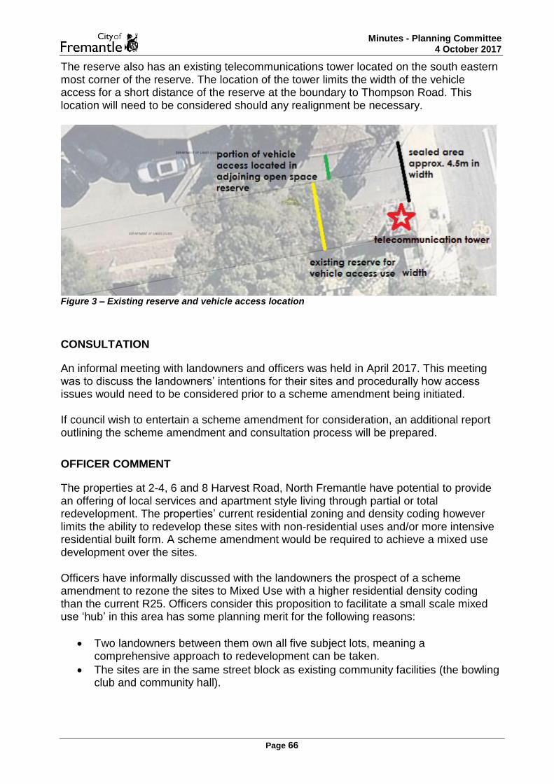
Minutes - Planning Committee 4 October 2017
Page 66
The reserve also has an existing telecommunications tower located on the south eastern most corner of the reserve. The location of the tower limits the width of the vehicle access for a short distance of the reserve at the boundary to Thompson Road. This location will need to be considered should any realignment be necessary.
Figure 3 – Existing reserve and vehicle access location
CONSULTATION
An informal meeting with landowners and officers was held in April 2017. This meeting was to discuss the landowners’ intentions for their sites and procedurally how access issues would need to be considered prior to a scheme amendment being initiated. If council wish to entertain a scheme amendment for consideration, an additional report outlining the scheme amendment and consultation process will be prepared.
OFFICER COMMENT
The properties at 2-4, 6 and 8 Harvest Road, North Fremantle have potential to provide an offering of local services and apartment style living through partial or total redevelopment. The properties’ current residential zoning and density coding however limits the ability to redevelop these sites with non-residential uses and/or more intensive residential built form. A scheme amendment would be required to achieve a mixed use development over the sites. Officers have informally discussed with the landowners the prospect of a scheme amendment to rezone the sites to Mixed Use with a higher residential density coding than the current R25. Officers consider this proposition to facilitate a small scale mixed use ‘hub’ in this area has some planning merit for the following reasons:
Two landowners between them own all five subject lots, meaning a comprehensive approach to redevelopment can be taken.
The sites are in the same street block as existing community facilities (the bowling club and community hall).

Minutes - Planning Committee 4 October 2017
Page 67
Redevelopment could provide small scale local services for surrounding residents on the eastern side of Stirling Highway, without the need to cross Stirling Highway.
The sites do not abut other residential development.
The potential to develop apartment type residential uses would provide an alternative housing type to the immediate area.
The current access to the sites however will not be adequate for comprehensive redevelopment and there are limited other options. Current access options have the following constraints:
Access to the sites will not be permitted from Stirling Highway by Main Roads WA.
Greater traffic movement into the existing access point(s) from Harvest Road will not be permitted considering its proximity to Stirling Highway.
The narrow street frontage to Thompson Road does not provide opportunities for access.
Current informal access on the vehicle access way reserve to the north is not ‘as of right’ as the vehicle access way is managed as an open space reserve, not a public or private road.
Without certainty over the ability for these lots to adequately support increases in vehicle movement, and access to and from the site, it becomes difficult to determine the appropriate scale and intensity of redevelopment for the area. Therefore irrespective of any changes to the planning provisions for these sites, officers consider some direction from council on vehicle access issues is required prior to a scheme amendment being progressed. The most suitable traffic safety solution would be to encourage access be taken from the existing vehicle access way to the north of the properties. Should council be willing to support formalised access to the private lots via this access way three potential options could be considered. Option 1 – Public Road - RECOMMENDED Option 1 proposes the existing northern vehicle access way reserve (reserve 39041) be changed into a public road, with a similar function to how the land is presently used. This is the option officers consider most preferable if council supports in principle any change to the current status of the access way reserve. This option is considered the most appropriate access solution for the Harvest Road lots as it is sympathetic to the existing access needs of the bowling club and community hall and has the ability to accommodate vehicles from the southern lots. In creating a public road the City would have formal rights to maintain and manage the road, similar to the role the City currently performs with the management of the reserve. This would mean all adjoining parties would be given right of use over the public road and any uncertainty of use would be removed. In relation to the administrative process of changing the land from an open space reserve to a public road, there are no upfront costs to the City. The administrative process for creating a public road requires the City to make a request to the Minister for Lands to

Minutes - Planning Committee 4 October 2017
Page 68
relinquish the City’s current management order over the open space reserve and to change the reserve to a public road. The public road classification has a variety of ‘street types’ that fall under a public road, each having differing width guidelines dependant on the intensity of traffic and function of the road. Guidance on design standards are set out in the State’s operational policy, Liveable Neighbourhoods 2009 for each of the different street types. The volume of traffic and function of the access way could lend itself to several street types, including a laneway or access street. As part of the road classification change, upgrades to the access way would be desirable, particularly with the existing variations in the sealed portion of the access way and the inconsistencies of the reserve alignment and physical location of the road. The City would continue to manage the access way and would determine the need for these upgrades. The need for upgrades is dependent on two considerations; the City must first consider if increased residential density is desirable and what traffic might be generated, and secondly consider whether the existing function of the access way is satisfactory. It is anticipated that the laneway street type would most closely describe the existing access way. Indicative road pavement widths for laneways can be between 3-6.4m, which can be achieved presently. Despite the ability to achieve this presently, officers have recommended that the alignment issues be investigated further so the most desirable configuration can be determined. These investigations will form part of a report back to council. The current width of the vehicle access and functionality of the road supports its currently limited traffic use. In the event that the reserve is converted to a public road and the southern sites are afforded additional density allowances and land use changes, the public road may warrant additional upgrades including more width to support increased use. As a scheme amendment has not yet been proposed, and appropriate planning provisions still need to be considered, it would be unreasonable to anticipate the level of increased traffic that could occur and the road upgrades required. It is recommended that any upgrades as a result of increased traffic from the southern lots on Harvest Road be investigated with the scheme amendment and joint responsibility for these costs be shared with the adjoining landowners. Therefore, should council wish to entertain an amendment in the future, the scheme amendment could include provisions requiring the upgrading of the newly converted public road to be at the cost or part cost of private landowners. Notwithstanding any upgrades, the functionality of the road should remain similar to its current use. Therefore, no direct access to Stirling Highway would be recommended. Option 2 – Private Road An alternative solution to the public road conversion is to request that the reserve be sold for the purpose of creating a private road. The private road is a less desirable solution as this relies on the City purchasing the land and then legally allowing access to both the current open space reserve uses and the adjoining private landowners. The administrative process presents greater complexities in achieving access rights for the southern landowners and would result in a greater upfront cost for the City. Similar to

Minutes - Planning Committee 4 October 2017
Page 69
option 1, access directly to Stirling Highway would not be recommended. Again upgrade requirements would also be necessary for this option. It is also essential to continue the use of the access way with a focus on the adjoining open space reserve uses and to not undermine their continuation. The sale of the reserve for the purpose of a private road is not recommended, as this would create a greater risk to the City’s existing assets. Option 3 - Changing the management order The vehicle access way reserve currently has a vesting order (also known as a management order) which specifies the use of the reserve for vehicle access. A possible solution could be to request that the management order be amended to clarify whether or not the southern private properties can use the access way. This option has not been recommended as the use of the access way for private or public purpose is more appropriately addressed and provided more certainty through the other options. Additional recommendations
As outlined in the background, there are uncertainties to the accuracy of the alignment of the vehicle access and the boundary of the reserve. It is recommended that an appropriate alignment for the reserve be established and where necessary the reserve boundary corrected to reflect the existing road width. Should discrepancies exist between the boundary and the physical location of the existing road this can form part of the City’s request to the Minister for Lands. The telecommunications tower location will also need to be considered should any realignment be necessary.
In addition to the changes recommended for the open space reserve, officers also recommend that the discussions with landowners regarding the proposed scheme amendment continue to be progressed if the access is formalised for the sites. Should council not wish to formalise the access for the Harvest Road lots then a scaled back scheme amendment is considered more appropriate if an amendment is desired at all.
FINANCIAL IMPLICATIONS
There are no financial implications should Council adopt the officers recommendation.
LEGAL IMPLICATIONS
There are no legal implications of adopting the officer recommendation.
VOTING AND OTHER SPECIAL REQUIREMENTS
Simple Majority Required

Minutes - Planning Committee 4 October 2017
Page 70
COMMITTEE & OFFICER'S RECOMMENDATION
MOVED: Cr J Strachan Council:
1. Authorise officers to carry out further investigation into converting Reserve 39041 to a Public Road with a similar function to how the land is presently used. This is to additionally include investigation into the realignment of the vehicle access and the boundary of the reserve and appropriate location of the telecommunications tower.
2. Request officers report back to the next appropriate meeting of council on converting reserve 39041 into a public road.
3. Authorise officers to continue investigations into scheme amendment
provisions for a local mixed use hub for 2-4 (lot 100), 6 (lot 5 and 305) and 8 (lot 7 and 306) Harvest Road, North Fremantle.
CARRIED: 6/0
For Against
Cr Jon Strachan Cr Simon Naber Cr Bryn Jones Cr Hannah Fitzhardinge Cr Ingrid Waltham Cr Jeff McDonald

Minutes - Planning Committee 4 October 2017
Page 71
CONFIDENTIAL MATTERS
Nil.
CLOSURE OF MEETING
THE PRESIDING MEMBER DECLARED THE MEETING CLOSED AT 7.42 PM.

Minutes - Planning Committee 4 October 2017
Page 72
SUMMARY GUIDE TO CITIZEN PARTICIPATION AND CONSULTATION
The City values community engagement and recognises the benefits that can flow to the quality of decision-making and the level of community satisfaction. Effective community engagement requires total clarity so that Elected Members, Council officers and citizens fully understand their respective rights and responsibilities as well as the limits of their involvement in relation to any decision to be made by the City.
How consultative processes work at the City of Fremantle
The City’s decision makers 1. The Council, comprised of Elected Members, makes policy, budgetary and key strategic decisions while the CEO, sometimes via on-delegation to other City officers, makes operational decisions.
Various participation opportunities 2. The City provides opportunities for participation in the decision-making process by citizens via itscouncil appointed working groups, its community precinct system, and targeted community engagement processes in relation to specific issues or decisions.
Objective processes also used 3. The City also seeks to understand the needs and views of the community via scientific and objective processes such as its bi-ennial community survey.
All decisions are made by Council or the CEO
4. These opportunities afforded to citizens to participate in the decision-making process do not include the capacity to make the decision. Decisions are ultimately always made by Council or the CEO (or his/her delegated nominee).
Precinct focus is primarily local, but also city-wide
5. The community precinct system establishes units of geographic community of interest, but provides for input in relation to individual geographic areas as well as on city-wide issues.
All input is of equal value 6. No source of advice or input is more valuable or given more weight by the decision-makers than any other. The relevance and rationality of the advice counts in influencing the views of decision-makers.
Decisions will not necessarily reflect the majority view received
7. Local Government in WA is a representative democracy. Elected Members and the CEO are charged under the Local Government Act with the responsibility to make decisions based on fact and the merits of the issue without fear or favour and are accountable for their actions and decisions under law. Elected Members are accountable to the people via periodic elections. As it is a representative democracy, decisions may not be made in favour of the majority view expressed via consultative processes. Decisions must also be made in accordance with any statute that applies or within the parameters of budgetary considerations. All consultations will clearly outline from the outset any constraints or limitations associated with the issue.

Minutes - Planning Committee 4 October 2017
Page 73
How consultative processes work at the City of Fremantle
Decisions made for the overall good of Fremantle
8. The Local Government Act requires decision-makers to make decisions in the interests of “the good government of the district”. This means that decision-makers must exercise their judgment about the best interests of Fremantle as a whole as well as about the interests of the immediately affected neighbourhood. This responsibility from time to time puts decision-makers at odds with the expressed views of citizens from the local neighbourhood who may understandably take a narrower view of considerations at hand.
Diversity of view on most issues 9. The City is wary of claiming to speak for the ‘community’ and wary of those who claim to do so. The City recognises how difficult it is to understand what such a diverse community with such a variety of stakeholders thinks about an issue. The City recognises that, on most significant issues, diverse views exist that need to be respected and taken into account by the decision-makers.
City officers must be impartial 10. City officers are charged with the responsibility of being objective, non-political and unbiased. It is the responsibility of the management of the City to ensure that this is the case. It is also recognised that City officers can find themselves unfairly accused of bias or incompetence by protagonists on certain issues and in these cases it is the responsibility of the City’s management to defend those City officers.
City officers must follow policy and procedures
11. The City’s community engagement policy identifies nine principles that apply to all community engagement processes, including a commitment to be clear, transparent, responsive , inclusive, accountable andtimely. City officers are responsible for ensuring that the policy and any other relevant procedure is fully complied with so that citizens are not deprived of their rights to be heard.
Community engagement processes have cut-off dates that will be adhered to.
12. As City officers have the responsibility to provide objective, professional advice to decision-makers, they are entitled to an appropriate period of time and resource base to undertake the analysis required and to prepare reports. As a consequence, community engagement processes need to have defined and rigorously observed cut-off dates, after which date officers will not include ‘late’ input in their analysis. In such circumstances, the existence of ‘late’ input will be made known to decision-makers. In most cases where community input is involved, the Council is the decision-maker and this affords community members the opportunity to make input after the cut-off date via personal representations to individual Elected Members and via presentations to Committee and Council Meetings.

Minutes - Planning Committee 4 October 2017
Page 74
How consultative processes work at the City of Fremantle
Citizens need to check for any changes to decision making arrangements made
13. The City will take initial responsibility for making citizens aware of expected time-frames and decision making processes, including dates of Standing Committee and Council Meetings if relevant. However, as these details can change, it is the citizens responsibility to check for any changes by visiting the City’s website, checking the Fremantle News in the Fremantle Gazette or inquiring at the Customer Service Centre by phone, email or in-person.
Citizens are entitled to know how their input has been assessed
14. In reporting to decision-makers, City officers will in all cases produce a community engagement outcomes report that summarises comment and recommends whether it should be taken on board, with reasons.
Reasons for decisions must be transparent 15. Decision-makers must provide the reasons for their decisions.
Decisions posted on the City’s website 16. Decisions of the City need to be transparent and easily accessed. For reasons of cost, citizens making input on an issue will not be individually notified of the outcome, but can access the decision at the City’s website under ‘community engagement’ or at the City Library or Service and Information Centre.

Minutes - Planning Committee 4 October 2017
Page 75
Issues that Council May Treat as Confidential Section 5.23 of the new Local Government Act 1995, Meetings generally open to the public, states: 1. Subject to subsection (2), the following are to be open to members of the public -
a) all council meetings; and b) all meetings of any committee to which a local government power or duty has
been delegated.
2. If a meeting is being held by a council or by a committee referred to in subsection (1) (b), the council or committee may close to members of the public the meeting, or part of the meeting, if the meeting or the part of the meeting deals with any of the following:
a) a matter affecting an employee or employees; b) the personal affairs of any person; c) a contract entered into, or which may be entered into, by the local government
and which relates to a matter to be discussed at the meeting; d) legal advice obtained, or which may be obtained, by the local government and
which relates to a matter to be discussed at the meeting; e) a matter that if disclosed, would reveal –
i) a trade secret; ii) information that has a commercial value to a person; or iii) information about the business, professional, commercial or financial
affairs of a person. Where the trade secret or information is held by, or is about, a person other than the local government.
f) a matter that if disclosed, could be reasonably expected to - i) impair the effectiveness of any lawful method or procedure for preventing,
detecting, investigating or dealing with any contravention or possible contravention of the law;
ii) endanger the security of the local government’s property; or iii) prejudice the maintenance or enforcement of a lawful measure for
protecting public safety.
g) information which is the subject of a direction given under section 23 (Ia) of the Parliamentary Commissioner Act 1971; and
h) such other matters as may be prescribed.
3. A decision to close a meeting or part of a meeting and the reason for the decision are to be recorded in the minutes of the meeting.

Minutes - Planning Committee 4 October 2017
Page 76

Minutes - Planning Committee 4 October 2017
Page 77

MINUTES ATTACHMENTS
Planning Committee
Wednesday, 4 October 2017, 6.00 pm

Minutes Attachments - Planning Committee
4 October 2017
Page 2