middle illinois river tmdls and load reduction strategies
TRANSCRIPT

Middle Illinois River TMDLs and
Load Reduction Strategies
IMPLEMENTATION PLANNING
Jennifer Olson, Tetra Tech, Inc.
Jennifer Clarke, Illinois EPA
Chris Urban, US EPA
September 6, 2012

Presentation Overview
►Project Area
►TMDL Analysis and Conclusions
► Implementation Planning Process
►Pilot Areas
►Questions & Comments

Project Area
►2,100 square mile watershed
► Illinois River Bluffs Region
►Many tributary inputs
►Backwater lakes
Illinois River
Watershed
Middle Illinois
River Watershed

Why are TMDLs and LRSs needed for the Middle Illinois River watershed?
►Streams/River/Lakes not meeting water quality goals
Pathogens (Fecal Coliform)
Chloride
Manganese
Total Dissolved Solids
Phosphorus (lakes)
Sediment
Nutrients

► Three Impaired Main Stem Segments
► Three Impaired Tributaries
Big Bureau
Kickapoo
Farm
► Two Impaired Lakes
Depue
Senachwine

TMDL Determined Pollutant Reduction Goals
►75% reduction in chloride in Farm Creek
►Up to 79% reduction in fecal coliform in Illinois River
►9-68% reduction in TN load
►96% reduction in TSS in Kickapoo Creek
►Up to 39% reduction in TSS in Illinois River
►20-90% reduction in TP load

Source Identification
►Wastewater (treatment plants, sewer overflows, septics)
► Industrial facilities
►Stormwater runoff (urban and agricultural)
►Erosion (bluffs, channel, gullies)
►Animal agriculture (stream access, AFOs)
TMDL and LRS Status
►Public comment period ended in February
►Final draft document available on Illinois EPA website
http://www.epa.state.il.us/water/tmdl/report-status.html#ill
►Still subject to US EPA review and approval
► Implementation planning efforts underway Focus of this meeting

Implementation Approach
► Obtain input from stakeholders on needs and wants
► Develop a watershed approach that achieves objectives
► Provide focused implementation activities with costs and milestones
General Implementation Plan
BMP Optimization - Pilot Studies
► Work with local partners to review and finalize plan
► Use adaptive management process to revisit and refine plan in future

BMP Optimization Process
Baseline
conditions Identify potential BMPs Identify watershed
opportunities
BMP modeling Evaluate options
Design and cost
assumptions

Pilot Area Analysis
► Pilot area approach
► Two priority watersheds selected for focused analysis
Dry Run Tributary Creek watershed
North Farm Creek watershed
► Watershed and BMP modeling
► Implementation planning
Dry Run Tributary
North Farm Creek

Dry Run Tributary Creek
► 1,690 acres
► Peoria and Peoria Heights
► Tributary to Dry Run, Kickapoo Creek, and Illinois River
► Watershed is 94% developed
Residential
High School
Commercial centers

Dry Run Tributary Creek
►High peak flows and volumes causing stream instability, erosion, pollutant loading
►Need reductions in bacteria, sediment, nutrients
►Sources are linked to urban stormwater runoff
►Previous work to evaluate channel and erosion issues

North Farm Creek Watershed
►Steep slopes, ravines, and gullies common
►Watershed drains to Farm Creek and Illinois River
►6,248 acres, East Peoria, Washington
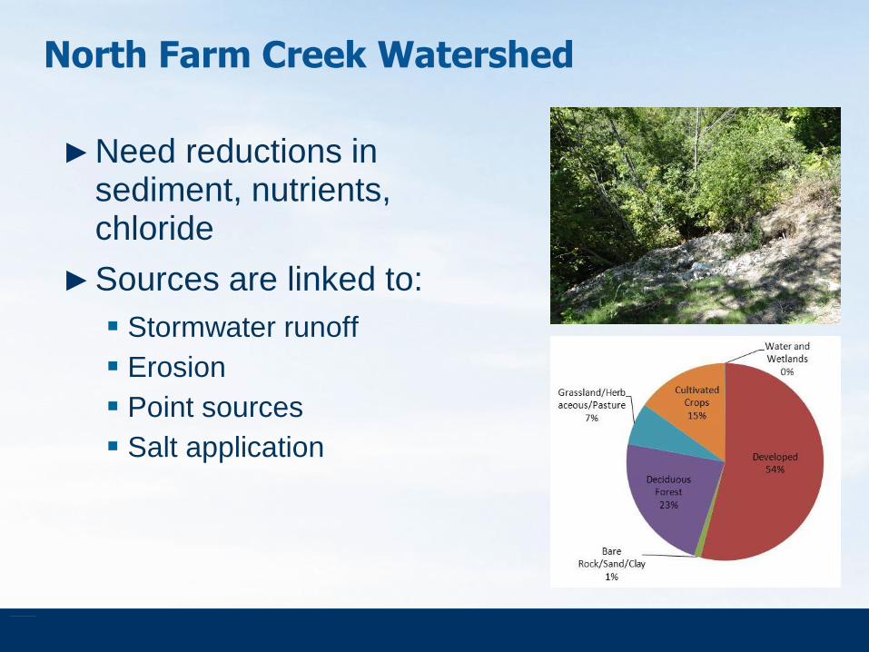
North Farm Creek Watershed
►Need reductions in sediment, nutrients, chloride
►Sources are linked to:
Stormwater runoff
Erosion
Point sources
Salt application

North Farm Creek Watershed
►Stormwater runoff is causing gully erosion, ravine formation, and other significant erosion issues
►Existing efforts – Steep Slope Ordinance

How Do We Solve the Problem?
► Non-structural practices
Street and parking lot sweeping
Ordinances
Education programs
Pollution prevention programs focused on pet waste and yard waste
Winter road materials management
Conservation/Revegetation
Others
► Structural practices
Bioretention and rain gardens
Permeable pavement
Filter strips and buffers
Rain barrels
Ponding
Others

Finding the Right Balance for Implementation
►Need to identify both structural and non-structural improvements
How much of each? Where?
►Transfer tools to local organizations for future use
BMP modeling analysis for stormwater sources
►Evaluate costs and timing considerations

BMP Modeling Analysis
► BMP Decision Support System (BMPDSS)
Developed by Tetra Tech for Prince George’s County, Maryland
An “add on” model
Allows for optimization of BMPs
Integrates costs
Models BMPs individually and as treatment train
Requires continuous simulation model
Available from PG County
► Long-Term Hydrologic Impact Assessment (L-THIA)
Developed by Purdue
Provides long-term annual averages (flow, pollutant loads)
CN based runoff analysis with EMCs for water quality
Evaluates BMPs using LID version using adjusted CN values
Web-based, easily accessible
Low High Level of Complexity

Next Steps
►Obtain input on pilot areas
Watershed concerns
Existing efforts
Possible implementation activities
►Modeling analysis
L-THIA, BMPDSS
Pilot area implementation plans
BMPs, costs, timing
►Update Middle Illinois River TMDL implementation strategy
►Timeline – Project completion Dec 2012

Questions/Comments