lecture satellite navigation
TRANSCRIPT
Week 11 – Satellite NavigationMMT 3301 – Elektronik dan Instrumentasi Marin
Dr. Ahmad Zaki Annuar
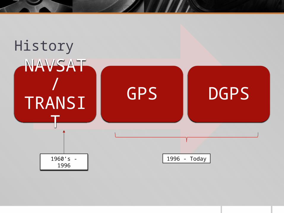
History
NAVSAT / TRANSIT GPS DGPS
1960’s - 1996 1996 - Today
NAVSAT / TRANSIT The Navy Navigation Satellite System (NAVSAT, also known as TRANSIT)
was the first operational satellite navigation system.
The system’s accuracy was better than 0.1 nautical mile anywhere in the world.
It was used primarily for the navigation of surface ships and submarines; but it also had some applications in air navigation.
It was also used in hydrographic surveying and geodetic position determination.
How NAVSAT Works NAVSAT uses the doppler shift of radio signals transmitted from a satellite
to measure the relative velocity between the satellite and the navigator.
Knowing the satellite orbit precisely, the navigator’s absolute position can be accurately determined from the time rate of change of range to the satellite.

It’s started with…Doppler shift What is Doppler shift ( or well known as Doppler effect) ?
How NAVSAT works The NAVSAT consists of 10 orbiting satellites and 3 orbiting spares; a network of
tracking stations continuously monitoring the satellites and updating the information they transmit; and the receivers and computers for processing signals.
Each satellite contains: (1) receiver equipment to accept injection data and operational commands from the ground,
(2) a decoder for digitizing the data,
(3) switching logic and memory banks for sorting and storing the digital data,
(4) control circuits to cause the data to be read out at specific times in the proper format,
(5) an encoder to translate the digital data to phase modulation,
(6) ultra stable 5 MHz oscillators, and
(7) 1.5-watt transmitters to broadcast the 150- and 400-MHz oscillator-regulated frequencies thatcarry the data to earth.
Global Positioning System (GPS) GPS is a spaced-based radio positioning system which provides suitably
equipped users with highly accurate position, velocity, and time data.
It consists of three major segments: a space segment,
a control segment, and
a user segment
Introduction to GPS - Video

C/A Code and P Code – Space segment GPS satellites transmit pseudorandom noise (PRN) sequence-modulated
radio frequencies, designated L1 (1575.42 MHz) and L2 (1227.60 MHz).
The satellite transmits both a Coarse Acquisition Code (C/A code) and a Precision Code (P code).
Both the P and C/A codes are transmitted on the L1 carrier; only the P code is transmitted on the L2 carrier.
Superimposed on both the C/A and P codes is the Navigation message. This message contains satellite ephemeris data, atmospheric propagation correction data, and satellite clock bias
Control Segment Includes master control station (MCS), which consists of equipments and
facilities required for satellite monitoring, telemetry, tacking, commanding, control, uploading and navigation message generation.
Monitor station passively track the satellites data (signals) and passed it to the MCS. Then MCS will process this information to determine satellite position and signal data accuracy, updates the navigation message of each satellite and release this information to the ground antenna .
The Ground antenna then transmit back this information to the GPS satellites.
User Segments of GPS The user segment is designed for different requirements of various users. These receivers
can be used in high, medium, and low dynamic applications.
An example of a low dynamic application would be a fixed antenna or slowly drifting marine craft.
An example of a medium dynamic application would be a marine or land vehicle traveling at a constant controlled speed.
Finally, an example of a high dynamic application would be a high performance aircraft or a spacecraft.
The user equipment is designed to receive and process signals from four or more orbiting satellites either simultaneously or sequentially.
The processor in the receiver then converts these signals to three-dimensional navigation information based on the World Geodetic System 1984 reference ellipsoid.
The user segment can consist of stand-alone receivers or equipment that is integrated into another navigation system.
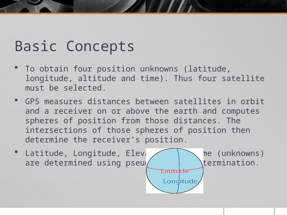
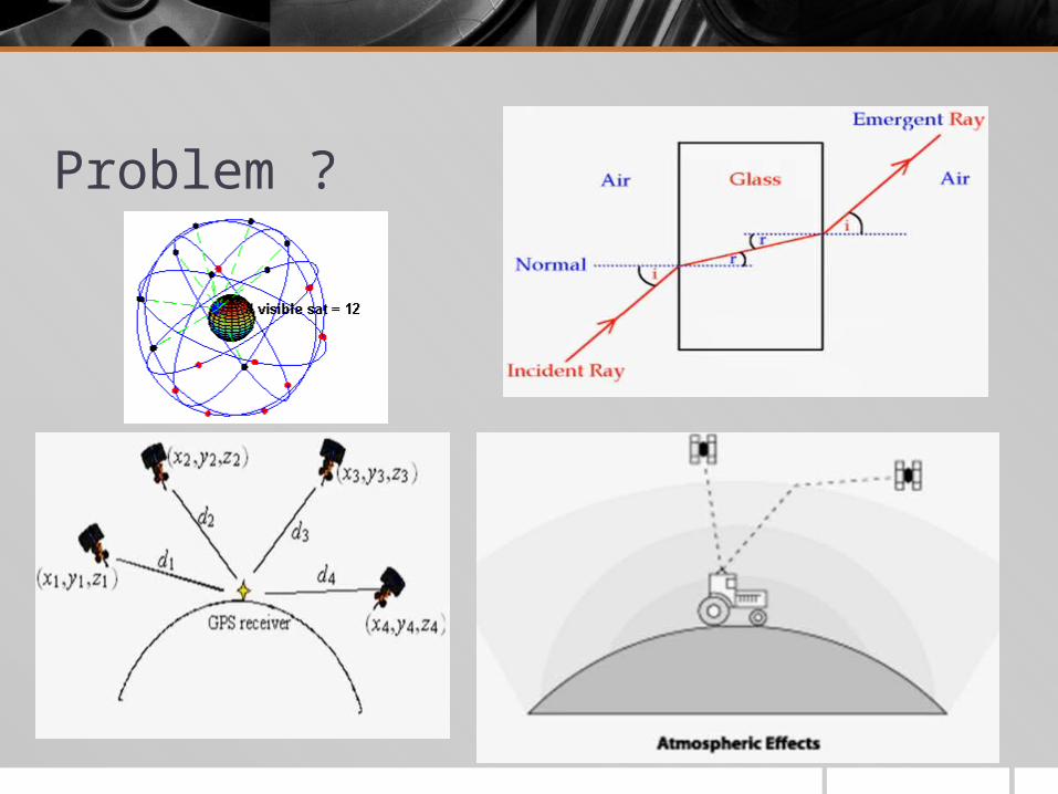
Basic Concepts To obtain four position unknowns (latitude, longitude, altitude and time).
Thus four satellite must be selected.
GPS measures distances between satellites in orbit and a receiver on or above the earth and computes spheres of position from those distances. The intersections of those spheres of position then determine the receiver’s position.
Latitude, Longitude, Elevation and Time (unknowns) are determined using pseudo-random determination.
Precise Positioning Service and Standard Positioning Service Precise Positioning Service (PPS)
High accuracy military use
Standard Positioning Service (SPS) Civillian use
Selective Availability (SA) : SA operates by introducing controlled errors into both the C/A and P code signals.
SA can be programmed to degrade the signals’ accuracy even further during time of war, denying a potential adversary the ability to use GPS to nominal SPS accuracy. SA introduces two errors into the satellite signal:
epsilon error: an error in satellite ephemeris data in the navigation message;
clock dither: error introduced in the satellite atomic clocks’ timing. The presence of SA is the largest source of error present in an SPS GPS position measurement.
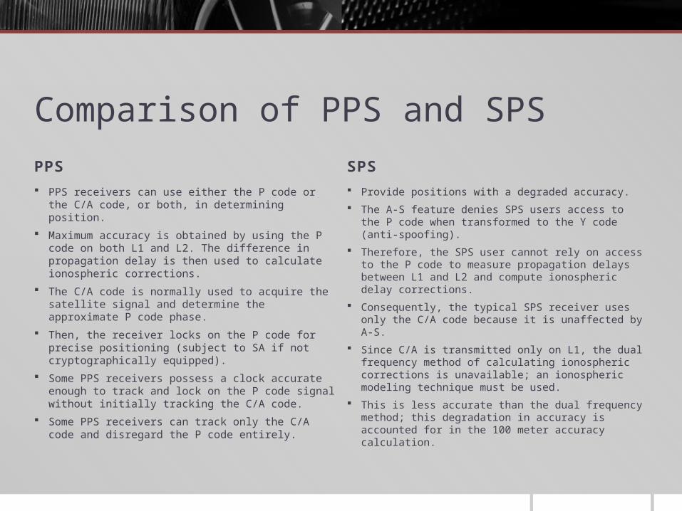
Comparison of PPS and SPSPPS SPS
PPS receivers can use either the P code or the C/A code, or both, in determining position.
Maximum accuracy is obtained by using the P code on both L1 and L2. The difference in propagation delay is then used to calculate ionospheric corrections.
The C/A code is normally used to acquire the satellite signal and determine the approximate P code phase.
Then, the receiver locks on the P code for precise positioning (subject to SA if not cryptographically equipped).
Some PPS receivers possess a clock accurate enough to track and lock on the P code signal without initially tracking the C/A code.
Some PPS receivers can track only the C/A code and disregard the P code entirely.
Provide positions with a degraded accuracy.
The A-S feature denies SPS users access to the P code when transformed to the Y code (anti-spoofing).
Therefore, the SPS user cannot rely on access to the P code to measure propagation delays between L1 and L2 and compute ionospheric delay corrections.
Consequently, the typical SPS receiver uses only the C/A code because it is unaffected by A-S.
Since C/A is transmitted only on L1, the dual frequency method of calculating ionospheric corrections is unavailable; an ionospheric modeling technique must be used.
This is less accurate than the dual frequency method; this degradation in accuracy is accounted for in the 100 meter accuracy calculation.
GPS Receiver Operation GPS has to track satellite signals, make pseudorange measurements, and
collect navigation data.
A typical satellite tracking sequence:
Begins with the receiver determining which satellites are available for it to track Satellite visibility is determined by user-entered predictions of position,
velocity, and time, and by almanac information stored internal to the receiver. If no stored almanac information exists, then the receiver must attempt to locate and lock onto the signal from any satellite in view.
When the receiver is locked onto a satellite, it can demodulate the navigation message and read the almanac information about all the other satellites in the constellation.
A carrier tracking loop tracks the carrier frequency while a code tracking loop tracks the C/A and P code signals.
The two tracking loops operate together in an iterative process to acquire and track satellite signals.
Doppler Offset The receiver’s carrier tracking loop will locally generate an L1 carrier
frequency which differs from the satellite produced L1 frequency due to a doppler shift in the received frequency.
This doppler offset is proportional to the relative velocity along the line of sight between the satellite and the receiver, subject to a receiver frequency bias.
The carrier tracking loop adjusts the frequency of the receiver generated frequency until it matches the incoming frequency.
This determines the relative velocity between the satellite and the receiver.
The GPS receiver uses this relative velocity to calculate the velocity of the receiver. This velocity is then used to aid the code tracking loop.
Pseudo-range Measurement The code tracking loop is used to make pseudorange measurements between
the GPS receiver and the satellites.
The receiver’s tracking loop will generate a replica of the targeted satellite’s C/A code with estimated ranging delay.
In order to match the received signal with the internally generated replica, two things must be done: 1) The center frequency of the replica must be adjusted to be the same as the center
frequency of the received signal; and
2) the phase of the replica code must be lined up with the phase of the received code.
The center frequency of the replica is set by using the doppler-estimated output of the carrier tracking loop.
The receiver will then slew the code loop generated C/A code though a millisecond search window to correlate with the received C/A code and obtain C/A tracking.

Code tracking Once the carrier tracking loop and the code tracking loop have locked onto
the received signal and the C/A code has been stripped from the carrier, the navigation message is demodulated and read.
This gives the receiver other information crucial to a pseudorange measurement.
The navigation message also gives the receiver the handover word, the code that allows a GPS receiver to shift from C/A code tracking to P code tracking.
Handover Word (HOW) The handover word is required due to the long phase (seven days) of the P code signal.
The C/A code repeats every millisecond, allowing for a relatively small search window.
The seven day repeat period of the P code requires that the receiver be given the approximate P code phase to narrow its search window to a manageable time.
The handover word provides this P code phase information. The handover word is repeated every subframe in a 30 bit long block of data in the navigation message. It is repeated in the second 30 second data block of each subframe.
For some receivers, this handover word is unnecessary; they can acquire the P code directly.
This normally requires the receiver to have a clock whose accuracy approaches that of an atomic clock.
Since this greatly increases the cost of the receiver, most receivers for non-military marine use do not have this capability
Final measurements Once the receiver has acquired the satellite signals from four GPS satellites, achieved carrier
and code tracking, and has read the navigation message, the receiver is ready to begin making pseudorange measurements.
Recall that these measurements are termed pseudorange because a receiver clock offset makes them inaccurate; that is, they do not represent the true range from the satellite, only a range biased by a receiver clock error.
This clock bias introduces a fourth unknown into the system of equations for which the GPS receiver must solve (the other three being the x coordinate, y coordinate, and z coordinate of the receiver position).
Recall that the receiver solves this clock bias problem by making a fourth pseudorange measurement, resulting in a fourth equation to allow solving for the fourth unknown.
Once the four equations are solved, the receiver has an estimate of the receiver’s position in three dimensions and of GPS time.
The receiver then converts this position into coordinates referenced to an earth model based on the World Geodetic System (1984).
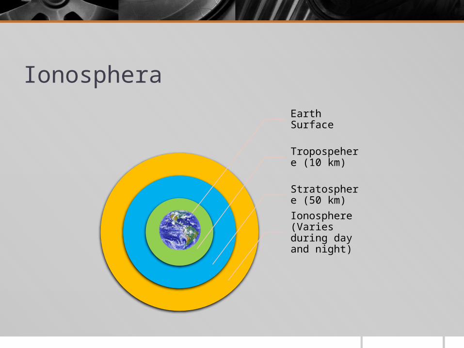
Ionosphera
Earth Surface
Tropospehere (10 km)
Stratosphere (50 km)
Ionosphere (Varies during day and night)
Effect of Ionosphera to GPS accuracy The largest effect that this ionospheric effect has on GPS accuracy is a
phenomenon known as group time delay.
As the name implies, group time delay results in a delay in the time a signal takes to travel through a given distance.
Obviously, since GPS relies on extremely accurate timing measurement of these signals between satellites and ground receivers, this group time delay can have a noticeable effect on the magnitude of GPS position error.
The group time delay is a function of several elements. It is inversely proportional to the square of the frequency at which the satellite transmits, and it is directly proportional to the atmosphere’s total electron content (TEC), a measure of the degree of the atmosphere’s ionization.

Why do we need a more accurate GPS?
GPS system is fairly accurate for civilian use
The most accurate GPS can be found in military application
For maritime use, an accuracy of 100m is adequate for open ocean application. But how about in busy route?
Introducing Differential GPS
The idea behind all differential positioning is to correct bias errors at one location with measured bias errors at a known position.
A reference receiver, or base station, computes corrections for each satellite signal.
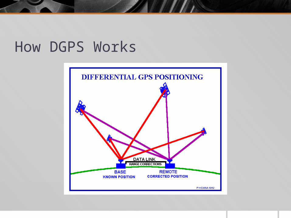
How DGPS Works
How accurate is DGPS? For suitably equipped users, DGPS results in positions as accurate as if not
more accurate than those obtainable by the Precise Positioning Service (PPS).
For the mariner approaching a harbour or piloting in restricted waters near a site with a DGPS transmitter, the accuracy required for ship’s safety is now available from a system other than plotting visual bearings.
This capability is not limited to simply displaying the correct position for the navigator to plot.
Moving to the Present Time… Selective Availability (SA) was an intentional degradation of public GPS
signals implemented for national security reasons.
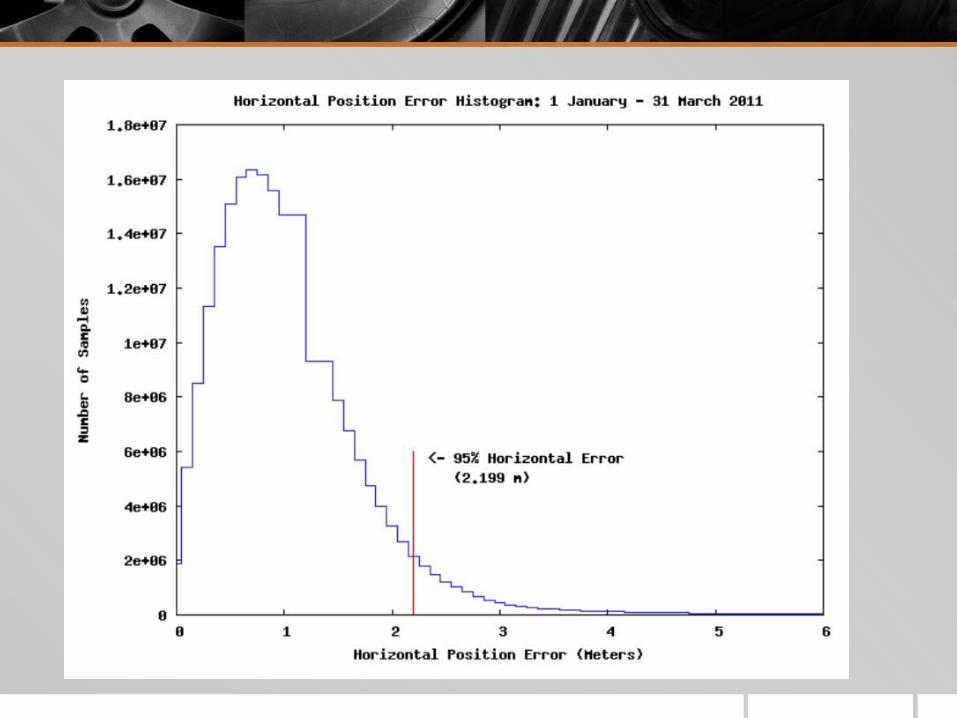
In May 2000, at the direction of President Bill Clinton, the U.S government discontinued its use of Selective Availability in order to make GPS more responsive to civil and commercial users worldwide.
Today, following the discontinued Selective Availability (SA), the accuracy of GPS devices are up to 7.8m with 95% of confidence.
However, recent report 2011 shown that the horizontal accuracy (as if you are standing on the ground) is up to 1m accuracy.