lecture 7: soils and infiltrationkula.geol.wwu.edu/rjmitch/l7_soils_infiltration.pdf · lecture 7:...
TRANSCRIPT

Lecture 7: Soils and Infiltration
Key Questions1. What is a soil?
2. How are soil types classified?
3. What is infiltration?
4. What quantities control infiltration rate?
5. What is soil storage
6. What is soil porosity
7. What is capillarity?
rain drop infiltrating into soil

Soil type and thickness affect runoff and streamflow

Soil is an unconsolidated aggregate of mineral and rock fragments ranging in size from clay, silt, sand, to gravel. Some soils (near surface) also contain organic matter.

Soil type (or classification) is determined by fragment (clast) size and distribution of clast sizes.
RELATIVE SIZES

Soil classification can get more descriptive, but for hydrology purposes we use clast size.

USDA Soil Texture Classification
relative size

Figure 1.‐Location of Whatcom County In Washington.
Soil Survey ofWhatcom County Area, WashingtonBy Alan Goldin, Ph.D., Soil Conservation Service Washington State Department of Natural Resources United States Department of Agriculture, Soil Conservation Service

Digital soil data (for ArcGIS) is available from the following data base.

Soil Coverage (USDA)

Infiltration is the movement of water INTO the soil surface
infiltration

percolation
Percolation is the movement of water WITHIN the soil matrix.

percolation
Percolation rate controls the infiltration rate
infiltration

ponding and runoff
When the rainfall rate exceeds the infiltration rate, surface ponding and runoff occurs

Open the link below and read about infiltration

wet silt
moist sand
dry sand

water is flowing in fast
nothing happening

water is coming out
water flowing in slowly

nothing came out
nothing came out

nothing came out
soil storage
surface runoff
groundwater recharge

Infiltration (and runoff) is controlled by soil type, thickness, original water content, and precipitation characteristics
infiltration
runoff

Moist soils produce more runoff than dry soils

sandy soils allow water to infiltrate silt and clay soils have slow infiltration rates, hence more surface runoff

USDA Soil Texture Classification
clays have extremely low infiltration rates (high runoff)
silts have low infiltration ratessands have high infiltration rates
The degree of infiltration and runoff depends on the soil type

Rainfall characteristics determine the amount of infiltration versus runoff
light rain – more infiltration heavy rain – more runoff
infiltrationrunoff

Soil storage is the amount of water the soil can hold. It is controlled by the soil type, thickness, and porosity.

Porosity is a measure of void space in a soil

total volume of dry soil

water volume

saturate soil

volume of voids
saturated soil
water loss

volume of voids
saturated soil total volume
porosity =total volume
volume of voids

porosity ≈ 40% porosity ≈ 25%
uniform grain sizes mixture of grain sizes
Grain-size distribution controls the magnitude of porosity

nothing came out
soil water storage
surface runoff
groundwater recharge

After water has drained by gravity, some water is held between the pore spaces by tension (capillary forces)

water is polar
__
++

The polar nature of water causes it to adhere to solid surfaces and bond to other water molecules (cohesion)
read about adhesion, cohesion, and surface tension

The tension or capillary forces are created by “molecular” forces of attraction between the sand – water – air and are the same forces that bind sand together in the sculpture below

Open the link below and read about water properties and capillarity
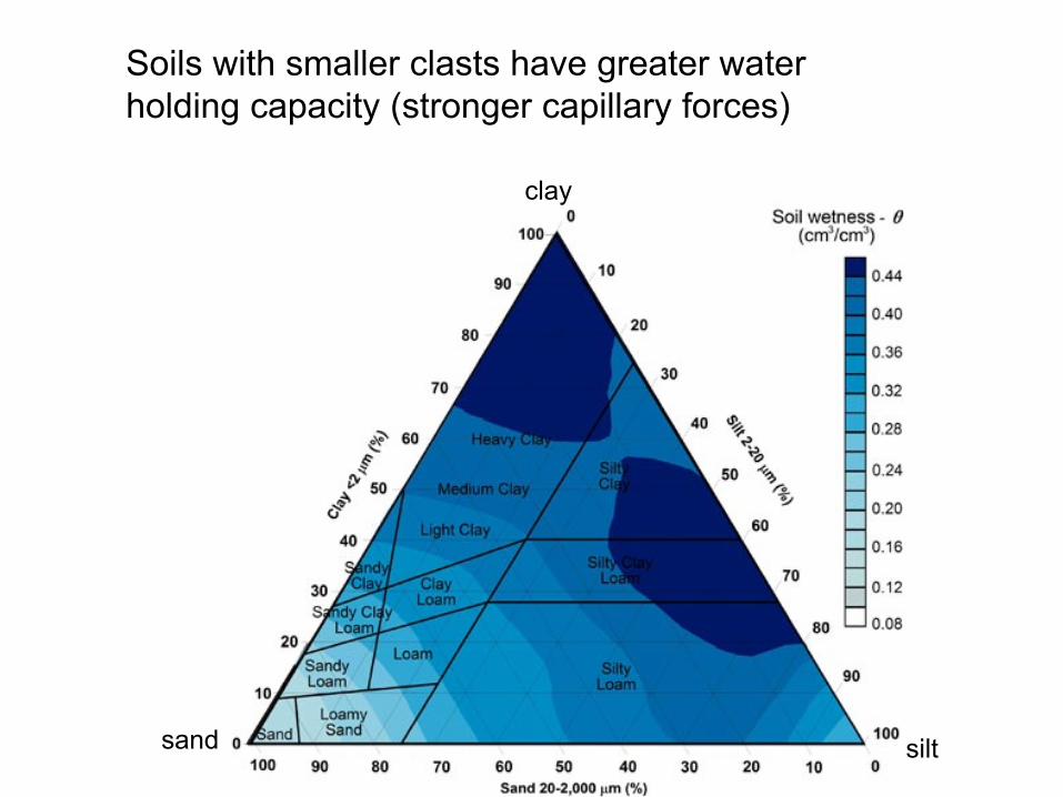
Soils with smaller clasts have greater water holding capacity (stronger capillary forces)
sand
clay
silt

watershed
Q = stream discharge
Q
Time
HydrographQ

sandy soils silt and clay soils
Q
Time
Hydrograph
Q
Time
Hydrograph
attenuated response rapid “ high peak” response

Impervious surfaces in urban settings don’t allow any infiltration, hence very rapid surface runoff
Q
Time
Hydrograph
very rapid “high peak” response

Water flows to both sides and across Squalicum Parkway near the intersection with Roeder Avenue on Wednesday, January 7, 2009

Frozen soils don’t allow any infiltration, hence very rapid surface runoff
Q
Time
Hydrograph
very rapid “high peak” response
The frost line is 4 to 6 feet in Minnesota


http://www.ndsu.edu/fargo_geology/fldphotos2010.htm
Fargo North Dakota: March 13, 2010

thick, dry soils can store a lot of rain, hence produce less runoff (if they are dry to begin with)
Q
Time
Hydrograph

thin soils saturate quicker, hence produce more runoff
Q
Time
Hydrograph

soils near saturation produce more runoff
Q
Time
Hydrograph

water can flow through the soils toward a stream
Q
Time
Hydrograph