lake arrowhead community plan - san bernardino · pdf fileland within the lake arrowhead...
TRANSCRIPT

April 12, 2007 1
Lake Arrowhead Community Plan
Adopted March 13, 2007 Effective April 12, 2007

April 12, 2007 2
Acknowledgements The following individuals contributed to the preparation of the
Lake Arrowhead Community Plan
Board of Supervisors Brad Mitzelfelt, First District
Paul Biane, Second District, Chairman Dennis Hansberger, Third District
Gary Ovitt, Fourth District, Vice Chairman Josie Gonzales, Fifth District
Planning Commissioners
Ken Anderson, First District Michael Cramer, Second District
Bill Collazo, Third District Mark Dowling, Vice Chairman, Fourth District
Audrey Mathews, Chair, Fifth District
General Plan Advisory Committee Mark Bulot, Redlands
Ted Dutton, Lake Arrowhead Scott Frier, Helendale Matt Jordan, Redlands
Michael Kreeger, Chino Hills Jornal K. Miller, Muscoy
Ken Morrison, Yucca Valley Kathy Murphy, Fawnskin
Mark Nuaimi, Fontana Marvin Shaw, Lake Arrowhead Doug Shumway, Apple Valley
Jean Stanton, Bloomington Eric Swanson, Hesperia
Lake Arrowhead Community Plan Committee
Carol Banner Duanne Banner
Dave Barrie Hugh Bialecki Butch Bauman Michael Burch Cynthia Carley
Suzie Doyle Jim Gardner Bob Hertel
Wes McDaniel Howard Miller Marcel Machler
Gerry Newcombe John Padore
Bruce Prendergast Debbie Quioness Heather Sargeant
Marvin Shaw Stan Sievers Mary Snaer
Bob Spoeneman Walt Sweet
Jane St. John Diane Wilk

April 12, 2007 3
County Staff Julie Rynerson Rock, AICP, Director, Land Use Services Department
Randy Scott, AICP, Deputy Director, Advance Planning Jim Squire, AICP, Supervising Planner
Carrie Hyke, AICP, Supervising Planner Dave Prusch, AICP, Senior Associate Planner
Ron Matyas, Senior Associate Planner Matt Slowik, REHS, Senior Associate Planner
Consultants to the County
URS Corporation
Frank Wein, DPDS, FAICP, Project Director Jeff Rice, AICP, Assistant Project Manager
Brian Smith, AICP, Environmental Manager Kavita Mehta, Urban and Environmental Planner
Cynthia Wilson, Environmental Planner Mari Piantka, Senior Environmental Planner
Michael Greene, INCE Bd. Cert., Senior Project Scientist Joseph Czech, Senior Project Engineer
Jun Wang, Senior Water Resources Engineer Cynthia Gabaldon, Senior Engineer
Veronica Seyde, Senior Scientist Tom Herzog, Senior Biologist
Bryon Bass, Senior Archaeologist Paul Nguyen, Senior Air Quality Scientist
Chris Goetz, Senior Project Geologist Jerry Zimmerle, Principal Engineer
Joe Devoy, GIS Specialist Matt Eimers, GIS Analyst Vidas Sekas, GIS Analyst
Wendy Lamont, Word Processor Wayne Lim, Senior Graphic Designer
Hogle-Ireland, Inc. Paul Ireland, Partner
Mike Thiele, AICP, Principal Kimiko Lizardi, Project Manager
Ron Pflugrath, AICP
Jacobson and Wack Bruce Jacobson, AICP, Principal
RBF Consulting
Laura Stearns, Planner
Stanley R. Hoffman Associates, Inc. Stanley R. Hoffman, FAICP, President
Debbie L. Lawrence, AICP, Project Manager Bravishwar Mallavarapu, Planner
ISMS, Inc.
Doug Mende, Vice President
Economics Politics, Inc. John Husing, Vice President

April 12, 2007 4
Meyer, Mohaddes Associates Viggen Davidian, P.E, Project Manager
Matthew Simons, T.E., Senior Transportation Engineer Adolfo Ozaeta, Project Engineer Yim Tse, Graphics Technician
Psomas
Dan McCroskey, PLS, Project Manager Duane Haselfeld Sergio Sanchez
Moore, Iacofano & Goltzman (MIG)
Pat McLaughlin, Office Manager Esmeralda Garcia, Project Associate
Special Acknowledgements
Bill Postmus, Past First District Supervisor and Chairman of the Board Theresa Kwappenberg, Past Third District Planning Commissioner
Michael E. Hays, AICP, Past Director, Land Use Services Department Sam Gennawey, Past Project Manager for MIG

TABLE OF CONTENTS
April 12, 2007 5
TABLE OF CONTENTS 1 1 INTRODUCTION.................................................................................................................................................................. 7
LA1.1 PURPOSE OF THE COMMUNITY PLAN .................................................................................................................... 7 LA1.2 COMMUNITY BACKGROUND .................................................................................................................................... 7
LA1.2.1 Location.................................................................................................................................................................. 7 LA1.2.2 History .................................................................................................................................................................. 11 LA1.2.3 Description of the Plan Area ............................................................................................................................. 11
LA1.3 COMMUNITY CHARACTER...................................................................................................................................... 12 LA1.3.1 Unique Characteristics ........................................................................................................................................ 12 LA1.3.2 Issues and Concerns .......................................................................................................................................... 12 LA1.3.3 Community Priorities.......................................................................................................................................... 12
2 LAND USE.................................................................................................................................................................................... 15 LA2.1 INTRODUCTION........................................................................................................................................................ 15 LA2.2 GOALS AND POLICIES.............................................................................................................................................. 23
3 CIRCULATION AND INFRASTRUCTURE ........................................................................................................................ 27 LA3.1 INTRODUCTION........................................................................................................................................................ 27 LA3.2 CIRCULATION – INTRODUCTION ........................................................................................................................... 27 LA3.3 CIRCULATION – GOALS AND POLICIES................................................................................................................. 36 LA3.4 INFRASTRUCTURE - INTRODUCTION ..................................................................................................................... 38 LA3.5 INFRASTRUCTURE – GOALS AND POLICIES .......................................................................................................... 49
4 HOUSING..................................................................................................................................................................................... 51 5 CONSERVATION....................................................................................................................................................................... 53
LA5.1 INTRODUCTION........................................................................................................................................................ 53 LA5.2 GOALS AND POLICIES .............................................................................................................................................. 53
6 OPEN SPACE............................................................................................................................................................................... 57 LA6.1 INTRODUCTION........................................................................................................................................................ 57 LA6.2 GOALS AND POLICIES.............................................................................................................................................. 61
7 NOISE ............................................................................................................................................................................................ 65 8 SAFETY ......................................................................................................................................................................................... 67
LA8.1 INTRODUCTION........................................................................................................................................................ 67 LA8.2 GOALS AND POLICIES.............................................................................................................................................. 75
9 ECONOMIC DEVELOPMENT .............................................................................................................................................. 77 LA9.1 INTRODUCTION........................................................................................................................................................ 77 LA 9.2 GOALS AND POLICIES.............................................................................................................................................. 77
10 IMPLEMENTATION............................................................................................................................................................... 79 APPENDIX ...................................................................................................................................................................................... 81

TABLE OF CONTENTS
April 12, 2007 6
LIST OF FIGURES FIGURE 1-1, VICINITY/REGIONAL CONTEXT ................................................................................................................. 9 FIGURE 2-1, LAND USE POLICY ............................................................................................................................................ 17 FIGURE 3-1, CIRCULATION ..................................................................................................................................................... 29 FIGURE 3-2, WATER DISTRICTS............................................................................................................................................. 41 FIGURE 3-3, WASTEWATER SYSTEM ................................................................................................................................... 47 FIGURE 6-1, JURISDICTIONAL CONTROL......................................................................................................................... 59 FIGURE 8-1, FIRE DISTRICTS .................................................................................................................................................. 69 FIGURE 8-2, FIRE STATIONS ................................................................................................................................................... 71
LIST OF TABLES TABLE 1: DISTRIBUTION OF GENERAL PLAN LAND USE DISTRICTS ................................................................. 19 TABLE 2: LAND USE POLICY MAP MAXIMUM POTENTIAL BUILD-OUT............................................................. 21 TABLE 3: POPULATION, HOUSEHOLDS AND EMPLOYMENT PROJECTION 2000-2030................................. 22 TABLE 4: EXISTING AND FUTURE ROADWAY OPERATING CONDITIONS...................................................... 33 TABLE 5: CMP FACILITY LEVELS OF SERVICE ............................................................................................................... 35 TABLE 6: SUPPLY AND POLICY INFORMATION OF SERVICE PROVIDERS ....................................................... 43 TABLE 7: WASTE WATER AGENCIES/DISTRICTS.......................................................................................................... 49 TABLE 8: FIRE STATIONS ......................................................................................................................................................... 73

INTRODUCTION
April 12, 2007 7
1 INTRODUCTION
LA1.1 PURPOSE OF THE COMMUNITY PLAN The primary purpose of the Lake Arrowhead Community Plan is to guide the future use and development of land within the Lake Arrowhead Community Plan area in a manner that preserves the character and independent identity of the individual communities within the area. By setting goals and policies for the Lake Arrowhead community that are distinct from those applied countywide, the Community Plan outlines how the County of San Bernardino will manage and address growth while retaining the attributes that make Lake Arrowhead unique. Community plans focus on a particular community within the overall area covered by the General Plan of a jurisdiction. As an integral part of the overall General Plan, a community plan must be consistent with the General Plan. To facilitate consistency, the Lake Arrowhead Community Plan builds upon the goals and policies of each element of the General Plan. However, to avoid repetition, those goals and policies defined within the overall General Plan that adequately address the conditions of the community will not be repeated in this or other community plans. Instead, the policies that are included within the community plan should be regarded as refinements of broader General Plan goals and policies that have been customized to meet the specific needs or unique circumstances within individual communities. These unique goals and policies will facilitate the citizens of the mountain communities to have a ready reference to guide them.
LA1.2 COMMUNITY BACKGROUND
LA1.2.1 LOCATION The plan area is located in the San Bernardino Mountains and is surrounded by the San Bernardino National Forest. The Lake Arrowhead plan area is bound to the southwest by the Crestline Community Plan area and to the southeast by the Hilltop Community Plan area. The Lake Arrowhead Community Plan area encompasses approximately 30 square miles and includes the communities of Agua Fria, Blue Jay, Cedar Glen, Crest Park – Meadowbrook Woods, Deer Lodge Park, Lake Arrowhead, Rimforest, Skyforest and Twin Peaks (see Figure 1-1, Vicinity, Regional Context).

INTRODUCTION
April 12, 2007 8
[This page intentionally left blank]

INTRODUCTION
April 12, 2007 9
Figure 1-1, Vicinity/Regional Context

INTRODUCTION
April 12, 2007 10
[This page intentionally left blank]

INTRODUCTION
April 12, 2007 11
LA1.2.2 HISTORY In 1851, when the Mormons purchased land from the early Spanish settlers and founded the City of San Bernardino, there was an immediate need for lumber to build homes, churches, stores, and civic buildings. During the 1860s, as the area attracted settlers into the valley, there was a heavy demand on the lumber mills that were scattered across the mountain top. During this period, the Lake Arrowhead area was opened to logging. At various times, there were mills in Twin Peaks, Blue Jay, Grass Valley, Cedar Glen and what is now Lake Arrowhead. By the late 1800s the value of the mountains as a watershed to protect and foster growth in the valley became apparent. In 1890, Congress enacted the Forest Reserve Act, and in 1893 the San Bernardino Forest Reserve was established. Businessmen in the area organized the Arrowhead Reservoir Company and constructed Little Bear dam in 1904 to create a large reservoir in Little Bear Valley. In 1912, the plans were halted by a State Supreme Court decision that water from one watershed could not be diverted to another for irrigation. Later, the holdings of the Arrowhead Reservoir Company (which had been transferred to a new corporation, the Arrowhead Reservoir and Power Company) were purchased by the Lake Arrowhead Company, a syndicate headed by Benton Van Nuys, a prominent Los Angeles entrepreneur. The new owners completed the dam and developed the lake and adjacent lands into a resort. Over the next thirty years, the area flourished as a fashionable summer resort for the rich and famous. Exclusive hotel and recreation facilities were constructed and lands adjacent to the lake were subdivided for private residences. In 1946, the property holdings of the Lake Arrowhead Company were sold to the Los Angeles Turf Club, which, in turn, sold out to the Lake Arrowhead Development Company in 1960. Since then, there have been several changes in ownership and most of the land has been subdivided into residential lots. The lake is now owned by the Arrowhead Lake Association, which has exclusive rights for use of Lake Arrowhead. Only property owners in the Arrowhead Woods area of Lake Arrowhead are eligible to pay a membership fee to utilize the various Lake Arrowhead recreational facilities. The original Lake Arrowhead Community Plan was adopted in August, 1981. The plan was intended as a short range plan to implement those portions of the General Plan that directly affected the community of Lake Arrowhead. The 1989 General Plan update proposed that comprehensive community plans be incorporated into the General Plan and Development Code, however, full incorporation was not completed due to budget and staff constraints. The Phase I Scoping of the 2006 General Plan update recommended that the community plan program be reinstated to help fulfill the need for development guidance of certain unique communities within the County. The Lake Arrowhead community was selected as one of 13 areas that would have a community plan prepared in conjunction with Phase II of the San Bernardino County General Plan update.
LA1.2.3 DESCRIPTION OF THE PLAN AREA Lake Arrowhead is located approximately 85 miles east of the City of Los Angeles and 23 miles north of the City of San Bernardino. The altitude of the Lake Arrowhead plan area averages over 5,000 feet. This provides for a mild climate and four distinct seasons. Average temperatures range from 37 degrees Fahrenheit in the winter months to 68 degrees Fahrenheit in the summer months. Precipitation averages 40 inches per year. Precipitation occurs mostly in the form of snow, with up to 3 to 4 feet at one time.

INTRODUCTION
April 12, 2007 12
The plan area is a heavily wooded mountainous terrain with steep slopes and numerous ravines. Soil types range from outcropping and decomposing granites, to alluvial deposits on the valley floors. No major earthquake faults are located in the immediate area.
LA1.3 COMMUNITY CHARACTER
LA1.3.1 UNIQUE CHARACTERISTICS The Lake Arrowhead Community Plan area is known as a charming, small-town mountain community that is attractive to tourists and residents alike for its climate, recreational amenities, scenic resources and sense of remoteness from urban life. The lake, after which the community is named, is a focal point of the area.
LA1.3.2 ISSUES AND CONCERNS A series of public meetings for the preparation of the plan were held in 2003 and 2004. The issues and concerns identified in this section are based on input from those meetings. Several issues set Lake Arrowhead apart from other mountain communities suggesting that different strategies for future growth may be appropriate. Among these are preservation of community character, and infrastructure.
A. PRESERVATION OF COMMUNITY CHARACTER
Residents feel that the high quality of life experienced in their neighborhoods today should not be degraded by growth and the subsequent impacts of traffic congestion, strains on infrastructure and threats to natural resources. The clean air, ambient quiet, dark skies, abundant wildlife and rich natural vegetation are valued highly by residents as well as by the visitors who frequent the area. Residents are concerned about the conversion of natural open space to development and particularly to a type of development that detracts from the natural setting and the mountain character currently enjoyed by the community. The preservation of the community’s natural setting, small-town atmosphere and mountain character becomes important not only from an environmental sustainability perspective, but from a cultural and economic point of view.
B. INFRASTRUCTURE
Like much of San Bernardino County, Lake Arrowhead faces the potential for significant growth. Residents are concerned with the impacts that future growth and development will have on an infrastructure system they sense is already strained. The community’s primary concerns centered around water supply and traffic, circulation and public health and safety.
LA1.3.3 COMMUNITY PRIORITIES The community’s common priorities that have influenced the goals and policies included within this community plan are (a) the environment, and (b) community character. ENVIRONMENT
A key consideration in developing this plan has been acknowledging the potential impacts that future development will have on the area’s valued natural resources. The goals and policies included in this community plan emphasize protection of these sensitive resources, the integration of natural vegetation and open space, and development that is scaled and designed to sustain the natural surroundings. In public

INTRODUCTION
April 12, 2007 13
workshops held to develop the General Plan and the Lake Arrowhead Community Plan, the public has identified the following principle planning issues and concerns to be addressed in the plan:
A. A community in a forest – the natural environment prevails. B. Ensure no conflict in the interface between the national forest and adjacent land uses. C. Conservation of natural resources and scenic beauty.
COMMUNITY CHARACTER
The Lake Arrowhead Community Plan area will continue to experience growth as a variety of factors continue to drive people to migrate from more urban areas to areas attractive for their rural nature. As the mountain develops, it will be imperative that adequate services and infrastructure are provided, that all improvements reflect the needs of local residents as well as visitors, that all development maintains a sense of connection to the natural environment, and that the small-town, mountain character of the community is preserved. Relating to community character, the public has identified the following issues and concerns to be reflected and addressed in the community plan:
A. Acknowledge service and infrastructure capacity and limitations of the area, particularly roads and water, to serve future development.
B. Protect and preserve the rural mountain character of the community by maintaining primarily low-density residential development and compatible commercial development.
C. Maintain the value of community's scenic and natural resources, including Lake Arrowhead, which are the foundation of the community character and quality of life.

INTRODUCTION
April 12, 2007 14
[This page intentionally left blank]

LAND USE
April 12, 2007 15
2 LAND USE
LA2.1 INTRODUCTION The purpose of the land use element is to address those goals and policies that deal with the unique land use issues of the community plan area that are not addressed by the overall County General Plan. Land use, and the policies that govern it, contribute fundamentally to the character and form of a community. With the continuing growth in many of the county’s rural areas, the importance of protecting valuable natural resources, habitats and preserving the rural character of these unique areas has become increasingly important. The purpose of the Land Use Policy Map is to provide for orderly growth that will preserve the existing mountain character of the community and protect the plan area’s natural resources. The Lake Arrowhead Land Use Policy Map is provided in Figure 2-1.1 The Lake Arrowhead Community Plan area is contained within the San Bernardino National Forest. Approximately 53 percent, or 10,235 acres, of the National Forest comprises the plan area. Table 1 provides the General Plan land use district distribution for the Lake Arrowhead Community Plan area. As shown in Table 1, the most prominent land use district within the plan area is Single Residential (RS), which makes up approximately 67 percent or 6,050 acres, of the total land area that is under County jurisdiction. The second most prominent land use district within the plan area is Resource Conservation (RC), which makes up approximately 14 percent or 1,261 acres, of the land under County jurisdiction. The Lake Arrowhead plan area also contains Special Development (SD), Multiple Residential (RM), Office Commercial (CO), Neighborhood Commercial (CN), General Commercial (CG), Service Commercial (CS), Community Industrial (IC), Institutional (IN), and Floodway (FW) land use districts, however, these land use districts only make up a small percentage of the total plan area. The plan area is characterized primarily by residential and recreational uses. Most of the commercial land uses are concentrated in four nodes; one in the community of Blue Jay, the second in downtown Lake Arrowhead, the third in the community of Cedar Glen and the fourth in the community of Rim Forest. Figure 2-1, the Land Use Policy Map, also depicts the boundary of the Cedar Glen Disaster Recovery Redevelopment Project Area (Project Area). The Project Area consists of 837 acres in the Cedar Glen community, which is located within the boundaries of the Lake Arrowhead Community Plan. The primary purpose of the Project Area is to help rebuild homes and businesses and to improve infrastructure (streets, water systems, etc.) in the Cedar Glen Community, which were destroyed in the October 2003 wildfires.
1 For definitive mapping detail, please refer to the official Lake Arrowhead Land Use Policy Map.

LAND USE
April 12, 2007 16
[This page intentionally left blank]

LAND USE
April 12, 2007 17
Figure 2-1, Land Use Policy Map

LAND USE
April 12, 2007 18
[This page intentionally left blank]
LAND USE
April 12, 2007 19
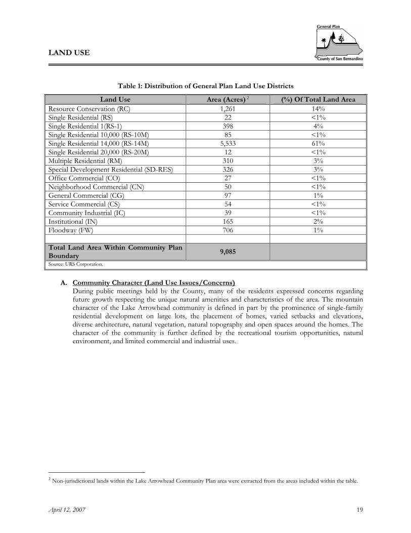
Table 1: Distribution of General Plan Land Use Districts
Land Use Area (Acres) 2 (%) Of Total Land Area Resource Conservation (RC) 1,261 14% Single Residential (RS) 22 <1% Single Residential 1(RS-1) 398 4% Single Residential 10,000 (RS-10M) 85 <1% Single Residential 14,000 (RS-14M) 5,533 61% Single Residential 20,000 (RS-20M) 12 <1% Multiple Residential (RM) 310 3% Special Development Residential (SD-RES) 326 3% Office Commercial (CO) 27 <1% Neighborhood Commercial (CN) 50 <1% General Commercial (CG) 97 1% Service Commercial (CS) 54 <1% Community Industrial (IC) 39 <1% Institutional (IN) 165 2% Floodway (FW) 706 1% Total Land Area Within Community Plan Boundary
9,085
Source: URS Corporation.
A. Community Character (Land Use Issues/Concerns) During public meetings held by the County, many of the residents expressed concerns regarding future growth respecting the unique natural amenities and characteristics of the area. The mountain character of the Lake Arrowhead community is defined in part by the prominence of single-family residential development on large lots, the placement of homes, varied setbacks and elevations, diverse architecture, natural vegetation, natural topography and open spaces around the homes. The character of the community is further defined by the recreational tourism opportunities, natural environment, and limited commercial and industrial uses.
2 Non-jurisdictional lands within the Lake Arrowhead Community Plan area were extracted from the areas included within the table.

LAND USE
April 12, 2007 20
Input gathered from residents of Lake Arrowhead suggests that the primary land use concern is that the mountain character of the area is preserved. Residents of the Lake Arrowhead community emphasized that to preserve the type of community that exists today, future growth should be managed to preserve the same balance of land uses. The Lake Arrowhead community is predominately a single-family residential and recreational community. Residents would like to preserve the predominance of single-family residential uses and ensure that non-residential land uses, including recreational uses, are developed to serve the needs of local residents and limited tourist needs. Residents are concerned with the potential impacts of future growth, including potential strains on infrastructure and services, degradation of the natural environment, and loss of the existing small-town character. In addition, residents articulated concerns with the location of future industrial and commercial development and the development potential of existing large parcels of land.
Table 2 provides the Land Use Policy Map Maximum Potential Build-out for the Lake Arrowhead Community Plan area. This build-out scenario provides the maximum build-out potential of the community plan area based on the Land Use Policy Map. Table 2 does not account for constraints to the maximum build-out potential. However, all development within the Lake Arrowhead community plan area, in particular residential development, is limited by provisions of the Fire Safety Overlay. The maximum build-out potential is constrained substantially by the slope-density standards and fuel modification requirements of the Fire Safety Overlay.

LAND USE
April 12, 2007 21
Table 2: Land Use Policy Map Maximum Potential Build-Out
Land Use Policy Map Maximum Potential Build-Out
Land Use Designation Area
(Acres) Density
(D.U. Per Acre)
Maximum Policy Map Build-Out ( D.U.’s)
D.U. Per Acre
D.U.’s
Resource Conservation (RC) 1,261 0.025 32 RS-1 398 1 398 RS-10M 85 4 342 RS-20M 12 2 24 RS-14M 5,533 3 16,599 RS 22 4 87 RM 310 16 4,968 SD-RES 326 3 978
TOTAL RESIDENTIAL 7,947 - 23,419 FAR SQUARE FEET
CO-Office Commercial 27 0.5:1 588,060 CN- Neigborhood Commercial 50 0.25:1 544,500 CG - General Commercial 97 0.5:1 2,112,660 CS-Service Commercial 54 0.4:1 940,896 IC-Community Industrial 39 0.4:1 679,536 IR-Regional Industrial 0 0.4 0 IN-Institutional 165 0.5:1 3,593,700 Floodway 706 N/A N/A TOTAL NON-RESIDENTIAL 1,117 - 8,459,352 Source: Stanley R. Hoffman Associates, Inc. and URS Corp. Notes:
(1) Floor Area Ratio (FAR) is a measure of development intensity. FAR is defined as the gross floor area of a building permitted on a site divided by the total area of the lot. For instance, a one-story building that covers an entire lot has an FAR of 1. Similarly, a one-story building that covers 1/2 of a lot has an FAR of 0.5.
(2) The total square feet for the non-residential land use designations was calculated by multiplying the area (acres) by the FAR and then converting the total acres to square feet. 43,560 square feet = 1 acre

LAND USE
April 12, 2007 22
Table 3 outlines the projected growth in the Lake Arrowhead Community Plan area over the period 2000 to 2030, and compares that growth to the maximum potential build-out shown in Table 2. The table includes population, households and employment projections based on the Land Use Policy Map Maximum Potential Build-out and a General Plan projection. The Land Use Policy Map Maximum Potential Build-out is a capacity analysis (with no specific build-out time frame) based on the County’s General Plan land use and density policies. The General Plan projection provides estimates of population, households and employment from 2000 to 2030 based on an analysis of historic and expected growth trends. The historic and expected growth trends for population take into account the influx of new residents and shifts from part-time residents to full-time residents. The comparison of the 2000 to 2030 projections to the maximum potential build-out provides a method for testing the projected growth against ultimate build-out. The projection and maximum potential build-out can be used to assess land use policies, existing infrastructure capacity and the need for additional infrastructure, particularly for roads, water and sewer facilities. The General Plan projection is based on the assumption that the Lake Arrowhead Community Plan area will continue to grow. This would provide a population of 21,940 people by the year 2030. The Maximum Land Use Policy Map Build-out assumes a maximum population of 57,340 based on the Land Use Policy Map. The number of households is projected to reach 8,177 by the year 2030. The Maximum Land Use Policy Map Build-Out assumes a maximum of 22,054 households based on the Land Use Policy Map. These numbers imply that the plan area will reach 37 and 38 percent of its potential household and population capacity respectively, by the year 2030.
Table 3: Population, Households and Employment Projection 2000-2030
1990 2000 Projection 2030
Average Annual Growth Rate:
1990-2000
Average Annual Growth Rate:
2000-2030
Maximum Policy Map Build-Out
Ratio of 2030 Projection to
Land Use Policy Plan Build-out
Population 9,061 12,673 23,509 3.4% 2.1% 65,127 0.36 Households 3,257 4,554 8,445 3.4% 2.1% 23,419 0.36 1991 2002 1991-2002 Employment 2,728 3,068 5,215 1.1% 1.9% 9,864 0.53 Source: Stanley R. Hoffman Associates, Inc. Note: The population figures for 1990 and 2000 were based on the U.S. Census. The employment figures for 1991 and 2002 were based on data from the EDD (Employment Development Department).

LAND USE
April 12, 2007 23
LA2.2 GOALS AND POLICIES Goal LA/LU 1. Retain the existing resort-oriented mountain character of the
community.
Policies
LA/LU 1.1 Require strict adherence to the land use policy map unless proposed changes are clearly demonstrated to be consistent with the community character.
LA/LU 1.2 In recognition of the community’s desire to preserve the rural character and protect the
area’s natural resources, projects that propose to increase the density of residential land uses or provide additional commercial land use districts or zones within the plan area should only be considered if the following findings can be made: A. That the change will be consistent with the community character. In determining
consistency, the entire General Plan and all elements of the community plan shall be reviewed.
B. That the change is compatible with surrounding uses, and will provide for a logical transition in the plan area’s development. One way to accomplish this is to incorporate planned development concepts in the design of projects proposed in the area.
C. That the change shall not degrade the level of services provided in the area, and that there is adequate infrastructure to serve the additional development that could occur as a result of the change. Densities should not be increased unless there are existing or assured services and infrastructure, including but not limited to water, wastewater, circulation, police, and fire, to accommodate the increased densities.
LA/LU 1.3 Regulate the density of development in sloping hillside areas in order to reduce fire hazards,
prevent erosion, and to preserve existing vegetation and the visual qualities of the plan area. One method this can be accomplished by is requiring adherence to the following hillside development standards required by the Fire Safety Overlay: A. Residential density: the density of development for any tentative parcel map or tentative
tract map in sloping hillside areas shall be in accordance with the following criteria: i. One to four (1-4) dwelling units per gross acre on slopes of zero to less than fifteen
percent (0 - <15%) ii. Two (2) dwelling units per gross acre on slopes of fifteen to less than thirty percent
(15 - <30%) iii. One (1) dwelling unit per three (3) gross acres on slopes of greater than thirty
percent (30%) gradient B. When twenty-five percent (25%) or more of a subdivision project site involving five (5)
or more lots is located on natural slopes greater than thirty percent (30%), the subdivision application shall be submitted concurrently with a Planned Development application to evaluate appropriate project design in consideration of topographic limitations of the site. This provision shall not apply if all of the areas on the site with natural ungraded slopes over thirty percent (30%) are permanently restricted from structural development.

LAND USE
April 12, 2007 24
LA/LU 1.4 Establish locational criteria for future Multiple Family Residential (RM) districts or zones to areas that are: A. In close proximity to commercial areas; B. Adjacent to a mountain secondary or greater width roadway; C. Where adequate circulation exists; D. Where services are available or assured; E. Where average slopes are relatively flat, F. Where compliance with fire safety standards can be met.
LA/LU 1.5 All architecture and outside facades of commercial structures shall be in keeping with the
mountain character. Natural woods and masonry shall be used as much as practicable, and shall be reviewed for conformance during the Land Use Services Conditional Use Permit approval process.
LA/LU 1.6 Prohibit construction of new high density residential development along the shore of Lake
Arrowhead and Grass Valley Lake in order to protect the scenic qualities. No additional Multiple Family Residential (RM) districts or zones shall be permitted in the following areas: A. Grass Valley Lake: between the shoreline and Golf Course Road north of Lake
Arrowhead Country Club, Brentwood Drive north of Riviera Drive and Cumberland (beyond the Blueridge Development Project).
B. Lake Arrowhead: generally between the shoreline and North Shore Road. C. Twin Peaks: along State Highway 189.
Goal LA/LU 2. Ensure that commercial and industrial development is compatible
with the forest and mountain character and meets the needs of local residents and visitors.
Policies LA/LU 2.1 Concentrate future commercial development within existing commercial nodes, centralized
areas, or neighborhood centers that are designed with the mountain character in mind to avoid strip commercial development along roads.
LA/LU 2.2 In coordination with the community, develop site design standards for commercial
development within the plan area to ensure that architectural detailing and signage are compatible with the mountain character of the community, to ensure that sites are designed to be more pedestrian-friendly, and to provide adequate parking and buffers between commercial and adjacent residential uses.
LA/LU 2.3 Neighborhood commercial uses shall be buffered from adjacent residential uses through
transitional land uses and/or design features such as enhanced setbacks and landscaping and/or other screening materials.
LA/LU 2.4 Through the Land Use Services Conditional Use Permit process, all new commercial sites
shall be reviewed to ensure that the site is large enough to accommodate required parking and access.

LAND USE
April 12, 2007 25
LA/LU 2.5 Limit future industrial development to that which is necessary to meet the service, employment and support needs of local residents, and does not adversely impact the mountain environment. This can be accomplished by:
A. Fully screen all open storage activities with fencing and indigenous-landscaping and limit
open storage to the rear 75 percent of any parcel. B. Require the architecture and appearance of all buildings to be compatible with the
mountain character; natural wood and masonry shall be used. C. Requiring the architecture and appearance of all buildings to be compatible with the
mountain character; natural wood and masonry should be used. LA/LU 2.6 Industrial land uses shall be located in areas where industrial uses will best serve the needs of
the community, and will have a minimum adverse effect upon surrounding property with minimal disturbance to the mountain environment and the total community.
LA/LU 2.7 Commercial recreation and tourist facilities should be located, designed, and controlled to
protect the residential-recreation character of the area. This can be accomplished by: Limiting commercial tourist facilities to Lake Arrowhead Village, Blue Jay and Cedar Glen along State Highway 18.
LA/LU 2.8 New industrial uses which generate heavy truck traffic shall only be allowed in appropriately zoned areas located off of State Highway 18.
LA/LU 2.9 Any development proposal for any part of the old Santa's Village site in the Rimforest area
should be done as part of a master plan for development for the entire Santa's Village site, or subsequent to a County-approved master plan for the old Santa's Village site.
Goal LA/LU 3. Ensure the availability of convenient commercial services to residents
and visitors to communities within the Lake Arrowhead Community Plan area.
Policies LA/LU 3.1 Provide for future establishment of Neighborhood Commercial (CN) zoning districts in
close proximity to residential areas to provide convenient commercial services to residents and visitors. Possible locations for CN districts include:
• Highway 189 between Sierra Vista Drive and Fernrock Drive • Highway 173 between Chapel Road and Rainbow Drive

LAND USE
April 12, 2007 26
[This page intentionally left blank]

CIRCULATION AND INFRASTRUCTURE
April 12, 2007 27
3 CIRCULATION AND INFRASTRUCTURE
LA3.1 INTRODUCTION The quality of life and the mountain character of the community are dependent on the services that are provided. Residents in Lake Arrowhead expect that services such as schools, water and sewer, roads, fire and police protection, and park and recreation facilities are provided at levels that meet their needs. At the same time, it is understood that acceptable levels of service should be provided in accordance with the small-town character that is desired. Provisions of services in Lake Arrowhead should be commensurate with the mountain lifestyle and residential-recreational character of development. The impact of land development on services must be managed to ensure a balance between providing for population growth and preserving the character of the community. The impact of land development on services must be managed to ensure a balance between providing for sustainable population growth, preserving the character of the community and protecting public health and safety.
LA3.2 CIRCULATION – INTRODUCTION
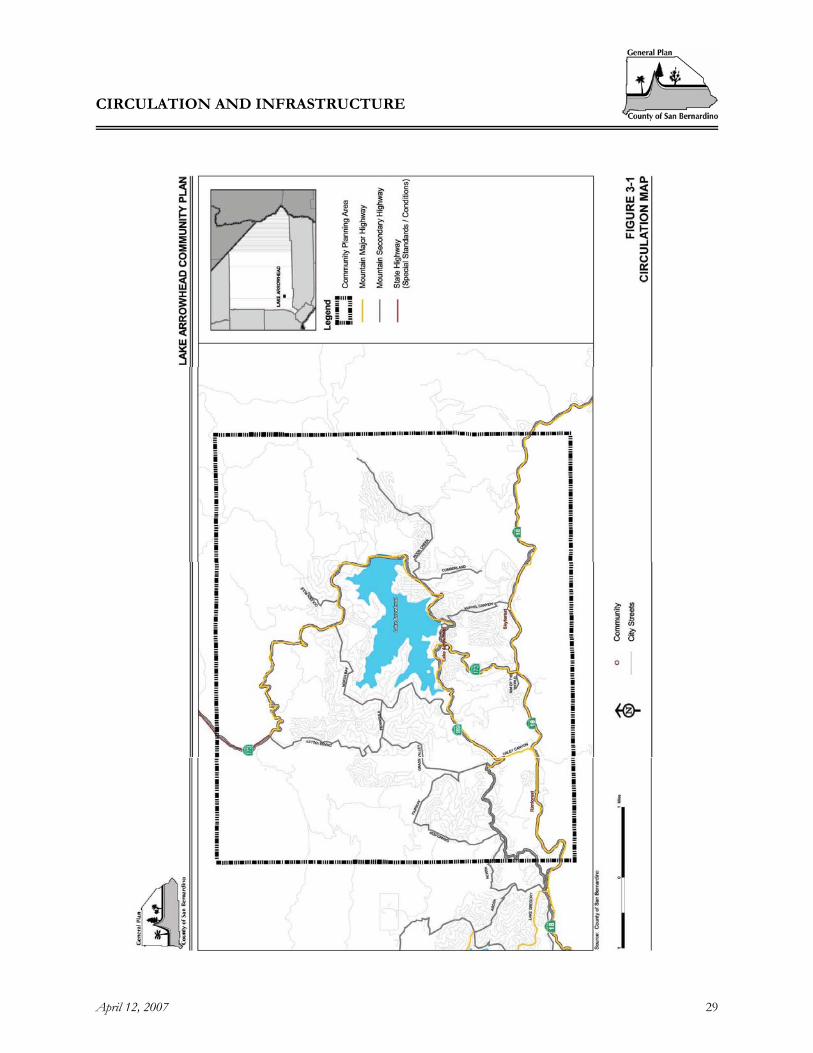
A. Roadway System One of the overriding goals expressed by residents of Lake Arrowhead is to maintain the mountain character of the community. The character of the community can be significantly impacted by roads and the traffic generated from the region and the community.
The existing street system in Lake Arrowhead is characterized by a combination of State Highways and local roadways (see Figure 3-1, Circulation). There is community interest in retaining existing road widths to maintain a quaint, mountain atmosphere in keeping with the community's overarching goal of maintaining the alpine character of the area. However, there is also interest in providing sufficient road improvements that meet future community needs for a safe and efficient traffic circulation.
Rim of the World Highway (SR-18) is a two-lane mountain major highway that provides access to the mountain region from both the valley region to the south and the desert region to the north. In the valley region, SR-18 originates as an interchange with SR-30, as Waterman Avenue in the City of San Bernardino. After passing through the communities of Lake Arrowhead, Running Springs, Arrowbear Lake and Big Bear Lake, it continues northeasterly into the desert region and through communities such as Lucerne Valley, Apple Valley and Victorville before terminating at its northern junction with SR-138 just west of the Los Angeles County line. This roadway operates as the primary access for the Lake Arrowhead community and other mountain communities such as Crestline and Big Bear Lake. It is considered to function as a mountain major highway under San Bernardino County roadway classification standards.
State Route 173 (SR-173) is a two-lane mountain major highway that extends north from Rim of the World Highway (SR-18) and continues counterclockwise around Lake Arrowhead before terminating at SR-138 just northwest of Silverwood Lake. It has been classified as a mountain major highway by San Bernardino County. The portion of roadway between Willow Creek Jeep Trail and Pacific Crest National Scenic Trail is unpaved.

CIRCULATION AND INFRASTRUCTURE
April 12, 2007 28
[This page intentionally left blank]
CIRCULATION AND INFRASTRUCTURE
April 12, 2007 29
Figure 3-1, Circulation

CIRCULATION AND INFRASTRUCTURE
April 12, 2007 30
[This page intentionally left blank]
CIRCULATION AND INFRASTRUCTURE
April 12, 2007 31
State Route 189 (SR-189) is a two-lane mountain major highway that splits from Rim of the World Highway (SR-18) and continues east until it terminates at a junction with SR-173. The portion of this roadway between Blue Jay Cutoff and SR-173 has been classified as a mountain major highway by San Bernardino County. The segment between Rim of the World Highway (SR-18) and Blue Jay Cutoff is classified as a mountain secondary highway. This facility provides access to residential properties in the Twin Peaks and Blue Jay communities.
Cumberland Drive extends southward from Hook Creek Road, just south of SR-173, to Blue Ridge Drive. It currently has one lane in each direction and is classified as a mountain secondary highway under San Bernardino County standards.
Daley Canyon Road is a two-lane mountain major highway that extends northward from SR-18 for one-half mile to its intersection with SR-189. This facility provides an important north-south connection between these two state highways.
Fairway Drive is a two-lane mountain secondary highway that extends from Augusta Drive north and east to Club House Drive, just west of Grass Valley Road.
Golden Rule Lane is a two-lane facility which extends northward from SR-173 to Manitoba Drive and is classified as a mountain secondary highway.
Grandview Drive is a two-lane mountain secondary highway that begins at Fairway Drive and travels southward to North Road.
Grass Valley Road is a two-lane mountain secondary highway which extends northward from its intersection with SR-189 in the community of Twin Peaks and travels approximately four and one-half miles through the community of Blue Jay before terminating at an intersection with SR-173.
Hook Creek Road is a two-lane mountain secondary highway that begins at an intersection with SR-173 and extends two miles northeast to Poplar Lane. This facility operates as the primary access to the community of Cedar Glen. Kuffel Canyon Road is a two-lane secondary arterial which originates at an intersection with Rim of the World Highway (SR-18) and extends north one and one-quarter miles to SR-173. This facility is a major thoroughfare in the community of Lake Arrowhead.
Kuffel Canyon Road is a two-lane mountain secondary highway that originates an intersection with Rim of the World Highway (SR-18) and extends north one and one-quarter miles to SR-173. This facility is a major thoroughfare in the community of Lake Arrowhead.
North Bay Road is a mountain secondary which extends from SR-189 approximately three and one-half miles north and east before terminating at SR-173. This facility provides access to residents living along the western and northern shores of Lake Arrowhead.
North Road is a two-lane mountain secondary highway that extends from SR-189 approximately three and one-half miles north and east before terminating at SR-173. This facility provides access to residents living along the western and northern shores of Lake Arrowhead.
Peninsula Drive is a two-lane mountain secondary highway that extends eastward for one-half mile and provides a connection between Grass Valley Road and North Bay Road.

CIRCULATION AND INFRASTRUCTURE
April 12, 2007 32
Rim of the World Drive extends eastward from Burnt Mill Road to SR-173, just north of Rim of the World Highway (SR-18). It currently consists of two lanes and has been classified as a mountain secondary highway.
The Lake Arrowhead plan area relies on SR-18, SR-173, and SR-189 for access to the mountain from the valley and desert Regions and within and to the neighboring mountain communities. These highways not only accommodate traffic from the local population but from the visitors who travel to the mountains on weekends and during the busy holiday season. Identifying and implementing future improvements will be a challenge that will have to address: a) a lack of local control over State Highway improvements, b) improvements that may be in conflict with the community’s desire to maintain the area’s scenic and natural resources and mountain character and c) environmental constraints that will limit the feasibility of certain improvements to the road system. During meetings held by the County, residents emphasized their concerns with traffic circulation on both State Highways and other major County roads within their community. They emphasized the need for improvements to the circulation system to be compatible with the community’s goal of maintaining the area’s character, scenic and natural resources and public health and safety. The operating condition of the roadway system within the plan area was examined in terms of congestion and delay. Table 4 provides the existing and Future 2030 roadway operating conditions for the Lake Arrowhead Community Plan area. The operating conditions include: Average Daily Trips (ADT) data, Volume to Capacity (V/C) ratios and Level of Service (LOS) data. The Average Daily Trips (ADT) data was provided by the County Public Works Department. Most of the trips data was collected within the past one to two years. The Volume to Capacity (V/C) ratio was calculated using the traffic counts (or ADT) and is a standard tool for describing the typical operating conditions of a roadway. The Level of Service data is based on the V/C ratio and helps to categorize and describe the degree of congestion on the roadways.

CIRCULATION AND INFRASTRUCTURE
April 12, 2007 33
Table 4: Existing and Future Roadway Operating Conditions
Existing 2004 Operating Condition
Future 2030 Operating Conditions
Facility Begin-End ADT V/C LOS ADT V/C LOS Arterials Cumberland Drive Hook Creek Rd – Blue Ridge Dr 1,350 0.117 A 1,626 0.141 A Daley Canyon Rd SR-189 – SR-18 7,650 0.665 C 8,010 0.668 C Fairway Drive August Dr – Club House Dr 4,450 0.387 B 5,359 0.466 B Golden Rule Lane SR-173 – Manitoba Dr 1,300 0.113 A 1,566 0.136 A Grandview Drive North Rd – Augusta Dr 2,400 0.209 A 2,890 0.251 A
SR-173 – Jagerhorn Dr 2,050 0.178 A 2,635 0.229 A Jagerhorn Dr – Peninsula Dr 4,000 0.348 A 4,650 0.404 B Peninsula Dr- Club House Dr 5,500 0.478 B 7,337 0.638 C
Club House Dr – Blue Jay Cutoff 7,500 0.652 C 9,210 0.801 D Grass Valley Road
Blue Jay Cutoff – SR-189 9,000 0.783 D 10,839 0.942 E SR-173 – Pineridge Dr 5,100 0.443 B 6,142 0.534 B Hook Creek Road Pineridge Dr - Poplar Ln 600 0.052 A 723 0.063 A
Kuffel Canyon Rd SR-173 – SR-18 2,850 0.248 A 4,245 0.369 B North Road Arosa Dr – SR-189 3,550 0.309 A 4,178 0.363 B
SR-173 – Peninsula Dr 4,850 0.422 B 4,898 0.426 B Peninsula Dr – Cottonwood Ln 5,850 0.509 B 7,107 0.618 C North Bay Road
Cottonwood Ln - SR-173 9,000 0.783 D 10,257 0.892 E Peninsula Drive Grass Valley Rd – North Bay Rd 3,800 0.330 A 5,637 0.490 B Rim of the World Dr
Burnt Mill Rd – SR-173 400 0.035 A 482 0.042 A
State Highways SR-189 – Daley Canyon Rd 10,700 0.930 E 12,200 1.017 F Daley Canyon Rd – SR-173 10,200 0.887 E 13,900 1.209 F SR-173 – Kuffel Canyon Rd 8,200 0.713 D 8,850 0.770 D
Rim of the World Highway (SR-18)
Kuffel Canyon Rd – SR-330 6,800 0.591 C 9,800 0.852 D Grass Valley Rd –North Bay Rd 650 0.057 A 3,400 0.296 A North Bay Rd – Hook Creek Rd 2,900 0.252 A 3,150 0.274 A Hook Creek Rd – Kuffel Cyn Rd 6,300 0.548 C 6,550 0.570 C
Kuffel Cyn Rd-SR-189 8,500 0.739 D 10,000 0.870 D SR-173
SR-189 – SR-18 5,300 0.461 B 8,500 0.739 D SR-18 – Bear Springs Rd 3,500 0.304 A 6,350 0.552 C
Bear Springs Rd–Grass Valley Rd 5,000 0.435 B 7,850 0.683 C SR-189 Grass Valley Rd – SR-173 7,400 0.643 C 8,700 0.725 D
Source: Myers, Mohaddes Associates
According to Table 4, most roadways within the plan area operated at acceptable Levels of Service in 2004. Most roads operated at a Level of Service “A,” “B” or “C.” A Level of Service “A” is described as a free flow low volume traffic condition with little or no delays. Levels of Service “B” and “C” are described as reasonably free-flow traffic conditions with reduced freedom to maneuver and select speeds. Segments of Grass Valley Road and North Bay Rd did not operate at acceptable Levels of
CIRCULATION AND INFRASTRUCTURE
April 12, 2007 34
Service. Grass Valley Road between Blue Jay Cutoff and SR-189 and North Bay Rd between Cottonwood Lane and SR-173 operated at Levels of Service “D,” which is described as congested but stable traffic conditions with drivers’ ability to select speed and maneuverability significantly affected. Most segments of Rim of the World Highway (SR-18) did not operate at acceptable Levels of Service. Two of the four segments operated at a Level of Service “E,” which is described as congested and unstable traffic conditions where drivers’ ability to maneuver is severely restricted and travel speeds are low and uniform. One segment of SR-173 between Kuffel Canyon Road and SR-189 also operated at a Level of Service “E.”
Future 2030 conditions for the Lake Arrowhead Community Plan area indicate that major County roads and State Highways within the plan area are projected to experience more congestion than 2004 conditions. All major arterials are projected to remain at acceptable Levels of Service except for Grass Valley Road between Club House Drive and Blue Jay Cutoff and between Blue Jay Cutoff and SR-189, and North Bay Road between Cottonwood Lane and SR-173. Portions of State Highways 173, and 189 are projected to operate at unacceptable Levels of Service. All segments of Rim of the World Highway (SR-18) are projected to operate at unacceptable LOS. Since the LOS data provided in this analysis were based on ADT volumes they represent the “average” LOS at which the facility generally operates throughout the day. When peak-hour volumes are utilized, these scores are expected to worsen, as demonstrated under the Congestion Management Program methodology shown in the following section.
B. Congestion Management Program Within San Bernardino County, the San Bernardino Associated Governments (SANBAG) is designated as the Congestion Management Agency (CMA). Through this program SANBAG can monitor regional transportation facilities and catalog their daily operating Levels of Service in an effort to identify existing travel patterns and better plan for future transportation improvements in response to shifting travel patterns. Rim of the World Highway (SR-18), SR-173 and SR-189 are roadways that have been designated as CMP facilities. As determined in the 2007 update, the operation Levels of Service for these facilities are shown in Table 5. The Levels of Service (LOS) for the CMP facilities reflect a peak period measurement.

CIRCULATION AND INFRASTRUCTURE
April 12, 2007 35
Table 5: CMP Facility Levels of Service
Facility No. of Lanes
Peak Hour Volume
Level of Service (LOS)
SR-18 Jct. Rte 138-Rte 189 2 900 E Jct. Rte 189 – Rte 330 2 930 E SR-173 Lake Arrowhead Rd. – Hook Creek Rd.
2 150 B
Hook Creek Rd. – Jct. Rte 18 2 700 E SR-189 Jct. Rte 18 – Jct. Rte 173 2 5,100 D
C. Pedestrian and Bicycle Circulation and Off-Street Parking
The current circulation system within the plan area does not safely and efficiently accommodate pedestrian and bicycle traffic. Many of the roads in the Lake Arrowhead area are narrow and lack enough visibility to safely accommodate non-motorized traffic. During the winter this problem is compounded by snow. Snow piled along the roadways or in parking lots reduces traffic capacity, available parking and non-motorized traffic circulation. Residents and visitors often park on the roads, which hinders snow removal and creates further difficulties for pedestrian and bicycle circulation.
D. Scenic Routes
Scenic highways play an important role in the preservation and protection of environmental assets. County Scenic Route designation recognizes the value of protecting scenic resources for future generations, and places restrictions on adjacent development including specific sign standards regarding sign placement and dimensions, utility placement, architectural design, grading, landscaping characteristics, and vegetation removal. The following streets are designated as scenic routes by the General Plan and are subject to the Open Space Overlay: Kuffel Canyon Road, Grass Valley Road, Rim of the World Highway (SR-18) and SR-173. In addition, both State Highways, SR-173 and SR-18, are eligible for designation as scenic routes by the State but have not been officially designated. The advantages of official designation are a positive image for the communities involved, preservation and protection of environmental assets and potential increase in tourism.

CIRCULATION AND INFRASTRUCTURE
April 12, 2007 36
LA3.3 CIRCULATION – GOALS AND POLICIES CIRCULATION
Goal LA/CI 1. Ensure a safe and effective transportation system that provides adequate traffic movement while preserving the mountain character of the community.
Policies LA/CI 1.1 Ensure that all new development proposals do not degrade Levels of Service (LOS) on State
Routes and Major Arterials below LOS “C” during non-peak hours or below LOS “D” during peak-hours.
LA/CI 1.2 Establish a circulation system within the plan area that is consistent with adopted land use
patterns, provides adequate connections to regional transportation facilities and provides access control, traffic system management and other improvements in keeping with the mountain character and scenic sensitivity of the plan area.
LA/CI 1.3 Design roads to follow natural contours, avoid grid pattern streets, minimize cuts and fills
and disturbance of natural resources and trees wherever possible. LA/CI 1.4 Preservation and protection of sensitive habitats shall have priority over road location,
relocation or realignment, when other practical alternatives are available. LA/CI 1.5 Work with local and State agencies to ensure that transportation system improvements are
made to SR-18, SR-173, Grass Valley Road and North Bay Road where transportation facilities are operating at or near full capacity. The County and State agencies shall identify existing and future deficiencies, such as the need for alternate routes, widening existing roads, providing turn lanes, and considering weekend traffic volumes in traffic analysis.
LA/CI 1.6 Minimize the traffic load on mountain major highways and mountain secondary highways by
requiring projects to minimize direct access to these main circulation roads, and encourage shared driveways for industrial and commercial uses on adjacent properties to promote use of the main circulation roads as throughways.
LA/CI 1.7 Provide access control, traffic system management and other improvements on the roadway
system within the plan area in keeping with the scenic sensitivity of the community plan area. One method this can be accomplished by is, to the maximum extent possible, use alternatives to the construction of new traffic signals where they can be shown to benefit roadway capacity and are compatible with the mountain character of the community.
LA/CI 1.8 Preserve the status of Kuffel Canyon, Grass Valley Road, SR-173 and SR-18 as County
Scenic Routes, and ensure protection of their natural features through the following methods: A. Require compliance with the provisions of the Open Space Overlay. B. Support hillside preservation regulations that will include standards for hillside
development to control densities, allowable cut and fill heights, soil and slope stability,
CIRCULATION AND INFRASTRUCTURE
April 12, 2007 37
grading and blending of contours, structural relationships, building foundations, and the like.
LA/CI 1.9 Seek State support and assistance for the designation of State Highways 18 and 173 as
official State Scenic Routes. LA/CI 1.10 Protect rights-of-way for mountain highways shown on the circulation portion of the
County General Plan. The Public Works department shall require dedications as entitlements are given.
LA/CI 1.11 Design road sections for mountain roads to be flexible in terms of required right of way
widths and roadway widths, however, existing two-lane roads should be maintained. Road widenings should be limited to safety type improvements and those that would facilitate flow such as turning lanes, passing lanes, intersection widenings and shoulder widenings.
LA/CI 1.12 Require a traffic impact analysis report to identify impacts and mitigation measures for
projects that may result in potentially significant impacts and limit new construction which would require significant improvements to the existing road system in order to handle project ingress, egress and traffic volumes until such time that the required improvements are completed. Significant improvements include anything other than additional turn lanes, transition lanes and stop signs.
LA/CI 1.13 All other methods of traffic control shall be considered before adding a traffic light within
the community plan area. The County shall coordinate with Caltrans to implement this policy on State Highways within the plan area.
LA/CI 1.14 Complete Cumberland Road from Cedar Glen to State Highway 18 near Santa’s Village as a
condition of development of the adjacent area and ensure protection of the character of the surrounding area by the following: A. Require that Cumberland Road be designated as a County Scenic Route. B. Require that Cumberland Road be used primarily for residential and emergency traffic. C. Prohibit trucks that exceed 5 tons and vehicles pulling large trailers.
LA/CI 1.15 Encourage the development of park-and-ride facilities to serve residents who commute to destinations off of the mountain.
Goal LA/CI 2. Ensure safe and efficient non-motorized traffic circulation within the community.
Policies LA/CI 2.1 Establish and coordinate a system of pedestrian and bicycle trails connecting residential areas
to recreational facilities, the National Forest and commercial activity centers. Promote safe and attractive pedestrian and bicycle crossings at logical points on Circulation Element roads and, where feasible, pursue opportunities to separate pedestrian and bicycle traffic from vehicular traffic particularly along SR-18, SR-173 and SR-189.

CIRCULATION AND INFRASTRUCTURE
April 12, 2007 38
LA/CI 2.2 Provide pedestrian improvements in commercial activity centers to enhance safety, provide a high quality visitor experience, enhance the mountain character of the area and reduce the need for vehicular travel.
LA/CI 2.3 Research the feasibility of using excess right-of-way not needed for road construction for
bicycle and pedestrian trails. Priority shall be given to providing trails within the right-of-way (or adjacent to) the following roadways: A. Work with Caltrans to establish bicycle trails along one side of State Highways 173 and
189 through the plan area. Encourage connections to trails outside the plan area. B. Provide trails along North Bay Road, Grass Valley Road, Hook Creek Road and
Cumberland Road. Encourage connections to local and/or regional trails.
LA/CI 2.4 Require school bus stop shelters as needed when road improvement or widening is required as part of an adjacent development.
Goal LA/CI 3. Protect the designed vehicular capacity of all mountain roads.
Policies LA/CI 3.1 Prohibit on-street parking where it reduces highway design capacity and limits snow plowing
effectiveness. LA/CI 3.2 Control access onto all State Highways and County mountain secondary highways. LA/CI 3.3 Limit and control the location and extent of all land uses which generate increased levels of
traffic beyond the designed capacity of the existing and planned highways. Goal LA/CI 4. Promote alternative modes of transportation.
Policies LA/CI 4.1 In coordination with the community, define the existing and future transportation needs as
they may relate to transit for residents, employees and visitors in the mountain region. When transportation needs are defined, the Public Works Department shall conduct a feasibility study to determine the feasibility and cost-effectiveness of instituting alternative transportation recommendations.
LA/CI 4.2 Evaluate additional service needs that could be provided by the Mountain Area Regional
Transit Authority (MARTA) through coordination with MARTA, the County and residents of the mountain communities.
LA3.4 INFRASTRUCTURE - INTRODUCTION The provision of adequate infrastructure services is essential for maintaining the health and quality of life of a community. The availability of adequate water supplies and wastewater disposal is crucial to supporting population growth. Proper management of the area’s water resources is not only important for the purpose of serving existing and projected peak load domestic needs, but is also important for fire protection purposes and sustaining the area’s natural resources and wildlife. In addition, residents have articulated the importance
CIRCULATION AND INFRASTRUCTURE
April 12, 2007 39
of ensuring that infrastructure improvements and facilities are compatible with the character of the plan area and natural environment.
A. Local Water Service There are six local water suppliers for the Lake Arrowhead community. Alpine Water Users Association, Arrowhead Villas Mutual Water, Lake Arrowhead Community Services District (LACSD), SkyForest Municipal Water District, Strawberry Lodge Mutual Water, and City of Big Bear – Rim Forest supply their specific areas as shown in Figure 3-2, Water Districts.3 An approximate total of 9,161 service connections are served by these agencies.4 The water districts and Rim Forest are public purveyors with a total of approximately 8,248 connections. The mutual water companies are private water purveyors with stakeholders and 913 connections.5 Detailed information regarding future demand, the long-term availability of water, and future projects was not available for the water purveyors within the plan area. General supply and policy information for these suppliers is presented in Table 6.
3 The sphere areas of Crestline Village Water District and Running Springs Water District overlap the outer corners of the plan area. However they do not provide services within these sphere areas. That portion of Crestline Village Water District located within the plan area does provide service to a very small number of residents. More detailed information pertaining to the entire area served by Crestline Village Water District can be found in the Crest Forest Community Plan. 4 No reply was received from Arrowhead Villas Mutual Water or Strawberry Lodge Mutual Water. Based on discussions with other agencies, both of these purveyors service substantial areas (residents) so we will continue to try and acquire additional information from these purveyors. 5 Ibid

CIRCULATION AND INFRASTRUCTURE
April 12, 2007 40
[This page intentionally left blank]

CIRCULATION AND INFRASTRUCTURE
April 12, 2007 41
Figure 3-2, Water Districts

CIRCULATION AND INFRASTRUCTURE
April 12, 2007 42
[This page intentionally left blank]

CIRCULATION AND INFRASTRUCTURE
April 12, 2007 43
Table 6: Supply and Policy Information of Service Providers
Service Provider
# of Water Connections
Estimated Population Served
Estimated Annual Water Production
Policies Allow service outside of boundaries
Imported Water Source
Imported Water Source Amount *
Alpine Water Users Association
913 4,000 162.1 A.F.
No CLAWA 80.3 A.F.
Arrowhead Villas Mutual Water
NA NA NA NA NA NA
Lake Arrowhead CSD
7,613 12,000 2,469 A.F.
No SBVMWD ( Future)
0-1,500 A.F. (Future)
Sky Forest Municipal Water District
148 400 32.2 A.F. No CLAWA 23.9 A.F.
Strawberry Lodge Mutual Water
- - - - - -
City of Big Bear Rim Forest
600 1,500 163.8 A.F.
No CLAWA 52-66 A.F.
* annual estimate NA = information not provided by purveyor/agency
The Lake Arrowhead Community Services District (LACSD) historically has not acquired water from other sources, however, due to approximately six years of drought, LACSD has proceeded with the fiscal and legal procedures to begin buying water from the San Bernardino Valley Municipal Water District through the Crestline-Lake Arrowhead Water Authority (CLAWA). The agreement states that over the next 10 to 15 years, up to 1,500 acre feet of water per year will be purchased by LACSD. The purchased water is used to provide LACSD the time to build other projects that will ultimately reduce the demand on the lake. The ultimate goal is to provide alternate sources of water so that the lake is no longer the only source of water for this area. The smaller purveyors already purchase some of their water from CLAWA through pipelines that transport water to the area. In 2003, LACSD established a Water Resource Fee to ensure that new construction pay for the cost of new water resources to serve it. In 2004, there were 64 new water service connections within LACSD. The amount of water used by these homes averages 1/3 of an acre-foot per year, or approximately 108,000 gallons. The impact of all the new connections last year was approximately 23 acre-feet of water. If this water were supplied from Lake Arrowhead it would be an amount equal to less than 1/3 of an inch.

CIRCULATION AND INFRASTRUCTURE
April 12, 2007 44
The Crestline-Lake Arrowhead Water Authority (CLAWA) is a wholesale water purveyor selling water to approximately 25 smaller water purveyors in the area. CLAWA distributes water from the State Water project and pumps the water from Lake Silverwood. CLAWAs boundary area is approximately 50,000 acres from Cedar Pines Park to Green Valley Lake. CLAWA is permitted a maximum 5,800 acre-feet per year from the State Water Project. Reports show that CLAWA used approximately 3,000 acre-feet during what is considered peak year usage during the fires in 2003. With peak year usage at 3,000 acre-feet, CLAWA utilized 52 percent of their total water capacity.
There are also some small private purveyors that supply a limited area, including: Arrowhead Manor Water Company (Cedar Glen),6 Arrowhead Pines Rose Cabins, Arrowhead Springs (Campus Crusade camp), Green Valley Campground, Lake Arrowhead Country Club, Alpine Conference Center, and Rim of the World USD. Those residents who live outside of a water district boundary have their own on-site methods such as wells or springs, that are recharged annually by winter snows and rains. The yield from these sources will vary dependent on the amount of snowmelt and rainfall.
B. Regional Water Supply
The Lake Arrowhead Community Plan area is located in the San Bernardino Mountains, where there are no true aquifers, but there are subsurface water sources from snow pack and rain, which percolate into the crystalline rocks. Groundwater in this plan area is found primarily in the unconsolidated alluvial deposits found in localized canyons and slopes. Wells are usually placed into the crystalline granitic rock in order to draw on long-term water supplies. It is important to note that the geology underlying the District is entirely made-up of fractured bedrock; it is difficult to estimate the sustainable yield of the groundwater basin. The LACSD currently produces approximately 200 acre-feet per year of groundwater from five wells in the Grass Valley basin. The District's Draft 2005 Urban Water Management Plan estimates that the District will develop an additional 450 acre-feet per year of groundwater for a total of 650 acre-feet per year of groundwater for use in the District's service area by the year 2025. Groundwater resources are limited in the Lake Arrowhead area. The geology in the Lake Arrowhead area is primarily made up of fractured granite. Groundwater in granitic mountain areas occurs where there are open fractures in the rock and it is difficult to estimate the true production of water from this type of geology.
C. Wastewater
Most of the Lake Arrowhead Community Plan area is serviced by the Lake Arrowhead Community Services District (LACSD)7 (see Figure 3-3, Wastewater System). However, there are also isolated sites that have been developed with septic tanks and leachfield systems. Approximately 90 percent of the area is on-line, while there remains about 10 percent that is exempt. Sewage is collected by the District and treated based on two drainage basin areas – the Lake Arrowhead Basin and the Grass Valley Basin. There are two wastewater treatment plants – Willow Creek and Grass Valley Wastewater treatment plants. Treated effluent is transported from the Willow Creek plant to the Grass Valley plant for transport and disposal through a 10 mile outfall down the mountain to a
6 This has been taken over by the Public Utilities Commission 7 The City of Big Bear Lake has limited transmission lines that run through the plan area but they do not provide services to the plan area. The sphere areas of Crestline Village Sanitation District and Running Springs Water District overlap the outer corners of the plan area. However they do not provide wastewater services within these sphere areas. That portion of Crestline Village Sanitation District located within the plan area does provide service to a very small number of residents. More detailed information pertaining to the entire area served by Crestline Village Sanitation District can be found in the Crest Forest Community Plan.

CIRCULATION AND INFRASTRUCTURE
April 12, 2007 45
percolation site near Hesperia.8 The Districts's Grass Valley Wastewater Treatment Plan is currently permitted to treat 2.5 million gallons of domestic wastewater per day. The District typically treats an average of 1.3 million gallons per day. On holiday weekends, the flow increases to a three-day average of 1.6 million gallons. Maximum day wet weather flows have been recorded at 8.5 million gallons per day due to infiltration.10 The high peak flows are managed through operational mechanisms to control treatment plant volumes. Based on information from the district, the Grass Valley Wastewater Treatment Plant's ultimate capacity at buildout for a three-day average holiday weekend is 5.0 million gallons per day. Based on rough information concerning the number of connections, approximately 70 percent of the available sewer connections have been used, with 30 percent remaining. Table 7 provides existing and future flow information for LACSD.
8 Lahontan Regional Water Board, Southern Basin, Basin Plan (10/94)

CIRCULATION AND INFRASTRUCTURE
April 12, 2007 46
[This page intentionally left blank]

CIRCULATION AND INFRASTRUCTURE
April 12, 2007 47
Figure 3-3, Wastewater System

CIRCULATION AND INFRASTRUCTURE
April 12, 2007 48
[This page intentionally left blank]
CIRCULATION AND INFRASTRUCTURE
April 12, 2007 49
Table 7: Waste Water Agencies/Districts
Wastewater Treatment Provider
# of Service Connections
Existing Dry Weather Average Daily WastewaterFlow (mgd)
Existing Dry Weather Average Three Day Holiday Weekend Wastewater Flow (mgd)
Existing Permitted Treatment Capacity (mgd)
Ultimate Buildout Design Flow (mgd)
LACSD 10,700 1.3 (average) 3.0 (holidays)
1.6 2.5 5.0
LA3.5 INFRASTRUCTURE – GOALS AND POLICIES Goal LA/CI 5. Ensure adequate water sources and associated infrastructure to serve
the needs of existing and future water users in the Lake Arrowhead Community Plan area.
Policies LA/CI 5.1 Through the development review process, permit new development only when adequate
water supply exists or can be assured. LA/CI 5.2 Support programs to use reclaimed water from mountain sewage systems to offset local
water supplies when such reclamation is consistent with public health and environmental standards.
LA/CI 5.3 Support efforts to continue to improve cooperation and communication among water
providers and the County in addressing water related issues. LA/CI 5.4 Any projects which propose the commercial extraction and exportation of native
groundwater shall be required to prepare a thorough hydrogeological investigation as analyzed in an Environmental Impact Report. The County will not support the extraction and exportation of native groundwater for commercial purposes in any situation that results in significant impacts to the environment.
LA/CI 5.5 Ensure that the required infrastructure is in place prior to the occupancy of any new
development project. Goal LA/CI 6. Encourage and promote water conservation.
Policies LA/CI 6.1 Support conservation and efficient water use, including water conservation programs of the
local water purveyors in an effort to minimize the need for new water sources.

CIRCULATION AND INFRASTRUCTURE
April 12, 2007 50
LA/CI 6.2 In coordination with local water providers, provide education for water conservation. Plan and implement educational programs and events promoting water conservation.
LA/CI 6.3 Recommend the use of native low water use vegetation, especially drought tolerant plants in
landscaping and discourage inappropriate use of vegetation unsuited to the mountain climate.
LA/CI 6.4 Minimize the use of turf grass. LA/CI 6.5 Promote use of water efficient irrigation practices for all landscaped areas. LA/CI 6.6 Regulate the extent and amount of impervious surface coverage. LA/CI 6.7 Develop mandatory landscaping standards to require water efficient and drought tolerant
landscaping within LACSD; require conformance to LACSD'S mandatory landscape standards.
LA/CI 6.8 Require landscaping plans to meet the requirements of a local water purveyor if said
purveyor has adopted specific landscaping guidelines within its service area. Goal LA/CI 7. Ensure that infrastructure improvements are visually and physically
compatible with the natural environment and mountain character of the community.
Policies LA/CI 7.1 Work with the United States Forest Service to ensure that improvements or development of
infrastructure facilities adjacent to the National Forest are non-invasive and do not adversely affect the natural environment.
LA/CI 7.2 Mitigate the visual impacts of facilities, structures, utilities and mechanical installations
through the development of appropriate screening and location criteria. LA/CI 7.3 Coordinate with service providers to relocate existing overhead utilities underground along
existing roadways and require underground utilities in new developments.

HOUSING
April 12, 2007 51
4 HOUSING
[See the Housing Element of the General Plan]

HOUSING
April 12, 2007 52
[This page intentionally left blank]
CONSERVATION
April 12, 2007 53
5 CONSERVATION
LA5.1 INTRODUCTION Preservation and protection of the community plan area’s natural and historic resources is extremely important to the residents of Lake Arrowhead. These resources contribute to the character, the appeal and subsequently to the economic viability of the area. If the plan area’s sensitive resources are not effectively protected and managed, they will be permanently lost.
A. Natural Resources and Historic Resources The natural resources such as the vegetation, wildlife, rock formations, streambeds, lakes, etc. contribute to the beauty and character of the area. Residents are concerned that unmanaged growth threatens the viability of these natural resources and desire appropriate management of these resources, particularly water resources.
The plan area is covered with a diverse biotic community of trees and other vegetation, fish, birds, reptiles, mammals, and other natural resources such as streams and lakes. The plan area includes the following general habitat types and respective sensitive species associated with these habitats (for a detailed list of the sensitive species associated with the various habitats see the Conservation Background Report of the General Plan and the Open Space Overlay):
i. Chaparral ii. Riparian iii. Oak Woodlands iv. Conifer Forest
In addition, preservation of historic resources is also important to residents and their desire to maintain the character of the plan area. In the 1981 Community Plan, a number of sites were identified within the Lake Arrowhead plan area as being of significant historic and/or cultural value. The list included Saw Mill sites, historical monuments and other sites such as Strawberry Lodge, Redwood Ranch, Skyforest Resort, etc. (a full list of historical sites and structures is included in the Appendix).
LA5.2 GOALS AND POLICIES Goal LA/CO 1. Preserve the unique environmental features of Lake Arrowhead
including native wildlife, vegetation, and scenic vistas.
Policies LA/CO 1.1 The following areas are recognized as important open space areas that provide for wildlife
movement and other important linkage values. Projects shall be designed to minimize impacts to these corridors.
a. Grass Valley Creek Wildlife Corridor b. Strawberry Creek Wildlife Corridor
CONSERVATION
April 12, 2007 54
c. Dispersion Corridor - between Lake Arrowhead and Running Springs and south of Highway 18.
LA/CO 1.2 Consider design, construction and maintenance techniques in the County Flood Control
District system, where technically and economically feasible, which allow the growth of habitat and the use of the flood control system by wildlife.
LA/CO 1.3 Protect scenic vistas by minimizing ridgeline development that would substantially detract from
the scenic quality of major ridgeline viewsheds. LA/CO 1.4 Work with Federal, State and local agencies to protect significant wildlife corridors. LA/CO 1.5 Provide for the grouping or clustering of residential buildings where this will maximize the
opportunity to preserve significant natural resources, natural beauty or open space without generally increasing the intensity of development otherwise possible.
Goal LA/CO 2. Maintain the health and vigor of the forest environment.
Policies LA/CO 2.1 Work collaboratively with the California Department of Forestry and Fire Warden (CDF),
Natural Resource Conservation District and the U.S. Forest Service to implement a long-term Forest Health Restoration and Maintenance Program that will restore fire resiliency, increase safety, and provide community and forest sustainability.
LA/CO 2.2 Work with the local Fire Safe Council and Fire agencies in the development of Community
Wildfire Protection Plans (CWPP) for the mountain communities. As part of this effort, a study shall be prepared to determine appropriate forest management techniques and identify any necessary modifications to the County’s Tree Preservation Ordinance to ensure the long term health of the forest.
LA/CO 2.3 Require the re-vegetation of any graded surface with suitable native drought and fire
resistant planting to minimize erosion. LA/CO 2.4 Establish a parking provision for the purpose of saving healthy trees in parking areas by
giving parking credit for areas containing specimen trees. LA/CO 2.5 Require an approved landscape plan as part of the location and development plan review
and approval process for all proposed residential, commercial and industrial projects. Projects within the LACSD service area shall conform to LACSD-adopted mandatory landscape standards.
Goal LA/CO 3. Protect streambeds and creeks from encroachment or development
that detracts from their beauty.
Policies LA/CO .3.1 Utilize open space and drainage easements as well as clustering of new development as
stream preservation tools.

CONSERVATION
April 12, 2007 55
LA/CO 3.2 Require naturalistic drainage improvements where modifications to the natural streamway are required.
LA/CO 3.3 Prohibit exposed concrete drainage structures. Acceptable designs include combinations of
earthen landscaped swales, rock rip-rap lined channels or rock-lined concrete channels. Property owners must provide for the maintenance of underground drainage structures.
LA/CO 3.4 Streams shall not be placed in underground structures in any Residential, Neighborhood
Commercial or public land use district or zone. LA/CO 3.5 Development that is found consistent with the Floodway (FW) land use district or zone shall
neither alter the natural stream course alignment nor alter natural flows. Goal LA/CO 4. Enhance and maintain the quality of water from Lake Arrowhead and
Grass Valley Lake, their tributaries and underground water supplies.
Policies LA/CO 4.1 Require the hook-up to sewers of any properties currently adjacent to lines within the Lake
Arrowhead Community Service District through notification by the district. LA/CO 4.2 Enforce grading and landscaping standards to reduce soil erosion. LA/CO 4.3 Ensure that the County Building Code incorporates appropriate construction activity control
measures. Goal LA/CO 5. Preserve the significant historical sites and structures which contribute
to the unique character of the Lake Arrowhead Community Plan area.
Policies LA/CO 5.1 Identify and inventory local historic sites and structures and seek input from the local
historical society and local committees.. LA/CO 5.2 Establish funding mechanisms for historic preservation through State and Federal grant
programs, private trusts, local tours and publications which explain the history of these facilities.
LA/CO 5.2 Criteria for historical structures within the Plan areas shall include the retention/replacement
of architectural elements that exemplify the respective historical period.

CONSERVATION
April 12, 2007 56
[This page intentionally left blank]

OPEN SPACE
April 12, 2007 57
6 OPEN SPACE
LA6.1 INTRODUCTION The natural setting, which includes open space, recreational areas, and natural resources, is the contributing factor to the mountain character of the Lake Arrowhead Community Plan area. The area’s natural features including lakes, streams, vegetation, wildlife, topography and rock formations are regional assets that are highly valued by residents of the area and by visitors. Much of the local economy is based on the attraction of these natural resources. Preservation of the area’s natural resources and enhancement of the area’s recreational resources are important issues articulated by residents of the Lake Arrowhead community, and will be increasingly important as population growth increases the amount of development and recreational demands in the area.
A. Recreation and Parks The Lake Arrowhead Community Plan area is completely surrounded by the San Bernardino National Forest. Approximately 47 percent of the land within the plan area is National Forest. The Lake Arrowhead Community Plan area contains a number of campgrounds and organization camps, hiking trails, and lake, all of which draw tourism to the area in the winter and summer months. Residents are highly protective of their forest environment and are concerned with management of forest service lands in and around their communities. Residents are most concerned with preserving the current National Forest boundary and would only consider changes where additional lands could be acquired by the United States Forest Service for open space preservation.
Even with the 9,720 acres of National Forest lands within the Lake Arrowhead Community Plan area, residents have expressed a need and desire for additional neighborhood parks with active recreation facilities for youth. As the permanent population continues to increase there will be a greater demand for recreation opportunities and services. Residents are particularly concerned that there are currently not enough recreational facilities to support the needs of youth and seniors within their communities.
The responsibility of open space preservation and management of recreation areas within the plan area is unique in that it requires coordination and cooperation between the County, the U.S. Forest Service and the Rim of the World Recreation and Park District (ROWRPD) (see Figure 6-1, Jurisdictional Control).
B. Trails
The Lake Arrowhead Community Plan area contains several trails and forest roads that are utilized as recreational facilities and help with forest maintenance and fire safety by providing access to less developed backcountry regions. The United States Forest Service (USFS), through its offices in San Bernardino and Sky Forest, is responsible for maintaining a vast majority of these facilities. There are no formal County trails recognized within the Lake Arrowhead plan area. However, residents have expressed a desire for a non-motorized multi-use trail system within their community which would connect recreational areas, the forest, residential areas, and commercial nodes. Community input along with future growth patterns indicates a need for continuing development of

OPEN SPACE
April 12, 2007 58
these recreational facilities. The trail network should provide access to open space and recreation, consistent with the need to protect these resources. The San Bernardino County Trails and Greenways Committee is a public committee appointed by the County Board of Supervisors that is currently working with the Regional Parks Advisory Commission and Regional Parks Division in an effort to develop and maintain a system of public trails for hiking, bicycling and horseback riding and other public greenways throughout the entire County. More specifically the committee was charged with advising the Regional Parks Advisory Commission and Regional Parks Division on all matters relating to the location, development, maintenance and promotion of trails and greenways, recommending a system of mitigating measures to ensure that the location of trails will be compatible with and sensitive to other authorized land uses such as wildlife corridors, wetlands and points of historical significance, and making recommendations regarding acquisitions, easements and leases for trail rights of way and greenway purchases.

OPEN SPACE
April 12, 2007 59
Figure 6-1, Jurisdictional Control

OPEN SPACE
April 12, 2007 60
[This page intentionally left blank]

OPEN SPACE
April 12, 2007 61
LA6.2 GOALS AND POLICIES Goal LA/OS 1. Ensure the preservation and proper management of National Forest
lands within the Lake Arrowhead Community Plan area.
Policies LA/OS 1.1 Encourage the exchange of properties between the United States Forest Service (USFS) and
private property owners to create better Forest Service boundary management. LA/OS 1.2 Work with USFS to explore land exchange opportunities that would provide additional areas
for open space, recreational opportunities and watershed protection; and offer the community the first right of refusal on lands available for exchange prior to being offered to the general public.
LA/OS 1.3 Coordinate with the United States Forest Service (USFS) in the Forest Service's management
of Off Highway Vehicle use trails and in the establishment of programs for Off Highway Vehicle use education.
LA/OS 1.4 Assign an appropriate land use district or zone to available exchange lands. Goal LA/OS 2. Develop parks and recreation facilities to meet the recreational needs
of the community and visitors.
Policies LA/OS 2.1 In coordination with the Rim of the World Recreation and Park District and the community,
establish priorities and identify opportunities for park development and establish a park and recreation plan for the Lake Arrowhead community. Priorities for consideration during the development of a park and recreation plan, as of the date of adoption of this plan, are as follows: A. The following properties have been identified by the community as well suited for
recreational development and should be researched as potential sites for recreational development. i. Santa’s Village ii. Crest Park iii. Dam property, behind Mountain Community Hospital iv. Children's Forest
B. The plan shall address the following existing facilities, services and programs, and shall provide for the continued operation and the potential enhancement of these services and facilities commensurate with growth. i. Community Senior Center in Twin Peaks ii. Ball Field in Twin Peaks iii. Playground in Twin Peaks iv. Childcare at school sites v. Preschool in Rim Forest vi. District offices, classrooms and conference room in Rim Forest
C. The plan shall address the need for ongoing partnerships with the following groups:

OPEN SPACE
April 12, 2007 62
i. Rim of the World Unified School District ii. Boys and Girls Club iii. Dam Commission iv. United States Forest Service v. County Regional Parks Department vi. Chamber of Commerce vii. Developers viii. Builders and Contractors
D. The plan shall evaluate the need for development and expansion of staff positions serving the Rim of the World Recreation and Park District.
E. The plan shall establish ongoing revenue generating programs. The following funding mechanisms shall be considered: i. Grants ii. Fundraisers iii. Sponsors iv. Ballot Measure to increase park fee v. Development/permit fees for new construction and remodels
LA/OS 2.2 Encourage the development of recreational facilities within community parks such as,
swimming pools, athletic facilities and community centers. Goal LA/OS 3. Establish a community-wide trail system.
Policies LA/OS 3.1 Support coordination between the community and the San Bernardino County Trails and
Greenways Committee in their effort to develop and maintain a system of public trails for hiking, bicycling and horseback riding. Particular attention shall be given to providing safe and convenient travel, and where feasible provide connections to the local trail system.
LA/OS 3.2 Establish a plan for the development of a multi-purpose (pedestrian, bicycle, and equestrian)
trail system within the plan area. The plan shall incorporate the following recommendations: A. Where feasible pursue opportunities to separate pedestrian/bicycle/equestrian traffic
from motorized vehicle traffic. B. Provide trail heads that link regional trails and those on National Forest System lands to
those in recreational areas, residential areas, neighborhood trail systems and commercial nodes.
LA/OS 3.3 When an approved trails plan is developed, require dedication of trail easements as a
condition of approval for all residential development projects to facilitate community-wide pedestrian accessibility and to capitalize on recreation opportunities within the plan area. The trail easement shall allow unobstructed trail access and provide connections to off site trails.
LA/OS 3.4 Review site plans to determine if residential and commercial uses are designed for pedestrian
use. Future developments shall contain an internal system linking residential areas, recreational facilities, the National Forest and commercial activity centers.
LA/OS 3.5 Support the improvement and extension of United States Forest Service (USFS) trails by
encouraging the USFS to maintain existing trails and to develop new hiking and biking trails.
OPEN SPACE
April 12, 2007 63
LA/OS 3.6 Investigate the feasibility of including a system of bicycle/hiking/ equestrian paths into a community recreation program, specifically an improvement zone empowered to purchase lands.
Goal LA/OS 4. Improve and preserve open space corridors throughout the plan area.
Policies LA/OS 4.1 Where possible, require that open space areas set aside within individual developments be
contiguous to natural areas adjacent to the site. Isolated open space areas within development shall be specifically discouraged, but may be accepted if no adjacent open space areas are available.
LA/OS 4.2 Use open space corridors to link natural areas.

OPEN SPACE
April 12, 2007 64
[This page intentionally left blank]

NOISE
April 12, 2007 65
7 NOISE
[See the Noise Element of the General Plan]

NOISE
April 12, 2007 66
[This page intentionally left blank]
SAFETY
April 12, 2007 67
8 SAFETY
LA8.1 INTRODUCTION Fire protection and emergency services are among the most crucial of community needs. Quality of life is dependent on the adequacy of these services. The mountain region as a whole exhibits a combination of several factors which exposes development and natural resources to potential disaster from wildland fires and subsequent flooding and erosion. The factors include topography, climate, vegetation, pathogen infestation, and human use and occupancy.
A. Fire Services Fire protection services are mainly provided by the Lake Arrowhead Fire Protection District and Crest Forest Fire Protection District (see Figure 8-1, Fire Districts). The San Bernardino County Fire Department (SBCFD) provides administration and support for these fire districts and other services such as hazardous materials regulation, dispatch communication and disaster preparedness. In the mountains, the San Bernardino County Fire Department (SBCFD) provides services through the Mountain Division of their department.
Other agencies providing fire protection services and/or fire related information for the Lake Arrowhead plan area include the California Department of Forestry and Fire Protection (CDF), the U.S. Forest Service and the Fire Safe Council.
There are nine fire stations located within the Lake Arrowhead Community Plan area, two of which are U.S. Forest Service Stations: the Rock Camp USFS Station and Sky Forest USFS Station. All stations are listed in the table below (see Figure 8-2, Fire Stations).

SAFETY
April 12, 2007 68
[This page intentionally left blank]

SAFETY
April 12, 2007 69
Figure 8-1, Fire Districts

SAFETY
April 12, 2007 70
[This page intentionally left blank]

SAFETY
April 12, 2007 71
Figure 8-2, Fire Stations

SAFETY
April 12, 2007 72
[This page intentionally left blank]

SAFETY
April 12, 2007 73
Table 8: Fire Stations
Fire Stations Fire District Area Served Equipment Personnel (Number and Title)
EMT Response Capabilities
Availability of Ambulance Services
Nearest Medical Facilities
USFS Station 13, Rock Camp
U.S. Forest Service
U.S. Forest Service lands
Type III engine and utility vehicles
Engine=5 person, 7 days, summer only
NA NA Mountain Community Hospital (MTCH)
USFS Station 11, Sky Forest
U.S. Forest Service
U.S. Forest Service lands
Type III engine, Type IV patrol and utility vehicles
Engine=5 person, 7 days, year round. Prevention Unit 11= 1 person, year round
NA NA Mountain Community Hospital (MTCH)
USFS Station 12, Deer Lick
U.S. Forest Service
U.S. Forest Service lands
Type III engine, Type II water tender, Type IV patrol and utility vehicles
Engine=5 person, 7 days, summer only. Water tender=1 person, summer only. Prevention Unit 12= 1 person, year round
NA NA Mountain Community Hospital (MTCH)
North Shore Station 92
Lake Arrowhead Fire Protection District
Northeast shore of Lake Arrowhead
Fire boat, Snow Loader, Snow Cat (SC), Medic Ambulance (MA) 92, Water Tender (WT) 92, Medic Engine (ME) 92
3 capt, 3 engineers, 3 firefighters
9 staff Medic Ambulance (MA) 92 Lake Arrowhead
Mountain Community Hospital (MTCH)
Arrowhead Village Station 91
Lake Arrowhead Fire Protection District
South shore of Lake Arrowhead
Heavy Rescue, Snow Loader, Snow Cat and Paramedic Ambulance, Engine 91, R91, Medic
3 capt, 3 engineers, 3 Firefighters, 3 Limited Term (LT), 3 firefighter/pm
15 staff
Medic Ambulance (MA) 91, Medic Ambulance (MA) 91R Lake Arrowhead
Mountain Community Hospital (MTCH)

SAFETY
April 12, 2007 74
Fire Stations Fire District Area Served Equipment Personnel (Number and Title)
EMT Response Capabilities
Availability of Ambulance Services
Nearest Medical Facilities
Ambulance (MA) 91, Medic Ambulance (MA) 91R
North Bay/Peninsula Station #94
Lake Arrowhead Fire Protection District
West Shore of Lake Arrowhead
Paramedic Ambulance, Bob Cat, Snow Loader, Engine 94, Medic Ambulance (MA) 94
3 capt, 3 engineers, 3 Limited Term (LT), 3 firefighter/pm
12 staff Medic Ambulance (MA) 94 Lake Arrowhead
Mountain Community Hospital (MTCH)
Blue Jay Station #27
Crest Forest Fire Protection District
Blue Jay No equipment currently housed
None None none Mountain Community Hospital (MTCH)
Twin Peaks Station #26
Crest Forest Fire Protection District
Twin Peaks, Blue Jay, Rim Forest, All Crest Forest District
Medic Ambulance (MA) 26, Snow Cat (SC) 26, Loader (LDR) 26, Brush Engine (BE) 26, TLR26, Medic Engine (ME) 26, Rescue (RS) 26, Utility 26
5 Firefighters, 2 PM, 10 Paid Call Firefighters (PCF)
5 staff Medic Ambulance (MA) 26 Crest Forest
Mountain Community Hospital (MTCH)
Rim Forest Station #30
Crest Forest Fire Protection District
Rim Forest, All Crest Forest District
Engine 30, Water Tender (WT) 30
10 Paid Call Firefighters (PCF)
none none Mountain Community Hospital (MTCH)
NA = information not provided by purveyor/agency

SAFETY
April 12, 2007 75
B. Evacuation Routes Residents’ primary concerns regarding safety in their community revolve around fire protection and the need for improved evacuation routes. SR-189, SR-173, SR-18, Grass Valley Rd, Daley Canyon, North Bay and Peninsula are designated as evacuation routes. Specific evacuation routes will be designated during an emergency in order to respond to the specific needs of the situation and circumstances surrounding the disaster and will be handled in accordance with the evacuation procedures contained within the County Emergency Management Plan.
LA8.2 GOALS AND POLICIES
Goal LA/S 1. Provide adequate fire safety measures to protect residents of the plan area.
Policies LA/S 1.1 Ensure that all new development complies with applicable provisions of the Fire Safety
Overlay. LA/S 1.2 Work with the community and appropriate local Fire Protection agencies to ensure that
there is continued evaluation and consideration of the fire protection and fire service needs of the community commensurate with population growth.
LA/S1.3 Work with the local Fire Safe Council, the U.S. Forest Service and Fire agencies in the
development of Community Wildfire Protection Plans (CWPP) for the mountain communities. As part of this effort, a study shall be prepared to determine appropriate forest management techniques and identify any necessary modifications to the County’s Tree Preservation Ordinance to ensure the long term health of the forest.
Goal LA/S 2. Ensure that emergency evacuation routes will adequately evacuate all
residents and visitors in the event of a natural disaster.
Policies LA/S 2.1 Work with the Public Works Department and Caltrans to ensure that an adequate road
system and proper access are provided to ensure safe and efficient evacuation for residents and visitors of the mountain communities.
LA/S 2.2 Work with the various fire agencies, the Fire Safe Councils, Caltrans, the Unites States Forest
Service, and the community to ensure the development of an effective firebreak system. LA/S 2.3 Work with the U.S. Forest Service to explore opportunities to develop access routes for
evacuation purposes only through the National Forest. Evacuation routes through the National Forest would only be used in the event that primary evacuation routes are found to be inadequate.

SAFETY
April 12, 2007 76
Goal LA/S 3. Support and coordinate disaster planning with affected agencies and
organizations.
Policies LA/S 3.1 Work with local, state, federal and other agencies involved in disaster preparedness. LA/S 3.2 Provide an emergency response system that is both efficient and economical.

ECONOMIC DEVELOPMENT
April 12, 2007 77
9 ECONOMIC DEVELOPMENT
LA9.1 INTRODUCTION As has been repeated throughout the various elements included within this community plan, one of the most important goals of the Lake Arrowhead community is to protect the mountain character. It will be important to ensure that future development protects and enhances the natural resources, scenic beauty, and alpine character in order to continue to appeal to both residents and visitors. The local economy is driven by recreation and tourism. Lake Arrowhead and the National Forest provide opportunities for outdoor recreation. Downtown Lake Arrowhead is the primary commercial area within the community plan area and is a major tourist attraction. This commercial center provides a mixture of retail establishments, restaurants, and service uses. Residents expressed concerns regarding the prosperity of local businesses. They also emphasized the need to ensure that commercial and industrial services continue to support community needs and enhance tourism opportunities. However, residents also expressed concerns regarding the potential impacts that tourism, in combination with an increasing permanent population, could have on their community, particularly with regard to traffic congestion and parking.
LA 9.2 GOALS AND POLICIES Goal LA/ED 1. Promote economic development that is compatible with the mountain
character of the Lake Arrowhead community.
Policies LA/ED 1.1 Encourage development and business activities that capitalize on the amenities and
recreational activities contained within the National Forest and offered by Lake Arrowhead. LA/ED 1.2 Support commercial and light industrial development that is of a size and scale that
complements the natural setting, is compatible with surrounding development, and enhances the alpine character.
LA/ED 1.3 Support the development of design standards for commercial development within the plan
area. Design standards should focus on improving parking and circulation, enhancing the pedestrian experience, and focusing on building architecture and site design that is compatible with the mountain character.
LA/ED 1.4 Encourage the creation of hiking and biking trails as tourist attractions.

ECONOMIC DEVELOPMENT
April 12, 2007 78
[This page intentionally left blank]

IMPLEMENTATION
April 12, 2007 79
10 IMPLEMENTATION
OVERVIEW
The Community Plan, as part of the General Plan, provides goals and policies intended to guide development in a specific area over the next 25 years. To that end, Community Plans translate broad statements from the General Plan into specific actions designed to direct the physical development and public improvements within the given specific geographical area. Because the Community Plan is part of a long-range plan, the expectation is that some policies will be implemented immediately following the adoption of the General Plan while others will be initiated 10 to 15 years later. Therefore, it is important that key implementation priorities are established and subsequently monitored through a regular, but adaptable annual report process. The overarching goal in the Lake Arrowhead Community Plan is to maintain the character of the community. While the individual community plans have unique features, they also include common policies set forth in the General Plan. The most critical of these policies relate to two issues; (a) maintaining the existing balance of land uses; and (b) ensuring the adequacy of infrastructure and public services to attend to existing and future development. Implementation of policies related to these two issues shall be treated as priorities and shall be monitored by the annual report.
IMPLEMENTATION APPROACH
CAPITAL IMPROVEMENT PROGRAM (CIP) The County annually prepares a budget for available capital improvement funds, before reviewing all policies important to the development of the various communities. The CIP must then reconcile all competing interests for the budgeted funds. Implementation for many of the policies established in the Community Plan will be contingent upon available County funding. Other policies are considered ongoing and will be incorporated or are already incorporated in everyday activities by various County departments.
NEW POLICIES AND ORDINANCES Implementation measures include existing ordinances and procedures as well as recommended amendments to these measures. Recommendations for new policies and ordinances can promote the implementation of General Plan measures by further clarifying them in respect to the Community Plan area.
SITE PLAN REVIEW PROCESS Site Plan Reviews are required for all new developments. Concurrency issues of a development are reviewed with the site plan to ensure that the level of service for all public facilities will be adequate prior to, or concurrent with the new development. A Site Plan is approved only when its components are in compliance with all zoning and land development requirements.
IMPLEMENTATION
April 12, 2007 80
DEVELOPMENT CODE The purpose of land use regulations is to implement the Lake Arrowhead Community Plan. These regulations are presented in the Development Code. The Development Code also includes the following overlays:
• Additional Agriculture (AA) • Agricultural Preserve (AP) • Airport Safety (AR) • Alternate Housing (AH) • Biotic Resources (BR) • Cultural Resources Preservation (CP) • Fire Safety (FS) • Flood Plain Safety (FP) • Geological Hazard (GH) • Hazardous Waste (HW) • Mineral Resources (MR) • Noise Hazard (NH) • Open Space (OS) • Paleontologic Resources (PR) • Sign Control (SC) • Sphere Standards (SS)
PROGRESS REPORTING The Community Plan identifies numerous policies that range from area specific to regional and countywide. It is important that implementation of these policies be monitored. In fact, the State requires an annual report on the status of the General Plan and its implementation. The first purpose of the progress report is to inform the County’s Board of Supervisors on the status of implementing the County’s General Plan, including the Community Plans. Secondly, the progress report also provides a means to review the General Plan and determine if changes need to be made to the Plan or its implementation. Finally, the progress report serves as a method to regularly monitor the effectiveness of the General Plan.
California Government Code Section 56400(b)(1) mandates that all non-charter cities and counties submit an annual report to their legislative bodies discussing the status of the General Plan and progress in its implementation. Copies of this progress report must be sent to the Governor’s Office of Planning and Research (OPR) and the Department of Housing and Community Development (HCD). Organization of the report and determination of the relevant issues to include in the County’s annual progress report may be modified from year to year and adapted to incorporate new sources of information, changes in funding sources, and available staff resources. Pursuant to Government Code Section 56700, charter cities are exempt from the progress reporting requirements.

APPENDIX
April 12, 2007 81
APPENDIX
HISTORICAL SITES AND STRUCTURES
Saw Mill Sites
1. La Praix- Fleming, 1870- 1896, lake bottom off Edgewater Beach 2. Suverkrup- Hooks, 1888- 1914, Hooks Creek in Lakebrook 3. Caley- BeeVee, 1864- 1878, Blue Jay 4. Houston Clipper, 1864- 1874, Grass Valley area 5. Tyler, 1869- 1892, near 7th Green, Grass Valley golf Course 6. Sherman- Metcalf, 1874- 1878, north of Santa’s Village at the head of Hook Creek 7. Talmadge, 1876- 1895, Hamiltair- North Bay area 8. Guernseys Burnt Mill, 1883- 1886, Meadowbrook 9. Van Slyke- Guernsey, 1885- 1891, Willow Creek area 10. Baker’s, 1922- 1923, State Highway 18 Other Sites and Structures 1. Strawberry Lodge 2. Squirrel Inn, 1882 3. Rock Wood, Fire House Loop, hand made by A.E Scoles, 1920 4. Dobbins & Lowe, Fernrock Ranch, 1887 (Lowe house built in 1927) 5. Redwood Ranch, 1915, trout ponds, etc. (now Rimforest) 6. Old Homestead, Skyforest, built in 1890 by Hansen 7. Movie Point, Lake Arrowhead 8. Lake Arrowhead Tunnel System 9. Elevator to Tower Controls, Doheny property, Lake Arrowhead (formerly Camp 1 for crews
building dam) 10. Gate House early Campground, corner of John Muir and State Highway 173 11. Skyforest resort, built in late 1920’s (now Shanty Town) 12. North Shore Tavern, built in late 1920’s (now U.C. Conference Center) 13. Lake Arrowhead Elementary School, dedicated in 1926 (now County Building) 14. Mile Hi Resort- Stillens 15. Redwood Grove, planted in 1930’s by U. S. Forest Service (beyond Baker’s Old Mill) 16. Joe Henck Memorial Redwood Grove, 1958, State Highway 18, Skyforest Historical Monuments 1. Indian Rock Camp, State Highway 173, U.S. Forest Service 2. Daley Canyon Monument, State Highway 18 3. 101 Mile Scenic Highway Monument, Rim of the World Drive (State Highway 18)