jica erakv news no · quake, and to develop the drrm plan for concrete and effective promo-tion of...
TRANSCRIPT

JICAPROJECT
NEPAL - JAPAN
ERAKV
Contents
1. Introduction and Project Summary
2. Gorkha Earthquake and Emergency Survey
3. Modi cation of Project Components
4. Activities of WGs
5. JCC and Joint Working Group Meetings
6. Result of the Seismic Hazard Assessment
7. Progress of the Seismic Risk Assessment
8. BBB Recovery and Reconstruction Plan for 3 Pilot Municipalities
9. Counterpart Training in Japan
10. Further Schedule
JICA ERAKVNEWS No.2
The Project for Assessment of
EARTHQUAKE DISASTER RISK
for the Kathmandu Valley in Nepal
September 2016

TEAM MEMBER
Ryoji TAKAHASHI
Kenpei KOJIKA
Fumio KANEKO
Jun MATSUO
Toshio DOI
Koichi HASEGAWA
Shukyo Segawa
Michio MORINO
Katsu KATO
Makoto IKEDA
Junya UMEMURA
Kanako IUCHI
Akira INOUE
Akio HAYASHI
Hiroshi IMAIZUMI
Miki KODAMA
Akihiro FURUTA
Abilash POKHREL
Yasuhiro KAWASOE
Team Leader /
DM Administration
Deputy Team Leader/
DM Administration/
Risk Assessment/
DRR Planning
Seismic Hazard
Assessment
(Earthquake)
Seismic Hazard
Assessment
(Ground Modelling)
Soil Survey
Seismic Hazard
Assessment
(Ground motion)
Seismic Hazard
Assessment
(Ground motion)
Seismic Hazard
Assessment
(Topography)
Regional DM Planning/
Reconstruction Plan-
ning
Emergency response
Planning
Urban Design
and Planning
Land Use Planning
Earthquake Disaster
Risk Assessment
(Building)
Earthquake Disaster
Risk Assessment (Infra-
structure)
Earthquake Disaster
Risk Assessment
(Economic and
Social Analysis)
Community Based Dis-
aster Risk Management
GIS and Mapping
Damage Survey
Organization Coordi-
nation
Project Coordinator /
Associate Regional
DM Planning
INTRODUCTIONThe project “The study on Earthquake Disaster Mitigation”, conducted by JICA in 2002, estimated the dam-
age with several scenario earthquakes. More than ten years have passed since the project, and popula-
tion and the number of buildings have increased without enough countermeasures against the earthquake
disaster. In this circumstance, the Government of Nepal (GoN) requested the assistance from the Govern-
ment of Japan, and this project was formulated.
On April 25, 2015, just before the commencement of the project, the Gorkha Earthquake of Mw7.8 (USGS)
occurred. The experts from this project urgently visited Kathmandu from 6th May as on Page 2. During the
visit, the team investigated the damage of buildings, the needs from the GoN for recovery and reconstruc-
tion, and had series of discussions with the counterparts.
Though the Gorkha Earthquake caused heavy damages both in and out of Kathmandu Valley, the damage
was relatively small compared with other earthquakes having similar magnitude. It was recognized by both
JICA and GoN that the quick recovery and reconstruction with the concept of Build Back Better (BBB) is an
urgent issue and, in the meantime, it is necessary to promote the Disaster Risk Reduction and Manage-
ment (DRRM) for the future earthquake. This project modi ed its contents as shown on Contents 3 so as to
achieve above concept, and has been proceeding.
PROJECT SUMMARY
Nirdesh SHRESTHA
Subhechha SHARMA
Sangita ADHIKARI
Civil Engineer
GIS Engineer
Interpreter /
Civil Engineer
Secretary
1contents
Deepak Raj PAGENI
Overall Gaol
To reduce the earthquake disaster risk through effective and sustainable
measures to be taken based on the disaster risk assessment.
Project Purpose
To implement the earthquake risk assessment for future scenario earth-
quakes considering the earthquake environment after the Gorkha Earth-
quake, and to develop the DRRM plan for concrete and effective promo-
tion of disaster risk management for future earthquakes.
Project Output
• Output 1
Seismic hazard assessment based on scenario earthquakes utilizing the
latest knowledge and creation of detailed ground model for Kathmandu
Valley.
• Output 2
Seismic risk assessment based on the results of seismic hazard assess-
ment (Output 1), and summarize as damage estimation by considering
several occurrence scenes (time, date, etc.) for buildings and infrastruc-
ture damage, and human and economic loss.
• Output 3
Enhancement of technical skills for updating risk assessment results in ac-
cordance with the social environment change in the future.
• Output 4
To formulate BBB recovery and reconstruction plan utilizing the results of
hazard assessment, and DRRM plan based on the results of seismic risk
assessment for the pilot municipalities.
Implementing Agencies
MoUD, MoHA, MoFALD, and DMG
Pilot Municipalities
1) Lalitpur Sub-Metropolitan City
2) Bhaktapur Municipality,
3) Budhanilkantha Municipality
Duration
Approx. 3 Years
( from May 2015 to April 2018)
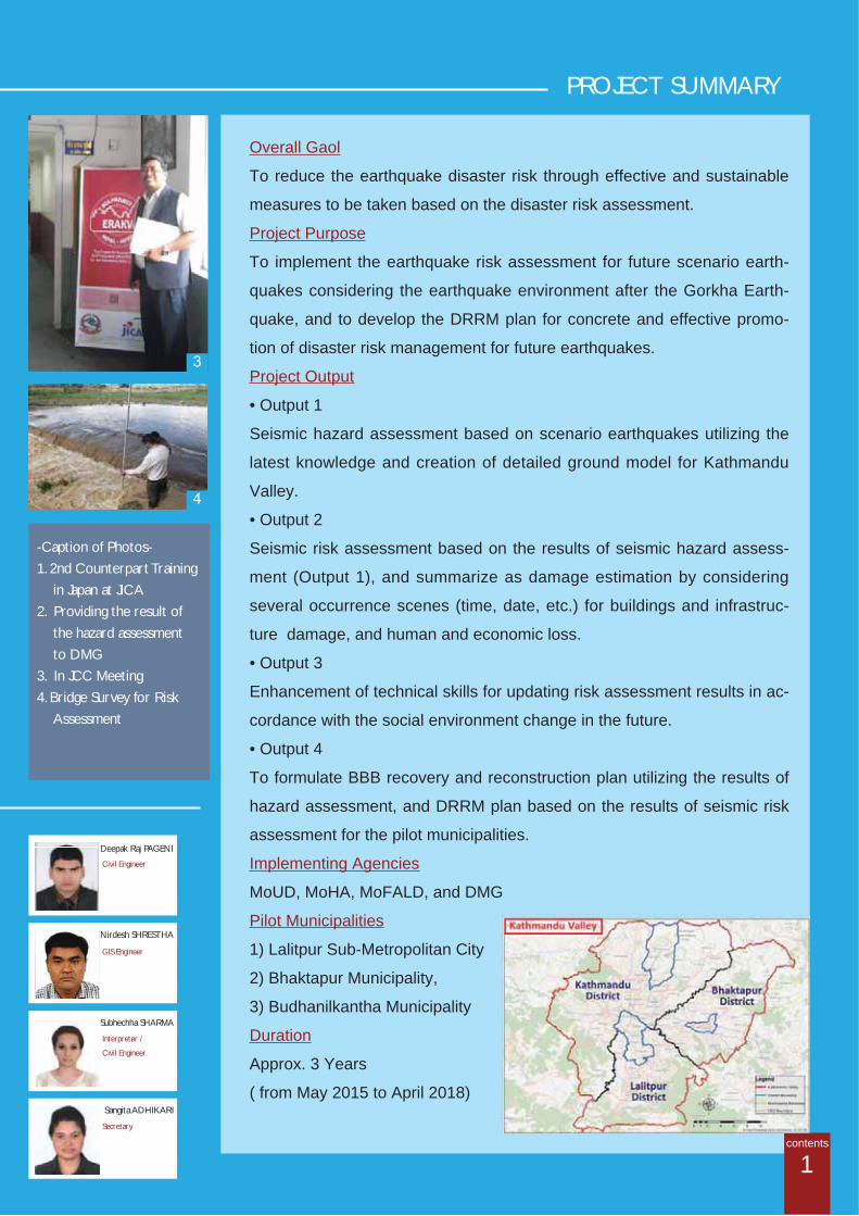
-Caption of Photos-1. 2nd Counterpart Training
in Japan at JICA2. Providing the result of
the hazard assessment to DMG
3. In JCC Meeting4. Bridge Survey for Risk
Assessment

1
Gorkha Earthquake
and Emergency SurveyThe JICA Project Team carried out an urgent damage survey
after the Gorkha Earthquake in order to understand seismic
damage and the needs of GoN for recovery and reconstruction.
The damage survey was carried out in the Kathmandu Valley
and in Sindhupalchowk District which suffered the most severe
damage due to the earthquake. Damage to the buildings built of
adobe, bricks or RC frame, high rise buildings, and roads were
investigated. A detailed damage survey was carried out in Sankhu
and Bhaktapur.
Construction of Cut Model
Quick Response Activities after the Gorkha Earthquake
2
4
2
3
The JICA Project Team members provided
explanation about the quake-resistant model
houses, Japanese earthquake resistant method
and its technical history with Cut Models.
More than 800 people including Secretary of
MoUD, President of JICA visited the site on the
2 days event. After the
event, Himani Shah, Former
Crown Princess also visited
the site, and many Nepali
News published about the
model.Example of the Section
2 days Event (24, 25 June 2015)
1. Damage Survey in Sankhu
2. Survey of collapsed RC Buildings
3. Discussion for modi cation of the
project with JS of MoUD
4. 1st JCC Meeting
contents
from June to August 2015
Constructed RC Model
Image of the Cut Models

WG2
WG3
BBB Reconstruc on Planfor Pilot Municipali es
Disaster Risk Reduc on/Management Plan
Seismic HazardAssessment
Soil Inves ga on
EmergencyResponse
Chronicle Survey
Standard Opera onProcedures
Building Damage andInventory Survey
Scenario Earthquake
Seismic RiskAssessment
Evalua on of theResults of 2002 Project
Construc on ofCut Model
Safe KathmanduCampaign
BBB Recovery and Reconstruc on Planfor Pilot Municipali es
Original Components Supplement components
WG1
“The Safe Kathmandu
Campaign”, which is for
enhancing community
awareness for Disaster
Risk Reduction, was
c o n d u c t e d i n t h e
middle of August with
approx.200 participants
i n t h r e e p i l o t
municipalities. Necessity of retrofitting and issue for
cost, lack of information, request of support from the
government, and so on were among the topics widely
discussed in these WSs. Also, "The Radio
program" and distribution of "the Brochure of
the earhquake resistance" were conducted.
Safe Kathmandu Campaign
Modification of Project Components
Cover of the Brochure
Workshop in
Lalitpur Sub-Metropolitan City
Originally, this project was planned for Seismic Hazard Assessment, Seismic Risk Assessment and DM plan
based on the Risk Assessment. However, in order to correspond to the needs after the Gorkha Earthquake,
following activities were added in the 1st Joint Coordinating Committee (JCC) meeting held on 18th June,
2015.
3contents
in August 2015
Explanation of the Earthquakes Mechanism

Activities of 3 WGs
4
WG1 Seismic Hazard Assessment
WG2 Seismic Risk Assessment
WG3 Pilot Activities
1st Meeting on 7th Aug 2015
2nd Meeting on 9th Nov 2015
1st Meeting on 27th July 2015
2nd Meeting on 8th Feb 2016
1st Meeting on 5th Aug 2015
2nd Meeting on 1st Mar 2016
The Outline and Framework for the activities were discussed.The progress of the Microtremor meas-urement was introduced.
The progress including Scenario Earthquake and Soil Modelling was explained. The importance of techni-cal transfer was shared among partici-pants.
The Outline and Framework for the activities were explained from the JICA Project Team and discussed among participants.
The progress of Data collection for Buildings, Infrastructures, Lifelines, so-cial economic situation was explained The necessity of more detail data was shared among participants.
The Outline and Framework of the Recovery and Reconstruction plan was explained. The schedule, image of plan was discussed, as some recovery works has already started.
(Draft) BBB Recovery and Reconstruc-tion Plan was introduced. The implementation method and budget were recognized as the main issue to be further discussed.
contents
3rd Meeting on 4th Aug 2016The risk assessment approaches forbuilding and infrastructure damage and human and economic loss are dis-cussed.
3rd Meeting on 6th May 2016The contents of BBB Recovery and Reconstruction Plan was discussed.
3rd Meeting on 11 Sep 2016Scheduled.

5
JCC and Joint Working Group Meetings
1st JWG Meeting on 6th Dec 2015
2nd JCC Meeting on 16th Dec 2015
2nd JWG Meeting on 11th April 2016
3rd JCC Meeting on May 10th 2016Result of Hazard Assessment (the Scenario Earthquakes and Seismic motion) and Finalization of the Recovery and Reconstruction Plans in Pilot Municipalities were discussed and con rmed.
1st Joint Working Group (JWG) meeting was organized to share the works of each working group before the 2nd JCC meeting. The Development Commissioner of KVDA chaired the meeting. The presentation was prepared by the JICA Project Team, and the comprehensive ideas including the themes of 3 WGs were discussed.
The activities of the three WGs were presented by Nepali representative of each WG. Scenario Earthquakes were determined. The framework for Recovery and Reconstruction Plan was con rmed.
2nd JWG meeting focused on the progress of Seismic Hazard Assessment, especially for calculation of PGA (Peak Ground Acceleration of seismic motion at ground surface) for the Scenario Earthquakes. The importance of PGA for Risk Assessment and Disaster Management was shared among the participants.
1st JCC Meeting on 18th June 2015The Project component was modi ed (Contents 3), and 3 pilot municipalities were determined.
contents4th JCC Meeting on September 14th 2016 (Scheduled)Final Result of the Hazard Assessment and Coverage items for the Risk Assessment, etc. will be discussed.
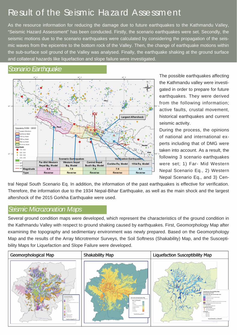
The possible earthquakes affecting
the Kathmandu valley were investi-
gated in order to prepare for future
earthquakes. They were derived
from the following information;
active faults, crustal movement,
historical earthquakes and current
seismic activity.
During the process, the opinions
of national and international ex-
perts including that of DMG were
taken into account. As a result, the
following 3 scenario earthquakes
were set; 1) Far- Mid Western
Nepal Scenario Eq., 2) Western
Nepal Scenario Eq., and 3) Cen-
tral Nepal South Scenario Eq. In addition, the information of the past earthquakes is effective for veri cation.
Therefore, the information due to the 1934 Nepal-Bihar Earthquake, as well as the main shock and the largest
aftershock of the 2015 Gorkha Earthquake were used.
As the resource information for reducing the damage due to future earthquakes to the Kathmandu Valley,
“Seismic Hazard Assessment” has been conducted. Firstly, the scenario earthquakes were set. Secondly, the
seismic motions due to the scenario earthquakes were calculated by considering the propagation of the seis-
mic waves from the epicentre to the bottom rock of the Valley. Then, the change of earthquake motions within
the sub-surface soil ground of the Valley was analysed. Finally, the earthquake shaking at the ground surface
and collateral hazards like liquefaction and slope failure were investigated.
Scenario Earthquake
Result of the Seismic Hazard Assessment
Seismic Microzonation MapsSeveral ground condition maps were developed, which represent the characteristics of the ground condition in
the Kathmandu Valley with respect to ground shaking caused by earthquakes. First, Geomorphology Map after
examining the topography and sedimentary environment was newly prepared. Based on the Geomorphology
Map and the results of the Array Microtremor Surveys, the Soil Softness (Shakability) Map, and the Suscepti-
bility Maps for Liquefaction and Slope Failure were developed.

6
Ground ModellingSince the sub-surface ground remarkably affects the strength of the ground motion, its structure and physical
properties should be identi ed in order to assume the seismic hazard. For the Kathmandu Valley, maximum
depth to rock layer is more than 550 m. Prior to this project, the details of the characteristics of the sub-surface
ground had not been suf ciently investigated. The following are the main portion of the investigation of this
project. First of all, based on around 449 bore-hole data and the gravity exploration result data, 25 geological
cross-sections estimating the situation in the direction of the depth of the geology were produced. Simultane-
ously, the Microtremor Survey at 518 Single Points, including existing 210 points, 74 points of L-Shape Array,
39 points of 3-point Array and 5 points of Tripartite Array, gave the S-wave velocities for the geologic structure.
Based on the above information and survey results, a detailed ground model (structure and properties) for
each 250 m x 250 m grid (total 11,934 grids) was set.
contents

Seismic Ground Motion Estimation
Singularity of ground motion was observed in the Gorkha earthquake.
Recorded seismic motion values due to main shock (7.8) were about
quarter of those calculated for the same magnitude earthquake, and
about half due to the largest aftershock (M7.3) . The reason for such
phenomena is still under consideration in seismology. Therefore, the
project decided to use a correction factors (x1/3 to x1/1) for The Central
Nepal South Scenario earthquake, whose source area is close to that of
the Gorkha earthquake.
t
f
Kathmandu Valley shows complicated
features, as the sub-surface ground is
covered by the strata deposited at the
time of the Paleo-Kathmandu Lake, river
and terrace deposits. Features of the
amplification and the predominant pe-
riod calculated from the ground models
greatly influence ground motion distribu-
tion. Depending on the level of the input
ground motion, a nature of nonlinearity of
soil appears.
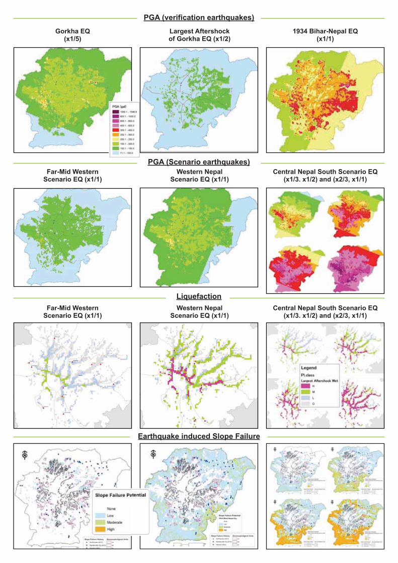
Using the ground models for sub-surface of the Kathmandu Valley, the peak ground acceleration (PGA)
by 3 scenario earthquakes and verification earthquakes were calculated by response analysis. PGAs are:
150-200gals for Gorkha earthquake and Western Nepal Scenario earthquake, 100-150gals for Far-Mid West-
ern Nepal Scenario earthquake and the largest aftershock, and 200-300gals for Central Nepal South Scenario
earthquake with correction factor x1/3 and 1934 Bihar-Nepal earthquake, and PGAs increase along correction
factors and Central Nepal South Scenario earthquakes with x1/1 become PGA 400-800gals.
Liquefaction and Earthquake induced Slope FailureAs very less information for assessment of liquefaction and slope failure is
available in Kathmandu Valley, this project decided to understand their over-
all trend for scenario earthquakes by referring to the history. Considering
the utilization of the result in disaster management, some assumptions were
adapted to be in safer side.
For the largest aftershock and the main shock of the 2015 Gorkha earth-
quake, Far-Mid Western Nepal, and Western Nepal Scenario earthquake, liquefaction and slope failure are
assumed as rare occurrence. Some occurrences of liquefaction and slope failure caused by the Gorkha earth-
quake did not bring real damage. For the 1934 Bihar-Nepal earthquake and
Central Nepal South Scenario earthquake with correction factor of x1/3, the
possibility of liquefaction and slope failure were assumed at some parts of
Kathmandu Valley. The assumed results were con rmed with the actual histo-
ry information of the 1934 earthquake. For other cases (x1/2, x2/3, x1/1) of the
Central Nepal South Scenario earthquake, the possibility of liquefaction and
slope failure were assumed to gradually spread toward the peripheral region of
the Kathmandu Valley, as the correction factor gets larger.
Slope failure in a road portion along Bag-mati River near Kokhana during the 2015 Gorkha earthquake (after KUKL)
Liquefaction at Tundhikel duringthe 1934 Bihar-Nepal earthquake(Rana, 1935)
Progress of the Seismic Risk AssessmentWG2 performs the seismic risk assessment based on the diverse information collected in the activity now un-
der way and the result of seismic hazard assessment prepared by WG1. The major targets of the assessment
are buildings, road network, bridges, water supply and sewage pipelines, electricity system and telecommuni-
cation system. The results will be summarized in maps by each sector such as building, infrastructure, lifelines,
human damage and economic losses.
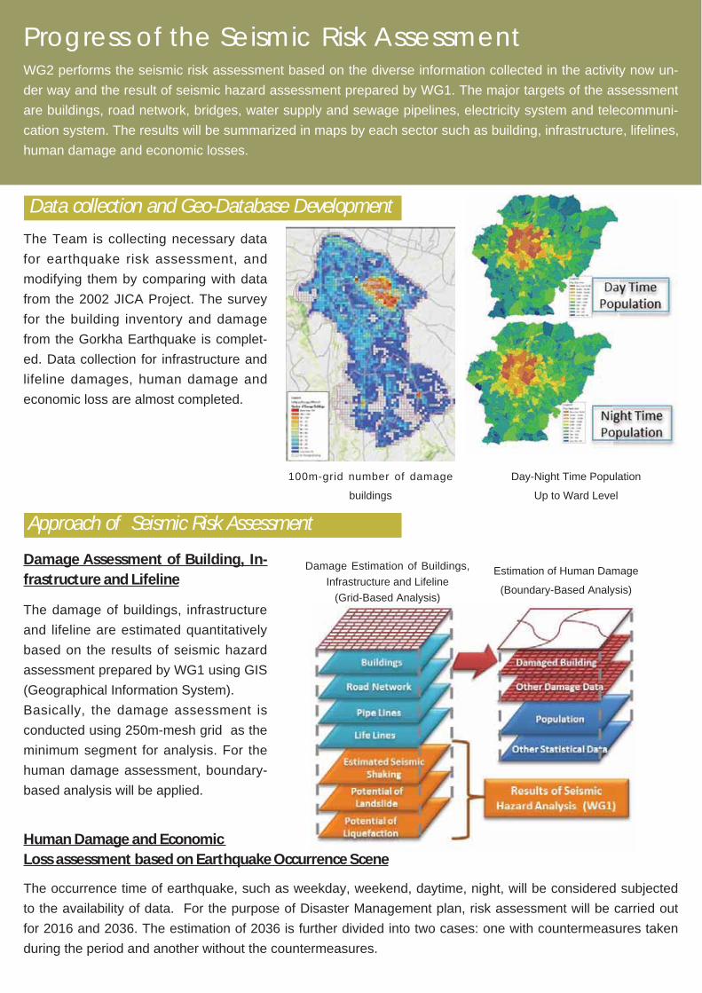
Data collection and Geo-Database Development
The Team is collecting necessary data
for earthquake risk assessment, and
modifying them by comparing with data
from the 2002 JICA Project. The survey
for the building inventory and damage
from the Gorkha Earthquake is complet-
ed. Data collection for infrastructure and
lifeline damages, human damage and
economic loss are almost completed.
100m-grid number of damage
buildings
Day-Night Time Population
Up to Ward Level
The damage of buildings, infrastructure
and lifeline are estimated quantitatively
based on the results of seismic hazard
assessment prepared by WG1 using GIS
(Geographical Information System).
Basically, the damage assessment is
conducted using 250m-mesh grid as the
minimum segment for analysis. For the
human damage assessment, boundary-
based analysis will be applied.
Damage Assessment of Building, In-frastructure and Lifeline
The occurrence time of earthquake, such as weekday, weekend, daytime, night, will be considered subjected
to the availability of data. For the purpose of Disaster Management plan, risk assessment will be carried out
for 2016 and 2036. The estimation of 2036 is further divided into two cases: one with countermeasures taken
during the period and another without the countermeasures.
Human Damage and Economic Loss assessment based on Earthquake Occurrence Scene
Damage Estimation of Buildings,
Infrastructure and Lifeline
(Grid-Based Analysis)
Estimation of Human Damage
(Boundary-Based Analysis)
Approach of Seismic Risk Assessment

Damage Assessment Flow (Draft) - Case of Building Damage & Human Damage -
7contents
Building Inventory Peak Ground Acceleration
Building Damage Function (Fragility Curve)
Population Distribution
Number of Damaged Building Number of Death
InventoryData
Collection
from WG1
Damage Data
Collection
PopulationData
Collection
BuildingDamage
Assessment
HumanDamage
Assessment
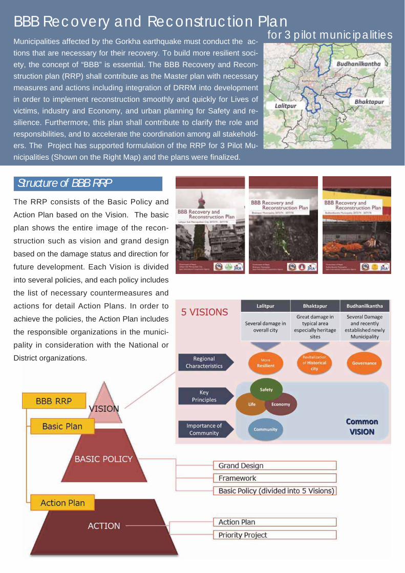
BBB Recovery and Reconstruction Planfor 3 pilot municipalities
Municipalities affected by the Gorkha earthquake must conduct the ac-
tions that are necessary for their recovery. To build more resilient soci-
ety, the concept of “BBB” is essential. The BBB Recovery and Recon-
struction plan (RRP) shall contribute as the Master plan with necessary
measures and actions including integration of DRRM into development
in order to implement reconstruction smoothly and quickly for Lives of
victims, industry and Economy, and urban planning for Safety and re-
silience. Furthermore, this plan shall contribute to clarify the role and
responsibilities, and to accelerate the coordination among all stakehold-
ers. The Project has supported formulation of the RRP for 3 Pilot Mu-
nicipalities (Shown on the Right Map) and the plans were nalized.
The RRP consists of the Basic Policy and
Action Plan based on the Vision. The basic
plan shows the entire image of the recon-
struction such as vision and grand design
based on the damage status and direction for
future development. Each Vision is divided
into several policies, and each policy includes
the list of necessary countermeasures and
actions for detail Action Plans. In order to
achieve the policies, the Action Plan includes
the responsible organizations in the munici-
pality in consideration with the National or
District organizations.
Structure of BBB RRP
8
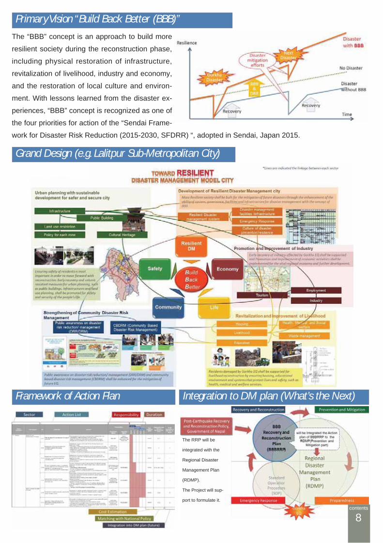
Primary Vision “Build Back Better (BBB)”
The “BBB” concept is an approach to build more
resilient society during the reconstruction phase,
including physical restoration of infrastructure,
revitalization of livelihood, industry and economy,
and the restoration of local culture and environ-
ment. With lessons learned from the disaster ex-
periences, “BBB” concept is recognized as one of
the four priorities for action of the “Sendai Frame-
work for Disaster Risk Reduction (2015-2030, SFDRR) “, adopted in Sendai, Japan 2015.
Grand Design (e.g. Lalitpur Sub-Metropolitan City)
The RRP will be
integrated with the
Regional Disaster
Management Plan
(RDMP).
The Project will sup-
port to formulate it.
Framework of Action Plan Integration to DM plan (What’s the Next)
contents
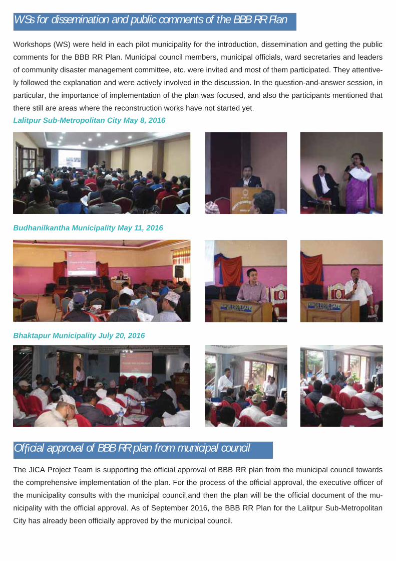
WSs for dissemination and public comments of the BBB RR Plan
Workshops (WS) were held in each pilot municipality for the introduction, dissemination and getting the public
comments for the BBB RR Plan. Municipal council members, municipal of cials, ward secretaries and leaders
of community disaster management committee, etc. were invited and most of them participated. They attentive-
ly followed the explanation and were actively involved in the discussion. In the question-and-answer session, in
particular, the importance of implementation of the plan was focused, and also the participants mentioned that
there still are areas where the reconstruction works have not started yet.
The JICA Project Team is supporting the of cial approval of BBB RR plan from the municipal council towards
the comprehensive implementation of the plan. For the process of the of cial approval, the executive of cer of
the municipality consults with the municipal council,and then the plan will be the of cial document of the mu-
nicipality with the of cial approval. As of September 2016, the BBB RR Plan for the Lalitpur Sub-Metropolitan
City has already been of cially approved by the municipal council.
Of cial approval of BBB RR plan from municipal council
Lalitpur Sub-Metropolitan City May 8, 2016
Budhanilkantha Municipality May 11, 2016
Bhaktapur Municipality July 20, 2016
9
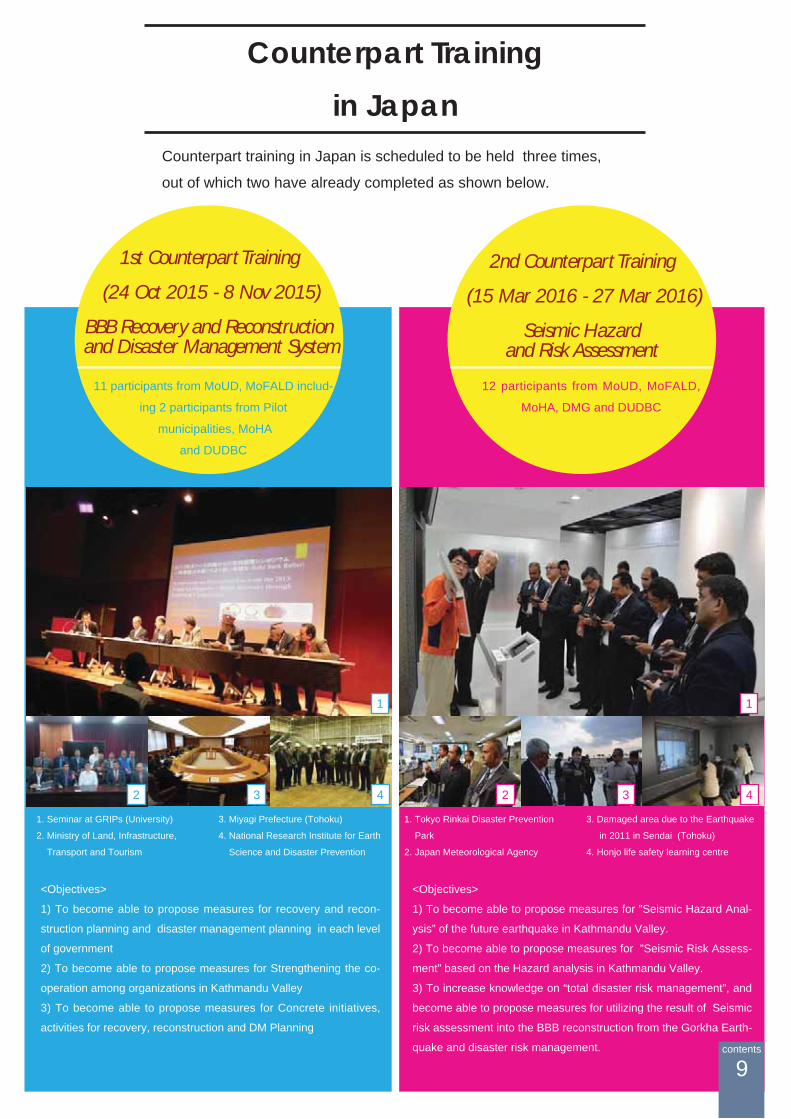
1st Counterpart Training
(24 Oct 2015 - 8 Nov 2015)
BBB Recovery and Reconstruction and Disaster Management System
2nd Counterpart Training
(15 Mar 2016 - 27 Mar 2016)
Seismic Hazard and Risk Assessment
Counterpart training in Japan is scheduled to be held three times,
out of which two have already completed as shown below.
<Objectives>
1) To become able to propose measures for recovery and recon-
struction planning and disaster management planning in each level
of government
2) To become able to propose measures for Strengthening the co-
operation among organizations in Kathmandu Valley
3) To become able to propose measures for Concrete initiatives,
activities for recovery, reconstruction and DM Planning
11 participants from MoUD, MoFALD includ-
ing 2 participants from Pilot
municipalities, MoHA
and DUDBC
12 participants from MoUD, MoFALD,
MoHA, DMG and DUDBC
<Objectives>
1) To become able to propose measures for ”Seismic Hazard Anal-
ysis” of the future earthquake in Kathmandu Valley.
2) To become able to propose measures for ”Seismic Risk Assess-
ment” based on the Hazard analysis in Kathmandu Valley.
3) To increase knowledge on “total disaster risk management”, and
become able to propose measures for utilizing the result of Seismic
risk assessment into the BBB reconstruction from the Gorkha Earth-
quake and disaster risk management.
3
1. Seminar at GRIPs (University)
2. Ministry of Land, Infrastructure,
Transport and Tourism
42
1
3. Miyagi Prefecture (Tohoku)
4. National Research Institute for Earth
Science and Disaster Prevention
1. Tokyo Rinkai Disaster Prevention
Park
2. Japan Meteorological Agency
3. Damaged area due to the Earthquake
in 2011 in Sendai (Tohoku)
4. Honjo life safety learning centre
3 42
1
Counterpart Trainingin Japan
contents

Further ScheduleResult of Seismic Hazard Assessment
(Contents 6)
BBB Recovery and Reconstruction Plan
(Contents 8)
Seismic Risk Assessment for Buildings, InfrastructureLifeline, and Social and Economic Impact (Contents 7)
Formulation of Disaster Risk Management (DRM) Plan Guideline, DRM plans for the three Pilot Municipalities, Community based Disaster Risk Management (CBDRM) Activities, and Standard Operation Procedure (SOP)
10
Image of Guideline for DM Plan Image of SOP
contents

Title Page -Caption of Photos-1. One year seminar in April 25 20162. Bridge Survey for risk assessment3. Damage Survey in Bhaktapur4. Construction of Cut Model in TU5. First Meeting with new Secretary
of MoUD6. Regular Meeting with Counter-
parts7,8 . Dissemination WS in Budhanil-
kantha Municipality9. Sharing the data of Hazard Assess-
ment with DMG.10. Technical Transfer for Building
Risk assessment to DUDBC

https://www.facebook.com/JICA-Earthquake-Risk-Assessment-PJ-in-KV-Nepal-Commun-
ity-690728411055174/
The Project for Assessment of
EARTHQUAKE DISASTER RISK
for the Kathmandu Valley in Nepal
JICAPROJECT
NEPAL - JAPAN
ERAKV