jeppview : egll (56 charts)uvairlines.com/admin/resources/charts/egll.pdf · | jeppesen sanderson,...
TRANSCRIPT
| JEP
PESEN
SAN
DERSO
N, IN
C., 2006. A
LL RIGHTS RESERV
ED.
LONDON, U
KEG
LL/LHR
HEA
THRO
W
JEPPESEN
+
CHA
NG
ES:
AIRPORT.BRIEFIN
G
1.3
.2.
ARRIV
AL
-Surface M
ovement Radar is norm
ally available and all RWY exits w
ill then be illum
inated.
Pilots should select the first convenient exit.-
Pilots are to delay the call ‘RWY vacated’ until A
CFT has com
pletely passed the end of the green/yellow
colour coded TWY centerline lights.
1.3
.3.
DEPA
RTURE
ATC
will require departing A
CFT to use the C
AT III holding points listed below
.How
ever, other departure points may be used at A
TC discretion in w
hich case due allow
ance will be m
ade by ATC
for the necessary ILS protection.-
RWY 09L: A
13.-
RWY 09R: N
11 and S7.-
RWY 27L: N
2W, N
2E, N3, S1S, S1N
and S3.-
RWY 27R: A
3W, A
3E, A2, A
Y1, A
4 and A5.
1.4
.SURFA
CE M
OVEM
ENT G
UID
ANCE A
ND C
ONTRO
L SYSTEM
HEA
THRO
W A
PT is equipped with M
ode S movem
ent radar. Pilots must ensure that:
ACFT transponder is set to transm
it Mode S signals, and associated M
ode A code,
from the com
mencem
ent of push-back and after landing, continuously until ACFT is
fully parked on stand.
1.5
.RW
Y O
PERA
TIO
NS
1.5
.1.
RW
Y C
RO
SSIN
G P
RO
CEDURE
After crossing RW
Y 09R/27L and having reported RW
Y vacated, the A
CFT w
ill be instructed to revert to G
round for further clearance. In absence of further clearance it is essential that A
CFT holds position w
hen clear of RWY.
1.6
.TA
XI P
RPCEDURES
1.6
.1.
GRO
UND M
OVEM
ENT R
ESTRIC
TIO
NS
1.6
.1.1
.RESTRIC
TIO
NS T
O LA
RG
E A
CFT
-Pilots of C
ode E ACFT m
ust exercise caution when using TW
Y S betw
een reporting point SY
6 and TWY Z as w
ingtip clearances to the South are minim
al.-
TWY J has below
Code E w
ingtip clearances for Code E A
CFT allocated stands 123
and 125. Code E A
CFT on stands 123, 125 and 127 are to push back onto the TW
Y B
.-
All B
747-400 ACFT on TW
Y Z m
ust be under tow.
-A
340-600 and B777-300 A
CFT: It is recom
mended that flight crew
s use judgemental
steering at all times w
hen manoeuvring on the TW
Ys.
These ACFT are not perm
itted to use the following routes:
-Exit 09L at A
5 - TWY A
- Left onto TWY K
.-
PLUTO
- TWY K
- Left on TWY A
- Left on Link 21.-
TWY K
- PLUTO
- Right onto Link 21.-
TWY A
- Right on TWY F - Right on TW
Y B
.-
Eastbound on TWY S - turning Right onto Link 41.
1.6
.1.2
.TW
Y B
EA
ST O
F LIN
K 3
2 T
O T
WY Q
MA
X w
ingspan 157’/48m.
1.6
.1.3
.TW
Y R
OUTE W
EST O
N T
WY S
- RIG
HT T
O S
3/SB3
During D
AY and good visibility only and M
AX w
ingspan 91’/27.7m.
1.6
.1.4
.HO
LDIN
G IN
LINK 2
7 a
nd LIN
K 2
8A
CFT m
ust ensure that they are positioned entirely within the block before shutting
down. B
747 ACFT m
ust move forw
ard to a position where stop bar is just visible in
front of the nose from the norm
al flight deck seating position.
1.6
.1.5
.CO
DE E
TW
Y - T
WY S
EPA
RA
TIO
NSeparation of 262'/80m
is not met as follow
s: TWYs A
and B betw
een TWY H
and TW
Y K
, and TWY F and TW
Y R is 249'/76m
.
10-1P13 N
OV 06
None.
1. G
ENERA
L
Licensed to BR
ITISH A
IRW
AYS PLC
, . Printed from JeppView
disc 23-06.N
otice: After 7.12.2006 0901Z this chart should not be used w
ithout first checking JeppView or N
OTA
Ms.
| JEP
PESEN
SAN
DERSO
N, IN
C., 2006. A
LL RIGHTS RESERV
ED.
LONDON, U
KEG
LL/LHR
HEA
THRO
W
JEPPESEN
+
CHA
NG
ES:
AIRPORT.BRIEFIN
G
1.6
.1.6
.CO
DE E
TW
Y T
O S
TA
ND, O
R T
WY T
O O
BJE
CT S
EPA
RA
TIO
NSeparation of 156'/47.5m
is not met on the follow
ing TWYs.
Min
imum
cle
ara
nce is
139'/
42.5
m.
TWY B
from TW
Y F to TW
Y R, and TW
Y F to TW
Y K
. A
ll of TWY F.
TWY E from
TWY G
to TWY B
North.
TWY S from
reporting point SY6 East to TW
Y W
and South ABEA
M stand RS1/2.
Min
imum
cle
ara
nce is
121'/
37m
.TW
Y S from
reporting point SY6 and TW
Y Z to the South.
1.6
.1.7
.RW
Y S
TO
P B
ARS
The RWY stop bars at N
4E, N4W
, N5W
, S4 and S5 are not positioned perpendicular to the TW
Y centerline.
1.6
.1.8
.TW
Y G
REEN C
ENTERLIN
E LIG
HTS
The TWY green centerline lights have som
e omni-directional green light fittings to
assist ATC
controllers.
1.7
.PA
RKIN
G IN
FO
RM
ATIO
NA
ll stands except 170, 171, 192 thru 192R, 209L, 212L, 212R, 350, 354, 365, 463, 542, 543, 553, 566, 590L, 590R and 594 thru 616 equipped w
ith stand entry guidance system
.
Com
manders of ‘heavy’ A
CFT allocated to stands in cul-de-sacs are to keep all
engines running (not with standing fuel econom
y measures), in order to reduce the
necessity for high thrust levels on the remaining engines. Ideally the A
CFT should be
kept moving to ensure breakaw
ay power is not required how
ever in all cases the m
inimum
power to com
lete the manoeuvre safely m
ust be applied. A
318, A319, B
737-500 and B737-600 A
CFT using stands 102, 103, 105, 109, 114, 116,
118, 120, 202 thru 204, 206, 208, 211, 213 and 310 must have the port engine fully
shut down before entering stands.
10-1P229 SEP 06
New
page.
1. G
ENERA
L
Licensed to BR
ITISH A
IRW
AYS PLC
, . Printed from JeppView
disc 23-06.N
otice: After 7.12.2006 0901Z this chart should not be used w
ithout first checking JeppView or N
OTA
Ms.

| JEP
PESEN
SAN
DERSO
N, IN
C., 2006. A
LL RIGHTS RESERV
ED.
LONDON, U
KEG
LL/LHR
HEA
THRO
W
JEPPESEN
+
CHA
NG
ES:
AIRPORT.BRIEFIN
G
2.1
.SPEED R
ESTRIC
TIO
NS
Pilots should typically expect the following speed restrictions to be enforced:
-220 K
T from the holding facility during the initial approach phase;
-180 K
T on base leg/closing heading to the final apch;-
between 180 K
T and 160 KT w
hen established on the final apch;and thereafter 160 K
T to D4.0.
These speeds are applied for ATC
separation purposes and are mandatory.
In the event of a new (non-speed related) A
TC clearance being issued (e.g. an
instruction to descend on ILS), pilots shall continue to maintain a previously
allocated speed. All speed restrictions are to be flow
n as accurately as possible. A
CFT unable to conform
to these speeds should inform A
TC and state w
hat speeds can be used. In the interests of accurate spacing, pilots are requested to com
ply w
ith speed adjustments as prom
ptly as feasible within their ow
n operational constraints, advising A
TC if circum
stances necessitate a change of speed for ACFT
performance reasons.
Cross Speed Lim
it Point or 3 MIN
before holding facility at 250 KT or less.
2.2
.NO
ISE A
BA
TEM
ENT P
RO
CEDURES
The following procedures m
ay at any time be departed from
to the extent necessary for avoiding im
mediate danger or for com
plying with A
TC instructions.
Every operator of ACFT using the A
PT shall ensure at all times that A
CFT are
operated in a manner calculated to cause the least disturbance practicable in areas
surrounding the airport.
An A
CFT approaching to land shall according to its A
TC clearance m
inimize noise
disturbance by the use of continuous descent and low pow
er, low drag operating
procedures (see below).
Where the use is not practicable, A
CFT shall m
aintain an altitude as high as possible.
Pro
pelle
r-driv
en A
CFT w
ith M
TO
W a
bove 5
700 K
GS a
nd je
t ACFT:
ACFT approaching RW
Y 27L/R betw
een 0600-2330LT and using the ILS shall not descend below
2500' (Heathrow
QN
H) on G
S before being established on LOC, nor
thereafter fly below G
S. ACFT approaching w
ithout ILS assistance shall follow a
descent path which w
ill not result in its being at any time low
er than the approach path that w
ould be followed by an A
CFT using the ILS G
S, and shall follow a track to
intercept the extended RWY centerline at or above 2500'.
ACFT approaching RW
Y 27L/R betw
een 2330-0600LT and using the ILS shall not descend below
3000' (Heathrow
QN
H) on G
S before being established on LOC at not
less than 10 NM
from touchdow
n, nor thereafter fly below G
S. ACFT approaching
without ILS assistance shall follow
a descent path which w
ill not result in its being at any tim
e lower than the approach path that w
ould be followed by an A
CFT using
the ILS GS, and shall follow
a track to intercept the extended RWY centerline at or
above 3000'.A
CFT approaching RW
Y 09L/R betw
een 0700-2300LT and using the ILS shall not descend below
2500' (Heathrow
QN
H) on G
S before being established on LOC, nor
thereafter fly below G
S. ACFT approaching w
ithout ILS assistance shall follow a
descent path which w
ill not result in its being at any time low
er than the approach path that w
ould be followed by an A
CFT using the ILS G
S, and shall follow a track to
intercept the extended RWY centerline at or above 2500'.
ACFT approaching RW
Y 09L/R betw
een 2300-0700LT and using the ILS shall not descend below
3000' (Heathrow
QN
H) on G
S before being established on LOC at not
less than 10 NM
from touchdow
n, nor thereafter fly below G
S. ACFT approaching
without ILS assistance shall follow
a descent path which w
ill not result in its being at any tim
e lower than the approach path that w
ould be followed by an A
CFT using
the ILS GS, and shall follow
a track to intercept the extended RWY centerline at or
above 3000'.
10-1P329 SEP 06
New
page.
2. A
RRIV
AL
Licensed to BR
ITISH A
IRW
AYS PLC
, . Printed from JeppView
disc 23-06.N
otice: After 7.12.2006 0901Z this chart should not be used w
ithout first checking JeppView or N
OTA
Ms.
| JEP
PESEN
SAN
DERSO
N, IN
C., 2006. A
LL RIGHTS RESERV
ED.
LONDON, U
KEG
LL/LHR
HEA
THRO
W
JEPPESEN
+
CHA
NG
ES:
AIRPORT.BRIEFIN
G
CO
NTIN
UO
US D
ESCENT A
PPRO
ACH
Headings and flight levels/altitudes by A
TC. A
CFT w
ill be radar vectored. An
estimate of track distance to touchdow
n will be passed w
ith descent clearance. Further distance inform
ation will be given betw
een descent clearance and the intercept heading to the ILS LO
C.
On receipt of descent clearance descend at the rate best suited to a continuous
descent so as to join the GS at the appropriate height for the distance w
ithout recourse to level flight.
2.3
.CA
T II/
III OPERA
TIO
NS
RWYs 09L/27R and 09R/27L approved for C
AT II/III operations, special aircrew
and A
CFT certification required.
2.4
.RW
Y O
PERA
TIO
NS
2.4
.1.
MIN
IMUM
RW
Y O
CCUPA
NCY T
IME
Pilots are reminded that rapid exit from
the landing RWY enables A
TC to apply the
minim
um spacing on final approach that w
ill achieve maxim
um RW
Y utilisation and
will m
inimize the occurrency of go-arounds.
2.4
.2.
RW
Y V
ACA
TIO
N G
UID
ELIN
ES
ACFT in
stru
cte
d to
hold
short o
f TW
Y A
This means that the pilot should pull up the edge of the RW
Y Exit B
oard/stop bar, but not enter the TW
Y.
ACFT la
nds b
ut c
annot c
onta
ct H
EA
THRO
W G
round d
ue to
RTF c
ongestio
nIn this case the pilot should com
pletely vacate the landing RWY and taxi into the
first TWY available. The pilot should then hold position until contact w
ith Ground
can be established.
2.5
.O
THER IN
FO
RM
ATIO
N2.5
.1.
GENERA
LW
ARN
ING
: The possibility of building-induced turbulence and large windshear
effects may occur w
hen landing on RWY 27R in strong southerly / south w
esterly w
inds.
2.5
.2‘LA
ND A
FTER’ P
RO
CEDURE
Norm
ally, only one ACFT is perm
itted to land or take-off on the RWY-in-use at any
one time. H
owever, w
hen the traffic sequence is two successive landing A
CFT, the
second one may be allow
ed to land before the first one has cleared the RWY-in-use,
providing:-
The RWY is long enough;
-it is during daylight hours;
-the second A
CFT w
ill be able to see the first ACFT clearly and continuously until it
is clear of the RWY;
-the second A
CFT has been w
arned. A
TC w
ill provide this warning by issuing the second A
CFT w
ith the instruction ‘La
nd
afte
r ... (first A
CFT ty
pe)’ in place of the usual instruction "
Cleared to land"
. Responsibility for ensuring adequate separation betw
een the two A
CFT rests w
ith the pilot of the second A
CFT.
2.5
.3.
SPECIA
L LANDIN
G P
RO
CEDURES
Special landing procedures may be in force in conditions hereunder, w
hen the use w
ill be as follows:
-W
hen the RWY-in-use is tem
porarily occupied by other traffic, landing clearance w
ill be issued to an arriving ACFT provided that at the tim
e the ACFT crosses the
THR of the RW
Y-in-use the follow
ing separation distances will exist:
-La
ndin
g fo
llow
ing la
ndin
g - The preceding landing A
CFT w
ill be clear of theRW
Y-in-use or w
ill be at least 2500m/1.35 N
M from
the THR of the RW
Y-in-use.
10-1P429 SEP 06
New
page.
2. A
RRIV
AL
Licensed to BR
ITISH A
IRW
AYS PLC
, . Printed from JeppView
disc 23-06.N
otice: After 7.12.2006 0901Z this chart should not be used w
ithout first checking JeppView or N
OTA
Ms.

| JEP
PESEN
SAN
DERSO
N, IN
C., 2006. A
LL RIGHTS RESERV
ED.
LONDON, U
KEG
LL/LHR
HEA
THRO
W
JEPPESEN
+
CHA
NG
ES:
AIRPORT.BRIEFIN
G
-La
ndin
g fo
llow
ing d
epartu
re - The departing A
CFT w
ill be airborne and at least 2000m
/1.1 NM
from the threshold of the RW
Y-in-use, or if not airborne,
will be at least 2500m
/1.35 NM
from the TH
R of the RWY-in-use.
-Reduced separation distances as follow
s will be used w
here both the preceding and succeeding landing A
CFT or both the landing and departing A
CFT are propeller
driven and have a maxim
um total w
eight authorized not exceeding 5700 kg:-La
ndin
g fo
llow
ing la
ndin
g - The preceding A
CFT w
ill be clear of the RWY-in-
use or will be at least 1500m
/0.8 NM
from the TH
R of the RWY-in-use.
-La
ndin
g fo
llow
ing d
epartu
re - The departing A
CFT w
ill be airborne or will be
at least 1500m/0.8 N
M from
the THR of the RW
Y-in-use.
-Conditions of U
seThe procedures w
ill be used by DA
Y o
nly
under the following conditions:
-W
hen the reported meteorological conditions are equal to or better than a
visibility of 6 KM
and a ceiling of 1000' and the air controller is satisfied that the pilot of the next arriving A
CFT w
ill be able to observe continuously the relevant traffic.
-W
hen both the preceding and succeeding ACFT are being operated in the norm
al m
anner. (Pilots are responsible for notifying ATC
if they are operating their A
CFT in other than the norm
al manner).
-W
hen the RWY is dry and free of all precipitants.
-W
hen the air controller is able to assess the separation either visually or by m
eans of aerodrome traffic m
onitor. W
hen issuing a landing clearance following the application of these procedures
ATC
will issue the second A
CFT w
ith the following instructions:
...... (call s
ign) a
fter la
ndin
g/departin
g...... (A
CFT T
ype) c
leare
d to
land
RW
Y ..... (d
esig
nato
r).
10-1P529 SEP 06
New
page.
2. A
RRIV
AL
Licensed to BR
ITISH A
IRW
AYS PLC
, . Printed from JeppView
disc 23-06.N
otice: After 7.12.2006 0901Z this chart should not be used w
ithout first checking JeppView or N
OTA
Ms.
| JEP
PESEN
SAN
DERSO
N, IN
C., 2006. A
LL RIGHTS RESERV
ED.
LONDON, U
KEG
LL/LHR
HEA
THRO
W
JEPPESEN
+
CHA
NG
ES:
AIRPORT.BRIEFIN
G
3.1
.STA
RT-U
P &
PUSH-B
ACK P
RO
CEDURES
3.1
.1.
STA
RT-U
PO
n first contact with H
EATH
ROW
Delivery, pilots are to report A
CFT type, stand
number, Q
NH and identification letter of received A
TIS info.Betw
een 0630-1400 LT and between 1500-2200 LT pilots of operators w
ho have been briefed w
ith regard to the correct phaseology may call for A
TC clearance up to
15 minutes prior to be fully ready for push-back. A
ll other operators must be fully
ready before calling on frequency.Flight deck &
ground crews m
ust be in verbal contact.G
round crews are responsible to ensure that the area im
mediately behind an A
CFT is
clear of personnel, vehicles and equipment.
If an engine is required to be started on stand for operational reasons, the crews
must ensure that:
-perm
ission is obtained from A
TC for the start.
-no other A
CFT is on the TW
Y centerline or about to push-back onto the centerline,
in the area behind the ACFT aw
aiting start.-
passengers are not boarding or disembarking via steps from
an ACFT on an opposite
stand.
Pilots are warned that start-up approval applies only to those engines w
hich may be
started up on stands.A
ll jet ACFT are to advise A
TC, if for any reason they are unable to accelerate after
noise abatement procedures to 250 K
T.If w
ithin 30 min of a previously issued C
alculated Take-off Time (C
TOT) the flight is
unable to comply w
ith that CTO
T, the pilot should advise ATC
as soon as possible. Pilots are advised that delays in excess of 10 m
in can be expected at holding position. Sufficient tim
e should be allowed for start, push-back and taxi to take
account of such a delay especially if required to comply w
ith a Calculated Take-off
Time (C
TOT).
3.1
.2.
PUSH-B
ACK
Following push-back from
cul-de-sac stands, all ACFT m
ust pull forward to a
minim
um of 328'/100m
from the blast screen (indicated by a painted m
ark on the TW
Y centerline) before disconnecting the tug. D
ue to exhaust fume ingestion w
ithin the buildings at the end of all cul-de-sacs, engine start-up m
ust be delayed until the A
CFT has reached the 328'/100m
mark.
Stands that currently affect baggage areas are 102, 104, 106, 117, 119, 121, 202, 204, 206, 211, 213, 324, 326, 328, 351, 353, 401, 402 and 403.
During the push-back m
anoeuvre, ACFT engine settings m
ust not exceed idle power.
Push-back manoeuvres are to end w
ith the ACFT aligned w
ith TWY centerline.
Push-back approval must be obtained from
HEA
THRO
W G
round.
3.2
.SPEED R
ESTRIC
TIO
NS
MA
X 250 K
T below FL100 unless otherw
ise authorized.
3.3
.NO
ISE A
BA
TEM
ENT P
RO
CEDURES
3.3
.1.
GENERA
LThe follow
ing procedures may at any tim
e be departed from to the extent necessary
for avoiding imm
ediate danger or for complying w
ith ATC
instructions. Every operator of A
CFT using the A
PT shall ensure at all times that A
CFT are
operated in a manner calculated to cause the least disturbance practicable in areas
surrounding the airport.
After take-off operate A
CFT so that it is at or above 1090' at 6.5 km
from start of
roll as measured along the departure track and so that it w
ill not cause more than:
-94 dB
A betw
een 0700-2300LT,-
89 dBA
between 2300-2330LT and betw
een 0600-0700LT,-
87 dBA
between 2330-0600LT
10-1P63 N
OV 06
None.
3. D
EPA
RTURE
Licensed to BR
ITISH A
IRW
AYS PLC
, . Printed from JeppView
disc 23-06.N
otice: After 7.12.2006 0901Z this chart should not be used w
ithout first checking JeppView or N
OTA
Ms.

| JEP
PESEN
SAN
DERSO
N, IN
C., 2006. A
LL RIGHTS RESERV
ED.
LONDON, U
KEG
LL/LHR
HEA
THRO
W
JEPPESEN
+
CHA
NG
ES:
AIRPORT.BRIEFIN
G
at any noise monitoring term
inal. Jet ACFT m
aintain a minim
um clim
b gradient of 243' per N
M (4%
) to at least 4000' to ensure progressively decreasing noise levels at points on the ground under the flight path beyond the m
onitoring terminal.
Noise preferential routing procedures applicable for all jet A
CFT and other A
CFT
with M
TWA
of more than 5700 K
GS (betw
een 0600-2330 LT of more than 17000 K
GS
and except any Dash 7 A
CFT) are depicted on London H
eathrow SID
charts and on page 10-4.
3.3
.2.
NO
ISE Q
UO
TA
SYSTEM
DURIN
G N
IGHT (2
300-0
700LT
)M
ain restrictions are as follows:
-N
ight Period (2300-0700LT)-
Night Q
uota Period (2330-0600LT)
ACFT m
ovements w
ill score against the quota as follows:
Operators w
ishing to query the classification of their ACFT send details of the
relevant noise data to:
ACFT C
ertification Departm
entA
ir Worthiness D
ivisionCivil A
viation Authority
2E Aviation H
ouseG
atwick A
PT SouthG
atwick
West Sussex RH
6 0YR
Tel: +44 (0) 1293 573306/3309 during office hours.
In the event that the ACFT C
ertification Departm
ent is uncontactable, the Heathrow
Flight Evaluation O
ffice may be contacted during norm
al working hours on H
eathrow
+44 (0) 20 8757 0340.
Noise Level B
and (EP
NdB
)Q
UO
TA C
ount
84 - 86.90.25
87 - 89.90.5
90 - 92.91
93 - 95.92
96 - 98.94
99 - 101.98
more than
101.916
10-1P73 N
OV 06
Noise quota system
.
3. D
EPA
RTURE
Licensed to BR
ITISH A
IRW
AYS PLC
, . Printed from JeppView
disc 23-06.N
otice: After 7.12.2006 0901Z this chart should not be used w
ithout first checking JeppView or N
OTA
Ms.
| JEP
PESEN
SAN
DERSO
N, IN
C., 2006. A
LL RIGHTS RESERV
ED.
LONDON, U
KEG
LL/LHR
HEA
THRO
W
JEPPESEN
+
CHA
NG
ES:
AIRPORT.BRIEFIN
G
3.4
.RUNW
AY O
PERA
TIO
NS
3.4
.1.
MIN
IMUM
RW
Y O
CCUPA
NCY T
IME
On receipt of line up clearance pilots should ensure, com
mensurate w
ith safety and standard operating procedures, that they are able to taxi into the correct position at the hold and line up on the RW
Y as soon as the preceding A
CFT has com
menced its
take-off roll. Pilots w
ho require to back-track the RWY (including line up from
N2W
onto RWY 27L)
must notify A
TC prior to arrival at the holding point.
Whenever possible, cockpit checks m
ust be completed prior to line up and any checks
requiring completion w
hilst on the RWY should be kept to the m
inimum
required. Pilots should ensure that they are able to com
mence the take-off roll im
mediately
after take-off clearance is issued. Pilots not able to com
ply with these requirem
ents should notify ATC
as soon as possible once transferred to H
EATH
ROW
Tower.
3.4
.2.
RW
Y H
OLD
ING
AREA
SIn good visibility an A
TIS message w
ill remind pilots that they rem
ain responsible for w
ing tip clearance. In prom
ulgated holding areas, flight crew w
ill be expected to follow conditional
line-up clearances to maxim
ize RWY utilization, w
hich may entail overtaking and
passing other ACFT in the holding areas. It is stressed that during these m
anoeuvres, avoidance of other A
CFT is the responsibility of the flight crew
involved. If doubt exists as to w
hether other ACFT can be overtaken then A
TC m
ust be informed that
the conditional clearance that has been received cannot be complied w
ith.
At N
IGHT, selectable reds and greens are used in the RW
Y 27L and 27R holding areas.
10-1P829 SEP 06
New
page.
3. D
EPA
RTURE
Licensed to BR
ITISH A
IRW
AYS PLC
, . Printed from JeppView
disc 23-06.N
otice: After 7.12.2006 0901Z this chart should not be used w
ithout first checking JeppView or N
OTA
Ms.

| JEP
PESEN
SAN
DERSO
N, IN
C., 2006. A
LL RIGHTS RESERV
ED.
LONDON, U
KEG
LL/LHR
HEA
THRO
W
JEPPESEN
+
CHA
NG
ES:
AIRPORT.BRIEFIN
G
1.1
.A
TIS
* D
-ATIS A
rrival113.75 115.1 128.07
* D
-ATIS D
eparture121.85
1.2
.NO
ISE A
BA
TEM
ENT P
RO
CEDURES
1.2
.1.
GENERA
LThe follow
ing procedures may at any tim
e be departed from to the extent necessary
for avoiding imm
ediate danger or for complying w
ith ATC
instructions. Every operator of A
CFT using the A
PT shall ensure at all times that A
CFT are
operated in a manner calculated to cause the least disturbance practicable in areas
surrounding the APT.
1.2
.2.
PREFERENTIA
L RUNW
AY S
YSTEM
When tailw
ind component is not greater than 5 K
T on RWYs 27R/L, these RW
Ys w
ill be used in preference to RW
Ys 09R/L, provided the RW
Y surface is dry.
Pilots asking for permission to use the RW
Y into the w
ind when RW
Ys 27R or 27L are
in use, should understand that their arrival or departure may be delayed.
1.2
.3.
REVERSE T
HRUST
Avoid use of reverse thrust betw
een 2330-0600LT except for safety reasons.
1.2
.4.
RUN-U
P T
ESTS
Run-up tests are controlled in accordance with instructions issued by H
eathrow A
PT LTD
.
1.2
.5.
CO
NTRO
L OF G
RO
UND N
OIS
E A
T T
ERM
INA
L 4-
Running of engines prohibited, other than taxiing to, from or onto stands
404 thru 412, between 2330-0630LT.
-Taxiing to or from
Terminal 4 betw
een 2300-0700LT is prohibited on TWY S W
est of A
pron V or thru Link A
to SB1 and reverse.
In addition no A
CFT is perm
itted to taxi to or from stands on A
pron V or stands
401 thru 403 and 461 thru 463. -
Except on stands 404 thru 412 no APU
s may be operated betw
een 2330-0630LT.-
Other than routine servicing of A
CFT on turnaround, no m
aintenance work w
hich involves running of engines is perm
itted on Terminal site at any tim
e.
1.2
.6.
NIG
HTTIM
E R
ESTRIC
TIO
NS
Any A
CFT w
hich has a noise classification greater than 95.9 EPNdB
may not be
scheduled to take-off or land between 2330-0600LT.
Any A
CFT w
hich has a noise classification greater than 98.9 EPNdB
may not
-be scheduled to take-off or land betw
een 2300-0700LT, -
take-off between 2300-0700LT, except betw
een 2300-2330LT when
-it w
as scheduled to take-off prior to 2300LT,-
take-off was delayed for reasons beyond control of the A
CFT operator,
-A
PT authority has not given notice to the ACFT operator precluding take-off.
Any A
CFT m
ay not take-off or be scheduled to land between 2300-0700LT w
here the operator of that A
CFT has not provided (prior to its take-off or prior to its scheduled
landing times as appropriate) sufficient inform
ation to enable the APT authority to
verify its noise classification.N
one of the provisions of this notice shall apply to a take-off or landing which is
made in an em
ergency consisting of an imm
ediate danger to life or health, whether
human or anim
al.
1.3
.LO
W V
ISIB
ILITY P
RO
CEDURES (LV
P)
1.3
.1.
GENERA
LD
uring CA
T II and III operations, special ATC
Low V
isibility Procedures will be
applied. LVP w
ill come in force w
hen RVR is less than 600m
and ceiling is 200' or less. Pilots w
ill be informed w
hen these procedures are in operation via ATIS or RTF.
10-1P3 N
OV 06
Nighttim
e restrictions.
1. G
ENERA
L
Licensed to BR
ITISH A
IRW
AYS PLC
, . Printed from JeppView
disc 23-06.N
otice: After 7.12.2006 0901Z this chart should not be used w
ithout first checking JeppView or N
OTA
Ms.
D23
131^
D22
D
D25
D42
D46
D
D
D
D32
063^
D
R140^BNN113.75
BNN
D
285^
D17D8
EGLL/LH
RHEA
THRO
WLO
NDON, U
K
Apt Elev
83'Alt S
et: h
Pa
Tra
ns le
vel: B
y A
TC T
rans a
lt: 6000'
113.75 115.1 128.07*D
-ATIS
Radials updated; runway layout.
172^19
237^
R057^
15
21
10
KOPULN51 32.5E001 08.2
BIG
3D
21
BIG
3B,1
243^
285^
17
HILLYN51 20.1E000 14.6
13
R063^
WEA
LD
3D
3
WEALD 3
B
30
8
.STAR.
10-2
2 As directed by ATC, not to beused for flight planning purposes.Aircraft will be instructed by ATCto fly the appropriate FL.
3
172^19
HILLY
By A
TC
319^
3
311^
HOLDING
BIG 3C
WEALD1E, 1F
BIG 3
C
WEA
LD 3
C
1
294^
WEA
LD
3D
N51 20.1 E000 14.6
WEA
LD3B, 3C
OVER TIGER
22
| JEP
PESEN
SAN
DERSO
N, IN
C., 2003, 2006. A
LL RIGHTS RESERV
ED.
MSAARP
360^
2300'2100'
180^
3 NO
V 06
SLP Speed Limit Point
7000
D
D
115.1 BIGN51 19.9 E000 02.1
117.3 DETN51 18.2 E000 35.8
114.05 LYDLYDN51 00.0 E000 52.7
BIGGIN
DETLING
LYDD
SANDYSLP
SLP
320^
140^
140^
317^
42
12
R138^ 303^12
1(WEALD )
D12 BIG
R114^
BIG 1F
276^R096^
BIG
1E
21
LOGAN
DLAMBOURNE
115.6 LAMLAMN51 38.8 E000 09.1
1
10
TIGER
ARRIV
ALS
D12 BIG
NOT TO SCALE
D
ALESO
D114.95 DVR
N51 09.8 E001 21.6
DOVER
DURIN
G PERIO
DS O
F CONGESTIO
N TRA
FFIC M
AY BE RO
UTED
VIA
OCK 1G
AS D
IRECTED
BY A
TC
BIG
DET
DVR
TANETN51 27.0E000 55.5
2
MAA FL90
WEALD
1E
N51 03.9E001 04.1
318^
N51 44.9 E001 36.7
CH
AN
GES:
JEPPESEN
WILL BE AS DIRECTED BY ATC.ACTUAL DESCENT CLEARANCE
DESCENT PLANNING
BIG 3C, 3D, 1E, 1F:by TIGER
As directedby ATC
D 117.3 DETN51 18.2 E000 35.8
DETLING
114.05 LYDLYDN51 00.0 E000 52.7
LYDD
SANDYTIGER
WEALD
N51 03.9E001 04.1
N51 19.9E000 02.1
1
7000D32/37
21
22
R131^
23
277^
320^
LAMBOURNED115.6 LAMLAM
N51 38.8 E000 09.1
To be used when
D
N51 04.0E000 26.4
DET N51 04.0 E000 26.4
138^318^
WARNINGDo not proceed beyond
BIG/WEALDwithout ATC clearance.
BIG VOR unserviceable
123^
WEALD1F
BIG 3B: FL150
WEALD 3B [WEAL3B]WEALD 3C [WEAL3C]WEALD 3D [WEAL3D]WEALD 1E [WEAL1E]WEALD 1F [WEAL1F]
MAX FL140
ABO
VE FL140
N50 34.5 E001 13.5
Pilots should plan for possible
BIGGIN TH
REE BRAVO (BIG
3B), BIGGIN TH
REE CHARLIE (BIG
3C)
BIGGIN O
NE FO
XTRO
T (BIG 1F)
, BIGGIN O
NE EC
HO (BIG
1E) BIG
GIN TH
REE DELTA
(BIG 3D
)
descent clearance as follows:
WHEN
BIG V
OR U
NSERV
ICEA
BLE USE W
EALD
3B, 3C, 3D
, 1E, 1F1
NOT TO
BE USED
FOR FLIG
HT PLA
NNING PU
RPOSES
Licensed to BR
ITISH A
IRW
AYS PLC
, . Printed from JeppView
disc 23-06.N
otice: After 7.12.2006 0901Z this chart should not be used w
ithout first checking JeppView or N
OTA
Ms.

D32
D
D
R320^
D32
EGLL/LH
RHEA
THRO
WLO
NDON, U
K
Apt Elev
83'Tra
ns le
vel: B
y A
TC
Tra
ns a
lt: 6000'
Alt S
et: h
Pa
113.75 115.1 128.07*D
-ATIS
| JEPPESEN
SAN
DERSO
N, IN
C., 2003, 2006. A
LL RIGHTS RESERV
ED.
Runway layout.
278^BNN 1
E
33
1
FL200
DO
NNA
BELOW
2BO
VVA
1E
3
.STAR.
10-2A
2
FL.
3
As d
irecte
d b
y A
TC,
not to
be u
sed fo
r flight
pla
nnin
g p
urp
oses.
Airc
raft w
ill be in
stru
c-
ted b
y A
TC to
fly th
eappro
pria
te
155^
335^
HO
LDIN
GS O
VER W
CO
33
DO
NNA
278^
BO
VVA
1E
3
N51 42.0 W
000 44.6By A
TC
By ATC
(LAM
D33)
8
W001 28.0
TO
BID
N52 13.0
.R.
.R.MHA FL200
MHA FL160
MAX FL150
N51 42.0 W
000 44.6
168^
20
BNN 1C
BOVVA 1C
1
SO
PIT
N51 57.5
W001 06.4
Do n
ot e
xceed
BNN 2
7 D
ME
BNN 27 DME
2 2M
SAA
RP
360^
2300'2100'
180^
3 NO
V 06
SLP
Speed L
imit P
oin
t
WC
O335 W
CO
WESTC
OTT
N51 51.2 W
000 57.8
D116.4 D
TYD
TYN52 10.8 W
001 06.8D113.65 H
ON
HO
NN52 21.4 W
001 39.8
DAVEN
TRY
HONILEY
L 10
A 47
MAA FL140
FL90
FL90
AT FL70
1
BNN 3A 21
SLP
17
7000
143^
149^
329^
151^
331^
119^
R299^ (BO
VVA
)1
BNN
D113.75 BNN
BOVINGDON
N51 43.6 W
000 33.0
24
BNN 1
D
R253^
073^KENET
N51 31.2
W001 27.3
SLP
D12 B
NN
12
1
NO
T TO SC
ALE
DLA
MBO
URN
E115.6 LA
MN51 38.8 E000 09.1
329^
LAM
2
BOVVA 3A
BO
VVA
1D
CHA
NG
ES:
JEPPESEN
190^
010^
WC
O335 W
CO
WESTC
OTT
N51 51.2 W
000 57.8
BO
VVA
D
N51 19.9 E000 02.1
BIGGIN 1
17
7000 D32/37
119^
140^
36
073^
KENET
W000 33.0
N51 43.6
N51 31.2 W
001 27.3
By A
TC
LAMBO
URN
ED115.6 LA
MN51 38.8 E000 09.1
By A
TC
115.1 BIG
LAM
BIG
BOVVA 1
D
To b
e u
sed w
hen
DESC
EN
T P
LA
NN
IN
G
WA
RN
IN
GDo n
ot p
roceed b
eyond
BNN/BOVVA
with
out A
TC c
leara
nce.
N 615
11
BO
VVA
3A
, 1C
BNN V
OR u
nserv
iceable
BN
N 3
A: F
L200
by T
OBID
,FL150
BO
VV
A 1
C[B
OVA
1C]
BO
VV
A 1
D[B
OVA
1D
]BO
VV
A 1
E[B
OVA
1E]
BO
VV
A 3
A[B
OVA
3A
]
299^
Pilo
ts s
hould
pla
n fo
rpossib
le d
escent c
leara
nce
as fo
llows:
AC
TU
AL D
ESC
EN
TC
LEA
RA
NC
E W
ILL B
E A
SD
IREC
TED
BY
ATC
.
by S
OPIT
.
ARRIV
ALS
BOVINGDON O
NE C
HARLIE (BN
N 1C
)
BOVINGDON O
NE EC
HO (BN
N 1E)
BOVINGDON O
NE D
ELTA (BN
N 1D
)
WHEN
BNN V
OR U
NSERV
ICEA
BLE USE
BOVINGDON TH
REE ALFA
(BNN 3A
)
1BO
VVA 3A
, 1C, 1D
, 1E
119^
Licensed to BR
ITISH A
IRW
AYS PLC
, . Printed from JeppView
disc 23-06.N
otice: After 7.12.2006 0901Z this chart should not be used w
ithout first checking JeppView or N
OTA
Ms.
EG(D)-138BEG(D)-138A
D8
D18R111^
198^
D30 D35
D55
D25R07
0^
D30R100^
D30100^
EGLL/LH
RHEA
THRO
WLO
NDON, U
K
| JEPPESEN
SAN
DERSO
N, IN
C., 2003, 2006. A
LL RIGHTS RESERV
ED.
Apt Elev
83'Alt S
et: h
Pa
Tra
ns le
vel: B
y A
TC T
rans a
lt: 6000'
113.75 115.1 128.07*D
-ATIS
Radials updated; runway layout.
MHA FL180
MAX FL240
FL250
FL220Planned at or below FL290);
3
By ATCBy ATC
By ATC
.STAR.
2
FL.3
by LOGAN (Aircraft Flight
by LOGAN (Aircraft Flight
10-2B
280^MHA FL180MAX FL240
3 By ATC Planned at or above FL300 and all air-craft via airway UP 7);
Due to proximity of EG(D)-138 do not fly south of track Abeam CLNuntil BRASO.Aircraft will be instructed by ATCto fly the appropriate
By ATC
D18/25
NOT TO
BE USED
FOR FLIG
HT PLA
NNING PU
RPOSES
MSAARP
360^
2300'2100'
180^
3 NO
V 06
SLP Speed Limit Point
10
812
LOGAN
TRIPO
BRASO
SLPD12 LAM
N51 44.9E001 36.7
N51 42.8E001 05.0
N51 41.1E000 41.0
DCLNCLACTON
114.55 CLNN51 50.9 E001 08.9
7000
1
DLAMBOURNE115.6 LAMLAM
N51 38.8 E000 09.1
20
R086^
ACTUAL DESCENT CLEARANCE WILL BE AS DIRECTED BY ATC.
291^5
SABERN51 42.2E000 57.0
266^
LAM 3A
1
2
FL150
NOT TO SCALE
TAWNY 3ACHA
NG
ES:
JEPPESEN
DESCENT PLANNINGPilots should plan for possible descent clearance as follows:
by SABER.DLONDON
LON113.6 LONN51 29.2 W000 28.0
7000
D25/D30
TAWNY
1
E000 41.0N51 41.1BRASO
20250
^
266^
DBPK117.5 BPKN51 45.0 W000 06.4
PARKBROOKMANS
TAWNY 3A
N51 38.8 E000 09.1
(TAWNY )
MAX FL170
DBPK117.5 BPKN51 45.0 W000 06.4
PARKBROOKMANS
WARNINGDo not proceed beyond
LAMwithout ATC clearance.
To be used whenLAM VOR unserviceable
[TAWN3A]
ARRIV
AL
DURIN
G PERIO
DS O
F CONGESTIO
N TRA
FFIC M
AY BE RO
UTED
VIA
BIG 3D
, BIG 1E, BN
N 1E &
OCK 1H
AS D
IRECTED
BY A
TC
LAMBO
URN
E THREE A
LFA (LA
M 3A
)1WHEN
LAM V
OR U
NSERV
ICEA
BLE USE TA
WNY 3A
Licensed to BR
ITISH A
IRW
AYS PLC
, . Printed from JeppView
disc 23-06.N
otice: After 7.12.2006 0901Z this chart should not be used w
ithout first checking JeppView or N
OTA
Ms.
D
R268^
D35
D15
D
EGLL/LH
R.STAR.
HEA
THRO
WLO
NDON, U
K10-2C
| JEP
PESEN
SAN
DERSO
N, IN
C., 2003, 2006. A
LL RIGHTS RESERV
ED.
Apt Elev
83'Tra
ns le
vel: B
y A
TC
Tra
ns a
lt: 6000'
Alt S
et: h
Pa
113.75 115.1 128.07*D
-ATIS
Radials updated; runway layout.
DO
RKI
256^
218^
287^
712
27OCK 1H
OC
K 1
GR107^
227^
28
TO
MM
O
HO
GBA
7 7000
089^
21
255^
13
TOMMO 1H
TO
MM
O 1
G
2
2
FL.
2Airc
raft w
ill be in
stru
cte
d b
yATC to
fly th
e a
ppro
pria
te
.STAR.
10-2C
DOC
K
088^
STARS A
RE TO FA
CILITA
TE THE TRA
NSFER O
FTRA
FFIC BETW
EEN TERM
INAL H
OLD
ING FA
CILITIES1
MSA
ARP
7000
CH
AN
GES:
JEPPESEN
360^
2300'2100'
180^
3 NO
V 06
332^
152^
NO
T TO SC
ALE1
OCKHAM
115.3 OCK
N51 18.3 W
000 26.8
D
D
LAMBO
URN
E115.6 LA
ML
AMN51 38.8 E000 09.1
BIGGIN
115.1 BIGB
IGN51 19.9 E000 02.1
N51 16.6 W
000 15.9
CH
AN
GES:
JEPPESEN
N51 13.7 W
000 29.7
N51 18.9
W000 21.8
DLA
MBO
URN
E115.6 LA
ML
AMN51 38.8 E000 09.1
DBIG
GIN
115.1 BIGB
IGN51 19.9 E000 02.1
WA
RN
IN
GDo n
ot p
roceed b
eyond
OCK/TOMMO
with
out A
TC c
leara
nce.
WILL B
E A
S D
IREC
TED
BY
AT
C.
AC
TU
AL D
ESC
ENT
CLEA
RA
NC
E
DESC
EN
T P
LA
NN
IN
G
FL150
cent c
leara
nce a
s fo
llows:
Pilo
ts s
hould
pla
n fo
r possib
le d
es-
OC
K 1
G:
by T
IGER;
FL150
OC
K 1
H:
by S
ABER.
To b
e u
sed w
hen
OCK V
OR u
nserv
iceable
TO
MM
O 1
GT
OM
MO
1H
[TOM
O1G
][TO
MO
1H]
ARRIV
ALS
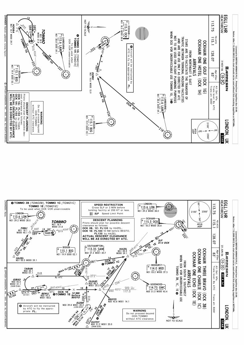
OCKHAM O
NE H
OTEL (O
CK 1H
)OCKHAM O
NE G
OLF (O
CK 1G
)
FROM N
ORTH
EAST &
EAST
AND A
RE FOR U
SE ONLY
AS D
IRECTED
BY A
TCNOT TO
BE USED
FOR FLIG
HT PLA
NNING PU
RPOSES
WHEN
OCK V
OR U
NSERV
ICEA
BLE USE TO
MMO 1G
, 1H
Licensed to BR
ITISH A
IRW
AYS PLC
, . Printed from JeppView
disc 23-06.N
otice: After 7.12.2006 0901Z this chart should not be used w
ithout first checking JeppView or N
OTA
Ms.
R261^
R216^
256^
R272^D19
D52SFD
117.0
SFD
272^
R265^
D9
D18
D41
D74
D48
R 18 2^
D35
D101
D14
D14
R268^
R216^
D15D27
D35
.Eff.6.Jul.EG
LL/LHR
HEA
THRO
WLO
NDON, U
K
Apt Elev
83'Alt S
et: h
Pa
Tra
ns le
vel: B
y A
TC T
rans a
lt: 6000'
113.75 115.1 128.07
None.
*D
-ATIS
MAA FL150
FL160
FL100
MAA
BEWLI
TARAN
OLGUD
ELDER
BEGTO
N50 45.0
N50 45.5
N50 48.3
N50 50.1
W002 31.1
W002 01.1
W001 48.6
W001 20.5
036^
085^092^
27
By A
TC
9
10
17
27
1
1
1
00 2 ^
By ATC
By ATC
OCK 1E
OCK 3
B
N50 39.8 W001 20.2
TOMMO 1E
TOMMO 3
B
2
OCK
3B, 1C, 1
E
N50 45.8 W001 14.1
OCK 1
E
TOMMO 1
E
ByTC
A
MHA
FL110
MAX
FL15
0
027^
32
KATHYN50 31.2 W001 20.0
GIBSO
.STAR.
FL.
2
10-2D21
12
089^ 7000
TOMMO
3B, 1C, 1E
2
036^
D
D
D
(SAM D46)
(LON D59)
(SAM D26)
216^
036^
.R.
10
12
10 NM before BEGTO
| JEPPESEN
SAN
DERSO
N, IN
C., 2003, 2004. A
LL RIGHTS RESERV
ED.
LON D
59/6
6
088^
Aircraft will be instructedby ATC to fly the appro-priate
MSAARP
360^
2300'2100'
180^
23 JUN
06
ARRIV
ALS
1
WILL BE AS DIRECTED BY ATC.ACTUAL DESCENT CLEARANCE
NOT TO SCALE
D
D
MIDHURST
MID114.0 MIDN51 03.2 W000 37.5
SAM113.35 SAMN50 57.3 W001 20.7
OCKHAM
OCK115.3 OCKN51 18.3 W000 26.8
HAZEL
12
15
14
700
0
LOND113.6 LON
LONDON
N51 29.2 W000 28.0
SLPD12 OCK
081^
051^
332^152^
R231^
R 81
DGOODWOOD
GWC114.75 GWCN50 51.3 W000 45.4
R 8
N51 00.3W000 59.1
OCK 1C
N 8
66
TOMMO 3B, 1C
, 1E
TOMMO 1C
FROM SO
UTH
& SO
UTH
WEST
CHA
NG
ES:
JEPPESEN
DESCENT PLANNINGPilots should plan for possible descent
by HAZEL,
HAZEL
1
W000 40.1
FIMLIN51 18.1
N51 18.9TOMMOW000 21.8
N51 00.3 W000 59.1
BIG115.1 BIGBIGGIN
N51 19.9 E000 02.1
LON113.6 LONLONDON
N51 29.2 W000 28.0
SOUTHAMPTON
WARNINGDo not proceed beyond
OCK/TOMMOwithout ATC clearance.
OCKHAM TH
REE BRAVO (O
CK 3B)
OCKHAM O
NE C
HARLIE (O
CK 1C
)OCKHAM O
NE EC
HO (O
CK 1E)
SLP Speed Limit Point
Cross SLP or 3 MIN before holding facility at 250 KT or less.
SPEED RESTRICTION
To be used when OCK VOR unserviceable
WHEN
OCK V
OR U
NSERV
ICEA
BLE USE
clearance as follows:OCK 3B, 1C: FL130
10 NM before BEGTO,by HAZEL.FL130
OCK 1E: FL180
[TOMO3B], [TOMO1C] [TOMO1E]
TOMMO 3B TOMMO 1C
TOMMO 1E
Licensed to BR
ITISH A
IRW
AYS PLC
, . Printed from JeppView
disc 23-06.N
otice: After 7.12.2006 0901Z this chart should not be used w
ithout first checking JeppView or N
OTA
Ms.
D37276^
R 268 ^D15
BIG115.1 BIG
D
D
D40
D27
D31.7268^
.Eff.6.Jul.EG
LL/LHR
HEA
THRO
WLO
NDON, U
K
Apt Elev
83'Tra
ns le
vel: B
y A
TC
Tra
ns a
lt: 6000'
Alt S
et: h
Pa
113.75 115.1 128.07*D
-ATIS
Ballnote 3 revised.
By ATC
7000
088^
111^
R284^
9
34
22
104^T
OM
MO
1A
2
2
COMPTO
N
114.35 CPT
CP
TN51 29.5 W
001 13.2
D
3
.STAR.
10-2E
2
| JEP
PESEN
SAN
DERSO
N, IN
C., 2003, 2006. A
LL RIGHTS RESERV
ED.
OKESI
N51 26.6 W
002 03.7
FL.
3
Airc
raft w
ill be in
-stru
cte
d b
y A
TC to
fly th
e a
ppro
pria
teDurin
g p
erio
ds o
f con-
gestio
n in
the L
ondon
TMA, tra
ffic m
ay b
ere
quire
d to
hold
at
OKESI.
MSA
ARP7000
WILL B
E A
S D
IREC
TED
BY
AT
C.
360^
2300'2100'
180^
23 JUN
06
28
12
OCK 1
A
LO
ND113.6 LO
NLO
NDON
N51 29.2 W
000 28.0
332^ 152^
R292^
112^
SLP
D12 O
CK
KENET
N51 31.2
W001 27.3
62
OCK 1D
155^
R302^
122^
12
6
1By ATC
NO
T TO SC
ALE
OC
K 1
D:
As d
irecte
d b
y A
TC
FL140
Pilo
ts s
hould
pla
n fo
r possib
le d
escent
cle
ara
nce a
s fo
llows:
KENET
N51 31.2
W001 27.3
162
155^
By ATC
LO
ND113.6 LO
NLO
NDON
N51 29.2 W
000 28.0
114.35 CPT
DCOMPTO
N
CP
TN51 29.5 W
001 13.2
WOODLEY
WO
D352 W
OD
N51 27.2 W
000 52.7
093^30
NIG
IT
DOCKHAM
OC
K115.3 O
CK
N51 18.3 W
000 26.8
094^O
CK
1F
15
12
R274^SLP
D12 O
CK
NIG
IT
DHONILEY
113.65 HON
HO
NN52 21.4 W
001 39.8
TO
MM
ON51 18.9
W000 21.8
TOMMO 1D
TOMMO 1DT
OM
MO
1F
SLP
D12 O
CK
106^
3
113.65 HON
DHONILEY
HO
NN52 21.4 W
001 39.8
CH
AN
GES:
JEPPESEN
AC
TU
AL D
ESC
ENT
CLEA
RA
NC
E
DESC
EN
T P
LA
NN
IN
G
WOODLEY
WO
D352 W
OD
N51 27.2 W
000 52.7
ARRIV
ALS
1
FROM W
EST & N
ORTH
WEST
TOMMO 1A
, 1D, 1F
N51 18.8
W001 10.3
(LON
R-276/D
37)
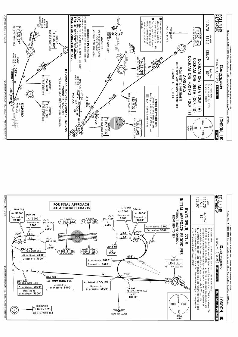
OCKHAM O
NE A
LFA (O
CK 1A
)OCKHAM O
NE D
ELTA (O
CK 1D
)OCKHAM O
NE FO
XTRO
T (OCK 1F)
SLP
Speed L
imit P
oin
t
Cro
ss S
LP o
r 3 M
IN b
efo
re
hold
ing fa
cility
at 2
50 K
T o
r less.
SPEED
REST
RIC
TIO
N
WHEN
OCK V
OR U
NSERV
ICEA
BLE USE
To b
e u
sed w
hen O
CK V
OR u
nserv
iceable
.
by 4
0 N
M b
efo
re O
CK
TO
MM
O 1
AT
OM
MO
1D
TO
MM
O 1
F
[TOM
O1A
], [TO
MO
1D]
[TOM
O1F]
WA
RN
IN
GDo n
ot p
roceed b
eyond
OCK/TOMMO
with
out A
TC c
leara
nce.
286^
N51 18.8
W001 10.3
OC
K 1
A, 1
F:
Licensed to BR
ITISH A
IRW
AYS PLC
, . Printed from JeppView
disc 23-06.N
otice: After 7.12.2006 0901Z this chart should not be used w
ithout first checking JeppView or N
OTA
Ms.
001^
303^295^
279^
IRR*110.3 IRR
IBB*109.5 IBB
ILS DME
ILS DME
IAA*110.3 IAAILS DME
ILL*109.5 ILLILS DME
.Eff.24.Nov.
EGLL/LH
RHEA
THRO
WLO
NDON, U
K
Apt Ele
v
83'
*A
TIS
CH
AN
GES:
JEPPESEN
10-2F
113.75115.1
128.07
Alt S
et: h
Pa T
rans le
vel: B
y A
TC T
rans a
lt: 6000'
.INITIA
L.APPROACH.
1.
Min
imum h
old
ing le
vel (F
light L
evel E
quiv
ale
nt o
f 7000') is
above T
A
and w
ill be a
llocate
d b
y A
TC.
2.In
itial a
ppro
ach p
rocedure
s a
re
3.
unle
ss o
therw
ise in
stru
cte
d b
y A
TC. P
rocedure
desig
n is
compatib
le
with
3^ d
escent p
ath
from 6
000'.
Contin
uous d
escent a
ppro
ach s
hould
be u
sed w
henever p
ractic
able
New
chart.|
JEPPESEN
SAN
DERSO
N, IN
C., 2005. A
LL RIGHTS RESERV
ED.
INITIA
L APPRO
ACH PRO
CED
URES
WITH
OUT RA
DAR C
ONTRO
L
RWYS 09L/R, 27L/R
BIG115.1 BIGBIGGIN
N51 19.9 E000 02.1
D
(IAF)
277^275^
D26 BIG
N51 22.2 W000 44.0D29 BIG
26
3
6
2.5
2.5
092^
092^4
3
D35 GWCN51 26.3 W000 47.4
D10 IBB
D7.5 IAA(FAF)
D10 IAA
D7.5 IBB(FAF)
GOODWOOD
114.75 GWCGWCN50 51.3 W000 45.4
D
N51 20.3 W000 12.2D9 BIG
9
093^
9 DME
272^2.5
272^2.5
1615
D10 IRRD10 ILL
D7.5 IRR(FAF)
(FAF)D7.5 ILL
desig
ned fo
r manoeuvrin
g s
peeds u
p to
220 K
T T
AS a
nd a
ssume a
cft
can m
ain
tain
a d
escent g
radie
nt o
f appro
xim
ate
ly 3
20' p
er N
M.
FROM BIG
TO ILS
2500'Descend to
3000'At2500'
Descend to
3000'At
2500'At
2500'At
6000'
At MNM HLDG LVL
at or aboveDescend to
3500'Descend to
At or above 6000'
3000'Descend to
At or above 3500'
2500'Descend to
3000'At
2500'Descend to
3000'At
2500'At
MSAARP
3500'at or aboveDescend to
At or above 6000' 6000'
At MNM HLDG LVL
at or aboveDescend to
2500'At
180 KTMAX
3000'Descend to
At or above 3500'
18 NO
V 05
NOT TO SCALE
7000
303^
123^
360^
2300'2100'
180^
FOR FINAL APPROACHSEE APPROACH CHARTS
Licensed to BR
ITISH A
IRW
AYS PLC
, . Printed from JeppView
disc 23-06.N
otice: After 7.12.2006 0901Z this chart should not be used w
ithout first checking JeppView or N
OTA
Ms.

268^
134^
R001^
LAMBOURNE
115.6 LAMLAMN51 38.8 E000 09.1
D
BOVINGDON113.75 BNNBNN
N51 43.6 W000 33.0
D.Eff.24.N
ov.
EGLL/LH
RHEA
THRO
WLO
NDON, U
K
Apt Ele
v
83'
*A
TIS
CH
AN
GES:
JEPPESEN
10-2G
113.75115.1
128.07
Alt S
et: h
Pa T
rans le
vel: B
y A
TC T
rans a
lt: 6000'
.INITIA
L.APPROACH.
1.
Min
imum h
old
ing le
vel (F
light L
evel E
quiv
ale
nt o
f 7000') is
above T
A
and w
ill be a
llocate
d b
y A
TC.
2.In
itial a
ppro
ach p
rocedure
s a
re
3.
unle
ss o
therw
ise in
stru
cte
d b
y A
TC. P
rocedure
desig
n is
compatib
le
with
3^ d
escent p
ath
from 6
000'.
Contin
uous d
escent a
ppro
ach s
hould
be u
sed w
henever p
ractic
able
New
chart.|
JEPPESEN
SAN
DERSO
N, IN
C., 2005. A
LL RIGHTS RESERV
ED.
INITIA
L APPRO
ACH PRO
CED
URES
WITH
OUT RA
DAR C
ONTRO
L
RWYS 09L/R, 27L/R
129^
180^ D11 BNN
(IAF)
D15 BNN
D19 BNNN51 32.3W000 08.5
11
4
4
6
7
272^2.5
272^2.5
D10 IRR
D10 ILL
D7.5 IRR(FAF)
(FAF)D7.5 ILL
IRR*110.3 IRRILS DME
IAA*110.3 IAAILS DME
IBB*109.5 IBBILS DME
ILL*109.5 ILLILS DME
D5 BNN
5
6
4
D30 LAM
D34 LAMN51 35.6 W000 45.2
181 ^
D39 GWCN51 30.2 W000 47.6
2.5
2.5
092^
092^
D10 IBB
D7.5 IAA(FAF)
D10 IAA
D7.5 IBB(FAF)
GOODWOOD114.75 GWCGWC
N50 51.3 W000 45.4
D
4
4
7
desig
ned fo
r manoeuvrin
g s
peeds u
p to
220 K
T T
AS a
nd a
ssume a
cft
can m
ain
tain
a d
escent g
radie
nt o
f appro
xim
ate
ly 3
20' p
er N
M.
FROM BN
N TO
ILS
N51 38.6 W000 32.6
MSAARP
6000'
At MNM HLDG LVL
at or aboveDescend to
3500'Descend to
At or above 6000'
180 KTMAX
2500'At
2500'Descend to
3000'At
3000'Descend to
At or above3500'
AtMNM HLDG LVL
3500'at or aboveDescend to
At or above 6000'
2500'At
2500'At
3000'Descend to
At or above 3500'
2500'Descend to
3000'At
2500'At
2500'Descend to
3000'At
2500'Descend to
3000'At
6000'
At MNM HLDG LVL
at or aboveDescend to
NOT TO SCALE
360^
2300'2100'
180^
18 NO
V 05
7000
119^
299^
FOR FINAL APPROACHSEE APPROACH CHARTS
Licensed to BR
ITISH A
IRW
AYS PLC
, . Printed from JeppView
disc 23-06.N
otice: After 7.12.2006 0901Z this chart should not be used w
ithout first checking JeppView or N
OTA
Ms.
129^
134^
R001^
113.75115.1
128.07unle
ss o
therw
ise in
stru
cte
d b
y A
TC. P
rocedure
desig
n is
compatib
le
with
3^ d
escent p
ath
from 6
000'.
N51 32.3W000 08.5
desig
ned fo
r manoeuvrin
g s
peeds u
p to
220 K
T T
AS a
nd a
ssume a
cft
can m
ain
tain
a d
escent g
radie
nt o
f appro
xim
ate
ly 3
20' p
er N
M.
JEPPESEN
EGLL/LH
RHEA
THRO
WLO
NDON, U
K
Apt Ele
v
83'
*A
TIS
CH
AN
GES:
10-2H
Alt S
et: h
Pa T
rans le
vel: B
y A
TC T
rans a
lt: 6000'
.INITIA
L.APPROACH.
1.
Min
imum h
old
ing le
vel (F
light L
evel E
quiv
ale
nt o
f 7000') is
above T
A
and w
ill be a
llocate
d b
y A
TC.
2.In
itial a
ppro
ach p
rocedure
s a
re
3.
Contin
uous d
escent a
ppro
ach s
hould
be u
sed w
henever p
ractic
able
| JEP
PESEN
SAN
DERSO
N, IN
C., 2005. A
LL RIGHTS RESERV
ED.
D19 BNN
15 DME
275^268^
LAMBOURNE115.6 LAMLAM
N51 38.8 E000 09.1
D
(IAF)
D11 LAM
11
9
IRR*110.3 IRRILS DME
IAA*110.3 IAAILS DME
IBB*109.5 IBBILS DME
ILL*109.5 ILLILS DME
6
7
272^2.5
272^2.5
D10 IRR
D10 ILL
D7.5 IRR(FAF)
(FAF)D7.5 ILL
BOVINGDON113.75 BNNBNN
N51 43.6 W000 33.0
D
D30 LAM
4
D34 LAMN51 35.6 W000 45.2
181^
D39 GWCN51 30.2 W000 47.6
2.5
2.5
092^
092^
D10 IBB
D7.5 IAA(FAF)
D10 IAA
D7.5 IBB(FAF)
GOODWOOD
114.75 GWCGWCN50 51.3 W000 45.4
D
4
4
7
30
INITIA
L APPRO
ACH PRO
CED
URES
WITH
OUT RA
DAR C
ONTRO
L
RWYS 09L/R, 27L/R
N51 39.1 W000 08.6
FROM LA
M TO
ILS
None.
3000'Descend to
At or above3500'
MSAARP
180 KTMAX
6000'
At MNM HLDG LVL
at or aboveDescend to
2500'At
2500'Descend to
3000'At
2500'At
2500'At
3000'Descend to
At or above 3500'
2500'Descend to
3000'At
3500'at or aboveDescend to
At or above 6000'
6000'
At MNM HLDG LVL
at or aboveDescend to
2500'At
2500'Descend to
3000'At
2500'Descend to
3000'At
3500'at or aboveDescend to
At or above 6000'
NOT TO SCALE
360^
2300'2100'
180^
FOR FINAL APPROACHSEE APPROACH CHARTS
7000266^
086^
3 FEB 06
Licensed to BR
ITISH A
IRW
AYS PLC
, . Printed from JeppView
disc 23-06.N
otice: After 7.12.2006 0901Z this chart should not be used w
ithout first checking JeppView or N
OTA
Ms.

001^
065^
113.75115.1
128.07unle
ss o
therw
ise in
stru
cte
d b
y A
TC. P
rocedure
desig
n is
compatib
le
with
3^ d
escent p
ath
from 6
000'.
desig
ned fo
r manoeuvrin
g s
peeds u
p to
220 K
T T
AS a
nd a
ssume a
cft
can m
ain
tain
a d
escent g
radie
nt o
f appro
xim
ate
ly 3
20' p
er N
M.
OCKHAM
115.3 OCKOCKN51 18.3 W000 26.8
D
EGLL/LH
RHEA
THRO
WLO
NDON, U
K
Apt Ele
v
83'
*A
TIS
CH
AN
GES:
10-2J
Alt S
et: h
Pa T
rans le
vel: B
y A
TC T
rans a
lt: 6000'
.INITIA
L.APPROACH.
1.
Min
imum h
old
ing le
vel (F
light L
evel E
quiv
ale
nt o
f 7000') is
above T
A
and w
ill be a
llocate
d b
y A
TC.
2.In
itial a
ppro
ach p
rocedure
s a
re
3.
Contin
uous d
escent a
ppro
ach s
hould
be u
sed w
henever p
ractic
able
(IAF)
290^ 077^
5
2.5
2.5
092^
092^4
3
D35 GWCN51 26.3 W000 47.4
D10 IBB
D7.5 IAA(FAF)
D10 IAA
D7.5 IBB(FAF)
N51 21.8 W000 45.1D12 OCK
GOODWOOD
114.75 GWCGWCN50 51.3 W000 45.4
D
D8 OCK
4
8
INITIA
L APPRO
ACH PRO
CED
URES
WITH
OUT RA
DAR C
ONTRO
L
RWYS 09L/R, 27L/R
272^2.5
272^
2.510
10
D10 IRRD10 ILL
D7.5 IRR(FAF)
(FAF)D7.5 ILL
7
4
1
D7 OCK
D11 OCK
D12 OCK
360^
IRR*110.3 IRRILS DME
IAA*110.3 IAAILS DME
IBB*109.5 IBBILS DME
ILL*109.5 ILLILS DME
N51 21.5 W000 08.4
FROM O
CK TO
ILS
Holding over O
CK.
| JEP
PESEN
SAN
DERSO
N, IN
C., 2005, 2006. A
LL RIGHTS RESERV
ED.
JEPPESEN
MSAARP
2500'Descend to
3000'At2500'
Descend to
3000'At
2500'At
2500'At
6000'
At MNM HLDG LVL
at or aboveDescend to
2500'Descend to
3000'At
2500'Descend to
3000'At
2500'At
3500'at or aboveDescend to
At or above 6000'
3000'Descend to
At or above 3500'
3500'at or aboveDescend to
At or above 6000'
3000'Descend to
At or above 3500'2500'
At
6000'
At MNM HLDG LVL
at or aboveDescend to
7000
332^152^
3 FEB 06
NOT TO SCALE
360^
2300'2100'
180^
FOR FINAL APPROACHSEE APPROACH CHARTS
Licensed to BR
ITISH A
IRW
AYS PLC
, . Printed from JeppView
disc 23-06.N
otice: After 7.12.2006 0901Z this chart should not be used w
ithout first checking JeppView or N
OTA
Ms.
300^
318^
N51 30.2 W
000 37.5
1.
3.
4.
Apt Elev
.SID.
83'
EGLL/LH
R10-3
Tra
ns le
vel: B
y A
TC T
rans a
lt: 6000'
LONDON, U
KHEA
THRO
W
LON
DO
N C
ontrol
118.822.
056^
066^
46
4000'
Above
DLO
NDON
113.6 LON
LO
NN51 29.2 W
000 28.0
CHILTERN
277 CHT
CH
TN51 37.4 W
000 31.1
BURN
HAM
421 BUR
BU
RN51 31.1 W
000 40.6
D6 LO
N
D4 LO
ND3 LO
NBPK
6F
BPK 6
G
301^
1
2
3
2
R246^
D
N51 45.0 W
000 06.4B
PK
117.5 BPK
BROOKMANS
PARK
17
6000'
RWY 23 w
ithdrawn.
| JEP
PESEN
SAN
DERSO
N, IN
C., 2004, 2005. A
LL RIGHTS RESERV
ED.
MSA
ARP
NO
T TO SC
ALE
27R
BPK
6F
BPK
6G
27L
4000'.
243' p
er N
M
75
100
405
304
150
608
810
1013
1215
300
250
200
360^
2300'2100'
180^
Gnd s
peed-K
T
1090',
CH
AN
GES:
JEPPESEN
30 DEC
05
Initia
l clim
b s
traig
ht a
head to
590'.
Cru
isin
g le
vels
will b
e is
sued a
fter ta
ke-o
ffby L
ONDON C
ontro
l.
there
afte
r main
tain
a m
inim
um c
limb g
radie
nt
of
243' p
er N
M (4
%) u
p to
RW
YSID 3500'
Above
6000'
At
WA
RN
IN
G:
Due to
inte
ractio
n w
ithoth
er ro
ute
s d
o n
ot c
limb a
bove
until c
leare
d b
y A
TC.
SID
s in
clu
de n
ois
e p
refe
rentia
l route
s (re
fer
to 1
0-4
B).
Do n
ot c
limb a
bove S
IDle
vels
until in
stru
cte
d b
y A
TC.
Cro
ss a
ppro
pria
te N
ois
e M
onito
ring T
erm
inal
(refe
r to c
hart 1
0-4
B) a
t or a
bove
RO
UT
IN
G
Stra
ight a
head, in
terc
ept 3
01^ b
earin
g to
ward
s B
UR b
y D
4 L
ON to
D6 L
ON,
turn
RIG
HT, in
terc
ept 0
56^ b
earin
g to
CHT, tu
rn R
IGHT, in
terc
ept B
PK
R-2
46 in
bound to
BPK.
Stra
ight a
head, in
terc
ept 3
01^ b
earin
g to
ward
s B
UR b
y D
3 L
ON to
D6 L
ON,
turn
RIG
HT, in
terc
ept 0
56^ b
earin
g to
CHT, tu
rn R
IGHT, in
terc
ept B
PK
R-2
46 in
bound to
BPK.
MA
X 2
50 K
T B
ELO
W F
L100
BROOKMANS PA
RK SIX
FOXTRO
T (BPK 6F)
BROOKMANS PA
RK SIX
GOLF (BPK
6G)
UNLE
SS O
THERW
ISE A
UTHO
RIS
ED
RWYS 27R/L D
EPARTU
RESSPEED:
Licensed to BR
ITISH A
IRW
AYS PLC
, . Printed from JeppView
disc 23-06.N
otice: After 7.12.2006 0901Z this chart should not be used w
ithout first checking JeppView or N
OTA
Ms.

073^
N51 32.7 W
000 13.0
1.
3.
4.
.SID.
EGLL/LH
R
Tra
ns le
vel: B
y A
TC T
rans a
lt: 6000'
LONDON, U
KHEA
THRO
W10-3A
DLO
NDON
113.6 LON
LO
NN51 29.2 W
000 28.0
018^
R198^
D10 LO
N
D8 B
PK
8
5
D
N51 45.0 W
000 06.4B
PK
117.5 BPK
BROOKMANS
PARK
4000'
Above
053^053^ BPK 4
KBPK 5J
2DME 1.5 DME
910
6000'
Apt Elev
83'LO
ND
ON
Control
118.822.
RWY 23 w
ithdrawn.
| JEP
PESEN
SAN
DERSO
N, IN
C., 2004, 2005. A
LL RIGHTS RESERV
ED.
MSA
ARP
09R
BPK
5J
BPK
4K
09L
4000'.
243' p
er N
M
75
100
405
304
150
608
810
1013
1215
300
250
200
360^
2300'2100'
180^Gnd s
peed-K
T
MA
X 2
50 K
T B
ELO
W F
L100
1090',
CH
AN
GES:
JEPPESEN
30 DEC
05
BROOKMANS PA
RK FIV
E JULIETT (BPK
5J)
Cru
isin
g le
vels
will b
e is
sued a
fter ta
ke-o
ffby L
ONDON C
ontro
l.
UNLE
SS O
THERW
ISE A
UTHO
RIS
ED
there
afte
r main
tain
a m
inim
um c
limb g
radie
nt
of
243' p
er N
M (4
%) u
p to
RW
YSID
BROOKMANS PA
RK FO
UR K
ILO (BPK
4K)
RWYS 09R/L D
EPARTU
RES
Stra
ight a
head, a
t LON 2
DM
E tu
rn L
EFT, 0
53^ tra
ck, in
terc
ept L
ON R
-073
to D
10 L
ON, tu
rn L
EFT, in
terc
ept B
PK R
-198 in
bound to
BPK.
Stra
ight a
head, a
t LON 1
.5 D
ME tu
rn L
EFT, 0
53^ tra
ck, in
terc
ept L
ON
R-0
73 to
D10 L
ON, tu
rn L
EFT, in
terc
ept B
PK R
-198 in
bound to
BPK.
6000'
At
NO
T TO SC
ALE
3000'
Above
WA
RN
IN
G:
Due to
inte
ractio
n w
ithoth
er ro
ute
s d
o n
ot c
limb a
bove
until c
leare
d b
y A
TC.
levels
until in
stru
cte
d b
y A
TC.
Do n
ot c
limb a
bove S
ID
SID
s in
clu
de n
ois
e p
refe
rentia
l route
s (re
fer
to 1
0-4
B).
Initia
l clim
b s
traig
ht a
head to
590'.
Cro
ss a
ppro
pria
te N
ois
e M
onito
ring T
erm
inal
(refe
r to c
hart 1
0-4
B) a
t or a
bove
RO
UT
IN
G
SPEED:
Licensed to BR
ITISH A
IRW
AYS PLC
, . Printed from JeppView
disc 23-06.N
otice: After 7.12.2006 0901Z this chart should not be used w
ithout first checking JeppView or N
OTA
Ms.
073^
D43
332^
BIG115.1
BIG
BUZA
DN51 56.5 W
000 33.1
N51 32.7 W
000 13.0
.SID.
EGLL/LH
RLO
NDON, U
KHEA
THRO
W
119.77
10-3B
DLO
NDON
113.6 LON
LO
NN51 29.2 W
000 28.0
D10 LO
N
053^053^ BUZ 2K
BUZ 3J
2DM
E 1.5 DME
910
13
5
5
D20 B
IG
4000'
Above
5000'
Above
D25 B
IG
D30 B
IG
5
6000'
1.
3.
4.
Apt Elev
83'
Tra
ns le
vel: B
y A
TC T
rans a
lt: 6000'
LON
DO
N C
ontrol2.
[BUZA
3J]
[BUZA
2K]
RWY 23 w
ithdrawn.
| JEPPESEN
SAN
DERSO
N, IN
C., 2004, 2005. A
LL RIGHTS RESERV
ED.
MSA
ARP
09R
BU
Z 3
J
BU
Z 2
K09L
4000'.
243' p
er N
M
75
100
405
304
150
608
810
1013
1215
300
250
200
360^
2300'2100'
180^
Gnd s
peed-K
T
MA
X 2
50 K
T B
ELO
W F
L100
1090',
CHA
NG
ES:
JEPPESEN
30 DEC
05
UNLE
SS O
THERW
ISE A
UTHO
RIS
ED
there
afte
r main
tain
a m
inim
um c
limb g
radie
nt
of
243' p
er N
M (4
%) u
p to
RW
YSID
RWYS 09R/L D
EPARTU
RES
NO
T TO SC
ALE
BUZAD TH
REE JULIETT (BU
Z 3J)
BUZAD TW
O K
ILO (BU
Z 2K
)
Stra
ight a
head, a
t LON 2
DM
E tu
rn L
EFT, 0
53^ tra
ck, in
terc
ept L
ON R
-073
to D
10 L
ON, tu
rn L
EFT, in
terc
ept B
IG R
-332 to
BUZAD.
Stra
ight a
head, a
t LON 1
.5 D
ME tu
rn L
EFT, 0
53^ tra
ck, in
terc
ept L
ON
R-0
73 to
D10 L
ON, tu
rn L
EFT, in
terc
ept B
IG R
-332 to
BUZAD.
3000'
Above
6000'
At
WA
RN
IN
G:
Due to
inte
ractio
n w
ithoth
er ro
ute
s d
o n
ot c
limb a
bove
until c
leare
d b
y A
TC.
Initia
l clim
b s
traig
ht a
head to
590'.
Cru
isin
g le
vels
will b
e is
sued a
fter ta
ke-o
ffby L
ONDON C
ontro
l.
SID
s in
clu
de n
ois
e p
refe
rentia
l route
s (re
fer
to 1
0-4
B).
Do n
ot c
limb a
bove S
IDle
vels
until in
stru
cte
d b
y A
TC.
Cro
ss a
ppro
pria
te N
ois
e M
onito
ring T
erm
inal
(refe
r to c
hart 1
0-4
B) a
t or a
bove
RO
UTIN
G
SPEED:
Licensed to BR
ITISH A
IRW
AYS PLC
, . Printed from JeppView
disc 23-06.N
otice: After 7.12.2006 0901Z this chart should not be used w
ithout first checking JeppView or N
OTA
Ms.

258^
.SID.
EGLL/LH
RLO
NDON, U
KHEA
THRO
W
134.12
10-3CDLONDON
113.6 LONLONN51 29.2 W000 28.0
CPT 3F
CPT 3G284^
R104^
D
N51 29.5 W001 13.2CPT114.35 CPTCOMPTON
WODN51 27.2 W000 52.7
WOODLEY
352 WOD
5
8
D13 CPT
D8 CPT D7 LON272^4 4
6
6
D11 LOND17 CPT
6000'
Apt Elev
83'LO
ND
ON
Control
N51 27.4 W000 38.8
RWY 23 w
ithdrawn.
| JEP
PESEN
SAN
DERSO
N, IN
C., 2004, 2005. A
LL RIGHTS RESERV
ED.
1.
3.4.
Tra
ns le
vel: B
y A
TC T
rans a
lt: 6000'
2.
MSAARP
MA
X 2
50 K
T B
ELO
W F
L100
CH
AN
GES:
JEPPESEN
30 DEC
05
UNLE
SS O
THERW
ISE A
UTHO
RIS
ED
COMPTO
N TH
REE FOXTRO
T (CPT 3F)
COMPTO
N TH
REE GOLF (C
PT 3G)
6000'At
4000'Above
27RCPT 3F
CPT 3G 27L
4000'.
243' per NM
75 100
405304
150
608 810 1013 1215
300250200Gnd speed-KT
1090',thereafter maintain a minimum climb gradientof243' per NM (4%) up to
RWYSID
These SIDs require a minimum climb gradientof304' per NM (5%) until D8 CPT.
506380 760 1013 1266 1519304' per NM
NOT TO SCALE
Straight ahead, intercept LON R-258 to D7 LON, turn RIGHT,intercept 272^ bearing to WOD (D13 CPT), then to CPT.
WARNING: Due to interaction withother routes do not climb above
until cleared by ATC.
RWYS 27R/L D
EPARTU
RES
3000'Above
Cross appropriate Noise Monitoring Terminal(refer to chart 10-4B) at or above
ROUTING
SID
s in
clu
de n
ois
e p
refe
rentia
l route
s (re
fer to
10-4
B).
Initia
l clim
b s
traig
ht a
head to
590'.
Cru
isin
g le
vels
will b
e is
sued a
fter
take-o
ff by L
ONDON C
ontro
l.Do n
ot c
limb a
bove S
ID le
vels
until in
stru
cte
d b
y A
TC.
360^
2300'2100'
180^
SPEED:
Licensed to BR
ITISH A
IRW
AYS PLC
, . Printed from JeppView
disc 23-06.N
otice: After 7.12.2006 0901Z this chart should not be used w
ithout first checking JeppView or N
OTA
Ms.
.SID.
EGLL/LH
RLO
NDON, U
KHEA
THRO
W
134.97
10-3D
DLONDON
113.6 LONLONN51 29.2 W000 28.0
HEA
THRO
W D
irector
D
N51 29.5 W001 13.2CPT114.35 CPTCOMPTON
R104^
D8 CPT
8
5
284^
1.5
DME
2 DME
284^
CPT4K
CPT5J
D11 LOND17 CPT
4
WODN51 27.2 W000 52.7
WOODLEY
352 WOD
D13 CPT
18
17
6000'
Apt Elev
83'
RWY 23 w
ithdrawn.
| JEP
PESEN
SAN
DERSO
N, IN
C., 2004, 2005. A
LL RIGHTS RESERV
ED.
1.
3.4.
Tra
ns le
vel: B
y A
TC T
rans a
lt: 6000'
2.
MSAARP
MA
X 2
50 K
T B
ELO
W F
L100
CH
AN
GES:
JEPPESEN
30 DEC
05
UNLE
SS O
THERW
ISE A
UTHO
RIS
ED
09RCPT 5J
CPT 4K 09L
4000'.
243' per NM
75 100
405304
150
608 810 1013 1215
300250200Gnd speed-KT
1090',thereafter maintain a minimum climb gradientof243' per NM (4%) up to
RWYSID
354266 532 709 886 1063213' per NM
COMPTO
N FIV
E JULIETT (C
PT 5J)COMPTO
N FO
UR K
ILO (C
PT 4K)
RWYS 09R/L D
EPARTU
RES
These SIDs require a minimum climb gradientof213' per NM (3.5%) until D8 CPT.
6000'At
Straight ahead, at LON 2 DME turn RIGHT, intercept 284^bearing to WOD (D13 CPT), then to CPT.
Straight ahead, at LON 1.5 DME turn RIGHT, intercept 284^bearing to WOD (D13 CPT), then to CPT.
NOT TO SCALE
3000'Above
4000'Above
WARNING: Due to interaction withother routes do not climb above
until cleared by ATC.
ROUTING
Cross appropriate Noise Monitoring Terminal(refer to chart 10-4B) at or above
360^
2300'2100'
180^
SID
s in
clu
de n
ois
e p
refe
rentia
l route
s (re
fer to
10-4
B).
Initia
l clim
b s
traig
ht a
head to
590'.
Cru
isin
g le
vels
will b
e is
sued a
fter
take-o
ff by L
ONDON C
ontro
l.Do n
ot c
limb a
bove S
ID le
vels
until in
stru
cte
d b
y A
TC.
SPEED:
Licensed to BR
ITISH A
IRW
AYS PLC
, . Printed from JeppView
disc 23-06.N
otice: After 7.12.2006 0901Z this chart should not be used w
ithout first checking JeppView or N
OTA
Ms.

.SID.
EGLL/LH
RLO
NDON, U
KHEA
THRO
W
120.52
10-3E
DLONDON
113.6 LONLONN51 29.2 W000 28.0
D ILLN51 27.8 W000 27.5
140^
DET
2
F
DET 2
G
DVR 4
GDVR
5
F
LON
2DME
1DME
ILL
EPSOM
EPMN51 19.2 W000 22.3
316 EPM
(109.5) ILL
093^
5 3
D32 DET
D29 DET
R273^
R289^
109^
24 5
D5 DET
D117.3 DETDET
N51 18.2 E000 35.8
DDOVER
114.95 DVRDVRN51 09.8 E001 21.6
DETLING
30
11
13
HEATHROW
6000'
ILS DME
1
D10 LON
1.
3.4.
Apt Elev
83'
Tra
ns le
vel: B
y A
TC T
rans a
lt: 6000'
LON
DO
N C
ontrol2.DVR5F, 4G
RWY 23 w
ithdrawn.
| JEP
PESEN
SAN
DERSO
N, IN
C., 2004, 2005. A
LL RIGHTS RESERV
ED.
MSAARP
MA
X 2
50 K
T B
ELO
W F
L100
CH
AN
GES:
JEPPESEN
30 DEC
05
UNLE
SS O
THERW
ISE A
UTHO
RIS
ED
DETLIN
G TW
O FO
XTRO
T (DET 2F)
DETLIN
G TW
O G
OLF (D
ET 2G)
DOVER FIV
E FOXTRO
T (DVR 5F)
DOVER FO
UR G
OLF (D
VR 4G
)
4000'At or above
6000'At
4000'.
304' per NM
75 100
506380
150
760 1013 1266 1519
300250200Gnd speed-KT
1090',thereafter maintain a minimum climb gradientof243' per NM (4%) up to
466349 699 932 1165 1398280' per NM
These SIDs require minimum climb gradientsof
DET 2F, DVR 5F280' per NM (4.6%) until EPM.
DET 2G, DVR 4G304' per NM (5%) until EPM.
405304 608 810 1013 1215243' per NM
NOT TO SCALE
WARNING: Due to interaction with other routesdo not climb above until cleared by ATC.
6000'At5000'At or above
RWYS 27R/L D
EPARTU
RES
Cross appropriate Noise Monitoring Terminal(refer to chart 10-4B) at or above
27R
27L
RWYSID ROUTING
DET 2F
DET 2G
27R
27L
DVR 5F
DVR 4G
Straight ahead, at LON 2 DME turn LEFT, intercept 140^ bearing to EPM, at EPM, but not before D10 LON intercept DET R-273 inbound to DET, then to DVR.
Straight ahead, at ILL 1 DME (LON 2 DME if ILL u/s) turn LEFT, intercept 140^ bearing to EPM, at EPM, but not before D10 LON intercept DET R-273 inbound to DET.
Straight ahead, at ILL 1 DME (LON 2 DME if ILL u/s) turn LEFT, intercept 140^ bearing to EPM, at EPM, but not before D10 LON intercept DET R-273 inbound to DET, then to DVR.
Straight ahead, at LON 2 DME turn LEFT, intercept 140^ bearing to EPM, at EPM, but not before D10 LON intercept DET R-273 inbound to DET.
360^
2300'2100'
180^
SID
s in
clu
de n
ois
e p
refe
rentia
l route
s (re
fer to
10-4
B).
Initia
l clim
b s
traig
ht a
head to
590'.
Cru
isin
g le
vels
will b
e is
sued a
fter
take-o
ff by L
ONDON C
ontro
l.Do n
ot c
limb a
bove S
ID le
vels
until in
stru
cte
d b
y A
TC.
SPEED:
Licensed to BR
ITISH A
IRW
AYS PLC
, . Printed from JeppView
disc 23-06.N
otice: After 7.12.2006 0901Z this chart should not be used w
ithout first checking JeppView or N
OTA
Ms.
.SID.
EGLL/LH
RLO
NDON, U
KHEA
THRO
W10-3F1.
5DM
E
2 DME
DLONDON
113.6 LONN51 29.2 W000 28.0
124^124^
R289^
109^
D117.3 DETDET
N51 18.2 E000 35.8
DDOVER
114.95 DVRDVRN51 09.8 E001 21.6
DETLING
30DVR6J, 6K
R286^
106^
5
11
4
9
5
DET 1JDVR 6J
DET 1KDVR 6K
4DME
D16 DET
D5 DET
D20 DET
D34 DET
D29 DET
LON
6
6
6000'
120.52A
pt Elev
83'LO
ND
ON
Control
1.
3.4.
Tra
ns le
vel: B
y A
TC T
rans a
lt: 6000'
2.
RWY 23 w
ithdrawn.
| JEP
PESEN
SAN
DERSO
N, IN
C., 2004, 2005. A
LL RIGHTS RESERV
ED.
MSAARP
MA
X 2
50 K
T B
ELO
W F
L100
CH
AN
GES:
JEPPESEN
30 DEC
05
UNLE
SS O
THERW
ISE A
UTHO
RIS
ED
09R
09L
RWYSID
DETLIN
G O
NE JU
LIETT (DET 1J)
DETLIN
G O
NE K
ILO (D
ET 1K)
DOVER SIX
KILO
(DVR 6K
)DOVER SIX
JULIETT (D
VR 6J)
RWYS 09R/L D
EPARTU
RES
Straight ahead, at LON 1.5 DME turn RIGHT, 124^ track, at LON 4 DMEturn LEFT, intercept DET R-286 inbound by D34 DET to DET, then to DVR.
Straight ahead, at LON 2 DME turn RIGHT, 124^ track, at LON 4 DMEturn LEFT, intercept DET R-286 inbound by D34 DET to DET, then to DVR.
Straight ahead, at LON 1.5 DME turn RIGHT, 124^ track, at LON 4 DMEturn LEFT, intercept DET R-286 inbound by D34 DET to DET.
Straight ahead, at LON 2 DME turn RIGHT, 124^ track, at LON 4 DMEturn LEFT, intercept DET R-286 inbound by D34 DET to DET.
09R
09L
DVR 6J
DVR 6K
DET 1J
DET 1K
6000'At
5000'At or above
6000'At
3000'At or above
4000'.
1090',thereafter maintain a minimum climb gradientof243' per NM (4%) up to
243' per NM
75 100
405304
150
608 810 1013 1215
300250200Gnd speed-KT
NOT TO SCALE
WARNING: Due to interaction with other routesdo not climb above until cleared by ATC.
SID
s in
clu
de n
ois
e p
refe
rentia
l route
s (re
fer to
10-4
B).
Initia
l clim
b s
traig
ht a
head to
590'.
Cru
isin
g le
vels
will b
e is
sued a
fter
take-o
ff by L
ONDON C
ontro
l.Do n
ot c
limb a
bove S
ID le
vels
until in
stru
cte
d b
y A
TC.
360^
2300'2100'
180^
Cross appropriate Noise Monitoring Terminal(refer to chart 10-4B) at or above
ROUTING
SPEED:
Licensed to BR
ITISH A
IRW
AYS PLC
, . Printed from JeppView
disc 23-06.N
otice: After 7.12.2006 0901Z this chart should not be used w
ithout first checking JeppView or N
OTA
Ms.

.SID.
EGLL/LH
RLO
NDON, U
KHEA
THRO
W
126.82
10-3G
DLO
NDON
113.6 LON
LO
NN51 29.2 W
000 28.0
DILL
N51 27.8 W
000 27.5
140^ MAY 3F
MAY 2G
LON2DME
1DMEILL
(109.5) ILL
11
13
HEA
THRO
WILS D
ME
D10 LO
N
DMAYFIELD
117.9 MAY
MAY
N51 01.0 E000 07.0
R317^
EPSOM
EPM
N51 19.2 W
000 22.3
316 EPM
1
137^
5000'
5.26
1.
3.
4.
Apt Elev
83'
Tra
ns le
vel: B
y A
TC T
rans a
lt: 6000'
LON
DO
N C
ontrol2.
RWY 23 w
ithdrawn.
| JEP
PESEN
SAN
DERSO
N, IN
C., 2004, 2005. A
LL RIGHTS RESERV
ED.
MSA
ARP
NO
T TO SC
ALE
27R
MA
Y 3
F
MA
Y 2
G27L
243' p
er N
M
75
100
405
304
150
608
810
1013
1215
300
250
200
360^
2300'2100'
180^
Gnd s
peed-K
T
MA
X 2
50 K
T B
ELO
W F
L100
CH
AN
GES:
JEPPESEN
30 DEC
05
UNLE
SS O
THERW
ISE A
UTHO
RIS
ED
RW
YSID
MAYFIELD
THREE FO
XTRO
T (MAY 3F)
MAYFIELD
TWO G
OLF (M
AY 2G
)
4000'.
1090',
there
afte
r main
tain
a m
inim
um c
limb g
radie
nt
of
243' p
er N
M (4
%) u
p to
TO EG
KK O
NLY
D5
090^
2 70^
5000'
At
WA
RN
IN
G:
Due to
inte
ractio
n w
ithoth
er ro
ute
s d
o n
ot c
limb a
bove
until c
leare
d b
y A
TC.
Initia
l clim
b s
traig
ht a
head to
590'.
Cru
isin
g le
vels
will b
e is
sued a
fter ta
ke-o
ffby L
ONDON C
ontro
l.
SID
s in
clu
de n
ois
e p
refe
rentia
l route
s (re
fer
to 1
0-4
B).
Do n
ot c
limb a
bove S
IDle
vels
until in
stru
cte
d b
y A
TC.
Airc
raft V
OR
or D
ME fa
ilure
advis
e A
TC a
nd c
omply
with
ATC
instru
ctio
ns.
RWYS 27R/L D
EPARTU
RES
Cro
ss a
ppro
pria
te N
ois
e M
onito
ring T
erm
inal
(refe
r to c
hart 1
0-4
B) a
t or a
bove
RO
UT
IN
G
Stra
ight a
head, a
t LON 2
DM
E tu
rn L
EFT, in
terc
ept 1
40^ b
earin
g to
EPM
,at E
PM
, but n
ot b
efo
re D
10 L
ON in
terc
ept M
AY R
-317 in
bound to
MAY.
Stra
ight a
head, a
t ILL 1
DM
E (L
ON 2
DM
E if IL
L u
/s) tu
rn L
EFT, in
terc
ept
140^ b
earin
g to
EPM
, at E
PM
, but n
ot b
efo
re D
10 L
ON in
terc
ept M
AY R
-317
inbound to
MAY.
5000'
At
MA
X220 K
T
SPEED:
Licensed to BR
ITISH A
IRW
AYS PLC
, . Printed from JeppView
disc 23-06.N
otice: After 7.12.2006 0901Z this chart should not be used w
ithout first checking JeppView or N
OTA
Ms.
127^
R029^
.SID.
EGLL/LH
RLO
NDON, U
KHEA
THRO
W10-3H
DLO
NDON
113.6 LON
LO
NN51 29.2 W
000 28.0
2DM
E 1.5 DME
D3.5
LON
209^
R317^
DMIDHURST
114.0 MID
MID
N51 03.2 W
000 37.5
5000'
D20 M
ID
7
28
2
2
MAY 2K
MAY
2J
N51 21.3 W
000 23.8
126.825.
1.
3.
4.
Apt Elev
83'
Tra
ns le
vel: B
y A
TC T
rans a
lt: 6000'
LON
DO
N C
ontrol2.
137^
DMAYFIELD
117.9 MAY
MAY
N51 01.0 E000 07.0
RWY 23 w
ithdrawn.
| JEP
PESEN
SAN
DERSO
N, IN
C., 2004, 2005. A
LL RIGHTS RESERV
ED.
MSA
ARP
09R
MA
Y 2
J
MA
Y 2
K09L
360^
2300'2100'
180^
MA
X 2
50 K
T B
ELO
W F
L100
CH
AN
GES:
JEPPESEN
30 DEC
05
UNLE
SS O
THERW
ISE A
UTHO
RIS
ED
RW
YSID
RWYS 09R/L D
EPARTU
RES
MAYFIELD
TWO JU
LIETT (MAY 2J)
MAYFIELD
TWO K
ILO (M
AY 2K
)
TO EG
KK O
NLY
D5
090^
270^
4000'.
243' p
er N
M
75
100
405
304
150
608
810
1013
1215
300
250
200
Gnd s
peed-K
T
1090',
there
afte
r main
tain
a m
inim
um c
limb g
radie
nt
of
243' p
er N
M (4
%) u
p to
NO
T TO SC
ALE
WA
RN
IN
G:
Due to
inte
ractio
n w
ithoth
er ro
ute
s d
o n
ot c
limb a
bove
until c
leare
d b
y A
TC.
5000'
At
Stra
ight a
head, a
t LON 2
DM
E tu
rn R
IGHT, in
terc
ept L
ON R
-127 to
D3.5
LON, tu
rn R
IGHT, in
terc
ept M
ID R
-029 in
bound to
D20 M
ID, tu
rn L
EFT, in
-te
rcept M
AY R
-317 in
bound to
MAY.
Stra
ight a
head, a
t LON 1
.5 D
ME tu
rn R
IGHT, in
terc
ept L
ON R
-127 to
D3.5
LON, tu
rn R
IGHT, in
terc
ept M
ID R
-029 in
bound to
D20 M
ID, tu
rn L
EFT, in
-te
rcept M
AY R
-317 in
bound to
MAY.
Initia
l clim
b s
traig
ht a
head to
590'.
Cru
isin
g le
vels
will b
e is
sued a
fter ta
ke-o
ffby L
ONDON C
ontro
l.
SID
s in
clu
de n
ois
e p
refe
rentia
l route
s (re
fer
to 1
0-4
B).
Do n
ot c
limb a
bove S
IDle
vels
until in
stru
cte
d b
y A
TC.
Airc
raft V
OR
or D
ME fa
ilure
advis
e A
TC a
nd c
omply
with
ATC
instru
ctio
ns.
Cro
ss a
ppro
pria
te N
ois
e M
onito
ring T
erm
inal
(refe
r to c
hart 1
0-4
B) a
t or a
bove
RO
UT
IN
G
5000'
At
MA
X220 K
T
SPEED:
Licensed to BR
ITISH A
IRW
AYS PLC
, . Printed from JeppView
disc 23-06.N
otice: After 7.12.2006 0901Z this chart should not be used w
ithout first checking JeppView or N
OTA
Ms.

258^
242^
344^
1.
3.
4.
Apt Elev
.SID.
83'
EGLL/LH
R
Tra
ns le
vel: B
y A
TC T
rans a
lt: 6000'
LONDON, U
KHEA
THRO
W
LON
DO
N C
ontrol
133.17
10-3J
DLO
NDON
113.6 LON
LO
NN51 29.2 W
000 28.0
164^
MID 4
F
MID
3G
D5.5
LON
D5 LO
N
D8 LO
N
D12 LO
N
4000'
Above
N51 17.6 W
000 32.5
DMIDHURST
114.0 MID
MID
N51 03.2 W
000 37.5
BURN
HAM
421 BUR
BU
RN51 31.1 W
000 40.6
195^
R015^ 10
5000'
Above
D10 M
IDD17 LO
N
6
6
4
6
5
4
6000'
2.
RWY 23 w
ithdrawn.
| JEP
PESEN
SAN
DERSO
N, IN
C., 2004, 2005. A
LL RIGHTS RESERV
ED.
MSA
ARP
27R
MID
4F
MID
3G
27L
243' p
er N
M
75
100
405
304
150
608
810
1013
1215
300
250
200
360^
2300'2100'
180^
Gnd s
peed-K
T
MA
X 2
50 K
T B
ELO
W F
L100
CH
AN
GES:
JEPPESEN
30 DEC
05
Cru
isin
g le
vels
will b
e is
sued a
fter ta
ke-o
ffby L
ONDON C
ontro
l.
UNLE
SS O
THERW
ISE A
UTHO
RIS
ED
RW
YSID
4000'.
there
afte
r main
tain
a m
inim
um c
limb g
radie
nt
of
243' p
er N
M (4
%) u
p to
MIDHURST FO
UR FO
XTRO
T (MID 4F)
MIDHURST TH
REE GOLF (M
ID 3G
)
3000'
Above
6000'
At
NO
T TO SC
ALE
WA
RN
IN
G:
until c
leare
d b
y A
TC.
Due to
inte
r-actio
n w
ith o
ther ro
ute
sdo n
ot c
limb a
bove
1090',
SID
s in
clu
de n
ois
e p
refe
rentia
l route
s (re
fer
to 1
0-4
B).
Initia
l clim
b s
traig
ht a
head to
590'.
Do n
ot c
limb a
bove S
IDle
vels
until in
stru
cte
d b
y A
TC.
RWYS 27R/L D
EPARTU
RES
Cro
ss a
ppro
pria
te N
ois
e M
onito
ring T
erm
inal
(refe
r to c
hart 1
0-4
B) a
t or a
bove
RO
UT
IN
G
Stra
ight a
head, in
terc
ept L
ON R
-258 to
D5 L
ON, tu
rn L
EFT, in
terc
ept 1
64^
bearin
g fro
m B
UR to
D12 L
ON, tu
rn R
IGHT, in
terc
ept M
ID R
-015 in
bound to
M
ID.
Stra
ight a
head, in
terc
ept L
ON R
-242 to
D5.5
LON, tu
rn L
EFT, in
terc
ept
164^ b
earin
g fro
m B
UR to
D12 L
ON, tu
rn R
IGHT, in
terc
ept M
ID R
-015
inbound to
MID
.
SPEED:
Licensed to BR
ITISH A
IRW
AYS PLC
, . Printed from JeppView
disc 23-06.N
otice: After 7.12.2006 0901Z this chart should not be used w
ithout first checking JeppView or N
OTA
Ms.
127^
.SID.
EGLL/LH
RLO
NDON, U
KHEA
THRO
W10-3K
DLO
NDON
113.6 LON
LO
NN51 29.2 W
000 28.0
2DM
E 1.5 DME
D3.5
LON
209^
R029^
DMIDHURST
114.0 MID
MID
N51 03.2 W
000 37.5
D19 M
ID
7
MID 3K
MID
3J
4
4
3
8
D8 M
ID
D12 M
ID
D15 M
ID
| JEP
PESEN
SAN
DERSO
N, IN
C., 2004, 2005. A
LL RIGHTS RESERV
ED.
None.
2
2.
4.
5.
Apt Elev
83'
Tra
ns le
vel: B
y A
TC T
rans a
lt: 6000'
LON
DO
N C
ontrol
134.123.
1.
6000'
MSA
ARP
09R
MID
3J
MID
3K
09L
MA
X 2
50 K
T B
ELO
W F
L100
CH
AN
GES:
JEPPESEN
30 JUN
06
UNLE
SS O
THERW
ISE A
UTHO
RIS
ED
RW
YSID
RWYS 09R/L D
EPARTU
RES
75
100
150
300
250
200
Gnd s
peed-K
T
there
afte
r main
tain
a m
inim
um c
limb g
radie
nt
of
243' p
er N
M (4
%) u
p to
NO
T TO SC
ALE
MIDHURST TH
REE JULIETT (M
ID 3J)
MIDHURST TH
REE KILO
(MID 3K
)
4000'
At or above
1090',
4000'.
MID
3J
MID
3K
5000'
At or above
3000'
At or above
304' p
er N
M506
380
760
1013
1266
1519
486
365
729
972
1215
1458
292' p
er N
M
405
304
608
810
1013
1215
243' p
er N
M
Stra
ight a
head, a
t LON 2
DM
E tu
rn R
IGHT, in
terc
ept L
ON R
-127 to
D3.5
LON, tu
rn R
IGHT, in
terc
ept M
ID R
-029 in
bound to
MID
.
Stra
ight a
head, a
t LON 1
.5 D
ME tu
rn R
IGHT, in
terc
ept L
ON R
-127 to
D3.5
LON, tu
rn R
IGHT, in
terc
ept M
ID R
-029 in
bound to
MID
.
RO
UT
IN
G
Cro
ss a
ppro
pria
te N
ois
e M
onito
ring T
erm
inal
(refe
r to c
hart 1
0-4
B) a
t or a
bove
6000'
At
6000'
At
360^
2300'2100'
180^
Cru
isin
g le
vels
will b
e is
sued a
fter ta
ke-o
ffby L
ONDON C
ontro
l.
SID
s in
clu
de n
ois
e p
refe
rentia
l route
s (re
fer
to 1
0-4
B).
Initia
l clim
b s
traig
ht a
head to
590'.
Do n
ot c
limb a
bove S
IDle
vels
until in
stru
cte
d b
y A
TC.
When in
stru
cte
d c
onta
ct L
ONDON C
ontro
l.
WA
RN
IN
G:
Due to
inte
ractio
n w
ithoth
er ro
ute
s d
o n
ot c
limb a
bove
until c
leare
d b
y A
TC.
292' p
er N
M (4
.8%) u
ntil D
19 M
ID d
ue to
ATC
and a
irspace p
urp
oses.
304' p
er N
M (5
%) u
ntil D
19 M
ID d
ue to
ATC
and a
irspace p
urp
oses.
SPEED:
Licensed to BR
ITISH A
IRW
AYS PLC
, . Printed from JeppView
disc 23-06.N
otice: After 7.12.2006 0901Z this chart should not be used w
ithout first checking JeppView or N
OTA
Ms.
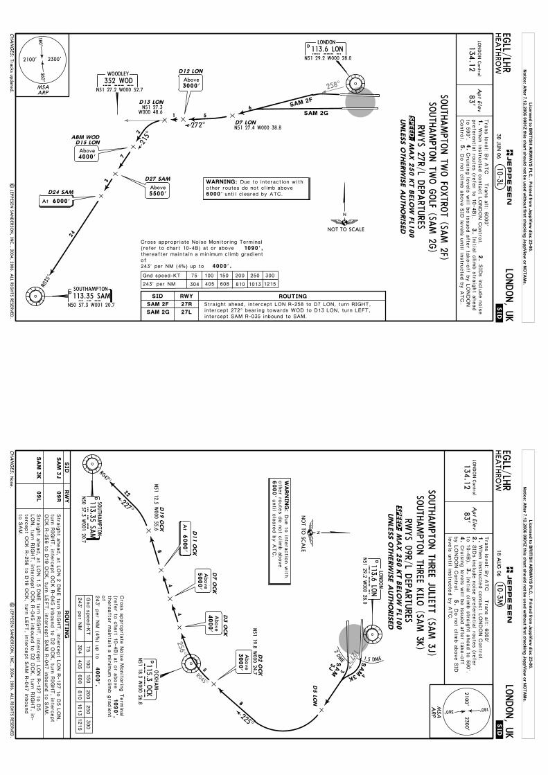
258^
D12 LON
D113.35 SAMSAM
N50 57.3 W001 20.7
SOUTHAMPTON
N51 27.3W000 48.6
D13 LON
D15 LONABM WOD
.SID.
EGLL/LH
RLO
NDON, U
KHEA
THRO
W
134.12
10-3LD
LONDON
113.6 LONLONN51 29.2 W000 28.0
SAM 2F
SAM 2G
WODN51 27.2 W000 52.7
WOODLEY
352 WOD
D7 LON272^
5
6
1
2
R035^
215^
7
3
24
D24 SAM
D27 SAM
5500'Above
Apt Elev
83'LO
ND
ON
Control
| JEPPESEN
SAN
DERSO
N, IN
C., 2004, 2006. A
LL RIGHTS RESERV
ED.
3.
4.
Tra
ns le
vel: B
y A
TC T
rans a
lt: 6000'
2.
N51 27.4 W000 38.8
6000'
Tracks updated.
1.
5.
MSAARP
3000'Above
MA
X 2
50 K
T B
ELO
W F
L100
CH
AN
GES:
JEPPESEN
30 JUN
06
UNLE
SS O
THERW
ISE A
UTHO
RIS
ED
SOUTH
AMPTO
N TW
O FO
XTRO
T (SAM 2F)
SOUTH
AMPTO
N TW
O G
OLF (SA
M 2G
)
Above4000'
NOT TO SCALE
RWYS 27R/L D
EPARTU
RES
3 6 0^
2300'2100'
180^
27RSAM 2F
SAM 2G 27L
RWYSID
243' per NM
75 100
405304
150
608 810 1013 1215
300250200Gnd speed-KT
4000'.
1090',thereafter maintain a minimum climb gradientof243' per NM (4%) up to
ROUTING
Straight ahead, intercept LON R-258 to D7 LON, turn RIGHT, intercept 272^ bearing towards WOD to D13 LON, turn LEFT, intercept SAM R-035 inbound to SAM.
Cross appropriate Noise Monitoring Terminal(refer to chart 10-4B) at or above
WARNING: Due to interaction withother routes do not climb above
until cleared by ATC.
6000'At
When in
stru
cte
d c
onta
ct L
ONDON C
ontro
l.SID
s in
clu
de n
ois
epre
fere
ntia
l route
s (re
fer to
10-4
B).
Initia
l clim
b s
traig
ht a
head
to 5
90'.
Contro
l.Cru
isin
g le
vels
will b
e is
sued a
fter ta
ke-o
ff by L
ONDON
Do n
ot c
limb a
bove S
ID le
vels
until in
stru
cte
d b
y A
TC.
SPEED:
Licensed to BR
ITISH A
IRW
AYS PLC
, . Printed from JeppView
disc 23-06.N
otice: After 7.12.2006 0901Z this chart should not be used w
ithout first checking JeppView or N
OTA
Ms.
127^
256^
R045^
N51 12.5 W
000 55.6
.SID.
EGLL/LH
RLO
NDON, U
KHEA
THRO
W10-3M
DLO
NDON
113.6 LON
LO
NN51 29.2 W
000 28.0
2DME 1.5 DME
4
3
SAM
3K
SA
M3J
D5 LO
N
D113.35 SA
MSAM
N50 57.3 W
001 20.7
SOUTH
AMPTO
N
227^
R047^
D19 O
CK
4000'
Above
D11 O
CK
D7 O
CK
D3 O
CK
8
4
4
22
5
225^
DOCKHAM
115.3 OCK
OC
KN51 18.3 W
000 26.8
D2 O
CK
8
2.
4.
5.
Apt Elev
83'
Tra
ns le
vel: B
y A
TC T
rans a
lt: 6000'
LON
DO
N C
ontrol
134.123.
N51 19.8 W
000 24.7
| JEP
PESEN
SAN
DERSO
N, IN
C., 2004, 2006. A
LL RIGHTS RESERV
ED.
1.
6000'
None.
MSA
ARP
360^
2300'2100'
180^
MA
X 2
50 K
T B
ELO
W F
L100
CH
AN
GES:
JEPPESEN
18 AUG
06
UNLE
SS O
THERW
ISE A
UTHO
RIS
ED
SOUTH
AMPTO
N TH
REE JULIETT (SA
M 3J)
SOUTH
AMPTO
N TH
REE KILO
(SAM 3K
)RW
YS 09R/L D
EPARTU
RES
09R
SA
M 3
J
SA
M 3
K09L
RW
YSID
Stra
ight a
head, a
t LON 2
DME tu
rn R
IGHT, in
terc
ept L
ON R
-127 to
D5 L
ON,
turn
RIG
HT, in
terc
ept O
CK R
-045 in
bound to
D2 O
CK, tu
rn R
IGHT, in
terc
ept
OCK R
-256 to
D19 O
CK, tu
rn L
EFT, in
terc
ept S
AM
R-0
47 in
bound to
SAM
.
Stra
ight a
head, a
t LON 1
.5 D
ME tu
rn R
IGHT, in
terc
ept L
ON R
-127 to
D5
LON, tu
rn R
IGHT, in
terc
ept O
CK R
-045 in
bound to
D2 O
CK, tu
rn R
IGHT, in
-te
rcept O
CK R
-256 to
D19 O
CK, tu
rn L
EFT, in
terc
ept S
AM
R-0
47 in
bound
to S
AM
.
Above
5000'
NO
T TO SC
ALE
3000'
Above
Cru
isin
g le
vels
will b
e is
sued a
fter ta
ke-o
ffby L
ONDON C
ontro
l.
SID
s in
clu
de n
ois
e p
refe
rentia
l route
s (re
fer
to 1
0-4
B).
Initia
l clim
b s
traig
ht a
head to
590'.
Do n
ot c
limb a
bove S
IDle
vels
until in
stru
cte
d b
y A
TC.
RO
UT
IN
G
243' p
er N
M
75
100
405
304
150
608
810
1013
1215
300
250
200
Gnd s
peed-K
T
4000'.
there
afte
r main
tain
a m
inim
um c
limb g
radie
nt
of
243' p
er N
M (4
%) u
p to
1090',
Cro
ss a
ppro
pria
te N
ois
e M
onito
ring T
erm
inal
(refe
r to c
hart 1
0-4
B) a
t or a
bove
6000'
At
When in
stru
cte
d c
onta
ct L
ONDON C
ontro
l.
WA
RN
IN
G:
Due to
inte
ractio
n w
ithoth
er ro
ute
s d
o n
ot c
limb a
bove
until c
leare
d b
y A
TC.
SPEED:
Licensed to BR
ITISH A
IRW
AYS PLC
, . Printed from JeppView
disc 23-06.N
otice: After 7.12.2006 0901Z this chart should not be used w
ithout first checking JeppView or N
OTA
Ms.
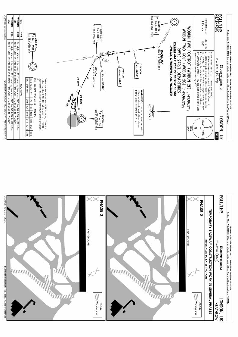
360^
179^
D17.1
127^
WO
BUN
N52 01.2 W
000 44.0
.SID.
EGLL/LH
RLO
NDON, U
KHEA
THRO
W10-3N
N51 30.6 W
000 39.0
DLO
NDON
113.6 LON
LO
NN51 29.2 W
000 28.0
BURN
HAM
421 BUR
BU
RN51 31.1 W
000 40.6D7 LO
N
D4 LO
ND3 LO
N
301^
1
3
32
DMIDHURST
114.0 MID
MID
N51 03.2 W
000 37.5
359^
D16 LO
N
D10 LO
N
19
85
DDAVEN
TRY
116.4 DTY
DTY
N52 10.8 W
001 06.8
8 DME
[WO
BU2F]
[WO
BU2G
]
| JEP
PESEN
SAN
DERSO
N, IN
C., 2004, 2006. A
LL RIGHTS RESERV
ED.
2.
4.
5.
Apt Elev
83'
Tra
ns le
vel: B
y A
TC T
rans a
lt: 6000'
LON
DO
N C
ontrol
119.773.
1.
6000'
WOBUN 2
G
WO
BU
N 2
F
Com
munication.
MSA
ARP
MA
X 2
50 K
T B
ELO
W F
L100
CH
AN
GES:
JEPPESEN
18 AUG
06
UNLE
SS O
THERW
ISE A
UTHO
RIS
ED
27R
27L
RW
YSID
243' p
er N
M
75
100
405
304
150
608
810
1013
1215
300
250
200
Gnd s
peed-K
T
4000'.
there
afte
r main
tain
a m
inim
um c
limb g
radie
nt
of
243' p
er N
M (4
%) u
p to N
OT TO
SCA
LE
1090',
3000'
Above
4000'
Above
RWYS 27R/L D
EPARTU
RES
Cro
ss a
ppro
pria
te N
ois
e M
onito
ring T
erm
inal
(refe
r to c
hart 1
0-4
B) a
t or a
bove
RO
UT
IN
G
Stra
ight a
head, in
terc
ept 3
01^ b
earin
g to
ward
s B
UR b
y D
4 L
ON to
D7 L
ON,
turn
RIG
HT, in
terc
ept 3
59^ b
earin
g fro
m B
UR (M
ID R
-360) to
WOBUN.
Stra
ight a
head, in
terc
ept 3
01^ b
earin
g to
ward
s B
UR b
y D
3 L
ON to
D7 L
ON,
turn
RIG
HT, in
terc
ept 3
59^ b
earin
g fro
m B
UR (M
ID R
-360) to
WOBUN.
6000'
At
360^
2300'2100'
180^
Cru
isin
g le
vels
will b
e is
sued a
fter ta
ke-o
ffby L
ONDON C
ontro
l.
SID
s in
clu
de n
ois
e p
refe
rentia
l route
s (re
fer
to 1
0-4
B).
Initia
l clim
b s
traig
ht a
head to
590'.
Do n
ot c
limb a
bove S
IDle
vels
until in
stru
cte
d b
y A
TC.
When in
stru
cte
d c
onta
ct L
ONDON C
ontro
l.
WA
RN
IN
G:
Due to
inte
ractio
n w
ithoth
er ro
ute
s d
o n
ot c
limb a
bove
until c
leare
d b
y A
TC.
WOBU
N TW
O FO
XTRO
T (WOBU
N 2F)
WOBU
N TW
O G
OLF (W
OBU
N 2G
)
WO
BU
N2F
WO
BU
N2G
SPEED:
Licensed to BR
ITISH A
IRW
AYS PLC
, . Printed from JeppView
disc 23-06.N
otice: After 7.12.2006 0901Z this chart should not be used w
ithout first checking JeppView or N
OTA
Ms.
CHA
NG
ES:|
JEPPESEN
SAN
DERSO
N, IN
C., 2006. A
LL RIGHTS RESERV
ED.
12 MA
Y 06
RWY 09L/27R
RWY 09L/27R
LEGEN
D
Working area
LEGEN
D
Working area
10-8JEPPESEN
Temporary chart.
LONDON, U
KHEA
THRO
WEG
LL/LHR
REFER A
LSO
TO
LATEST N
OTA
MS
TEM
PO
RA
RY T
AXIW
AY C
ONSTRUCTIO
N W
ORK IN
SEVERA
L PHA
SES
PHA
SE 3
PHA
SE 2
Licensed to BR
ITISH A
IRW
AYS PLC
, . Printed from JeppView
disc 23-06.N
otice: After 7.12.2006 0901Z this chart should not be used w
ithout first checking JeppView or N
OTA
Ms.

CHA
NG
ES:|
JEPPESEN
SAN
DERSO
N, IN
C., 2006. A
LL RIGHTS RESERV
ED.
12 MA
Y 06
10-8A
RWY 09L/27R
LEGEN
D
Working area
RWY 09L/27R
LEGEN
D
Working area
JEPPESEN
Temporary chart.
LONDON, U
KHEA
THRO
WEG
LL/LHR
REFER A
LSO
TO
LATEST N
OTA
MS
TEM
PO
RA
RY T
AXIW
AY C
ONSTRUCTIO
N W
ORK IN
SEVERA
L PHA
SES
PHA
SE 5
PHA
SE 4
Licensed to BR
ITISH A
IRW
AYS PLC
, . Printed from JeppView
disc 23-06.N
otice: After 7.12.2006 0901Z this chart should not be used w
ithout first checking JeppView or N
OTA
Ms.
CHA
NG
ES:|
JEPPESEN
SAN
DERSO
N, IN
C., 2006. A
LL RIGHTS RESERV
ED.
12 MA
Y 06
RWY 09L/27R
10-8B
RWY 09L/27R
LEGEN
D
Working area
JEPPESEN
Temporary chart.
LONDON, U
KHEA
THRO
WEG
LL/LHR
REFER A
LSO
TO
LATEST N
OTA
MS
PHA
SE 6
TEM
PO
RA
RY T
AXIW
AY C
ONSTRUCTIO
N W
ORK IN
SEVERA
L PHA
SES
CO
MPLE
TE
Licensed to BR
ITISH A
IRW
AYS PLC
, . Printed from JeppView
disc 23-06.N
otice: After 7.12.2006 0901Z this chart should not be used w
ithout first checking JeppView or N
OTA
Ms.

Link
11
Link
12
Link
13
Link
36
Remote parking
stand
Ground reporting
point
Runway
Holding
Areas
Caution: H
elicopter pilots should note the visual sim
ilarity between the dual taxiw
ays (Links 25 and 26) and Links 27/28 im
mediately to the South.
Pilots should ensure that holding is carried out only over the dual taxiw
ays (Links 25 and 26) in order to ensure adequate separation from
the southern runw
ay and associated taxiways.
Link
43
Link
44
Link
42
Link
34
Link
33
Link
31
Link
35W
Link
35E
Link
25
Link
51
Link
32
Link
21
FO
R P
ARKIN
G
1
SNA
PAOSTER
| JEPPESEN
SAN
DERSO
N, IN
C., 1998, 2006. A
LL RIGHTS RESERV
ED.
By A
TC
Apt Elev
10-9
51-27
51-2851-28
51-2951-29
00-25
00-25
00-26
00-26
00-27
00-27
00-28
00-2800-29
00-30
E2
F2
AC
DB
E
F
F
AB13
A12
A11
A10W
A10E
A9W
A9E
A8A
7A
6
Parking stand
SNA
PA
160161
162163
E11
1
A
A
B
B
B
M
Link 2
5
Link 2
6
Link 2
7N
A5
A4
A1
U
M
SY6
F1
A
B
SS
W
W
S1S
N4E
N4W
N5E
N5W
S4S5
S6S7
SB7
NB11
S11
N11
B
DN
7
A
BB
D
A
C
HO
RKA
N
UM
S
N3
NB3
N2W
N2E
NB1
N1
SB1
S1N
SB3
S3S
PLUTO
ROKIT
ETTIV
LOKKI
MO
RRAU
SATU
N
00-29
A
B
K
Link 2
5
Link 2
6
Link 2
7
Link 2
8 N
N
UM
Link 21
A4
N3
NB3
N2W
N2E
NB1
N1
M1
M
A2
Link
25
AY5
DC
Link 4
1
29
N6
NB10N
10N
8N
B8
A
21
Link
A
Link 5
3
Link 5
2 AA B
A
51-27
00-30
02^W
AY1
For A
IRPO
RT B
RIE
FIN
G re
fer to
10-1
P p
ages
B1
10 NO
V 06
Link2
A3A
2
Link23 Link22
A1
A3
Link23
Y
Holding points.
Link 22
B
TMNL 2
A
226'
Link
1
FO
R D
ETA
ILSSEE IN
SET
Remote H
oldingfor delayedoutbound aircraft
FO
R P
ARKIN
G
PO
SIT
IONS
SEE 1
0-9
C
ARP
09L27R
78'Elev
Elev
PIER 7
PIER 5
PIER 2
PIER 3
TERM
INA
L3
TERM
INA
L
Treesup to
138'
SEE 1
0-9
B
PI E
R 4
A
092^272^
150'
125'
EURO PIER
78'
130'
12,799'3901m
HJP
G
N51 28.7 W
000 27.783'
121.97121.9
LONDON, U
KHEA
THRO
W
121.7118.7
118.5
*HEA
THRO
W D
elivery (Cpt)
*G
roundTow
er
121.85
EGLL/LH
R
LEGEN
D
702
162
566567
553552
543542
27L
221'
MA
INTENA
NCE
MA
INTENA
NCE
AREA
1
AREA
1
272^
130'
K
K
12,008' 3660m
TERM
INA
L 4
CA
RG
OTERM
INA
L
CA
RG
OA
PRO
N
SUIT
ERO
YA
L
139'
172'
CA
RG
OA
PRO
N
Q
1
PIER
R
Z
T
VT
568551
541
77'Elev
Link 2
8
CHA
NG
ES:
702703
701
HJ
K
QR
G
PIE
R 6
PIER 4
1
ControlTow
er362'
09R092^
PO
SIT
IONS
TERM
INA
L 5
544545
Elev71'
JEPPESEN
5002000
2500800
600200
Feet
Meters
001000
30001000
1500
400
*D
-ATIS D
eparture
Licensed to BRITISH AIRWAYS PLC, . Printed from JeppView disc 23-06.
Notice: After 7.12.2006 0901Z this chart should not be used without first checking JeppView or NOTAMs.
(60m
)(1
5m
)
(60m
)(1
5m
)
10-9A
CHA
NG
ES:
TAKE-O
FF
ABCD
RCLM
(DA
Y only)
250m
300m
400m
500m
& m
ult. RVR req
125m
150m
NIL
(DA
Y only)
HIRL, C
L
1
1
Operators applying U
.S. Ops Specs: C
L required below 300m
; approved guidance system required
below 150m
.
RCLM
(DA
Y only)
RL & C
L
200m
250m
& m
ult. RVR req
150m
200m
LVP m
ust b
e in
Forc
e
RL, CL
or RLor RL
LONDON, U
KHEA
THRO
W
.JAR-OPS.
Approved
Operators
| JEPPESEN
SAN
DERSO
N, IN
C., 1998, 2006. A
LL RIGHTS RESERV
ED.
EGLL/LH
R
(60m
)(1
5m
)
All R
wys
10 NO
V 06
RWY
AD
DITIO
NA
L RUN
WA
Y IN
FORM
ATIO
N
ThresholdLA
ND
ING
BEY
ON
DUSA
BLE LEN
GTH
S
WID
THTA
KE-O
FFG
lide Slope
SEQ
UENCIN
G O
F A
IRCRA
FT G
RO
UND M
OVEM
ENTS
FO
R T
AKE-O
FF IN
LOW
VIS
IBILIT
Y
AIRC
RAFT TA
KE-O
FF MIN
IMA
MIN
IMUM
RVR FO
R START-U
P
When the reported RV
R is below 400m
do not request start-up until the reported RVR is equal to or
greater than the appropriate value as shown below
:
350m RV
R300m
RVR
250m RV
R200m
RVR
150m RV
R100m
RVR
75m RV
R
300m250m200m150m150m100m75m
RVR
09R27L
164'50m
11,000'3353m
10,905'3324m
3047m
2
4
RVR
09L27R
164'50m
11,795'3595m
11,586'3531m
1
4TA
KE-O
FF RUN
AVA
ILABLE
From rw
y head12,008' (3660m
)RW
Y 27L:
From rw
y head12,008' (3660m
)10,558' (3218m
)
JEPPESEN
12,743'3884m
1
10,801'3292m
HIRL
TDZ
CL
HIA
LS-IIPA
PI-L(3.0^)
HIRL
CL
HIA
LS-IITDZ
PAPI-L(3.0^)
RWY 09R:
2Rwy grooved.
Rwy grooved.
9577' (2919m)
N7
NB10
11,585' (3531m)
RVR
HIRL
TDZ
CL
HIA
LS-IIPA
PI-L(3.0^)3
3HST - N
6
9997'
Rwy provided w
ith porous friction course.
NB3
12,743' 3884m
None.
Licensed to BRITISH AIRWAYS PLC, . Printed from JeppView disc 23-06.
Notice: After 7.12.2006 0901Z this chart should not be used without first checking JeppView or NOTAMs.

Link11
Link12
Link13
Link25
Link36
Link21
Link35W
Link35E
101
102
103
104
105
106108
109110
114116
117
118
119
120
121
122
123
124
125
126
127
128
129
130
132134125R
127R125L
127L
139
141
143
144145
146147
148149150
152153
154155156
158158L
158R
242240
238
236
202
203
204
205
206
207
208 209210
209R
209L
211
212213
214215
212L212R
311
309
313
314
316
317
318319
320321
322
323
325
326
327
328
329
330
331
332334
335
336338
340
342
363
365364
174176
178180
182184
186188
190192192R 192L
353
350
354
351
00-27
00-27
00-28
00-28
ARP10-9B
00-27.5 00-26.5
595
594
592
51-28.3
51-28.5
51-28.6
51-28.1
51-28.3
51-28.4
51-28.5
51-28.6
| JEPPESEN
SAN
DERSO
N, IN
C., 1999, 2006. A
LL RIGHTS RESERV
ED.
352
D
A
A
A
B
B
BB
E
F
F
M
A10W A10E A9W A9EA8
A7 A6
A5
NB3N4E
N4WN5E
N5W
B
U
Link 29
U
A
171
170
A51-28.0
591
590
58358251-28.1
51-28.2
B
D
576D
A
F2
E2
E1 F1
B1
B1
AY5
LOKKI
A
305
590L
590R
N6
Link34
Link33
Link31
598
597
596
307 303 301581
32Link
A
51-28.4 29 SEP 06
None.
PIER
4
PIER 3
TERM
INAL 2
PIER 2
PIER 1
TERMIN
AL 1
00-27.5 00-26.5
CH
AN
GES:
PIER 5
ControlTower
RWY 09L/27R
RWY 09R/27L
PIER 7
PIER 4A
EURO
PIER
LONDON, U
KHEA
THRO
W
163
EGLL/LH
R
H
K
J
P
Q
R
G
K
H J
K
QR
G
PIER 6
JEPPESEN
TERMIN
AL 3
LEGEND158
163
Parking standRemoteparking stand
Groundreporting point
Licensed to BR
ITISH A
IRW
AYS PLC
, . Printed from JeppView
disc 23-06.N
otice: After 7.12.2006 0901Z this chart should not be used w
ithout first checking JeppView or N
OTA
Ms.
Link 41
51-28
00-2700-28
51-27.5
51-27.4
51-27.3
51-27.2
51-27.6
51-27.8
51-27.6
51-27.5
51-27.4
00-28.100-28.300-28.5 00-27.9 00-27.7 00-27.5 00-27.3 00-27.1 00-26.9 00-26.7 00-26.5 00-26.3
00-26.400-26.600-26.800-27.100-27.700-28
10-9C| JEPPESEN
SAN
DERSO
N, IN
C., 1999, 2006. A
LL RIGHTS RESERV
ED.
51-27.3
51-27.2
A
S
S
WLink43
Link42
W
Link34
Link33
Link31 N3
NB3
SB3S3
N4EN4WN5E
N5W
S4S5S6S7SB7
Link 44
00-28.2
N7
A00-28.4
QR
N6
Link32
Notes transferred to 10-1P pages. 29 SEP 06
51-27.951-27.9
LONDON, U
KEG
LL/LHR
TERMINAL 4
SUITE
CARGOAPRON
RWY 09R/27L
ROYALCARGOAPRON
601602603604605606607608609
611
612
613614
615
616
401402
403
404
405
406
407
408
409
410
411
412
451
414
461
463
452
453
454
455
456
440
441
429
430 431 432
HEA
THRO
W
JEPPESEN
RSR
RSL 415416
417
419420
421422
423
424
425
CARGOTERMINAL
Z
T
V
T
RSCHA
NG
ES:
Licensed to BR
ITISH A
IRW
AYS PLC
, . Printed from JeppView
disc 23-06.N
otice: After 7.12.2006 0901Z this chart should not be used w
ithout first checking JeppView or N
OTA
Ms.

10-9D| JEP
PESEN
SAN
DERSO
N, IN
C., 1999, 2006. A
LL RIGHTS RESERV
ED.
24 MA
R 06
Stand 315 deleted.
LONDON, U
KHEA
THRO
WEG
LL/LHR
CH
AN
GES:
JEPPESEN
INS C
OO
RDIN
ATES
STA
ND N
o.
CO
ORDIN
ATES
STA
ND N
o.
CO
ORDIN
ATES
101102103104105 106108109110
114, 116
117118119120 121
122123124
125, 125R
125L
126127, 127L/R
128129
130, 132, 134
139, 141, 143144145
146, 147
148 thru 150
152, 153154 thru 156158, 158L/R
170, 171
174, 176 178, 180, 182
184, 186, 188190
192, 192L/R
N51 28.5 W
000 27.1N
51 28.4 W000 27.0
N51 28.5 W
000 27.1N
51 28.4 W000 27.0
N51 28.5 W
000 27.0
N51 28.4 W
000 26.9N
51 28.5 W000 26.9
N51 28.5 W
000 27.0N
51 28.5 W000 26.9
N
51 28.3 W000 26.9
N51 28.4 W
000 26.9N
51 28.3 W000 26.8
N51 28.4 W
000 26.9N
51 28.3 W000 26.8
N
51 28.4 W000 26.9
N51 28.3 W
000 26.8N
51 28.4 W000 26.8
N51 28.4 W
000 26.7N
51 28.5 W000 26.8
N
51 28.5 W000 26.7
N51 28.4 W
000 26.7N
51 28.5 W000 26.7
N51 28.4 W
000 26.6N
51 28.5 W000 26.6
N
51 28.4 W000 26.6
N51 28.3 W
000 26.7N
51 28.4 W000 26.6
N51 28.4 W
000 26.5N
51 28.2 W000 26.7
N
51 28.2 W000 26.6
N51 28.3 W
000 26.6N
51 28.3 W000 26.5
N51 28.3 W
000 26.5
N51 28.1 W
000 26.5
N51 28.5 W
000 27.2 N
51 28.5 W000 27.3
N51 28.5 W
000 27.4N
51 28.5 W000 27.5
N51 28.5 W
000 27.5
212, 212L212R
213214215236
238, 240, 242
N51 28.1 W
000 27.2N
51 28.1 W000 27.1
N
51 28.1 W000 27.0
N51 28.1 W
000 27.1N
51 28.1 W000 27.0
N51 28.2 W
000 26.9N
51 28.2 W000 26.8
202203
204205206 207208
209, 209L/R210211
N51 28.2 W
000 27.0N
51 28.2 W000 26.9
N51 28.1 W
000 27.0N
51 28.2 W000 26.9
N51 28.1 W
000 27.0
N51 28.2 W
000 26.9N
51 28.1 W000 26.9
N51 28.1 W
000 26.8N
51 28.1 W000 26.9
N51 28.1 W
000 27.1
160161
162163
N51 28.5 W
000 28.8N
51 28.5 W000 28.6
N51 28.5 W
000 28.5N
51 28.5 W000 28.3
N51 28.1 W
000 27.2N
51 28.1 W000 27.3
N51 28.1 W
000 27.4N
51 28.1 W000 27.5
N51 28.1 W
000 27.6
N51 28.2 W
000 27.3N
51 28.1 W000 27.7
N51 28.1 W
000 27.8N
51 28.1 W000 27.9
N51 28.2 W
000 27.7
N51 28.2 W
000 27.9N
51 28.2 W000 27.8
N51 28.2 W
000 28.0N
51 28.3 W000 27.8
N51 28.2 W
000 27.7
N51 28.3 W
000 27.7N
51 28.4 W000 27.6
N51 28.3 W
000 27.7N
51 28.4 W000 27.7
N51 28.3 W
000 27.8
N51 28.4 W
000 27.7N
51 28.3 W000 27.8
N51 28.5 W
000 27.8N
51 28.4 W000 27.9
N51 28.5 W
000 27.9
N51 28.5 W
000 28.0N
51 28.4 W000 28.0
N51 28.4 W
000 27.6N
51 28.2 W000 28.0
N51 28.3 W
000 27.9
N51 28.3 W
000 28.0
301303305307309 311313
314, 316317318 319320321322323 325326327328329 330331
332, 334335336 338
340, 342350 thru 354
363364 365
Licensed to BR
ITISH A
IRW
AYS PLC
, . Printed from JeppView
disc 23-06.N
otice: After 7.12.2006 0901Z this chart should not be used w
ithout first checking JeppView or N
OTA
Ms.
10-9E| JEP
PESEN
SAN
DERSO
N, IN
C., 1999, 2006. A
LL RIGHTS RESERV
ED.
24 MA
R 06
Stands 544, 545 and 581 added.
LONDON, U
KHEA
THRO
WEG
LL/LHR
CH
AN
GES:
JEPPESEN
INS C
OO
RDIN
ATES
STA
ND N
o.
CO
ORDIN
ATES
STA
ND N
o.
CO
ORDIN
ATES
N51 27.5 W
000 26.9N
51 27.5 W000 27.0
N51 27.4 W
000 27.0N
51 27.5 W000 27.1
N51 27.6 W
000 27.0
N51 27.7 W
000 26.9N
51 27.7 W000 26.8
N51 27.8 W
000 26.8N
51 27.7 W000 26.6
N51 27.7 W
000 26.7
N51 27.6 W
000 26.7N
51 27.6 W000 26.6
N51 27.7 W
000 26.6N
51 27.7 W000 26.5
N51 27.7 W
000 26.4
N51 27.7 W
000 26.3N
51 27.6 W000 27.1
N51 27.7 W
000 27.0N
51 27.5 W000 27.2
N51 27.6 W
000 27.2
N51 27.6 W
000 27.3N
51 27.7 W000 27.3
N51 27.5 W
000 27.2N
51 27.4 W000 27.1
N51 28.1 W
000 28.8
N51 28.2 W
000 28.8N
51 28.1 W000 28.7
N51 28.2 W
000 28.7N
51 28.2 W000 28.5
N51 28.1 W
000 28.5
N51 28.2 W
000 28.4N
51 28.1 W000 28.3
N51 28.1 W
000 28.2N
51 28.2 W000 28.2
N51 28.1 W
000 28.2
N51 28.2 W
000 28.2N
51 28.2 W000 28.2
N51 28.3 W
000 28.2N
51 28.4 W000 28.2
N51 28.5 W
000 28.2
N51 28.5 W
000 28.2N
51 27.8 W000 27.5
N51 27.8 W
000 27.6N
51 27.8 W000 27.7
N51 27.8 W
000 27.8
N51 27.8 W
000 27.9N
51 27.8 W000 28.0
N51 27.7 W
000 28.3N
51 27.6 W000 28.3
N51 27.6 W
000 28.4
N51 27.7 W
000 28.4N
51 28.4 W000 25.8
N51 28.4 W
000 25.9N
51 28.5 W000 25.8
N51 27.8 W
000 27.4
N51 27.7 W
000 27.4N
51 27.8 W000 27.4
N51 28.1 W
000 28.1N
51 28.1 W000 27.9
401402403
404, 405406 thru 408
409, 410
411412
414 thru 419420 421
422, 423424425
429, 430
431, 432440441
451, 452453 454
455, 456461463
541, 542
543 thru 545551
552, 553566
567, 568
576581, 582
583590590L
590R
591, 592594
595, 596597, 597L/R
598601
602, 603604
605, 606
607608, 609611, 612
613614
615, 616701702703RS RSLRSR
L35WL35E
Licensed to BR
ITISH A
IRW
AYS PLC
, . Printed from JeppView
disc 23-06.N
otice: After 7.12.2006 0901Z this chart should not be used w
ithout first checking JeppView or N
OTA
Ms.

10-9F| JEP
PESEN
SAN
DERSO
N, IN
C., 1999, 2006. A
LL RIGHTS RESERV
ED.
Airc
rew
must n
ot a
ttem
pt to
self-p
ark
if the S
tand E
ntry
Guid
ance is
unserv
iceable
,uncalib
rate
d o
r not s
witc
hed o
n. 29 SEP 06S
LOW
DO
WN
SLO
WDO
WN
SLO
WDO
WN
A. G
ENERA
L
LONDON, U
KHEA
THRO
W
CH
AN
GES:
JEPPESEN
REDRED
GREEN
GREEN
GREEN
GREEN
Turn towards G
REEN.
LEFT of centerline.A
ircraft on centerline.RIG
HT of centerline.
Turn towards G
REEN.
B. G
UID
ANCE S
YSTEM
S
EM
ERG
ENCY S
TO
P
1. A
GNIS
- AZIM
UTH G
UID
ANCE F
OR N
OSE-IN
STA
NDS
2. A
PIS
- AIR
CRA
FT P
OSIT
IONIN
G A
ND IN
FO
RM
ATIO
N S
YSTEM
The unit combines both alignm
ent and stopping signals in one visual display mounted ahead of the
pilot and is to be used from the left hand cockpit seat.
Azim
uth guidance element
Display can be used to show
stand number, acft type selected
and final STOP w
ording when
the acft has reached its finalstopping position.
AG
NIS units display red and/or green light signals through tw
o parallel vertical slots. The systemis aligned for interpretation from
the left hand cockpit seat. Acft should be turned tow
ards thegreen light to rem
ain on centerline. AG
NIS does not provide stopping guidance. Stopping guidance is
provided by a sign (PAPA
or STOP A
RROW
) positioned near the AG
NIS unit.
Indicates progress of the acftover the last 52'/16m
of theapproach to the stop position.
STA
ND E
NTRY G
UID
ANCE S
YSTEM
S (S
EG
)
EGLL/LH
R
STO
P S
HO
RT P
RO
CEDURE
The term "
STOP SH
ORT"
is defined as a requirement to stop the acft in a position that allow
sm
obile or integral airstairs to be deployed, due to the unserviceability of the stand loadingbridge or som
e other obstruction. The requirement to "
STOP SH
ORT"
will be indicated to the
flight crew by m
arshalling signals.
Should an emergency arise as the acft is taxiing onto stand, the airline or handling agent
representative can activate the SEG em
ergency over-ride button, colocated with all
emergency stop buttons at ram
p level at the head of the stand. This will instantly cut pow
er to the parking aids and activate a sign m
ounted at pilot's eye level which w
ill flash "STO
P".
Chart reindexed. N
otes transferred to 10-1P pages.
If a Stand Entry Guidance System
becomes unserviceable or is not illum
inated, call Ground M
ovement
Control (G
MC) to request m
arshalling assistance.
Licensed to BR
ITISH A
IRW
AYS PLC
, . Printed from JeppView
disc 23-06.N
otice: After 7.12.2006 0901Z this chart should not be used w
ithout first checking JeppView or N
OTA
Ms.
10-9G| JEP
PESEN
SAN
DERSO
N, IN
C., 1999, 2000. A
LL RIGHTS RESERV
ED.
29 SEP 06
SLOT
737F100
MD
80
767B757
A320
A321
LONDON, U
KHEA
THRO
W
CH
AN
GES:
JEPPESEN
4. S
TO
P A
RRO
WS
5. M
IRRO
R
3. P
APA
- PA
RA
LLAX A
IRCRA
FT P
ARKIN
G A
ID
FLUO
RESCEN
TTU
BEW
hite "STO
P" line
This provides stopping guidance only, used in conjunction with A
GN
IS in the form of one or tw
o painted lines w
ith the word "
STOP"
above the line and, where appropriate, the acft type below
the line. The line is aligned w
ith the pilot's eye position and is normally located to the left of the
stand centerline, but may be provided on the right or both sides.
The mirror is norm
ally mounted on the port side of he extended centerline. It is angled to give
the pilot in the left hand seat view of the aircaft's nose landing gear (N
LG). A
ssociated mirror
image paint m
arkings will indicate the various stopping positions of the N
LG. A
ll mirrors are
heated to prevent misting and icing.
This stopping aid is comm
only positioned to the right side of the stand centerline. On som
estands it w
ill be located to the left side and indicated as such by the sign adjacent to the AG
NIS
unit. The aid consists of a black board, bearing acft type identification labels and "STO
P" lines,
with a horizontal slot running across the center. B
ehind the board is a vertically mounted
fluorescent light tube. As an acft is taxiing onto the stand, the pilot w
ill see the fluorescenttube appear to m
ove across the slot towards the "
STOP"
lines. When the tube is in line w
iththe appropriate acft type "
STOP"
line, the acft has reached the correct position.
Chart reindexed.
EGLL/LH
R
Licensed to BR
ITISH A
IRW
AYS PLC
, . Printed from JeppView
disc 23-06.N
otice: After 7.12.2006 0901Z this chart should not be used w
ithout first checking JeppView or N
OTA
Ms.
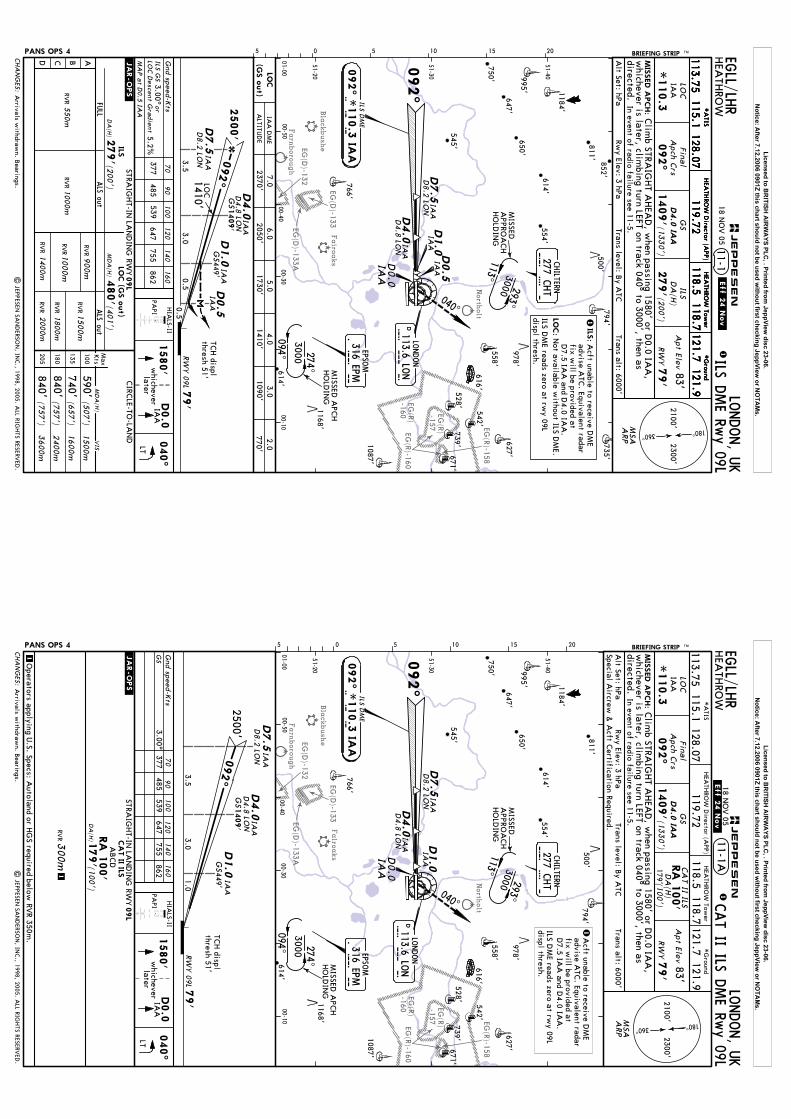
North
olt
Fairo
aks
Bla
ckbushe
Farn
boro
ugh
EG(D
)-132EG
(D)-133A
EG(D
)-133
EG(R)-158
EG(R)-160
-157EG
(R)
-160EG
(R)
MIS
SED A
PCH:
05 5 10 15 20LO
NDON, U
KHEA
THRO
W11-1
*A
TISH
EATH
ROW
Tower
119.72LO
C
*110.3
IAA
Final
Apch C
rs
092^
GS
1409'(1
330')
ILSD
A(H
)
279'(2
00')
Apt Elev
83'
RW
Y79'
121.9118.5 118.7
ABCD
DA
(H)
ILSSTRA
IGHT-IN
LAN
DIN
G RW
Y
ALS out
MD
A(H
)
CIRC
LE-TO-LA
ND
ALS out
LOC (G
S o
ut)
Max
Kts
135
180
205
100(5
07')
(657')
3600m
2400m
1600m
1500m
(200')
1400m
1500m
1000m
MD
A(H
)(4
01')
FULL
1800m
Gnd speed-K
ts70
90
100
120
140
160
377485
539647
755862
ILS GS
3.00^or
LOC D
escent Gradient
5.2%
590'740'840'840'
(757')
(757')
279'
2000m
480'
MA
P at D
0.5 IAA
09L
PANS OPS 4
D4.0
IAA
D4.8
L ON
D7.5
IAA
D8.2
LON
PAPI
*G
round
Clim
b STRAIG
HT A
HEA
D, w
hen passing 1580' or D0.0 IA
A,
whichever is later, clim
bing turn LEFT on track 040^ to 3000', then as In event of radio failure see 11-5.
040^
1580'
D0.0
IAA
laterw
hicheverLT
040^
.JAR-OPS.
900m
VIS
RVR
RVR
RVR
RVR
RVR
RVR
RVR
550m
RVR1000m
ILS DME Rw
y 09L
BRIEFING STRIP TM
HEA
THRO
W D
irector (APP)
directed.
| JEPPESEN
SAN
DERSO
N, IN
C., 1998, 2005. A
LL RIGH
TS RESERVED
.
EGLL/LH
R
113.75115.1
128.07
18 NO
V 05
121.7*
ATIS
HEA
THRO
W Tow
er
119.72121.9
118.5 118.7*
Ground
HEA
THRO
W D
irector (APP)
113.75115.1
128.07121.7
*A
TISH
EATH
ROW
Tower
119.72121.9
118.5 118.7*
Ground
HEA
THRO
W D
irector (APP)
113.75115.1
128.07121.7
.Eff.24.Nov.
Arrivals w
ithdrawn. B
earings.
811'
739'
647'
650'
554'
614'
735'
750'
852'614'
766'
627'671'
794'
1087'
1184'
542'
528'
978'
1168'
500'
558'
545'
995'
616'
277 CHT
CHILTERN
316 EPMEPSO
M
274^
094^
3000
293^3000
113^
51-20
51-30
51-40
01-0000-50
00-4000-30
00-10
D0.5
D1.0
D4.0
D7.5
092^
ILS DM
E
I A A092^ *
110.3
IAA
CHA
NG
ES:
Alt Set: hPa
Trans level: By A
TCTrans alt: 6000'
Rwy Elev: 3 hPa
1
180^360^
2100'2300'
MSA
RW
Y 0
9L 7
9'
2500'
0.5
092^
0.5 D0.5
3.53.0
IAA
IAA
D8.2
LON
IAA
IAA
IAA
D4.0
IAA
1409'
GS
D1.0
IAA
GS449'
LOC
1410'
(GS o
ut)
LOC
IAA
DM
E
ALTITU
DE
4.01410'
1090'3.0
2.0770'
C H
TM
ISSEDA
PPROA
CH
HO
LDIN
G
D4.8
LON
D0.0
IAA
E P MM
ISSED A
PCH
HO
LDIN
G
5.01730'
6.02050'
7.02370'
TCH displ
thresh 51'
JEPPESEN
ARP
HIA
LS-II
LONDON
113.6 LON
DL O
N
Acft unable to receive D
ME
advise ATC
. Equivalent radarfix w
ill be provided atD
7.5 IAA
and D4.0 IA
A.
ILS:
1
Not available w
ithout ILS DM
E.LO
C:
ILS DM
E reads zero at rwy 09L
displ thresh.
Licensed to BR
ITISH A
IRW
AYS PLC
, . Printed from JeppView
disc 23-06.N
otice: After 7.12.2006 0901Z this chart should not be used w
ithout first checking JeppView or N
OTA
Ms.
North
olt
Fairo
aks
Bla
ckbushe
Farn
boro
ugh
EG(D
)-132EG
(D)-133A
EG(D
)-133
EG(R)-158
EG(R)-160
-157EG
(R)
-160EG
(R)
MIS
SED A
PCH:
05 5 10 15 20
LONDON, U
KHEA
THRO
W
LOC
*110.3
IAA
Final
Apch C
rs
092^
GS
1409'(1
330')
Apt Elev
83'
RW
Y79'
1
Gnd speed-K
ts70
90
100
120
140
160
377485
539647
755862
3.00^
PANS OPS 4
D4.0
IAA
D4.8
LON
PAPI
Clim
b STRAIG
HT A
HEA
D, w
hen passing 1580' or D0.0 IA
A,
whichever is later, clim
bing turn LEFT on track 040^ to 3000', then as In event of radio failure see 11-5.
040^
1580'
D0.0
IAA
laterw
hicheverLT
040^
.JAR-OPS.
1
11-1ACAT II ILS D
ME Rw
y 09L
CA
T II ILS
DA
(H)
RA
100'
(100')
179'
GS
09L
STRAIG
HT-IN
LAN
DIN
G RW
YCA
T II ILS
ABCD
RA
100'
179'
DA
(H)
(100')
1300m
RVR
| JEPPESEN
SAN
DERSO
N, IN
C., 1998, 2005. A
LL RIGH
TS RESERVED
.
BRIEFING STRIP TM
directed.
EGLL/LH
R
Operators applying U
.S. Specs: Autoland or H
GS required below
RVR 350m
.
*A
TISH
EATH
ROW
Tower
119.72121.9
118.5 118.7*
Ground
HEA
THRO
W D
irector (APP)
113.75115.1
128.07121.7
18 NO
V 05
.Eff.24.Nov.
Arrivals w
ithdrawn. B
earings.
811'
739'
647'
650'
554'
614'
750'
614'
766'
627'671'
794'
1087'
1184'
542'
528'
978'
1168'
500'
558'
545'
995'
616'
277 CHT
CHILTERN
316 EPMEPSO
M
274^
094^
3000
51-20
51-30
51-40
01-0000-50
00-4000-30
00-10
D1.0
D4.0
D7.5
092^
ILS DM
E
I A A092^ *
110.3
IAA
CHA
NG
ES:
Alt Set: hPa
Trans level: By A
TCTrans alt: 6000'
Rwy Elev: 3 hPa
180^360^
2100'2300'
MSA
RW
Y 0
9L 7
9'
2500'092^
1.03.5
3.0
IAA
D8.2
LON
IAA
IAA
D4.0
IAA
1409'
GS
D1.0
IAA
GS
449'
D7.5
IAA
D8.2
LON
C H
TM
ISSEDA
PPROA
CH
HO
LDIN
G
D4.8
LON
D0.0
IAA
E P MMISSED
APC
HHO
LDIN
G
Special Aircrew
& A
cft Certification Required.
TCH displ
thresh 51'
JEPPESEN
HIA
LS-II
ARP
293^3000
113^
1A
cft unable to receive DM
Eadvise A
TC. Equivalent radar
fix will be provided at
D7.5 IA
A and D
4.0 IAA
.ILS D
ME reads zero at rw
y 09Ldispl thresh.
D113.6 LO
NLO
NDON
L O
N
Licensed to BR
ITISH A
IRW
AYS PLC
, . Printed from JeppView
disc 23-06.N
otice: After 7.12.2006 0901Z this chart should not be used w
ithout first checking JeppView or N
OTA
Ms.

North
olt
Fairo
aks
Bla
ckbushe
Farn
boro
ugh
EG(D
)-132EG
(D)-133A
EG(D
)-133
EG(R)-158
EG(R)-160
-157EG
(R)
-160EG
(R)
D4.0
MIS
SED A
PCH:
LONDON, U
KHEA
THRO
W11-2
LOC
*109.5
IBB
Final
Apch C
rs092^
GS
1405'
ILSD
A(H
)275'(2
00')
Apt Elev
83'RW
Y75'
(1330')
D4.8
LON
D4.0
IBB
PANS OPS 4 05 5 10 15 20
In event of radio failure see 11-5.
092^
ABCD
DA
(H)
ILSSTRA
IGHT-IN
LAN
DIN
G RW
Y
ALS out
MD
A(H
)
CIRC
LE-TO-LA
ND
ALS out
LOC (G
S o
ut)
Max
Kts
135
180
205
100
3600m
2400m
1600m
1500m
(200')
1400m
1500m
1000m
MD
A(H
)(4
05')
FULL
1000m
1800m
Gnd speed-K
ts70
90100
120140
160
377485
539647
755862
ILS GS
3.00^or
LOC D
escent Gradient
5.2%
3000'
275'
2000m
480'
D4.8
LON
MA
P at D
0.5 IBB
09R
D7.5
IBB
D8.2
LON
PAPI
092^
on
.JAR-OPS.
550m
900m
VIS
RVR
RVR
RVR
RVR
RVR
RVR
RVR
RVR
ILS DME Rw
y 09R
Clim
b STRAIG
HT A
HEA
D to 3000', then as directed.
BRIEFING STRIP TM
| JEPPESEN
SAN
DERSO
N, IN
C., 1998, 2005. A
LL RIGH
TS RESERVED
.
EGLL/LH
R
MSA
ARP
*A
TISH
EATH
ROW
Tower
119.72121.9
118.5 118.7*
Ground
HEA
THRO
W D
irector (APP)
113.75115.1
128.07121.7
*A
TISH
EATH
ROW
Tower
119.72121.9
118.5 118.7*
Ground
HEA
THRO
W D
irector (APP)
113.75115.1
128.07121.7
*A
TISH
EATH
ROW
Tower
119.72121.9
118.5 118.7*
Ground
HEA
THRO
W D
irector (APP)
113.75115.1
128.07121.7
590'(5
07')
740'(6
57')
(757')
840'840'
(757')
18 NO
V 05
.Eff.24.Nov.
Arrivals w
ithdrawn. B
earings.
811'
739'
647'
650'
554'
614'
735'
750'
852'614'
766'
627'671'
794'
1087'
1184'
542'
528'
978'
1168'
500'
558'
545'
995'
616'
MISSED
APPRO
ACH
HO
LDIN
G
277 CHT
CHILTERN
316 EPMEPSO
MILS D
ME
274^
094^
3000
51-20
51-30
51-40
01-0000-50
00-4000-30
00-10
I B B
092^
092^ *
109.5
IBB D
7.5
D0.5
D1.0
CHA
NG
ES:
1
Alt Set: hPa
Rwy Elev: 3 hPa
Trans level: By A
TCTrans alt: 6000'
IBB
D8.2
LON
IBB
IBB
IBB
180^360^
2100'2300'
LOC
(GS o
ut)
4.01410'
3.01090'
2.0770'
C H
T
E P MM
ISSED A
PCH
HO
LDIN
G
5.01730'
6.02050'
7.02370'
IBB D
ME
ALTITU
DE
75'
2500'
RW
Y 0
9R
0.5
LOC
092^
0.5 D0.5
GS
1410'
445'
3.5
D1.0
3.0
GS1405'
D4.0
IBB
IBB
IBB
TCH displ
thresh 52'
JEPPESEN
HIA
LS-II
113^
293^3000
113.6 LON
LONDON
DL O
N
Acft unable to receive D
ME
advise ATC
. Equivalent radarfix w
ill be provided atD
7.5 IBB and D
4.0 IBB.
ILS DM
E reads zero at rwy 09R
displ thresh.
Not available w
ithout ILS DM
E.LO
C:
ILS:
1
Licensed to BR
ITISH A
IRW
AYS PLC
, . Printed from JeppView
disc 23-06.N
otice: After 7.12.2006 0901Z this chart should not be used w
ithout first checking JeppView or N
OTA
Ms.
North
olt
Fairo
aks
Bla
ckbushe
Farn
boro
ugh
EG(D
)-132EG
(D)-133A
EG(D
)-133
EG(R)-158
EG(R)-160
-157EG
(R)
-160EG
(R)
D4.0
MIS
SED A
PCH:
LONDON, U
KHEA
THRO
W
LOC
*109.5
IBB
Final
Apch C
rs092^
GS
1405'
Apt Elev
83'RW
Y75'
1
(1330')
D4.8
LON
D4.0
IBB
PANS OPS 4 05 5 10 15 20
In event of radio failure see 11-5.
092^
Gnd speed-K
ts70
90
100
120
140
160
377485
539647
755862
3.00^3000'
D4.8
LON
PAPI
092^
on
CAT II ILS D
ME Rw
y 09R11-2A
CA
T II ILS
DA
(H)
RA
100'
175'(100')0
9R
STRAIG
HT-IN
LAN
DIN
G RW
YCA
T II ILS
ABCD
RA
100'
175'
DA
(H)
(100')
1300m
RVR
.JAR-OPS.
1 GS
| JEPPESEN
SAN
DERSO
N, IN
C., 1998, 2005. A
LL RIGH
TS RESERVED
.
Clim
b STRAIG
HT A
HEA
D to 3000', then as directed.
BRIEFING STRIP TM EGLL/LH
R
Operators applying U
.S. Specs: Autoland or H
GS required below
RVR 350m
.
MSA
ARP
*A
TISH
EATH
ROW
Tower
119.72121.9
118.5 118.7*
Ground
HEA
THRO
W D
irector (APP)
113.75115.1
128.07121.7
*A
TISH
EATH
ROW
Tower
119.72121.9
118.5 118.7*
Ground
HEA
THRO
W D
irector (APP)
113.75115.1
128.07121.7
*A
TISH
EATH
ROW
Tower
119.72121.9
118.5 118.7*
Ground
HEA
THRO
W D
irector (APP)
113.75115.1
128.07121.7
18 NO
V 05
.Eff.24.Nov.
Arrivals w
ithdrawn. B
earings.
MISSED
APPRO
ACH
HO
LDIN
G
277 CHT
CHILTERN
316 EPMEPSO
MILS D
ME
274^
094^
3000
51-20
51-30
51-40
01-0000-50
00-4000-30
00-10
I B B
092^
092^ *
109.5
IBB
D7.5
D1.0
CHA
NG
ES:
Alt Set: hPa
Rwy Elev: 3 hPa
Trans level: By A
TCTrans alt: 6000'
IBB
D8.2
LON
IBB
IBB
180^360^
2100'2300'
C H
T
E P M
MISSED
APC
HHO
LDIN
G
75'
2500'
RW
Y 0
9R
092^
1.0
GS
445'
3.5
D1.0
3.0
GS1405'
D4.0
IBB
IBB
D7.5
IBB
D8.2
LON
Special Aircrew
& A
cft Certification Required.
TCH displ
thresh 52'
JEPPESEN
HIA
LS-II
113^
293^3000
Acft unable to receive D
ME
advise ATC
. Equivalent radarfix w
ill be provided atD
7.5 IBB and D
4.0 IBB.
1ILS DM
E reads zero at rwy 09R
displ thresh.
811'
739'
647'
650'
554'
614'
735'
750'
852'614'
766'
627'671'
794'
1087'
1184'
542'
528'
978'
1168'
500'
558'
545'
995'
616'
D113.6 LON
LONDON
L O
N
Licensed to BR
ITISH A
IRW
AYS PLC
, . Printed from JeppView
disc 23-06.N
otice: After 7.12.2006 0901Z this chart should not be used w
ithout first checking JeppView or N
OTA
Ms.

Sta
ple
ford
Big
gin
Hill
North
olt
Fairo
aks
EG(D
)-132
EG(D
)-133A
EG(D
)-107
EG(D
)-133
EG(R)-158
EG(R)-159
EG(R)-160
Westla
nd
EG(R)
-157
London (C
ity)
MIS
SED A
PCH:
05 5 10 15 20LO
NDON, U
KHEA
THRO
W11-3
LOC
*109.5
ILLFina
lA
pch Crs
272^
GS
1407'(1
330')
ILSD
A(H
)
277'(2
00')
Apt Elev
83'
RW
Y77'
ABCD
DA
(H)
ILSSTRA
IGHT-IN
LAN
DIN
G RW
Y
ALS out
CIRC
LE-TO-LA
ND
ALS out
LOC (G
S o
ut)
Max
Kts
135
180
205
100
3600m
2400m
1600m
1500m
(200')
1400m
1500m
1000m
MD
A(H
)(4
13')
FULL
1000m
1800m
Gnd speed-K
ts70
90
100
120
140
160
377485
539647
755862
ILS GS
3.00^or
LOC D
escent Gradient
5.2%
277'
2000m
490'
MA
P at D
0.5 ILL
27L
PANS OPS 4
D7.5
D5.3
LON
ILLD
8.7
LON
D5.3
LON
D4.0
ILL
In event of radio failure see 11-6.
Clim
b STRAIG
HT A
HEA
D, w
hen passing 1080' or D0.0 ILL,
150^
550m
VIS
.JAR-OPS.RV
RRV
RRV
R
RVR
RVR
RVR
RVR
ILS DME Rw
y 27L
BRIEFING STRIP TM
whichever is later, clim
bing turn LEFT on track 150^ to 2000'. When
RVR
900m
passing D6.0 LO
N clim
b without delay to 3000', then as directed.
PAPI
1080'
D0.0
ILLlater
whichever
LT
150^
| JEPPESEN
SAN
DERSO
N, IN
C., 1998, 2005. A
LL RIGH
TS RESERVED
.
EGLL/LH
R
MD
A(H
)
(507')
(657')
590'740'840'840'
(757')
(757')
*A
TISH
EATH
ROW
Tower
119.72121.9
118.5 118.7*
Ground
HEA
THRO
W D
irector (APP)
113.75115.1
128.07121.7
*A
TISH
EATH
ROW
Tower
119.72121.9
118.5 118.7*
Ground
HEA
THRO
W D
irector (APP)
113.75115.1
128.07121.7
*A
TISH
EATH
ROW
Tower
119.72121.9
118.5 118.7*
Ground
HEA
THRO
W D
irector (APP)
113.75115.1
128.07121.7
18 NO
V 05
.Eff.24.Nov.
Arrivals w
ithdrawn. B
earings.
Trans level: By A
TCTrans alt: 6000'
ILS:
1 A
cft unable to receive DM
Eadvise A
TC. Equivalent radar fix
will be provided at D
7.5 ILL andD
4.0 ILL.LO
C:N
ot available w/o ILS D
ME.
ILS DM
E reads zero at rwy 27L
threshold.
739'
554'
614'
806'
614'
766'
627'671'
920'794'
1087'
823'
542'
528'
742'
1168'
500'
558'
643'718'
1035'
1154'
616'
579'
272^
293^
113^
094^ 3000
3000M
ISSEDA
PPROA
CH
HO
LDIN
G
MISSED
APPRO
ACH
HO
LDIN
G
D1.0
D4.0
D7.5
51-20
51-30
51-40
00-4000-30
00-2000-10
00-0000-10
D0.5
CHA
NG
ES:
Alt Set: hPa
1
Rwy Elev: 3 hPa
MSA
180^360^
2100'2300'
TCH 56'
77'
RW
Y 2
7L
GS
GS
447'
1407'
2500'
1410'
0.50.5
3.03.5
LOC
272^
D0.5
D1.0
ILL
ILL
D4.0
ILL
ALTITU
DE
LOC
(GS o
ut)
ILL
ILL
ILL
ILLD
8.7
LON
D6.0 LO
N
ILL DM
E5.0
1730'6.0
2050'7.0
2370'
EPSOM
316 EPME P
M D0.0
ILL
JEPPESEN
2.0770'
3.01090'
4.01410'
ARP
274^
HIA
LS-II
D113.6 LON
LONDON
L O
N
ILS DM
E
272^ *
109.5
ILLI L
L
277 CHT
CHILTERN
C H
T
Licensed to BR
ITISH A
IRW
AYS PLC
, . Printed from JeppView
disc 23-06.N
otice: After 7.12.2006 0901Z this chart should not be used w
ithout first checking JeppView or N
OTA
Ms.
Sta
ple
ford
Big
gin
Hill
North
olt
Fairo
aks
EG(D
)-132
EG(D
)-133A
EG(D
)-107
EG(D
)-133
EG(R)-158
EG(R)-159
EG(R)-160
Westla
nd
EG(R)
-157
London (C
ity)
D5.3
LON
MIS
SED A
PCH:
05 5 10 15 20
LONDON, U
KHEA
THRO
W
LOC
*109.5
ILLFina
lA
pch Crs
272^
GS
1407'(1
330')
Apt Elev
83'
RW
Y77'
1
Gnd speed-K
ts70
90
100
120
140
160
377485
539647
755862
3.00^
PANS OPS 4
D5.3
LON
D4.0
ILL
In event of radio failure see 11-6.
Clim
b STRAIG
HT A
HEA
D, w
hen passing 1080' or D0.0 ILL,
.JAR-OPS.
11-3ACAT II ILS D
ME Rw
y 27L
CA
T II ILS
DA
(H)
RA
102'
177'(100')
GS
27L
STRAIG
HT-IN
LAN
DIN
G RW
YCA
T II ILS
ABCD
RA
102'
177'
DA
(H)
(100')
300m
RVR
1
1
150^
| JEPPESEN
SAN
DERSO
N, IN
C., 1998, 2005. A
LL RIGH
TS RESERVED
.
BRIEFING STRIP TM
whichever is later, clim
bing turn LEFT on track 150^ to 2000'. When
passing D6.0 LO
N clim
b without delay to 3000', then as directed.
PAPI
1080'
D0.0
ILLlater
whichever
LT
150^
EGLL/LH
R
Operators applying U
.S. Specs: Autoland or H
GS required below
RVR 350m
.
*A
TISH
EATH
ROW
Tower
119.72121.9
118.5 118.7*
Ground
HEA
THRO
W D
irector (APP)
113.75115.1
128.07121.7
*A
TISH
EATH
ROW
Tower
119.72121.9
118.5 118.7*
Ground
HEA
THRO
W D
irector (APP)
113.75115.1
128.07121.7
*A
TISH
EATH
ROW
Tower
119.72121.9
118.5 118.7*
Ground
HEA
THRO
W D
irector (APP)
113.75115.1
128.07121.7
18 NO
V 05
.Eff.24.Nov.
Arrivals w
ithdrawn. B
earings.
Trans level: By A
TC
D113.6 LON
LONDON 277 C
HT
CHILTERN
272^
ILS DM
E
293^
113^
094^ 3000
3000
MISSED
APPRO
ACH
HO
LDIN
G
MISSED
APPRO
ACH
HO
LDIN
G
L O
ND1.0
D4.0
D7.5
I L L
51-20
51-30
51-40
00-4000-30
00-2000-10
00-0000-10
272^ *
109.5
ILL
ILL
ILL
ILLD
8.7
LON
C H
T
CHA
NG
ES:
Alt Set: hPa
Trans alt: 6000'Rw
y Elev: 3 hPaM
SA
180^360^
2100'2300'
TCH 56'
77'
RW
Y 2
7L
GS
GS
447'
1407'
2500'
1.03.0
3.5 272^
D1.0
D7.5
ILL
ILLD
8.7
LON
D4.0
ILL
Special Aircrew
& A
cft Certification Required.
EPSOM
316 EPME P
M
D0.0
ILL
D6.0 LO
N JEPPESEN
ARP
HIA
LS-II
274^ 1A
cft unable to receive DM
Eadvise A
TC. Equivalent radar
fix will be provided at
D7.5 ILL and D
4.0 ILL.
ILS DM
E reads zero at rwy 27L
threshold.
739'
554'
614'
806'
614'
766'
627'671'
920'794'
1087'
823'
542'
528'
742'
1168'
500'
558'
643'718'
1035'
1154'
616'
Licensed to BR
ITISH A
IRW
AYS PLC
, . Printed from JeppView
disc 23-06.N
otice: After 7.12.2006 0901Z this chart should not be used w
ithout first checking JeppView or N
OTA
Ms.

Sta
ple
ford
Big
gin
Hill
North
olt
Fairo
aks
EG(D
)-132
EG(D
)-133A
EG(D
)-107
EG(D
)-133
EG(R)-158
EG(R)-159
EG(R)-160
Westla
nd
EG(R)
-157
London (C
ity)
MIS
SED A
PCH:
05 5 10 15 20LO
NDON, U
KHEA
THRO
W11-4
LOC
*110.3
IRRFina
lA
pch Crs
272^
GS
1408'(1
330')
ILSD
A(H
)
278'(2
00')
Apt Elev
83'
RW
Y78'
D4.0
IRR
ABCD
DA
(H)
ILSSTRA
IGHT-IN
LAN
DIN
G RW
Y
ALS out
MD
A(H
)
CIRC
LE-TO-LA
ND
ALS out
LOC (G
S o
ut)
Max
Kts
135
180
205
100
3600m
2400m
1600m
1500m
(200')
1400m
1500m
1000m
MD
A(H
)(4
02')
FULL
1000m
1800m
Gnd speed-K
ts70
90100
120140
160
377485
539647
755862
ILS GS
3.00^or
LOC D
escent Gradient
5.2%
278'
2000m
480'
MA
P at D
0.5 IRR
27R
D5.3
LON
D5.3
LON
PANS OPS 4
Clim
b STRAIG
HT A
HEA
D w
hen passing 1580' or D0.0 IRR,
whichever is later, clim
bing turn RIGHT on track 320^ to 3000', then as
In event of radio failure see 11-6.
320^
1580'whicheverlater
D0.0
IRR
RT
320^
.JAR-OPS.
550m
900m
VIS
RVR
RVR
RVR
RVR
RVR
RVR
RVR
RVR
ILS DME Rw
y 27R
BRIEFING STRIP TM
directed.
| JEPPESEN
SAN
DERSO
N, IN
C., 1998, 2005. A
LL RIGH
TS RESERVED
.
EGLL/LH
R
PAPI
(507')
(657')
590'740'840'840'
(757')
(757')
*A
TISH
EATH
ROW
Tower
119.72121.9
118.5 118.7*
Ground
HEA
THRO
W D
irector (APP)
113.75115.1
128.07121.7
*A
TISH
EATH
ROW
Tower
119.72121.9
118.5 118.7*
Ground
HEA
THRO
W D
irector (APP)
113.75115.1
128.07121.7
*A
TISH
EATH
ROW
Tower
119.72121.9
118.5 118.7*
Ground
HEA
THRO
W D
irector (APP)
113.75115.1
128.07121.7
18 NO
V 05
.Eff.24.Nov.
Arrivals w
ithdrawn. B
earings.
277 CHT
CHILTERN316 EPM
EPSOM
272^
ILS DM
E
293^
113^
094^
3000
3000M
ISSEDA
PPROA
CH
HO
LDIN
G
MISSED
APPRO
ACH
HO
LDIN
G
E P M
D1.0
I R R
51-20
51-30
51-40
00-4000-30
00-2000-10
00-0000-10
2
D0.5
272^ *
110.3
IRR
2.0770'
3.01090'
4.01410'
LOC
(GS o
ut)
CHA
NG
ES:
Alt Set: hPa
Trans level: By A
TCTrans alt: 6000'
Rwy Elev: 3 hPa
1
MSA
180^360^
2100'2300'
TCH 56'
0.50.5
3.03.5
LOC
272^
1410'
2500'
D7.5
IRR
D8.7
LON
D0.5
IRR
D1.0
IRR
448'G
S
D4.0
IRR
1408'
GS
RW
Y 2
7R
78'
IRR
IRR
D4.0
IRR
D7.5
IRR
D8.7
LON
C H
T
D0.0
IRR
D113.6 LON
LONDON
L O
N
2ILS G
S flag indicationsm
ay be noticed when
below glide path in
the region of 8^ LEFTof centerline.
5.01730'
6.02050'
7.02370'
JEPPESEN
IRR DM
E
ALTITU
DE
ARP
HIA
LS-II
274^ Acft unable to receive D
ME
advise ATC
. Equivalent radarfix w
ill be provided atD
7.5 IRR and D4.0 IRR.
LOC:
ILS:
1
Not available w
ithout ILS DM
E.
ILS DM
E reads zero at rwy 27R
threshold.
739'
554'
614'
806'
614'
766'
627'671'
794'
1087'
823'
542'
528'
742'
1168'
500'
558'
643'718'
1035'
1154'
616'
Licensed to BR
ITISH A
IRW
AYS PLC
, . Printed from JeppView
disc 23-06.N
otice: After 7.12.2006 0901Z this chart should not be used w
ithout first checking JeppView or N
OTA
Ms.
Sta
ple
ford
Big
gin
Hill
North
olt
Fairo
aks
EG(D
)-132
EG(D
)-133A
EG(D
)-107
EG(D
)-133
EG(R)-158
EG(R)-159
EG(R)-160
Westla
nd
EG(R)
-157
London (C
ity)
D5.3
LON
320^
MIS
SED A
PCH:
05 5 10 15 20
LONDON, U
KHEA
THRO
W
LOC
*110.3
IRRFina
lA
pch Crs
272^
GS
1408'(1
330')
Apt Elev
83'
RW
Y78'
1
D4.0
IRR
Gnd speed-K
ts70
90
100
120
140
160
377485
539647
755862
3.00^
D5.3
LON
PANS OPS 4
Clim
b STRAIG
HT A
HEA
D w
hen passing 1580' or D0.0 IRR,
whichever is later, clim
bing turn RIGHT on track 320^ to 3000', then as
In event of radio failure see 11-6.
PAPI
1580'whicheverlater
D0.0
IRR
RT
320^
.JAR-OPS.
11-4ACAT II ILS D
ME Rw
y 27R
178'(100')
DA
(H)
RA
102'
CA
T II ILS
GS
ABCD
27R
CA
T II ILS
STRAIG
HT-IN
LAN
DIN
G RW
Y
RA
102'
178'
DA
(H)
(100')
300m
RVR
1
1
| JEPPESEN
SAN
DERSO
N, IN
C., 1998, 2005. A
LL RIGH
TS RESERVED
.
BRIEFING STRIP TM
directed.
EGLL/LH
R
Operators applying U
.S. Specs: Autoland or H
GS required below
RVR 350m
.
*A
TISH
EATH
ROW
Tower
119.72121.9
118.5 118.7*
Ground
HEA
THRO
W D
irector (APP)
113.75115.1
128.07121.7
*A
TISH
EATH
ROW
Tower
119.72121.9
118.5 118.7*
Ground
HEA
THRO
W D
irector (APP)
113.75115.1
128.07121.7
*A
TISH
EATH
ROW
Tower
119.72121.9
118.5 118.7*
Ground
HEA
THRO
W D
irector (APP)
113.75115.1
128.07121.7
18 NO
V 05
.Eff.24.Nov.
Arrivals w
ithdrawn. B
earings.
277 CHT
CHILTERN
316 EPMEPSO
M
272^
ILS DM
E
293^
113^
094^
3000
3000
MISSED
APPRO
ACH
HO
LDIN
G
MISSED
APPRO
ACH
HO
LDIN
G
E P M
D1.0
I R R
51-20
51-30
51-40
00-4000-30
00-2000-10
00-0000-10
2
272^ *
110.3
IRR
1A
cft unable to receive DM
Eadvise A
TC. Equivalent radar
fix will be provided at
D7.5 IRR and D
4.0 IRR.
IRR
D4.0
IRRD7.5
IRR
D8.7
LON
C H
TD0.0
IRR
D113.6 LON
LONDON
L O
N
2ILS G
S flag indicationsm
ay be noticed when
below glide path in
the region of 8^ LEFTof centerline.
CHA
NG
ES:
Alt Set: hPa
Trans level: By A
TCTrans alt: 6000'
Rwy Elev: 3 hPa
MSA
180^360^
2100'2300'
TCH 56'
1.03.0
3.5 272^
2500'
D7.5
IRR
D8.7
LON
D1.0
IRR
448'G
S
D4.0
IRR
1408'
GS
RW
Y 2
7R
78'
Special Aircrew
& A
cft Certification Required. J
EPPESEN
ARP
HIA
LS-II
274^ ILS DM
E reads zero at rwy 27R
threshold.
739'
554'
614'
806'
614'
766'
627'671'
920'794'
1087'
823'
542'
528'
742'
1168'
500'
558'
643'718'
1035'
1154'
616'
Licensed to BR
ITISH A
IRW
AYS PLC
, . Printed from JeppView
disc 23-06.N
otice: After 7.12.2006 0901Z this chart should not be used w
ithout first checking JeppView or N
OTA
Ms.

Bla
ckbushe
Farn
boro
ugh
EG(D
)-132
North
olt
Fairo
aks
EG(R)-158
EG(R)-160EG
(R)-157
EG(D
)-133AEG
(D)-133
268^
MIS
SED A
PCH:
MIS
SED A
PCH:
Apt Elev
PANS OPS 4 05 5 10 15 20
040^
D12.0
D34.0
LAM
OCK
| JEPPESEN
SAN
DERSO
N, IN
C., 1998, 2005. A
LL RIGH
TS RESERVED
.
In event of radio failure, on passing D10.0 LO
N proceed to
EPM N
DB at 3000', thence:
In event of radio failure, on passing D10.0 LO
N proceed to
CHT N
DB at 3000', thence:
EGLL/LH
R18 N
OV 05
.Eff.24.Nov.
OCKHAM
115.3 OCK
D
092^
GW
CD39.0
(R-001 GWC)181^
O C
KGOODWOOD
114.75 GWC
DG W
C
D10.0
IBB
IBB
D7.5
IAA
D7.5
Procedure.
LAMBO
URNE
115.6 LAM
DL A M
D10.0
IAA
739'
647'
650'
554'
614'
814'
692'
614'
766'
627'
671'
920'794'
1087'
791'
1184'
542'
528'
1168'
500'
558'
545'
995'
1154'
616'
277 CHT
CHILTERN
092^
092^
VIA
CHILT
ERN N
DB
C H
T
268^
3000
51-20
51-30
51-40
00-50
VIA
EPSO
M N
DB
CHA
NG
ES:
HEA
THRO
W83'
11-5
RWY 09L/R
PROCED
URES TO
BE U
SED IN
THE EV
ENT O
F RAD
IOFA
ILURE FO
LLOW
ING
A M
ISSED A
PPROA
CH
LONDON, U
K
D10.0
LON
JEPPESEN
293^3000
113^
D113.6 LON
LONDON
284^14.3
3000
L O
ND10.0
00-4000-30
00-2000-10
LON
274^
094^ 3000
MA
X 180 K
T
3000'A
t
2500'A
t
316 EPMEP
SOM
E P M
3000'A
t
Rwy 09L: A
fter holding leave EPM N
DB on track 284^ m
aintaining 3000'. A
t D12.0 O
CK (M
AX 180 K
T) turn RIGHT to intercept ILS localizer course
to be established at D10.0 IA
A. A
fter D10.0 IA
A descend to 2500'.
Continue approach as charted for rw
y 09L.
Rwy 09L: A
fter holding leave CHT N
DB on R-268 LA
M m
aintaining 3000'. At
D34.0 LA
M turn LEFT to 181^ (R-001 G
WC). A
t D39.0 G
WC turn LEFT to
intercept ILS localizer course to be established at D10.0 IA
A. A
fterD
10.0 IAA
descend to 2500'. Continue approach as charted for rw
y 09L.
Rwy 09R: A
fter holding leave CHT N
DB on R-268 LA
M m
aintaining 3000'. At
D34.0 LA
M turn LEFT to 181^ (R-001 G
WC). A
t D39.0 G
WC turn LEFT to
intercept ILS localizer course to be established at D10.0 IB
B. A
fterD
10.0 IBB descend to 2500'. C
ontinue approach as charted for rwy 09R.
I A AILS D
ME 0
9L
092^ *110.3 IA
AILS DM
E 09R
I B B
092^ *109.5 IBB
Rwy 09R: A
fter holding leave EPM N
DB on track 284^ m
aintaining 3000'. A
t D12.0 O
CK (M
AX 180 K
T) turn RIGHT to intercept ILS localizer course
to be established at D10.0 IB
B. A
fter D10.0 IB
B descend to 2500'.
Continue approach as charted for rw
y 09R.
3000'A
t
Holdings, initial and interm
ediate approach valid up to 220 KT.
Licensed to BR
ITISH A
IRW
AYS PLC
, . Printed from JeppView
disc 23-06.N
otice: After 7.12.2006 0901Z this chart should not be used w
ithout first checking JeppView or N
OTA
Ms.
Big
gin
Hill
North
olt
Farn
boro
ugh
EG(D
)-133
EG(D
)-133A
London-
City
EG(D
)-107
EG(R)-158
EG(R)-159
EG(R)-157
Fairo
aks
EG(D
)-132
065^
MIS
SED A
PCH:
MIS
SED A
PCH:
PANS OPS 4
In event of radio failure, on reaching 3000' proceed toEPM
ND
B at 3000', thence:
320^
| JEPPESEN
SAN
DERSO
N, IN
C., 1998, 2005. A
LL RIGH
TS RESERVED
.
In event of radio failure, on passing D10.0 LO
N proceed to
CHT N
DB at 3000', thence:
BOVINGDON
113.75 BNN
D
Apt ElevEG
LL/LHR
616'
18 NO
V 05
.Eff.24.Nov.
D19.0
BN
N
274^
150^
180^
D12.0
OCK
IRR
D7.5
ILLD7.5ILL
D10.0
D10.0
IRR
B N N
OCKHAM
115.3 OCK
D
O C
K
Procedure.
272^
272^
51-20
51-30
00-5000-00
CHA
NG
ES:
HEA
THRO
W
RWY 27L/R
PROCED
URES TO
BE U
SED IN
THE EV
ENT O
F RAD
IO
LONDON, U
K
VIA
CHILT
ERN N
DB
VIA
EPSO
M N
DB
05 5 10
739'806'
672'
1083'
774'823'
528'
742'
643'718'
1035'
545'
D113.6 LO
NLO
NDON
L O
N 277 CHT
CHILTERN
111^
3000
15.0
C H
T51-40
FAILU
RE FOLLO
WIN
G A
MISSED
APPRO
ACH
15 20
LON
D10.0
11-6JEPPESEN
83'
3000113^
650'554'
814'
614'
627'
920'794'
542'
500'
558'
1154'
077^
3000
094^
9.0
3000
00-4000-30
00-2000-10
316 EPMEP
SOM
E P M
614'
766'
1168'
1014'
3000'A
t
2500'A
t
3000'A
t
MA
X 180 K
T360^ I R R
272^ *110.3 IRR
ILS DM
E 27R
I L L
272^ *109.5 ILL
ILS DM
E 27LD
6.0LO
N
Rwy 27L: A
fter holding leave EPM N
DB on R-077 O
CK m
aintaining 3000'. A
t D12.0 O
CK turn LEFT onto track 360^. A
t R-065 OCK turn LEFT to
intercept ILS localizer to be established at D10.0 ILL. A
fter D10.0 ILL
descend to 2500'. Continue approach as charted for rw
y 27L.
Rwy 27R: A
fter holding leave EPM N
DB on R-077 O
CK m
aintaining 3000'. A
t D12.0 O
CK turn LEFT onto track 360^. A
t R-065 OCK turn LEFT to
intercept ILS localizer to be established at D10.0 IRR. A
fter D10.0 IRR
descend to 2500'. Continue approach as charted for rw
y 27R.
Rwy 27L: A
fter holding leave CHT N
DB on track 111^ m
aintaining 3000'. A
t D19.0 B
NN
(MA
X 180 K
T) turn RIGHT to intercept ILS localizer to be
established at D10.0 ILL. A
fter D10.0 ILL descend to 2500'. C
ontinueapproach as charted for rw
y 27L.
Rwy 27R: A
fter holding leave CHT N
DB on track 111^ m
aintaining 3000'. A
t D19.0 B
NN
(MA
X 180 K
T) turn RIGHT to intercept ILS localizer to be
established at D10.0 IRR. A
fter D10.0 IRR descend to 2500'. C
ontinueapproach as charted for rw
y 27R.
Holdings, initial and interm
ediate approach valid up to 220 KT.
Licensed to BR
ITISH A
IRW
AYS PLC
, . Printed from JeppView
disc 23-06.N
otice: After 7.12.2006 0901Z this chart should not be used w
ithout first checking JeppView or N
OTA
Ms.

North
olt
EG(R)-160EG
(R)-157
05 5 10LO
NDON, U
KHEA
THRO
W18-1
*A
TISH
EATH
ROW
Tower
119.72
RA
DA
RFina
lA
pch Crs
Minim
um A
ltA
pt Elev83'
121.9118.5 118.7
By A
TCRefer to
Minim
ums
Missed A
pproach - See below
MA
P 2N
M from
touchdown
ABCD
MD
A(H
)M
axKts
205
180
135
1500m
1600m
2400m
3600m
100
MD
A(H
)730' (6
55')
MD
A(H
)730' (6
51')
ALS out
STRAIG
HT-IN
LAN
DIN
GSRA
09R
SRA
09L
1200m
1400m
1800m
1500m
2000m
PANS OPS 4
Refer to M
issed Apch
above
SRA Rw
y 09L/R
MD
A(H
)
MIS
SED A
PCH:
VIS
CIRC
LE-TO-LA
ND
RVR
RVR
RVR
RVR
RVR
RVR1
200m
1400m
RVR
RVR1
800m
RVR2000m
RVR1
500m
ALS out
.JAR-OPS.
Gnd speed-K
ts70
90
100
120
140
160
Descent G
radient4.9%
347 447
496 595
695 794
Lighting -Refer to
Airport C
hart
*G
round
Seetable below
51-25
51-35
| JEPPESEN
SAN
DERSO
N, IN
C., 1998, 2005. A
LL RIGH
TS RESERVED
.
BRIEFING STRIP TM
HEA
THRO
W D
irector (APP)
EGLL/LH
R
79'
75'
RW
Y 0
9L
RW
Y 0
9R
113.75115.1
128.07*
HEA
THRO
W Radar
125.62121.7
730'740'840'840' (7
57')
(757')
(657')
(647')
18 NO
V 05
Bearings.
3. ILS DM
E reads zero at rwy 09L/R displ thresh.
542'
528'
978'
558'616'
421 BUR
BURN
HAM
092^092^
272^272^
277 CHT
CHILTERN
293^
113^
3000C
H T
I L L
272^ *109.5 ILL
I B B
092^ *109.5 IBB
I A A092^ *
110.3 IAA
B U
R
MISSED
APPRO
ACH
HO
LDIN
G
274^
094^ 3000
51-30
00-3000-20
00-10
00-40
EPSOM
M
ISSED A
PPROA
CH
HO
LDIN
G
CHA
NG
ES:
Alt Set: hPa
Apt Elev: 3 hPa
Trans level: By A
TCTrans alt: 6000'
180^360^
2100'2300'
Min
imum
Alt/
NM
4.0SRA
09L
SRA
09R
6.0 FAF
1930'
1930'
1180'1180'
ALTITU
DE
(HA
A)
5.01630'
4.01330'
3.01030'
2.0RA
DA
R FIX
730'
2. QFE altim
eter setting normally used on final approach.
316 EPMEPSO
M
E P M
In event of radio failure see 11-5.
In event of radio failure see 11-5.
I R R
272^ *110.3 IRR
JEPPESEN
Rwy 09L: C
limb STRA
IGHT A
HEA
D, w
hen passing 1580' or D0.0 IA
A,
whichever is later, clim
bing turn LEFT on track 040^ to 3000', then asdirected.Rw
y 09R: Clim
b STRAIG
HT A
HEA
D to 3000', then as directed.
113.6 LON
DL O
NLO
NDON
1. Initial and intermediate approach valid up to 220 K
T.
MSA
ARP
(947')
(1547')
(1247')
(647')
(1851')
(1855')
(1101')
(1105')
TM
N 2
.0 N
M
TM
N 2
.0 N
M
ILS DM
E 09L
ILS DM
E 27RILS DM
E 27LILS D
ME 0
9R
Licensed to BR
ITISH A
IRW
AYS PLC
, . Printed from JeppView
disc 23-06.N
otice: After 7.12.2006 0901Z this chart should not be used w
ithout first checking JeppView or N
OTA
Ms.
North
olt
EG(R)-160EG
(R)-157
05 5 10
LONDON, U
KHEA
THRO
W18-2
RAD
AR
Final
Apch C
rsM
inimum
Alt
By A
TCRefer to
Minim
ums
Missed A
pproach - See below
MA
P 2N
M from
touchdown
ABCD
MD
A(H
)M
axKts
205
180
135
1500m
1600m
2400m
3600m
100
MD
A(H
)730' (6
52')
ALS out
STRAIG
HT-IN
LAN
DIN
G
1200m
1400m
1800m
1500m
2000m
PANS OPS 4Refer to
Missed A
pchabove
MD
A(H
)
MIS
SED A
PCH:
VIS
CIRC
LE-TO-LA
ND
RVR
RVR
RVR
RVR
RVR
.JAR-OPS.
Gnd speed-K
ts70
90
100
120
140
160
Descent G
radient4.9%
347 447
496 595
695 794
Lighting -Refer to
Airport C
hart
Seetable below
51-25
51-35
| JEPPESEN
SAN
DERSO
N, IN
C., 1998, 2005. A
LL RIGH
TS RESERVED
.
BRIEFING STRIP TM
SRA
27R
MD
A(H
)730' (6
53')
ALS out
1200m
1400m
1800m
1500m
2000m
RVR
RVR
RVR
RVR
RVR
SRA
27L
EGLL/LH
RSRA
Rwy 27L/R
*A
TISH
EATH
ROW
Tower
119.72121.9
118.5 118.7*
Ground
HEA
THRO
W D
irector (APP)
113.75115.1
128.07*
HEA
THRO
W Radar
125.62121.7
Apt Elev
RW
Y 2
7L
RW
Y 2
7R
78'
77'
83'730'740'840'840'
(757')
(757')
(657')
(647')
18 NO
V 05
Bearings.
3. ILS DM
E reads zero at rwy 27L/R thresh.
D113.6 LO
NLO
NDON
421 BUR
BURNHAM
092^092^
272^272^
277 CHT
CHILTERN
293^
113^
3000C
H T
I L L
272^ *109.5 ILL
I B B
092^ *109.5 IBB
I A A092^ *
110.3 IAA
B U
R
MISSED
APPRO
ACH
HO
LDIN
G
L O
N51-30
00-3000-20
00-10
00-40
CHA
NG
ES:
Alt Set: hPa
Apt Elev: 3 hPa
Trans level: By A
TCTrans alt: 6000'
180^360^
2100'2300'
ALTITU
DE
(HA
A)
5.04.0
3.02.0
RAD
AR FIX
316 EPMEP
SOM
E P M
In event of radio failure see 11-6.
In event of radio failure see 11-6.
272^ *110.3 IRR
I R R
JEPPESEN
EPSOM
M
ISSED A
PCH
HO
LDIN
G
274^
094^ 3000
MSA
ARP
1630'(1547')
1330'(1247')
1030'(947')
730'(647')
Min
imum
Alt/
NM
4.0SRA
27L
SRA
27R
6.0 FAF
1930'
1930' (1
853')
(1852')
TM
N 2
.0 N
M
TM
N 2
.0 N
M
(853')
(852')
Rwy 27L: C
limb STRA
IGHT A
HEA
D, w
hen passing 1080' or D0.0 ILL,
whichever is later, clim
bing turn LEFT on track 150^ to 2000'. When
passing D6.0 LO
N clim
b without delay to 3000', then as directed.
Rwy 27R: C
limb STRA
IGHT A
HEA
D, w
hen passing 1580' or D0.0 IRR,
whichever is later, clim
bing turn RIGHT on track 320^ to 3000', then
as directed.
930'930'
1. Initial and intermediate approach valid up to 220 K
T.2. Q
FE altimeter setting norm
ally used on final approach.
ILS DM
E 09L
ILS DM
E 27R
ILS DM
E 27LILS D
ME 0
9R
542'
528'
978'
558'616'
Licensed to BR
ITISH A
IRW
AYS PLC
, . Printed from JeppView
disc 23-06.N
otice: After 7.12.2006 0901Z this chart should not be used w
ithout first checking JeppView or N
OTA
Ms.