jamuna bridge project environmental assessment
TRANSCRIPT

eljg........................................................ ............................................................................................................... ................................................. ........ .. ............. .
JAMUNA BRIDGE PROJECT
ENVIRONMENTAL ASSESSMENT
(Compilation of Summaries)
August 22, 1993
... ......... - -.-.-.-.------ i----i-ii--iE-iiiiii............-......ii.iiiiiiiiiii.*-ii-iiiiii.ii.-i---iE--ii-i:-ii.i.i
Pub
lic D
iscl
osur
e A
utho
rized
Pub
lic D
iscl
osur
e A
utho
rized
Pub
lic D
iscl
osur
e A
utho
rized
Pub
lic D
iscl
osur
e A
utho
rized

Jamuna Bridge Environmental Assessment
Explanatory Note
1. The attached documents consist of summaries of studiesprepared by the Government of Bangladesh and its consultantsover the period 1989-1993 relative to the environmentalanalysis and resettlement aspects of the Jamuna Bridgeproject. The environmental and resettlement work iscontinuing; presented here are the studies and recommendationsavailable to date. The recommendations of the studies doneearly in the time period were in some instances implemented,incorporated into the design of the project or superseded bythe studies done later in time. A comprehensive environmentalassessment overview is under preparation and would becontained in the staff appraisal report.
Environment
2. The initial environmental work was carried out in 1989 aspart of the project feasibility study. This study produced anenvironmental chapter (presented here as Attachment 1) and anenvironment annex. The study recommended additionalenvironmental work on drainage, fisheries, wildlife and landuse, and the development of a plan to mitigate the impacts ofclosing the northern intake of the Dhaleswari River. Therecommended studies with the (exception of a drainage study),including the development of management plans, were carriedout in 1991 to 1993.
3. The fisheries plan is presented as Attachment 2, thewildlife plan as Attachment 3. Both plans are under review byIDA and are subject to revision.
4. The land use master plan was prepared by a consulting firmin 1992 - 1993, its summary is presented as Attachment 4.This plan was deemed to require modification, therefore a.revised plan, termed the Bridge End Integration Study, wasprepared in 1992 and is presented as Attachment 5.
5. The Dhaleswari Mitigation Plan is presented as Attachment6. The recommendations of this plan are under review by theGovernment of Bangladesh and IDA staff. Of particular concernis the recommendation for the construction of an embankmentsouth of the bridge to limit overbank flow and .jonsequenterosion-cause land loss because the embankment sSo1ution hasits own adverse impacts on fisheries and water resources.
6. The drainage problem cited in Attachment 1 can not beaddressed until the river training works and bridge abutmentsare in place and the land form reconfigures to a new naturalstate. At that time topographic surveys will be conducted anddrainage facilities will be designed and built. The projectbudget includes funds for this purpose.

- ii -
7. In discussions with the Government in August 1993,agreement was reached that an environmental cell would becreated for monitoring environmental parameters duringconstruction and when the bridge is operational, and that thebroadly representative Jamuna Bridge Environmental ManagementCommittee would play a larger role in providing environmentaloversight. Government also agreed that an environmentalspecialist would be added to the existing Panel ofInternational Experts associated with the project.
8. At present an environmental specialist is assisting theGovernment of Bangladesh in consolidating the variousenvironmental studies and mitigation plans. The appraisal ofthe project would not be considered complete until managementand monitoring plans which are satisfactory to IDA are inplace.
Resettlement
9. The resettlement action plan is presented here asAttachment 7. Resettlement experts are assisting theGovernment of Bangladesh in refining the plan. As with theenvironment plan, the appraisal of the project will not beconsidered to be complete until the resettlement plan isacceptable to IDA.
A. Bruestle, TWUWSAugust 22, 1993

::::::::::..:::::.:::::::::::::::::::.....................::::::::::::::::::....:: .::::.:::.::.... . .......:::.:::..... ... w. ... *e. *...------ -. - --.......... N-----..... ............................................ --.--.- . ........ .. . ........
JAMUNA BRIDGE PROJECT
ENVIRONMENTAL ASSESSMENT
Attachment 1
. . . . . . . . . . . . . . . . . .* . . ... ...n...-.- nX--.--.--*-*.-'----n.................................-*'---.---*-*---*--*---............................ -*---X*-@@*@*** .................... N-*@--N*

- l -
11. ENVIRONMENTAL IMPACT ASSESSMENT
11.1 ScoDe of the Study
In the course of the feasibility study several questions have been raisedwith respect to possible side effects of the bridge project. Some concernwas expressed about the hydraulic and morphological changes induced by theproject and their possible adverse effect on agriculture, fisheries andnavigation. In particular the complete closure of one of the Dhaleswariintake channels by the approach embankment was expected to have asignificant impact on the environment as a whole.
In view of these concerns the Consultants were requested to determinewhether or not the proposed project can be expected to result insignificant environmental impacts and if so to indicate which additionalstudies will be required to ensure that the project will give dueconsideration to these impacts.
A first assessment of all possible effects (both positive and negative)caused by the bridge project was made and it was determined where measureswould be required to remedy significant and unacceptable adverse effects.All significant physical and socio-economic effects due to the projectwere considered and are discussed in Annex M. Direct and indirectquantifiable costs or benefits are discussed in Appendix H-15. Thisenvironmental impact assessment (EIA) is not intended to study thefeasibility of alternative mitigatory measures, but rather to indicatewhich further studies will be required to determine the most feasiblesolution.
It was not the purpose of this study to modify the basic concept of thebridge project, nor its design. The study however indicates which minormodifications might be desirable in order to prevent environmental damage.
The study enables the Authorities to determine:
(i) whether the project has significant environmental impacts ornot;
(ii) whether such significant impacts are acceptable from asocioeconomic, cultural and technical point of view;
(iii) and if not, what further actions are required to determinethe most feasible measures to conserve and protect theenvironment.
11.2 Methodologv
Given the very short time available for this EIA, most of the study wasbased on secondary data and information collected in Bangladesh in August1988.
Some additional information was collected in the field mainly with respectto:
- demographic and socio-economic situation in the impact area;

-2-
- agriculture;
- fisheries;
- navigation and water transport.
A sample household survey was carried out in the areas directly affectedby the proposed project works. Due to the severe flood condition duringthe study period, this survey was limited to the most accessible placesonly, and cannot therefore be considered as a purely random sample.
Further, the scheduling of the EIA also precluded that an adequateanalysis of the rail project be taken into consideration as the alignmentand characteristics of the rail embankments were unknown. As a result ofthe analysis carried out of the road approaches and their effect onagriculture and on flooding, it is generally considered acceptable toassume that the costs and benefits to the environment caused by includinga rail link on the bridge are equal. The environmental effects includethe change of use of the land from agriculture to rail embankment and theeffects on agriculture of an altered flooding regime.
11.3 Definition of Impact Area
The environmental impact area of the Jamuna bridge is defined as all areaswhere physical changes in the existing environment may be expected. Itexcludes more distant areas where economic changes occur as a result ofthe improvement of the transport network (regional development effects).
In this study the following types of impact area are distinguished:
(M) land that will be occupied by permanent structures;
(ii) land that will be acquired for temporary use or occupationduring construction;
(iii) land in the vicinity of project works, where changes in landuse are expected as a result of the road construction(settlements, industries, etc.);
(iv) land where water management, agricultural and fishingpractices will change as a direct result of the bridge project(e.g. backwater effect, disrupted drainage, navigation etc.);
(v) land where ecological changes (flora, fauna, soil, water, air)will occur as a result of the infrastructural works;
(vi) the North West zone, where wood fuel consumption anddeforestation will be reduced as a result of the gas pipelinewhich may cross the Jamuna on the bridge.
11.4 Environmental Effects during Construction
No major environmental effects are expected during the construction periodof about 3.5 years, except the normal construction hazards.

-3-
Minor effects identified include:
- limited disruption of drainage, groundwater and waste waterdischarge;
- interruption of agricultural practice due to temporaryoccupation of land (40ha);
- some disturbance of wildlife, mainly migratory birds andreptiles (unavoidable during construction);
- pollution of soil and water, which can be avoided by carefulhandling and storage of chemical waste and other potentialcontaminants.
In order to avoid social unrest and health hazards in the constructionarea, adequate housing and sanitary facilities should be provided forabout 1,500 to 2,000 labourers and staff.
It is recalled in this respect that the Consultants have proposed that aflood free housing site be created from dredged sand at the beginning ofthe construction period. After completion of the project, part of thehousing and sanitary facilities could be used by the Jamuna BridgeAuthority for housing of its own staff.
All dredged material (25 to 30 million m3) may be used for theconstruction of bridge end facilities, approach roads and working areas.Only dredge spoil from temporary access channels across chars may have tobe disposed of in the river. The embankments will be raised above floodlevel by means of hydraulic fill. When normal 'standard' procedures arefollowed no environmental impact is expected.
It is unlikely that dredged material from the Jamuna river will becontaminated by toxic chemicals or heavy metal, because as yet no heavyindustries exist upstream of the bridge site. It is neverthelessrecommended that the fill material be analysed prior to reclaiming thehousing and residential areas. The likelihood of contaminated material inthe Padma river is much greater because of the heavy industries along theGanges in India. Samples should be analysed prior to the selection ofdumping sites.
11.5 Flood Protection
Maximum backwater effects after river training works during average floodsare less than 10 cm, and during standard high water almost negligjble.The frequency of failure of the Brahmaputra flood embankment wouldtheoretically increase as a result of the backwater effect. For a 1 in 50year design flood, the height should be increased by 0.25 metres.Furthermore river training works would also provide some additionalprotection to the flood embankment, resulting in less erosion damage.
11.6 Closure of the Dhaleswari River
Closure of the northern intake channel of the Dhaleswari river by theconstruction of the east approach embankment is expected to have a

-4-
significant hydrological impact on the upper Dh2leswari basin (700km2)and a minor impact on the middle basin (1,860km ) but no impact on thelower basin (beyond Savar). The total impact area amounts to 256,000ha.It is estimated that maximum flood levels in the upper basin would bereduced by 0.25 to 0.50m and by less than 0.1m in the middle basin.
Water level reduction in the pre and post monsoon period would be moreimportant, i.e. up to 1.25m in the upper basin and 0.6m in the middlebasin. Maximum flow reduction in the Dhaleswari middle reach would be35 percent in an average year.
Navigation on the upper Dhaleswari river will be disrupted by the closureof the northern intake channel. Navigation downstream of the bridge sitewill be adversely effected by the flood reduction in the Dhaleswaribasin. It is estimated that the navigable period will be reduced from3 months at present to about 1.5 month.
Closure of the Dhaleswari river and the resulting flood reduction isexpected to have a significant impact on fish resources in the impactarea:
- disruption of longitudinal fish migration;
reduction of spawn fry fish collection in theDhaleswari-Kaliganga system; this loss of spawn represents30 tons of fish;
flood reduction causes a loss of fish grounds of about 1500hawhich represents a loss of fish of about 300 tons/year.
The annual agricultural benefits due to flood reduction in the monsoonseason are estimated to significantly outweigh the combined disbenefitsdue to (i) yield reductions of the dry season crops as a consequence offlood reduction and reduced availability of water, (ii) disturbance ofnavigation, (iii) reductions of spawn fry fish collection and loss of fishgrounds and (iv) the loss of land to other users.
Potential irrigation development, both ground water and surface water,will be reduced by the changing flood regime.
11.7 Draina.e
Drainage and runoff from the floodplain land upstream of the bridge wouldbe severely disrupted as a result of the constructjon of the roadembankments across the flood plain. The area affected is some 4,000ha.The number of affected households is approximately 1,600. The consequentincome reduction is estimated to be TklO,600 per family. Remedialdrainage measures should be further investigated.
11.8 Navigation on the Jamuna River
In order to assess the navigation clearance and width in relation to thedesigned bridge profile, an analysis has been made of the river channels

that occurred during the last 20 years. The results of this analysisshow that a minimum channel width of 170m which meets the requirements forClass A waterways is always available.
11.9 Pollution
Pollution hazards related to the increased traffic system flow are limitedbecause of the relatively low traffic densities. Adequate road drainageis imperative in order to prevent contamination of water resources andagricultural land by polluted highway runoff and spill of hazardousmaterials.
11.10 Gas Transmission
Gas transmission to the North West zone of Bangladesh is not expected tohave a significant impact on reforestation and wood fuel consumption,because,
- the total forest area in the North West zone is small,probably less than two percent (including village forest) oftotal area;
- the wood fuel demand is much higher than actual consumption;for the year 2000 the wood fuel deficit is estimated at some1,000,000 tons/year.
The maximum saving of wood fuel due to gas distribution is estimated atsome 300,000 tons per year, which is the same order of magnitude as thepresent wood fuel production in the North West zone.
11.11 Loss of Agricultural Lands
It is estimated that 1,150ha of agricultural land will be lost to theproject, affecting about 724 households or 4,300 people. The number ofhouses to be moved from the right of way of the project works is estimatedat 202. It is further estimated that about 90 percent of the affectedhouseholds will loose more than 80 percent of their cropped land and hencetheir means of living. The total number of households to be resettledtherefore amounts to 652.
11.12 Summary of Benefits and Costs
Table 11.1 provides a summary of the costs and benefits of theenvironmental effects of the bridge. The values incorporated in the tablehave been extracted from results discussed in Appendix H-15. The mostsignificant benefit is the improvement to agricultural yiejds during themonsoon period in areas affected by the closure of the Ohaleswari river.Agriculture in other seasons is adversely affected but not assignificantly. Additional embankment protection provided by the rivertraining works also make a contribution to protecting the environment.The net value of agricultural production foregone because of changes inland use is estimated at Tk8.3 million a year which represents some15 percent of the net gain in the value of agricultural production.

-6-
The above analysis excludes the consequences of the railway approaches tothe bridge, as discussed in section 11.2 above. A brief analysis of theeffects of the railway approaches has led to the conclusion that the valueof agricultural production foregone is at least compensated by theadditional protection from flooding offered by the rail embankments.
11.13 Mitigatory Measures
The following specific mitigatory measures are recommended:
- drainage facilities for agricultural land in the Jamuna floodplain upstream of the bridge;
- construction of carp hatcheries to replace the loss of spawncollection areas (investment costs estimated at Tk3.0 million)and to improve the fish extension services and the spawncollection technology;
- resettlement programme for about 650 farming families,including a training programme to provide skills foralternative employment;
- impose and monitor standard control measures during theconstruction period to prevent pollution hazards andsanitation risks;
- impose security measures to reduce construction accidents andto prevent social unrest and other incidents during theconstruction period.
For each of these recommended measures detailed studies and plans arerequired.
In addition to these mitigatory measures it is recommended that:
- a masterplan should be prepared for future urban andindustrial development prior to the implementation of theproject and surplus dredge spoil should be used to reclaim theareas for future settlement and immediate resettlement ofdisplaced families;
- an inventory should be made of the wildlife in the impact areawith a view to assessing the impact after the completion ofthe project. This study is recommended because very little isknown about the wildlife situation in general 4n Bangladesh(e.g. migratory birds) and useful data may be aTcquired forsimilar projects elsewhere.

7-
Table 11.1 COSTS AND BENEFITS OF THE ENVIRONMENTAL IMPACT OF THE BRIDGE(Tk 000)
Teqiorary Backwater Embankment Agriculture- Agriculture- Agriculture- Navigation Fish Land Resettlement Total Total
Effects Effect Erosion monsoon Floodplain Dry Season Resources Acquistion ($000)
IJpstream
1990 (3501 19601 (3431 (1,6541 I 31
1991 (700) (1,920) 16961 (3,30n6 ,1:71
1992 ( 7. -1# '.96) 11 -;,C631 1
19S3 (7aO) (;,;c) i686I 13,306) 1 -71
1994 (136) (1901 2,024 88,900 (17,4101 (8,5001 (5401 (2.6001 (8,3001 53,248 1,716
1995 (681 11901 2,024 88,900 117.41C1 (8,5001 (5401 (2,6001 (8,3001 53,316 1,.70
1996 (341 1519 :,C24 8:,90O ii1 .- j, C1 i-.:GI (2,e,) (1,33J; 53,350 Q
1997 (190) 2,024 88,900 (17,4101 (8,5001 b540 (2,6001 (8,300) 53,384 1,722
1998 (190l 2,024 88,900 (17,4101 18,500) (540) (2,6001 (8,3001 53,384 1,722
1999 (1901 2,024 88,900 (17,4101 (8,5001 (5401 42,600) (8,3001 53,384 1,722
2000 (1901 2,024 88,900 (17.4101 (8.5001 (540) (2,600) (8,3001 53,384 1,722
2001 (1901 2,024 88,900 (17,410) (8,500) (540) (2,600) (8,3001 53,384 1,722
2002 (1901 2,024 88,900 417,4101 (8,500) (540) (2,600) (8,3001 53,384 1,722
2003 (1901 2,024 88,900 (17.4101 (8,500) (5401 12,600) 18,300) 53,384 1,722
2004 (190) 2,024 88,900 (17,410) (8,500) (5401 (2,600) (8,3001 53,384 1,722
2005 (190) 2,024 88,900 (17,4101 (8,500) (5403 (2,600) (8,3001 53,384 1,722
2006 (190) 2.024 88,900 (17,410) (8,5001 (5401 (2,600) (8,300) 53,384 1,722
2007 (190) 2.024 88,900 (17,4101 (8,5001 (5401 (2,6001 (8,3001 53,384 1,722
2008 1190) 2,024 88,900 (17,410) (8,500) (5401 (2,6001 (8,3001 53,384 1,722
2009 (1901 2,024 88,900 (17,4101 (8,500) (5401 (2,6001 18.300) 53,384 1,722
2010 (190) 2,024 88,900 117,4101 18,500) (5401 (2,6001 (8,300) 53,384 1,722
2011 1190) 2,024 88,900 (17,4101 (8,500) (540) (2,6001 (8,3001 63,384 1,722
2012 (190) 2,024 88,900 117,4101 (8,500) (5401 (2,6001 (8,3001 53,384 1,7-2
2013 (190) 2,024 88,900 (17,410) (8,500) (5401 (2,6001 (8,3001 53,384 I,?.
2014 (190) 2,024 88,900 (17,4101 (8,5001 *540G 2,ECCI (E .3}xi 53,E.4 !. .:
2015 (190) 2,024 88,900 (17,41C1 (8,500) t 16,6(0 jo,3jC., 53,834 1,1.
2016 (190) 2,p24 88,900 117,4101 (8,500) (540) (2,6001 (8,3001 53,384 1,722
2017 (1901 2,024 88,900 (17,410) (8,500) (5401 (2,600) (8,300) 53,384 1,72Z
2018 (190) 2,024 88,900 (17,410) (8,500) (540) (2,6001 (8,300) 53,384 1,722
2019 (1901 2,024 88,900 (17,410) (8,500) (5401 (2,6001 (8,3001 53,384 1,722
2020 (1903 2,024 88,900 (17,4101 (8,5001 (5401 (2.600) (8,3001 53,384 1,722
Source: Consultants' estimates, based on discussion in Appendix H-15

- 8 -

-9-
JAMUNA BRIDGE PROJECT
ENVIRONMENTAL ASSESSMENT
Attachment 2
iiiiii.-.i.iiii...iii-i.-..i.i--iiii--.i.-...ii-ii... iiii-i-iiii-iiiii-i--iiii-3'-ii-iiii.iiii-ii............................................i'--iii

ICi

* - -- 11 - A77TAc/JF-+1nt1'; 43 -la 2-g3zGd :W;CRL: -=N -Q WAG pC-C ^~UG 2; c :* ,
Jamuna Multipurpose Bridge AuthorityFisheries Mitiaation Action Plan
0 pH-2SP 1 1:f-~~~~~~~~~ON
1.0 Jamuna MuIttipuiPose Bridge, because of its size, has been classified under category A'Project requiring full cnvironmental impact assessment in line with Operational Directive(O.u 4.00) set forth by the World Bank. Among the enviionmental studies."Resettlement of the Projoct Affected Pcrsons" and "Fisheries Mitigation Action Plan" arethe most important.
ConstructiQn of Ja"muna Multipurpose Bridge, especially the closure of the northern intakeof thc Dhaleswari river, wijl! entail certain impacts over the river system of the area withinand suarounding the projoct. Some negative impact on the fish production ntd fish catchin the .area is expected to occur which will require adequate mitigatory measures torestore the loss of fish production and fish catch in the affectoc areas. This plan aimsat restoring the present condition of the aifected people and, if possible, improve theirpresent condition.
2.0 The main objectives of the fisheries mitigation action plan is "To identify as well as toquantity the impacts on fisheries resourccs" due tn the construction of JMB which,among other activitios. include the closure of tho northern intake of the Ohaleswari rivorthe principat water body In the region, and 'To initiate adequate mitigatory measures'
through management & mitigation plan of which Department of Fisheries is the nucleu!providing leadership for training NGOs and Its extension services, personnel to enablt
thcm to organize and motivate the affected fishermon and landless groupt & unemployesyouth in modern aquaculture technology so as to derive the maximum benefits anthereby, not only neutralize the negative irilpacts of the projoct. but also ;mprove the
!ot through mainiy (a) Pond culture tcchniqucs imparted by trained NGOs who will Iassisteo by fish and environmental expatriate personnel & (bI Restocking beel area tfingerlings.
3.0 a) Resutlt of different studies - The proiecgt ijgset aret
The fGHKIMRM study shows that due to closure of the northern intake of Dhaleswari. t'
surrounding river system comprising the rivers Pungli, Lohajang, Elnjani, Jugini will'affected. The bees fed by the river system will aiso4tuf4er for want of water. Timpact area will, therefore, extend right Ltpto MirjRpur of Tangail District which is abc30 km east of the bridge. In all. abuuL B nos. of Thanes will be affected in districtTangail and Manikganj. The Dhaelswari river extends from Bhuapur immediat
upstream of the proposed bridge site through Munshigonj to Meghna river. Out oftwo principal intakes of Dhateswari. the northern one is located slightly upstream ofproposed bridge and the southern intake is located at about 20 km downstream ofproposed Jamuna Bridge Project.

12 -
IOM:US P'-':W 24JORLO S< -Q2 '4.ASH D^ ^_ 2t. :o ::26PM 03?-
tIAL.j X OHALr w.8..-
I- 0,-,u,#r .. - s . 0 i /j e5- i 2
_ Hq\ \ 9_)9 '9 ': Dt¢,"1 EC~~~~~~~~~~~~~~~~~~~~~ C Ac;c
LJXXT3~~~~~~~~~~~~~~~~~~~~~~~~~~~~
°'' rIi ha (
______ N~~~~~~~~~~~CI&~~~~~~M Ia1OLTMIC CAUQI#4 3TATIIU41
*Af[A Lt4t. AMOC Oi%CmAA3
imPACY AMCrA
1'~~~~~~~~~~~~.
1r--''<XX~~~E~ >'E..X.<
, AS A. $s8*X'~~~~~I *' ti' -Il 5 90
LOCATIO P'46`
_. _ _ _. _ _ _ ,_
7.~~~~~~~~~,) *; Jl '
2~~~~~~~~~~~~~~~~~5

.. .: - 13 :
:-:-M:WB PMW -2:2 7--46322 0GRLD < t S DC -- - 9 :: 2PM 3Z-
The ;arnuna Briage ConsuiLtant, RPT/NEDECO!BCL. whiie conducting tne teasiolilty suuu 'of tho Drolect. determined the location of the bridge at about 8 km, downstream ofSira)gan;. The Consuitant found that for safety of the river-training and other allied works
; of the train bridge, the niorthern intake of thc fiver Ohaleswari will have to be closed.CDhaleswari river is in the eastern bank of tho river 2amuna and is about 8 km north-wardof the east bridge-end area. According to tho consultant such ciosure is inevitable forsafety of ths main bridge. Sudden onrush of flood water which enters through thenorthern intake of Ohaleswari may outflank and can cause irreparable damage to thebridge itsolf. Of course, flow of water through Dhaleswari river hardly remains perennialfor continuous siltation specially at the intake-point. (Appendix "A" explains the reasonfor closure). CA7 / 2V
It, therefore. follows that the Jamuna bridge project having to close the northern intakeof the Ohaleswari river apart from putting up embankment and bridge-end facilities willhavo deiinite inypact onr the fishery at the site of the bridge, the adjacent river courses,floodpiins, canals. ponds and depressed areas directly fed by the Ohaleswari river. Themain impact area is the upper Dhaleswari river basin. The miiddls Ohal5awori riVer beginmostly fed by the southern intake, will be little or less affected as the Dhaileswari river-system has a few more prominent link channels with the Jamuna, south of tiel 8(idge.Of them. Makerkhal is getting wider & deeper day by day indicating the reduced fiow inthe Ohaluswari on account of closure will be considerly compensated. Other than this.one plus point of closuro is that because of impeded drainage, shallow water depthoffering shelter for fish fry shall increase by 70% and will partially offset the fish loss.Although the flood ombankment prevents spill to the floodplain, there are openings inembankment in the form of sluices at intervals which will allow floodwater with fish fryto get in & get out as and when sluices are in operation. Besides, inundated ponds in theimpact area will present opportunity of improvement for reduced flood depth In the area.
Actual projected impact area within the affected districts:
District/Water Body Potential Impact Estimated Percent Projocted ActualType Area (ha) Impact Impact Area (ha)
Tangail
Ponds 480 100% 480Opon Water 16.463 30% 4,939Sub-Tutal 16,943 5,419
M&nikca_n _---
Ponds 664 100% 664Open Water 52,253 10%6 5,225Sub-Total 52.917 5.889
TOTAL 69,860 11,308

- 14 -
Thwe projectei acttuai imoact area covers a total of 1 .308 ha in the two aistricts, vv,
includeis 1,144 ha of aquaculttire ponds arnd 1.,1 04 ha of open water fisheries area.
Quantity of hatchling ha,vested and sale price flurn the Jamuna & Dhaleswari River in 19R9
~~- ______ _____ __
Distrc:t ThaEU Collectiuni arnae fi Iliver Ouant,ty of Sale rate ThJKgCentre Nat:chlings
__________ ___ I ___ _________ - - ____ _________ harvested (kgl>
Tatga-I Tangail Sadat Charaosta oahat Ohaiswar 3.25 4.000.00
Kalihati Kesnuto0ur . 49.00 4,900.008 attt.a, Alipur
Naoartur Nolsondo ghat. . 38.00 4.000.00Paneiara glhat.
.__._f'_._____ Agadioulia
Sub-Total 7 90*05
Tanguil G Anuf ZagatUrs, Jamuna 6.00Noline
Bh.ajur 1 .3.45
Sub-Tutil _ 2 I8.46
Sbtroani Si'aijgnr (Soda:) Sieajgri ghat. Jamruna 7225.00Katiour,
. Kaoaknsli
Kazi'pw Khudbandi, Jamuna 143.00Tangl.ghata
Chouthait Sola jane Jamuna 4.80
Belkachi Delve, Jamuna 175.75X?hedramaria
Sahtanadpu Sona:avi, Jamjna 81.00 3500.00Gopalrur. - -
_____________ D englachar _ _
Sub-total1 1 __ _ 7629.551
Manikoanj ShivaI!ava J. Kulia. Jarmuna 50.00 2000.00Kawora. Tabla
. Dawiatpw Arlcha, Taragnat Jamuna 2000.00. _ _ _ _ _ _ _ I9acnarharas
Sub-total _ 5 _ 60.00 _
Toual- 7 - - 18.4S
TotaI.Jamuna un8 7s f 9 WGrand Total- 2s 7787.25DOhulswori + ia
mu ____=

- 15 -
-;Om! -jr, W;-9 32-6'r0!>tXP_'1L nANk' 1' WAQ C_ aL -1 I:| go, =_
In addition to the c-pturc fishery, there is a carp spawn and fry collection industrV in theinipact area (See table for the spacics involved). The collection of carp paswn isimnortant Lacaause frcsh water aquaculture in ciosed water bodies Is largely dependenton the supply of capturoa fry and fingeriings wrnich will gt entrance into tile flood plainsthrough the ti(eK channeis/
Major Fish species caught in tht pvrojectod impact area
~~~~ _ _
Local Name &ngtish Nsme Species Name
Mvaior CparpKatla Katie Cat:l cat:la
Rui , Rohu Labso rohitaKalibaish' Otanefin taboo Laboo calbusaMrigal Mrigal Cirrhinus mrigals
Q:tfishes
Rita Rita rite
Pabda Ompak pabdaMagur Walking catfish Clarius batrachus
Guli Myatus aor
Shinr . Heteropneustus f ossihis
Taki Channa PunctatuS
Goter Channa marulius
Titpunti Fire-Fin barb Ptntius ticto
Small Poraop FishMola Amblypharyngodon moleDarkina Common rasbora Rasbora danionias
Chspcela Winged rasbora Chela laubuca
OthersKtilsa llilsa shad Hilsa llisha
Table-I providos information on the affected districts. thoero effectod, populationdependent on the open water fishery, of the Jamuna rivor systern and the total area of
fish ponds in the dJistricts. In tn, impact area, riverine water bodies covefs potential area
of about 69,860 ha of which about 11,308 ha will be actually affocted by the JamunaBridge Prnj.t (Map attechod). In addition go the loss of permanent fishin grounds
comprising rivors and ostuaties, beels and ponds thore is an additional lasa of cossonalfloodplain fishery areas which in flooded aroa is calculated as about 20% In tho upperand 1IO% it tlsm middle Ohnilswafi basins rospecdivelv.

.. ,~~~ 16 -
': is RMB ee-2i&JZ2' - wnRI D 5 P Q WASH DC '2. * 3 A5pm =3'7
As alroody s:att;:. tho initially Feasibility 3tudies f or the Construction uI JamunaMultipwrpopo Uridge by RPTtNEDECCO1iCL, GHK & cmtlers indicated CloSure of Northern.;nrake of Dhaleswari river wjhich lies across tne flood embankment & in close proximityto the bridge apploach (Map attached). In oroer tu obviate the possibility of outflankingof tha bridge, it was technically established that tne closure is a must.
Tabic I -Potential Affected Districts, Thana and Impact Areas t /
Pooutation District wise Estimated Impact Estimatea loss otPonds S.atua (1981 open watet impact area lish Grondds
Diutrict Upa*'la _ Census) boGies triver. % hal Numnber Aroa , ox-bow lakes,
! ( ; hna) . beels etcl he
.ITang&iS
Bhiuapur 653 98 137 ,115Kailnau 937 1 32 258.992NigiUpur 984 13S 269. I 98 16,463 30 4,638 20 928TAngail 787 Il 408.617
Mar~~une
DaAuiotpur 1,537 207 43.000Oileor 1,035 131 114,000 52,235 10 5.223 10 522Saturia 1,187 148 142.000 Od Dhaka
Sibyea 1 ,411 1 78 200.000
TOTAL ~~8.651 ¶je41 1,652,922 67.6981 9.881 1,450
Soutme: Bangiantsh Fishcr:cs Reso'jee Survey System - Fishene.a iniortmation Bulletin.
The impact assessment on Fisheries due to closuro of the northern intake of Phaleswariwas extensively & comiprehensively studicd by GHK/MRM intRraational Ltd followred by'Fisheries impact and Mitigation Study" done by Agrodev Canada Inc./Shamolina Ltd.in the year 1 993. Furthermore, based on the "Fish Catch Statistics of Bangladesh", aTFP study was undertaken by Dept. of Fisheries in the yeat 1987-88. All these studiesconcluded with the findings that due to closure of the northern intake there will besignificant impact on fish Production.

-- : 17 -
-RnM-'q' -M3 830-2-;CX 7^: -ZRLD SAW 2 4RSH DC ^3 2:, !TT3 ::2SPM a 37
!mpact oni Fisheres following the construction of JMBP is mentioned below:
___ oP'Y'°S-'2z§,//3 6ij6L'~ ~ ~~~~~~~~~~~~~~~t -ta Repcsr ._ _17 -~ ~ -Fish
Swuay.- Repgrt Production Loss
According to M/s. RPTINEDECOISCL 1 ,260 mnt.(Fcasibility Stujdy Report)
According to Mls. GHKiMAM. 1.250 mt. 500-1,000 mt.(Dhaleswari Mitigation Plan) _
According to B$lngladesh Bureau of 1,24b nit. Not calculatedStatistics (BBS).
According to Fish Catch Statistics of 1 1,800 mt. Not calculatedBangladesh (FCSB)
According to Fisheries Project (TPP) Do 3,300 mt. (28%)
According to Mls. AgrodevlShamolima I 1,380 mt. 9,240 mt.Rooort (Potential Lose)
1,130 mt. (Actual Loss)
Weight of hatchlings coliected from the Jamuna and tlhaleswsri Rivers at centres located withinthe project impact area, 1986-87 to 1988s89.
stict And iver Production --______And _iver 1986-B7 1987-88 1988-89
Tangail
Jamuna 305.00 762.34 18.452haleswari 174.00 95.88 90.25
Sub-total 524.00 585.22 108.70
Manikganj
Dhaleswori 27.97 17 .00 32.50
Siralganja
Jamuna 3,750.00 3,610.00 7,225.00
TOTAL 4.301.97 4,485.22 7,369.20
Sirajganj Sadar Thans only
Soulce: DOF Statistics
8

-. . . . . .. . ... ....18
F;P"-'S HMP FW- -E; -2:UORt D K HQ lIA51 21, :.993 ':S9PM =23? -
FIShpfrmen Affected
According to MIS. RPTINEDEC0/BCL 400
According to MIS. GHK;'MRM 9,000 (Art, 2)
According to Mis. Agrodev/Shaanolima Ld. 5.6;1
ompa,",Q: H3tCtlis ° i8- 4 9/i 1 Cf, 2 c
According to Mhs. RTINEDECOI/CL 50 kg of fingerlings are likely to be lost following
construction of the JMBP ending in the closing of the Northern intake of the Ohaleswari
river. But.M/s. Agrodev/Shamolima Ltd. calculated this loss to the tuns of 122.75 kg.
This loss has to be compen.sated by rennvating existing Hatchery,
3.0 (b) jMOvCLEValuatioj:
Ac stated earlier the impact on Fisheries evaluated by the consultants varies to a large
extent ranging from 1000 ton to 3300 ton per year. However, the most exhaustivnstudios have been donv by GHK/MRM and M/s. Agrodev. Canada Inc.lShamolima Ltd.Bangladesh and according to them the loss of fisli in the impact area would amount to
I 000 to 1 260 ton & the loss of hatchlings wilt be 1 22.75 kg. The Third Fisheries Projectcalculated the Ioss of fish to the tuna of 3300 tons on the basis of one in 20 years
dsught conditions which will be about 28% of the averags fish production of the non-
stocked fish area. Jamuna Multipurpose BEddge Authority (JMBA) assumes the actualfigures may be much less. In view of the requiroment a few mitigatory measu(esrecominended by M/S Agrodev/Shamolima Ltd. as mentioned below are therefore.plannod to make good the loss of tisla produc:.cn.
laotential fish production from the three districtsS00d during 1988*89
Source Number of Matchlinqs !Quivaient NumberI_____ _ .. _-_.... _ . .of Fingerlings
Natural Spawn 2,154,184,006 _ 161,563,800
Govt. Hatcheries .1,000
Private Hatcheries 280,000,000 21,000,000
TOTAL 2.4 billion 183 million

- 19 -
-- fl;WE ~ ~~~~~I'WOL BANK 1=-S-s.@-!W' -.:.A I4l#A. 2-C LZG _1; -:A3 _:-2 :;-' -
a) Pond Aouacuti=rOt
With 2.5 ton -f hectaie ;e:r year & 810 htclutes availablo pond out of 1141 hoctares;Total yidd = 2025 tOll (2.5 x 810).
bl Et.sockina of thu beel area p 2.9?/ I f2 r
Tho rest (3300*2025) = 1275 ton would bo recouped by restocking the beg1 aroa. Beal
area required to be restocked 5 1 275/0.075 = 17,000 huctare.s considefing 0.075 ton
production per hectaro frorn the beel area (Potential beel area available 56,742'thectares).
c) lmnnrovnrnent ot thn I.a1cho.y
For supply of fingerlings existing l ,atcheries shall have to be improved and one
demonstration hatchery has to be made for training.
JMIBA considers the target of production of fish of 2.5 ton per hectre per year trom pondand 0.075 ton/ha from beel Is quite rational and can be achieved with moderate efforts.The high yield variety (HYV) fish now availabla in Bangladesh can produce 2.5 ton per
hectare per yitr.
4.0 naLtion Action Plan
The mitigation action plan aimns at. not only, compensating the loss suffered by thepotentially affsimAd fishermern but also improving their condition. GKK/MRM,
Agrodev/Shamoliasra LLd. and OOF though differed in their opinion about the magnitude
of loss ot fish production in the impact area5 'MBA agreeing with Mr. Ronald Zweig of
IDA holds that it will be safe to consider the high side of the probable estimated loss
which is about 3300 ton per year. Therefore, the mitigation measures should be aimyeadat comoensoting 3300 ton per year.
Mr. Ronald Zweig of IDA recommended three options for potontial mitigation:
Construct en approach bridge over Ohaleswari river,
Develop a stocking programme along tho line of IDA's third Fisheries Project (TFP)or ADB's Second Aquaculture Project (SAP) and /or,
Expand pond Aquaculture in the project area.
5.0 Tthe first option i.e construotion of an approach bridge over the river Chaleswari wouldhava haAn a good option had it bocn a tochnically Viable proposition. This could have kept
alive the bhaleswari river sub-system. But JMBA as well as consultants have great
concem about this option. In addition to serious technical objection, the cost for the
bridge of this kind resembles that of the Jamuna bridge propor and far outweighs ttm
viability of the main bridge. This option therefore is not acceptable.
- 20 -
-sx^3,91:t.lR f;n ssa-O-GL S,Q k1:I0PL Snv -a c'2 DC 'UG < I i: 32PM 4Gt -
6.0 ° Stppkin Prngrammno
As o broad national policy, thQ deptt. of tishuiries have beeni vigorously pursuing stockingprogrammo all over BanqIodesn in low Saytrig beco arcas and in flood plain areas and foundit tocnnically feasible, firancially viable in gencral. But the sUCCO;U ot such project insoOciaic areas trmains yet to be demonstrated anc further expansion of the project should
wait till positive results from TFP and SAP accrue; JM8A considers that stockingprogramme in low lying areas can run concurrently with the pond squaculture. In northerndistricts of Bangladesh the stocking programme in lool areas have acquirad momentumhnd positive results have emerged out of this experiment,
7.0 Pond- au rati.,
I -Of the three options, p0oid aquaculturo appears to be most viable and can be achieved.A recent cstimate of MIS Agrodov/Shamolima Ltd. shows that there are about 1144hectares of unused ponds in Tangail and Manikgonj District of which 8 1 0 hectares wouldbe coveloped. A fiald level survey undertakon jointly by DOF and NGOs would Identify& develop these ponds numbering 5720 out of 8651 and equal number of associatedgroups would need to be developed and formod respectively. Taking the total loss of fishproduction of 3300 ton par year, the mitigatory measure by pond aquaculture & beelstocking along with estinmate of Hatchery Improvement & supply of fingerlings to foodthe ponds and the beal is shown below:
(a) Pond Development 810 hectares Tk. 911.25 lao(b) Beef Restocking 1 7,000 Tk. 1 12.50 lac
(c) Hatchery improvement 8 nosat the rate of 25.00 lacs a Tk. 200.00 lao
(dl Supply of Fingerling at therate of 1.25 lacs per ton T k.-l .Q.g lac
Tk.2,073.75 lac
8.0 JMBA accepts the option of pond aquaculture to ba the best in all respects and the DOFhas prepared a project concept paper (PCP) for obtaining approval of GOB. The
methodology to be adopted to handle this project nfficiently and in a timiv rmanner isdescribed iln subsequont chapters, Of course, the be1l stocking programme can also run
concurrently. Developing of mini hatchery now existing at p(Nair level with the help ofDOF can be a good answer for supplying fingerlings. Reputed NGOS wil also be invited
by JMBA/DOF to pursuo the programme by motivation, training and providing theaffected groups with post-training loan. The cost estimate also covers such activities.The post-training loan will enable the offected fisherman to continue his aquaculturepractice which he has been doing traditionally and the landless group will thereby getopportunity to improve thoir livelihood.

........ ... -... - 21 -
-:C1M:J-W_8 ' 'eG tg- GC : :9 :SH r.c37 .
9.0 S;.o*cOnQzpic pove4opment Plan,
The consuttants stuay sCiluw that there are about 5,600- 9,000 fishermen going to be
adversaty affected. Since the flow of water in the river Dhaleswafi is always seasonal (5to 6 months in a yoar), %ne income loss of each fisherman has oeon estimated to bevarying from Tk 1,000 to Tk 2,000 per annum. DOvelopment/k-excavation of unused
ponds will anab'e the affected lishormen to find new source of livelihood and this can be
done with ADB'S financiai support.
JMBA anticipates that leasing of this deveiopod ponds among the afifected fishbrmen willhave to be svsutmatically organised and motivated by NGO3. The 'K.has' water areas canbe loausd out immediately to the of (voted fishermon either Individually or in groups. Thegroup formation will be done by NG03. Bul in case of private ponds such proposition forleasing ambng affected fishermen may need motivation. This can also be suitabiv doneby NGOs. DOF will enter into an agreement with NGOS on commoncement of work. TheN50s will carry out the work on payment to be made by DOF. The initial estimate showsthat about Tk 144 (tac) will be rqluired for this Purpose.
10.0 .JMBA along with DOF and NGOs will undertake a wide ranging training programme forthe potentially affected fishermen and landless groups. The main objective of the trainingprogramme will be to educate the fishermen about modern pisciculture concept as wellas improving the traditional methods. NGOs will train the fishermen in groups at DOP'scost. The cost as has been estimated now is Tk 23 lacs.
11.0 Qblctives of Maannent Ind Monitnrina Plan
The primary functions of the fisheries managemnont in the impact area that will devolveupon DOF (ee mentioned blow:
a) Collection of fisheries data in the impact area.
b) Conducting training programme for the field lovol fisheries officers and fishermanby expatriate personnel & NGOs.
C) Imparting training to the squaculture group in fisheries technology and extensionservice. -
di Organize fishermon end landless grouob & tinemployed youth.
s) Distribute fisheries equipment among the trained people groups.
t) Processing of the credit documents by NGOs.

- 22 -
! Mlonilrlina ProrarmmP
a) Collection of environmontai data relating to lishcries during con3truction andafterwaras. OPr/- zi /2 6J2
b) Poriodic report on fisheries related affairs, during slici aftertthe project is completed.
C) Evallation of fisheries nmanagement.
It is proposad that the aquaculture progratnme in iris project area will be achieved withfinancial supPOrt of ApB tind in collaboration with the ADS Second Fisheries -Project and
the extensiorL sarvices of DANIQA and FAO/UNOP.
12.0 The mitigptory mossures aims at, not only, compensating tha love oufforod by thofishermen but also improving the socio-economic condition of the fishermen. DOF intendsto provide posttraining loan to the trained fisherman so that they can continue their fishcuiture which they have bocn doing for generations. It has been estimated that Tk 144lscs will be required for post-training loan. The priority of giving loan will be determinedaccording to the loss sufrftud by each fisherman due to the closure of Dhalesweri.
13.0 A ffrestation
Department of Forest will take up afforestation in the pond area at JMBA's cost.
Cost Estjm~as for Develooment Pl'2n
1. Manpowor: (In lacslal Officerm 11 Nos. 42.00b) .Staft 38 Nos. 52.OQ 95.00
2. a) Pund development 810 hectaro 911.25bI Improvement of the Hatcheries 8 unit 200.00ce BooliRivers devolopment 100 hec. 112.50
(Wheat)
3. Transport:di Jeep/Pickup 2 Nos. 20.00b) Motor Cycle 30 Nos. 18 00c) Bicycle 50 Nos, 2.50 40.50
4. Office Furniture & Equipment 40.00
D. Land Development 960 ha 144.00(Leasing of Land ftor two years)
: - 23 -
*~~~~~~~~~~~~~~~AHD t_S , . 0 .;1 '...34..M =...
6. rorelgn Consultant 2 NOs. x 94.60 189.60'Fisneries Expert 24 man-months:Environmontal Speciaiist "24
r,an months each) 2 9 9/21 6
7. NGO/Locat Consultant:Fisheries Expert I Nos. 7.50 7.50(48 man-months)
Environmental Specialist 1 Not. 7.50(48 man-months)
Fisheries Co-ordinator I Nos. 4.80
(48 man-months)
Agro-Fishories gxpert 8 Nos. 25.00(384 man-months)
Field Asaistant a Nos. 1 0.0Q 79.801288 man-months)
a. PrQduclion Cost:
a I Hiring of Houses t 0.00
hi Fuel und maintenance of vehicles 40.U0
c) Training cost . 25.00
di Purchase of Fingorlings tor 850.00aquaculture and stocking boel area
0) Fishing EQuipments 720.00
fl Medicine and Chemicals 30-00
g) Survey and Suparvision 60.00
hi Miscellaneous .2.Zt 65I00Totst 3,577.65

- 24 -
_u_ RME1 W 2JORLD ANk l<GQ wAS9 .- AUG t -34PM =237
moL=omrntption Procedure
hrle above scrion plan shnall cover a five *eir piqogramme: CPA'- 297 22.
1 St year ocing spent in (al Data collection (b) Identificatiof of ponds (c) Formation of targhtgroups Cd) Appointment of FMP persoiinal (e) Ttaining schedule & poJicy formulation
consistent with national fisheries monagemcnt policy (f) Credit documents processing.
Implementation shall start from the 2nd vasr. DOF being the sponsoring Authority.
Programme for-the 2nd yVar shall comprise.
B udgetary provision for pond renovation and execution.
2. Renovation of i, Demonstratiof Firm, including purchasc of equipmgiii
ii) Mni Hatchory
3. Utilkiation of the credit by different target groulg.s assisted by NGOs.
3rd year shall witness the rearing of fish in the pond (2000 Nos.) with purchased
fingerlinos and Monitoring Programme continued.
Inr'the 4th year, tho 3720 ponds shall be commissioned for fish culture and MonitoringProgramme for post evaluation shall commenco.
5th year-comoietion of remsininq activities.

- 25 -
.~ .- !. .PM .O3-7
?4pnecidix-A R_easons fp! Closure
OJ 'W(-2s/2 df 'L
The decisioIi oi olosing tho nortnorri intake uf the Dhaloswari river was taken after properand dotailed study by GHKI/MM International Limited in association with HuntingsTechnical Services Ltd. & Uniconsult lnternationial Ltd. which are reflected in article 4.8.5.3.1, 5.3.2 in the final report of OlDleswari Mitigation Plan, January, 1992. ConsultantsRPTINEtDECOIBCL strongly subscribe to the same view. W.
in article 4.2.3 iGHK report) both JICA & RPTINEDECOIBCL studies considered thatretention of northern intake would be highly expensive fot tho approach Road/Embankmentand a major risk to the stability of the main bridgo Structure because of the possibility thata secondary or even the main channel of the Jamuna River mav outflank the bridgo-approach rendering the conception of an approach bridge untenable. The question ofproviding link - ch3nncl furthor north may be deferred till such time the flow at the bridge-point (Jamuna) stabilizes and the development of the other intake channels located atsouthern 5ite oi the bridge is closely observed.

- 26 -
INSTITUTIONAL ARRANGEMENTS FOR FISHERIESMANAGEMENT PLAN
Oopy- 2 o/4a
i JMUMALJ4ULTTPUPOSE
lAUTHMSY
LOCAL VON !| GOVZNNETAL ( fIRZCITORMllt
OPoANIZAT:ON 1- m(NGO) & FISXERS
aCONSUL T ANT L. - EKVIaONKSRTAL
--, - ADVISO
GO LZ.OER GROUP L-E71E E:X?ZXSZOtT AQASCULTUR8
j ROPL£ GROUP
Z1

S.-~~~~~~~~~~~~~~~~~~:
S.. -~~~~~~~~~~~~~~~~~~~~~~~~~~~~~~~~~~~~~~~~~~~~~~~~~~~~.
!!.~~~~~~~~~~~~~~~~~~~~~~~~~~~~~~~~~~~ :::
S.. 'U~~~~~~~~~~~~~~~~~~~~~~~~~~~~~~~~~~~~~~~~~~~~~~~~~~~~~~~~~~~~~~~~~~~~~~~~~~~~~~~~~~~~~~~~~~~~~~~~~~~~~~~~~~~~~~~~~~~~~~~~~
.5. -- - S..~~~~~~~~~~~~~~~~~~~~~~~~~~~~~~~~~~~~~~~~~~~~~~~~~~~~~~~~~~~~~~~~~~~~~~~~~~~~~~~~~~~~~~
S.. a~~~~~~~~~~~~~~~~~~~~~~~~~~~~~~~~~~~~~~~~~~~~~~~~~~~~~~~~~~ill~~~~~~~~~~~~~~~~~~:
S.. rn~~~~~~~~~~~~~~~~~~~~~~~~~~~~~~~~~~~~~~~~~~~~~~~~~~~~~~~~~~
a::i :
a::: :a::: :

- 28 -

FRO1M:W5 W D e-2- 22 TO:1 2 5?477 6391 JUL 28. 1993 5:9PM #7r7 P.36
ATTACHMENT 2
GOVERNMENT OF BANGLADESH
JAMUNA MULTIPURPOSE BRIDGE AUTIORITY
WILDLIFE ACTION PLANIN
JMBP AREA
July, 1993.
Allenbury, TeigaonDhaka 1215, Bangladesh.
- 30 -
FROM:WB RM1B 8S0-2-563220 TQ;1 W2 477 63aS JUL 29- 1593 S:2tM #727 P.37
UNVERET0Y O1'~ ]JIA(ADHAXA-2 IGLADES1l1'HONE: 7o633o (off
505258 (fies
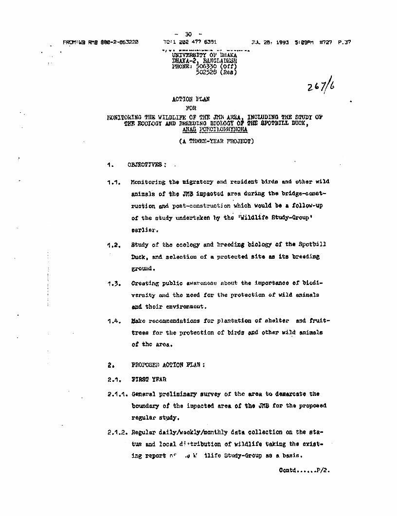
2.'4ACTION PLAj
FORMON[TO1IIG THE WILDLIFE OF TlHli J3?U AIJUA, INCLUDING THE STUDY 0?
TIM7 MOOGT AND PR=E INRG BIOLOGY OF THE $POUILL DUCK,ANAS PO3,CILOIRHYNCHA
(A TIIREE-Y!EAR PROJEOT)
1. O TECTIVES;
1.1. Monitoring the migratory and resident birde and other wild
anizals of the JMB impaotod eroa during tbe brdge-const-
ructi.on and post-construction which would be a tollow-up
of the study uyiderttacen by tho 'Wildlife Study-Group
earlier.
1.2. Study of the ecology and breeding biolol,;y of the Spotb.ill
Duck, end saelection of a protected site a its breedine
-1.3. Crealtin.g public awar(anosr3 about the importanoo of biodi-
versity mid the need for the protection of wild animals
ead thoir environment.
1.4. lakce recommendatians for plantation of shelter and fruit-
trees for the protection of birds and other wild animals
of the area.
2. PROPOSED) AOCtlON PLAN:
2.1. IZMT YIAU
2.1.1. General preliminary survey of the area to demarcate the
boundary of the impacted area of the JRB for the propoeed
rogular study.
2.1.2. Regular daily/weekly/monthly data collection on the sta-
tus and local d4'-tribution of wildlife taking the exdst-
inE report rz .o V ilire Study-Group as a basis.
Contd ...... P/2.

- 31 -
FORTM:WB RMB ee-2-86320 TCtI 22 47? 5391 JUL 8 1993 5:12PM 7?2? P-38
2A1.2.1. Idontiticatior of resident br6odinc birds, their food
and habltats. 2- 6 7/7
2.1.2.2. Identification of roRicLenU but non-breeding locally
migratory birds, their food and habitats.
2.1.2.3. Idontification or wintor migrants, their food and habitats.
2.1.3. Study of the other wild animuala.
2,1.3.1. Coliection of data on thc hp.AWltats and other wspects of
the aquatic, terrestrial nfd aerial Mamala.
2.1.3.2. Colleotion of datia on the habitats and other aspects of
lizards, anakes and tortoi.sus (Reptiles)
2.1.5.3. Gollection of data oII the haiabitats and other aspects of
amLDphibians.
2.1.4. LocatinG the roostJng tr,d fceding Erounde of the Spotbill
Dut:X in the non-brccdin,e as well an breeding seasons, and
also locatinr: its brcedln3g grounds within the impactedF
areo.
2.1.5. Solecttion of suitablO blreeding ground/groiunds of the Spot-
bill D)uck zor' tho co0louction of data on
2.1.5.1. NSestinr.
P0..5.2. gaglaging.
2.1,5.3, Incubation.
2.1. 5.l,l. lla.tching.
2. 1.5. arenta l care.
2,1.5.6. brooding suc&eos,
2.1.6. Spot-etunting at f$xed times and places for information
on the sio anid density of binis and, if possible, other
animhals .
2.1.7. Special attention to be given to sudden and unexpected
bloloGical and ecological hazards ( i.t any) durinlc drecig-
ini, and bridge-aoonatruct-iox± and suggest iommdiate- mitiga-
Contd ... }/3.

FRQI:WP RMB 88o-2-863220 TO:1 222 44 639± JUL 2e. 1993 5:11PM W'2? P.39
t-oryS m¢"@oci ( if' nondectle ). 26 k /
2.1.8. Afl possible efforts Would 1be ulace: to involve thfe lo04l
peoplO in the study proctess to get inforAration about ttu
past hiistory of tho fanma and flora of the inmpacted area.
Awareness would bo 4cveloped through discussions, lecturues
amd othi;er friendly persaasion about the importance of prot-
ccting the 'kanshi grass' (Sacceborum spontwieuin) und othor
'char vegetiat-ion' (Rivor island vesgetation) at leatt till
the breeding of tho Spotbill Duck and other bircls of t?he
ati aCted aeas is5 over.
2.1.9. A fe.w ducks and other waders, migratory and resident, would
bc collected, subject to the approval of the hinitztry of
Environmrent and Yorestry (I'IOi':f), to collect stoBinch contents,
parasites, etc.
2.1.10. A compLhrehlensiveO annuttl roiott, in addition to month)y
reports, would be prepared at the eni of the first yeuar.
2.2. SCO1ID AnND tHIRD AYlt
2.2A1. 'T3h0e same prograionio wou)i be ropeated Jn the second yvar.
IHowever, uadjustxuLzts, amnendments, etc., would bo made to it,
if nooeosasoy, for ie.ttiry; better information in the 'ccoijd
year. Like the £frot yoAr, roports will be made in the second
year also.
2.2.2. Tlhe programme tor the thiird year would also be imnproved upon,
if necessary.
2.2.4. A final. and comprehensive final report would be prepared at
the end or the third year, anialysing the records of thte entire
project period.
2.2.4. In oider to implement the above plan, the proposed organo-
gram i4 shown in anrcxurwe A' and th e proposed man month is
shown in aJzaoxure 'J
2.3. '.UT{F, JOJi I%8UiTFlIoI$N OR WulE: REWSPNSIBIJ.ItIES OF TULf

- 33 - S1p 77P4
FROM;WB RMB S88-2-8e3220 TO:1 22 477 639l JU. 29, 1i3 SiiPP1 #727 P.40
.&,L3iNtNJ~I' JVOI.El) A1SI stio'rN 21F1/JId7/
2.3.1, Prorjct IiraCtor (P_): lie would be resporisible for the
whole pro; ct: planning, I ropl emzentation, recoMn.Adt,,n.i,
prep#ration of the final report ctc t. Ile wy have to make
more visits and spend more dsy't Jn the project.w6a. tlhn
specified in tho programe, to get desired sucoess, an andwhen necessary.
2.3.2. Wli xe Wi : He would hlip the P.D. in panring,
iTnplementeliz and analyving the findingso. He maK accompwr
the PD or may visit the project area independently. Ile too
may havo to make more vrisits andt spond more days in the
pro:ect-aroa that specified in the programet on and whenwhen neefassa8.
2.3.3. Reaearch 2?cflow (RI?): A f2ll-tiio OMDploy'e, he will stay in
the projoct-oroa throughout the project pariod, except for
the approved holid.ys/vacations, aid would be responsible.
for exoout3ng progrwamme a8 inetructed by the PD and WM: lle
will koap records and prepare reporte for the PD and l.
do &Va have to make prelivinary r analysis of the tiold-data,
axid mke asuggestions based on the colleetOd informktiol and
tile on-the-6pot field experienecs.
2O3.4 Be.cacnh-AeSistant (tA)_ .: lie wiJl assiet the PI in aLl his
fio3d works. lie too would tt.y I.j the project-grea for the
wiholo pro4cct period, except for the approved holidaes/vca-
tionB.
2.3.5. LJdlifo Sre outp (a)S They wi3l stay in the project area for
the whbole project poriod, except for the approved holldays/
vacat-ions. They will keop watch on the project szrea, help the
R? and follow hlis directiorns.
2.3.6. Wildlife Guards (W&)s Thoy will be enLZeed frog timo to tinme,
eapecia.ly d%urijg thie breeding atatouns, and would help in the
project work as. directed by tht: VDj/WVAI etc.
Contd ....... P/5.

- 34 - 4
FROM:WP RMB 880-2-863220 TO 1 282 4?7 6391 JUL 28, 1993 5a12pM W?Z7 P.41
- ,~~~~P,4,7- a 'A I)41OF-01ce Y?t-f W'i.t.fA I-l3if. ,}5'!;,1Dttt11c ac-Zion
1es,Tw :in r(Alwm; in 'A:7<,1Xt'f'
1, of 't; '1lT ;J)tA1- 'W;:
i i t.t1fl CoVtC.i'( t:f l (3P4't rom:* w rral TId c1l Ci..a) pC.j III 44-iew
c il tho( Uv!X III i~1~' ;)O"iotu Pio-(tC;vL 1V-,. 16
3:,. hi,dJ'; 1 :,fl,(:v*. t. ';. JA.: w ,.n: a t;i, ,c ue &chvu
dulflu of ",14 N-n,0v ) i .1 .i .i P% I'tc:7)4rv 'iLIOn Aet, 197.f'
>,2* A roviascd invont-'yr, *If nveded on thc tL-a4iBs or' a thc*uo-
yew-' vtv.U yI wmil.d bo V'I'f, ' for .iutueVO r.1VflC(3.
A l! i±uij: 6v4oUwd u. Uhu Spoi.;fJ.l I)ck vo-l.i beo voI40te1d
fca" d(v,- 3AT'FA'tiCYP tW': 'Pvo-oct-s.dMtt tUi. and. w^ould boQ ls¢utld
Q.ie-Y to t}e; 1I.(.}4F/JLMIJ for.It1' Cc- COW;(VV'ti.0fl.
rDepm:t'mnt or Zoot.O-yt)i) i vo raity of Lh fli1a, &
rteid ent
14.1,. t 8njigcD1tons and r(oormn!nwiations £filA4 by lii. .Isaii
MNoburk of t1\e Worhl dA3nk} t nd ¶1t Subsequernt ruetijig
esud& iitwoe:.nioun vWtt h\iml,were kntrc;moy uat Sul. irn
prupg;rini tLhe pr5:3vait doouta*nt on action pre,u.rgue.I: am cL?trcirO3y CxmtciA.l to hi$n.

- 35 -
FROMIWB RMB 880-2-863220 TO;1 202 477 6391 JUL 28. 1993 5:12PTI W27 P.42
DO 7/tt
Asnb>uz ro 'A'
J'AMU NA Mi L'_T I tJJZi>OK v it( I: DG i4 AUTIICfl'C .1 't Y
W:l 1.: I F '.! AC irY'I CON P LAN
MA_4P-O14- J. q %ANO%MURA-M
IX l?t!S0&V-Ch Al-is1gunt
2w Wildlife scoit,
2x Fiv1Jd Otiard

- 36 -
. FPRQWI RMBE 8 -2-863220 TO'1 202 477 6;S31 JUL 29 1 5: 1PM #V2 P 43
. .~~~~~~~~~~~~~~~~~~~~~~~~~~~~~~~~~~~~~~~~~~~i
A isitex ilt' i-c
J AM NtNA Ml I,' I PIJI 'IOtLI. It1-1 I A)LIT AU 1'1l1l01 I TI'Y
W I 14.1). I Vt':.: A ;'I'l (N JhLAN
MAN S'(.)IY&A: F;-i-I£ t:NC.'rl ( 'AI' I MI)I.I.:M 54:N'IA'I' a Cti )
I . ::10)RI )M* U11TOU
AW I 1.1*'. I 1JAI tTV:i' i. I i't'LA
matinjr,4wrat vtuff to|4. lIA.ZiAltCIl A$S3i:l'.AN?I _ 1 1
15. W, l.ll. Fi.i i sc:zsvr z ,
X. I EI.18,1 (jI,Alt) _ 2 z
IQA14{l^. 2 U
Notut : '11c' ;.ro,jc D lrvc' tor ssnd zI dgli L.u ........ sl s I.F1 *¢1 ;r~
JAl lu io ?Z {(. 'g |i a i in te 4 ,:l ;hb.)It ;i. ,;!I4ii.ti.ntila1
hoOzt;i.f;t at:dTs to a:c,rl in th*, .fi.el.4 zi:i.J J bi} ti~uc~i.t.elI
w _ ~~~~~~~~~~Proj-ect: :ttrt thle -'ji4 'i o' t.-he 3:::3 ar,ea ( ctdine t.e s-udy o.. the ecco:v treo""Z-- and 'treedi--Z -r,oloZy of tWhe S-notted -^ .....................A--as =
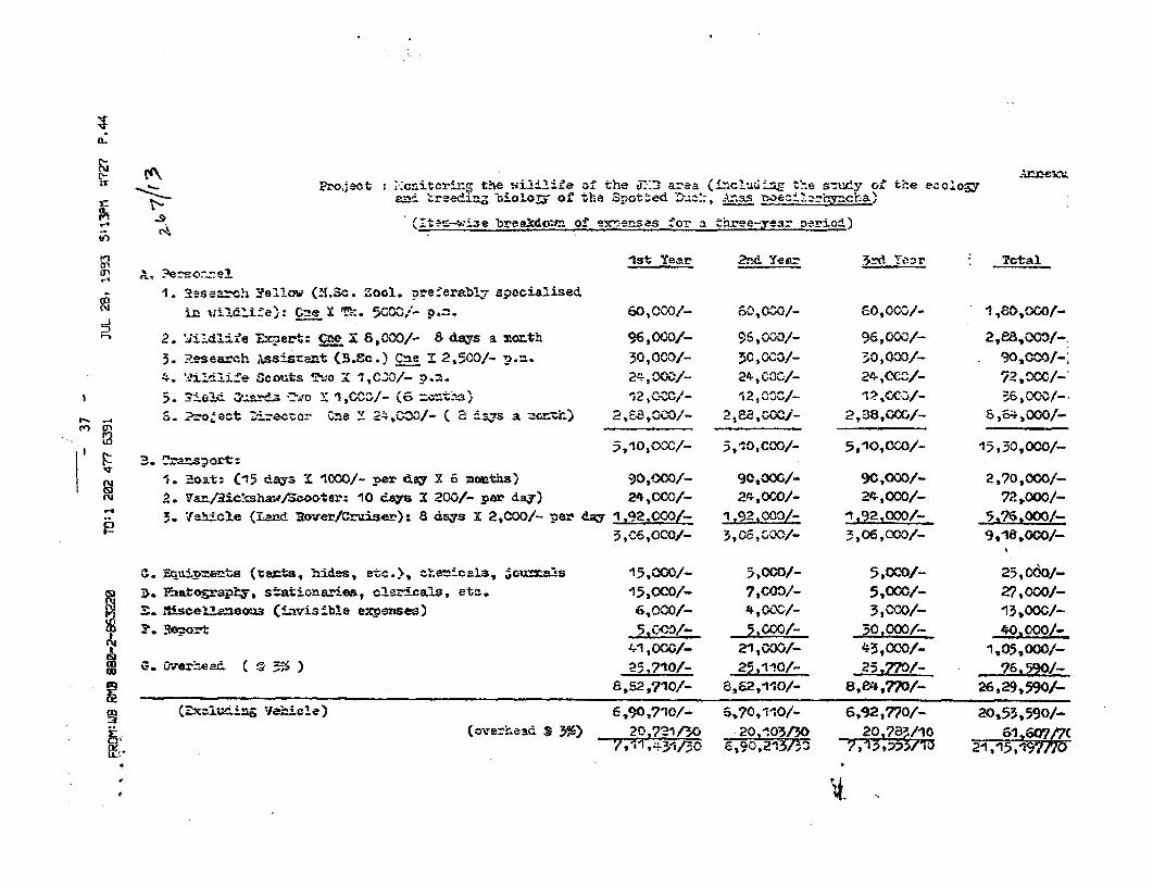
> 9 (t v:53e ~~~~~~~~brealcdo;-I. of enemses fo- a theryea=3r Derimi)
.. c
a) ". -e oe -es1. a-asea h 1:'sl'oM; (YI.Sc. Zool. Dreferably speoialised
g~~~~~~~r 1-14-Idife2: 5-0- * V: 'u- P.M. 0,OCIO/- 6-,0v^O/- 60,0ov/- 1b4 2. 'ii: itis~~e E-ert: C2e i; 6,COO/- a3 d.Vs a mort1h %60O- 5v3- ;ti3-2s wJ
3. 'Research. .ts (S+<.Cc.) Cme Is 2,1500- :,.m. 3r),COt 30,0c3,- 30,000/_ O,
4. 'f:L -' life Sc¢outs Tht:3 ' -,,Ck O/- p.m.7 $ OODk/_ 24.000W/_ 24,CC.C/- -/72.OCC/-'5, ={5i Vt .oY ><X o=-v 2wC- 19vt vX*-E>
s. 2.o4ect Dizeccor cne x, 24,ow/^- ( a_^>,vs a-!i 2, Z-A"-;40/- 2,-88,;=X:- 2,38,=;C,- 8,64,0C0/-,n En ,
:3 ,10,0ZCf- >~~~~~~~~~~~~~~~~~~~~~~~ ~~~~~~,10f,C-00/- 5,10s0C0/_ -15,30,OC30/_
ru . 'oat: (d15 days I 1000/- per da; X o monthls) 90,=/- 9C,=O/- 9C,000O/_ 2,70,000f-ru2. Ta/R:c'-shwv/Soooter: 10 dasX 20G/- par day) 24,COO/- 24,000/- 24,000/- 7P,000/-
.. 3* [e.Ece (Land Rover/Crise-r): 8 d-as X 2,000/- per dg I 92,CGO&- 1 f2,0- t92,2000/ 5 76,CMOO/_-
3.,0C-,CO/_ 5,Oc,000/_ 3,06,0000/- 9,118,a:0OJ_
9. Eceue>Qfs(te:cts, hidles, et--.>, _ .................. e::e-mcalz, 3ou=a: -s 15.000J- 5,000/- 5,oco/- 25,0601-
> 3, lEntapP;, ~~stationa-ries, clez-cals, eta. 15,0CO/- 7,COO/- 5,0GOJ- 27,000/-S . 3iscelaewa3 (:Larisible ex;menes) 6,000/- 4,OOC/- 3,COO/_ 13,000/-
3 2. G5 C-,'O/_ 5 IC/- -3:L/_ 40,222+~~~~~~~~~~~~~~~~~~~~~~~~~~~~~~- i OCG/- 21,00OG- #5 ,000/_ :|,0-
g &~~~~~~~~~~~~~~~~~~~~~~~~~~~~,52,710/- 86,;0- 8, E4,77/- ;h6.29,590/-
3 ~~~(MxZ;=5*iE Vehicle) - t ^X 6,?0,1i10/- 6,192,770/- 20,53,590/-- ~~~~~~~~~~~~~~~~~~~(ove=2,asc 3 3663 2- 7l I 21 -7 20,^103J30 201,783/^0 {;1 6wa/-C
X,~~~~~~~~~~~~~~~~~~~~~~~~~~~~~ i 7s1 34 0 3-/ , ,435' 21,1-5,19 4t

- 38 -
.....................................................................................................................................................................
JAMUNA BRIDGE PROJECT
ENVIRONMENTAL ASSESSMENT
Attachment 4
... ................................................................................................................................................................ ... ...... ..... ....... .... .... ................ . . .......... @-... .... ....-:::::::::::::::::::::::::::::::::::::irl::::iiii:i::iii::ii::::::::::::::** :

- 39 -
EXECUTIVE SUMMARY
The Land Use Master Plan (LUMP) consultants conclude in this report that the construction of the
Jamuna Bridge offers opportunities to encourage and plan for the economic and urban development of
the bridge-ends and the surrounding Study Area.
In brief, we condude that a self-sustaining township of about 20,000 people could be esablished
at one bridge-end, and that a series of supporting physical action plans and related institutional
progrunmes are required to ensure the spread of benefits and the efflcient implementation of the
plan.
Following this summary, Chapter One (Introduction) briefly outlines the objectives of the Study and
outlines the imporance of adopting a flexible response to the issue of uncerainty in plan preparation.
This is because the bridge may not open until rive years hence and certain decisions may have to be
held in abeyance until then or even later.
Chapter Two (The Regional Sefing) is a description of the context for development in the Study
Area and the surrounding region. The chapter shows that natural growth within 50 kilometres of the
bridgc would produce a population of 10.5 million by 2016. However, of these, some 0.9 million
would be expected to migrate from the countrvside for urban locations elsewhere in the country or the
region. Such a figure indicates the magnitude of the urbanisation potential of the Bridge Area.
Chapter Three (Generated Development at the Bridge-ends) considers the basic dcveiopment
required to operate the bridge and concludes that after the construction period a "Minimal Scetario"
resident population of about 1,800 would be required at both bridge-ends. This figure may increase to
about 4,300 within five years of bridge opening as a "Service Centre Scenario" develops.
It is further concluded that although some of the population displaced by the bridge works may take up
urban occupations it is not a viable option to rehouse these people at the bridge-ends given the
ii

- 40 -
included a more modest economic internal rate of return of about 12.4 percent is forecast.
The Study Area Land Use Plan presented in Chapter Six suggests the preparation of several Action
Plans designed to focus on junctions and corridors in the Study Area at which pressures for
development may be found. These include:
o linkages fm the approach roads and integration of the resettlement sites;
o the newly created junctions at Hatikamrul and Elenga;
o a reinforced corridor linking Sirajganj to the west bridge-end.
o a by-pass for Tangail.
Chapter Seven (Supporting Infrasrucsure Projects) reviews the range of infrastructural provision
likely to be required and makes clear recommendations for appropriate standards at the bridge-ends,
the resettlement areas, the approach roads and junctions, and also for Tangail and Sirajganj.
Supporting Instituional Arrangements are reviewed in Chapter Eight and these are seen to parallel
and correspond to the evoludon of the Study Area described in Chapters Three, Four and Five. It is
recommended that the JMBA should retain responsibility for the operation of the bridge and the
impiementation of the bridge end land use plan is undertaken by an internal Urban Development
Section .(UDS).
Financial Management of the proposed UDS and UDA is discussed in Chapter Nine but the final
chapter (Chapter Ten: Proposed Technical Assistanu e Requirements) identifies four technical
assistancc packages required for the successful implementation of the plan, and these are:
o resetlement and identification survey;
o assistance to the proposed UDS in JMBA;
o detailed engineering and layout studies for priority projects; -
o assistance to JMBA UDS or the proposed JBUDA.
iv

........................ ..... ......................................................
S zuewqoeutt
iN3WSS3SSV 1VIN3WNOHlAN3
LoaroId 3salUS VNnwvr
*.--E-.--.---.-.....- i.s-..- ..............................---........

- 42 -
Rendel Palmer & TrittonNedeco 2J6 Mohammadpur RA. Block A
Mirpur Road. Dhaka 120Bangladesh Consultants Ltd Tel 6813437,815CConsulting Engineers Fax (880-2) 8135
Ref: 2798/269.1/SC/JvO 13 July 199
JAMUNA MULTIPURPOSE DRIDGE PROJECT
The World BankAttention: Dr Ismail MobarekSenior Port EngineerRoom F 80251818 H Street. NWWashinqton DC 20433U.S.A.
Jamuna Bridqe-End Planninqg Inteqration Study
Dear Dr. Mobarek,
We have pleasure in enclosing 4 cooies of our draft report on the above Study.
As you know the Jamuna Bridge Co-financiers meeting in Washington on 27th - 29th Apr1992 instructed RPT/NEDECO/BCL to inteqrate the GHK/MRM International (GHI) Land U!Master Plan with their own bridge-end designs and tender documents.
The Consultants subseouently invited GMI to join them in a single Study Team in ordfto carry out the integration work in the most efficient manner possible.
The underlvinq aim of the Study has been to ensure that township development can ipromoted without detriment to the efficient and effective operation of the bridge. !are oleased to reoort that the Study Team reached unanimous agreement on all issuiand have prepared new draft land use master plans to be known as the "InteqratMaster Plans'. The Study Team believe that the new Plans:
i) provide for the efficient oceration of the bridge-end;
ii) achieve the most effective use of limited and valuable flood free land;
iii) minimise the need for land accuisition and, therefore, resettlement;
iv) minimise develooment costs: -
v) achieve an adeauate seoaration between essential operation areas and the ntownship and service community:
vi) orovide an attractive and efficient town layout.

- 43= -
One of the most fruitful outcomes of the Study has been the reduction in thereouirements for fill material on the west bank of the Jamuna (where a shortagse offill is exoected). with a cotential savinq to the main project of US$ 1 to 2 million.Other adjustments to layouts and land use allocations have also been achieved withoutany increase in overall orolect costs.
A oresentation of our draft oroposals was made to JMBA in Dhaka on 11/07/1992 and therecommendations met their broad approval.
Adjustment to the Integrated Master Plans may be required once the precise quantitiesof dredge socil are known and the final location of the guide bunds fixed.
We look forward to receivinQ vour comments in due course.
Yours sincerely,
J. van DuivendiikProject ManagerJamuna Bridge Phase II Studies
Distribution:
World Bank: USA 4 copiesWorld Bank: Dhaka 1 copyJMBA: Dhaka 10 copiesPOE: Prof. Gerwick 1 copy
Mr. Sandford 1Prof. J.R. Chowdhury 1
ADB: Dhaka 1 -ADB: Manila 1IOECF: Dhaka IOECF: Tokyo iRPT: London 4 copiesNEDECO: Nijmegen 2"aCL: Ohaka 1 coDyGHK/MRM (Mr Ryman) 2 copiesOffice file 4 "
Tota7 35 cooies==-====== ~ ~ -

- 44 -
C O N T E N TS
1. INTRODUCTION 1
1.1 Study Background t1.2 Report Outline and Outputs 3
2. STUDY APPROACH AND METHODOLOGY 4
2.1 Consultants Approach 42.2 Methodology 5
3. SUMMARY OF KEY ISSUES 6
4. EAST BRIDGE-END 8
4.1 Landfill 8
4.1.1 Determining Factors 84.1.2 Dredge Spoil Quantities 94.1.3 Land Accuisition Boundaries 114.1.4 Bridge-End Facilities 124.1.5 Contractors and Engineers/Employers Facilities 14
4.2 The Integrated Master Plan is
4.2.1 General is4.2.2 Main Features of the Plan 2C
5. WEST BRIDGE-END 2
5.1 Landfill 2
5.1.1 Determining Factors 2:5.1.2 Dredge Sooil Availability 25.1.3 Bridqe-End Facilities 25.1.4 Support Settlement 2!5.1.5 Links with the Resettlement Site 2-5.1.6 Railway Facilities 215.1.7 Electrical Interconnector and Gas Pipeline 2
- ,
5.2 The Integrated Master Plan 3(
5.2.1 General5.2.2 Main Features 3

- 45 -
LIST OF TABLE
Table 4.1 Estimated Quantities of Available Dredge Spoil - EastBridge-End
Table 4.2 Tender Drawings - General Distribution of Spoil - EastBridge-End
Table 4.3 Enqineers/Emoloyers Facilities East Bridge-End
LIST OF FIGURES
Fig. 4.1 Inteqrated Master Plan - East Bridge-End 1:12,500
Fig. 4.2 Integrated Master Plan - East Bridge-End 1:5,000
Fig. 4.3 East Bridge-End - Fill Distribution Priority
Fig. 4.4 Sketch Layout of Emoloyer and Engineers Facilities,East Bridge-End
Fig. 5.1 Integrated Master Plan West Bridge End 1:12,500
Fig. 5.2 Integrated Master Plan West Bridge End 1:5,000

- 46 -
1. INTRODUCTION
1.1 Study Background
The construction of a bridge across the Jamuna river represents
one of the most significant development opportunities for the
Government of Bangladesh. Following Feasibility Studies carried
out by the Bridge Consultants (RPT-NEDECO-BCL), it was estab-
lished that the Jamuna Multipurpose Bridge is technically
feasible and economically viable. Nevertheless this viability
has always depended upon construction costs being tightly
controlled. In carrying out detailed design and in preparing
Tender Documents, the Bridge Consultants have therefore
endeavoured to ensure that all bridge and associated works are
kept to the absolute minimum consistent with the effective
operation of the bridge.
Notwithstanding this, the Bridge Consultants have always
recognised that the Bridge could provide additional developmen-
tal opportunities and in their detailed designs have sought to
allow eventual urban development at the Bridge-Ends.
Following acceptance of the Bridge Consultants scheme in 1989,
the World Bank commissioned GHK/MRM International Ltd (GMI) to
prepare a strategic plan to guide urban and economic development
for an area within a radius of 30 km around the proposed Jamuna
Bridge.
In addition, they were instructed to prepare land use master
plans for the two Bridge-Ends in order to establish comprehen-
sive plans and development programmes for all the flood free
land created as a result of the bridge design anr. river training
works.
bl.4/report.bef 1

- 47 -
The underlying aim of the strategic and detailed land use master
plans has been to maximise the ooportunities for development at
the bridge ends and, therefore, increase the economic benefits
of the whole Jamuna Bridge Project. The GMI Study recommended
that urban develooment should be concentrated at one end of the
bridge only, because of the greater economic impact that one
large townshio would have rather than two separate and smaller
settlements.
Because there is likely to be substantially more dredge spoil
available for fill purooses at the East Bridge-End than at the
west, it was prooosed that a township of up to 20,000 people be
established on the east side of the river and that development
on the West Bridge-End be kept to a minimum.
In order to achieve the most efficient township design, and to
maximise development opportunities, GMI recommended a number of
small, but nevertheless significant changes to the original
design and layouts at the Bridge-Ends. In particular they
suggested:
o changes to the ooerational layouts
o the location and re-use of contractors facilities
o the distribution of fill material
o the integration of the resettlement sites with the bridge-
ends.
It was recommended that these issues be resolved through a short
study which integrated the Bridge-End layout with the Land Use
Master Plan. At the Co-financing Meeting in Washington in April
1992, the Government of Bangladesh and the Co-financiers
acceoted the underlying objectives of the GMT Study, particular-
ly as it applied to the east end of the bridge. It was agreed
that "modest reconfiguration of bridge end facilities at both
bl.4/report-bef 2

- 48 -
ends of the bridge a should be undertaken and that the proposals
of the land use plan and the original layout and design of
bridge end facilities should be fully integrated. The meeting
instructed the Bridge Consultants to carry out this task, anc
they subseauently invited GMI to work alongside their land use
planner and engineers as part of a single Study Team.
This reoort comprises the combined considerations of the
integrated Study Team and draws on the experience of all
consultants oreviously involved in the project.
1 2 Recort Outline and Outguts
The Report is divided into the following sections:
Section 2 Study Approach and Methodology
3 Key Issues
4 The East Bridge-End
5 The West Bridge-End
The key outputs of the Study are separate Integrated Master
Plans for the East and West Bridge-Ends. The Plans are producec
in detail at 1:5,000 scale and at a smaller scale of 1:12,500 tc
indicate the wider planning context of the Bridge-Ends.
These plans supersede the former GMI Land Use Master Plans al
1:5,000 and 1:15,000 respectively.
Tender drawings (to be issued as part of final Tender Document:
in Seotember 1992) will be amended in accord with the Integratec
Master Plans.
Minutes of Co-financing Meeting 27-29 April 1992.
bl.4/report.bef 3

- 49 -
2. STUDY APPROACH AND METHODOLOGY
2.1 Consultants Aporoach
The Consultants' aim in this Study has been to integrate
engineering and land use designs with a view to achieving an
optimal balance between the following key objectives:
i) Cost
ii) Operating flexibility
iii) Technical feasibility
iv) Socio-economic impact
v) Maximization of development potential
These ob.ictives are discussed briefly below:
i) Cost - In order that the Jamuna Bridge project remains
economically viable, the Bridge Consultants have sought to
ensure that its construction cost including bridge, river
training, land filling, and the provision of bridge-end
facilities is kept to. the absolute minimum. Any alterations
to the Bridge-End layout or engineering should not,
therefore, entail an additional cost to the main project.
ii) Operating flexibility - The existing bridge-end layout is
robust and capable of catering for a wide range of future
demands and operating conditions. It is vital that any
changes or modifications to the existing designs retain a
similar degree of flexibility.
iii) Technically feasibility - Any modifications to the existing
scheme should be capable of achievemient without undue
technical or other problems.
bl.4/report.bef 4

- 50 -
iv) Socio-economic acceptability - The integrated plan should
seek to minimise the need for land acquisition, thus
reducing the loss of productive agricultural land and the
necessity to resettle local inhabitants.
v) Maximisation of development potential - The development
stimulus that the Jamuna Bridge will give to the national
sub-regional and local economies needs to be fully exploit-
ed by urban develooment at the bridge in order to realise
all potential benefits from the project.
2.2 Methodologv
The methodology adopted to carry out the Study was, briefly, to:
o Define study objectives;
a Define key issues;
o Evaluate key issues and the detailed implications of each
course of action;
o Prepare new layout plans incorporating the preferred solu-
tions;
o .Identify Tender Document drawings to be modified or
amended.
It is proposed that the new land use master plans for the two
bridge ends will be known as "Integrated Master Plans" (IMPs),
to distinquish them from the existing Land Use Master Plans
(LUMPs). It is intended that the Integrated Master Plans at
1:5,000 scale and 1:12,500 scale will supersede the Land Use
Master Plans at the 1:5,000 and 1:15,000 scales. However, the
detailed design of internal township industr4al and housing
modules, together with the standards of service provision for
educational, health and social facilities will remain as
specified in the Land Use Master Plans.
bl.4/regort.bef 5

- 51 -
3. SUMMARY OF KEY ISSUES
Following the identification of Study objectives. the Study Team
carried out a thorough evaluation of the bridge-end layouts and
Land Use Master Plans. A substantial number of issues were found
to require resolving at both bridge-ends, of which some were
clearly more crucial than others. They are all closely interre-
lated and a course of action adopted in one area has a knock-on
effect elsewhere. rssues have been addressed in this Study in a
logical sequence, the more crucial issues which have wide
implications for all planning and engineering work being
assessed first. The following is a brief summary of the main
issues:
o the availability of fill material at either bridge-end,
including the problems of dealing with Possible shortages
or surplus of spoil;
o the precise shape and distribution of filled areas in
relation to existing land acquisition boundaries;
a integration of major infrastructure elements such as roads
and drainage, particularly in terms of standards and
networks;
o the location and layout of operational facilities, particu-
larly fire, police and rescue services at the east bridge-
end:
o the size of the townshi: east bridge-end) and support
settlement (west bridge-endj;
o separation between the operational bridge-end areas and the
township and settlement areas;
b1. 4/revort. bef 6
- 52 -
o road connections between the operational areas and the
townships and other residential areas, including the
resettlement sites:
o the location and re-use of engineer/employer and contrac-
tors facilities and the phasing of township development;
o provision of future expansion areas for the second stage
bus stations and the rail interchange facilities;
o the routing of the overhead electricity lines and the gas
pipeline beyond the operational areas;
o the problems of dealing with the large areas of land
created as a result of reclamation work which are not
required for immediate development but which are very
susceptible to informal or illegal occupation e.g. land for
future grade seoaration of roads;
Although many of these issues are common to both river banks,
the engineering and land use constraints are very different. It
is proposed, therefore, to evaluate and address the problem of
the east and west bridge-ends separately.
bl.4/report.bef 7

- 53 -
4. EAST BRIDGE-END
4.1 Landfill
4..1.1 Determininq Factors
The Jamuna Bridge design involves the construction of major
guide bunds at each river bank to protect the bridge abutments,
approach viaducts and embankments from the erosive force of the
river, and. to orevent the bridge from being outflanked. The
guide bunds, each about 2.5 km in length, will be created by
dredging trenches in order to create the underwater slopes to be
protected. The resultant dredge spoil (mainly sand) will be usec
to create the flood bunds, aoproach viaducts, land for bridge-
end facilities and fill for approach roads and other uses.
It is important to note that dredged material supply is
essentially a by-product of the creation of the guide bunds, anc
has not been determined by fill requirements. Nevertheless, a
balance between supply and demand has been sought in the Phase
1I Feasibility Study and subsequent Tender Documents. As e
result of the Land Use Master Plan (GMI) the demand for urbar
development land has been more clearly defined and it is nob
necessary to determine in more detail the likely range of
possible surplus or shortfalls of fill available.
The original estimates of the quantities of dredge spoil likely
to became available as a result of the bund construction work,
were based upon the following criteria:
o Existing average ground level in the floodplain at PWD + 12
metres;
o Soecified gradients for the permanent slopes of the guide
bunds;
bl.4/reaort.bef 8

- 54 -
o Assumed gradients for temporary slopes necessary for
construction of the trenches in which the slope protection
works can be made.
Three important additional points need to be made. Firstly, it
has been assumed that a certain amount of the dredged material
will be unsuitable for fill purposes, for example, because it is
too fine. An allowance of St has, therefore, be allowed for this
loss in any calculations.
Secondly, material will be pumped directly onto the adjacent
designated fill areas during dredging operations, so that to
transfer surplus spoil from one bank of the Jamuna to.the other
would involve a separate operation. Because of the distance and
difficulty of crossing the Jamuna by barge and the double
handling involved, this is considered to be an uneconomic
proposition. For calculation purposes, the total spoil arising
from the construction of each guide bund is, therefore,
considered separately.
Lastly, the possibility of returning dredged material from
bridge building operations has also been investigated but was
considered likely to be impractical for many reasons, for
example because of the distances involved and disruption to
dredging operations that the operation would entail. This option
has therefore, been discounted as uneconomic.
4.1.2 Dredge Sooil Quantities
Based upon the criteria described above, the following table
indicates the amounts of dredge spoil estimated to be available
for reclamation work. For calculation purposes it is assumed
that minimum dredged quantities are unlikely to differ more than
10% from maximum quantities, because af the precisely defined
profiles of the guide bunds.
bl.4/report.bef 9

- 55 -
JAMUNA BRIDGE PROJECT
ENVIRONMENTAL ASSESSMENT
Attachment 6
........................................................... ..................................................... :**::::::::::::-.*:::::::::::::::::::::*.:::::-.

- 56 -
1/77-4C ./. '-f . _
EXECUTIVE SUMMARY
This volume and related Annexes pmsent the Final Report of the Dhaleswari Mitigation Plan Study
which has been prepared as part of the Dhaleswari Mitigation Plan and Land Use Master Plan
Study undertaken by GHK/MRM International Ltd. in association with Hunting Technical Services
Ltd and Uniconsult Intemational Ltd. on behalf of the Jamuna Multipurpose Bridge Authority.
Annex VI was prepared by Mott MacDonald Intemational Ltd.
The objectives of the study were to identify the impact of the proposed closure of the northem
intake of the Dhaleswari river and to initiate a process to mitigate and monitor the adverse effects,
including the social, economic, and health impacts on the population of the area together with an
assessment of the impacts on agriculture, navigation and other resource and economic benefits.
The area potentially affected by the closure of the northern intake of the Dhaleswari river was
identified at inception stage as the catchment area of the Dhaleswari extending from the northern
intake to the confluence with the Mcghna and Padma rivers. The eastern and western boundaries of
the affected area were defined by the Turag and Jamuna rivers respectively.
Subsequent hydraulic modelling studies demonstrated that the principal impacts would be confined
to an area of approximately 60,000 ha comprising the catchment areas of the upper Dhaleswari,
Pungli, Louhajang and Elangiani rivers and described in this report as the Impact Area.
The study concludes that direct impacts of the closure would be:
o a reduction in averagc depths of flooding ranging from one metr in the upper
Dhaleswari and Pungli rivers decreasing southwards to a negligible amount in the
vicinity of Mirzapur town and the southem Dhaleswari intake.
O total annual discharges in the upper Dhalcswari, Pungli, Louhajang and Elangjani
would be significantly reduced in both volume and duration. The most affected
channels would include the Upper Dhaleswari and Pungli where annual discharges
would be reduced from 40,000 Mm3 and from 15,000 Mm3 to 22,000 Mm3 and
7,000 Mm3 respectively, with the duration of flow reduced from six to fourmonths.

- 57 -
o overbank and spill channei discharges from the Jamuna to the upper Dhaleswariwould be increased by 83 per cent from 12.000 to 22,000 Mm3 which is likely to
give rise to increased erosion of areas of land supporting rainfed cropping between
the Jamuna and Dhaleswari rivers.
O ground water recharge would be not be reduced significantly and mnaximum depths
of pumping lift would remain unchanged although potential recharge would be
rduced by 40 per cent.
O a reduction in the area available for fish spawning and refuge of 11,000 ha and a
corresponding reduction in annual fish prduction from 1250 to 750 tonnes.
O the effect on river transport would be limited as commercial traffic has already
ceased and much of the country boat through traffic will transfer to road and railservices pomvided by the Jamuna bridge.
The indirect impacts of the closure would be:
o the reduction in flooding would enable an improvement in agricultural prductivity
through the adoption of higher yielding crpping systems over an area of about15,000 hectares. Rainfed crops of mixed broadcast aus and aman rice crops would
be replaced by broadcast aus or jute followed by transplanted deepwater aman.
Under irrigation, HYV boro followed by transplanted deepwater aman would be
replaced by HYV boro followed by transplanted aman.
O the environmental impacts, other than fisheries, are be difficult to assess given thepresent degraded status of the terrestrial habitat Increased dryland areas would
provide an improved monsoon habitat for the very limited surviving mammal and
bird populations.
O the benefits to the 20,000 farming households in the impact area would represent
an average increase in income of 50 per cent or Taka 6,000 per year, although the
range would vary considerably. This would also increase employment opportunities
for the landless and poorer sections of the community.

- 58 -
o the net annual economic benefits of the intake closure are estimated to stabilise at
Taka 25 million from Year 5 onwards after allowing increases in agriculturaloutput of Taka 48.8 million to be offset by losses in fish production of Taka 17.5
million and the loss of agricultural production of Taka 6.3 million from land lost to
increased erosion between the Jamuna and Dhaleswari rivefs.
O the loss of income to the 9000 or so professional hLshermen would be of the order
of Taka 1000 to Taka 2000 each depending on the location of their fishery. This
compares to average incomes of about Taba 4000 to 6000 each.
A range of mitigation measures have been considered to reduce the negative impacts of closure on
the present surface water regime and eliminate the risks of erosion of lands lying between the
Jamuna and Dhaleswari rivers.
The options studied for the maintenance of the present surface water regime included the retention
of the present northern intake channel, the provision of an alternative intake channel and the
enlargement of the southern intake channel. It was concluded that these options would not providc
a technically acceptable solution in view of the unstable characteristics of the Jamuna river and'the
uncertainties regarding the geomorphological conditions following the construcdon of the Jamuna
bridge.
A mitigation plan based on the construction of a guide embankment between the Jamuna and
Dhaleswari rivers is recommended. Implementation of the plan would reduce the risks of the loss
of land through erosion due to overbank spill between the Jamuna and Dhaleswari although it
would have little effect on the normal erosion taking place along the east bank of the Jamuna.
Agricultural benefits would be increased and benefits would also arise from reduced flood damagc
in the impact area. The impact on fish production would be negative with annual yields reduced by
75 per cent although a fisheries support component may reduce the overall loss to about 30 per
cent.
The project would support a Project Monitoring Cell (PMC)for a period of five years. The PMC
would coordinate the monitoring of the mitigation plan including the commissioning of base line
and annual surveys of surface and groundwater resources, agriculture, fisheries, and socio-
economic effects including health and nutrition. The PMC would be attached to the office of the
Deputy Commissioner, Tangail District. As an alternative arrangement, the PMC could be attachedto the proposed Jamuna Bridge Development Authority as recommended by the Land Master Plan
report.

- 59 -
The overail impact of the mitigation plan would be:
o a reduction in average depths of flooding ranging from two metres in the upper
Dhaleswari and Pungli rivers decreasing in a southerly direction towards Mirzapur
and the southem Dhaleswari intake.
o total annual discharges in the upper Dhaleswari, Pungli, Louhajang and Elangjani
would be further reduced in volume and duration. The most affected rivers would
be the Upper Dhaleswari and Pungli.
O ovetbank and spill channel discharges from the Jamuna to the upper Dhaleswariwould be eliminated thus protecting areas of rainfed cropping between the Jamuna
and Dhaleswari rivems.
O ground water resources and pumping levels would remain unchanged. Future
increases in the use of irrigation will increase pumping lifts and may necessitate to)use of deep set shallow tube wells, particularly in the areas of FO and Fl land. This
will not be as a direct consequence of the mitigation plan but due to the increased
use of groundwater for irrigation.
O a reduction in the area available for fish spawning and refuge of 26,500 ha and butthe provision of a fishery support component would reduce the loss in production
to only 450 tonnes.
The indirect impacts of the mitigation plan would include:
o the reduction in flooding would enable agricultural productivity to be increased
through the adoption of higher yielding cropping systems over an area of about
29,200 hectares.
O the environmental impacts, other than fisheries, are difficult oi4sscss given thepresent degraded status of the terrestrial habitaL Increased dryland areas would
provide an imprved monsoon habitat for the very limited surviving mammal and
bird population.

- 60 -
o the benefits to the 36,500 farming households in the impact area would represent
an average of Taka 6,000 per year or a 50 per cent increase in income, although
the range would vary considerably. This increase in agricultural activity would also
increase employment opportunities for the landless and poorer sections of the
community.
o the net annual economic benefits of the intake closure are estimated to be Taka 107
million after allowing for increases in agricultural output of Tah 98 million and
reduced flood damage of Tah 25 million to be offset by decreases in fish
production of Tab 16 million and land lost to construction of the embankment of
Taka 0.13 million.
The full social impact of the closure is difficult to evaluate in detail because of the limitations of
the present data base and the natural demographic changes are already occurring within the
structure of rural society in Bangladesh. There will be income losses to the profession fishermenand to rutal households involved in opportunistic fishing. Increased agricultural production and the
generation of 2.3 million man-days of employment may compensate for these losses, although
clearly the losers may not be entirely identical to the gainerm. The detailed social impact can only
be assessed as the result of the activities to be undertaken by the proposed Project Monitoring Cell.
The total cost of the Dhaleswari Mitigation Plan including physical and financial contingencies is
estimated to be Taka 129.3 million (USS 3.60 million) of which Taka 76.9 million (USS 2.15
million) would be in local currency and Tah 52.4 million (USS 1.45 million) in foreign exchange.
The anticipated level of benefit flows are very substantial in relation to the additional costs
incurred and indicate that it would be well worthwhile making the recommended investments
suggested within the scope of the Mitigaton Plan. Since net incremental benefits are positive fromYear 1, it is not possible to calculate an appropriate internal rate of return. However, assuming a
12 per cent discount rate and a 25 year pmject life, the net present values of the net cash flow
would be arund Tab 715 million (USS 19.86 million).

- 61 -
....................................................................................... .... :* :....................................
JAMUNA BRIDGE PROJECT
ENVIRONMENTAL ASSESSMENT
Attachment 7
...................................................................................................................................................................

- 62 -
772/cf /7Jr
GOVERNMENT OF BANGLADESH
JAMUNA MULTIPURPOSE BRIDGE AUTHORITY
RESETTLEMENT UNIT
RESETTLEMENT ACTION PLANFOR
PROJECT AFFECTED PERSONS (PAPs)
Jtd 1993 -
Alenbari. TeigaonDhaka 1215. Bangladesh

- 63 -
CONTENTS
* Resettlement Action Plan
* Residual Land & Socio-Economic Survev(Ust of Tables -Table 1 to 51) 18
* Annexures(List of Annexures - Annex A to M) 48

- 64 -
JAMUNA MULTIPURPOSE BRIDGE AUTHORITYRESETTLEMENT UNIT
RESETTLEMENT ACTION PLAN
1.0 Jamuna Multipurpose Bridge construction along with approach roads, flood protect
embankments. hard point, river training works. etc will involve acquisition of 5,681 ac.
of land on both sides of the Jamuna River. The villages, unions and thanas where lawill be acquired can be seen in Annex-A. In all 58 villagesJmouzas will be affected in
or in part.
2.0 In view of the size of the project and number of PAPs. the project has been classified
category 'A', requiring full environmental impact assessment, by the World Bank a
other participating development agencies. WB Operational Directives (00) 4.00 and 4.
have been closely followed by the JMBA in preparation of the Resettlement Action Pi
(RAP). The RAP aims at not only compensating PAPs for the loss suffered due
compulsory land acquisition and consequent involuntary resettlement, it also aims
improving their condition.
3.0 A detailed survey of project affected persons (PAPs) has been conducted by t
Bangladesh Rural Advancement Committee (BRAC). lt was conducted during the mont
of October, November and December 1992. Because of the uncertainty of final locati
of West bridge-end, West bank guide-bund and bridge-end facility areas have not be
surveyed. The draft final report of the socio-economic survey was sent to World Ba
and other donors for their respective comments/observations. World Bank and JME
made some comments on BRAC's draft report for further modification. lPAC submkt
a detailed census of all PAPs and the final report on 31 May 1993. The land acquired i
the JMBP (except 117 households at Tangail and west bank guide bund and bridge el
facility areas) is shown below (ii decimals): -
Tangail Siraiganj Total
Agricultural Land 269,628 61,666 331,29'
Homesteads (Land) 31,308 8,305 39,61:
Fallow Land 20.595 423 21,01f
Other Land 5.920 308 6.22f
TOTAL 327,451 70,702

- 65 -
4.0 The survev has been able to establish the nature and magnitude of loss being suffert
by each category of PAPs together with the change taking place in pre and pc
acquisition status. 6.1 56 households are being directly affected due to loss of land wh
5,906 are-being indirectly affected. In all 32 public institutions and community faciliti,
will be acquired and 90 businesseslindustries will be affected. Table 1 to 51 (annexe
show major classifications.
5.0 Among the land-losers there are four groups: (A) Homestead-Losers. (B) Agricultur
Land-Losers. (C) Both Homestead and Agricultural Land-Losers. and (0) Fallow andi
Other Land-Losers. Excluding the 1 17 households of Tangail. the number and percentai
of these households are:
Tangail Siraigani Total
A 470 (11.71) 330 (16.301 800 (13.25
B 2.453 (61.11) 1,359 (67.11) 3.812 (63.12
C 1,070 (26.66) 296 (14.62) 1.366 (22.62
0 21 ( 0.521 40 ( 1.97) 61 ( 1.01
TOTAL 4,014 (100.0) 2.025 (100.0) 6.039 (100.0
Not all PAPs were agriculturally-landed before the JMBP acquisition (these PAPs belo
to the groups 'A' and 'D ). And the households in their respective groups still ha'
various amounts of residual homesteads and/or agricultural land. Detailed information
provided in BRAC report. The salient aspects of loss and residuals are given below:'

- 66 -
Tangail Siraiganj Total
Landless Before Acquisition: 350 262 61Lost No Agri Land: 141 108 24Lost 100% Agr Land: 818 351 1,16Lost < 100% Agri Land: 2.705 1.304 4.00
Lost No Homestead: 2.474 1.399 3.87Lost 100% Homestead: 1 .269 424 1,69Lost < 100% Homestead: 271 202 47
Pre-Acquisition Agri Land:Per Capita > 33 dec: 1,059 418 1.47Per Capita < 33 dec: 2.605 1,345 3.95
Post-Acquisition Agri Land:Per Capita > 33 dec: 691 288 97Per Capita < 33 dec: 2.979 1 475 4,45
Landless Tenants LosingEntire Homesteads: 69 38 10
One-Person Households: 49 21 7
Households Already Relocated: 418 313 73
6.0 The indirectly affected persons/households are as below:
Tangail Siraigani Total
Tenant Cultivators: 312 249 56
Farm Workers: 1 645 816 2.46:
Non-farm Workers: 88 530 611
Businesses/industries: 40 50 9(
Squatters & Uthulis': 743 1.432 2.17!
TOTAL 2,828 3.077 5.90(
Not all tenant cultivators are agriculture-dependent, or cultivate the rented-in land onl
So are not the daily labourers dependent on farm 2E non-farm works. 2E on dailv labo
alone. Many of these people are landowners, tenant farmers, and farm and non-far
workers - all at the same time. This is also true for many households that have lo
properties.
2 People who lost their land due to river erosion and now living on land not owns

- 67 -
.7.0 The following tabie presents the summary information on the number of affecti
households in the different categories suggested by the World Bank for the Resettleme
Policy Matrix of the JMBA:
Resettlement Policy Matrix, 03 March 1993
Number of HouseholdsDescription of PAP Category Tangail Sira;gan; Total
1. PAPs Losing Homestead Land and 1 ,070 296 1 ,36EAgricultural Land
2. PAPs Losing all or Parts of Agricul- 2,474 1,399 3.87tural Land. But Not Homestead
3. PAPs Losing Homestead Only 470 330 80C
4&7. Weaving, Business. Industries. Shop- 40 50 SCkeepers Losing Place of Employment
5. Tenant Farmers 312 249 561
6. Farm labourers 1,645 816 2,461
8. Squatters and Uthulis 743 1.432 2.17!
9. Peopie Affected Due to Unforeseen Unknown Unknown UnknowrReasons
10. Households Already Relocated 418 313 731
1 1. Non-farm Labourers 88 530 61E
8.0 Compensation and mitigatory measures proposed in the RAP aim at not only rehabilitatir
PAPs in their old profession or economic activity, but proposes imparting new skills wi
new economic and employment opportunities. A tabular presentation of the resettlemel
package. in the form of a matrix, is at Annex-B. Adverse impacts have been classifie
into eleven categories while as many as twelve types of Benefits will be available undi
the RAP.
9.0 While adverse impact varies from complete loss of homestead, agricultural land ar
occupation to loss of part time employment only, the benefits available from JMBA (oth,
than land acquisition compensation under 1982 and 1989 acquisition acts) will ranc
from payment of extra premium for purchase of replacoment land to allotment e
commercial sites for trading etc. Entitlement to these benefits will not only relate to los
suffered but also to the needs of PAPs keeping in view their ability to benefit from then
A PAP will be able to claim multiple benefits as per entitlement under the RAP. RAP als

- 68 -
aims to benefit the indirectly affected persons to tide up their immediate difficultie
These benefits will range from one time cash grant to various vocational trainings al
subsequent post training loan to acquire new opportunities. The unforeseen effects.
any, due to construction of Jamuna Multipurpose Bridge will also be monitors
systematically by JMBA-RU. A reserve fund to the extent of Taka fifty million has bet
kept to meet such unforeseen effects.
10.0 To allow smooth operation of the resettlement action plan it will be imperative
establish efficient liaison and grievance redressal procedure through formation of villa(
committees with participation of representatives of PAPs. social leaders. village eide'
interested NGO's, UP Chairman and members and local administration. Acquisition
land for this project covers 58 villages spread over 12 Union Parishads. It is propos
that these committees be set up one in each union having relatively smaller number
PAPs. At Unions having larger number of PAPs more than one committee will be neede
New committees will be set up for PAPs leaving their original areas and needit
relocation. List of village/grievance redressal committee is at Annex-Al.
On final acceptance of the resettlement action plan a resettlement brochure (R
incorporating the provisions and procedures will be prepared in Bangba and distributwidely by the RU.
11.0 w _of 12.062 H/H /He ulse bund area wlihas noL bee .swveyed in view of uncertainty of its location. The PAPs can be broac
cGaafied as tollows:
(a) Loss of land owned by the H/H 6.039 of whom 2,166 are homestead loser. a,
90 institutions.
(b) PAPs residing in the area as squatters/uthulis 2.1,75 H/H.
(c) PAPs living outside the area but working in the area 1,721.
ld) PAPs who have moved out of the area are also included in the ciasses mention
above. JMBA - RU will prepare registers of PAPs and issue ID card to each H
or family. ID card would be issued to head of H/H for those living in the area
the individual affected if the PAP lives outside the area. The Engiish translation
the forms used for registration and ID card can be seen at Annex-C. Issue of
cards will start soon after finalisation of RAP.

- U, -
12.0 Out of 5,681 acres to be acquired for the project, substantial quantum of land bevyo
the permanent structures will become surplus after the bridge is completed. It is propos
to undertake an intensive plantation programme along the road and embankment slot
and periphery of other structures. A preliminary estimate indicates that about 300 act
can be put under plantation. The vegetation will be mixed consisting of short maturata
and long maturation trees as well as fruit trees, fuel wood and timber. All land beyo
the tree belt will be retained by the bridge authority to meet futute requirements of t
bridge but will be used for agriculture or pisciculture depending on topography. x
expect an area in excess of 1.000 acres to be available to agriculture. These will
leased out on short term renewable lease at nominal annual rent to PAPs. mainly shi
croppers and landless agricultural labour. Lease will be given jointly to husband and wi
the wife having right of lease in case of separation or death of husband. Subdivision
sublease of leased area of land will not be permitted. Leaseholders along the tree belt '
be expected to maintain the plantation in lieu of usufruct thereof. We hope to accomrn
date 1.000 PAP H/H in this manner. Plantation will be pianned and supervised by t
Forest Department. while plantation and subsequent maintenance will be done by PA
to be paid for by JMBA.
Plantation programme is tentatively estimated to cost Tk 30 m. Renewable lease
surplus and road side land is likely to accommodate up to 1,000 shaer-crc
per/agricultural households. A similar number of jobs will be created for afforestatior
13.0 The benefit package will be as described below. This is in addition to cash compensati
to which they are entitled under the land acquisition laws. The relevant extracts of t
laws are at Annex-D. Cost for detailed benefit package is given at Annex-K.
(a) JMBA/GO8 agree in principle with the World Bank that a PAP, being adversE
affected by the acquisition of his property, can not be expected to go into de
in order to replace his/her assets by borrowing money from any bank. whste
soft the terms of loan might be. So JMBA/GOB have agreed to enhance t
premium (from 20% of 1982 and 25% of 1989 act) to 50% for all land losi.
PAPs, whether agriculture or homestead land. Further, there will be a safety r
provided by JMBA for the PAP in the event that the total cash compensati
provided for his land is not adequate to purchase an equivalent parcel of land. T:
Deputy Commissioners would use their discretion under the Acts and use tt
safety net.

- 70 -
The socio-economic survey has identified 6,156 directly affected HHs. 1
payment of premium and provision for safety net would cost Taka 200 millic
(b) The socio-economic survey has identified 504 nos. HHs who had pre-acquisat
more than 33 decimals agricultural land per person but have post-acquisit,
residual land of less than 33 decimal per person. This group of PAPs is conside
as most vulnerable. Compensation received by this group has to be used
purchase equivalent land. If the replacement land chosen by a PAP of this grc
is evaluated by the RU to be more (e.g., in area, quality etc) than the Ia
acquired. then JMBA-RU will arrange loan for them through Bangladesh Kri
Bank and Raishahi Krishi Unnayan Bank to meet the additional cost. The barwil disburse loans to PAPs as per their existing procedures. JMBA proposes
keep a fixed deposit of Taka 32 million in these two banks as guarantee for l
loans to be given to PAPs. This policy will automatically result in the holdi
becoming uneconomic by virtue of acquisition to become economic and allow I
PAP to remain a full-time farmer. All endeavour would be made by RU
motivate, encourage and monitor all land-losing PAPs, specially the mc
vulnerable group, to purchase replacement land. Draft operational procedure is
Annex-E. A copy of draft agreement with BKB and RKUB is at Annex-F.
(c) The socio-economic survey conducted by BRAC indicates that there are abc
2,745 numbers of PAP Hll who have expressed their willingness to be relocat
at their own plac, of choice. JMBA-RU intends that these affected HH be giv
enhanced cash compensation to purchase homestead plots of their own choic
The RAP aims to ;ssist the homestead losers some financial assistance to bu
their houses which will be in addition to the cash compensation received for Ic
homestead. Such self relocation by PAPs will bring opportunities for them to
relocated with theit kith and kins. This will also greatly facilitate the professior
groups, the landless women and other vulnerable groups to choose their ov
places of resettlement. The enhanced compensatio-n rate (50% premium inste;
of 20% of 1982 and 25% of 1989 Act) along with some house building lo
combined together will enable a PAP to make his new house. JMBA-RU woL
assist in transportation during migration from one place to RS site or to the pla
where a PAP wants to relocate. The cost of transportation will be borne
JMBA-RU. A preiminary cost estimate of Tk 1.00 million has been kept.

- 7.1 -
(d) Serviced plot at resettlement site: Two resettlement sites.one on each bank of t:river located at village Saratia. Jamtaildas, Jamtailkhidirpur and Dukhiabari
Sirajgani thana (21 6 acres) and village Palsia & Nikrail in Kalihati thana (316 acre
will be established. Plots of 300 and 600 sq. meters will be allotted f
homestead at a price of Tk 4,000/- and Tk 8,000J- respectively payable in t
years. The allottees will be expected to build their homesteads within one ye
and settle therein. No sale at transfer other than by inheritance will be permissit
before the price is paid in full. JM8A will have a right to resume the land in ca.
of violation of this condition. Families having 6 members or more will be allottf
the bigger plots.
Portions of RS sites will be earmarked for squatters and uthulis now living in t
JMBA area. They will be allotted squatting sites of 1O' x 10' size for each HI
They will not be expected to pay any price for the land but no sale. sublea.
would be permitted. If they move outside the area the land will be taken over t
JMBA.
The socio-econognic survey has identified 3.014 nos. of land losing PAP HHS wt
have expressed their willingnes to move to RS site and 397 nos. of land losit
PAPs found indecisive to move to RS sites. There are 2,175 squatter and uthi
HHs in the projei area.
The resettlement site will be elevated by digging ponds. If necessary, dike will t
constructed to keep RS site flood-free. Common services and facilities like prima
school, secondary school, road. mosque, madrasha, health centre includir
maternity and child care contre, tubewell. etc will be provided by RU in RS site
Space for graveyard, playground, park, bazar, market, industry, etc will t
developed and earmarked in the RS sites. Such services and facilities will t
provided/extended by RU in the host population areas where concentration of ti
migrating PAPs would be dense. This will perhaps ease tension among the hoa
and the new settlers. To protect the environment from deforestation due l
sudden influx of new population. systematic plantation in host areas will t
organized by RU in consultation with forest department. Development of RS sit(
and host areas would cost Take 70 million.

- 72 -
The squatters and uthulis who will be moving to squatting place at RS sites',
be attached to NGOs who are experienced in "cluster village" or "ideal villagi
an established concept in Bangladesh. Interested NGOs may participate
plantation programme of host area and RS sites.
(e) Due to closure of northern intake of Ohaleswari and Hurasagar rivers about 3
acres of khas land will be reciaimed which will be leased out to land losing PA
permanently in blocks up to 2 acres per family. In case land lost is more thar
acres. he may be entitled to cash compensation. Allotment of khas land will
attractive to the land losing PAPs and this will reduce the pressure on local la
market which is already over-saturated.
It is expected that the allottees of khas-land can not transfer/saleisub-lease th
land other than by inheritence. The allotment will be given jointly in the name
husband and wife, the wife having right to lease in case of separation or death
husband. The JMBA-RU will resume possession of the land in case of violation
conditions by PAPs. The annual lease will be fixed at Taka 1001- per year per ac
payable yearly. JMBA may increase the rental at the time of renewal but su
increase should not exceed more than 10% per year over the preceeding rate
(f) There ae 561 sarecropper among the PAPs. .This category is also a priori
group and in addition to one time cash grant for 45 days' wage (Tk 40 x 45
Tk 1,800), he will get preference in allotment of JMBA's surplus land. Renewsk
lease of surplus land @ 1 acre per H/H will be given to them at a very nomir
rent and they will become virtually landholders thus improving their status frc
tenant farmers to lessees of the government, a status almost permanent in natur
Allotment of commercial plots. jobs under project contractors, training ai
subsequent self-employment assistance will be their additional gains. Draft lea
agreement is at Annex-G.
(g) Weavers, industrial workers. shopkeepers and artisans will be given ca
compensation to move business and establish their enterprises elsewhev
Shopkeepers will be given preferential allotment of commercial plots at bridge el
areas. JMBA expects that a good number of commercial plots can be mi(
available for shopkeiepers. Weavers are expected to relocate plants collective
and will get all benefits so entitled. There s *ffld bv (4

- 73 -
The socio-econoMic survey has identified 613 nos. non-farm workers of whic
496 nos. am handloom workers. These non-farm workers wili be given one tim
cash grant for 45 days wage (Taka 1,8001-) and training with subsequent s3l
empioyment assistance.
(h) Farm labourers and tenant shopkeepers who will be losing their seasonal incom
will be given one time cash grant amounting to 45 days wage (Tk 40 x 45 = T
1,800) per H/H to tide over immediate difficulties. The socio-oconomic surve
indicates that there are about 2,461 number of farm labours and tenar
shopkeepers who will undergo intensive training. NGOs have expressed the
willingness to train the intending PAPs as per necessity and choice. Post-trainin
assistance for self-employment through NGOs will also improve their economi
status. All other PAPs will be eligible for skill training.
(i) Other than the squatting places in RS sites the squatters and uthulis will t
entitled to one time cash grant of Taka 1.8001-. They will have additional benef
package such as training and subsequent loan, preferential allotment (
commercial plots in BEF for uthulis and job under contractor.
Total cost of one time cash grant for sharecroppers, farm and non-farm worker.
squatters, uthulis and shopkeepers will be Taka 10.50 million.
(j) 731 nos. directly affected PAPs who have already moved away and if they repoi
to JMBA RU afterwards will be entitled to the same benefits as per enttletmen
A reasonable time will be allowed by JMBA RU for such reporting.
(k) There are 6.615 nos. households who are entitled to training for skill developmer
and seif-employment. These households include.PAPs losing homestead onls
sharecroppers, farm and non-farm labourers, tenant shopkeepers, squatters an
uthulis. Other than these, people of host population areas and other directt
affected households will also have opportunitv for receiving training. 16,000 noz
persons will be given training on various disciplines by reputed NGOs of th
country. Women will have equal opportunity like men in receiving training.
At least two NGOs in each site of the bridge would be engaged by JMBA-RU t
impart training to. PAPs and host area population. Age and educational backgroun(
of the PAP and financial condition of the HM will be the criterias for selection c

- 74 -
a PAP in a particular training. Training will be given in occupations like weavit
garment manufacturing/tailoring, rural health works. pisciculture, poultryilivestc
farming, automobile/mechanics, improved agricultural works, professional traini
(deed writing, computer, typewriting, etcl. cottage industry etc which woa
enable the trainees to develop their skill and earn self-employment opportunit
JMBA resettlement unit will keep close watch on the training programme.
outcome and will arrange loan through Bangladesh Krishi Bank, Rapshahi Kri:
Unnayan Bank, Grameen Bank. BRAC and other reputed NGOs of the country
self-employment. Grameen Bank has agreed in principle to extend its operatic
to cover the willing PAPs. It is understood that the PAPs will follow the norr
discipline of Grameen Bank and other training and financing institutions.
While some training would cost more than Taka 2.500/- per person, some wot
cost less. Taka 40 million has been proposed to impart training to some 16.0
persons under the RAP, assuming training cost of Taka 2,500/I per person. TL
30 million has been proposed for giving ioans to trained PAPs which would bent
them in self employment.
*.I) An intensive programme of tree plantation will be undertaken along with fic
embankment, road sides. guide bunds and other project areas. Substan
employment will be created in the process of plantation and maintenance of
same for first five years and subsequently usufruct thereof will become availa
to PAPs. JMBA RU wili allow short term renewable lease to uthulis and Bargat
families @ one acre per family along the road side and flood embankment surp
land. The allottees will be allowed to make a small house and do cropping/piscic
ture. A total area of about 300 acres will be put under plantation. Only PAPs
be employed for plantation activities.
Approximately 0.1 miilion trees will be planted in consultation with the for
department. At an average cost of Take 300/- per tree for plantation E
maintenance, the total cost for afforestation programme has been estimated
be Taka 30 million.
(ml The bridge-end facility study recently done by JMBA consultants indicates a
of commercial activities at both bridge-ends, specially at east bridge-ew
Shopkeepers who will be losing their business may be allowed shops at bridge-e

- 75 -
areas. The PAPs will get preference in such allotments. JMBA RU will take speci;
care when such allotments will be made.
The socio-economic survey has identified 90 shopkeepers and other bus
nessindustry losing their place of business. Loss of land is covered by compens;
tion under category-I of the Resettlement Matrix. In addition to that they may t
allotted commercial plots to make their shops at the bridge-end or any othisuitable area. It is expected that the shopkeepers directly losing their business ca
restore their lost source of income. Similar allotment of commercial plots can als
be done for tenant shopkeepers who used to run their shop/business on land n(
owned. JMBA consultant (GHK/MRM International Ltdl has mentioned about ti
business opportunities that may subsequently come up due to construction
JMB.
(nI The construction contractors will be urged by RU to engage PAPs as unskillelabours or even skilled, if so found. In fact good number of PAPs are alreac
working under JMSA contractor under Contract 7. i.e. east flood embankmen
cum-road. The construction of the JM3 would enable the employed PAPs t
receive on-the-job training and deveiop their skill.
(a) A large number of economic activities such as shops, too stalls, grocerie.
restaurants, repair shops, workshops, petrol pumps, etc will come up along tt
approach roads particularly, where the road passes along existing villages
intersects existing roads. The RU will identify these sites and make them availab:
to PAPs. The existing programmes of BKBs, BROS, NCBs for promotion of set
employment are considered adequate to support these activities.
The JMIBA-RU in consultation with NGO's will select commercial plots with'
JMBA acquird area and allot these plots among the trained PAPs. BRAC surve
has identified 504 land losing PAPs having marginal residual land Ito continue i
full time farmer) who will be interested to run parallel business activities in whic
they are/would be trained. As mentioned earlier JMBA-RU will arrange po!
training loan for self relocation. BRAC, Swanirvar Bangladesh, Proshika, tf
leading NGOs will also be entrusted to create income generating actvities for tt
affected women. The cost of training, post training loan and systemat
rehabilitation will be done bv JMBA-RU through the NGOs.

- 76 -
(pi Though not foreseen, it is however anticipated that some other adverse impz
maV be caused which maV need immediate mitigation. It is proposed to estab
a fund under the control of RU to undertake mitigatorV activities.
The mitigatory measures will take care of the affected persons during and a
the construction work of the bridge. The river channel under the bridge
substantially be narrowed down resulting in rise of the water level at the
stream of the river. This situation may have adverse impact on the people at
up stream of the bridge. It may be necessary for JMBA-RU to take some spe
measure to mitigate the recurring problem arising out of the inevitable situati
Also during construction activities some special category of PAPs may emerge
of some unforeseen effects which will also be taken care of under this mitigat
fund.
The total cost is estimated at Taka 50 million.
14.0 A development project at a cost of Tk 540 m has been approved by the Plann:
Commission for inclusion in the Annual Development Programme, copy of PCP is
Annex-H. The operational period of the project will extend beyond the physii
construction of the bridge. The Resettlement Unit (RU) headed by a Director/Proji
Director with full financial and administrative powers under the overall supervision of t
Executive Director of JMBA with 56 full time personnel has been proposed. JMBA-i
will also recruit 11 6 nos. work charged staff, preferable from among the PAPs (one m.
and one female from each of the 58 affected villages) to work as village resettlem(
workers. These VRWs will work as JMBA agents in the village to assist PAPs and
maintain the communication links with the local resettlement office and they will provi
the necessary local input and participation by the viilagers in resettlement decisi,
making process. These VRWs will work in addition to the grievance redressd committe
Two offices under the RU will be set up. one at the east and other at the west bar,
preferably at Shuapur and Siraiganj respectively. RU orgnogram during and aft
completion is at Annex-I. The main functions of the RU will be to:
(a) Issue ID cards: One ID card will be issued to the head of each affected family. I
number will be unique. Particulars of the assets lost and the benefits received w
be recorded on ID cards. The amount of compensation received, lease of kh,
lands and all other benefits, as and when given, will be recorded. Correspondir
entries will be made in PAP registers in RU office simultaneousiy.
- 77
(b) Select land losing PAPs for permanent settlement ot khas land reclaimed fr
Ohaleswari and the Hurasagar rivers.
(C) Arrange land purchase loan from the Bangladesh Krishi Bank and the RaislKrisht Unnavan Bank for vulnerable groups of PAPs. Monitor land purchase
maintain liaison with borrowers and banks.
(di Organise and liaise with village committees/grievance redressal committees.
(a) Prepare detailed brochure in Bangla describing resettlement plan and entitlem
of PAPs and procedures.
(f) Monitor the progress of various components of training and arrange loan for s
emplovment.
(g) Assign short term renewable lease of surplus land of JMBA, monitor use there
and tag PAPs to ditferent NGO s. if necessary.
(h) Monitor migrating PAPs and provide counsel in matters of movement ana
purchase of replacement land. house construction children's educatit
sanitation, etc.
(i) Keep close watch on squatters during their relocation to designated squatt
sites. Extend logismc support to them and also resolve problems of hi
population.
(p) Keep account of loan amount and accrued interest of land purchase and pi
training loan and paymems made by the PAPs to Bank.
4k) Arrange plantation along approach roads, flood embankments and around brid
permanent structures. Forest Department will provide technical and logis
support:
(1C Fund host area schools; religious piaces and preserve forest to safeguard agair
environmental imbiaance. Intensive afforestation programme will be undertak
to preserve forest of th host area.

- 78 -
(m) Identify commercial sites and new commercial opportunities on JMBA land
select PAPs for location therein.
(n) Monitor unforeseen effects of the Project and mitigate them promptly.
(ol Establish RS sites and ensure common facilities.
15.0 The JMBA.RU plans to engage the reputed NGOs of the country to assist in the foNlow
resettlement activities:
e To identify particular training needs and impart training to PAPs and host a
population. Table 12 may be seen.
* To organize the squatters and uthulis and construct "cluster village" in reset
ment sites.
e To take part in the afforestation programme.
a To identify and select commercial plots in the JMB project area.
* To give post training loans to trained PAPs.
* To monitor and evaluate the progress of the RAP by conducting necessary sun
and analysis.
* To provide specific consultancy service to JMBA-RU in implementing the RA
JMBA-RU has started dialogue with the NGOs regarding the above activitis. The NG
would be funded by JMBA-RU mainiy. They would also be invited to carry on th
already programmed development activities in the project area from their own fund. I
NGOs would be given specific tasks for implementation and will be closelY monitored a
evaluated by JMBA-RU. JMBA-RU intends to enter into agreements with the qualif
NGOs after finalization of the RAP.

- 79 -
16.0 A periodic progress report will be prepared and sent to concerned agencies by JMBA-R
This progress report will reflect the category-wise resettlement and migration of PAF
Speciai remarks if any will be detailed in the progress report. A comprehensive two-sta
monitoring format will be designed one at the family level and the other at resettleme
villegeisite level. JMBA-RU also intends to conduct a "Post-Resettlement Survey"
some NGO, preferably BRAC. to determine the actual progress and success of the R.
after 4/5 years.
17.0 The JMBA-RU will be given the responsibility with necessary administrative and financ
authority to implement the RAP effectivelv and efficiently. The functions and powers
Project Director. Resettlement, Head Quarter, Dhaka and Deputy Directors. East a
West site offices in relation to the various tasks are given at Annex-J. Officers and st;
with social science background would be empioVed at the field level and also
headquarter at Dhaka, The officers and staff will be given training on resettlemer
JMBA-RU plans to organize workshops in Tangail and Siraigan; to train and educate
staff, the NGOs and the Village Resettlement Workers.
18.0 Presentation of the bridge project to the IDA Board will be taken as the date when t
entire land acquired for the project will be cleared of all habitations and structure
Assuming that mobilization and start of construction will take place soon thereafti
project completion has been assumed to follow the time schedule as described belo%
Contract 1: 0 + 2 + 40 months from board presentation
Contract 2: 0+2+36 "
Contracts 3&4: 0+2+34" " "
Closure of Dhaleswari &khas land demarkationand allotment 0+ 2+8
The various components of the RAP will be related to thr time schedule mention(
above. Sufficient lead time is not available to perform all the necessary activities-befo
the presentation of the bridge project to the IDA Board. It has been planned to comple
actions 13(a), (c). (d), (f). (g), (h), (i) (j). before 01 October 1994 and 1 3(b). (c). (d),
during bridge project execution. Actions 13(e), (f), (g), (h). i, (ij), (k). (I). (o), (p) wou
continue from 01 October 1994 till end of resettlement project and actions 13(m). 1
wouid be mainly done after completion of the bridge project till end of resettleme
project.

- 80 -
Attempt has been made to relate the different resettlement activities and draw a networ
diagram of RAP. An implementation schedule and network diagram of RAP is shown,
Annex-M.
I 9.0 The detailed cost estimate of RAP is given at Annex-K. A year-wise budgetary provisic
of RAP has been made which is given at Annex-L.

- 81 -
RESIDUAL LAND & SOCIO.ECONOMIC SURVEY
aU of Tables
Table 1: Affected Households. Population and Average Household Size. Tangail arSiraiganj
Table 2: Distibution of Male and Female Population by Age Group. Tangail and Siraiga
Table 3: Number and Percentage of Households That Have Already Moved Out of TheHomesteads
Table 4: Amounts of Land Acquired, By Category
Table 5: Community Facilities Affected
Table 6: Tenurial Arrangement - Number and (Percentage) of Households With AverasAmount of Land Owned. Rented In and Out, Tangail
Table 7: Tenurial Arrangement - Number and (Percentage) of Households With AverasAmount of Land Owned. Rented In and Out. Sirajgani
Table 8: Occupational Structure: Number and (Percentagel of Households in DiffereCategories of Occupations. Tangail
Table 9: Occupational Structure: Number and (Percentage) of Households in DiffereCategories of Occupations. Sirajgani
Table 10: Household Income From Different Source. Tangail and Siraigani
Tible 11: Utilization of Monetary Compensation, Tangail and Sirsjganj
Table 12: Opinion on Occupation That Might be Suitable For the Potential Resettlers
Table 13: Occupation andlor Occupational Training for That Might be Suitable for ttRespondent
Table 14: Whether or Not the Responding Househoids Would Participate in JMSA/Goveriment Sponsored Training Programs
Table 15: Opinion on Resettlement Options. Both Districts
Table 16: Land-Losers in Different Categories. Tangail and Sirajgani
Table 17: Number and (Percentage) of HousehoId Which Have Lost Only Homestead LarA): Only Agricultural Land (B): Both Homestead ang Agricuitural Land (C); aT
Only Fallow and/or Other Lands (OX, Tangail
Table 18: Homestead-Losers: Number and (Percentage) of Households With ResiduHomestead Land is 0.00 By Entitlement Categorv, Tangail
Table 19: Homestead-Lowers: Nunber and (Percentage) of Households With BaidWHomestead Land is > 000 By Entitlement Category, Tangaie
In