how to keep your admiralty products up-to-date (2014)
DESCRIPTION
The purpose of this document is to set out clearly and simply the essential points of good chart andpublication maintenance - both paper and digital.This document does not attempt to teach navigation. ln the case of paper charts and publications,it is assumed that you are able to plot from the text of an ADMIRALTY Notice to Mariners and thatyou know how to position the updates accurately on the chart.For the purpose of demonstrating paper chart updating techniques, the examples shown are fromcharts that were updated by the United Kingdom Hydrographic Office.TRANSCRIPT


HOW TO KEEP YOUR ADMIRALTYPRODUCTS UP.TO.DATE
Eighth Edition2014
PUBLISHED BYTHE UNITED KINGDOM HYDROGRAPHIC OFFICE
@ British Crown Copyright 2014

Contents
7lntroduction.. ..........,
SECTION ONE - PAPER PRODUCTS
Chapter 1
How to obiain your ADMIRALTY Notices to Mariners......, .... .11Daily NMs .......................11Electronic Courier Services..... ........... 1lUKHO Customer Service ..11
Chapter 2 ..... ......... 13
lnformation available from the Weekly Edition of ADMIRALfyNotices to Mariners .. . . .. . .... 13
Section I Explanatory Notes. Publications List............. ..13Section lATemporary and Preliminary (T&p) Notices (incruded Monthty) ....14Sectron lB Current Nautical Publications (inctuded euarterly)... ...14Section ll ADMIRALTY Notices to Mariners. Updates to Standard Nautical Charts.... 14Section lll Reprints of NAVAREA I Navigational Warnings .....lsSection lV Updates to ADMIRALTY Saiting Directions. ........... jsSection V Updates to ADMIRALTY List of Lights and Fog Signats ..15Section Vl Updates to ADMIRALTY List of Radio Signa|s................ ..15Section VllUpdates to Miscellaneous ADMIRALTY Nautical Publications ....................15Hydrographic Note........ .. i5
How to find Notice to Mariners information by using a QR code. ..16What are QR codes?. .. ..16QR code readers . 16Locate the QR code........... ..16Ensure you have internet access........ ..16Scan the QR code ...17Access the NMWebSearch database.... ..18Using the NMWebSearch service ......18Viewing an NM ..18
Chapter3 .., ., ...ieNotices to Mariners - format of Chart Updates .....19
Mrscellaneous Updates to Charts.... .....................21
Chapter 4 ..... ........ 23Equipment - Tools ..25Equipment - Publications................. .....................24How to apply the updates to your charts . ..26Explanation of Terms used in Notices to Mariners ..............._..27Explanation of Symbols and lnstructions on Tracings..... ........27Plotting from Tracings on a Chart.......... ...._..........27Drawing Conventions when Updating Charts ......28Final Notes ._ ...28
Chapter 5 ..,.. ........ 2sExamples .........29
11
il1:' i: l=ij:ji:::. .=:::
:'= '=-'. :tj:=. . ::=::::=:-.,i. ::=j==:=
.a---_ ::=:::l: li:tr:r -::.::. i1
I

Chapter 6..... .........75
How to update your ADMIRALTY Nautical Publications..... ............75
ADMIRALTY Sailing Directions... . ...75
ADMIRALTY List of Lights and Fog Signals....... .................,....76
ADMIRALTY List of Radio Signa1s.......,......... ........77
ADMIRALTY Tide Tables ....................77
Catalogue of ADMIRALTY Charts and Publications (NP131)..............'. ....78
The Mariner's Handbook (NP1O0)...... ................'..78
Chapter 7 ..... .........81
How to obtain updates for your ADMIRALTY Digital Publications .,.,........8'l
Updating ADMIRALTY Digital Publications '........'81
Knowing When to Update ADMIRALTY Digital Publications Data ..........................,....'81
Data Updating Wizard . .,........'.82
Choosing an Update Path {or ADP Data ..............82
Choosing an Update Data Method................. ......83
Choosing the'Apply Update' Data Source ........,..90
Chapter 8 .. , .. .. ..... . 93
How to obtain updates for ADMIRALry e-Nautical Publications (e-NP).....93
Chapter 9..... .........e7
How to install and update the ADMIRALTY Vector Chart Service (AVCS) .....97
Electronic Navigational Charts (ENCs) .......,'.,.'....97
Getting Started ................97
Pre-installation Checks. .............,.......'98
lnstalling and Maintaining AVCS.. ..'..,98
Emergency AVCS ENC Permits ,. . 100
Chapter 10... ...,..' 101
ADMIRALTY lnformation Overlay........ '..........."..,101What is the ADMIRALTY lnformation Overlay? .......,'........ .....101
lnstalling the ADMIRALTY lnformation Overlay ...'......"..'...'..101
Using the ADMIRALTY lnformation Overlay . ,.1O2
Using the Overlay to Navigate ........104
Chapter 1 1 ...ADMIRALry
105
Raster Chart Service (ARCS) .......105
lntroduction
Service Overview
105
105
105
105New Editions and
Licence Period....
New Charts
Data Verification.............. ........' '..... 106
ARCS Start-Up Pack,........., .....'....'. 106
Getting Started ,............ 106
Maintaining the Chart Outfit.......... ..107
Service Details ,........... 108
Chapter 12... ....... 1i1
How to update ADMIRALTY products using e-Navigator..... ........ 111
ADMIRALI-Y e-Navigator Planning Station........ ............,........111
Planning Station Communications........... ...........111
How to keep Planning Station Catalogues upto-date ..........112How to keep paper products up-to-date using Planning Station .............114Using Paper chart updating software in Planning Station........ . ,.,...., . 116
How to keep digital charts upto-date using Planning Station .................117
Updating the ADMIRALTY lnformation Overlay in Planning Station ..118Updating the ECDIS.. . 119
Updating your ECDIS Status in Planning Station . ....,. 120Managing your Working Folio ..........121
Updating Other ADMIRALTY Products in Planning Station . . .. .... . . .....121
Applying the Weekly Update Email .......... .........122Receiving Data with the Weekly Update Email .......... ...........124
, t illlill t

lntroductionThe purpose of this document is to set out clearly and simply the essential points of good chart andpublication maintenance - both paper and digital.
This document does not attempt to teach navigation. ln the case of paper charts and publications,it is assumed that you are able to plot from the text of an ADMIRALTY Notice to Mariners and thatyou know how to position the updates accurately on the chart.
For the purpose of demonstrating paper chart updating techniques, the examples shown are fromcharts that were updated by the United Kingdom Hydrographic Office.
I r I I rlilllt lil iliililililtflilI tililililililflf,

SECTION ONE I
PAPER PRODUCTS

Chapter .l
How to obtain your ADMIRALTY Notices to Marinersln the interests of safety, it is important that ADMIRALTY products are kept up-to-date. Access toADMIRALTY Notices to Mariners (NMs) can be obtained in a number of ways:
a. Printed copies are available from ADMIRALTY Chart Distributors. For details of these,see the Catalogue of ADMIRALTY Charts and Publications (NP131), the UnitedKingdom Hydrographic Office (UKHO) website www.ukho.gov.uk or contact the UKHOCustomer Service Desk (see below).
b. All standard ADMIRALTY NM products are available through the UKHO website -www.ukho.gov.u[</msi. There are no subscription fees for access to this website.
Current and historical NM information (from January 2003) can be found on the UKHO websitewww.ukho.gov.u[</msi. This includes the full text of Weekly NM bulletins and full colour blocks andnotes, and is normally updated by 1600 (UTC) on the Monday of each week (ten days beforethe paper version is available). For NMs prior to 2003, the Cumulative List of Notices to Mariners(NP234) must be used;this is issued every 6 months.
NM tracings are not available from the website but can be supplied electronically or in paper formby ADMIRALTY Chart Distributors.
Daily NMsUpdates to Standard Nautical Charts are also published daily, excluding weekends and UK publicholidays. NMs with associated Blocks are normally published on Mondays. Please note that DailyNMs are not currently included in the Searchable Notices to Mariners (NM Websearch) untilpublished in the Section ll of the Weekly NM Butletin.
Electronic Courier ServicesThe UKHO has also appointed Electronic Courier Service Providers to supply updates toADMIRALTY paper and digital products. Such providers supply update services, customised to theportfolio of charts and publications held on board, lo vessels whilst on passage that are distributedthrough electronic communication channels. They also offer value added services for ADMIRALTY;details are available from the UKHO website www.ukho.gov.uk.
UKHO Customer Servicelf you experience any difficulties, please contact UKHO Customer Services on:
Tel: +a p)1823 337900 (2417)
email: [email protected]
Ill lr':l

Chapter 2
lnfornnation available from the Weekly Edition ofADMIRALTY Notices to Mariners
Section I Explanatory Notes. Publications List
Guidance Notes for the use of ADMIRALTY Notices to Mariners on the UKHO WebsiteThe beginning of Section I contains guidance notes for the use of ADMIRALTY Notices to Marinerson the UKHO website.
Explanatory Notes, Cautionary NotesThere are a number of explanatory and cautionary notes about specific items within the WeeklyNotices to Mariners. lt is strongly recommended that these are thoroughly read.
Publications ListAt the beginning of the Publications List there is an index of ADMIRALTY Charts affected by thePublications List. Thereafter there are a number of standard sections (outlined below) and finally any"one-off " announcements.
ADMIRALW Charts and Publications Now Published and Available. This part containsa list of New ADMIRALTY Charts and Publications, followed by New Editions of ADMIRALTYCharts and Publications published in the last week and available from ADMIRALIY ChartDistributors. lt is important to monitor this information to avoid being left with a chart whichhas been cancelled. When you receive a New Chart or New Edition, you must destroy any oldcopies immedialely; it is dangerous to use a cancelled chart.
ADMIRALTY Charts and Publications to be Published This is a list of charls to bepublished as New Charts or New Editions of existing charts and a list of new ADMIRALI-Ypublications scheduled to be published on a certain date in the future;these will be availablefrom ADMIRALTY Chart Distributors on the date stated. This is included so that advancedorders may be placed with an ADMIRALTY Chart Agent.
Revised publication dates. This paragraph revises, if necessary, the publication date ol achart or publication which has been announced in previous weeks.
ADMIRALTY Charts and Publications Permanently Withdrawn. As a result of thepublication of a New Chart or new publication, certain other charts or publications may becancelled and withdrawn. lt is important that the cancelled copies are destroyed as soon asyou receive the new copy.
ADMIRALTY Raster Chart Service - Latest lssue Dates of Regional Discs. As well asthe last issue date, the intended re-issue date is promulgated for regional discs due to besuperseded in the near future.
From time to time there will be a paragraph entitled Revised UK Recommended RetailPrices (UK RRP) - this will advise you of the latest revised prices ol ADMIRALTY Charts andPublications and the date these will take effect.
Also from time to time, there will be an announcement under the heading ADMIRALTYChart Agent lnformation to show the appointment of new ADMIRALTY Chart Distributors,the termination of appointments and any changes in the address or contact details.
Erratum. Occasionally, at the end of Section l, corrections to textual errors which haveoccurred in earlier Weekly Editions of ADMIRALTY Notices to Mariners will appear.
13

Section lA lemporary and Preliminary (T&P) Notices (included Monthly)This section contains a list of T&P Notices cancelled during the previous month and a list of thoseT&P Notices previously published and still in force.
Section IB Current Nautical Publications (included euarterly)lnformation is provided about Nautical Publications at the end of March, June, September andDecember. This section lists the current editions of :
. ADMIRALTY Sailing Directions;
. ADMIRALTY List of Lights and Fog Signats;
. ADMIRALTY List of Radio Signats;
. ADMIRALTY Tidat Publications; and
. ADMIRALTY Digitat Pubtications.
This information is also contained in the cumulative List of ADMIRALTY Notices to Mariners (Np234)published every six months.
Section ll ADMIRALTY Notices to Mariners. Updates to StandardNautical Charts
Geographical lndex.This index gives you a quick reference to those pages dealing with updates tocharts in a particular geographical area.
lndex Pages. On receipt of the Weekly Edition you should look at the lndex of Charts Affected andcompare it with your charts held to identify those charts to be updated. The appropriate NM numbersshould be inserted against the affected chart in the Paper Chart Maintenance Record (Np133A)or other record as explained in Chapter 4. NMs are printed in numerical order within geographicalregions;the lndex of Notices and Chart Folios on the previous page will identify the appropriate pagenumber for a particular NM. Some ADMIRALTY Chart Agents/Distributors can suppty lists of NMnumbers tailored to your charts held on board.
Chart Updates. The first Notices in Section ll refer to Miscellaneous Updates to Charts. Theseupdates normally arise as consequential action to overlapping or different scale charts on publicationof a New Chart or New Edition. For example, new chart limits may have to be inserted on a smallerscale chart covering the same area as the New Chart, or limits deleted if a chart has been cancelled.Alternatively, cautionary notes may need to be inserted or the wording altered.
Temporary and Preliminary NMs.These are shown by (T) or (P) after the NM number and beforethe reference to the year of publication. The explanatory notes at the beginning of Section I of theWeekly Edition include further explanation. Temporary Notices may be issued to warn of temporarychanges in aids to navigation or to warn of hazards of a temporary nature e.g. a naval exercise,exploratory drilling, dredging, etc.
A.Preliminary of Notice is issued to promulgate navigationally significant data early to the marinerwhen:
'Action/work will shortly be taking place (e.g. harbour developments; installation of, oralterations to, important navigational aids).
' lnformation has been received, but is too complex or extensive to be promulgated by chartupdating NM. A pr6cis of the overall changes, together with detailed navigationally significantinformation, will be provided in the (P) NM, with a statement that full details will be includedin a New Chart or New Edition to be published shorfly.
' Further confirmation of details is needed. A chart-updating NM will be promulgated, or NEissued, when the details have been confirmed.
14
ilil1ilil

'For ongoing and changeable situations such as a bridge construction across a majorwaterway.The (P) NM may be revised and reissued for updates (including diagrams if useful)as work progresses. A chart-updating NM will be promulgated, or NE issued, when the workis complete.
These Notices are placed at the end of Section ll and printed only on one side of the page so thatthey can be cut out and pasted in a notebook or loose leaf folder for easy reference.
The information contained in T & P Notices is important navigational information which should benoted on your in-use charts in pencil. The number of the NM should also be inserted in pencil againstthe affected chart number in NP133A. A monthly list is published which lists ail T & P Nbtices in force(see Section 1A above).
At the end of Section ll, you will find cautionary notes, NM Blocks, depth tables and diagramsassociated with the updates listed in Section ll.
Section lll Reprints of NAVAREA I Navigational WarningsSee the note at the start of Section lll of the Weekly Edition. lnformation included in this Section is:
. a list of the numbers of all NAVAREA I warnings in force;
' a table of all NAVAREA I warnings issued since the lasl Weekly Edition, with the full text ofthose that were in force at the time the table was compiled.
' the full text of all NAVAREA I warnings in force is reproduced in Weekly Editions 1, 19, 26and 39 each year.
It is recommended that in force warnings should be plotted on in-use charts in pencil and kept in afile or logbook.
More details on the World-Wide NavigationalWarning Service can be found in The Mariner's Handbook(NPl00) and the ADMIRALTY List of Radio Signals Volumes 3 & 5 (NP283(1), NP283(2) & NP285).
Section IV Updates to ADMIRALIY Sailing Directions.ADMIRALTY Sailing Directions (SDs) are complementary to the chart and to other navigationalpublications; it is important, therefore, to have a system whereby any updates can be easily retrievedand cross referenced to the particular section of the parent publication. For further details, seeChapter 6.
Section v Updates to ADMIRALTY List of Lights and Fog SignalsEach week there are changes affecting the volumes of ADMIRALTY List of Lights and Fog Signats(ALL). The most important of these changes are reflected in the chart updates but not necessarilyin the same Weekly Edition. For further details, see Chapter 6.
Section Vl Updates to ADMIRALTY List of Radio SignalsEqually important is the information contained in the ADMIRALTY List of Radio Signals (ALRS).Updates should be carried out in the same manner as those in the ADMIRALTY List of Lights andFog Signals. For further details, see Chapter 6.
Section Vll Updates to Miscellaneous ADMIRALTY Nautical PublicationsUpdates to selected Miscellaneous ADMIRALTY Nautical Publications are given in Section Vll (seeSection I of Weekly Bulletin for list of Publications).
Hydrographic NoteAt the end of each Weekly Edition a Hydrographic Note (H102), a Hydrographic Note for Portlnformation (H102A) and a Hydrographic Note for GPS Observations Against CorrespondingADMIRALTY Chart Positions (H102B) are included foryour use should you find any information ofnavigational importance which is not already on your chart.
15
,,,,'

How to find Notice to Mariners information by using aQR codeThis is the process of accessing Notice to Mariners information for an ADMIRALTY StandardNautical Chart using the supplied QR code.
What are QR codes?
QR codes are machine-readable labels that can be read using a reader app on your smartphone ortablet. The QR code featured on ADMIRALTY Standard Nautical Charts contains a link to the Noticeto Mariners web page associated with that particular chart.
QR code readersTo make use of the QR code printed on your paper chart, you must first download a QR code readerfor your smartphone or tablet.
Locate the QR codeThe QR code is printed on the bottom left of ADMIRALTY Standard Nautical Charts.
Note: QR codes are included on over 3,300 Standard Nautical Charts and selected Thematic Charts.However some charts do not yet have QR codes.
Ensure you have internet accessScanning the QR code willtake you to the ADMIRALTY Notice to Mariners web service. As this is aweb-based service, you will need internet access for this to be successful.
,illlllll,:lrl'
16
i lil illt

Scan the QR codeUsing your QR code reader app, scan the QR eode. The QR code reader will iake You to theappropriate Notice to Mariners web page for your chart, displaying the Notices to Mariners that applyto the latest edition of the chart.
Note:The process of accessing the Notice to Mariners web service may differ according to the QRcode reader used.
rffilflil|||IliliiliiltlitiiliillllllilIllllfiltilitititiiiltlliril ii' f
17

Access the NMWebSearch databaseYour QR code reader will navigate to the appropriate NMWebsearchcurrent Notice to Mariners in place for that cfrait.
Using the NMWebSearch serviceProviding that there are Notice to Mariners associated with your chart, you can view the details byselecting the check box next to the NM your would like to view, and clic(ing:
Viewing an NMviewing a selected NM will display a .PDF file containing the NM information. This information canbe saved or printed depending on your setup.
NMWebSearch Chart Update Results
436812013 UNITED STATES oF AMERICA - West Coast - California - Los Angeles - Long Beach BreakwaterSouthwards and Middle Breakwater S _ Buoyage.
Source: US coast Guard Disrrict 11 LNMs 3511874913 & 3i figl51r13
Chart 1082 NAD83 DATUM
Delete n E- , l.y.4t A'v
A Ft.y.6s'B'Y
page. This will disptay ail
3i' 42' 00N., 1 I 8" 0g'.79W.
33' 42'.00N., 118" 12',.05w.
rl
1B

Chapter 3
Notices to Mariners - format of Chart UpdatesThe text of a chart updating Notice always follows the same format:
2087* ENGLAND - East Coast - The Wash - Lynn Deeps, BuIl Dog Channel, Wisbech Channel and King's LynnC==.t(Q...- Wreck. Light-beacon. Buoyage. Depths.
> Light List Vol. A. 2004/05. 23?6.2Source: MRCC Yarmouth, Port of Wisbech Authority and King's L;,ltn Conservancy Board ----@
@------+ Nore. Former Notice 1966(P)/03 is cancelled
,A.) Chart 108 lprevious update 5328/03 I ETRS89 DATUM\l _/
I___=- rrr".' :.'i$'rw*(u/
Chart 1190 (INT 1508) fprevious update 61 5/04 I ETRS89 DATUM
Insen if':w,k AI
v
I/ Q161+LF|.15s LakeYB
,l I/Q(3)5s h.t4CBYB
0m low water line, joining:
Delere lormer j g,al rLFt.l5s LakeYB
fbrmer 0m low water line, ioining
A The NM number in the current year which should be recorded in the bottom left hand cornerof each chart after you have updated the chart. An asterisk immediately following the NM
number indicates that the Notice is based on original information.
B The title includes the geographical area or country, a more specific region or port and thenature of the update.
C When the update affects a light and/or radio signal, the relevant ADMIRALTY List of Lights
and Fog Signals and/or ADMIRALTY List of Radio Signals volume/edition and the appropriateentry reference will be shown.
D The source of the information is shown under the title of the NM.
Chart 1200 (INT 1556) (plan F, King's Lynn) | previous update 5154/03 I ETRS89 DATUM
Insert E O.nt-
Chart 1200 (INT 1556) lprevious update 5154/03 I ETRS89 DATUM
Insert ilA',*
53" 00"05N.,0'2i'.878
s3' 00'.05N., 0" 21'..878
s2' 45"32sN., 0" 23"481E
53' 00'.05N., 0" 21',.878.
52' 51',.02N.. 0" 13"398.
52' 50'.63N., 0" 12',.498.
GD--------> k) s2" s1"20N..0' 1.1"74E.
\ (exisring contour)
\ s2'so'.seN.. o' t]'.44E,.
\r, s2's0'.80N..0" l2'.q8E.
\\ s2'so'.8?N.. o" t3 .o4E.
(a) above
ft) above
l ,
19
I rt ltl

G
Occasionally an informative Note is included. These notes may be used to indicate suchthings as a T or P NM being cancelled by the promulgation of ihat particular chart update;when other charts affected by the source information will be updated in due course e.g. byBlock or New Edition; or when the NM affects "Certain Copies only." "Certain Copies only,'means that some copies of the charts affected have already been updated for informationcontained in the NM. You should plot the NM using normal procedures to determine whelheryour copy of the chart requires updating manually. You must always write the number of theNotice to Mariners in the bottom left hand corner of the chart even when your chart alreadyconlains the intormation reported in the NM.
The NM individually lists each chart affected, showing the relevant part or parts of the updatewhich affect that chart.
The following points should be noted:. Charts are listed in numerical order within each update.
' lf the previous update information contained in the square brackets does not agree with theinformation on your chart, you are missing one or more NMs or you are using a cancellededition. You should always insert the missing NM content onto the chart befo-re updating itfor the latest NM.
' The geodetic datum is shown alongside the chart number after "previous update,,. lf theNotice affects a plan or inset, this is indicated.
The text of the update comes next. Be careful when noting positions. positions are normallygiven in degrees, minutes and decimals of a minute, but miy occasionally quote seconds forconvenience when plotting from the graduation of some cnarts. ln a few circumstances it willbe necessary to plot using bearing and distance from charted features.
Positions may be cross-referenced in this manner.
20

Miscellaneous Updates to ChartsMiscellaneous updates primarily include changes to charts as a result of the publication of the NewEditions and New Charts listed in Section l. These can include changes to the limits of larger scalecharts, changed "adjoining chart" references or altered cautionary notes. The following is an exampleof a Miscellaneous Update:
A-.- - 22s3 MIscELLANEoUsUpDATESTocHARTS
Source: UKHO
Chart Previous Update Details
1425 1131114 Effective from29l05ll4 on publication of Chart 1998 fO\ ,/ Replace existing note, cHAMS 1974, 1992 AND 1999: POSITIONS, with < -\,/
\B/ accompanying note, CHAMS L974,1992,1998 AND 1999: PoSITIONS, within titlepanel.
227I MTSCELLANEOUS UPDATES TO CHARTS
Source: UKHO
Chart Previous Update Details /a\
2360 l844ll4 Effective from22tliltl4onpublicationof Chart 2857. 4
Insert magenta limit and chart number, 2857, as follows:
North: 56' 13"01N. East: 15o 54"12E.\!/ - South: 55" 54"14N. West: 15o 02''50E.
Delete former magenta limit and chart number, 2857, in position
55' 55',.24N., 15' 48',.68E.
A The Miscellaneous NM number in the current year which should be recorded in the bottom left
hand corner of each chart updated. Miscellaneous NM updates are always the first Notices to
appear in Section ll of the weekly.
B The chart to be updated and the previous update number.
C The text of the update to be applied.
D The instruction to insert new larger-scale chart limits is shown like this. Draw a "box'with these
limits and insert the chart number (in this case Aus 676) in a corner of the box clear of other detail.
E The date the Miscellaneous NM comes into effect and which chart publication the changesresult from.
21
'rii'r"liiil l lll

Chapter 4
Equipment - Tools
It is recommended that you have the proper tools before you begin to update your charts.
2.
1. Pens
3.
4.
5.
Pencils
Eraser
Adhesive
Parallel rule
Dividers
Compass
Hacksaw blade
10. Straight edge
11. Template
lnk
You need two pens with different sizes of nib - use a 0.1Bmm nib to insertinformation and a 0.25mm nib to delete.
Always use violet ink so that your updates can be clearly seen, sincered ink disappears under the red lighting frequently used at nightl.Updates will then also be clearly visible to Port State, Flag State, Classand lnsurance surveyor inspection teams. The use of violet ink is alsoappropriate for applying updates to charts printed with multiple coloursincluding, for example, coloured light sector bands and light flare symbols.Attempting to replicate the colour of the printed chart in applying updatesis not recommended.
A 7H is suggested for pin-pointing positions when using either aparallel rule and dividers or a tracing. For normal chart work mariners mayprefer a softer pencil such as a 28.
This should be soft and used only for rubbing out pencil marks or trackson charts or Notices to Mariners (NMs) recorded in the Paper ChartMaintenance Record (NP1 33A).
A firm adhesive must be used when sticking NM Blocks and cautionarynotes onto charts to ensure that lhere is no distortion to the chart or theBlock. There are many types of firm positionable mounting adhesive rolls on
the market and it is important to use one which provides a permanent fixing.
There are two types - rolling and stepping; both are perfectly suitable forthe purpose of plotting chart updates.
Bow dividers are more sensitive for accurate positioning.
With a pen attachment;this is an essential piece of equipment for updatingwhere you have to draw large circles or sectors.
A useful tool which you can use to draw the symbol for a cable. The bladeshould have about'14 teeth to 1 inch (2.Scm). Be carefulto use the bladeso that the pen will flow over the teeth.
A steel straight edge, preferably 1 metre in length with a true and straightedge, is a useful tool for finding a position on a chart. lt is a slower process
than using a parallel rule and dividers but there is less room for error.
With various sizes of holes; used for drawing symbols for radar beacons,small circular limits, etc.
6.
7.
8.
9.
1 Use of correcting fluid or tape should be avoided, since these may flake or peel during use
23
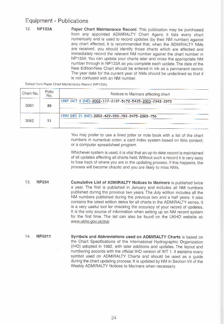
Equipment - Publications12. NPl33A
13. NP234
14. NP5011
Paper Chart Maintenance Record. This publication may be purchasedfrom any appointed ADMIRALTY Chart Agent; it lists every chartnumerically and is used to record updates (by their NM number) againstany chart affected. lt is recommended that, when the ADMIRALTy NMsare received, you should identify those charts which are affected andimmediately record the relevant NM number against the chart number inNP133A. You can update your charts later and cross the appropriate NMnumber through in NP133A as you complete each update. The date of theNew Edition/New Chart should be entered in ink as a permanent record.The year date for the current year of NMs should be underlined so that itis not confused with an NM number.
You may prefer to use a lined jotter or note book with a list of the chartnumbers in numerical order; a card index system based on folio content;or a computer spreadsheet program.
Whichever system is used, it is vital that an up-to-date record is maintainedof all updates affecting all charts held. Without such a record it is very easyto lose track of where you are in the updating process. lf this happens, theprocess will become chaotic and you are likely to miss NMs.
Cumulative List of ADMIRALTY Notices to Mariners is published twicea year. The first is published in January and includes all NM numberspublished during the previous two years. The July edition includes all theNM numbers published during the previous two and a half years. lt alsocontains the latest edition dates for all charts in the ADMIRALTY series. ltis a very useful tool for checking the accuracy of your record of updates.It is the only source of information when setting up an NM record systemfor the first time. The list can also be found on the UKHO website at:www.ukho.gov.uk/msi
Symbols and Abbreviations used on ADMIRALIY Charts is based onthe Chart Specifications of the lnternational Hydrographic Organization(lHO) adopted in 1982, with later additions and updates. The layout andnumbering accords with the official IHO version of INT 1. lt explains everysymbol used on ADMIRALTY Charts and should be used as a guideduring the chart updating process. lt is updated by NM in Section Vll of theWeekly ADMIRALTY Notices to Mariners when necessary.
Exiract from Paper Chart Maintenance Record (NP133A)
Chart No, FolioNo. Notices to Mariners affecting chart
3061 89
t9 87 O Cr 2 NE) - 2002 - t t7 - 2t 27 -5 t7 ? - 5435 - ?OO3 - ?3 43 - 297 3
3062 11
1 99O DEC 2 1 (NE)- 2002 - 429 -559 -7 83 -5475 - 2OO3 -756
24
15. 'X'Charts
16. NP247
17. NP131
When important changes to routeing measures or other charted featuresare due to come into force on a given day, it is important that chart usersare aware of the changes before the event takes place. Sometimesthe safest and easiest way to promulgate these changes is to issue aNew Edition of the chart in advance of the changeover day, with the newdetails depicted. This chart will then be readily available for use when thechangeover occurs. However, until that date, mariners should continue touse the existing edition of the chart.
To stop the existing and updated charts becoming confused, the UKHOrefers to the existing chart as an'X'chart. Mariners are instructed to markthe chart number on the existing chart with a prefix'X'. Both charts willthen need to be kept up-to-date until the New Edition comes into force,at which time the 'X' chart will be cancelled. Separate updates will beissued for the New Edition and the 'X'chart. (Only (T) NMs will be issuedto update the'X'chart.) The date and time that the New Edition comes intoforce will be shown on the chart.
The Annual Summary of ADMIRALTY Notices to Mariners is publishedin two parts in January each year. Part 1 contains the text of AnnualNotices to Mariners issued in that year and a reprint of all Temporaryand Preliminary Notices to Mariners in force at the beginning of the year.Parl 2 contains a reprint of updates to ADMIRALTY Sailing Directionsand Miscellaneous Nautical Publications that have been issued sincepublication of the latest editions or supplements. These books are anessential part of a chart outfit; you should make sure that you have themon board as soon as they have been published, and replace them annually.They can also be downloaded from the UKHO website.
Catalogue of ADMIRALTY Charts and Publications - see Chapter 6.
25
26 t.= -..=. = :r:=.: .:
How to apply the updates to your chartsAll NMs should be recorded against the appropriate chart number in NPl33A.Thereafter all chartsin current use and those required for any forthcoming passage should be updated immediately; othercharts held on board should then be updated as time allows.
Where more than one copy of a chart is held, either each copy should be recorded separately inNP133A or a pencil notation should be made against the chart number indicating how many copiesare held. lt is important that all copies are maintained consistently so as to avoid the possibility of acopy that has not been updated being used.
The principles, practices and conventions of chart updating are illustrated by the examples in Chapter5. Though reference is made to the tracing in the examples given, always refer to the ADMIRALTYNotice to Mariners text which is the primary source. By reading the NM whilst looking at the chartin question you will avoid the risk of deleting information which otherwise could have been used tocomplement the new information being inserted.
It should be noted that a tracing is only a guide to illustrate the update and to pin-point a position.Special symbols are used on the tracing to indicate insertions and deletions; these should NOT becopied faithfully onto the chart. The following examples will point out mistakes which can be madeif the inlormation you are inserting on the chart is copied from a tracing. lf tracings are used, theseshould be stored by chart number so that in the event of a change of passage plan any chartsthat are required but have not been updated can quickly be brought up-to-date. AII the relevantinformation for any particular chart is also kept together and, if that chart is cancelled or replaced bya New Edition or a New Chart, all the old tracings relating to that chart can be destroyed.
There is not an example of an NM Block. These should be aligned accurately and stuck onto theaffected charts. lt is important to remember to completely remove the enclosing black line around thelimits of the area of a block before sticking it onto the chart;there is normally at least 5mm inside theline with no new or deleted information on it. Care should be taken that new block information doesnot obscure parts of previously inserted updates (for example, where a sounding has been insertedunder the new block but arrowed-in to a position outside it).
The following procedure will help you avoid making mistakes:
' Using the information in the NM (in conjunction with the tracing, if you have it), apply theupdate to the chart.
. Check what you have done.
' When you are satisfied that you have correctly followed the instructions of the NM (andonly then) write the NM number in the bottom left hand corner of the chart as a recordof the completed update. lt is dangerous to insert the NM number in the bottom left handcorner of the chart before you have updated the chart. The year date for the current yearof NlVs should be underlined so that it is not confused with an NM number.
, When you have completed all the steps above, cross through the NM number adjacent tothe chart in your NP'133A or similar record.
Further advice can be obtained from the DVD "How to Update ADMIRALTY Standard NauticalCharts" or by asking your ADMIRALTY Chart Agent.
Any charts held on board that are not, and will not, be maintained up-to-date should clearly bemarked "NOT TO BE USED FOR NAVIGATION".

Explanation of Terms used in Notices to MarinersThe main text of the update starts with one ol the following five commands, usually in the ordershown:
INSERT is used for the insertion of all new data or, together with the DELETE command, when afeature has moved position sufficiently that the MOVE command is inappropriate.
AMEND is used when a feature remains in its existing charted position but has a change ofcharacteristic, for example:
Amend light to, Fl.3s25m10M
When only the range of a light changes:Amend range of light to, 10M
REPLACE is to be used when one feature replaces an existing, but different, feature and the positionremains unchanged. The old feature will always come first in the sentence, e.g. Replace xx with yy(where yy is the new feature).
EXAMPLE
Replace depth, 34,wilh deplh, 29 57' 44'.61N., 1 1'05',.97E.
MOVE is used for features whose characteristics or descriptions remain unchanged, but they are tobe moved small distances, for example:
Move No 3light-buoy, from:
to:
32'36',.90S., 60"54',.1 gE.
32"36',.90S., 60'54',.1 gE.
56'00'.625. , 4" 46', .47E.
56"00'.30s., 4' 46'.35E
DELETE is used when features are to be removed from the chart or, together with the INSERTcommand, when features are moved a significant distance such that the MOVE command isinappropriate.
The "Certain copies only" informative note occasionally included in the NM means that someprinted copies of the charts affected have already been updated for information contained in theNM. (The number of the NM must always be written in the bottom left hand corner of the chart evenif your chart already contains the information).
Explanation of Symbols and lnstructions on Tracingslnsertion: lnformation to be inserted will be boxed. The position of the insertion is shown as a
small circle containing a dot at its centre. An arrow will be shown from the box to thecircle (--). Sometimes clarification may be required regarding what should beinserted or deleted. This is often the case with a replacement where words such as"in lieu" may be added to the tracing to assist those carrying out updates.
Deletion: lnformation to be deleted will either be boxed and hatched out by diagonal Iines ordeleted by a strike through double line. A deletion symbol ("2)will be annotated nextto the boxed area. Where a cautionary note is being deleted, the words "Delete + thetitle of the note" will be inside the hatched area.
Linear features: Short lines are used to indicate the turning points of linear features such assubmarine pipelines, cables or area limits thus: ------_+/
Plotting from Tracings on a ChartThe positioning of tracings should always be checked carefully using three methods, as follows:
. Latitude and Longitude lines shown
. Location on Chart or Chart panel (e.g. ffi I
. Other fitting marks shown such as soundings or prominent features
lil i
tt
Drawing Conventions when Updating ChartsIt is good practice to observe the following conventions when updating charts:
lnsertions: Do not make the common error of drawing exactly what is on the tracing onto thechart. lnsertions can often be made by drawing the new feature in an open area ofthe chart and "arrowing it in" to a small circle in the correct position. Other insertionsare shown in the exact position by drawing the feature in the correct location;a newlegend is a typical example of this.
Deletions: These should be made by drawing two straight lines through each piece of text orfeature to be deleted. lf there is any doubt, the tracing will be annotated with amplifyinginformation so that adjacent information, for example, is not deleted in error.
Moves: Occasionally features are moved a short distance from their original position. Drawa small circle at the new position and arrow the feature to that position.
New Symbols: The examples that follow do not contain a complete set of symbols used on tracings.New symbols may be introduced from time to time. lf unsure of the meaning, alwaysconsult the text of the NM for clarification.
Replacements: Wherever possible, overwriting of existing information should be avoided; pointsymbols (i.e. depths, buoys, lights) should be inserted in a clear space and "arrowed"into position. Legends may be amended by inserting the new text in clear spaceadjacent to the existing charted detail.
Final NotesThe examples shown in this booklet are by no means exhaustive but should be sufficient to illustratethe principles involved. When you are updating your charts you should try to achieve the very higheststandards of draughtsmanship so that you can read the information clearly.
Most important of all:
. Positions must be exact.
. Depths and symbols must be clear.
. Legends and descriptions must be legible.
illliilir l: i
28

Chapter 5
Examples
Example 1 lnsert new buoyage ......30
Example 2 Delete a swept area.... .....32
Example 3 Replace a buoy with a light-buoy .........34
Example 4 lnsert a light and breakwater ..,...36
Example 5 Move a light.. ,.......,.38
Example 6 Replace a beacon with a light. ...............4O
Example 7 lnsert a pipeline and legend...... ....42
Example B lnsert a leading line ,..., ....44
Example 9 lnsert a light sector ...............46
Example 10 Delete coloured light sector........ ........48
Example '11 Amend light with coloured flare . ..........50
Example 12 Amend the range of a light ......52
Example 13 Amend a light description....,, ...............54
Example 14 lnsert a racon ..........,56
Example 15 lnsert circular fish havens..,,.. ,,....58
Example 16 lnsert a submarine cable .......,..60
Example '17 lnsert a new radio reporting line.,, ....62
Example 1B lnsert a legend between two or more positions ......64
Example 19 Delete charted detail. ,.........66
Example 20 lnsert fish havens........... ........68
Example 21 Move a buoy .........,.70
Example 22 lnsert sounding out of position ......72
29
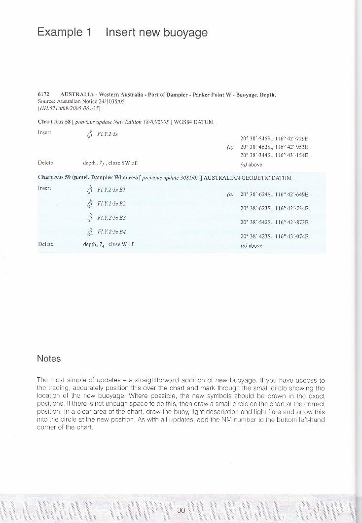
Example 1 lnsert new buoyage
al=.rl
6172 AUSTRALIA - Western Australia - Port of Dampier - Parker Point W - Buoyage. Depth.Source: Australian Notice 24ll 035/05(HH. 5 7 t /009/2 00 5 -0 6 ej 5).
Chart Aus 58 [ previous update New Edilion l8/03/200J ] WGS84 DATUM
Insert A n.r.z s'
depth,T1,closeSWof:
Chart Aus 59 (panel, Dampier Wharves) lprevious update j08l/05I AUSTRALIAN GEODETIC DATUM
Insert
Delete
Delete
20" 38',.545s., tt6" 42'..729E.
(r) 20" 38"4625., 116 42"9538.
20" 38'.344S., 1 t6' 43',.154E.
(a) above
(a) 20" 38"6245., 116" 42'.649F,.
20" 38'.623S., 116" 42'.7348.
20" 38"5425., tt6. 42'..8738.
20" 38',.4235., tl6" 43',.074E.
(a) above
A
Ax
v
A
FLY.2'5s B I
Fl.Y.2'5s B2
Fl.Y.2.5s B3
FI.Y.2'5s B4
depth,7a, close W of:
Notes
The most simple of updates - a straightforward addition of new buoyage. lf you have access tothe tracing, accurately position this over the chart and mark through the small circle showing thelocatton of the new buoyage. Where possible, the new symbols should be drawn in the exactpositions. lf there is not enough space to do this, then draw a small circle on the chart at the correctposition. ln a clear area of the chart, draw the buoy, light description and light flare and arrow thistnto the circle at the new position. As with all updates, add the NM number to the bottom left-handcorner of the chart.
'-1
-tlrl
/
I
: r , lililllfiil

o-.g(D-c
q,oor(oa,
ID5Ee'16(nll,otJ(ic._:-oc$'jao(D
(,o!cta.;(E(l,(d
g{I,6,i
=(hDa.'66
(l)
'(>
,QE
-9,Eg,q,
-=o-0)
o_E(}0)Eoa;o.
(6()
'6tc.o,'=o-oC
={)Ea'=an
@
=a(U<-C()
H,,tDAZZ
:\r,7\
- '/^A
,/f1)L2
i
t--,
',
82
$Bo'il
Gr*s*d
,ru"lu*'
20'39'
PANEL: DAMPIER V1,HA
6l
-{.- s?
t----I '-- s2
i---_l-\_
;11UrJ

Example 2 Dele{B a swept area
60?9 CEINA - Ye8ow Sea Coast - Approaches to Dalian Xingang - Swept area.Source: Chinese Chart I 1381
{HH.548/527/4j e38).
Grft 1249 lprevious update 5628/05I LTNDETERMINED DATUM
Delete limit of swept area, pecked line, joining: (a)
limit of swept area, pecked line, joining:
20,within:
38" 52',.7N., 121" 5g'.0E.
(E border)
38" 52'.7N., 121" 55',.28.
38" 55',.5N., 121" 55"28.(harbour limit)and
380 56',,8N., 121. 57',.3r-.
(harbour limit)38' 56'.8N., l2l" 58',-oE.
(E border)
(a)-(e) above
38' 54',.9N., 121" 58',.5E.
38' 52'.7N., l2l' 58',.5E.
38' 52',.7N., t2l" 55'..28.
38" 55',.3N., t2t" 55',.2E.
(harbour limit)
(a)-(d) above
(b)
(c)
(d)
(e)
20,within
Chart 1255 fprevious update 5728/05 I BEIJING (1954) DATUM
Delete (a)
(b)
(c)
(d)
Notes
This is another simple update - the deletion of a swept area. Using a 0.25mm nib, draw twoIines through the "20" depth, the symbol and the limit. The existing limit is deleted by nealystriking through as shown on the tracing. Note that the tracing shows the work to be deleted bycross-hatching. This is for clarity only and should not be copied onto the chart.
32
\ilrl '- I l1 ll lll jllllllllllllllllll
ru,s,ffi&TflArii. ,
mllr
*

Folio52
-racing Size'20 x 185 mm
NM 6029/05 Prc/NE Chart NoMAR. 04
@ British Crown Copyright 2014
ry adjust settings on the[i printe
ra0quanu lzl
9
Caution: someeomputer printers might distort the tracings. Users are advised to check and, il
^,o' :.ig:w7-t Daa 1 lL\olostvesl ,ri'' ...... Obstn a"(79)Iroou Ja f.
Fi-4s88m9M:1 '
I -_.I... oo"t eJ . ..'=) \.....:(Explastves) (
t4 40
i/
i
;I
I
I
:,t.,
47
Jinzhou Wan
4e
A
a/
,=Zq
,/ -a ^1"' Uanrla Snin ^ )
^J,'c23s =- ,.,1t,,r${
]1tr'r.2i='\"i
Wfl6r*ti''mE
33

Example 3 Replace a buoy with a light-buoy
2877 wEsr INDIES - windward Islands - Martinique, NE coast - Loup Sainte-Maric -Buoy.
Source: French Notice 18170106
(HH.67t/480/-05 et7).
chart 37I (panel c, Havre de la Trinit6) f previous update 1789/06I sHoM l9g4 DATUM
Replace A 'TRt" with / Fl.n.4r,TRt,14" 48', -l lN., 60. 5g'.00w
Chart 371 (panel, Pointe Caracoli to Fort-dc-France) | previous update t 789/06I SHOM 1984 DATUM
Replace A "TRt, with A Ft.R.4s "TRt,RR
Chart 594 f previous uptlate 1296/06I WGS84 DATUMA.Replace A "TRI, with A Fl.R.4s "TRt,Ri'
Notes
ln this example, one feature replaces another. Using theand then add a Iight flare. This avoids a deletion and an
14" 48',.1 1N., 60. 59',.00w.
14" 48"2N., 60" 58'.9W.
existing buoy, insert the light descriptioninsertion on the chart.
34

59
@
'=o-'6=ooo,cEc)att
ah
=6o0
*rd<lta0)oo:=Jg(t-v{)c,ct)o
o.g:o6E:(!'v,C)o,:]u,tr.s()
6)
o.uroEo'=g,oc'=o.o)
aEoo0}Eo4'
o.E:f,(d()
()C{
c(n'=(:-_e
E
I()c@
F.C&a
O.f,Zff]E(6-Co[Ll -tto)DJl-
1'-:-.-ril;."'€49',ozld'-*= Y\ .-
-=-{c*@':-:
tt77)'g-a:.
C\ \.*_\--.fono5'
Le Morne-Rouge
(o(}
1.-f-ooC{
=ZO .EE:= I- "i3
8oo .EH
Vr
g€tosas, (O=(').q c\l(I)'d
42-\50---1 53\.'o'e\' \e.a'i \N. \ "
t------
\\ \ 38 )\\ -r"^ -- \
lenos F/-R. 4l
' 4:'<*1226]- IPresqu'ile de la
/ ff,u-*frJ vu"'
t
7)*
1 r,\l / ^:) I \\r -/ I ]/ / t\- / "sMorre-R6ugs (\_-> nf
N- \-Tij \' \ ^)
\f -
rlffilHlllllllliiililililllllllillllllllillllilliilllllllllrllili ll ilr -i'i'
.15

Example 4 lnsert a light and breakwater
6009 JAPAN - Honshii - NW Coast - Toyama - yokata - Lights. Breakwater.Light List Vol. F, 2005/06,7150.6Source: Japanese Notice 48/1437105(HH.563/510/-04 e40).
Chart 1342 (panel D, Toyama) f previous update 3227/05I WGS84 DATUM
Insert
Delete
{ rt.R.3sttm3v
breakwater, single firm 1ine, joining:
f Fl.G.3s7m5M, close SE ofl
(a) 36" 45'.71N., I 37" I I '.56E.
(a) above
36' 45'.69N., 137" 1 l'.50E.
(a) above
Notes
Lights must be drawn in the correct position, not arrowed in unless stated "move" in the text ofthe Notice. Light descriptions should always be as close to the light star as possible, but caremust be taken to make sure they do not obscure other important existing information. Follow theinstructions in the'text and draw the light first and its flare. Then draw the breakwater joining thelight to the position quoted. Although this is a single line, it should be drawn fairly heavily so tf,atthe breakwater stands out. Once the new information is in, neatly cross through the existing light,not forgetting its light descriptron.
36

|*e/NE Chart NoMAR. 02 1342
@ British Crown Copyright 2014
PANEL TOYAMA
137'112'
might distort the tracings. Users are aiJvisedlo checEand, if necessary adjust settings on their print
I
-1I
SCALE l:20@0
45'.
Sources: Japaoese Govertrment charts of 1991 ald 1996,based mainly on surveys to 1989. Later informatiol hasalso been included.Magnetie Yadrtioo: 7'35'W 2002 (1'w)
TOKYO DATUM. Refer to Plan G)
:,.:: l
,j:,:.:{::.1,:,:l
92
fs.sh
66
o;OYAMASCALE l:20000
Sourccs: Iapanese Government charts of 1991 and 1996'based mainly oo surveys to 1989. Later information has
37
i!!ffi lll{lliillil'lrtriiiiiltiiltlllilIIliilillillltiiililttrri ilt tt :'

Example5 Movealight
2653 NEWZEALAND -North Island -E Coast-HaurakiGulf -MotuiheIslandN -NorthReef poinr- Light.
Light List Vol. K, 2006/07,3845.1Source: New Zealand Notice l0/96106(HH. 580/009/-2006 e t 5).
Chart NZ 532 | previous update j07/06I WGS84 DATUM
Move { Fl.R, from:
to:
Chart NZ 5324 | previous update 307/061 WGS84 DATUM
Move f Fl.R.3s3mlM,from:
to:
36" 47'.805., 174 56'.208.36' 47'..7 45., t7 4" 56'.258.
36' 47',.80S., 174" 56"2AF-
36' 47',.745., 1'74. 56'.25E.
Notes
"Move" is used for features whose characteristics or descriptions remain unchanged, but they areto be moved small distances. Follow the instructions on the text and tracing. Draw=a small circle onthe chart at the new position and arrow the feature to the circle.
.llilFf lflilililililililililililillillfi I I tlt il illt ilt ilililIililil ilililililffi

.'7f/'
j'"rogt
A l8s
:"1:1,:
I
,rr-. ,''.]ul".ir,
76
,6. F.9h 1
fio*ea
5.
a g 4 rt
rea -\, ,-nrMo Point
l4s(1+k.'
, t7tq\rV1'-
"1
jlToro rsLAr.aD
-*=; l
\
\,J',Ao-, -s'1-5o r
:!-84269. r'-i'- -j--'V: i
ffi;',, ,ruf o'
.nrtf,'.
{--''' r"r{uiortt "
o*
f,aqrliisi:>\+t
{,u'&"
*s*$?.:<:;-,
'.{/6.ne,)e.lt fi-a;
91
,'TALtA*,(r)
:r=j::i.:i:
ffi
Chart NoN2532
@ British Cro\,!n Copyright 2014
Folio71
lracrng size120x185mm
NM 2653/06Previous Update
307106
might distort the tracings- Users are advised to check and, if necessary adjust settings on their printer.
f\-" Adr''tfi::.r:
nt,
{l
liuo!
ffi,rc";flf ',"
(" *rF*
,1,,01,.',** q;
.\,.s:

Example 6 Replace a beacon with a light
2931 NORWAY - West Coast - Sognefiorden - Ortnevik N - Beacon. Light.Light List Vol. L,2006107 ,0093Source: Norwegian Notice l0 / 57 9 I 06(HH.310/465/-04 e8).
Chart 2291 f previous update tl37/06I WGS84 DAIUM
Replace t with *a6la 06,.9N.,6" 09..3E.
Notes
This is an update where a light replaces another feature. Lights should be drawn in their correctpositions unless the "move" command is used in the text of the Notice and on the tracing. Neatlydraw the light star on top of the beacon it is replacing. Write the light description alongside anddraw the light fldre, covering the beacon as shown on the tracing.
40
I il' -..-.".'.7 ti,lillilil]IilillilIil1ilililil|ftL

{4' 64f*--/-l,:1-i.l_-..-_---.-,+ l
.\ t29A ]-/oL00o--\
- ---\500_J00--:.\
-\__-
.\ It\ -s{
:_r831
,t---<
I D
amf jorden
Framrjord
ifliillli,illtiil i t
41

Example 7 lnsert a pipeline and Iegend
5492* NORTH SEA - United Kingdom Sector - Buchan OiI Field NE - Submarine pipelines.Legend.
Source: Talisman Energy (UK) Limited(HH.254/70t/-02 et8).More.'Former Notice 3237(P)/05 is cancelled.
Chart 2 (INT 160) f previous update 5491/05lI-TNDETERMINED DATUM
Insert submarine pipeline, ----,joining:
legend, Oil & Gas, along:
Chart 278 | previous update 5082/05I ED50 DATUM
Insert submarine pipeline, ----,joining:
(a) 57" 57'.0N., 0" I l'.6E.(b) 58. 17"3N.,0.09',.3E.
58' 27',.7N., 0. 15',.0E. (
(a)-(b) above
legend, Oil & Gas (see Note), along.,
57" 59',.77N., 0" 1 1',.71E.
( i.:.:..j tretk)58" 0l'.20N., 0. I l'.95E.58' 05'..60N., 0. 09'.80E.
58' 06',.50N., 0" l0'.05E.58" 09',.76NI., 0" 09'.5 18.
(N border)
and
(a) above
57' 58',.50N., 0. I 1',.008.
57" 57'.68N., O. 07'..70E.
( :.:.:.-] wett)
and
57" 57"07N., 0" 11"728.( !.:.:..: wett)
57" 57',.90N., 0" I I "40E.(a) above
(b)-(c) above
Notes
The tracing shows the turning points of the pipeline as short lines drawn across the symbol. plotthe positions of these or mark them through the tracing. Use a straight edge and draw the pipelinesymbol, breaking it where necessary so that existing information on the chart is not obscured. Addthe legend as shown on the tracing.
tr)
(a)
(b)
(c)
t'tI t'[] rliililillllltfl

t,
.r.-*
4+
lLD i3
,2n I-:. _iI
rJ-tr €zaa\i()(p5EZ:.."*-*
atr
,lI
0nl
;.
j.
,;
*-(b@
a=zrd
5(s&t,'tDt,{l}c:rJd'u:claE
-1>-ls--c(,5
.E{D.g:E,6
.. !!as6&(Da
='.4'@E
:o6
.)Q
r4s 149
'-+.-\'€/ , r'.*..
"9.9tl${i\^ 146 - \gsz-"'\ .u*?'
\ nil -/-'lr"L//V.!i**nou t47
Y"148 \
trcH GI
X
=Z
Lfi""@.A'7**,l'ffil.(Ih,sIJ}117
lg
w,Srosqe#.g,(3E.I*TL'1'.
: :i?l\
e$.a;,&rx*ixi7"
i:1
o&zt--c.ar,
EIR.@
CEo,{I}:f'aE,*{,6C(lg!
(} 20'
1M
113
,M
ls4wih' un'-n" l4o
-nt I
'Q' ut5" "$ E
H;tu+-*, ',*#$ -;;Y;r;'':-:i;r\Y: 6{J
',r*ff" '*t.\,
gLD n3
, ----\(\\93 I\-__-,
,;ii'alwatwett6trc;1..rual
$F\or$\\e
r6\-\o'F rzr
4/^'("
1 145Iit
\\:140 'rt
\s1_z1q
129
t35
\. ,46 _oo-e)?'r. oi\.o2Y-
16'.i,/ -F.{.*,arniau t4z
ITCH G
'li: ,l \ ,rz 'l31i-t'"\ *),u \,,, \,,,
L,=' \*o't'i^:::%?5"\ 113
n/:ry!wii' _.-'
-"-,A,f*i
43
-i'll[lflIlllllllllllillllillllilllllllllllllllr
.ry t t flilli llllll

Example 8 lnsert a leading line
3162* INDONESIA - Nusatenggara - Bali - Benoa E - Light-beacon. Leading linc. Legend. Buoyage.Beacons. (continued)
Chart 946 (panel D, Approaches to Benoa) | previous updare 2312/06I I-INDETERMINED DATUM
Move symbol,white lighlbeacon with topmark, Fl.3s9M, from: (a) g.45'.60s., I15. l3'.30E.to: @) 8" 45..55S., I t5" 13..298.
Insert leading line, pecked line for 720mthen firm line for 4g50m,extending in direction 75.5o from: G) ft) abovelegend,255.5., seaward end of: @) above
Delete former leading line, pecked and firm line, and associatedlegend 250.,
"*tenaing in direction 070" from: (a) above
Notes
When inserting a leading line it is important to follow the instructrons in the NM exactly so that theright amount of pecked and firm line is shown. This ensures that the user has a clear understandingof how these lights are used for navigation.
44
I I', ll lil [ lttlflr]il|ililililil

l3a
loe
ll5" l4'
47
s-
r
U9
Co
28 47
59
SELAT
45
lttll

Example 9 lnsert a Iight sector
32ll ES'I'ONIA - Muuga Laht - Coal Tcrminal - Light.Light List Vol. C,2006/07,3852Source: Estonian Notice 6/57l06(SEP:2006000366014).
Chart 2225 f previous update 2 I 00/06 I WGS84 DATUM
lnsert fi oc.wRG.4s30m2M (Oct - May)
sectors at light as follows:
G 086'- 102" (16. )
w I02'- 108. (6" )
Rt08"-I19" (ll.)
(a) 59'30'.21N., 24' 59'.9'18.(a) above
Notes
This is a small light sector. Draw the light star and flare in the correct position with the descriptionin a clear space as close as possible. Remember that bearings for lights are shown from seaward.Either plot the sectors of the light or use the tracing as a guide. For updating purposes, light sectorscan be drawn as solid lines. lt is good practice to use a compass to draw the arcs. Do not forgetto show the colours of the sectors against the arcs.
lf your chart includes coloured light flares and sectors it is acceptable to insert the sectors asdescribed above; this avoids the need for coloured pens.
46
..-li[]ililu

Caulion: softe computer printers might
ho!sas
59"30"
f.r,.u,**,r,
23s
tl so.2s41m12M* Kallavere
'""1-.---
.:l,o"i,"1
!
l //,:\ tt/^).- //,'', ... :/',*.i/
',$l$lllll!l1lililillililillillllilIIlililllllilllililllllill llli rl r,
/,'\*-<1
47

Example 10 Delete coloured light sector
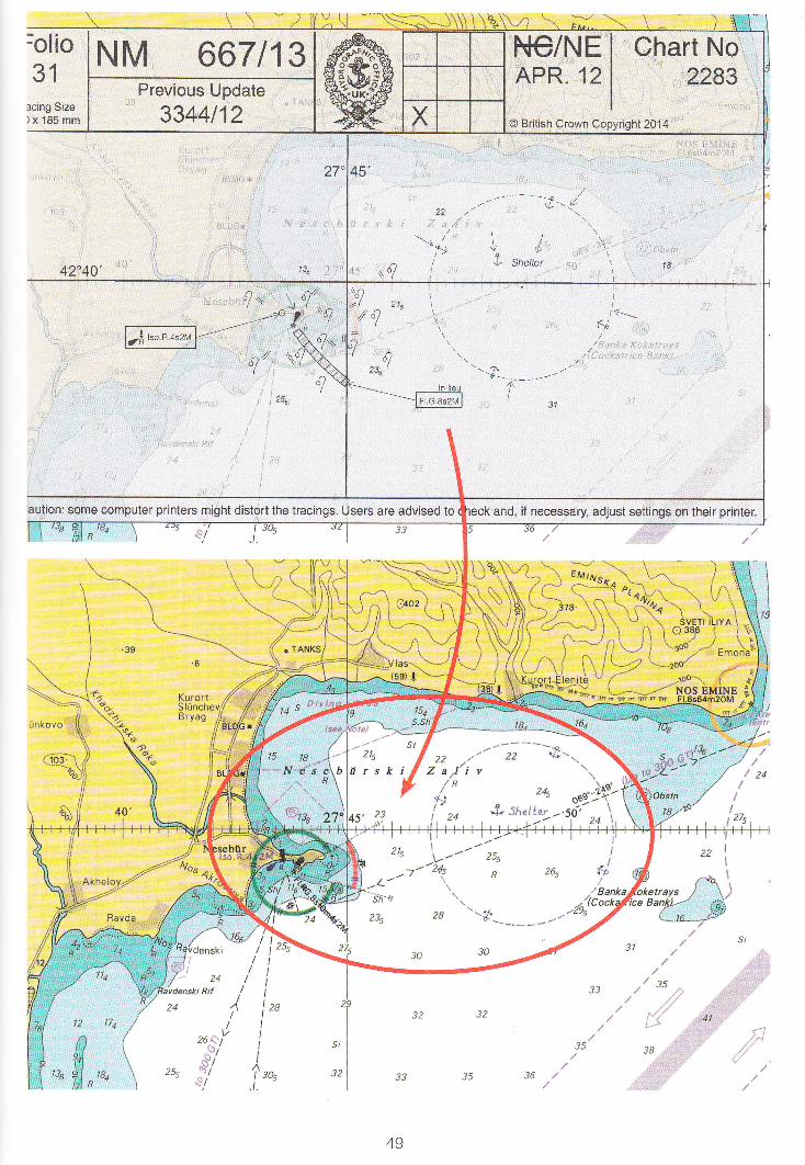
667 BULGARIA - Nesebirski Zaliv - Anchorage area. Light-beacon. Legend. Light.Light List Yol.8,2012113,4993 and 4994Source: Bulgarian Notices 2142-43112 & 2151112
Chart 2230 lprevious update 5907/12 I WGS84 DATUM
Insert {. Sheker42.40',.0N., 27. 4g"gB.
Chart 2283 lprevious update 3344/12 I WGS84 DATUM
Insert I Iso.R.4s2MF """" "-"" 42.39..48N., 27" 43'.59F,.circular limit of anchorage area" pecked line, radius 1.5M.centred on: (") 42.39'.98N., 27a 48..928.legend, f" Shelter,within:
@) aboveAmend light to. Pl.G.Ss2M @l 42" 39..30N., 2i" 43,.80E.Delete sectors at light /A\ -t^-,^- (b) above
Notes
Delete the sectors by drawing two lines across the sector lines and arcs at regular intervals. AIsodraw two lines through letters annotating sector colours, if shown. Charts which include colouredIight f lares and sectors do not depict flares at lights with sectors. When deleting all sectors at a lightit is important to insert a flare at the light star, this will make the symbol more prominent.
48
il l[] illt
:olio
31acing Size)x185mm
42744' ,"8
4rr \,q"_,-nb "fl
fl..qo\
q25s
aution: scme computer printers mfght distort the tracings. Users are advised to
\ \ *,,\ \r\.
t?itt,
unkovo
'o^
a
skl
v26- t:l'Jl
{/
KNqi,(Sre;*N,J],/ffii:-})\:E\l',tA"J t
^ , J3u ----/ r.oa1 Y'a- -/ ,'n;L' / / 24
,\!L
: '/540'
4t2
n?,i
Ha
j.:i'::t:l:l
,ri
,:1
49
l3e

Example 1 1 Amend light with coloured flare
201 TURI(EY - South Coast - Marmaris - Keqi Adasr - Keglada - Light.Light List Yol.E,20t2l13, 5838Source: Turkish Notice 481281112
(SEP: 2012000248878 - 1).
Chart 1054 lprevious update 5784/12 I WGS84 DATIJM
Amend light to. Fl.2s7M
Chart 1055 lprevious update 5814/12 I WGS84 DATIIM
Amend light to, Fl.2s7M
Chart 1644 (panel C, Marmaris) lprevious update 5Bt4/12 I WGS84 DATUM
36" 47'.88N., 28" 15'.-578.
36' 47',.88N., 28. 15'..578.
Amend light to, F1.2s30m7M 36" 47',.88N., 28" t5"57E'.
Notes
A simple update similar to Example 13 - A light description has changed which includes a colourchange. The update is to be applied to a chart which includes coloured light flares and sectors. lnthe example shown it is possible to delete part of the existing light description, other updates mayrequire you to rewrite the complete new description, clear of exrsting detail, above or below the oldone. Finally, tnsert a new flare using violet ink then delete the existing coloured flare by drawing twoIines through it. This will prevent a discrepancy between the colour of the printed flare and colourstated in the light description.
iliil

28" rs
28"11s',
25',
Folio29
Tracing $izeI20 x 185 mm
NM 201113 NC1NE Chart NoQCT, 12 1454
@ British Crown Copyright 2014
€-4*'*
55
Caution: some computer printers might distort the tracings. Users are advised to and, if necessary adjust settings on their printer.
t86 .
J i.^r: r"':/59
ARMARIS LIM,4NI
i ,.'llr
.{#,,1,A,,ri"
i[]tj :,--':l "'
Ytlatttk Eaakt
t/2
tr-1 .-:.:Jt :1::
: ' :i-
:: :-:l I :I :..

Example12 Amend the range of a light
2898 AUSTRALIA - South Australia - Approaches to Port Lincoln - Williams Island - Light.Light List Vol. K, 2006/07, 1873Source: Australian Notice I 0/441106(HH. 5 7 1 /009/2 006-0 2 e 2 Q.
Chart Aus 134 | previous update 1357/06I WGS84 DATUM
Amend range of light to, 9M 35. 0l'.81S., 135" 58'.218.
Chart Aus 343 [ previous update I124/06 ] AUSTRALIAN GEODETIC DATUM
Amend rangeof lightto,9M 35.01'.85., 135.59'.2E.
Chart Aus 345|previous update I124/06 ]UNDETERMINED DATUM
Amend light to, Fl.2.5s9M 35" 01..7s., 135" 58..1E.
Chart Aus 444l previous update 2131/06I T NDETERMINED DATUM
Amend range of light to, 9M 35. 0l'.9S., 135. 5g'.2E.
Chart Aus T76lprevious update 21391061 WGS84 DATUM
Amend range of light to, 9M 35" 0l'.7S., 135. 58..3E.
Notes
This is a straightforward change to the range of a light. The amended range should be writtenadjacent to the old one. Note that if space is limited, the range on its own should not be arrowedin. ln these cases, it is better to write the whole description again. Make sure the 'M' is included toavoid the range being mistaken for a sounding. Remember to delete the old range by crossing itthrough.
52
----.'.*

v /iN\ \l
46
', 69rlt:t dfi rg
i.
5A't.47
SSl,Co :
64
73Tidal Streamlsee Note)
66
Aus 13r
il, .,,,.,,rttlllllllllllllllllllllllllllltl tr,,,.
53

Example 13 Amend a Iight description
5757 PHILIPPINE ISLANDS - Mindanao - N Coast - Iligan - Light.Light List Y ol. F, 2005 106, 2268Source: Philippine Notice 10/210 105
(HH.5s2/47s/-03 et4).
Chart 3426 (panel, lligan) | prev ious update 49 5 4 /0 5 I LTNDETERMINED DATUM
Amend light to, Fl.G.5s37ft7M 8' l3'.93N., 124', 13',.868.
Chart 3810 lprevious update 5592/05 I LTNDETERMINED DATUM
Amend light to, Fl.G.5s37ft7M 8' 13"9N., 124" 13"9E.
Chart 3811 | previous update 4954/05 I LINDETERMINED DATUM
Amend light to, F1.G.5s37ft7M 8" 13',.9N., 124" 13'. .gE.
Notes
This is similar to the previous example, but the whole light description has changed. Althoughit would be possible to change the rndrvidual elements, it is clearer to rewrite the complete newdescription above.or below the old one. Choose an area that is clear of existing detail so that thenew description can be read properly.
Refer to Example 1'l when updating a chart which includes coloured light flares.
54

vruqurGuS3e Chart-342
Folio
See Chart 342Oroquieta ', s
tiirio Yl
tl?r't
'&nno
l:-.1 j
r!Sq nio"4+
58"Tracing $ize120 x 185 mm
hart-NO--381 1
O British Crown Copyright 2014
"124',\AA'.
1r
Caution: some computer printers might distort the Users are advised to check and, il necessary adjust settings on their printer.
,$.s . r a ta?
FfGINE
@*: 4! *n-"\
1
a;:tt fl}.dla;
,' 3j3 *r't ls Ji; t
('/l9' ?
'ol. 1a7 lt1.* ]' Iil+1see Charl 3426 I*!\ Ma zlr e nl 3., (otfrl.5s32f rt5M i;{'"1?" ,u, J "o':I|.5 )
'i.:!),,,e j
472
3-!:ugr:-
-. .lmmi* af -€i<tge9lui,r
.r;si.l
f*it*."oi"j
Ilalo-Igo.nN
l)74
7t9l64
*zzr*o
IlataxaJBqsd4€a8r
r iillillllllllllllllllll
Tidal Levelr
Place
MargosatubigTikauan Point
Sibuco BayMlmb*haoDassalan Island
,:\
55
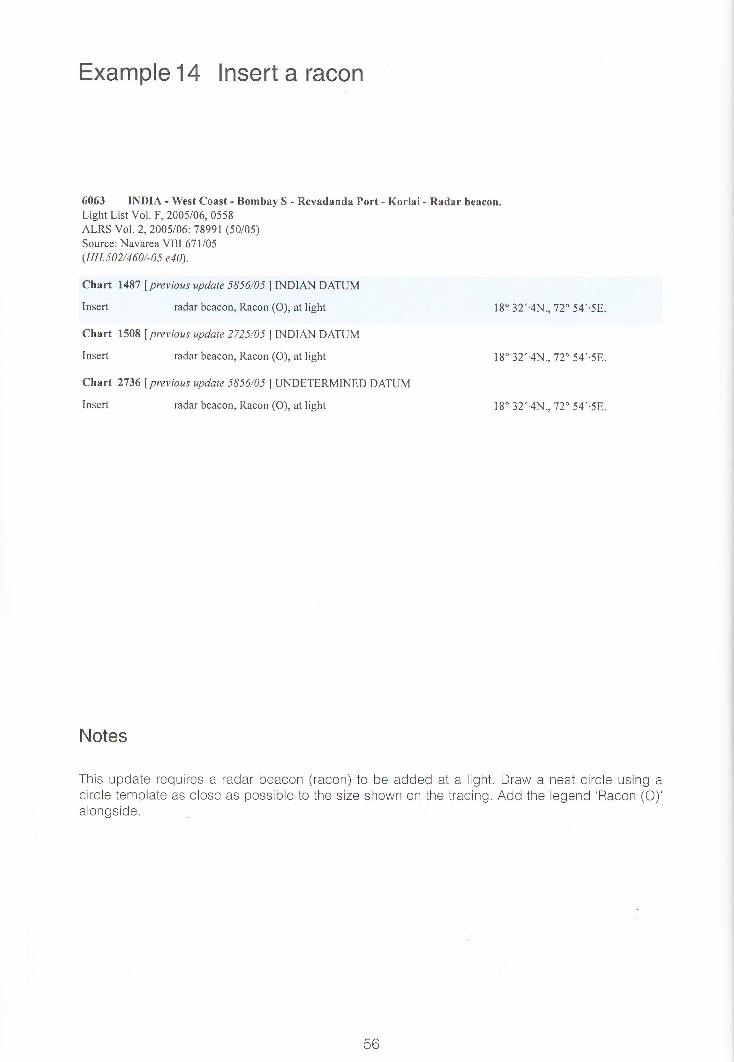
Example14 lnsert a racon
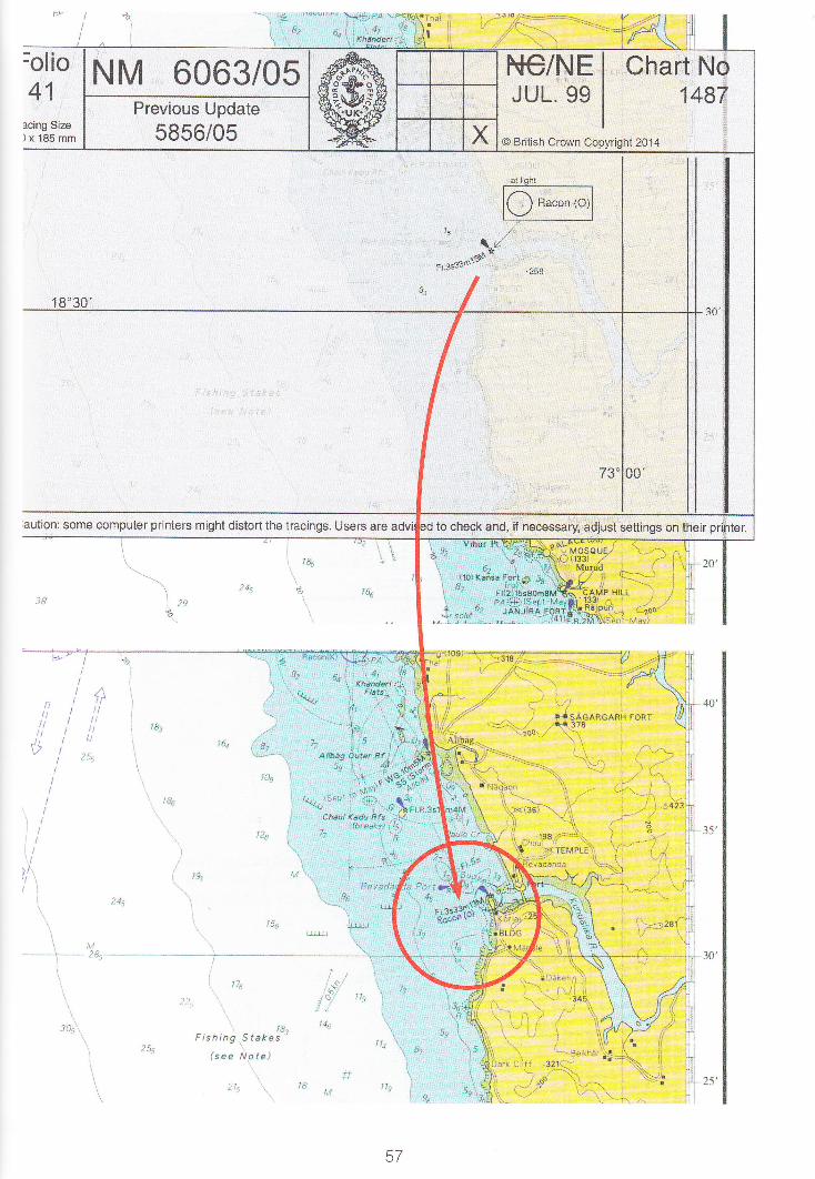
6063 INDIA - West Coast - Bombay S - Revadanda Port - Korlai - Radar beacon.Light List Vol. F, 2005/06, 0558ALRS Vol. 2,2005106 78991 (50/05)Source: Navarea VIII 671l05(HH.502/460/-05 e40).
Chart 1487 lprevious update 5856/05 ] TNDIAN DATUM
Insert radar beacon, Racon (O), at light l8o 32'.4N., 72" 54'.5E.
Chart 1508 f previous update 2725/05 ] INDIAN DATUM
Insert radar beacon, Racon (O), at light 18" 32'.4N., 72. 54'.58.
Chart 2736 f previous update 5856/05I I-INDETERMINED DATUM
Insert radar beacon, Racon (O), at light 18" 32'.4N., 72. 54'.58.
Notes
This update requires a radar beacon (racon) to be added at a light. Draw a neat circle using acircle template as close as possible to the size shown on the tracing. Add the legend 'Racon (O)'alongside.
56
'-"
rrlra .!., ig ,,."",",*
l.f*;F.{ \,,82 6.!:'4r'\.r(/r@sl
hal'- -rJ 16,s*
I
:olio
41acing Size)x185mm
1 8"38r
;aution: some computer printers might distort the tracings. Users are
\/&
\
lt, 4:i r' ;'it' .,' f ,l# ,,' ,i,
{10}$r.
sgM
't 9"
I*L
'rS:'Iu*uIx:
sl(?)
sr'rt*
r8:sicAacARH roRT
78
l8e
l9r)l\
-l as
llq \ "
J]
30'
25'.
17t ,.*!
1t
" t4^
Fistring S/ekes -'
(sae &,ote)
.'t, J I t,i
\sg/t- '!\&
l
igo
tr-7

Example 15 lnsert circular fish havens
2993 SOUTH CHINA SEA - T'ai-wan - Approaches to Kao-flsiung, Liu-Chiu Yii W, Mao-pi T,ou S,Kang-K'ou Wan E and Nan-jen Pi E - Fish havens.
Source: Taiwanese Notice 63106(HH.s49/210/-03 e2).
Chart 3230 f previous update j608/05I UNDETERMINED DATUM
Insert circular limit of fish haven, dotted line, radius 900m (0.48M),depth 50, centred on:
Chart 3232 l previous update 1 6 6 5 /0 6 I UNDETERMINED DATUM
Insert circular limit of fish haven, dotted line, radius 900m (0'48M),depth 50, centred on:
22" 20',.08N., 120. 14',.50E.
22' 20',.08N., 120" 14',.50E.
21" 48',.04N., 120. 43'.728.
Chart 3233 lprevious update 5333/05I UNDETERMINED DATUM
Insert circular limit of fish haven, dotted line, radius 900m (0.48M),depth 50, centred on: 21" 48'.04N., 120" 43"72E.
21" 57'.5TN., 120' 54'.52E.
22. 05'.4TN., 120" 56',.808.
Notes
This update is similar to the previous example. A circle template can be used to ensure the correctsize. lf a template is not available, it will be necessary to use a compass with a pen attachmentto achieve the exact radius of 900m (0'4BM). Place the fish symbol and the depth in open spaceinside the circle. Do not arrow them into position.

Previous", Update
3608r05
Folio50
Tracing Size120 x 1gS mm
-t!tj
NM 2993106 P*C/NE I Chart NoocT. 03 I 3230
O British Crown Copyright 2014
iis!:!-if
Caution: $ome compuler printars might
770

Example 16 lnsert a submarine cable
3273 ARABIAN SEA - Pakistan - Karichi SW - Submarine cable.Source: Pakistani Notice 19/75106(HH.487/300/-02 et t).
Chart 38 (INT 7019) f previous update l64l/06I WGS84 DATUM
Insert submarine cable, *, joining:24" 5l "45N., 66" 52'.318. (shore)
24" 49"48N., 66" 52',.508.
24" 46"37N., 66 51',.41E.
24 45'.22N., 66. 48',.38E.
24' 38'.95N., 66" 26',.00F..
Chart 39 lprevious update l64l/06 ] WGS84 DATUM
Insert submarine cable, *, joining:24' 5l'.45N., 66' 52'.31E. (shore)
24' 49',.48N., 66 52'.508.24' 48'.52N., 66. 51',.98E.
24' 46'.37N., 66. 5 I ',.41E.
24. 45',.22N., 66. 49',.39E.
24. 38"95N., 66 26',.008.
Notes
Using the tracing or the text, mark or plot the turning points of the submarine cable on the chart.Using the hacksaw blade as a template, join up the turning points, being careful not to draw overother information on the chart. lt is good practice to count the number of turning points to ensurenone are missed. '
60

Folio41
Tracing Size120 x 185 mm
25"00'
Cautiom some computer printers might distort the tracings.
BMARINE
(ERCISE66
,a\\
\,n.
!$f
3:*:.,.'* ,,, l7s
a t Spo,t.' l lGtottnr!
22
78a t3t
78,
\ lst,.,;-\ :\\!)) )I
I
L
i
i
l
1Aia
Eeauchamp
75
^.-^-'r/''"66
BMARINE
61

ExamplelT Insert a new radio reporting line
DENMARK - Islands - Oms Island SW - Radio reporting line. (continued)
2583 lprevious update 2702/06I WGS84 DATUM
radio reporting line, pecked line, joining:
2966
Chart
Insert
Q, direction of vessel movement 270o
Q, direction of vessel movement 000"
legend, WS (see Note), along:
radio reporting line, pecked line, joining:
Q, direction of vessel movement 270o
Q, direction of vessel movement 000o
legend, WS (see Note), along:
radio reporting line, pecked line, and associated legend, l"lS(see Note), joining:
a
Notes
This update requires a new reporting line to be drawn in. lnsert the radio reporting point first in thedirection stated rn the text, then plot and insert ihe radio reporting pecked line, leaving the insertionof the legend until last.
Chart 2597 (INT 1368) lprevious update 455/06lWCS84 DATUM
Insert radio reporting line, pecked line,joining:
55'08"40N., 1 1" 09"00E. (shore)
55" 05'.00N., 11" 09',.00E.
55" 05'.00N., 11. 07'.20E.
(W border)
55'07'.50N., I I" 09',.00E.
55" 05'.00N., 11" 08'.20E.
(a)-(b) ahve(a) above
55' 08'.47N., 11" 0'1'.208.
(W border)
(r) 55'08"40N., I l'09"00E. (shore)
(b) 55'05',.00N., 11" 09'..00E.
55' 05"00N., l0' 56"10E. (shore)
55' 06'.80N., I 1" 09"00E.
55" 05"00N., 10" 59'.45E.
55" 05"00N., 11" 02'.20E.
(a)-(b) *nve
(a) above
55' 08"80N., 10' 57"30E. (shore)
55" 08',.72N., l0' 59',.50E.
55' 08',.60N., I l' 02'.858.
(r)(b)
Delete
Delete

(oO(o(oo)C{
=Z
(D
(dr, (o5a(/Jc\I=o.o f\ac.t(L
,Voil.ra
I
I
-.->tIII
{<-
3 1"; i#* \^--l .- , ' ro- ".- -.,'{z \$[-"\*\ :r /r. \"P |
----- \.. ' ,,, Y\
\
.Yl. \ wkoI \- \ - .lO9l .o\ /-,tN " -'r'a
wk 14'- .to
19 ) -.-7)l*-e\S I \/r, t.r{r,\_
El <!'j \al \ M
utIbl tosvtlf,l
s l-'o--..a'd l--- -)fiY.: I toa
P I syr'd
I t/ a- lor /al //a L-a;* /-\P l,/ tv3 ./ \
E K ',\6'1 -. "-\\,i \ \b F \.."o' t,p \\ | "-\\ i1L v' \) \ ""i ,('(a,-$ f\'.. arrravolM FLAK I (. I ' '; .^pl\'.. cb I L .tu.: h \ 4" \ r. -
IEN HELLEH,LMFLAK lr. l',t,,r.I E l'..\. "'
-::-, 1_]__I, rt
'1, o \\ \^\\' , rr,-=."--\\-Y "' -,o .' "/{'
\/5 ( -'-\-r\.v tlt
r.\ ::-,1,. \)
e ltt<z 6s "o'o'Sll Ii;D
\ swlo. I-l 02ot /Zl^ta^o_Eo()
-\ tos-:. \&\ .i-- " \-\\\o
wk -\\,/l.. wk t4t1 - to.
rg ).'-.,7t3r ]--tsrA\\\
1\ -/\ /o.?
t"
6s IA ./'-''o- \\'-/ /8, .-- )
/,'/toa!/,/^./ __,/ / _/-*-\
i-- MA
,o/ ..-' i /-' -
iu,/ ,'\-" u, ! z'./,-6 \ / 'vr"/'\
--/ - ''""-/
4\ \*;-i 7'tot ,t'\ t2s /s\ "'z l.*'r',\ \ .t /sr, -\ t7s-25.q--':*----____-*--
B 1 I 9a 1i: -*/ 6e t^tU3
\\\' q
\\lk\{3
{a,ls -9i '-ro
I \ q,)Htr' ?16"\,'-")"
$ "
(_ ------ 'l,-\ --\ I
ls,. \ \ 6r"\ \----\llos \ ,/ ll
;:.'\ ',(-)f)) ,, n '+''
cril.
-
tb
OJ

Example 18 lnsert a legend between two or morepositions
1966 CHINA - Yellow Sea Coast - Haiyang Dao N - Shicheng Dao E - Legend. Buoy.Source: Chinese Notices lll-2107(HH.556/410/-04 e21).
Note: Radar beacon remains unchanged.
'73/07 ) BETJTNG r954 DATUM
Insert legend, Buoyed channel,between: 39'34"8N., 122" 57"5E.
39' 34',.8N., 123' 00',.0E.
39' 33'.8N., 123" 02',.58.
and
39. 32',.3N.. 123. 03', -5F-.
39. 29'.0N., 123. 05',.38.
Replace j rt.c.n, with j rt.c.ls 1Vota t 39'28'.7N., 123'05'.8E.
Notes
It is common to have to insert a new legend. ln most cases the legend will be centred on aparticular position, but in this example the legend has to be inserted between two or more points sothat it adequately. covers the correct area. Plot the positions from the text or follow the instructionson the tracing. Add the new legend, spre4ding it between the positions. lt is important to writeclearly and to distinguish between capital letters and lower case. The size of the lettering shouldbe proportionate to the size of the area the legend covers on the chart. Always position legendshorizontally unless the text of the NM instructs otherwise.
64

rlioi2ing.Size185 mm
',."'j.: '
-*-{
l!6 X;da LiaaSr
5r
{:
i*:m45
7,,
6iu't' snr...J s
4.,,.,... !l\
o, ........ """ "" ..-''t'.:."'
1;./ ,.t
,3.t
4" ,,'
r-
.f,:.:t-"t.{'
t.'./
8:
i
,o 15.
NM 1966 107 NC/P+E I Chart NoMAR. 05 I 1251
O British Crown Copyrighi 2014
Previous Update
1773t07
PANEL @HAIYANG DAO TO
/s,/
t/
\58
printers might distort the tracin Users are advised to check and, if necessary, adjust settings on their printer.
icheng bao
65
Example 19 Delete charted detail
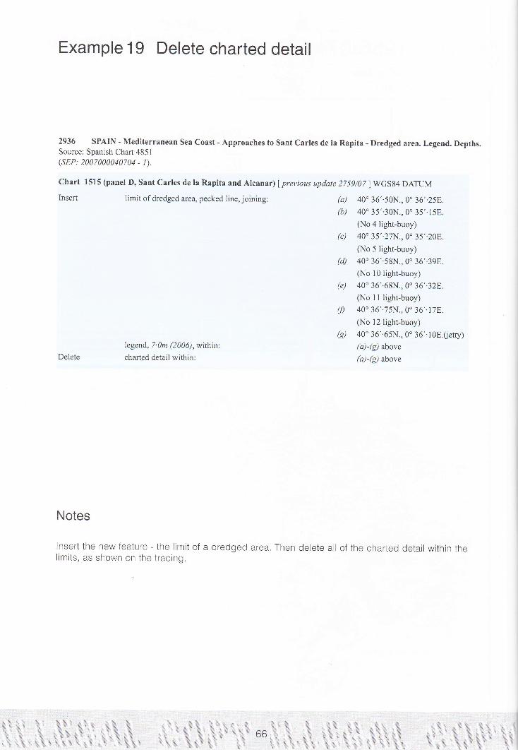
2936 SPAIN - Mediterranean Sea Coast - Approaches to Sant Carles de la Rapita - Dredged area. Legend. Depths.Source: Spanish Chart 4851(SEP: 2007000040704 - 1).
Chart 1515 (trlanel D, Sant Carles de la Rapita and Alcanar) | previous update 2759/02 I WCS84 DATUM
Insert limit ofdredged area, pecked line,joining:
legend, 7. 0m (2 006), withinDelete charted detail within:
Notes
lnsert the new feature - the limit of a dredged area.limits, as shown on the tracing.
40' 36'.50N., 0. 36',.258.
40. 35'.30N., 0. 35',.15E.
(No 4 light-buoy)
40' 35',.27N., 0. 35'.20E.
Q.{o 5 light-buoy)
40' 36'.59N., 0" 36',.39E.
(No l0light-buoy)40' 36',.68N., 0" 36',.328..
(No I I light-buoy)
40" 36',.75N., 0. 36'. l7E.(No 12 light.buoy)
40' 36'.65N., 0' 36'.10E.(ietty)(a)-(g) above
(a)-(g) above
Then delete all of the charted detail within the
(a)
(b)
(c)
(d)
(e)
(f)
@)
)
I
I
I.==-
.i=.. .

rJ-r ;< ;z-. a\.- an O(l)5 Ez<3
f lt,v//*
PANEL @SANT CARLESDE LA RAPITAA}ID ALCANAR
-
I
0'136'I
II
53
\€3
5?
DEI,S A T*M
5?
I)"54 S i{ t*&t
it"ii..
J] .'''
ii \.jj'r
ii
5sv
6357s

Example20 lnsert fish havens
2385 UNITED STATES OF AMERJCA - Gulf of Mexico - Louisiana - Outer Approaches to Calcasieu Pass -Trinity Shoal S and Ship Shoal SW - Fish havens.Platform.
Source: US Chart I 1 340(HH.6l6/183/-04 e7Q.
,Chart 3850 f previous update 2261/06I NAD83 DATIJM
ilnsert ,#_: (t5)
Chart 3851 lprevious update 1856/06I NAD83 DATUM
28" 001.0N., 92" 22',.5W.
?91o'-'I:' ?r'31"5w'-
(") 28'02"9N.,91" 31"5W.
(a) above
Insert
Delete
t#..; (15)
Fl. close SE of:J''
Notes
A simple update which requires a fish haven and depth to be inserted in two positions. The positionrefers ONLY to the fish havens themselves. Draw the fish symbols in the correct positions and thenadd the dotted danger lines around them. The depths are added close east or west depending onthe space available.
lllllllllllllil rr i I rlllllll lll rl r i
68
I

Folio
sA
Caution;'r
OILFI;a seelt
5o**
' ,; a: .-_....:,-..-.-' -
i lil *.* 1 *:
36
33:wsil 35
,-s& Obsr,Hls PA
s.3;iwil
4tArea
.+, PA,iii(t7)
rc'!'ld;w*u;.4
;iii.
(sProhibitedi;;..
& rc, wetl'IYt3
e N3-te):.4AWeil
45 PAr*
-----=-----7 !\g| :4-?\
-U ,p'V---s2oo'f -+_1---*j+----i--
l,o't3illr,'^?6':wertt\ /
[zz / I\:-_/ I
(44) \
\ a0)
I rzt
I
\&l' /r
;!fu,tr*-'! ,/i'.r -4 ----l
-'#,,,*fr*:i-#,f )-(,u\!t; a\ '6a \"il \uql Y--:rY
t,- \ ) :.t?i,werrs50
"/M
*{:' -;6t,/ rsbT':,, .'16(
i r.'.1I!l'\ /20
i
i'i,*,,| rA x'--a'I?ostn
IS:'Obsrn-=.** I
'" " iljbo"r,l
r:.-=?'f gt r'il. f ' w
" t t i.i ii ii w' t t -
c ar:f o 4n
14 !.1.7 k; f$, t r s(19).P-:'- *t. obstn*,. obstnBP,4
/'\;-::*'/ /-\L//' 'll9 '':tt'/\// 'r I
,,".*___--*_ --=-_--'!or---<---4'
69

Example2l Move a buoy
2912 UNITED STATES OF AMERICA - East Coast - Connecticut - Long Island Sound - New Haven S -Buoy.
Source: US Notice 20112354106(HH.6l4/475/-04 el2).
Chart 27 54 f previous update 5 I 63/0 5 I NAD83 DATUM
Move A Fl.y.4s 'CDA'trom:v 41" 09'.00N., 72" 52'..80W.
41" 08'.68N,, 72" 53',.20W.
Notes
This is the simple move of a buoy. There is no need to redraw the buoy: plot the position or markit through the tracing. Draw a small circle at the new position and arrow the buoy to that position.Make sure the arrow does not cut through any existing detail on the chart.

FolioB1
lltlcrng $lze120 x 185 mm
NM 2912106Previous Updale
5{ 63105
Caution: some computer printers might distort the
. 74 A4.Sh ?l
lia*
NG/NE I Chart NoNOV: 04 2754
It
I-/l
,,.ii '
Welc'-\'\\ ,
ls ,/
t
zt, ..|1:4..?.:'t473
q:l .-
/--;i>;-nN\/ JJI Fl.YaslI l-t'cDA l
>o'
Users are advised to check and, if necessary adjust settings on their printe
t5
tl* A.rc ALf LwG.tO6
[ "tp- Branford
Havat
*n?
5t@vCreek'A
ol,.- ,i.
| ,,edinr
i€Hia P€*t s#|1l 4*6zj {
i35 jt7u
-//' 4r
65\\
/l
PAE;i5;Rea(t990l'*:1
-\J
i!.i':w1.wt\ :.u5-j
/-I-/ro/ lot
12
l4
.,wk
/11.,/
*1'
'wk
71 =-:==. -::.'- ::: '.::: :ill.--.-::==jj:=..:-.j

Example22 lnsert sounding out of position
4526 CANADA - Saint Lawrence River - Port de Montr6al - Chenal Varennes, Chenal Pointe-aux-Trembles,Longue-Pointe NE and Montr6al E - Depths; Dredged depths. Dredged areas.Dolphins. Coastline.
Source: Canadian Notice 8l l3l0l 12
(sEP: 2012000172164 - 1310).
Chart 4792 (Panel A-B) f previous update 33j7/12 I NAD83 DATUM
Insert sounding out of position 64 @) 45" 42' Ig.l,'N., 73" 26' 1g.0,,w.
Replace depth, 66, with depth, 6 45. 39, 46.7"N., j3. 2g, 3 1.7',W.
Delete sounding out of position, 63 . close SW of: (a) above
Chart 4792 (Panel B-C) lpreyious update 3337/12 I NAD83 DATUM
Insert the accompanying block, showing amendments to dredgeddepths, dredged areas, dolphins and coastline, centred on: 45. 35. 10.g,'N., 73" 30, l l.g"W.depth, 107 @) 45" 32,35.4,,N., 73" 31.53.4,,w.
Delete depth, lLj, close N of: @) above
limit of dredged area, pecked line, joining: 45" 32' 52'2"N., 73" 37' 4l'4"W.(shore)
dredged depth, 10,4m, close N of:
(b) 45" 32'. 50.4"N., 73" 31'. 40.2"W
(existing limit)(b) above
Notes
Occasionally you will be required to insert or delete a sounding 'out of position', these differ from othersoundings which can be inserted in their accurate location or 'arrowed in'to avoid existrng detail.
Place a dot accurately in the stated position, then write the sounding close by, draw a line betweenthe sounding and the dot. The dot always represents the actual position.
ltflftlllliltiil$ irit til llilililllilllll]lilt lt1 ill]
72

NC/NEJ UL. 08
@ British Crown Copyright 2l
the tracings. Users are advised to check and, if necessary adiust setti
5t
uszzE5., R
ry
3
J
48'Cy:
i't
.,1
Il
i'rl
.Iii
iii
il,i
a
\Irloitti
ls1oi
rlrEIo1
ql
s/tJr,$rxil.t ..\a '_r'_'
., ,t :.
0s :,
\l
.... .. :.i'i
low6r {371
42'
/.)

Chapter 6
How to update your ADMIRALIY Nautical Publications
ADMI RALTY Sailing DirectionsBefore using ADMIRALTY Sailing Directions, the mariner must always:
. Check that the most recent edition of the volume is held.
. Check that all the updates in Annual Summary of Notices to Mariners Parl2 - Updates toSailing Directions (NP247(2)) have been applied.
. Check that all updates published al Section lV of Weekly Editions of ADMIRALTY Noticesto Mariners subsequent to the publication of the most recent edition of Annual Notices toMariners Parl2 have been applied, using the most recent quarterly check-list at Section lBof the weekly edition, and the most recent edition of Cumulative List of ADMIRALTYNotices to Mariners.
Where it is found that the most upto-date information is not held, the most recent editions of allADMIRALTY publications can be obtained from ADMIRALTY Chart Distributors, and back copies ofWeekly Editions of ADMIRALTY Notices to Mariners can also be downloaded from the UKHO websitewww.ukho.gov.uk.
New EditionsSailing Directions are updated by a process of Continuous Revision, with titles republished asnew editions at approximately three yearly intervals. Some volumes, indicated in the Catalogue ofADMIRALTY Charts and Publications are on an extended cycle of approximately 5 years.
Current editionsTo determine the current editions of Sailing Directions, and for information regarding the publication
dates of new editions, see Annual Summary of Notices to Mariners Parl 2 - Updates to SailingDirections and Miscellaneous ADMIRALTY Nautical Publications (NP247(2)). This informationcan also be found in Catalogue of ADMIRALTY Charts and Publications (NP131), Cumulative Listof ADMIRALTY Notices to Mariners (NP234), and quarterly at Section 1B of Weekly Editions of
ADMIRALTY Notices to Mariners.
75

Update by Notices to MarinersSection lV of Weekly Editions of ADMIRALTY Notices to Mariners contains updates to SailingDirections that cannot wait until the next new edition. These updates will normaliy be restricted tothose deemed navigationally signlficant, and information required to be publisneo as a result ofchanges to naiional legislation affecting shipping, and to port regulations. information that is madeclear by a chart updating Notice will not always be repeated in a Section lV Notice unless it requireselaboration in Sailing Directions.
Extant updates published in Section lV of Weekly Editions of ADMIRALTy Notices to Marinersare listed in a Notice published quarterly in that Section. Those in force at the end of the year arereprinted in full in Annual Summary of Notices to Mariners Parl2 - Updates to Sailing Directions andMiscellaneous ADMIRALTY Nauticat pubtications (Np247(2)).
It is recommended that updates are cut out and pasted into the parent book. Mariners may, however,prefer to keep updates in a separate file, and annotate the text of the book in the margin to indicatethe existence of an update. This latter method may be more appropriate in volumes wn6re significantnumbers of updates, sometimes overlapping, may make the cut-and-paste method unwieldy andconfusing. Examples are NP28 Dover Strait Pilot and NP32 China Sea pilot Volume 3.
The record of updates page, inside the front cover of the volume of Sailing Directions beingamended, should then be annotated,
ADMIRALTY List of Lights and Fog Signals
System of updatingEach List of Lights volume is kept up-to-date in a "Continuous Revision" cycle. This means thatit will be continuously revised by it's Editor(s) for a period of one year using information receivedin the UKHO. lt will then be republished as a new edition - normally in theiame month annually.Publication of a new edition is announced in Part 1 of the weekly Edition of ADMIRALTy Notices toMariners.
During the life of the book important Safety of Life at Sea (SOLAS) updates are issued each weekin Section V of the Weekly Edition of ADMIRALTY Notices to Mariners. Minor updates are not issuedfor the paper books but are available in the ADMIRALTY Digitat List of Lights (nof-f-y. A[ minor andSOLAS updates are included in each new edition of the book.
Directions for updatingEach new edition of the ADMIRALTY List of Lights and Fog Signals contains the latest informationreceived by the UKHO and supersedes the previous edition. Subsequent updates to each book willbe included in Section V of the Weekly Edition of ADMIRALTY Notices to Mariners, copies of whichcan be obtained from authorised ADMIRALTy Distributors or via the uKHo.
The insertion of weekly updates should be recorded in the table at the front of each volume. Theupdates which accumulate during lhe book printing period will be found in Section V of the WeeklyEdition of ADMIRALTY Notices to Mariners which announces the publication of the new edition. Acut out "New Edition" note is pasted into the NEW EDITION First Updates box. New and extensivelyaltered entries are intended to be pasted in. lt is recommended that a manuscript entry is made forall shorter updates.
The entire entry for each light updated will be printed (including minor changes) and an asterisk (.)will denote which column contains an update. ln the case of a new light, an asierisk (.) will appeaiunder all columns. "Remove from list; deleted" will be used when a light is withdrawn, or a standalone fog signal is discontinued.
76

The insertion of \reekll updates should be recorded in the Record of Updates table below
NEW EDITIONFirst Updates
Vol F Edition 201U12. NEW EDITION Weekly Edition No. 39, Dated 29 September 201 1
NOTE: These tre the ltrst updates issued for the New Edition.
WeekNo
DateUpdated
WeekNo
Date[]odated
WeekNo
DateUpdated
WeekNo
DateUpdated
36t11 02t12 2t/12 40/12
37 03 22 41
38 04 23 /1
39 l.? lo9/'lt r'r.t 05 24 43
40 06il{}/lf *, 06 25 44
1t L3/1bl3J :* o7 26 1<
42 TAlMlH ," OB 27 46
43 ?7lffiltl *t 09 28 47
44 0 29 48
45 30 /o
16 2 31 50
4'/ 3 32 5l48 + 33 52
49 5 34
50 6 35 01/13
51 7 36 02
52 8 3t 03
9 38 04
oUt2 20 39 05
ADMIRALIY List of Radio Signals
Directions for updatingEach edition o{ the ADMIRALTY List of Radio Signals contains the latest information received by
the UKHO and supersedes the previous edition. Subsequent updates to each book will be included
in Section Vl of the Weekly Edition of ADMIRALTY Notices to Mariners, copies of which can be
obtained from authorised ADMIRALTY Distributors or via the UKHO website. Note: NP284 is only
updated by new edition.
The insertion of weekly updates should be recorded in the table at the front of each volume. The
updates which accumulate during the book printing period will be found in Section Vl of the Weekly
Edition of ADMIRALTY Notices to Mariners which announces the publication of the new edition. A
cut out "New Edition" note is pasted into the NEW EDITION First Updates box. New and extensively
altered entries are intended to be pasted in. lt is recommended that a manuscript entry is made lor
all shorter updates.
The Weekly Edition number is shown on all updates. The appropriate indexes and diagrams should
also be amended if necessary. Colour versions of these may be downloaded from the UKHO website.
A cumulative list of updates is published quarterly in Section Vl of the Weekly Edition of ADMIRALTYNotices to Mariners and provides a summary list of the entries in the current editions which have
been amended.
ADMIRALTY Tide Tables
ADMIRALTY Tide Tables are not normally amended between annual editions; however, important
corrections notified after going to press will be found in Section Vll of Weekly Notice to Mariners.
77

catalogue of ADMIRALTY charts and pubrications (Np131)Each Edition of the Catalogue is correct to the end of August of the year it is published, and theaddendum (provided with it) brings it up-to-date to the date of publication for changes occurringduring production. Chart users should be aware that some Flag States may require this publicationto be maintained up{o-date and that some industry association audits can include this.
Users may keep the Catalogue up-to-date for new Charts and New Editions published, for chartswithdrawn without replacement, and for changes to ADMIRALTY Publications by using theinformation contained in:
. Section 1, and:
' the Miscellaneous Updates to Charts Notice at the beginning of Section ll of the WeeklyEdition of ADMIRALTY Notices to Mariners.
Chart limits may be inserted, deleted or amended on the appropriate index sheet, and the chartnumbers and title inserted or deleted on the opposite page in the appropriate place. Similarprocedures should be.adopted Ior changes to ADMIRALTY Pu-blications. Thb inclusion of updates tothe catalogue should be recorded in the table provided in the catalogue.
The Mariner's Handbook (NP100)The Mariner's Handbook is kept upto-date in a "Continuous Revision" cycle. This means that it will becontinuously revised by its Editor for a period of approximately five years using information receivedin the Hydrographic Office, and then republished. Publication is announced in part 1 of ADMIRALTyNotices to Mariners, and a listing of the current edition is updated and published quarterly in part 1B ofADMIRALTY Notices to Mariners and 6-monthly in the NP234 Cumulative List of ADMIRALTY Noticeto Mariners. Additionally, this list is continuously updated and available on the UKHO website at:www.ukho.gov.uk
During the life of the book, it is amended as necessary by NMs published weekly in Section Vll ofADMIRAL|Y Notices to Mariners. A check-list of all extant Notices, but not the text, is publishedquarterly in Part 1B of ADMIRALTY Notices to Mariners. The full text of all extant Notices arepublished annually in January in NP2a7Q) Annual Summary of ADMIRALTY Notices to Mariners -Update to Sailing Directions and Miscellaneous ADMIRALIY Nautical Publications.
These updates will normally be restricted to those critical to the safety of navigation, and toinformation required to be published as a result of changes to national legislation affelting shipping,and to port regulations. lt is recommended that updates issued in this way are cut out and pastedinto the book. Mariners may, however, prefer to keep updates in a separate file, and annotate thetext of the book in the margin to indicate the existence of an update.
7B

SECTIONTWO I
DIGITAL PRODUCTS
79
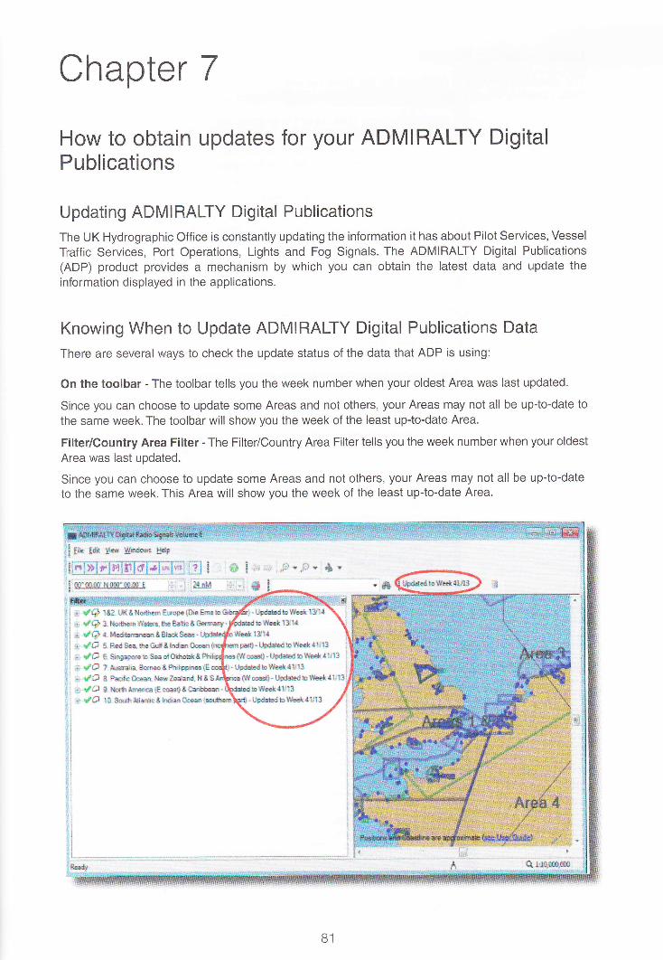
Chapter 7
How to obtain updates for your ADMIRALTY DigitalPublications
Updating ADMIRALI-Y Digital Publications
The UK Hydrographic Office is constantly updating the information it has about Pilot Services, Vessel
Traffic Services, Port Operations, Lights and Fog Signals. The ADMIRALTY Digital Publications(ADP) product provides a mechanism by which you can obtain the latest data and update the
information displayed in the applications.
Knowing When to Update ADMIRALTY Digital Publications Data
There are several ways to check the update status of the data that ADP is using:
On the toolbar - The toolbar tells you the week number when your oldest Area was last updated.
Since you can choose to update some Areas and not others, your Areas may not all be up-to-date to
the same week. The toolbar will show you the week of the least up-to-date Area.
Filter/Country Area Filter - The Filter/Country Area Filter tells you the week number when your oldest
Area was last updated.
Since you can choose to update some Areas and not others, your Areas may not all be up-to-dateto the same week. This Area will show you the week of the least up-to-date Area.
S! Ee Y* Srdt!6 g&
& ra* t8A Ultt I'ls&m fuopc {&iE Ela b:i dG X l'&rhen Sdrxa Uu Eaibt &mxr-t {Q t tieemraat8hdrSe.1. rfg 5- &dss, &s&.S& hdiffi &agna t'# S. $irgportbSea e*SIek&.a rPG ? *l#ia, Samao&Ftrlimrse {!t ladl * M&xn. trlxlaahnd" l{iSt rf,$ *. Xor&trrq*x*{€*} t&r&hax -
r. tXI I0. s..dhtda*c& !di*Ocm
m t , lS I.*':4 ,P.B - ,9, .slbdrrEdtolw13!{
rpa;r!-Up&dblYdtlil3 i
tlSs$. !Se&dbl$aair1t13 l
-UFedbl&{*{1r13 :
6#toq*- 1.&da*drollhsk4
- U$eedb llh€k!ilJl3
B1
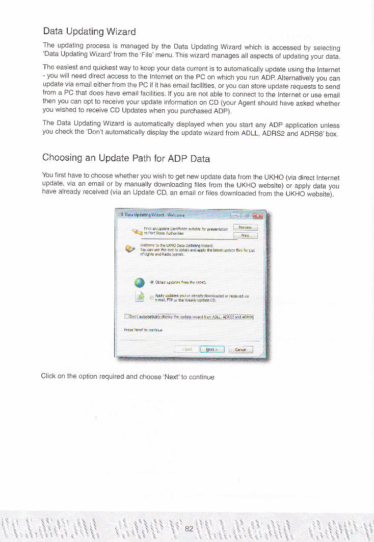
Data Updating WizardThe updating process is managed by the Data Updating Wizard which is accessed by selecting'Data Updating Wizard'from the 'File' menu. This wizard manages all aspects of updating your data.
The easiest and quickest way to keep your data current is to automatically update using the lnternet- you will need direct access to the lnternet on the PC on which you run ADp. Alternatively you canupdate via email either from the PC if it has email facilities, or you can store update requests to sendfrom a PC that does have email facilities. lf you are not able to connect to the lnternet or use emailthen you can opt to receive your update information on CD (your Agent should have asked whetheryou wished to receive CD Updates when you purchased ADp).
The Data Updating Wizard is automatically displayed when you start any ADp application unlessyou check the'Don't automatically display the update wizard from ADLL, ADRS2 and ADRS6,box.
Choosing an Update Path for ADp Data
You first have to choose whether you wish to get new update data from the UKHo (via direct Internetupdate, via an email or by manually downloading files from the UKHO website) or apply data youhave already received (via an Update CD, an email or files downloaded from the UKHO website).
EL Friitrrt#ffi*terndcftrtr*ffin {.j]&l
-t.4s.s wdcrfiEbhauoroh6tFdalrt9Bffi.lF rlg enr,tE rE Ed boaeit rd +* the irEs$(e tE ftr i.tstgftirrEidR.*b SOr*.
$ 'oeu*rr*da*rtF64r-!d{o
l'* a ACEh€&eta\e&edydo*foa& *r.6EdrirIa.t L *r.a,F'IP6lrasaddyt.l&@.
nDsl:#ffi Eil-il'*e*-ffi rs!:"Ei",EtsS"-as"r_ofi S
F?€stExtbffir*
L-:ry-lffill.*ffi
Click on the option required and choose'Next'to continue
tillllllllililrltri i rillllilllltilllliltirtilr rll ill l
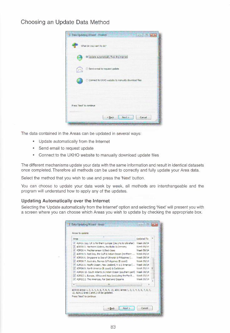
Choosing an Update Data Method
f &'.,a"*rwa*rEdq?
sffi*L
*reffiffiEi[&:iEffi
'1, strd Gfl.C b l€q":st Wd.te
:. i esrEt to tJo{O $lM a rnff.rafv dornhad ncr
9rGr8l*xgbdt{HE
t, -.H.Jf ,rr!;.l I; F**tl
The data contained in the Areas can be updated in several ways:
. Update automatically from the lnternet
. Send email to request update
. Connect to the UKHO website to manually download update files
The different mechanisms update your data with the same information and result in identical datasetsonce completed. Therefore all methods can be used to correctly and fully update your Area data.
Select the method that you wish to use and press the'Next'button.
You can choose to update your data week by week, all methods are interchangeable and theprogram will understand how to apply any of the updates.
Updating Automatically over the InternetSelecting the'Update automatically from the lnternet'option and selecting'Next'will present you witha screen where you can choose which Areas you wish to update by checking the appropriate box.
&.*krsd.*&s,,.,.,..,..,.,-..,-,,.,,.,..,..,....,...,....,.......,,..,,.....,,,.--.,itfFf,n-'
ffi lXsE fea, tx eNer{rsrn Errap* Erc ErE b €&dt&) we€& SEll4
Baenser,NorUremwalsE,theEalte&€Hmlny Yre*S9J1a
ffi &eSe+. MedilsrEnean&lla*Sees weet!9/14fl A8*SO S. *ed Sea, $e Gulf &Indt$ Ac?an (noraen .., 1r!*k q?r1{
S :mSe O. Su,eapo.e b sEc of Olilo*:&Pl*Friiee t,,. \,lre* S9/14
ffi eOe* r. ,qwfdi., E{neo &thi&rrane€ {E eoasQ $ie€r( 0fr1{B qER56 C. priif€ e<*n, 3EH Zed$d, N A 5 ,m€'re! (. . . Wset q9/14
E l*.sJ C. Nor{, A.siG E oas0 & esbbean Wad Ogl14
lS eonse lo. ssu{1 A{fiitc &IndiEn q€ean {oshBrn pErB wq€k 03/14
B aOeSe L g.rooe, Af,is :nd Arln {cxduding !h? F.r E. . . !i&sk 09114
mADRS:2.Tt€Amsiers.F!.gactando€ania rrye**9114
ADRS$ Ared r, z, & 4. 5, 6, :, g 9, 10. r&t tree L a & + 5, E, 7, E, I'10, AtrsZ &q. I ard Z wil b€
'ed.tBd.9r€6s tf€}? to aofttixJe
i;Kltffi, tKl
oo

When you want the transfer to start, click the'Next' button and the ADP application will connect tothe UK Hydrographic Office computer systems and download the information required
. - prht s t-Fdah ctrtftate sEH€ fo( r Pt ri." I-ti(-? trffitatis to Pryr SbE Arthnttss
Lwatiqsl$fs
Area 10 wdaied b Week 1311{
Area 3rpdated to l.leEk t3l1q
Ars 4 LFdaM tD Week 13/14
Ars 5 Lpdated tD trreek !3/14
Area 5 Lpdated b Week 13114
Area TLpdabd ta week 13/14
offia$ p.ogrs
Wo*ingvtryhdd...
It will automatically apply the update data once downloaded. A progress bar shows you the statusof the current action and a second progress bar shows the status oithe overall updaiing operation.
During the updating operation messages are displayed in the main window showing the updatesthat have been applied. ln addition, the Data Updating Wizard also creates a histoiy of updatesthat have been applied from the last 6 updates and reports which areas have been updated. Whenthe updating progress is complete, the'Finish'button will be enabled which you can then press tocontinue working with the ADP which will now be using the updated information.
Requesting an Update using Email
1f *nuro"*rKttodo?
S ,:: uoart" *t*ticly frm the tnErrei
$ :.] a**to r"{+,io sebsite to mmany domioad ft*
B4

Obtaining an update via email is a two stage process.
. You must first use the Data Updating Wizard to send an email request containinginformation about the Areas you wish to update. This will be processed automatically atthe UK Hydrographic Office and email(s) will be sent immediately with an attachmentcontaining the data you need to update ADP.
a{€sigsFdab
6i:?.,...,r..,..t:...J:i..!ir::::::' ..-.:t.r...',"'::::t.:'.'::':i l.lpdatrg'fo :'
ffi ffisa fsa tKa!tulrmErope $eeis tochtrd6) m*oelr+ i
mAm.SS3.lJsthsnWaErs,theBaltic&GsMy Week09/14
ffi lioF.SO + Nedtaranem &Bh& Ses tte* Bl1{ :ffi A!ES6 5. ted sea, ihe Gr:tf &Ind*: Oam {mtlwn .., Weer( .,9/14 :
S] ,lm,Sg e , :Xeaptre t6 sea of d+Et* &Ft&p{!s {... We€* 09/1{
ffi ,AAes5 ;, *sb.ae, 8.im & l4&kE* G m.rt) We€ft @/14
M *OcSe g. padfr Oeet nrew Zedildr { & S Affiic (,.. wE*. 09114
S Am.ss L Nrtr *mia {€ oass A Cdebeal W€€k 09/14
m rDRs6 10, Setrt AintiE & kEfim Offi {wtrn pat} we€k O9/1{
B eOrS: f, nsope. Aiia and lcia {ex*ldrq Ele Fa E .. Wek 09/1{
fflms:arfexmie,F*Eaitadotrilia v!e€ko9/14
a8*s$.a,&s 1a a.{ 5,6J18j& 18;€Il-rreas ! 3.r Q.d 5,6;t8;9,10, !m5! &r€ tad :xi$ le iritdabd.PrNltxt bffitiu,
FWWIW
When this update is received you can use the Data Updating Wizard to import theattachment by selecting "Apply updates you've already downloaded or received via e-mail,FTP or the Weekly Update CD" or you can simply double-click on the attachment to startthe Data Updating Wizard.
tu Palltar{&d{*cgticaa*ifr*etulp.er6&}. Ii*i:@Rbmsae*rmlts [-mt-*l
& , Wdcfir b tle U+E Dab tbdatirg V6"ad.
@ vwa e t*' bd b obbi! dd 4ply the bh3twdaE fl6 fu usr- of Ljchts ad P€do cryrds,
$ e*"'**ofrmthctxllo.n1 *& ^ riliffiH;iir,G;ft&"ileffi;4il;dGi"vdjI Eq *
F-*d.UP,e..,tq-qi--d-d-x.ihC1s_-q-D.._-_*_..._^_._-_-- -j
EOmtarlomtq *qr.y tE{.e&*ri3ied*ffi AEX!, ffiSl$d ffiS6
Prtrl.aexltomtrc
f--Eq.,.][WG tr.r'ffi
B5
iillil

lf you select the'Obtain updates from the UKHO', 'Send email to request update'option in the DataUpdating Wizard you will be given the choice of Areas for which you require an update. Select oneor more Areas from the list of Areas and press the'Next'button.
You are given the option to'Send the email now'or'Store the request in a file to send later or to sendfrom another PC'. lf the computer that you are running ADP on has email facilities then you shouldchoose to email the request, otherwise you should store the request in a file which you can sendfrom a different computer.
Send the email nowlf you select this option and press'Finish', the Data Updating Wizard will create an email messageautomatically containing all the information needed to request your update. lt is addressed [email protected] with'UKHOBLUR'on the subject line of the email.You just need to'send'this email to complete your update request. The UKHO will respond with email(s) containingthe update data as an attachment.
!i1. ldit Vi€w !ns.d Femd
lse.d g I Eloerio.r...
o try;:.qi:tfsl ;!, .....
e... I I
# -,updateautornatkdlyFmtrhGmet
'.j {, g"-t-d,e!i{ -!o t9,$re_Bt_rlpCgB;
ADR55 Area L, ?, 3, 4, S, 6, 7. 8, 9. l0! ,qDL! Ared L 2, 3,4,5,6, ?, A,9and 10 #{ be Lpaated.
Prs llext t6 rffttu.
AM..] I AoP ootub*dfd dt6ffi)
3 e-Eatl has an aEtache.t that eill be lead b! a co@uie. io trnd !u. ati.h uidaies Vou need.!o!i ora Resea[e; ii ei11 noi be .ead,
OO
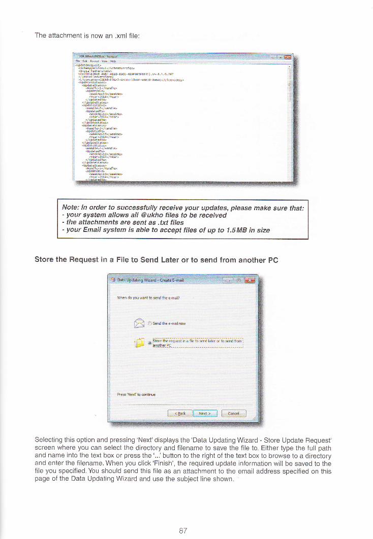
The attachment is now an .xml file:
Note: ln order fo successfully receive your updates, please make sure that:- your system allows all @ukho files to be received- the attachments are sent as .txt files- your Email system is able to accept files of up to 1.5M8 in size
Store the Request in a File to Send Later or to send from another PC
Ll$gl do VarxEritto*rd lk *ad?
A.la-xil flserdtee+eamu@-, -
kl{exf h"*m6rqe
E$M*.I$reS L*gw*d
Selecting this option and pressing 'Next'displays the'Data Updating Wizard - Store Update Request'screen where you can select the directory and filename to save the file to. Either type the full pathand name into the text box or press the '...' button to the right of the text box to browse to a directoryand enter the filename. When you click'Finish', the required update information will be saved to thefile you specified. You should send this file as an attachment to the email address specified on thispage of the Data Updating Wizard and use the subject line shown.
87
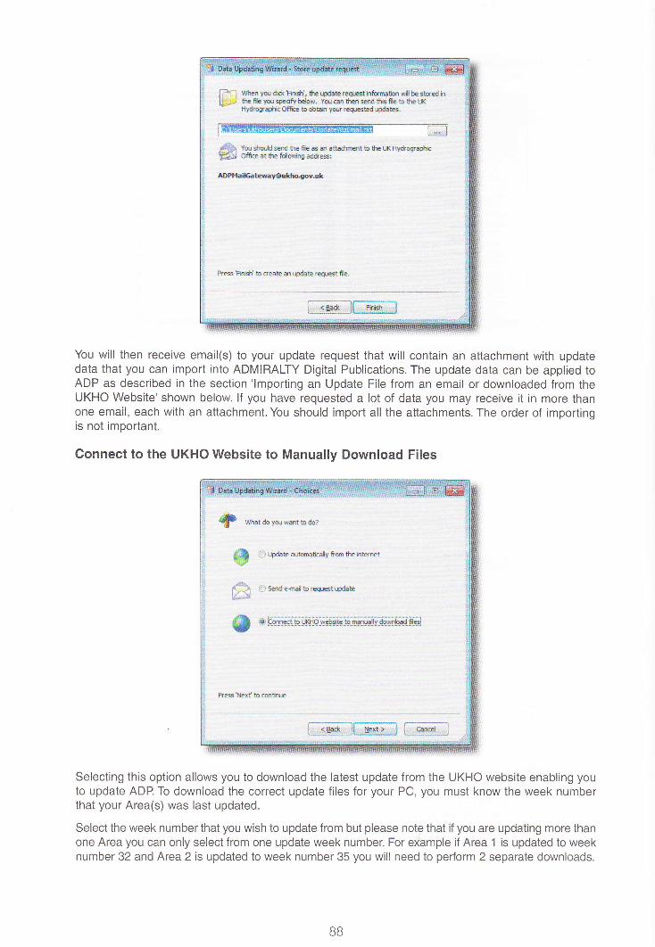
$fen n*ii& ??*Si, lk1e&*ersqie*i*ors**irc*ilbelM|.tPre Ee ni ee<ifo below, Yu; @1 *r€rl Btrd tiB flc b tE l.}(i66!rad&ffich.bHr foljrre+reEhd$&leg
l@ G$ Vm *u.U sU ttp Ec c a rtbdrEtt b bhe l..X Hy*ognghicEN otre at the foWiq ra*es:
A0Plftffi.ErerJr$ddngsyJ*
Pr* hi$' b ssE m W&te rcqJd fic.
L$*wJGffi
You will then receive email(s) to your update request that will contain an attachment with updatedata that you can import into ADMIRALTY Digital Publications. The update data can be applied toADP as described in the section 'lmporting an Update File from an email or downloaded from theUKHO Website'shown below lf you have requested a lot of data you may receive it in more thanone email, each with an attachment. You should import all the attachments. The order of importingis not important.
Connect to the UKHO Website to Manually Download Files
dl U',**$dRb&!
&l7R
S t&dat *rumHy Fd* ttein*met
I Send*mdenq.le*wd.6
^fl S $ffit-E-q.gp*rFl$ts- -tDsI{I"CsB$h#-hi
Pr*lexf t6&*rr
[.-{*.]t"ffi i--6#;
Selecting this option allows you to download the latest update from the UKHO website enabling youto update ADP. To download the correct update files for your PC, you must know the week numberthat your Area(s) was last updated.
Select the week number that you wish to update from but please note that if you are updating more thanone Area you can only select from one update week number. For eXample if Area 1 is updated to weeknumber 32 and Area 2 is updated to week number 35 you will need to pedorm 2 separate downloads.
BB

Select the Area(s) you wish to update then click the'Submit Update Request'button.Your selectionr,vill take a few moments to process. When it is complete, the updates wiil appear in a new window,ready for you to download. The download file can then be applied to ADP as described in section'lmporting an Update File downloaded from the UKHO Website or received in an email from anothercomputer'shown below.
I td. fa? fa rrr.dl.' i.* H.lF
4 grr(urx(c6r95LvPNtr* alflPioor&urhc.loy lijtusgd.dsn6- !,[email protected]&.(*- 3 P.rt!6
Once you have received your data you can apply the updates already received
ao

Choosing the 'Apply Update' Data Source
*u prutaupdatecrrifi.Esi*fvpr€abli,, IiW{q!*;}aq&bMsbbArtho.itirE f-prbt l
-!
-^ -. $rdoreto BEtl+€Datatbdafirg ttiad.lF7 Y9u g. * *is bol ro obtairr ad aFdI tE lae*l{dae ffs fu lt!s!
of Llhts and Ra& 9rr*.
$ ***r*a"Es*etEu&ro.r--L|;&,aimhqt:ltEslur'E*e;,rn &d;'edia;;jI.*r -'ssd.fllct.6e_.t:dglk#E!D,-
i
L Oon't rutnratizlv dspby tE Lp6E wiad [m AD[I. ADRSI rd ADRS6
Pru'trlst tomilu
i_:.**_j[ffi3 l.,e*a{.;
The Data contained in the Areas can be updated from several data sources:
. Update from the ADP weekly Update CD
' lmport an Update File from an email or downloaded from the UKHO WebsiteUpdate from a CD
$ w***rw.bdo?
g# ,Ouaerrmo'r- 9
@ .*,*."u**
Pr*iErf iosrthre
l-*qeJf ;ffi.-q*3 [i].s*s.{;l
When you receive your updates on CD, simply place the CD in the CD drive of your computer afterselecting the'Apply updates you've already downloaded or received via e-mail, FTp or the WeeklyUpdate CD"'and then 'Update from CD'. The Data Updating Wizard will ask you to select the drivethat the CD is located in. Either type the drive name (for example 'D:\') direcily into the text box orclick on the'...'button to the right of the text box and select the CD Drive from ihe dialogue.
90

. --S SdedBrrcfut4ahr EEl.pda*e.TtiE rdmudybepr@qry dire.e.eDr\
I D:lvteeldv ArB hta\ ii* i
e [cD,mFsl ADffi<11_r4
RilEe n6 Se€t trr4 b t,JEd( 1tn{
!+e.elrod.
l**ss*,j[ffi] l;,.6"si.;
lf the CD is a valid UKHO ADP Update CD then information on the Areas that are contained on theCD and the Week Number will be displayed, otherwise a message indicating that the path specifiedis either an 'lnvalid folder'or that the CD does not contain ADP update data is displayed.
When you have selected the location from which to import the data simply click the'Next'button.The Data Updating Wizard will say that it is ready to perform the update. Click'Next'again and theupdate will commence. The Data Updating Wizard will display a screen allowing you to monitorupdate progress. This will update all the areas even the areas you are not licensed for.
Update from a File
S ****r*ilt6&r
*S *taaun*..ucn
*ffiffi
R!ss!*rf Ueikr-
[i.€e*l$'ffiffi1
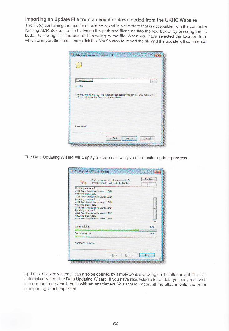
lmporting an Update File from an email or downloaded from the UKHO WebsiteThe file(s) containing the update should be saved in a directory that is accessible from the computerrunning ADP. Select the file by typing the path and filename into the text box or by pressing the '...'button to the right of the box and browsing to the file. When you have selected the location fromwhich to import the data simply click the'Next'button to import the file and the update will commence.
lE:t.d.tesl'hrf
-
l- L ry'l
.hrf f,e ..ttxr:$*cdeicq,b$$e *ratnrsleq sept by th {.fito, s }.d& .ri&,.r6&J or .uirEss fie fffi 0E txt€ s€bdE
Pre*s l1letd,
t_d"silfrffi;:l t-H.,
The Data Updating Wizard will display a screen allowing you to monitor update progress.
lL PrhtmLhd.Sct'tif@tss.*deflr=f,B prEffit timbPortst hArthdtesffi
rrai6'.*hdss,e€k lts{4rcr7.*r
t&datutdrb
ovudpoqrc
lrt&rtbc sfhed...
l-:,**.:KlffiW
,rd4lFd.hdtowrr{( $rfi&sa.ea5.r&.!Ars slpdaL+ to t4eh 1ill+
lre ?r,4dabd blleeh f{1abqrFe&*rarrs S tedlbd u rirr* l5r1r
Updates received via email can also be opened by simply double-clicking on the attachment. This willautomatically start the Data Updating Wizard. lf you have requested a lot of data you may receive itin more than one email, each with an attachment. You should import all the attachments; the orderof importing is not important.
92

Chapter B
How to obtain updates for ADMIRALTY e-NauticalPublications (e-N P)
This is the process of requesting and applying Updates (NMs) applicable to ADMIRALTY e-NPs youhave downloaded to your ADMIRALTY e-NP Reader.
Using the lnternet
Your e-NP reader will indicate if the product is out of date and the action required to update it.
Check the communication setting is set to lnternet (if it reads "Media" then click on "User Settings"to amend). Ensure the "Request" button has been selected and then click on the "Next" button toproceed with the Update request.
Click the "Get Updates" button to connect to the UKHO and download the latest updates for theADMIRALI-Y e-NP Reader. On receiving the reply the ADMIRALTY e-NP Reader automaticallyassigns the Updates to the e-NPs.
93

Once the download has finished a success message is displayed detailing which week e-NPs areupdated to. Click on the "Finish" button to complete the process. The downloaded Updates (NMs)can be viewed to the right of the main text of the e-NP in the View Book component.
Loading your e-NP Permit FileCheck your communication setting is set to Media (if it reads "lnternet" then click on "User Settings"to amend). Within "Tools" and "Get Updates" click on the "Apply" button and then click "Next". Thiswill take you to a new screen where you should click on the "Browse" button to locate your savede-NP_Permits(yyyyww).enp. Select this file and click on the "Load" button to import the file andprocess the permit.You will be given a success message and if you then navigate to the "Book Shelf"you will see the books you have purchased are at the top of the list and require data.
AA

Using MediaCheck communication setting is set toto amend). Ensure the "Request" buttonproceed with the Update request.
Media (if it reads "lnternet" then click on "User Settings"has been selected and then click on the "Next" button to
CIick on the "Browse" bulton to determine the location of your Update request file and then click onthe "Save" button to store the request file at your chosen location.
Using the request file which has been saved, (named "request_xx.enp") send an email with thefile attached to [email protected] and include "e-NP" as the subject. Click "Next" tocontinue onto the next step of updating e-NPs.
t
*
.: j--=.:.o( -,::

An email will be returned with an attachment(s) (named e-NP_Response*Master_xx). Save the fileto a location on the device the ADMIRALTY e-NP Reader is installed on. Click the "Browse" buttonto point to the saved response file(s) and then click "Load" to process the Updates.
Once the download has finished a success message is displayed detailing the week the e-NPs areupdated to. Click on the "Finish" button to complete the process. The downloaded Updates (NMs)can be viewed to the right of the main text of the e-NP in the View Book component.
96

Chapter 9
How to install and update the ADMIRALTY VectorChart Service (AVCS)This guide is designed to help you to load and maintain your AVCS data easily and quickly. ltdescribes the basic steps necessary to use AVCS in any ECDIS. However, each ECDIS manufacturerhas implemented the ENC import module differently. Users who are experienced in operating aparticular model of ECDIS may require additional supporting information when managing AVCSENCs on ECDIS equipment that they are less familiar with. For detailed installation instructions andtroubleshooting information, see the AVCS User Guide and your ECDIS User Guide (supplied by themanufacturer). A copy of the AVCS User Guide is supplied with the AVCS Start-Up Pack. ln additiona wide range of support information including installation guides and videos for popular ECDISmodels can be downloaded from the UKHO website www.ukho.gov.uk/AVCS
Electronic Navigational Charts (ENCs)AVCS is comprised entirely of Electronic Navigational Charts (ENCs) produced by GovernmentHydrographic Offices. lt is designed to be used in conjunction with a type approved ECDIS to providea primary navigation tool that meets the requlrements of SOLAS Chapter V. ENCs contained withinthe ADMIRALTY Vector Chart Service (AVCS) are produced and distributed according to well-defined international standards.
Details of the ENCs available in AVCS, including their coverage, is available in the ADMIRALTYDigital Catalogue, which can be downloaded from www.ukho.gov.uk/catalogue, and in ADMIRALIYe-Navigator Planning Station.
Getting StartedYour ADMIRALTY Chart Agent will provide you with the following materials when you subscribe toAVCS for the first time:
AVCS Start-Up Pack
. AVCS Quick Start Guide;
. AVCS User Guide;
. AVCS Base Discs (a set of CDs or a DVD labelled'Base');
. AVCS Update Disc (a CD labelled'Update', not required when using the DVD);
. ADMIRALTY lnformation Overlay CD;
. End User Licence Agreement (EULA) for digital data services.
AVCS Licence
This may be supplied with the AVCS Start-Up Pack on hard media, such as CD, or separatelyin an email. The initial licence pack will contain the following:
. A "Schedule A", (except when using ADMIRALTY e-Navigator Planning Station) this is aPDF document listing the Folios and ENC Units that the user is licensed to use. lt also liststhe "Home CD" where the licensed ENCs are held. This is particularly useful as it preventsunnecessary loading of those CDs that do not contain any licensed ENCs.
. A set of ENC Permit files (PERMIT.TXT and ENC.PMT) for each ECDIS installation.
. An AVCS Certificate (a PDF document showing your vessel and licence details).
97

Pre-i nstal lation Checks
Data CleansingNew AVCS users who have previously subscribed to other ENC services are strongly recommendedto remove (purge) all ENC Permits and ENCs from the system before installing AVCS. There is agood reason for doing this as previously installed ENCs may become out-of-date if they are notlicensed in AVCS. lf the system is not purged, redundant ENCs may remain in the system database(SENC) and be available for use, even if the previous licence has expired. However unlicensed ENCscannot be updated and the user may be unaware of this if inadvertently navigating using one. Topurge the system users should consult the ECDIS User Guide supplied with the equipment.
Public Key - ls the Correct File lnstalled?The ECDIS will not install ENCs from AVCS unless the correct Public Key is installed. lf the correctPublic Key is not installed the ECDIs will report an Authentication Failure.
Newer ECDIS, type-approved from 1 January 2009, are compatible with edition 1.'1 of the IHO's 5-63Data Protection Scheme. Your ADMIRALTY Chart Agent will supply you with the 5-63 1.i formatAVCS CDs or DVD, which authenticate against the IHO public Key.
Older ECDIS may only be compatible with edition 1.0 of 5-63. Edition 1.0 format CDs can berequested from your ADMIRALTY Chart Agent and authenticate against the PRIMAR pubtic Key,which is contained on the discs.
BackgroundThe ECDIS authenticates the source and integrity of encrypted ENCs from Service providersagainst a pre-installed Public Key. The Public Key can be formatted in one of two ways, either anASCII text file (.PUB) or an X509 Certificate (.CRT). Newer ECDIS (manufactured since 2003) oftencome with the IHO.PUB and/or IHO.CRT pre-installed as the IHO is the Scheme Administrator (SA)for the 5-63 ENC Data Protection Scheme. The UKHO is a certified subscriber to this scheme.
Check the Public KeyBefore installing AVCS ENCs, the user should check that the correct Public Key is installed on thesystem. The method of managing and viewing these will vary between different makes or versions ofECDIS. lf the correct Public Key is not present on the system then it will have to be installed beforeAVCS ENCs can be loaded. The relevant Public Key files (.PUB and .CRT) are held on all AVCSdiscs in the root folder. Most ECDIS have functionality that allows the user to import this file to thesystem and users should consult the ECDIS User Guide supplied with the equipment.
ECDIS Authentication WarningIf 5-63 1.0 format dala is installed on a newer ECDIS, the ECDIS will report the following warningmessage:
SSE26 - This ENC is not authenticated by the IHO acting as the Scheme Administrator
Users should acknowledge these warnings, if prompted to do so, but should not be concerned asthe source and integrity of the ENCs are authenticated correctly against the PRIMAR Public Key.However users should switch to 5-63 1.1 format at the next opportunity.
lnstalling and Maintaining AVCSAVCS ENCs are currently distributed on CD, DVD and via the lnternet. The ENCs are encryptedaccording to the lnternational Hydrographic Organization (lHO) 5-63 Data Protection Scheme.lnitially the AVCS user is provided with ALL of the latest base and update discs which containall the ENCs in AVCS. However these cannot be accessed by the ECDIS until a valid set of 5-63ENC Permits are installed. Each ENC Permit is unique and gives the user selective access to theparticular ENCs required for the intended voyages.
' ..:.
j=-.: oQ :t= :: : 'l:

Step 1: lnstalling AVCS ENC PermitsThe AVCS ENC Permits will be supplied to you by your ADMIRALTY Chart Agent in a zipped file.The contents ol this file will depend on the user's bridge configuration as each AVCS licence allowsfor use on multiple ECDIS. When extracted, one or more sets of permit files (PERMIT.TXT and ENC.PMT)will be copied automatically into folder(s) named MASTER, BACKUB RESERVEl, RESERVE2and RESERVE3 depending on the number of ECDIS configured on the bridge.The contents shouldbe extracted to a suitable media, such as CD or USB flash drive, that can be read by the system.
NOTE:The ENC Permits must be installed before any ENCs can be imported and installed on thesystem.
AVCS users with multiple ECDIS on board or with other systems that use ENCs (such as ChartRadar, VDR etc) should be careful to load the correct permits for the intended system. Each systemmay require its own unique set of permits. Failure to do so will result in an error being reported similarto the following:
. CRC failure permit could not be read
. Failure to uncompress ENC data file
. Decryption failed
Step 2: lnstalling AVCS ENCs
AVCS data is delivered on a series of CDs labelled Base and a CD labelled Update, or on a singleDVD. Each Base CD contains all the ENC base cell files and associated updates for those producernations identified on the CD label. The Base CDs are issued about every 8 weeks and the UpdateCD is issued weekly in between to provide access to the latest ENC data. The Base CDs must be
loaded first before the latest Update CD can be loaded. The DVD is issued weekly and contains all
the ENCs available and all updates. Users are provided with all ENCs in the service but can onlyaccess those ENCs that they are licensed to use.
The AVCS disc labels show the date and week of issue. Users should be careful to only load an
Update CD that is newer than the installed bases. The status ol the latest Base CDs is published in
the weekly ADMIRALTY Notices to Mariners bulletin. Users with internet access can check the statusof the latest AVCS discs using the following link:
http ://www. u kho. gov. u k/AVC S
Click on the Licensing tab to view the AVCS distribution and issue dates.
When using CDs, it is unlikely ihat users will need to install all of the Base CDs in order to load all
licensed ENCs. Users should refer to the Schedule A or ADMIRALTY e-Navigator Planning Station
to avoid the unnecessary loading of some CDs. A small sample of the information contained in the
Schedule A is provided below:
RFA03 - English Channel Holding Expiry Date 31.12.2010
Ce11 Title Home CD AVCS UpdateGB301820 Isles of Scillv and Western Approaches AVCS Base 3 NiAGB301840 Land's End to Falmouth AVCS Base 3 AVCS UpdateGB302020 Falmouth to Looe AVCS Base 3 N/A
PACAS Asian Seas Holding Expiry Date 31 .12.2010
Ce11 Title Home CD AVCS UpdateGB202868 Tokongkemudi to Natuna Utara AVCS Base 9 N/AG8202870 Pulau-Pulau Leman to Badas AVCS Base 9 AVCS UpdateG8202872 Selat Karimata and Approaches AVCS Update N/A
:: j.' :'1..', ::-OO-'
_ .j.. ::. : :i.:l

Users should be aware that, depending on the manufacturer, each type of ECDIS manages theimport of ENCs in one of two ways:
1. The ECDIS loads the ENC base data (base cell) in the first instance and then the user hasto update as a separate operation;
2. The ECDIS will manage the import of ENC base data and all updates in a single operation.
Users should consult the ECDIS User Guide supplied with the equipment to confirm which operationis appropriate to the system.
The appropriate base discs must be installed rn the system and licensed ENCs imported accordingto.the instruction provided in the ECDIS User Guide. ihe process must be repeated until all licensedENCs are imported to the system.
Step 3: Installing AVCS ENC UpdatesAVCS is updated on a weekly basis and updates are distributed on CD, DVD and via the lnternet.AII discs are cumulative and contain all data available up to their date of issue. Only the most recentUpdate CD or DVD received need be installed. However when the Base CDs ire reissued, therelevant discs must be installed before any subsequent Update CDs can be installed.
NoTE: Although ECDIS equipment and ENCs are designed to be very reliable, there is a slighlyincreased risk of problems occurring when ENCs are being added, removed or upoited.For this reason, you should not attempt to make changes to the installed AVCS ENCswhen the equipment is being used for primary navigation or if the vessel is committed toan imminent departure.
AVCS ENC updates are available over the lnternet using the ADMIRALTY Updating Service orADMIRALTY e-Navigator planning Station.
Step 4: Maintaining AVCS ENC Holdings
Periodically the user will. be supplied with an updated set of AVCS ENC permits. New permits areissued for any ENC that has had more than one new edition. The reason for this is that older ECDISwill only install ENCs with the same edition number as contained in the permit. f.f"* p"irits are alsoissued for ENCs that replace cancelled ENCs.
An AVCS permit file is specific to a particular week as described in the Schedule A. lt is importantthat users do not install these unless they have the corresponding CD or DVD tor tfre same week.Failure to follow this advicellgn using an ECDIS type-ipprov6d before 1 January 2009 coutdrender some of the installed ENCs unavailable for use-in the ECDls. The only exception to this ruleis if additional coverage is required in case of emergency or a change to a planned route.
4Y9_SJN9 updates are also available over the lnternet using the ADM|RALTY Updating Service orADMIRALTY e-Navigator Planning Station.
Emergency AVCS ENC PermitsUnder certain circumstances it may be necessary lor avessel to gain access to an unlicensedAVCS ENC at very short notice. For instance if the vessel has to dive-rt from a planned route due toa medical or safety related emergency. ln these emergency situations only, individual AVCS ENCPermits can be obtained from the UKHO 24 hours a Oay, iOS Oays a year.These permits can betransmitted direct to the v-essel by email, by fax, or simply by reading th-e AVCS permit string(s) outover the telephone or radio. This service is also available foi the ECbIS and ARbS services.
To obtain an AVCS emergency chart permit please contact UKHO Customer Services, quoting yourname and contact details, the vessel name, the User Permit Number of your ECDIS system and theENC(s) required.
100

Chapter 10
ADM I RALTY Information Overlay
What is the ADMIRALTY Information Overlay?The ADMIRALTY lnformation Overlay (AlO) contains additional information which is considerednavigationally significant and can be used in conjunction with ENCs to improve safety of navigationwhen using ECDIS.
The Overlay contains information about changes or hazards of a temporary nature, such as changesto aids to navigation, advance notice of permanent changes, new survey information which willlater be issued as an ENC update, and additional information of relevance to mariners which isnot currently included in national ENCs. The Overlay includes all ADMIRALI-Y T&P NMs in forceworldwide and additional information from the comparison of ENCs and ADMIRALTY paper charts,published as ENC Preliminary NMs (EP NMs).
The UKHO can only include information in the Overlay where it exists in the UKHO archive ofhydrographic information. AVCS includes ENCs produced by national Hydrographic Offices that arethe equivalent to their local paper chart series. Where there is no equivalent ADMIRALTY paperchart, the UKHO does not have any additional information and the Overlay shows a'No Overlay'feature. Additional information, such as localT&P NMs, may be available in these areas from othersources. When navigating in these areas, mariners should ensure that all appropriate sources ofinformation have been consulted.
Installing the ADMIRALI-Y lnformation Overlay
Compatible EquipmentThe Overlay can be displayed on compatible ECDIS equipment and also in ADMIRALTY e-NavigatorPlanning Station. Please see the UKHO website at www.ukho.gov.ut</AVCS for an up-to-date list ofcompatible equipment, or consult your ECDIS supplier.
ADMIRALTY e-Navigator Planning Station allows the Overlay to be displayed against all ENCs onyour AVCS licence. To allow your licensed ENCs to be installed on e-Navigator, please ask yourADMIRALTY Chart Agent to include the e-Navigator User Permit on your AVCS licence.
lnstalling Overlay PermitsThe Overlay data is protected in the same way as ENCs and requires a permit to unlock the data.This permit will automatically be added to all ENC Permit files used with e-Navigator. Please notifyyour ADMIRALTY Chart Agent if you wish to use the Overlay on any other compatible ECDIS so thatthe Overlay permit can be added to the ENC Permit files for that equipment.
The Overlay permit will be loaded at the same time as all ENC permits when the ENC Permit filesare loaded.
101
lnstalling Overlay DataThe Overlay data is provided on a single CD that contains both base data and all updates up to thedate of issue. Therefore only the latest CD is required for installation and all others can be discarded.
The Overlay data is loaded in to the display equipment (e-Navigator or ECDIS) in the same way asENC data. Note that some ECDIS may require you to run an 'Update ENC' process after loading thebase data to ensure that all updates on the disk are also applied.
Updating the OverlayUpdates to the Overlay are issued weekly on CD, along with the weekly AVCS Update CD, and arealso available over the lnternet through e-Navigator. Updates on CD should be loaded in the sameway as loading ENC updates.
The data volume in each weekly update is normally small. However it is occasionally necessary toissue a New Edition of the Overlay, which consolidates all update data into a base daia set that maybe tens of megabytes in size. lt is impractical for most users to download this volume of data overthe lnternet and an AIO CD should be used.
Updating the Overlay in Planning StationAVCS customers can also request the weekly AIO update when downloading AVCS updates usingthe 'Get Update'function. For a full explanation of this method of updating please see page 111 i;Chapter 11
When an Overlay new edition is issued (see above), the new edition must be installed before anyfurther updates can be applied. For users who normally update over the lnternet this means thatan Overlay update CD will need to be installed before further lnternet updates can be applied.
Using the ADMIRALTY lnformation Overlay
Displaying the OverlayThe Overlay is designed to be displayed on top of a standard ECDIS chart display and can beswitched on and off without changing the underlying chart.
Only those features relevant to the chart in use are displayed. As the user zooms in or out, theECDIS will automatically select charts of a relevant scale and the Overlay features relevant to theselected charts will be displayed. For example, a Temporary NM that applies only to a large scalechart will not be displayed when smaller scale charts of the same area are being used.
T&P NMsAll ADMIRALTY T&P NMs that are in force are included in the Overlay. Each NM is displayed as asimple red polygon (usually rectangular) with red hatched fill which indicates the area affected bythe NM. Each NM carries the same NM number that is used in the ADMIRALTY Notices to MarinersBulletin.
102

The full text of the NM is included as an associated text file which can be displayed by selecting the'Temporary Notice to Mariners'or'Preliminary Notice to Mariners'feature in the ECDIS Pick Report.Any associated diagrams can also be viewed through the Pick Report.
Figure 1 Preliminary (P) NM showing text and diagram
EP NMsENC P (EP) NMs contain additional information that is specific to ENCs and cannot be publishedas a standard ADMIRALTY T&P NM. These NMs are displayed in the same way as T&P NMs, as asimple red polygon (usually rectangular) with red hatched fill which indicates the area affected bythe NM. Each NM is allocated a unique EP NM number.
The full text of the NM can be viewed in the ECDIS Pick Report against the lnformation attribute.Where additional information is needed to explain the NM an associated picture file displays animage showing the ENC superimposed over the current paper chart information.
'No Overlay'FeatureWhere there is no equivalent ADMIRALTY paper chart, the UKHO does not have any additionalinformation and the Overlay shows a'No Overlay'feature. This feature is displayed as a grey polygon
with a grey hatched fill indicating the area where there is no overlay information.

Using the Overlay to NavigateThe ADMIRALTY lnformation Overlay contains additional safety and NM information which isconsidered navigationally significant and may affect your voyage. This information should be referredto when planning your passage and may also be temporarily displayed during route monitoring.
When planning your passage it is normal to review all charts (and therefore ENCs) that are expectedto be used on the passage. When these charts are reviewed the Overlay should. be turned on andany features that could affect the planned route should be investigated. Those features that aresignificant lor the planned passage should be marked using Marinei's Navigational Objects, whichcan be displayed by the ECDIS when navigating. Sufficient information should be attached to theMariner's Navigational Objects to inform the navigator of the action to be taken when they areencountered on passage.
lf the ECDIS is capable of displaying the Overlay, overlay information may temporarily be displayedwhen navigating. To avoid complexity on the ECDIS display the Overlay should normally be turnedoff and should only be turned on for brief periods when required for reference. Therefore Mariner,sNavigational Objects should be used to draw attention to relevant Overlay features when the Overlayis turned off.
104

Chapter 1.1
ADMIRALTY Raster Chart Service (ARCS)
lntroductionARCS charts are high quality, digital facsimile copies of British ADMIRALI-Y (BA) paper charts, and
share a common numbering system. Chart availability is published in the 'Catalogue of ADMIRALTYCharts and Publications' (NP131), in the ADMIRALTY Digital Catalogue which can be downloaded from
the UKHO website at www.ukho.gov.uk/catalogue, and in ADMIRALTY e-Navigator Planning Station.
ARCS charts are official Raster Navigational Charts (RNCs) that can be used in ECDIS as an aideto navigation and may be used for navigation in areas without adequate ENC coverage subject to therequirements of Flag State authorities.
This guide is designed to help you gain maximum benefit from using the service, and should be usedin conjunction with your ECDIS User Manual.
Service OverviewOver 3200 ARCS charts are now available on 11 Raster Chart (RC) CDs, covering the world's majortrading routes and ports. Each disc contains an average ol 270 charts, but as many as 350 canbe stored. Regionally based discs RC'l to RC'10 contain standard BA nautical charts, while RC11
contains ocean charts at scales of 1:3,500,000 and smaller. However, please note that some oceancharts are provided on regional discs to provide continuous coverage, instead of RC11.
New Editions and New ChartsNew Editions and New Charts for ARCS and BA paper charts are issued simultaneously. They aresupplied on each weekly Update CD until incorporated into their respective'Home'CD at the nextissue. Please note that New Editions and New Charts replacing charts already licensed, are suppliedautomatically, but will require loading from the Update CD (in instances where one chart is replaced
by more than one new chart, access to all replacement charts is provided).
Occasionally, it is necessary to issue new charts in advance of their intended date of validity, for
example a change in regulations commencing on a future date. ln such cases the current chart will
co-exist with the new chart until the date of implementation, the earlier chart being indicated with asuffix'X'. The system will allow access to both charts for the period of overlap by the issue of new
chart permits. At the date of implementation, the old ('X') edition should be deleted from the system.
Licence Period
ARCS is licensed for a period of 12 months. At the start of the licence period users will receive an
ARCS Start-Up Pack containing all 11 Raster Chart CDs, the latest Update CD, a Chart Permit fileand a Schedule A from their ADMIRALTY Chart Agent. The Chart Permit file unlocks the chartsadded to the licence and the Schedule A lists the licensed charts for your records.
During the licence period, ARCS Update CDs will be supplied weekly to enable the licensedcharts to be maintained for Notices to Mariners. You will also be provided with all New Editions and
replacement charts within your licence. These updates are also available by email and over theinternet using the ADMIRALTY Updating Service or ADMIRALTY e-Navigator Planning Station.
When your ARCS licence expires you will no longer be able to load ARCS Update CDs. Unless thelicence is renewed the charts will not be updated for Notices to Mariners and will therefore not meet
SOLAS chart carriage requirements. Licence renewal can be arranged by your chosen ADMIRALTYChart Agent.
105
Data VerificationARCS charts are supplied with the same guarantee of accuracy and reliability as BA paper charts,and are subject to stringent checks to ensure that the raster image is identical to the paper one.Data quality is likely to be more reliable on newer surveys at larger scales, and the source datadiagram can be used to assess the quality of source data. This is typically ten times smaller thanthe chart to which it refers, and should be interpreted with care at the limits of specific surveyareas. Occasionally, plotting on the source data diagram will not be possible because it cannot bereferenced to the main chart with sufficient accuracy.
ARCS CDs are protected by encryption to ensure data integrity and to allow licensing of charts.Access to ARCS charts is provided by the Chart Permit files supplied; these will have beengenerated for, and will only work on, the ECDIS for which they were ordered. They will be providedon disc or emailed to you.
ARCS Start-Up PackThis pack should include:
. ARCS User-guide
. Packaging (to hold your CDs, Chart permit files, etc)
. 11 ARCS RC CDs (these contain ail availabte ARCS Charts)
. 1 Update CD
. End User Licence Agreement (EULA) for digital data services
. Chart Permit files (supplied by your Agent on disc or via email)
' A'Schedule A'which lists all ARCS charts incorporated in the licence (except when usingADM I RALTY e-Navigator Ptanning Station).
If any of these items are missing from your Start-Up pack, please contact your ADMIRALTy ChartAgent.
Getting Started
Loading Charts
The procedure for loading ARCS charts varies from ECDIS to ECDIS however the same generalprinciples apply and these are outlined below. You should consult your ECDIS system manual fordetailed instructions.
Chart Permits
Access to the charts on the RC discs is provided by Chart Permit files. These are supplied by yourAgent and consist of 2 files; Gb.lcn and Gb.ncp. The Chart Permit file contains permits for all thelicensed charts.
106
Loading ARCS for the First TimeChart Permits - insert the Permits supplied into the ECDIS by {ollowing the procedures supplied by
the manufacturer.
Loading Base Charts - insert the RC CD(s) for the relevant chart permits held (refer to the ScheduleA supplied or to the diagram in the section below). Most ECDIS will allow you to choose whether toload all licensed charts or just those of your choice; some may prompt you to load specific RC or'Area'CDs. Once the charts have been installed you should update your charts by loading the latestARCS weekly Update CD.
Loading Latest ARCS Update CDs - the Update CDs contain cumulative information. lf you receivemore than one Update CD at the same time, you only need to load the most recent one. Havinginstalled the RC disc(s) and loaded the latest weekly Update CD, the ECDIS system willthen displaythe latest ARCS information available.
Maintaining the Chart Outfit
Update CDs
ARCS Update CDs are issued weekly containing all the latest'Notice to Mariner'corrections, New
Editions and any New Charts issued. Updates for ARCS charts are provided in line with ADMIRALTYNotices to Mariners; New Editions and New Charts are issued in the same week as for paper charts.
On receipt of the Update CD you should load the new data using the update procedure specified in
your ECDIS manual.The process should be automatic, but as required by the ECDIS specificationsyou will be asked by the ECDIS to accept the updates. Again, if you receive more than one weekly
Update CD at the same time, you only need to use the most recent because they are cumulative.
It is possible that your ECDIS will occasionally report warnings or errors during the update process.
Whilst it is not possible to be definitive in this matter, users are advised that a warning can be
accepted as being very unlikely to corrupt data already loaded, but an error should be treated more
seriously and the chart should only be used with caution since it may not reflect the latest Notices to
Mariners information. Users should notify UKHO Customer Services if their ECDIS system reports
errors on loading of charts or updates.
Note:
lf replacement ARCS RC CDs have been issued containing New Editions of certain charts,
subsequent updates for those charts cannot be applied until the New Edition has been installed.
NB: Stored Routes and UpdatesUpdates applied to the ECDIS may affect previously stored routes. lt is important to check the effect
of any updates on a stored route prior to its use.
Re-lssued ARCS RC CDsThe UKHO periodically re-issues new RC discs in order to integrate newly available Base data thatis temporarily held on the Update CDs. Re-issued RC CDs will be accompanied by an ARCS weeklyUpdate CD as normal.
On receipt of re-issued RC discs it is necessary to reload all required ARCS charts from the CDs.
New Chart PermitsYou will automatically be issued with all necessary Chart Permits to provide access to newly availableor replaced charts within your licence. Please ensure that you load new Chart permits when youreceive them to ensure your ECDIS has the capability to use the latest charts from the latest CDs.
Schedule AThe Schedule A lists the content of all the charts thatbe provided with the weekly Update CDs where this iscancelled and replaced charts.
have been licensed. Updates to this willnecessary. The update will list details of
Licence ExpiryOnce the licence period for the service has ended, the ECDIS system will prevent the loading offurther updates until the licence is renewed. Access to ARCS charts will cease 30 days after expiryof the licence. The expiry date is shown on the Schedule A and on the Chart permit file.
Note:
ARCS must be kept upto-date for Notices to Mariners to meet IMO SOLAS requirements.An ECDIS using charts beyond the expiry date of the licence will not meet chart carriagerequirements.
Adding Chart CoverageAdditional charts may be obtained during the licence period through your chosen ADMIRALTy ChartAgent who will supply new chart Permits to'unlock'the newly added charts.
Licence RenewalApproximately four weeks before licence expiry you should receive a renewal reminder from yourADMIRALTY Chart Agent. The ECDIS will display an intermittent warning one month before eipiryand a permanent warning following expiry. To ensure continuity of service, please confirm requestsfor renewal at least two weeks in advance of the expiry date.
Service Details
Features of ARCSProduced by the UKHO for the commercial shipping industry, ARCS charts meet the lnternationalHydrographic Organization's (lHO) 5-61 Raster Navigational Chart (RNC) standard. They may, withFlag State approval, be used in ECDIS (in conjunction with an appropriate folio of up-to-date papercharts) to meet Qhart carriage requirements for areas where ENCs are not yet available. See IMOECDIS Performance Standard (1.9 as amended).
Each ARCS Chart shares the same numbering as the BA paper chart from which it is produced.Please note that certain charts included on the ARCS discs may not currenfly be availabte for use,pending approval from the national hydrographic offices concerned.
108

Chart CoverageARCS charts are provided on 11 'RC CDs' for the geographic areas shown in Figure 3 below
Please note that ARCS RCl1 covers the whole area shown in the diagram as it contains oceancharts at scales of 1:3,500,000 and smaller.
Figure 3 ARCS RC CD Coverage
T&P Notices to Mariners (NMs)
A complete listing of ADMIRALTYT&P NMs are included on the ARCS Update CD.This is in text file
format and can be printed out. Some ECDIS systems have a capability to display the appropriate
T&P NMs to the user.
109

Chapter 12
How to update ADMIRALTY products using e-Navigator
ADMIRALTY e-Navigator Planning Station
ADMIRALTY e-Navigator Planning Station is a software application for use by the navigating teamon board vessel. The application comprises of three key functions:
. Holdings Management System - Mariners can track the status of all ADMIRALTYdigital and paper charts and publications in a single place, giving them quick and easyvisibility of the status of products held on board. Missing data for digital charts canbe downloaded almost instantaneously through Planning Station, ensuring the vesselremains safe and compliant. The Holdings Management system also integrates withpaper chart updating services supplied by our partners to offer complete managementof paper charts and publications.
. ADMIRALTY catalogue - The integrated ADMIRALTY Catalogue allows the mariner toidentify and purchase the best combination of charts and publications needed to navigatea plotted route safely, compliantly and cost effectively. Orders placed from Planning Stationare sent direct to your ADMIRALTY distributor, allowing you to purchase ADMIRALTYproducts when you need them.
. Product Viewer - An integrated chart viewer enables viewing of subscribed digital chartdatasets such as the ADMIRALTY Raster Chart Service (ARCS), ADMIRALTY VectorChart Service (AVCS) and the ADMIRALTY lnformation Overlay (AlO). Customers ofADMIRALTY Digital Publications can also view these products in Planning Station.
Planning Station CommunicationsADMIRALTY e-Navigator Planning Station requires either a broadband internet connection or emailaccess to download data or to place orders. Below are the communication methods which can be
used with Planning Station:
. lnternet: - When a 'Get Update' is submitted using HTTPs, the requested data will bedownloaded directly f rom the UKHO servers on demand. The data will be sent directly backto Planning Station and a wizard opens to guide you through the process of exporting an
exchange set file to be applied to ECDIS.
. Direct Email: - The direct email method connects your Planning Station application to aspecified email account of your choice. When a'Get Update'is submitted, Planning Stationwill send a data request from your email account to the UKHO server. An email will besent back to your lnbox containing a data file. Planning Station will check the email lnboxfor the response email at time intervals specified in your settings (Default to check every10 minutes). When Planning Station checks your lnbox it will find the response email andimport the attached data file. This will open a wizard to guide you through the process ofexporting an exchange set file to be applied to ECDIS.
. Removable Drive: - When a 'Get Update' is submitted using the Removable Drivemethod, Planning Station creates a request file which needs to be attached to an emailsent to the UKHO servers. An email is sent back with a data file attached that needs tobe manually imported into Planning Station. lf your Planning Station and communicationsPC are separate, you will need to use either a Removable USB Drive or CD to transferthe request and data files between the computers. When the data file has been importedinto Planning Station, a wizard will open to guide you through the process of exporting an
exchange set file to be applied to ECDIS.
111

To view or change yourCommunication MethodRemovable Drive.
selected Planning Station communication method go to User Settings >and select from Email, Removable Drive or lnternet. The default option is
How to keep Planning Station Catalogues up-to-date
When the ADMIHALTY e-Navigator Planning Station software is activated it downloads the latestcatalogue files. lt is important that the Planning Station catalogues are updated regularly as thesecontain Notice to Mariner and Edition details as well as the latest ADMIRALTY product catalogue.Planning Station compares the products held on board against the catalogues, frigfrtighting chlrtsand publications which require updating.
New catalogue files are released every Thursday and can either be received with the Weekly Updateemail sent to your vessel or requested from the Home page via'check My status,.
Catalogue updates are requested from the Home screen by selecting 'Check My Status, in thebottom right corner. This is also used to check that the latest catalogues are held in planning Station.
Artivete my e-Navigator
n Subscriptionsetlings
tdatoque HotdinsprodEtType Upd.tedto{e& kuonNow Adhngoon Action.dchdts
L0/201{ ?3 79 I .:ARCS ro,2ol4 .t2papci 6.rs tol2at4 z 1s9
Dig tnt plbkdtons
nd-ra., -o-a-oe lO,2O.4
STATUS 4d rar.Dbk -(d%d.osFd, 1o/20r4Aomrat!Ddtr.L{Dl
'ohGt:jtuou-!4.{ddr'ro **,,-a.,"*
CurentUNnOweek tglZOta LGtortsh&indFoosiqnok nl2arLdofRadosqnaE loj2ol4 1
c. rqo"ed,o.' fiDol4 3
'Gdlub[cLoT tltzot4r5-elo_.oJrpod-G lo/2014
Non-admil.tv produ.E
r cireak ilrdL yorlr Ierrrrlts nn(l
I
Upd.t.j to.atalolues.nd d.ta!16 avatlable from UKHO ea.h Thu6day (GMT) No (.tahoues arc rcnt f you.16 aleady uo to d.t6roC.. +6r r."_rrddos-ena.<a odo!-.ao-p{o.o.tepe.-r. .,.,h.,c-ec.;,}.!-, bi.on
112
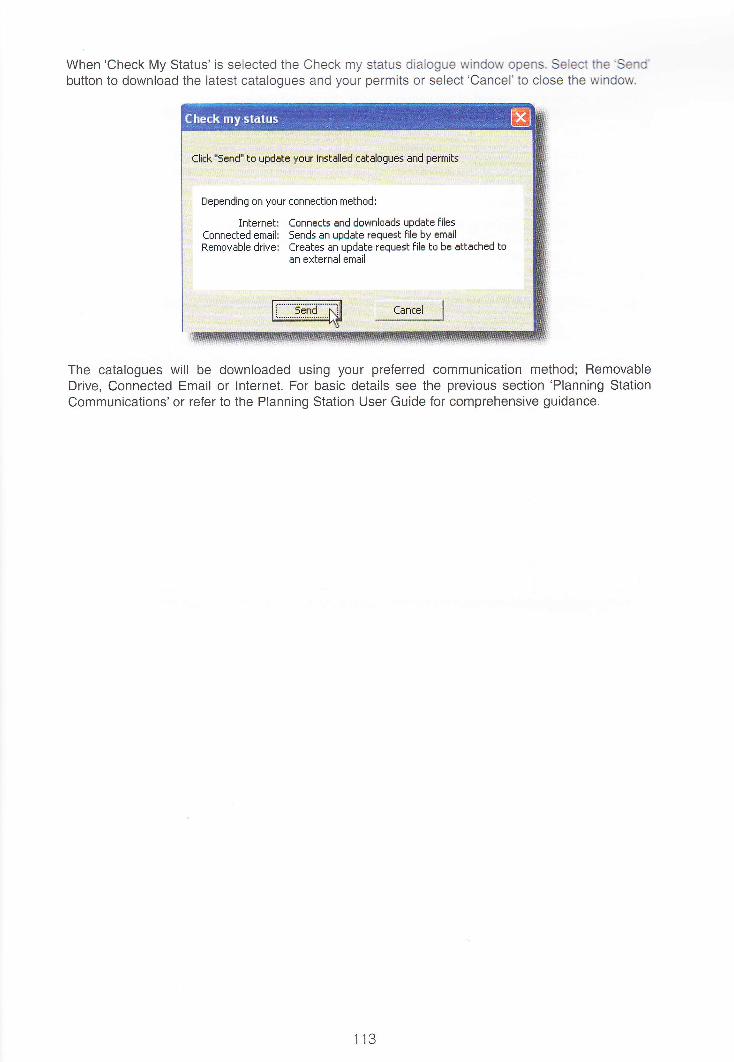
When 'Check My Status' is selected the Check my status dialogue window opens. Select the'SerxC'button to download the laiest catalogues and your permits or select'Cancel'to close the window.
The catalogues will be downloaded using your preferred communication method; RemovableDrive, Connected Email or lnternet. For basic details see the previous section 'Planning StationCommunications'or refer to the Planning Station User Guide for comprehensive guidance.
113

How to keep paper products up-to-date using Planning Station
A master, or'holdings', record of the vessel's paper charts and publications held can be maintainedin Planning Station. This record is passed back to the shore-based users of ADMIRALTY e-NavigatorFleet Manager, meaning that it can be viewed by Shipping Company and Distributor users.
The integrated catalogues within Planning Station mean that it can also be used to view and managethe status of paper charts and publications held on board. This allows the bridge team to manuallyadd and remove paper products to reflect the true holdings. The update status of the paper productsheld can be manually managed so that mariners know if they are up-to-date.
When a new paper chart or publication is received on board it should be manually added to thePlanning Station Holdings. To do this go to the Catalogue screen, select the paper product neededfrom the Product Selection Filters and then Search for the new chart or publication using thegeographical display or list catalogue.
When the new paper products have been selected, use the'Add to Holdings'button to manually addselected paper products to your holdings. Paper products which are no longer held on board can bemanually removed using the'Remove from Holdings'button.
After adding the new paper products to your holdings, go to the Maintain Holdings area and selectthe product type added from the Product Selection Filter. The holdings added will now be displayedon the geographical display and in the holdings list. Use the Search tool to find and select all paperholdings that have just been manually added; these will all appear in yellow colouring with the'Update Status' as'Not lnstalled'.
PqM iddlh(*PdbidP# Wa$ N2Sse M&:illiti!S;i.:':J&idl*t1l;ir6iit ii.{a..: rryd 4r?is€ t&6&:::::.li
w ---ffiqfrffiA-PryW WtuW&baAEsqCtWd.tM 6tul Mffi ffi*
114
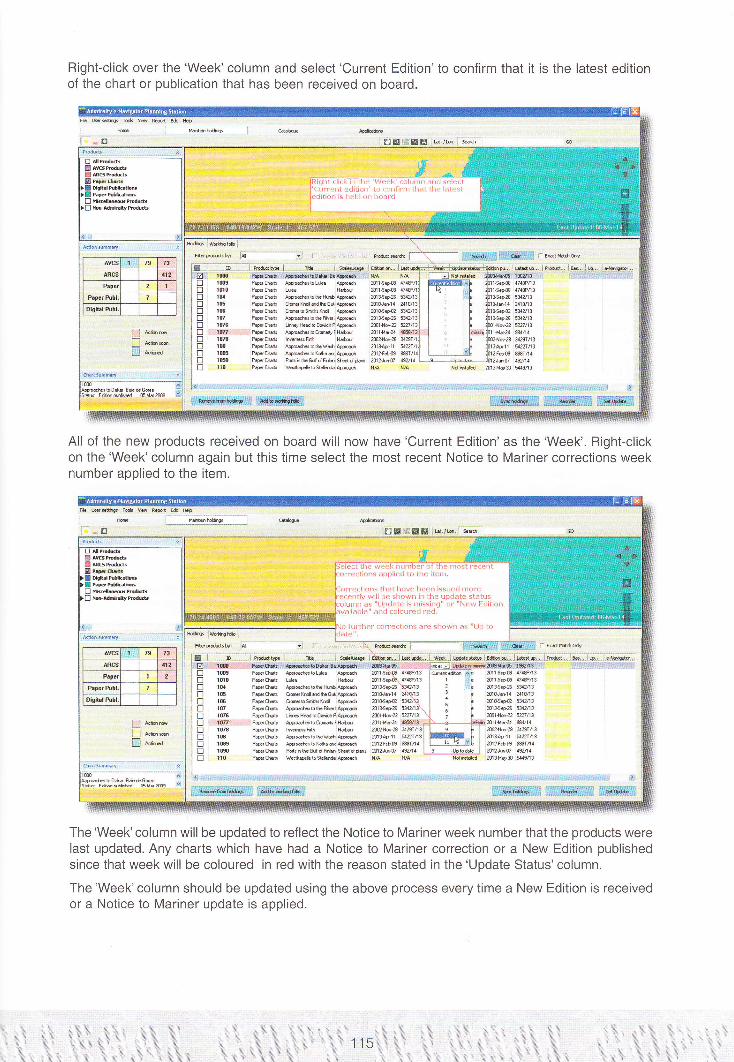
Right-click over the'Week'column and select'Current Edition'to confirm that it is the latest editionof the chart or publication that has been received on board.
All of the new products received on board will now have'Current Edition'as the'Week'. Right-clickon the'Week'column again but this time select the most recent Notice to Mariner corrections weeknumber applied to the item.
bwwf*tuwe8
ffiS$ffi T-tuffidu
1mt@1fl0lgt6IG10t06
: .1!77: : :lwi@IE1@110
PryM *ffibatuM Atqd gOa*APwtu Aw&ktuFktgd A79*BPryM @HdbotuPfud m$daPrytub bw&bgM|lqtu a14*21Pryh lffiF6 Hrtu w\tufrP#W Ary&bb\4drwd NtAs.l1PryW Aryebl@rt@d fr?F&@
lecL lllc s3(lk rlllllrlrea al Ine fi,''1at rea:ent,rtrDliEd Lo Ll,e irEr,1,
orr..ti.nc ti)ar llave ireFn issreai rnorecenlly !"riil tic shovin in the up.late statls
nn as "l !pdale is .nissin.t" or "i\le!r E(litioir" ancl csloLrfecl real,
iLrriher aicrre.liorrs are shorvn as "iJt) lo
tus&b* F-----------": r -- ..-.:I M
[email protected]@1@1@1@IIO
PryW ,s&btufitulrwd fr79q8 W?@M tuHdhAMPtud N4@-2 wA1P#W M&tog@l9tu ffi14a-a:,@41Prytu l@Ffi Htu w$d8 !ffi\?Prytu Aw&btuq*Awe 8W.11 WnXPrytu ,q&btu*rw& frz+ffi WA1Prytu PentuGld|tu,@db tu21u& {illPeW \|Mh$ffiMd N/A NlA
The'Week'column will be updated to reflect the Notice to Mariner week number that the products werelast updated. Any charts which have had a Notice to Mariner correction or a New Edition publishedsince that week will be coloured in red with the reason stated in the'Update Status'column.
The'Week'column should be updated using the above process every time a New Edition is receivedor a Notice to Mariner update is applied.
II3.::

Using Paper chart updating software in Planning Station
Paper products can also be managed using third party software applications which may be availablefrom your ADMIRALTY Distributor. These applications support paper chart updating by downloadingthe Notice to Mariners text and block corrections. Some paper chart updating appticaiions can also linkwith Planning Station to provide a single integrated solution for keeping all paper products updated.
lf the paper chart updating software used on board is compatible with Planning Station it can belaunched from the Maintain Holdings screen by selecting the'Open software'Outton, providing thesoftware is installed on the same PC as Planning Station. The master record for your paper chartholdings will now be maintained using the chart updating software and will be synchronised withPlanning Station as changes are applied. The Holdings record in Planning Station is greyed out toavoid confusion. The date and time of the most recent Holdings synchronization is shown on theHoldings tab.
tu Bd setqr Todr ue R@! rdr Heb
: H.@ - ffil;;u,tr -.'l
^o
.chdsl$ryNo terc sbdd
116
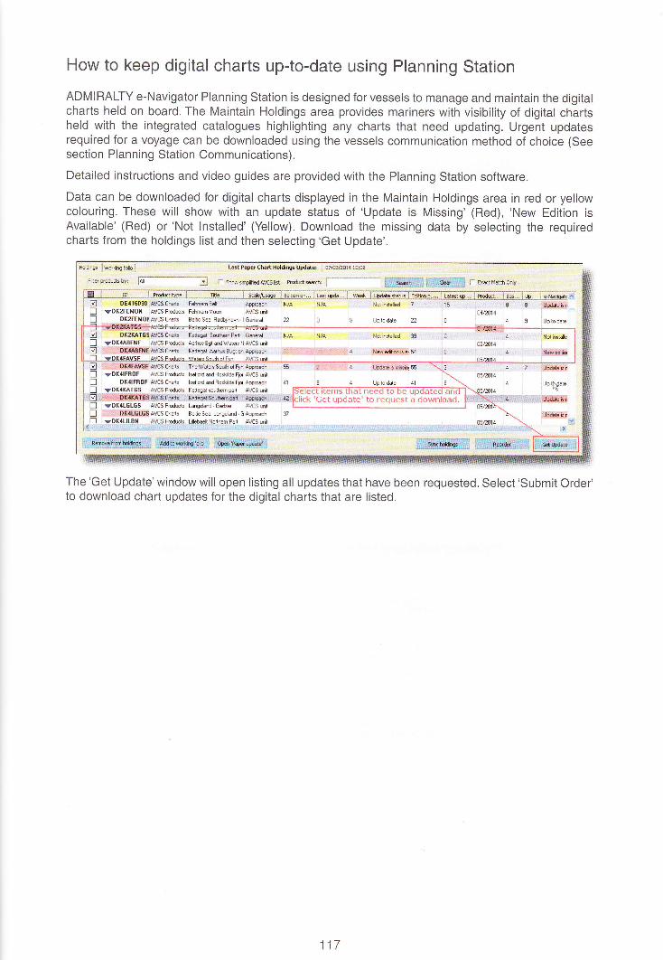
How to keep digital charts up-to-date using Planning Station
ADMIRALTY e-Navigator Planning Station is designed for vessels to manage and maintain the digitalcharts held on board. The Maintain Holdings area provides mariners with visibility of digital chartsheld with the integrated catalogues highlighting any charts that need updating. Urgent updatesrequired for a voyage can be downloaded using the vessels communication method of choice (Seesection Planning Station Communications).
Detailed instructions and video guides are provided with the Planning Station software.
Data can be downloaded for digital charts displayed in the Maintain Holdings area in red or yellowcolouring. These will show with an update status of 'Update is Missing' (Red), 'New Edition isAvailable' (Red) or'Not lnstalled' (Yellow). Download the missing data by selecting the requiredcharts from the holdings list and then selecting'Get Update'.
**-&t!ftEl!llfl.r:..: :lApdd{ffit1 nrnFehmam"MoBn IAVCS unit l
AVCS Cha*s i Ballic S... Fodbyhsvn. LIp to datB
Up lN€te
i&Nxx& *lr S:.
The'Get Update'window will open listing all updates that have been requested. Select'submit Order'to download chart updates for the digital charts that are listed.
117

Updating the ADMIRALTY lnformation overlay in Planning Station
AVCS customers can also request the weekly ADMIRALTY lnformation Overlay (AlO) update whendownloading AVCS updates using the'Get Update'function.
To do this, select any AVCS updates that are needed from the Maintain Holdings tab. The 'GetUpdates'window will open listing the AVCS products that updates were requested for. The AIO isdisplayed as G8800001 which will appear by default at the bottom of the list of AVCS products.Select the G8800001 tick box to request the latest AIO updates.
Fts p.sditt. bytr: IAE *HB :j
l,lot id#Hid#Hid#hH#ffii*#ibr e*im b ftd*LFddE b trtsiEl-Fdate B iisiE
*slffiDEilffilDE}1ffi0t41ffi0t€xar6D{.il8ftFX#AYsFXffiTGsAO
Seiect "GBSOOOO1" to dowrrload arupdate of Adnriralfy Informatior] Overlay
WgRflII{Gl Athi*f lrft:m*in Oalry {*IO} r fvt*r mt*rirar rdtismay nnanth*akgE ilEr* of d*a lfl hE
dovrJo#, Itm 4d# re fu aJable bf ercr*ly CD. Are1mr re 1rr ni*ltoird:det}EAIOh fql dsrjod?
Irrt#; eru*, lE.- Ld'+d*: F-- i:**------** *,-_--------:
Tr--Y* t'.1 ib Il----J.fFt
Note: lf you have not previously applied AIO data to your ECDIS and/or Planning Station, it isrecommended that you first load this from an AIO data CD due to the large file size.
118
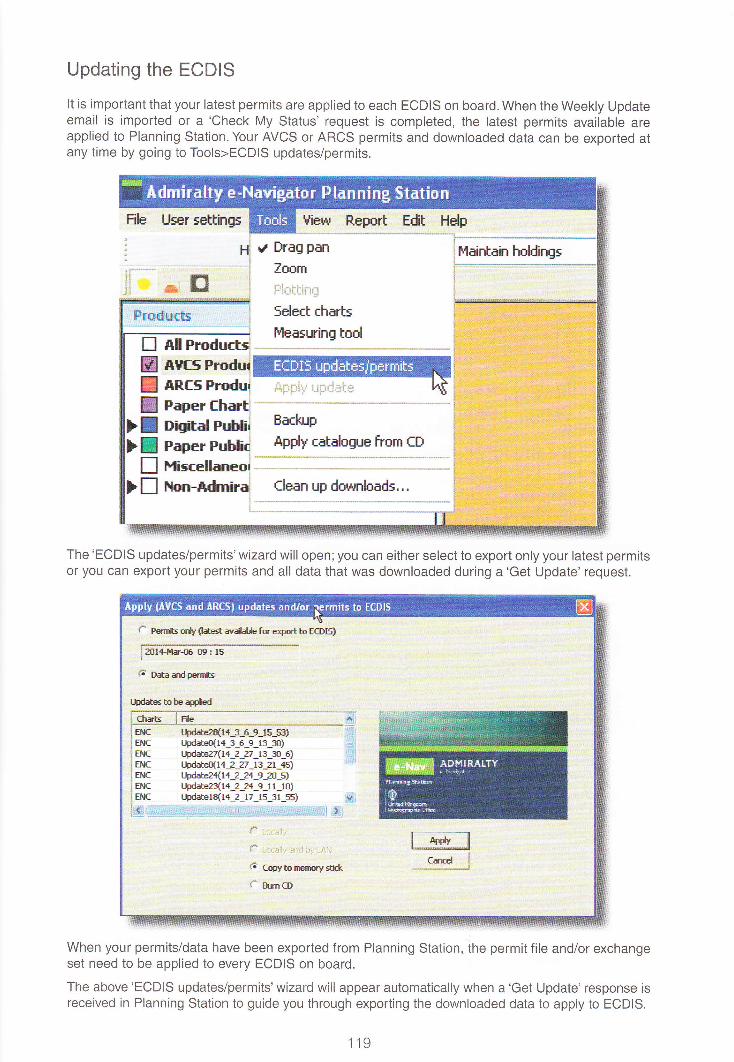
Updating the ECDIS
It is important that your latest permits are applied to each ECDIS on board. When the Weekly Updateemail is imported or a 'Check My Status' request is completed, the latest permits available areapplied to Planning Station. Your AVCS or ARCS permits and downloaded data can be exported atany time by going to Tools>ECDIS updates/permits.
File User settings Uierru Report Edit Helpi*,-.-
i. Drflg pan
Zoom
rcSelect charts
I''leasuring tnolf,ll Produrt=rAtfs Produi+Rfs ProduiPaper fhart:Disital PuhliiPaper Publi-r
HisrellaneoiFlon-ldmira, Clean up downlaads...
The'ECDIS updates/permits'wizard will open;you can either select to export only your latest permitsor you can export your permits and all data that was downloaded during a'Get Update' request.
f- Fffi*s fl{f {lated avdde fr e+ort to E(DIS}
lAll.+f4rfi t}B: rs
{: tr*ardpemits
lSd*es to be appled
EIICEI{(Et{fEI{CETI(
tFd*e2fl14_3_6_9 ls s3lr..Fd#ri1+_3_6_e_r 3_rr)t-Fddbz4l4 2 27_13_:[_6]I ErlihFfl{14_2_27_13_21_+5)tFdateza{ta ? 2+_9_?O_5}l+dat#ql4 2 2+_9_11 lo)t-bdaterql{_2_17_15_3r_55}
j enc
ls{cj.{, . I
{"
1l fopy to nuruy sti*
H-mCD
I--rs, lqei
When your permits/data have been exported from Planning Station, the permit file and/or exchangeset need to be applied to every ECDIS on board.
The above'ECDIS updates/permits'wizard will appear automatically when a'Get Update'response isreceived in Planning Station to guide you through exporting the downloaded data to apply to ECDIS.
fIEW
ww,Etrtr
Eackup
,4pply catalogue frcm fD
119

Updating your ECDIS Status in Planning Station
When data has been loaded to your ECDIS it is important that you synchronise Planning Station todisplay the updated ECDIS status. You will need to synchronise Planning Station with your ECDISwhen any of the fotlowing processes have been applied:
. Data loaded to ECDIS from UKHO Base/Update CD
' Data downloaded from Planning Station (via'Get Update'process) is applied to ECDIS. Data received with the Weekly Updaie Emait is applied to ECDIS
To synchronise the status of your Planning Station and ECDIS you will need to use the 'SyncHoldings'wizard. This is opened using the 'Sync Holdings' button in ihe bottom right corner of theMaintain Holdings page.
ff7i201 3
Update is missir 22 4E Update ir r
Up to date.* I
!
6Bb,UFdate
The synchronise holdings wizard will open giving you three options. . The screen explains whichoption to use depending whether you have downloaded the data, or have an update disk.
Planning Station is designed to handle update data on CD and on DVD.
Use ihis wizard to tell Planning statinn Ebout updates which you have applied to your ECDIS and t,: Ioed daia intoFlanning 5tation
What wuuld you like to do?
, l* Just update your ECDIS status in Flanning Slation
Use this option when you have exported chJrt updates from Flanning Station and already loaded them on yourr ECDI5, Or, use this aption it you have updated your ECDI5 by CDI DVD or other media and d,: n':l v+ant io loadr chart drta inls Plenning Stetion
I t* luEt install chart data For viewing in Planning Station (your ECDI5 status will NOT be updated)
Use this option if you rirant to load UKHO chert dJta tor viewing in Clinninq Station, but do not Hant to set the. record oi your ECDI5 slatuE at this time
, f Updateyour E(DIs status AND load charl data tor viewing in PlEnning stdtion
Use this option when you heve received your chart data on CD, OVD or other media and have already updatedyour ECDIS, This aption will load the dato For viewing in Planning Station and also update the Planning Station
, ierard of your E(DIS status
Nrrt
- -i f...r!.t-l
Select'Sync Holdings'button to open a wirard that will synchr0nisEPlanning Statinn to display your updated ECDIS status
120
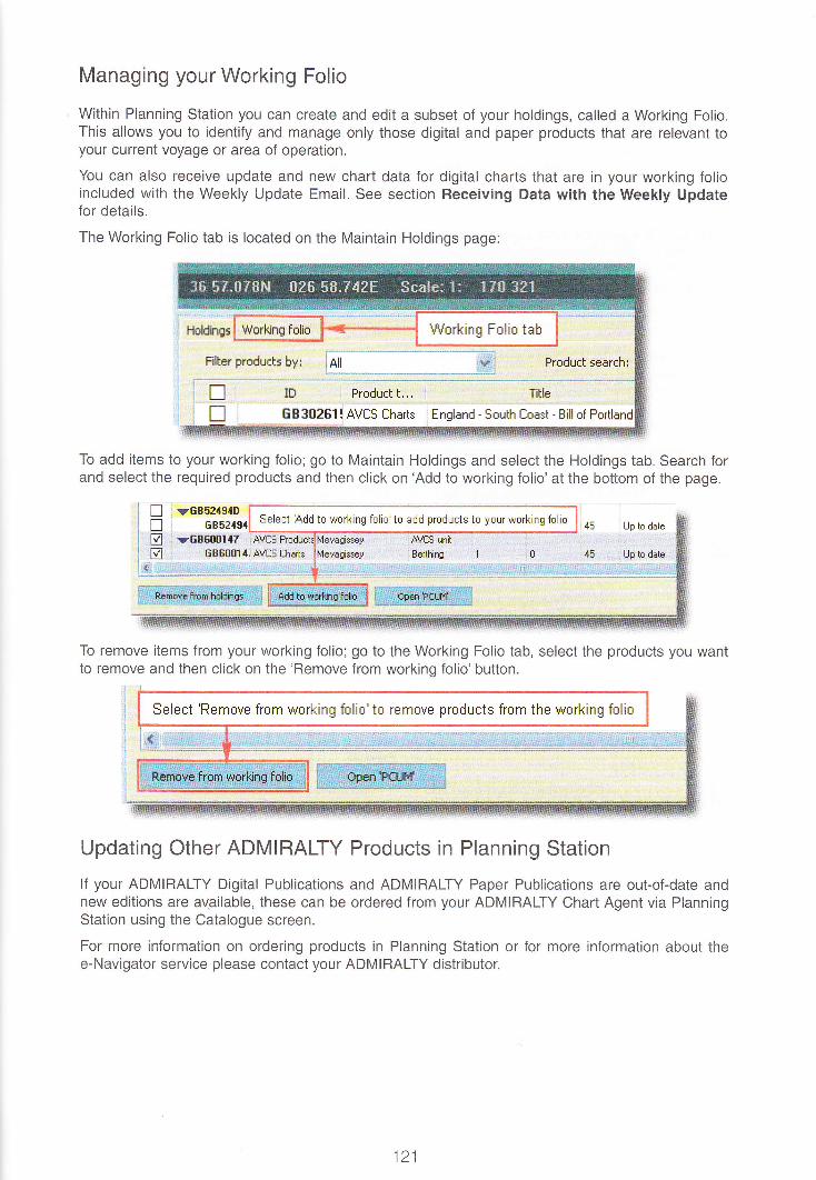
Managing your Working Folio
Within Planning Station you can create and edit a subset of your holdings, called a Working Folio.This allows you to identify and manage only those digital and paper products that are relevant toyour current voyage or area of operation.
You can also receive update and new chart data for digital charts that are in your working folioincluded with the Weekly Update Email. See section Receiving Data with the Weekly Updatefor details.
The Working Folio tab is located on the Maintain Holdings page:
Filter products byr ,All -. ..- _ **l Product search:
Tille
EB3[2EI: AVES fharts , England - South E'rast - Bill of Por
To add items to your working folio; go to Maintain Holdings and select the Holdings tab. Search forand select the required products and then click on'Add to working folio'at the bottom of the page.
To remove items from your working folio; go to the Working Folio tab, select the products you wantto remove and then click on the'Remove from working folio'button.
Updating Other ADMIRALTY Products in Planning Station
lf your ADMIRALTY Digital Publications and ADMIRALTY Paper Publications are out-of-date andnew editions are available, lhese can be ordered from your ADMIRALTY Chart Agent via PlanningStation using the Catalogue screen.
For more information on ordering products in Planning Station or for more information about thee-Navigator service please contact your ADMIRAITY distributor.
trtr
121
Select Add to working folio'trr add products to yr:ur working folir
Select 'Eemove from working folio'to rEmnve products from the working folio

Applying the Weekly Update Email
The Weekly Update Email is sent to AVCS and ARCS customers that have chart permits whichhave changed during the previous week (E.g. Permits have been cancelled, replaced, added orwithdrawn). The Weekly Update Email is sent out by the UKHO every Thursday and contains theupdated AVCS or ARCS permits which need to be applied to ECDIS.
Planning Station customers receive the Weekly Update Email with an e-Navigator specific fileattached (.ads).
Right-click on the weekly update file (.ads) and 'Save as'to save the file in a folder. If planningStation is not installed on a communications PC, you will need to save the file on a removable drivefor transfer between computers.
,f*trp+ fdncdiboA!:r$r"'_*-a,X,&ffi:t.t___*-.,_,,:_*:ji-"-;l .*_ :,- .',.'. .- -:,,-, :: Ele E* Unw ln*ft furntat To.b &dins Hg} i::i,.: !.rjerl,:i, i:r f,:rr
Frm: frndonotertr@l+n,go..r* 5€nt: Ttu3rlolfanr3ffi:{5To:
Cr:qtrtr e+lil'rig#- ASc5Yae€l+t-bd# Anan5 ftrffi pnr rIJ4Ze
Vector Chail Seffice - ltYeekly Update
find attached the reekly update file for your action. The content of this file is determined by your User Sefiings.
opening or using the attached fles you agree to the terms ofthe End User Licence Agreemenl, thal can be found onet Manager, Support > EULr4. lf you do nst agree with lhese terms please do not open or use these pgmits.
Ihe Weekly Update Email sent to Planning Stalioncustomers has an e-Harrigator specific file attached {-ads}
ector Chart Senrice - Weekly
attached the weekly update
or using the attached files you ,
1er, Support > EULA. If you doofthe End Userse teffns please
--[ "'!ffilIrlt

Go to Planning Station and ensure that the communication method is set to 'Removable Drive' bygoing to User Settings>Communication Method. Then import the weekly update file by going toTools>Apply Update.
File User settings
r, Drag pEn
Ioom
Select charts
l"leasuring tool
EfBI5
! eaper Publir Apply cotslogue from CD
I HiscellaneorI tton-*dmirai
I-lelpView Repert
ffi :f l::l-
i.-*ri "i;tt-brd
My FlecentDocuments
c."=ilE tff
L}fJDesktop
. :.1r-J't
My Dncuments
wtr'ly f,omputer
Ii__File name:
Files af gpe:
lUts]JrgEloll-o!,:{L - ---:irc
My Network
! fhart Manager Update [".ads] :tti:l
n 0pen as read-only
Douhle-click on the Utt'eekly Updatefile to import tn Planning Station
Planning Station will now hold your latest permits. These should be exported using the 'ECDISupdates/permits'wizard - See section Updating the ECDIS for details.
-=:;;. ]ll=-- :-;. =
try*$Y- :
Q *tfS FrodulS *ncs rrodui
Paper
! nErtat
Go to Tools>,Apply Update toimpoil the Weekly Update lile
Use the'Open'window to search for the weekly update file and double-click on the file to import.

Receiving Data with the Weekly Update Email
Planning Station customers can choose to receive catalogues and chart data included with theWeekly Update Email. To save on download sizes, the UKHO has put in place the following controlson sending data with the Weekly Update Email:
. Update and New Chart data is only sent for products in the Working Folio
. Catalogues and data are only sent when there are changes to the AVCS or ARCS permitsheld, which means that a Weekly Update Email is sent
. Distributors and Shipping Companies can set restrictions on the maximum downloadsize sent
When the Weekly Update Email is received it should be imported using the process given at thesection Applying theWeekly Update Email. lf the file contains data, a wizard will open automaticallyto guide you through the process of exporting the exchange set to apply to ECDIS - See sectionUpdating the ECDIS.
Contact your ADMIRALTY Distributor for more information on receiving data with the Weekly UpdateEmail.
124
