high temperature geothermal logging for temperature …
TRANSCRIPT

ICELAND GEOSURVEY
HIGH TEMPERATURE GEOTHERMAL LOGGINGFOR TEMPERATURE AND PRESSURE
“or how advanced technology changed life at Iceland GeoSurvey”
Well ÞG-03
ARGeo 2008, Entebbe, UgandaPeter E. Danielsen

ICELAND GEOSURVEY
Outline• Iceland – a short introduction
• HT instruments• Historical view of mechanical and electronic instruments
• Comparing the logging hardware
• Data quality and resolution
• Continuous on‐edge improvement
• HT logging services• Slick‐line units and slick‐line failure
• Safety and contingency plans
• Conclusions

ICELAND GEOSURVEY
Geothermal map of Iceland
High temperature area
Low temperature area

ICELAND GEOSURVEY
•Clock driven Amarada and Kuster mechanical tools•Obtaining maximum readings of either T or P•The main source to obtain readings until the 1960’s•Simple, sturdy and reliable•Repair “in-house”
Mechanical instruments

ICELAND GEOSURVEY
•Battery driven electronic HT Strain sensor tool (10), which measurestemperature and pressure (T corrected) simultanously
•Today >95% of HT measurements are done with the K10 tools•Experience has shown that though the K10 is superior in many aspect,
it is still nessesary to keep the mechanical tools for very demanding circumstances
•Extensive wear
The K10 Strain instrument

ICELAND GEOSURVEY
K10 Properties Mechanical
Small(especially in deviated well)
Robustness Very good
To short experience to tell Lifespan Very long
Essential Computer Not essential
Very good(1/2m. Interval at 30m/min.)
(1sec. In pump-tests)Data resolution
Poor(normally measurements are taken
every 100m)
Easy -> guided through->> less likely to fail
Tool preparation Easy -> NOT guided through->> more likely to fail
Easy and fast Data handling Easy but time consuming
2km well: ~9 quarter3km well: ~14 quarter
Measuring time down and up 2km well: ~12+6 quarter3km well: ~18+9 quarter
2 (both T and P) Number of sensors 1 (either T or P)
~3 weeks(at 5sec. sampling interval)
Longest measuring time 48 hours(120 hours clocks available)
~$250 Cost per run ~$20
30 Maximum speed (m/min.) ~100
0-400 T range (°C) 0-470
$25.000 Price; one tool all incl. $7-8.000
6,2 runs (-> 12.400m) Turn a profit(based on a 2km well)
3,8 runs (-> 7.600m)3,8 runs (-> 7.600m)
ICELAND GEOSURVEY
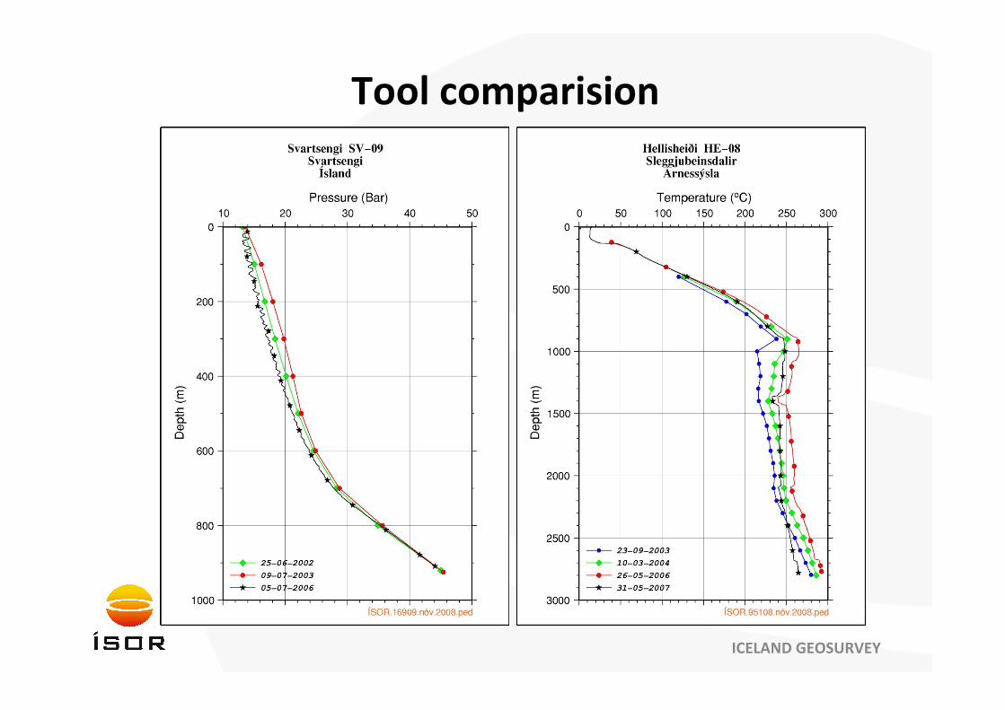
Tool comparision
ICELAND GEOSURVEY

ICELAND GEOSURVEY
Reykjanes peninsula
ICELAND GEOSURVEY
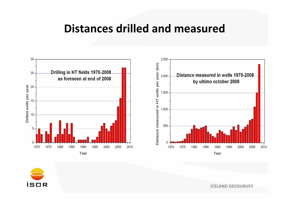
Distances drilled and measured
ICELAND GEOSURVEY
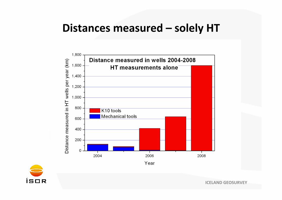
Distances measured – solely HT

ICELAND GEOSURVEY
Safety and planning ahead
• Safety• Success criteria
• Maintainance
• Conditions, weather ‐ wellhead
• Contingency plans• Planning ahead
• Malfunction, fishing
• Customer contact• Contact with supplier / client
• Enhancing performance and reliability

ICELAND GEOSURVEY
Conclusions• Choosing the right tool for the application
• Electronic superior
• Saves time and money
• Mechanical still necessary though
• Good communication• Always room for improvement
• Open dialogue and candid feedback
• Pushing tool limits to improve end‐product
• The criteria of success• Safety – a stand‐alone factor of success
• Contingency plans
• Customer contact – early abroad

ICELAND GEOSURVEY
Well HN-05
Takk fyrir !