handouts - north houston highway improvement project section 4 handouts.pdf · pick up handouts...
TRANSCRIPT

Handouts

Agenda
North Houston Highway Improvement Project
Agency Scoping Meetings, November 14, 2011
Thank you for attending this agency scoping meeting for the North Houston Highway Improvement Project (NHHIP). The Federal Highway Administration (FHWA), in cooperation with the Texas Department of Transportation (TxDOT), has initiated the Environmental Impact Statement (EIS) process for the project. This meeting is the first in a series of agency coordination meetings that will be held throughout the project.
1. Welcome and Introductions 2. Project Background – see Public Scoping Meeting handout
a. NHHIP project location map (Page 1) b. Project Description (Page 2) c. North-Hardy Corridor study history (Page 2)
3. Scoping Meeting Schedule - agency and public meetings 4. Scoping Meeting Presentation 5. Review of Scoping Meeting Exhibits – see Exhibit packet and 2 display exhibits
a. Environmental: What is an EIS?, EIS Process and Timeline, Agencies and Their Roles, Environmental Considerations During Transportation Planning, Environmental Constraints Map (display)
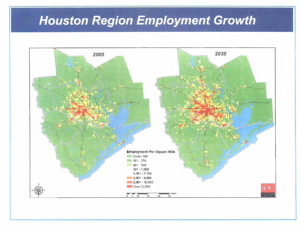
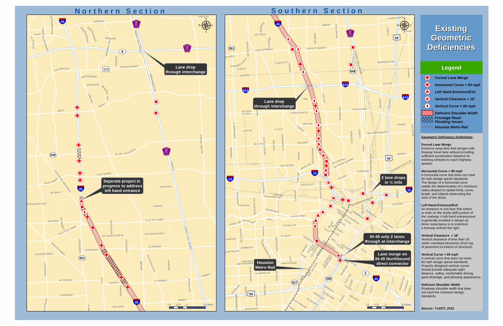
b. Need and Purpose: Houston Region Population Growth, Houston Region Employment Growth, Hurricane Evacuation, Existing and Future Daily Traffic Volumes, Level of Service (LOS), Existing Rush Hour LOS, Existing Geometric Deficiencies, High Crash Locations, Project Area Map (display)
6. Draft Documents for Review a. Need and Purpose – identifies and assesses highway transportation needs in the
project area to help identify what action is being pursued. The draft statement demonstrates problems that already exist or will exist if a project is not implemented.
b. Agency Coordination and Public Involvement Plan – establishes a plan for agency and public participation in the environmental review process
7. Agency Coordination & Agency Roles and Responsibilities 8. Open Discussion 9. Next Steps

WELCOME TO THE MEETING!Please Sign In
Pick Up Handouts
View Presentation
View Exhibits
Ask Questions
Share Your Thoughts
Leave Your Comments


Project T eam
Lead Federal Agency Joint Lead Agency
Environment al Design Engineering
Public Involvement Archeological Resources Traffic Engineeering
Biological ResourcesHistorical ResourcesEIS Support


ENVIRONMENTAL IMPACT STATEMENT (EIS) PROCESS AND TIMELINE


I
Houston Region Population Growth
1990
. F c· I ~ -..,
' (.'
Po, utWofl , 2010 \
<$l
) 1 · -':";
:!: 1 tit,]
~1· · ..l);'A.
.•Ci)j - 1 .0(..1
tml ·l,t\n
U )I· "'OO'. _. XO
2010
\ ,,-, ~,-~
• I
\, I "
('''--- 1
,I, ~.....- -
<:,' !
l., I
"\,
'i to.
!
@,
2005
.'
..
\-;. POJluinUon Per SqUDrc L lie .,
Urnu'/" L 20 · n;u tnt . ' S)
~I f · f:m
~)J I ,
' , n ~ I , 2, 'iIJ~
0< ~'1' S 000 OW,,s.nr-Al -
2035
,-, "
\ 'l.,' , );'
'r
, , , ~
\. \ \-
)-. -
"
o8 0 0 8 r:i
.


High CrashHigh CrashLocationsLocations
Legend:
Figure xxFigure xx
WW
WW
W
WW
WW
W
W
WW
WW
WW
W
WW
WW
WW
WW
WW
WW
W
W
WW
W
§̈¦45
ALDINE BENDER
HA
RD
Y T
OLL
VETERAN
S MEM
OR
IAL
GULF BANK
N S
HE
PH
ER
D
525
315,000(435,000)
38%52,200
(89,000)70%
312,000(451,200)
45%
303,000(416,900)
38%
§̈¦45
UV261
UV8
UV249
HA
RD
Y E
HA
RD
Y W
AL
DIN
E W
FIE
LD
AIR
LIN
E
YA
LE
BA
UM
AN
E PARKER
BERRY
WH
EA
TL
EY
E LITTLE YORK
FULTO
N
GREENS
WEST
NO
RD
LIN
G
E TIDWELL
DE
PR
IES
T
BENMAR
Gears
VICTORY
CANINO
IRV
ING
TO
N
IMP
ER
IAL
VA
L
PINEMONT
TIDWELL
MONTGOM
ERY
W TIDWELL
W LITTLE YORK
RITTENHOUSE E
NO
RT
HL
INE
DE WALT
VICTORIA
WE
RN
ER
GOODSON
W PARKER
SP
EN
CE
N
ORTH
CH
AS
E
WILBURFORCE
GR
EEN
SP
OIN
T
MITCHELL
IMPERAIL V
AL
EL
LA
BLV
DGREEN S PK W
Y
NO
RT
HB
RO
UG
H
BUCKBOARD
Hardy E
SU
NN
YW
OO
D
GREENS
HA
RD
Y W
CANINO
AIR
LINE
GREENS
TIDWELL
W
WW
WW
WW
WW
WW
W
WW
WW
W
WW
W
WW
W
WWWWW
W
WW
WW
W
WW
WW
W
W
§̈¦45
§̈¦610
§̈¦10§̈¦10
§̈¦45
£¤59
£¤59
§̈¦10
§̈¦45
UV288
UV527
317,000(410,900)
30%
61,000(79,000)
30%
272,000(354,100)
30%
240,000(315,500)
31%
336,500(472,800)
41%124,000
(193,200)56%
206,000(318,100)
54%
291,200(377,200)
30%
262,000(342,000)
31%
195,800(258,300)
32%
--(44,600)
§̈¦610§̈¦610
£¤59
YA
LE
N M
AIN
POLK
JEN
SO
N
FU
LTO
N
ELGIN
FAN
NIN
MA
IN
AIR
LIN
E
HIR
SC
H
MIL
AM
BERRY
HA
RD
Y
MO
NT
RO
SE
LOC
KW
OO
D
TRAV
IS
SMIT
H
CANAL
LEELAND
DO
WLI
NG
KELLEY
CAVALCADE
AU
STI
N
LYONS
PEASE
CENTER
SC
OT
T
SA
N J
AC
INTO
WA
UG
H
OX
FO
RD
LA B
RA
NC
H
LOU
ISIA
NA
TEXAS
DU
NL
AV
Y
HA
RD
Y W
CU
LLE
N
GRAY
MEMORIAL
W DALLAS
ALABAMA
MC GOWEN
CRANE
W GRAY
QUITMAN
CROSSTIMBER E
CLEBURNE
RUSK
GR
EG
G
CLINTON
Allen
LIBERTY
CA
RO
LIN
E
BENNINGTON
CLAY
LINK
CU
RR
Y
WHITEOAK
CO
CH
RA
N
BELL
HARRISBURG
E 14THCOLLINGSWORTH
LAMAR
PATTON
W 11TH
EN
NIS
NAVIGATION
DU
MB
LE
FRANKLIN
MA
ND
EL
L
IRV
ING
TO
N
ST
UD
EW
OO
DCalhoun St
WASHINGTON
WEAVER
HOLMAN
HE
IGH
TS
BLV
D
WALKER
WHEELER
HO
US
TO
N A
VE
BLODGETT
WO
OD
HE
AD
RICHMOND
CAPITOL
ALM
ED
A
W 20TH
MIL
BY
BA
GB
Y
PRAIRE
ALABAMA W
SA
MP
SO
N
EL
YS
IAN
DALLAS
YOR
K N
BINZ
VICTORIA
WESTHEIMER
Wa
tson
CONGRESS
NE
W Y
OR
K
WA
CO
ST
TELE
PH
ON
E
CR
AWFO
RD
BA
UM
AN
TUAM
MC
KE
E
Fairview
SA
WY
ER
CROSSTIMBER
BR
OY
LE
S
JEFFERSON
BISSONNET
PECORE
YO
AK
UM
MC KINNEY
ALLEN PKW
SUNSET
SOUTHMORE
ER
NE
ST
INE
MARKET
Lock
woo
d
CAVALCADE W
FAIRVIEW
Gray
DENMARK
TAF
T
BE
AU
CH
AM
P
HE
IGH
TS
RUNNELS
DIS
MU
KE
HAWTHORNE
LAWNDALE
N M
ILB
Y
Preston
WA
CO
AD
AM
S
FEAGAN
STOKES
W 19TH
SC
HW
EK
HA
RO
T
CO
MM
ON
WE
ALTH
Navigation
14TH W
BRO
ADM
OO
R
TIE
RW
ES
TE
R
TAY
LOR
HERMANN
BOUNDARY
HIR
SC
H
IRV
ING
TO
N
CLAY
PRAIRE
OX
FO
RD
CROSSTIMBER
IRV
ING
TO
N
SA
MP
SO
N
BAG
BY
LOC
KW
OO
D
OX
FO
RD
JEFFERSON
N o r t h e r n S e c t i o nN o r t h e r n S e c t i o n S o u t h e r n S e c t i o nS o u t h e r n S e c t i o n
0.5 0 0.50.25 Miles 0.5 0 0.50.25 Miles
Legend
µ µ
Existing (2009)Existing (2009)andand
Future (2035)Future (2035)Daily TrafficDaily Traffic
VolumesVolumes
Note: Traffic volumes includeMainlanes and Frontage Roadvolumes. Does not include HOVlane volume.
xx,xxx 2009 Daily Traffic Volume
(xx,xxx) 2035 Daily Traffic Volume
xx% PercentIncrease
Existing Number of Lanes4 Lanes6 Lanes8 Lanes10 Lanes
HOVW
Future HardyDowntownConnector(by others)
Source: TxDOT; H-GAC; HCTRA, 2011

LOS A LOS B
LOS C LOS D
LOS E LOS F
Level of Service

High CrashHigh CrashLocationsLocations
Legend:
Figure xxFigure xx
§̈¦45
ALDINE BENDER
HA
RD
Y T
OLL
VETERAN
S MEM
OR
IAL
GULF BANK
N S
HE
PH
ER
D
525
§̈¦45
UV261
UV8
UV249
HA
RD
Y E
HA
RD
Y W
AL
DIN
E W
FIE
LD
AIR
LIN
E
YA
LE
BA
UM
AN
E PARKER
BERRY
WH
EA
TL
EY
E LITTLE YORK
FULTO
N
GREENS
WEST
NO
RD
LIN
G
E TIDWELL
DE
PR
IES
T
BENMAR
Gears
VICTORY
CANINO
IRV
ING
TO
N
IMP
ER
IAL
VA
L
PINEMONT
TIDWELL
MONTGOM
ERY
W TIDWELL
W LITTLE YORK
RITTENHOUSE E
NO
RT
HL
INE
DE WALT
VICTORIA
WE
RN
ER
GOODSON
W PARKER
SP
EN
CE
N
ORTH
CH
AS
E
WILBURFORCE
GR
EEN
SP
OIN
T
MITCHELL
IMPERAIL V
AL
EL
LA
BLV
DGREEN S PK W
Y
NO
RT
HB
RO
UG
H
BUCKBOARD
Hardy E
SU
NN
YW
OO
D
GREENS
HA
RD
Y W
CANINO
AIR
LINE
GREENS
TIDWELL
§̈¦45
§̈¦610
§̈¦10§̈¦10
§̈¦45
£¤59
£¤59
§̈¦10
§̈¦45
UV288
UV527
§̈¦610§̈¦610
£¤59
YA
LE
N M
AIN
POLK
JEN
SO
N
FU
LTO
N
ELGIN
FAN
NIN
MA
IN
AIR
LIN
E
HIR
SC
H
MIL
AM
BERRY
HA
RD
Y
MO
NT
RO
SE
LOC
KW
OO
D
TRAV
IS
SMIT
H
CANAL
LEELAND
DO
WLI
NG
KELLEY
CAVALCADE
AU
STI
N
LYONS
PEASE
CENTER
SC
OT
T
SA
N J
AC
INTO
WA
UG
H
OX
FO
RD
LA B
RA
NC
H
LOU
ISIA
NA
TEXAS
DU
NL
AV
Y
HA
RD
Y W
CU
LLE
N
GRAY
MEMORIAL
W DALLAS
ALABAMA
MC GOWEN
CRANE
W GRAY
QUITMAN
CROSSTIMBER E
CLEBURNE
RUSK
GR
EG
G
CLINTON
Allen
LIBERTY
CA
RO
LIN
E
BENNINGTON
CLAY
LINK
CU
RR
Y
WHITEOAK
CO
CH
RA
N
BELL
HARRISBURG
E 14TH
COLLINGSWORTH
LAMAR
PATTON
W 11TH
EN
NIS
NAVIGATION
DU
MB
LE
FRANKLIN
MA
ND
EL
L
IRV
ING
TO
N
ST
UD
EW
OO
DCalhoun St
WASHINGTON
WEAVER
HOLMAN
HE
IGH
TS
BLV
D
WALKER
WHEELER
HO
US
TO
N A
VE
WEBSTER
BLODGETT
WO
OD
HE
AD
RICHMOND
CAPITOL
ALM
ED
A
W 20TH
MIL
BY
BA
GB
Y
PRAIRE
ALABAMA W
SA
MP
SO
N
ELY
SIA
N
BR
AZO
S
YOR
K N
HOGAN
BINZ
VICTORIA
WESTHEIMER
Wa
tson
CONGRESS
NE
W Y
OR
K
WA
CO
ST
TELE
PH
ON
E
CR
AWFO
RD
BA
UM
AN
S JE
NS
ON
TUAM
PRESTON
MC
KE
E
Fairview
SA
WY
ER
LORRAINE
LIV
E O
AK
CROSSTIMBER
BR
OY
LE
S
JEFFERSON
BISSONNET
PECORE
YO
AK
UM
MC KINNEY
ALLEN PKW
SUNSET
E 40TH 1/2
SOUTHMORE
ER
NE
ST
INE
MARKET
Lock
woo
d
CAVALCADE W
FAIRVIEW
Gray
DENMARK
TAF
T
CROCKETT
BE
AU
CH
AM
P
HE
IGH
TS
RUNNELS
DIS
MU
KE
HAWTHORNE
LAWNDALE
N M
ILB
Y
Preston
WA
CO
AD
AM
S
FEAGAN
W. Capitol
STOKES
W 19TH
SC
HW
EK
HA
RO
T
CO
MM
ON
WE
ALTH
Navigation
SA
UE
R
14TH W
BRO
ADM
OO
R
TIE
RW
ES
TE
R
TAY
LOR
HERMANN
BOUNDARY
IRV
ING
TO
N
HIR
SC
H
STOKES
PRAIRE
CLAY
SA
MP
SO
N
IRV
ING
TO
N
CROSSTIMBER
OX
FO
RD
JEFFERSON
HOLMAN
BA
GB
Y
LOC
KW
OO
D
OX
FO
RD
N o r t h e r n S e c t i o nN o r t h e r n S e c t i o n S o u t h e r n S e c t i o nS o u t h e r n S e c t i o n
0.5 0 0.50.25 Miles 0.5 0 0.50.25 Miles
ExistingExistingRush HourRush Hour
Level Of ServiceLevel Of Service
Legend
Source: Houston TranStar, 2011 Field Investigation, 2011
Existing Level of ServiceA/B/C (> 40 mph)D (40 - 30 mph)E (30 - 20 mph)F (< 20 mph)
µ µ
!(̧
!(X
!(®!(X
!(®
!(®!(G
!(G
!(G
!(G
!(G
!(G
!(G
!(G
!(G
!(G
!(G
!(G
N. S
HE
PH
ER
D
FULTO
N
EL
LA
UN
ION
PA
CIF
IC R
R
Lane dropthrough interchange
Seperate project in progress to addressleft hand entrance
ALDINE BENDER
SH
EP
HE
RD
§̈¦45
UV249
UV8
UV261
WX525
ELLA
BLV
D
E LITTLE YORK
GREE
NSP
OI N
T
VICTORY
Hard
y E
HA
RD
Y T
OL
L RO
AD
BERRY
AIR
LIN
E
MITCHELL
BUCKBOARD
SP
EN
CE
FERGUSON WAY
WEST
HA
RD
Y T
OLL
RO
AD
WH
EA
TLE
Y
TIDWELL
NO
RT
HB
RO
UG
H
IMPERA
IL V
AL
W PARKER
GOODSON
GR
EE
NS
CR
OS
SIN
G
GREENS
E PARKER
WE
RN
ER
VICTORIA
DE WALT
RITTENHOUSE W
WILBURFORCE
Gears
NO
RT
HLI
NE
TIDWELL
AIR
LINE
CANINO
BENMAR
RITTENHOUSE E
W TIDWELL
PINEMONT
GREENS
E TIDWELL
NO
RD
LIN
G
MONTG
OMERY
BA
UM
AN
ALD
INE
WF
IEL
D
IMP
ER
IAL
VA
L
EL
LA B
LVD
NORTHC
HA
SE
IRV
I NG
TO
N
YA
LE
FULTO
N
DE
PR
IES
T
W LITTLE YORK
GULF BANK
VE
TER
AN
S M
EM
OR
IAL
§̈¦45
WEST
FALLBROOK
§̈¦45
GULF BANK
W MT HO U STON
!(̧!(̧!(̧
!(X
!(® !(X
!(X
!(X
!(®
!(G
!(G
!(®
!(®
!(®
!(X
!(®
!(̂!(̂
!(̂
!(̂
!(̂
!(̂
!(̂
!(̂
!(G!(®!(® !(®
!(®
!(®
!(X
!(®
!(®
!(G
!(G
!(G
!(G
!(GWHITE OAK
QUITMAN
HA
RD
Y
SOUTHERN PACIFIC RR
SOUTHERN PACIFIC RR
SO
UT
HE
RN
PA
CIF
IC R
R
UNION PACIFIC RR
2 lane dropsin ¼ mile
IH-45 only 2 lanesthrough at interchange
Lane merge onIH-45 Northbounddirect connectorHouston
Metro Rail
Lane dropthrough interchange
§̈¦610
§̈¦10
§̈¦45
£¤59
UV527
UV548
UV288UV5
UV261
MO
NT
RO
SE
R
UNNELS
FAN
NIN
LORRAINE
RUSK
GR
EE
NB
RIA
R
FRANKLINCOMMERCE
WASHINGTONCENTER
HA
RD
Y T
OLL
RO
AD
S JE
NS
ON
MC
KE
E
14TH W
ELGIN
MA
IN
PRESTON
W DALLAS
W 11TH
WEBSTER
DALLAS
W 20THW 19TH
BR
AZO
S LEELAND
BINZ
WHEELER
FEAGAN
GR
EG
G
WEAV ER
SOUTHMORE
FARN
H
AM
WA
UG
H
W 38TH
W 43RD
POLK
MC
DU
FF
IE
SA
UE
R
W 34TH
LINK
TAY
LO
R
PRAIRE
ALABAMA
SH
EP
HE
RD
QUITMAN
TEXAS
BOUNDARY
LA B
RA
NC
H
CR
AWFO
RD
Gray
CLEBURNE
TAF
T
AIR
LINE
BLU
EG
RA
SS
Navigation
INWOOD
SAN FELIPEW
OO
DH
EA
D
HA
ZA
RD
CROSSTIMBER E
CLAY
DU
NL
AU
Y
BLODGETT
BR
OY
LES
BISSONNET
ELY
SIA
N
LAURA KOPPE
ALLEN P K Y
OX
FO
RD
YA
LE
MEMORIAL
HE
IGH
TS
KELLEY
JAC
KS
ON
HIL
L
VERMONT
MA
ND
ELL
YO
RK
N
BENNINGTON
WE
RN
ER
TUAM
PEASE
KIRBY DRCANAL
DU
MB
LE
Lock
wo
od
PATTON
CROCKETT
HAWTHORNE
CO
MM
ON
WE
ALTH
E 40TH 1/2
PECORE
CU
LLE
N
YO
AK
UM
CRANE
CAVALCADE
BE
AU
CH
AM
P
COLLINGSWORTH
LIBERTY
ER
NE
ST
INE
SA
MP
SO
N
EN
NIS
HOGAN
LIV
E O
AK
BA
GB
Y
SM
ITH
BELL
Allen
BERRY
CLINTON
ALLEN PKW
MC KINNEY
IRV
ING
TO
N
CAVALCADE W
BA
UM
AN
JEFFERSON
FAIRVIEW
FU
LTO
N
DO
WLI
NG
VICTORIA
E 14TH
HOLMAN
SA
N J
AC
INTO
CU
RR
Y
Calhoun St
IRV
ING
TO
N
CROSSTIMBER
OX
FO
RD
HE
IGH
TS
BLV
D
W GRAY
WHITEOAK
ALABAMA W
WESTHEIMER
MIL
AM
SC
OT
T
CONGRESS
LOU
ISIA
NA
CO
CH
RA
N
ST
UD
EW
OO
D
NE
CH
ES
GARDEN OAKS
Wat
son
HIR
SC
H
HO
US
TO
N A
VE
SA
WY
ER
JEN
SO
N
DU
RH
AM
TRAV
IS
N M
AIN
N MAIN
SH
EP
HE
RD
N
HA
RD
Y
§̈¦610
§̈¦610
£¤59
§̈¦45
§̈¦10
§̈¦10
£¤59
µN o r t h e r n S e c t i o nN o r t h e r n S e c t i o n S o u t h e r n S e c t i o nS o u t h e r n S e c t i o n
0.5 0 0.50.25 Miles
µ
0.5 0 0.50.25 Miles
ExistingExistingGeometricGeometric
DeficienciesDeficienciesLegend
Source: TxDOT, 2011
!(G Forced Lane Merge!(® Horizontal Curve < 60 mph!(̧ Left Hand Entrance/Exit!(̂ Vertical Clearance < 16'!(X Vertical Curve < 60 mph
Deficient Shoulder Width
Houston Metro Rail
Frontage RoadFlooding Issues
Geometric Deficiency Definitions:Forced Lane MergeEntrance ramp lane that merges withfreeway travel lane without providingsufficient acceleration distance forentering vehicles to reach highwayspeeds.
Horizontal Curve < 60 mphA horizontal curve that does not meet60 mph design speed standards. The design of a horizontal curveentails the determination of a minimumradius (based on speed limit), curve, length, and objects obstructing theview of the driver.
Left Hand Entrance/ExitAn entrance or exit lane that entersor exits on the inside (left) portion ofthe roadway. A left hand entrance/exitis generally avoided in design asdriver expectancy is to enter/exita freeway to/from the right.
Vertical Clearance < 16'Vertical clearance of less than 16' under overhead structures (from top of pavement to bottom of structure).
Vertical Curve < 60 mphA vertical curve that does not meet 60 mph design speed standards. Properly designed vertical curves should provide adequate sight distance, safety, comfortable driving,good drainage, and pleasing appearance.
Deficient Shoulder WidthRoadway shoulder width that doesnot meet the minimum designstandards.

High CrashHigh CrashLocationsLocations
Legend:
Figure xxFigure xx
!
!
!
!
!
!
!!
!
!
!!!!!
!!!!
!
!
!
!
!
!
!
!!!
!
!!!
!!!
¢¢
¢¢
¢¢
¢¢
¢
¢¢¢
¢¢
¢
¢
¢¢
¢¢
¢
¢
¢¢¢
¢
§̈¦45
ALDINE BENDER
HA
RD
Y T
OLL
VETERAN
S MEM
OR
IAL
GULF BANK
N S
HE
PH
ER
D
525
§̈¦45
UV261
UV8
UV249
HA
RD
Y E
HA
RD
Y W
AL
DIN
E W
FIE
LD
AIR
LIN
E
YA
LE
BA
UM
AN
E PARKER
BERRY
WH
EA
TL
EY
E LITTLE YORK
FULTO
N
GREENS
WEST
NO
RD
LIN
G
E TIDWELL
DE
PR
IES
T
BENMAR
Gears
VICTORY
CANINO
IRV
ING
TO
N
IMP
ER
IAL
VA
L
PINEMONT
TIDWELL
MONTGOM
ERY
W TIDWELL
W LITTLE YORK
RITTENHOUSE E
NO
RT
HL
INE
DE WALT
VICTORIA
WE
RN
ER
GOODSON
W PARKER
SP
EN
CE
N
ORTH
CH
AS
E
WILBURFORCE
GR
EEN
SP
OIN
T
MITCHELL
IMPERAIL V
AL
EL
LA
BLV
DGREEN S PK W
Y
NO
RT
HB
RO
UG
H
BUCKBOARD
Hardy E
SU
NN
YW
OO
D
GREENS
HA
RD
Y W
CANINO
AIR
LINE
GREENS
TIDWELL
!
!
!!
!
!
!!
!
!
!
!
!
!
!
!
!
!!!!!!
!!!
!
!
!
!
¢¢
¢
¢
¢
¢
¢
¢¢¢¢¢¢¢¢
¢¢
¢
¢
¢¢
¢¢
¢¢
¢¢
¢
¢¢¢
¢
¢¢
¢¢
¢
§̈¦45
§̈¦610
§̈¦10§̈¦10
§̈¦45
£¤59
£¤59
§̈¦10
§̈¦45
UV288
UV527
§̈¦610§̈¦610
£¤59
YA
LE
N M
AIN
POLK
JEN
SO
N
FU
LTO
N
ELGIN
FAN
NIN
MA
IN
AIR
LIN
E
HIR
SC
H
MIL
AM
BERRY
HA
RD
Y
MO
NT
RO
SE
LOC
KW
OO
D
TRAV
IS
SMIT
H
CANAL
LEELAND
DO
WLI
NG
KELLEY
CAVALCADE
AU
STI
N
LYONS
PEASE
CENTER
SC
OT
T
SA
N J
AC
INTO
WA
UG
H
OX
FO
RD
LA B
RA
NC
H
LOU
ISIA
NA
TEXAS
DU
NL
AV
Y
HA
RD
Y W
CU
LLE
N
GRAY
MEMORIAL
W DALLAS
ALABAMA
MC GOWEN
CRANE
W GRAY
QUITMAN
CROSSTIMBER E
CLEBURNE
RUSK
GR
EG
G
CLINTON
Allen
LIBERTY
CA
RO
LIN
E
BENNINGTON
CLAY
LINK
CU
RR
Y
WHITEOAK
CO
CH
RA
N
BELL
HARRISBURG
E 14TH
COLLINGSWORTH
LAMAR
PATTON
W 11TH
EN
NIS
NAVIGATION
DU
MB
LE
FRANKLIN
MA
ND
EL
L
IRV
ING
TO
N
ST
UD
EW
OO
DCalhoun St
WASHINGTON
WEAVER
HOLMAN
HE
IGH
TS
BLV
D
WALKER
WHEELER
HO
US
TO
N A
VE
WEBSTER
BLODGETT
WO
OD
HE
AD
RICHMOND
CAPITOL
ALM
ED
A
W 20TH
MIL
BY
BA
GB
Y
PRAIRE
ALABAMA W
SA
MP
SO
N
ELY
SIA
N
BR
AZO
S
YOR
K N
HOGAN
BINZ
VICTORIA
WESTHEIMER
Wa
tson
CONGRESS
NE
W Y
OR
K
WA
CO
ST
TELE
PH
ON
E
CR
AWFO
RD
BA
UM
AN
S JE
NS
ON
TUAM
PRESTON
MC
KE
E
Fairview
SA
WY
ER
LORRAINE
LIV
E O
AK
CROSSTIMBER
BR
OY
LE
S
JEFFERSON
BISSONNET
PECORE
YO
AK
UM
MC KINNEY
ALLEN PKW
SUNSET
E 40TH 1/2
SOUTHMORE
ER
NE
ST
INE
MARKET
Lock
woo
d
CAVALCADE W
FAIRVIEW
Gray
DENMARK
TAF
T
CROCKETT
BE
AU
CH
AM
P
HE
IGH
TS
RUNNELS
DIS
MU
KE
HAWTHORNE
LAWNDALE
N M
ILB
Y
Preston
WA
CO
AD
AM
S
FEAGAN
W. Capitol
STOKES
W 19TH
SC
HW
EK
HA
RO
T
CO
MM
ON
WE
ALTH
Navigation
SA
UE
R
14TH W
BRO
ADM
OO
R
TIE
RW
ES
TE
R
TAY
LOR
HERMANN
BOUNDARY
IRV
ING
TO
N
HIR
SC
H
STOKES
PRAIRE
CLAY
SA
MP
SO
N
IRV
ING
TO
N
CROSSTIMBER
OX
FO
RD
JEFFERSON
HOLMAN
BA
GB
Y
LOC
KW
OO
D
OX
FO
RD
N o r t h e r n S e c t i o nN o r t h e r n S e c t i o n S o u t h e r n S e c t i o nS o u t h e r n S e c t i o n
0.5 0 0.50.25 Miles 0.5 0 0.50.25 Miles
Legend
µ µ
Number of Crashes¢ Fatal Crash Location
! 26 - 50
! 51 - 100
! > 100
High CrashHigh CrashLocationsLocations
(2008 - 2011*)(2008 - 2011*)
Note: Includes crashes onMainlanes, Ramps and FrontageRoads. Does not include crasheson HOV system.Source: TxDOT, 2011
Through July 2011**

PUBLIC MEETINGS
Tuesday
November 15, 2011
6:00 p.m. - 8:00 p.m.
OPEN HOUSE
Jefferson Davis High School
1101 Quitman Street
Houston, Texas 77009
Thursday
November 17, 2011
6:00 p.m. - 8:00 p.m.
OPEN HOUSE
Aldine Senior High School
11101 Airline Drive
Houston, Texas 77037
Welcome to the Public Scoping Meeting for the North Houston Highway Improvement Project, lo-cated in Harris County, Texas. This evening’s meeting is an integral part of the Envi-ronmental Impact State-ment (EIS) process and the Preliminary Engineering phase of this project. We greatly appreciate your participation. This handout will detail the many ways you may be involved throughout this project.
Public involvement is a vital part
of the environmental review
process. The purpose of having a
public meeting at this early stage
of the project is to:
1. Initiate your early involve-
ment
2. Provide project history and
background
3. Explain the environmental
review process
4. Present the project timeline
5. Invite review and comment
on two draft documents:
Need and Purpose State-
ment; Agency Coordination
and Public Involvement Plan
6. Gather information about
the project area
7. Discuss project with you
and answer questions
8. Request comments on the
project
9. Encourage your continued
involvement
Welcome to the Meeting!
Welcome to the Meeting
1
Public Meetings 1
Project Location Map
1
Purpose of the Meeting
1
Project Description
2
North-Hardy Corridor Studies History
2
How to Submit Comments
2
Purpose of the Public Scoping Meeting
NORTH HOUSTON HIGHWAY IMPROVEMENT PROJECT
N O V E M B E R 1 5 & 1 7 , 2 0 1 1 P U B L I C S C O P I N G M E E T I N G
T A B L E O F
C O N T E N T S
W H E R E T O G O ?
�� Sign-In
�� Pick-Up
Handouts
�� View Video
�� View Exhibits
�� Ask Questions
�� Share your Thoughts
�� Leave your Comments
P A G E
Project website: www.IH45northandmore.com
Page 1

DON’T
FORGET!
We want your
input on :
1. Need and
Purpose
Statement
2. Agency
Coordination
and Public
North-Hardy Corridor Studies History
How to Submit Comments by December 5, 2011
Project Description
Transportation needs and alternatives to address those needs in the North-Hardy Corridor were documented in three reports listed below. The studies evaluated transit and highway improvement alternatives for a corridor from downtown Houston to 30 miles north, principally in the area between IH 45 and the Hardy Toll Road, and including Bush Intercontinental Airport (IAH) and segments of IH 45 and US 59 south of downtown. 2003 North-Hardy Corridor Alternatives Analysis Report Examined transit and highway alternatives; recommended that transit alternatives be examined prior to detailed evaluation of highway alternatives 2004 North-Hardy Corridor Planning Studies, Alternatives Analysis Report (Transit Component) Findings used to develop a regional Transit System Plan that combines an aggressive bus service program with Advanced High Capacity Transit (light rail) 2005 North-Hardy Planning Studies, Alternatives Analysis Report (Highway Component) The Recommended Highway Alternative from downtown Houston to Beltway 8 North is to add four managed lanes to the IH 45/Hardy Toll Road corridor
�� Mail comments to:
Director of Project Development Texas Department of Transportation P.O. Box 1386 Houston, TX 77251
There are several con-venient ways to submit your comments about the project: �� Use the
comment box at this meeting to submit com-ments
�� Email comments to: [email protected] �� Go to the project website:
www.IH45northandmore.com and click on the “Comments/Contact Us” tab.
Your input is important to us. Please submit your comments!
The proposed project and study limits begin at the interchange of US 59 and SH 288 south of downtown Houston and follow northward along IH 45 to the interchange of IH 45 and Beltway 8 North, a distance of approximately 16 miles. The proposed project area also includes portions of IH 10, IH 610, and US 59 near downtown Houston; and the Hardy Toll Road corridor from downtown to Beltway 8 North. Projected increases in population and employment in the Houston metropolitan area will contribute to additional traffic congestion on IH 45, which is currently classified as serious to severe. The proposed project is needed to address the congestion and to accommodate existing and anticipated future traffic. Additionally, the project is needed to bring the roadway up to current design standards, which would improve safety and provide for more efficient movement of people and goods. Improved efficiency is also needed to aid in evacua-tion events. The purpose of the proposed North Houston Highway Improvement Project is to create additional roadway capacity to manage congestion, enhance safety, and to improve mobility and operational efficiency. The costs and sources of funding for future project implementation have not been determined. A reasonable range of alternatives will be considered to satisfy the identified need for and purpose of the project. The alternatives will include the no-build alternative as well as managed lane/tolling alternatives. The proposed project will be developed in compliance with Section 6002 of the Safe, Accountable, Flexible, Efficient Transportation Equity Act: A Legacy for Users (SAFETEA–LU) and the National Environmental Policy Act (NEPA).
N O R T H H O U S T O N H I G H W A Y I M P R O V E M E N T P R O J E C T
Project website: www.IH45northandmore.com
Page 2
All information
presented at
tonight’s meeting
may be viewed
on the project website.
BOTH DRAFT
DOCUMENTS ARE
AVAILABLE AT THIS
MEETING AND
ON THE
PROJECT WEBSITE

Check the appropriate answer:
1. How closely have you followed news about plans for the North Houston highway improvements?
Very closely ___ Somewhat closely ___ Not very closely ___ Not at all ___
2. Overall, do you support or oppose the idea to improve highway transportation in the North Houston area?
Support ___ Oppose ___ Don’t know/Not sure ___
Check all that apply:
3. What is the best way to share information with your community about the North Houston Highway Improvement Project?
TV ___ Newspaper ___ Radio ___ Internet/Website ___ Library ___ Email ___
Postal Mail ___ Church/Neighborhood Association ___ Other _____________________
Share your ideas:
4. How do you think our public outreach program may be improved?
__________________________________________________________________________________________________________________________________________________________________________________________________________________________________________
5. What do you believe are the most important needs to be addressed by the proposed project?
__________________________________________________________________________________________________________________________________________________________________________________________________________________________________________
6. What environmental considerations are the most important to you? (For example: air quality, water quality, traffic noise, community resources, floodplains, wetlands, land use including public use)
__________________________________________________________________________________________________________________________________________________________________________________________________________________________________________
NORTH HOUSTON HIGHWAY IMPROVEMENT PROJECT
PUBLIC SCOPING MEETING SURVEY FORM November 15 & 17, 2011
OPTIONAL INFORMATON:
Name:_________________________________________________________________________
Address:_______________________________________________________________________
Phone:_________________________________________________________________________
Email address:___________________________________________________________________

Thank you for attending this evening’s public scoping meeting. If you would like to provide written comments on the project you may use this form (feel free to include additional sheets of paper if necessary). You may also draw on the map provided and complete the survey on the back of this page. Please submit this information in the comment box at this evening’s meeting, or mail it to: Director of Project Development, Texas Department of Transportation, P.O. Box 1386, Houston, TX 77251. You may also Email comments to: [email protected], or go to the project website: www.IH45northandmore.com and click on “Comment/Contact Us” tab. For your comments to be included as part of the official record for this meeting, please email by December 5, 2011, or if mailing, have postmarked by this date. _____________________________________________________________________________________
_____________________________________________________________________________________
_____________________________________________________________________________________
_____________________________________________________________________________________
_____________________________________________________________________________________
_____________________________________________________________________________________
_____________________________________________________________________________________
_____________________________________________________________________________________
_____________________________________________________________________________________
_____________________________________________________________________________________
_____________________________________________________________________________________
_____________________________________________________________________________________
_____________________________________________________________________________________
_____________________________________________________________________________________
_____________________________________________________________________________________
_____________________________________________________________________________________
NORTH HOUSTON HIGHWAY IMPROVEMENT PROJECT PUBLIC SCOPING MEETING COMMENT FORM November 15 & 17, 2011
OPTIONAL INFORMATON:
Name:_________________________________________________________________________
Address:_______________________________________________________________________
Phone:_________________________________________________________________________
Email address:___________________________________________________________________

Ib
K̈%&j(
!"h$
?h
!"̀$
Hardy Toll R
oad
!"h$
Beltway 8 North
Ib
!"̀$
PROJECT LIMIT PROJECT LIMIT
PROJECT LIMIT
PROJECT LIMIT PROJECT LIMIT
LITTLE YORK
TIDWELL
AN
TOIN
E
AIRLIN
E
YALE
LITTLE YORK
43RD
SH
EP
HE
RD
34TH
MES
A
WAY
SID
E
PARKER
HIR
SC
H
BIN
GLE
HO
ME
STEA
D
RICHMOND
RANKIN
11TH
CLINTON
FULTON
FANN
IN
POLK
WESTHEIMER
KIR
BY
VO
SS
ALD
INE
WE
STFIELD
MEMORIAL
SAN FELIPE
WEST
WESTPARK
LAUDER
CAVALCADE
ELGIN
ALDINE BENDER
WIR
TM
C C
AR
TY
ALDINE MAIL
HEMPSTEAD20TH
MARKET
LOC
KW
OO
D
ELY
SIA
N
IRV
ING
TON
CROSSTIMBERS
18TH
DU
RH
AM
NAVIGATION
BISSONNET
MONTGOMERYSC
OTT
T C JE
STER
VETERANS MEM
ORIAL
WASHINGTON
TOMBALL
SPEARS
CH
IMN
EY
RO
CK
HEIG
HTS
WALLISVILLE
MOUNT HOUSTON
CU
LLEN
OLD H
UMBLE
KR
ES
S
SILB
ER
MA
NG
UM
MAI
N
LATH
RO
P
LONG POINT
JOHN
F KENNED
Y
WE
SLAYA
N
COLLINGSWORTH
HO
US
TON
RO
SS
LYN
ENDAHL
BAM
ME
L NO
RTH
HO
US
TON
GULFTON
LAURA KOPPE
PO
ST O
AK
HILLC
RO
FTGELLHORN
PATTON
HAMMERLY
FOU
NTA
IN V
IEW
GRIGGS
HO
US
TON
STU
DE
WO
OD
NEW
CAS
TLE
HIDALGO
BUFFALO
SPEED
WAY
CRAW
FORD
STUEBNER AIRLINE
ATASCOCITA
MACGREGOR
PRAIRIE
KELLEYR
ICE
HA
RD
Y
YALE
RO
SS
LYN
MA
IN
RANKIN
FULT
ON
HIR
SC
H
MOUNT HOUSTON
GREENS
ELLA
0 21
Miles
-
NORTH HOUSTON HIGHWAY IMPROVEMENT PROJECT
November 2011DRAFT
LegendProject Area
Future HardyDowntownConnector(by others)