hamilton economic plan” compromise”: 1791-1794 federalist (hamilton’s) position state’s...
TRANSCRIPT
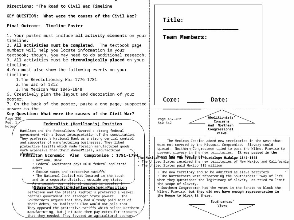
Hamilton Economic Plan” Compromise”: 1791-1794
Federalist (Hamilton’s) Position
State’s Rights (Jefferson’s) Position
Page 330Fed. 1Notes
Directions: “The Road to Civil War Timeline”
KEY QUESTION: What were the causes of the Civil War?
Final Outcome: Timeline Poster.1. Your poster must include all activity elements on your timeline.2. All activities must be completed. The textbook page numbers will help you locate information in your textbook; though, you may need to do additional research.3. All activities must be chronologically placed on your timeline.4.You must also show the following events on your timeline:
1.The Revolutionary War 1776-17812.The War of 18123.The Mexican War 1846-1848
6. Creatively plan the layout and decoration of your poster.7. On the back of the poster, paste a one page, supported answer to the Key Question: What were the causes of the Civil War?
• National Bank• Federal Government pays BOTH federal and state debts• Excise taxes and protective tariffs• The National Capitol was located in the south and in a separate district, outside any state. As a result, our national capital is located in Washington, D.C. (District of Columbia).
Hamilton and the Federalists favored a strong federal government with a loose interpretation of the constitution. They preferred a National Bank as a strong central control and supporter of manufacturing businesses. They liked protective tariffs which made foreign manufactured goods more expensive than their domestically manufactured products.
Jefferson and the State’s Righter’s preferred a weaker central government and stronger State powers. The Southerners argued that they had already paid most of their debts, so Hamilton’s Plan would not help them. They opposed the protective tariffs which helped Northern manufacturing, but just made them pay extra for products that they needed. They favored an agricultural economy.
The Mexican War and The Treaty of Guadalupe Hidalgo 1846-1848• The United States received the new territories of New Mexico and California• The United States paid Mexico $15 million.
Abolitionists’Concerns
And Northern Congressional
Views
Southerners’Views
Page 457-460540-542
• The new territory should be admitted as slave territory.• The Northerners were threatening the Southerners’ “way of life” when they questioned the legitimacy of slavery or tried to limit the scope of slavery.• Southern Congressmen had the votes in the Senate to block the Wlimot Proviso, but they did not have enough representation in the House to block it there.
The Mexican Cession added new territories in the west that were not covered by the Missouri Compromise. Slavery could spread. Northern Congressmen tried to pass the Wlimot Proviso to prevent slavery in the new territories. It was passed in the House but not the Senate.
Title: ______________________
Team Members:
Core: _____ Date: ___________

A)Label the Original 13 Colonies. (Page 9)
B)Color the states that used plantation, cash crop farming (rice, indigo, tobacco, and cotton) GRAY.
C) Color the states that used food crop farming, trade, fishing and small manufacturing BLUE.
The Original 13 ColoniesEconomies
1607 - 1763
Cash Crop Agriculture
Food Crop Farming, Trade, Fishing Manufacturing
Map 1: Chapter 6
The Louisiana Purchase
The Louisiana Purchase: May 1803
Map 3: A) Color the Louisiana Purchase RED. B) Color the Free States BLUE and Slave States GRAY - in 1803.
Election of 1796: Political Parties Form
1821: Free and Slave Soil After The Missouri Compromise
Federalist States
Republican States
Map 4: Label the “FREE SOIL” and “SLAVE SOIL” regions after the Missouri Compromise.
Map 2: FrontierGazette Activity
A)Color the Federalist States BLUE.
B)Color the Republican States GRAY.

Uncle Tom’s Cabin is Published by Harriet Beecher Stowe - 1852
Abolitionists’Views
Southerners’Views
Harper’s Ferry - October 16, 1859
Northerner’sViews
Southerners’Concerns
Page 557Page 547
Dred Scott Decision 1857
AbolitionistAnd Federalist
Views
SouthernAnd State’s Rights
Views
Pages549-550
The Kansas Nebraska Act - 1854
AbolitionistViews
Southern Slave Holders’
Views
Page 547-549

Union States
Confederate States
Slave States That Stayed With the Union
Map 6: Page 559A) Color the Union States BLUEB) Color the Confederate States GRAYC) Color the Slave States that Stayed with The Union RED
Union and Confederate States

The Stamp Act - 1765
England’sViews
Colonists’Views
Boston Tea Party - December 16, 1773:
England’sViews
Colonists’Views
Page 195Page 192
Shay’s Rebellion -September 1786
Farmers’Problems
New U.S. Government
Actions
Pages258-259
Whiskey Rebellion-1794
WesternFarmer’s
Views
Hamilton andWashington’s
Actions
Page 331

The Great Compromise: July 16, 1787
Northern Position
Southern Position
The Missouri Compromise: 1820
Free State Position
Slave State Position
The Compromise of 1850:
Free State Position
Slave State Position
Page 265
The 3/5ths Compromise: August 1787
Northern Position
Southern Position
Page 265 - 266
Page 542-545
See Index Listing on page 809

Declaration of Independence - July 4, 1776
Declaration of Natural Rights
We hold these truths to be _________ - __________ that all ________ are created ____________ by their Creator with certain unalienable _____________, that among them are _____________, ____________ and the _____________ of __________________. That to secure these ______________, Governments are instituted among Men, deriving their __________ __________ from the ___________ of the Governed.
Page 220
The Kentucky - Virginia Resolutions 1798
In Response to the: _____________ and_______________ Acts passed by the__________ Administration.
State’s have the right to n____________, or cancel, a federal law, if a state determines that the federal government has gone beyond its constitutional powers. This was based on _________’s _____________Theory. It was supported by J_________.
Page
347
The Fugitive Slave Act - 1850
Penalties for Helping Fugitive Slaves
Fine: __________________________
Imprisonment: ___________________
Page 545 As part of the Compromise of 1850 …
The North Carolina Nullification Act - 1833
In Response to the: _____________ Acts passed by Jackson’s Administration which raised t________.
The Union is an agreement between s_______________, or independent states, which have a right to n_______ federal law and s__________ from the Union if their concerns are not addressed. It was supported by C_________.
Page430-431

Eli Whitney’s Cotton Gin - 1794
IMPACT:
Map 5: A) Recreate the legend for the map on page 558 for the map above on your poster. B) Color the Republican states BLUE. C) Color the Southern Democrat states GRAY. D) Color the remaining VOTING states RED.
Election of 1860
The Election of 1860
RepublicanPlatform
Southerners’ViewsAbout
Lincoln
Page 558-560
-
Page 524-525
Popular Vote: 4,689,586
Lincoln
Breckinridge
Bell
Douglas
Electoral Vote:303
Republican
Southern Democrat
Constitutional Union
Northern Democrat
Map 5 Legend: Fill-in the electoral results using the map on page 558.
Follow-up Research: Click on these link to view recent Presidential Election Maps:http://statsinthewild.files.wordpress.com/2012/09/screen-shot-2012-09-18-at-6-46-44-pm.png