ground-truth wetland mitigation assessment
TRANSCRIPT

1
GROUND-TRUTH WETLAND MITIGATION ASSESSMENT
CLEAN WATER ACT SECTION 404
HOUSTON 8-COUNTY METRO REGION
JOHN S. JACOB, MARISSA LLOSA, DANNY WALTON
JUNE 2017
TEXAS COASTAL WATERSHED PROGRAM
TEXAS A&M AGRILIFE EXTENSION SERVICE

2
Contents Permit: SWG-0-19244 (1991) ........................................................................................................................................... 3
Permit: SWG-1995-00406 ................................................................................................................................................. 6
Permit: SWG-1995-01666 ................................................................................................................................................. 9
Permit: SWG-1995-01370 ............................................................................................................................................... 12
Permit: SWG-1998-01289 ............................................................................................................................................... 15
Permit: SWG-1998-01358 ............................................................................................................................................... 20
Permit: SWG-2001-01086 ............................................................................................................................................... 23
Permit: SWG-2002-01358 ............................................................................................................................................... 27
Permit: SWG-2006-00149 ............................................................................................................................................... 29
Permit: SWG-2009-00988 ............................................................................................................................................... 32
Permit: SWG-2009-01124 ............................................................................................................................................... 36
Permit: SWG-2010-00225 ............................................................................................................................................... 39
Permit: SWG-2011-00068 ............................................................................................................................................... 42

3
Permit: SWG-0-19244 (1991) Location: 29⁰40’57.66”N, 95⁰0’44.30”W Mitigation Location: 29 36’11.57”N, 95 2’58.42”W Mitigation Type: Permittee responsible Acres impacted: 0.6 acres Mitigation acres completed: 0.6 acres
PERMIT BACKGROUND: This permit was a standard permit authorizing 7,000 cubic yards of fill material to be
discharged into 0.6 acres of low quality tidal herbaceous wetlands adjacent to Barbours Cut. Impacts are associated
with construction of new process units and utilities at the existing La Porte Tenneco Natural Gas Liquids Plant. The
project will require construction of a wastewater treatment facility, water treatment system, and primary peripheral
roads. To compensate for impacts to 0.6 acres of tidal wetlands, 0.6 acres of fringe herbaceous Spartina alterniflora
tidal wetland will be created along Taylor Bayou at three separate pre-determined sites.
INVESTIGATION RESULTS: An on-site assessment was completed late Summer 2016.
Vegetation Data
Species Status Total Site
Coverage
Spartina alternifolia OBL 58.0%
Schoenoplectus robustus FACW, OBL 7.0%
Spartina patens OBL 3.5%
Iva spp. FACW 1.0%
Typha latifolia OBL 0.5%
Cyperus haspan 0.1%
Pluchea odorata OBL 0.1%
Open Water 24.0%
Water With Floating/Submerged Vegetation 0.0%
Water with Emergent Vegetion 57.6%
Exposed Mineral Soil 0.9%
Exposed Gravel/ Cobble 0.0%
Exposed Rock 0.0%
High Water Depth (in.)
Med. Water Depth (in.)
Low Water Depth (in.)
Vegetative Litter Cover
Vegetative Litter Type
Thatch Depth (in.)
Plot Sample Soil Depth Soil Color Soil Texture
1 0-4” 5Y 3/2 Clay Loam
3-10” 10Y 5/ Mucky Loam
2 0-4” 5Y 3/2 Clay Loam
3-10” 10Y 5/ Mucky Loam

4
The evaluation of the mitigation site showed a successful mitigation completion. The sample sites were all
dominated by facultative wet and obligate wetland vegetation indicative a well-established brackish to tidal
marsh (58% Spartina alterniflora). The soil makeup of the site also indicated wetland conditions. Indicators
were present to show tidal marsh hydrology (standing open water, 24%). This mitigation site appears to
meet the conditions of the original permit.
Typical view of the creation portion of the mitigation site.
AREA 1 IN TAYLOR LAKE BAYOU. The outlined area is about 0.3 acres. It is a fringing area that does not appear
in earlier photographs. This fringing area appears to be most prominent in Area 1

5
The three mitigation areas to be planted as mitigation. All three sites were visited. Site 2 was documented. The erosional scarp mentioned in the permit was present on all three sites. As with Armand Bayou, subsidence in the 1960’s and 70’s drowned existing wetlands. The stabilization of subsidence with the establishment of the Harris-Galveston Subsidence district makes it possible to reestablish wetlands such as these. All indications are that the planting took place as required. The wetlands are still present and functioning well with a mature and healthy stand of Spartina alterniflora. Conclusion: Mitigation was successful.

6
Permit: SWG-1995-00406 Location: 29⁰47’35.92”N, 95⁰41”49.24”W
Mitigation Type: Permittee Responsible
Acres impacted: 5.5
Mitigation acres Required: 12.8
Mitigation Acres completed: None
PERMIT BACKGROUND: The completed residential development project impacted 5.5 acres of isolated jurisdictional
wetlands very near the western edge of the Barker-Cypress Reservoir, on the south side. The permit was initiated in
1995, and the work appears to have been completed by 2002 (per available Google Earth imagery).
As compensatory mitigation, the permit required (1), 2.9 acres enhancement of an on-site historical wetland through
the removal of Chinese Tallow trees and the establishment of native vegetation (presumably emergent herbaceous—
prairie vegetation), and (2), a combination of creation (6.8 acres) and restoration (3.1 acres) of wetlands on a 16-acre
block in the adjacent Addicks Reservoir.
RESULTS OF FIELD INVESTIGATION:
On-Site Mitigation. From the January 2017 Google Earth image, it is clear that the historical enhancement wetland is
still present. Looking at older Google Earth photos this wetland depression was clearly a prairie pothole. The air
photo signature on the 2017 photo is entirely consistent with the signature of Chinese Tallow. GE photos from 1995
forward show no evidence of any vegetation removal. The target wetland has not been filled, but there is no
indication of any kind of easement preserving this site in perpetuity. No real increase in wetland functions and values
was served by this mitigation.
Off-Site mitigation. Air photo interpretation of Google Earth imagery from 1995 (1/1995; 9/2002; 2/04; 5/05; 1/06)
does not reveal any activities consistent with the kind of earth moving that would be required on nearly half of this
16-acre block (see below) for the creation of the stated amount of wetlands. Furthermore, there is no significant
change in in the tonal pattern of the 3-acre wetland that was to be restored in this block, a tonal pattern consistent
with Chinese Tallow since 1989. The last entry in the permit documentation stated that the permit was pending the
permission to complete the mitigation. The permission was perhaps received but there is no evidence in the paper
trail nor on the ground that any of the mitigation activities were ever completed in accordance with the permit. The
site manager for the reservoir was contacted and he verified that there is no record that this portion of the proposed
mitigation was ever completed (phone conversation, October 2016).
Conclusion: No effective mitigation for the wetland loss.

7
Impact site: South of South Park View Drive to the east-west property line, and from Meadow Bend on the west to
Addicks Levee Drive on the east.

8
16-acre mitigation site in the Addicks Reservoir. 1/23/17 Google Earth aerial photo. 3-acre restoration wetland is
dark area just left of center. Scale bar is 500ft.

9
Permit: SWG-1995-01666 Project location: 29 56’02.85”N, 95 32’18.64”W
Mitigation Location: 29 47’35.40”N, 95 52’30.91”W
Mitigation Type: Permittee Responsible
Acres impacted: 4.4
Compensatory Mitigation acres required: 6.4
Avoidance Acres Required: 6.4
Mitigation acres completed: 6.4 avoidance; 6.4 Mitigation (likely poor quality) PERMIT BACKGROUND: This permit was an after-the-fact (ATF) Nationwide Permit (NWP) 26: Headwaters and Isolated
Waters Discharges. SWG-1995-01666 authorized retention of fill in 1.4 acres of isolated wetlands for development of
an 18-hole golf course in Harris County, Texas. Additionally, the permit authorized additional fill in 3 acres of on-site
isolated wetlands for the golf course construction. 6.4 acres of on-site isolated wetlands were to be avoided by
permit activities. As compensation for impacts to jurisdictional waters, the permittee would create 6.4 acres of
palustrine emergent wetlands and preserve 3.6 acres of upland prairie as a buffer on a 10 acre site 23 miles to the
southwest, as the crow flies. Both the impact site and the mitigation site are within the greater San Jacinto
Watershed (HUC??), but the impact site is in the White Oak Bayou Watershed (HUC??) while the mitigation site is in
the Barker Reservoir Watershed (HUC??).
No special conditions were issued in conjunction with SWG-1995-01666. The only requirements listed in the permit
were that permitted work was to be completed within the 1 year verification period for the activity and that the
mitigation was to be completed in accordance with approved plans. Permit issuance for SWG-1995-01666 issuance
was dated 12/09/1996.
RESULTS OF FIELD INVESTIGATIONS:
Avoidance: Recent aerial photography from Google Earth (GE) (2017) confirms the presence of the remnants of
historical wetlands in the golf course, more or less consistent with the 6.4-acre requirement. The largest of these
wetlands appear to be dominated by invasive Chinese Tallow trees. No enhancement was required in the permit.
Wetlands preserved in an isolated condition within a highly-manicured golf course have a limited amount of
ecological services that can be provided. Dossier analysis by R. Davanon in 2015 (on file with the Texas Coastal
Watershed Program) revealed that some “avoided” wetlands were later filled.
Off-Site Mitigation. For permit SWG-1995-01666, the site owner of the mitigation site was contacted on multiple
occasions but did not return calls. Permission to access and assess was therefore not obtained. Based on the aerial
photography and the assessment completed during a previous project phase, it is obvious that wetlands were
created on the mitigation site, between 1995 and 2002, based on available GE imagery. While we could not directly
assess the quality of the wetland mitigation without on-the-ground inspection, we could make some observations
based on the aerial photography. It would appear that the acreage requirement has been met, and that these
created wetlands retain some wetland features and functionality. However, most of the excavated areas at the
creation site show an open water aerial photo signature in nearly every photo available from Google Earth, including
relatively drier times of the year (e.g., October). An open-water pond is not the same thing as a wetland. It is quite
clear that most of the so-called wetlands at the mitigation site do not have mature stands of wetland vegetation.
Conclusion: Almost no significant wetland functionality mitigated with this project.

10
Impact Site. Green arrows point to some of the “preservation wetlands” required by the permit.

11
Mitigation site (green outline), Google Earth, 1/2017. Note open water signature of the putative wetlands.

12
Permit: SWG-1995-01370 Location: 29⁰38’25.55”N, 95⁰09’58.19”W
Mitigation Location: 29 38’42.63”N, 95 06’32.82”W
Mitigation Type: Permittee Responsible
Acres impacted: 2.7 acres
Mitigation acres Required: 5.4 acres
Mitigation acres completed: 5.4 acres (quality dubious but unknown)
PERMIT BACKGROUND: The permit impacted 1.6489 acres of isolated wetlands (described as coastal prairie wetlands) in
Harris County, Texas to complete a road extension (Crenshaw Road, Pasadena, Texas). The permit was issued in
October 1995 with expiration in October 1997. The City of Pasadena executed a resolution on August 22, 1995,
stating that the impacted wetlands would be compensated with a 5.4-acre mitigation site of similar wetland types by
either creation, restoration or enhancement methods. The mitigation would be completed at one of two sites and
the final location of the actual mitigation site would be determined 90 days after the date of the resolution and
before October 1996. Additionally, the city agreed to provide appropriate management (i.e. Chinese Tallow and
other exotic vegetation removal by mowing, herbicide application or controlled burns) of the mitigation site for
fifteen (15) years after the date of the resolution (up to August 2010) and preserve the mitigation site in perpetuity
with a conservation easement. The final location selected was city-owned property south of Fairmont Parkway and
east of Willow Springs Bayou. The actual site was to be just to the east of a newly-constructed berm on the eastern
side of Willow Springs Bayou, the berm extending 200 meters north of the CIWA raw water pipeline along Willow
Springs Bayou.
RESULTS OF FIELD INVESTIGATIONS : For permit SWG-1995-01370, the field investigations ended with no resolution as the
permittee did not acknowledge or return phone inquiries regarding the permit. Because this permit is 22 years old,
and the permittee is a municipality, the lack of communication is likely due to new staff who simply are ignorant of
any actions/permits from 1995. The Google Earth imagery (2017) shows work at the impact site has been completed
and no development has occurred at the off-site mitigation location (see images below).
The FOIA file is quite extensive with comments from reviewing agencies, in particular, Texas Parks and Wildlife
Department and U.S. Fish and Wildlife Service, both of whom raise serious objections to the permit and the
mitigation. Both commenters stated the value of the proposed impacted wetlands being “extremely rare and
valuable” and while the proposed road expansion would only directly impact 1.65 acres, it would indirectly destroy
27 acres of associated wetlands and adjacent habitat. From the 2017 Google Imagery, the entire project area is now
developed with the only set-aside area being mowed detention areas.
The mitigation site shows prairie vegetation in the latest available Google Earth (2017) imagery. Per the FOIA record,
the mitigation site was to be set-aside in a conservation easement held by the City of Pasadena in perpetuity. There
is no evidence of the easement on the permit record. A city council resolution was recorded approving the site for
mitigation. It is not clear that a council resolution carries the same force of law as a recorded conservation easement.
The consultant record detailing the mitigation work to be accomplished stated that 5.4 acres of wetlands would be
established/enhanced by the construction of the berm on the east side of Willow Springs Bayou asdescribed above.
It is difficult to establish from the available aerial photography for this time period (1995 and 2002) whether or not
the berm was completed. There does appear to be a v-notch weir in the location described in the mitigation
proposal. But there does not appear to be any enhanced wetland hydrology, as evidenced by a darker tonal pattern
on the aerial photography.

13
CONCLUSION: The area east of the putative berm is still a vegetated undeveloped track. But there is no indication of a
conservation easement on this site, nor is there any indication from aerial photography that increased wetland
functionality occurred at this site. The mitigation thus appears to be a failure. (Interestingly, a larger wetland (.15
acres) just to the east is present with a pronounced wetland signature. This area did not appear in the
documentation for mitigation of this project).
Google Earth aerial of the impacted site, January 2017

14
Google Earth aerial of the mitigation site, January 2017, with relevant features associated with the permit.

15
Permit: SWG-1998-01289 Location: 29⁰14’46.61”N, 94⁰52’21.14”W
Mitigation Type: Permittee Responsible
Acres impacted: 0.73
Mitigation acres Required: 1.43
Mitigation acres completed: 1.43
PERMIT BACKGROUND: The permit requested authorization of fill in 0.73 acres of wetlands for construction of a soccer
field recreation area in Galveston, Galveston County Texas. 0.9 acres of onsite wetlands were avoided and enhanced
as part of the project. To compensate for impacts to wetlands, 1.49 acres of freshwater marsh will be created on
uplands onsite and seeded with seed bank excavated from the filled wetlands. The proposed park is primarily
utilized as a soccer field park with associated parking for visitors. SWG-1998-01289 was approved 02/26/1999 and
expired 12/31/2002. No special conditions are listed for SWG-1998-01289
INVESTIGATION RESULTS: An on-site evaluation of the mitigation was completed in Fall 2016.
Summarized Vegetative Data
Species Status Total Site Coverage
Typha latifolia OBL 47.6%
Cyperus virens FACW 0.02%
Sesbania drummondii FACW 1.7%
Ludwigia decurrens OBL 0.2%
Lemna aequinoctialis OBL 3.3%
Cyperus articulatus OBL 0.6%
Polygonum hydropiperoides OBL 0.3%
Panicum repens FACW (I) 14.3%
Morella cerifera FAC 0.2%
Baccharis halimifolia FAC 0.3%
Lantana urticoides FACU 0.4%
Triadica sebifera FAC (I) 0.0%
Iva frutescens FACW 0.6%
Rubus trivialis FACU 0.3%
Andropogon glomeratus FACW 0.1%
Ipomea wrightii FACW (I) 0.0%
Solidago altissima FACU 1.2%
Pluchea odorata FACW 0.0%
Spartina patens FACW 0.8%
Cyperus esculentus FAC 0.0%
Ambrosia trifida FAC 0.4%
Centella erecta FACW 0.1%
Rumex crispus FAC (I) 0.0%
Cyperus retrorsus FACU 0.0%
Bacopa monnieri OBL 0.3%
Phyla nodiflora FAC 0.4%

16
Borrichia frutescens OBL 14.0%
Paspalum Spp. 3.9%
Open Water 7.2%
Water With Floating/Submerged Vegetation 3.3%
Water with Emergent Vegetation 34.2%
Exposed Mineral Soil 1.3%
Exposed Gravel/ Cobble 11.1%
Exposed Rock 0%
Soil Data
Site 1 to 3
Depth (in) Soil Texture Soil Color
0-3 loam 10YR 3/2
3-10 sandy loam 2.5Y 2/5
Site 5
Depth (in)
Soil Texture Soil Color Description
0-2" organic matter of undecomposed plant stalks/roots
2-6" Loam 2.5Y 3/1
6-14" sandy loam 2.5Y 4/1 common white / depleted zones, about 50% of matrix
Site 6
Depth (in)
Soil Texture Soil Color Description
0-4" silty clay loam 2.5Y 5/1
4-9" clay loam (CL) 2.5Y 5/1 3-5% distinct iron (Fe) channel coatings, few fine Mn nodules
Site 7
Depth (in)
Soil Texture Soil Color Description
0-4 fine sandy loam
10YR 3/2 10% distinct iron pore coating
4-13 loamy sand 10YR 5/2 no redox features

17
Site 8
Depth Soil Texture Soil Color Description
0-10 loamy sand 2.5Y 2/ 10% black stains -Fe/Mn
Site 9
Depth (in) Soil Texture Soil Color Description
0-4 sandy loam
40% 10yr 3/2
Variegated soil dodies present : spoil 60 % 10Y 4/0
4-12 loamy sand 20% 2.5Y 4/2, 60% 10Y 4/
5% Fe/Mn stains, 20% 10YR4/6 bodies and pure coating
Site 11
Depth (in.) Soil Texture Soil Color Description
0-4 loamy sand 2.5Y 4/2 few fine faint redox coatings
4-13 loamy sand 2.5Y 6/2 5% fine and medium redox coatings, faint to distinct
Soils features are consistent with wetland hydrology.
Typical view of the created portion of the wetland.

18
These photos reflect a typical view of the enhancement portion of the wetland.
Aerial of the ballfield site. The main mitigation wetland is in the NW corner of the tract.
The mitigation wetland was completed per the plan. Over half of the vegetation (52%) was obligate wetland species
and up to 83.6% of the coverage was comprised of an obligate/facultative wet mixture of plants. It is important to

19
note that the dominant obligate plant for the majority of the mitigation site was cattail (Typha latifolia). It is clear
that the site only receives fresh water input (rainfall) from the presence of cattail. Due to the extensive presence of
cattail, other wetland vegetation is “crowded out”—a typical succession pattern for cattails in wetlands. Hydrology
and hydrological features were present within the mitigation site for all locations (created and enhanced) (open
water, 7.2%). Additionally, the soil characteristics were consistent with wetland conditions. There was no evidence
of the planted wetland trees described in the mitigation plan. Overall, the created mitigation site is bordered by
soccer fields on one side and open prairie mix on the opposite side (undeveloped land). The enhanced portion of the
mitigation site was surrounded by more open undeveloped land. The site functions as a wetland but the dominance
of cattails suggests a low quality functioning. albeit low quality due to the dominant persistence of cattails.
CONCLUSION: The mitigation is marginally successful. The project site vegetation list was not described in any detail, therefore, we do not know if the original wetland was a cattail marsh or not. However, given that cattail invade freshly exposed soils, it is not unreasonable to say that the site was invaded once the created areas were graded down and topped with the excavated soil.

20
Permit: SWG-1998-01358 Location: 29⁰31’12.35”N, 95⁰09’47.49”W
Mitigation Location: 29⁰35’02.51”N, 95⁰21’17.22”W
Mitigation Type: Mitigation Bank (owned by the permittee)
Acres impacted: 1.4
Mitigation acres required: 2.8
Mitigation acres completed: 2.8 PERMIT BACKGROUND: This permit requested authorization to fill 1.4 acres of isolated wetlands for the construction of a multi-family residential development. At the time of application, proposed mitigation would be located within a 47-acre area under development as a mitigation area. The mitigation included a 2.8-acre area in which 1.4 acres of depressional wetlands would be excavated and created, and 1.4 acres of upland buffer would be preserved. The permittee is Friendswood Development. INVESTIGATION RESULTS: An on-site assessment was completed in winter 2017.
Vegetation Data
Species Indicator
Status Avg. % Cover
Eleocharis quadrangulata OBL 25.2%
Saccharum giganteum FACW 12.0%
Eleocharis montana OBL 10.0%
Eleocharis montevidensis FACW 3.2%
Juncus effusus OBL 3.0%
Ludwigia peploides OBL 2.2%
Proserpinaca palustris OBL 1.6%
Acer rubrum FAC 1.4%
Hydrolea ovata OBL 1.2%
Typha latifolia OBL 1.2%
Triadica sebifera FAC 1.0%
Callitriche heterophylla OBL 0.6%
Eclipta prostrata FACW 0.4%
Rhyncospera corniculata OBL 0.2%
Andropogon virginicus FAC 0.2%
Pluchea odorata FACW 0.2%
Phyla nodiflora FAC 0.2%
Juncus scirpoides FACW 0.2%
Sagittaria spp. 0.0%
Open Water 22.4%
Water With Floating/Submerged Vegetation 6.2%
Water with Emergent Vegetion 53.2%
Exposed Mineral Soil 0.2%

21
Exposed Gravel/ Cobble 0.0%
Exposed Rock 0.0%
High Water Depth (in.)
Med. Water Depth (in.)
Low Water Depth (in.)
Vegetative Litter Cover
Vegetative Litter Type
Thatch Depth (in.)
Soil Data (surface horizons)
Depth Soil Texture Soil Color Description
- clay gleyed
spoil pile, masses, no redox pore coatings or ped coatings
Depth Soil Texture Soil Color Description
- clay gleyed few redox pore coatings, common yellow masses
Depth Soil Texture Soil Color Description
- clay gleyed few faint pore coatings
Depth Soil Texture Soil Color Description
- clay gleyed common medium yellow masses
The mitigation site was a series of created ponds within a larger complex. The excavated areas were
completely dominated by obligate to facultative wet plants (99.8%) and comprised of species typical to
native freshwater prairie wetland systems. Hydrological conditions were present and evident (standing
open water, 22% cover). Wetland soil characteristics were were not pronounced, but the gleyed colors of
the clays are consistent with wetland hydrology, at least at the drier end. \
Conclusion: Overall, the mitigation site functions as a wetland. The mitigation site, however, is quite some
distance from the mitigation site. In addition, the mitigation site is full of wetlands in very close proximity,
reducing their contribution on the landscape considerably.

22
Typical landscape view of the created wetlands, January 2017.
The mitigation site. Created wetlands are separated only by narrow berms. Natural wetlands do not occur
in this pattern anywhere in the study area.

23
Permit: SWG-2001-01086 Location: 29°30'2.15"N, 95° 8'14.58"W
Mitigation Type: Permittee Responsible
Acres impacted: 1.178
Mitigation acres Required: 1.178 —of topsoil replacement
Mitigation acres completed: Topsoil replaced in a 1.6-acre basin. No Wetlands
PERMIT BACKGROUND: The permit application requested authorization to excavate 1.178 acres of adjacent wetlands
for the creation of a detention basin for the future Magnolia Estates Subdivision in League City, Texas. As mitigation,
the permittee was to stockpile the wetland soil and replace the topsoil once construction was complete, and allow
the area to revegetate naturally. The replacement of the top soil was the only special permit condition and in lieu of
mitigation monitoring plans. The permit was issued on September 17, 2001 and set to expire on September 17, 2003
and issued as a Nationwide permit 43.
INVESTIGATION RESULTS: An on-site assessment was completed in August 2016. The mitigation site functions as a
detention pond. There apparently were no requirements on the permittee beyond topsoil replacement. The topsoil
may indeed have been placed on the floor of this basin, but the water depth is clearly too deep to support wetland
vegetation.
Seven plots were randomly selected for analysis outside of the pond.
Soil cores taken from sample plots and analyzed by Dr. John Jacob did not have any indicators of wetland soils. All
soils analyzed from the sides of this pond were spoil or disturbed soils and sediments with no soil horizonation nor
significant topsoils present.
Wetland vegetation was present only on the edge of the pond, consisting mainly of invasive and non-native Bacopa
monnieri (Water hyssop).
In the original permit description, the area was described by the applicant (Dannenbaum Engineering Corporation) as
a man-made stock pond. Review of aerial photographs, however, suggest that the area to be mitigated functioned as
a wetland, and had not been converted to a stock pond prior to the disturbance associated with this permit.
Conclusion: Total failure

24
Summarized Vegetation Data
Plot Species Status Cover Notes on Hydrology Hydrophytic
Indication
1 Stenatophratum secundatum FAC 1 NO
2 Stenatophratum secundatum FAC 0.4 no standing water NO
2 Mimosa microphylla FAC 0.001 moist soil
2 Cynodon dactylon FACU 0.01 On edge of pond
2 Eleocharis montevidensis FACW 0.05
2 Bacopa monnieri OBL 0.3 Yes
2 Ludwigia palustris OBL 0.1
3 Bacopa monnieri OBL 0.55 possible mottling YES
3 Philoxeroides alternanthera OBL 0.45 Standing water
4 Stenatophratum secundatum FAC 1 NO
5 Stenatophratum secundatum FAC 0.9 no hydrology NO
5 Brachiaria platyphylla FAC 0.05
5 Dichondra carolinensis FAC 0.05
6 Stenatophratum secundatum FAC 0.25 moist soil YES
6 Cynodon dactylon FACU 0.05
6 Diodia virginiana FACW 0.1
6 Eleocharis montevidensis FACW 0.001
6 Bacopa monnieri OBL 0.5
7 Brachiaria platyphylla FAC 0.7 NO
7 Cynodon dactylon FACW 0.25
7 Oxalis stricta UPL 0.001
Landscape view of the mitigation site; it is clearly heavily manicured detention area.

25
A typical view of a sample plot showing mowed down vegetation, primarily Bacopa monneri, along the pond edge.

26

27
Permit: SWG-2002-01358 Project Location: 29 08’46.25”N, 95 40’09.99”W
Mitigation Location: 28⁰57’55.55”N, 95⁰36’22.06”W
Mitigation Type: Mitigation Bank
Acres impacted: 0.42 acres to wetlands; 0.15 acres to waters
Mitigation acres/credits Required: 6 acre-credits
Mitigation acres completed: unverified
PERMIT BACKGROUND: The applicant proposed improvements along SH 35 for 8.4 miles from the intersection of SH 36
and FM 1301 in West Columbia west to FM 524 in Old Ocean. The proposed work would permanently impact
jurisdictional wetland areas of approximately 2.212 acres and 0.381 acres permanent impacts to jurisdictional waters
of the US. A later reassessment of the project impacts, determined by ACOE, concluded 0.42 acres of medium to
high quality wetlands and 0.15 acres of waters of the US would be impacted. The applicant originally proposed to
purchase credits from the Coastal Bottomlands Mitigation Bank at a 2:1 ratio. After reviewing comments and
reassessing, the mitigation plan was altered to include a 6:1 ratio for credits in the mitigation bank, totaling 6-acres
credits in the Coastal Bottomland Mitigation bank. Permit issuance occurred in October 2003 with special conditions:
TxDOT will debit 6 acre-credits from the Coastal Bottomlands Mitigation bank prior to the start of
construction and submit documentation to the ACE prior to the start of construction;
TxDOT will conduct a pre-construction meeting with the contract and notify the ACE of the meeting at least 2
weeks in advance.
TxDOT will not initiate work within any jurisdictional waters of the US until they have submitted the requisite
cultureal resources survey.
Modification: 1. 1 acre credit must be reserved from CBMB and documentation submitted to ACE.
District engineer must be notified when work is complete. No documentation in FOIA file.
RESULTS OF FIELD INVESTIGATIONS: The Coastal Bottomlands mitigation bank was contacted regarding the completed
mitigation. The investigation started with a search in RIBITS to identify the bank manager, Ms. Susan Shuffield
with TXDOT. The point of contact for the mitigation bank requested justification for access to the site for
evaluation. Justification specifying the details of this project were provided. Upon trying to reach the site
manager again, further inquiries were not acknowledged by the bank manager. It remains unclear why the bank
manager would not continue communications.
The record also states that TxDOT provided mitigation for non-jurisdictional wetlands by designing for wetlands
in several roadside detention basins. Given that these were not jurisdictional areas, they were not investigated
for this report.
The ledger for the Coastal Bottomlands mitigation bank does show an entry for RAMS permit 22777
(corresponding to SWG-2002-01358) for 6 credits on 10-2-2003.
CONCLUSION: Mitigation cannot be verified.

28
Google Earth aerial location map for SWG-2002-01358, November 2015
Google Earth aerial image of part of the project site in 1995

29
Permit: SWG-2006-00149 Location: 29⁰49’37.96”N, 95⁰28’46.03”W
Mitigation Location: 29⁰55’56.19”N, 95⁰12’45.78”W
Mitigation Type: Mitigation Bank
Acres impacted: 0.65 acres
Mitigation acres completed: 0.397 acres PERMIT BACKGROUND: The permit requested authorization to discharge fill material into 0.65 acres of wetlands
adjacent to Brickhouse Gully, Houston, Texas, to support the construction of a regional stormwater management
facility. Harris County Flood Control District was to purchase 0.397-acre credits from the Greens Bayou Wetland
Mitigation Bank prior to the start of construction and submit documentation verifying the purchase of credits. Letter
of verification included in file, dated May 30, 2006. Google Earth aerial photos showed no evidence of modification
on the site in January 2008, but by January 2009 construction had been begun and presumably completed by the
completion date of December 31, 2011.
INVESTIGATION RESULTS: An on-site assessment was completed in Fall 2016.
Vegetation Data
Species Status Avg.
Species Cover
Saggittaria platyphylla OBL 18.00%
Carex cherokeensis FACW 11.15%
Zizaniopsis miliacea OBL 11.00%
Ilex vomitoria FAC 8.40%
Quercus phellos FACW 8.00%
Polygonon hydropeploides OBL 7.60%
Sabal minor FACW 5.10%
Mikania scandens FACW 3.67%
Typha latifolia OBL 3.20%
Elecoharis montevidensis FACW 3.00%
Pinus taeda FAC 2.65%
Juncus effuses OBL 2.35%
Leersia hexandra OBL 2.00%
Elecoharis montana OBL 1.45%
Callicarpa americana FACU 0.85%
Rubus trivialis FACU 0.82%
Sesbania drummondii FACW 0.70%
Rhynchospora corniculata OBL 0.64%
Liquidambar styraciflua FAC 0.60%
Ampelopsis arborea FAC 0.60%
Symphyotrichum subulatus OBL 0.55%
Sapium sebiferum FAC 0.52%

30
Helianthus angustifolius FACW 0.50%
Arnoglossum plantagineum FACU 0.40%
Baccharis halimifolia FAC 0.34%
Phyla nodiflora FAC 0.30%
Poncirus trifoliata UP 0.22%
Cyperus virens FACW 0.22%
Rudbeckia texana UP 0.20%
Oplismenus hirtellus UP 0.20%
Steinchisma hians OBL 0.20%
Dicanthelium accuminatum FAC 0.20%
Sida rhombifolia FACU 0.20%
Andropolgon virginicus UP 0.12%
Lemna aequinoctialis OBL 0.10%
Cyperus esculentes FAC 0.06%
Solidago altissima FACU 0.04%
Diospyros virginiana FAC 0.04%
Pluchea carolinensis FACW 0.02%
Smilax rotundifolia FAC 0.02%
Morella cerifera FAC 0.02%
Ipomea hederacea FACU 0.02%
Andropolgon glomeratus UP 0.02%
Unk 3 0.02%
Unk 4 0.02%
Acmella repens FACW 0.02%
Cyperus ochreacea FACW 0.02%
Paspalum urvillei FAC 0.02%
Eupatorium rotundifolium UP 0.00%
Fraxinus pennsylvanica FACW 0.00%
Open Water 0.00%
Water with Floating/Submerged Vegetation 0.10%
Water with Emergent Vegetation 96.00%
Exposed Mineral soil 0.00%
Exposed Gravel/Cobble 0.00%
Exposed Rock 0.00%
Vegetative Litter Cover 0.80%
The mitigation site was completed as credits within a mitigation bank. The lower credit versus the impact
acreage was calculated using a coefficient thought to account for the less-than-fully functioning nature of
the impact wetlands.
The mitigation bank record documents that the credit were purchased and recorded—verified by the then-
site manager. The on-site evaluation of the mitigation bank shows the area to be a mixture of facultative
areas which grade into open canopied wetlands, dominated by obligate wetland vegetation. It is important
to note that for the credit makeup of the mitigation bank, up to 10% of the site (and therefore) credits
could be satisfied with upland areas (per ACOE letter). As the bank is an approved bank, this allowance for

31
compensation has been considered permissible, but still leaves open the broader question of whether this
allowance should be acceptable at all for compensating wetland losses.
CONCLUSION: Successful.

32
Permit: SWG-2009-00988 Location: 29⁰38’36.41”N, 95⁰38’27.91”W
Mitigation Location: 30° 2'20.42"N, 96°33'54.36"W
Mitigation Type: Mitigation Bank
Acres impacted: 1.03
Mitigation acres Required: o.6 acre-credits
Mitigation acres completed: 0.6 acre-credits
PERMIT BACKGROUND: This permit was a standard permit issued on October 08, 2010 for discharge of fill material into
1.03 acres of non-tidal emergent wetlands for the creation of a sewage treatment plant with an 18-acre forebay
along Oyster Creek in Sugar Land, Texas. The permit expired on December 31, 2015. Compensation for impacts
required the purchase of 0.6 credits from the Katy-Cypress Mitigation Bank or another ACOE approved alternative
bank. The final permit was the last record in the administrative file. There is no evidence of purchase of credits from
KCMB or other mitigation bank in the administrative file.
A record of 0.3 credits purchased from Mill Creek Mitigation Bank under permit SWG-2009-00988 was found on the
RIBITS web site. The date of purchase is 03/08/2011. The 0.3 credits purchased is noted to be for Riverine Forested
iHGM Physical credits. There is a purchase of an additional 0.8 credits noted to be for Riverine Forested iHGM
Biological credits on the same day for the same permit. The permittee is listed as City of Sugarland.
INVESTIGATION RESULTS: An on-site evaluation of the mitigation was completed in early 2017.
Summarized Vegetation Data, Mitigation Site
Species Indicator
Status
Avg. %
Cover
Unknown grass 34.0%
Cyperus entrerianus FACW 20.4%
Symphyotrichum divaricatum OBL 19.0%
Ilex vomitoria FAC 16.0%
Carex cherokeensis FACW 14.0%
Ulmus crassifolia FAC 8.0%
Chaerophyllum tainturieri FAC 6.0%
Rubus trivialis FACU 3.0%
Smilax spp. 3.0%
Centella erecta FACW 2.4%
Celtis occidentalis FACU 2.0%
33
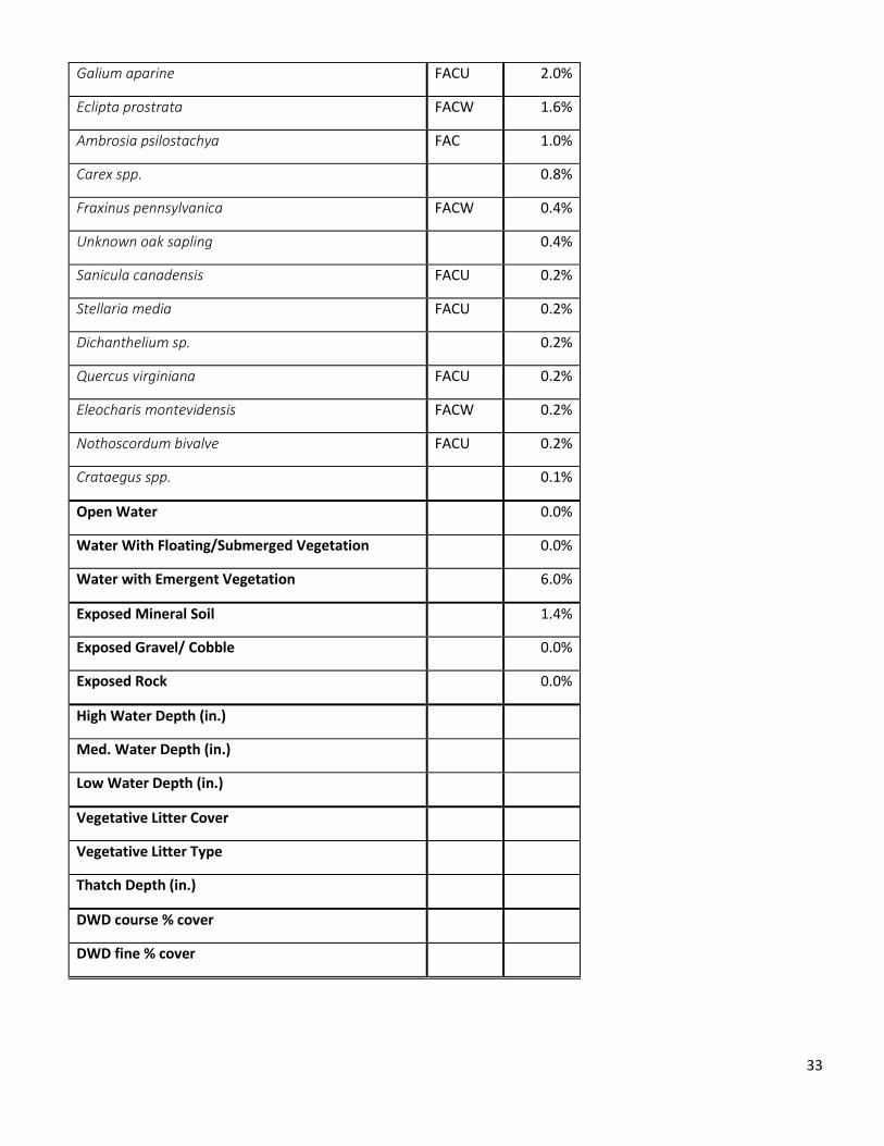
Galium aparine FACU 2.0%
Eclipta prostrata FACW 1.6%
Ambrosia psilostachya FAC 1.0%
Carex spp. 0.8%
Fraxinus pennsylvanica FACW 0.4%
Unknown oak sapling 0.4%
Sanicula canadensis FACU 0.2%
Stellaria media FACU 0.2%
Dichanthelium sp. 0.2%
Quercus virginiana FACU 0.2%
Eleocharis montevidensis FACW 0.2%
Nothoscordum bivalve FACU 0.2%
Crataegus spp. 0.1%
Open Water 0.0%
Water With Floating/Submerged Vegetation 0.0%
Water with Emergent Vegetation 6.0%
Exposed Mineral Soil 1.4%
Exposed Gravel/ Cobble 0.0%
Exposed Rock 0.0%
High Water Depth (in.)
Med. Water Depth (in.)
Low Water Depth (in.)
Vegetative Litter Cover
Vegetative Litter Type
Thatch Depth (in.)
DWD course % cover
DWD fine % cover

34
Soil Data (surface)
Sample Soil Texture Soil Color Description
2 fine sandy
loam 10 YR 4/3 no redox features
Sample Soil Texture Soil Color Description
3 dark clay 10 YR 2/1 no redox features
Sample Soil Texture Soil Color Description
4 clay 2.5 Y 5/1
Gleyed colors, pockets
of 5/2, shot-gray color
Sample Soil Texture Soil Color Description
5 clay loam 10 YR 3/2 no redox
The soil and vegetation are consistent with a riverine bottomland situation. The area is mapped as Trinity, with a
“frequent” flooding class (or about a 50% chance of flooding in any given year). The mitigation can be labeled as
successful, mainly from meeting the basic requirements. The question here, though, concerns the value of mitigating
a real wetland loss with mitigation in a bottomland not remotely threatened by development.
Site of the Mill Creek Mitigation Bank. 100-year FEMA floodplain overlay.

35
These pictures show typical landscape views of the mitigation site, January 2017.

36
Permit: SWG-2009-01124 Location: 29⁰04’16.62”N, 95⁰43’57.76”W
Mitigation Type: Permittee Responsible
Acres impacted: 0.4 acres
Mitigation acres required: 0.34 acres creation; 0.17 acres conservation.
Mitigation acres completed PERMIT BACKGROUND: This permit was a Nationwide Permit (NWP) 14 verified for realignment of FM 524 in Brazoria
County, TX. A preconstruction notice (PCN) for this permit was required because discharge occurred in wetlands. 0.4
acres of wetlands were impacted along Stevenson Slough as a result of the realignment. As compensation for the
impacts, 0.17 acrex of avoided wetlands will be preserved via conservation easement, and a 0.34 acre site adjacent
to the avoided wetlands will be converted to wetlands. The permit was issued on February 17, 2010 and expired
February 17, 2012.
The permit was verified under NWP 14 with 3 special conditions:
1. All construction of mitigation, including planting must be completed within 180 days (6 months) after the
start of construction in jurisdictional areas. The permittee will notify ACOE in writing when work in
jurisdictional areas begins. Monitoring and maintenance will proceed according to approved mitigation plan
2. The mitigation success criteria, per the approved mitigation plan, must be achieved for the mitigation
requirement to be considered complete
3. Should mitigation be determined to be unsuccessful by ACOE at the end of the monitoring period, corrective
measures must be taken to achieve mitigation success
The final permit is the last record on file in the administrative record.
INVESTIGATION RESULTS: An on-site assessment of the creation site was completed Fall 2016.
Summarized Vegetation Data
Species Status
Plot 1
Ht. Class
% Cover
Paspalum notatum FACU 1 35.0%
Iva annua FAC 2 15.0%
Panicum hemitomon OBL 2 11.0%
Bothriochloa ischaemum UPL (I) 2 8.0%
Solidago altissima FACU 2 5.0%
Melochia corchorifolia FAC (I) 1 4.0%
Ampelopsis arborea FAC 1 3.0%
Croton capitatus UPL 2 3.0%
Cynodon dactylon UPL 1 3.0%
Unknown fern 1 3.0%
Sesbania herbacea FACW 2 2.0%
Sorghum halepense FACU (I) 2 1.0%
Rubus trivialis FACU 1 1.0%
Polygonon hydropeploides OBL 1 1.0%

37
Alternanthrea philoxeroides OBL (I) 1 1.0%
Andropolgon glomeratus FACW 2 1.0%
Cyperus entreianus FACW (I) 2 0.1%
Symphyotrichum subulatus OBL 1 0.1%
Echinocloa muricata UPL 2 0.1%
Cyperus retrorsus FACU 1 0.1%
Open Water 0.0%
Water With Floating/Submerged Vegetation 0
Water with Emergent Vegetion 0
Exposed Mineral Soil 5.0%
Exposed Gravel/ Cobble 0
Exposed Rock 0
High Water Depth (in.) 0
Med. Water Depth (in.) 0
Low Water Depth (in.) 0
Vegetative Litter Cover 15.0%
Vegetative Litter Type Dead Graminoid
Thatch Depth (in.) 0-12
Soil Data
Depth (in) Soil Texture Soil Color Description
0-10 fine sandy loam
50% 10YR 3/2 Varigated soil bodies
consistent with spoil 50% 10YR 4/3
10+ fine sandy loam 10YR 5/6
* at 6" deep calcium carbonate masses It should be noted that the planting plan for the mitigation site included obligate wetland plants such as Pickerel weed, Canna, Arrowheads and Iris. None of this vegetation was present at the site within the vegetative plot samples. The mitigation site was dominated by facultative and facultative upland species comprising 73% of the sampled area.
Bahiagrass (Paspalum notatum) was the dominating species for this area, along with lesser amounts other weedy
species such as Cynodon dactylon (Bermuda grass), Iva annua and several exotic species (e.g., Melochia and
Alternanthera). Although obligate wetland plants were present, the percent coverage was minimal compared to the
more upland areas.
At the time of the survey, hydrology was not present and hydrological were minimal at a time of the year when the
site should have definite hydrological presence
Conclusion: This site cannot really be considered a successful functioning wetland. The vast majority of the plants are
upland. The 11% presence of Panicum hemitomon (Maindencane) is an outlier, but its presence is significant,
suggesting the presence of at least some hydrology.

38
A typical landscape view of the creation portion of the mitigation site.
Creation and avoidance mitigation areas, and impact area pre-construction (1995, Google Earth)

39
Permit: SWG-2010-00225 Location: 29⁰35’18.96N, 95⁰33’01.41”W
Mitigation Type: Permittee Responsible
Acres impacted: 0.02 acres
Mitigation acres Required: 0.1 acres
Mitigation acres completed: Significantly less than 0.1 acres
PERMIT BACKGROUND: This permit was a standard permit authorizing placement of 1,760 cubic yards of fill into 0.5
acres of jurisdictional Waters of the US for restoration of an 834 linear foot berm. The berm will be used to separate
low-water flow of Stafford Run Creek from the adjoining pond. This separation was required for water quality
associated with upstream water treatment facilities. A total of 0.48 acres of open waters of Stafford Run Creek and
0.02 acres of herbaceous wetlands adjacent to Stafford Run Creek were impacted. To offset impacts to 0.02 acres of
herbaceous wetlands, 0.1 acres of herbaceous wetlands was required to be planted along a 5-foot wide strip on the
Stafford Run Creek section of the berm. SWG-2010-00225 was approved 08/19/2010 and with an expiration date of
12/31/2015. No special conditions are associated with issuance of SWG-2010-00225.
INVESTIGATION RESULTS: An onsite evaluation was completed in September 2016.
Summarized Vegetation Data
Species Status Ht. Class
Percent Cover
Polygonum hydropiperoides OBL 2 27.0%
Alternanthera philoxeroides OBL 1 10.0%
Echinochloa colona FACW (I) 2 10.0%
Eragrostis elliotii FACW 2 9.0%
Bacopa monerii OBL 1 3.0%
Echinachloa muricata UPL 2 2.0%
Sphenoclea zeylanica FACW (I) 2 1.0%
Leersia hexandra OBL 2 1.0%
Physalis longifolia UPL 1 1.0%
Cyperus esculentus FAC 2 0.1%
lemna aequinoctialis OBL 1 0.1%
Impatiens capensis FACW 2 0.1%
Panicum spp. 2 0.1%
Open Water 33.0%
Water With Floating/Submerged Vegetation 0.1%
Water with Emergent Vegetation 57.0%
Exposed Mineral Soil 0
Exposed Gravel/ Cobble 0
Exposed Rock 0
High Water Depth (in.) 16
Med. Water Depth (in.) 7
Low Water Depth (in.) 0
Vegetative Litter Cover -
Vegetative Litter Type -

40
Thatch Depth (in.) -
Soil Data
Depth Soil Texture Soil Color Description
0-4 mucky loam 2Y 3/1
4-10 clay loam 5Y 4/2 3-4% depletion zones, few distinct redox coatings
Ground view of mitigation site, October 2016
View of the site from the top of the adjacent slope, October 2016
The mitigation site was completed per the proposed plan at the site. Approximately 61% of the vegetative cover was
dominated by obligate to facultative wetland plants and 33% of the site is open water, demonstrating the hydrology
for the site. Additionally, the soil samples show wetland features typical of fresh water systems. This wetland
mitigation site is a fringing marsh area that creeps into the open channel and runs the length of the channelized area
(800 ft). It is also bordered by steep slopes on either side and a concrete weir in the middle of one side.

41
Google Earth aerial view of the project/mitigation site, January 2017
Although the site has obligate and facultative wetland plants, the plants present are considered opportunistic
colonizing plants. For example, Polygonum hydropiperoides is a floating aquatic species that can root at any of the
nodes, or can break off from the main plant structure and re-root on bare soil in another location. The original
summary completed during a previous phase of this project indicated that 700 sprigs of Polygonum hydropiperoides
and Pontedaria cordata would be planted. There is no trace of the Pontedaria along the channel. It seems
reasonable to speculate that the current established vegetation is an outcome of opportunistic plants colonizing the
mitigation site, rather than a result of the mitigation design plan. Additionally, the original planting area (or what we
speculate was the planting area) is no longer 5 feet in width. The planted strip is at maximum 1 to 3 feet wide and
large sections are bare with signs of heavy erosion. In contrast to the mitigation site, the pond east of the the
concrete weir had more consistent wetland vegetation and wetland wildlife (i.e. herons and egrets) present. Overall,
the mitigation site retains minimal characteristics as a wetland.
Conclusion: The site provides minimal to no ecological wetland functions, and the wetland fringe is eroding due to
the flowing water.

42
Permit: SWG-2011-00068 Location: 29⁰41’12.02”N, 94⁰31’53.70”W
Mitigation Location: 30⁰11’48.78”N, 94⁰8’15.30”W
Mitigation Type: Conservation Easement/ Permittee Responsible.
Acres impacted: 0.52 acres
Mitigation acres Required: 11.22 acres
Mitigation acres completed:
PERMIT BACKGROUND: SWG-2011-00068 is a standard permit issued 08/19/2011 for authorization of impacts
associated with oil exploration and potential production of a well at Oyster Bayou Oil Field, Chambers County, TX. An
exploration well pad resulted in temporary impacts of 2.81 acres. When successful, the exploration well pad would
be reduced to a production pad permanently impacting 0.52 acres. Compensatory mitigation for this project will be
preservation of 11.22 acres of cypress-tupelo swamp and protection of a non-jurisdictional 4.705 acre upland buffer
in Hardin County adjacent to the Big Thicket National Preserve. The preservation will be via donation of the parcel to
the Big Thicket National PreserveThe permittee is Denbury Onshore, LLC.
INVESTIGATION RESULTS: An on-site assessment was completed in Winter 2017.
Vegetation Data
Species Wetland Status Avg. % Cover
Taxodium distichum OBL 35.0%
Carpinus caroliniana FAC 14.0%
Ilex opaca FAC 9.0%
Liquidambar styraciflua FAC 8.0%
Magnolia grandiflora FACU 4.4%
Quercus laurifolia FACW 4.0%
Quercus spp. 2.0%
Triadica sebifera FAC 1.4%
Pinus taeda FAC 1.2%
Carex cherokeensis FACW 0.8%
Vaccinium corymbosum FACW 0.8%
Quercus phellos FACW 0.8%
Quercus lyrata OBL 0.4%
Carex spp. 0.4%
Ilex vomitoria FAC 0.4%
unknown bud tree 0.2%
Viburnum dentatum FAC 0.2%
Smilax spp. 0.0%
Dicanthelium spp. 0.0%
Lygodium japonicum FAC 0.0%

43
Commelina spp. 0.0%
Viola spp. 0.0%
Morella cerifera FAC 0.0%
Prunus angustifolia 0.4%
Open Water 31.0%
Water With Floating/Submerged Vegetation 0.0%
Water with Emergent Vegetation 7.0%
Exposed Mineral Soil 2.6%
Exposed Gravel/ Cobble 0.0%
Exposed Rock 0.0%
High Water Depth (in.)
Med. Water Depth (in.)
Low Water Depth (in.)
Vegetative Litter Cover
Vegetative Litter Type
Thatch Depth (in.)
Soil Data (surface unless otherwise noted)
Depth Soil Texture Soil Color Description - loam 2.5YR 2/ Saturated, no redox features
Depth Soil Texture Soil Color Description
- clay loam 10YR 4/3 no redox
Depth Soil Texture Soil Color Description
- clay loam 2.5Y 6/2
matrix color, mini (20-30%) prominent iron ped coatings
Depth Soil Texture Soil Color Description
0-5" clay loam 2.5Y 4/2 mini distinct iron pore and ped coatings
5"+ clay loam 10YR 6/2 20% 7.5 YR 4/6 masses, fine sandy loam. few pore coats
The mitigation site was clearly a swamp, where the majority of the area was covered by Cypress trees and open
water (66% of the total coverage). The area showed clear hydrology, as the water made much of the area impassable
by foot and would require a boat. Soil characteristics were consistent with wetland characteristics. The concern for
this permit was the offsetting of impacts in a different area as well as no creation of new wetlands to compensate for
the lost, impacted wetlands, nor protection of a threatened area. The donated parcel is in a deep bottomland unlike
to be filled.

44