wetland impacts - mtri wetland mitigation site … impacts - mtri wetland mitigation site selection...
TRANSCRIPT

Wetland Impacts - MTRI Wetland Mitigation Site Selection Synthesis Report Colin Brooks, Richard Powell, and Dr. Robert Shuchman, MTRI. Introduction Transportation projects such as roadway realignments, widening, and bridge replacements frequently involve unavoidable impacts to wetlands. These projects often affect wetlands by altering surface flows, increasing sediment loads, removing vegetation, or reducing habitat. Many State and Federal laws require mitigation as a condition for issuing construction permits. For example, Section 404 of the Clean Water Act requires the approval of a wetland mitigation plan before a construction permit can be issued by the U.S. Army Corps of Engineers. Wetland mitigation is the replacement of wetland functions through the creation or restoration of wetlands. The goal of wetland mitigation is to replace wetland functions which provide public benefits such as flood storage, water quality protection, fish and wildlife habitat, and groundwater recharge. Wetland mitigation efforts by transportation departments vary by project, project size, and state. Many projects make use of off-site mitigation banks to comply with permitting requirements while others may develop mitigation sites at the project site or create or restore wetlands within the same watershed as the project. Site selection for wetland mitigation projects is frequently determined by economic factors such as cost and land availability rather than biophysical parameters necessary for ecologically effective wetlands. Recent studies from the National Cooperative Highway Research Program (NCHRP), Washington DOT, and Florida Department of Environmental Protection indicate that many wetland mitigation sites fail to comply with permit criteria or provide wetland ecological functions due to insufficient hydrology and unsuitable soil attributes as a result of poor site selection (NCHRP). Commercial remote sensing and geospatial information (CRS&SI) technologies provide new tools to mitigate the impact of transportation-related construction on wetland areas. These tools have been successfully used to identify suitable locations for wetland mitigation projects that integrate the ecological characteristics of wetland sites with a transportation department’s priorities for selecting sites. In this Synthesis Report, we present a review of the current practices used to select wetland mitigation sites. We then compare new and innovative approaches using commercial remote sensing and geospatial information (CRS&SI) to meet these needs, including identifying environmental factors that need to be addressed in the decision-making necessary to develop ecologically effective wetlands. Our findings indicate that the development of a flexible, interactive, web-based tool to map suitable locations for wetland mitigation and restoration sites would enable transportation agencies to perform rapid site assessments, providing results which reduce time-consuming research, allowing field resources to be efficiently allocated for maximum benefit. Traditional Approaches The selection of a wetland mitigation site is a critical first step to a successful mitigation project. Wetland mitigation activities are categorized in several types; restoration of historic or degraded wetlands, enhancement of existing wetlands, and establishment of new wetlands. Wetland establishment is the manipulation of the physical, chemical, or biological characteristics to create a wetland on upland or open water sites where a wetland did not previously exist. Created wetland sites typically require excavation and grading of soils to elevations that will produce a wetland hydroperiod, support hydric soils, and the growth of hydrophytic plant species. A created wetland's structure, function, and ecological integrity are significantly influenced by its location. The location of wetland mitigation sites are selected by considering a wide range of criteria such as policy, cost, long-rage manageability, sufficient area, hydrology, topography, and soils. Selection criteria are often evaluated with the assistance of U.S. Geological Survey (USGS) topographic maps, Natural Resource Conservation Service (NRCS) soil maps, and U.S. Fish and Wildlife Survey National Wetlands Inventory maps.
USDOT/RITA Streamlining EIS MTRI Wetland Mitigation Site Selection Synthesis Report

USDOT/RITA Streamlining EIS MTRI Wetland Mitigation Site Selection Synthesis Report
Frequently, the most critical factors used to determine the location of created wetland mitigation sites are the availability of land and policies that require wetlands to be restored or created within the same watershed to compensate for nearby wetland losses. When practical, many agencies locate mitigation sites at the transportation project site; however this practice may not always be feasible. More frequently, mitigation sites are located off-site but within the same watershed as the project site. For example, the Washington State Department of Transportation (WSDOT) prioritizes mitigation site selection by considering areas with multiple projects planned in the future. Their approach seeks to identify the general areas (such as watersheds) of these projects and focus mitigation efforts in advance. The application of selection criteria may vary by region and department however; it regularly involves time-consuming, extensive field work to locate suitable sites. For example, the Michigan Department of Transportation (MDOT) seeks to locate mitigation sites on agricultural lands which are near roadways and adjacent to lands owned by the State of Michigan. MDOT’s approach includes reviewing Michigan Department of Natural Resource maps, working closely with local real estate agencies and evaluating potential locations through field surveys. However, site-specific field work for identifying possible mitigation sites is not always practical, especially where larger areas of land are under consideration. Streamlining Approaches Recent studies from the National Cooperative Highway Research Program (NCHRP), Washington State DOT, and Florida Department of Environmental Protection indicate that many wetland mitigation sites fail to comply with permit criteria or provide wetland ecological functions due to insufficient hydrology and unsuitable soil attributes as a result of poor site selection (NCHRP). Commercial remote sensing and geospatial information (CRS&SI) technologies provide new techniques to mitigate the impact of transportation-related construction on wetland areas. These techniques have been successfully used to identify suitable locations for wetland mitigation projects that integrate the ecological characteristics of wetland sites with a transportation department’s priorities for selecting sites. One example of this approach was developed for the Michigan Department of Transportation for two diverse study areas within the state. The solution is comprised of the Wetland Mitigation Site Suitability Index (WMSSI) which integrates geospatial data sources to identify locations with environmental conditions capable of supporting wetland ecosystems, and a property selection tool that integrates MDOT’s methodology for acquiring real estate for mitigation sites with locations identified by the WMSSI. The technique is flexible for use throughout the state and scalable to meet MDOT’s requirements as they evolve. Most significantly, the tool augments the agency’s current methods by providing a decision support tool that enables more efficient planning and optimizes valuable field time.
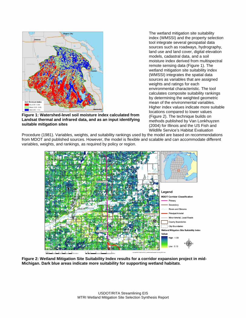
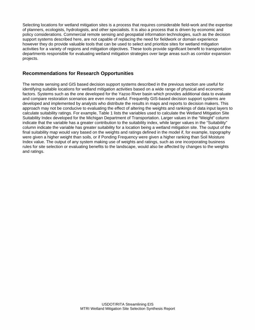
The wetland mitigation site suitability index (WMSSI) and the property selection tool integrate several geospatial data sources such as roadways, hydrography, land use and land cover, digital elevation models, cadastral data, and a soil moisture index derived from multispectral remote sensing data (Figure 1). The wetland mitigation site suitability index (WMSSI) integrates the spatial data sources as variables that are assigned weights and ratings for each environmental characteristic. The tool calculates composite suitability rankings by determining the weighted geometric mean of the environmental variables. Higher index values indicate more suitable locations compared to lower values (Figure 2). The technique builds on methods published by Van Lonkhuyzen (2004) for Illinois and the US Fish and Wildlife Service’s Habitat Evaluation
Procedure (1981). Variables, weights, and suitability rankings used by the model are based on recommendations from MDOT and published sources. However, the model is flexible and scalable and can accommodate different variables, weights, and rankings, as required by policy or region.
Figure 1: Watershed-level soil moisture index calculated from Landsat thermal and infrared data, and as an input identifying suitable mitigation sites
Figure 2: Wetland Mitigation Site Suitability Index results for a corridor expansion project in mid-Michigan. Dark blue areas indicate more suitability for supporting wetland habitats.
USDOT/RITA Streamlining EIS MTRI Wetland Mitigation Site Selection Synthesis Report

USDOT/RITA Streamlining EIS MTRI Wetland Mitigation Site Selection Synthesis Report
xisting
query format.
MDOT evaluates several characteristics when selecting a mitigation site; these characteristics include the size of available parcel, the parcels adjacency to roads, ewetlands, and Michigan Department of Natural Resources (DNR) lands. The property selection tool integrated MDOT’s methods for evaluating mitigation sites with suitable locations identified by the Wetland Mitigation Site Suitability Index by performing a spatial query of the data layers characterizing MDOT’s site selection parameters. Parcels of suitable size adjacent to roads, wetlands, and DNR lands are identified and displayed on maps that can be used to target locations for further research or field work (Figure 3). An Internet Map Server demonstration of the property selection tool was also developed to provide an example of this could be accomplished through user-friendly web mapping environment. The wetland mitigation site selection tool will help decrease the time required for MDOT to develop its watershed-based wetland mitigation banks by providing the ability to screen large watersheds for suitable sites and minimize costly field data collection.
Figure 3: Example output showing the WMSSI and Property Selection tool. Suitable sized agricultural parcels, adjacent to wetlands and roadways are outlined in black. GIS-based format leads to faster screening and access to parcel and landowner info in an easy to
The focus of the tool developed for MDOT is to assist with identifying locations for establishing new wetland mitigation areas. Geospatial information technologies are also capable of quantitatively identifying and prioritizing degraded wetlands for restoration. In a collaborative study, the U.S. Geological Survey and the U.S. Environmental Protection Agency developed a functional prototype of a GIS-based decision support system (DSS) to identify, select and prioritize sites within the Mississippi’s Yazoo River basin for the restoration of forested wetlands. The Yazoo Basin DSS uses geospatial data sources such as geomorphology, soils, land use and hydrography to identify potential sites and then evaluates the context of those sites to quantify the benefits of reforestation on the surrounding landscape based on flexible ecologic and economic criteria (Figure 4). Since restoration of all suitable areas is not practical the system reports on functional restorability and ecological factors of sites that decision makers can use to evaluate and compare restoration scenarios.
Figure 4: Mitigation Sites in the Yazoo River Basin Ranked by Functional Restoration Score
USDOT/RITA Streamlining EIS MTRI Wetland Mitigation Site Selection Synthesis Report
Selecting locations for wetland mitigation sites is a process that requires considerable field-work and the expertise of planners, ecologists, hydrologists, and other specialists. It is also a process that is driven by economic and policy considerations. Commercial remote sensing and geospatial information technologies, such as the decision support systems described here, are not capable of replacing the need for fieldwork or domain experience however they do provide valuable tools that can be used to select and prioritize sites for wetland mitigation activities for a variety of regions and mitigation objectives. These tools provide significant benefit to transportation departments responsible for evaluating wetland mitigation strategies over large areas such as corridor expansion projects. Recommendations for Research Opportunities The remote sensing and GIS based decision support systems described in the previous section are useful for identifying suitable locations for wetland mitigation activities based on a wide range of physical and economic factors. Systems such as the one developed for the Yazoo River basin which provides additional data to evaluate and compare restoration scenarios are even more useful. Frequently GIS-based decision support systems are developed and implemented by analysts who distribute the results in maps and reports to decision makers. This approach may not be conducive to evaluating the effect of altering the weights and rankings of data input layers to calculate suitability ratings. For example, Table 1 lists the variables used to calculate the Wetland Mitigation Site Suitability Index developed for the Michigan Department of Transportation. Larger values in the “Weight” column indicate that the variable has a greater contribution to the suitability index, while larger values in the “Suitability” column indicate the variable has greater suitability for a location being a wetland mitigation site. The output of the final suitability map would vary based on the weights and ratings defined in the model if, for example, topography were given a higher weight than soils, or if Ponding Frequency were given a higher ranking than Soil Moisture Index value. The output of any system making use of weights and ratings, such as one incorporating business rules for site selection or evaluating benefits to the landscape, would also be affected by changes to the weights and ratings.

USDOT/RITA Streamlining EIS MTRI Wetland Mitigation Site Selection Synthesis Report
Table 1: Variables Used to Calculate the Wetland Mitigation Site Suitability Index. Larger values in the “Weight” indicate that the variable has a greater contribution to the suitability index, while larger values in the “Suitability” column indicate the variable has greater suitability for being a wetlands mitigation site.
Input Weight Domain Suitability
Land Cover / Use
3
Agricultural Land 100 Other 0
Topography
3
Sink
50
Not sink
0
3
Slope <= 4
100
Slope > 4
0
Soil
3
Hydric Soils
100
Partially Hydric
50
Not Hydric
0
3
Ponding Frequency > 75
100
Ponding Frequency > 50 but < 75
50
Ponding Frequency > 25 but < 50
25
Ponding Frequency < 25
0
3
Soil Moisture Index >=.6
100
Soil Moisture Index >= 0.35 but <.6
50
Soil Moisture Index < 0.35
0
Hydrology
3
DepthToWaterTable >-6 but < 1 foot
100
DepthToWaterTable >1 but < 3 feet
50
DepthToWaterTable >3 but < 4 feet
25
DepthToWaterTable >4 feet
0
Historic Condition
2
Presettlement Wetland
100
Therefore, we propose to develop a web-based, interactive mapping system that would provide decision makers with the ability to explore site suitability and wetland restoration scenarios by interactively revising suitability model weights and ratings and mapping the results in real-time. The system would be a lightweight GIS web application based on free, open-source web mapping tools that would support a variety of data types and visualizations such as the overlay of model output results with aerial orthophotographs. The proposed system would model both the geophysical characteristics of locating wetland mitigation or restoration sites and the ‘policy’ or ‘business rules’, such as size, adjacency to roadways, etc., used by many departments to locate suitable sites. The strength of the system would be the flexibility of exploring different suitability scenarios interactively, providing the opportunity for collaboration and feedback with project partners and constituents. The weakness of the system is that GIS-based data sources used to model suitability would be static and would require careful selection in the requirements analysis phase of the project. Nonetheless, the resulting tool would enhance an agency’s capability to rapidly assess locations for wetland mitigation or restoration projects while providing results that can be used to reduce time-consuming research, allowing field resources to be efficiently allocated for maximum benefit.