global navigation satellite next generation global ... · global navigation satellite systems...
TRANSCRIPT

1
5th FIG Regional Conference - Accra Ghana 1
Next GenerationGlobal Navigation Satellite Systems
Matt HigginsPrincipal Survey Advisor,
Department of Natural Resources, Mines and WaterChair Commission 5 on Positioning and Measurement,
International Federation of Surveyors (FIG)
Co-Authors: Chris Rizos and Steven HewitsonUniversity of New South Wales
5th FIG Regional Conference - Accra Ghana 2
Global Navigation Satellite Systems (GNSS) are seeing many new developments…
• USA’s GPS Modernisation and ultimately GPS-III
• Russia’s GLONASS Re-vitalisation
• Japan’s MSAS and QZSS • India’s GAGAN• China’s Beidou
• A very significant new development is the EU’s Galileo…
5th FIG Regional Conference - Accra Ghana 3
Outline of the Presentation• Next Generation GNSS
– GPS Modernization and GPS-III– GLONASS– Galileo
• Growing Number of Centimetre Accuracy Applications of GNSS;
• Multi-GNSS Receiver Options/Implications;• Some Issues for Surveyors and Reference
Station Service Providers;• Some Institutional Arrangements;• Concluding Remarks.
5th FIG Regional Conference - Accra Ghana 4
Benefits of Next Generation GNSS• GPS and GLONASS combined have already
demonstrated the benefits of extra satellites;• Galileo brings all that and more;• The benefits of the extra satellites and their signals:
– Continuity (3 sub-systems are better than 1);– Accuracy (eg Galileo Commercial Service 0.1m in handset);– Efficiency (centimetre accuracy with shorter initialisation times);– Availability (60+ Satellites by 2010, 10 available will be common place,
working in Urban Canyons, under Tree Canopies, in Open Cut Mines) and;– Reliability (more reliable signal tracking, also designed for Safety-of-Life).
• Coded signals brings cheaper receivers for centimetre applications.
5th FIG Regional Conference - Accra Ghana 5
GPS Modernisationand GPS-III
5th FIG Regional Conference - Accra Ghana 6
GPS Satellite Status(as at October 2005)
_________________________________________________________SVN PRN Launch Date Orbit Plane Useable__________________________________________________________________________________________________
Block I1 4 22-02-78 no2 7 13-05-78 no3 6 6-10-78 no4 8 10-12-78 no5 5 9-02-80 no6 9 26-04-80 no7 launch failure8 11 14-07-83 no9 13 13-06-84 no10 12 8-09-84 no11 3 9-10-85 no
Block II14 14 14-02-89 no13 2 10-06-89 no16 16 18-08-89 no19 19 21-10-89 no17 17 11-12-89 no18 18 24-01-90 no20 20 26-03-90 no21 21 2-08-90 no15 15 1-10-90 D5 15-10-90
Block IIA23 23 26-11-90 no24 24 4-07-91 D1 30-08-9125 25 23-02-92 A2 24-03-9228 28 10-04-92 no26 26 7-07-92 F2 23-07-9227 27 9-09-92 A4 30-09-92
32 1 22-11-92 F6 11-12-9229 29 18-12-92 F5 5-01-9322 22 3-02-93 no31 31 30-03-93 no37 7 13-05-93 C4 12-06-9339 9 26-06-93 A1 20-07-9335 5 30-08-93 B4 28-09-9334 4 26-10-93 D4 22-11-9336 6 10-03-94 C1 28-03-9433 3 28-03-96 C2 9-04-9640 10 16-07-96 E3 15-08-9630 30 12-09-96 B2 1-10-9638 8 6-11-97 A3 18-12-97
Block IIR42 launch failure43 13 23-07-97 F3 31-01-9846 11 6-10-99 D2 3-01-0051 20 11-05-00 E1 1-06-0044 28 16-07-00 B3 17-08-0041 14 10-11-00 F1 10-12-0054 18 30-01-01 E4 15-02-0156 16 29-01-03 B1 18-02-0345 21 31-03-03 D3 12-04-0347 22 21-12-03 E2 12-01-0459 19 4-03-04 C3 5-04-0460 23 23-06-04 F4 9-07-0461 2 6-11-04 D7 30-11-04________________________________________________________
12 satellites currently older than 10yrs! (Design life is 7.5yrs).

2
5th FIG Regional Conference - Accra Ghana 7
GPS Signal Modernization
L2 L1
L5
2nd Civil Signaland M-code
Block IIR-M
Present Signals
3rd Civil SignalBlock IIF + Block III
http://www.navcen.uscg.gov/
29 sats
8 sats
16 sats+ 30 sats
Block IiA/IIR
From Sept 2005
From 2005
5th FIG Regional Conference - Accra Ghana 8
Baseline Milestone
GPSCapabilities
Space Segment
Control Segment
1803 04 05 06 07 08 09 10 11 12 13 14 15 16 17 19FY
M-Code
Block II
IIR-M
IIF
GPS III
L5
SAASM
L2C
GPS III
Flex-Power
Test IOC / FOC
Test IOC FOC
Test IOC FOC
Test IOC
Test IOC FOC
FOC
Test IOC (Protect) FOC
1st IIRM IIRM-8Dev
1st IIF IIF-10Dev
IIF-16
ATPConcept
30KDP B 184III-21st GPS IIIDev
IIRM IIFDev
SAASM Flex / Civil M-Code
DevTT&C NAV FinalGPS III
UserEquipment Contract
AwardDev
RCVR CardReady for Prod LRU I&T
Full PVT (FOC)
Initial PVT (IOC)Test
JPO Approved Baseline
Based on FY05 PB
Updated as of: 25 Oct 04
JPO Approved Baseline
Based on FY05 PB
Updated as of: 25 Oct 04
Concept Development Production
Bombers / Strikers
SAASM
MUE
SAASM UEVendors
Mobility / Tankers /Munitions
IOT&E Comp Bombers / Strikers /C4ISR Mobility / Tankers
ConceptATP
Platforms / Fielding Milestone Slip
12
PVT/C2
Enhanced T&M
IIF-4 IIF-12IIF-12
8
EnhancedT&M
EnhancedT&M
EnhancedT&M
EnhancedT&M
DAGRFRP
GPS Modernization Schedule (1)
5th FIG Regional Conference - Accra Ghana 9
Baseline Milestone
GPSCapabilities
Space Segment
Control Segment
1803 04 05 06 07 08 09 10 11 12 13 14 15 16 17 19FY
M-Code
Block II
IIR-M
IIF
GPS III
L5
SAASM
L2C
GPS III
Flex-Power
Test IOC / FOC
Test IOC FOC
Test IOC FOC
Test IOC
Test IOC FOC
FOC
Test IOC (Protect) FOC
1st IIRM IIRM-8Dev
1st IIF IIF-10Dev
IIF-16
ATPConcept
30KDP B 184III-21st GPS IIIDev
IIRM IIFDev
SAASM Flex / Civil M-Code
DevTT&C NAV FinalGPS III
UserEquipment Contract
AwardDev
RCVR CardReady for Prod LRU I&T
Full PVT (FOC)
Initial PVT (IOC)Test
JPO Approved Baseline
Based on FY05 PB
Updated as of: 25 Oct 04
JPO Approved Baseline
Based on FY05 PB
Updated as of: 25 Oct 04
Concept Development Production
Bombers / Strikers
SAASM
MUE
SAASM UEVendors
Mobility / Tankers /Munitions
IOT&E Comp Bombers / Strikers /C4ISR Mobility / Tankers
ConceptATP
Platforms / Fielding Milestone Slip
12
PVT/C2
Enhanced T&M
IIF-4 IIF-12IIF-12
8
EnhancedT&M
EnhancedT&M
EnhancedT&M
EnhancedT&M
DAGRFRP
Multiple generations of GPS for many years!+ GPS-IIA &
IIR, with >10yr lifetimes
GPS Modernization Schedule (2)
�10 GPS-IIR
�8 GPS-IIRM
�10 GPS-IIF
20105th FIG Regional Conference - Accra Ghana 10
Baseline Milestone
GPSCapabilities
Space Segment
Control Segment
1803 04 05 06 07 08 09 10 11 12 13 14 15 16 17 19FY
M-Code
Block II
IIR-M
IIF
GPS III
L5
SAASM
L2C
GPS III
Flex-Power
Test IOC / FOC
Test IOC FOC
Test IOC FOC
Test IOC
Test IOC FOC
FOC
Test IOC (Protect) FOC
1st IIRM IIRM-8Dev
1st IIF IIF-10Dev
IIF-16
ATPConcept
30KDP B 184III-21st GPS IIIDev
IIRM IIFDev
SAASM Flex / Civil M-Code
DevTT&C NAV FinalGPS III
UserEquipment Contract
AwardDev
RCVR CardReady for Prod LRU I&T
Full PVT (FOC)
Initial PVT (IOC)Test
JPO Approved Baseline
Based on FY05 PB
Updated as of: 25 Oct 04
JPO Approved Baseline
Based on FY05 PB
Updated as of: 25 Oct 04
Concept Development Production
Bombers / Strikers
SAASM
MUE
SAASM UEVendors
Mobility / Tankers /Munitions
IOT&E Comp Bombers / Strikers /C4ISR Mobility / Tankers
ConceptATP
Platforms / Fielding Milestone Slip
12
PVT/C2
Enhanced T&M
IIF-4 IIF-12IIF-12
8
EnhancedT&M
EnhancedT&M
EnhancedT&M
EnhancedT&M
DAGRFRP
Multiple generations of GPS for many years!
GPS Modernization Schedule (3)
�8 GPS-IIRM
�16 GPS-IIF
�12 GPS-III
2015
5th FIG Regional Conference - Accra Ghana 11
• True Next (2nd) Generation GPS is GPS-III.• For the next decade there will be 3 generations
of GPS signals …• GPS-IIR: L1 C/A code, L2 codeless• GPS-IIRM: L1 C/A code, L2C code• GPS-IIF: L1 C/A code, L2C code, L5 code/codeless• GPS-III: L1C code, L2C code, L5 code/codeless
• Receiver costs should drop for some signal combinations, but complexity will rise (in antennas, hardware, software).
• What will NOT change is tight U.S. military control over GPS space & ground segments.
• No plans for introduction of user charges.
GPS … the old & the new • GNSS similar to GPS, originally developed by the USSR (now Russian Federation). Also military controlled.
• GPS is CDMA-based, GLONASS is FDMA.• No direct user charges, as in the case of GPS.• Fully operational in 1996, but now only 14
functioning satellites. • Several new (multiple satellite) launches in the last
few years. • Russian president has made commitment to be
operational by 2007 (18 sats?). • Open, dual-use system, with civil L2 signal and
new L5 signal (2007+), compatible with GPS.• India has signed a MoU with Russia in January
2004.• India’s SBAS (‘GAGAN’) is based on both GPS and
GLONASS.
GLONASS
http://www.glonass-center.ru/
Combined GPS/GLONASS receivers already have market advantage where signal availability difficult, e.g. open cut mines…

3
5th FIG Regional Conference - Accra Ghana 13
1999
Comparison GPS & GLONASS
5th FIG Regional Conference - Accra Ghana 14
◆ Initiative of the EU, supported by ESA. ◆ Tension between EU & USA over issues of
“interoperability” & “compatibility”.◆ ‘Development & Validation’ phase has
commenced (naming of Concessionaire).◆ First test satellite launches in 2005-2006.◆ 30 MEO satellite constellation, operational by
2008-2010. ◆ Four levels of service: 2 fee-based to
guarantee certain level of performance (e.g. integrity for SoL users, accuracy for CS), plus free OS to match GPS’s, & restricted PRS.
◆ ‘Private-Public Partnership’, in contrast to U.S. military control/funding of GPS.
◆ Current Business Models will be challenged.◆ Galileo is a ‘2G’ system, compared with GPS’s
‘1G’ system.
http://www.galileo-pgm.org/index.htmhttp://www.genesis-office.org/http://www.galileoju.com/http://www.esa.int/navigation/
GALILEO
5th FIG Regional Conference - Accra Ghana 15
The GALILEO Arguments …
Political
- Independence and sovereignty- Industrial politics
Social
- Better and new services for the citizens- Improved safety of transport systems- Environmental benefits
Economic
- Global market shares- Global competitiveness of all segments of the Value Chain
- Employment- Efficiency of transport industry
Technological- Technological lead- Explore synergy of a number of technologies
5th FIG Regional Conference - Accra Ghana 16
US-EU Dromoland Castle Agreement26 June 2004
• Paves way for eventual doubling of satellites that will broadcast a common civil signal worldwide (GPS+GALILEO), tripling if include GLONASS.
• Requires non-discrimination and open markets in trade in civil GNSS-related goods and services.
• Ensures GALILEO’s signals will not harm NAVWAR capabilities of U.S. and NATO.
• Establishes process for U.S. and EU to address individual and mutual security concerns.
• GPS-III new L1 signal should be compatible with GALILEO’s.
5th FIG Regional Conference - Accra Ghana 17
Multi-GNSS Availability
5th FIG Regional Conference - Accra Ghana 18
4
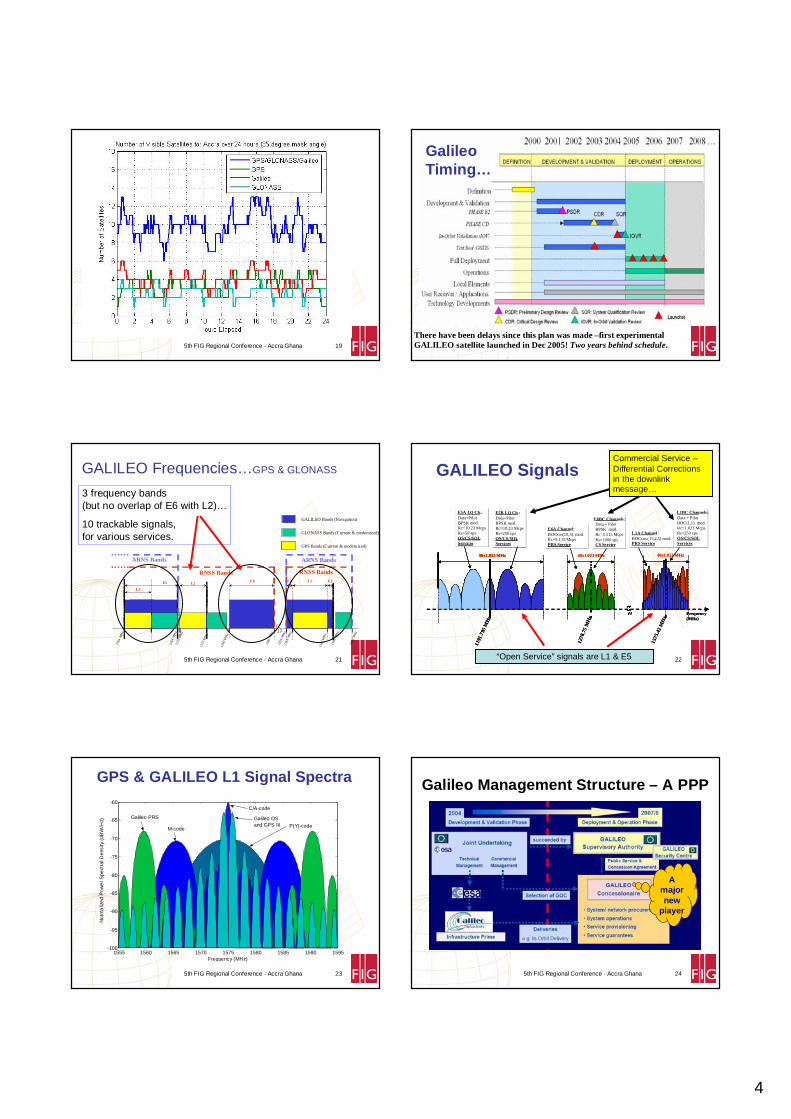
5th FIG Regional Conference - Accra Ghana 19 5th FIG Regional Conference - Accra Ghana 20
There have been delays since this plan was made –first experimental GALILEO satellite launched in Dec 2005! Two years behind schedule.
GalileoTiming…
5th FIG Regional Conference - Accra Ghana 21
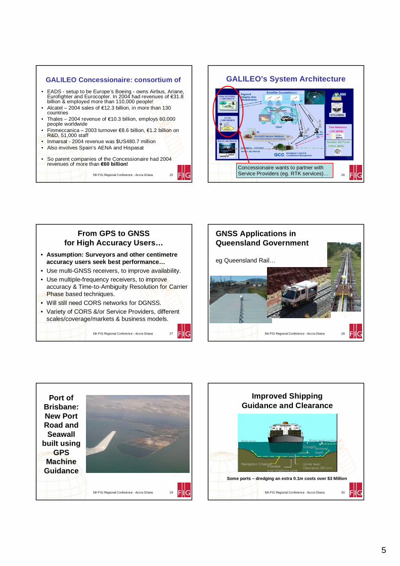
GALILEO Frequencies…GPS & GLONASS
L5
E5 E6 L1E2 E1
1164
MH
z
1214
MH
z
1260
MH
z
1300
MH
z
155 9
MH
z
1587
MH
z
1591
MH
z
1 563
MH
z
1215
MH
z
123 7
MH
z
L2
RNSS Bands RNSS Bands
ARNS Bands ARNS Bands
1610
MH
z
GALILEO Bands (Navigation)
GPS Bands (Current & modernized)
GLONASS Bands (Current & modernized)
3 frequency bands (but no overlap of E6 with L2)…
10 trackable signals, for various services.
5th FIG Regional Conference - Accra Ghana 22
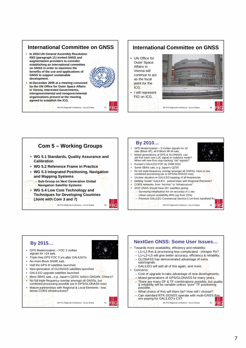
GALILEO Signals
1278
.75
MH
z
40x1.023 MHz
E6A Channel:BOCcos(10,5) mod.Rc=5.115 McpsPRS Service
E6BC Channels:Data + PilotBPSK mod.Rc=5.115 McpsRs=1000 spsCS Service
1575
.42
MH
z
40x1.023 MHz
L1A Channel:BOCcos (15,2.5) mod.PRS Service
L1BC Channels: Data + PilotBOC(1,1) mod.Rc=1.023 McpsRs=250 spsOS/CS/SOLServices
1191
.795
MH
z
E5A I,Q Ch.:Data+PilotBPSK mod.Rc=10.23 McpsRs=50 spsOS/CS/SOLServices
E5B I,Q Ch.: Data+PilotBPSK mod.Rc=10.23 McpsRs=250 spsOS/CS/SOLServices
Frequency(MHz)
90x1.023 MHz
1278
.75
MH
z
40x1.023 MHz
E6A Channel:BOCcos(10,5) mod.Rc=5.115 McpsPRS Service
E6BC Channels:Data + PilotBPSK mod.Rc=5.115 McpsRs=1000 spsCS Service
1575
.42
MH
z
40x1.023 MHz
L1A Channel:BOCcos (15,2.5) mod.PRS Service
L1BC Channels: Data + PilotBOC(1,1) mod.Rc=1.023 McpsRs=250 spsOS/CS/SOLServices
1191
.795
MH
z
E5A I,Q Ch.:Data+PilotBPSK mod.Rc=10.23 McpsRs=50 spsOS/CS/SOLServices
E5B I,Q Ch.: Data+PilotBPSK mod.Rc=10.23 McpsRs=250 spsOS/CS/SOLServices
Frequency(MHz)
90x1.023 MHz90x1.023 MHz
“Open Service” signals are L1 & E5
Commercial Service –Differential Corrections in the downlink message…
5th FIG Regional Conference - Accra Ghana 23
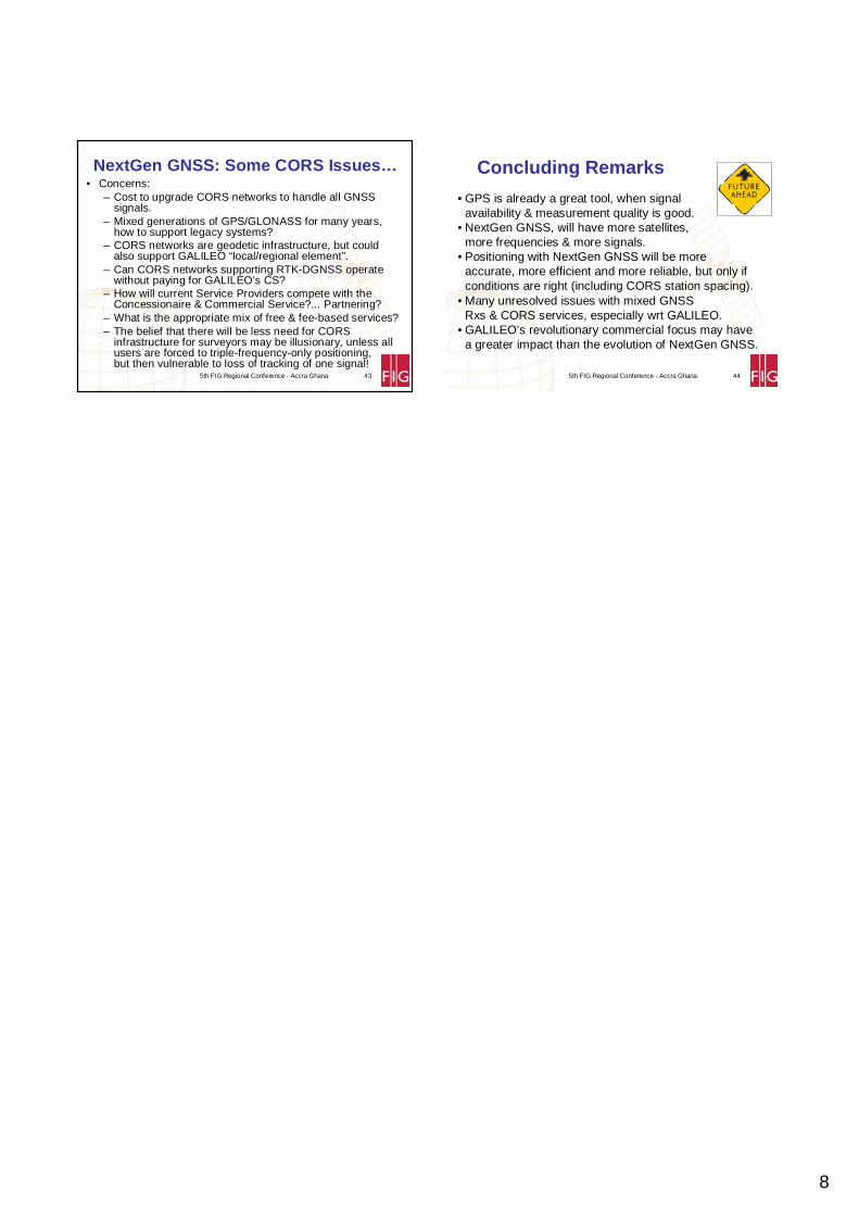
GPS & GALILEO L1 Signal Spectra
1555 1560 1565 1570 1575 1580 1585 1590 1595-100
-95
-90
-85
-80
-75
-70
-65
-60
Frequency (MHz)
Nor
ma
lized
Pow
er S
pect
ral D
ensi
ty (d
BW
/Hz)
C/A-code
Galileo OSand GPS III P(Y)-code M-code
Galileo PRS
5th FIG Regional Conference - Accra Ghana 24
Galileo Management Structure – A PPP
A major new
player
5
5th FIG Regional Conference - Accra Ghana 25
• EADS - setup to be Europe’s Boeing - owns Airbus, Ariane, Eurofighter and Eurocopter. In 2004 had revenues of €31.8 billion & employed more than 110,000 people!
• Alcatel – 2004 sales of €12.3 billion, in more than 130 countries
• Thales – 2004 revenue of €10.3 billion, employs 60,000 people worldwide
• Finmeccanica – 2003 turnover €8.6 billion, €1.2 billion on R&D, 51,000 staff
• Inmarsat - 2004 revenue was $US480.7 million• Also involves Spain’s AENA and Hispasat
• So parent companies of the Concessionaire had 2004 revenues of more than €60 billion!
GALILEO Concessionaire: consortium of
5th FIG Regional Conference - Accra Ghana 26
GALILEO’s System Architecture
Concessionaire wants to partner with Service Providers (eg. RTK services)…
5th FIG Regional Conference - Accra Ghana 27
• Assumption: Surveyors and other centimetre accuracy users seek best performance…
• Use multi-GNSS receivers, to improve availability.• Use multiple-frequency receivers, to improve
accuracy & Time-to-Ambiguity Resolution for Carrier Phase based techniques.
• Will still need CORS networks for DGNSS.• Variety of CORS &/or Service Providers, different
scales/coverage/markets & business models.
From GPS to GNSSfor High Accuracy Users…
5th FIG Regional Conference - Accra Ghana 28
GNSS Applications in Queensland Government
eg Queensland Rail…
5th FIG Regional Conference - Accra Ghana 29
Port of Brisbane:New Port Road and Seawall
built using GPS
Machine Guidance
5th FIG Regional Conference - Accra Ghana 30
Improved Shipping Guidance and Clearance
Some ports – dredging an extra 0.1m costs over $3 Million

6
5th FIG Regional Conference - Accra Ghana 31
Mine Safety Dragline Automation
5th FIG Regional Conference - Accra Ghana 32
My Dept’s SunPOZ RTK Network Service
• Centimetre accuracy in real-time using survey quality GPS receiver and mobile phone communications;
• Pilot Network since 2001;• Operational Network during 2006;• Coverage for cm accuracy
includes 15km buffer around outside of network;
• Coverage much larger for sub-meter corrections;
• Ideally suited to become a Galileo Local Element
5th FIG Regional Conference - Accra Ghana 33
Galileo Sensor Station Proposal to European Space Agency
5th FIG Regional Conference - Accra Ghana 34
GPS Surveying Receivers…cm accuracy RT or PP
C18-DF36-DF
--
1836
--
1836
B18/10-DF, 10-TF36-DF, 28-TF
1028
1836
--
2836
A Can old Rx track L2C in codeless mode?
28/10-DF, 10-TF36-DF, 28-TF
1028
1836
100
2836
Comments# sats 2010# sats 2015
L5L2CL2codeless
L1
Dec
reas
ing
cos
t
A: Rx tracks all sats, highest availability, highest cost, improvement in DF-only performance over current system, no TF-only positioning until 2015, best hybrid.
B: Moderate cost Rx, DF-only performance improved in 2015, no TF-only positioning until 2015, good hybrid positioning.
C: Lowest cost Rx, DF-only performance (decreased performance in 2010, but improved in 2015), no TF positioning possible.
5th FIG Regional Conference - Accra Ghana 35
GALILEO1/GPS2 Surveying Receivers…
Dec
reas
ing
cos
t
A: Top-of-line GNSS Rx tracks all sats, highest availability, highest cost, highest in DF-only & TF-only performance, best hybrid.
B: Moderate cost GNSS Rx tracks all sats, but does not track E6, GPS TF-only positioning available 2015, good price/performance compromise.
C: Moderate cost GALILEO-only surveying Rx, TF-only positioning available 2010, unclear if tracking of E6 requires user charges for CS.
D: Lowest cost GALILEO-only surveying Rx, DF-only performance (similar to current GPS-only performance in 2010), uses OS signals only.
C GALILEO
60-DF1; 30-TF1
60-DF1; 30-TF13030
--
3030
3030
DGALILEO
30-DF1
30-DF13030
--
--
3030
BGPS+GALILEO
30-DF1,28-DF2; 10-TF2
30-DF1,64-DF2; 30-TF130/1030/28
1836
--
30/2830/36
AGPS+GALILEO
60-DF1,28-DF2; 30-TF1,10-TF2
60-DF1,64-DF2; 30-TF1,28-TF230/1030/28
1836
3030
30/2830/36
Comment# sats 2010; # sats 2015E51/L52L2C2E61L11,2
5th FIG Regional Conference - Accra Ghana 36
Multiple GNSS Sub-Systems needs improved
Institutional Arrangementsfor GNSS
7
5th FIG Regional Conference - Accra Ghana 37
International Committee on GNSS• In 2004 UN General Assembly Resolution
59/2 (paragraph 11) invited GNSS and augmentation providers to consider establishing an international committee on GNSS in order to maximize the benefits of the use and applications of GNSS to support sustainable development.
• In December 2005 at a meeting convened by the UN Office for Outer Space Affairs in Vienna, interested Governments, intergovernmental and nongovernmental organizations present at the meeting agreed to establish the ICG.
5th FIG Regional Conference - Accra Ghana 38
International Committee on GNSS
• UN Office for Outer Space Affairs in Vienna will continue to act as the focal point for the ICG.
• I will represent FIG on ICG.
5th FIG Regional Conference - Accra Ghana 39
Com 5 – Working Groups
• WG 5.1 Standards, Quality Assurance and Calibration
• WG 5.2 Reference Frame in Practice• WG 5.3 Integrated Positioning, Navigation
and Mapping Systems– Sub-Group on Next Generation Global
Navigation Satellite Systems
• WG 5.4 Low Cost Technology and Techniques for Developing Countries(Joint with Com 3 and 7)
5th FIG Regional Conference - Accra Ghana 40
By 2010…• GPS Modernization – 3 civilian signals for 10
sats (Block IIF), all 8 Block IIR-M sats.• Mixed generations of GPS & GLONASS, can
old Rxs track new L2C signal in codeless mode?When will new Rxs stop tracking “old” signals?
• Europe’s GALILEO FOC by 2008-2010• Some SBAS sats, e.g. Japan’s QZSS• No full triple-frequency overlap amongst all GNSSs, have to use
combined processing (as in GPS/GLONASS now)• Unclear situation re GALILEO tracking of all frequencies• Getting “inside” GALILEO - partnerships with Regional Elements?• CORS networks, from “Ad-Hoc” to “Infrastructure”• 2010 GNSS should have 50+ satellites giving:
– Surveying initialisation for cm accuracy in 1 sec– Urban canyon availability 80% (up from 15%)– Premium GALILEO Commercial Service 0.1m from handheld Rx
5th FIG Regional Conference - Accra Ghana 41
By 2015…• GPS Modernization – FOC 3 civilian
signals for >24 sats.• Triple-freq GPS FOC 5 yrs after GALILEO’s• No more Block IIA/IIR sats.• Half the GPS-III satellites launched• New generation of GLONASS satellites launched• GALILEO upgrade satellites launched• More SBAS sats., e.g. Japan’s QZSS, India’s GAGAN, China’s?• No full triple-frequency overlap amongst all GNSSs, but
combined processing possible (as in GPS/GLONASS now)• Mature partnerships with Regional & Local Elements - less
dense CORS infrastructures?
5th FIG Regional Conference - Accra Ghana 42
• Towards more availability, efficiency and reliability: – L1+L2 Rxs & processing less complicated - cheaper Rx? – L1+L2+L5 will give better accuracy, efficiency & reliability.– GLONASS has demonstrated advantage of extra
sats/signals.– GALILEO will add all of this again, and more.
• Concerns: – Cost of upgrade to take advantage of new developments.– Mixed generations of GPS/GLONASS for many years.– There are many DF & TF combinations possible, but quality
& reliability will be variable unless “pure” TF positioning possible.
– What choice of Rxs will there be? How will I choose?– Can standard RTK-DGNSS operate with multi-GNSS Rxs
w/o paying for GALILEO’s CS?
NextGen GNSS: Some User Issues…
8
5th FIG Regional Conference - Accra Ghana 43
• Concerns: – Cost to upgrade CORS networks to handle all GNSS
signals.– Mixed generations of GPS/GLONASS for many years,
how to support legacy systems?– CORS networks are geodetic infrastructure, but could
also support GALILEO “local/regional element”.– Can CORS networks supporting RTK-DGNSS operate
without paying for GALILEO’s CS?– How will current Service Providers compete with the
Concessionaire & Commercial Service?... Partnering?– What is the appropriate mix of free & fee-based services?– The belief that there will be less need for CORS
infrastructure for surveyors may be illusionary, unless all users are forced to triple-frequency-only positioning, but then vulnerable to loss of tracking of one signal!
NextGen GNSS: Some CORS Issues…
5th FIG Regional Conference - Accra Ghana 44
Concluding Remarks
• GPS is already a great tool, when signal availability & measurement quality is good.
• NextGen GNSS, will have more satellites, more frequencies & more signals.
• Positioning with NextGen GNSS will be more accurate, more efficient and more reliable, but only if conditions are right (including CORS station spacing).
• Many unresolved issues with mixed GNSS Rxs & CORS services, especially wrt GALILEO.
• GALILEO’s revolutionary commercial focus may have a greater impact than the evolution of NextGen GNSS.