fresno to bakersfield - california high-speed rail · pdf filecalifornia high-speed train...
TRANSCRIPT

East San Gabriel
Valley
Riverside/Corona
Escondido
Sacramento
Stockton
Modesto
Merced
Transbay Transit Center
Fresno
Kings/Tulare
Gilroy
San Jose Redwood City or Palo Alto
(Potential Station)
Millbrae-SFO
Bakersfield
Palmdale
San Fernando/Burbank Ontario Airport
Norwalk
Murrieta
San Diego
Los Angeles
Anaheim
FINAL
Fresno to Bakersfield
Second Supplemental Historic Architectural
Survey Report
March 2014
Project Environmental Impact Report / Environmental Impact Statement

California High-Speed Train Project EIR/EIS
FINAL
Fresno to Bakersfield Section
Second Supplemental
Historic Architectural Survey Report
Prepared by:
URS/HMM/Arup Joint Venture
March 2014


CALIFORNIA HIGH-SPEED TRAIN PROJECT SECOND SUPPLEMENTAL HASR FRESNO TO BAKERSFIELD SECTION
Page i
Table of Contents
Page
1.0 Summary of Findings ...................................................................................... 1-1 1.1 Section 106 Cultural Resources ........................................................................ 1-2 1.2 “CEQA-Only” Cultural Resources ...................................................................... 1-3
2.0 Regulatory Setting .......................................................................................... 2-1 2.1 NRHP Eligibility (Section 106) .......................................................................... 2-1 2.2 CRHR Eligibility (CEQA) ................................................................................... 2-2 2.3 “CEQA-Only” Cultural Resources (CEQA) ........................................................... 2-2
3.0 Description of Undertaking ............................................................................. 3-1 3.1 Project Alternatives ......................................................................................... 3-1
3.1.1 Alignment Alternatives......................................................................... 3-1 3.1.1.1 No Project Alternative ................................................................... 3-1 3.1.1.2 BNSF Alternative ........................................................................... 3-2 3.1.1.3 Hanford West Bypass 1 Alternative ................................................ 3-2 3.1.1.4 Hanford West Bypass 1 Modified Alternative ................................... 3-3 3.1.1.5 Hanford West Bypass 2 Alternative ................................................ 3-3 3.1.1.6 Hanford West Bypass 2 Modified Alternative ................................... 3-3 3.1.1.7 Corcoran Elevated Alternative ........................................................ 3-4 3.1.1.8 Corcoran Bypass Alternative .......................................................... 3-4 3.1.1.9 Allensworth Bypass Alternative ...................................................... 3-4 3.1.1.10 Wasco-Shafter Bypass Alternative .................................................. 3-4 3.1.1.11 Bakersfield South Alternative ......................................................... 3-4 3.1.1.12 Bakersfield Hybrid Alternative ........................................................ 3-5
3.1.2 Station Alternatives ............................................................................. 3-5 3.1.2.1 Fresno Station .............................................................................. 3-5 3.1.2.2 Kings/Tulare Regional Station Alternatives ...................................... 3-6 3.1.2.3 Bakersfield Station Alternatives ...................................................... 3-6
3.1.3 Heavy Maintenance Facility .................................................................. 3-7 3.2 Power ............................................................................................................ 3-8
4.0 Area of Potential Effects ................................................................................. 4-1 5.0 Potentially Interested Parties, Public Participation ....................................... 5-1 6.0 Summary of Identification Efforts and Methods ............................................. 6-1
6.1 Identification Efforts ........................................................................................ 6-1 6.2 Field and Research Methods ............................................................................ 6-2
7.0 Historic Context .............................................................................................. 7-1 7.1 Arrival of the Railroads and Towns along the Tracks ......................................... 7-1 7.2 Irrigated Agriculture and Land Colonies ............................................................ 7-4 7.3 Events and Trends of the Twentieth Century .................................................... 7-8
7.3.1 Fresno County .................................................................................... 7-8 7.3.2 Kings County .................................................................................... 7-10 7.3.3 Kern County ..................................................................................... 7-11
8.0 Properties Identified – Findings ..................................................................... 8-1 8.1 Properties Identified as Eligible for the NRHP .................................................... 8-1 8.2 Properties Identified as Not Eligible for the NRHP.............................................. 8-3
9.0 References ...................................................................................................... 9-1 10.0 Preparer Qualifications ................................................................................. 10-1

CALIFORNIA HIGH-SPEED TRAIN PROJECT SECOND SUPPLEMENTAL HASR FRESNO TO BAKERSFIELD SECTION
Page ii
Appendices
A Project Location and Vicinity Maps B Area of Potential Effects Maps C Correspondence D DPR 523 Forms for Eligible Properties E DPR 523 Forms for Non-Eligible Resources F Streamlined Documentation
Tables
Table 1-1 Summary of Evaluation Efforts in Second Supplemental HASR ............................... 1-1 Table 1-2 Results of Formal Evaluations of NRHP and CRHR Eligibility (arranged by APN by
County) ...................................................................................................................... 1-2 Table 8-1 Historic Property (Historical Resource) Previously Determined Eligible for the NRHP 8-3 Table 8-2 Historic Architectural Resources Evaluated as Not Eligible for the NRHP for Which
SHPO Concurrence Is Requested ................................................................................. 8-5
Figures
Figure 7-1 San Joaquin Valley in 1873, showing progress of Southern Pacific Railroad construction ................................................................................................................ 7-3
Figure 7-2 Major rail lines between Fresno and Bakersfield in 1899 ....................................... 7-4 Figure 7-3 Land colonies in the vicinity of Fresno ................................................................. 7-7 Figure 8-1 Residence at 7870 S. Maple Avenue, Contributor to the Washington Irrigated Colony
Rural Historic Landscape, Fresno County ...................................................................... 8-3

CALIFORNIA HIGH-SPEED TRAIN PROJECT SECOND SUPPLEMENTAL HASR FRESNO TO BAKERSFIELD SECTION
Page iii
Acronyms and Abbreviations
APE Area of Potential Effects
APN Assessor Parcel Number
AT&SF Atchison Topeka and Santa Fe
Authority California High-Speed Rail Authority
CEQA California Environmental Quality Act
CHRIS California Historical Resources Information System
CRHR California Register of Historical Resources
EIR Environmental Impact Report
EIS Environmental Impact Statement
FOE Findings of Effect
FRA Federal Railroad Administration
HASR Historic Architecture Survey Report
HMF Heavy Maintenance Facility
HPSR Historic Property Survey Report
HST high-speed train
KCL Kern County Land Company
NHPA National Historic Preservation Act
NRHP National Register of Historic Places
OHP Office of Historic Preservation
project Fresno to Bakersfield Section of the California High-Speed Train Project
QI Qualified Investigator
RC Regional Consultant
ROD Record of Decision
RTP Regional Transportation Plan
Section 106 PA Section 106 Programmatic Agreement for the High-Speed Train Project
SHPO State Historic Preservation Officer
SJVR San Joaquin Valley Railroad
SOI Secretary of the Interior
SR State Route
TPSS Traction power substations
USGS U.S. Geological Survey

CALIFORNIA HIGH-SPEED TRAIN PROJECT SECOND SUPPLEMENTAL HASR FRESNO TO BAKERSFIELD SECTION
Page iv
This page intentionally left blank

Chapter 1.0 Summary of Findings


CALIFORNIA HIGH-SPEED TRAIN PROJECT SECOND SUPPLEMENTAL HASR FRESNO TO BAKERSFIELD SECTION
Page 1-1
1.0 Summary of Findings
This Second Supplemental Historic Architectural Survey Report (Second Supplemental HASR) has been prepared for the Fresno to Bakersfield Section of the California High-Speed Train Project (HST project). The purpose of this study is to document the identification and evaluation of historic-era built environment resources within areas recently added to the Area of Potential Effects (APE) for the Fresno to Bakersfield Section of the HST project. The additions to the APE that are addressed in this study are associated with engineering refinements resulting from changes in the design speed of proposed roadway overcrossings at various locations throughout the Section.
This Second Supplemental HASR identifies and documents: properties listed in or eligible for listing in the National Register of Historic Places (NRHP) or California Register of Historical Resources (CRHR); properties that are not eligible for the NRHP or CRHR; and properties identified as historical resources for the purposes of the California Environmental Quality Act (CEQA). This report also includes documentation of those historic-era built environment properties evaluated for eligibility through streamlined documentation. Table 1-1 summarizes the scope of these efforts.
Table 1-1 Summary of Evaluation Efforts in Second Supplemental HASR
Type of Evaluation Number of Properties
Appendix of Second Supplemental HASR
NRHP and CRHR Eligibility 25 Appendix D (eligible)Appendix E (not eligible)
“CEQA-Only” Cultural Resources * 0 Not applicable (none encountered)
Streamlined Documentation 42 Appendix F
* “CEQA-only” resources do not meet the significance criteria for listing in the NRHP or CRHR, but have been identified as historical resources for the purposes of CEQA, see Section 2.3.
Built environment resources in the original APE and earlier additions to the APE are addressed in the following documents:
• California High-Speed Train Fresno to Bakersfield Historic Architectural Survey Report (Authority and FRA 2011a);
• Supplemental California High-Speed Train Fresno to Bakersfield Historic Architectural Survey Report (Authority and FRA 2012a) to the State Historic Preservation Officer;
• California High-Speed Train Fresno to Bakersfield Historic Property Survey Report (HPSR) (Authority and FRA 2011b);
• California High-Speed Train Fresno to Bakersfield Supplemental Historic Property Survey Report (Supplemental HPSR) (Authority and FRA 2012b).
Copies of State Historic Preservation Officer (SHPO) correspondence regarding these studies are provided in Appendix C.

CALIFORNIA HIGH-SPEED TRAIN PROJECT SECOND SUPPLEMENTAL HASR FRESNO TO BAKERSFIELD SECTION
Page 1-2
1.1 Section 106 Cultural Resources
The 25 historic architectural resources formally evaluated in this study are summarized in Table 1-2. This study concluded that one property contributes to an existing historic landscape and is eligible for listing in the NRHP and CRHR. The remaining 24 do not meet the criteria for listing in the NRHP or the CRHR. The eligible property is a residence at 7870 South Maple Avenue (APN: 33511011), a contributor to the Washington Irrigated Colony Rural Historic Landscape located in southern Fresno County. The Washington Irrigated Colony has been determined eligible for listing in the NRHP as a rural historic landscape district with a period of significance of 1878 to 1910. It is significant for its association with settlement patterns and architecture (NRHP Criteria A and C). The contributing property at 7870 South Maple Avenue is eligible at the local level of significance under NRHP Criteria A and C and CRHR Criteria 1 and 3. Of the buildings on this parcel, only the Neoclassical residence is a contributing element of the district.
Historic architectural resources built in or before 1963 that met the HST Section 106 Programmatic Agreement (PA; see Section 2.0) definition of streamlined documentation because they had been substantially altered and did not require full evaluation on DPR 523 forms. Forty-two properties within the supplemental APE were evaluated using streamlined documentation. Streamlined documentation of these resources is presented in Appendix F.
None of the historic architectural resources in the supplemental APE that were built after 1963 (i.e., were less than 50 years old at the time of survey) have potential for exceptional significance (NRHP Criteria Consideration G), and these resources did not require further study.
Table 1-2 Results of Formal Evaluations of NRHP and CRHR Eligibility
(arranged by APN by County)
Map ID#
APN/DPR Form Address City Year Built
NRHP status CHRS Code
Map Sheet
1 48015405 2308 S. East Avenue Fresno ca. 1939 not eligible 6Z 10
2 48015406 2312 S. East Avenue Fresno ca. 1918 not eligible 6Z 10
3 48015407 2314 S. East Avenue Fresno ca. 1910 not eligible 6Z 10
4 48015409 2324 S. East Avenue Fresno 1940 not eligible 6Z 10
5 48002076 3589 E. Jensen Avenue Fresno 1954 not eligible 6Z 13
6 33425009 6072 S. Maple Avenue Fresno 1925 not eligible 6Z 25
7 33431049 6816 S. Maple Avenue Fresno 1960 not eligible 6Z 27
8 33431021 6875 S. Cedar Avenue Fresno 1953 not eligible 6Z 27
9 33431030 6854 S. Maple Avenue Fresno 1914 not eligible 6Z 27
10 33511011 7870 S. Maple Avenue Fresno 1911 3D (contributor) 29
Updated Landscape DPR
Form
Washington Irrigated Colony Rural Historic Landscape
1878-1910 2 (eligible) 23-29
11 04223016 2163 Floral Avenue Fresno 1950 not eligible 6Z 34
12 38502056 3148 E. Nebraska Avenue Fresno ca. 1885 not eligible 6Z 36

CALIFORNIA HIGH-SPEED TRAIN PROJECT SECOND SUPPLEMENTAL HASR FRESNO TO BAKERSFIELD SECTION
Page 1-3
Table 1-2 Results of Formal Evaluations of NRHP and CRHR Eligibility
(arranged by APN by County)
Map ID#
APN/DPR Form Address City Year Built
NRHP status CHRS Code
Map Sheet
13 38505101 3183 E. Nebraska Avenue Fresno ca. 1907 not eligible 6Z 36
14 38511032 4033 E. Conejo Avenue Selma 1924 not eligible 6Z 41
15 011010026000 12406 Hanford-Armona Road Hanford ca. 1925 not eligible 6Z 117
16 018241022000 13151 12th Avenue Hanford 1962 not eligible 6Z 123
17 028201009000 9850 Kansas Avenue Hanford ca. 1920 not eligible 6Z 133
18 04711020 28384 Highway 155 Delano 1954 not eligible 6Z 218
19 04735011 28592 Peterson Road Wasco ca. 1950 not eligible 6Z 246
20 07221061 17005 Shafter Avenue Shafter 1937 not eligible 6Z 283
21 09127024 32166 7th Standard Road Shafter 1940s not eligible 6Z 331
22 46506008 11846 Rosedale Highway Bakersfield ca. 1920 not eligible 6Z 343
23 46506009 11828 Rosedale Highway Bakersfield 1946 not eligible 6Z 343
24 46506010 11808 Rosedale Highway Bakersfield 1948 not eligible 6Z 343
25 36804004 1500 Coffee Road Bakersfield ca. 1954, ca. 1958 not eligible 6Z 351
1.2 “CEQA-Only” Cultural Resources
The survey population was also evaluated in accordance with Section 15064.5(a)(2)–(3) of the CEQA Guidelines, using criteria outlined in Section 5024.1 of the California Public Resources Code. CEQA historical resources are those listed in the CRHR, eligible for listing in the CRHR, or that meet other local government standards as historical resources, as per CEQA Guidelines Section 15064.5(a)(4). None of the historic architectural resources surveyed and presented in this Second Supplemental HASR are considered to be CEQA-only historical resources, and no historic architectural resources addressed in this Second Supplemental HASR required further study to resolve the question of eligibility.

CALIFORNIA HIGH-SPEED TRAIN PROJECT SECOND SUPPLEMENTAL HASR FRESNO TO BAKERSFIELD SECTION
Page 1-4
This page intentionally left blank

Chapter 2.0 Regulatory Setting


CALIFORNIA HIGH-SPEED TRAIN PROJECT SECOND SUPPLEMENTAL HASR FRESNO TO BAKERSFIELD SECTION
Page 2-1
2.0 Regulatory Setting
This supplemental study was prepared for the California High-Speed Rail Authority (Authority) and the Federal Railroad Administration (FRA) in their ongoing compliance with Section 106 of the National Historic Preservation Act (NHPA), and its implementing regulations issued by the Advisory Council on Historic Preservation (ACHP) that pertain to federally funded undertakings and their impacts on historic properties. This supplemental report is part of the technical studies prepared in support of the forthcoming Final Environmental Impact Report/Environmental Impact Statement (FEIR/EIS), which also addresses the project refinements through October 2013 and their potential to affect historic properties.
This Second Supplemental HASR follows the procedures set forth in the “Programmatic Agreement among the Federal Railroad Administration, the Advisory Council on Historic Preservation, the California State Historic Preservation Officer, and the California High-Speed Rail Authority Regarding Compliance with Section 106 of the National Historic Preservation Act as it Pertains to the California High-Speed Train Project” (Section 106 PA) (Authority and FRA 2011). The Second Supplemental HASR assists the Authority to comply with the California Environmental Quality Act (CEQA) and the CEQA Guidelines, as they pertain to historical resources for this project.
The HST Section 106 PA provides overall guidance regarding compliance with Section 106 of the NHPA. It provides direction for the development of the APE (Appendix B), the identification, documentation, and evaluation of historic properties, and the assessment of adverse effects. The PA directs that “historic properties shall be identified to the extent possible within the APE,” and requires that identified historic properties be evaluated in a manner consistent with the Secretary of the Interior’s Standards and Guidelines for Evaluation, and that the evaluations shall be completed by Qualified Investigators (QIs) per the standards of the Secretary of Interior.
The cultural resources studied for this HASR were evaluated for both NRHP and CRHR eligibility, and in regard to their potential status as a historic resource under CEQA.
2.1 NRHP Eligibility (Section 106)
Eligibility for the NRHP rests on dual factors: significance and integrity (National Park Service 1997). In order to be eligible for inclusion in the NRHP, a property must meet one or more of the significance criteria (listed below) and retain integrity:
Criterion A: association with “events that have made a significant contribution to the broad patterns of our history.”
Criterion B: association with “the lives of persons significant in our past.”
Criterion C: resources “that embody the distinctive characteristics of a type, period, or method of construction, or that represent the work of a master, or that possess high artistic values, or that represent a significant and distinguishable entity whose components may lack individual distinction.”
Criterion D: resources “that have yielded, or may be likely to yield, information important to history or prehistory.”
In addition to meeting one or more of the above criteria, an eligible property must retain integrity, which is determined through application of seven aspects: location, design, setting, workmanship, materials, feeling, and association. Location and setting relate to the relationship between the property and its surrounding environment. Design, materials, and workmanship
CALIFORNIA HIGH-SPEED TRAIN PROJECT SECOND SUPPLEMENTAL HASR FRESNO TO BAKERSFIELD SECTION
Page 2-2
relate to construction methods and architectural details. Feeling and association are the least objective of the seven aspects of integrity, and pertain to the overall ability of the property to convey a sense of the historical time and place in which it was constructed.
2.2 CRHR Eligibility (CEQA)
The CRHR criteria closely parallel those of the NRHP. A resource must be determined to be significant at the local, state, or national level under one or more of the four criteria (paraphrased below) in order to be eligible (California Office of Historic Preservation, “Instructions for Nominating Historical Resources to the California Register of Historical Resources,” August 1997):
Criterion 1: Resources associated with important events that have made a significant contribution to the broad patterns of our history.
Criterion 2: Resources associated with the lives of persons important to our past.
Criterion 3: Resources that embody the distinctive characteristics of a type, period, or method of construction, or represents the work of a master.
Criterion 4: Resources that have yielded, or may be likely to yield, information important in prehistory or history.
The CRHR definition of integrity and its special considerations for certain properties are slightly different than those for the NRHP. Integrity is defined as “the authenticity of an historical resource’s physical identity evidenced by the survival of characteristics that existed during the resource’s period of significance.” The CRHR further states that eligible resources must “retain enough of their historic character or appearance to be recognizable as historical resources and to convey the reasons for their significance,” and lists the same seven aspects of integrity used for evaluating properties under the NRHP criteria.
2.3 “CEQA-Only” Cultural Resources (CEQA)
The survey population was also evaluated in accordance with Section 15064.5(a)(2)–(3) of the CEQA Guidelines, using criteria outlined in Section 5024.1 of the California Public Resources Code. CEQA historical resources are those listed in the CRHR, eligible for listing in the CRHR, or that meet other local government standards as historical resources, as per CEQA Guidelines Section 15064.5(a)(4). “CEQA-only” resources are those resources that were evaluated under NRHP criteria and are not eligible for listing in the NRHP, but have some level of local designation (i.e., are listed in or are eligible for listing in a local register), and are considered to be historical resources for the purposes of CEQA.

Chapter 3.0 Description of Undertaking


CALIFORNIA HIGH-SPEED TRAIN PROJECT SECOND SUPPLEMENTAL HASR FRESNO TO BAKERSFIELD SECTION
Page 3-1
3.0 Description of Undertaking
The Fresno to Bakersfield Section of the HST project is approximately 114 miles long, varying in length by only a few miles depending on the route alternatives selected. To comply with the Authority’s guidance to use existing transportation corridors when feasible, the Fresno to Bakersfield HST Section would primarily be located adjacent to the existing BNSF Railway right-of-way. Alternative alignments are being considered where engineering constraints require deviation from the existing railroad corridor, and where necessary to avoid environmental impacts.
The Fresno to Bakersfield HST Section would cross both urban and rural lands and include a Fresno Station, a Kings/Tulare Regional Station in the vicinity of Hanford, and Bakersfield Station, a potential heavy maintenance facility (HMF), and power substations along the alignment. The HST alignment would be entirely grade-separated, meaning that crossings with roads, railroads, and other transport facilities would be located at different heights (overpasses or underpasses) so that the HST would not interrupt nor interface with other modes of transport. The HST right-of-way would also be fenced to prohibit public or vehicle access. The project footprint would primarily consist of the train right-of-way, which would include both a northbound and southbound track in an area typically 120 feet wide. Additional right-of-way would be required to accommodate stations, multiple track at stations, maintenance facilities, and power substations.
3.1 Project Alternatives
3.1.1 Alignment Alternatives
This section describes the Fresno to Bakersfield HST Section project alternatives, including the No Project Alternative. The Project EIR/EIS for the Fresno to Bakersfield HST Section examines alternative alignments, stations, and HMF sites within the general BNSF Railway corridor. Discussion of the HST project alternatives begins with a single continuous alignment (the BNSF Alternative) from Fresno to Bakersfield. This alternative most closely aligns with the preferred alignment identified in the Record of Decision (ROD) for the Statewide Program EIR/EIS. Descriptions of the additional ten alternative alignments that deviate from the BNSF Alternative for portions of the route then follow. The alternative alignments that deviate from the BNSF Alternative were selected to avoid environmental, land use, or community issues identified for portions of the BNSF Alternative (see Appendix A).
3.1.1.1 No Project Alternative
Under the No Project Alternative, the HST System would not be built. The No Project Alternative represents the condition of the Fresno to Bakersfield Section as it existed in 2009 (when the Notice of Preparation was issued), and as it would exist without the HST project at the planning horizon (2035). In assessing future conditions, it was assumed that all currently known programmed and funded improvements to the intercity transportation system (highway, rail, and transit), and reasonably foreseeable local development projects (with funding sources identified), would be developed by 2035. The No Project Alternative is based on a review of regional transportation plans (RTPs) for all modes of travel, the State of California Office of Planning and Research CEQAnet Database, the Federal Aviation Administration Air Carrier Activity Information System and Airport Improvement Plan grant data, the State Transportation Improvement Program, airport master plans and interviews with airport officials, intercity passenger rail plans, and city and county general plans and interviews with planning officials.

CALIFORNIA HIGH-SPEED TRAIN PROJECT SECOND SUPPLEMENTAL HASR FRESNO TO BAKERSFIELD SECTION
Page 3-2
3.1.1.2 BNSF Alternative
The BNSF Alternative’s cross sections include provisions for a 102-foot separation of the HST track centerline from the BNSF Railway track centerline, as well as separations that include swale or berm protection, or an intrusion protection barrier (wall) where the HST tracks are closer. A 102-foot separation between the centerlines of BNSF Railway and HST tracks is provided wherever feasible and appropriate. In urban areas where a 102-foot separation could result in substantial displacement of businesses, homes, and infrastructure, the separation between the BNSF Railway and HST was reduced. The areas with reduced separation require protection to prevent encroachment on the HST right-of-way in the event of a freight rail derailment. The use of a swale, berm, or wall protection would depend on the separation distance.
The BNSF Alternative would extend approximately 114 miles from Fresno to Bakersfield and would lie adjacent to the BNSF Railway route to the extent feasible (Appendix A). Minor deviations from the BNSF Railway corridor would be necessary to accommodate engineering constraints, namely wider curves necessary to accommodate the HST (as compared with the existing lower-speed freight line track alignment). The largest of these deviations occurs between approximately East Clarkson Avenue in Fresno County and Nevada Avenue in Kings County. This segment of the BNSF Alternative would depart from BNSF Railway corridor and instead curve to the east on the northern side of the Kings River and away from Hanford, and would rejoin the BNSF Railway corridor north of Corcoran.
Although the majority of the alignment would be at-grade, the BNSF Alternative would include aerial structures in all of the four counties through which it travels. In Fresno County, an aerial structure would carry the alignment over Golden State Boulevard and SR 99, and a second would cross over the BNSF Railway tracks in the vicinity of East Conejo Avenue. The alignment would also be elevated over Cole Slough and the Kings River into Kings County.
In Kings County, the BNSF Alternative would be elevated east of Hanford where the alignment would pass over the San Joaquin Valley Railroad (SJVR) and SR 198. The alignment would also be elevated over Cross Creek, and again in the city of Corcoran to avoid a BNSF Railway spur and agricultural facilities located at the southern end of the city. In Tulare County, the BNSF Alternative would be elevated at the Tule River crossing and over Deer Creek and the Stoil railroad spur that runs west from the BNSF Railway mainline. In Kern County, the BNSF Alternative would be elevated through the cities of Wasco, Shafter, and Bakersfield. The BNSF Alternative would be at-grade through the rural areas between these cities.
3.1.1.3 Hanford West Bypass 1 Alternative
The Hanford West Bypass 1 Alternative would parallel the BNSF Alternative from East Kamm Avenue to approximately East Elkhorn Avenue in Fresno County. The Hanford West Bypass 1 would diverge from the BNSF Railway corridor just south of East Elkhorn Avenue and ascend onto an elevated structure just south of East Harlan Avenue, crossing over the Kings River complex and Murphy Slough, and passing the community of Laton to the west. The Hanford West Bypass 1 Alternative would return to grade just north of Dover Avenue. The alignment would continue at-grade and would travel between the community of Armona to the west and the city of Hanford to the east on a southeasterly route toward the BNSF Railway corridor. The alignment would rejoin the BNSF Railway corridor adjacent to its western side at about Lansing Avenue. The alignment would continue on the western side of the BNSF Railway corridor and ascend onto another elevated structure, traveling over Cross Creek and special aquatic features that exist north of Corcoran. This alignment would return to grade just north of Nevada Avenue and would connect to the BNSF Alternative traveling through Corcoran at-grade, maintaining an alignment on the western side of the BNSF Railway corridor. The total length of the Hanford West Bypass 1 Alternative would be approximately 28 miles.

CALIFORNIA HIGH-SPEED TRAIN PROJECT SECOND SUPPLEMENTAL HASR FRESNO TO BAKERSFIELD SECTION
Page 3-3
The Kings/Tulare Regional Station–West Alternative would be located along this alignment, at-grade and east of 13th Avenue between Lacey Boulevard and the SJVR railroad spur.
3.1.1.4 Hanford West Bypass 1 Modified Alternative
The Hanford West Bypass 1 Modified Alternative is similar to the Hanford West Bypass 1 Alternative; however it was modified to avoid Section 106 adverse effects and Department of Transportation Section 4(f) uses of a two properties in Kings County located at 13148 Grangeville Boulevard and 9860 13th Avenue. Like the Hanford West Bypass 1 Alternative, the Hanford West Bypass 1 Modified Alternative would be approximately 28 miles in length and connect only with the BNSF Alternative through Corcoran, maintaining an alignment on the western side of the BNSF Railway corridor.
This alternative incorporates a below-grade alignment design between Grangeville Boulevard and Houston Avenue and would include the below-grade Kings/Tulare Regional Station–West Alternative, also located east of 13th Avenue, between Lacey Boulevard and the SJVR railroad spur.
3.1.1.5 Hanford West Bypass 2 Alternative
The Hanford West Bypass 2 Alternative would be the same as the Hanford West Bypass 1 Alternative from East Kamm Avenue to just north of Jackson Avenue. The Hanford West Bypass 2 Alternative would then curve away from the Hanford West Bypass 1 Alternative, traveling approximately 0.3 mile east of the Hanford West Bypass 1 route, and ascend over Kent Avenue and then cross over the BNSF Railway right-of-way and Kansas Avenue. The alignment would remain elevated for approximately 1.5 miles, return to grade north of Lansing Avenue, and continue along the BNSF Railway corridor on its eastern side. Similar to the Hanford West Bypass 1 Alternative, the Hanford West Bypass 2 Alternative would travel over Cross Creek and the special aquatic features located north of Corcoran and return to grade north of Nevada Avenue; however, the Hanford West Bypass 2 would be located on the eastern side of the BNSF Railway tracks in order to connect to either of the two Corcoran alternatives that would travel on the eastern side of the BNSF Railway corridor, the Corcoran Elevated Alternative or the Corcoran Bypass Alternative, described below. Like the Hanford West Bypass 1 Alternative, the total length of the Hanford West Bypass 2 Alternative would be approximately 28 miles.
The Hanford West Bypass 2 Alternative would include the same at-grade Kings/Tulare Regional Station–West Alternative described for the Hanford West Bypass 1 Alternative.
3.1.1.6 Hanford West Bypass 2 Modified Alternative
The Hanford West Bypass 2 Modified Alternative is similar to the Hanford West Bypass 2 Alternative however, like the Hanford West Bypass 1 Modified Alternative, this alignment was refined to avoid Section 106 adverse effects and Department of Transportation Section 4(f) uses of two properties in Kings County located at 13148 Grangeville Boulevard and 9860 13th Avenue. Like the Hanford West Bypass 2 Alternative, the Hanford West Bypass 2 Modified Alternative would be approximately 28 miles in length and connect with the Corcoran Elevated or the Corcoran Bypass alternatives on the eastern side of the BNSF Railway railroad.
The Hanford West Bypass 2 Modified Alternative would include the same below-grade alignment design and below-grade Kings/Tulare Regional Station–West Alternative described for the Hanford West Bypass 1 Modified Alternative.

CALIFORNIA HIGH-SPEED TRAIN PROJECT SECOND SUPPLEMENTAL HASR FRESNO TO BAKERSFIELD SECTION
Page 3-4
3.1.1.7 Corcoran Elevated Alternative
The Corcoran Elevated Alternative would be the same as the corresponding section of the BNSF Alternative from approximately Nevada Avenue to Avenue 136, except that it would pass through the city of Corcoran on the eastern side of the BNSF Railway right-of-way on an aerial structure. The aerial structure would begin at Niles Avenue and return to grade south of Fourth Avenue. The total length of the Corcoran Elevated Alternative would be approximately 10 miles. Dedicated wildlife crossing structures would be provided from approximately Cross Creek south to Avenue 136 in at-grade portions of the railroad embankment at intervals of approximately 0.3 mile. Dedicated wildlife crossing structures would also be placed between 100 and 500 feet to the north and south of both the Cross Creek and Tule River crossings.
3.1.1.8 Corcoran Bypass Alternative
The Corcoran Bypass Alternative would diverge from the BNSF Alternative at Nevada Avenue and swing east of Corcoran, rejoining the BNSF Railway route at Avenue 136. The total length of the Corcoran Bypass would be approximately 10 miles. Similar to the corresponding section of the BNSF Alternative, most of the Corcoran Bypass Alternative would be at-grade. However, one elevated structure would carry the HST over SR 43, the BNSF Railway, and the Tule River. Dedicated wildlife crossing structures would be provided from approximately Cross Creek south to Avenue 136 in at-grade portions of the railroad embankment at intervals of approximately 0.3 mile. Dedicated wildlife crossing structures would also be placed between 100 and 500 feet to the north and south of each of the Cross Creek and Tule River crossings.
3.1.1.9 Allensworth Bypass Alternative
The Allensworth Bypass Alternative would pass west of the BNSF Alternative, avoiding Allensworth Ecological Reserve and the Allensworth State Historic Park. This alignment was refined over the course of environmental studies to reduce impacts to wetlands and orchards. The total length of the Allensworth Bypass Alternative would be approximately 21 miles, beginning at approximately County Road J22/Avenue 56 and rejoining the BNSF Alternative at Elmo Highway. The Allensworth Bypass Alternative would be constructed on an elevated structure where the alignment crosses Deer Creek and the Stoil railroad spur, as well as Poso Creek. The majority of the alignment would pass through Tulare County at-grade. Dedicated wildlife crossing structures would be provided from approximately Avenue 84 to Poso Creek at intervals of approximately 0.3 mile. Dedicated wildlife crossing structures would also be placed between 100 and 500 feet to the north and south of both the Deer Creek and Poso Creek crossings.
3.1.1.10 Wasco-Shafter Bypass Alternative
The Wasco-Shafter Bypass Alternative would diverge from the BNSF Alternative between Taussig Avenue and Zachary Avenue, crossing over to the eastern side of the BNSF Railway tracks and bypassing Wasco and Shafter to the east. The Wasco-Shafter Bypass Alternative would be at-grade except where it travels over 7th Standard Road and the BNSF Railway to rejoin the BNSF Alternative. The total length of the Wasco-Shafter Bypass Alternative would be approximately 21 miles.
The Wasco-Shafter Bypass was refined to avoid the Occidental Petroleum tank farm as well as a historic property potentially eligible for listing on the National Register of Historic Places.
3.1.1.11 Bakersfield South Alternative
From the Rosedale Highway (SR 58) in Bakersfield, the Bakersfield South Alternative would parallel the BNSF Alternative at varying distances to the north. At Chester Avenue, the

CALIFORNIA HIGH-SPEED TRAIN PROJECT SECOND SUPPLEMENTAL HASR FRESNO TO BAKERSFIELD SECTION
Page 3-5
Bakersfield South Alternative would curve south and run parallel to California Avenue. As with the BNSF Alternative, the Bakersfield South Alternative would begin at-grade and become elevated starting at Country Breeze Place through Bakersfield to its terminus at Oswell Street. Dedicated wildlife crossing structures would not be required because this alternative would be elevated to the north and south of the Kern River.
This alternative includes the Bakersfield Station–South Alternative.
3.1.1.12 Bakersfield Hybrid Alternative
From Rosedale Highway (SR 58) in Bakersfield, the Bakersfield Hybrid Alternative would follow the Bakersfield South Alternative and parallel the BNSF Alternative at varying distances to the north. At approximately A Street, the Bakersfield Hybrid Alternative would diverge from the Bakersfield South Alternative, cross over Chester Avenue and the BNSF right-of-way in a southeasterly direction, then curve back to the northeast to parallel the BNSF Railway tracks towards Kern Junction. After crossing Truxtun Avenue, the alignment would curve to the southeast to parallel the UPRR tracks to its terminus at Oswell Street. As with the BNSF and Bakersfield South alternatives, the Bakersfield Hybrid Alternative would begin at-grade and become elevated starting at Country Breeze Place through Bakersfield to Oswell Street.
This alternative includes the Bakersfield Station–Hybrid Alternative.
3.1.2 Station Alternatives
The Fresno to Bakersfield HST Section would include a new station in Fresno, a Kings/Tulare Regional Station in the vicinity of Hanford, and a new station in Bakersfield.
Stations would be designed to address the purpose of the HST, particularly to allow for intercity travel and connection to local transit, airports, and highways. Stations would include the station platforms, a station building, and an associated access structure, as well as lengths of bypass tracks to accommodate local and express service at the stations. All stations would contain the following elements:
• Passenger boarding and alighting platforms. • Station head house with ticketing, waiting areas, passenger amenities, vertical circulation,
administration and employee areas, and baggage and freight-handling service. • Vehicle parking (short-term and long-term) and “kiss and ride.”1 • Motorcycle/scooter parking. • Bicycle parking. • Waiting areas and queuing space for taxis and shuttle buses. • Pedestrian walkway connections.
3.1.2.1 Fresno Station
The Fresno Station would be located in Downtown Fresno, less than 0.5 mile east of SR 99 on the BNSF Alternative. The station would be centered on Mariposa Street and bordered by Fresno Street on the north, Tulare Street on the south, H Street on the east, and G Street on the west. The station building would be approximately 75,000 square feet, with a maximum height of approximately 64 feet.
The two-level station would be at grade; with passenger access provided both east and west of the HST guideway and the UPRR tracks, which would run parallel with one another adjacent to
1 “Kiss-and-ride” refers to the station area where riders may be dropped off or picked up before or after
riding the HST.

CALIFORNIA HIGH-SPEED TRAIN PROJECT SECOND SUPPLEMENTAL HASR FRESNO TO BAKERSFIELD SECTION
Page 3-6
the station. The majority of station facilities would be east of the UPRR tracks. The station and associated facilities would occupy approximately 20.5 acres, including 13 acres dedicated to the station, short term parking, and “kiss-and-ride” passenger drop-off areas. The site proposal includes the potential for up to three parking structures occupying a total of 5.5 acres.
The historic Southern Pacific Railroad depot and associated Pullman Sheds would remain intact and adjacent to the HST station. While these structures could be used for station-related purposes, they are not assumed to be functionally required for the HST project and are thus not proposed to be physically altered as part of the project. The Fresno Station building footprint has been configured to preserve views of the historic railroad depot and associated sheds.
The Authority Board selected this Fresno station location on May 3, 2012 following certification of the Merced to Fresno Section Final EIR/EIS and the FRA issued a ROD which included this station site in September 2012.
3.1.2.2 Kings/Tulare Regional Station Alternatives
Two alternative sites are under consideration for the Kings/Tulare Regional Station.
Kings/Tulare Regional Station–East Alternative
The Kings/Tulare Regional Station–East Alternative would be located east of SR 43 (Avenue 8) and north of the SJVR on the BNSF Alternative. The station building would be approximately 40,000 square feet with a maximum height of approximately 75 feet. The entire site would be approximately 25 acres, including 8 acres designated for the station, bus transit center, short-term parking, and kiss-and-ride. An additional approximately 17.25 acres would support a surface parking lot with approximately 2,280 spaces.
Kings/Tulare Regional Station–West Alternative
The Kings/Tulare Regional Station–West Alternative would be located east of 13th Avenue and north of the SJVR on the Hanford West Bypass alternatives. The station would be located either at-grade or below-grade depending on which Hanford West Bypass alignment is chosen.
The at-grade Kings/Tulare Regional Station–West Alternative would be located along either the Hanford West Bypass 1 or 2 alternatives and would include a station building of approximately 100,000 square feet with a maximum height of approximately 36 feet. The entire site would be approximately 48 acres, including 6 acres designated for the station, bus bays, short-term parking, and kiss-and-ride areas. Approximately 5 acres would support a surface parking lot with approximately 700 spaces. An additional 3.5 acres would support two parking structures with a combined parking capacity of 2,100 spaces.
The below-grade Kings/Tulare Regional Station–West Alternative would be located along either the Hanford West Bypass 1 or 2 Modified alternatives and would include a station building of approximately the same size and height. The below-grade station site would include the same components as the at-grade station on the same number of acres; however, the station platform would be located below-grade instead of at ground level. Approximately 4 acres would support a surface parking lot with approximately 600 spaces and an additional 4 acres would support two parking structures with a combined parking capacity of 2,200 spaces.
3.1.2.3 Bakersfield Station Alternatives
Three options are under consideration for the Bakersfield Station.

CALIFORNIA HIGH-SPEED TRAIN PROJECT SECOND SUPPLEMENTAL HASR FRESNO TO BAKERSFIELD SECTION
Page 3-7
Bakersfield Station–North Alternative
The Bakersfield Station–North Alternative would be located at the corner of Truxtun and Union Avenue/SR 204 along the BNSF Alternative. The three-level station building would be 52,000 square feet, with a maximum height of approximately 95 feet. Under this alternative, the station building would be located at the western end of the parcel footprint. Two new boulevards would be constructed to access the station and the supporting facilities.
The 19-acre site would designate 11.5 acres for the station, bus transit center, short-term parking, and kiss-and-ride. An additional 7.5 acres would house two parking structures that together would accommodate approximately 4,500 cars. The bus transit center and the smaller of the two parking structures (2.5 acres) would be located north of the HST tracks. The BNSF Railway line would run through the station at-grade, with the HST alignment running on an elevated guideway.
Bakersfield Station–South Alternative
The Bakersfield Station–South Alternative would be would be similarly located in downtown Bakersfield, but situated on the Bakersfield South Alternative along Union and California avenues, just south of the BNSF Railway right-of-way. The two-level station building would be 51,000 square feet, with a maximum height of approximately 95 feet. Access to the site would be from two new boulevards, one branching off from California Avenue and the other from Union Avenue.
The entire site would be 20 acres, with 15 acres designated for the station, bus transit center, short-term parking, and kiss-and-ride. Five acres would support one six-level parking structure with a capacity of approximately 4,500 cars. Unlike the Bakersfield Station–North Alternative, this station site would be located entirely south of the BNSF Railway right-of-way.
Bakersfield Station–Hybrid Alternative
The Bakersfield Station–Hybrid Alternative would be in the same area as the North and South Station alternatives, and located at the corner of Truxtun and Union Avenue/SR 204 on the Bakersfield Hybrid Alternative. The station design includes an approximately 57,000 square-foot main station building and an approximately 5,500 square-foot entry concourse located north of the BNSF Railway right-of-way. The station building would have two levels with a maximum height of approximately 95 feet. A pedestrian overcrossing would connect the main station building to the north entry concourse across the BNSF right-of-way.
The entire site would be approximately 24 acres, with 15 acres designated for the station, bus transit center, short-term parking, and kiss-and-ride areas. Approximately 4.5 of the 24 acres would support three parking structures with a total capacity of approximately 4,500 cars. Access to the station site would be from Truxtun and Union avenues, as well as from Hayden Court. Under this alternative, the BNSF Railway track runs through the station site, and the main station building and majority of station facilities would be sited south of the BNSF Railway right-of-way.
3.1.3 Heavy Maintenance Facility
One HST heavy vehicle maintenance and layover facility would be sited along either the Merced to Fresno or Fresno to Bakersfield HST section. Before the start-up of initial operations, the HMF would support the assembly, testing, commissioning, and acceptance of high-speed rolling stock. During regular operations, the HMF would provide maintenance and repair functions, activation of new rolling stock, and train storage. The HMF concept plan indicates that the site would encompass approximately 154 acres to accommodate shops, tracks, parking, administration, roadways, power substation, and storage areas. The HMF would include tracks that allow trains to enter and leave under their own electric power or under tow. The HMF would also have

CALIFORNIA HIGH-SPEED TRAIN PROJECT SECOND SUPPLEMENTAL HASR FRESNO TO BAKERSFIELD SECTION
Page 3-8
management, administrative, and employee support facilities. Up to 1,500 employees could work at the HMF during any 24-hour period.
The Authority has determined that one HMF would be located between Merced and Bakersfield; however, the specific location has not yet been finalized. The property boundaries for each HMF site would be larger than the acreage needed for the actual facility because of the unique site characteristics and constraints of each location. Five HMF sites are under consideration in the Fresno to Bakersfield Section (Appendix A):
• The Fresno Works–Fresno HMF site lies within the southern limits of the city of Fresno and county of Fresno next to the BNSF Railway right-of-way between SR 99 and Adams Avenue. Up to 590 acres are available for the facility at this site.
• The Kings County–Hanford HMF site lies southeast of the city of Hanford, adjacent to and east of SR 43, between Houston and Idaho avenues. Up to 510 acres are available at the site.
• The Kern Council of Governments–Wasco HMF site lies directly east of Wasco between SR 46 and Filburn Street. Up to 420 acres are available for the facility at this site.
• The Kern Council of Governments–Shafter East HMF site lies in the city of Shafter between Burbank Street and 7th Standard Road to the east of the BNSF Railway right-of-way. This site has up to 490 acres available for the facility.
• The Kern Council of Governments–Shafter West HMF site lies in the city of Shafter between Burbank Street and 7th Standard Road to the west of the BNSF Railway right-of-way. This site has up to 480 acres available for the facility.
3.2 Power
Power for the HST System would be drawn from California’s electricity grid and distributed to the trains via an overhead contact system. The project would not include the construction of a separate power source, although it would include the extension of power lines to a series of power substations positioned along the HST corridor. The transformation and distribution of electricity would occur in three types of stations:
• Traction power substations (TPSSs) transform high-voltage electricity supplied by public utilities to the train operating voltage. TPSSs would be sited adjacent to existing utility transmission lines and the HST right-of-way, and would be located approximately every 30 miles along the route. Each TPSS would be 200 feet by 160 feet.
• Switching stations connect and balance the electrical load between tracks, and switch power on or off to tracks in the event of a power outage or emergency. Switching stations would be located midway between, and approximately 15 miles from, the nearest TPSS. Each switching station would be 120 feet by 80 feet and be located adjacent to the HST right-of-way.
• Paralleling stations, or autotransformer stations, provide voltage stabilization and equalize current flow. Paralleling stations would be located every 5 miles between the TPSSs and the switching stations. Each paralleling station would be 100 feet by 80 feet and located adjacent to the HST right-of-way.

Chapter 4.0 Area of Potential Effects


CALIFORNIA HIGH-SPEED TRAIN PROJECT SECOND SUPPLEMENTAL HASR FRESNO TO BAKERSFIELD SECTION
Page 4-1
4.0 Area of Potential Effects
The additions to the APE that are addressed in this study are associated with engineering refinements, most of which resulted from changes in the design speed of proposed roadway overcrossings at various locations throughout the Section. It is anticipated that the APE will continue to be revised as planning and design proceed. Maps showing the full revised APE as of October 2013 (which includes the original APE and all subsequent additions, including those addressed by this study) are provided in Appendix B.
The Authority made revisions to the APE for built environment (historic architectural) resources consistent with Stipulation VI.C of the Section 106 PA. The APE was revised in consultation with project engineers to ensure all built environment resources potentially affected by the refinements are considered. All parcels within this supplemental APE (areas added in response to refinements) that contain buildings, structures, or objects more than 50 years of age at the time of the survey were subject to intensive-level study, or were evaluated using streamlined documentation as defined in the HST Section 106 PA (this latter group of properties are referred to as “streamlined documentation properties”). The additions to the built environment APE for the HST Fresno to Bakersfield Section addressed in this document include all legal parcels intersected by the proposed right-of-way, construction of proposed ancillary features (such as grade separations or maintenance facilities), and construction staging areas. If historic architectural resources existed on a large rural parcel within 150 feet of the proposed HST right-of-way for each alternative, or if it was determined that the resources on that parcel were otherwise potentially affected by the project, the entire parcel was included in the revised APE. If historic architectural resources on a large rural parcel were more than 150 feet away from the proposed HST at-grade right-of-way, and were otherwise not potentially affected by the project, the APE boundary was set at 150 feet from the right-of-way. In these cases, resources outside the APE on that parcel did not require further survey. This methodology for establishing the supplemental areas for the Historic Architectural APE follows both standard practices for the discipline, and Attachment B of the Section 106 PA, and it received SHPO concurrence in 2011 and 2012 as part of the previous studies conducted for this project.
The supplemental APE includes parcels adjacent to those intersected by the proposed HST project if the historic architectural resources on those parcels may be indirectly affected. Indirect effects could be caused, for example, by the introduction of rail service where none existed, such as along a rural highway or through agricultural fields. The supplemental APE was designed to address such indirect effects by including legal parcels or historic architectural resources that might be affected by changes to their setting and the introduction of visual or audible elements. Other potential effects that were considered when delineating the supplemental APE included, but were not limited to, physical damage or destruction of all or part of a property; physical alterations; moving or realigning property; isolating a property from its setting; visual, audible, or atmospheric intrusions; shadow effects; damage from vibrations; and change in access or use.
Please refer to the previous cultural resources studies for descriptions of the previous versions of the APE. These studies include:
• California High-Speed Train Fresno to Bakersfield Historic Architectural Survey Report (Authority and FRA 2011a);
• Supplemental California High-Speed Train Fresno to Bakersfield Historic Architectural Survey Report (Authority and FRA 2012a) to the State Historic Preservation Officer (SHPO);
• California High-Speed Train Fresno to Bakersfield Historic Property Survey Report (HPSR) (Authority and FRA 2011b);

CALIFORNIA HIGH-SPEED TRAIN PROJECT SECOND SUPPLEMENTAL HASR FRESNO TO BAKERSFIELD SECTION
Page 4-2
• California High-Speed Train Fresno to Bakersfield Supplemental Historic Property Survey Report (Supplemental HPSR) (Authority and FRA 2012b).
Copies of SHPO concurrence with those previous APE submittals are provided in Appendix C of this Second Supplemental HASR.

Chapter 5.0 Potentially Interested Parties, Public
Participation


CALIFORNIA HIGH-SPEED TRAIN PROJECT SECOND SUPPLEMENTAL HASR FRESNO TO BAKERSFIELD SECTION
Page 5-1
5.0 Potentially Interested Parties, Public Participation
Please refer to the original HASR (Authority and FRA 2011a) for copies of the letters informing parties interested in the historic architectural resources of this project, and responses received. The recipients of the letters include such interested parties as area planning agencies, local government planning departments and/or historic preservation programs, historical societies, and museums, in compliance with the consultation requirements of NHPA and its implementing regulations (36 Code of Federal Regulations [CFR] Part 800). Any future correspondence submitted or received regarding historic architectural resources will be included with subsequent technical documents, as appropriate. Continued consultation with the cities of Fresno and Bakersfield regarding historic properties will be included with the Fresno to Bakersfield Section Memorandum of Agreement.
Consultation with consulting parties and potential consulting parties regarding the Fresno to Bakersfield Section is ongoing, and has been documented in the original cultural resources inventory studies for the section, and most recently in the draft version of the Finding of Effect (FOE) for the Section. This study addressed relatively small supplemental areas and did not result in the identification of additional consulting parties. As a result, it has not affected those broader Section 106 consultation efforts underway for the Fresno to Bakersfield Section.

CALIFORNIA HIGH-SPEED TRAIN PROJECT SECOND SUPPLEMENTAL HASR FRESNO TO BAKERSFIELD SECTION
Page 5-2
This page intentionally left blank

Chapter 6.0 Summary of Identification Efforts and
Methods


CALIFORNIA HIGH-SPEED TRAIN PROJECT SECOND SUPPLEMENTAL HASR FRESNO TO BAKERSFIELD SECTION
Page 6-1
6.0 Summary of Identification Efforts and Methods
For the purposes of this report, the term historic properties is used to refer to resources that are listed, determined eligible for, or that appear eligible for listing in the NRHP; and historical resources will refer to those eligible for listing in the CRHR only. Those not eligible for listing in either the NRHP or CRHR will be referred to as historic architectural resources. These terms have been used throughout the previously submitted studies to describe the status of “historic architectural resources,” which can be either buildings, structures, or objects. Resources can exist singly or as part of a larger district, system, or historic cultural landscape.
6.1 Identification Efforts
Architectural historians meeting the professional qualifications under the Secretary of the Interior’s Standards for Architectural History, and meeting the definition of Qualified Investigator (QI) according to the HST Section 106 PA, conducted the identification and evaluation of historic architectural resources for the Fresno to Bakersfield HST Section.
The focus of this Second Supplemental HASR is to report on historic architectural resources identified within the Supplemental APE that are more than 50 years old. URS Corporation archaeologists conducted Information Center records searches for this project and shared the results regarding historic architectural resources with the QIs studying those resources. The results of that original record center search were incorporated in this Second Supplemental HASR document, in accordance with the HST Section 106 PA. Additional information about built environment resources within the APE has also been included in this Second Supplemental HASR. This information includes review of the following sources:
• National Register of Historic Places–Listed Properties and Determined Eligible Properties (NPS March 2012).
• Directory of Properties in the Historic Property Data Files for Fresno, Kings, Tulare, and Kern Counties (California Office of Historic Preservation [OHP] 2011).
• California Inventory of Historic Resources (OHP 1976). • California Points of Historical Interest (OHP 1992). • California Historical Landmarks (OHP 1996). • Sanborn Maps in urban areas (see lists in Chapter 9, References). • Historic U.S. Geological Survey (USGS) quadrangles.
The original records searches performed at the South San Joaquin Valley Information Center between February 2010 and December 2011 revealed only 15 recorded architectural resources within the search area. The search area for this project was a 500-foot radius of the alignment centerline adopted for record searches prior to the field surveys. These searches revealed only 15 architectural resources because most of the area within the APE has not been previously surveyed for historic architectural resources. Of the resources identified in the search results, only one was listed in the NRHP: the Shafter Railroad Depot in Kern County. The searches identified three canals found locally eligible, and one State Historic Landmark marker. The other ten resources identified in the search results had been found “not eligible” for listing in the NRHP, had been destroyed, or had not been fully evaluated. Any resources reported in the search results that were not fully evaluated were added to the previous studies. Record Center searches did not identify any resources that required survey by this Second Supplemental HASR.
In addition to the Information Center results, QIs also reviewed the California Historical Resources Information System (CHRIS) lists for Fresno, Kings, Tulare, and Kern counties, as well as previous cultural resources reports found in local planning offices and libraries. Because of the scope and magnitude of the proposed project, extensive field surveys and background research were undertaken to thoroughly identify historic architectural resources within the supplemental APE. The

CALIFORNIA HIGH-SPEED TRAIN PROJECT SECOND SUPPLEMENTAL HASR FRESNO TO BAKERSFIELD SECTION
Page 6-2
project QIs noted any additional potential historic architectural resources during fieldwork, reviewed local registers and lists of historic properties while conducting research in local repositories, and consulted with local government planning staff to thoroughly account for previously identified historic properties.
6.2 Field and Research Methods
QIs conducted all intensive-level field surveys and field research for preparation of the evaluation of the 25 resources presented in this Second Supplemental HASR during the period between August and October 2013. For this Second Supplemental HASR, and consistent with the HST Section 106 PA, QIs conducted an intensive-level survey of historic architectural resources within the revised APE that were 50 years of age or older at the time of survey, and that were not exempt from study under the HST Section 106 PA. All surveys were conducted from public thoroughfares.
Once the architectural APE was revised (see Chapter 4), QIs conducted an intensive-level survey of the area to account in the field for all buildings, structures, and objects found within the supplemental APE. This survey identified those historic architectural resources that would require evaluation as part of the Second Supplemental HASR; specifically, those buildings, structures, or objects that not only appeared to be more than 50 years old, but also appeared to largely retain historic integrity. These resources were then subject to recordation and evaluation on DPR 523 forms, which are presented in Appendices D (eligible properties) and E (non-eligible resources).
Built-environment resources that met the HST Section 106 definition of “streamlined documentation properties” are those resources that are more than 50 years old that have been substantially altered. Because they do not retain integrity, they were evaluated using streamlined documentation and not DPR 523 forms. Documentation for these resources is presented in Appendix F.
QIs conducted research in conjunction with the field survey for the Supplemental HASR, and subsequently refined those research efforts in accordance with the results of the survey. Property-specific research proceeded once identification of the Supplemental HASR survey population was complete. To confirm specific construction dates, and to refine estimated dates of construction, background research was done through the First American Real Estate Solutions commercial database to review current county property data, as well as through review of historic plat maps and current USGS topographic maps, county assessor records, historic aerial photographs, and other documents. This research helped to determine which resources were built in or before 1963.
The historical overview presented in this report and the property-specific research conducted for the significance evaluations were both based on a wide range of primary and secondary material gathered by QIs. Research on the historic themes and survey population reported in this Second Supplemental HASR was conducted in both archival and published records, including, but not limited to: Beale Memorial Library (Bakersfield); Fresno Historic Preservation Program, Fresno Planning Office; California State University Fresno, Special Collections; Kings County Assessor; Kern County Assessor and Recorder; California State Archives and Library; Bancroft Library (University of California, Berkeley); Shields Library (University of California, Davis); maps and plans obtained from Caltrans District 6 (Fresno); and Caltrans Transportation Library and History Center (Sacramento). Research also included review of CHRIS listings, California Historical Landmarks and Points of Historical Interest publications and updates, and National Register of Historic Places, California Register of Historical Resources, and local register listings, as well as published and digital versions of U.S. Census Bureau information, including population schedules (1850–1940) and agricultural schedules (1850–1880). In addition, research included review of previous cultural resources reports, historic-period maps, aerial photography, local- and state-level historical resource lists, public documents such as deeds and assessment records and city directories, and various newspaper and journal articles.

Chapter 7.0 Historic Context

CALIFORNIA HIGH-SPEED TRAIN PROJECT SECOND SUPPLEMENTAL HASR FRESNO TO BAKERSFIELD SECTION
Page 7-1
7.0 Historic Context
The historic context that follows is provided to address specifically the 25 historic architectural resources studied as a part of this Second Supplemental HASR for the Fresno to Bakersfield Section of the HST. Portions of this context have been adapted or summarized from previous cultural resources studies prepared for the Fresno to Bakersfield Section; please refer to these earlier studies for additional historical context (Authority and FRA 2011a, 2011b, 2012a, and 2012b).
Irrigation and transportation systems were the two principal factors in the historic-era development of the region through which the Fresno to Bakersfield Section passes. This region had advantageous environmental conditions but was sparsely inhabited before California statehood. Although the California Gold Rush in the mid-nineteenth century stimulated initial economic development and settlement in the state, it was the advent of irrigated agriculture and the arrival of the first railroad in the 1870s that profoundly reshaped the existing setting to promote agricultural and municipal growth in the Central Valley.
Subsequent events and trends beginning at the turn of the twentieth century—particularly the widespread adoption of the automobile and advent of high-volume water conveyance systems—amplified and extended the development initially brought to the region of the Fresno to Bakersfield Section in the late nineteenth century, while agriculture persisted as a dominant economic force in the area. These themes are discussed below to provide the appropriate context within which the resources of the survey population are evaluated for historic significance.
7.1 Arrival of the Railroads and Towns along the Tracks
The expansive territory of California, its limited inland navigation and road systems, and its remoteness from the populous East, made railroads vital to the state’s early economic development. Nowhere in California was this truer than in the Central Valley, where railroad construction coupled with irrigation development brought settlement, growth, and prosperity. In the years since statehood, some 200 railroads have been constructed and operated in California. The Fresno to Bakersfield HST Section parallels some of these railroads along its route through the San Joaquin Valley, including the Atchison, Topeka and Santa Fe (AT&SF) line (now owned by BNSF Railway), and farther to the east, the first rail line to enter the region, the Southern Pacific Railroad (now owned by Union Pacific Railroad).
The Southern Pacific mainline, built southward into the San Joaquin Valley in the 1870s, is largely east of the Fresno to Bakersfield HST Section, except in the cities of Fresno and Bakersfield. The study corridor does, however, intersect the former Southern Pacific’s “cross-valley” branch line, built westward from the mainline junction at Goshen through Mussel Slough country in 1877. Much of the Fresno to Bakersfield HST Section closely parallels the AT&SF main line, which did not reach the San Joaquin Valley until the late 1890s. The railroads established stations that spawned some of the communities, such as the Southern Pacific cities of Fresno and Hanford (platted by the railroad), and the AT&SF cities of Corcoran and Shafter (founded by independent land developers). Existing towns that the railroad bypassed struggled to survive, and many dwindled away. Both the AT&SF and the Southern Pacific continued to add branch lines and to acquire competitors well into the twentieth century.
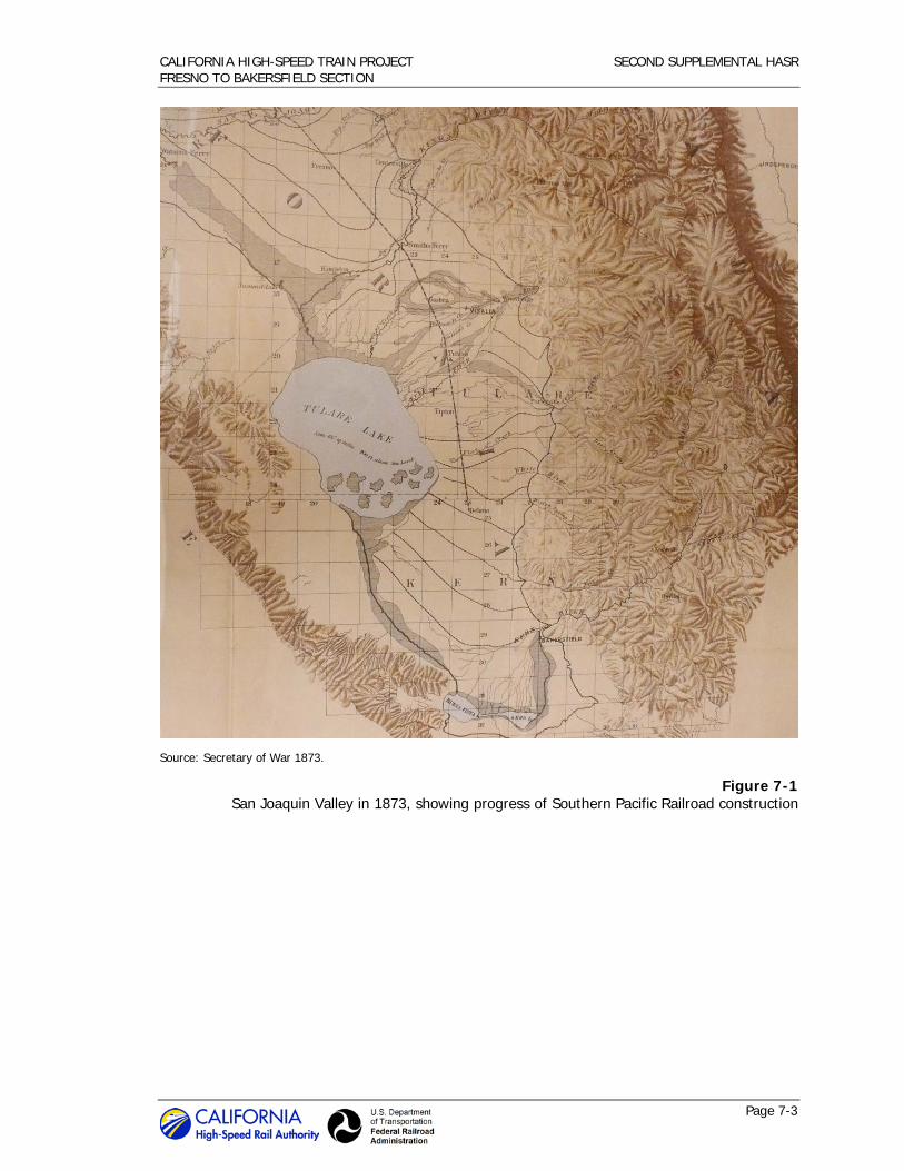
The Southern Pacific Railroad was the first major railroad to build through the Central Valley, where a rail line was desperately needed to tap the rich wheat-producing region at the heart of California and open the sparsely settled southern portion of the valley to development. In 1870, the company pushed the San Joaquin Valley mainline south from Stockton to the Stanislaus River, and the first train entered Modesto on May 5 of that year. Construction pushed southward, such that in May of 1872 the railroad reached Fresno, a town laid out by the Contract and

CALIFORNIA HIGH-SPEED TRAIN PROJECT SECOND SUPPLEMENTAL HASR FRESNO TO BAKERSFIELD SECTION
Page 7-2
Finance Company—the land-development arm of the Southern Pacific. The Southern Pacific continued down the valley, laying tracks east of the Fresno to Bakersfield HST Section over the semi-barren, dusty plains of Kings County, finally entering Kern County and establishing Delano Station, an important shipping point for wool and stock, in July 1873 (Figure 7-1). In April 1874, the railroad resumed work on the line south of Delano to the Kern River, and laid out a new town called Sumner to the east of Bakersfield and initiated rail service there the following August. Sumner was later called Kern, or Kern City, and was eventually annexed to the city of Bakersfield (Bailey 1984: 72–75; Burmeister 1969: 21; Carothers 1934: 47–48, 52–54; Hoover et al. and Kyle 1990: 129; Preston 1981: 128–129; Smith 1976: 175–180; Tinkham 1923: 94).
In 1877, Southern Pacific began construction on the Goshen Division “cross-valley” line, an east-west branch extending from the mainline at Goshen into the fertile Mussel Slough region to the west (Figure 7-1). The company laid 40 miles of track passing through its newly founded town of Hanford, and terminating at Huron. By 1893, Southern Pacific had extended the line to the west toward the Diablo Range, making Coalinga its western terminus (Figure 7-2). The Goshen Division provided transportation of goods and passengers to western Kings and Fresno counties. Construction of the line resulted in the establishment of new towns Hanford, Armona, and Lemoore, but older Mussel Slough settlements such as Kingston and Grangeville were bypassed, and substantially drained of their populations (Williams 1878: 279, 285; Brown and Richmond 1940: 179; Smith 1976: 286-287, 309-310). Armona got another boost in 1891 with the arrival of a new regional railroad line, the San Pablo & Tulare Railroad, which the Southern Pacific quickly bought up. The route ran from its southern terminus in Armona north into Fresno County (Thompson 1891, 1892; Preston 1981: 123, 125).
With these developments, Southern Pacific and its rail and steamboat affiliates held a virtual transportation monopoly in northern California, where the company had instituted a rate policy of “all the traffic will bear.” Anti-railroad sentiment was intense, particularly among the businessmen of San Francisco and farmers of the San Joaquin Valley, who organized into associations to fight control of “The Octopus,” as Southern Pacific was derisively dubbed. These groups of merchants, farmers, and other shippers sought lower freight rates and retribution for the Big Four’s oppression of the small landowners of Mussel Slough, who had resisted Southern Pacific’s uncompromising land acquisition tactics during the 1870s and early 1880s.
One of the most effective responses to the hold of “The Octopus” was the establishment of a new rail company known as the San Francisco and San Joaquin Valley Railway (SF&SJV). The San Francisco Traffic Association, a group of San Francisco merchants who had promoted several waterborne freight operations, decided in 1893 that the only way to free San Francisco and the Valley from the Southern Pacific’s grip was to construct an independent railway from San Francisco Bay down the valley to a connection with the mainline of the AT&SF. The SF&SJV, nicknamed “the People’s Railroad,” would run from Stockton to Bakersfield, generally west of, but substantially parallel to, the Southern Pacific line. After many financing delays, the state issued a charter for the SF&SJV on February 25, 1895 (Bergman 2009: 51–53; Brown 1958: 123–125; Rice et al. 1988: 217–236). The new railroad company opened its mainline between Stockton and Fresno in 1896, pushed south to Hanford and Shafter the following year, and reached its southern terminus in Bakersfield in 1898 (Figure 7-2) (Bryant 1974: 175–178; Storey 1940: 31–39; Vandor 1919: 271). The mainline of the SF&SJV is now operated by the BNSF Railway, and lies within or closely parallels much of the Fresno to Bakersfield HST Section.
CALIFORNIA HIGH-SPEED TRAIN PROJECT SECOND SUPPLEMENTAL HASR FRESNO TO BAKERSFIELD SECTION
Page 7-3
Source: Secretary of War 1873.
Figure 7-1 San Joaquin Valley in 1873, showing progress of Southern Pacific Railroad construction

CALIFORNIA HIGH-SPEED TRAIN PROJECT SECOND SUPPLEMENTAL HASR FRESNO TO BAKERSFIELD SECTION
Page 7-4
Source: Cram 1899.
Figure 7-2 Major rail lines between Fresno and Bakersfield in 1899
7.2 Irrigated Agriculture and Land Colonies
While the railroads opened up vast tracts of unoccupied land to settlement, the establishment of irrigation systems was also central to the transformation of the San Joaquin Valley into a remarkably successful agricultural region. That transformation began with the construction of ditch systems that expanded the zone of cultivation beyond nearby river banks to eventually bring vast areas of otherwise arid land into production, and make specialty agriculture possible. Expansion and diversification of agriculture worked in concert with railroad development, particularly after completion of the first rail line through the valley itself in the early 1870s, which provided a mode for San Joaquin Valley produce to access markets in the Midwest and East.
The first irrigation ditches in the San Joaquin Valley were built in the 1850s by farmers in the Visalia area, and other early diversions were from the Merced River and San Joaquin River, farther to the north. Diversions in and near the Fresno to Bakersfield HST Section date to the early 1870s, and were built by a variety of private and public entities. Private organizations—commercial irrigation companies, land colonies, and mutual water companies—led the water

CALIFORNIA HIGH-SPEED TRAIN PROJECT SECOND SUPPLEMENTAL HASR FRESNO TO BAKERSFIELD SECTION
Page 7-5
development projects until the early 1880s. Beginning in the late 1880s, public entities, including irrigation districts, county water districts, and later, water storage districts, assumed a greater role in designing, building, and administering irrigation systems in the San Joaquin Valley (Adams 1929: 204; Harding 1960: 83–90; JRP Historical Consulting Services 2000: 19–24).
The first cooperative canal companies within the Fresno to Bakersfield HST Section began organizing in the Mussel Slough area of Kings County in 1872. The Mussel Slough District, later known as the Lucerne District, is located within the fertile bottom lands of the Kings River Delta. The region derives its name from Mussel Slough, a natural waterway that branched off from Kings River and meandered in a generally southwesterly direction, passing to the north of Hanford en route to its drainage at Tulare Lake, south of Lemoore. Settlement of the area was sporadic at first, and until the early 1870s, those few who arrived to stake a claim typically ranged cattle or sheep on large, unfenced tracts of grassland. Intensive settlement of Mussel Slough began in earnest after the introduction of irrigation. The first canal to successfully divert water from the Kings River was the Lower Kings River Ditch, built in 1872 by a mutual irrigation company to serve the lands north and east of Lemoore. Other groups of settlers soon followed suit and formed various irrigation companies. Local farmers north of Hanford incorporated the People’s Ditch Company in 1873, and completed the first phase of their works by 1879. Other major canal systems developed during the 1870s were the Last Chance Ditch, providing Kings River water to Grangeville farms; and the Settlers Ditch, which drew water form Cross Creek to irrigate lands east and northeast of Hanford. Later Mussel Slough ditch systems include the Lone Oak Canal, built about 1890 as an offshoot of the Last Chance Ditch (Grunsky 1898: 62-69; Menefee and Dodge 1913: 192-196).
With fertile soil and a reliable and steady supply of water in place, many Mussel Slough farmers began experimenting with new varieties of crops, ushering in an era of agricultural diversification. Traditional farming of grain and alfalfa remained commercially viable into the 1880s and beyond; but increasingly, farmers and ranchers converted acreage to row crops, fruit and nut orchards, vineyards, and dairy farms. The transformation of the landscape was swift. As late as 1885, grain and grazing remained the principal land use in the Mussel Slough district, and lands were still held in relatively large parcels, typically in multiples of 160 acres. Already, though, smaller farms of 20, 40, and 80 acres were prevalent, especially along the lines of the larger irrigation canals (Preston 1981: 124; California State Engineering Department 1885). Within a decade, fruit production had supplanted grain farming as the principal agricultural industry, with grapes, peaches, apricots, prunes, and pears emerging as particularly profitable crops (Lapham and Heileman 1901: 447-449; Preston 1981: 145-147, 158-159). Dairying also emerged as a major industry, thanks in part to improvements in shipping, advancements in refrigeration and production techniques, and availability of alfalfa, an important source of cattle feed (Menefee and Dodge 1913: 136-137). By the turn of the twentieth century, milk production had increased to a level sufficient to support a dairy cooperative, a cheese factory at Hanford, and several area creameries (California 1900: 36; U.S. Census Bureau 1900, 1910a, 1910b; Menefee and Dodge 1913: 196, 207-208).
The division of holdings into smaller, intensively irrigated tracts planted primarily to vines, row crops, and orchards was virtually complete by the early 1890s. By this time, Mussel Slough included a mixture of family and corporate farms, and had earned a reputation as one of the most productive growing districts in the San Joaquin Valley. Its prosperity was reflected in the many Victorian-style homes that dotted the countryside (Preston 1981: 159; Thompson 1891, 1892). In fact, Mussel Slough’s wealth in large part precipitated the formation of Kings County out of western Tulare County in 1893. In the words of one historian: “Already identified as independent rebels by the titular reference to the famous Mussel Slough tragedy, many residents of the future Kings County disliked sending ‘their’ money off to be spent by those in faraway Visalia” (Roberts 2008: 7).
Just south of Mussel Slough country is an agricultural region historically referred to as the “Lakeside District,” so named because of its proximity to now-dry Tulare Lake. The district also

CALIFORNIA HIGH-SPEED TRAIN PROJECT SECOND SUPPLEMENTAL HASR FRESNO TO BAKERSFIELD SECTION
Page 7-6
shares its name with the Lakeside Ditch and its system of branches and laterals, built to bring water from Cross Creek—a branch of the Kaweah River—to irrigate the area south of Hanford and northeast of the lakebed. Local farmers organized the Lakeside Ditch Company in 1874, and completed the main canal in 1875. After the initial irrigation works were completed, Lakeside opened to sustained settlement, and over the next decade developed into a productive agricultural region devoted primarily to the cultivation of alfalfa and cereal grains. Hanford to the north was the principal shipping point, but the small settlement of Guernsey emerged at a station about nine miles to the south after completion of the AT&SF through this part of Kings County in 1897. By this time, acreage previously devoted almost exclusively to grain cultivation was being converted to row crops, fruit and nut orchards, alfalfa fields, and a few dairy farms (Grunsky 1898: 18-20; Menefee and Dodge 1913: 196, 207-208; Brown and Richmond 1940: 176-177; Preston 1981: 124, 142, 146-147; Durham 1998: 1,043).
Another mechanism for bringing irrigation water to arid or unreclaimed lands was the practice of land colony development, a distinctive institution in the San Joaquin Valley that is considered to have been among the more innovative methods of land development of the period. These colonies were tracts of subdivided irrigable land wherein water delivery canals were often built in advance of settlement to service blocks of small-scale family-farm units suitable for growing fruit orchards, vegetables, and vineyards. Colony developers often marketed to prospective buyers nationwide, selling small, roughly 10- to 20-acre farm plots, each supplied with irrigation. Sometimes colony owners directed their sales effort to specific groups with common theologies, or more often, to residents of a certain geographical area, particularly from the Midwest. Settlers in these land colonies typically aspired to achieve an idyllic, homogeneous, rural culture, but vineyard and orchard agriculture in California differed from the family farms of the Midwest. Historian David Vaught has described this manner of agriculture as “specialized, market-oriented, labor-intensive farming.” The principal early crop of the colonies in this area was raisin grapes (Thickens 1946: 26–35; Vaught 1999: 1, 20-25, 53–56, 94, 70–75, 78, 98, 184–186; JRP Historical Consulting Services 2000: 12-15).
The Fresno to Bakersfield HST Section passes through the former Washington Colony, a rural historic landscape district in southern Fresno County (Figure 7-3). Wendell Easton, J.P. Whitney, and A.T. Covell established the colony in 1878 by dividing 7,700 acres of land 8 miles south of Fresno into small farm lots. Its organizers invested heavily in advertising across the country, as well as in Europe and Australia. Sale of 20-acre parcels was slow in the first couple of months of the promotion, but increased so rapidly that six sections were added to the colony by April 1879. By 1882, Washington Colony was the largest colony by acreage in Fresno County. The colony’s agriculture developed quickly too, and by 1885, over 1,000 acres had been planted to grapevines for raisins and to supply local wineries. Other principal crops were apricots, nectarines, peaches, Bartlett pears, and plums (Pacific Rural Press 1883 Apr 14; Truman 1885: 29). The colony purchased water rights from the Fresno Canal and Irrigation Company and each buyer was guaranteed water, which allowed residents to lay out large farms and vineyards (Harvey 1907; Thickens 1946: 32–35; Thompson 1891).2
2 The Washington Irrigated Colony Rural Historic Landscape is a determined eligible rural historic
landscape district. For information about the district, see Appendix D of this Second Supplemental HASR. In addition, the revised APE includes a Neoclassical residence at 7870 S. Maple Avenue (Reference: 335-110-11) built in the Washington Colony in 1911 that is eligible for listing in the NRHP as a contributor to the determined eligible rural historic landscape district.

CALIFORNIA HIGH-SPEED TRAIN PROJECT SECOND SUPPLEMENTAL HASR FRESNO TO BAKERSFIELD SECTION
Page 7-7
Source: Thickens 1946.
Figure 7-3 Land colonies in the vicinity of Fresno
Land development companies and land colonies also played a role in the agricultural development of the Bakersfield area, in the southern portion of the Fresno to Bakersfield HST Section. The efforts of one company in particular, the Kern County Land Company (KCL), were notable. Formed in 1890, KCL aggregated vast swaths of Kern County property that James B. Haggin, Lloyd Tevis, and William Carr had accumulated since the 1870s. With a mission to subdivide and sell tracts of land to small farmers, KCL used the colony concept to market and develop its lands. The company advertised large subdivisions, or colonies, as agricultural communities featuring 20-acre lots primed for settlement. In order to make their land development company more profitable, Haggin, Tevis, and Carr also developed some of region’s largest and most important irrigation systems, which were folded into KCL in the early 1890s under a canal and water subsidiary company. KCL owned and operated the canals, selling water to individual farmers who had purchased tracts in its colonies (Baldwin 1916: 41, 88–90; Berg 1971: 43; Morgan 1914: 115-116, 148-152, 175-176).
One of KCL’s first subdivisions was the 12,000-acre Rosedale Colony. The Fresno to Bakersfield HST Section passes through a portion of the former Rosedale Colony, now a suburb of western Bakersfield. Under the management of S.W. Fergusson, KCL extensively advertised Rosedale as an agricultural colony, but had to declare the venture a failure after flooding and a subsequent drought in 1893-1894 stifled settlement, and inexperienced farmers improperly managed irrigation water from KCL’s canal. Despite these setbacks, development of Rosedale resumed in the early twentieth century, with land owners and speculators further subdividing many of the

CALIFORNIA HIGH-SPEED TRAIN PROJECT SECOND SUPPLEMENTAL HASR FRESNO TO BAKERSFIELD SECTION
Page 7-8
remaining larger tracts into smaller agricultural plots and residential parcels (Morgan 1914: 115-116, 175-176).
7.3 Events and Trends of the Twentieth Century
Since the turn of the twentieth century, additional events and trends have influenced the development of the Fresno to Bakersfield HST Section: the discovery and exploitation of Kern County oil fields, federal-state water development projects, and adoption of the automobile as the primary mode of transportation in the United States and the Central Valley. Although these changes were distinct and important, their overall effect on the corridor was to intensify and expand the land settlement patterns already established by the end of the nineteenth century. The agricultural identities of the rural areas of southern Fresno County, Kings County, and northern Kern County remained generally intact, although new crop types such as cotton and potatoes were introduced, and the dairy industry rose to prominence. The twentieth century also ushered in a period of expansion of urban boundaries, which resulted in more densely settled residential and industrial areas on the peripheries of Fresno and Bakersfield in particular, but also around the smaller communities of Hanford, Armona, and Shafter.
The historic architectural survey population for this Second Supplemental HASR includes many farmsteads, residences, housing tracts, and commercial and industrial buildings that date to the twentieth century. These complexes and individual buildings are located throughout the Fresno to Bakersfield HST Section corridor—within or near the larger urban centers including Fresno, Shafter, and suburban Bakersfield, as well as in predominantly rural areas such as the former Washington Colony in southern Fresno County, and Mussel Slough and Lakeside districts in Kings County. Mixed-use development was evident in southern Fresno along the Golden State Avenue and Highway 99 corridors, where twentieth century growth was a combination of commercial and light industrial and residential. In the Bakersfield-area community of Rosedale, most new development was residential in nature, with numerous housing tracts developed, often on former agricultural land. In the largely rural expanses between these dense urban nodes, building stock encountered within the Second Supplemental HST revised APE was overwhelmingly agricultural and residential, with several properties including aspects of both – family homes placed alongside barns, silos, and other farm-related buildings and structures. The following section will discuss developments along the study corridor from north to south, beginning with Fresno County, then continuing into Kings and Kern counties.
7.3.1 Fresno County
The revised APE for this Second Supplemental HASR includes properties in the urbanized area of southern Fresno, as well as several rural properties in the southern reaches of the county. The urban properties are located in an area historically known as Calwa City, a junction point along the AT&SF about one mile south of the original downtown grid of Fresno. In the late 1890s Calwa City still had a distinct agricultural character, but by the turn of the century this area was also being influenced by a growing urban and suburban population and expansion from Fresno to the north (Bergman 2009: 52; Vandor 1919: 273) Residential development rose as early subdivisions, such as the Darling Addition (1888) began to sell, while others, like the adjacent Belgravia Addition (1909) were newly created or re-subdivided. The proximity to the railroad also attracted farms and agricultural processing plants, which began to populate this area at the turn of the century (Fresno County Recorder 1888, 1909; USGS 1923; Britton & Rey 1901; Sanborn Map Company 1919:95-96; USAAA 1937).
Development picked up during the mid-twentieth century as the state moved and expanded the Golden State Highway, the primary automobile corridor through the Central Valley. Between 1946 and 1948 the State Highway (Golden State Boulevard) was rerouted from following existing surface streets to a new dedicated route about one block parallel and southwest of the rail

CALIFORNIA HIGH-SPEED TRAIN PROJECT SECOND SUPPLEMENTAL HASR FRESNO TO BAKERSFIELD SECTION
Page 7-9
corridor; this development spurred industrial construction between the tracks and the new freeway (USAAA 1937; USGS 1946). Completion of the highway in 1948 resulted in a formal recognition of the industrial nature of the area when the county zoned the area south of Church Avenue adjacent to the highway for light and heavy industry (Bangs 1949). The current Highway 99 freeway replaced the Golden State Highway in about 1963 and industrial development in the area continued at a steady pace (USDA 1961; USGS 1963).3
The built environment resources within the supplemental APE reflect the mixed-use character of twentieth-century historical development in the Calwa area. Four properties are residential, located within the Darling Addition, a subdivision platted in 1888 that grew slowly into the twentieth century (Fresno County Recorder 1888). The Darling Addition was originally divided into 252 small lots of 0.07 acres or smaller, although most buyers acquired and built on multiple lots. Development was initially slow; even by the late 1910s, only about half of the tract was populated with buildings (Fresno County Recorder 1888; USGS 1923; Britton & Rey 1901; Sanborn Map Company 1919:95-96). Since that time, the subdivision has become increasingly populated with light-industrial and commercial properties. The houses in the subdivision feature an eclectic mix of architectural styles that reflect the gradual growth, ranging from revival-period and Craftsman styles, to Minimal Traditional and Ranch styles. The subdivision remains a small, mostly residential pocket amid a surrounding industrial district, which includes another the Fresno to Bakersfield HST Section corridor property, a warehouse complex located to the south, that was developed in the aftermath of highway construction in the 1940s (USAAA 1937; USDA 1950; Sanborn Map Company 1948: 95-96; Sanborn Map Company 1950: 95-96).4
South of Fresno, the portion of southern Fresno County that is crossed by the Fresno to Bakersfield HST Section corridor generally retained its agricultural heritage in the twentieth century, although the region was not immune to modernization. For example, in the lands encompassed by the Washington Irrigated Colony, irrigation methods changed after 1910 as farmers began to rely heavily on pumping underground water using centrifugal pumps, rather than on the irrigation water provided through the Washington Colony canals (Weitze 1990b: 3). This marked the beginning of a shift in the types of crops planted in the colony (Weitze 1990a: 1). Development of Washington Colony continued to generally retain its pattern of small agricultural holdings, but the built environment evolved and continued to change throughout the twentieth century as new houses were built and old ones demolished or renovated, a trend that accelerated in the prosperous post-World War II era.5
South of the Washington Colony, two entirely new communities, Monmouth and Conejo, were established as shipping points along the AT&SF line, which arrived in the region in the late 1890s. This unincorporated part of southern Fresno County was initially settled in the 1870s with the arrival of the Southern Pacific rail line to the east in 1872, but the western portion of the county
3 The property at 3589 E. Jensen Avenue (Reference 480-020-76) is a light-industrial warehouse
located within the revised APE and built in 1954, see Appendix E for DPR 523 form. 4 Four properties were developed in the Darling Addition during the early and mid twentieth century.
Examples include the Tudor-style residence at 2308 S. East Avenue (Reference: 480-154-05), built circa 1939, and the Vernacular Bungalow at 2314 S. East Avenue (Reference: 480-154-07), developed circa 1910. See Appendix E.
5 Four properties within the revised APE were developed in the twentieth century in the Washington Irrigated Colony, including a Craftsman-style residence and auxiliary farm buildings at 6854 S. Maple Avenue (Reference: 334-310-30) developed circa 1914; a Craftsman-style residence at 6072 S. Maple Avenue (Reference: 334-250-09) built circa 1925; and two Ranch-style residences at 6876 S. Cedar Avenue (Reference: 334-310-21), built in 1953, and 6816 S. Maple (Reference: 334-310-49), built in 1960. These properties are not contributors to the Washington Irrigated Colony Rural Historic Landscape because they were built after the period of significance. They also are not individually eligible for listing in the either the NRHP or CRHR. See Appendix E.

CALIFORNIA HIGH-SPEED TRAIN PROJECT SECOND SUPPLEMENTAL HASR FRESNO TO BAKERSFIELD SECTION
Page 7-10
was still sparsely populated at this time. Conejo was established in 1906 in an agricultural district previously known as Wildflower. Local settler Margaret Burnett filed a plat map for the new town, which was laid out across the tracks from the AT&SF depot and was only one block deep. The Berry Improvement Company marketed and sold the individual town lots, which gradually infilled with a mixture of a few commercial and residential buildings surrounding the intersection of South Peach Avenue, Conejo Avenue, and the railroad tracks (Fresno County Recorder 1906; Progressive Map Service 1907; Polk Husted 1908-9). Charles P. Avenell platted the town of Monmouth a short distance to the north of Conejo in 1908. Monmouth was and remains small, consisting of a mix of residences, warehouses, and other light industrial buildings clustered around the northeast corner of the intersection of the AT&SF tracks and Nebraska Avenue (Fresno County Recorder 1908; Bergman 2009: 51-57). The four properties in the Monmouth/Conejo area are all located in the agricultural districts surrounding these two small communities.6
7.3.2 Kings County
The mixed land use that characterized the Mussel Slough and Lakeside districts at the end of the 1800s persisted into the twentieth century. The larger population centers mushroomed, as they transitioned from agricultural towns along the railroad into self-sustaining and economically diverse cities. This trend was most pronounced in Hanford, the seat of Kings County, whose population grew from less than 3,000 in 1900 to nearly 50,000 by the end of the century. The community of Armona, west of Hanford, also grew in population and expanded beyond its nineteenth-century street grids and into the surrounding countryside (USGS 1926, 1954b; USDA 1961; Preston 1981: 236). Residential building stock scattered throughout the rural surroundings and on the peripheries of these towns reflected twentieth century architectural styles such as Craftsman, Spanish Eclectic, Minimal Traditional, and Ranch.7
Diversified agriculture remained the region’s principal industry throughout the decades leading up to the Second World War. Small family farms of 10, 20, or 40 acres coexisted with larger corporate enterprises, and principal products were dairy products, orchard fruits, raisin grapes, grains, and alfalfa and other types of feed (McIntire 1908; Kings County Abstract Company 1923; Preston 1981: 184, 205). The dairy industry in particular prospered in the Lakeside district in the early decades of twentieth century, and surrounding fields were typically planted to alfalfa, corn, and other crops. Area orchardists, dairy ranchers, and general farmers had numerous outlets for their products. Mussel Slough communities of Hanford, Armona, Grangeville, and Hardwick offered fruit drying and packing houses, wineries, creameries, cheese factories, flour mills, and shipping facilities on two major railroad lines. Although many agricultural products were shipped by rail to San Francisco, Los Angeles, and other distant markets, there was also a strong local market for truck farmers and home dairies (Dewey 1901: passim; Menefee and Dodge 1913:
6 The Conejo and Monmouth communities include a nineteenth century property and three twentieth
century properties within the revised APE, all of which are not eligible because they lack historical significance and/or integrity (see Appendix E of this Second Supplemental HASR). The Folk Victorian farmstead at 3148 E. Nebraska Avenue (Reference: 385-020-56) developed circa 1885 also includes a tank house. The farmstead at 3183 E. Nebraska Avenue (Reference: 385-051-01) features a Craftsman-style residence and tank house initially developed around 1907. A farm complex at 4033 E. Conejo Avenue (Reference: 385-110-32) features several buildings, including a Craftsman-style residence and tank house. Finally, the Ranch-style residence at 2163 Floral Avenue (Reference: 042-230-16), constructed in 1950, features pumice-brick construction, a popular alternative construction method used throughout the San Joaquin Valley during the mid twentieth century.
7 Within the revised APE, two properties were developed in the twentieth century in the Mussel Slough District of Kings County: the property at 12406 Hanford Armona Road (Reference: 011-010-026-000) was constructed about 1925 and is an example of Craftsman style residential architecture, while the property at 13151 12th Avenue (018-241-022-000) is a Ranch-style residence built in 1962. See Appendix E.

CALIFORNIA HIGH-SPEED TRAIN PROJECT SECOND SUPPLEMENTAL HASR FRESNO TO BAKERSFIELD SECTION
Page 7-11
196, 207-208; Brown and Richmond 1940: 152-154; Hanford Sentinel 1973 Feb 24; Preston 1981: 147, 205; Roberts 2007: 38, 54; Roberts 2008: 108-110, 119).8
7.3.3 Kern County
Like Kings County, the twentieth-century architectural resources within the Fresno to Bakersfield HST Section in Kern County are related to agricultural and residential developments.
Near the county’s northern border are two agricultural parcels with residential components that date to the mid twentieth century. Both properties are located several miles west of Delano, which was established in 1873 along the Southern Pacific Railroad tracks, opening the area to settlement and encouraging wheat and sheep raising (Morgan 1914: 90, 182). The lands west of Delano had heavy soils that inhibited early settlement, but the sinking of artesian wells in the area attracted investment, and the Smyrna Colony was platted in 1887. Water distribution proved difficult, and the colony failed in the early twentieth century (California State Engineering Department 1885; Kern County Recorder 1887;The Daily Californian 1906 Nov 29; Bakersfield Californian 1912 Mar 6).9
The arrival of the AT&SF gave the region the boost it required. Small towns sprouted up along the tracks, including Kernell, established by the railroad about seven miles west of Delano, and Pond, which was founded in the early 1900s around the intersection of Pond Road and Central Valley Highway (State Route 43). These stations provided an outlet for stock farmers in the area, which remained the backbone of the local agricultural industry well into the twentieth century (Bergman 2009: 57; USGS 1929; USDA 1937). After World War II, however, large, high-volume irrigation canals, like the Friant-Kern Canal, were built, which helped offset dwindling underground water sources and provided expanded agricultural opportunities for the region. While remaining relatively sparse, the population in the area increased and scattered sections of land were converted to crop-based agriculture (Burmeister 1969; Wasco News 1982 May 12).
Further south, the aforementioned Kern County Land Company was the driver early twentieth century agricultural developments in the region surrounding what is now Shafter. In 1913, KCL subdivided 7,000 acres of land along the alignment of AT&SF into farming tracts, drilled some demonstration irrigation wells, and platted Shafter. The surrounding agricultural district initially developed as a sugar beet producing area irrigated by groundwater pumping, and became known for cotton, and eventually almond, pistachio, and potato cultivation. Agriculture has continued to be the predominant regional land use, and Shafter has remained the principal service center for area farms (Morgan 1914: 151; Comfort 1934: 203, 236-239; San Joaquin Light and Power Magazine 1915: 609).
The two Fresno to Bakersfield HST Section corridor properties in the Shafter area are both residences located on former KCL lands. One, a Ranch-style adobe brick home, was built in the 1930s on a residential lot at the corner of Shafter and Jack avenues, located due north of the city. The other residence was built in the 1940s in Hights Corner, a subdivision on the west side of the AT&SF tracks at 7th Standard Road, located about five miles southeast of Shafter. Individual lots in the subdivision were less than an acre in size, and typically featured a residence fronting the main access road and small family farm to the rear. A light industrial area has developed east of the tracks since the early 2000s and includes the sprawling Target Distribution
8 One property within the revised APE was developed within the Lakeside District during the twentieth
century: 9850 Kansas Avenue (Reference: 028-201-009-000) was developed around 1920 as a dairy farm. See Appendix E.
9 These two properties in northern Kern County within the revised APE include 28592 Peterson Avenue (Reference: 047-350-11), which was developed circa 1950, and 28384 Highway 155 (Reference 047-110-20), initially developed in 1954. See Appendix E.

CALIFORNIA HIGH-SPEED TRAIN PROJECT SECOND SUPPLEMENTAL HASR FRESNO TO BAKERSFIELD SECTION
Page 7-12
Center complex (Bakersfield Californian 1950 Mar 24, 1952 Aug 11; USDA Aerials 1937, 1952; USGS Rosedale 1933, 1954a, 1968; Target Stores 2001).10
In the Bakersfield area of Kern County, the arrival of the AT&SF and the Kern River oil boom of May 1899 initiated a period of rapid urban development that carried into the twentieth century. On the western side of Bakersfield, northwest of the Kern River, development of the Rosedale area accelerated in the twentieth century. After the Rosedale Colony venture failed in the 1890s (see discussion above), landowners and speculators began subdividing the remaining large parcels into smaller agricultural and residential lots – and later, laying out housing tracts. The subdivision of land in this area was common in the middle years of the twentieth century, as population pressures from the growing city of Bakersfield transformed the area from a rural agricultural region to an increasingly suburban extension of the metropolitan area (Stegeman 1918; Wise, 1933; Kern County ESS 1946, 1952; USGS 1912, 1954a, 1968).
The supplemental APE includes four parcels that were originally part of a larger Rosedale-area tract owned by farmers Philip P. and Katherina Bender (Kern County Recorder 1938; U.S. Census 1920, 1930). During the 1940s, the southern portion of the Bender property that fronted Rosedale Highway was subdivided into multiple residential-sized lots, and over the next decade the former farm evolved into a neighborhood consisting of modest residences of a variety of architectural styles popular at the time. By the end of the 1960s this process had greatly intensified, and in 1970 and 1971 the land surrounding the small strip of residential development was subdivided into 87 approximately one acre parcels (Kern County ESS 1970, 1971). Within five years residences had been built on the majority of these parcels, and much of the surrounding area was suburban in nature. The substantial development in the Rosedale Highway corridor paralleled the growth of Bakersfield, whose population rose from under 5,000 in 1900 to nearly 70,000 in 1970. Much of this growth was channeled in previously agricultural areas west of the city, including along the Rosedale Highway corridor (Kern County ESS 1975; California State Data Center 2011).11
10 The revised APE includes two properties in the Shafter area: the California Adobe Ranch–style
residence at 17005 Shafter Avenue (Reference: 072-210-61) was developed in 1937 and the Minimal Traditional house at 32166 7th Standard Avenue (Reference: 091-270-24) was built in the 1940s. See Appendix E.
11 The four properties within the revised APE that were developed in the Rosedale area include the former Munzer School house at 11846 Rosedale Highway (Reference: 465-060-08) that was built circa 1920 and moved to its current site circa 1950, where it has been used as a residence. Additionally, the former detached garage at 11808 Rosedale Highway (Reference 465-060-10) was built in 1948 and later converted to primary residence on the parcel when the former residence was demolished. The Bungalow-style residence at 11828 Rosedale Highway (Reference: 465-060-09) was developed in 1946 while the Ranch-style residence and warehouse property at 1500 Coffee Road (Reference: 368-040-04) was built starting circa 1954. See Appendix E.
Chapter 8.0 Properties Identified – Findings


CALIFORNIA HIGH-SPEED TRAIN PROJECT SECOND SUPPLEMENTAL HASR FRESNO TO BAKERSFIELD SECTION
Page 8-1
8.0 Properties Identified – Findings
This HASR has been prepared as part of project compliance with the Section 106 PA and applicable sections of the NHPA and its implementing regulations of the Advisory Council on Historic Preservation as these pertain to federally funded undertakings and their impacts on historic properties. All historic architectural resources were also evaluated in accordance with Section 15064.5(a)(2)–(3) of the CEQA Guidelines using the criteria outlined in Section 5024.1 of the California Public Resources Code. This HASR will be submitted to the California SHPO for concurrence with the adequacy of the APE and with the identification and evaluation findings.
This section summarizes the inventory and evaluation of 25 historic architectural resources addressed in this Second Supplemental HASR. The survey population of built environment resources are those resources built in 1963 or before, and they reflect the major themes discussed in Chapter 7.0, Historic Context. The context explores the major historic events and trends that occurred within the study corridor, which extends from just south of downtown Fresno, through rural Kings and Tulare counties, and terminates in unincorporated Kern County, east of Bakersfield. The survey population resources are located throughout the study corridor: 14 properties in Fresno County, 3 in Kings County, and 8 in Kern County. There were no resources identified in Tulare County within the revised APE.
Of the 25 survey population architectural resources, one property (the landscape district) has been previously determined eligible for listing in the NRHP and CRHR, and received SHPO concurrence. The remaining 24 historic architectural resources surveyed for this Second Supplemental HASR are not eligible for listing in the NRHP or CRHR, but required study under the HST Section 106 PA. Section 8.1 includes a brief description of the eligible property (applicable NRHP/CRHR criterion or criteria; level of historical significance; period of significance; character-defining features; and historic property boundaries). Non-eligible resources (including those that were evaluated using streamlined documentation) are summarized by a description of the general range of construction types, uses, and ranges of construction dates (Section 8.2). There were no “CEQA-only” properties (i.e., resources not eligible for the NRHP, but considered historical resources for the purposes of CEQA) identified within the supplemental APE.
Detailed descriptions and evaluations may be found in the respective DPR 523 forms, which are attached in Appendix D (eligible properties) and Appendix E (ineligible resources).
8.1 Properties Identified as Eligible for the NRHP
The survey conducted for this Second Supplemental HASR identified one additional contributing element of an existing NRHP historic landscape district, as shown in Table 8-1. The residence at 7870 S. Maple Avenue (APN: 33511011) is a contributor to the Washington Irrigated Colony Rural Historic Landscape, in Fresno County. This residence is also eligible for listing in the CRHR as a contributor to the district, and is considered an historical resource for the purposes of CEQA.
The Washington Irrigated Colony Rural Historic Landscape is an historic district based on a nineteenth-century irrigated colony development, and was identified in the original HPSR and updated in the first Supplemental HPSR (Authority and FRA 2011b and 2012b). SHPO concurred in the identification and update of the landscape district in their letter of February 6, 2012 (Appendix C). The property description and evaluation required updating as part of this Second Supplemental HASR to reflect changes in the APE that occurred since the previous HST studies were prepared. Refinements to the project footprint brought the farmstead at 7870 S. Maple Avenue into the APE for this Second Supplemental HASR.
A study conducted in 1990-1992 concluded that the former Washington Irrigated Colony in southern Fresno County appeared eligible for listing in the NRHP as a rural historic landscape

CALIFORNIA HIGH-SPEED TRAIN PROJECT SECOND SUPPLEMENTAL HASR FRESNO TO BAKERSFIELD SECTION
Page 8-2
district with a period of significance of 1878 to 1910 (Weitze 1990a-b). The study found the landscape district significant for its association with settlement patterns and architecture (NRHP Criteria A and C). At the time of its identification in the 1990s, contributors to the district consisted of 6,520 acres within the district boundaries (planted in raisin grapes, historically consistent fruit and nut trees, oranges, and onions; dairy and pastureland; eucalyptus groves; tule ponds; minor remaining street trees); 55 farmsteads; approximately 22 linear miles of open earthen canals; the north-south, east-west grid platted for the colony; and the Santa Fe railroad line (1898), running north-south between Cedar and Maple Avenues. The study identified 522 post-1910, non-contributing buildings and 1,060 non-contributing acres within the original boundaries of the Washington Irrigated Colony. Most of the non-contributing acreage is around Easton, which is not in the revised APE for this project. Refer to the DPR 523 Update Form and the 1990-1992 evaluation (Appendix D) for more information about the Washington Irrigated Colony Rural Historic Landscape and its contributing elements.
It is the conclusion of the present study that the farmstead at 7870 S. Maple Avenue is a contributing element of the Washington Irrigated Colony Rural Historic Landscape, and that the property does not individually meet the criteria for listing in the NRHP or CRHR. The contributing property is eligible at the local level of significance, under NRHP Criteria A and C and CRHR Criteria 1 and 3. Of the buildings on this parcel, only the 1911 Neoclassical residence is a contributing element of the district.12 A secondary residence, shed, and shade structures on the parcel were built well after the district’s period of significance and are not contributing elements of the district. The elements that contribute to the significance of this property – its character-defining features – include the general agricultural setting of the property, surrounded by fields and other rural farmsteads; its setback location on the parcel; and its orientation to South Maple and East avenues. The elements that define the house as of the Neoclassical style include its one-story hip-roof form, symmetrical façade, prominent gable dormers with round vents, full-width porch with square columns, horizontal wood siding, double-hung wood sash windows, and cutaway bay window (Figure 8-1). Non-contributing elements of the house include a modern brick chimney and roof-mounted solar panels.
The boundary for this historic property / historical resource as part of the Washington Irrigated Colony Rural Historic Landscape, is both the parcel on which this property sits and the previously defined historic district boundaries.
12 While historical research for this present project shows that the 7870 South Maple Avenue was built
in 1911 – one year after the end of the landscape district’s period of significance – the present study concurs with the 1992 evaluation that the property is a contributor. The 1910 end of significance date was an estimate based on a number of historical trends that began to shift around that period. It is clear, therefore, that this residence constructed in 1911 was still influenced by and important to the significant pioneering settlement patterns and architecture of the Washington Irrigated Colony.

CALIFORNIA HIGH-SPEED TRAIN PROJECT SECOND SUPPLEMENTAL HASR FRESNO TO BAKERSFIELD SECTION
Page 8-3
Figure 8-1 Residence at 7870 S. Maple Avenue, Contributor to the Washington Irrigated Colony Rural
Historic Landscape, Fresno County
Table 8-1 Historic Property (Historical Resource) Previously Determined Eligible for the NRHP
Map ID# APN/DPR Form Address City County
Year Built CHRS Code
Map Sheet
10 33511011 7870 S. Maple Avenue, contributing element Fresno Fresno 1911 3D 29
Updated
Landscape DPR Form
Washington Irrigated Colony Rural Historic Landscape Fresno 1878-
1910 2 23-29
APN = Assessor Parcel Number CHRS = California Historical Resource Status 2=determined eligible for listing in the National Register (NR) or California Register (CR) 3D=appears eligible for NR as a contributor to a NR eligible district through survey evaluation
8.2 Properties Identified as Not Eligible for the NRHP
A total of 24 historic architectural resources surveyed for this Second Supplemental HASR have been determined not eligible for listing in the NRHP or CRHR. Although the APE for this study traverses four counties, the ineligible resources are located in only three: the majority (13) are in Fresno County; three are in Kings County; and eight are in Kern County. No resources were identified in Tulare County within the supplemental APE.

CALIFORNIA HIGH-SPEED TRAIN PROJECT SECOND SUPPLEMENTAL HASR FRESNO TO BAKERSFIELD SECTION
Page 8-4
The resources within the survey population reflect the major historical events and trends previously described. These historic architectural resources are not eligible for listing in the NRHP or CRHR because they lack historical or architectural significance. None was found to be significant within the contexts of agricultural or residential development patterns, for associations with important persons, or as an important example of a type, period, or method of construction, or work of a master designer.
Nearly all of the survey population properties date to the twentieth century. Only one dates to the latter half of the nineteenth century: a farmstead in rural Fresno County with a Folk Victorian residence and attached tank house built circa 1885, as well as a garage and other outbuildings built at later dates (Reference: APN 38502056). Not only does the property lack significance, it has undergone numerous major changes that have combined to substantially reduce the integrity of the property to its late nineteenth and early twentieth century appearance. The residence has recently received new siding, replacement vinyl windows throughout, an expanded and modernized wraparound porch, and modern doors. Likewise, the garage has replacement modern siding, modern garage doors and a modified function.
Of the twentieth-century properties, 15, or about 65%, date to (or include elements that date to) the first half of the twentieth century. All of these properties contain single- or multiple-family residences that reflect architectural styles popular during the period, such as Craftsman and Vernacular Bungalows, Neoclassical, Tudor, Spanish Colonial Revival, and Minimal Traditional. All but one is of wood frame construction and feature wood materials for siding, windows, and roofing. The exception is an adobe brick residence built near Shafter, Kern County in 1937 (Reference: APN 07221061). About half of these early twentieth century resources are located in rural, agrarian regions of Fresno, Kings, and Kern counties, and feature an agricultural component, varying from an outbuilding or barn to a collection of farm buildings and structures. The other half of the resources are strictly residential, and most of these are located on relatively small lots within formal subdivisions or housing tracts, including: the Darling Addition, laid out just south of Fresno in 1888 (Reference: APN 48015406); Hights Corner, established near Shafter in the 1940s (Reference: APN 09127024); and on a subdivision of the former Bender family ranch in the Rosedale area west of Bakersfield (Reference: APN 46506009).
The remaining eight twentieth-century properties (about 35%) were built in the 1950s or early 1960s. One, a light industrial property in southern Fresno, includes several metal frame warehouses with corrugated metal siding (Reference: APN 48002076). The rest are residential, and overwhelmingly favor the Ranch style of architecture, which was widely popular throughout California during decades following World War II. One of these residences, located on an agricultural parcel in rural Fresno County, is of pumice brick construction (Reference: APN 04223016). The rest retained wood framing used in earlier styles, but featured a wider variety of materials for siding (stucco, brick and stone veneer), roofing (asphalt shingles), and windows (steel and aluminum).
As was the case for the properties that date to the first half of the century, these post-war properties are more-or-less evenly distributed between rural and urban settings. Most, however, are on smaller lots dedicated to residential use, and lack agricultural components, though they may be surrounded by parcels containing orchards or fields planted to row crops.
The locations, reference numbers, and construction dates of these ineligible buildings are listed in Table 8-2.

CALIFORNIA HIGH-SPEED TRAIN PROJECT SECOND SUPPLEMENTAL HASR FRESNO TO BAKERSFIELD SECTION
Page 8-5
Table 8-2 Historic Architectural Resources Evaluated as Not Eligible for the NRHP for Which SHPO
Concurrence Is Requested (arranged by APN by County)
Map ID#
APN/DPR Form Address City County Year Built
CHRS Code
Map Sheet
1 48015405 2308 S. East Avenue Fresno Fresno ca. 1939 6Z 10
2 48015406 2312 S. East Avenue Fresno Fresno ca. 1918 6Z 10
3 48015407 2314 S. East Avenue Fresno Fresno ca. 1910 6Z 10
4 48015409 2324 S. East Avenue Fresno Fresno 1940 6Z 10
5 48002076 3589 E. Jensen Avenue Fresno Fresno 1954 6Z 13
6 33425009 6072 S. Maple Avenue Fresno Fresno 1925 6Z 25
7 33431049 6816 S. Maple Avenue Fresno Fresno 1960 6Z 27
8 33431021 6875 S. Cedar Avenue Fresno Fresno 1953 6Z 27
9 33431030 6854 S. Maple Avenue Fresno Fresno 1914 6Z 27
11 04223016 2163 Floral Avenue Fresno Fresno 1950 6Z 34
12 38502056 3148 E. Nebraska Avenue Fresno Fresno ca. 1885 6Z 36
13 38505101 3183 E. Nebraska Avenue Fresno Fresno ca. 1907 6Z 36
14 38511032 4033 E. Conejo Avenue Selma Fresno 1924 6Z 41
15 011010026000 12406 Hanford-Armona Road Hanford Kings ca. 1925 6Z 117
16 018241022000 13151 12th Avenue Hanford Kings 1962 6Z 123
17 028201009000 9850 Kansas Avenue Hanford Kings ca. 1920 6Z 137
18 04711020 28384 Highway 155 Delano Kern 1954 6Z 222
19 04735011 28592 Peterson Road Wasco Kern ca. 1950 6Z 250
20 07221061 17005 Shafter Avenue Shafter Kern 1937 6Z 287
21 09127024 32166 7th Standard Road Shafter Kern 1940s 6Z 335
22 46506008 11846 Rosedale Highway Bakersfield Kern ca. 1920 6Z 347
23 46506009 11828 Rosedale Highway Bakersfield Kern 1946 6Z 347
24 46506010 11808 Rosedale Highway Bakersfield Kern 1948 6Z 347
25 36804004 1500 Coffee Road Bakersfield Kern ca. 1954, ca. 1958 6Z 354
APN = Assessor Parcel Number CHRS = California Historical Resource Status 6Z=found ineligible for NR, CR, or Local designation through survey evaluation
CALIFORNIA HIGH-SPEED TRAIN PROJECT SECOND SUPPLEMENTAL HASR FRESNO TO BAKERSFIELD SECTION
Page 8-6
This page intentionally left blank

Chapter 9.0 References


CALIFORNIA HIGH-SPEED TRAIN PROJECT SECOND SUPPLEMENTAL HASR FRESNO TO BAKERSFIELD SECTION
Page 9-1
9.0 References
Note: this section includes references cited in the text of this HASR; for the citations in the DPR 523 forms, refer to the individual forms that are attached to the report in Appendices D and E.
Adams, Frank. 1929. Irrigation Districts in California, Bulletin No. 21. Sacramento, California: State of California Department of Public Works.
Bailey, Richard. 1984. Heart of the Golden Empire: An Illustrated History of Bakersfield. Woodland Hills, California: Windsor Publications, Inc.
Bakersfield Californian.
1912. Mar 6
1950 Mar 24. “Wanted Check Suspects Seized by Kern Officers.” Bakersfield Californian; 21 (col. 5).
1952 Aug 11. “Alfalfa Plant Nearly Ready.” Bakersfield Californian; 15 (col. 4).
Baldwin, George H. 1916. Water Rights on Kern River. Berkeley, California: MS G4562/D1 Water Resources Center Archives, University of California, Berkeley.
Bangs, Robert L. 1949, Nov.-Dec. “Boost for Freeways,” California Highways and Public Works. Vol 28, No 11-12.
Berg, Norman. 1971. A History of Kern County Land Company. Bakersfield, California: The Kern County Historical Society.
Bergman, John. 2009. The Southern San Joaquin Valley, A Railroad History: Fresno to Bakersfield. Visalia, California : Jostens Printing & Publishing Co.
Britton & Rey. 1901. Bakersfield, Kern County, California [bird's eye view]. San Francisco: N.J. Stone Co.
Brown, J.L. 1958. The Mussel Slough Tragedy.
Brown, Robert R. and J.E. Richmond (editors). 1940. History of Kings County. Hanford, California: A.H. Cawston.
Bryant, Keith L. 1974. History of the Atchison, Topeka and Santa Fe Railway. New York: Macmillan.
Burmeister, Eugene. 1969. City Along the Kern — Bakersfield, California, 1869-1969: A Centennial Publication in Limited Edition. Bakersfield, California: Kern Publishing House.
California. 1900. Third Report of the State Dairy Bureau to the Governor of the State of California. Sacramento: State Printing Office.
California High-Speed Rail Authority. 2013. “HASR Annotated Outline” Technical Memorandum
California High-Speed Rail Authority and USDOT Federal Rail Authority (Authority and FRA). 2011a. California High-Speed Train Fresno to Bakersfield Historic Architectural Survey Report (HASR). Sacramento and Washington, DC: California High-Speed Rail Authority and USDOT Federal Railroad Administration.

CALIFORNIA HIGH-SPEED TRAIN PROJECT SECOND SUPPLEMENTAL HASR FRESNO TO BAKERSFIELD SECTION
Page 9-2
_______. 2011b. California High-Speed Train Fresno to Bakersfield Historic Property Survey Report (HPSR). Sacramento and Washington, DC: California High-Speed Rail Authority and USDOT Federal Railroad Administration.
_______. 2012a. California High-Speed Train Fresno to Bakersfield Supplemental Historic Architectural Survey Report (HASR). Sacramento and Washington, DC: California High-Speed Rail Authority and USDOT Federal Railroad Administration.
_______. 2012b. California High-Speed Train Fresno to Bakersfield Supplemental Historic Property Survey Report (HPSR). Sacramento and Washington, DC: California High-Speed Rail Authority and USDOT Federal Railroad Administration.
California Office of Historic Preservation (OHP). 1976. California Inventory of Historic Resources.
_______. 1992. California Points of Historical Interest.
_______. 1996. California Historical Landmarks.
_______. 2011. Directory of Properties in the Historic Property Data Files for Fresno, Kings, Tulare, and Kern Counties.
California State Data Center, Demographic Research Unit, Department of Finance. 2011 August 18. Historic Population Census 1850-2010. Kern County, Bakersfield. State of California Data Center.
California State Engineering Department, William Hammond Hall. 1885. Detail Irrigation Map, Hanford and Lemoore Sheet. Water Resources Center Archives, University of California, Berkeley.
Carothers, Alice L. 1934. “The History of the Southern Pacific Railroad in the San Joaquin Valley.” MA Thesis, University of Southern California, June.
Comfort, Herbert G. 1934. Where Rolls the Kern: A History of Kern County, California. Moorpark, California: Enterprise Press.
Dewey, V.F. 1901. Kings County Directory. Hanford, California: Hanford Daily Journal.
Durham, David L. 1998. California’s Geographic Names: A Gazetteer of Historic and Modern Names of the State. Clovis, California: Quill Driver Books/Wood Driver Press, Inc.
Fresno County Recorder.
1888. Map of the Darling Addition.
1906. Map of The Town of Conejo.
1908. Map of the Town of Monmouth.
1909. Map of South Fresno Addition.
Grunsky, Carl Ewald. 1898. Irrigation Near Fresno, Water Supply Paper No. 18. United States Geological Survey. Washington: Government Printing Office.
Hanford Sentinel. 1973 Feb 24. “Residents Closely Knit in Lakeside Community.” 11-D (col. 5-6).
Harding, S.T. 1960. Water in California. Palo Alto, California: N-P Publications.

CALIFORNIA HIGH-SPEED TRAIN PROJECT SECOND SUPPLEMENTAL HASR FRESNO TO BAKERSFIELD SECTION
Page 9-3
Harvey, William, Sr. 1907. Map of Fresno County, California. Fresno: Wm. Harvey, Sr.
Hoover, Mildred Brooke, et al. 1990. Historic Spots in California. (First published in 1932, 1933, 1937, 1948, and 1968). 4th ed. Rev. by Douglas E. Kyle. Stanford, California: Stanford University Press.
JRP Historical Consulting Services. 2000. Water Conveyance Systems in California: Historic Context Development and Evaluation Procedures. Prepared with Caltrans Environmental Program/Cultural Studies Office, Sacramento.
Kern County Engineering and Survey Services (ESS).
1946. Kern County Aerial Photographs. Photo 10135 39.
1952. Kern County Aerial Photographs.
1970. Tract Number 3254. 1970 June 8. Map Book 19, Page 67.
1971. Tract Number 3255. 1971October 18. Map Book 22, Page 85.
1975. Kern County Aerial Photographs. Photo 2636. Western Photo Air.
Kern County Recorder. 1887 Aug 26. Smyrna Colony and Townsite. Kern County Recorder.
Kings County Abstract Company. 1923. Official Map of Kings County California 1923. Hanford, California Kings County Abstract Company.
Lapham, Macy H. and W.H. Heileman. 1901. Soil Survey of the Hanford Area, California. In US Department of Agriculture, Bureau of Soils: Report on Field Operations of the Bureau of Soils.
McIntire, Frank C. 1908. Map of Kings County, California.
Menefee, Eugene L. and Fred A. Dodge. 1913. History of Tulare and Kings Counties, California. Los Angeles, California: Historic Record Company.
Morgan, Wallace M. 1914. History of Kern County, California. Los Angeles, California: Historic Record Company.
National Park Service, Keeper of the National Register. 1979, revised 1990, 1996, 1998. “How to Evaluate and Nominate Potential National Register Properties That Have Achieved Significance within the Last Fifty Years.” National Register Bulletin No. 22. U.S. Department of the Interior, National Park Service.
———. 1989, revised 1999. “Guidelines for Evaluating and Documenting Rural Historic Landscapes.” National Register Bulletin 30. U. S. Department of the Interior.
———. 1990. “Guidelines for Evaluating and Documenting Properties Associated with Significant Persons." National Register Bulletin No. 32. U.S. Department of the Interior, National Park Service.
———. 1991. “Part A: How to Complete the National Register Registration Form.” National Register Bulletin No. 16A. U.S. Department of the Interior, National Park Service.
———. 1997. “How to Apply the National Register Criteria for Evaluation.” National Register Bulletin No. 15. U.S. Department of the Interior.

CALIFORNIA HIGH-SPEED TRAIN PROJECT SECOND SUPPLEMENTAL HASR FRESNO TO BAKERSFIELD SECTION
Page 9-4
———. 2002. “Historic Residential Suburbs: Guidelines for Evaluation and Documentation for the National Register of Historic Places." National Register Bulletin. U.S. Department of the Interior, National Park Service.
———. 2012. National Register of Historic Places – Listed Properties and Determined Eligible Properties (as of March 2012). From web site http://www.nps.gov/nr/research/. Accessed April 2012.
Pacific Rural Press. 1883. “Washington Colony, Fresno County.” Pacific Rural Press 25, no. 15, April 14.
Polk Husted Directory Company. 1908-9. Fresno County Directory. Los Angeles, California: Polk Husted Directory Company.
Preston, William L. 1981. Vanishing Landscapes: Land and Life in the Tulare Lake Basin. Berkeley, California: University of California Press.
Progressive Map Service. 1907. Progressive Atlas of Fresno County. Progressive Map Service.
Rice, Richard B., et al. 1988. The Elusive Eden: A New History of California. New York: Alfred A. Knopf.
Roberts, Robin M. 2007. Hanford 1900-2000. Charleston, South Carolina: Arcadian Publishing.
———. 2008. Kings County: Images of America. Charleston, South Carolina: Arcadia Publishing.
San Joaquin Light and Power Magazine. 1915. “Valley Development Progress.” San Joaquin Light and Power Magazine 3(11). November.
Sanborn Map and Publishing Company. 1919. Fresno, California. New York: Sanborn Fire Insurance Company.
Sanborn Map and Publishing Company. 1948. Fresno. New York: Sanborn Map and Publishing Company, Limited.
________. 1950. Fresno. New York: Sanborn Map and Publishing Company, Limited.
Smith, Richard H. 1976. Towns along the Tracks: Railroad Strategy and Town Promotion in the San Joaquin Valley, California. Ph.D. diss., University of California, Los Angeles.
Stegeman, A.E. 1918. Map of Kern County California.
Storey, W.B. 1940. “William Benson Storey–Civil Engineer and Railroad Executive.” Journal of the Western Society of Engineers. Vol. 45, No. 1, Feb 1940.
“Target Stores selects International Trade and Transportation Center for a distribution center.” October 9, 2001. San Francisco (CA): All Business; [2001 October 9; cited 2010 Jun 17]. Available from: http://www.allbusiness.com/construction/4266643-1.html.
The Daily Californian. 1906 Nov 29. Trustee’s Sale. The Daily Californian.
Thickens, Virginia E. 1946. “Pioneer Agricultural Colonies of Fresno County.” California Historical Society Quarterly 25(1). March.
Thompson, Thos. H. 1891. Official Historical Atlas Map of Fresno County. Tulare, California: Thos. H. Thompson.

CALIFORNIA HIGH-SPEED TRAIN PROJECT SECOND SUPPLEMENTAL HASR FRESNO TO BAKERSFIELD SECTION
Page 9-5
———. 1892. Official Historical Atlas Map of Tulare County. Tulare, California: Office of the Board of Supervisors of Tulare County, California.
Tinkham, George H. 1923. History of San Joaquin County, California. Los Angeles, California: Historic Record Company.
Truman, Benjamin Cummings. 1885. Homes and Happiness in the Golden State of California, Third Edition. San Francisco, California: H.S. Crocker & Co., Printers and Publishers.
United States Agricultural Adjustment Association. 1937. Fresno County Aerial Photographs. Los Angeles: Fairchild Aerial Surveys.
U.S. Population Census 1920, Kern County.
U.S. Population Census 1930, Kern County.
U.S. Census Bureau. Population Schedule.
1900. Kings County. Lucerne Township. Enumeration District 36, Sheets A12-A15, B12, B14.
1910a. Kings County. Lucerne Township. Enumeration District 74, Sheets 23A-B, 24A-B, 25A-B, 26A-B, 27A.
1910b. Kings County. Lucerne Township. Enumeration District 79, Sheets 1A-B, 2A, 7A-B, 12A-B.
U.S. Department of Agriculture.
1937. Kern County Aerial Photographs.
1952. Kern County Aerial Photographs.
1956. Kern County Aerial Photographs.
United States Department of Agriculture.
1950. Fresno County Aerial Photographs. Aero Exploration Company. U.S. Department of Agriculture, Commodity Stabilization Service. 1961. Kings County Aerial Photographs. Washington, DC: Aeroflex Corporation, Robinson Aerial Surveys Division.
U.S. Geological Survey. 1912. Buena Vista Lake Quad. 7.5-minute Quadrangle.
———.1923. Fresno. 7.5-Minute Quadrangle.
———. 1926. Hanford. 7.5-minute Quadrangle.
———. 1929. Stone. 7.5-Minute Quadrangle
———. 1933. Rosedale. 7.5 Minute Quadrangle.
———. 1946. Fresno South. 7.5-Minute Quadrangle.
———. 1954a. Rosedale. 7.5 Minute Quadrangle.
———. 1954b. Hanford. 7.5-minute Quadrangle.

CALIFORNIA HIGH-SPEED TRAIN PROJECT SECOND SUPPLEMENTAL HASR FRESNO TO BAKERSFIELD SECTION
Page 9-6
———. 1963. Fresno South. 7.5-Minute Quadrangle.
———. 1968. Rosedale. 7.5 Minute Quadrangle.
Vandor, Paul E. 1919. History of Fresno County, California. Los Angeles, California: Historic Record Company.
Vaught, David. 1999. Cultivating California: Growers, Specialty Crops, and Labor, 1875-1920. Baltimore: The Johns Hopkins University Press.
Wasco News. 1982. “Life Sustaining Water Comes to Wasco: Friant-Kern Canal.” May 12, 1982.
Weitze, Karen J. 1990a. “Architectural Inventory and Evaluation Form: Washington Colony,” for Caltrans, District 6.
_____. 1990b. “Architectural Inventory and Evaluation Form: Washington Colony Canals,” for Caltrans, District 6.
Williams, Henry T. 1878. The Pacific Tourist. New York: Henry T. Williams.
Wise, John. 1933. Map of Rio Bravo Area, Kern County, California. Union Oil Company of California.

Chapter 10.0 Preparer Qualifications


CALIFORNIA HIGH-SPEED TRAIN PROJECT SECOND SUPPLEMENTAL HASR FRESNO TO BAKERSFIELD SECTION
Page 10-1
10.0 Preparer Qualifications
The cultural resources study presented in this HASR was conducted by or under the supervision of persons who qualify as historians and/or architectural historians under the Professional Qualification Standards of the U.S. Secretary of the Interior (as defined in 36 CFR Part 61). The following preparers meet the standards for “Qualified Investigator” as defined in the HST Section 106 PA.
Rebecca Meta Bunse (M.A., History–Public History, California State University, Sacramento) prepared this HASR and meets the Secretary of the Interior’s standards for both Historian and Architectural Historian. Ms. Bunse, who is a partner at JRP Historical Consulting, LLC, has more than 23 years of experience as a consulting historian on a wide variety of historical research and cultural resource management projects. She has conducted research and field evaluation for historic architectural surveys throughout California. For this project, she served as the task manager for the built environment surveys; directed QI staff; conducted research, reconnaissance, recordation for streamlined documentation properties, intensive-level fieldwork; and delineated the historic architectural APE. She directed the preparation of all built environment technical reports, as well as authoring sections of the reports and DPR 523 forms.
Bryan Larson (M.A. in Public History, California State University, Sacramento) the lead historian/ architectural historian for this project, He prepared and directed staff in the preparation of the report and DPR 523 forms. Mr. Larson has been with JRP since 1998 conducting historic surveys and evaluation studies. Based on his education and experience, he qualifies as a historian/architectural historian under the Secretary of the Interior’s Professional Qualification Standards (as defined in 36 CFR Part 61).
Toni Webb (B.F.A., Historic Preservation, Savannah College of Art & Design) contributed to the preparation of this report as an architectural historian. Ms. Webb conducted research and field surveys, and data management. Ms. Webb has more than 14 years of experience in public history and historic preservation with JRP. Based on her level of experience and education, Ms. Webb qualifies as an architectural historian under the Secretary of the Interior’s Professional Qualification Standards (as defined in 36 CFR Part 61).
Joseph Freeman (M.A., History, University of California, Riverside) has 7 years of experience in cultural resource management and historical research projects and is a historian at JRP Historical Consulting, LLC. His tasks for this project included primary and secondary research, DPR 523 form preparation, and contributions to the HASR. Mr. Freeman qualifies as an historian under the Secretary of the Interior’s Professional Qualification Standards (as defined in 36 CFR Part 61).
Cheryl Brookshear (M.S., Historic Preservation, University of Pennsylvania) conducted field surveys, field research, and prepared DPR forms for this project. Ms. Brookshear is an Architectural Historian with JRP Historical Consulting, LLC, with 7 years of experience. Ms. Brookshear qualifies as an architectural historian under the Secretary of the Interior’s Professional Qualification Standards (as defined in 36 CFR Part 61).
Additional JRP technical staff and research assistants who assisted in the preparation of the DPR 523 forms, illustrations, data management, and production of this HASR include Rebecca Flores, Leslie Trew, and Garret Root.

CALIFORNIA HIGH-SPEED TRAIN PROJECT SECOND SUPPLEMENTAL HASR FRESNO TO BAKERSFIELD SECTION
Page 10-2
This page intentionally left blank

Appendix A Project Location and Vicinity Map


Kings/Tulare Regional Station West Alternative
Fresno Station
Bakersfield Station
Kings/Tulare Regional Station East Alternative
FRES
NO C
OUNT
YKI
NGS C
OUNT
Y
KING
S COU
NTY
TULA
RE C
OUNT
Y
KINGS COUNTYKERN COUNTY
FRESNO COUNTYTULARE COUNTY
TULARE COUNTYKERN COUNTY
HAGEMAN RD
GARCES HWY
COUNTY HWY J 24
ELMO HWY
NEVADA AVE
ELKHORN AVE
PANAMA LN
7TH STANDARD RD
LERDO HWY LERDO HWY
FAMOSO WOODY RD
POND RD
UTICA AVE
10TH
AVE
KANSAS AVE
GRANGEVILLE BLVD 6TH
AVE
HOUSTON AVE
AVENUE 328THCOUN
TY H
WY J
19
AVENUE 384TH
S BET
HEL A
VE
W MANNING AVE
E JENSEN AVE
E SHAW AVE
AVENUE 256TH
Cross
Creek
Kings
River
Cole Slough
Tule River
Poso Creek
Kern River
Deer Creek
Traver
Goshen
Earlimart
Calico
Tipton
Bakersfield
Shafter
Wasco
McFarland
Delano
Porterville
LindsayTulare
Corcoran
Lemoore Hanford VisaliaExeter
Farmersville
Woodlake
Orange Cove
Dinuba
Reedley
Kingsburg
ParlierSelma
Fowler
Fresno
Clovis
Sanger
Laton
Armona
Allensworth
∙}180
∙}180
∙}245∙}145
∙}41 ∙}201
∙}201
∙}269
∙}63
∙}63
∙}190
∙}137
∙}46
∙}58
∙}155
∙}65
∙}58∙}58
∙}58
§̈¦5
∙}33
∙}41
∙}190
∙}198
∙}43 ∙}216
∙}43∙}99
Bakersfield Hybrid
BNSF Alternative
Corcoran Elevated
BNSF Alternative
Bakersfield South
Wasco-Shafter Bypass
Allensworth Bypass
Corcoran Bypass
Hanford West BypassAlternatives 1 & 2
Shafter West HMF Site Shafter East HMF Site
Wasco HMF Site
Hanford HMF Site
Fresno HMF Site
BNSF
SJVR
UPRR
BNSF
SJVR
UPRR
UPRR SJVR
BNSF
SJVRBNSFSJVR
BNSF
∙}119∙}184
∙}180
$
March 13, 2014
BNSF AlternativeHanford West BypassAlternatives 1 & 2Corcoran ElevatedCorcoran BypassAllensworth BypassWasco-Shafter BypassBakersfield SouthBakersfield Hybrid
Station
Potential heavy maintenance facility (HMF)
Stream
Existing rail line
Community/Urban area
County boundary
0 5 10Miles
Source: URS/HMM/Arup JV, 2013.
0 10 20Kilometers
Path:
L:\P
rojec
ts\Hi
gh_S
peed
_Rail
_275
6068
5\Map
s\Cult
ural\T
ech_
Repo
rts\Fi
gure_
2-21_
HSTa
lterna
tives
_and
_HMF
sites
1.mxd
Appendix AFresno to Bakersfield HST alignments

Appendix B Area of Potential Effects Maps
(Under separate cover)

Remaining AppendicesNo provided in thisversion
