for the violet town landscape zone
TRANSCRIPT
1
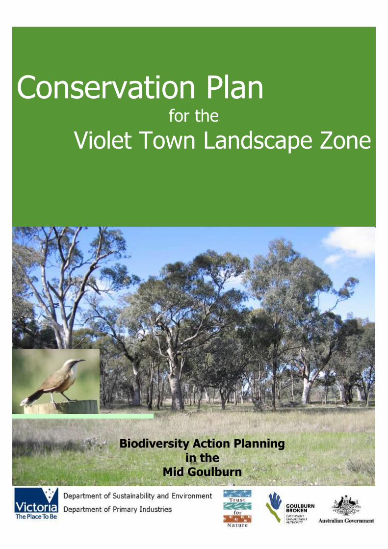
Conservation Plan
for the
Violet Town Landscape Zone
Biodiversity Action Planning in the
Mid Goulburn
2
Developed By:
Environmental Management Program, Sustainable Irrigated Landscapes, Department of Primary Industries, for the Goulburn Broken Catchment Management Authority. Developed under the guidance of the Biodiversity Action Planning Steering Committee - comprising personnel from the Goulburn Broken Catchment Management Authority, Department of Primary Industries, Department of Sustainability and Environment and Trust for Nature (Vic). Tobi Edmonds 255 Ferguson Rd Tatura, Victoria 3616 Phone: (03) 5824 5524 Fax: (03) 5833 5299
Acknowledgments:
This project is funded as part of the Goulburn Broken Catchment Management Authority Regional Catchment Strategy in the Mid Goulburn Region and is provided with support and funding from the Australian and Victorian Governments. This project is delivered primarily through partnerships between the Goulburn Broken Catchment Management Authority, Department of Primary Industries, Department of Sustainability and Environment, Trust for Nature (Vic) and other community bodies. Personnel from these agencies provided generous support and advice during the development of this plan. We also thank numerous Landholders, Landcare groups, Local Area Planning Groups and other individuals, who also provided generous support, advice; information and assistance wherever possible (refer to acknowledgment section).
Front cover: Grassy Woodland near Baddaginie Inset: Grey-crowned Babbler (Pomatostomus temporalis) Photos: DSE Water and Biodiversity 2006 Published & Printed By:
Water and Biodiversity section Department of Sustainability and Environment Alexandra (Draft (Version 1) January 2007) © Copyright State of Victoria 2006 This publication is copyright. No part may be reproduced by any process except in accordance with the provisions of the Copyright Act 1968.
Authorised by:
Victorian Government 1 Treasury Place Melbourne, Victoria 3000 Australia ISSN (To be supplied)
Disclaimer
This publication may be of assistance to you but the State of Victoria and its employees do not guarantee that the publication is without flaw of any kind or is wholly appropriate for your particular purposes and therefore disclaims all liability for any error, loss or other consequence which may arise from you relying on any information in this publication.
For Further Information:
For further information about Biodiversity Action Planning visit the DPI website at www.dpi.vic.gov.au, the DSE website at www.dse.vic.gov.au or call the DPI Customer Service Centre on 136 186. Information can also be obtained at the Goulburn Broken Catchment Management Authority website at www.gbcma.vic.gov.au
3
EXECUTIVE SUMMARY The ultimate aim of Biodiversity Action Planning (BAP) is to achieve broad-scale conservation of native biodiversity. BAP identifies priorities for the conservation of native biodiversity, as part of the implementation of the Victorian Biodiversity Strategy 1997. It is not a ‗stand-alone‘ project; rather a
process for translating objectives set out in Victoria‘s Biodiversity Strategy to regional, catchment and local level (Victoria‘s Biodiversity Strategy fulfils a statutory requirement under Section 17 of the Flora and Fauna Guarantee Act 1988 and provides the biodiversity action plan for Victoria).
To translate objectives from state to regional, catchment and local landscape level, Victoria was first divided on a bioregional basis (bioregions) and then at a landscape level (landscape zones). The ‗Victorian Riverina Bioregional Plan‘ and the ‗Mid Goulburn Region North Landscape Zone Plan‘
outline biodiversity priorities at the bioregional level. This ‗Violet Town Landscape Zone Conservation Plan‘ has been developed at the local (landscape) level and is intended to assist government agencies (primarily extension staff) and the community, to work in partnership towards achieving
catchment targets, by setting priority areas for protection and enhancement of native biodiversity. This plan is also intended to enable biodiversity priorities, data and advice, to be disseminated through existing planning processes, to landholders and agencies.
The methodology used to develop this plan is according to the ‗Goulburn Broken Biodiversity Action Planning Developer‘s Manual‘. Two important components of the BAP process, are the ‗focal
species‘ approach and the ‗key biodiversity assets‘ approach. The focal species approach uses the habitat requirements of a particular species, or a group of species, to define the attributes that must be present in a landscape, for these species to persist. Six focal species have been identified in the
Zone: Jacky Winter, Brush-tailed Phascogale, Brown Treecreeper, Sacred kingfisher, Bush-stone Curlew, and Grey-crowned Babbler. These focal species have been chosen in order to promote the uptake of actions, for conservation within the Zone.
The key biodiversity asset approach is a method of grouping biodiversity assets (eg. birds, animals and plants) that use the same type of habitat. Five key biodiversity assets were identified
for the Violet Town Zone: Grassy Woodlands, Major creeklines, Wetlands, Box-Ironbark Forest and Plants of Local interest. The grouping of these assets will assist in targeting the very high value sites first, down to the lowest priority sites.
The Violet Town Landscape Zone is located within the Goulburn Broken Catchment of Victoria. The Zone, which is approximately 126,409 hectares, is within sections of the Victorian Riverina and
Northern Inland Slopes Bioregions and the Local Government area of Greater Shepparton City Council, Strathbogie and Rural City of Benalla. Since European settlement much of the vegetation in the Zone has been cleared, leaving a fragmented landscape, with many of the remnants being
highly modified. Within the Violet Town Landscape zone 547 priority environmental sites have been identified. These priority sites have been determined and ranked (very high, high, medium or low) based on
factors such as, size, quality, Ecological Vegetation Class (EVC) conservation status, threatened species, landscape context and field surveying. These sites contain remnant vegetation and vary greatly in size, from a stand of paddock trees, to areas such as the Reef Hills State Park.
Management actions (advisory only) have been developed for the Violet Town Landscape Zone, based on the results of desktop analysis and surveying. It is intended that government agencies and
the community, work together to incorporate these actions, in to existing projects/strategies, for the benefit of biodiversity conservation in the Violet Town Landscape Zone, as well as the Mid Goulburn Region and the Goulburn Broken Catchment.
4
CONTENTS
SECTION PAGE EXECUTIVE SUMMARY .............................................................................................................. 3 CONTENTS ............................................................................................................................... 4 1.0 BACKGROUND .................................................................................................................... 5
1.1 INTRODUCTION .............................................................................................................. 5 1.2 OBJECTIVES .................................................................................................................... 5 1.3 CONTEXT FOR DEVELOPING THE VIOLET TOWN CONSERVATION PLAN .............................. 6
2.0 THE STUDY AREA ............................................................................................................... 8 2.1 LANDSCAPE .................................................................................................................... 8 2.2 VEGETATION................................................................................................................. 10 2.3 SIGNIFICANT FLORA AND FAUNA ................................................................................... 14
2.3.1 Flora:...................................................................................................................... 14 2.3.2 Fauna: .................................................................................................................... 15
3.0 PREPARING A CONSERVATION PLAN .................................................................................. 16 3.1 METHODOLOGY............................................................................................................. 16
4.0 IDENTIFYING PRIORITY SITES ........................................................................................ 18 5.0. SUMMARY OF SITE SURVEYING ........................................................................................ 19
5.1. VEGETATION QUALITY ASSESSMENTS ........................................................................... 19 5.2 BIRD SURVEYS .............................................................................................................. 19 5.3 CONSERVATION THREATS ............................................................................................. 19 5.4 SITE PRIORITISATION ................................................................................................... 21
6.0 BIODIVERSITY ASSETS ..................................................................................................... 23 6.1 FOCAL SPECIES ............................................................................................................. 23 6.2 KEY BIODIVERSITY ASSETS ........................................................................................... 25
7.0 PRIORITY ACTIONS - KEY BIODIVERSITY ASSETS ............................................................... 28 7.1) KEY BIODIVERSITY ASSET – GRASSY WOODLANDS ........................................................ 29 7.2) KEY BIODIVERSITY ASSETS – WETLANDS ...................................................................... 32 7.3) KEY BIODIVERSITY ASSET – MAJOR CREEKLINES ........................................................... 34 7.4) KEY BIODIVERSITY ASSET – BOX IRONBARK ................................................................. 36
8.0 Monitoring ........................................................................................................................ 39 9.0 FURTHER INFORMATION - PRIORITY SITES ....................................................................... 42 10.0 LANDHOLDER ASSISTANCE .............................................................................................. 44 11.0 REFERENCES .................................................................................................................. 46 12.0 ACKNOWLEDGMENTS ..................................................................................................... 48 13.0 APPENDICES ................................................................................................................... 49 APPENDIX 1 – VICTORIAN BIOREGIONS .................................................................................. 50 APPENDIX 2 – VICTORIAN LANDSCAPE ZONES ......................................................................... 51 APPENDIX 3 – GOULBURN BROKEN CATCHMENT TARGETS ....................................................... 52 APPENDIX 4 –THREATENED FLORA .......................................................................................... 53 APPENDIX 5 – THREATENED FAUNA ........................................................................................ 54 APPENDIX 6 – SITE PRIORITISATION METHOD ........................................................................ 56 APPENDIX 7 – VEGETATION QUALITY ANALYSIS (VQA) ASSESSMENT FORM .............................. 57 APPENDIX 8 – LANDSCAPE CONTEXT MODEL (LCM).................................................................. 58 APPENDIX 9 – BIRD LIST ........................................................................................................ 59 APPENDIX 10 – PRIORTY SITE INFORMATION (MAPPING): ....................................................... 60
5
1.0 BACKGROUND
1.1 INTRODUCTION
The ultimate aim of Biodiversity Action Planning1 (BAP) is to achieve broad-
scale conservation of native biodiversity. BAP identifies priorities for the conservation of native biodiversity, as part of the implementation of the Victorian Biodiversity Strategy (Crown 1997). In particular, it aims to:
Conserve native biodiversity2 by maintaining viable examples of the range of ecosystems that occur naturally in Victoria,
Promote a more strategic and cost-effective expenditure of public funds for the protection, restoration and ongoing management of priority biodiversity sites
Achieve community support for biodiversity landscape planning and the conservation of strategic assets, in rural landscapes (Platt & Lowe 2002).
In order to achieve these aims, effective planning for native biodiversity also requires detailed planning at a bioregional and landscape level. Therefore,
Victoria was first divided on a bioregional basis (Appendix 1) and then at a landscape level (landscape zones)(Appendix 2).
At the regional scale the ‗Bioregional Strategic Overview for the Victorian Riverina Bioregion‘ and the ‗Landscape Plan for the Goulburn Broken CMA - Mid Goulburn Region - North Zones‘, identifies the broad priorities for
biodiversity conservation in the region. They also provide the foundation for producing detailed plans, such as the ‗Violet Town Landscape Zone Conservation Plan (Ahern et al 2003). At the landscape level, this Violet Town
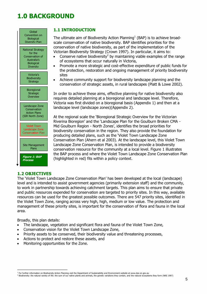
Landscape Zone Conservation Plan, is intended to provide a biodiversity conservation resource for the community at a local level. Figure 1 illustrates the BAP process and where the Violet Town Landscape Zone Conservation Plan (highlighted in red) fits within a policy context.
1.2 OBJECTIVES The ‗Violet Town Landscape Zone Conservation Plan‘ has been developed at the local (landscape) level and is intended to assist government agencies (primarily extension staff) and the community,
to work in partnership towards achieving catchment targets. This plan aims to ensure that private and public resources expended for conservation are targeted to priority sites. In this way, available resources can be used for the greatest possible outcomes. There are 547 priority sites, identified in the Violet Town Zone, ranging across very high, high, medium or low value. The protection and
management of these priority sites, is important for the conservation of flora and fauna in the local area.
Broadly, this plan details: The landscape, vegetation and significant flora and fauna of the Violet Town Zone,
Conservation vision for the Violet Town Landscape Zone, Priority assets to be conserved, their biodiversity value and threatening processes,
Actions to protect and restore these assets, and Monitoring opportunities for the Zone.
1 For further information on Biodiversity Action Planning visit the Department of Sustainability and Environment website at www.dse.vic.gov.au 2 Biodiversity: the natural variety of life: the sum of our native plants and animals, the genetic variations they contain, and the natural ecosystems they form (NRE 1997)
Global Convention on
Biological Diversity Plan
National Strategy
for the Conservation of
Australia‘s Biological
Diversity
Victoria‘s
Biodiversity Strategy
Bioregional
Strategic Overview
Landscape Zone Conservation
Action Plans (SIR North Zone)
Violet Town
Landscape Zone Conservation Plan
Site Management
Plans
Figure 1: BAP Process
6
1.3 CONTEXT FOR DEVELOPING THE VIOLET TOWN CONSERVATION PLAN The Goulburn Broken Regional Catchment Strategy (GBRCS) identifies a vision for biodiversity in the
catchment. The vision is that ―the community will work in partnership with Federal and State Governments and other agencies, to protect and enhance ecological processes and genetic diversity, to secure the future of native species of plants, animals and other organisms in the catchment‖
(GBCMA 2003 p87). This Hughes Creek Landscape Conservation Plan is to assist in achieving this vision, through providing a strategic coordinated approach, for conservation of priority assets.
The GBRCS also identifies targets and priorities for the catchment (refer to Appendix 3 for further detail). The following points are intended to provide a summary of the Goulburn Broken Regional Catchment Strategy targets and priorities for biodiversity conservation. For further information
please refer to GBCMA 2003. The Goulburn Broken Catchment Management Strategy identifies the following biodiversity resource
condition targets for native vegetation in the catchment: 1. Maintain the extent of all native vegetation types at 1999 levels in keeping with the goal of ‗Net
Gain‘ listed in Victoria‘s Biodiversity Strategy 1997,
2. Improve the quality of 90% of existing (2003) native vegetation by 10% by 2030, 3. Increase the cover of all endangered and applicable vulnerable Ecological Vegetation Classes to
at least 15% of their pre-European vegetation cover by 2030,
4. Increase 2002 conservation status of 80% threatened flora and 60% threatened fauna by 2030, 5. Maintain the extent of all wetland types at 2003 levels where the extent (area and number) has
declined since European settlement, and 6. Improve the condition of 70% of wetlands by 2030, using 2003 as the benchmark for condition
(GBCMA 2003 p11). Priorities for action to conserve biodiversity in the Goulburn Broken are driven by the conservation
significance of the biodiversity asset. Regional investments in biodiversity conservation in the Goulburn Broken Catchment are driven by the following goals (in order of priority): 1. Protecting existing viable remnant habitats and the flora and fauna populations they contain
(ie through reservation, covenants, management agreements, fencing and statutory planning), 2. Enhancing the existing viable habitats that are degraded (management by controlling threats
such as pest plants and animals, grazing, salinity, promotion of natural regeneration and/or
revegetation with understorey), and 3. Restoring under-represented biodiversity assets to their former extent by revegetation (to
create corridors, buffers, patches of habitat) (GBCMA 2003).
It is intended that the actions outlined in this plan will complement the targets of the GBRCS and other policy/strategies pertinent to the state, catchment and region (eg. Victoria‘s Native Vegetation
Management – A Framework for Action (NRE 2002a): Goulburn Broken Native Vegetation Management Plan (GBCMA 2000): and the Victorian River Health Strategy (NRE 2002b). This plan is also intended to integrate such policies (eg. targets and legislative requirements) in to the one
document, for use by local communities. For example, this plan incorporates aspects of legislation (eg. Action Statements prepared under the Flora and Fauna Guarantee Act 1988), in to recommended on-ground actions, for the conservation of threatened species and communities.
The Biodiversity Action Planning (BAP) process uses current scientific knowledge to produce an ‗ideal‘ landscape for biodiversity conservation. This ‗ideal‘ landscape provides for the current levels
of species abundance, diversity and interactions. BAP attempts to take a strategic approach to the conservation of threatened and declining species and vegetation types, by looking for opportunities to conserve groups of species in appropriate ecosystems (Platt & Lowe 2002). It is therefore intended that this South West Landscape Zone Conservation Plan will assist government agencies
and the community, to work in partnership towards achieving catchment targets and an ‗ideal‘ landscape, by setting priority areas for protection and enhancement of native biodiversity.
7
This plan is not intended to be a method of ‗taking over‘ land, but rather a resource document, that assists with identifying priority assets and methods of action, to protect or restore valuable assets, through voluntary extension principles. This document may be used by agencies and community
groups, for informing existing projects and for strategic planning. However, it must be remembered that this document is by no means ‗comprehensive‘, as the BAP process relies on the regular updating of information, to keep it accurate and timely. The plan has therefore been developed as
an adaptive plan, to enable management actions and information to be modified, in response to further information (eg monitoring).
This plan will be reviewed when necessary to ensure that it remains a ‗living‘ document. It is also intended that extension staff will use Geographic Information System (GIS) programs, databases and DSE/DPI staff, to fully identify and understand the BAP process and to provide further
information to the community. Consultation and extension with relevant stakeholders, including agencies and community groups, was conducted (and will continue to occur) throughout the development and implementation of this plan. It is envisaged that this plan will be a valuable
resource, for identifying priority biodiversity sites and initiating further conservation works in the Zone, and at a later stage, will lead to further sites and projects being identified by interested individuals and groups.
8
2.0 THE STUDY AREA
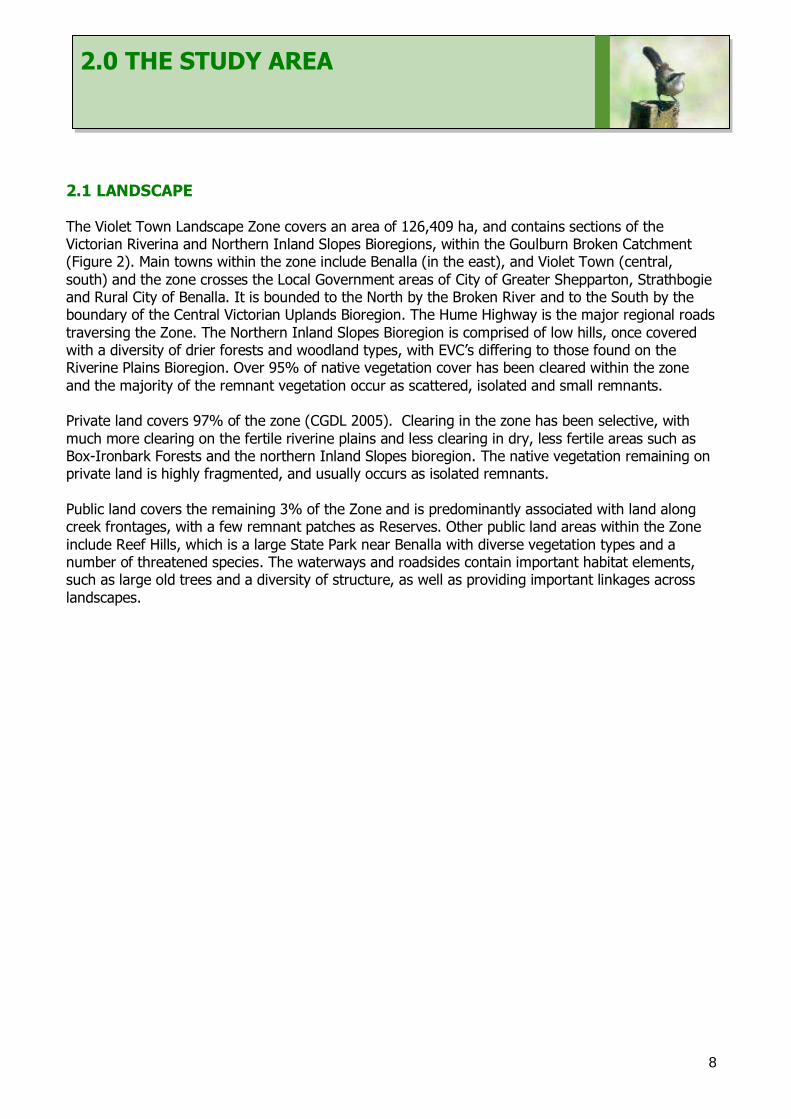
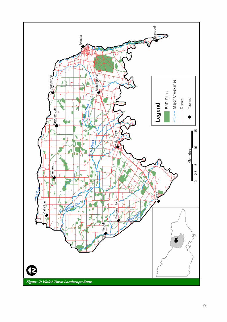
2.1 LANDSCAPE The Violet Town Landscape Zone covers an area of 126,409 ha, and contains sections of the Victorian Riverina and Northern Inland Slopes Bioregions, within the Goulburn Broken Catchment (Figure 2). Main towns within the zone include Benalla (in the east), and Violet Town (central,
south) and the zone crosses the Local Government areas of City of Greater Shepparton, Strathbogie and Rural City of Benalla. It is bounded to the North by the Broken River and to the South by the boundary of the Central Victorian Uplands Bioregion. The Hume Highway is the major regional roads
traversing the Zone. The Northern Inland Slopes Bioregion is comprised of low hills, once covered with a diversity of drier forests and woodland types, with EVC‘s differing to those found on the Riverine Plains Bioregion. Over 95% of native vegetation cover has been cleared within the zone
and the majority of the remnant vegetation occur as scattered, isolated and small remnants. Private land covers 97% of the zone (CGDL 2005). Clearing in the zone has been selective, with
much more clearing on the fertile riverine plains and less clearing in dry, less fertile areas such as Box-Ironbark Forests and the northern Inland Slopes bioregion. The native vegetation remaining on private land is highly fragmented, and usually occurs as isolated remnants.
Public land covers the remaining 3% of the Zone and is predominantly associated with land along creek frontages, with a few remnant patches as Reserves. Other public land areas within the Zone
include Reef Hills, which is a large State Park near Benalla with diverse vegetation types and a number of threatened species. The waterways and roadsides contain important habitat elements, such as large old trees and a diversity of structure, as well as providing important linkages across
landscapes.
9
Figure 2: Violet Town Landscape Zone
10
2.2 VEGETATION
Ecological Vegetation Classes (EVC3s) are a vegetation classification system, derived from groupings
of vegetation communities based on floristic, structural and ecological functions. Mosaics (combinations of EVCs) are a mapping unit, where the individual EVCs could not be separated, at the scale of 1:100,000 (Berwick, 2003).
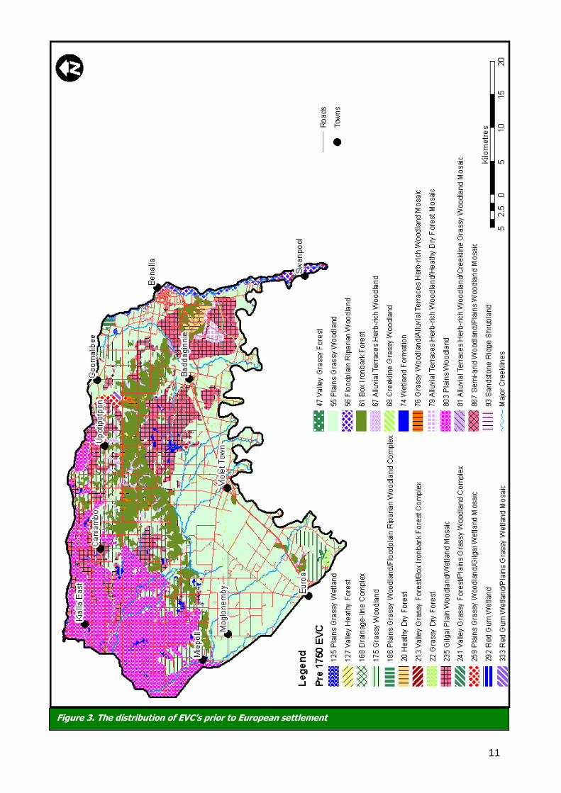
Prior to European settlement, 24 EVCs were known to have been present within the Violet Town Landscape Zone (Figure 3). The most wide spread EVCs were Grassy Woodlands, Grassy Forest and Wetlands, and some Box-Ironbark forest and Box woodlands.
Woodland communities in the Victorian Riverina Plains Bioregion were dominated by Grey Box Eucalyptus microcarpa, Yellow Box E. melliodora and Buloke Allocasuarina leuhmannii. Box-Ironbark Forests occur on the low sedimentary hills of Koonda and Dookie within the Northern Inland Slopes Bioregion. Understorey plants include Bent-leaf Wattle, Bush Peas, Common Cassinia
with small shrubs, herbs and native grasses making up the understorey. Waterways and wetlands are critical biodiversity features within the Violet Town Landscape Zone.
Major waterways include Honeysuckle Creek, Sheep Pen Creek, Stoney Creek, Woolpress Creek and Seven Creeks. A number of small to medium sized wetlands (< 150 ha) with River Red Gum and associated box species remain, the largest being Jubilee Swamp Wildlife Reserve (147 ha) (Ahern et
al 2003). There are also numerous small wetlands scattered throughout the zone which are of Bioregional Conservation Significance: Morphett swamp Wildlife reserve, Sawpit Creek Dam, Lehmanns Swamp, Coopers lane wetland, McBurney Swamp and Gum Swamp.
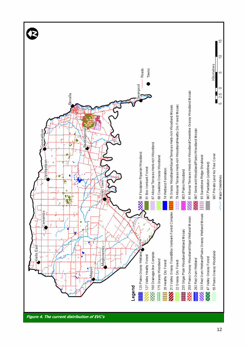
The majority of native vegetation has been cleared, and currently there is 12% tree cover in the zone. There has been selective clearing of EVC‘s with drier areas less cleared than EVC‘s associated
with more fertile soils. Of the 24 EVC‘s thought to occur in the zone prior to settlement, 21 (88%) are considered to be Endangered or Vulnerable, two depleted (Box-Ironbark Forest; Grassy Dry Forest) and one EVC is of Least Concern (Heathy Dry Forest) (See GBCMA 2000 for details of
categories). The Goulburn Broken Native Vegetation Plan describes goals and targets that have been set for the vegetation communities within the catchment. This includes ensuring that all EVCs are at least 15% of the pre-European cover by 2030 (GBCMA 2000). The majority of EVCs within
the Violet Town Landscape Zone are below the 15% target (80%) (Table 1). Therefore, revegetation in this zone could be used to help achieve bioregional targets. For further details on each EVC contact GBCMA or DSE staff.
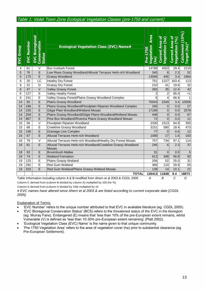
The current extent of native vegetation in the Violet Town Zone has dramatically reduced (Figure 3 & 4) since European settlement, primarily due to clearing. Table 1 identifies the EVCs in the Violet
Town Landscape Zone, including their Bioregional Conservation Status (BCS), their pre-European settlement extent and current (as of 2003) extent (in hectares and % cover). Table 1 also identifies the area of ‗Private Land No Tree Cover‘ and Unknown/Unclassified EVCs (Ahern et al 2003).
The Goulburn Broken Regional Catchment Strategy (RCS) identifies goals and targets that have been set for the vegetation communities within the catchment (Appendix 3). This includes ―increasing the cover of all ‗Endangered‘ and ‗Vulnerable‘ (where applicable4) EVCs to at least 15%
of their pre-European vegetation cover by 2030‖ (GBCMA 2003). The majority of EVCs within the Violet Town Landscape Zone are below the 15% target (Table 1) and are therefore considered ‗Endangered‘ (17) or ‗Vulnerable‘ (3) at the Bioregional level (Ahern et al 2003).
3 For further information on each EVC, refer to the Department of Sustainability and Environment website at www.dse.vic.gov.au 4 Applicable to Ecological Vegetation Classes that are ‗Vulnerable‘ and are below 15%
11
Figure 3. The distribution of EVC’s prior to European settlement
12
Figure 4. The current distribution of EVC’s
13
Table 1: Violet Town Zone Ecological Vegetation Classes (pre-1750 and current)
EV
C G
rou
p
EV
C N
um
be
r
EV
C B
iore
gio
nal
Co
nse
rva
tio
n
Sta
tus
Ecological Vegetation Class (EVC) Name#
Pre
-17
50
V
eg
eta
tio
n A
rea
(ha
)
Cu
rre
nt
Are
a o
f
Ve
ge
tati
on
(h
a)
Cu
rre
nt
Are
a o
f
Ve
ge
tati
on
(%
)
Ca
tch
me
nt
(15
%)
Ta
rge
t (h
a)*
4 61 V Box Ironbark Forest 14788 4353 29.4 2218
5 76 E Low Rises Grassy Woodland/Alluvial Terraces Herb-rich Woodland 345 8 2.3 52
5 175 E Grassy Woodland 13096 445 3.4 1964
6 20 LC Heathy Dry Forest 751 1227 163.4 113
6 22 D Grassy Dry Forest 210 41 19.6 32
6 47 V Valley Grassy Forest 283 35 12.4 42
6 127 E Valley Heathy Forest 2 2 85.0 <1
6 241 E Valley Grassy Forest/Plains Grassy Woodland Complex 6 4 66.6 1
14 55 E Plains Grassy Woodland 70043 2349 3.4 10506
14 186 E Plains Grassy Woodland/Floodplain Riparian Woodland Complex 183 0 0.0 27
14 235 E Gilgai Plain Woodland/Wetland Mosaic 17186 0 0.0 2578
14 259 E Plains Grassy Woodland/Gilgai Plains Woodland/Wetland Mosaic 448 0 0.0 67
14 867 E Pine Box Woodland/Riverina Plains Grassy Woodland Mosaic 72 0 0.0 11
15 56 V Floodplain Riparian Woodland 2330 1513 64.9 350
15 68 E Creekline Grassy Woodland 3151 580 18.4 473
15 168 E Drainage Line Complex 77 0 0.0 12
16 67 E Alluvial Terraces Herb-rich Woodland 1085 17 1.6 163
16 79 V Alluvial Terraces Herb-rich Woodland/Heathy Dry Forest Mosaic 757 734 97.1 114
16 81 E Alluvial Terraces Herb-rich Woodland/Creekline Grassy Woodland Mosaic
246 6 2.3 37
18 93 E Broombush Mallee 31 0 0.0 5
19 74 E Wetland Formation 613 348 56.8 92
19 125 E Plains Grassy Wetland 206 52 25.0 31
19 292 E Red Gum Wetland 366 110 29.9 55
19 333 E Red Gum Wetland/Plains Grassy Wetland Mosaic 138 14 10.1 21
TOTAL 126413 11838 9.4 18873
Table Information including column A & B modified from Ahern et al 2003 & CGDL 2005 A B C D
Column C derived from (column B divided by column A) multiplied by 100 (for %)
Column D derived from (column A divided by 100) multiplied by 15
# EVC names have altered since Ahern et al 2003 & are listed according to current corporate date (CGDL 2005) Explanation of Terms:
‘EVC Number’ refers to the unique number attributed to that EVC in available literature (eg. CGDL 2005).
‘EVC Bioregional Conservation Status’ (BCS) refers to the threatened status of the EVC in the bioregion (eg. Murray Fans). Endangered (E) means that ‘less than 10% of the pre-European extent remains, whilst Vulnerable (V) is defined as ‘less than 10-30% pre-European extent remaining’ (Platt 2002).
‘Ecological Vegetation Class (EVC) Name’ is the name given to that unique community.
‘Pre-1750 Vegetation Area’ refers to the area of vegetation cover (ha) prior to substantial clearance (eg. Pre-European Settlement).
14
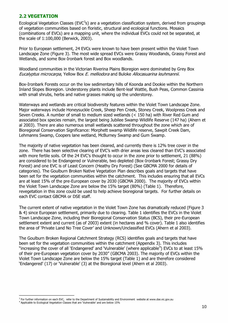
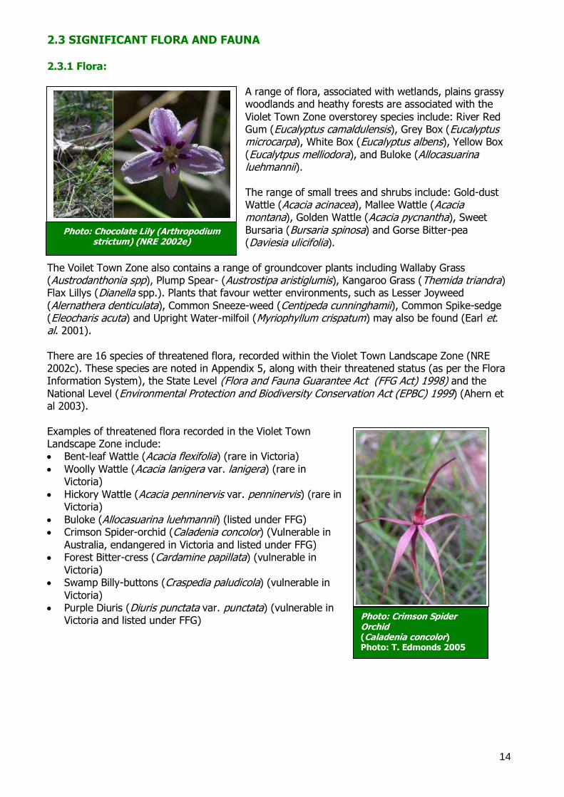
Photo: Crimson Spider Orchid (Caladenia concolor) Photo: T. Edmonds 2005
2.3 SIGNIFICANT FLORA AND FAUNA 2.3.1 Flora:
A range of flora, associated with wetlands, plains grassy woodlands and heathy forests are associated with the
Violet Town Zone overstorey species include: River Red Gum (Eucalyptus camaldulensis), Grey Box (Eucalyptus microcarpa), White Box (Eucalyptus albens), Yellow Box
(Eucalytpus melliodora), and Buloke (Allocasuarina luehmannii).
The range of small trees and shrubs include: Gold-dust Wattle (Acacia acinacea), Mallee Wattle (Acacia montana), Golden Wattle (Acacia pycnantha), Sweet
Bursaria (Bursaria spinosa) and Gorse Bitter-pea (Daviesia ulicifolia).
The Voilet Town Zone also contains a range of groundcover plants including Wallaby Grass (Austrodanthonia spp), Plump Spear- (Austrostipa aristiglumis), Kangaroo Grass (Themida triandra) Flax Lillys (Dianella spp.). Plants that favour wetter environments, such as Lesser Joyweed
(Alernathera denticulata), Common Sneeze-weed (Centipeda cunninghamii), Common Spike-sedge (Eleocharis acuta) and Upright Water-milfoil (Myriophyllum crispatum) may also be found (Earl et. al. 2001).
There are 16 species of threatened flora, recorded within the Violet Town Landscape Zone (NRE 2002c). These species are noted in Appendix 5, along with their threatened status (as per the Flora Information System), the State Level (Flora and Fauna Guarantee Act (FFG Act) 1998) and the
National Level (Environmental Protection and Biodiversity Conservation Act (EPBC) 1999) (Ahern et al 2003).
Examples of threatened flora recorded in the Violet Town Landscape Zone include: Bent-leaf Wattle (Acacia flexifolia) (rare in Victoria)
Woolly Wattle (Acacia lanigera var. lanigera) (rare in Victoria)
Hickory Wattle (Acacia penninervis var. penninervis) (rare in Victoria)
Buloke (Allocasuarina luehmannii) (listed under FFG) Crimson Spider-orchid (Caladenia concolor) (Vulnerable in
Australia, endangered in Victoria and listed under FFG) Forest Bitter-cress (Cardamine papillata) (vulnerable in
Victoria) Swamp Billy-buttons (Craspedia paludicola) (vulnerable in
Victoria) Purple Diuris (Diuris punctata var. punctata) (vulnerable in
Victoria and listed under FFG)
Photo: Chocolate Lily (Arthropodium strictum) (NRE 2002e)
15
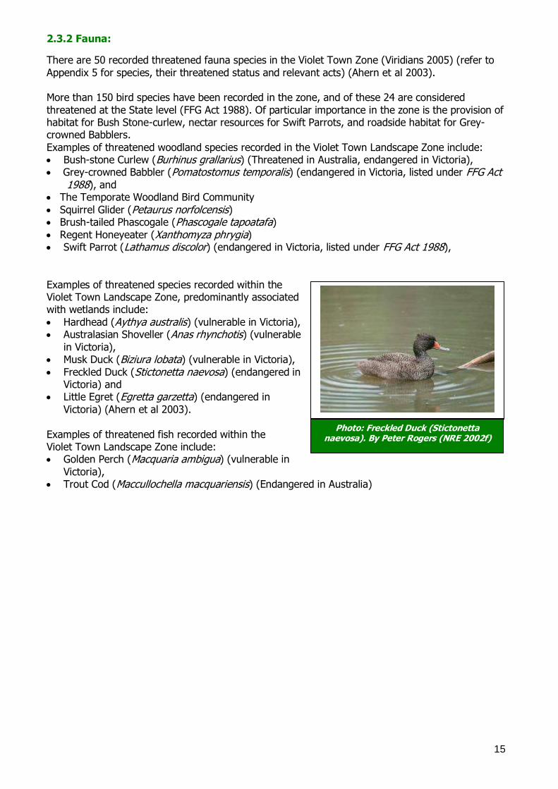
2.3.2 Fauna:
There are 50 recorded threatened fauna species in the Violet Town Zone (Viridians 2005) (refer to
Appendix 5 for species, their threatened status and relevant acts) (Ahern et al 2003). More than 150 bird species have been recorded in the zone, and of these 24 are considered
threatened at the State level (FFG Act 1988). Of particular importance in the zone is the provision of habitat for Bush Stone-curlew, nectar resources for Swift Parrots, and roadside habitat for Grey-crowned Babblers.
Examples of threatened woodland species recorded in the Violet Town Landscape Zone include: Bush-stone Curlew (Burhinus grallarius) (Threatened in Australia, endangered in Victoria), Grey-crowned Babbler (Pomatostomus temporalis) (endangered in Victoria, listed under FFG Act
1988), and The Temporate Woodland Bird Community
Squirrel Glider (Petaurus norfolcensis) Brush-tailed Phascogale (Phascogale tapoatafa)
Regent Honeyeater (Xanthomyza phrygia) Swift Parrot (Lathamus discolor) (endangered in Victoria, listed under FFG Act 1988),
Examples of threatened species recorded within the Violet Town Landscape Zone, predominantly associated with wetlands include:
Hardhead (Aythya australis) (vulnerable in Victoria), Australasian Shoveller (Anas rhynchotis) (vulnerable
in Victoria), Musk Duck (Biziura lobata) (vulnerable in Victoria),
Freckled Duck (Stictonetta naevosa) (endangered in Victoria) and
Little Egret (Egretta garzetta) (endangered in
Victoria) (Ahern et al 2003).
Examples of threatened fish recorded within the Violet Town Landscape Zone include: Golden Perch (Macquaria ambigua) (vulnerable in
Victoria), Trout Cod (Maccullochella macquariensis) (Endangered in Australia)
Photo: Freckled Duck (Stictonetta naevosa). By Peter Rogers (NRE 2002f)
16
3.0 PREPARING A CONSERVATION PLAN
3.1 METHODOLOGY
The methodology used to develop this Conservation Plan is based on the ‗Goulburn Broken Biodiversity Action Planning Developer‘s Manual‘ (GBCMA in prep.). This document provides the background information relating to BAP in the Goulburn Broken Catchment, and is designed to
ensure consistency during the development of the plans. The methodology used to prepare this plan contained eight main elements. These were,
1) Identification of Conservation Features and Threatened Species, 2) Ground-truthing of Potential BAP Sites, 3) Field Surveying of BAP sites,
4) Prioritisation of BAP sites, 5) Generation of Focal Species List, 6) Generation of Key Biodiversity Asset List,
7) Development of Actions for Key Biodiversity Assets, and 8) Landscape Context Analysis. Step 1. Identification of Conservation Features and Threatened Species
Features in the landscape that are of potential priority for conservation were identified, as well as flora and fauna species of conservation significance (eg. threatened under State or Commonwealth legislation). This involved desktop analysis of data (eg. literature review; spatial data (eg EVC, trees
cover, wetlands, flora and fauna records, aerial photographs); corporate databases (eg. Biosites, Victorian Fauna Display and Flora Information Systems); local knowledge investigations; and the Landscape Context Model (refer to Step 8). From this analysis, a series of sites likely to have
conservation values and threatened species, were identified and mapped using GIS (CGDL 2005). Step 2. Ground-Truthing of Potential BAP Sites
Involved surveying the Zone from the roadside, to compare desktop analysis data (Step 1) to the actual on-ground area, in regards to presence/absence, type of vegetation and raw condition.
Step 3. Field Surveying of BAP Sites Sites were prioritised for survey as per the ‗Goulburn Broken Biodiversity Action Planning Developer‘s Manual‘ (GBCMA in prep.). This prioritisation method is shown in Appendix 6. One
hundred of the sites requiring ground-truthing were field surveyed (on-site or from the nearest public land). This involved: 3.1) Bird Surveys: Undertaken in accordance with the Birds of Australia – Atlas Search Methods (1-
2-hectares, twenty minutes) (Birds Australia 2001). 3.2) Vegetation Quality Assessment (VQA)(DSE 2004): Site-based habitat and landscape components were assessed against a pre-determined ‗benchmark‘ relevant to the vegetation type
being assessed (eg. grasslands, wetlands, plains grassy woodlands) (Refer to Appendix 7 for form). 3.3) Threat Identification: Whilst undertaking the Vegetation Quality Assessment (DSE 2004), a list of threatening processes (eg. pest plants and animals) at the priority sites, were recorded.
Step 4. Prioritisation of BAP Sites The 100 sites were given a ranked value of very high (VH), high (H), medium (M) or low (L), based on a range of factors (eg. conservation status of the EVC, presence of threatened species, size, VQA
score). Sites not surveyed, nor automatically ranked (as per Appendix 6), were given a ranked value to the lesser of the available options (until surveying occurs). Step 5. Generation of Focal Species List
17
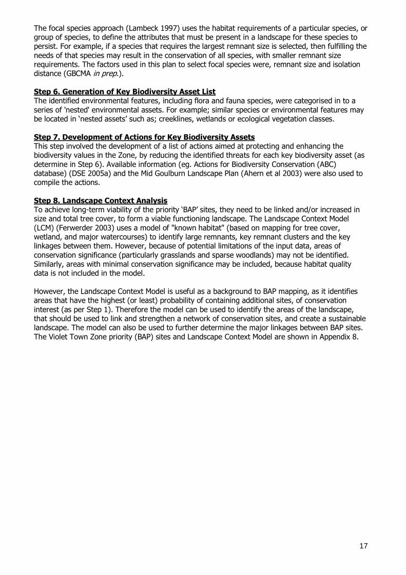
The focal species approach (Lambeck 1997) uses the habitat requirements of a particular species, or group of species, to define the attributes that must be present in a landscape for these species to persist. For example, if a species that requires the largest remnant size is selected, then fulfilling the
needs of that species may result in the conservation of all species, with smaller remnant size requirements. The factors used in this plan to select focal species were, remnant size and isolation distance (GBCMA in prep.). Step 6. Generation of Key Biodiversity Asset List The identified environmental features, including flora and fauna species, were categorised in to a
series of 'nested' environmental assets. For example; similar species or environmental features may be located in ‗nested assets‘ such as; creeklines, wetlands or ecological vegetation classes.
Step 7. Development of Actions for Key Biodiversity Assets This step involved the development of a list of actions aimed at protecting and enhancing the biodiversity values in the Zone, by reducing the identified threats for each key biodiversity asset (as
determine in Step 6). Available information (eg. Actions for Biodiversity Conservation (ABC) database) (DSE 2005a) and the Mid Goulburn Landscape Plan (Ahern et al 2003) were also used to compile the actions.
Step 8. Landscape Context Analysis To achieve long-term viability of the priority ‗BAP‘ sites, they need to be linked and/or increased in size and total tree cover, to form a viable functioning landscape. The Landscape Context Model
(LCM) (Ferwerder 2003) uses a model of "known habitat" (based on mapping for tree cover, wetland, and major watercourses) to identify large remnants, key remnant clusters and the key linkages between them. However, because of potential limitations of the input data, areas of
conservation significance (particularly grasslands and sparse woodlands) may not be identified. Similarly, areas with minimal conservation significance may be included, because habitat quality data is not included in the model.
However, the Landscape Context Model is useful as a background to BAP mapping, as it identifies areas that have the highest (or least) probability of containing additional sites, of conservation
interest (as per Step 1). Therefore the model can be used to identify the areas of the landscape, that should be used to link and strengthen a network of conservation sites, and create a sustainable landscape. The model can also be used to further determine the major linkages between BAP sites.
The Violet Town Zone priority (BAP) sites and Landscape Context Model are shown in Appendix 8.
18
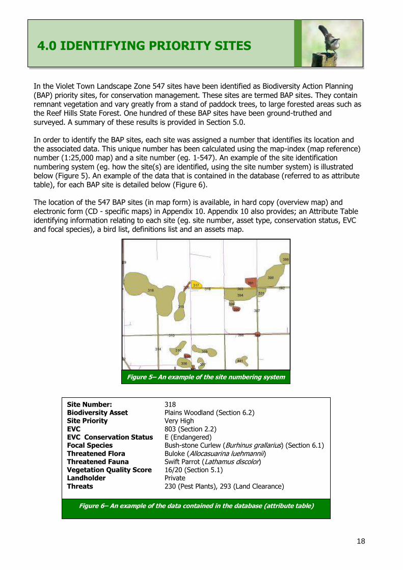
4.0 IDENTIFYING PRIORITY SITES In the Violet Town Landscape Zone 547 sites have been identified as Biodiversity Action Planning
(BAP) priority sites, for conservation management. These sites are termed BAP sites. They contain remnant vegetation and vary greatly from a stand of paddock trees, to large forested areas such as the Reef Hills State Forest. One hundred of these BAP sites have been ground-truthed and
surveyed. A summary of these results is provided in Section 5.0.
In order to identify the BAP sites, each site was assigned a number that identifies its location and the associated data. This unique number has been calculated using the map-index (map reference) number (1:25,000 map) and a site number (eg. 1-547). An example of the site identification
numbering system (eg. how the site(s) are identified, using the site number system) is illustrated below (Figure 5). An example of the data that is contained in the database (referred to as attribute table), for each BAP site is detailed below (Figure 6).
The location of the 547 BAP sites (in map form) is available, in hard copy (overview map) and
electronic form (CD - specific maps) in Appendix 10. Appendix 10 also provides; an Attribute Table identifying information relating to each site (eg. site number, asset type, conservation status, EVC and focal species), a bird list, definitions list and an assets map.
Site Number: 318 Biodiversity Asset Plains Woodland (Section 6.2) Site Priority Very High
EVC 803 (Section 2.2) EVC Conservation Status E (Endangered) Focal Species Bush-stone Curlew (Burhinus grallarius) (Section 6.1) Threatened Flora Buloke (Allocasuarina luehmannii) Threatened Fauna Swift Parrot (Lathamus discolor) Vegetation Quality Score 16/20 (Section 5.1) Landholder Private
Threats 230 (Pest Plants), 293 (Land Clearance)
Figure 6– An example of the data contained in the database (attribute table)
Figure 5– An example of the site numbering system
19
5.0. SUMMARY OF SITE SURVEYING
5.1. VEGETATION QUALITY ASSESSMENTS A small number of BAP sites were assessed based on habitat features of, 1) Large trees, 2) Canopy Cover, 3) Understorey, 4) Weediness, 5) Recruitment, 6) Organic Litter, 7) Logs (and Landscape Component Scores of), 8) Size, 9) Neighbourhood and 10) Core Area. They were scored out of a
maximum score of 20 (assumed intact habitat). An example of the assessment sheet is provided in Appendix 7. It is hoped that extension staff will be able to complete more assessments in the future
5.2 BIRD SURVEYS
One hundred of the 547 priority BAP sites had bird surveys completed, resulting in 82 bird species being identified. A list of birds sighted within the Violet Town Landscape Zone is provided in Appendix 9. A number of threatened species were identified during surveying, including, Superb
Parrot (Polytelis swainsonii), and Grey-crowned Babbler (Pomatostomus temporalis).
5.3 CONSERVATION THREATS Whilst undertaking the bird surveys (DSE 2004), a list of threatening processes (e.g. pest plants and animals) at the priority sites, were recorded according to the Actions for
Biodiversity Conservation (ABC) database (DSE 2005a). These included: Vegetation Clearance (Land Clearance – removal of native vegetation),
Habitat Fragmentation/Edge Effects (includes ‗Adjacent Land Use Practices‘), Waterways (instream barriers) (Changes in hydrological regimes e.g. wetlands),
Animals – Domestic Stock (Inappropriate grazing management (e.g. timing, stocking rate)), Firewood Collection & Cleaning Up (Removal of Habitat)
Animals – e.g. Pest Species - Foxes and Rabbits, Invasion by Environmental Weeds (Pest Plants),
Recreational Activities – motorised (Transport and Recreation), and Removal of Rocks/Soil (Impacts of Roadworks on Roadside Vegetation).
Vegetation/Land clearance (a key threatening process under the EPBC Act 1999) (Wierzbowski
et al 2002) particularly occurred in the past, however it continues to be a threat to conservation values within the Zone. Practices such as inappropriate earth works (e.g. removal of natural depressions/wetlands, removal of native vegetation cover) and illegal tree removal, is a threat to
biodiversity values. Habitat fragmentation (a potentially threatening process for fauna in Victoria under the FFG Act
1988 (Wierzbowski et al 2002)) is primarily the result of historical land clearance. A range of species such as the Superb Parrot (Polytelis swainsonii) and Grey-crowned Babbler (Pomatostomus temporalis) are detrimentally affected by habitat fragmentation. It affects their ability to source food and suitable habitat required for their survival (e.g. leads to less effective immigration, emigration
and breeding success). Habitat fragmentation also favours species such as Noisy Miners (Manorina melanocephala) (Bennett 1993). Elevated competition from these aggressive species (although native to Australia) threatens species diversity, by the exclusion of less aggressive species (e.g.
Grey-crowned Babblers) from remnants.
20
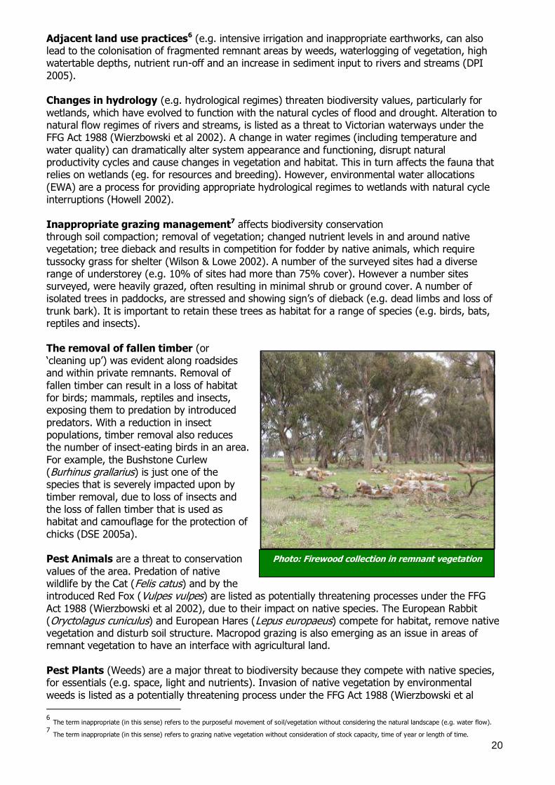
Photo: Firewood collection in remnant vegetation
Adjacent land use practices6 (e.g. intensive irrigation and inappropriate earthworks, can also lead to the colonisation of fragmented remnant areas by weeds, waterlogging of vegetation, high watertable depths, nutrient run-off and an increase in sediment input to rivers and streams (DPI
2005). Changes in hydrology (e.g. hydrological regimes) threaten biodiversity values, particularly for
wetlands, which have evolved to function with the natural cycles of flood and drought. Alteration to natural flow regimes of rivers and streams, is listed as a threat to Victorian waterways under the FFG Act 1988 (Wierzbowski et al 2002). A change in water regimes (including temperature and
water quality) can dramatically alter system appearance and functioning, disrupt natural productivity cycles and cause changes in vegetation and habitat. This in turn affects the fauna that relies on wetlands (eg. for resources and breeding). However, environmental water allocations
(EWA) are a process for providing appropriate hydrological regimes to wetlands with natural cycle interruptions (Howell 2002).
Inappropriate grazing management7 affects biodiversity conservation through soil compaction; removal of vegetation; changed nutrient levels in and around native vegetation; tree dieback and results in competition for fodder by native animals, which require
tussocky grass for shelter (Wilson & Lowe 2002). A number of the surveyed sites had a diverse range of understorey (e.g. 10% of sites had more than 75% cover). However a number sites surveyed, were heavily grazed, often resulting in minimal shrub or ground cover. A number of isolated trees in paddocks, are stressed and showing sign‘s of dieback (e.g. dead limbs and loss of
trunk bark). It is important to retain these trees as habitat for a range of species (e.g. birds, bats, reptiles and insects).
The removal of fallen timber (or ‗cleaning up‘) was evident along roadsides and within private remnants. Removal of
fallen timber can result in a loss of habitat for birds; mammals, reptiles and insects, exposing them to predation by introduced
predators. With a reduction in insect populations, timber removal also reduces the number of insect-eating birds in an area.
For example, the Bushstone Curlew (Burhinus grallarius) is just one of the species that is severely impacted upon by
timber removal, due to loss of insects and the loss of fallen timber that is used as habitat and camouflage for the protection of
chicks (DSE 2005a). Pest Animals are a threat to conservation
values of the area. Predation of native wildlife by the Cat (Felis catus) and by the introduced Red Fox (Vulpes vulpes) are listed as potentially threatening processes under the FFG
Act 1988 (Wierzbowski et al 2002), due to their impact on native species. The European Rabbit (Oryctolagus cuniculus) and European Hares (Lepus europaeus) compete for habitat, remove native vegetation and disturb soil structure. Macropod grazing is also emerging as an issue in areas of remnant vegetation to have an interface with agricultural land.
Pest Plants (Weeds) are a major threat to biodiversity because they compete with native species, for essentials (e.g. space, light and nutrients). Invasion of native vegetation by environmental
weeds is listed as a potentially threatening process under the FFG Act 1988 (Wierzbowski et al
6 The term inappropriate (in this sense) refers to the purposeful movement of soil/vegetation without considering the natural landscape (e.g. water flow). 7 The term inappropriate (in this sense) refers to grazing native vegetation without consideration of stock capacity, time of year or length of time.
21
2002). Examples of weeds evident in the Zone include; Paterson‘s Curse (Echium plantagineum), Horehound (Marrubium vulgare), Sweet Briar (Rosa rubiginosa), Peppercorns (Schinus molle), Boxthorn (Lycium ferocissimum), Arrowhead (Sagittaria graminea), Bridal Creeper (Asparagus asparagoides) and Willows (Salix spp). Weeds are especially evident on roadsides due to escaped garden/agricultural plants, machinery disturbance (e.g. roadworks) and poor vehicle hygiene. Pest plants invading remnants can also be a result of adjacent land practices (e.g. agricultural weeds)
and animal movement (e.g. birds). Transport and Recreational Pursuits (e.g. motorised activities) can also lead to increased
weeds and loss of native vegetation). Removal of Rocks and Soil was evident along roadsides, where graders had caused impact on native vegetation.
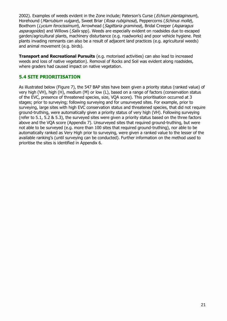
5.4 SITE PRIORITISATION As illustrated below (Figure 7), the 547 BAP sites have been given a priority status (ranked value) of
very high (VH), high (H), medium (M) or low (L), based on a range of factors (conservation status of the EVC, presence of threatened species, size, VQA score). This prioritisation occurred at 3 stages; prior to surveying; following surveying and for unsurveyed sites. For example, prior to
surveying, large sites with high EVC conservation status and threatened species, that did not require ground-truthing, were automatically given a priority status of very high (VH). Following surveying (refer to 5.1, 5.2 & 5.3), the surveyed sites were given a priority status based on the three factors
above and the VQA score (Appendix 7). Unsurveyed sites that required ground-truthing, but were not able to be surveyed (e.g. more than 100 sites that required ground-truthing), nor able to be automatically ranked as Very High prior to surveying, were given a ranked value to the lesser of the available ranking‘s (until surveying can be conducted). Further information on the method used to
prioritise the sites is identified in Appendix 6.
22
Figure 7 – Biodiversity Action Planning (BAP) Sites – Prioritised from Very High to Medium
23
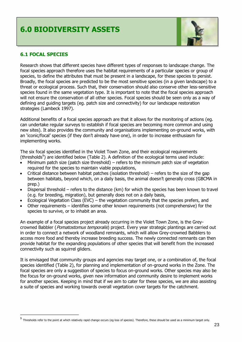
6.0 BIODIVERSITY ASSETS
6.1 FOCAL SPECIES
Research shows that different species have different types of responses to landscape change. The focal species approach therefore uses the habitat requirements of a particular species or group of species, to define the attributes that must be present in a landscape, for these species to persist.
Broadly, the focal species are predicted to be the most sensitive species (in a given landscape) to a threat or ecological process. Such that, their conservation should also conserve other less-sensitive species found in the same vegetation type. It is important to note that the focal species approach
will not ensure the conservation of all other species. Focal species should be seen only as a way of defining and guiding targets (eg. patch size and connectivity) for our landscape restoration strategies (Lambeck 1997).
Additional benefits of a focal species approach are that it allows for the monitoring of actions (eg. can undertake regular surveys to establish if focal species are becoming more common and using new sites). It also provides the community and organisations implementing on-ground works, with
an ‗iconic/focal‘ species (if they don‘t already have one), in order to increase enthusiasm for implementing works.
The six focal species identified in the Violet Town Zone, and their ecological requirements (thresholds9) are identified below (Table 2). A definition of the ecological terms used include: Minimum patch size (patch size threshold) – refers to the minimum patch size of vegetation
required for the species to maintain viable populations, Critical distance between habitat patches (isolation threshold) – refers to the size of the gap
between habitats, beyond which, on a daily basis, the animal doesn‘t generally cross (GBCMA in prep.)
Dispersal threshold – refers to the distance (km) for which the species has been known to travel
(e.g. for breeding, migration), but generally does not on a daily basis, Ecological Vegetation Class (EVC) – the vegetation community that the species prefers, and
Other requirements – identifies some other known requirements (not comprehensive) for the species to survive, or to inhabit an area.
An example of a focal species project already occurring in the Violet Town Zone, is the Grey-crowned Babbler (Pomatostomus temporalis) project. Every year strategic plantings are carried out
in order to connect a network of woodland remnants, which will allow Grey-crowned Babblers to access more food and thereby increase breeding success. The newly connected remnants can then provide habitat for the expanding populations of other species that will benefit from the increased
connectivity such as squirrel gliders. It is envisaged that community groups and agencies may target one, or a combination of, the focal
species identified (Table 2), for planning and implementation of on-ground works in the Zone. The focal species are only a suggestion of species to focus on-ground works. Other species may also be the focus for on-ground works, given new information and community desire to implement works
for another species. Keeping in mind that if we aim to cater for these species, we are also assisting a suite of species and working towards overall vegetation cover targets for the catchment.
9 Thresholds refer to the point at which relatively rapid change occurs (eg loss of species). Therefore, these should be used as a minimum target only.
24
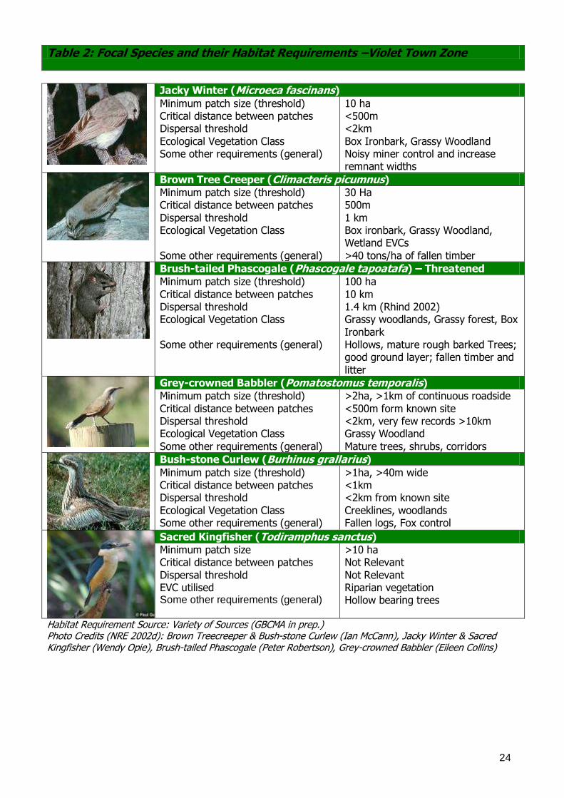
Table 2: Focal Species and their Habitat Requirements –Violet Town Zone
Jacky Winter (Microeca fascinans)
Minimum patch size (threshold) Critical distance between patches Dispersal threshold
Ecological Vegetation Class Some other requirements (general)
10 ha <500m <2km
Box Ironbark, Grassy Woodland Noisy miner control and increase remnant widths
Brown Tree Creeper (Climacteris picumnus)
Minimum patch size (threshold) Critical distance between patches
Dispersal threshold Ecological Vegetation Class
Some other requirements (general)
30 Ha 500m
1 km Box ironbark, Grassy Woodland, Wetland EVCs
>40 tons/ha of fallen timber
Brush-tailed Phascogale (Phascogale tapoatafa) – Threatened
Minimum patch size (threshold)
Critical distance between patches Dispersal threshold Ecological Vegetation Class
Some other requirements (general)
100 ha
10 km 1.4 km (Rhind 2002) Grassy woodlands, Grassy forest, Box
Ironbark Hollows, mature rough barked Trees; good ground layer; fallen timber and
litter
Grey-crowned Babbler (Pomatostomus temporalis)
Minimum patch size (threshold)
Critical distance between patches Dispersal threshold Ecological Vegetation Class
Some other requirements (general)
>2ha, >1km of continuous roadside
<500m form known site <2km, very few records >10km Grassy Woodland
Mature trees, shrubs, corridors
Bush-stone Curlew (Burhinus grallarius)
Minimum patch size (threshold) Critical distance between patches Dispersal threshold
Ecological Vegetation Class Some other requirements (general)
>1ha, >40m wide <1km <2km from known site
Creeklines, woodlands Fallen logs, Fox control
Sacred Kingfisher (Todiramphus sanctus)
Minimum patch size Critical distance between patches
Dispersal threshold EVC utilised Some other requirements (general)
>10 ha Not Relevant
Not Relevant Riparian vegetation Hollow bearing trees
Habitat Requirement Source: Variety of Sources (GBCMA in prep.) Photo Credits (NRE 2002d): Brown Treecreeper & Bush-stone Curlew (Ian McCann), Jacky Winter & Sacred Kingfisher (Wendy Opie), Brush-tailed Phascogale (Peter Robertson), Grey-crowned Babbler (Eileen Collins)
25
6.2 KEY BIODIVERSITY ASSETS Biodiversity Action Planning (BAP) attempts to take a strategic approach toward the conservation of
threatened and declining species and vegetation types, by looking for opportunities to conserve groups of species, in appropriate ecosystems. The identification of the appropriate biodiversity assets to focus conservation effort is the most critical part of the BAP process. This approach has
been used to group together species that use the same type of habitat. By protecting these assets, habitat for a suite of threatened species associated with that habitat can be conserved (e.g. by choosing ‗Wetlands‘ as a key biodiversity asset, it incorporates all of the species that live in, and use
a wetland, as well as the individual threatened species). Another benefit of this approach is that specific actions (Section 7.0), based on the requirements of each asset (e.g. to counter threats and improve the status of the asset), can be developed. Planning and implementation of on-ground
works and actions that specifically target each of these assets, can then be undertaken (GBCMA in prep.).
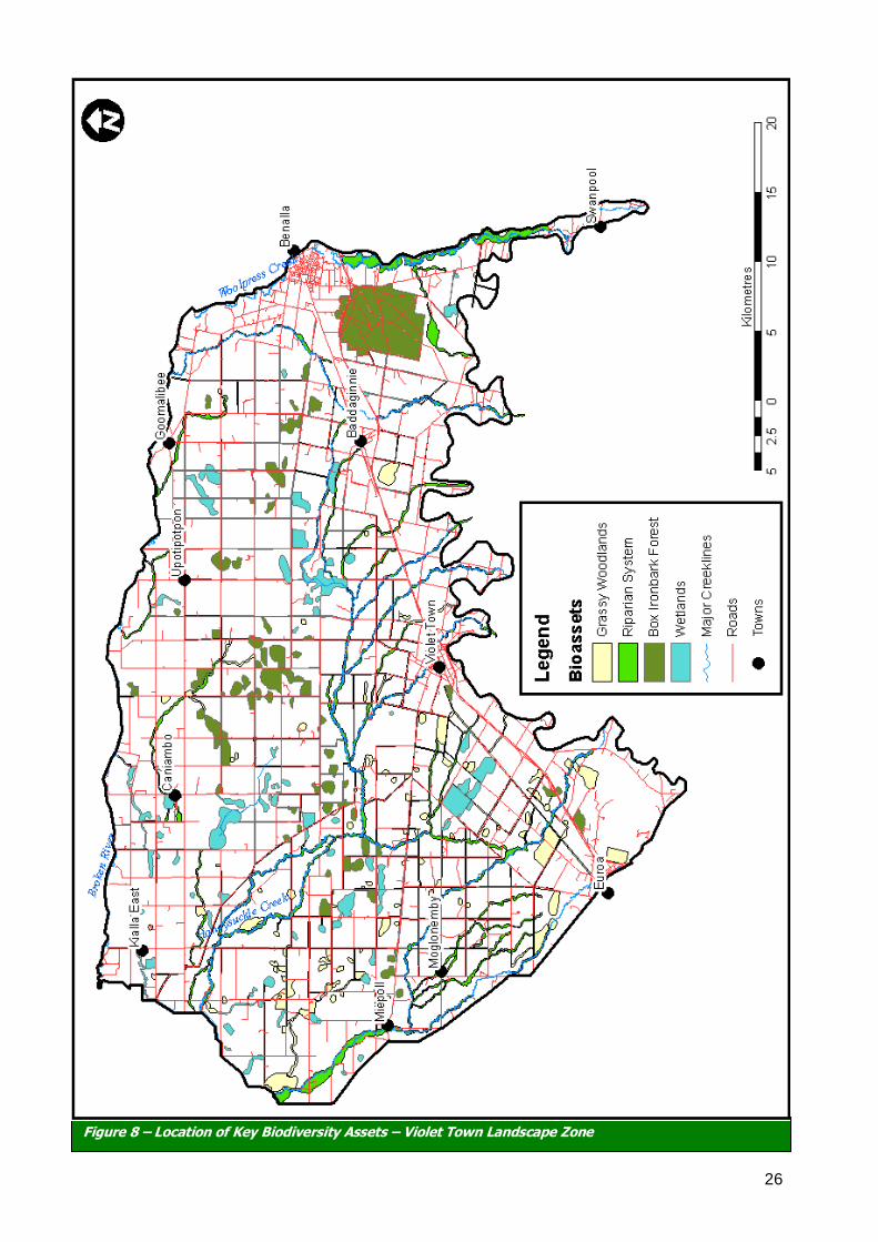
The 547 BAP sites in the Violet Town Zone have been categorised according to five key biodiversity assets: Grassy Woodland, Wetlands, Box-Ironbark Forest, and Major Creeklines (Figure 8). For further information on each asset, along with threatened species examples, refer to Table 3.
26
Figure 8 – Location of Key Biodiversity Assets – Violet Town Landscape Zone
27
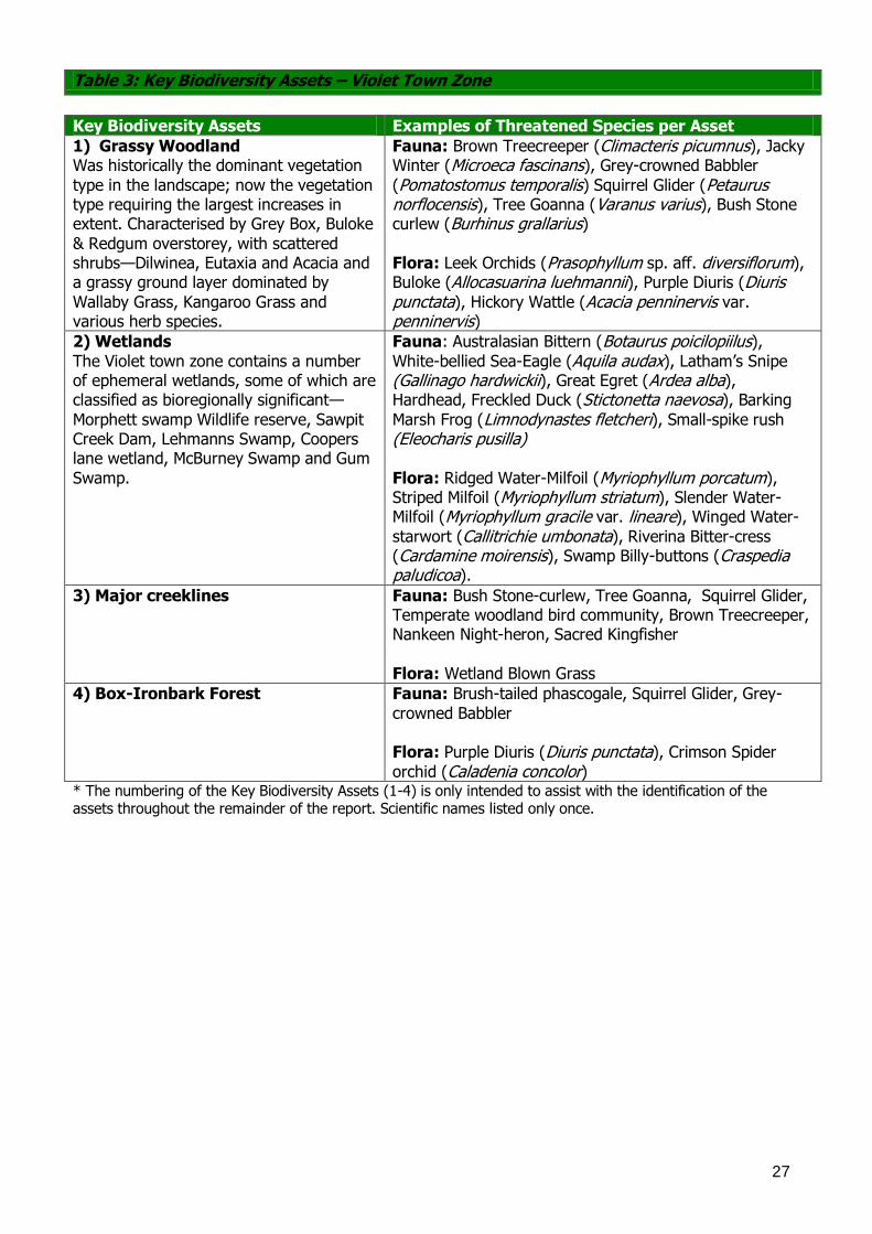
Table 3: Key Biodiversity Assets – Violet Town Zone
Key Biodiversity Assets Examples of Threatened Species per Asset
1) Grassy Woodland Was historically the dominant vegetation
type in the landscape; now the vegetation type requiring the largest increases in extent. Characterised by Grey Box, Buloke
& Redgum overstorey, with scattered shrubs—Dilwinea, Eutaxia and Acacia and a grassy ground layer dominated by
Wallaby Grass, Kangaroo Grass and various herb species.
Fauna: Brown Treecreeper (Climacteris picumnus), Jacky Winter (Microeca fascinans), Grey-crowned Babbler
(Pomatostomus temporalis) Squirrel Glider (Petaurus norflocensis), Tree Goanna (Varanus varius), Bush Stone curlew (Burhinus grallarius) Flora: Leek Orchids (Prasophyllum sp. aff. diversiflorum), Buloke (Allocasuarina luehmannii), Purple Diuris (Diuris punctata), Hickory Wattle (Acacia penninervis var. penninervis)
2) Wetlands
The Violet town zone contains a number of ephemeral wetlands, some of which are classified as bioregionally significant—
Morphett swamp Wildlife reserve, Sawpit Creek Dam, Lehmanns Swamp, Coopers lane wetland, McBurney Swamp and Gum
Swamp.
Fauna: Australasian Bittern (Botaurus poicilopiilus), White-bellied Sea-Eagle (Aquila audax), Latham‘s Snipe (Gallinago hardwickii), Great Egret (Ardea alba), Hardhead, Freckled Duck (Stictonetta naevosa), Barking
Marsh Frog (Limnodynastes fletcheri), Small-spike rush (Eleocharis pusilla)
Flora: Ridged Water-Milfoil (Myriophyllum porcatum), Striped Milfoil (Myriophyllum striatum), Slender Water-Milfoil (Myriophyllum gracile var. lineare), Winged Water-
starwort (Callitrichie umbonata), Riverina Bitter-cress (Cardamine moirensis), Swamp Billy-buttons (Craspedia paludicoa).
3) Major creeklines
Fauna: Bush Stone-curlew, Tree Goanna, Squirrel Glider, Temperate woodland bird community, Brown Treecreeper, Nankeen Night-heron, Sacred Kingfisher
Flora: Wetland Blown Grass
4) Box-Ironbark Forest Fauna: Brush-tailed phascogale, Squirrel Glider, Grey-
crowned Babbler Flora: Purple Diuris (Diuris punctata), Crimson Spider
orchid (Caladenia concolor) * The numbering of the Key Biodiversity Assets (1-4) is only intended to assist with the identification of the assets throughout the remainder of the report. Scientific names listed only once.
28
7.0 PRIORITY ACTIONS - KEY BIODIVERSITY ASSETS
Priority actions for the Violet Town Landscape Zone have been developed and grouped based on each ‗Key Biodiversity Asset‘ (eg. Wetland, roadside vegetation)(refer to Section 6.2). Priority actions for the key biodiversity assets were developed based on the following factors, (1)
size/extent (2) condition and (3) landscape processes (eg. habitat connectivity, hydrological regimes). The condition (2) section was also further split in relation to; education/extension; on-ground works; threatened species; and pest plants and animals. For example; an action relating to
the condition of a remnant, due to rabbits, can be found under; ‗condition‘ – ‗pest plants and animals‘.
For each of the five key biodiversity assets (1-4), the following pages identify: A) An introduction to the asset in the Violet Town Landscape Zone, B) Photographic example of the asset in ‗good condition‘ for the zone, and
C) Proposed actions for each of the assets in the Zone (broader actions in Ahern et al 2003). It is proposed that the community and agencies in the Violet Town Zone investigate options for
implementing these actions in to existing projects/policies. For example, BAP sites (refer to Appendix 10) in each asset type, should be targeted in order of priority (Very High, High, Medium to Low) in relation to these actions (where applicable). This forms the basis of BAP, where the very
high value sites, that require less cost for long-term protection, will provide the highest prospect for conservation (GBCMA in prep.). Note: The Flora and Fauna Guarantee Act 1988 provides for the listing of Victoria‘s threatened plant and animal species, ecological communities and potentially threatening processes. Under the Act, an Action Statement must be prepared. Action Statements outline what is required for the species conservation. They are developed based on a rigorous legislative process (Acts of Parliament) and are therefore of high priority. For further information refer to the ‗Actions for Biodiversity Conservation Database‘ (ABC) (DSE 2005a).
29
7.1) KEY BIODIVERSITY ASSET – GRASSY WOODLANDS 1A) Introduction –Grassy Woodlands: Grassy Woodlands were the most dominant biodiversity asset within the Violet Town Landscape Zone prior to the introduction of agriculture but are now endangered. The Grassy Woodland
biodiversity asset is made up of the EVC group numbers 5, 14, 15 & 16 (See Table 1). They can be found on public and private land including creeklines and roadsides.
The majority of Plains Grassy Woodland in the zone occurs on private land, roadsides and edges of larger public land. These remnants serve many important functions, including water conservation, aesthetic values, habitat values, sources of native seed and sources of food, shelter and nesting
sites for a range of woodland birds and mammals (Lunt 1998). This asset is scattered throughout the Violet Town Landscape Zone. Many of the areas in the zone
that once contained these vegetation types have been cleared for agriculture, leaving fragmented landscapes. Other threats include Adjacent Land Use Practices, Grazing, Pest Plants and Pest Animals. The actions identified below are intended to assist in the protection of the remaining
remnants within the zone. However, these actions are specific to the Violet Town Landscape Zone and are by no means comprehensive for the region.
1B) Photographic Example - Grassy Woodlands:
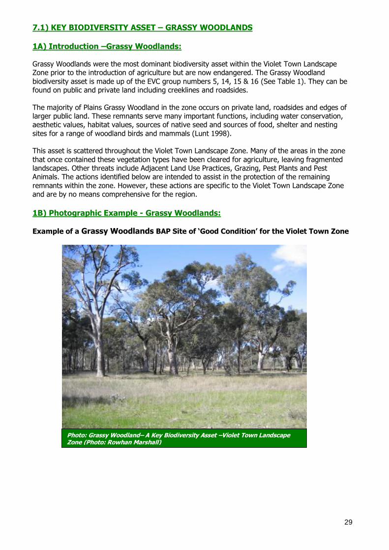
Example of a Grassy Woodlands BAP Site of ‘Good Condition’ for the Violet Town Zone
Photo: Grassy Woodland– A Key Biodiversity Asset –Violet Town Landscape Zone (Photo: Rowhan Marshall)
30
C) Actions Proposed –: Grassy Woodlands
Size/Extent:
Create buffers, through revegetation, on freehold land abutting roadside remnants or reserves to widen the habitat.
Increase connectivity to remnants and reserves along roadsides and the riparian areas. Expand patch size and improve connectivity of isolated or partly disconnected patches
Condition:
Education/Extension
Encourage landholders to increase the size of existing remnants, to establish new areas of indigenous species of trees and shrubs, and to retain or establish buffer zones of revegetation
or unimproved, uncultivated pasture around woodland. Liase with Parks Victoria, DSE, Trust for Nature, committees of management and adjacent
landholders, to establish the best practice for reserve management.
Encourage protection (fencing) of all remnants and manage grazing practices to benefit the grassy woodland (such as exclude all domestic grazing stock in remnants to allow plants to set
seed and regenerate. Manage stock grazing to benefit the native vegetation once plants have set seed).
Organise community education activities relating to the importance of Plains Grassy
Woodlands and associated flora and fauna species, specifically targeting high priority remnants in paddock environments.
Further promote the benefits of protecting and enhancing remnant patches through extension
and voluntary programs, such as Environmental Management Incentives. Educate landowners on the need to retain fallen in privately owned sites and making sure that
fallen timber is not removed illegally from public land. Educate landowners about the importance of ephemeral wetlands how to recognise them
and how to protect them. On-ground Works Protect high priority sites, through covenants or incentives.
Minimise disturbance at high value sites to prevent erosion and minimise weed invasion. Ensure clusters or individual specimens of large, hollow-bearing trees and dead standing trees
are retained and protected throughout the zone. Enhance high value sites such as Balmattum, and significant roadsides such as the Violet
Town–Dookie Road and the Violet Town–Shepparton Road, and continue to control weeds such as Phalaris.
Identify additional native grassland paddocks for protection and restoration, where artefact
grasslands were once grassy forests. Planting alternative timber supplies, to reduce the impact of firewood collection on roadsides,
remnants and waterways. Protecting and Enhancing Populations of Buloke (Allocasuarina luehmannii), Sweet Busaria
(Bursaria spinosa), Leafy Templetonia (Templetonia stenophylla), Variable Glycine (Glycine tabacina) as species which are not listed as rare and threatened in the state but are at risk within the Violet Town Zone.
Threatened Species Install nest boxes where hollows are deficient to increase the number of nesting hollows for
woodland birds and Squirrel Gliders. Modify stocking levels and grazing times, as necessary, to benefit threatened species Encourage community groups to work on threatened species projects such as Purple Diuris
(Diuris punctata), Leek Orchids (Prasophyllum. Sp. aff. pyriforme, P. sp. aff. diversiflorum), and Euroa Guinnea Flower (Hibbertia humifusa)
Pest Plant and Animals Continue ongoing control of foxes and feral cats.
Reduce the number of feral herbivores and native macropods that may exceed the carrying capacity of a site especially around Balmattum
Irradicate Feral Bee populations to allow the hollows to be used for native animals.
Control regionally listed weeds and environmental weeds from sites.

31
Landscape Processes (ie. habitat connectivity):
Identify and prioritise potential sites for habitat expansion and improved connectivity as
identified by the landscape context tool and maps provided in this document.
32
7.2) KEY BIODIVERSITY ASSETS – WETLANDS
A) Introduction – Wetlands: Wetlands are amongst the most important, productive and valuable ecosystems within the Violet
Town Landscape Zone. They perform vital functions including water purification, nutrient processing, flood management and maintenance of the watertable. They provide habitat, refuge, and breeding (nursery areas) for many common and threatened species (Howell 2002). Wetlands
can also include dams and drainage depressions on private land that are only full during the wettest times of the year (ephemeral wetlands). Most of the ephemeral wetlands within the Goulburn Broken Catchment are on private land and are therefore at a high risk of being altered by
agricultural practices such as lazering and ploughing. High value wetlands in the Zone include Jubilee Swamp Wildlife Reserve, Morphett swamp Wildlife
reserve, Sawpit Creek Dam, Lehmanns Swamp, Coopers lane wetland, McBurney Swamp and Gum Swamp.
There are a number of threats affecting wetlands in the Zone, such as land clearing, changed hydrological regimes, adjacent land use practices and pest plants and animals. The actions identified below are intended to assist in the protection of the remaining wetlands within the Violet Town
Landscape Zone. However, these actions are specific to the Zone and are by no means comprehensive for the region. Other documents (eg. Wetlands Directions Paper for the Goulburn Broken) (Howell, 2002), provide direction for protecting wetlands in the catchment.
B) Photographic Example – Wetlands:
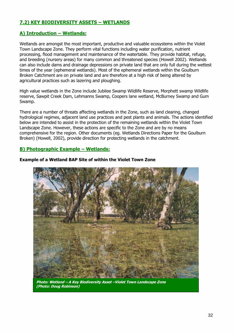
Example of a Wetland BAP Site of within the Violet Town Zone
Photo: Wetland – A Key Biodiversity Asset –Violet Town Landscape Zone (Photo: Doug Robinson)
33
C) Actions – Wetlands: Size/Extent Related:
Implement a buffer zone around all identified wetlands (as far out beyond the rim of the basin as possible) to increase the size of wetlands and provide for their protection.
Condition Related:
Education/Extension:
Provide extension to all landholders with wetlands in the Zone, to assist with recognition of the benefits of wetlands and associated plants and animals on their properties.
Provide opportunities for education of landholders and school children regarding the
benefits of wetlands on farms (eg. Violet Town Public School) (eg. a campaign on the productive value of intact wetlands, in coordination with agriculture).
Development of a site management plans for all identified wetlands in the Zone, particularly, Jubilee Swamp Wildlife Reserve, Morphett swamp Wildlife reserve, Sawpit Creek
Dam, Lehmanns Swamp, Coopers lane wetland, McBurney Swamp and Gum Swamp Encourage landholders with wetlands to protect (fence/mange stock) them. Encourage the grazing of wetlands under management, only when dry, to prevent seed set
of weeds. Encourage the appropriate use of chemicals and other water contaminants on farms and
within local communities. Prevent further removal of wetlands, through education (and legislation where required).
Investigate the use of ‗Index of Wetland Condition Assessments‘ (DSE 2006) in conjunction with Vegetation Quality Assessments (still required to allow priority comparisons).
On-ground Works: Protect (via incentives) all identified wetlands in the Zone, commencing with very high value
sites such as Jubilee Swamp Wildlife Reserve, Morphett swamp Wildlife reserve, Sawpit Creek
Dam, Lehmanns Swamp, Coopers lane wetland, McBurney Swamp and Gum Swamp. Protect existing or implement vegetative cover on inflow paths to increase water quality.
Encourage the fencing of sites to exclude grazing, particularly when wet, or prior to being wet, to allow flowering and seed-set of native plants.
Identify a demonstration site (show casing very high value site) for educational purposes.
Seek approval from Mid Goulburn IC for the Links program to provide off-stream-watering
points for private wetlands. Threatened Species: Encourage Landowners to fence off or partially fence off wetlands drainage depressions to
allow Ridged Water-milfoil and Winged Water Starwort to spread through the zone. Encourage Landowners to direct seed or transplant Ridged Water-milfoil and Winged Water
Starwort into wetlands/dams/drainage depressions that do not have stock access. Pest Plants and Animals: Encourage the continuation of fox and cat control programs for the benefit of all
species.
Landscape Processes (eg. Regimes, habitat connectivity):
Form clusters of wetlands by giving priority to protecting wetlands that are in close proximity to one another, or in close proximity to a high value site.
Restore and deliver natural hydrological regimes to wetlands, for the benefit of flora and
fauna. Continue to seek environmental water allocations for priority wetlands.
34
7.3) KEY BIODIVERSITY ASSET – MAJOR CREEKLINES A) Introduction – Major creek-lines:
Waterways, such as rivers, streams, creeks and lagoons, are the lifeblood upon which most of the other assets depend. There are a number of major waterways in the Zone, including—Broken River,
Stony Creek, Woolpress Creek, Seven Creeks and Honeysuckle Creek. All of these creeks and rivers run from the eastern or south eastern part of the zone across to the north western corner of the zone. The Major Creek lines within the zone comprise a very important refuge system for a number
of threatened taxa, and also provide abundant opportunity for expansion of habitat patches, restoration of linear corridors and consolidation of broader links (SKM Draft 2006).
Creekline vegetation remnants retain good connectivity, especially on the all of the major creeks. Sections of Seven, Honeysuckle, Stoney and Woolpress Creek are reserved as Public land Water Frontage. However, many parts of these creeklines still have stock access directly to the water,
which results in higher nutrient input and higher sediment loads. Other vegetation removal and heavy grazing from the riparian zone will also increase runoff into the creeks thereby increasing erosion, suspended sediments and increasing nutrient loads. Grazing of the riparian zones also
prevents, recruitment of all structural layers of vegetation, which results in a lack of habitat for native species. The land lying north of two lines linking Miepoll-Violet Town and Violet Town-Benalla falls within the Sheep Pen Creek ‗High Priority Area‘ for salinity management. Recommendations for
environmental flows are outlined in SKM (Draft 2006), which includes flow I for both Seven and Honeysuckle Creeks to improve the hydrology, geomorphology, water quality, fish and macroinvertebrate health, in-stream and riparian flora.
B) Photographic Example – Major creek-lines:
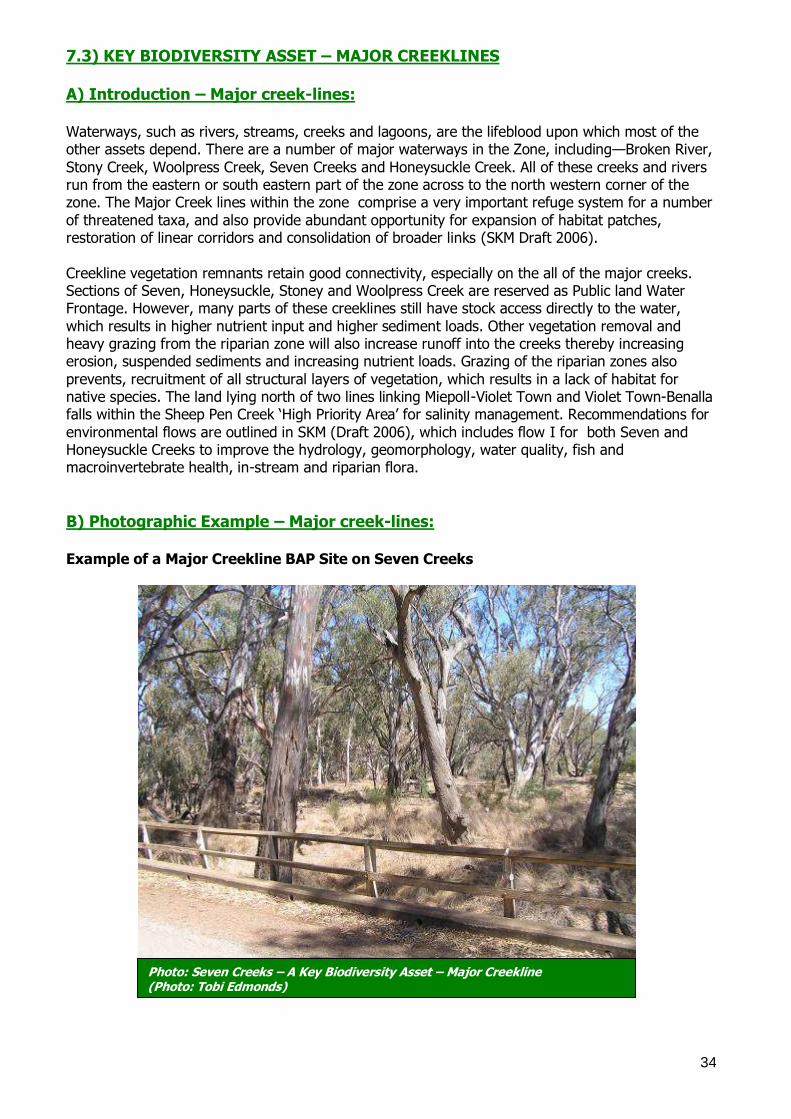
Example of a Major Creekline BAP Site on Seven Creeks
Photo: Seven Creeks – A Key Biodiversity Asset – Major Creekline (Photo: Tobi Edmonds)
35
C) Actions – Major creek-lines:
Size/Extent Related:
Buffer all Major Creeklines (Broken River, Stony Creek, Woolpress Creek, Seven Creeks and Honeysuckle Creek) with the assistance CMA Waterways grants.
Extend the area of native vegetation adjoining Major creeklines through revegetation or protection.
Condition Related:
Education/Extension: Encourage the retention of logs, leaf litter and dead trees, as habitat for reptiles and bats.
Take tours to other odeling regions (such as those of the upper Murray) to observe the
improvements to water quality that has resulted from the protection and revegetation of riparian zones.
Continue the extension work of the CMA Waterways Program.
On-ground Works: Protect all Major Creekline frontages (eg. Old Coach Road, Murray Valley Highway).
Continue to support Sheep Pen Creek Land Management Group in their efforts to restore habitat.
Undertake the flow recommendations for Honeysuckle Creek and Seven Creeks (SKM Draft
2006)
Manage grazing on public land to benefit native species following the principal ―that
adjustments to stocking numbers should be based on the condition of the ecosystem rather than the condition of the stock‖ (www.dse.vic.gov.au/dse/nrenfor.nsf).
Negotiate conservation licences with the licencees of water frontages.
Threatened Species: Manage grazing on Public Land to benefit Bush Stone-curlew and Regent Honeyeater.
Exclude regular burning at sites which host Grey-crowned Babblers to allow for shrubs to grow and provide an insect habitat.
Raise awareness among Landowners north of Violet Town, between Violet Town–Shepparton Road and Violet Town–Dookie Road; of the habitat requirements for Barking Owl.
Raise awareness among Landowners between Benalla and the Baddaginnie–Goomalibee Road; of the habitat requirements for Carpet Pythons.
Conduct Ecological burns to benefit Purple Diuris.
Manage grazing in drainage depressions and ephemeral wetlands to exclude grazing in these areas while they are wet and susceptible to pugging. This will allow for the growth and
reproduction of Ridged Water-milfoil. Encourage fishing groups to target introduced species such as Trout, Carp and Redfin and
prevent the restocking of trout in waterways. Pest Plants and Animals: Undertake pest plant management (for priority weeds such as Arrowhead (Sagittaria
odeling es s) for all high priority sites and encourage stakeholders to coordinate the removal of weeds (eg. Community working bees).
Undertake pest animal management (eg. Foxes and Cats) in areas adjoining all reserves for
the benefit of threatened fauna such as Bush Stone Curlew, Ground Cuckoo-shrike, Squirrel Glider and Turquoise Parrot.
Landscape Processes (eg. Hydrological regime, habitat connectivity):
Revegetate corridors between Major Creeklines to increase habitat connectivity across the
landscape. Restore and/or revegetate nodes (where Major Creeklines meet up) to provide habitat from
which fauna can breed and disperse. Restore the linkages between the Pranjup, Castle and Goulburn Rivers system and associated
wetlands and floodplains by the removal or breaking of levees at 80%.

36
7.4) KEY BIODIVERSITY ASSET – BOX IRONBARK
APPENDIX 4 Introduction – Box Ironbark: Box Ironbark Forests are open forests that occur on low hills at altitudes between 150-230m, with
an annual rainfall between 500-650mm. The skeletal sandy loam to clay loam soils are often odelin, and are of low fertility with a poor moisture holding capacity. In the Violet Town landscape zone they occur in a belt running west from reef hills across to Miepoll. The overstorey is
dominated by Red Box, Red Stringybark (Eucalyptus macrorhyncha), Long-leaf Box, Yellow Box and Red Ironbark (E. tricarpa). The understorey is a scattered shrub layer which includes Golden Wattle, Spreading Wattle, Daphne Heath (Brachyloma daphnoides), Grey Everlasting (Ozothamnus
obcordatus) and Sweet Bursaria (Bursaria spinosa). The sparse ground layer includes Wallaby Grasses, Spear Grasses, Red Anther Wallaby Grass (Joycea pallida), Black Anther Flax Lily (Dianella odeling), Shiny Everlasting (Bracteantha odelin) and Chocolate lily.
Over 60% of the Box Ironbark Forest in the Goulburn Broken Catchment has been lost since European settlement. Of the 40% that remains, most has been disturbed at some stage and is
degraded. Many of the plants and animals that relied on this habitat are also threatened. The main threats include: inappropriate grazing regimes, mining, isolation, lack of understorey and ground layer, lack of natural regeneration, weed invasion, pest animals and loss of old trees through
harvesting and loss of fallen timber.
B) Photographic Example – Box Ironbark: Example of a Box Ironbark BAP Site in the Violet Town Zone
Photo: Box Ironbark – A Key Biodiversity Asset in the Violet Town Zone (Photo: Rowhan Marshall)
37
C) Actions – Box Ironbark: Size/Extent:
Encourage landholders to increase the size of existing remnants, to establish new areas of indigenous species of trees and shrubs, and to retain or establish buffer zones with
revegetation or fence out and allow regeneration around Box Ironbark forest. Protect significant roadsides such as Lamonts Rd, Sloans Rd, Plozzas Rd, Griffens Rd.
Condition:
Extension/Education Organise community education activities relating to the importance of Box Ironbark
Forests and associated flora and fauna species, specifically targeting high priority remnants in paddock environments.
Further promote the benefits of protecting and enhancing remnant patches through extension and voluntary programs, such as Environmental Management Incentives and Land for Wildlife.
Encourage retention of fallen timber in privately owned Box Ironbark Forest sites. On-ground Works Maintain and improve condition of all identified high value sites by encouraging the
retention of fallen timber and hollow bearing trees, and manage regionally listed weeds. Protect clusters or individual specimens of large, hollow-bearing trees are retained and
protected throughout the zone. Exclude all grazing to allow trees, shrubs and native ground cover regenerate.
Leave any dead standing trees. Install nest boxes where natural hollows are in short supply to increase the number of nesting hollows for animals such as Brush-tailed Phascogales.
Restore structural diversity by revegetating degraded remnants with indigenous shrubs and ground cover, if regeneration has not occurred following fencing (eg. No existing seed source).
Replant species that are becoming rare within the zone such as Cane Spear-grass (Austrostipa breviglumis)
Pest Plant and Animals
Minimise disturbance at high value sites to prevent erosion and minimise weed invasion. Reduce all herbivore (including Macropod) populations in and around Box Ironbark remnants
such as Reef Hills and private remnants around Earlston; to allow for the regeneration of native understorey and ground cover species.
Continue ongoing control of foxes and feral cats for the protection of threatened species
and focal species including Brush-tailed Phascogale, Sugar Gliders and Hooded Robins. Threatened Species
Encourage community groups to work on threatened species projects such as Crimson Spider Orchid (Caladenia concolor)
Landscape Processes (eg. Hydrological regime, habitat
connectivity):
Increase connectivity to important reserves and remnants such as Reef Hills.
Identify and prioritise potential sites for habitat expansion and improved connectivity as identified by the landscape context tool and maps provided in this document.

39
8.0 Monitoring
Monitoring is a fundamental component of all management activities and an important tool, which can be used to enhance the knowledge of biodiversity assets and manage for their on-going protection (Robinson in prep.).
The following table (Table 4) provides a basis for monitoring in the Violet Town Landscape Zone. Where possible, this information will feed in to the various Goulburn Broken Catchment monitoring
programs. It identifies a general monitoring outline, including actions that may be conducted to determine progress towards achieving catchment biodiversity targets. It identifies the key biodiversity asset, key indicators for monitoring and the suggested frequency/intensity of
monitoring. It is important to note that many of the monitoring activities listed below are already taking place,
through a variety of mechanisms (eg. Collection of data via local/catchment and Statewide databases and processes). Where existing mechanisms are already in place, they will continue to be used. However, there are other monitoring activities that are needed, to provide useful information
and allow for accuracy assessment of the Catchments progress, towards meeting the Biodiversity Resource Condition Targets (RCT‘s).
A wide variety of monitoring actions are listed below. However this does not result in a binding commitment of those organisations (eg. Time or funding), to undertake all of the monitoring. Rather, this table is intended to be a source of ideas for agency staff and community groups (eg. Community groups may be interested in conducting future surveys). Interested persons can contact
the Goulburn Broken Catchment Management Authority, Shepparton, or the Department of Primary Industries and Department of Sustainability and Environment Offices, Tatura, to discuss ideas and to ensure a coordinated approach (refer to Section 10.0 for contact information).
Whilst Table 4 outlines monitoring actions, evaluation of the BAP process also needs to occur, to evaluate the effectiveness of the BAP process (eg. In engaging people and prioritising works). An
evaluation plan is therefore being developed to provide an overarching evaluation process for BAP in the Goulburn Broken Catchment.
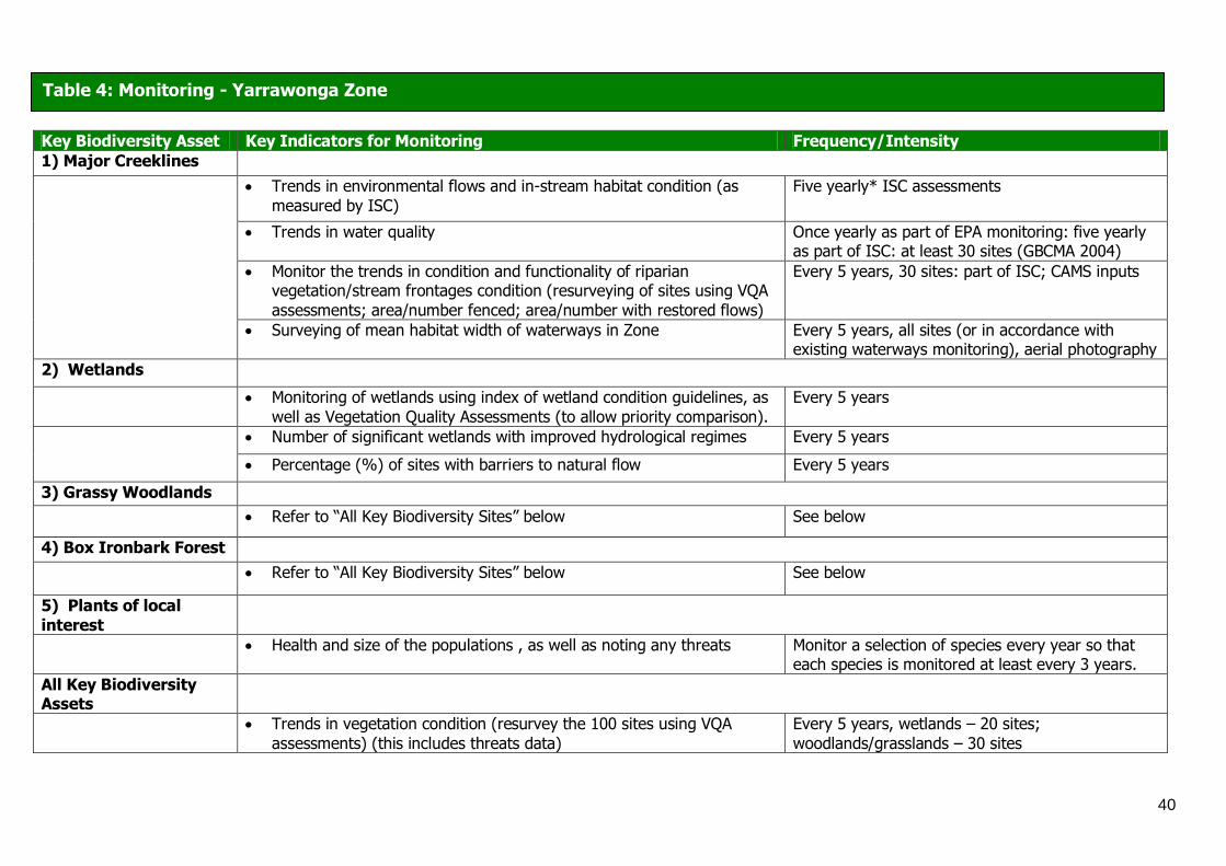
40
Key Biodiversity Asset Key Indicators for Monitoring Frequency/Intensity
1) Major Creeklines
Trends in environmental flows and in-stream habitat condition (as
measured by ISC)
Five yearly* ISC assessments
Trends in water quality Once yearly as part of EPA monitoring: five yearly as part of ISC: at least 30 sites (GBCMA 2004)
Monitor the trends in condition and functionality of riparian vegetation/stream frontages condition (resurveying of sites using VQA
assessments; area/number fenced; area/number with restored flows)
Every 5 years, 30 sites: part of ISC; CAMS inputs
Surveying of mean habitat width of waterways in Zone Every 5 years, all sites (or in accordance with existing waterways monitoring), aerial photography
2) Wetlands
Monitoring of wetlands using index of wetland condition guidelines, as
well as Vegetation Quality Assessments (to allow priority comparison).
Every 5 years
Number of significant wetlands with improved hydrological regimes Every 5 years
Percentage (%) of sites with barriers to natural flow Every 5 years
3) Grassy Woodlands
Refer to ―All Key Biodiversity Sites‖ below See below
4) Box Ironbark Forest
Refer to ―All Key Biodiversity Sites‖ below See below
5) Plants of local
interest
Health and size of the populations , as well as noting any threats Monitor a selection of species every year so that each species is monitored at least every 3 years.
All Key Biodiversity Assets
Trends in vegetation condition (resurvey the 100 sites using VQA
assessments) (this includes threats data)
Every 5 years, wetlands – 20 sites;
woodlands/grasslands – 30 sites
Table 4: Monitoring - Yarrawonga Zone
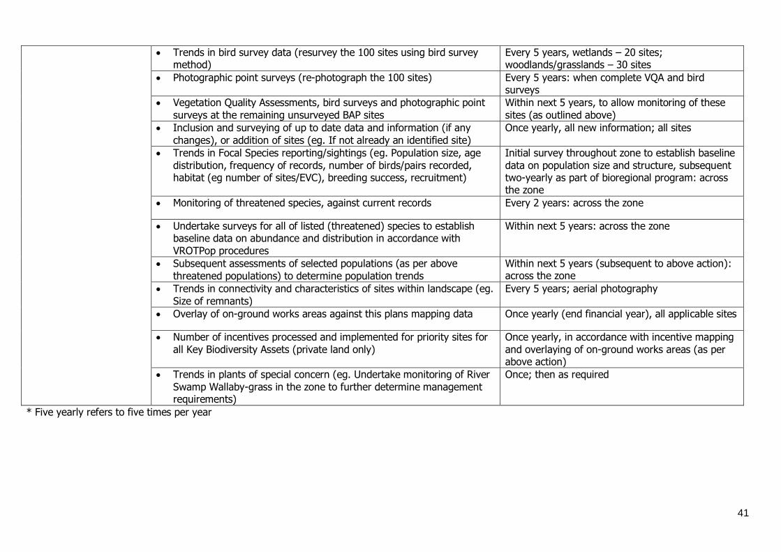
41
Trends in bird survey data (resurvey the 100 sites using bird survey method)
Every 5 years, wetlands – 20 sites; woodlands/grasslands – 30 sites
Photographic point surveys (re-photograph the 100 sites) Every 5 years: when complete VQA and bird surveys
Vegetation Quality Assessments, bird surveys and photographic point
surveys at the remaining unsurveyed BAP sites
Within next 5 years, to allow monitoring of these
sites (as outlined above)
Inclusion and surveying of up to date data and information (if any
changes), or addition of sites (eg. If not already an identified site)
Once yearly, all new information; all sites
Trends in Focal Species reporting/sightings (eg. Population size, age
distribution, frequency of records, number of birds/pairs recorded, habitat (eg number of sites/EVC), breeding success, recruitment)
Initial survey throughout zone to establish baseline
data on population size and structure, subsequent two-yearly as part of bioregional program: across the zone
Monitoring of threatened species, against current records Every 2 years: across the zone
Undertake surveys for all of listed (threatened) species to establish baseline data on abundance and distribution in accordance with
VROTPop procedures
Within next 5 years: across the zone
Subsequent assessments of selected populations (as per above
threatened populations) to determine population trends
Within next 5 years (subsequent to above action): across the zone
Trends in connectivity and characteristics of sites within landscape (eg.
Size of remnants)
Every 5 years; aerial photography
Overlay of on-ground works areas against this plans mapping data Once yearly (end financial year), all applicable sites
Number of incentives processed and implemented for priority sites for
all Key Biodiversity Assets (private land only)
Once yearly, in accordance with incentive mapping
and overlaying of on-ground works areas (as per above action)
Trends in plants of special concern (eg. Undertake monitoring of River
Swamp Wallaby-grass in the zone to further determine management requirements)
Once; then as required
* Five yearly refers to five times per year
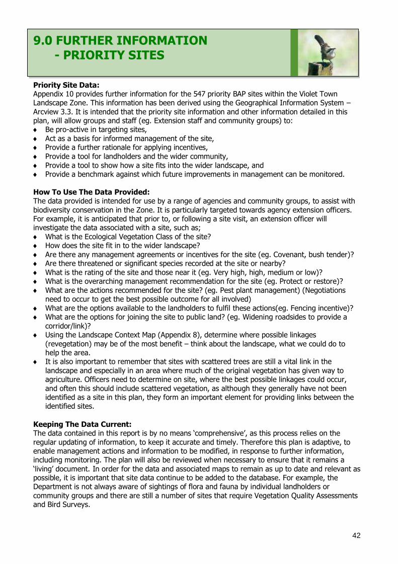
42
9.0 FURTHER INFORMATION - PRIORITY SITES
Priority Site Data: Appendix 10 provides further information for the 547 priority BAP sites within the Violet Town Landscape Zone. This information has been derived using the Geographical Information System –
Arcview 3.3. It is intended that the priority site information and other information detailed in this plan, will allow groups and staff (eg. Extension staff and community groups) to: Be pro-active in targeting sites,
Act as a basis for informed management of the site, Provide a further rationale for applying incentives,
Provide a tool for landholders and the wider community,
Provide a tool to show how a site fits into the wider landscape, and Provide a benchmark against which future improvements in management can be monitored.
How To Use The Data Provided: The data provided is intended for use by a range of agencies and community groups, to assist with
biodiversity conservation in the Zone. It is particularly targeted towards agency extension officers. For example, it is anticipated that prior to, or following a site visit, an extension officer will investigate the data associated with a site, such as;
What is the Ecological Vegetation Class of the site? How does the site fit in to the wider landscape?
Are there any management agreements or incentives for the site (eg. Covenant, bush tender)? Are there threatened or significant species recorded at the site or nearby?
What is the rating of the site and those near it (eg. Very high, high, medium or low)? What is the overarching management recommendation for the site (eg. Protect or restore)?
What are the actions recommended for the site? (eg. Pest plant management) (Negotiations need to occur to get the best possible outcome for all involved)
What are the options available to the landholders to fulfil these actions(eg. Fencing incentive)? What are the options for joining the site to public land? (eg. Widening roadsides to provide a
corridor/link)? Using the Landscape Context Map (Appendix 8), determine where possible linkages
(revegetation) may be of the most benefit – think about the landscape, what we could do to help the area.
It is also important to remember that sites with scattered trees are still a vital link in the
landscape and especially in an area where much of the original vegetation has given way to agriculture. Officers need to determine on site, where the best possible linkages could occur,
and often this should include scattered vegetation, as although they generally have not been identified as a site in this plan, they form an important element for providing links between the identified sites.
Keeping The Data Current: The data contained in this report is by no means ‗comprehensive‘, as this process relies on the
regular updating of information, to keep it accurate and timely. Therefore this plan is adaptive, to enable management actions and information to be modified, in response to further information, including monitoring. The plan will also be reviewed when necessary to ensure that it remains a
‗living‘ document. In order for the data and associated maps to remain as up to date and relevant as possible, it is important that site data continue to be added to the database. For example, the Department is not always aware of sightings of flora and fauna by individual landholders or
community groups and there are still a number of sites that require Vegetation Quality Assessments and Bird Surveys.

43
Further Information or To Provide Data: For clarification of information or to provide further data, please contact the Water and Biodiversity Team, Department of Sustainability and Environment, Benalla on (03) 5761 1611.
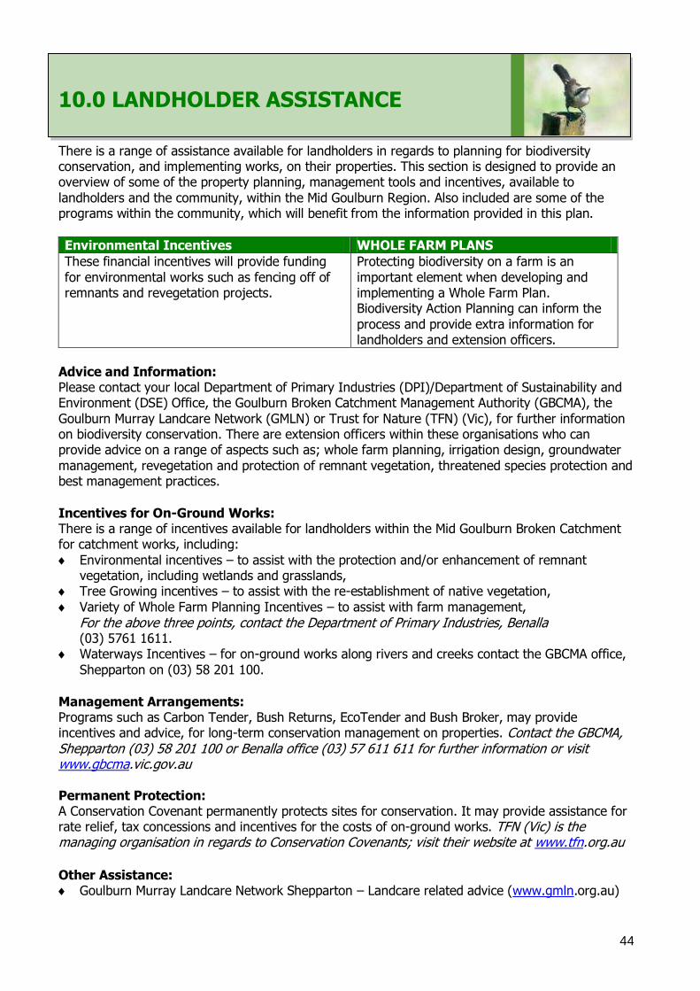
44
10.0 LANDHOLDER ASSISTANCE
There is a range of assistance available for landholders in regards to planning for biodiversity conservation, and implementing works, on their properties. This section is designed to provide an overview of some of the property planning, management tools and incentives, available to
landholders and the community, within the Mid Goulburn Region. Also included are some of the programs within the community, which will benefit from the information provided in this plan.
Environmental Incentives WHOLE FARM PLANS
These financial incentives will provide funding
for environmental works such as fencing off of remnants and revegetation projects.
Protecting biodiversity on a farm is an
important element when developing and implementing a Whole Farm Plan. Biodiversity Action Planning can inform the
process and provide extra information for landholders and extension officers.
Advice and Information: Please contact your local Department of Primary Industries (DPI)/Department of Sustainability and Environment (DSE) Office, the Goulburn Broken Catchment Management Authority (GBCMA), the
Goulburn Murray Landcare Network (GMLN) or Trust for Nature (TFN) (Vic), for further information on biodiversity conservation. There are extension officers within these organisations who can provide advice on a range of aspects such as; whole farm planning, irrigation design, groundwater
management, revegetation and protection of remnant vegetation, threatened species protection and best management practices.
Incentives for On-Ground Works: There is a range of incentives available for landholders within the Mid Goulburn Broken Catchment for catchment works, including:
Environmental incentives – to assist with the protection and/or enhancement of remnant vegetation, including wetlands and grasslands,
Tree Growing incentives – to assist with the re-establishment of native vegetation,
Variety of Whole Farm Planning Incentives – to assist with farm management,
For the above three points, contact the Department of Primary Industries, Benalla (03) 5761 1611.
Waterways Incentives – for on-ground works along rivers and creeks contact the GBCMA office,
Shepparton on (03) 58 201 100. Management Arrangements: Programs such as Carbon Tender, Bush Returns, EcoTender and Bush Broker, may provide incentives and advice, for long-term conservation management on properties. Contact the GBCMA, Shepparton (03) 58 201 100 or Benalla office (03) 57 611 611 for further information or visit www.gbcma.vic.gov.au
Permanent Protection: A Conservation Covenant permanently protects sites for conservation. It may provide assistance for rate relief, tax concessions and incentives for the costs of on-ground works. TFN (Vic) is the managing organisation in regards to Conservation Covenants; visit their website at www.tfn.org.au
Other Assistance: Goulburn Murray Landcare Network Shepparton – Landcare related advice (www.gmln.org.au)

45
Land for Wildlife – a voluntary scheme aiming to encourage and assist landholders to protect and enhance biodiversity values on their properties. Managed by the Department of Sustainability and Environment – for further information visit www.dse.vic.gov.au.
Local Government (Greater Shepparton City Council, Strathbogie and Rural City of Benalla) – managing authority for native vegetation statutory planning requirements.
46
11.0 REFERENCES
Ahern, L.D., Lowe, K.W., Berwick, S., Robinson, D. & Handley, K. (2003). Biodiversity Action Planning: Landscape Plans
for the Goulburn Broken Catchment Management Authority (GBCMA) – Mid Goulburn Region – North Zones. Department
of Sustainability and Environment, Victoria.
Bennett, A.F. (1993). Fauna conservation in Box and Iron-Box forests: a landscape approach. Victorian Naturalist
110:15-23.
Berwick, S (2003b). Map Unit Descriptions of Lower Goulburn Broken (draft). State of Victoria, Melbourne.
Birds Australia (2001). Bird Surveying Techniques. Available at: http://www.birdsaustralia.org.au.
CGDL (2005). Corporate Geographical Database Library (CGDL). State of Victoria, Melbourne.
Crown (1997). Victoria‘s Biodiversity: Directions in Management. State of Victoria, Melbourne.
DPI (2005). Dairying for Tomorrow: Dairy Sat- The Guide. State of Victoria, Melbourne.
DSE (2004). Environmental Management in Agriculture: Worksheet Series 1-8. State of Victoria, Melbourne.
DSE (2005a). Actions for Biodiversity Conservation Database (ABC). Department of Sustainability and Environment
(DSE). State of Victoria, Melbourne.
DSE (2006). Index of Wetland Condition: Assessment of wetland vegetation. Update – March 2006. State of Victoria,
Melbourne.
Earl, G., stelling, F., Titcumb, M. & Berwick, S. (Editors) (2001) Revegetation Guide for the Goulburn Broken Catchment.
Department of Natural Resources & Environment.
Ferwerder, F. (2003). Landscape Context Model. State of Victoria, Melbourne.
GBCMA (in prep.). Goulburn Broken Biodiversity Action Planning Developer‘s Manual. GBCMA, Shepparton.
GBCMA (2000). Goulburn Broken Native Vegetation Plan. GBCMA, Shepparton. Available at:
http://www.gbcma.vic.gov.au.
GBCMA (2003a). Goulburn Broken Regional Catchment Strategy. GBCMA, Shepparton. Available at:
http://www.gbcma.vic.gov.au.
GBCMA (2004). Goulburn Broken River Health Strategy (draft). GBCMA, Shepparton. Available at:
http://www.gbcma.vic.gov.au.
Howell, M. (2002). Wetland Directions Paper for the Goulburn Broken Catchment. GBCMA, Shepparton. Available at:
http://www.gbcma.vic.gov.au.
Lambeck, R.J. (1997). Landscape planning for biodiversity conservation in agricultural regions. Biodviersity Technical
paper No. 2. Commonwealth of Australia, Canberra.
Lunt, I. (1998). Protecting our wonderful woodland remnants. Charles Sturt University, Thurgoona, NSW.
47
NRE (2002a). Victoria‘s Native Vegetation Management: a Framework for Action. State of Victoria, Melbourne.
NRE (2002b). Healthy rivers, healthy communities and regional growth: the Victorian River Health Strategy. State of
Victoria, Melbourne.
NRE (2002c). Victorian Flora Site Database – May 2002. State of Victoria, Melbourne.
NRE (2002d). Atlas of Victorian Wildlife. March 2002. State of Victoria, Melbourne.
Platt, S.J. (2002). How to plan wildlife landscapes: a guide for community odeling es s. State of Victoria, Melbourne.
Platt, S.J. & Lowe, K.W. (2002). Biodiversity Action Planning: planning for native biodiversity at multiple scales –
catchment, bioregional, landscape, local. State of Victoria, Melbourne.
Rhind, S. G., (2002), Reproductive demographics among brush-tailed odeling es (Phascogale tapoatafa) in south-
western Australia, Wildlife Research, 29, 247–257, CSIRO Publishing Collingwood Vic
Robinson, D. (in prep.). A monitoring, evaluation and reporting strategy for the Longwood Plains Biodiversity Project.
Trust for Nature (TfN) (Vic) & DSE, Benalla.
SKM , (Draft 2006) Seven Creeks environmental flows assessment, Sinclair Knight Merz, Armadale Victoria
Viridians (2005). Victorian Fauna Database. Viridians Pty Ltd Bentleigh east, Victoria Australia3165
Wilson, J.A & Lowe, K.W. (2002). Planning for the conservation of native biodiversity within catchments using
biophysical odeling. State of Victoria, Melbourne.
Wierzbowski, P., Lowe, K.W., Handley, K, Berwick, S., Robinson, D. & Ahern, L.D. (2002). Biodiversity Action Planning:
Strategic Overview for the Victorian Riverina Bioregion. State of Victoria, Melbourne.
48
12.0 ACKNOWLEDGMENTS
This project is funded as part of the Goulburn Broken Catchment Management Authority Regional
Catchment Strategy, in the Upper Goulburn Broken Region and is provided with support and funding from the Australian and Victorian Governments. This project is delivered primarily through partnerships between the Goulburn Broken Catchment Management Authority (GBCMA),
Department of Primary Industries (DPI), Department of Sustainability and Environment (DSE), Trust for Nature (Vic) (TfN) and other community bodies. Personnel from these agencies provided generous support and advice during the development of this plan.
We also thank numerous Landholders, Landcare Groups, Local Area Planning Groups, Agency representatives and individuals, who provided generous support, advice, information and
assistance. This included, guidance, technical knowledge, attendance at meetings, plan review, provision of literature and survey data, and property access.
Thank-you also to person‘s who have provided photographs. Photographer credit (names) are included under each photograph throughout the report.
A special acknowledgment to all representatives (current and past) on the Goulburn Broken Biodiversity Action Planning (BAP) Steering Committee. This steering committee was established to oversee the BAP process and is responsible for the coordination of BAP, in the Goulburn Broken
Catchment. The committee is comprised of personnel from a range of departmental organisations, including the GBCMA, DPI, DSE and TfN (Vic). Core committee members are detailed below, along with contributors to BAP in the Goulburn Broken (eg. Meeting attendance, trial implementation,
and plan development). Thank you to person‘s whom have attended meetings as invited guest‘s (names not listed) and provided valuable comment. BAP Steering Committee Members: GBCMA - Barlow, Tim – Manager, Biodiversity Programs, GBCMA (current)
Brunt, Kate – Biodiversity Projects Coordinator, GBCMA (current) Bell, Kate – (as) Manager, Biodiversity Programs, GBCMA (past)
DPI - Heard, Rebecca – Native Biodiversity Coordinator, DPI (SIR) (current) Stothers, Kate – Nature Conservation Coordinator, DPI (Dryland) (current)
Williams, Lance – Planning Officer, DPI (SIR) (past)
Sislov, Alex – Team Leader Enviroment Programe, DPI (SIR) (current) DSE - Merritt, Bronwyn – Biodiversity Landscape Plan Project Officer (Upper) (past)
Smith, Stephen – Senior Flora and Fauna Officer, DSE (Upper) (current)
Edmonds, Tobi – Threatened Flora Projects Officer, DSE (Lower) (current) Wilson, (Dr) Jenny – Biodiversity Projects Officer, DSE (Dryland) (current)
Colbourne, Debbie – (as) Flora and Fauna Planner, DSE (Dryland) (past)
Sheahan, Mark – (as) Biodiversity Team Leader, North East, DSE (past) TFN (Vic) - Robinson, (Dr) Doug – Regional Manager, Goulburn Broken – TfN (Vic) (current)
Biodiversity Action Planning Contributors: Mitchell, Peter – Links Officer, DPI (trial implementation) Olive, Cathy – Links Officer, DPI (trial implementation)
Weber, Rolf – (as) Acting Biodiversity Team Leader, DSE Berwick, Sue – (as) Flora and Fauna Planner, DSE (past) Mentiplay-Smith, Janice – Links Officer, DPI (current)
Howell, Marion – Biodiversity Officer, GBCMA (past)
49
13.0 APPENDICES
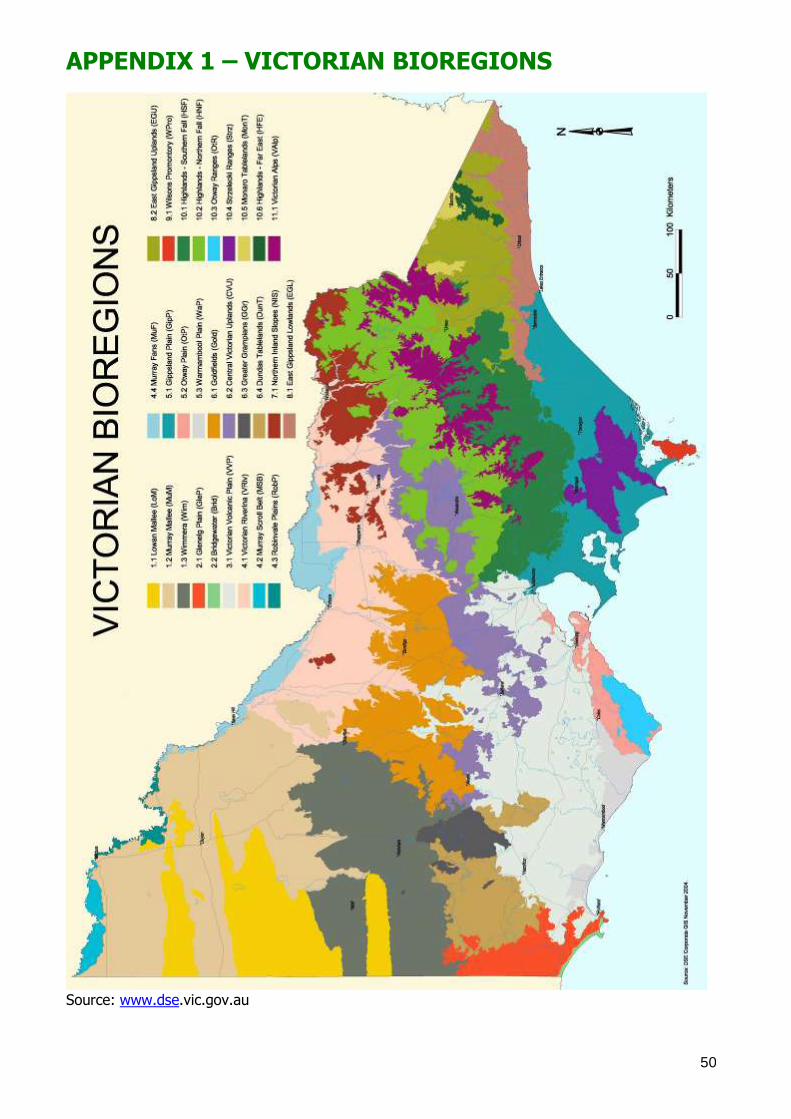
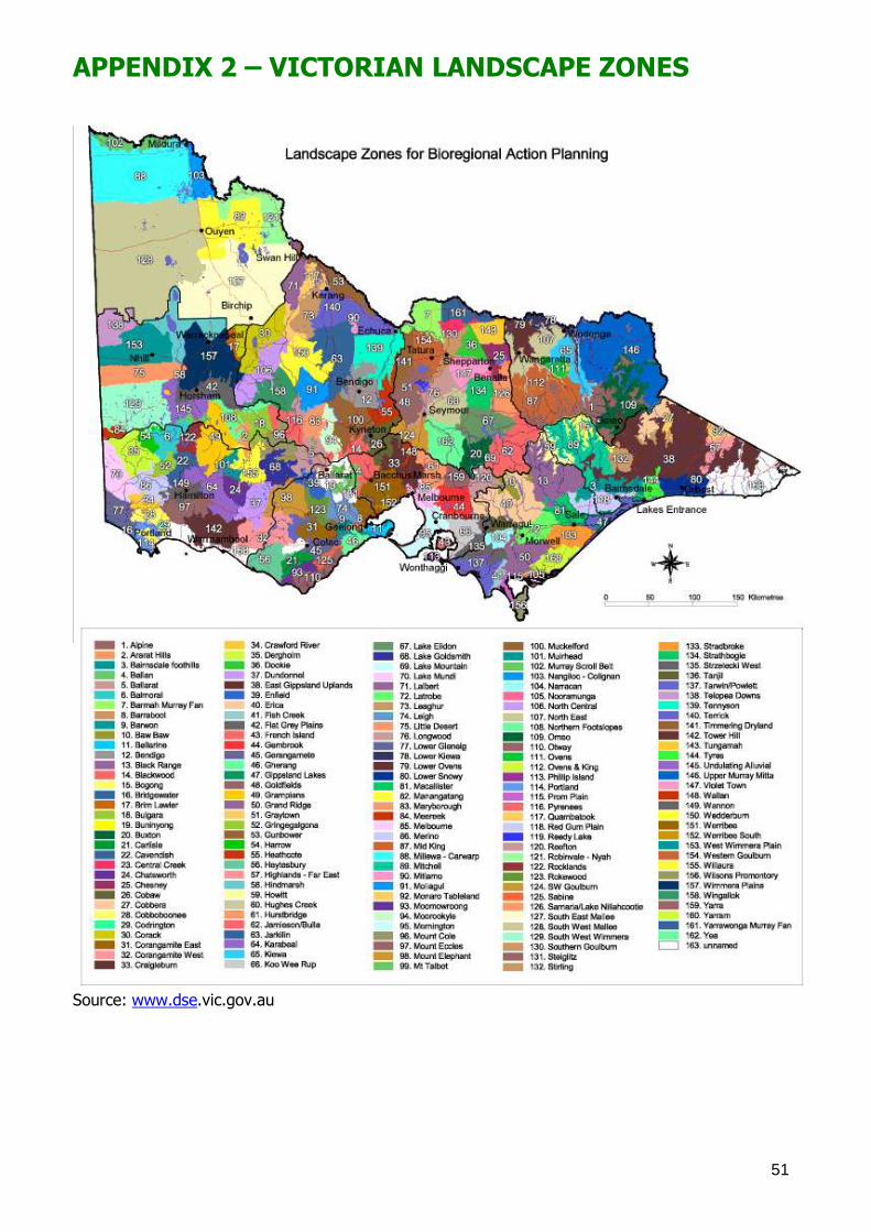
52
APPENDIX 3 – GOULBURN BROKEN CATCHMENT TARGETS This Appendix is intended to provide a summary of the Goulburn Broken Regional Catchment Strategy targets and priorities for biodiversity conservation. For further information please refer to
GBCMA 2003 or visit www.gbcma.vic.gov.au.
The Goulburn Broken Regional Catchment Strategy identifies the following biodiversity resource condition targets, for native vegetation in the catchment: 1. Maintain the extent of all native vegetation types at 1999 levels in keeping with the goal of
‗Net Gain‘ listed in Victoria‘s Biodiversity Strategy 1997, 2. Improve the quality of 90% of existing (2003) native vegetation by 10% by 2030, 3. Increase the cover of all endangered and applicable vulnerable Ecological Vegetation Classes to
at least 15% of their pre-European vegetation cover by 2030, 4. Increase 2002 conservation status of 80% threatened flora and 60% threatened fauna by
2030,
5. Maintain the extent of all wetland types at 2003 levels where the extent (area and number) has declined since European settlement, and
6. Improve the condition of 70% of wetlands by 2030, using 2003 as the benchmark for condition (GBCMA 2003 p11).
Priorities for action to conserve biodiversity in the Goulburn Broken Catchment (GBC) are driven by the conservation significance of the biodiversity asset. Regional investments in biodiversity
conservation in the GBC are driven by the following goals (in order of priority): 1. Protecting existing viable remnant habitats and the flora and fauna populations they contain
(eg. Through reservation, covenants, management agreements, fencing and statutory
planning), 2. Enhancing the existing viable habitats that are degraded (eg. Management of threats such as
pest plants and animals, grazing, salinity, promotion of natural regeneration and/or
revegetation with understorey), and 3. Restoring under-represented biodiversity assets to their former extent by revegetation (to
create corridors, buffers, patches of habitat) (GBCMA 2003).
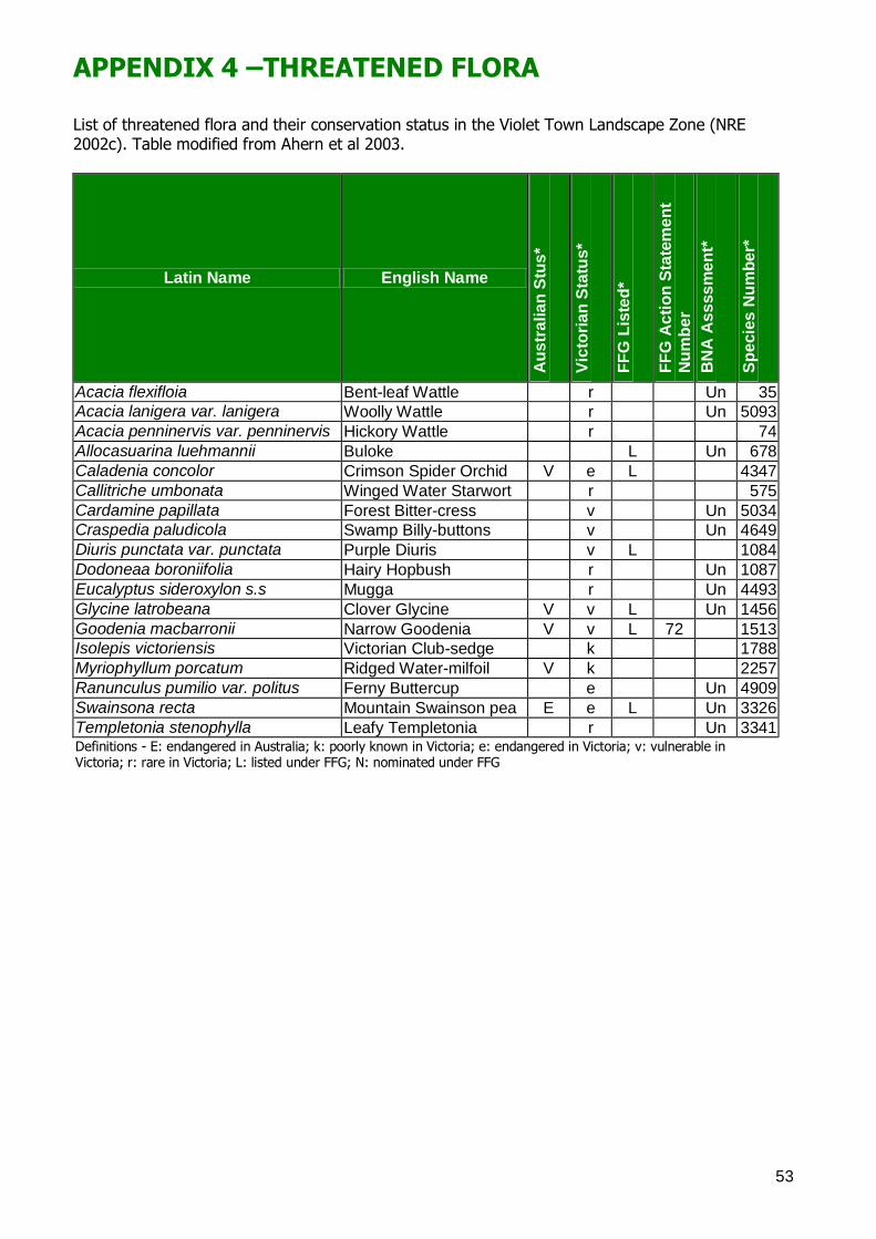
53
APPENDIX 4 –THREATENED FLORA List of threatened flora and their conservation status in the Violet Town Landscape Zone (NRE 2002c). Table modified from Ahern et al 2003.
Latin Name English Name
Au
str
alia
n S
tus
*
Vic
tori
an
Sta
tus
*
FF
G L
iste
d*
FF
G A
cti
on
Sta
tem
en
t
Nu
mb
er
BN
A A
ss
ss
me
nt*
Sp
ecie
s N
um
be
r*
Acacia flexifloia Bent-leaf Wattle r Un 35
Acacia lanigera var. lanigera Woolly Wattle r Un 5093
Acacia penninervis var. penninervis Hickory Wattle r 74
Allocasuarina luehmannii Buloke L Un 678
Caladenia concolor Crimson Spider Orchid V e L 4347
Callitriche umbonata Winged Water Starwort r 575
Cardamine papillata Forest Bitter-cress v Un 5034
Craspedia paludicola Swamp Billy-buttons v Un 4649
Diuris punctata var. punctata Purple Diuris v L 1084
Dodoneaa boroniifolia Hairy Hopbush r Un 1087
Eucalyptus sideroxylon s.s Mugga r Un 4493
Glycine latrobeana Clover Glycine V v L Un 1456
Goodenia macbarronii Narrow Goodenia V v L 72 1513
Isolepis victoriensis Victorian Club-sedge k 1788
Myriophyllum porcatum Ridged Water-milfoil V k 2257
Ranunculus pumilio var. politus Ferny Buttercup e Un 4909
Swainsona recta Mountain Swainson pea E e L Un 3326
Templetonia stenophylla Leafy Templetonia r Un 3341 Definitions - E: endangered in Australia; k: poorly known in Victoria; e: endangered in Victoria; v: vulnerable in Victoria; r: rare in Victoria; L: listed under FFG; N: nominated under FFG
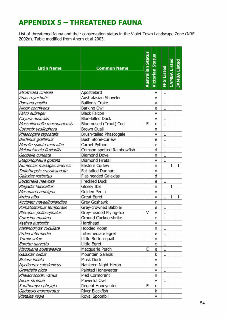
54
APPENDIX 5 – THREATENED FAUNA List of threatened fauna and their conservation status in the Violet Town Landscape Zone (NRE 2002d). Table modified from Ahern et al 2003.
Latin Name Common Name
Au
str
ali
an
Sta
tus
Vic
tori
an
Sta
tus
FF
G L
iste
d
CA
MB
A L
iste
d
JA
MB
A L
iste
d
Struthidea cinerea Apostlebird v L
Anas rhynchotis Australasian Shoveler v
Porzana pusilla Baillon's Crake v L
Ninox connivens Barking Owl e L
Falco subniger Black Falcon v
Oxyura australis Blue-billed Duck v L
Maccullochella macquariensis Blue-nosed (Trout) Cod E c L
Coturnix ypsilophora Brown Quail n
Phascogale tapoatafa Brush-tailed Phascogale v L
Burhinus grallarius Bush Stone-curlew e L
Morelia spilota metcalfei Carpet Python e L
Melanotaenia fluviatilis Crimson-spotted Rainbowfish d L
Geopelia cuneata Diamond Dove n L
Stagonopleura guttata Diamond Firetail v L
Numenius madagascariensis Eastern Curlew n 1 1
Sminthopsis crassicaudata Fat-tailed Dunnart n
Galaxias rostratus Flat-headed Galaxias d
Stictonella naevosa Freckled Duck e L
Plegadis falcinellus Glossy Ibis n 1
Macquaria ambigua Golden Perch v
Ardea alba Great Egret v L 1 1
Accipiter navaelhollandiae Grey Goshawk r
Pomatostomus temporalis Grey-crowned Babbler e L
Pteropus poliocephalus Grey-headed Flying-fox V v L
Coracina maxima Ground Cuckoo-shrike e L
Aythya australis Hardhead v
Melanodryas cucullata Hooded Robin n L
Ardea intermedia Intermediate Egret e L
Turnix velox Little Button-quail n
Egretta garzetta Little Egret e L
Macquaria australasica Macquarie Perch E e L
Galaxias olidus Mountain Galaxis k L
Biziura lobata Musk Duck v
Nycticorax caledonicus Nankeen Night Heron n
Grantiella picta Painted Honeyeater v L
Phalacrocorax varius Pied Cormorant n
Ninox strenua Powerful Owl v L
Xanthomyza phrygia Regent Honeyeater E c L
Gadopsis marmoratus River Blackfish k
Platalea regia Royal Spoonbill v
55
Aepyprymnus rufescens Rufous Bettong x L
Bidyanus bidyanus Silver perch e L
Myotis macropus Southern Myotis n
Chthonicola sagittata Speckled Warbler v L
Lophoictinia isura Square-tailed Kite e L
Petaurus norfolcensis Squirrel Glider e L
Lathamus discolor Swift Parrot E e L
Varanus varius Tree Goanna v
Neophema pulchella Turquoise Parrot n L
Ramphotyphlops proximus Woodland Blind Snake n Definitions: CAMBA listed (China-Australia Migratory Bird Agreement); JAMBA listed(Japan-Australia Migratory Bird Agreement); V: vulnerable in Australia; E: Endangered in Australia; c: criticaly endangered in Victoria; e: endangered in Victoria; v: vulnerable in Victoria; n: near threatened in Victoria; L: listed under FFG
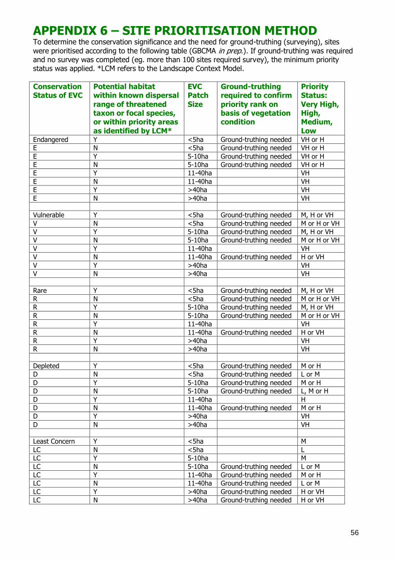
56
APPENDIX 6 – SITE PRIORITISATION METHOD To determine the conservation significance and the need for ground-truthing (surveying), sites
were prioritised according to the following table (GBCMA in prep.). If ground-truthing was required and no survey was completed (eg. more than 100 sites required survey), the minimum priority status was applied. *LCM refers to the Landscape Context Model.
Conservation Status of EVC
Potential habitat within known dispersal
range of threatened taxon or focal species, or within priority areas
as identified by LCM*
EVC Patch
Size
Ground-truthing required to confirm
priority rank on basis of vegetation condition
Priority Status:
Very High, High, Medium,
Low Endangered Y <5ha Ground-truthing needed VH or H
E N <5ha Ground-truthing needed VH or H
E Y 5-10ha Ground-truthing needed VH or H
E N 5-10ha Ground-truthing needed VH or H
E Y 11-40ha VH
E N 11-40ha VH
E Y >40ha VH
E N >40ha VH
Vulnerable Y <5ha Ground-truthing needed M, H or VH
V N <5ha Ground-truthing needed M or H or VH
V Y 5-10ha Ground-truthing needed M, H or VH
V N 5-10ha Ground-truthing needed M or H or VH
V Y 11-40ha VH
V N 11-40ha Ground-truthing needed H or VH
V Y >40ha VH
V N >40ha VH
Rare Y <5ha Ground-truthing needed M, H or VH
R N <5ha Ground-truthing needed M or H or VH
R Y 5-10ha Ground-truthing needed M, H or VH
R N 5-10ha Ground-truthing needed M or H or VH
R Y 11-40ha VH
R N 11-40ha Ground-truthing needed H or VH
R Y >40ha VH
R N >40ha VH
Depleted Y <5ha Ground-truthing needed M or H
D N <5ha Ground-truthing needed L or M
D Y 5-10ha Ground-truthing needed M or H
D N 5-10ha Ground-truthing needed L, M or H
D Y 11-40ha H
D N 11-40ha Ground-truthing needed M or H
D Y >40ha VH
D N >40ha VH
Least Concern Y <5ha M
LC N <5ha L
LC Y 5-10ha M
LC N 5-10ha Ground-truthing needed L or M
LC Y 11-40ha Ground-truthing needed M or H
LC N 11-40ha Ground-truthing needed L or M
LC Y >40ha Ground-truthing needed H or VH
LC N >40ha Ground-truthing needed H or VH
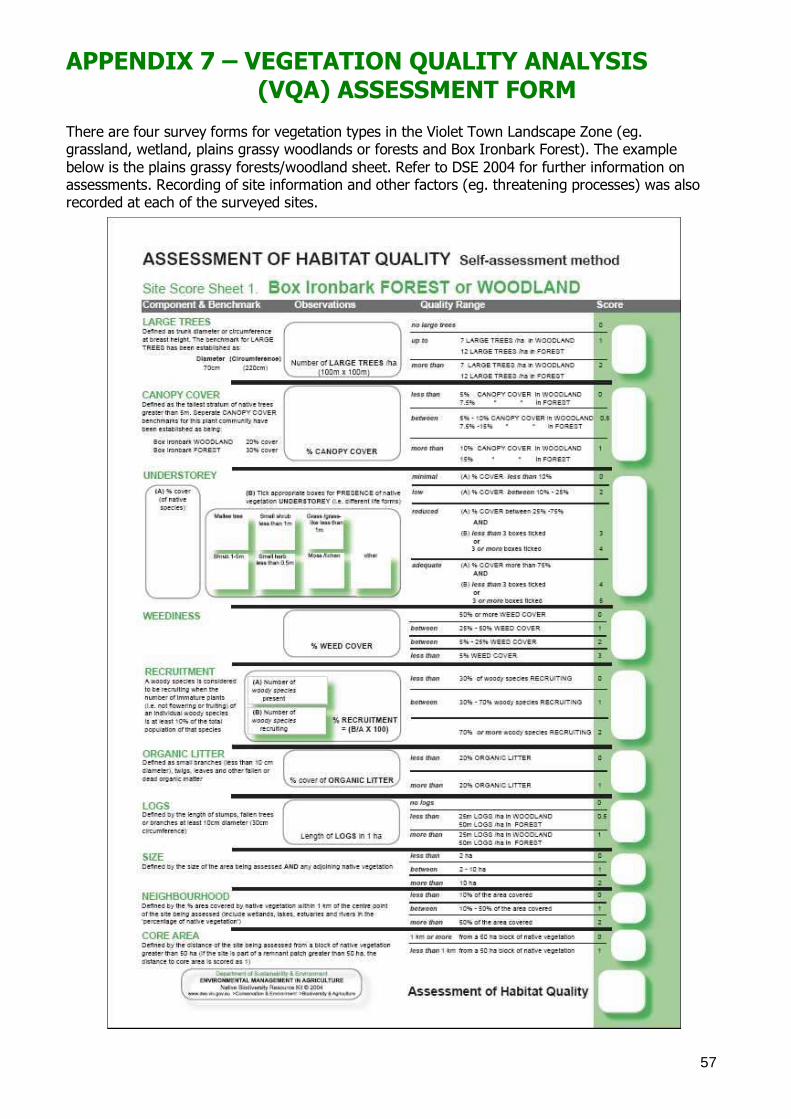
57
APPENDIX 7 – VEGETATION QUALITY ANALYSIS (VQA) ASSESSMENT FORM There are four survey forms for vegetation types in the Violet Town Landscape Zone (eg. grassland, wetland, plains grassy woodlands or forests and Box Ironbark Forest). The example
below is the plains grassy forests/woodland sheet. Refer to DSE 2004 for further information on assessments. Recording of site information and other factors (eg. threatening processes) was also recorded at each of the surveyed sites.
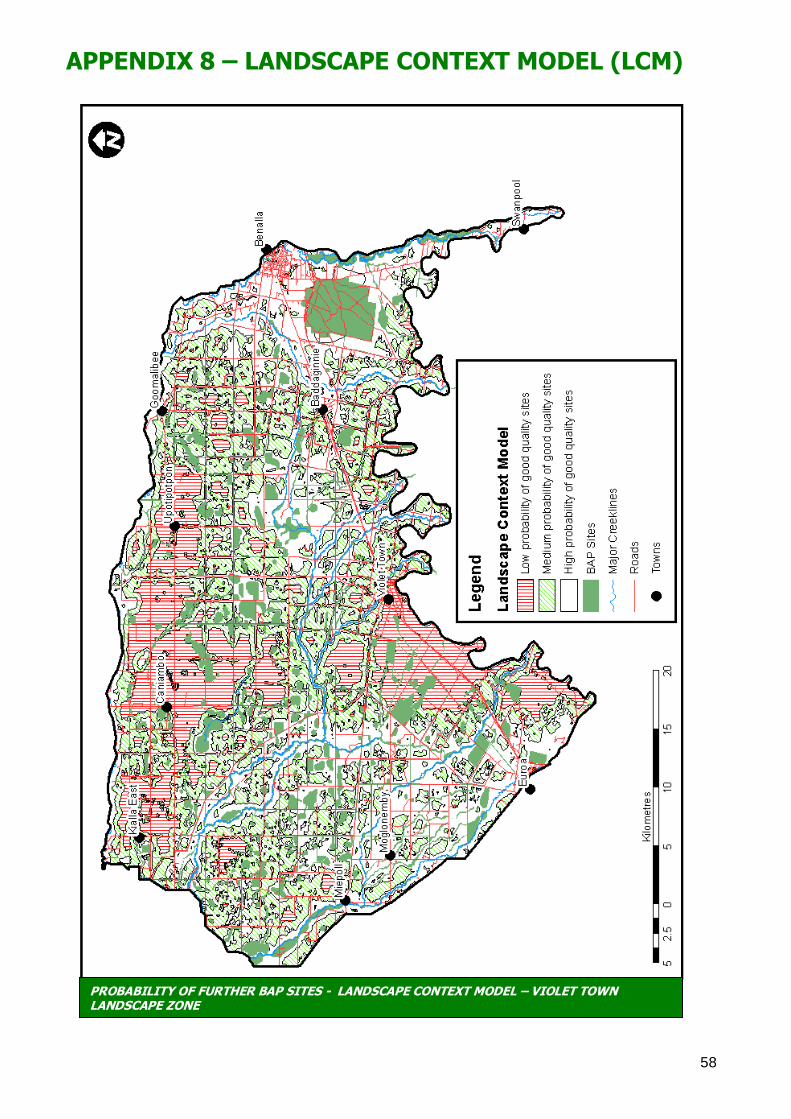
58
APPENDIX 8 – LANDSCAPE CONTEXT MODEL (LCM)
PROBABILITY OF FURTHER BAP SITES - LANDSCAPE CONTEXT MODEL – VIOLET TOWN LANDSCAPE ZONE
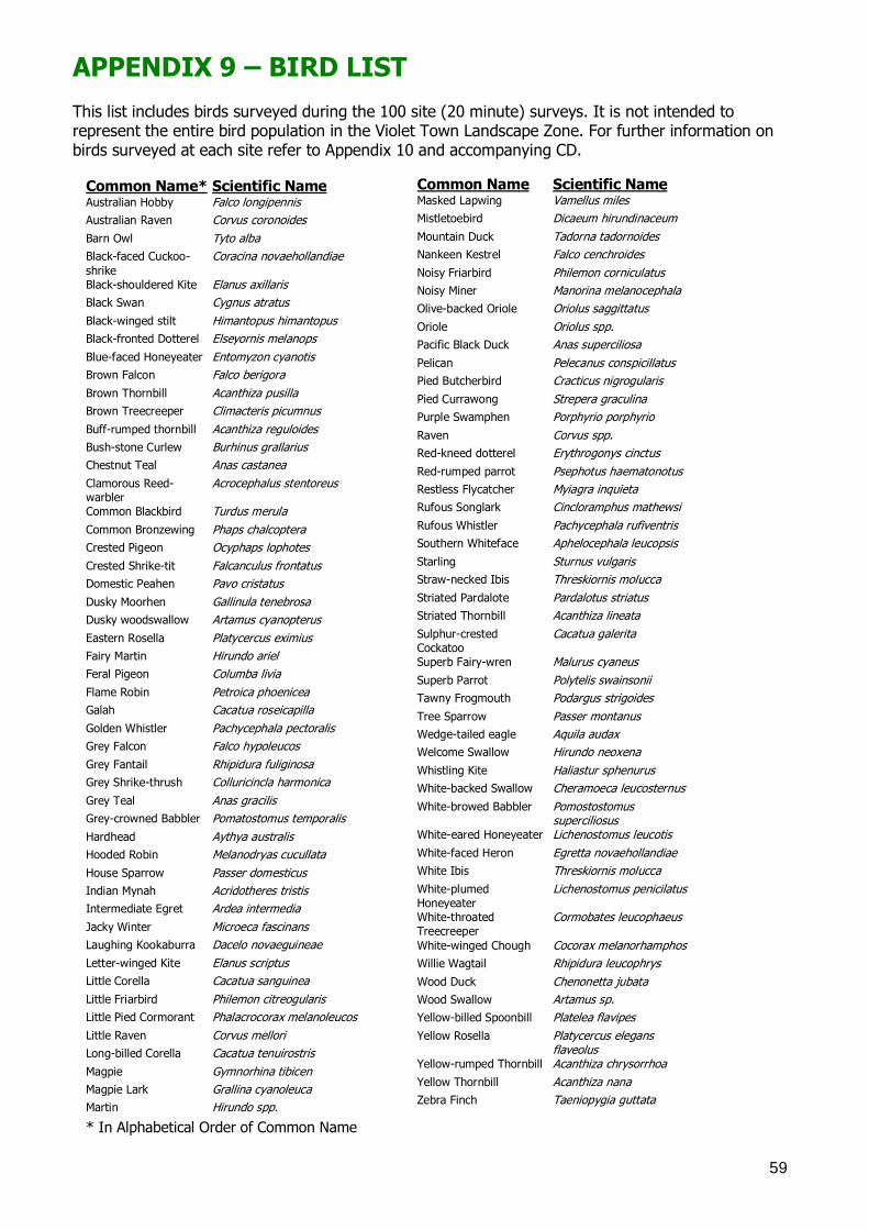
59
APPENDIX 9 – BIRD LIST
This list includes birds surveyed during the 100 site (20 minute) surveys. It is not intended to represent the entire bird population in the Violet Town Landscape Zone. For further information on birds surveyed at each site refer to Appendix 10 and accompanying CD.
Common Name* Scientific Name Australian Hobby Falco longipennis
Australian Raven Corvus coronoides
Barn Owl Tyto alba
Black-faced Cuckoo-
shrike
Coracina novaehollandiae
Black-shouldered Kite Elanus axillaris
Black Swan Cygnus atratus
Black-winged stilt Himantopus himantopus
Black-fronted Dotterel Elseyornis melanops
Blue-faced Honeyeater Entomyzon cyanotis
Brown Falcon Falco berigora
Brown Thornbill Acanthiza pusilla
Brown Treecreeper Climacteris picumnus
Buff-rumped thornbill Acanthiza reguloides
Bush-stone Curlew Burhinus grallarius
Chestnut Teal Anas castanea
Clamorous Reed-warbler
Acrocephalus stentoreus
Common Blackbird Turdus merula
Common Bronzewing Phaps chalcoptera
Crested Pigeon Ocyphaps lophotes
Crested Shrike-tit Falcanculus frontatus
Domestic Peahen Pavo cristatus
Dusky Moorhen Gallinula tenebrosa
Dusky woodswallow Artamus cyanopterus
Eastern Rosella Platycercus eximius
Fairy Martin Hirundo ariel
Feral Pigeon Columba livia
Flame Robin Petroica phoenicea
Galah Cacatua roseicapilla
Golden Whistler Pachycephala pectoralis
Grey Falcon Falco hypoleucos
Grey Fantail Rhipidura fuliginosa
Grey Shrike-thrush Colluricincla harmonica
Grey Teal Anas gracilis
Grey-crowned Babbler Pomatostomus temporalis
Hardhead Aythya australis
Hooded Robin Melanodryas cucullata
House Sparrow Passer domesticus
Indian Mynah Acridotheres tristis
Intermediate Egret Ardea intermedia
Jacky Winter Microeca fascinans
Laughing Kookaburra Dacelo novaeguineae
Letter-winged Kite Elanus scriptus
Little Corella Cacatua sanguinea
Little Friarbird Philemon citreogularis
Little Pied Cormorant Phalacrocorax melanoleucos
Little Raven Corvus mellori
Long-billed Corella Cacatua tenuirostris
Magpie Gymnorhina tibicen
Magpie Lark Grallina cyanoleuca
Martin Hirundo spp.
* In Alphabetical Order of Common Name
Common Name Scientific Name Masked Lapwing Vamellus miles
Mistletoebird Dicaeum hirundinaceum
Mountain Duck Tadorna tadornoides
Nankeen Kestrel Falco cenchroides
Noisy Friarbird Philemon corniculatus
Noisy Miner Manorina melanocephala
Olive-backed Oriole Oriolus saggittatus
Oriole Oriolus spp.
Pacific Black Duck Anas superciliosa
Pelican Pelecanus conspicillatus
Pied Butcherbird Cracticus nigrogularis
Pied Currawong Strepera graculina
Purple Swamphen Porphyrio porphyrio
Raven Corvus spp.
Red-kneed dotterel Erythrogonys cinctus
Red-rumped parrot Psephotus haematonotus
Restless Flycatcher Myiagra inquieta
Rufous Songlark Cincloramphus mathewsi
Rufous Whistler Pachycephala rufiventris
Southern Whiteface Aphelocephala leucopsis
Starling Sturnus vulgaris
Straw-necked Ibis Threskiornis molucca
Striated Pardalote Pardalotus striatus
Striated Thornbill Acanthiza lineata
Sulphur-crested Cockatoo
Cacatua galerita
Superb Fairy-wren Malurus cyaneus
Superb Parrot Polytelis swainsonii
Tawny Frogmouth Podargus strigoides
Tree Sparrow Passer montanus
Wedge-tailed eagle Aquila audax
Welcome Swallow Hirundo neoxena
Whistling Kite Haliastur sphenurus
White-backed Swallow Cheramoeca leucosternus
White-browed Babbler Pomostostomus superciliosus
White-eared Honeyeater Lichenostomus leucotis
White-faced Heron Egretta novaehollandiae
White Ibis Threskiornis molucca
White-plumed Honeyeater
Lichenostomus penicilatus
White-throated Treecreeper
Cormobates leucophaeus
White-winged Chough Cocorax melanorhamphos
Willie Wagtail Rhipidura leucophrys
Wood Duck Chenonetta jubata
Wood Swallow Artamus sp.
Yellow-billed Spoonbill Platelea flavipes
Yellow Rosella Platycercus elegans flaveolus
Yellow-rumped Thornbill Acanthiza chrysorrhoa
Yellow Thornbill Acanthiza nana
Zebra Finch Taeniopygia guttata
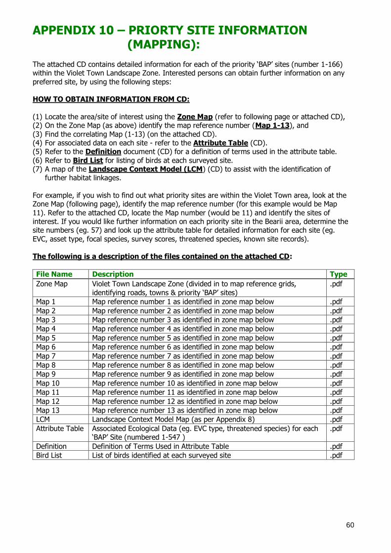
60
APPENDIX 10 – PRIORTY SITE INFORMATION (MAPPING): The attached CD contains detailed information for each of the priority ‗BAP‘ sites (number 1-166) within the Violet Town Landscape Zone. Interested persons can obtain further information on any
preferred site, by using the following steps: HOW TO OBTAIN INFORMATION FROM CD:
(1) Locate the area/site of interest using the Zone Map (refer to following page or attached CD), (2) On the Zone Map (as above) identify the map reference number (Map 1-13), and
(3) Find the correlating Map (1-13) (on the attached CD). (4) For associated data on each site - refer to the Attribute Table (CD). (5) Refer to the Definition document (CD) for a definition of terms used in the attribute table.
(6) Refer to Bird List for listing of birds at each surveyed site. (7) A map of the Landscape Context Model (LCM) (CD) to assist with the identification of
further habitat linkages.
For example, if you wish to find out what priority sites are within the Violet Town area, look at the Zone Map (following page), identify the map reference number (for this example would be Map
11). Refer to the attached CD, locate the Map number (would be 11) and identify the sites of interest. If you would like further information on each priority site in the Bearii area, determine the site numbers (eg. 57) and look up the attribute table for detailed information for each site (eg.
EVC, asset type, focal species, survey scores, threatened species, known site records). The following is a description of the files contained on the attached CD:
File Name Description Type
Zone Map Violet Town Landscape Zone (divided in to map reference grids,
identifying roads, towns & priority ‗BAP‘ sites)
Map 1 Map reference number 1 as identified in zone map below .pdf
Map 2 Map reference number 2 as identified in zone map below .pdf
Map 3 Map reference number 3 as identified in zone map below .pdf
Map 4 Map reference number 4 as identified in zone map below .pdf
Map 5 Map reference number 5 as identified in zone map below .pdf
Map 6 Map reference number 6 as identified in zone map below .pdf
Map 7 Map reference number 7 as identified in zone map below .pdf
Map 8 Map reference number 8 as identified in zone map below .pdf
Map 9 Map reference number 9 as identified in zone map below .pdf
Map 10 Map reference number 10 as identified in zone map below .pdf
Map 11 Map reference number 11 as identified in zone map below .pdf
Map 12 Map reference number 12 as identified in zone map below .pdf
Map 13 Map reference number 13 as identified in zone map below .pdf
LCM Landscape Context Model Map (as per Appendix 8) .pdf
Attribute Table Associated Ecological Data (eg. EVC type, threatened species) for each ‗BAP‘ Site (numbered 1-547 )
Definition Definition of Terms Used in Attribute Table .pdf
Bird List List of birds identified at each surveyed site .pdf
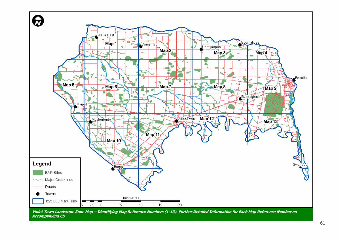
61
Violet Town Landscape Zone Map – Identifying Map Reference Numbers (1-13). Further Detailed Information for Each Map Reference Number on Accompanying CD

62