natural heritage zones: a national assessment of … · zone 3 western isles 76 1 nature of the...
TRANSCRIPT

NATURAL HERITAGE ZONES: ANATIONAL ASSESSMENT OFSCOTLAND’S LANDSCAPES
Page 2 11 January, 2002
ContentsPurpose of document 6
An introduction to landscape 7
The role of SNH 7
Landscape assessment 8
PART 1 OVERVIEW OF SCOTLAND'S LANDSCAPE 9
1 Scotland’s landscape: a descriptive overview 10
Highlands 10
Northern and western coastline 13
Eastern coastline 13
Central lowlands 13
Lowlands 13
2 Nationally significant landscape characteristics 18
Openness 18
Intervisibility 18
Naturalness 19
Natural processes 19
Remoteness 19
Infrastructure 20
3 Forces for change in the landscape 21
Changes in landuse (1950–2000) 21
Current landuse trends 25
Changes in development pattern 1950–2001 25
Changes in perception (1950–2001) 32
Managing landscape change 34
4 Landscape character: threats and opportunities 36
References 40
PART 2 LANDSCAPE PROFILES: A WORKING GUIDE 42
ZONE 1 SHETLAND 43
1 Nature of the landscape resource 43
2 Importance and value of the zone landscape 51
3 Landscape and trends in the zone 51
4 Building a sustainable future 53
ZONE 2 NORTH CAITHNESS AND ORKNEY 54
Page 3 11 January, 2002
1 Nature of the landscape resource 54
2 Importance and value of the zone landscape 72
3 Landscape and trends in the zone 72
4 Building a sustainable future 75
ZONE 3 WESTERN ISLES 76
1 Nature of the landscape resource 76
2 Importance and value of the zone landscape 88
3 Landscape and trends in the zone 89
4 Building a sustainable future 92
ZONE 4 NORTH WEST SEABOARD 93
1 Nature of the landscape resource 93
2 Importance and value of the zone landscape 107
3 Landscape and trends in the zone 108
4 Building a sustainable future 110
ZONE 5 THE PEATLANDS OF CAITHNESS AND SUTHERLAND 111
1 Nature of the landscape resource 111
2 Importance and value of the zone landscape 124
3 Landscape and trends in the zone 125
4 Building a sustainable future 128
Zone 6 WESTERN SEABOARD 129
1 Nature of the landscape resource 129
2 Importance and value of the zone landscape 145
3 Landscape and trends in the zone 146
4 Building a sustainable future 149
ZONE 7 NORTHERN HIGHLANDS 150
1 Nature of the landscape resource 150
2 Importance and value of the zone landscape 164
3 Landscape and trends in the zone 165
4 Building a sustainable future 168
ZONE 8 WESTERN HIGHLANDS 169
1 Nature of the landscape resource 169
2 Importance and value of the zone landscape 186
3 Landscape and trends in the zone 188
4 Building a sustainable future 190
ZONE 9 NORTH EAST COASTAL PLAIN 191
1 Nature of the landscape resource 191
2 Importance and value of the zone landscape 204
3 Landscape and trends in the zone 205
Page 4 11 January, 2002
4 Building a sustainable future 208
Zone 10 CENTRAL HIGHLANDS 209
1 Nature of the landscape resource 209
2 Importance and value of the zonal landscape 218
3 Landscape and trends in the zone 219
4 Building a sustainable future 220
ZONE 11 CAIRNGORM MASSIF 221
Nature of the landscape resource 221
2 Importance and value of the zone landscape 233
3 landscape and trends in the zone 233
4 Building a sustainable future 235
ZONE 12 NORTH EAST GLENS 236
1 Nature of the landscape resource 236
2 Importance and value of the zone landscape 248
3 Landscape and trends in the zone 249
4 Building a sustainable future 251
ZONE 13 LOCHABER 252
1 Nature of the landscape resource 252
2 Importance and value of the zone landscape 268
3 Landscape and trends in the zone 270
4 Building a sustainable future 272
ZONE 14 ARGYLL WEST & ISLANDS 273
1 Nature of the landscape resource 273
2 Importance and value of the zone landscape 288
3 Landscape and trends in the zone 290
4 Building a sustainable future 292
Zone 15 CENTRAL ARGYLL AND BREADALBANE 293
1 Nature of the landscape resource 293
ZONE 16 WESTERN SEABOARD 319
1 Nature of the landscape resource 319
2 Importance and value of the zone landscape 341
3 Landscape and trends in the zone 342
4 Building a sustainable future 345
ZONE 17 WEST CENTRAL BELT 346
1 Nature of the landscape resource 346
2 Importance and value of the zone landscape 364
3 Landscape and trends in the zone 365
4 Building a sustainable future 369

Page 5 11 January, 2002
ZONE 18 WIGTOWN MACHAIRS & OUTER SOLWAY 370
1 Nature of the landscape resource 370
2 Importance and value of the zone landscape 378
3 Landscape and trends in the zone 379
4 Building a sustainable future 381
ZONE 19 WESTERN SOUTHERN UPLANDS & INNER SOLWAY 382
1 Nature of the landscape resource 382
2 Importance and value of the zone landscape 398
3 Landscape and trends in the zone 399
4 Building a sustainable future 401
ZONE 20 BORDER HILLS 402
1 Nature of the landscape resource 402
2 Importance and value of the zone landscape 418
3 Landscape and trends in the zone 419
4 Building a sustainable future 424
ZONE 21 MORAY FIRTH 425
1 Nature of the landscape resource 425
2 Importance and value of the zone landscape 442
3 Landscape and trends in the zone 443
4 Building a sustainable future 445

Page 6 11 January, 2002
Purpose of documentThis National Assessment provides an overview of Scotland’s landscape resource and isdivided into four parts:
• a descriptive summary of the resource from a national perspective;• a description of the nationally significant characteristics of the Scottish landscape,
building on the more detailed Landscape Character Assessments commissioned byScottish Natural Heritage;
• an overview of changes in landuse and development that influence the character of theScottish landscape and an examination of how these affect both the physical landscapecharacter and its perception; and finally
• an analysis of these changes in relation to the threats and opportunities they pose forthe nationally significant landscape qualities.

Page 7 11 January, 2002
An introduction to landscapeFor its size Scotland has a diverse landscape. Primarily influenced by its geology andgeomorphological history the diverse range of landscape character is directly related to theland form and the variety of rock types and soils which underpin the physical landscape.These physical features and processes, along with climate, have influenced the naturalvegetation pattern and, combined with accessibility, have in turn influenced cultivation andsettlement patterns. Much of the current pattern of land use and development reflects thephysical limitations and opportunities provided by the natural environment.
However, the tangible elements of physical relief and pattern of vegetation and settlementare only a component of what we now refer to as ‘landscape’. The term has an establishedmeaning as land that is appreciated through visual experience. Visual appreciation is still thedominant sense, but in contemporary usage the meaning of landscape has been developed toinclude aspects which are more than just about our visual senses. Perceptions such as thedegree of enclosure or exposure, or historical and aesthetic attributes which may create avery particular, and often intangible ‘sense of place’, also contribute to the term ‘landscape’.
In this way, the study of landscape aims primarily to explore how people respond to thephysical landscape, and to identify, assess and understand its aesthetic values.
The role of SNH
The remit of SNH is set out in its founding legislation, The Natural Heritage (Scotland) Act1991. This states that the aims of SNH are to ‘...secure the conservation and enhancementof, and to foster understanding and facilitate the enjoyment of, the natural heritage ofScotland.’ The Act defines the natural heritage as ‘...the flora and fauna of Scotland, itsgeological and physiographic features, its natural beauty and amenity.’ There is no clearstatutory definition of ‘natural beauty and amenity’, although there is an explanation of theelements embraced by the term in Section 78(2) of the Countryside (Scotland) Act 1967 whichstates that natural beauty is ‘....construed as including references to the conservationfeatures of geological or physiographical interests therein and of the fauna and flora thereof’.In more popular terms ‘natural beauty and amenity’ is simply interpreted as what peoplesee, experience and enjoy as they react to their surroundings. SNH uses the word‘landscape’ as a more descriptive and analytical interpretation of ‘natural beauty and amenity’in the course of its work.
SNH’s recently published Corporate Strategy – A Natural Perspective, sets out the contextfor its work over the next ten years. The strategic framework is founded on three themes:
1. caring for the natural world;
2. enriching peoples lives;
3. promoting sustainable use.
The landscape work of SNH bridges all three themes. Broad objectives within the strategyset out SNH’s approach to conserving landscapes (Theme 1), outline activities designed toenhance the quality of settlements and the green space around these (Theme 2), and inform

Page 8 11 January, 2002
decisions about the design of new built development and sustainable use of naturalresources (Theme 3).
Landscape assessment
When SNH was formed in April 1992 it quickly became apparent that there was nocoherent or comprehensive body of knowledge or inventory in existence on the landscapesof Scotland. Landscape assessment had first emerged in the mid-1980s as a tool which setout clearly to separate the classification and description of landscape character, that is whatmakes one area ‘different’ or ‘distinct’ from another, from landscape evaluation.
SNH initiated its own Landscape Character Assessment programme in 1994 to fill thesubstantial gap that existed in our knowledge of the extent and diversity of Scotland’slandscapes. Between 1994 and 1998 29 regional LCA studies (see reference list) wereundertaken with the co-operation and support from local planning authorities, and a rangeof other statutory and community organisations. The programme was designed to describethe landscape character of the total land area of Scotland. Activities which impact on thelandscapes, referred to as ‘forces for change’; and especially those forces which have thepotential to alter or reduce the intrinsic character and diversity of the landscape, were alsoidentified.
The awareness of landscape as a combination of physical attributes and human response hasbeen used within the SNH Landscape Character Assessments to identify ‘areas of consistentand recognisable landscape character’. These areas are known as Landscape Character‘Types’; 365 of which have been identified for Scotland. The 29 regional LandscapeCharacter Assessment reports provide the basis for much of the summary in Part I of thisdocument.
In addition, SNH is concerned about values; especially the scenic qualities of the landscape.These values are largely concerned with the aesthetic and compositional aspects oflandscape and focus on people’s perceptions. While this has principally been articulatedthrough the designation of National Scenic areas, understanding of scenic quality has alsobeen used to inform the text in Part III of this National Assessment.

Page 9 11 January, 2002
PART 1OVERVIEW OF
SCOTLAND'SLANDSCAPE

Page 10 11 January, 2002
1 Scotland’s landscape: a descriptiveoverview
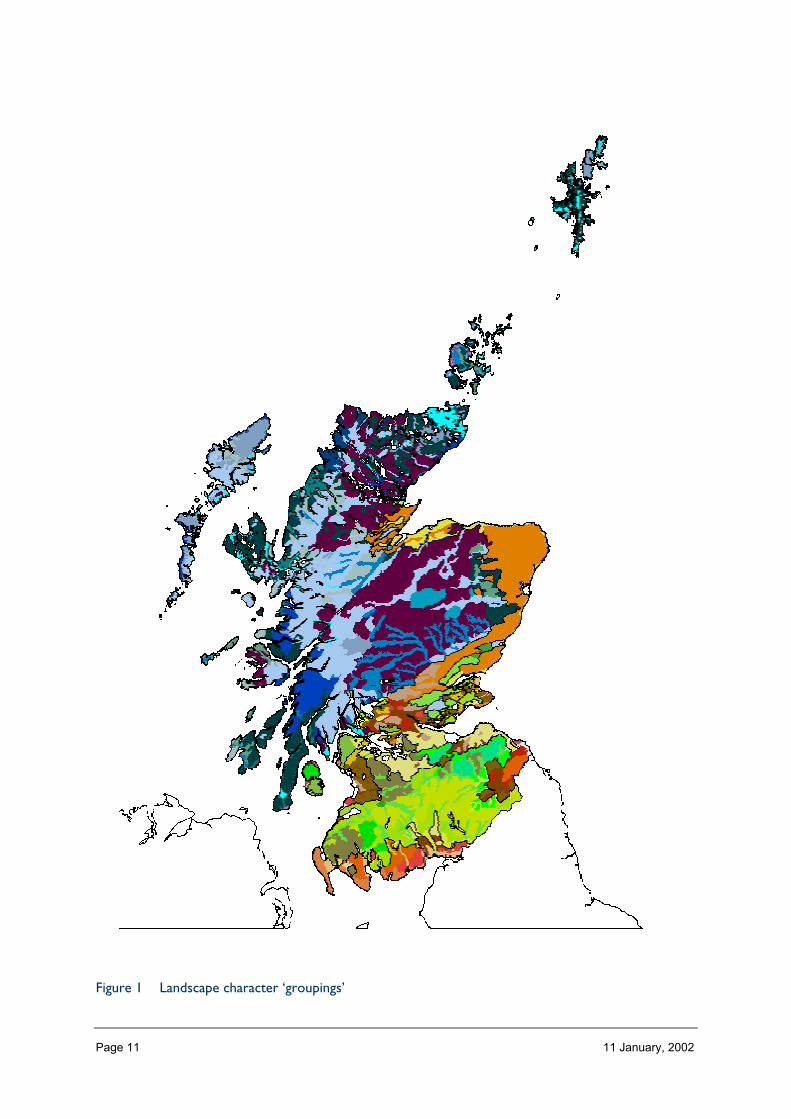
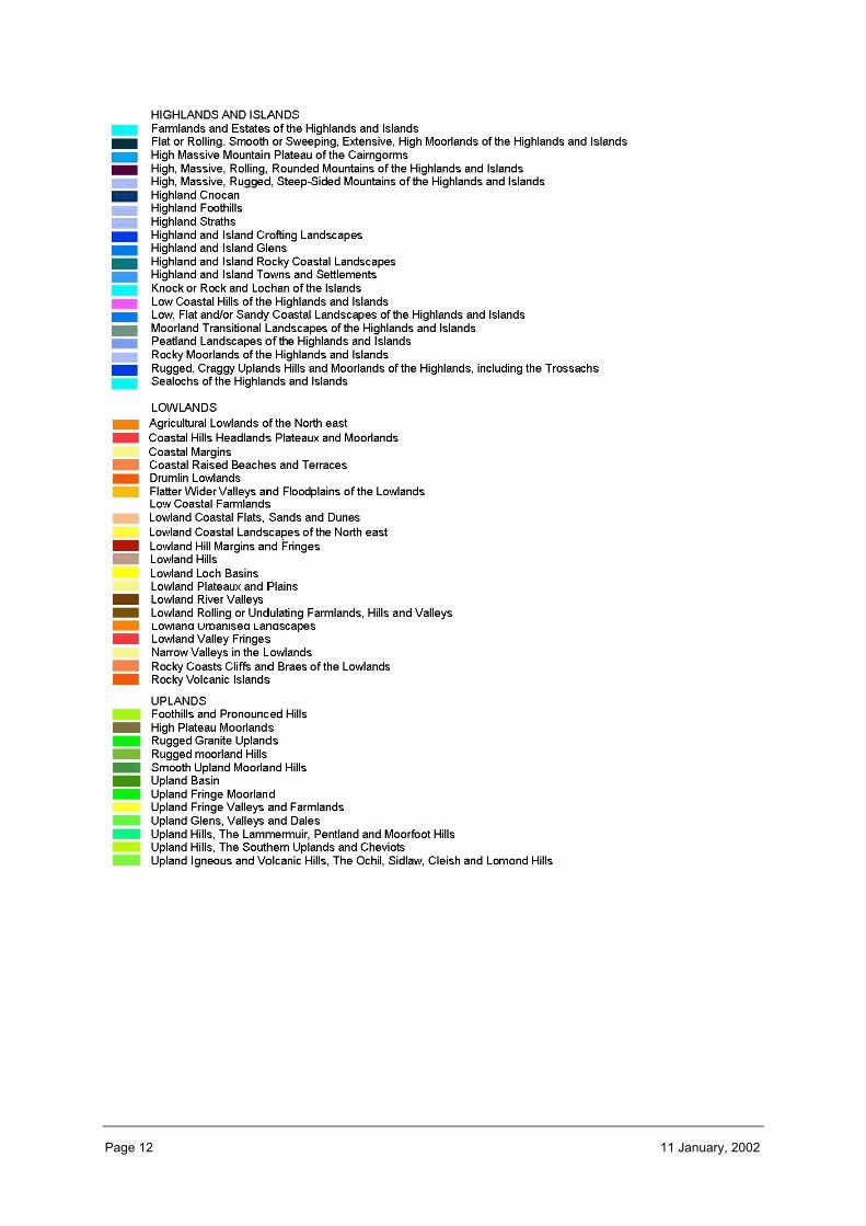
The long history of physical and cultural evolution of the landscape has resulted in thecreation of a wide variety of landscape types ranging from intensely urbanised townscapes totracts of relatively untrammelled wild land and from enclosed land locked glens to opencoasts, in a relatively small land mass. This diversity is very evident in SNH’s own landscapecharacter assessments, which have identified 365 types of distinctive character. Thesedistinctive character types are often grouped and presented in an aggregated way as 52landscape character ‘groupings’ (see Figure 1).
Scotland’s landscape today is both diverse in character and continually changing in nature.On a national scale, there is generally a pronounced contrast between the landscapecharacter of the north and west and the south and east of Scotland. Dramatic mountains,sweeping moorland and a highly indented, exposed coastline fragmented into islandscharacterises the north and west. This contrasts with the rolling southern uplands, fertilestraths and populated estuaries of the south and east. Here human activity and developmentcreates a landuse pattern which, while it relates to the underlying natural resources, oftenhas a more dominant visual and landscape presence than the physical structure of the landform in the north and west.
In this section of the Assessment we illustrate the key geological and geomorphologicalprocesses and human influences that have created a diverse landscape in differentgeographical areas around Scotland (see Figure 2). As well as distinct landscape characters indifferent geographical areas of Scotland we also highlight some of the distinct andrecognisable features within the landscape – rural, built, designed, scenic and transitionallandscapes.
Highlands
The sense of vertical scale provided by mountains, and the degree of enclosure they cancreate, characterises much of the Highland landscape. The mountains create structure andform, reveal and frame views, offer a sense of mystery, provide a backdrop for moreintimate landscapes, and reinforce a sense of height, distance and grandeur within sweepingpanoramas. In areas of high relief such as Torridon and the far north west, the mountainsdominate the landscape in terms of both form and vertical scale, and contrast sharply withthe horizontal expanse of both sea and low lying plateau. In the central and southernHighlands, relief is lower and the landscape is more enclosed, with long glens winding intothe interior of the mountain massifs, or fjord-like lochs reaching out to the rocky westerncoastline.
These northern landscapes are perceived to be relatively natural. This perception is basedon the lack of obvious human presence and intervention in the landscape as well as on thesense of exposure and openness. This landscape has, however, at least in part been createdby human action, most notably through the removal of natural woodland and themodification of heath and bog vegetation by burning and grazing. The sense of wildnessassociated with the more remote mountain and coastal areas and islands is furtheremphasised by the inaccessibility, due to relatively long travelling times, from the main areasof population, and is much valued today.
Page 11 11 January, 2002
Figure 1 Landscape character ‘groupings’
Page 12 11 January, 2002

Page 13 11 January, 2002
Northern and western coastline
Much of Scotland’s landscape is greatly influenced by the presence of the sea, and the long,often highly indented coastline. Coastal landscapes and the offshore islands are characterisedby their exposure, and the evidence of physical change, brought about by erosion anddeposition by tides and wave. The often harsh weather conditions shape the vegetation (ordictate the lack of it), and emphasise the openness and expansive horizontal scale of waterdominated views. Sheltered bays and inlets offer relief from this exposure, wheresettlements rely on safe access to the sea and relative ease of cultivation of more gentleslopes.
Eastern coastline
In the east and south of Scotland, these coastal fringes back onto fertile lowlands, enrichedby soils created in part from relatively friable sedimentary rocks. Here, the gentle landformprovides an open landscape, where long views are common, and where shelter is providedby narrow belts of woodland. Farms, often with substantial farm houses, are sited at regularintervals along low ridges or at the edges of wide straths, surrounded by relatively even-sized fields, marked out by field boundary trees. This is farmland characterised by thedynamics of cropping, where the fertile soil is annually ploughed and resown, and where thediversity of colour and seasonal change are key characteristics of the landscape.
Central lowlands
Much of Scotland’s landscape is greatly influenced by the presence of the sea, and the long,often highly indented coastline. Coastal landscapes and the offshore islands are characterisedby their exposure, and the evidence of physical change, brought about by erosion anddeposition by tides and wave. The often harsh weather conditions shape the vegetation (ordictate the lack of it), and emphasise the openness and expansive horizontal scale of waterdominated views. Sheltered bays and inlets offer relief from this exposure, wheresettlements rely on safe access to the sea and relative ease of cultivation of more gentleslopes.
Lowlands
In the east and south of Scotland, these coastal fringes back onto fertile lowlands, enrichedby soils created in part from relatively friable sedimentary rocks. Here, the gentle landformprovides an open landscape, where long views are common, and where shelter is providedby narrow belts of woodland. Farms, often with substantial farm houses, are sited at regularintervals along low ridges or at the edges of wide straths, surrounded by relatively even-sized fields, marked out by field boundary trees. This is farmland characterised by thedynamics of cropping, where the fertile soil is annually ploughed and resown, and where thediversity of colour and seasonal change are key characteristics of the landscape.

Page 14 11 January, 2002
Figure 2 Scotland’s distinctive landscape (an amalgamation of landscape character groupings)

Page 15 11 January, 2002
There are some instantly recognisable features within Scotland’s landscape which span thespectrum from highly developed parts of the countryside to those areas which are muchmore rural in character. Some of these distinct features are drawn out below.
Built heritageThe earliest known human settlement in Scotland dates back to 7500 BC and succeedinggenerations have left evidence of settlement, ritual, hunting and farming activity whichremains in the landscape we have today. In a very few places, the landscape containssubstantial physical remains and visual evidence of past land use or ancient rituals. Suchremains often have a landscape significance far beyond their immediate impact on theground. They can invoke a particular historical resonance and provide us with anopportunity to explore the enduring links between our ancestors, our cultural inheritance,and the present day. There is a strong regionalisation of this historic presence, in particularthe long evidence of settlement associated with the far Northern and Western Isles, themysterious Pictish remnants characteristic of the north east, the early Christian associationswith the south and west and the evidence of long centuries of skirmishing with southernneighbours is revealed in the prevalence of fortified remains in the Borders. However, forthe most part, early human activity has been absorbed into the landscape of the enclosedfields of the lowlands and the sporting estates of the uplands, created mainly in theseventeenth and eighteenth centuries, still dominate today.
Settlement patterns have evolved to meet need and practical considerations, but also oftenreflect physical and landuse constraints. Our settlement patterns are in general stronglyinfluenced by natural resources. The shelter, sunshine, fertile soils and exploitable mineralresources of the east and south are where cultivated patterns and concentrated settlementsdominate the landscape, while to the north and west, the thin soils and exposed coast havelimited the potential for cultivation and tend to be more sparsely populated. Close knitmarket towns, for example, impinged little on the fertile land on their outskirts. Plannedvillages such as Fochabers or Gatehouse of Fleet reflected the desire for harmony andbalance, and scattered, often linear whilst crofting townships such as Elphin still today reflectthe distribution of land holding within the community.
In the nineteenth century many people migrated from areas more rural in character tosettle in rapidly expanding cities. These are located on estuaries where trading links resultedin both monetary wealth and cultural influences from around the world. Scotland’s rich builtheritage demonstrates these influences in terms of some design features, which combinewith more traditional simple facades and the solid materials of stone and slate. This createsa distinctive thread in Scottish architecture, although there are of course regional variationsreflecting both local geology and climatic conditions. Buildings made of more transientmaterials, such as wood and turf have, with rare exceptions, long gone.
Rural characterLarge areas of lowland Scotland are rural in character, emphasised by the lack of largesettlements. The extent of these less urbanised areas provide a marked contrast to thehighly developed cities and their expanding fringes, all of which are located on the coast,although this location does not dominate their character today. Within rural areas,settlements tend to be closely associated with ease of access, generally being sited at rivercrossing points, the mouths of fertile glens or in sheltered coastal bays, leaving large areas ofland where scattered housing, or little sign of current habitation, is characteristic.
Page 16 11 January, 2002
The relationship between the settlement pattern and the physical landscape continues in thebroader countryside. Examples include the way farms are often located on spring lines,settlements at river crossing points and roads aligned along a break in slope, away frompotential flooding and minimising their impact on valuable low lying fields. At a more localscale this may be obvious where dykes of cleared stones mark the boundaries to fields.These surprisingly direct links between the physical environment and the pattern of humansettlement create a landscape character with a strong sense of integrity, where humanintervention, physical character and natural processes complement and reinforce oneanother, both physically and visually.
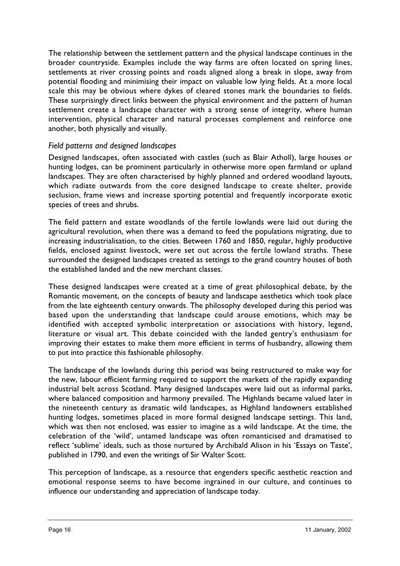
Field patterns and designed landscapesDesigned landscapes, often associated with castles (such as Blair Atholl), large houses orhunting lodges, can be prominent particularly in otherwise more open farmland or uplandlandscapes. They are often characterised by highly planned and ordered woodland layouts,which radiate outwards from the core designed landscape to create shelter, provideseclusion, frame views and increase sporting potential and frequently incorporate exoticspecies of trees and shrubs.
The field pattern and estate woodlands of the fertile lowlands were laid out during theagricultural revolution, when there was a demand to feed the populations migrating, due toincreasing industrialisation, to the cities. Between 1760 and 1850, regular, highly productivefields, enclosed against livestock, were set out across the fertile lowland straths. Thesesurrounded the designed landscapes created as settings to the grand country houses of boththe established landed and the new merchant classes.
These designed landscapes were created at a time of great philosophical debate, by theRomantic movement, on the concepts of beauty and landscape aesthetics which took placefrom the late eighteenth century onwards. The philosophy developed during this period wasbased upon the understanding that landscape could arouse emotions, which may beidentified with accepted symbolic interpretation or associations with history, legend,literature or visual art. This debate coincided with the landed gentry’s enthusiasm forimproving their estates to make them more efficient in terms of husbandry, allowing themto put into practice this fashionable philosophy.
The landscape of the lowlands during this period was being restructured to make way forthe new, labour efficient farming required to support the markets of the rapidly expandingindustrial belt across Scotland. Many designed landscapes were laid out as informal parks,where balanced composition and harmony prevailed. The Highlands became valued later inthe nineteenth century as dramatic wild landscapes, as Highland landowners establishedhunting lodges, sometimes placed in more formal designed landscape settings. This land,which was then not enclosed, was easier to imagine as a wild landscape. At the time, thecelebration of the ‘wild’, untamed landscape was often romanticised and dramatised toreflect ‘sublime’ ideals, such as those nurtured by Archibald Alison in his ‘Essays on Taste’,published in 1790, and even the writings of Sir Walter Scott.
This perception of landscape, as a resource that engenders specific aesthetic reaction andemotional response seems to have become ingrained in our culture, and continues toinfluence our understanding and appreciation of landscape today.
Page 17 11 January, 2002
Cultural monumentsScotland has a strong sense of the past within its landscape. This manifests itself mostprofoundly where highly evocative ancient monuments dominate the landscape, or wherecastles and great houses with planned grounds are located to best advantage within a view.However, it is also evident in the traces of cultivation and habitation found high on hillsides,or in now unpopulated glens and coastlines, where limited human intervention leaves slightfeatures still visible. In addition to cultural history, the sense of geological and ecologicalhistory also contributes to Scotland’s landscape. The resonance of ancient pine forests, thesometimes perceptible sense of a still evolving physical landscape, the sight of along–battered coastline, all link us to our past, and prehistory.
The diverse geology of Scotland provides an abundance of natural landmark features rangingfrom individual hills, such as the relict volcanoes which create the ‘Laws’ of the Lothians, tocoastal stacs and arches and high waterfalls. Natural features are themselves often furtheremphasised in the landscape by the siting of defensive structures or monuments (such asStirling Castle and Wallace Monument) which often occupy prominent hills.
Transitional landscapesSome parts of Scotland are characterised by large areas of transitional landscapes, mostnotably where hills and mountains meet lowland cultivated plains, or where the land meetsthe sea. These landscapes are located between major landscape types, and tend to becomplex and fragile, or liable to change. They contain elements from all surroundingcharacter types. They also tend to contain a high degree of interlock in terms of land formand vegetation pattern, and usually a history of ebb and flow of settlement and cultivation.This reflecting the marginal nature of the usable land, which makes it vulnerable to climaticchanges and land use pressures. Thus, the landscape along the Highland Boundary fault lineis characterised by the variety, pattern and colour of the vegetation associated with the low-lying cultivated straths, combined with the relief and enclosure of long glens more typical ofwith the landscapes further north. Similar transitional landscape character can be foundalong the Southern Uplands, and around the coast, where the exposed, often treeless,landscapes nevertheless contain pockets of smaller scale character where fertile soilsprovide the basis of cultivation in spite of the hostile environment.

Page 18 11 January, 2002
2 Nationally significant landscapecharacteristics
The 29 Regional Landscape Character Assessment reports for Scotland draw out a numberof significant key characteristics which are described in this section.
The way we perceive these key characteristics is also influenced by the light and weather.These play a distinctive role in the illumination of land and water, and this is a special featureof Scotland’s northerly geographical location and its oceanic weather. Low northerly lightoften gives a special ambience to the landscape, creating long soft shadows and emphasisingsubtleties in the landform. In coastal locations, the presence of reflected light can reduce theimpact of directional light, particularly on water based structures. These qualities, combinedwith rapidly changing, and often unpredictable, weather and seasonal conditions emphasise asense of dynamism in Scotland’s landscape.
Colour in the landscape is largely created through the combination of vegetation patternand light, on both land and sea. While colours are generally soft, there can be dramaticeffects, for example when the heather turns purple in August, or the fields of yellow oil seedrape flower in June. Geology, too, contributes to colour in the landscape. On the east coast,for example, the red soils, derived from the old red sandstone strata, are exposed whenploughed. Colour change is related to the relatively well defined, if short, seasons: inparticular, the northerly geographic location ensures colour following autumn frosts in the
wooded landscapes, snow in most winters, and long hours of intense light in summer.
Openness
The sense of openness in the Scottish landscape is in many places emphasised by the lack of‘native’ tree cover, which has largely been removed. Elsewhere this sense of openness isreinforced by the natural rockiness of the highest mountains, the exposed coast, andexpanses of inland water. In the north and west openness is particularly characteristic ofexpansive peatlands and other waterlogged habitats. Our appreciation of openness can beaffected by weather conditions, which influence visibility and sense of distance.
Intervisibility
Views in Scotland often embody distance, revealing a layered composition, and a range ofcolours and tones which reinforce the sense of space. This intervisibility is related toopenness and is considered an important characteristic of coastal and island landscapes inparticular. It can also be a characteristic of transitional landscape – where upland meetslowland, creating opportunities for panoramic views, and in inland landscapes dominated byopen water or open farmland.

Page 19 11 January, 2002
Naturalness
Scotland has an extensive area of land and water that is perceived to be natural or nearnatural. While there is often little sign of intensive land use and development in these areas,much of this land is not nearly as natural as people perceive it to be. Traces of habitationand cultivation are to be found frequently on the semi-natural terrain. But for most people,the ‘perceived’ naturalness is a special part of Scotland and, along with its relativeremoteness, creates valued wildland. Wildness is further emphasised by the topographicroughness and exposed rock of many northern landscapes.
Natural processes
In some areas of Scotland there is still a perceptible sense of the dominance of naturalprocesses and continuing evolution of the physical environment. This is most obvious inrelation to the activity of water in the landscape, whether through the changes broughtabout by the actions of the sea or the upper reaches of rivers, or by the annual flooding oflow lying farmland. It is also evident in some mountain areas, particularly where over-steepened slopes bearing superficial deposits periodically show instability through gullying orland slip.
The presence of water in the landscape is a distinctive component of many of Scotland’slandscapes. The indented coastline and islands of the west, and the broad estuaries of theeast and south, as well as numerous lochs and lochans, ensure that an expanse of water isoften a major component of visual character. At times this expanse of water is calm andreflective, and at others it contributes to the openness and wildness of the landscape. Fastflowing burns, tumbling down mountains in autumn and spring, as well as wide, meandering,sometimes flooding rivers emphasise seasonal change and re-confirm the presence of naturalprocesses even in the cultivated lowlands.
Remoteness
Rugged topography imposes difficulties in road layout which as a result, often gives thetraveller in Scotland the illusion that the country is larger than it is in terms of land mass.This is because there are relatively few roads within the upland areas, and the grain of the

Page 20 11 January, 2002
land often ensures that while on a map places may look close together, there is a long andoften circuitous route between them. In addition, there are still areas that are fairlyinaccessible, and therefore engender a sense of mystery. Many coastal roads tend to wind inand out of bays and estuaries, lengthening the journey time, providing a varied series ofviews of the same landscape feature, and accentuating a sense of distance when experiencingthe landscape. This characteristic, although embodied in the development of theinfrastructure, is heavily influenced by the physical character of the landform.
Infrastructure
Topographic constraints have also led to the development of infrastructure corridors withinScotland, where roads, rail, settlements and associated developments congregate alongrelatively narrow passes, such as the M74 corridor and along the A9. To a lesser extent, thischaracteristic is also evident along coastal roads in more remote areas, where infrastructuredevelopment is concentrated as it links scattered settlements.
The integrity of the relationship between the physical landscape and human intervention isstill very strong in parts of rural Scotland. This is particularly obvious where there has beenlittle recent development. Settlement pattern, road alignment and other physical structurestraditionally reflected the opportunities and limitations of natural resources and physicalconstraints, ensuring that human intervention was not only a very direct response to thephysical environment, but often visually reinforced natural characteristics.

Page 21 11 January, 2002
3 Forces for change in the landscapeOne of the key elements of the National Landscape Character Assessment programmeundertaken by SNH was to identify, for each of the 29 regional studies, the factors,environmental and social, which have the potential to alter or reduce the intrinsic characterand diversity of the landscape. In this National Assessment, a summary of the changes thathave taken place in the landscape, with analysis focussing largely on changes which informthe understanding of landscape characteristics at a national perspective is undertaken.
Change in landscape is not only inevitable, it is an intrinsic dimension of landscape.Landscape has evolved as natural processes and human pressures and demands havedeveloped over time. Natural processes are usually regarded as imperceptible, and seenwithin the context of geological time. However, along the coast, on flood plains and in areasexposed to harsh winter weather, physical changes are part of the landscape character,which along with seasonal change, dramatic weather conditions and quality of light,contribute to the overall diversity of landscape character. These naturally induced changesare generally welcomed as positive contributions to the character and experience ofScotland’s landscapes.
Change induced by human activity on the other hand is generally less readily accepted, eventhough the landscape qualities we often now value are frequently the result of humanintervention. The landscape does essentially reflect society’s demands on the land and thosewho manage it. As a result, the landscape largely reflects broadly based cultural trends,social expectations and economic influences.
There are three broad types of human induced change that influence landscape character:
• changes which relate to land use, such as the continued expansion of forestry and thedecline in agricultural incomes;
• changes brought about by incremental and ongoing development such as housing, theexpansion of villages, quarrying and widening of roads and new built structures, such aswind turbines, hydro schemes and telecommunications masts; and
• changes in perception, brought about for example, by awareness and experience oflandscapes elsewhere, faster journey times, increased access and higher expectations inrelation to recreation and visitor experience.
These three types of change are now described in more detail, in terms of both recenthistorical change and current trends.
Changes in landuse (1950–2000)
The use of land and other natural resources has in general intensified during the past fiftyyears. The agricultural industry, encouraged at first by the drive towards self-sufficiency infoodstuffs in the post-war years, and more recently by the need to compete in a globalmarket, has been encouraged to maximise yields and produce cheap food.
Commercial forestry expanded rapidly in post-war Scotland, largely due to demand forhome grown timber. Focused mainly in marginal upland areas, the adverse natural heritageimpacts of the rapid expansion of largely coniferous forest led in the 1980s to a reappraisalof the role of forestry, and now there is a broader and more diverse range of financialincentives in place.
Page 22 11 January, 2002
In general across all land use sectors, there has been a move towards a uniformity ofmanagement, where only the most efficient and productive crops are grown, harvested,stored and processed. Only in very recent years has this approach to production begun tolose momentum.
Landuse trends that have had a significant effect on the landscape in recent decades includethe following:
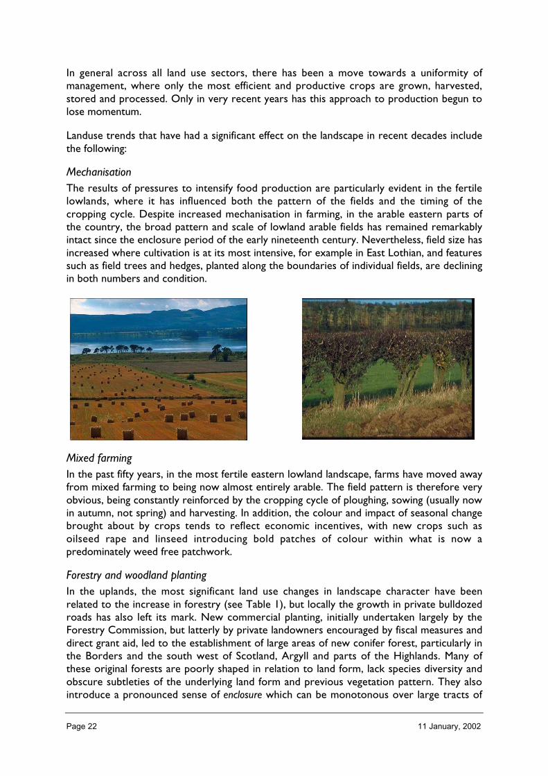
MechanisationThe results of pressures to intensify food production are particularly evident in the fertilelowlands, where it has influenced both the pattern of the fields and the timing of thecropping cycle. Despite increased mechanisation in farming, in the arable eastern parts ofthe country, the broad pattern and scale of lowland arable fields has remained remarkablyintact since the enclosure period of the early nineteenth century. Nevertheless, field size hasincreased where cultivation is at its most intensive, for example in East Lothian, and featuressuch as field trees and hedges, planted along the boundaries of individual fields, are decliningin both numbers and condition.
Mixed farmingIn the past fifty years, in the most fertile eastern lowland landscape, farms have moved awayfrom mixed farming to being now almost entirely arable. The field pattern is therefore veryobvious, being constantly reinforced by the cropping cycle of ploughing, sowing (usually nowin autumn, not spring) and harvesting. In addition, the colour and impact of seasonal changebrought about by crops tends to reflect economic incentives, with new crops such asoilseed rape and linseed introducing bold patches of colour within what is now apredominately weed free patchwork.
Forestry and woodland plantingIn the uplands, the most significant land use changes in landscape character have beenrelated to the increase in forestry (see Table 1), but locally the growth in private bulldozedroads has also left its mark. New commercial planting, initially undertaken largely by theForestry Commission, but latterly by private landowners encouraged by fiscal measures anddirect grant aid, led to the establishment of large areas of new conifer forest, particularly inthe Borders and the south west of Scotland, Argyll and parts of the Highlands. Many ofthese original forests are poorly shaped in relation to land form, lack species diversity andobscure subtleties of the underlying land form and previous vegetation pattern. They alsointroduce a pronounced sense of enclosure which can be monotonous over large tracts of

Page 23 11 January, 2002
land. In recent years, new forests have been expected to meet much stricter landscapeguidelines if they are to receive grant assistance from the Forest Authority.
New financial incentives have aimed to encourage more diverse types of woodland planting.Both the Farm Woodland Scheme, which aims to increase the number of small woodlandsin farmed areas and the Native Woodland Grant Scheme are examples of these. Under thelatter scheme, some very extensive areas of currently young pine- and birch- dominatedwoodland will mature to create quite a different, softly textured landscape in the future,which will nevertheless still be enclosed.

Page 24 11 January, 2002
Table 1 Changes in woodland cover
Group Trends
Dec
reas
ing
Sta
tic
Incr
easi
ng
Rel
iabi
lity
of t
rend
Extent ofwoodlandcover
1924–2000: the area of woodland coverincreased from 5.6% to 17.2% of Scotland, mostlydue to the planting of conifers.
207%�
T
1924–1980: the area of broadleaved woodlanddeclined by 55%.
55%�
CBroadleavesand conifers
1924–1980: the area of conifer plantationincreased by 330%.
330%� T
1988–1999: 569 km2 of broadleaves were planted,under the Woodland Grant Scheme and onForest Enterprise land.
569km2
�1988–1999: 1,430 km2 of conifers were plantedunder the Woodland Grant Scheme and onForest Enterprise land.
1430km2
�1984–1999: the extent of native woodlandincreased by 34%.
34%�
CNativewoodland
1994 and 2005: the area of native pinewood isset to increase from 1994 levels by 305 km2. �
1999 and 2015: the cover of priority broadleavedwoodland types will be increased from 1999levels by 72 km2.
�
Native pinewoods
1988–1998: 275 km2 were established throughWoodland Grant Scheme funding.
�
Naturalregeneration
1995–2000: native woodland was establishedover 31.3km2 by natural regeneration (26.8km2
broadleaves and 4.6km2 Scots pine).� T
c. 1970–c. 1990: ten woodland speciescontracted in range, and eleven expanded, bymore than 10%.
48%�
52%�
Woodlandbirds
1994–1999: five out of 14 widespread woodlandspecies showed a statistically significant increasein abundance, while one species declined. Theremaining eight showed no significant change.
7%�
57%�
36%�
C
Reliability of change or trend between the specified years: T = an increasing (or decreasing) trend established; C = change clearlyestablished between first and last year, but no clear evidence for a trend. Blank indicates that assessment of change was not appropriate.Statistical significance was tested where possible (at the 5% level).
Protected areasThe designation and subsequent protection of habitats and natural features has had someimpact on landscape character. This has resulted in some relatively large tracts of habitat,such as lowland bog, being maintained as a feature in the landscape as well as for theirconservation interest. Elsewhere, protected natural features, such as geological formationsor ancient woodlands act as a focal point within the landscape as well as being ofconservation value. Nature conservation legislation can also influence some land useactivities, encouraging the maintenance of land use practices that support the conservation

Page 25 11 January, 2002
interests of the site and discouraging those that are detrimental to the interest. This in turnwill affect the landscape character.
CroftingCrofting landscapes exhibit a decline in active traditional land management, such as makinghay, other than where successful Environmentally Sensitive Areas (ESA) schemes are inplace. New residential buildings, farm buildings and fencing are also on the increase, in someareas changing the settlement pattern in the crofting landscape.
Current landuse trends
AgricultureThe current uncertainty in the agricultural sector, demonstrated so starkly by the recentfoot and mouth outbreak, is likely to have some impact on the landscape of the future. Lossof revenue, or a reduction in people working on the land may affect the ability of individualsto maintain particular landscape characteristics, particularly those that are now functionallyredundant, such as hedges, field trees and old farm buildings. Uncertainty about the future offood production also means that there may be pressure to look for new crops and newenterprises in the farming sector. If more marginal land is forested the landscape characterwould also change. There may also be pressure to increase the options for builtdevelopment in the countryside, for reasons of rural economic development.
ForestryForestry also faces financial uncertainty, as timber prices have collapsed, partly in the face ofglobal competition. This is at a time when established commercial forests are now ready tobe felled, often for the first time, and there are opportunities to restructure and improvethe design of these forests once felling begins. The Forest Authority now have a financialincentive in place to ensure that long term plans for such forests ensure that future designmakes a positive contribution to landscape character.
CroftingIn crofting areas, new woodland establishment on common grazings has increased in recentyears. Recent proposals for legislation under which planting trees may become a permitteddevelopment in new and existing statutory leases may promote even more planting.Conversely, the change from headage to area based payments for sheep may encouragecrofting tenants to take less land out of grazing, as the subsidies will now relate to theamount of land managed and stocking levels, not simply to the number of sheep. This may asa result discourage planting proposals, as crofters aim to keep land in grazing.
Changes in development pattern 1950–2001
The past fifty years have seen substantial changes to Scotland’s built environment. In themain centres of population, the demise of heavy industry, the reclamation of derelictindustrial infrastructure, the expansion of the road network, the rapid growth of suburbanhousing development, the establishment of new towns and the expansion of small villagesand scattered housing in the city hinterlands, all reflect Scotland’s changing economicfortunes and social fabric. Since 1950, the main employment opportunities have shifted frommanufacturing and heavy industry to the new service based providers, many of which arenow sited in retail and business parks located around the fringes of settlements.

Page 26 11 January, 2002
Rural InfrastructureIn rural areas, the major changes to the landscape brought about by built developmentinclude the upgrading of roads, the development of large-scale hydro-electricity schemes inthe post war years, the increasing use of suburban housing styles in the countryside and,more recently in coastal areas, the development of the fish farming industry.
In rural areas the impact of these changes, with the possible exception of the hydroschemes, has generally been incremental. Over decades roads have been gradually widenedand straightened and transport links improved, and the number of ‘kit’ houses built in thecountryside has increased over time. However, some developments, including fish farmingstructures and telecommunications masts, have expanded relatively rapidly and their impactis significant due to their cumulative effect (i.e. increasing numbers of one type ofdevelopment having a much greater impact than a single structure).
New technologiesThe dramatic changes in technology and mechanisation over the past fifty years, have had aprofound effect on both the overall quantity and individual scale of built development inboth rural and urban Scotland. Rock and soil can now be moved relatively easily, so thatstructures such as roads, building sites, coastal defences, causeways and bridges can becreated at a scale, and sometimes in locations, which would previously not have beenpossible. Roads can be widened and straightened, more mountain tracks can be constructedat the highest levels and houses can be built on steep slopes that are levelled by powerfulmachines. Technological developments have also brought positive changes to the landscapeas many tips, bings and industrial infrastructure has been removed.

Page 27 11 January, 2002
These new technologies are used to control or influence natural processes, particularly inrelation to coastal defences and flood management. The resulting structures are oftenstrongly discordant with the physical or natural constraints of the environment. Withoutsensitive design there can be a loss of coherence between the character of the naturalenvironment and the attributes of the new built structures, such as when new houses arebuilt on under building rather than designed to fit the gradient of the land.
Rural housingThe trend towards ‘kit house’ domestic architecture, particularly since the 1950s, has had aprofound impact on both the siting and design of houses. The combination of mechanisedconstruction techniques and improved thermal efficiency have made it possible to buildhouses almost anywhere. In addition, the style of housing is less a result of the technicallimitations of local materials or traditional scale and proportion, than the technicalrequirements of widely available concrete based materials and the scale and proportionswhich are easy to build in prefabricated units. In areas where there has been rapidexpansion of housing, for example in Aberdeenshire during the 1970s and 1980s, multiplenew domestic buildings can appear incongruous if they do not reflect any aspect of survivinglocal design or incorporate superficial detailing which relates to domestic architecture fromelsewhere. Where new buildings are sited in locations that have no relationship with thesurrounding landform and settlement pattern, they adversely affect the integrity of theexisting landscape character.
Settlement expansionOne of the key areas of land use change in recent years has been on the outskirts ofsettlements, where agricultural land has been replaced by expanding built development,especially housing and business park developments. The peri-urban landscape is becomingincreasingly similar in character around many towns and cities, with the built environmentgenerally coming to an abrupt edge at a wide ring road, for example in Edinburgh, Perth andInverness. The uniform approach to lay-out and design of housing estates has led to a loss ofidentity and the quality of the rural landscape surrounding cities and large towns often lacksdistinctive local features and areas of high landscape quality.
Farm buildingsThe intensification of food production over the last 50 years has had an impact on both landuse and built structures in the landscape. In particular, there has been a dramatic increase inthe size and industrial character of farm buildings, which reflects an increase inmechanisation, the need to accommodate greater quantities of food and livestock and tomanage farms efficiently with a reduced labour force. These buildings are often modularstructures, easy to alter and relocate, or prefabricated prior to erection on site. Designs areubiquitous and do not tend to reflect local building character, and are often out of scale withnearby traditional buildings.
Upland tracksIn upland areas, the demand for more efficient use of the land has led to increased road andtrack construction, to provide easy access into areas of difficult terrain. Some of thesetracks are in areas where thin soils and prevailing weather conditions make it difficult to re-establish cleared vegetation, resulting in prominent and long term scarring of the hillsides.
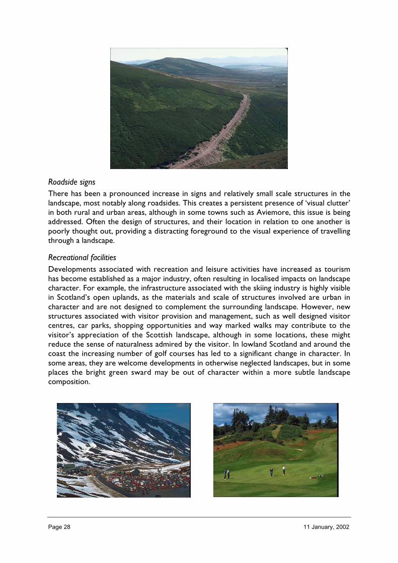
Page 28 11 January, 2002
Roadside signsThere has been a pronounced increase in signs and relatively small scale structures in thelandscape, most notably along roadsides. This creates a persistent presence of ‘visual clutter’in both rural and urban areas, although in some towns such as Aviemore, this issue is beingaddressed. Often the design of structures, and their location in relation to one another ispoorly thought out, providing a distracting foreground to the visual experience of travellingthrough a landscape.
Recreational facilitiesDevelopments associated with recreation and leisure activities have increased as tourismhas become established as a major industry, often resulting in localised impacts on landscapecharacter. For example, the infrastructure associated with the skiing industry is highly visiblein Scotland’s open uplands, as the materials and scale of structures involved are urban incharacter and are not designed to complement the surrounding landscape. However, newstructures associated with visitor provision and management, such as well designed visitorcentres, car parks, shopping opportunities and way marked walks may contribute to thevisitor’s appreciation of the Scottish landscape, although in some locations, these mightreduce the sense of naturalness admired by the visitor. In lowland Scotland and around thecoast the increasing number of golf courses has led to a significant change in character. Insome areas, they are welcome developments in otherwise neglected landscapes, but in someplaces the bright green sward may be out of character within a more subtle landscapecomposition.

Page 29 11 January, 2002
Historical and archaeological landmarksThe most significant historical and archaeological remains within the landscape are nowprotected. Some of these are prominent built structures, which have become permanentcontributions to landscape character, rather than disappearing over time. More significantbuildings and monuments have also become the focus for development associated withvisitor provision.
Fish-farmingThe development of marine and freshwater fish farming has introduced structures intocoastal waters and on shore locations throughout the west coast and the Western andNorthern Isles, often in remote locations (see Figure 3). In coastal areas valued for theirqualities of wildness, or in areas where scenic qualities are characterised by untrammelledwaters, these developments and their associated activity can have a disproportionate effecton the landscape character.
Figure 3 Location of salmon and trout fishfarms. Copyright statement © Crown EstateCommissioners for Scotland
Locations of salmon and troutfish farms – note: not all sitescurrently in production

Page 30 11 January, 2002
Table 2 Fishfarm sites in production
Year No. of sites in production*
Rainbow trout* Salmon
1991 691992 721993 74 1381994 72 1471995 69 1621996 69 1661997 69 1711998 71 1771999 68 189
*Source: Scottish Fish Farms: Annual Production Survey 1999, FRS Marine Laboratory
Communication technologyThe recent expansion of communication technology has had a significant affect on manylandscapes. First, in more remote areas, where wild land experience is most likely to befound, telecommunications infrastructure is one of the few developments which by necessityhas to be prominently sited. Such developments inevitably affect the perceived wildness ofthe landscape character, by introducing an obviously engineered structure into an areaperceived as relatively natural and remote from human influence. Second, the increase ofstructures along established infrastructure corridors, where telecommunications areproviding coverage for existing roads, railways and settlements. This results in increasedvisual clutter and development in a highly visible location. In addition, masts can becomeeven more visible through cumulative impact, as prominent sites often contain several,disparately designed developments.
RenewablesWind turbine development is the most widespread of the renewable energy technologieswhich is likely to alter existing landscape character (see Figure 4). Turbines are often highlyvisible because of their height and the need to be sited in exposed locations. Their impact isemphasised by the movement of the blades, which is relatively unusual in the landscape, andthe associated infrastructure. While individually the structures themselves are sometimesperceived as elegant, they are nevertheless clearly engineered structures and part of thebuilt environment and have the potential to impact significantly on areas where the existing

Page 31 11 January, 2002
character is valued because of the lack of built structures. The impacts of suchdevelopments in some coastal and near-shore areas could be acute. Within upland settingsthe phase of hydro-electric developments also changed the character of many western glens.
Figure 4 Wind energy developments
Wind energy developments
at June 2001

Page 32 11 January, 2002
There is a small but growing trend in sustainable building design. The development of bothtimber and renewable energy technology, and techniques such as reed bed water treatmentsystems and sustainable urban drainage systems has resulted in a small but significant movetowards more sustainable domestic and industrial development, where natural resourcessuch as water are better managed, and materials used in construction minimise impact onthe environment.
Changes in perception (1950–2001)
Many people come from an urban background and have little direct experience of the widevariety of landscape settings found in Scotland. Whilst they will have direct experience ofthe factors influencing their immediate surroundings, few will have had any directinvolvement with managing our more rural land uses, or understand how and why changesin land use over time might be necessary. Landscape is often regarded as a stable, lastingreference point for society. This creates tensions between those who wish to changefamiliar landscapes for economic, or even natural heritage benefits, and those who wish tomaintain familiar places and landscapes in their current form.
There is a growing general concern for the environment, which does influence the waypeople value what is perceived to be the natural environment and how they wish to see landmanaged. Increasingly, one of the results of this interest is an understanding that the Scottishlandscape is not as natural as it is generally perceived to be. In addition to interest in thenatural environment, increasing enthusiasm for and understanding of archaeology adds afurther dimension to people’s understanding of the evolution of the landscape.
Scenic qualitiesThe landscape of Scotland underpins a range of social and economic interests. It contributesto our quality of life, it is a main attraction for visitors and is part of what makes Scotland anattractive place for inward investment. It is also an important complement to other naturalheritage interests, as it provides a resource that is enjoyed as a recreational asset, and theaesthetic context within which nature and earth science interests can be appreciated.
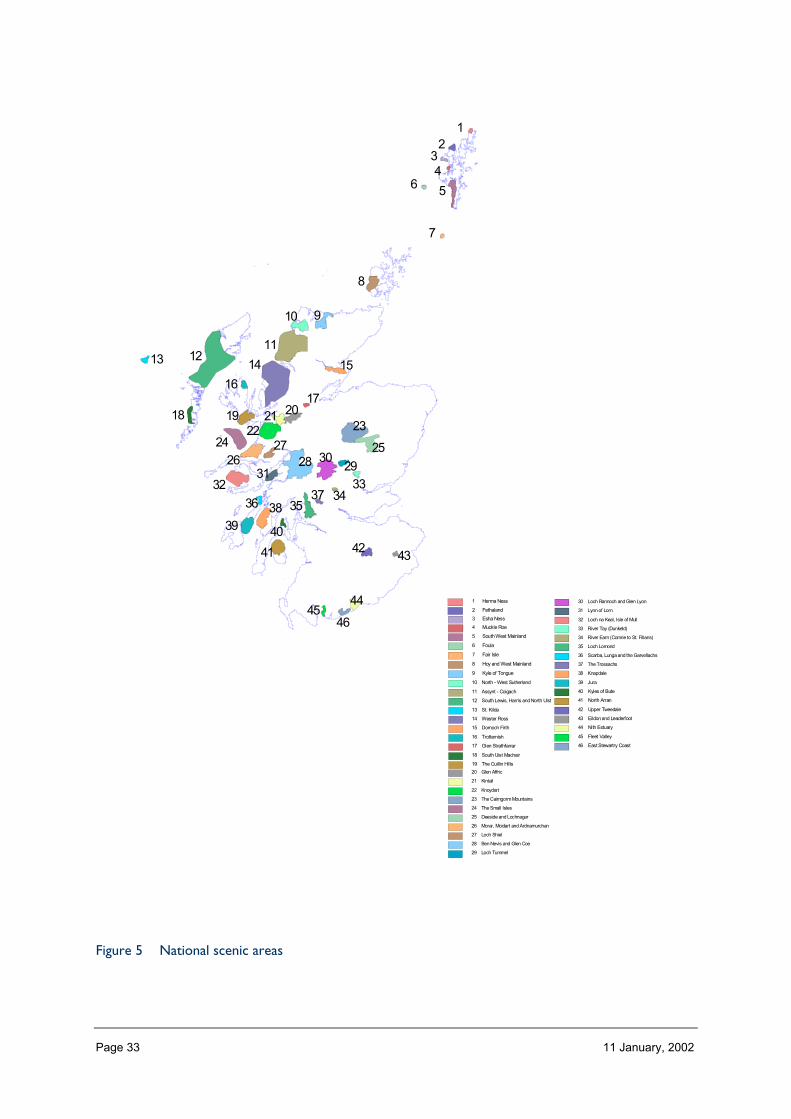
From SNH’s point of view the most significant of these are proposed National Parks (LochLomond and the Trossachs, and Cairngorms) and the National Scenic Areas (NSA)designation. The NSAs aim to safeguard areas of nationally significant scenic quality, and tendto be located in the mountainous and coastal areas of Scotland. The qualities of dramaticvertical scale, openness, views which encompass a sense of distance, perceived naturalness,and constantly changing light and weather conditions continue to be valued. Scotland has 46NSAs covering a total area of approximately 1 million hectares (see Figure 5). SNH’s recentreview of NSAs (National Scenic Areas: Scottish Natural Heritage’s Advice to Government, 1999),identifies the need to strengthen the measures in place to safeguard the existing areas, andto ensure that management strategies are developed and implemented. In addition, SNHconsiders that there may be some merit in expanding the existing series, to reflect a widerdiversity of Scotland’s best scenery.
Page 33 11 January, 2002
Figure 5 National scenic areas
12
34
56
7
8
910
111213 14 15
1617
18 19 202122 23
24 2526
2728 29
3031
32 3334
353637
3839 40
41 4243
4445
46
1 Herma Ness
2 Fethaland
3 Esha Ness
4 Muckle Roe
5 South West Mainland
6 Foula
7 Fair Isle
8 Hoy and West Mainland
9 Kyle of Tongue
10 North - West Sutherland
11 Assynt - Coigach
12 South Lewis, Harris and North Uist
13 St. Kilda
14 Wester Ross
15 Dornoch Firth
16 Trotternish
17 Glen Strathfarrar
18 South Uist Machair
19 The Cuillin Hills
20 Glen Affric
21 Kintail
22 Knoydart
23 The Cairngorm Mountains
24 The Small Isles
25 Deeside and Lochnagar
26 Morar, Moidart and Ardnamurchan
27 Loch Shiel
28 Ben Nevis and Glen Coe
29 Loch Tummel
30 Loch Rannoch and Glen Lyon
31 Lynn of Lorn
32 Loch na Keal, Isle of Mull
33 River Tay (Dunkeld)
34 River Earn (Comrie to St. Fillans)
35 Loch Lomond
36 Scarba, Lunga and the Garvellachs
37 The Trossachs
38 Knapdale
39 Jura
40 Kyles of Bute
41 North Arran
42 Upper Tweedale
43 Eildon and Leaderfoot
44 Nith Estuary
45 Fleet Valley
46 East Stewartry Coast
Page 34 11 January, 2002
AccessibilityOne of the main forces for change in perception of the Scottish landscape is increasedaccessibility. In particular, the effect of the expansion of an improved road network is tomake the land mass appear smaller and more accessible than in the past. Increasedaccessibility does increase familiarity, and for many people this has resulted in moreawareness and appreciation of Scotland’s landscapes. However, increased accessibility, andfaster access, has also had an impact on the sense of remoteness, as distance is appreciatedas a measurement of the time taken to move from one place to another, rather than as anabsolute measurement of distance.
Increased UK and international travel means that for many people appreciation of theScottish landscape is now relative to experiences of other parts of the world, whether thisis direct first hand experience or through the media. There is widespread knowledge thatthere are mountains that are higher, more rugged and wilder than those in Scotland. Thereare longer, more remote coastlines, and gentler, more intimate cultivated landscapes. Thereare more natural habitats, and larger areas of untrammelled land elsewhere. One effect ofthis opportunity to compare Scotland’s landscape with those elsewhere is a growingappreciation of the diversity of landscape character that exists in a very small country, and inrecent years this has been the main focus of debate in relation to landscape conservation.
Managing landscape change
There is a wide range of mechanisms in place which have the potential to influencelandscape change.
Town and country planningThe planning system has always had a role in directing development and influencing thedesign of the built environment. Town and Country Planning is the responsibility of LocalAuthorities, guided by national advice which is set out in Planning Advice Notes (PANs) andNational Planning Policy Guidance (NPPGs). Landscape character is an increasinglyimportant part of this decision making process, as indicated in NPPG 14 on the NaturalHeritage (January 1999)), and guidance on the siting and design of individual types ofdevelopment frequently aims to conserve landscape character. Certain types of activity,notably many of those associated with agriculture and forestry management, and includingthe building of hill tracks in certain circumstances, have general permitted developmentstatus, and are therefore subject to special arrangements under local authority planningprocedures.
AgricultureBy contrast, changes in agriculture have been led primarily by national and internationaleconomic decisions, with little local involvement. Generally the support system foragriculture uses a combination of financial incentives and quota restrictions to influence thetypes of crops grown and the amount of food produced. Landscape character has been aconsideration in locating and deciding the aims of Environmentally Sensitive Areas and someagri-environment schemes, but has been a less potent consideration in farm conservationplans than other conservation interests.

Page 35 11 January, 2002
ForestryForestry, both in relation to new planting and the felling and restructuring of existingforests, has increasingly taken into account landscape objectives within the managementmechanisms controlled by the Forest Commission. Guidance on the landscape design andmanagement of forests is now well established.

Page 36 11 January, 2002
4 Landscape character: threats andopportunities
The diversity of Scotland’s landscape is increasingly influenced by land use change anddevelopment. This is largely because new technology creates opportunities for humanactivity to overcome the potential natural constraints to development and management.Landscape character always exists, even if it changes, however some landscape charactertypes might be lost, or their quality may be reduced, over time. It is equally likely that newtypes of landscape character may evolve, some of which could become valued. While alllandscape character changes over time, there are likely to be areas where change incharacter is relatively rapid, such as where existing landuse is economically unsustainable, orwhere there are ideal conditions for a new type of land use or development to take place,which would quickly dominate the character of the landscape. There are thereforeopportunities to create new types of landscape character which are scenically attractive andeconomically sustainable, as well as benefiting other natural heritage interests.
Threats and opportunitiesThe landscape character assessment programme was initiated by SNH in 1994 to provide acoherent and comprehensive inventory of the landscapes of Scotland. The specific objectivesof the programme were to:
determine the landscape character of the total land area of Scotland;
identify and analyse the forces of landscape change, especially those forces which have thepotential to alter or reduce the intrinsic character and diversity of the landscape; and
develop design guidance to enable development whilst achieving the best environmental fitfor each proposal
As a result the assessments aim to inform those who are making decisions about the threatsand opportunities facing individual landscape types, and the following paragraphs indicateissues which are more relevant at a national level.
InfrastructureAround towns and cities continuous pressure for built development and associatedinfrastructure creates a rural landscape which is often ‘in limbo’, as landowners wait torealise the development potential of their land, or find it difficult to farm efficiently due tovandalism. Sometimes, this lack of management can erode the quality of the landscape inthese areas. There are opportunities here to develop more distinctive, robust and accessiblelandscape settings for cities and towns, and to ensure that future development takes asustainable approach in terms of both the design of developments and the management ofnatural resources. There is also an opportunity to create industrial landscapes with a localsense of identity and which reflect a sense of the new technologies.
It is recognised that the qualities of perceived wildness, remoteness and tranquillity in someareas of Scotland are relatively fragile. They are vulnerable to a number of different types ofdevelopment. The pressures on the accessible corridors of Scotland are likely to continue.The key communication routes through the uplands and round the coasts attract newdevelopment and infrastructure. While they are obviously the focus for road improvementworks and most recently telecommunication masts, they are also a prime location for
Page 37 11 January, 2002
developments associated with tourism and visitor management. The proximity of thesedevelopments to the road and rail network means that they are often highly visible. Alongmany roadsides, there is a continued rise in the amount of general visual clutter, largelycreated by ad hoc and cumulative build up of signs and structures. Careful siting and designis required to reduce the impact on the landscape quality. Low flying aircraft, speed boats, amountaineer’s mobile telephone or the sound of an off road vehicle, can have a profoundimpact in what is often a relatively quiet environment.
Agricultural influencesThe extensive areas of lowland Scotland that are essentially rural in character may oncehave appeared to be relatively robust. These are, however, probably the areas most likely tosee change brought about by any future changes in the agricultural sector. Both cumulativedevelopment and incremental change relating to the built environment and infrastructure islikely to affect the character of these areas, due to the relatively high population. Thepressure to diversify farm incomes may lead to an increase in built development andincreasing use of land for leisure activities, including golf courses and horse riding facilities.Such development could result in new uses for farm buildings and innovative design. New,sometimes experimental, land uses can contribute to the dynamic character of a lived-inlandscape. By contrast declining agricultural incomes could lead to changes in approach toland management which may in turn lead to the neglect of some of the key characteristicswhich were traditionally managed by part of the farm enterprise. The vulnerability of theseareas lies in the very ordinariness of their landscape character. This character may over timebe eroded by gradual road widening, scattered development of poorly designed buildings,lack of management of small-scale habitat features and the inappropriate siting of diversebuilt structures within a setting of neglected cultivated land.
Areas of transitional landscape character, for example along the boundary between lowlandand upland areas, tend to be marginal both by their location and nature, and as a result canbe particularly vulnerable to changes in farm economies. These are areas where alternativesto agriculture are likely, such as forestry or wind turbine developments, and the landscapewould change rapidly as a result. A substantial increase in woodland, for example, couldresult in changes to the degree of interlock between cultivated and uncultivated land, thetexture, colour and variety of vegetation and the degree of enclosure and inter visibilitywithin the landscape, as experienced in Dumfries & Galloway in the 1960s to 1980s.
Forestry and woodlandsNaturalness has been identified as a quality that contributes to the distinctiveness ofScotland’s landscape. There are opportunities to increase this quality, partly through theexpansion of native woodland but also through the restructuring of now mature commercialforests, which offers the opportunity to introduce a more diverse species and age structure,as well as create a forest which responds more sensitively to land form and natural features.The development of more extensive farming methods and organic agriculture, both of whichrely on less intensive methods of land management, may create the appearance of a more‘natural’ landscape, for example through the creation of more diverse grasslands.Conversely, what remains of the well defined ‘tidiness’ of the current farmed landscapemight be lost.
The quality of openness ensures that the sense of scale within sweeping horizontal ordramatic vertical landscapes can be readily appreciated. It also creates many opportunities

Page 38 11 January, 2002
for distant views and inter visibility, which are important characteristics of Scotland’slandscape. This quality is particularly vulnerable to the expansion of woodland, particularlywhere it obscures views and restricts inter visibility and to a lesser extent from poorlylocated linear development along accessible coasts. Conversely, however, in some areas theexperience of enclosure provided by woodland might be welcomed, providing shelter inexposed areas, and if well designed, woodland can enhance mystery and anticipation inproviding sequential viewing opportunities.
Natural processesHowever, some natural processes that contribute to the dynamic qualities of Scotland’slandscape are sometimes considered a threat to human activity. This is particularly the casein relation to the management of seasonal flooding and coastal erosion and deposition byhard engineering solutions. From a landscape perspective attempts to control theseprocesses could, if not sensitively managed, significantly reduce the visual and experientialsignificance of witnessing the power of natural processes in some landscapes, therebyaltering their character. The further development and application of ‘soft’ engineeringsolutions, including the restoration of flood plains, will conversely increase the perception ofthe landscape as naturally dynamic.
Glossary
Landscape An area or tract of land, whichcan be of any extent or scale.Landscape results from theinteraction of both naturalprocesses and human influences.These determine the form andappearance of the landscape andaffect the way we experience it.
Landscape can be perceived through all the senses,not just the visual. The way in which we perceivelandscape is affected by our own experience.Landscape is present everywhere: it includes thespecial as well as the ordinary. It is the setting forour everyday lives but can also be a source ofinspiration. It is dynamic and constantly changing,whether we intervene or not.
Landscapecapacity
The extent to which a landscapeis able to accept change withoutsignificant effects on itscharacter.
Changes can be due to built development or landmanagement. The capacity of a landscape for aspecific type of change will depend upon the natureand magnitude of the change and the landscapesensitivity.
Landscapecharacter
The distinctive and consistentcombination of characteristicswhich occurs in an area oflandscape.
The way in which the natural and cultural elementsof a tract of land combine to make it distinctive.
Landscapecharacterassessment
The process of systematicdescription, classification andanalysis of landscape, in order toidentify and understand itscharacter.
The process is now widely adopted. It does notrequire values to be attached to the landscape (seelandscape evaluation).
Landscapeevaluation
The process of attaching valuesto a landscape, through theapplication of a consistentmethodology and agreed criteria
Landscape evaluation is carried out for a specificpurpose, such as the designation of protectedlandscapes or the identification of landscapes ofvalue to a particular group or community. Thecriteria are normally agreed through a process ofconsultation.
Page 39 11 January, 2002
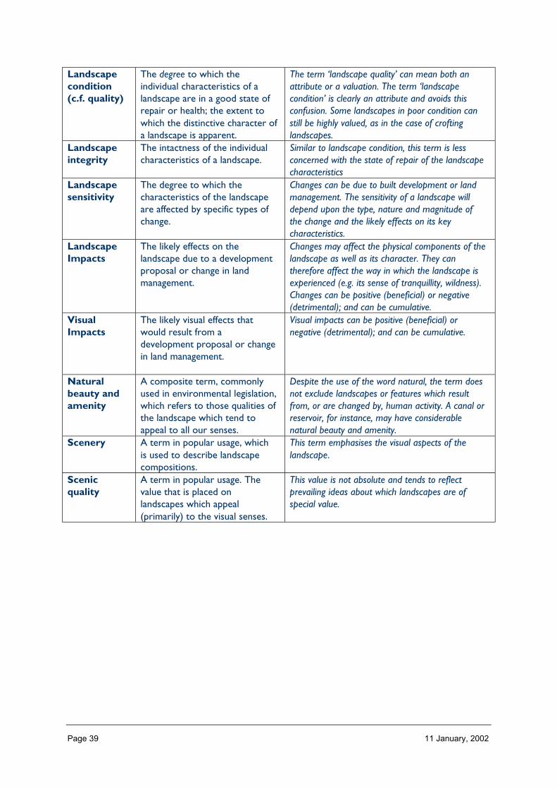
Landscapecondition(c.f. quality)
The degree to which theindividual characteristics of alandscape are in a good state ofrepair or health; the extent towhich the distinctive character ofa landscape is apparent.
The term ‘landscape quality’ can mean both anattribute or a valuation. The term ‘landscapecondition’ is clearly an attribute and avoids thisconfusion. Some landscapes in poor condition canstill be highly valued, as in the case of croftinglandscapes.
Landscapeintegrity
The intactness of the individualcharacteristics of a landscape.
Similar to landscape condition, this term is lessconcerned with the state of repair of the landscapecharacteristics
Landscapesensitivity
The degree to which thecharacteristics of the landscapeare affected by specific types ofchange.
Changes can be due to built development or landmanagement. The sensitivity of a landscape willdepend upon the type, nature and magnitude ofthe change and the likely effects on its keycharacteristics.
LandscapeImpacts
The likely effects on thelandscape due to a developmentproposal or change in landmanagement.
Changes may affect the physical components of thelandscape as well as its character. They cantherefore affect the way in which the landscape isexperienced (e.g. its sense of tranquillity, wildness).Changes can be positive (beneficial) or negative(detrimental); and can be cumulative.
VisualImpacts
The likely visual effects thatwould result from adevelopment proposal or changein land management.
Visual impacts can be positive (beneficial) ornegative (detrimental); and can be cumulative.
Naturalbeauty andamenity
A composite term, commonlyused in environmental legislation,which refers to those qualities ofthe landscape which tend toappeal to all our senses.
Despite the use of the word natural, the term doesnot exclude landscapes or features which resultfrom, or are changed by, human activity. A canal orreservoir, for instance, may have considerablenatural beauty and amenity.
Scenery A term in popular usage, whichis used to describe landscapecompositions.
This term emphasises the visual aspects of thelandscape.
Scenicquality
A term in popular usage. Thevalue that is placed onlandscapes which appeal(primarily) to the visual senses.
This value is not absolute and tends to reflectprevailing ideas about which landscapes are ofspecial value.
Page 40 11 January, 2002
ReferencesAnon. 1998. The Landscape Character of Scotland: the National Programme of Landscape Character
Assessment. Perth, Scottish Natural Heritage.ASH Consulting Group. 1998a. Clackmannanshire landscape assessment. Scottish Natural Heritage
Review No. 96. Perth, Scottish Natural Heritage.ASH Consulting Group. 1998b. Lothians landscape assessment. Scottish Natural Heritage Review No.
91. Perth, Scottish Natural Heritage.ASH Consulting Group. 1999a. Borders landscape assessment. Scottish Natural Heritage Review No.
112. Perth, Scottish Natural Heritage.ASH Consulting Group. 1999b. Central Region landscape assessment. Scottish Natural Heritage Review
No. 123. Perth, Scottish Natural Heritage.Cobham Resource Consultants. 1997. Banff & Buchan landscape character assessment. Scottish
Natural Heritage Review No. 37. Perth, Scottish Natural Heritage.David Tyldesley and Associates. 1995a. Kinross-shire landscape character assessment. Scottish
Natural Heritage Review No. 77. Perth, Scottish Natural Heritage.David Tyldesley and Associates. 1995b. Dunfermline district landscape character assessment. Scottish
Natural Heritage Review No. 19. Perth, Scottish Natural Heritage.David Tyldesley and Associates. 1999a. Fife landscape character assessment. Scottish Natural Heritage
Review No. 113. Perth, Scottish Natural Heritage.David Tyldesley and Associates. 1999b. Stirling to Grangemouth landscape character assessment.
Scottish Natural Heritage Review No. 124. Perth, Scottish Natural Heritage.Environmental Resources Management 1996. Argyll and the Firth of Clyde landscape character
assessment. Scottish Natural Heritage Review No. 78. Perth, Scottish Natural Heritage.Environmental Resources Management 1998a. Lochaber: landscape character assessment. Scottish
Natural Heritage Review No. 97. Perth, Scottish Natural Heritage.Environmental Resources Management 1998b. Aberdeenshire: South and Central landscape
character assessment. Scottish Natural Heritage Review No. 102. Perth, Scottish Natural Heritage.Fletcher, S. 1998. Inner Moray Firth landscape character assessment. Scottish Natural Heritage Review
No. 90. Perth, Scottish Natural Heritage.Gillespies. 1998. Shetland Isles landscape assessment. Scottish Natural Heritage Review No. 93. Perth,
Scottish Natural Heritage.Land Use Consultants 1998a. Dumfries and Galloway landscape assessment. Scottish Natural Heritage
Review No. 94. Perth, Scottish Natural Heritage.Land Use Consultants 1998b. Ayrshire landscape assessment. Scottish Natural Heritage Review No.
111. Perth, Scottish Natural Heritage.Land Use Consultants 1999a. Orkney landscape assessment. Scottish Natural Heritage Review No. 100.
Perth, Scottish Natural Heritage.Land Use Consultants 1999b. Glasgow and Clyde Valley landscape assessment. Scottish Natural
Heritage Review No. 116. Perth, Scottish Natural Heritage.Land Use Consultants 1999c. Tayside landscape assessment. Scottish Natural Heritage Review No. 122.
Perth, Scottish Natural Heritage.McIIveen, F. 1999. Ross and Cromarty landscape character assessment. Scottish Natural Heritage
Review No 119. Perth, Scottish Natural Heritage.Nicol, I, Johnston, A. and Campbell, L. 1996. Landscape character assessment of Aberdeen. Scottish
Natural Heritage Review No. 80. Perth, Scottish Natural Heritage.Richards, J. 1998. Western Isles landscape character assessment. Scottish Natural Heritage Review No.
92. Perth, Scottish Natural Heritage.Richards, J. 1999. Inverness District landscape character assessment. Scottish Natural Heritage Review
No. 114. Perth, Scottish Natural Heritage.SNH Landscape Group 1999. Ben Alder, Ardverikie and Creag Meagaidh landscape assessment.
Scottish Natural Heritage Review No. 120. Perth, Scottish Natural Heritage.Stanton, C. 1996. Skye and Lochalsh landscape character assessment. Scottish Natural Heritage Review
No. 71. Perth, Scottish Natural Heritage.Stanton, C. 1998. Caithness and Sutherland landscape character assessment. Scottish Natural Heritage
Review No. 103. Perth, Scottish Natural Heritage.

Page 41 11 January, 2002
Turnbull Jeffrey Partnership 1996a. Cairngorms: landscape assessment. Scottish Natural HeritageReview No. 75. Perth, Scottish Natural Heritage.
Turnbull Jeffrey Partnership 1996b. Mar Lodge Estate: landscape assessment. Scottish Natural HeritageReview No. 79. Perth, Scottish Natural Heritage.
Turnbull Jeffrey Partnership. 1998. Moray and Nairn landscape assessment. Scottish NaturalHeritage Review No. 101. Perth, Scottish Natural Heritage.
Page 42 11 January, 2002
PART 2LANDSCAPE PROFILES: A
WORKING GUIDE
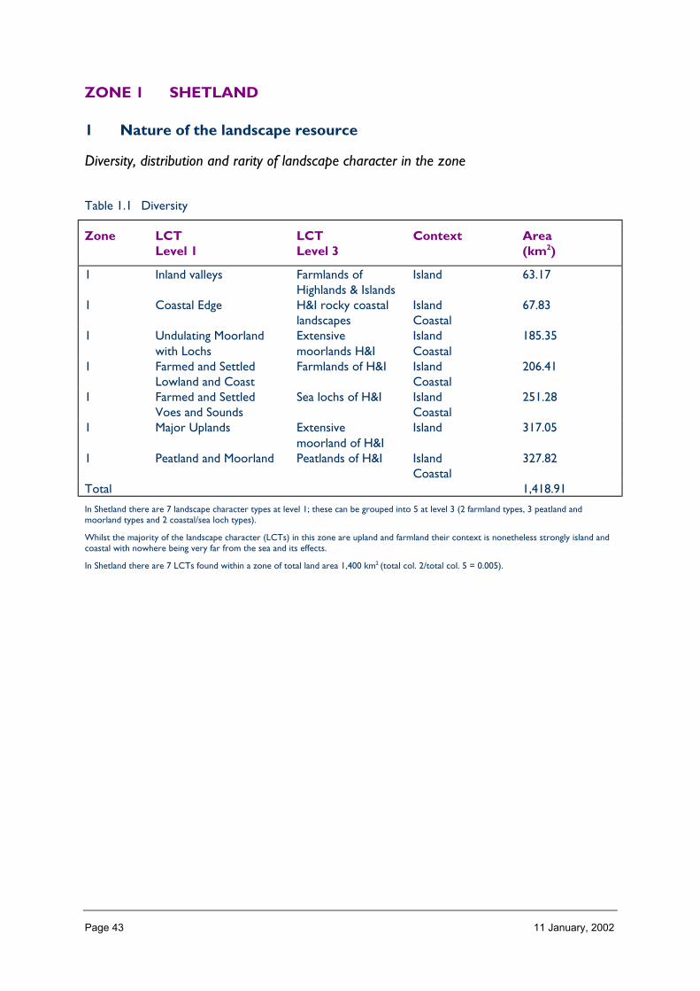
Page 43 11 January, 2002
ZONE 1 SHETLAND
1 Nature of the landscape resource
Diversity, distribution and rarity of landscape character in the zone
Table 1.1 Diversity
Zone LCTLevel 1
LCTLevel 3
Context Area(km2)
1 Inland valleys Farmlands ofHighlands & Islands
Island 63.17
1 Coastal Edge H&I rocky coastallandscapes
IslandCoastal
67.83
1 Undulating Moorlandwith Lochs
Extensivemoorlands H&I
IslandCoastal
185.35
1 Farmed and SettledLowland and Coast
Farmlands of H&I IslandCoastal
206.41
1 Farmed and SettledVoes and Sounds
Sea lochs of H&I IslandCoastal
251.28
1 Major Uplands Extensivemoorland of H&I
Island 317.05
1 Peatland and Moorland Peatlands of H&I IslandCoastal
327.82
Total 1,418.91
In Shetland there are 7 landscape character types at level 1; these can be grouped into 5 at level 3 (2 farmland types, 3 peatland andmoorland types and 2 coastal/sea loch types).
Whilst the majority of the landscape character (LCTs) in this zone are upland and farmland their context is nonetheless strongly island andcoastal with nowhere being very far from the sea and its effects.
In Shetland there are 7 LCTs found within a zone of total land area 1,400 km2 (total col. 2/total col. 5 = 0.005).
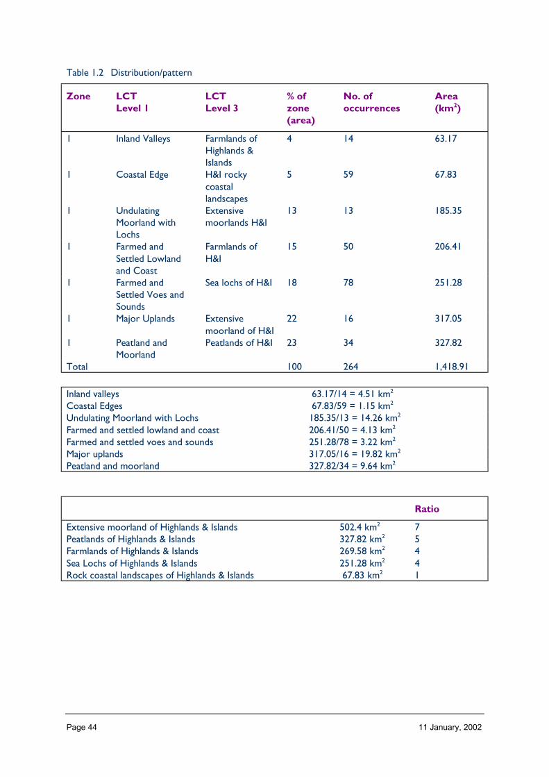
Page 44 11 January, 2002
Table 1.2 Distribution/pattern
Zone LCTLevel 1
LCTLevel 3
% ofzone(area)
No. ofoccurrences
Area(km2)
1 Inland Valleys Farmlands ofHighlands &Islands
4 14 63.17
1 Coastal Edge H&I rockycoastallandscapes
5 59 67.83
1 UndulatingMoorland withLochs
Extensivemoorlands H&I
13 13 185.35
1 Farmed andSettled Lowlandand Coast
Farmlands ofH&I
15 50 206.41
1 Farmed andSettled Voes andSounds
Sea lochs of H&I 18 78 251.28
1 Major Uplands Extensivemoorland of H&I
22 16 317.05
1 Peatland andMoorland
Peatlands of H&I 23 34 327.82
Total 100 264 1,418.91
Inland valleys 63.17/14 = 4.51 km2
Coastal Edges 67.83/59 = 1.15 km2
Undulating Moorland with Lochs 185.35/13 = 14.26 km2
Farmed and settled lowland and coast 206.41/50 = 4.13 km2
Farmed and settled voes and sounds 251.28/78 = 3.22 km2
Major uplands 317.05/16 = 19.82 km2
Peatland and moorland 327.82/34 = 9.64 km2
Ratio
Extensive moorland of Highlands & Islands 502.4 km2 7Peatlands of Highlands & Islands 327.82 km2 5Farmlands of Highlands & Islands 269.58 km2 4Sea Lochs of Highlands & Islands 251.28 km2 4Rock coastal landscapes of Highlands & Islands 67.83 km2 1

Page 45 11 January, 2002
Table 1.3 Rarity
Rarity byoccurrence %
Rarity by extent %
Inland valleys 5 4Coastal edge 22 5Undulating Moorland with lochs 5 13Farmed and settledLowland and coast
19 15
Farmed and settledVoes and Sands
30 18
Major Uplands 6 22Peatland and Moorland 13 23
The rarity of a landscape character types within the zone can be identified by the number of times it occurs or its extent. Examination ofboth the number of occurrences (of a LCT) as a percentage of the total and the area (of a LCT) as a percentage of the total area will givean indication of rarity. (col 5/total col. 5%) (col. 6/total col. 6%).
The map of LCTs in the zone at level 1 gives the actual location, orientation and distribution of LCTs which can be described andexplained as text along with any marked differences in the diversity and distribution in different parts of the zone.
Description
Landform
PROFILE
Shetland generally has a rolling profile of low ridges.
SEQUENCE
Uplands tend to terminate in coastal cliffs, stacks and arches. Hollows and shallow valleyslead ‘gently’ to coastal lowlands, beaches, bays and rocky headlands.
SCALE
In Shetland landforms tend to be of a moderate scale other than the cliffs and other coastalfeatures where the vertical scale is great.
LANDMARK FEATURES
Ronas hill
Voes (e.g. Whiteness)
Individual Islands (e.g. Bressay).
EXPERIENCE
The interior landform has a consistent and predictable profile and a pronounced grain butthe experience when travelling by public road is confused by the degree of indentation inthe coastline and the presence of the sea in all directions, north, south, east and west.
Page 46 11 January, 2002
Containment (created by landform and land cover)
TOPOGRAPHY
The strong ‘grain’ of central Shetlands landscape is divided by ridges of hills, provides somecontainment by focusing views. Elsewhere this is less influential, particularly on the coast,where views are often extensive
LAND COVER (VEGETATION AND BUILT DEVELOPMENT).
Except amongst the buildings of central Lerwick, built development does not contribute tocontainment. Woodland is almost entirely absent, and even where it occurs, it does notlimit views.
VISIBILITY
Often limited inland by landform (relative to location of public routes). Marked contrastbetween that of inner coastline, with the focused views to seaward, and outer coastline,where a great breadth of visibility is characteristic.
MICROCLIMATIC EFFECTS
Most enclosed bays (e.g. at Lerwick, which is protected by offshore island) and inland hillsare relatively sheltered. However, much of Shetland is highly exposed to wind and weatheralthough there are generally microclimatic pockets not typical of the Shetland landscape.
EXPERIENCE
Even though there are places in Shetland with limited visibility the sense of containment isaffected strongly by the climate and lack of tall growing vegetation.
Accessibility
DISTANCE
Shetland is located at some considerable distance from major population centres (150 kmfrom the north Scotland mainland and 340 km from Aberdeen) and being an islandarchipelago necessitates travel by ferry or plane. Inter-island transport is generally good butweather dependent, especially for remoter out isles.
PHYSICAL ACCESS
In Shetland – road network extensive with few places more than 5 km from a public road.Access tracks common place in moorland/peatland LCTs but footpaths few other than torecognised visitor sites. Terrain difficult in moorland/peatland areas. Access to shoreline andboat access limited to areas of coastal settlement.
CULTURAL ACCEPTANCE OF ACCESS
Generally a good level of acceptance of responsible open access on hill land, less so oninby/fenced farmland.
VISUAL ACCESS
Visual access of inland areas limited from any one view point but possible to see into an areafrom an array of publicly accessible viewing locations. Visual access from vantage points fromalong coastal areas good.
Page 47 11 January, 2002
EXPERIENCE
Shetland can feel a long way away to the visitor and access outwith the public road systemlimited. Lack of obvious access points/signage/interpretation affects psychological ease ofaccess. However, to the interested resident access to the landscape is not particularlylimiting provided it is undertaken responsibly.
Despite the often short distances to roads, access combined with exposure particularly onthe coast creates potential for a wild land experience which may be particular to theShetland landscape.
Land cover (including vegetation and land use)
VEGETATION
Being so open and with little vegetation of any height the simple colour and texturalcontrasts between the upland LCTs and the farmed and coastal LCTs (the browns, russetsand greens and occasional crops of the lowland and coast) becomes an important part ofthe zone’s landscape character; echoing underlying characteristics of drainage and soil type).
EXPOSED ROCK
Only the Major Uplands LCTs of Shetland are particularly noteworthy for the presence ofexposed rock in the form of, scree clad alpine heath, boulder strewn moorlands andgrassland. These areas introduce visual diversity into the otherwise simple vegetationalcontrasts.
The exposed rock of the coastline, its cliffs, arches and rocky shores dominates those areasand contributes much to the landscape character of the zone.
BUILT DEVELOPMENT
The farmed and settled LCTs are the landscapes of Shetland where built developmentcontributes significantly to land cover either as crofts, crofting townships, small farms,nucleated settlements and Shetland’s towns. Built development contributes contrast in theShetland landscape, a different pattern overlaid on the land, and sometimes dominatescharacter of the landscape.
EXPERIENCE
The land cover of Shetland tends to emphasise the natural and elemental experience of thislandscape, the bare rock of the coast and high hills, the obvious lack of high-growingvegetation, the built devilment focused in Shetland locations.
Hydrology and water bodies
TYPE
What kind of water bodies/features are characteristic of the landscape of this zone, e.g.rivers, burns, lochs, lochans, sea lochs, waterfalls?
EXPERIENCE
Views to inland lochs are most characteristic of the western hummocky topography of partsof Mainland where they form a distinctive landscape.

Page 48 11 January, 2002
In many other location, areas of freshwater form an occasional focal point. The main areathat without freshwater bodies is in the southern Mainland, and the resulting lack ofvariation is noticeable.
Built and infrastructure development (present day)
NATURE AND PATTERN OF SETTLEMENT
By far the largest settlement is the port and capital of Lerwick: Scalloway, an earlier capital,is a small town and harbour on the west coast. The most common settlement pattern,however, is a series of loose clusters of houses. These are generally centred on the coastand, at least originally, where some flatter better quality ground allowed a small area of in-bye land to be cultivated. High ground, moorlands and peatland is generally avoided, so thatsettlement is concentrated on lower, sheltered ground. Modern building methods, andtechnology such as double glazing, means that more exposed sites – often with expansiveviews – can now be settlement pattern is being sheltered bay.
NATURE AND PATTERN OF INFRASTRUCTURE
The settlements are served by a network of minor roads that feed into the main roadswhich follow the easier ground of the long glens and faults that run through the islands.Considerable areas are not connected to the road network, principally the large areas ofmoorland and peatland, and the uplands or remote islands.
The main airport is located at Sumburgh on the southern tip of Mainland. A secondaryairfield is situated at Tingwall, near Lerwick. Other airstrips are found near Sullom Voe, andon the outlying islands of Unst and Fetlar.
NATURE AND PATTERN OF INDUSTRIAL DEVELOPMENT
The feature harbours and ports of Lerwick and Scalloway are features. Lerwick has fairlyextensive harbour areas, storage, and industrial estates. The largest individual industrialdevelopment, however, is the oil terminal at Sullom Voe, and on the north of mainland.
EXPERIENCE
From the main roads through the islands, settlement appears frequent. However, theexpanse of remote areas without infrastructure or buildings is also characteristic and cangive the impression of a difficult environment.
Visible history (past settlement, landuse, churches, brochs, forts, dykes, standingstones etc.)
TYPES OF VISIBLE HISTORY
There are many historical features in Shetland that are intrinsic to the character of thelandscape. They include remnants of turf and stone boundary dykes that may be Neolithic inorigin. Some of the most striking and prominent are the remains of the brochs, fortifiedtower-shaped Iron Age dwellings. There are also frequent examples of ‘planticrubs’, smalldrystone enclosures in which plants were grown, clearly indicative of the harsh weatherconditions There are occasionally dramatic remains of castles, the main example being nearthe harbour of Scalloway on West Coast, an old capital of the islands.
Page 49 11 January, 2002
LOCATION/PATTERN
Almost all significant historical artefacts are located close to the coast. This reflects thereliance on the sea as the transport route until relatively recently, and the concentration ofsettlement on lower, more sheltered ground near the sea.
EXPERIENCE
Much of the visual history is present as individually prominent features. These act as focalpoints in the landscape. Together with less obvious elements such as dykes, combine toindicate the extent of human influence in this landscape.
Wildlife
FORMS OF WILDLIFE
The large numbers of seabirds are the most obvious form of wildlife in this zone. Seals arealso quite frequent. The relatively small range of habitats limits the type of wildlife that ispresent in the zone.
LOCATION
The cliffs and coastline are the main locations for seabirds. Seals are found offshore and onthe coastline.
WHEN
The typical wildlife of this zone tends to be present all year.
EXPERIENCE
The noise and movement of great colonies of seabirds can be an important part of how thelandscape is experienced.
The sight of seals, although welcome and often characteristic, is not so much a fundamentalcomponent of the zone landscape.
Climate
CLIMATIC CHARACTERISTICS
The Shetland is a group of islands equidistant from Scotland and Norway, therefore often arough, severe climate, tempered by maritime influences. Frequent high winds means theislands are very exposed.
LOCATIONAL AND SEASONAL EFFECTS
The latitude of the zone means very long days in summer and very short days in winter.
EXPERIENCE
The strength and noise of the wind has strong influences on the experience of thelandscape. This is particularly the case when it is accompanied by stormy seas, themovement, noise and force of which, crashing against the coastline adds extra dimension tothe landscape.

Page 50 11 January, 2002
Designated landscapes
National Scenic Areas
CONSTITUENTS
All of the Shetland NSA is located within the zone. All LCTs within the NSA are coastal,often dramatic rocky cliffs and inlets, also some of the ‘voes’ – long inlets of sea betweenpromontories.
LOCATION AND EXTENT
The NSA is divided into 7 separate areas, all on the West Coast.
EXPERIENCE
Generally, the NSA is not experienced as being distinct from the landscapes of the rest ofthe zone. The fragmentation of the NSA, and the fairly frequent occurrence of similar LCTsperhaps reinforces this.
AGLVS and other Local Authority designations
NATURE OF THE LANDSCAPE DESIGNATED
There are no local authority landscape designations in this zone.
Historic gardens and designed landscapes
NATURE OF THE LANDSCAPES DESIGNATED
There are several historic gardens in the zone. Policy woodland and parkland are absent.Most are probably nineteenth century in origin, with extensive walls for shelter. Often, thelarger size of the walls and houses are the only indication of a designed landscape.
LOCATION
Generally, they are concentrated in n settled, lower-lying, more sheltered areas.
EXPERIENCE
The composition formed by a house and garden within its setting: often carefully designed,acts as a focal point within the local landscape.
Recreational landscapes
Nature of landscapesMost landscapes in the zone attract use for recreation, as the principal attraction is to viewthe wildlife and natural beauty.
LOCATION
The whole of this zone is, potential the network of paths, coastal routes and, for troutfishing, the many lochs. Cliffs on Foulaare the highest in Britain (over 1000 feet in height)and they provide opportunities for rock climbing. The coastal areas are used for sports suchas diving, sailing and sea angling

Page 51 11 January, 2002
EXPERIENCE
The peace and quiet presented by several areas of the zone are qualities sought after bymany people.
2 Importance and value of the zone landscape
Category Brief explanation oflandscape importance(if any)
Importance(GB, Scotland,zone)
Landscape Character Importancerarity unique area Scotlandextent whole of zonediversity (including specific landmarks) somepattern distinctive, e.g.
settlements, geologicaltrends
Scotland
integrity fading with some moderndevelopment
typicalnessfragility yesCultural Importancepre history (designated/non-designated) includes prominent
features, e.g. brochsScotland/Great Britain
medieval (designated/non-designated) occasional castles andother features
Scotland
recent (designated/non-designated)Socioeconomic Importancesocial lots of visitors for peaceful
landscapesScotland/Great Britain
economic Scotland/Great BritainScenic importancedesignatednon-designated‘Spiritual’ Importanceremoteness and tranquillity Great BritainLearning ImportanceEnvironmental Education ZonalInterpretation ZonalEnjoyment ImportanceRecreation ZonalAmenity Scotland
3 Landscape and trends in the zone
The following table uses categories that match those used in the National Section.

Page 52 11 January, 2002
Pressure Nature of pressuretrends within zone,relative importancewithin the zone
Scale of pressures within zonewhen place in
an all Scotland context
Major Inter. Minor
Built developmentResidential high importance and impact ✔Retail ✔Industrial ✔OtherInfrastructure TransportRoads and tracks ✔ ✔Rail related N/A ✔ ✔Ferry relatedOtherInfrastructure otherTelecoms obvious in open landscape ✔Water treatment likely sites probably not
obtrusive?✔
Waste management ✔Coastal defences could be significant,
because of length of coast,but perhaps unlikely
✔ ✔
OtherMineralsOpen cast coal N/ASand and Gravel ✔Hard rock major quarry would be
significant in a renowned‘remote’ area
✔
PeatOtherForestry and WoodlandsRestructuring of existing N/ACreation of new small because of changes it
would create in this almosttreeless landscape
✔
Creation of large new/native ✔OtherAquacultureFinfish impacts high, because of
length of coastline andrelatively undevelopednature of much of it
✔
Shellfish ✔OtherEnergyNat. grid/infrastructure ✔Wind impacts on an area
renowned for itsremoteness
✔

Page 53 11 January, 2002
Hydro ✔Wave ✔OtherTourism and RecreationGolf ✔Marinas ✔Skiing facilities infrastructure for? for
downhill skiing would besignificant
✔
Leisure facilities/visitor centres ✔Information provision ✔Walking related/footpaths ✔Other
4 Building a sustainable future
This consideration should take into account those aspects of the zonal landscape you haveidentified as important (Section 2) and those landscape pressures and trends which aresignificant in a zonal context (Section 3). A matrix as outlined below may help in thisprocess, although text may be an easier way of presenting the information.
Zonal landscape objectives can be focused on outputs and/or mechanisms and shouldhighlight existing and potential opportunities for change where they exist. Where you feelthere is inadequate knowledge/information this should be highlighted.
GeneralThere is residential development pressure – buildings in ‘wrong’ sites have a negative impacton landscape character and settlement pattern. This is a current and ongoing problem,particularly in cthe ommuting belt to Lerwick. The aim is to help new developments to besited and designed sympathetically.
• Historical artefacts are a key part of the landscape resource. Help protect them andimportantly, their setting.
• Coastal defences could have high impacts but the coast is probably not eroding.• Quarrying, depending on scale, could have major impacts in a landscape renowned for its
peacefulness and relative naturalness.• Woodland: none at present so new would be significant.• Energy infrastructure highly visible in this open landscape.• Skiing infrastructure highly visible in this open landscape and character.
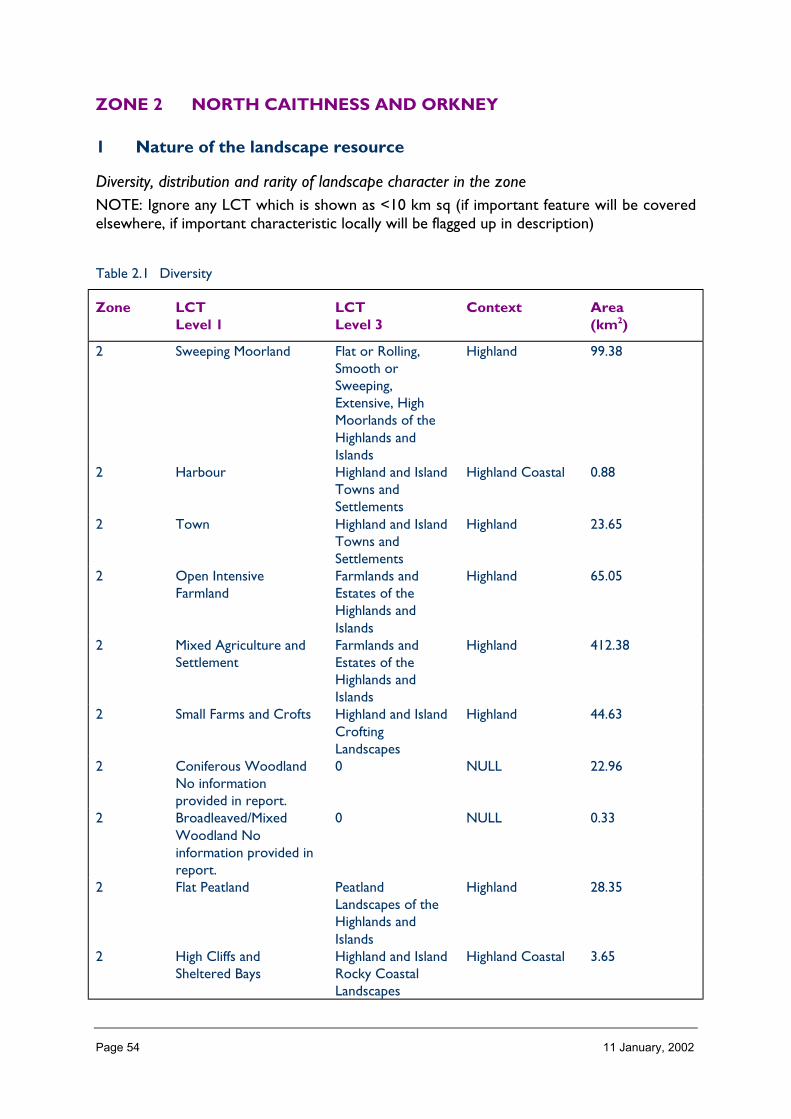
Page 54 11 January, 2002
ZONE 2 NORTH CAITHNESS AND ORKNEY
1 Nature of the landscape resource
Diversity, distribution and rarity of landscape character in the zoneNOTE: Ignore any LCT which is shown as <10 km sq (if important feature will be coveredelsewhere, if important characteristic locally will be flagged up in description)
Table 2.1 Diversity
Zone LCTLevel 1
LCTLevel 3
Context Area(km2)
2 Sweeping Moorland Flat or Rolling,Smooth orSweeping,Extensive, HighMoorlands of theHighlands andIslands
Highland 99.38
2 Harbour Highland and IslandTowns andSettlements
Highland Coastal 0.88
2 Town Highland and IslandTowns andSettlements
Highland 23.65
2 Open IntensiveFarmland
Farmlands andEstates of theHighlands andIslands
Highland 65.05
2 Mixed Agriculture andSettlement
Farmlands andEstates of theHighlands andIslands
Highland 412.38
2 Small Farms and Crofts Highland and IslandCroftingLandscapes
Highland 44.63
2 Coniferous WoodlandNo informationprovided in report.
0 NULL 22.96
2 Broadleaved/MixedWoodland Noinformation provided inreport.
0 NULL 0.33
2 Flat Peatland PeatlandLandscapes of theHighlands andIslands
Highland 28.35
2 High Cliffs andSheltered Bays
Highland and IslandRocky CoastalLandscapes
Highland Coastal 3.65
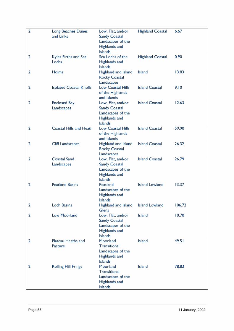
Page 55 11 January, 2002
2 Long Beaches Dunesand Links
Low, Flat, and/orSandy CoastalLandscapes of theHighlands andIslands
Highland Coastal 6.67
2 Kyles Firths and SeaLochs
Sea Lochs of theHighlands andIslands
Highland Coastal 0.90
2 Holms Highland and IslandRocky CoastalLandscapes
Island 13.83
2 Isolated Coastal Knolls Low Coastal Hillsof the Highlandsand Islands
Island Coastal 9.10
2 Enclosed BayLandscapes
Low, Flat, and/orSandy CoastalLandscapes of theHighlands andIslands
Island Coastal 12.63
2 Coastal Hills and Heath Low Coastal Hillsof the Highlandsand Islands
Island Coastal 59.90
2 Cliff Landscapes Highland and IslandRocky CoastalLandscapes
Island Coastal 26.32
2 Coastal SandLandscapes
Low, Flat, and/orSandy CoastalLandscapes of theHighlands andIslands
Island Coastal 26.79
2 Peatland Basins PeatlandLandscapes of theHighlands andIslands
Island Lowland 13.37
2 Loch Basins Highland and IslandGlens
Island Lowland 106.72
2 Low Moorland Low, Flat, and/orSandy CoastalLandscapes of theHighlands andIslands
Island 10.70
2 Plateau Heaths andPasture
MoorlandTransitionalLandscapes of theHighlands andIslands
Island 49.51
2 Rolling Hill Fringe MoorlandTransitionalLandscapes of theHighlands andIslands
Island 78.83

Page 56 11 January, 2002
2 Whaleback IslandLandscapes
Highland and IslandRocky CoastalLandscapes
Island 39.22
2 Moorland Hills Flat or Rolling,Smooth orSweeping,Extensive, HighMoorlands of theHighlands andIslands
Island Upland 210.51
2 Glaciated Valley Highland and IslandGlens
Island 10.42
2 Rugged Glaciated Hills High, Massive,Rugged, Steep-Sided Mountains ofthe Highlands andIslands
Island Upland 17.73
2 Urban and RuralDevelopment
Highland and IslandTowns andSettlements
Island Lowland 6.38
2 Ridgeline IslandLandscapes
Farmlands andEstates of theHighlands andIslands
Island 68.17
2 Low Island Pastures Farmlands andEstates of theHighlands andIslands
Island Lowland 88.52
2 Undulating IslandPasture
Farmlands andEstates of theHighlands andIslands
Island Lowland 37.37
2 Coastal Plain Low, Flat, and/orSandy CoastalLandscapes of theHighlands andIslands
Island 0.99
2 Coastal Basins Low, Flat, and/orSandy CoastalLandscapes of theHighlands andIslands
Island Coastal 70.36
2 Inclined CoastalPastures
Low, Flat, and/orSandy CoastalLandscapes of theHighlands andIslands
Island Coastal 109.29
2 Coastal GranitePastures
Low Coastal Hillsof the Highlandsand Islands
Island Coastal 4.62
2 Upland Igneous andVolcanic Hills TheOchil, Sidlaw,
Upland 3.22

Page 57 11 January, 2002
Cleish and LomondHills
Total 1783.33
The number of landscape character types represented in the zone at level 1, the way they are grouped at level 3, and their context givesan indication of overall diversity (total column 2, 3 and 4).
The number of landscape character types (level 1) represented per area of land in the zone gives a measure of diversity which can becompared between zones.
Table 2.2 Distribution/pattern
Zone LCTlevel 1
LCTlevel 3
% ofZone(area)
No. ofOccurrences
Areakm2
2 SweepingMoorland
Flat or Rolling,Smooth orSweeping,Extensive, HighMoorlands of theHighlands andIslands
5.6 14 99.38
2 Harbour Highland andIsland Towns andSettlements
0.0 3 0.88
2 Town Highland andIsland Towns andSettlements
1.3 3 23.65
2 Open IntensiveFarmland
Farmlands andEstates of theHighlands andIslands
3.6 12 65.05
2 Mixed Agricultureand Settlement
Farmlands andEstates of theHighlands andIslands
23.1 6 412.38
2 Small Farms andCrofts
Highland andIsland CroftingLandscapes
2.5 29 44.63
2 ConiferousWoodland Noinformationprovided in report.
0 1.3 25 22.96
2 Broadleaved/MixedWoodland Noinformationprovided in
0 0.0 1 0.33
2 Flat Peatland PeatlandLandscapes ofthe Highlandsand Islands
1.6 1 28.35
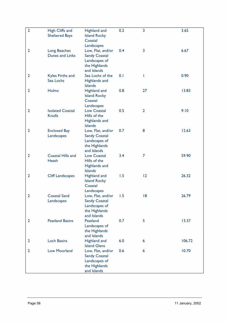
Page 58 11 January, 2002
2 High Cliffs andSheltered Bays
Highland andIsland RockyCoastalLandscapes
0.2 3 3.65
2 Long BeachesDunes and Links
Low, Flat, and/orSandy CoastalLandscapes ofthe Highlandsand Islands
0.4 3 6.67
2 Kyles Firths andSea Lochs
Sea Lochs of theHighlands andIslands
0.1 1 0.90
2 Holms Highland andIsland RockyCoastalLandscapes
0.8 27 13.83
2 Isolated CoastalKnolls
Low CoastalHills of theHighlands andIslands
0.5 2 9.10
2 Enclosed BayLandscapes
Low, Flat, and/orSandy CoastalLandscapes ofthe Highlandsand Islands
0.7 8 12.63
2 Coastal Hills andHeath
Low CoastalHills of theHighlands andIslands
3.4 7 59.90
2 Cliff Landscapes Highland andIsland RockyCoastalLandscapes
1.5 12 26.32
2 Coastal SandLandscapes
Low, Flat, and/orSandy CoastalLandscapes ofthe Highlandsand Islands
1.5 18 26.79
2 Peatland Basins PeatlandLandscapes ofthe Highlandsand Islands
0.7 5 13.37
2 Loch Basins Highland andIsland Glens
6.0 6 106.72
2 Low Moorland Low, Flat, and/orSandy CoastalLandscapes ofthe Highlandsand Islands
0.6 6 10.70

Page 59 11 January, 2002
2 Plateau Heaths andPasture
MoorlandTransitionalLandscapes ofthe Highlandsand Islands
2.8 6 49.51
2 Rolling Hill Fringe MoorlandTransitionalLandscapes ofthe Highlandsand Islands
4.4 7 78.83
2 Whaleback IslandLandscapes
Highland andIsland RockyCoastalLandscapes
2.2 10 39.22
2 Moorland Hills Flat or Rolling,Smooth orSweeping,Extensive, HighMoorlands of theHighlands andIslands
11.8 8 210.51
2 Glaciated Valley Highland andIsland Glens
0.6 1 10.42
2 Rugged GlaciatedHills
High, Massive,Rugged, Steep-Sided Mountainsof the Highlandsand Islands
1.0 2 17.73
2 Urban and RuralDevelopment
Highland andIsland Towns andSettlements
0.4 10 6.38
2 Ridgeline IslandLandscapes
Farmlands andEstates of theHighlands andIslands
3.8 4 68.17
2 Low IslandPastures
Farmlands andEstates of theHighlands andIslands
5.0 20 88.52
2 Undulating IslandPasture
Farmlands andEstates of theHighlands andIslands
2.1 3 37.37
2 Coastal Plain Low, Flat, and/orSandy CoastalLandscapes ofthe Highlandsand Islands
0.1 1 0.99
2 Coastal Basins Low, Flat, and/orSandy CoastalLandscapes ofthe Highlandsand Islands
3.9 12 70.36

Page 60 11 January, 2002
2 Inclined CoastalPastures
Low, Flat, and/orSandy CoastalLandscapes ofthe Highlandsand Islands
6.1 18 109.29
2 Coastal GranitePastures
Low CoastalHills of theHighlands andIslands
0.3 1 4.62
2 Upland Igneousand VolcanicHills The Ochil,Sidlaw, Cleishand LomondHills
0.2 1 3.22
Total 296 1783.33
In Zone 2 a total 296 occurrences of landscape character types (landscape units) are found within a zone of total land area 1783 km sq.The figure 296/1783 is 0.166.per km sq of land within the zone and gives a relative indication of the overall brokenness or fragmentation ofthe landscape pattern.

Page 61 11 January, 2002
LCT at Level 1 Area/Occurrences (km2)
Sweeping Moorland 7.09Harbour 0.29Town 7.88Open Intensive Farmland 5.42Mixed Agriculture and Settlement 68.73Small Farms and Crofts 1.53Coniferous Woodland No information provided in report. 0.91Broadleaved/Mixed Woodland No information provided in 0.33Flat Peatland 28.35High Cliffs and Sheltered Bays 1.21Long Beaches Dunes and Links 2.22Kyles Firths and Sea Lochs 0.9Holms 0.51Isolated Coastal Knolls 4.55Enclosed Bay Landscapes 1.57Coastal Hills and Heath 8.55Cliff Landscapes 2.19Coastal Sand Landscapes 1.48Peatland Basins 2.67Loch Basins 17.78Low Moorland 1.78Plateau Heaths and Pasture 8.25Rolling Hill Fringe 11.26Whaleback Island Landscapes 3.92Moorland Hills 26.31Glaciated Valley 10.42Rugged Glaciated Hills 8.86Urban and Rural Development 0.63Ridgeline Island Landscapes 17.04Low Island Pastures 4.42Undulating Island Pasture 12.45Coastal Plain 0.99Coastal Basins 5.86Inclined Coastal Pastures 6.07Coastal Granite Pastures 4.62Urban Area 3.22
The extent (area) of any one landscape character type (at level 1) divided by the number of times it occurs in the zone gives an idea of theaverage size of occurrences of that LCT

Page 62 11 January, 2002
LCTs at Level 3 Area (km2) Ratio
Flat or Rolling, Smooth or Sweeping, Extensive, High Moorlands ofthe Highlands and Islands
99.38 31
Highland and Island Towns and Settlements 0.88 2Highland and Island Towns and Settlements 23.65 69Farmlands and Estates of the Highlands and Islands 65.05 19Farmlands and Estates of the Highlands and Islands 412.38 124Highland and Island Crofting Landscapes 44.63 130 22.96 690 0.33 1Peatland Landscapes of the Highlands and Islands 28.35 8Highland and Island Rocky Coastal Landscapes 3.65 9Low, Flat, and/or Sandy Coastal Landscapes of the Highlands andIslands
6.67 18
Sea Lochs of the Highlands and Islands 0.90 2Highland and Island Rocky Coastal Landscapes 13.83 39Low Coastal Hills of the Highlands and Islands 9.10 2Low, Flat, and/or Sandy Coastal Landscapes of the Highlands andIslands
12.63 3
Low Coastal Hills of the Highlands and Islands 59.90 18Highland and Island Rocky Coastal Landscapes 26.32 8Low, Flat, and/or Sandy Coastal Landscapes of the Highlands andIslands
26.79 7
Peatland Landscapes of the Highlands and Islands 13.37 39Highland and Island Glens 106.72 32Low, Flat, and/or Sandy Coastal Landscapes of the Highlands andIslands
10.70 3
Moorland Transitional Landscapes of the Highlands and Islands 49.51 14Moorland Transitional Landscapes of the Highlands and Islands 78.83 23Highland and Island Rocky Coastal Landscapes 39.22 11Flat or Rolling, Smooth or Sweeping, Extensive, High Moorlands ofthe Highlands and Islands
210.51 63
Highland and Island Glens 10.42 3High, Massive, Rugged, Steep-Sided Mountains of the Highlandsand Islands
17.73 5
Highland and Island Towns and Settlements 6.38 1Farmlands and Estates of the Highlands and Islands 68.17 20Farmlands and Estates of the Highlands and Islands 88.52 26Farmlands and Estates of the Highlands and Islands 37.37 12Low, Flat, and/or Sandy Coastal Landscapes of the Highlands andIslands
0.99 3
Low, Flat, and/or Sandy Coastal Landscapes of the Highlands andIslands
70.36 22
Low, Flat, and/or Sandy Coastal Landscapes of the Highlands andIslands
109.29 33
Low Coastal Hills of the Highlands and Islands 4.62 12Upland Igneous and Volcanic Hills The Ochil, Sidlaw, Cleish andLomond Hills
3.22 9
The ratio of the extent (area) of the level 3 groupings gives an indication of the distribution pattern by proportion of the zone.

Page 63 11 January, 2002
Table 2.3 Rarity
LCTs at Level 1 Rarity by occurrence%
Rarity by extent%
Sweeping Moorland 4 5.6Harbour 1 0.0Town 1 1.3Open Intensive Farmland 4 3.6Mixed Agriculture and Settlement 2 23.1Small Farms and Crofts 9 2.5Coniferous Woodland No information provided inreport.
8 1.3
Broadleaved/Mixed Woodland No informationprovided in
0 0.0
Flat Peatland 0 1.6High Cliffs and Sheltered Bays 1 0.2Long Beaches Dunes and Links 1 0.4Kyles Firths and Sea Lochs 0 0.1Holms 9 0.8Isolated Coastal Knolls 0 0.5Enclosed Bay Landscapes 2 0.7Coastal Hills and Heath 2 3.4Cliff Landscapes 4 1.5Coastal Sand Landscapes 6 1.5Peatland Basins 1 0.7Loch Basins 2 6.0Low Moorland 2 0.6Plateau Heaths and Pasture 2 2.8Rolling Hill Fringe 2 4.4Whaleback Island Landscapes 3 2.2Moorland Hills 2 11.8Glaciated Valley 0 0.6Rugged Glaciated Hills 0 1.0Urban and Rural Development 3 0.4Ridgeline Island Landscapes 1 3.8Low Island Pastures 6 5.0Undulating Island Pasture 1 2.1Coastal Plain 0 0.1Coastal Basins 4 3.9Inclined Coastal Pastures 6 6.1Coastal Granite Pastures 0 0.3Urban Area 0 0.2
The rarity of a landscape character type within the zone can be identified by the number of time it occurs or its extent. Examination ofboth the number of occurrences (of a LCT) as a percentage of the total and the area (of a LCT) as a percentage of the total area will givean indication of rarity.
LANDSCAPE CHARACTER
The landscapes of this Zone are highly varied within a small area. However, there is often asubtle variation and considerable influence from the coastline and adjacent sea.
In Orkney, many if not most of the LCTs can occur anywhere in the islands, and thismirrors the highly varied yet subtle landscapes of the Zone. There are, of course,

Page 64 11 January, 2002
exceptions to this, for example the glaciated high hills and valleys of northern Hoy; andsome areas have characteristic combinations or concentrations of particular LCTs, such asthe dominance of coastal sand landscapes on Sanday. In Caithness, the areas of moorlandand peatland occur in the east, with almost all of the rest of the area being various types offarmland.
Description
Landform
PROFILE
Most of the relief of the Zone is gently rolling, with the vast majority (90%) being less than100 metres above sea level, and most of the rest being under 200 metres high. The highesthills are concentrated on the north of Hoy, where the summit of Ward Hill reaches 479metres. These glaciated hills are steep-sided and particularly dramatic in contrast to theprevailing gentle slopes of the rest of the Zone.
Wide, shallow loch basins are another landform feature of the Zone. They are largest onmainland Orkney, but also occur on the Scottish mainland. However, it is the coastallandform for which the Zone is probably best known. Rocky cliff and sandy bays are foundat the coast, and both can be highly dramatic boundaries between the sea and the land.
SEQUENCE
The sequence of landform tends to be subtle and complex in the Zone, with small-scale hillsand hollows occurring in various combinations. Some large-scale features form clear focalpoints within this, such as the loch basins on west Mainland, Orkney; and the cluster ofglacially sculpted hills and valleys on northern Hoy.
Cliffs and coasts occur throughout this Zone of coastal mainland and island archipelago. InOrkney the steepest cliffs tend to occur on the west. This sequence is less clear on themainland.
SCALE
Generally, the landform is of a medium scale. However, it can seem large horizontallybecause of the low relief, and where the intervening or adjacent sea emphasises it further.The Caithness part of the Zone tends to have a large horizontal scale.
Where they occur in the Zone, sea cliffs often have a large vertical scale. This results in adramatic landform, and a striking interface between the land and the sea.
LANDMARK FEATURES
Arguably, the Orkney archipelago itself is a landmark feature, given the unique intermixtureof water and land. On a rather smaller scale, particularly notable features include the OldMan of Hoy coastal stack; the immensely high cliffs of St John’s Head (also on Hoy); and thebays, inlets and islets that punctuate much of the Orkney coastline. The loch basins ofHarray and Stenness (West Mainland) are another distinctive landscape element. Coastalfeatures also occur on the Scottish mainland, notably the cliffs, for example at Dunnett Headand Duncansby Head; and wide bays at Sinclair’s Bay and Dunnett Bay.

Page 65 11 January, 2002
EXPERIENCE
Pentland has a distinctive expanse of coastal plain with a large horizontal scale and expansiveskies above. It changes only subtly and slowly when one travels through it. In Orkney, bycontrast, the presence of the sea, the indented nature of the coast, and the rolling landformlead to quick changes in views as one travels through the landscape.
In both areas, the presence of the sea, and the large skies and changing weather affect theexperience of the landscape, as the lighting effects on the landform either emphasise itssubtleties or flatten and dramatise it.
Containment (created by landform and land cover)
TOPOGRAPHY
Throughout the Zone elevations are mostly low, rarely exceeding 100 metres above sealevel. There is correspondingly little containment, and views are both panoramic andextensive. This factor is often enhanced by the presence of the adjacent sea. Where higherelevations do occur, notably on Hoy, they generally do not restrict much of the viewbecause they are located in such open surroundings, with short distances to the coast andsea.
Exceptions to the general rule are few. They include the glacial valley on Hoy; andoccasional bays that are enclosed on three sides (e.g. Rackwick in Orkney).
LAND COVER
Approximately two-thirds of the landcover is agricultural, of which the vast majority isgrassland or improved grassland. Only 1% is arable and this, together with the numbers ofanimals in the fields, reflects the high reliance on livestock for both meat and dairyproduction.
Moorland and peatland accounts for a quarter of land cover. It tends to occur on higher andwetter ground. Woodland is fairly rare, particularly in Orkney, where there are nocommercial plantations and high exposure limits native woodland to a couple of shelteredlocations on Hoy. Shelterbelts around larger houses, and urban trees, are the only othertypes of woodland. In Caithness, parts of the east of the Zone contain larger areas ofwoodland, but it is still relatively uncommon other than around and with settlements. Freshwater is a significant component of landcover, but this is addressed in a later section.
VISIBILITY
Visibility across the Zone is extensive (views of 30–40 km being commonplace) particularlyin Caithness where there is little containment except in enclosed bays. It is also extensiveover much of Orkney. There are only a few locations where it is significantly restricted(apart from within the distinctively huddled townscape of larger settlements on the islands),and this is due to landform in enclosed bays and valleys.
MICROCLIMATIC EFFECTS
There is probably little variation across the Zone because the significant coastal impacts onmicroclimate occur almost throughout the area. Possible exceptions include the most inlandsection of the Caithness part of the zone.
Page 66 11 January, 2002
EXPERIENCE
The roads – and railway – in the Caithness part of the zone provide little sense ofcontainment, as there are almost always fairly extensive views in at least one direction. InOrkney the roads often follow ridge-lines or the coastlines of islands, so the experience ofcontainment is further reduced.
Very occasionally, for example a road follows along the floor of a glaciated valley, orbetween hills and the coast where there can be an increased experience of enclosure, buteven in these cases there are generally directed views to more distant viewpoints or thesea.
Accessibility
DISTANCE
Caithness is located on the northernmost coast of the Scottish mainland, roughly 130 milesfrom Inverness along non-dual carriageway road or a railway with an infrequent service.Orkney is an archipelago of islands separated from the mainland by the Pentland Firth – anotoriously rough stretch of water. The islands can be reached by ferry from Scrabster nearThurso all year (seas permitting); from John o’ Groats in summer (passenger ferry); and byair from Aberdeen or Inverness. Therefore, it takes time, effort, and expense to reach theZone and it feels relatively isolated and distant from the main population centres. SeveralOrkney islands are further separated from the main island of the group.
PHYSICAL ACCESS
Generally, access within the Zone is straightforward thanks to a dense network of roadsand tracks. Most of the area is within 5 km of a road. The extent of the road network isconstrained by higher areas of moorland and peatland, and lochs. Otherwise, the gentlyrolling terrain is not very difficult to traverse.
Travel between the Orkney islands is by ferry or aeroplane. Ferry journey times can be upto an hour for the more distant islands such as Westray. By plane, journey times can,famously, be as little as two minutes (the shortest scheduled flight in the world, betweenWestray and Papa Westray). Road links between Mainland and the southern isles have beenfacilitated since the second World War by the roads built on the Churchill Barriers, anti-submarine defences blocking the eastern approaches to Scapa Flow.
CULTURAL ACCEPTANCE
This may be limited a little by the prevalence of agriculture, but several walks throughoutOrkney are publicised. In Caithness most opportunities for promoted access are on theshore and in recently planted woodland. In addition, the road network is valuable forwalking and cycling.
VISUAL ACCESS
Often this is limited only by distance, views fading with the horizon. Views are widespreadand varied, and can be achieved from air and sea as well as the extensive road network.
EXPERIENCE
The distance and time taken to get to Caithness heightens the ‘sense of arrival’. This is evengreater for Orkney, as it is a group of islands involving a journey by sea or air.
Page 67 11 January, 2002
Land cover (including vegetation and land use)
VEGETATION
The majority of vegetation is agricultural grassland, covering two-thirds of the area. This isdivided into fields, usually with post-and-wire fences that emphasise the open character ofthe landscape; and occasionally with vertical Caithness flagstones that form stone fences.These are distinctive, and are more prevalent on the Scottish mainland.
Moorland and peatland are also common. They can be prominent in the landscape, as theyoften occur on higher ground, or as expanses of wetter ground in larger hollows. Dunevegetation makes up a small percentage of land cover, but it is also more notable in thelandscape than this might suggest. Woodland is relatively rare, and tends to be concentratedin the more sheltered locations, or where landowners could afford to plant and maintainthick shelter woodlands.
EXPOSED ROCK
The sea cliffs, stacks, and rough coastlines in the Zone are the most prominent types ofexposed rock. Sandy bays and dunes also occur, particularly to the east of Orkney, andparticularly on the eastern coast in the Caithness part of the Zone. Ward Hill on Hoy hasareas of patterned ground, in which screes and rocks have been formed into shapes bygeomorphological processes such as solifluction.
BUILT DEVELOPMENT
Overall, a small percentage of land cover is built development but, apart from a few largersettlements (such as Kirkwall, Wick or Thurso), it occurs as frequent, almost evenlyscattered farmsteads and groups of houses. As a result, it makes a larger contribution to thelandscape than its area might suggest.
EXPERIENCE
The amount of settlement is characteristic, and is often clearly associated with the abundantfarmland. As a result the highly settled, low-lying and open landscape gives a certainexperience that, particularly in Caithness, contrasts with adjacent areas.
Hydrology and water bodies
TYPE
The hydrology of the Zone consists of many small, short rivers that are the result of theshort distance from source to sea in much of the area. The two exceptions are in Caithness,where the River Thurso and Forss Water, both of which flow northwards in the Zone, arethe lower reaches of rivers that rise outwith the Zone.
The more striking hydrological feature of the Zone are the number and size of freshwaterlochs that occur almost throughout the area. Lochs cover about 2% of the Zone, which is arelatively high amount. They are usually located within shallow loch basins.
PATTERN
The area with the greatest number of lochs is west Mainland in Orkney. The combined lochbasin that contains Lochs Harray and Stenness is a dramatic and large-scale feature. Lochs
Page 68 11 January, 2002
occur on most other large islands, although they are rare on Hoy and the southern isles ofOrkney. In Caithness they mostly occur in the eastern two-thirds of the Zone.
EXPERIENCE
The presence of water inland, as well as the almost continual sight of the sea, means that adefining characteristic of the landscapes of the Zone is a striking interface between land andwater. The inland lochs are different in character from the sea, and this adds a subtledimension to the experience of water bodies of the Zone.
Built and infrastructure development (present day)
NATURE AND PATTERN OF SETTLEMENT
There are a few main towns in the Zone: Kirkwall and Stromness in Orkney, and Thursoand Wick in Caithness. These are all coastal settlements with distinctive individualcharacteristics as well as the shared elements of a harbour, and a close gathering of olderbuildings near it.
Recent expansion has started to break away from this close association, but the core of thetowns is often an attractively neat huddle of buildings. The most striking example of this isStromness.
Most of the settlement, however, is scattered evenly and frequently through the agriculturalareas. It occurs as small villages and groups of cottages as well as individual farmsteads. Theprevalence of these buildings is a notable characteristic of the Zone. Most are traditional andvernacular in style, but in Orkney the considerable pressure for development has resulted ina noticeably high number of new houses in the countryside.
NATURE AND PATTERN OF INFRASTRUCTURE
There is an extensive network of roads and minor roads that serves the agricultural areas ofthe Zone. Away from this, on the moorland and peatlands, roads are absent. Much ofwestern Hoy is not accessed by roads, and neither is the moorland of central Rousay andnorth west Mainland; nor the peatland in the east of Caithness. A striking difference in thedistribution of roads is the result.
Power lines are mostly lower voltage wires on wooden poles that follow road routes butpylon routes where they exist, as in the Douneray link, are very dominant elements in thelandscape. There are two branches of railway line in the Caithness part of the Zone,following low ground near rivers from Thurso and Wick. There is an airport at Kirkwall,and at Wick; and airfields on all the main Orkney Islands. The airfields are low-key, andoften not very obvious developments.
NATURE AND PATTERN OF INDUSTRIAL DEVELOPMENT
Industrial development is not, generally, a significant component of the landscape.Exceptions are Douneray industrial estates around the main towns; the distillery at Kirkwall;and the glass factory at Wick, all of which are associated with existing large settlements.
EXPERIENCE
Settlement is a basic part of the landscape of this Zone, because of its predominantagriculture and the presence of the distinctive harbour towns. This is highlighted by the

Page 69 11 January, 2002
contrast to the adjacent Zones where settlement and road links are markedly sparse andthe experience of the landscape is quite different.
Visible history (past settlement, landuse, churches, brochs, forts, dykes, standingstones etc.)
TYPES OF VISIBLE HISTORY
There are numerous examples of various types of historical artefacts in this Zone. TheCaithness area contains brochs, chambered cairns, standing stones, and stone circles.However, it is in Orkney that the most outstanding examples of the zone are located.
The archaeological and historical features of Orkney are of international significance. Theyinclude Neolithic villages and houses at Skara Brae (Mainland) and Knap of Howar (PapaWestray); standing stones at Stenness and many other sites; stone circles at Ring ofBrodgar; chambered tombs as at Maes Howe; brochs; and numerous burnt mounds andburial mounds. There are also occasional Martello towers, which are remnants of defencesfrom the Napoleonic wars. In addition, there are various relics from the two World Wars,including the Churchill Barriers, ruined buildings, the Italian Chapel, various wrecks andblockships and, not least, War Grave Commission cemeteries.
LOCATION/PATTERN
The archaeological features occur almost throughout the Zone. However, there is aparticular concentration in the ‘golden triangle’ in west Mainland Orkney, which includesprominent examples such as Maes Howe chambered tomb, Skara Brae Neolithic village, andthe Ring of Brodgar standing stones. Most World War relics are located near Scapa Flowand on Hoy. The setting of many of these features is often dramatic, notably the standingstones on the narrow isthmus between the large lochs in west Mainland.
EXPERIENCE
The presence of many important historical features is so widespread that it forms afundamental part of the landscapes of the Zone. The experience of many of these landscapesis made immeasurably more distinctive and exciting by their existence in the surroundings inwhich they were built and designed for. The setting of many of these features is oftendramatic, notably the standing stones on the narrow isthmus between the large lochs inwest Mainland.
Wildlife
FORMS OF WILDLIFE
The absence of extensive woodland habitat, and the exposed and coastal landform ratherlimits the range of species that is commonly found in the Zone. Nevertheless, it is renownedfor its wildlife, particularly birds. Vast colonies of seabirds occur, particularly on cliffcoastlines. Barnacle geese are also found wintering in the Zone which is also known forseals.
LOCATION
The west coast of Mainland in Orkney contains huge colonies of seabirds. Barnacle geesefeed on South Walls, Hoy; and they roost on nearby islands. Seals occur all round thecoastline.
Page 70 11 January, 2002
WHEN
Barnacle geese are present in the Zone in winter. Other types of wildlife are found all yearround.
EXPERIENCE
The presence of wildlife, particularly the great numbers of seabirds, is intrinsic to theexperience of being in this Zone. The sight of seals offshore or on rocky outcrops is alsocharacteristic.
Climate
CLIMATIC CHARACTERISTICS
The northerly latitude and extensive coastal influence combine to form a distinct climate. Itis an extremely exposed area, with frequent high wind speeds made obvious by the lack ofwoodland and presence of wind-shorn trees, and stormy seas. Conversely, the area is oftenfog-bound and both these characteristics can affect the ease of travel to and within theZone.
LOCATIONAL AND SEASONAL EFFECTS
Long summer days and long winter nights are a feature of this Zone. Winters are oftenharsh and cold, although snow does not often lie for long due to the low altitude andcloseness of the sea.
EXPERIENCE
The almost ever-present wind tends to be a significant factor experienced in this Zone.
In high winds, the drama of the coastline is significantly increased by stormy, white-cappedseas and massively powerful waves. The noise of a blustery wind, and seas crashing againstthe shore can be incredible.
Designated landscapes
National Scenic Areas
CONSTITUENTS
The Hoy and West Mainland NSA lies entirely within this Zone. It contains the glaciated hillsand valley of north Hoy, and extends to include parts of the dramatic loch basin and coastallandscapes of west Mainland.
LOCATION AND EXTENT
The NSA covers a small part of the Zone. It is located on the north west of Hoy and thesouth-west of Mainland in Orkney.
EXPERIENCE
The NSA includes at least some of the most dramatic landscapes of the Zone. It contains arange of landscape types, from high hills to low loch basins. As a result of these factors, it isa popular area for visitors and recreation.
Page 71 11 January, 2002
AGLVS and other Local Authority designations
LOCATION AND EXTENT
A small area of Orkney has been designated by the Orkney Islands Council. The areas are allcoastal cliff landscapes on the west coast of Mainland, Hoy, and Westray. Those on Hoy andMainland overlap the NSA.
EXPERIENCE
These are all dramatic landscapes that provide a strong contrast between land and sea.
Historic gardens and designed landscapes
NATURE OF THE LANDSCAPES DESIGNATED AND NON-DESIGNATED
Designed landscapes are rather rare in this Zone. All are sited within thick shelteringwoodland planting, so that they are often quite prominent in the landscape, even if thegardens contained within are not visible.
LOCATION
Almost all of the sites are located on the coast. They are scattered within the Zone, withlittle sense of concentration in one area. Current Inventory sites are Melsetter House insouth Hoy, and the Castle of Mey on the north Caithness coast. Proposed sites are onShapinsay, and the west coast of Mainland, both in Orkney. Non-designated sites aregenerally by the coast, often near sheltered bays.
EXPERIENCE
The sight of woodland areas is sufficiently unusual in the Zone for these features to form animportant aspect of the landscape. Their seeming secretiveness, engendered by the densesurrounding woodland, can add a sense of intrigue.
Recreational landscapes
Nature of landscapesThere is a strong contrast between the two areas of the zone. The Pentland part ofCaithness is remote with limited recreational resources, although there are several pleasantwalks along its coasts and rivers. By contrast, Orkney has some of the finest archaeologicalsites in Britain which itself attracts many visitors. In addition to several coastal walks and thearchaeological attractions, there are significant opportunities for climbing on Orkney.
The coastal location of the Zone allows for sailing, there is fishing at sea and on rivers andlochs, and there is competitive surfing at Thurso.
LOCATION
Most recreational opportunities are sited near the coast, both on and offshore.
EXPERIENCE
The high numbers of visitors in the warmer months to the archaeological sites on Orkneyprovides a contrast with the generally quiet winter period. Apart from occasions whenvisiting cruise liners anchor off Orkney and busloads of visitors are found around the sites,visitors and recreation have generally low impacts on the landscape.

Page 72 11 January, 2002
2 Importance and value of the zone landscape
A judgement of the importance or value of the zonal landscape under the followingheadings:
Category Brief explanation oflandscape importance(if any)
Importance (GB,Scotland, zone)
Landscape Character Importancerarity Unique mixture of
landscape, archaeologicalfeatures and other settings
Great Britain
extentdiversity (including specific landmarks)patternintegritylocal distinctiveness Highly distinctive Great Britainfragility/sensitivityScenic importancequalities Mixture of land and sea,
coastal features andhistorical ‘depth’
perceptions Great BritainLearning ImportanceEnvironmental Education ✔ ScotlandInterpretationEnjoyment ImportanceRecreation ZonalAmenity ✔ Great Britainwildness and tranquillity ✔ Great BritainDesignationsNSAs ScotlandAGLVs ZonalRegional Landscape DesignationsHistoric Gardens & Designed Landscapes Scotland/Great BritainCultural Importancepre history (designated/non-designated) Very high, especially on
OrkneyGreat Britain
medieval (designated/non-designated) Farm mounds, dykes etc Scotlandrecent (designated/non-designated) World war relics Great BritainSocioeconomic Importancesocial Visitors attracted by
environmentScotland/Great Britain
economic
3 Landscape and trends in the zone
Pressures/influences which have a particular effect on the landscape of the zone:
• Nature of landscape pressures/influences: a brief description• Trends: increasing, static or declining
− long term (> 5 years); medium term (2 to 5 years); short term (< 2 years)

Page 73 11 January, 2002
• Importance: important, not important
Pressure Nature of landscapepressures/influencesand trends withinzone, relativeimportance withinthe zone
Scale of landscape influence (+ve/–ve)within zone when considered in an allScotland context
Major Inter. Minor Negligible
Built developmentResidential Housing in countryside
and expansion fortowns
–ve
Retail ✔Industrial ✔
(–ve?)OtherInfrastructure TransportRoads and tracks At sensitive sites, e.g.
setting of ancientmonuments, can besignificant
–ve
Rail related N/AFerry related either
+ or -OtherInfrastructure otherTelecoms –veWatertreatment/abstraction
✔–ve?
Waste management ✔–ve?Coastal defences poss✔–ve?OtherMineralsOpen cast coal N/ASand and Gravel –veHard rock Local impacts, trend
static, long term–ve
Peat –veOtherForestry and WoodlandsRestructuring of existing +veCreation of new small poss✔–ve?Creation of large new/native ✔+ or
-OtherAquaculture and FishingFinfish Fish farms already have
impacts✔
Shellfish ✔
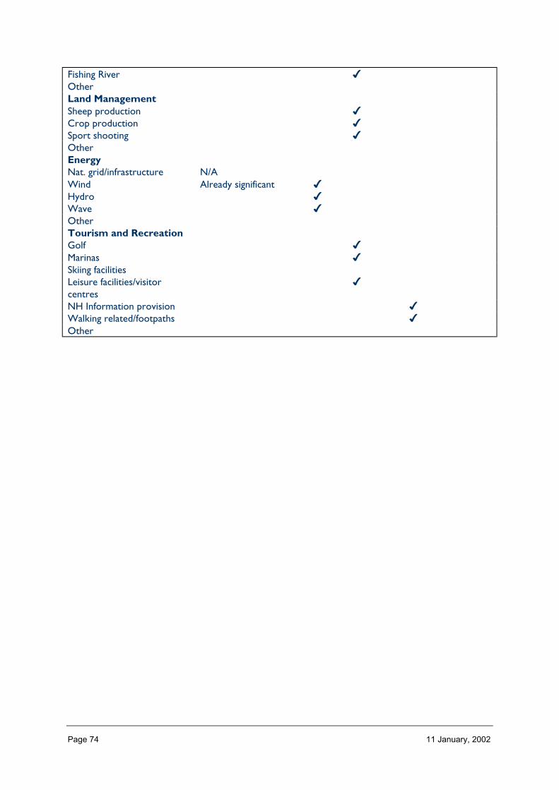
Page 74 11 January, 2002
Fishing River ✔OtherLand ManagementSheep production ✔Crop production ✔Sport shooting ✔OtherEnergyNat. grid/infrastructure N/AWind Already significant ✔Hydro ✔Wave ✔OtherTourism and RecreationGolf ✔Marinas ✔Skiing facilitiesLeisure facilities/visitorcentres
✔
NH Information provision ✔Walking related/footpaths ✔Other
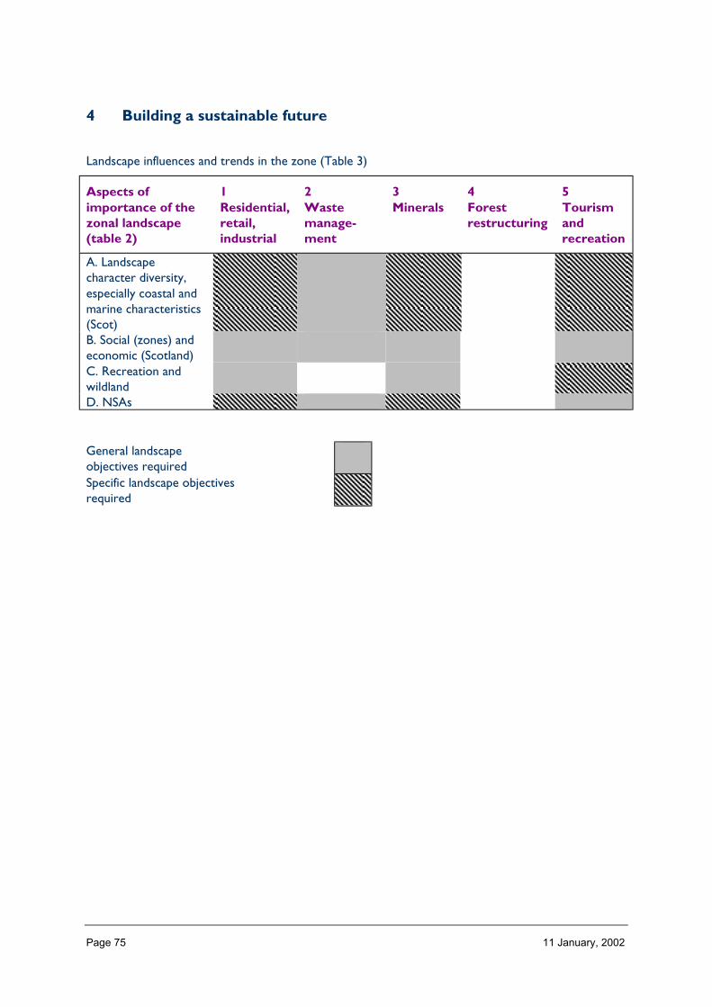
Page 75 11 January, 2002
4 Building a sustainable future
Landscape influences and trends in the zone (Table 3)
Aspects ofimportance of thezonal landscape(table 2)
1Residential,retail,industrial
2Wastemanage-ment
3Minerals
4Forestrestructuring
5Tourismandrecreation
A. Landscapecharacter diversity,especially coastal andmarine characteristics(Scot)B. Social (zones) andeconomic (Scotland)C. Recreation andwildlandD. NSAs
General landscapeobjectives requiredSpecific landscape objectivesrequired

Page 76 11 January, 2002
ZONE 3 WESTERN ISLES
1 Nature of the landscape resource
Diversity, distribution and rarity of landscape character in the zoneNote: Ignore any LCT which is shown as <10 km2 (if important feature will be coveredelsewhere, if important characteristic locally will be flagged up in description)
Table 3.1 Diversity
Zone LCTLevel 1
LCTLevel 3
Context Area(km2)
3 Marginal FarmlandMosaic
Marginal FarmlandMosaic
Island Lowland 102.90
3 Sand-Dunes andMachair
Low, Flat, and/or Island Coast 46.82
3 Crofting One Highland and Island Island Lowland 104.803 Rock and Lochan Knock or Rock and Island Upland 28.123 Mountain Massif (One) High, Massif, Rug Island Highland 728.513 Mountain Massif (Two) High, Massif Rolling Island Highland 25.723 Crofting 2 Highland and Island Island Lowland 75.573 Crofting Three Highland and Island Island Lowland 47.323 Crofting Four Highland and Island Island Lowland 106.693 Uist Farming Uist Farming Farmlands and Est 1.703 Machair Machair Low, Flat, and/or 140.323 Boggy Moorland Peatland Landscape Island Upland 1,127.023 Rocky Moorland Rocky Moorlands
ofIsland Upland 548.26
3 Knock and Lochan Knock or Rock and Island Upland 89.72Total 3,173.47
The number of landscape character types represented in the Zone 3 at level 1, is 14 the way they are grouped at level 3 into 10, and theircontext is island. No. of LCTs (Level 1)/Area of zone in Zone 3 is 0.004.

Page 77 11 January, 2002
Table 3.2 Distribution/pattern
Zone LCTLevel 1
LCTLevel 3
% of Zone(area)
No. ofoccurrences
Area(km2)
3 MarginalFarmland Mosaic
MarginalFarmland Mosaic
3.2 8 102.90
3 Sand-Dunes andMachair
Low, Flat, and/or 1.5 9 46.82
3 Crofting One Highland andIsland
3.3 15 104.80
3 Rock and Lochan Knock or Rockand
0.9 3 28.12
3 Mountain Massif(One)
High, Massif, Rug 23.0 18 728.51
3 Mountain Massif(Two)
High, MassifRolling
0.8 2 25.72
3 Crofting 2 Highland andIsland
2.4 38 75.57
3 Crofting Three Highland andIsland
1.5 52 47.32
3 Crofting Four Highland andIsland
3.4 11 106.69
3 Uist Farming Uist Farming 0.1 1 1.703 Machair Machair 4.4 43 140.323 Boggy Moorland Peatland
Landscape35.5 50 1,127.02
3 Rocky Moorland Rocky Moorlandsof
17.3 95 548.26
3 Knock andLochan
Knock or Rockand
2.8 24 89.72
Total 369 3173.47
The total number of occurrences of landscape character types (landscape units) per area of land within the Zone 3 gives a relativeindication of the overall brokenness or fragmentation of the landscape pattern (total col. 5/total col. 6).369/3173 is 0.116.
LCT at Level 1 Area/Occurrences (km2)
Marginal Farmland Mosaic 12.86Sand-Dunes and Machair 5.20Crofting One 6.98Rock and Lochan 9.37Mountain Massif (One) 40.47Mountain Massif (Two) 12.86Crofting 2 1.98Crofting Three 0.91Crofting Four 9.69Uist Farming 1.7Machair 3.26Boggy Moorland 22.54Rocky Moorland 5.77Knock and Lochan 3.73
The extent (area) of any one landscape character type (at level 1) divided by the number of times it occurs in the zone gives an idea of theaverage size of occurrences of that LCT (col. 6/col. 5).
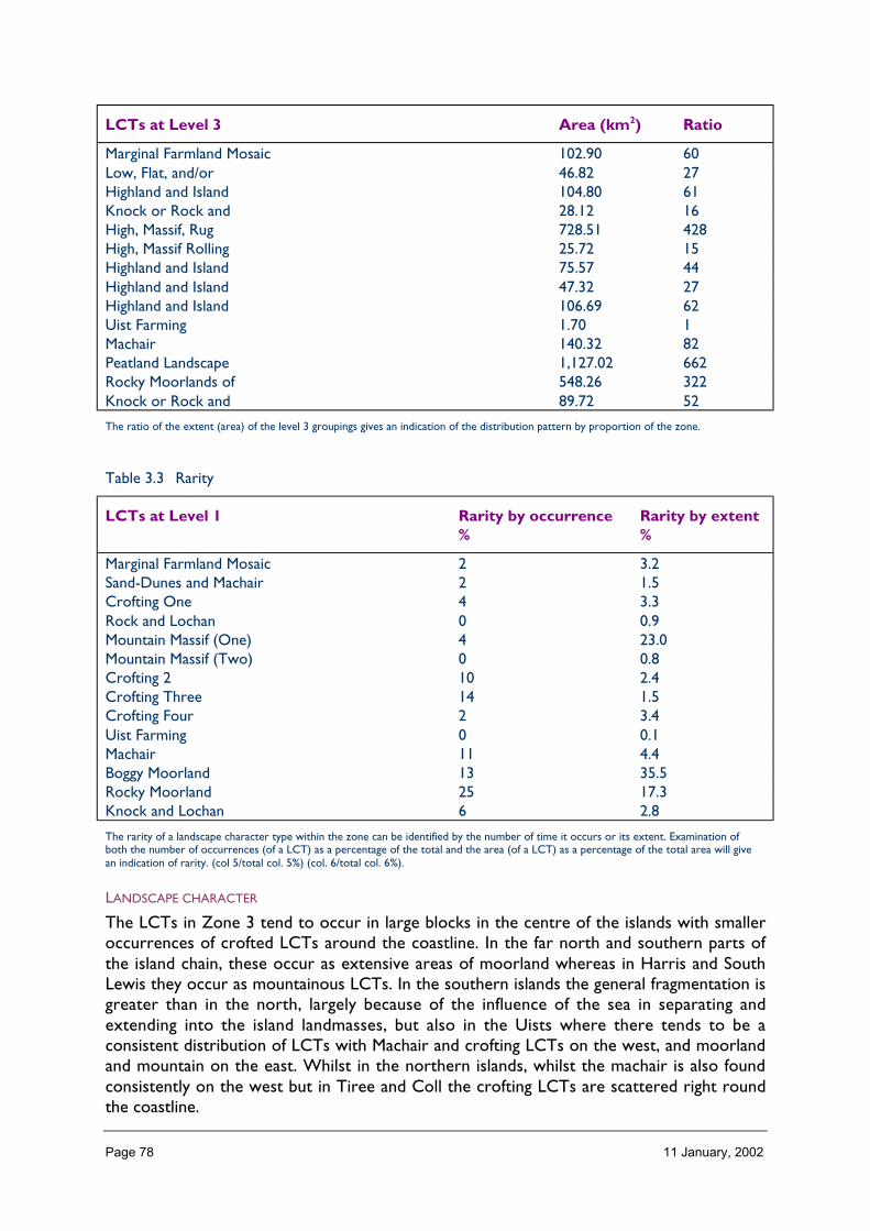
Page 78 11 January, 2002
LCTs at Level 3 Area (km2) Ratio
Marginal Farmland Mosaic 102.90 60Low, Flat, and/or 46.82 27Highland and Island 104.80 61Knock or Rock and 28.12 16High, Massif, Rug 728.51 428High, Massif Rolling 25.72 15Highland and Island 75.57 44Highland and Island 47.32 27Highland and Island 106.69 62Uist Farming 1.70 1Machair 140.32 82Peatland Landscape 1,127.02 662Rocky Moorlands of 548.26 322Knock or Rock and 89.72 52
The ratio of the extent (area) of the level 3 groupings gives an indication of the distribution pattern by proportion of the zone.
Table 3.3 Rarity
LCTs at Level 1 Rarity by occurrence%
Rarity by extent%
Marginal Farmland Mosaic 2 3.2Sand-Dunes and Machair 2 1.5Crofting One 4 3.3Rock and Lochan 0 0.9Mountain Massif (One) 4 23.0Mountain Massif (Two) 0 0.8Crofting 2 10 2.4Crofting Three 14 1.5Crofting Four 2 3.4Uist Farming 0 0.1Machair 11 4.4Boggy Moorland 13 35.5Rocky Moorland 25 17.3Knock and Lochan 6 2.8
The rarity of a landscape character type within the zone can be identified by the number of time it occurs or its extent. Examination ofboth the number of occurrences (of a LCT) as a percentage of the total and the area (of a LCT) as a percentage of the total area will givean indication of rarity. (col 5/total col. 5%) (col. 6/total col. 6%).
LANDSCAPE CHARACTER
The LCTs in Zone 3 tend to occur in large blocks in the centre of the islands with smalleroccurrences of crofted LCTs around the coastline. In the far north and southern parts ofthe island chain, these occur as extensive areas of moorland whereas in Harris and SouthLewis they occur as mountainous LCTs. In the southern islands the general fragmentation isgreater than in the north, largely because of the influence of the sea in separating andextending into the island landmasses, but also in the Uists where there tends to be aconsistent distribution of LCTs with Machair and crofting LCTs on the west, and moorlandand mountain on the east. Whilst in the northern islands, whilst the machair is also foundconsistently on the west but in Tiree and Coll the crofting LCTs are scattered right roundthe coastline.

Page 79 11 January, 2002
Description
Landform
PROFILE
The profiles encountered in the landscapes of Zone 3 are varied; from the high cliffs andvast rolling bogs of North Lewis, through the rocky moorland of South Lewis to themountain peaks and glens of North Harris. South Harris has landforms that vary in profilefrom the soft beaches and machair, of the coast, through high, rolling mountains to the verybroken knock and lochan landscapes of the coast.
The landform profiles of the southern isles range from the smooth, west coast beaches,through flat croft lands and rolling bog to high hills and a rugged coastline. St Kilda and theIslands south of Vatersay have pronounced profiles with cliffs often rising clear out of thesea. In contrast Tiree and Coll have the low rolling profiles and in many seaward viewsappear to Joan one another.
In the zone as a whole, 46% of the area has a slope of < 5° and only 1% of > 32°.
SEQUENCE
Although underlying this landscape is a common geology of Lewisian gneiss and graniticrocks, the landscapes of the islands possess differing but clearly recognisable sequences oflandform, which relate as much to dykes, the thrust planes and glacial influences. Lewis andHarris have a clear north/south sequence of low, rolling landforms, through to the highmountains of Harris. In the Uists and Benbecula, the strongest sequence of landforms is tobe seen in the west/east section: beach, rolling machair, flat croftlands, bog and moorland,rocky hills and steep, rugged coastline. Barra has a similar cross-section to the Uists, butrises more rapidly to the high hills.
No particular aspect dominates this landscape, though those of north-east and south-westoccur slightly more frequently, reflecting the orientation of the whole island chain.
Tiree and Coll are fairly uniform in section, though with a pronounced South-West/North-East grain.
SCALE
Although the mountains of Zone 3 are considerably less height than many of those on themainland (1% > 400m), the visible and vertical rise from sea level to summit lends these hillshave the stature of mountains, emphasised by the deep glens and sea lochs which cut intothem and the bare rock and exposed nature of their slopes and summits. The sheer cliffs ofthe east and north coasts and offshore islands also lend a sense of vertical scale to thislandscape. Between cliff and mountain are often vast expanses of moorland or bog and lochs(73% < 100m elevation) where the sense of horizontal scale is all-encompassing. Elsewherethe Machair lands and open views of the sea provide a similar experience of horizontalemphasis in the landscape.
LANDMARK FEATURES
Cliffs and prominent headlands – Butt of Lewis, Tiumpan Head, Kebock Head, Toe Head,Barra Head, Mingulay and St Kilda

Page 80 11 January, 2002
Individual peaks – The Clisham, Eaval, Hecla, Heaval
Deep glens – Glen Valtos, Glen Mhiabhaig
Fjordic lochs – Loch Seaforth, Loch Erisort, Loch Resort, Loch Skipport
Islands – many, particularly those seen in dramatic profile, from the shore, with sea all round
EXPERIENCE
The experience of landform as one moves through the landscape of Zone 3 is dominated bythe unusual and often unexpected. Expansive boggy moorlands, high sea cliffs, rockymountains with distinct peaks, deep fjordic lochs which extend a long way inland, ‘pock-marked’ knock and lochan. Narrow isthmuses, tidal races, ‘mazes’ of small islands andskerries and long, long Atlantic beaches backed by dunes and machair. Whilst theselandform features do exist elsewhere, it is rare and probably unique to find combinationslike this which can be so readily experienced by travelling through the island chain on thepublic road and ferry network.
Containment (created by landform and land cover)
TOPOGRAPHY
Containment offered by topography within the landscape of Zone 3 is very varied. It rangesfrom negligible in the open landscapes of North Lewis, the Uists and Tiree where moorland,cliff tops, croftlands, machair and beaches are all pretty exposed with only localised dips inthe landform along burns or in bays offering any sense of containment. Amongst the highhills, the deeply cut-through glens and high corries offer partial containment, often withinsheer rock walls. Often a high level of containment is also provided along rocky coastlineswhere small inlets and fjordic lochs are surrounded by steeply rising landforms with onlynarrow openings to the sea. The knock and lochan landscapes of Lewis and Harris providesthe alternating contrast of containment at a human scale and open exposure, as do theslacks and hollows of the coastal machair lands of the Uists and Tiree.
LAND COVER
Vegetation cover across the zone is limited in stature by the generally high degree ofexposure, the poor nutrition of the underlying soils, and the high rainfall. As a consequence,the containment within this landscape offered by vegetation is limited. Where it does occur,it tends to be within sheltered parts of the landform, or around substantial houses, wherepersistence has paid off with the establishment of limited shelter woodland. The woodlandsof Lewis Castle are notable in this context for their unusual extent and contribution tocontainment.
Built development within this zone is characteristically scattered, with only Stornoway andBallivanich being of sufficient size to provide a contained townscape. Elsewhere however,some settlements combine with rising landform to provide a sense of a contained landscape,e.g. Tarbert, Castlebay.
VISIBILITY
Visibility is generally wide and extensive in the north and south of the zone where there islittle landform variation to interrupt views. The lie of the land is such that often mid ground

Page 81 11 January, 2002
views of the low-lying ground of lochs, bog or crofted lands are lost with combination offoreground and distant hills being characteristic.
On the hills of Harris, South Uist, Barra and Coll visibility is either very extensive (weatherconditions dependent) with wide views to be had up and down the islands, out to St Kildato the west, and across the Minch to the inner isles and mainland. Amongst the hills andglens, framed, narrow, but extensive views to seaward and wider views of the summits,glens and corries are characteristic.
Coastal visibility is generally wide and extensive, apart from where local landform restrictsthe width of views, e.g. along the deep sea lochs, or where the coastline is particularlybroken.
MICROCLIMATIC EFFECTS
Contained, microclimatic pockets are few and far between in this landscape, existing onlywhere the landform provides a high degree of year-round shelter, e.g. in deep burn gorges,in east-facing hollows and in low-lying nooks and crannies by the sea (generally east coast).Here vegetation is likely to be more luxuriant, with scrub trees, aspens and rowan often afeature along with evidence of previous habitation or land use.
EXPERIENCE
Generally the experience of this landscape is as an open and exposed one with landformproviding partial containment (e.g. in glens and corries) which often being more visual thanproviding shelter. Where the landform provides more complete containment (e.g. in knockand lochan or broken coastal landscapes) the sense of enclosure, shelter and small scaledetail is very dominant in the landscape experience and more so, for the contrast with thegeneral openness experienced elsewhere.
Accessibility
DISTANCE
The western isles are located at a considerable distance from the major population centresof the Central Belt and Inverness. Whilst it takes approximately 45 minutes to fly fromInverness to Stornoway or Glasgow to Barra or Tiree, it takes a minimum of 4 hours fromInverness to Stornoway and 8 hours from Glasgow to Barra or Tiree/Coll by the morewidely used ferry services operating from Ullapool and Oban respectively. Anywherebeyond the ferry terminals of Stornoway, Castlebay, Scarinish, Arinagour, Lochboisdale,Lochmaddy and Tarbert require a substantially longer journey.
Zone 3 is without doubt remote and requires a concerted effort to get there from theplaces in Scotland where the majority of people live. This is especially so at times of roughseas and high winds when ferries are prone to cancellation or postponement.
PHYSICAL ACCESS
Within the landscape of Lewis and Harris, the Uists and Benbecula, and Barra and Vatersay,the road network provides a north-south spinal route of dual and single track highway,offshoots from this (usually single track) provide links to outlying communities to east andwest. In Tiree and Coll single track circular roads provide access throughout the Islands.
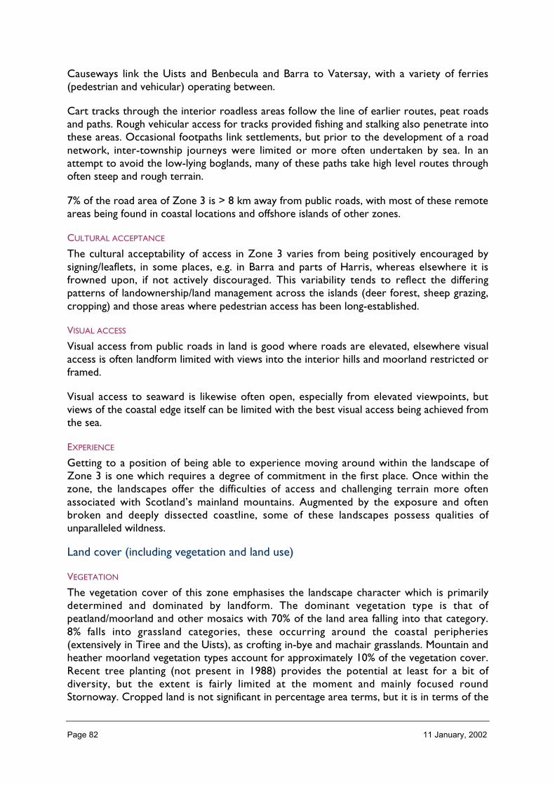
Page 82 11 January, 2002
Causeways link the Uists and Benbecula and Barra to Vatersay, with a variety of ferries(pedestrian and vehicular) operating between.
Cart tracks through the interior roadless areas follow the line of earlier routes, peat roadsand paths. Rough vehicular access for tracks provided fishing and stalking also penetrate intothese areas. Occasional footpaths link settlements, but prior to the development of a roadnetwork, inter-township journeys were limited or more often undertaken by sea. In anattempt to avoid the low-lying boglands, many of these paths take high level routes throughoften steep and rough terrain.
7% of the road area of Zone 3 is > 8 km away from public roads, with most of these remoteareas being found in coastal locations and offshore islands of other zones.
CULTURAL ACCEPTANCE
The cultural acceptability of access in Zone 3 varies from being positively encouraged bysigning/leaflets, in some places, e.g. in Barra and parts of Harris, whereas elsewhere it isfrowned upon, if not actively discouraged. This variability tends to reflect the differingpatterns of landownership/land management across the islands (deer forest, sheep grazing,cropping) and those areas where pedestrian access has been long-established.
VISUAL ACCESS
Visual access from public roads in land is good where roads are elevated, elsewhere visualaccess is often landform limited with views into the interior hills and moorland restricted orframed.
Visual access to seaward is likewise often open, especially from elevated viewpoints, butviews of the coastal edge itself can be limited with the best visual access being achieved fromthe sea.
EXPERIENCE
Getting to a position of being able to experience moving around within the landscape ofZone 3 is one which requires a degree of commitment in the first place. Once within thezone, the landscapes offer the difficulties of access and challenging terrain more oftenassociated with Scotland’s mainland mountains. Augmented by the exposure and oftenbroken and deeply dissected coastline, some of these landscapes possess qualities ofunparalleled wildness.
Land cover (including vegetation and land use)
VEGETATION
The vegetation cover of this zone emphasises the landscape character which is primarilydetermined and dominated by landform. The dominant vegetation type is that ofpeatland/moorland and other mosaics with 70% of the land area falling into that category.8% falls into grassland categories, these occurring around the coastal peripheries(extensively in Tiree and the Uists), as crofting in-bye and machair grasslands. Mountain andheather moorland vegetation types account for approximately 10% of the vegetation cover.Recent tree planting (not present in 1988) provides the potential at least for a bit ofdiversity, but the extent is fairly limited at the moment and mainly focused roundStornoway. Cropped land is not significant in percentage area terms, but it is in terms of the

Page 83 11 January, 2002
landscape effect. It gives a marked colour contrast in the landscape and highlights the areasof fenced in-bye ground, especially in the Uists and Tiree, where it is more common.
EXPOSED ROCK
Exposed rock, although calculated at only 1% of the landcover total, is very significant ininfluencing landscape character. A dominant feature is the rugged coastline of these islands,with exposed rock occurring as high and low cliffs, wave cut platforms, offshore skerries andboulder beaches. Inland, rock faces are a key characteristic of the ridges, buttresses andcorries of the mountainous LCTs, and exposed boulders are a feature of the footslopes.Emerging bedrock is one of the key characteristics of the rock and lochan landscape ofSouth Harris (possibly a unique LCT), and cleared stone is a feature of much of the in-byeground.
BUILT DEVELOPMENT
Built development, whilst an important component of some of the landscapes of Zone 3does not contribute to landcover other than in Stornoway and Ballivanich, the only twosettlements of any size. Elsewhere, settlement generally occurs as small villages andtownships, some of which have a clustered pattern of houses and others which are moredispersed. In both cases, built development creates focal points in the landscape rather thanhaving a dominating effect.
EXPERIENCE
The pattern of landcover in the landscape of Zone 3 adds to the experience of it as anelemental and exposed landscape, with vast expanses of similarly coloured and texturedvegetation interspersed with green patches of in-bye and machair, which, in early and latesummer, are often dramatically highlighted by a rich and diverse display of flowers.
Hydrology and water bodies
TYPE
There are 1339 freshwater lochs identified (lochstats) for Zone 3 (30% of the total for thewhole of Scotland) and 1,900 km of rivers. The lochs vary in size from the substantial LochLangavat in South Lewis to the small lochans of east coast Harris. Dubh Lochans, and vastnetworks of shallow inter-connecting lochs are typical of the moorland and bogs of Lewisand North Uist. Deep glacial lochs, corrie lochans, and series of hanging lochs are typical ofthe higher mountains and hills of Harris and South Uist.
Rivers on the whole are small, being short in length with small catchments. Their oftensteep descent makes small and large waterfalls a feature of some of these landscapes.
PATTERN
6% of landcover (LCS 88) is freshwater, though the occurrence of lochs and rivers on the1:50,000 map and experience on the ground, suggests that in reality it is far greater. Thepattern, and frequency of lochs, lochans, rivers and burns changes from north to south, andwith the nature of the landform. In the boggy moorland LCTs, lochs, lochans, and pools aresimilarly sized and fairly evenly spread across the area, though the pattern is often difficult toappreciate in the landscape because of the low-lying nature of the landform.

Page 84 11 January, 2002
In the rocky moorland and mountains of South Lewis and Harris, there are many large orinter-connecting water bodies, but also a vast range of smaller lochans and pools inapparently haphazard arrangements. Short stretches of river interlink these water bodiesand connect them to the coast with rivers radiating out in all directions to the coast.
Areas of knock and lochan/rock and lochan landscape are characterised by a pattern of smalllochans set down between low knolls of bedrock and glacial debris, producing a rhythmicand predictable pattern in the landscape. In the southern isles of Barra, Vatersay, Tiree andColl, lochs are less common in general. Those which there are tend to be shallow Lochslocated just behind the machair.
The presence of the sea, often quite far inland, adds a further dimension to the patterns ofwater in this landscape.
EXPERIENCE
The presence of water, both fresh and sea, as lochs, lochans, pools, sea lochs and to a lesserextent rivers, dominates the experience of this landscape, emphasising the dips and hollowsin the landform and creating the impression, especially from higher elevations in theWestern Isles, of a landscape which is at times half land and half water and where the sea isdifficult to separate from the water bodies of the interior.
Built and infrastructure development (present day)
NATURE AND PATTERN OF SETTLEMENT
Settlement, which is sparse across the zone, as a whole is a key characteristic of all thecrofting landscape character types with individual light coloured dwellings being particularlyprominent focal points in the landscape. (LCTS 25,26,28,29 Tiree and Coll, Level 1). Thepattern of settlement in these areas varies mainly in a response to landform but also tolandholdings, resulting in both linear and dispersed arrangements. In the north townships arelarger and sometimes housing is quite dense (e.g. Ness, Garabost, Pabal, Harach andBalallen) especially within commuting distance of Stornoway. Elsewhere smaller groups andindividual croft houses tend to be tucked into landscape and emphasised by surroundingpatches of in bye land. Only the towns of Stornoway and to a lesser extent, Balivanich, reallycreate a townscape, for themselves. With a population of (x) Stornoway is the majorbusiness and service centre for the islands and dominates the landscape over an area whichincludes Newmarket and extends eastward to the airport.
Elsewhere village settlements (Tarbert, Leverburgh, Lochmaddy, Loch Boisdale, Castlebay,Scarinish and Arinagour) are small and their character is as much to do with their landscapesetting and function (as ferry termini and ports) as with the built settlement, though thereare some individual buildings which are features in their own right.
NATURE AND PATTERN OF INFRASTRUCTURE
Roads and ferry termini are a key characteristic of this landscape, facilitating the movementof people and goods throughout the islands as well as to and from the mainland. Recentimprovements, especially on main North/South routes and causeways are dominantlandscape features whereas elsewhere narrow single track roads twist and turn betweenlandforms and round coastal inlets. Air strips, and the more visible air services, are a featureof the landscape of the islands. Power lines (wooden pole) are a ubiquitous feature of theinhabited landscapes and interlinking moorland areas in the zone. The prominence of these

Page 85 11 January, 2002
upstanding elements and the frequency required to service the dispersed croft houses,means that they are a dominant characteristic of the more open crofted landscapes ofNorth Lewis, the Uists and Tiree. Navigational and military masts and other installations(Telecommunications and water storage/treatment) are common features, often prominentin these open landscapes because of the requirement for ‘clear sight’ lines or head. This isparticularly the case on St Kilda and Uist where there is a significant military presence.
NATURE AND PATTERN OF INDUSTRIAL DEVELOPMENT
Industrial development is essentially only prominent in the landscape in and around thesettlements of Stornoway and Balivanich where warehouse type developments with openstorage and lots of large vehicles can appear incongruous in the open and largely naturalsetting of the wider landscape. Elsewhere aquaculture developments are probably the mostcommon form of industry to be seen in the landscape. Rafts, cages, longlines and on-shorefacilities (with access tracks, storage etc.) are a feature of much of the coastline even inparts remote from road access. (e.g. Park) though most often in broken areas of rockycoastline. Freshwater installations are also prominent in some road-side lochs.
Individual developments such as the yard at Arnish (oil related) and the fish processingfactory at Ardveenish (Barra) are infrequent but extremely prominent features in thelandscape owing primarily to the contrast of scale and form in coastal landscapes dominatedby their small scale and rugged nature.
EXPERIENCE
Low key and infrastructure development is characteristic of some of the landscapes of thezone but particularly those where access is easiest. However whilst often in the foregroundas one travels round the islands, the wider landscape context for this settlement andinfrastructure is as important in the landscape experience as the built forms themselves. It isthis contrast between the open, exposed and rugged landscapes and the visible tenacity ofits people which is such a striking characteristic of the landscape experience of Zone 3.
Visible history (past settlement, landuse, churches, brochs, forts, dykes, standingstones etc.)
TYPES OF VISIBLE HISTORY
Prehistory: Souterrains, chambered cairns, standing stones, brochs and duns, field systems.Village ruins (especially St Kilda) croft ruins, shieling sites, ‘feanagan’ (ridge and furrowcultivation), Castle (Lewis), occasional large estate house industrial archaeology (whalingstation, old piers).
LOCATION/PATTERN
Most widespread, but least visible in landscape terms is the prehistoric evidence of humanoccupation, tending to be on drier hillsides and ‘hidden’ from the untrained eye beneathvegetation. Brochs and Duns however tend to be in coastal situations for defensive reasonsand are more obvious especially where they are still upstanding on rocky promontories/hills.Ridge and furrow cultivations and former shieling sites are in places prominent owing todifferential drainage and vegetation patterns. On hillsides and offshore islands, extensiveareas of ridge and furrow are often visible particularly when picked out by shadows inconditions of bright low light. Dykes are a feature of some townships but also elsewhere canbe seen as head dykes or stock enclosures. More recent croft ruins (this century) are a

Page 86 11 January, 2002
poignant reminder of the remoteness, isolation and harshness of life in the islands where theultimate solution was abandonment of home and land (especially visible in east coat Harris).
EXPERIENCE
The visible history of the zone lends a time depth to this landscape which given theperipheral nature of the zone and its inclement climate adds an element of amazement tothe experience of this landscape, amazement that there were people living here so long agoin such a harsh environment. This is a particularly poignant element of the St Kildaexperience.
Wildlife
FORMS OF WILDLIFE
Wildlife which is characteristic within the landscape of this zone includes: seabirds(guillemots, puffins, razorbills, kittiwakes), waders, golden eagle and sea eagle, geese,corncrakes, divers, otters, cetaceans, seals and red deer.
Aquatic plants, especially water lilies, are characteristic of small lochans in bog and moorlandand areas and a rich flora is characteristic of the machair lands.
LOCATION
The cliffs of the main and offshore islands are the focus for seabird colonies especially inislands and stacks of St Kilda, Monachs, Shiants and uninhabited islands south of Barra. Thebroken and small scale coastal landscapes around the islands are where one is most likely toexperience otter, with seals being most frequent close to their regular ‘haul out’ sites,usually rocky skerries around the shores. Cetaceans (dolphins, porpoises) are mostcommonly seen in the channels between islands. e.g. South Uist, Eriskay and Barra. Thesound rather than sight of corncrakes is a feature of the cropped and grassland in byelandscapes particularly of the Uists, Barra and Tiree and Coll. Geese, divers, waders andswans are part of the landscape experience of both inland loch and moorland in summer andthe shoreline, in winter when migration and available feeding sites bring large numbers.
WHEN
See above.
EXPERIENCE
Wildlife (particularly birds and mammals) is a feature of the coastal landscapes of Zone 3with potential for experiencing otters, divers, a range of bird life and seals, even in manywell-frequented locations, whereas the wild land experience of the high tops and remotecoastal landscapes is often made more ‘alive’ by the presence of eagles, otters, divers andseabirds.
Climate
CLIMATIC CHARACTERISTICS
Sitting as it does on the Atlantic Seaboard, Zone 3 experiences some pretty extremeweather conditions. Frequent high winds are common place in all but the summer months,as is rain (though the average rainfall is lower than in parts of mainland Scotland).

Page 87 11 January, 2002
− Snow, other than on the higher hills of Harris and the Uists is rare. Sunshine hoursare high compared to much of Scotland (average 1300 with Tiree at 1400) andtemperatures are moderate being influenced by the Gulf Stream.
LOCATIONAL AND SEASONAL EFFECTS
Gale force winds are most frequent from October to March, but quite likely to occuroutwith this period as well. Rainfall follows a similar pattern.
EXPERIENCE
The experience of the landscape of this zone is profoundly influenced by its climaticcharacteristics. Whilst visibility tends to be reasonably good (when compared for exampleto Zone 2) it is the exposure, wind strength and wind chill, which for so much of the yearinfluences the way people move round in, work in, and experience this landscape andseascape. Calm, clear, sunny days when they occur, in either winter or summer, are like‘gems’ to be treasured and remembered.
Designated landscapes
National Scenic AreasThere are 3 NSAs in Zone 3 and South Uist Machair (21). Lewis, Harris and North UistNSA (9 LCTs> 1 km2 ).
CONSTITUENTS
St Kilda (20), Lewis, Harris and North Uist (19)
Greatest areas of LCTs are mountainous followed by moorland (rocky and boggy), mostcommon occurrences are crofting types and moorland types. Key aspect of this NSA is itsdiversity.
South Uist Machair NSA (4 LCTs >1 km2). The greatest area of LCTs are crofting andmachair, with one occurrence of crofting and two of machair, these LCTs form a continuousswathe down the West Coast of South Uist.
St Kilda designated for its cliff landscapes of very high and spectacular cliffs, stacs and seacaves. (LCA does not cover).
LOCATION AND EXTENT
Lewis, Harris and North Uist – very large at 1070 km2. South Uist Machair – 58 km2, StKilda – 9 km2.
EXPERIENCE
The NSAs within this zone ‘capture’ examples of some of the key landscape experiences ofthis zone; the great diversity and ruggedness of the northern part of the zone with itscroftlands ‘clinging’ round the rocky coast and beaches; the vast open landscapes of themachair/croft lands, where the presence of the sea is so much a part of the dynamics of theland; the dramatic cliff landscapes of Britain’s most westerly and most often seen in profile invery distant views from other islands.

Page 88 11 January, 2002
Recreational landscapes
Nature of location landscapes and activitiesThe remote, dramatic and wild landscapes and seascapes of Zone 3, present a greatrecreational resource to those willing to tolerate the often extreme weather, or simply toview it from a travelling vehicle (car, bus, ferry). Hill walking (coastal walking), loch fishing,surfing, sailing, cycling, diving, canoeing, climbing, camping and stalking are all practised atvarying degrees of intensity along with wildlife watching. The former of these activities focuson the hills of Harns, the lochs of the peatlands and moorland landscapes, the open coastsof Tiree and waters around the islands generally. Canoeing and diving focus on the moresheltered and broken east coasts of the Uists, Barra, Coll and South and West Lewis.
The study type forms of recreation are by their very nature more site-focused and are oftenlinked to facilities such as visitor/interpretation centres, e.g. Callanish, the Coll Reserve,NNRS, Local History Museums or the availability of boat hire.
LOCATION
See above.
EXPERIENCE
The landscape of this zone provides for a range of unique experiences; wildlife, history,isolation and challenge in the landscape to a degree and in combinations which it is difficultto find elsewhere in Scotland. The low numbers of people increases the experience ofprivilege and specialness to be had in the landscape of this zone.
2 Importance and value of the zone landscape
A judgement of the importance or value of the zonal landscape under the followingheadings:
Category Brief explanation oflandscape importance(if any)
Importance(GB, Scotland,zone)
Landscape Character Importancerarity zones contains most of
machair LCT in Scotlandand rare occurrences ofother LCTs (rock andlochan)
Great BritainScotland
extentdiversity (including specific landmarks)patternintegrity very strong relationships
between land forms, landcover/land use consistentacross zone
Scotland
local distinctivenessfragility/sensitivity LCTs closely linked to
ecological, geological andstatus
Zonal

Page 89 11 January, 2002
Scenic importancequalities Mountains, lochs,
moorlands, rugged coasts,beaches and croftedlandscapes
Scotland
perceptions Zone 3 landscapesperceived aspristine/unspoilt
Learning ImportanceEnvironmental EducationInterpretation Good visual links between
people and landscapesZonal
Enjoyment ImportanceRecreation Good for wildlife based
recreation and limitedrange of recreationalactivities
Scotland
Amenitywildness and tranquillity Remote from mainland,
exceptional wildlandqualities
Scotland
CategoryBrief explanation oflandscape importance(if any)
Importance(GB, Scotland, zone)
DesignationsNSAs 3 9
AGLVs ?Regional Landscape DesignationsHistoric Gardens & Designed Landscapes 1 ZonalCultural Importancepre history (designated/non-designated) ?medieval (designated/non-designated) ?recent (designated/non-designated) ?Socioeconomic Importancesocial Cultural links to landscape Zonaleconomic Tourism/recreation Zonal
3 Landscape and trends in the zone
Pressures/influences which have a particular effect on the landscape of the zone:
• Nature of landscape pressures/influences – a brief description• Trends: increasing, static or declining
− long term (> 5 years), medium term (2 to 5 years), short term (< 2 years)• Importance: important, not important

Page 90 11 January, 2002
Pressure Nature of landscapepressures/influencesand trends withinzone, relativeimportance within thezone
Scale of landscape influence(+ve/–ve) within zone whenconsidered in an all Scotlandcontext
Major Inter. Minor NegligibleBuilt developmentResidential Single housing, long term,
static�
RetailIndustrialOtherInfrastructure TransportRoads and tracks Ongoing programme of
road improvementsincluding causewaysmedium term
�
Rail relatedFerry related Ferry infrastructure
ongoing medium to longterm
�
OtherInfrastructure otherTelecoms Increasing provision of
masts close to road, longterm, important.
�
Water treatment/abstraction Local impacts prominentsites meeting ECLegislation
�
Waste management Sites few but increasing insize, long term
�
Coastal defencesOther
MineralsOpen cast coalSand and Gravel Localised, local impact on
dunes and machairlandscapes
�
Hard rock Extraction in prominentlocations often close topublic roads – increasinglong term, important
�
Peat Increased mechanisedcutting for domestic use– long term
�
OtherForestry and WoodlandsRestructuring of existingCreation of new small

Page 91 11 January, 2002
Creation of large new/native Landscape changed,fencing, scale, shape etc,increasing long term,important especially inNorth Harris
�
OtherAquaculture and FishingFinfish Landscape impacts from
inappropriate siting ofcages/lines and shorefacilities increasing, staticlong term
�
ShellfishFishing RiverOtherLand ManagementSheep production Crofting enhancement,
maintenance of smallscale landscape mosaic.ESA/CPS driver, longterm
�
Crop productionSport shooting �OtherEnergyNat. grid/infrastructureWind Potential landscape
impacts
EnergyHydroWave Potential landscape
impactsOtherTourism and RecreationGolfMarinasSkiing facilitiesLeisure facilities/visitorcentresNH Information provision Increasing provision, long
term and generallypositive
�
Walking related/footpaths Increasing provision, longterm and generallypositive
�

Page 92 11 January, 2002
4 Building a sustainable future
Pressures and trends
Theimportanceof thezonallandscape
1Transportinfra-structure
2Telecoms
3Minerals(sandandgravel,hardrock)
4Woodlands(new)
5Aqua-culture(fin andshell)
6Landmanagement,crofting
A. Rarity andintegrity oflandscapecharacterB. Servicequalities (andperception)C.Recreationand wildnessD. NSA’S
General landscape objectives requiredSpecific landscape objectives required

Page 93 11 January, 2002
ZONE 4 NORTH WEST SEABOARD
1 Nature of the landscape resource
Diversity, distribution and rarity of landscape character in the zoneNote: Ignore any LCT which is shown as <10 km sq (if important feature will be coveredelsewhere, if important characteristic locally will be flagged up in description)
Table 4.1 Diversity
Zone LCTLevel 1
LCTLevel 3
Context Areakm2
4 Sweeping Moorland Flat or Rolling, Smo Highland 61.904 Strath Highland Straths Highland 14.574 Harbour Highland and Island Highland Coast 0.854 Small Farms and Crofts Highland and Island Highland 23.504 Coniferous Woodland
No informationprovided in report.
Null 10.37
4 Broadleaved/Mixed Woodland Noinformation provided inreport.
NULL 0 6.70
4 Flat Peatland Peatland Landscape Highland 3.944 Moorland Slopes and
HillsHMRRMts Highland 364.87
4 Cnocan Highland Cnocan Highland 522.874 Lone Mountains HMRSSMts Highland 84.264 Irregular Massif HMRSSMts Highland 328.234 High Cliffs and
Sheltered BaysHighland and Island Highland Coast 12.34
4 Long Beaches Dunesand Links
Low Flat and/or Highland Coast 5.45
4 Kyles Firths and SeaLochs
Sea Lochs of theHighlands
Highland Coast 45.44
4 Smooth Moorland Flat or Rolling, Smo Highland 132.754 Linear Loch Highland and Island Highland 30.704 Fjord Sea Lochs of the
HighlandsHighland Coast 69.40
4 Enclosed Bay andOffshore Islands
Highland and Island Highland Coast 475.63
4 Forest Edge Farming AgriculturalLowland
Highland 3.53
4 Linear Crofting Highland and Island Highland 17.114 Scattered Crofting Highland and Island Highland 15.394 Harbour Settlement Highland and Island Highland Coast 12.624 Undulating Moorland Flat or Rolling, Smo Highland 172.834 Sloping Terrace
MoorlandFlat or Rolling, Smo Highland 216.36
4 Rocky Moorland Rocky Moorlandsof
Highland 547.97

Page 94 11 January, 2002
4 Cnocan Highland Cnocan Highland 123.654 Rugged Mountain Massif HMRSSMts Highland 836.994 Rounded Hills HMRRMts Highland 2.204 Narrow Farmed Strath Highland Straths Highland 17.294 Wide Farmed Strath Highland Straths Highland 25.00
Total 4184.71
HMRRMts = High, Massive, Rolling, Rounded Mts of Highlands & Islands
HMRSSMTS = High, Massive, Rugged, Steep-sided Mts of Highlands & Islands
RCUHM = Rugged, Craggy, Upland hills and Moorland of Highlands & Islands
The number of landscape character types represented in Zone 4 at level 1, is 30 the way they are grouped at level 3 is into 13 and theircontext is strongly Highland. No. of LCTs (Level 1)/Area of Zone in Zone 4 is 0.007, this gives an indication of the overall diversity oflandscape character in the zone and can be compared between zones.
The number of landscape character types (level 1) represented per area of land in the zone gives a measure of diversity which can becompared between zones. (Total col. 2/total col. 5).
Table 4.2 Distribution/pattern
Zone LCTLevel 1
LCTLevel 3
% of Zone(area)
No. ofOccurrences
Areakm2
4 SweepingMoorland
Flat or Rolling,Smo
1.5 19 61.90
4 Strath Highland Straths 0.3 2 14.574 Harbour Highland and
Island0.0 2 0.85
4 Small Farms andCrofts
Highland andIsland
0.6 43 23.50
4 ConiferousWoodland Noinformationprovided in report.
0.2 15 10.37
4 Broadleaved/MixedWoodland Noinformationprovided in report.
NULL 0.2 41 6.70
4 Flat Peatland PeatlandLandscape
0.1 1 3.94
4 Moorland Slopesand Hills
HMRRMts 8.7 19 364.87
4 Cnocan Highland Cnocan 12.4 12 522.874 Lone Mountains HMRSSMts 2.0 8 84.264 Irregular Massif HMRSSMts 7.8 4 328.234 High Cliffs and
Sheltered BaysHighland andIsland
0.3 7 12.34
4 Long BeachesDunes and Links
Low Flat and/or 0.1 6 5.45
4 Kyles Firths andSea Lochs
SLH 1.1 9 45.44
4 Smooth Moorland Flat or Rolling,Smo
3.2 5 132.75
4 Linear Loch Highland andIsland
0.7 1 30.70

Page 95 11 January, 2002
4 Fjord Sea Lochs of theHighlands
1.6 5 69.40
4 Enclosed Bay andOffshore Islands
Highland andIsland
11.3 4 475.63
4 Forest EdgeFarming
AgriculturalLowland
0.1 1 3.53
4 Linear Crofting Highland andIsland
0.4 14 17.11
4 Scattered Crofting Highland andIsland
0.4 14 15.39
4 HarbourSettlement
Highland andIsland
0.3 15 12.62
4 UndulatingMoorland
Flat or Rolling,Smo
4.1 12 172.83
4 Sloping TerraceMoorland
Flat or Rolling,Smo
5.1 10 216.36
4 Rocky Moorland Rocky Moorlandsof
13.0 15 547.97
4 Cnocan Highland Cnocan 2.9 6 123.654 Rugged Mountain
MassifHMRSSMts 19.9 12 836.99
4 Rounded Hills HMRRMts 0.1 7 2.20
4 Narrow FarmedStrath
Highland Straths 0.4 2 17.29
4 Wide FarmedStrath
Highland Straths 0.6 6 25.00
Total 317 4184.71
In Zone 4 a total 317 occurrences of landscape character types (landscape units) are found within a zone of total land area 4184 km sq.The figure 317/4184 is 0.075 per km sq of land within the zone and gives a relative indication of the overall brokenness or fragmentationof the landscape pattern.
LCT at Level 1 Area/Occurrences (km2)
Sweeping Moorland 3.25Strath 7.28Harbour 0.42Small Farms and Crofts 0.54Coniferous Woodland No information provided in report. 0.69Broadleaved/Mixed Woodland No information provided inreport.
0.16
Flat Peatland 3.94Moorland Slopes and Hills 19.20Cnocan 43.57Lone Mountains 10.53Irregular Massif 82.05High Cliffs and Sheltered Bays 1.76Long Beaches Dunes and Links 0.90Kyles Firths and Sea Lochs 5.04Smooth Moorland 26.55Linear Loch 30.70

Page 96 11 January, 2002
Fjord 13.88Enclosed Bay and Offshore Islands 118.90Forest Edge Farming 3.53Linear Crofting 1.22Scattered Crofting 1.09Harbour Settlement 0.84Undulating Moorland 14.40Sloping Terrace Moorland 21.63Rocky Moorland 36.53Cnocan 20.60Rugged Mountain Massif 69.74Rounded Hills 0.31Narrow Farmed Strath 8.65Wide Farmed Strath 4.16
The extent (area) of any one landscape character type (at level 1) divided by the number of times it occurs in the zone gives an idea of theaverage size of occurrences of that LCT (col. 6/col. 5).
LCTs at Level 3 Area km2 Ratio
Flat or Rolling, Smo 61.90 72Highland Straths 14.57 17Highland and Island 0.85 1Highland and Island 23.50 27NULL 10.37 12NULL 6.70 7Peatland Landscape 3.94 4HMRRMts 364.87 429Highland Cnocan 522.87 615HMRSSMts 84.26 99HMRSSMts 328.23 386Highland and Island 12.34 14Low Flat and/or 5.45 6Sea Lochs of the Highlands 45.44 53Flat or Rolling, Smo 132.75 156Highland and Island 30.70 36Sea Lochs of the Highlands 69.40 81Highland and Island 475.63 559Agricultural Lowland 3.53 4Highland and Island 17.11 20Highland and Island 15.39 18Highland and Island 12.62 14Flat or Rolling, Smo 172.83 203Flat or Rolling, Smo 216.36 254Rocky Moorlands of 547.97 644Highland Cnocan 123.65 145HMRSSMts 836.99 984HMRRMts 2.20 2Highland Straths 17.29 20Highland Straths 25.00 29
The ratio of the extent (area) of the level 3 groupings gives an indication of the distribution pattern by proportion of the zone.
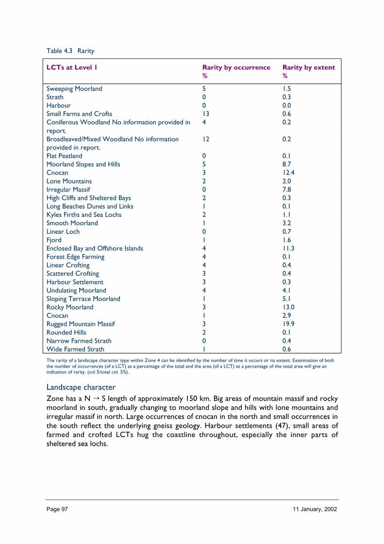
Page 97 11 January, 2002
Table 4.3 Rarity
LCTs at Level 1 Rarity by occurrence%
Rarity by extent%
Sweeping Moorland 5 1.5Strath 0 0.3Harbour 0 0.0Small Farms and Crofts 13 0.6Coniferous Woodland No information provided inreport.
4 0.2
Broadleaved/Mixed Woodland No informationprovided in report.
12 0.2
Flat Peatland 0 0.1Moorland Slopes and Hills 5 8.7Cnocan 3 12.4Lone Mountains 2 2.0Irregular Massif 0 7.8High Cliffs and Sheltered Bays 2 0.3Long Beaches Dunes and Links 1 0.1Kyles Firths and Sea Lochs 2 1.1Smooth Moorland 1 3.2Linear Loch 0 0.7Fjord 1 1.6Enclosed Bay and Offshore Islands 4 11.3Forest Edge Farming 4 0.1Linear Crofting 4 0.4Scattered Crofting 3 0.4Harbour Settlement 3 0.3Undulating Moorland 4 4.1Sloping Terrace Moorland 1 5.1Rocky Moorland 3 13.0Cnocan 1 2.9Rugged Mountain Massif 3 19.9Rounded Hills 2 0.1Narrow Farmed Strath 0 0.4Wide Farmed Strath 1 0.6
The rarity of a landscape character type within Zone 4 can be identified by the number of time it occurs or its extent. Examination of boththe number of occurrences (of a LCT) as a percentage of the total and the area (of a LCT) as a percentage of the total area will give anindication of rarity. (col 5/total col. 5%).
Landscape characterZone has a N � S length of approximately 150 km. Big areas of mountain massif and rockymoorland in south, gradually changing to moorland slope and hills with lone mountains andirregular massif in north. Large occurrences of cnocan in the north and small occurrences inthe south reflect the underlying gneiss geology. Harbour settlements (47), small areas offarmed and crofted LCTs hug the coastline throughout, especially the inner parts ofsheltered sea lochs.
Page 98 11 January, 2002
Description
Landform
PROFILE
The general profiles of the landform in Zone 4 vary from south to north, with the largerareas of mountain massif, peaks, corries and sheer cliffs occurring in the south amidstskirting moorland. In the north, the profiles tend to be of individual hills rising fromextensive areas of rolling and rocky moorland. These areas of higher ground are cut into byhigh glens and separated by deep fjord-like sea and fresh water lochs
The profile of the coast is generally very broken, rocky and rugged with exposed headlandsand cliffs dropping steeply to the sea. The smoother profiles of farmed land and soft coastare infrequent, but small rocky islands are scattered right along the coast of the zone. In thezone as a whole, 1% of the area has a slope of 41–50º. This level of steep slopes isconsistent with the other west coast zones, as is the 3% of the area which falls into the32–40º band. By far the majority of the zone area (73%) is < 16º.
SEQUENCE
A long section south to north in Zone 4 reveals a repeating sequence of high ground,broken by NW/SE lochs. The sea lochs in particular often extend far inland, almost to theeastern boundary of the zone.
West–east sections are similar throughout the zone in that they rise rapidly from the ruggedand broken coastline to rocky moorland and the high hills beyond.
North eastern and south western aspects occur more frequently than other aspects in thezone, reflecting the NW/SE grain of the landform.
SCALE
Although in terms of pure elevation, 82% of Zone 4 is < 400 m high, the sheer andprominent nature of the upstanding landforms is such that the vertical scale in this landscapeappears very imminent. In contrast, the brokenness of the landform makes the horizontalscale of this landscape difficult to appreciate other than from the hills themselves or whenviewed across the open water of loch and coast.
LANDMARK FEATURES
The free-standing nature of the hills of the north of the zone and their distinctive profiles,Suilven, Quinag, Stac Pollaidh, Canisp and the Moine give them great landmark qualities. Themore massive group of the Torridon hills with their characteristic stepped sandstone ledgesand quartzite ridges are also widely recognised as landmark features.
EXPERIENCE
Public routes through the zone either skirt the coastline or follow the base of the glenslinking east to west. The experience of the landform from these routes is the extent towhich the hills in particular dominate the landscape, framing and directing views, providingfocal points directing the roads. Along the coast the experience is of its exposure andruggedness, emphasised by the contrasting pockets of croft and farmland which are nestedinto the more sheltered bits of the landform.
Page 99 11 January, 2002
Containment (created by landform and land cover)
TOPOGRAPHY
The containment offered by landform within this zone is generally pretty high because of thebroken nature of the terrain. Slope and aspect combine to give a hierarchy of spacesoffering containment at a variety of scales, from the deep dissecting glens between groups ofhills to the small hollows so typical of the cnoc and lochan landscapes of the north.
LAND COVER
The generally low-growing nature of most of the vegetation in this zone means that itcontributes little to containment other than in those already contained landscapes wherelandform and restricted grazing provides adequate protection for tree growth. Thedominant landcover summary classes being heather moorland and peatland.
Built development is generally very sparse throughout the zone and it is only in settlementsof significant size (Ullapool, Lochinver, Gairloch) where the built environment providesgenuine containment.
VISIBILITY
Visibility is variable, ranging from the narrow confined visibility of the southern glens, to theextensive and layered visibility (i.e. mid-ground limited) of the mountain massifs, to the widebut limited visibility of the northern areas where the rolling moorland gives somecontainment, but allows upward and distant views of the lone hills, to the alternatingrestricted and open visibility of the cnocan and coastal areas.
MICROCLIMATIC EFFECTS
The zone is generally exposed and experiences a high level of rainfall. Inland this is reflectedin the landscape by the low growing vegetation and dominance of the landform and exposedrock. However, nearer the coast the moderating effect of the Gulf Stream and localisedshelter has, within the crofting and cnocan LCTs given rise to small patches of moreluxuriant, natural vegetation or encouraged active cultivation. These areas, particularly in thenorth often coincide with outcropping base-rich rock types.
EXPERIENCE
The experience of containment within the landscape of Zone 4 is an important part of itscharacter. Amongst the hills and lochs of Torridon, Fisherfield and Flowerdale, the GlenDhu Forest and Ben Mhor Assynt, the scale of containment and the drama of the containinglandforms provide a ‘sanctuary’ experience, which is best appreciated away from the publicroad network. In the more open landscapes of the north, the peaks and footslopes of theAssynt hills provide partial containment which varies as one moves through the landscape. Inthe smaller scale landscapes of the coast and cnocan landscapes. It is the experience of smallscale intimate spaces, landscape detail and shelter which prevails.
Accessibility
DISTANCE
Even at its southern extremities, Zone 4 is located at some considerable distance from themajor population centres of the central belt and east coast (Edinburgh and Glasgowapproximately 4 to 6 hours) and 2–3 hours from Inverness.
Page 100 11 January, 2002
The through-routes from Inverness to Kinlochewe (via Achnasheen), Ullapool andLochinver (via Strath Oykel) are the principal means of access to the zone and generallyprovide problem-free, but slow access.
PHYSICAL ACCESS
Road access within the zone is limited by the terrain with roads tending to traverse the areaon long-established east/west routes with linking coastal roads and the occasional dead-endroad extending out onto remote peninsulas. Footpaths and tracks following the routes ofearlier worn and constructed drove roads, peat roads and paths between settlements cutthrough the blocks of land round which the public roads skirt. Pony paths, fishing paths andmore recent access tracks for hydro developments, water installations and landmanagement purposes and worn hill walking routes extend from the glens and straths upinto the high hills and moorland. 3% of the area of Zone 4 is > 8 km (> 8km and isolated)from public roads, with Letterewe and Foinaven areas being particularly notable. 10% of thearea between 5 and 8 km from public roads and 30% between 2 and 5 km from publicroads.
CULTURAL ACCEPTANCE
Access within this landscape (i.e. off roads) is generally accepted (rather than encouraged)and provided it is responsible, with people sticking to recognised routes at particular timesof year, and that the stalking and fishing activities are not disturbed.
VISUAL ACCESS
Visual access from public roads is often restricted by landform, but glimpses (gained as theroads twist and turn through the landscape) into the interior of the mountain massifs andremote glens are characteristic. Individual peaks and coastal vistas add diversity to the nearviews of moorland and lesser hills.
EXPERIENCE
The experience of access within the landscape of this zone is that of a clear hierarchy, muchof which is off-road and into and through areas of recognised wildland quality.
Land cover (including vegetation and land use)
VEGETATION
The vegetation cover of this zone contributes to the character of the landscape, but on azonal scale it is its emphasis of the landform which is most significant.
Mountain vegetation is to be found on the high hills and mountain massifs throughout thezone, though in area terms, heather moorland and peatland vegetation is the most extensivewith marginally more peatland in north than the south. Small broadleaved woodlands oftenpick out the steep rocky hillsides, loch shores and gullies where grazing has been restrictedby the landform, or around settlements. The straths, lower glens and coastal bays arehighlighted by areas of in-bye grazing (very little cropping) and coniferous shelter planting.The slopes above these glens are frequently more extensively wooded with coniferousplantations, but this generally does not extend far into the interior. Where slopes are freedraining, poor rough grassland is characteristic. Increasingly throughout the zone, large areasof planted native woodland are to be found often extending well into the interior, e.g. Badan Sgalaig, Coigach, Torridon and Gairloch.
Page 101 11 January, 2002
EXPOSED ROCK
Exposed rock is a common feature of both the mountain massifs in the south and the hills,coast and cliffs to the north of the zone. In the south characterised by the inland cliffs,screes, narrow ridges and layered summits of the torridonian/quartzite mountains andelsewhere by the steep characteristic shapes of individual igneous intrusions the MoineThrust, and very high sandstone and gneiss sea cliffs.
BUILT DEVELOPMENT
As a form of landcover in the landscape, built development does not make a significantcontribution other than in the small, but nucleated settlements of Durness, Kinlochbervie,Ullapool, Poolewe, Gairloch and Lochcarron (see also ‘Built and Infrastructure Development(present day)’).
EXPERIENCE
The pattern of landcover in Zone 4 emphasises the ruggedness of the terrain and theperipheralness of human influence on the landscape.
Hydrology and water bodies
TYPE
The rivers and burns of Zone 4 tend to be quite small; they are short and steep, rising inrelatively small ‘flashy’ catchments. The River Torridon, River Ewe, River Broom and RiverLaxford are more substantial than average, though they do not compare in size norprominence with east coast rivers. Rivers and burns in the landscape of Zone 4 are moreprominent because of their frequency, their rocky character and consequently theirwaterfalls and noise.
Freshwater lochs, large and small, are characteristic of the landscape of this zone (total 638).Whilst hydro lochs are a common feature of the zones lying immediately to the west, onlyBad an Sgalaig in the south of the zone is controlled for power generation.
PATTERN
The larger of the rivers in this zone flow in a generally north westerly direction, withsmaller rivers and burns flowing radially out from areas of high land. Where roads followthe line of a river, or allow views of burns descending steeply down hillsides, this patterncan be readily appreciated, especially after periods of heavy or persistent rain, or rapid snowmelt.
Large lochs, e.g. Loch Maree and Fionn Loch, are characteristic of the south, picking out themajor landform troughs. In the north, whilst the larger lochs are often what is seen from thepublic road, the pattern of many small lochs scattered across the rugged and brokenlandscape is more characteristic of the interior areas.
EXPERIENCE
Water, be it moving, still, fresh or sea, forms an important part of the experience of thislandscape. Particularly characteristic of the zone is the cnocan landscape where theexperience of water and land in a small scale pattern is so distinctive (LCT 12 Level 1).

Page 102 11 January, 2002
Built and infrastructure development (present day)
NATURE AND PATTERN OF SETTLEMENT
Settlements within Zone 4 tend to be concentrated on the coast where there is accessinland and sheltered anchorage. These settlements occupy areas of low lying coastal land(Durness, Ullapool, Gairloch) or cluster around the shore (Lochinver, Kinlochbervie)squeezed between the steeply rising hinterland and rocky foreshore. Apart from Ullapool,which is a designed village (date?) the other settlements have grown in an ad hoc way basedon the fishing industry, transport connections (as in Ullapool) and as local service centresfor the dispersed crofting townships, which generally surround the core settlements.Elsewhere, the zone is thinly populated with farming related settlement in the principal glens(e.g. Dundonnel and Broom), sporadic crofting townships along the coast, estate lodges inthe minor glens and the occasional settlement at key route confluences. There is activeexpansion of residential development, round some settlements where space allows.
NATURE AND PATTERN OF INFRASTRUCTURE
Roads and marine related developments are the most obvious infrastructure features in thelandscape of Zone 4. The route and scale of roads has in the past been very much dictatedby the landform, though recent road improvement projects have greatly increased thedominance of some roads as features in the landscape. Likewise, marine (ferry and fishing)related infrastructure, which historically was small scale, has, in recent times, had to reflectthe changing requirements of modern services and industries, resulting in a scale ofinfrastructural development which is difficult to accommodate in the rugged but often small-scale character of the coastal landscapes of this zone. (Kinlochbervie and Lochinver).
NATURE AND PATTERN OF INDUSTRIAL DEVELOPMENT
Industrial development within Zone 4 is limited to fishing, aquaculture and quarrying, withthe possibility of oil related development on Loch Kishorn. Aquaculture is a prominentfeature of the coastal landscapes of the zone, interrupting the coastal views and openseascapes. Should oil development go ahead at Kishorn, it will be of a large scale and anature totally out of character with the landscape of this zone. Extractive industries producehard rock to fulfil local west coast requirements (Morefield, Inchnadamph) and small scaleborrow pits are commonplace.
EXPERIENCE
The experience of built and infrastructure development in this zone is that it generallyimpacts adversely on the landscape experience, but is confined to a few locations.
Visible history (past settlement, landuse, churches, brochs, forts, dykes, standingstones etc.)
TYPES OF VISIBLE HISTORY
Prehistoric evidence: burial cairns, hut circles. Evidence of more extensive habitation andlanduse in some places; shieling sites, croft ruins, jetties, field boundaries. Estate houses,ancillary estate buildings, walls, dykes, tracks and bridges. Fortified sites, brochs, duns,castles.
Page 103 11 January, 2002
LOCATION/PATTERN
Occasional tracks and shieling sites are found in remoter parts of this zone away from glensand straths: croft ruins, former field boundaries/enclosures, jetties tend to be found in thelesser glens and remote parts of coast with estate lodges and associated estate buildings inthe more major glens.
Large estate houses and walled gardens often surrounded by policy plantings tend to be inthe straths.
Prehistoric evidence locally frequently found throughout on drier, sloping sites, roughgrazing and moorland edges.
Fortified sites often tend to be found in coastal locations.
EXPERIENCE
In some parts of this landscape, evidence of long established habitation and land use isclearly visible, often linked to especially fertile or sheltered pockets within the widerlandscape, making the visible history a key characteristic of some landscapes. Elsewhere,prominent upstanding evidence provides important features in the landscape.
Wildlife
FORMS OF WILDLIFE
Wildlife which is characteristic of this landscape include birds of prey (especially goldeneagle, also sea eagle), ravens, red deer, black and red throated divers, otters, seals andseabirds (black guillemot, kittiwake, eider).
LOCATION
Golden eagle, raven and red deer are characteristic of the high hills and mountainous areas.Red deer, divers, dippers are characteristic of the moorland landscapes.
Along the inner coastline and around islands and skerries, otters, seals, feeding red-throateddivers and eiders are very much part of the landscape experience.
High coastal cliffs, especially those on the north coast of this zone provide important seabirdsites, very visible and audible.
WHEN
Red deer are often more frequently seen in winter when bad weather pushes them downthe hill, but like the eagles, otters and seals, their presence is year round.
− Divers, eider and other seabirds become more prominent at certain times of yearwhen their nesting, congregating, feeding and calling makes them more obvious in thelandscape.
EXPERIENCE
At certain times of year, especially spring and early summer, the experience of the coastaland mountainous parts of this landscape can be very much influenced by the presence ofwildlife.

Page 104 11 January, 2002
Climate
CLIMATIC CHARACTERISTICS
Average precipitation high – 3200 mm (approx) on higher ground with the coastal stripgetting a bit less at 1600 mm (approx) (1290 mm at Ullapool).
Exposed to westerly winds.
LOCATIONAL AND SEASONAL EFFECTS
Winter maximums for rainfall and wind.
EXPERIENCE
Noticeably wet and windy when compared to eastern zones, makes calm, clear and sunnyweather feel like a ‘treat’.
Designated landscapes
National Scenic Areas
CONSTITUENTS
There are 3 NSAs in Zone 4:
• Wester Ross (6) Most extensive area of LCT by far is rugged mountain massif, followedby rocky moorland. Most frequently occurring LCT is enclosed bays and offshore islands.
• Assynt Coigach (5) Most extensive area of LCTs is cnocan occurring in a more brokenpattern than in north west Sutherland NSA (24 times). Second most extensive ismoorland slopes and hills. Most frequently occurring LCT is enclosed bays and offshoreislands.
• North West Sutherland (4) The two most extensive LCTs are cnocan and irregularmassif. Most frequent occurrences of any one LCT is moorland slopes and hills.
LOCATION AND EXTENT
Approximated 55% of Zone 4 is covered by NSA designations.
• North West Sutherland NSA (195 km2) – all within Zone 4.• Assynt Coigach NSA (826 km2) – small area on eastern boundary outwith Zone 4.• Wester Ross NSA (1429 km2) – small area on eastern boundary outwith Zone 4.
EXPERIENCE
The NSAs of North West Sutherland and Assynt Coigach are similar in character in thatthey are focused on the areas of cnocan landscape with its rugged but intimate coastline.The extent of the lone mountain LCT of Assynt Coigach is not great in terms of its area,but is very significant in the experience of this landscape and is recognised in the NSAdescription.
Wester Ross NSA has a prevailing landscape experience of high mountains and deep glensand a varied coastline. This is reflected in the LCTs, both their area and occurrence.
Wild land qualities figure highly in the experience of all three NSAs.

Page 105 11 January, 2002
AGLVS and other Local Authority designations
NATURE OF THE LANDSCAPE DESIGNATED
There are seven AGLVs in Zone 4 (need to check local plans for details). These are theInner Sound of Applecross Bay, Badachro by Gairloch, Gruinard Bay, Loch Cul Drumrunieby Strathkanaird, Loch Assynt, Strath Shinary (Sandwood Glen), and Leinrunmore (SmooCaves and surrounds). These generally relate to coastal and loch sites with recreationalsensitivities.
LOCATION AND EXTENT
Location – scattered fairly evenly north and south within the zone, focusing on coastal andloch sites on the west.
EXPERIENCE
The landscape experience of these sites is variable, but are often focused on shelteredlocations within the landscape which tend to attract the visitor and where access is notdifficult.
Historic gardens and designed landscapes
NATURE OF THE LANDSCAPES DESIGNATED AND NON-DESIGNATED
There are three historic gardens and designated landscapes in Zone 4; Inverewe Gardens atPoolewe, Dundonnel House, and Leckmelm (extension to inventory).
LOCATION
All located in southern part of zone.
EXPERIENCE
Recreational landscapes
Nature and location of landscapes and activitiesThe landscapes of Zone 4 provide for a large range of recreational experience. Themountainous landscapes of Torridon and An Tealach areas attract hill walkers and climbersthroughout the year ‘bagging’ the munros and climbing on the buttress, ridges and slabs. Asone moves north in the zone, remoteness from centres of population increases and the hillsare not so high. Munro bagging tends to be replaced by the keen hillwalker, wild camper andfisherman, with some canning and sailing in coastal areas. Estate organised fishing and sportshooting (deer) is widespread throughout the zone with possibly more shooting in thesouth.
The Inchnadamph area provides for what is arguably the best caving in Britain, and naturestudy, based particularly on birdwatching and geology is a growing activity.
Car touring and beach recreation, focused on the accessible coastal landscapes, are a featureof the zone.

Page 106 11 January, 2002
ExperienceFor the active recreationalist, the landscape experience provided by the zone is rich andvaried; wild mountains, remote glens, settled coastline and active settlements with somefacilities. The weather, with its characteristically high rainfall and poor visibility, can,however, have an all-pervading effect on the recreational experience.
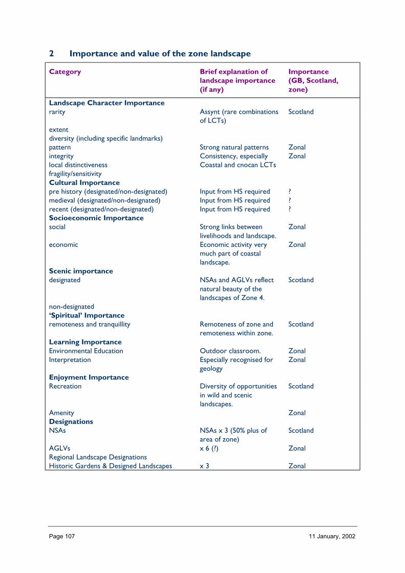
Page 107 11 January, 2002
2 Importance and value of the zone landscape
Category Brief explanation oflandscape importance(if any)
Importance(GB, Scotland,zone)
Landscape Character Importancerarity Assynt (rare combinations
of LCTs)Scotland
extentdiversity (including specific landmarks)pattern Strong natural patterns Zonalintegrity Consistency, especially Zonallocal distinctiveness Coastal and cnocan LCTsfragility/sensitivityCultural Importancepre history (designated/non-designated) Input from HS required ?medieval (designated/non-designated) Input from HS required ?recent (designated/non-designated) Input from HS required ?Socioeconomic Importancesocial Strong links between
livelihoods and landscape.Zonal
economic Economic activity verymuch part of coastallandscape.
Zonal
Scenic importancedesignated NSAs and AGLVs reflect
natural beauty of thelandscapes of Zone 4.
Scotland
non-designated‘Spiritual’ Importanceremoteness and tranquillity Remoteness of zone and
remoteness within zone.Scotland
Learning ImportanceEnvironmental Education Outdoor classroom. ZonalInterpretation Especially recognised for
geologyZonal
Enjoyment ImportanceRecreation Diversity of opportunities
in wild and sceniclandscapes.
Scotland
Amenity ZonalDesignationsNSAs NSAs x 3 (50% plus of
area of zone)Scotland
AGLVs x 6 (?) ZonalRegional Landscape DesignationsHistoric Gardens & Designed Landscapes x 3 Zonal

Page 108 11 January, 2002
3 Landscape and trends in the zone
Pressures/influences which have a particular effect on the landscape of the zone
Pressure Nature of pressuretrends within zone,relative importancewithin the zone
Scale of landscape influence(+ve/–ve) within zone whenconsidered in an all Scotlandcontext
Major Inter. Minor Negligible
Built developmentResidential Increase in edge of
settlement and individualhouses reflects stable andincreasing population
�
RetailIndustrial Small scale craft and
processing related�
OtherInfrastructure TransportRoads and tracks Upgrading, trend towards
less road improvement�
Rail relatedFerry relatedOtherInfrastructure otherTelecoms Continuing expansion of
masts (and tracks) tocover roads andsettlements – long term,important
�
Water treatment/abstractionWaste managementCoastal defencesOtherMineralsOpen cast coalSand and GravelHard rock Continued extraction for
construction on w. coastand beyond
�
PeatOther – Oil Developments to service
west of Shetland fields atKishorn – long termpossibly
�
Forestry and WoodlandsRestructuring of existing Long term landscape
improvement�
Creation of new small New element of visualdiversity on in-bye
�

Page 109 11 January, 2002
Creation of large new/native On common grazings lessopen ground. –ve effectson recreation. Trackupgrading/creation – longterm, important
�
OtherAquaculture and FishingFinfish Visual impacts and
impacts on wildlandexperience wildland. On-shore developmentsdifficult to integrate –long term, important
�
Shellfish �Fishing River River engineering and
ATV tracks. Stable ordeclining
�
Other – freshwateraquaculture
Landscape and visualimpact of tanks and cages.Scale of production unitsdifficult to accommodatein these landscapes.Ongoing
�
Land ManagementSheep production Maintenance by crofters.
Inappropriate grazing.ATV use
�
Crop productionSport shooting Increasingly high numbers
of deer, leading totracking, overgrazing.Scarring from ATVs.Perceived conflicts withrecreation. Ongoing –long term
�
OtherEnergyNat. grid/infrastructureWind Possibility of windfarm
developments (checkSRO 3)
?
Hydro Hydro development(Shieldaig, Assynt). Effectson landscape characterand wildland experience
�
WaveOtherTourism and RecreationGolfMarinasSkiing facilitiesLeisure facilities/visitorcentres
Expansion of small scaleprovision
�

Page 110 11 January, 2002
NH Information provision Linked to above �Walking related/footpaths Erosion of footpaths,
scars on the landscape(increasing use). Longterm
� �
Other
4 Building a sustainable future
Landscape Influences and Trends
Aspects ofimportanceof theZonalLandscape
1Residential
Development,especiallyedge ofsettlement
2RoadsandTracks
3Tele-coms
4Minerals
Oil and
Quarrying
5Forestry&Wood-landsLargeScaleNative
6Aqua-
culture
- Finfish
+Shellfish
7Energy
Hydro
A. Landscapecharacter,especiallyrarity,pattern &integrity(Scotland)B. Scenicimportance(Scotland)C.Remotenessandtranquillity(Scotland)D.Recreation(Scotland)E. NSAs,AGLVs, andHGDLs(Scotland)
General Landscape Objectives needed
Specific Landscape Objectives needed

Page 111 11 January, 2002
ZONE 5 THE PEATLANDS OF CAITHNESS ANDSUTHERLAND
1 Nature of the landscape resource
Diversity, distribution and rarity of landscape character in the zoneNote: Ignore any LCT which is shown as <10 km sq (if important feature will be coveredelsewhere, if important characteristic locally will be flagged up in description)
Table 5.1 Diversity
Zone LCTLevel 1
LCTLevel 3
Context Areakm2
5 Sweeping Moorland Flat or Rolling, Smo Highland 1,580.195 Strath Highland Straths Highland 201.365 Coastal Shelf Low, Flat, and/or Highland Co 21.465 Harbour Highland and Island Highland Co 0.365 Town Highland and Island Highland 3.765 Open Intensive
FarmlandFarmlands and Est Highland 0.00
5 Mixed Agriculture andSettlement
Farmlands and Est Highland 0.67
5 Small Farms and Crofts Highland and Island Highland 253.895 Coniferous Woodland
No Informationprovided in report.
0 NULL 562.80
5 Broadleaved/Mixed Woodland Noinformation provided inreport.
0 NULL 26.41
5 Flat Peatland Peatland Landscape Highland 403.815 Moorland Slopes and
HillsHMRRMts Highland 1,843.68
5 Cnocan Highland Cnocan Highland 0.005 Lone Mountains HMRSSMts Highland 178.525 Irregular Massif HMRSSMts Highland 0.005 High Cliffs and
Sheltered BaysHighland and Island Highland Co 12.04
5 Long Beaches Dunesand Links
Low, Flat, and/or Highland Co 19.88
5 Kyles Firths and SeaLochs
Sea Lochs of theHighlands
Highland Co 104.32
5 Sloping TerraceMoorland
Flat or Rolling, Smo Highland 0.02
5 Rounded Hills HMRRMts Highland 0.00
Total 5,213.17
The number of landscape character types represented in Zone 5 at level 1, is 20 the way they are grouped at level 3 is into 11 and theircontext is strongly Highland. No. of LCTs (Level 1)/Area of Zone in Zone 5 is 0.003, this gives an indication of the overall diversity oflandscape character in the zone and can be compared between zones.
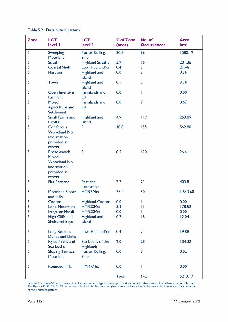
Page 112 11 January, 2002
Table 5.2 Distribution/pattern
Zone LCTlevel 1
LCTlevel 3
% of Zone(area)
No. ofOccurrences
Areakm2
5 SweepingMoorland
Flat or Rolling,Smo
30.3 66 1580.19
5 Strath Highland Straths 3.9 16 201.365 Coastal Shelf Low, Flat, and/or 0.4 3 21.465 Harbour Highland and
Island0.0 3 0.36
5 Town Highland andIsland
0.1 2 3.76
5 Open IntensiveFarmland
Farmlands andEst
0.0 1 0.00
5 MixedAgriculture andSettlement
Farmlands andEst
0.0 7 0.67
5 Small Farms andCrofts
Highland andIsland
4.9 119 253.89
5 ConiferousWoodland NoInformationprovided inreport.
0 10.8 155 562.80
5 Broadleaved/MixedWoodland Noinformationprovided inreport.
0 0.5 120 26.41
5 Flat Peatland PeatlandLandscape
7.7 23 403.81
5 Moorland Slopesand Hills
HMRRMts 35.4 50 1,843.68
5 Cnocan Highland Cnocan 0.0 1 0.005 Lone Mountains HMRSSMts 3.4 13 178.525 Irregular Massif HMRSSMts 0.0 1 0.005 High Cliffs and
Sheltered BaysHighland andIsland
0.2 18 12.04
5 Long BeachesDunes and Links
Low, Flat, and/or 0.4 7 19.88
5 Kyles Firths andSea Lochs
Sea Lochs of theHighlands
2.0 28 104.32
5 Sloping TerraceMoorland
Flat or Rolling,Smo
0.0 8 0.02
5 Rounded Hills HMRRMts 0.0 1 0.00
Total 642 5213.17
In Zone 5 a total 642 occurrences of landscape character types (landscape units) are found within a zone of total land area 5213 km sq.The figure 642/5213 is 0.123 per km sq of land within the zone and gives a relative indication of the overall brokenness or fragmentationof the landscape pattern.
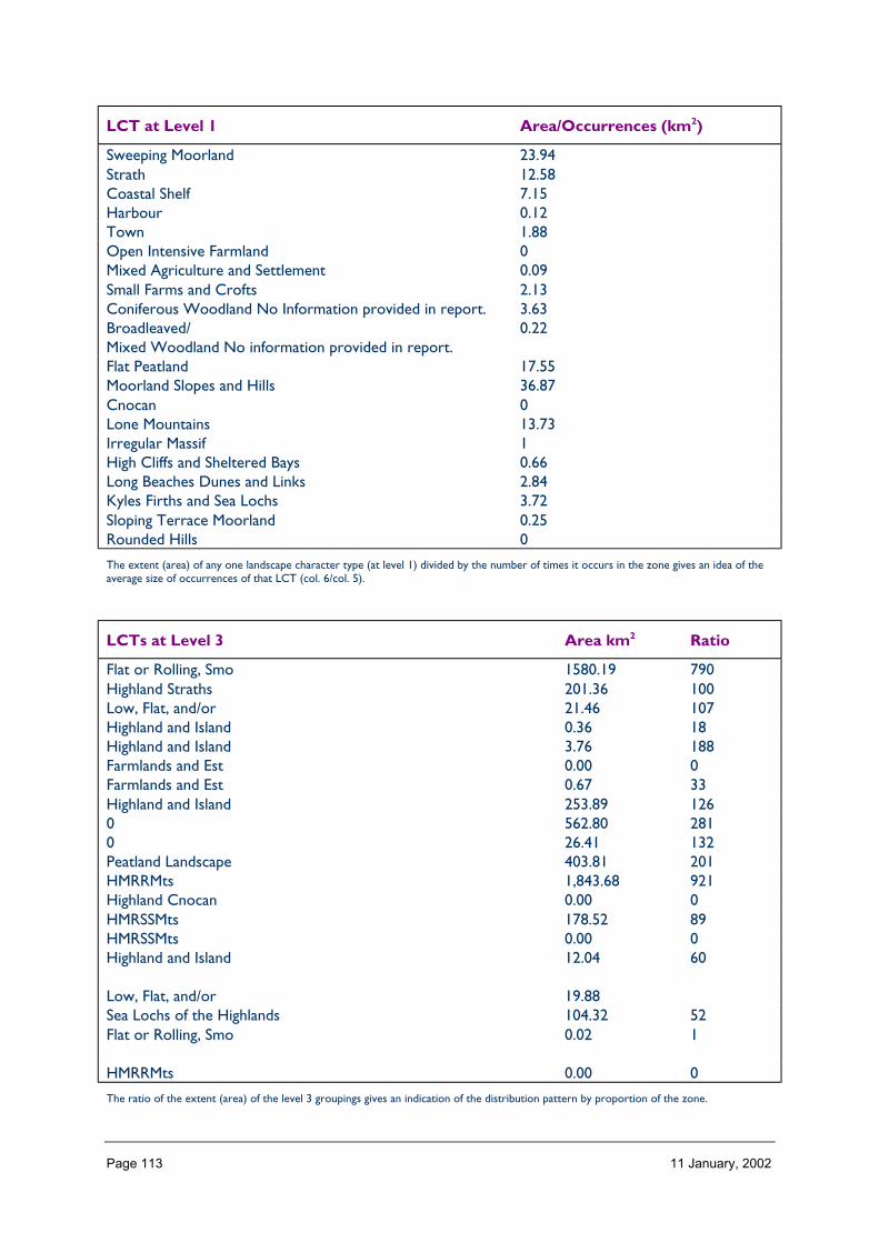
Page 113 11 January, 2002
LCT at Level 1 Area/Occurrences (km2)
Sweeping Moorland 23.94Strath 12.58Coastal Shelf 7.15Harbour 0.12Town 1.88Open Intensive Farmland 0Mixed Agriculture and Settlement 0.09Small Farms and Crofts 2.13Coniferous Woodland No Information provided in report. 3.63Broadleaved/Mixed Woodland No information provided in report.
0.22
Flat Peatland 17.55Moorland Slopes and Hills 36.87Cnocan 0Lone Mountains 13.73Irregular Massif 1High Cliffs and Sheltered Bays 0.66Long Beaches Dunes and Links 2.84Kyles Firths and Sea Lochs 3.72Sloping Terrace Moorland 0.25Rounded Hills 0
The extent (area) of any one landscape character type (at level 1) divided by the number of times it occurs in the zone gives an idea of theaverage size of occurrences of that LCT (col. 6/col. 5).
LCTs at Level 3 Area km2 Ratio
Flat or Rolling, Smo 1580.19 790Highland Straths 201.36 100Low, Flat, and/or 21.46 107Highland and Island 0.36 18Highland and Island 3.76 188Farmlands and Est 0.00 0Farmlands and Est 0.67 33Highland and Island 253.89 1260 562.80 2810 26.41 132Peatland Landscape 403.81 201HMRRMts 1,843.68 921Highland Cnocan 0.00 0HMRSSMts 178.52 89HMRSSMts 0.00 0Highland and Island 12.04 60
Low, Flat, and/or 19.88Sea Lochs of the Highlands 104.32 52Flat or Rolling, Smo 0.02 1
HMRRMts 0.00 0
The ratio of the extent (area) of the level 3 groupings gives an indication of the distribution pattern by proportion of the zone.
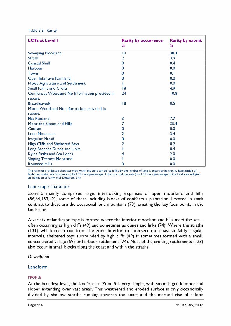
Page 114 11 January, 2002
Table 5.3 Rarity
LCTs at Level 1 Rarity by occurrence%
Rarity by extent%
Sweeping Moorland 10 30.3Strath 2 3.9Coastal Shelf 0 0.4Harbour 0 0.0Town 0 0.1Open Intensive Farmland 0 0.0Mixed Agriculture and Settlement 1 0.0Small Farms and Crofts 18 4.9Coniferous Woodland No Information provided inreport.
24 10.8
Broadleaved/Mixed Woodland No information provided inreport.
18 0.5
Flat Peatland 3 7.7Moorland Slopes and Hills 7 35.4Cnocan 0 0.0Lone Mountains 2 3.4Irregular Massif 0 0.0High Cliffs and Sheltered Bays 2 0.2Long Beaches Dunes and Links 1 0.4Kyles Firths and Sea Lochs 4 2.0Sloping Terrace Moorland 1 0.0Rounded Hills 0 0.0
The rarity of a landscape character type within the zone can be identified by the number of time it occurs or its extent. Examination ofboth the number of occurrences (of a LCT) as a percentage of the total and the area (of a LCT) as a percentage of the total area will givean indication of rarity. (col 5/total col. 5%).
Landscape characterZone 5 mainly comprises large, interlocking expanses of open moorland and hills(86,64,133,42), some of these including blocks of coniferous plantation. Located in starkcontrast to these are the occasional lone mountains (73), creating the key focal points in thelandscape.
A variety of landscape type is formed where the interior moorland and hills meet the sea –often occurring as high cliffs (49) and sometimes as dunes and links (74). Where the straths(131) which reach out from the zone interior to intersect the coast at fairly regularintervals, sheltered bays surrounded by high cliffs (49) is sometimes formed with a small,concentrated village (59) or harbour settlement (74). Most of the crofting settlements (123)also occur in small blocks along the coast and within the straths.
Description
Landform
PROFILE
At the broadest level, the landform in Zone 5 is very simple, with smooth gentle moorlandslopes extending over vast areas. This weathered and eroded surface is only occasionallydivided by shallow straths running towards the coast and the marked rise of a lone

Page 115 11 January, 2002
mountain towering up in stark vertical contrast. The undulating nature of the moorlandslopes results in varying profile at the coastal edge from long stretches of beach to highvertical cliffs with bays corresponding to the intersection of a strath.
Throughout the zone as a whole, the generally low and gentle nature of the landform isreflected by 59% of the land being below 200 m and 68% of slopes being under 5° with fairlyequal distribution of slope aspect.
SEQUENCE
The predominant gentle slopes of Zone 5 form a fairly consistent matrix which extendsthroughout the area. Within this the subtle route of shallow straths are fairly regular indistribution, penetrating the interior and generally aligned N–S in the north and NW–SE inthe east and south of the zone. The prominent lone mountains occur mainly in the west andcentral area of the zone, isolated by wide open areas of moorland slopes.
SCALE
The scale of Zone 5 seems immense due to the high extent of visibility over expansive areasof mainly low, simple landform.
It is often difficult to perceive actual distance and elevation, however, due to views rarelyrevealing features of a known size. Where mountains occur, their vertical scale seemsaccentuated in sharp contrast to the predominate low moorland surrounding them.
LANDMARK FEATURES
The occasional lone mountains which occur in this zone form dominant landmark foci;although only 2.5% of the zone, their influence is far reaching in views from surroundingareas. The cliffs formed on the coastal edge, and their abutment to sheltered, sandy baysalso creates a rhythm of landmarks along the north coast.
At a more detailed level, other key landmarks are the pattern of dubh lochans upon theeroded surface of the central moorland interior of the zone.
EXPERIENCE
There are few access routes through Zone 5 and these are mainly limited to the coast orstraths. Thus experience of the full extent of the moorland areas is difficult to appreciate,mainly limited to where routes pass between one strath to another. From these locations,the wide open simple expanse of the moorland offers a sense of exhilaration and personalfreedom, although the very scale and lack of differentiation of this may seem also tointimidate the viewer. The lone mountains are seen from vast distances across thesemoorland areas, welcomed as distinct landmarks where it is otherwise difficult to orientate.Although perception of the landscape qualities is most acute away from the distractions ofaccess routes or settlements, these characteristics are still appreciated to a certain degreein public areas due to the relatively low numbers of motorists and inhabitants in relation tothe large expanse of the landscape.

Page 116 11 January, 2002
Containment (created by landform and land cover)
TOPOGRAPHY
The containment of this zone is generally extremely low, being mainly exposed due topredominance of low, gently sloped or flat ground. The zone is least contained in the northeast area upon the unforested parts of the Flow Country peatlands.
Conversely, the coastal edge creates some containment, especially at the intersection ofstraths; however even here, shelter from the exposure of the interior moorlands iscompromised by there also being exposure to the sea.
LAND COVER
Vegetation is fairly uniform in this zone, heather moorland and peatland comprising around83% of the land cover, contributing greatly to the low level of containment.
The location of coniferous and mixed plantations within the zone do create somecontainment at a local level and contribute to around 1% of the land cover; however thehigh density of trees in these woodlands often mean they are so contained as to be difficultto penetrate except along tracks that form channelling corridors.
Built development is extremely sporadic in Zone 5, but tends to concentrate in areas withsome form of natural shelter by the coast of rivers. Although the scarcity of thisdevelopment means that it is not physically responsible for a significant level of containmentitself, the planting of woodland and hedges around buildings does create small pockets ofshelter.
VISIBILITY
Visibility is extensive throughout this zone, although greatest across the peatlands and uponthe high cliffs. It is reduced slightly, however, by the screening effect of slopes within areasof undulating moorland and hills along the low stretches of coastal shelf particularly.
Within the interior of the zone, views are very distant and panoramic with a visualdominance of the horizon and sky. These extensive views enable the immense open space ofthe landscape to be appreciated.
MICROCLIMATIC EFFECTS
Generally the openness of this zone means that it is extremely exposed and often subject toa barrage of changing weather conditions as systems cross the zone from west to east.
The openness of the landscape is also responsible for a dominant presence of the sky withinviews, revealing a clarity of light over the zone that highlights the subtlest pattern orvariation in landform.
EXPERIENCE
The experience of containment does vary slightly across the zone. However this tends tooccur in such a subtle nature and over such long distances that it is difficult to discernchanges until after they have occurred.

Page 117 11 January, 2002
As the over-riding character of the zone is open and fairly undifferentiated, however, thereis a focus of attention where any containment does occur for example along the coast or astrath.
Accessibility
DISTANCE
Zone 5 covers an extensive area and thus varies in accessibility with the southern partclosest to Inverness (approximately 52 miles away) and ease of access decreasing to thenorth and west.
The zone as a whole lies at the northern mainland periphery of Scotland as a country, some207 miles between Edinburgh and its southern boundary. Access to the zone mainly occursvia the A9 which runs up the eastern edge, the A836 and A837 which cross north and westfrom the Dornoch Firth, and the A838 which enters in the north west corner.
PHYSICAL ACCESS
Physical access is restricted within Zone 5 by the orientation and distribution of routestending to mainly follow the coast or travel up straths and thus limited by the occurrence ofthese.
In the northern half of the zone, roads mainly run N–S and thus it is difficult to travel inother directions; whilst in the southern half of the zone, roads mainly run NW–SE.
Of the main routes, including ‘A’ class roads, many are rough in nature, winding, undulatingand single track in width. Routes over the peatland areas are often particularly rough due tobeing built upon an unstable base.
A number of straths are serviced by private estate tracks, only freely accessible to the publicon foot.
The main footpaths, used chiefly by hillwalkers and stalkers, run up the lone mountains andalong the coast.
CULTURAL ACCEPTANCE OF ACCESS
Access and parking off public roads is generally discouraged within the landscape by mostlandowners and many estate access tracks are gated with signs discouraging walkers,especially during the deer stalking season. Access over crofting land is also discouraged insome places, especially during lambing.
This means that although 53% of the area is theoretically within 2 km from an access route,a much smaller proportion of the landscape is accessible to the public without having to defydiscouraging signs and gates.
VISUAL ACCESS
Visual access to the landscape is generally extensive due to its open nature, particularlywithin the moorland areas. However local confinement of views tends to occur in strath andcoastal areas where views are loosely channelled in a linear fashion.
Page 118 11 January, 2002
EXPERIENCE
Generally access within this zone is limited in extent and direction, but fairly evenlydistributed throughout the landscape. And although much of the landscape is not directlyaccessible, it is visible from public roads due to the extensive nature of views. All absence oflandmarks added to the simplicity of landscape means that it is often difficult to define actuallocation within the interior moorlands. However, this effect is less apparent along the coast,where the frequent and rhythmic intersection of straths and glens, and the settlements theyharbour, create notable foci along access routes.
Land cover (including vegetation and land use)
VEGETATION
The vegetation cover of this zone comprises predominantly a matrix of heather moorlandand peatland types which collectively make up around 83% of the zone.
This predominance of a similar, low vegetation type accentuates the simplicity of thelandform and sense of openness and means that views tend to either focus to distant foci orto foreground details of vegetation.
Although comprising only around 1% of the zone area, coniferous plantations notably affectthe character of the landscape, contrasting to the colour, elevation and texture ofsurrounding vegetation and creating shapes and dominant foci within the surroundingmoorlands.
EXPOSED ROCK
There is little exposed rock across Zone 5 as a whole, although it is evident in cliffs alongthe coastal edge (49, level 1) as a scattered component of some moorland areas, and uponthe upper slopes of the lone mountains (73, level 1).
BUILT DEVELOPMENT
Built development does not form a significant proportion of the zone (<1%) and isconcentrated as small settlements, estates and crofting townships, mainly in the straths andalong the coast.
EXPERIENCE
The simplicity of land cover over this zone contributes greatly to the powerful visual imagewhich presides over much of the area. It means there is little distraction from the basiclandforms, sense of exposure and the feeling of immense space; although where builtdevelopment and woodland occurs, this is often welcomed for the focus of shelter, visualintricacy and activity associated with such places in stark contrast to the surrounding land.
Hydrology and water bodies
TYPE
Water plays a prominent role in the landscape character of Zone 5, but mainly as an integralpart of the moorland and strath landscapes. With gentle landform slopes, the ground surfaceoften seems to gradually merge into water bodies, with weak distinction of edges between.This role changes through the seasons, the peatlands acting much like big sponges.

Page 119 11 January, 2002
Many of the lochs are regulated for the purposes of hydro electric generation and thus theirwater levels vary with use. And the main rivers in this zone also tend to be influenced byhumans for the purpose of fishing and to a lesser extent hydro, as well as being susceptibleto fluctuating levels because of large catchment areas over open mountains and moorlands.
Lochans and dubh lochans also form key features within certain parts of the peatlands withinZone 5.
PATTERN
The major rivers and lochs within Zone 5 run along well defined straths, mainly running N–Sin the northern half of the zone and NW–SE in the southern and eastern areas. And thepresence of large areas of dubh lochans tends to occur within the areas of blanket bog in thecentral and north eastern part of the zone. Apart from these, however, the distribution oftributaries and lochans tends to be fairly even and extensive throughout the zone.
EXPERIENCE
The route of rivers and the line of lochs along the straths within Zone 5 form the mainaccess routes through the interior and are thus very important to gaining an experience ofthe area. They tend to lead one through the landscape with their linear route, discouragingfocus at any one place. This generally only occurs at smaller lochs and where rivers intersectanother feature such as the coast. It is very difficult to discern the pattern and distributionof rivers, lochs and lochans in the flatter areas of this zone on account of visualforeshortening, meaning that they tend to be encountered in surprise and their pattern overa wide area only clearly appreciated from elevated viewpoints such as local knolls.
Built and infrastructure development (present day)
NATURE AND PATTERN OF SETTLEMENT
Settlement within Zone 5 is infrequent; but where occurring tends to be along the coast orwithin straths at key bridging points at fairly regular intervals. The settlements on the coasttend to be small and nucleated around the core of a harbour and extending along the mainaccess route into a hinterland of crofting. More dispersed are the pattern of estatesettlements and crofting townships which tend to coincide with favourable agricultural land,shelter and access along straths.
NATURE AND PATTERN OF INFRASTRUCTURE
Roads, a railway line, estate access tracks and electric power lines form the main links ofinfrastructure pattern in this zone. Of these, the combined route of the A9, railway andpower lines up the east coast form the most prominent spine crossing the zone which thenleads up the straths.
Owing to the open nature of the landscape, where confluences of infrastructure occur, forexample the meeting of powerlines at Invershin, these tend to be highly visible and affect thecharacter of the local landscape.
NATURE AND PATTERN OF INDUSTRIAL DEVELOPMENT
There is little industrial development in this landscape and that which does occur tends tobe linked to local natural resources, for example gravel quarrying in some of the straths, thewool mill at Brora and hydro schemes – some major ones such as that at Loch Shin.
Page 120 11 January, 2002
EXPERIENCE
Built and infrastructure development generally forms just a minor feature of this zone inrelation to predominance of the ‘natural’ landscape.
As most built development is located in close proximity to the small number of main accessroutes, there may be a perception when travelling through the landscape that there is a fargreater proportion of this development throughout the zone than there is in reality ifremote areas are considered.
There is a tradition of ‘boom and bust’ in this zone which means that feasibility andprosperity is repeatedly tested, as any settlement or industry has to work against theproblems of a peripheral UK location and often harsh physical conditions. This means,however, that human presence and sustainable activity is particularly valued whenexperienced in the landscape for the interest, determination and positive image itrepresents.
Visible history (past settlement, landuse, churches, brochs, forts, dykes, standingstones etc.)
TYPES OF VISIBLE HISTORY
There exists extensive evidence of historical land use in this zone representing a pattern ofrepeated occupation and prosperity followed by retreat and abandonment. The oldest relicsin the zone comprise old mounds of discarded seashells gathered by hunter-gathers over6000 years ago. These are followed by Neolithic large burial cairns, many of which arelocated upon small hills in the zone. Large defensive brochs, forts and ruins date back toaround 800BC and still portray today their great physical robustness in the landscape, and afew pictish stones occur dating back to around 390 AD.
There are a number of castles within the landscape which represent past divisions of landsand the associated feuding between the 1200s and 1700s. From the 1600s this clan systembegan to break down, resulting in the crofting tenant system that resulted in the clearances.Evidence of abandoned settlements during this period are prevalent throughout the zone,but particularly in the straths of Sutherland, with ruined buildings and enclosures, estatebuildings and boundaries.
LOCATION/PATTERN
Most historic features are located within the straths of this zone and near to the coast,although many cairns and shielings are located on and around the moorland hills.Overlapping of features of various age occur in places where particularly favourable localconditions occur, such as shelter, access, water supply, good soil and also a defensiveposition.
EXPERIENCE
Whilst the experience of historic features does not dominate the landscape character of thiszone as a whole, these features do strongly affect the experience of particular locations.This is emphasised when visible from public roads and highlighted by signs from these. Thephysical remains of crofting clearances particularly affect the landscape character of strathsand crofting areas in this landscape (131 and 123, level 1). The experience of these isheightened by the large number of remains, their visible connection to present settlements

Page 121 11 January, 2002
and their reference within the present day culture of the zone, promoted by the writings ofrecent generations.
Wildlife
FORMS OF WILDLIFE
Wildlife characteristic of this zone chiefly include deer (red, roe and sika), wild cat, haresand red grouse with birds of prey, dotterel, ptarmigan, greylag and gulls and midges. Some ofthese mainly occur in mountain and moorland areas and are seen only rarely, such as birdsof prey, whilst others are associated with coastal areas or are particularly prolific such asmidges.
LOCATION
Most of the mammals concentrate in the peatland and hill areas together with midges,chiefly landscape character types 73, 64, 133, 86 and 42 (level 1), whilst coastal speciesobviously tend to concentrate near to the sea, mainly landscape character types 74, 20, 49and 123 (level 1).
WHEN
Deer tend to be most visible in the winter, when they descend from the mountains to lowground, often grazing on the semi-improved pasture in strath floors. Mountain hares tend tobe most visible whilst in their ermine but after the snows have melted, and birds are usuallymost notable during spring and early summer when most active and vocal. Midges areprolific throughout late spring, summer and early autumn months.
EXPERIENCE
Although the visibility of wildlife throughout Zone 5 is not so prolific as to affect thecharacter of the landscape, the presence of these at certain times of the year and inparticular places does significantly contribute to the experience of the landscape. Inparticular, the experience of some species such as eagles, perceived as being rare, canintensify feelings of remoteness or wild land. Conversely, some species, such as midges, canbe perceived as a negative feature of the landscape experience and affect people’sappreciation of the zone at certain times of the year.
In some instances, it may actually be the sound of wildlife that adds most to the experiencerather than the sight of these, for example the roaring of stags in autumn and the call ofbirds over the boglands in spring and summer.
Climate
CLIMATIC CHARACTERISTICS
Climatic characteristics vary within Zone 5, especially on account of the differing influenceof Atlantic weather systems from the west which result in annual precipitation of around1600–3200 mm in the west of Zone 5 to 800–1200 mm in the east. Temperaturedifferentiation also varies across the zone – both in respect of central and southern areasusually being hottest in summer but coldest in winter. Over the zone, there is a meansummer temperature of 13°C and a mean winter temperature of 3°C.
Page 122 11 January, 2002
LOCATIONAL AND SEASONAL EFFECTS
As mentioned above, effects vary between inland and coastal areas, north and south, andwest and east. Seasons are quite marked within the zone as a whole, especially in relation tonumbers of hours daylight. In the north, particularly, hours of daylight in winter are few andthe angle of the sun low, creating spectacular effect in the landscape with numerous longshadows that highlight the slightest vertical element. In contrast, summer brings long hoursof daylight and an associated great increase of activity in the landscape. The clarity of light isquite acute in this zone, particularly in coastal areas.
EXPERIENCE
The experience of the climate in this zone contributes significantly to its landscapecharacter, and being predominantly open, the impact of changing weather systems passingfrom west to east, inland and offshore and north to south are particularly spectacular. Thesesystems significantly affect the activity of people in the landscape, this contrasting greatlybetween the extremes of summer and winter.
The experience of the great clarity of light can be quite marvellous, highlighting the subtlestvariation of form, texture, colour or tone and the impact of the sky is significant given itspredominance within views over the flatter areas of the zone. In changing weatherconditions, the views of rapidly moving clouds and their shadows across the landscape addsa very dynamic quality to the experience of Zone 5.
Designated landscapes
National Scenic Areas
CONSTITUENTS
There is one complete NSA contained within Zone 5 – Kyle of Tongue, and small parts oftwo other NSAs – The Dornoch Firth and Assynt-Coignach.
There are a number of landscape character types at level 1 which come together to makeup the Kyle of Tongue NSA, namely number 67 Kyles, Firths and sea lochs, surrounded by123, small farms and crofts, 86, moorland slopes and hills, 133, sweeping moorland and 49,high cliffs and sheltered bays and 73, lone mountains to the outer edges.
The small part of the Assynt-Coignach NSA includes number 133, sweeping moorland andnumber 86, moorland slopes and hills to the north of Ben More Assynt.
− The small area of the Dornoch Firth NSA within Zone 5 includes a mixed patchworkof number 86, moorland slopes and hills, coniferous woodland and 123, small farms andcrofts.
LOCATION AND EXTENT
The fragment of the Assynt-Coignach NSA occurs upon the western boundary of Zone 5and measures 26.67 km square in extent.
The Kyle of Tongue NSA, lying completely within this zone on the northern coast ofSutherland extends to 194 km square.

Page 123 11 January, 2002
The small part of the Dornoch Firth NSA lies at the south eastern corner of Zone 5,extending to 18.77 km square.
EXPERIENCE
Ben Loyal and Ben Hope, part of the Kyle of Tongue NSA are viewed from far distances asdistinctive peaks within open moorland. However views showing the combined compositionof these mountains together with the Kyle and its surrounding woodlands, settlements andthe sea are chiefly appreciated from the north. These views are valued for the diversity oflandscape elements at a variety of scales.
The small part of the Assynt-Coignach NSA within Zone 5 is mainly appreciated as part ofthe mountain range running N–S linking Glas Bheinn, Beinn Uidhe and Ben More Assynt.Although this is chiefly viewed from the west in Zone 4, it is appreciated at further distancefrom the east through the strath linking Loch Shin to Loch More along which the A838 roadpasses.
The small part of the Dornoch Firth NSA in Zone 5 is appreciated at a local and detailedlevel via the minor roads that pass around Loch Migdale where visibility is limited by thevariable landform and woodland. However, in terms of the whole and diverse compositionof the NSA for which this is valued – the combination of firth and sheltering hills – this ismost clearly appreciated from the northern parts of Zone 7, particularly from the A836passing over Cadha mór, and Zone 21, especially from the Dornoch Firth bridge and thepromontories extending out into the firth.
Historic gardens and designed landscapes
NATURE OF THE LANDSCAPES DESIGNATED AND NON-DESIGNATED
There are three original Historic Gardens and designated landscapes (HGDL) in this zoneand one new HGDL.
REFERENCES
• Inventory of Gardens and Designed Landscapes and digitised map (available soon);• HGDL profiles (contract currently being let by Nigel).
Recreational landscapes
Nature of landscapesThe main focus of recreation within Zone 5 occurs along the coast.
This is partly on account of the concentration of settlements and services in these areas andalso the route of the main access, many visitors passing through the area on a circulatoryroute around the coast of Caithness and Sutherland. Along the coast, recreation tends to betargeted upon the beaches, golf links, harbour towns and walks along cliff tops, especiallyupon promontories and the coastal hills. Inland, recreation tends to mainly take the form ofhillwalking, particularly to the Munro peaks, and deer stalking over the hills and fishing in thestraths.
LOCATION
The main beach areas acting as a focus for recreation occur around Brora and Loth alongthe southern stretch of the east cost of Zone 5 and at Melvich, Strathy, Armadale, Bettyhill

Page 124 11 January, 2002
and Tongue along the north coast, occurring at fairly equal intervals. The main harbourtowns acting as foci for visitors are Brora, Helmsdale and Dunbeath along the east coast,the first of these also being a focus for golf. The high promontories of the north coast suchas Strathy Point and Ardmore Point act as key destinations for cliff top walks, although thesealso occur along the east coast near Ord of Caithness.
The mountains which attract most recreation are those in the north east of Zone 5 – BenHope, Ben Loyal and Ben Klibneck, which are fairly close to access routes. However, theprominent hills of the east, Scraben and Maven particularly, are also popular. Fishing mainlyoccurs in the eastern strath of Kildonan and the northern straths of Halladale, Naver,Vagantie and More.
EXPERIENCE
Zone 5 offers a great variety of recreation experience – not only in the great contrast oflandscapes and the responses to these (seclusion, exhilaration, exposure, vastness,remoteness, prominence and history to name a few), but also in a contrast of provisionfrom pristine golf courses and tourist facilities to open areas of ‘wild land’ and informalpathways. And with a very small resident population and fairly few numbers of visitors, theexperience of recreation can be personal.
2 Importance and value of the zone landscape
Category Brief explanation oflandscape importance(if any)
Importance(GB, Scotland,zone)
Landscape Character Importancerarity Flow country, peatlands &
lone mountainsGB
extentdiversity (including specific landmarks) Extreme subtlety of
change over large areaScotland
pattern Large areas devoid of anypattern. This restricted tolocal crofting
Zonal
integrity Large extent of LCTs Scotlandtypicalness/local distinctiveness Peatlands. Low resident
population.Zonal
fragility/sensitivity Very sensitive habitat. ScotlandScenic importancequalities Not classical qualities of
diversity and coast andlone mountains mainlyappreciated.
Scotland
perceptions Qualities of simplicity andvery powerful imagestraditionally overlooked.
Scotland
Learning ImportanceEnvironmental Education Peatlands demonstration ScotlandInterpretation Few public facilities Zonal
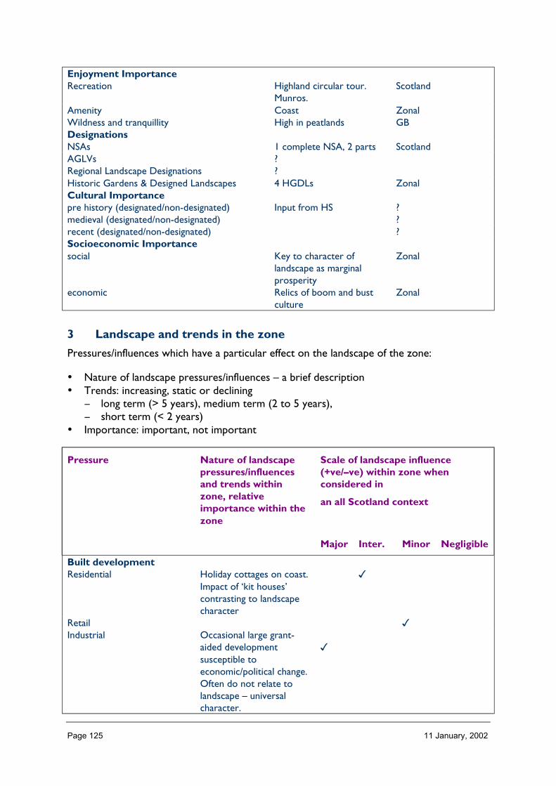
Page 125 11 January, 2002
Enjoyment ImportanceRecreation Highland circular tour.
Munros.Scotland
Amenity Coast ZonalWildness and tranquillity High in peatlands GBDesignationsNSAs 1 complete NSA, 2 parts ScotlandAGLVs ?Regional Landscape Designations ?Historic Gardens & Designed Landscapes 4 HGDLs ZonalCultural Importancepre history (designated/non-designated) Input from HS ?medieval (designated/non-designated) ?recent (designated/non-designated) ?Socioeconomic Importancesocial Key to character of
landscape as marginalprosperity
Zonal
economic Relics of boom and bustculture
Zonal
3 Landscape and trends in the zone
Pressures/influences which have a particular effect on the landscape of the zone:
• Nature of landscape pressures/influences – a brief description• Trends: increasing, static or declining
− long term (> 5 years), medium term (2 to 5 years),− short term (< 2 years)
• Importance: important, not important
Pressure Nature of landscapepressures/influencesand trends withinzone, relativeimportance within thezone
Scale of landscape influence(+ve/–ve) within zone whenconsidered in
an all Scotland context
Major Inter. Minor Negligible
Built developmentResidential Holiday cottages on coast.
Impact of ‘kit houses’contrasting to landscapecharacter
�
Retail �Industrial Occasional large grant-
aided developmentsusceptible toeconomic/political change.Often do not relate tolandscape – universalcharacter.
�

Page 126 11 January, 2002
OtherInfrastructure TransportRoads and tracks Pressure for upgrading �Rail related Increasing freight taken
off roads�
Ferry related Stable �OtherInfrastructure otherTelecoms Number of individual
applications. Greatcumulative impact in fewroad corridors
�
Water treatment/abstractionWaste management Transport impact �Coastal defences Significant demand and
impact on east coast�
OtherMineralsOpen cast coal
Sand and Gravel In strath floors. Fairlystable
�
Hard rock
Peat Domestic peat cuttingfeature of landscapecharacter. Commercialextraction graduallyexpanding
�
Other
Forestry and WoodlandsRestructuring of existing Significant positive visual
impact. Many plantationson Flow Country notbeing removed due toprohibitive access andcosts. Exotic conifers stillbeing planted.
�
Creation of new small Still predominance ofexotic conifer species.Few large native schemes.
�
Creation of large new/native �
Other
Aquaculture and FishingFinfish
Schemes concentrated infew
�
Shellfish lochs → high local impact. �
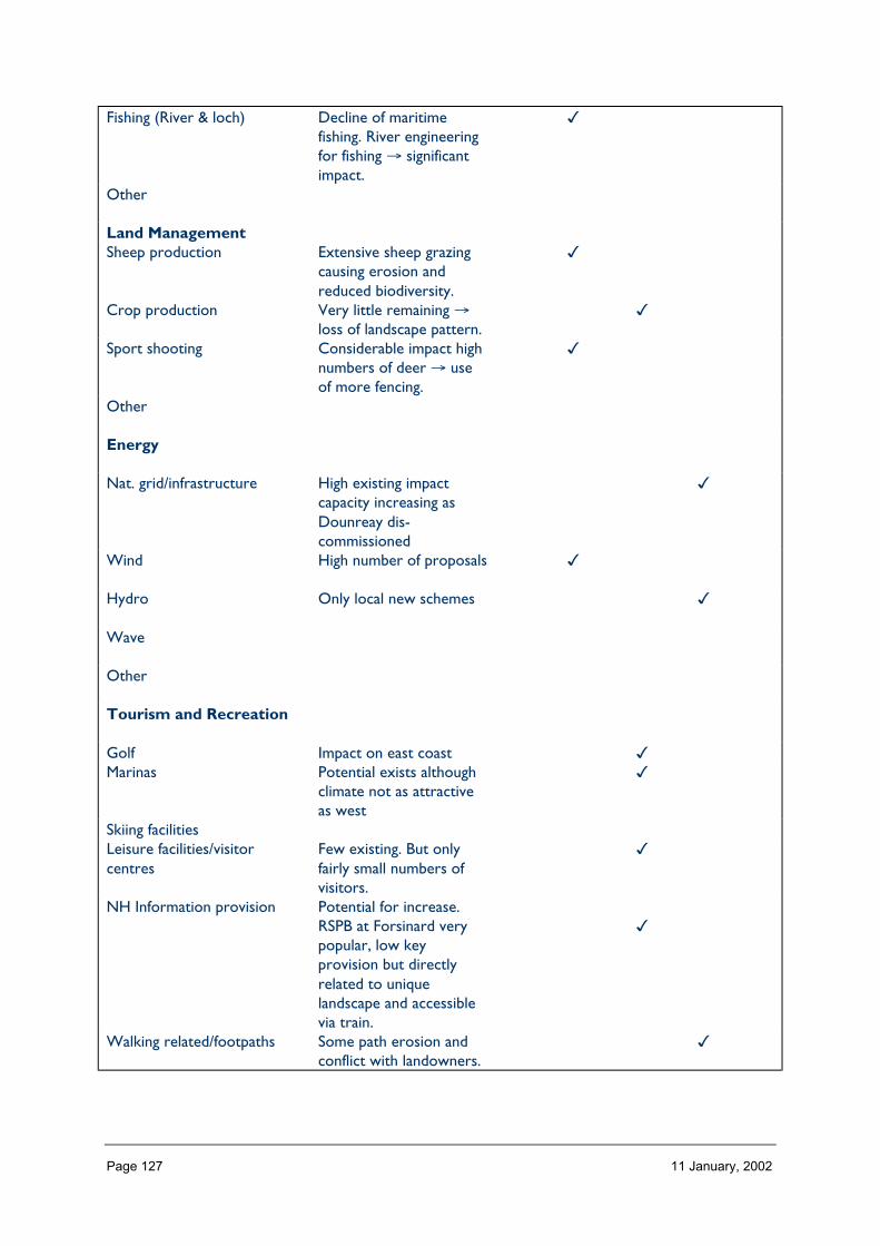
Page 127 11 January, 2002
Fishing (River & loch) Decline of maritimefishing. River engineeringfor fishing → significantimpact.
�
Other
Land ManagementSheep production Extensive sheep grazing
causing erosion andreduced biodiversity.
�
Crop production Very little remaining →loss of landscape pattern.
�
Sport shooting Considerable impact highnumbers of deer → useof more fencing.
�
Other
Energy
Nat. grid/infrastructure High existing impactcapacity increasing asDounreay dis-commissioned
�
Wind High number of proposals �
Hydro Only local new schemes �
Wave
Other
Tourism and Recreation
Golf Impact on east coast �Marinas Potential exists although
climate not as attractiveas west
�
Skiing facilitiesLeisure facilities/visitorcentres
Few existing. But onlyfairly small numbers ofvisitors.
�
NH Information provision Potential for increase.RSPB at Forsinard verypopular, low keyprovision but directlyrelated to uniquelandscape and accessiblevia train.
�
Walking related/footpaths Some path erosion andconflict with landowners.
�
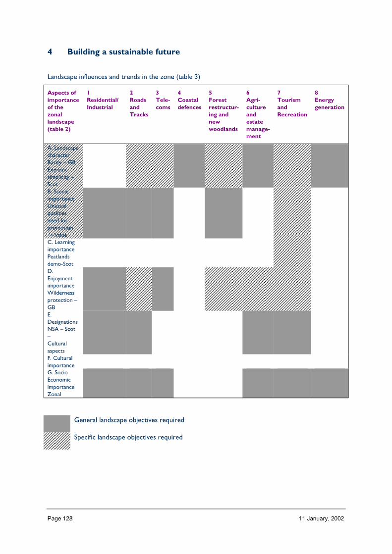
Page 128 11 January, 2002
4 Building a sustainable future
Landscape influences and trends in the zone (table 3)
Aspects ofimportanceof thezonallandscape(table 2)
1Residential/Industrial
2RoadsandTracks
3Tele-coms
4Coastaldefences
5Forestrestructur-ing andnewwoodlands
6Agri-cultureandestatemanage-ment
7TourismandRecreation
8Energygeneration
A. LandscapecharacterRarity – GBExtremesimplicity –ScotB. ScenicimportanceUnusualqualitiesneed forpromotion→ valueC. LearningimportancePeatlandsdemo-ScotD.EnjoymentimportanceWildernessprotection –GBE.DesignationsNSA – Scot–CulturalaspectsF. CulturalimportanceG. SocioEconomicimportanceZonal
General landscape objectives required
Specific landscape objectives required
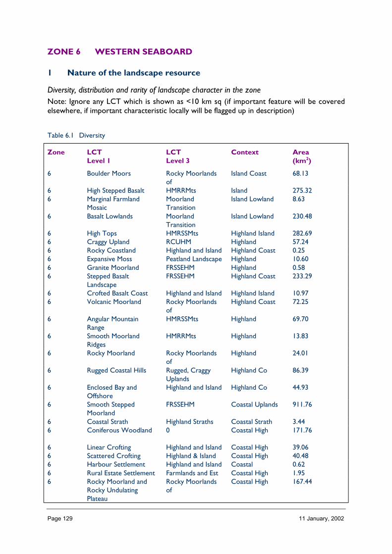
Page 129 11 January, 2002
ZONE 6 WESTERN SEABOARD
1 Nature of the landscape resource
Diversity, distribution and rarity of landscape character in the zoneNote: Ignore any LCT which is shown as <10 km sq (if important feature will be coveredelsewhere, if important characteristic locally will be flagged up in description)
Table 6.1 Diversity
Zone LCTLevel 1
LCTLevel 3
Context Area(km2)
6 Boulder Moors Rocky Moorlandsof
Island Coast 68.13
6 High Stepped Basalt HMRRMts Island 275.326 Marginal Farmland
MosaicMoorlandTransition
Island Lowland 8.63
6 Basalt Lowlands MoorlandTransition
Island Lowland 230.48
6 High Tops HMRSSMts Highland Island 282.696 Craggy Upland RCUHM Highland 57.246 Rocky Coastland Highland and Island Highland Coast 0.256 Expansive Moss Peatland Landscape Highland 10.606 Granite Moorland FRSSEHM Highland 0.586 Stepped Basalt
LandscapeFRSSEHM Highland Coast 233.29
6 Crofted Basalt Coast Highland and Island Highland Island 10.976 Volcanic Moorland Rocky Moorlands
ofHighland Coast 72.25
6 Angular MountainRange
HMRSSMts Highland 69.70
6 Smooth MoorlandRidges
HMRRMts Highland 13.83
6 Rocky Moorland Rocky Moorlandsof
Highland 24.01
6 Rugged Coastal Hills Rugged, CraggyUplands
Highland Co 86.39
6 Enclosed Bay andOffshore
Highland and Island Highland Co 44.93
6 Smooth SteppedMoorland
FRSSEHM Coastal Uplands 911.76
6 Coastal Strath Highland Straths Coastal Strath 3.446 Coniferous Woodland 0 Coastal High 171.76
6 Linear Crofting Highland and Island Coastal High 39.066 Scattered Crofting Highland & Island Coastal High 40.486 Harbour Settlement Highland and Island Coastal 0.626 Rural Estate Settlement Farmlands and Est Coastal High 1.956 Rocky Moorland and
Rocky UndulatingPlateau
Rocky Moorlandsof
Coastal High 167.44

Page 130 11 January, 2002
6 Landslide Edge FRSSEHM Coastal Highland 24.986 Peat Hag Peatland
Landscapes of theHighlands andIslands
Highland 0.20
6 Rugged Massif HMRSSMts Highland 151.276 Angular Mountain
RangeHMRSSMts Highland Coastal 80.13
6 Rounded Hills HMRRMts Highland Coastal 49.046 Sounds and Narrows Sea Lochs of the
HighlandsCoastal Island 319.27
Total 3450.69
HMRRMts = High, Massive, Rolling, Rounded Mts of Highlands & Islands
HMRSSMts = High Massive, Rugged, Steep-sided Mts of Highlands & Islands
FRSSEHM = Flat or Rolling, Smooth or Sweeping, Extensive, High Moorlands of Highlands & Islands
The number of landscape character types represented in Zone 6 at level 1, is 31 the way they are grouped at level 3 is into 11 and theircontext is strongly Highland Coastal. No. of LCTs (Level 1)/Area of zone in Zone 6 is 0.008, this gives an indication of the overall diversityof landscape character in the zone and can be compared between zones.
Table 6.2 Distribution/pattern
Zone LCTlevel 1
LCTlevel 3
% of Zone(area)
No. ofOccurrences
Areakm2
6 Boulder Moors Rocky Moorlandsof
2.0 2 68.13
6 High SteppedBasalt
HMRRMts 8.0 10 275.32
6 MarginalFarmland Mosaic
MoorlandTransition
0.3 1 8.63
6 Basalt Lowlands MoorlandTransition
6.7 8 230.48
6 High Tops HMRSSMts 8.2 1 282.696 Craggy Upland RCUHM 1.7 3 57.246 Rocky Coastland Highland and
Island0.0 4 0.25
6 Expansive Moss PeatlandLandscape
0.3 1 10.60
6 GraniteMoorland
FRSSEHM 0.0 3 0.58
6 Stepped BasaltLandscape
FRSSEHM 6.8 6 233.29
6 Crofted BasaltCoast
Highland andIsland
0.3 4 10.97
6 VolcanicMoorland
Rocky Moorlandsof
2.1 1 72.25
6 AngularMountain Range
HMRSSMts 2.0 1 69.70
6 SmoothMoorland Ridges
HMRRMts 0.4 1 13.83
6 Rocky Moorland Rocky Moorlandsof
0.7 1 24.01
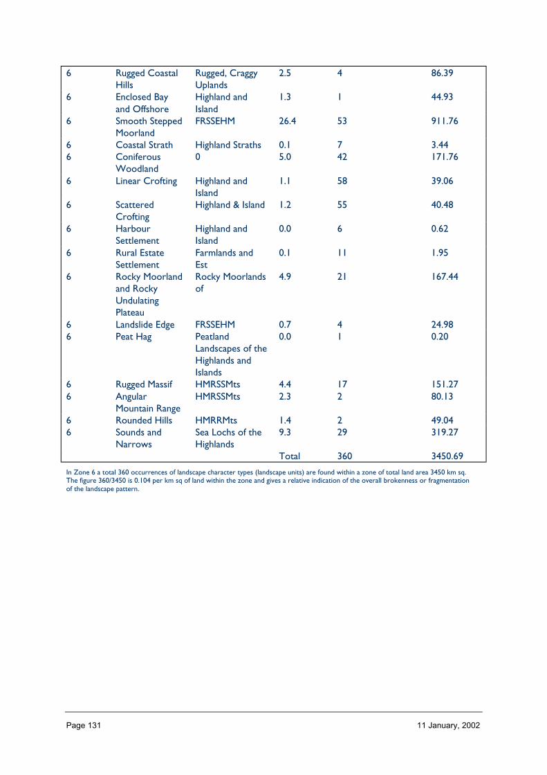
Page 131 11 January, 2002
6 Rugged CoastalHills
Rugged, CraggyUplands
2.5 4 86.39
6 Enclosed Bayand Offshore
Highland andIsland
1.3 1 44.93
6 Smooth SteppedMoorland
FRSSEHM 26.4 53 911.76
6 Coastal Strath Highland Straths 0.1 7 3.446 Coniferous
Woodland0 5.0 42 171.76
6 Linear Crofting Highland andIsland
1.1 58 39.06
6 ScatteredCrofting
Highland & Island 1.2 55 40.48
6 HarbourSettlement
Highland andIsland
0.0 6 0.62
6 Rural EstateSettlement
Farmlands andEst
0.1 11 1.95
6 Rocky Moorlandand RockyUndulatingPlateau
Rocky Moorlandsof
4.9 21 167.44
6 Landslide Edge FRSSEHM 0.7 4 24.986 Peat Hag Peatland
Landscapes of theHighlands andIslands
0.0 1 0.20
6 Rugged Massif HMRSSMts 4.4 17 151.276 Angular
Mountain RangeHMRSSMts 2.3 2 80.13
6 Rounded Hills HMRRMts 1.4 2 49.046 Sounds and
NarrowsSea Lochs of theHighlands
9.3 29 319.27
Total 360 3450.69
In Zone 6 a total 360 occurrences of landscape character types (landscape units) are found within a zone of total land area 3450 km sq.The figure 360/3450 is 0.104 per km sq of land within the zone and gives a relative indication of the overall brokenness or fragmentationof the landscape pattern.

Page 132 11 January, 2002
LCT at Level 1 Area/Occurrences (km2)
Boulder Moors 34.06High Stepped Basalt 27.53Marginal Farmland Mosaic 8.63Basalt Lowlands 28.81High Tops 282.69Craggy Upland 19.08Rocky Coastland 0.06Expansive Moss 10.60Granite Moorland 0.19Stepped Basalt Landscape 38.88Crofted Basalt Coast 2.74Volcanic Moorland 72.25Angular Mountain Range 69.70Smooth Moorland Ridges 13.83Rocky Moorland 24.01Rugged Coastal Hills 21.59Enclosed Bay and Offshore 44.93Smooth Stepped Moorland 17.20Coastal Strath 0.49Coniferous Woodland 4.08Linear Crofting 0.67Scattered Crofting 0.73Harbour Settlement 0.10Rural Estate Settlement 0.17Rocky Moorland and Rocky Undulating Plateau 7.97Landslide Edge 6.25Peat Hag 0.20Rugged Massif 8.89Angular Mountain Range 40.06Rounded Hills 24.52Sounds and Narrows 11.00
The extent (area) of any one landscape character type (at level 1) divided by the number of times it occurs in the zone gives an idea of theaverage size of occurrences of that LCT.
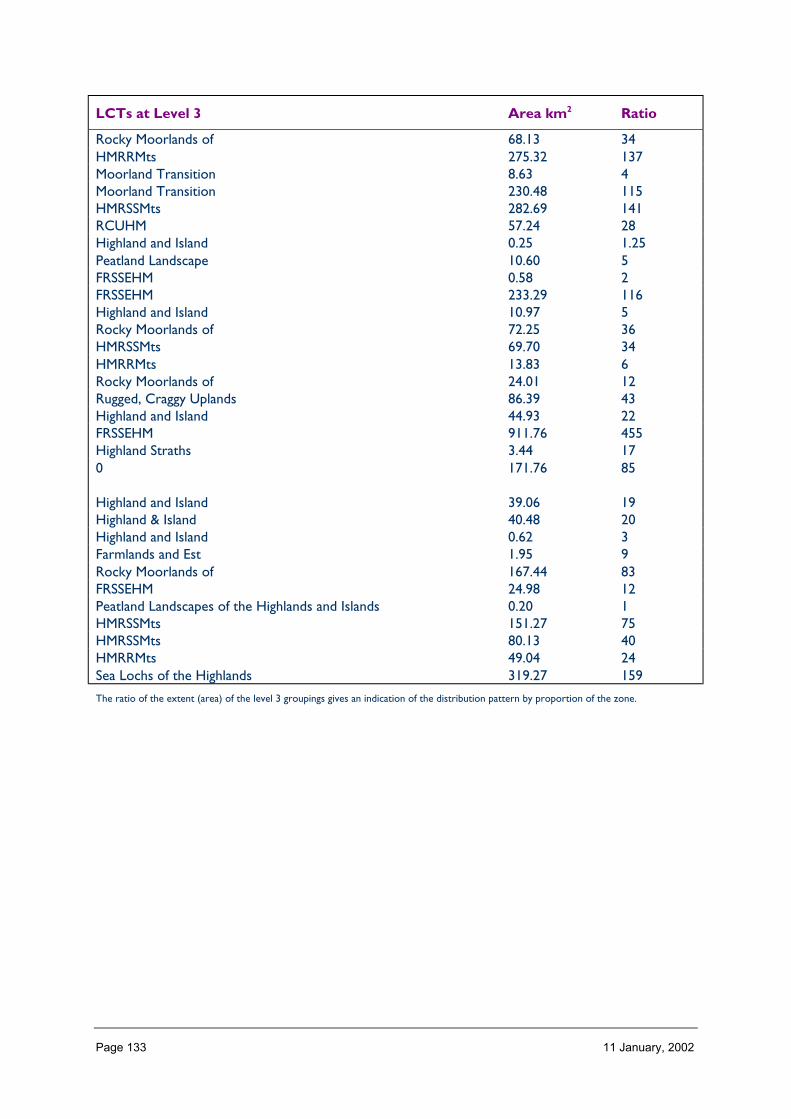
Page 133 11 January, 2002
LCTs at Level 3 Area km2 Ratio
Rocky Moorlands of 68.13 34HMRRMts 275.32 137Moorland Transition 8.63 4Moorland Transition 230.48 115HMRSSMts 282.69 141RCUHM 57.24 28Highland and Island 0.25 1.25Peatland Landscape 10.60 5FRSSEHM 0.58 2FRSSEHM 233.29 116Highland and Island 10.97 5Rocky Moorlands of 72.25 36HMRSSMts 69.70 34HMRRMts 13.83 6Rocky Moorlands of 24.01 12Rugged, Craggy Uplands 86.39 43Highland and Island 44.93 22FRSSEHM 911.76 455Highland Straths 3.44 170 171.76 85
Highland and Island 39.06 19Highland & Island 40.48 20Highland and Island 0.62 3Farmlands and Est 1.95 9Rocky Moorlands of 167.44 83FRSSEHM 24.98 12Peatland Landscapes of the Highlands and Islands 0.20 1HMRSSMts 151.27 75HMRSSMts 80.13 40HMRRMts 49.04 24Sea Lochs of the Highlands 319.27 159
The ratio of the extent (area) of the level 3 groupings gives an indication of the distribution pattern by proportion of the zone.

Page 134 11 January, 2002
Table 6.3 Rarity
LCTs at Level 1 Rarity by occurrence%
Rarity by extent%
Boulder Moors 0 2.0High Stepped Basalt 2 8.0
Marginal Farmland Mosaic 0 0.3Basalt Lowlands 2 6.7High Tops 0 8.2Craggy Upland 0 1.7Rocky Coastland 1 0.0Expansive Moss 0 0.3Granite Moorland 0 0.0Stepped Basalt Landscape 1 6.8Crofted Basalt Coast 1 0.3Volcanic Moorland 0 2.1Angular Mountain Range 0 2.0Smooth Moorland Ridges 0 0.4Rocky Moorland 0 0.7Rugged Coastal Hills 1 2.5Enclosed Bay and Offshore 0 1.3Smooth Stepped Moorland 14 26.4Coastal Strath 1 0.1Coniferous Woodland 11 5.0Linear Crofting 16 1.1Scattered Crofting 15 1.2Harbour Settlement 1 0.0Rural Estate Settlement 3 0.1Rocky Moorland and Rocky Undulating Plateau 5 4.9Landslide Edge 1 0.7Peat Hag 0 0.0Rugged Massif 4 4.4Angular Mountain Range 0 2.3Rounded Hills 0 1.4Sounds and Narrows 8 9.3
The rarity of a landscape character type within the zone can be identified by the number of time it occurs or its extent. Examination ofboth the number of occurrences (of a LCT) as a percentage of the total and the area (of a LCT) as a percentage of the total area will givean indication of rarity.
LANDSCAPE CHARACTER
Zone 6 contains a great variety of landscape character types. This reflects its diversegeology which creates a range of landforms from high, angular mountains (1), rounded hills(112), distinctive ridges (68) and stepped moorland (125) over very small areas. It alsoreflects the particular influence of social and land use characteristics, with an abundance ofvarious settlement types around the coast and within the straths (117, 69, 38, 21), and theimportance of land mass shape and islandness in relation to the sea (31, 127). The greatestdiversity and smallest areas of character types occur in the north of the zone, althoughthere is consistent prevalence of moorland types (130, 125, 144, 2) creating someunification.

Page 135 11 January, 2002
Description
Landform
PROFILE
The profile of landform over Zone 6 is quite variable, varying from high, steep sidedmountains to rounded hills and sweeping moorland. Particularly distinctive to this zone arecones of angular mountains rising from moorland surroundings and the stepped moorland,hills and inland cliffs corresponding to layers of basalt lava flow and sills.
Across the zone as a whole, a predominance of moorland is represented by 66% of the areacomprising a slope angle less than 10°, with hills and mountains making up the remainder.The impact of glaciation is quite marked in this zone with towering corries, pyramidal peaksand carved-out wide ‘U’ shaped valleys and eroded platforms scattered with deposition.
SEQUENCE
Greatly undulating moorlands make up most of Zone 6, gradually rising to massive hills inplaces. However, volcanic peaks also occur occasionally, concentrated as individual coneswith stepped moorland radiating from these, the profile of which is most obvious at cliffedges.
The sequence of varying landforms coincides closely with the geological characteristics ofthe zone. However, these are so variable and complex as to be quite difficult to discerntheir relative arrangement across the whole zone, especially where seen against variablecoast and island relationships.
SCALE
The great proportion of landform in Zone 6 is under 300m (87%), forming large scalemoorlands where there is horizontal emphasis. Within these areas, however, high hills andmountains occur; although not great in area (only 2% of the zone being over 500 m), theircontribution to the landscape character is very important – the stark contrast of peaks withmoorland emphasising the relative scale and shape of each.
LANDMARK FEATURES
Landform features occur throughout Zone 6, reflecting the very distinctive and variablegeology of the area and how this comes together. Very unusual are the flat-topped hills ofMacleod’s Tables on Skye, Dun Caan on Raasay, An Sgurr on Eigg, and the rotational sliplandform of the Trotternish Ridge. The Cuillin mountains form a key focus throughout thewestern seaboard, both on Skye and Rum, and the Small Isles and other islands formdistinctive and recognisable landmarks. Foci also occur at a smaller scale with local ‘gems’such as the coral beaches on Skye and the deep glens of the mountains on Mull.
EXPERIENCE
The experience of landform within Zone 6 seems to constantly change as you move throughthe landscape. Each hill you pass over, and every corner you turn, seems to reveal newfeatures, the moorland acting as a transitional buffer between. Where juxtaposition oflandmark features occur, the effect can be quite stunning, the contrast of these, for examplemoorland, angular mountains and sea, emphasising the relative superlatives of each. By

Page 136 11 January, 2002
indicating such complex geology and influencing land use, the landform seems to play animportant part in both the history and culture of the landscape.
Containment (created by landform and land cover)
TOPOGRAPHY
Overall, containment in this landscape is low, with a predominance of fairly gently slopedmoorland and wide, open glaciated valleys, 81% of slopes being between 1 and 16° and 87%of the zone being under 300 m. The fact that many areas of the zone form islands andpromontories also increases the sense of exposure. However, there are smaller areas ofhigh cliffs and steep mountain slopes and glens which create localised containment.
LAND COVER
Moorland and peatland vegetation comprise 50% of Zone 6. In addition to around 26%grassland and bracken, this contributes to a predominantly open landscape. The greatestamount of containment is created by woodland, which forms 12% of the zone, and of this,coniferous plantations create the most marked edges and screens. Fragments of nativewoodland, alternatively, tend to be wind-pruned and take refuge in the natural ‘nooks andcrannies’, only creating shelter at a local level.
Built elements tend to be concentrated in the main crofting and harbour settlements aroundthe coast. The crofting townships tend to be fairly dispersed to accommodate areas of in-bye, thus creating no great containment. Alternatively, the requirement for deep watersnext to harbour settlements mean they are generally located upon steep coastal slopes, thusjust reinforcing the natural containment offered by the landform.
VISIBILITY
Visibility extent is fairly great over the entire Zone 6, the large expanses of moorland andsea allowing panoramic and distant views. The landform channels and directs visibility insome places, however, even if not physically screening it; this is especially the case alongglens, ridges, steps and the coast, and towards mountain and island foci.
MICROCLIMATIC EFFECTS
The location of Zone 6 on the western seaboard means that it is generally subject towesterly Atlantic weather systems, clearly visible from the exposed, windswept moorlands.
There is generally high relative humidity and levels of precipitation, especially with theorographic lift of this over the mountains. Due to the presiding openness of the zone, localshelter afforded by both landform and woodland is greatly valued.
EXPERIENCE
The experience of containment in Zone 6, although variable and sometimes surprisinglyabrupt in response to a change of geology, is typically pre-warned by the high extent ofviews. The exception to this tends to be in areas of undulating rocky moorland and alongthe coastal edge, or in times of cloud, when it is often difficult to discern the overall lie ofthe land and features of the moorland can be concealed.

Page 137 11 January, 2002
Accessibility
DISTANCE
Zone 6 is located at considerable distance from the main population centres in the south ofScotland. Its indented coast and many islands also mean that travel within the zone is lengthyand time consuming, with restricted movement north – south and south west – north east.Access into the zone at Skye occurs over the Skye Bridge on the A87, and via the Kylerailway line from Inverness. The Small Isles towards the centre of the zone are reached byferry from Mallaig and also Arisaig in summer and Ardnamurchan is accessed via the A861to the east and from Mull. Mull is reached by ferry from Morvern or Oban to the east, andvia a ferry from Mallaig, which is accessed via the A830 from Fort William and by train fromGlasgow.
PHYSICAL ACCESS
Physical access within Zone 6 is fairly easy with 73% of the zone lying within 2 km of a publicroad. However, many of the islands are only accessible by boat. Promontories too aresometimes difficult to access, especially as many have only vehicular access on one side ofthe promontory and a spine of high ground along the central area that limits access betweeneither side. 24% of Zone 6 lies within 2–5 km of a road, yet much of this comprisesmoorland which is fairly difficult to cross due to its hagging and poor drainage. The coremountain areas, although distant from public roads, are often easily accessed via footpathspenetrating the wide, glaciated straths entering these areas. In contrast, it is sometimesmore difficult to access the mountain massif areas, less targeted by hill-walkers, yet withoutroad access.
CULTURAL ACCEPTANCE
The acceptance of public access in this landscape varies between land use types. In coastalareas, there is some acceptance of the high number of visitors wishing to access thelandscape; although this can result in conflicts in crofting areas, especially with regards towild camping and walking with dogs where grazing occurs.
Acceptance of access on to shooting estates may also cause friction off the main footpaths,especially during the stalking season.
Conflict of users is clearly indicated in some areas with an abundance of unwelcoming andhostile signs which create tension and can affect the appreciation of the landscape.
VISUAL ACCESS
Visual access in Zone 6 tends to be fairly unrestricted, except where routes run along thelowest edge of a hill area, glen or promontory. Visual movement tends to be focused withinthe mountain cores, although visibility from hills themselves reveals an extensive panoramaof islands, sea and coast.
EXPERIENCE
Generally, the landform and distribution of access routes and settlement within Zone 6results in extensive movement throughout. The complex arrangement of islands, sea andpromontories, however, means it is often difficult to decipher how one area can be reachedfrom another, and the zone may seem much more extensive than it actually is. Accessingparts of this by boat remains key to the experience of this seaboard zone, and together with
Page 138 11 January, 2002
low grade and indirect routes on land, encourages an experience of remoteness andfamiliarity with the physical conditions and cultural regions of the landscape.
Land cover (including vegetation and land use)
VEGETATION
The vegetation cover of Zone 6 contributes significantly to its landscape character, with adominance of peatland and moorland (50%) appearing as an overall matrix to local areas ofimproved grassland in crofting areas (26%), coniferous/mixed plantations (12%) and montanevegetation (4%).
This pattern of vegetation adds to the overall diversity of the zone, yet in close relation toits landform, geology and social characteristics so that local distinction of these is reinforced.
EXPOSED ROCK
Exposed rock accounts for 3% of the land cover of Zone 6. However, this is concentratedmainly in the mountains of the Skye and Rum Cuillins, along the Trotternish Ridge, withinthe rocky moorlands of Sleat, Rona and Raasay and upon the uppermost peaks of Mull.Elsewhere, although not forming large areas, exposed rock is revealed along the coastal cliffsand watercourses and forming small islands and skerries. It is also one of the maincomponents of the moorland and massif fabric in places.
BUILT DEVELOPMENT
Built development, although not extensive in area within Zone 6, contributes greatly to thelandscape character of particular localities, especially in forming crofting areas. Within these,mostly in coastal areas, built development occurs not only as houses and outbuildings, but asboundaries and access routes. Expansion of the tourist industry in recent years, however,has resulted in some traditional crofting areas having developed extensive tourist facilities,such as car parks, shops and accommodation, to the point that these built elementsdominate the underlying agricultural character of the landscape.
EXPERIENCE
The landcover of Zone 6 seems to emphasise its complex pattern of landform, access,arrangement of islands and promontories and settlement, with tiered zones often seemingto radiate from core areas of features/land use. As much of this land cover is linked tocultural/social factors, this experience changes from season to season and year to year.
Hydrology and water bodies
TYPE
Freshwater lochs and watercourses tend to have less significance in contributing to thelandscape character of Zone 6 than the juxtaposition and nature of the coast and sea.However, linked to this, the meeting of rivers and streams with the coast often createsfeatures, especially where waterfalls occur at this join and there is a bridging point for acoastal access route.
Freshwater lochs are not abundant through the zone and there is greater occurrence ofsmall lochans, particularly within areas of undulating moorland. Streams are most marked

Page 139 11 January, 2002
where their activity and noise affects the local tranquillity of moorland areas and where theyhave carved deep, bolder strewn glens which harbour ribbons of native woodland.
PATTERN
The pattern of hydrology within Zone 6 is not clearly defined on account of the proximityof most parts of the zone to the sea. However, repetition is most clearly seen along thestraths and linear promontories where watercourses run fairly direct and at regularintervals either side. A radial pattern of drainage is also discernible within mountain coresand upon many of the small, compact islands.
EXPERIENCE
Although not a dominant characteristic of Zone 6 as a whole, rivers do contributesignificantly to the experience of the landscape where they feature within the straths andglens, and especially where these abut the coast, often into a sea loch or bay. Theirpresence in these locations is emphasised by being where most access routes andsettlements occur.
Within the interior moorland areas, the low and undulating landform means it is oftendifficult to view and appreciate the extent, distribution and visual diversity of rivers andlochs. Locally, however, the activity, sounds and vegetation of wildlife associated with thesecreate natural foci of attention.
Built and infrastructure development (present day)
NATURE AND PATTERN OF SETTLEMENT
Although settlement within Zone 6 is not extensive, being as it is a peripheral part ofScotland, low density crofting settlements occur frequently within coastal areas and alongthe straths of the landscape, utilising favourable areas of shelter, deeper soils, gentler slopesand good access. In contrast, most mountain and hill areas and the smaller, remote islandsare largely devoid of settlement and possess a strong sense of remoteness, with estatebuildings generally concentrated at the edge of their lands.
NATURE AND PATTERN OF INFRASTRUCTURE
Roads, bridges and ferries are the most obvious elements of infrastructure in Zone 6.Although coverage of roads is fairly extensive, many routes are indirect in nature or ‘no-through’ routes and thus create almost a dendritic pattern of off shoots rather than a net-like arrangement. The combined route of roads and power lines with the occasional foci oflocal borrow pits and parking areas can dominate the contained spaces of the straths,particularly where these are crossed by these elements over a central loch or bay.
NATURE AND PATTERN OF INDUSTRIAL DEVELOPMENT
There is little industrial development in this landscape. Heavy industries which do occur,tend to be linked to the natural resources of this landscape, for example Skye marblequarrying, forestry and Talisker distillery. However light industry has been increasing,concentrated around the main towns. Unfortunately this tends to be located in businessparks which bear no reflection to the unique landscape characteristics of the zone.
This is also the case with some of the tourist industry development which dominates thelandscape in certain locations.

Page 140 11 January, 2002
EXPERIENCE
Infrastructure and associated development appears to dominate certain parts of thislandscape, where provision tends to cater for high summer demand, yet this is excessive atother times. This can result in a fluctuating experience of a landscape actually dominated bythose people accessing it to times when a ‘ghost town’ effect occurs.
Large scale industrial development, although affecting the landscape character of a locality,may actually appear positive in relation to utilising the particular qualities of the place,especially where this reveals a physical feature of the landscape which would not otherwisebe visible such as its geology. Small scale industry integrated into the small croft and harbourareas can also appear very positive by the activity and visual interest of diversity this creates.
Visible history (past settlement, landuse, churches, brochs, forts, dykes, standingstones etc.)
TYPES OF VISIBLE HISTORY
Evidence of history in Zone 6 occurs extensively, highlighted by the local culture whichoften recounts past events, particularly the clearances. Of prominence, dating back toNeolithic and Bronze Age times, are a number of standing stones, burial mounds and cairns,although the duns and brochs of Iron Age defensive sites are of greater notoriety, their largestone structures looking still very impressive by seeming to ‘grow’ robustly out of thelandform.
The historical clan system and later shooting estates are represented by a number of castlesand lodges in the zone, some of which form very popular visitor attractions. Of less popularappeal, although of great local interest conveyed through the arts and media, are theabandoned crofting settlements dating back to the 18th, 19th and even the 20th centuries.These sometimes occur in remote areas so their remains covered in vegetation are onlyaccessible on foot. However some relics such as old black houses and stone dykes occurwithin existing croft settlements, the old structures ‘growing’ out of the landscape oftenseeming in stark contrast to modern ‘kit’ buildings which appear unconnected to theirsurroundings in comparison.
Old shielings are visible upon some of the hills of this zone, inconspicuously occurring onsheltered shelves in the slopes and often marked by an isolated patch of improved grazingand the relics of stone structures.
LOCATION/PATTERN
The overall distribution of historic features through this landscape is extensive, mainly onaccount of the proximity of the coast to most areas, features often being located near tothe sea or along the straths leading inland from these. The most ancient defensive structurestend to occupy fairly prominent defensible positions, whilst settlements and dwellings tendto have targeted areas with favourable shelter, slopes, soil and access.
EXPERIENCE
Although historic features do not dominate the overall character of this zone, they form keyfeatures within certain localities; and with a fairly equal and extensive distribution offeatures, they create a sense of evolution in the landscape. This is also portrayed within theculture of the zone – on Skye particularly. Portrayal of the clearances, especially, is common
Page 141 11 January, 2002
place in the media and arts, the stories of which affect one’s appreciation of the visible relicsof this time in the landscape.
Wildlife
FORMS OF WILDLIFE
Wildlife characteristic of this zone chiefly include both mountain and moorland and coastalspecies – otter, eagles, red deer, gulls, cormorants, seals, salmon, wildcats, pine martens andmidges. The indented nature of the land mass means that various ecosystems combine tocreate great diversity over small areas.
LOCATION
Deer, pine martens and wildcats tend to be located in the mountain, moorland andwoodland areas chiefly found in landscape character types 125, 1, 12, 113, 130, 144, 51, 222, 50 and 106 (level 1). Eagles and other birds of prey tend to concentrate in the rockymountain areas (1, 51, 112, 50 and 22, level 1). Otters, seals, and fish obviously occur incoastal areas and character types 127 and 31 (level 1). However, as mentioned above, theintermingling of various landscape types and habitats in Zone 6 means that anydifferentiation tends to be at a local scale.
WHEN
Deer are usually most notable during autumn and winter on account of their roaring at thebeginning of this season, and their descent from the mountains in the worst weather tograze lower grasslands. Birds tend to be most notable in spring and in early morning whenmost active and vocal, and otters and seals tend to be most obvious when basking on rocksin warm weather. Midges are prolific throughout late spring, summer and early autumnmonths.
EXPERIENCE
Wildlife are not so obvious throughout Zone 6 as a whole as to affect its entire character,and many interior moorland and mountain areas appear to contain low numbers of wildlife,being disadvantaged by their fairly small extent yet high numbers of human visitors. Incontrast, wildlife do affect the local character of coastal areas quite markedly in all seasonsas the long length of indented coastline and narrow lochs and sounds harbour an active andvocal diversity of birds, mammals, insects and fish. These species, especially those which areperceived as being rare, such as eagles and otters, can intensify feelings of remoteness andtheir activity, and play in the case of otters, cause great interest emphasised by theirportrayal in local arts.
In contrast to these, however, midges, although also depicted in arts and the media, areperceived more as blight than blessing. These can create so great a nuisance as to stronglyaffect the nature in which, and whether at all, people experience the landscape.
Climate
CLIMATIC CHARACTERISTICS
Climate characteristics are fairly consistent over Zone 6, dominated by a coastal situationsubject to a prevalence of Atlantic westerly weather systems. There is some variationhowever between the western most coasts and eastern interior due to lessening maritime

Page 142 11 January, 2002
effects; and between the north and south of the zone on account of different latitude.Annual precipitation levels are high – around 1850 mm; and although there is a Decembermaximum, levels don’t typically fall below 100 mm for any month of the year. Mean wintertemperatures vary 10c between the west and east of the zone, but average at 4.50c. Meansummer maximum temperature varies again about 10c between the west and eastern areasof the zone, but average out at a mean of 13.50 c. Levels of snowfall are low throughout thezone, and snow tends to mainly occur on the high mountain tops.
LOCATIONAL AND SEASONAL EFFECTS
Zone 6 as a whole tends to be most influenced in its character by a barrage of Atlanticdepressions which hit it from the west. This results in high levels of precipitation and cloudcover, particularly in mountain and hill areas. Dry conditions occur most often in April andMay, the latter of these months also having the most sunshine. The proximity of the coastthroughout much of this zone results in great clarity of light, and its western emphasismeans that sunsets often feature quite spectacularly in the landscape. Hours of daylight arefew in winter, however, in contrast, summer brings long hours of light, resulting in acorresponding increase of activity in the landscape most marked by the activity of touristsand agricultural cropping.
EXPERIENCE
Climatic conditions contribute greatly to the experience of this zone, particularly as thelandscape is revealed as an intrinsic combination of sea, sky and land. The impact of theweather is also very acute because of the zones exposure to westerly weather systems andbecause these greatly affect the nature of the sea, and thus whether some parts of the zoneare accessible from mainland Scotland at all.
Experience of the great clarity of light in this landscape is quite spectacular on clear days,this highlighting the lush hues of the coastal vegetation in contrast to the reflecting rockytops of the mountains, the dark tones of the deep sea and the bright white of harled houses.Changing weather conditions are very visible within this composition, views of rapidlymoving clouds and their shadows across the land and seascape combining with the surpriseappearance and fading of rainbows, and selective spot lighting of features as showers passover the zone, creating a very dynamic quality to the landscape experience.
Designated landscapes
National Scenic Areas
CONSTITUENTS
Zone 6 contains 5 NSAs: Trotternish; The Cuillin Hills; The Small Isles; Morar, Moidart andArdnamurchan and Loch na Keal, Isle of Mull.
Trotternish NSA is entirely contained within Zone 6 and mainly comprises the landscapecharacter types (level 1) landslide edge (68) and smooth, stepped moorland (125), with smallareas of linear crofting (69), scattered crofting (117), rugged massif (115) and sounds andnarrows (127).
The Cuillin Hills NSA is also contained in its entirety within Zone 6. Angular mountains (1,level 1) form the core of this, with smaller areas of rounded Hills (112), rugged massif (115)and smooth, stepped moorland (125), with a scattering of crofting, settlement, woodland,
Page 143 11 January, 2002
rocky moorland and strath landscape character types around the margins (21, 69, 117, 38and 106).
The Small Isles NSA is contained within Zone 6. The distribution of landscape charactertypes within this NSA is not equal, with the main type, angular mountain range (no 1, level1) solely occurring on Rum. Type 124 and 105, smooth moorland ridges and rockymoorland respectively, are also exclusive to Rum – Eigg, Canna and Muck all comprising amix of 130 and 23, stepped basalt and crofted basalt coast.
Throughout the Small Isles the qualities of the NSA rely on the presence and juxtapositionposition of the sea and the islands as a collective group, as well as the relative qualities ofthe landscape character types themselves.
Approximately 52% of the Morar, Moidart and Ardnamurchan NSA is contained withinZone 6. This mainly comprises areas (from west to east) of volcanic moorland (144)stepped basalt landscape (130) and rugged coastal hills (113), with small areas of rockycoastland and expansive moss (104 and 32 respectively).
Loch na Keal NSA forms a small part of the Isle of Mull, contained entirely within Zone 6.Seventy three per cent of the NSA comprises high, stepped basalt landscape character type(50) with the remainder fairly equally comprising basalt lowlands (2) and high tops (51),although the sea too obviously plays a key role in forming the character of this area.
LOCATION AND EXTENT
The Trotternish NSA is located along the eastern ‘wing’ of Skye in the north of Zone 6,extending to 60 km square. The Cuillin Hills NSA occurs to the south east of Skye, towardsthe centre of Zone 6 and is 218 km square in extent. The Small Isles NSA is located withinThe Minch, almost halfway between Skye and Rum and within the central part of Zone 6; itcovers 155 km square. Morar Moidart and Ardnamurchan NSA encompasses 2 largepromontories extending to the west from the mainland north of Mull.
Within Zone 6, the NSA measures 80 km square out of a total area of the NSA of 154 kmsquare. Loch na Keal NSA is located on the west coast of Mull in the southern part of Zone6, extending to 123 km square in area.
EXPERIENCE
The experience of all 5 NSAs contained with Zone 6 varies greatly as all exhibit quitedifferent characteristics. The Trotternish and Cuillin Hills NSAs tend to be most greatlyappreciated for the spectacular and superlative nature of their landform and geologicalcharacteristics to the small scale settlement around their periphery. Although even betweenthese, there is a difference of experience, as the Cuillins are targeted by mountain climbersand are fairly inaccessible in forming a core surrounded by moorland although viewed fromafar; whilst Trotternish is small and familiar in scale and fairly easy to access, encouraginggreater visitation from the general public.
The experience of the Small Isles NSA is dominated by the collective arrangement of theisles within the sea and strongly distinguished by the mode of arrival and departure to theisles via boat. Although all the islands are relatively small in scale and Canna, Muck and Eiggare similar in landscape character, the experience of each varies in relation to their distinctcultural and social characteristics.
Page 144 11 January, 2002
The experience of Morar, Moidart and Ardnamurchan NSA is very much affected by theperipheral location of this area on the mainland and the scarcity of access which creates anintent sense of remoteness within many parts.
Loch an Keal NSA with its intricate arrangement of lochs and islands creates quite a diverselandscape of varying features at varying scales but inextricably linked by the sea.
Historic gardens and designed landscapes
NATURE OF THE LANDSCAPES DESIGNATED AND NON-DESIGNATED
There are 2 Historic Gardens and Designated landscapes (HGDL) throughout Zone 6.
Recreational landscapes
Nature of landscapesThe main focus of recreation within this landscape occurs along the coast and adjacent tothe main mountain areas. Targeting of the coast occurs not only because of the features thisincludes such as beaches, coastal walks and harbours, but also because most of theinfrastructure and services occur along the coastal edge, also linking to other areas via boat,ferry and bridges. Many visitors travel through the zone via circulatory road systems and‘island hopping’ by boat. However, the peripheral ‘wings’ of the zone such as Ardnamurchan,Morvern, Duirinish and Waternish tend to not be targeted for this reason, not possessingsuch circular routes. Within the mountain and moorland areas, recreation tends to betargeted upon the Munros (peaks over 3000 ft).
LOCATION
Within Zone 6, the main beach areas used for recreation are evenly distributed around thecoast of Skye within bay areas and include Talisker, Glen Brittle, and Tarskaraig on Sleat.There are beaches all around Muck, Canna and Eigg, with a few on Rum, and numerousupon the western edge of Ardnamurchan and Mull, Ulva and Iona, the abbey on the latteralso being visited by large numbers of people. The key harbour towns providing recreationand visitor foci and ferry connections for ‘island hopping’ are: Armadale, Uig and Portree onSkye; Kinloch, An Coroghan, Galmisdale and Part Mór on the Small Isles; Kilchoan andKentra on Ardnamurchan; and Craignure, Tobermory, Salen and Lochdon on Mull.
The key foci for hill walking and mountain climbing are the Cuillins of Skye and Rum, AnSgurr on Eigg and Ben More and the hills of Mull.
EXPERIENCE
At a broad scale, recreational experience of Zone 6 is fairly similar, centred around thelandscape resource and specifically the mountains, coast and sea. However at a local levelthere is great diversity of experience occurring over fairly small areas, added to by a districtresident population and portrayal of culture in the landscape and the dynamic and varyingweather conditions. This means that although large numbers of people partaking inrecreation at the key attractions at certain times may compromise the quality of landscapein these places, there are numerous other landscapes which can be appreciated at a morepersonal level uninterrupted by distractions.
Page 145 11 January, 2002
2 Importance and value of the zone landscape
A judgement of the importance or value of the zonal landscape under the followingheadings.
Category Brief explanation oflandscape importance(if any)
Importance(GB, Scotland,zone)
Landscape Character Importancerarity Trotternish, Cuillins and
Small Isles very rarefeatures and combinationsof LCTs
GB
extentdiversity (including specific landmarks) Very diverse combination
of LCTs on Skye linked toparticular geology andcultural characteristics
Scotland
pattern Linear crofting along coast Zonalintegrity Zonallocal distinctiveness Islandness combined with
distinct LCTs and culturallandscape characteristics
Scotland
fragility/sensitivity Small extent of uniquequalities
Scotland
Scenic importance
qualities ‘old fashioned’ perceptionof qualities – combinationof islands, sea, mountainsetc.
Scotland
perceptions Strongly portrayed inmedia and arts. ManyNSAs and high visitornumbers.
Learning ImportanceEnvironmental Education Geology demonstration.
Sabhal Mor Ostaig.Scotland
Interpretation Facilities available. ZonalEnjoyment ImportanceRecreation Mountain climbing. Island
hopping.Scotland
Amenity Zonalwildness and tranquillity High visitor numbers and
actively managed.Zonal
DesignationsNSAs 5 NSAs (4 complete, 1
50%) covering some veryrare landscapes
Scotland
AGLVs ? ZonalRegional Landscape Designations ? Zonal

Page 146 11 January, 2002
Historic Gardens & Designed Landscapes 7 HGDLs ZonalCultural Importancepre history (designated/non-designated) Input from HS ?medieval (designated/non-designated)recent (designated/non-designated)Socioeconomic Importancesocial Feature strongly in
portrayal of landscape andthus perception. Natureof crofting, estatemanagement, fishing andservice industries key tolandscape character.
Zonal
economic Zonal
3 Landscape and trends in the zone
• Pressures/influences which have a particular effect on the landscape of the zone:• Nature of landscape pressures/influences – a brief description• Trends: increasing, static or declining
− long term (> 5 years), medium term (2 to 5 years),− short term (< 2 years)
• Importance: important, not important
Pressure Nature of landscapepressures/influencesand trends withinzone, relativeimportance within thezone
Scale of landscape influence(+ve/–ve) within zone whenconsidered in an all Scotlandcontext
Major Inter. Minor Negligible
Built developmentResidential Steady increase in holiday
homes. ‘Kit’ housesthreaten intrinsiclandscape character
�
Retail Tourism related and*larger, out of town,developments
�
Industrial Business parks. Small scalebut divert activity fromsettlements
�
OtherInfrastructure TransportRoads and tracks Pressure for road
upgrading and newagricultural tracks
�
Rail related Could be utilised further �Ferry related Pressure for new,
upgraded facilities�

Page 147 11 January, 2002
Other Bridge construction andupgrading
�
Infrastructure otherTelecoms Number of individual
applications. Veryprominent.
�
Water treatment/abstractionWaste management Problems storing waste
before removal offshorefrom islands
�
Coastal defences Particular concerns in andaround settlements
�
OtherMineralsOpen cast coalSand and Gravel Traditional �Hard rock Skye marble and other
aggregates. Restorationafter working life is issue..
�
Peat Hand cuttings feature ofthe landscape. Mechanicalcutting results in localimpact.
�
OtherForestry and WoodlandsRestructuring of existing Existing plantations are
highly visible. Sometimesuneconomic to fell.
�
Creation of new small Increasing steadily.Difficult to incorporatewithin croft withoutaffecting pattern andagricultural character.
�
Creation of large new/native Large blocks particularlyon Mull. Impact of fencing.
�
Other Rhododendron controlneeded in certain areas.
�
Aquaculture and FishingFinfish Fairly stable �Shellfish Increase in numbers and
extent. Cumulative impactvery significant in certainareas.
�
Fishing (River & loch) �Other Shore related
development�
Land ManagementSheep production Excessively high numbers
of sheep. Prevent treeregen.
�
Crop production Gradually diminishing tolead to loss of landscapepattern and seasonal
�
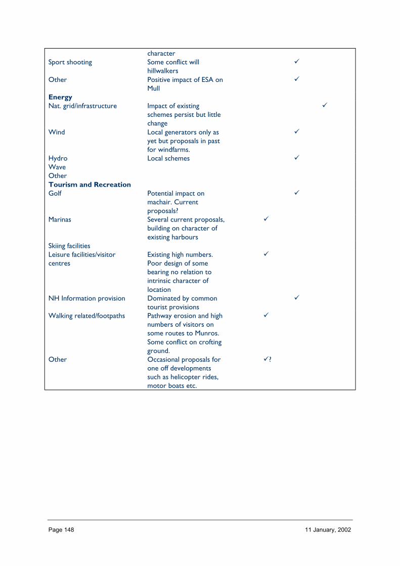
Page 148 11 January, 2002
characterSport shooting Some conflict will
hillwalkers�
Other Positive impact of ESA onMull
�
EnergyNat. grid/infrastructure Impact of existing
schemes persist but littlechange
�
Wind Local generators only asyet but proposals in pastfor windfarms.
�
Hydro Local schemes �WaveOtherTourism and RecreationGolf Potential impact on
machair. Currentproposals?
�
Marinas Several current proposals,building on character ofexisting harbours
�
Skiing facilitiesLeisure facilities/visitorcentres
Existing high numbers.Poor design of somebearing no relation tointrinsic character oflocation
�
NH Information provision Dominated by commontourist provisions
�
Walking related/footpaths Pathway erosion and highnumbers of visitors onsome routes to Munros.Some conflict on croftingground.
�
Other Occasional proposals forone off developmentssuch as helicopter rides,motor boats etc.
�?
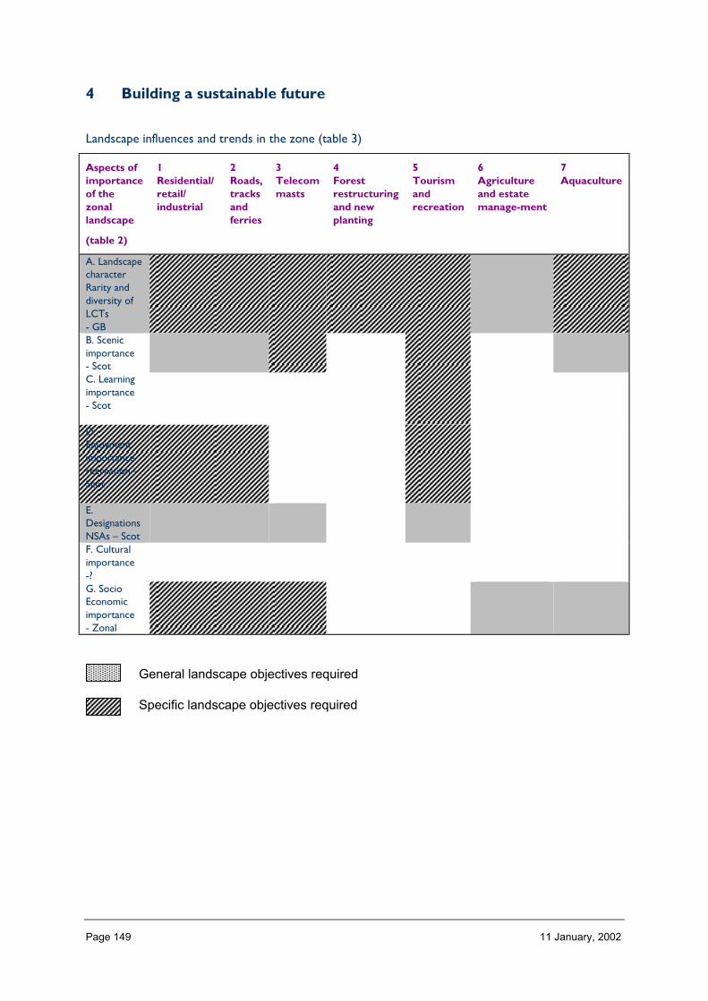
Page 149 11 January, 2002
4 Building a sustainable future
Landscape influences and trends in the zone (table 3)
Aspects ofimportanceof thezonallandscape
(table 2)
1Residential/retail/industrial
2Roads,tracksandferries
3Telecommasts
4Forestrestructuringand newplanting
5Tourismandrecreation
6Agricultureand estatemanage-ment
7Aquaculture
A. LandscapecharacterRarity anddiversity ofLCTs- GBB. Scenicimportance- ScotC. Learningimportance- Scot
D.Enjoymentimportancerecreation –Scot
E.DesignationsNSAs – ScotF. Culturalimportance-?G. SocioEconomicimportance- Zonal
General landscape objectives required
Specific landscape objectives required

Page 150 11 January, 2002
ZONE 7 NORTHERN HIGHLANDS
1 Nature of the landscape resource
Diversity, distribution and rarity of landscape character in the zoneNote: Ignore any LCT which is shown as <10 km sq (if important feature will be coveredelsewhere, if important characteristic locally will be flagged up in description)
Table 7.1 Diversity
Zone LCTLevel 1
LCTLevel 3
Context Areakm2
7 Sweeping Moorland FRSSEHM Highland 2.707 Strath Highland Straths Highland 23.007 Small Farms and Crofts Highland and Island
CroftingLandscapes
Highland 2.22
7 Coniferous WoodlandNo informationprovided in report.
0 NULL 52.52
7 Broadleaved/MixedWoodland Noinformation provided in
0 NULL 9.28
7 Moorland Slopes andHills
HMRRMts Highland 224.03
7 Irregular Massif HMRSSMts Highland 137.597 Kyles Firths and Sea
LochsSea Lochs of theHighlands andIslands
Highland Coastal 0.00
7 Rugged Massif HMRSSMts Highland 685.367 Farmed Straths Highland Straths Highland 53.657 Narrow Farmed Straths Highland Straths Highland 98.737 Rolling Uplands HMRRMts Highland 71.937 Rocky Moorland Plateau Rocky Moorlands
of the Highlandsand Islands
Highland 283.06
7 Farmed and WoodedFoothills
Highland Foothills Highland 81.68
7 Broad Steep-Sided Glen Highland and IslandGlens
Highland 193.31
7 Wooded Glen Highland and IslandGlens
Highland 59.39
7 Narrow Wooded Glen Highland and IslandGlens
Highland 126.99
7 Broad Forested Strath Highland Straths Highland 161.407 Smooth Moorland
RidgesHMRRMts Highland 232.25
7 Rocky Moorland Rocky Moorlandsof the Highlandsand Islands
Highland 155.27
7 Rugged Massif HMRSSMts Highland 47.33
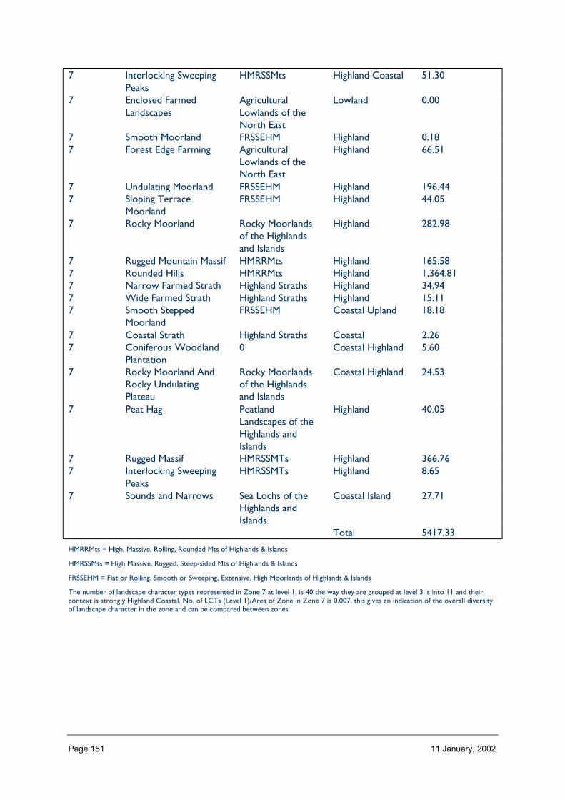
Page 151 11 January, 2002
7 Interlocking SweepingPeaks
HMRSSMts Highland Coastal 51.30
7 Enclosed FarmedLandscapes
AgriculturalLowlands of theNorth East
Lowland 0.00
7 Smooth Moorland FRSSEHM Highland 0.187 Forest Edge Farming Agricultural
Lowlands of theNorth East
Highland 66.51
7 Undulating Moorland FRSSEHM Highland 196.447 Sloping Terrace
MoorlandFRSSEHM Highland 44.05
7 Rocky Moorland Rocky Moorlandsof the Highlandsand Islands
Highland 282.98
7 Rugged Mountain Massif HMRRMts Highland 165.587 Rounded Hills HMRRMts Highland 1,364.817 Narrow Farmed Strath Highland Straths Highland 34.947 Wide Farmed Strath Highland Straths Highland 15.117 Smooth Stepped
MoorlandFRSSEHM Coastal Upland 18.18
7 Coastal Strath Highland Straths Coastal 2.267 Coniferous Woodland
Plantation0 Coastal Highland 5.60
7 Rocky Moorland AndRocky UndulatingPlateau
Rocky Moorlandsof the Highlandsand Islands
Coastal Highland 24.53
7 Peat Hag PeatlandLandscapes of theHighlands andIslands
Highland 40.05
7 Rugged Massif HMRSSMTs Highland 366.767 Interlocking Sweeping
PeaksHMRSSMTs Highland 8.65
7 Sounds and Narrows Sea Lochs of theHighlands andIslands
Coastal Island 27.71
Total 5417.33
HMRRMts = High, Massive, Rolling, Rounded Mts of Highlands & Islands
HMRSSMts = High Massive, Rugged, Steep-sided Mts of Highlands & Islands
FRSSEHM = Flat or Rolling, Smooth or Sweeping, Extensive, High Moorlands of Highlands & Islands
The number of landscape character types represented in Zone 7 at level 1, is 40 the way they are grouped at level 3 is into 11 and theircontext is strongly Highland Coastal. No. of LCTs (Level 1)/Area of Zone in Zone 7 is 0.007, this gives an indication of the overall diversityof landscape character in the zone and can be compared between zones.

Page 152 11 January, 2002
Table 7.2 Distribution/pattern
Zone LCTlevel 1
LCTlevel 3
% ofZone(area)
No. ofOccurrences
Area(km2)
7 Sweeping Moorland FRSSEHM 0.0 1 2.707 Strath Highland Straths 0.4 5 23.007 Small Farms and
CroftsHighland andIsland CroftingLandscapes
0.0 4 2.22
7 ConiferousWoodland Noinformationprovided in report.
0 1.0 15 52.52
7 Broadleaved/MixedWoodland Noinformationprovided in
0 0.2 10 9.28
7 Moorland Slopesand Hills
HMRRMts 4.1 6 224.03
7 Irregular Massif HMRSSMts 2.5 2 137.597 Kyles Firths and
Sea LochsSea Lochs of theHighlands andIslands
0.0 1 0.00
7 Rugged Massif HMRSSMts 12.5 2 685.367 Farmed Straths Highland Straths 1.0 2 53.657 Narrow Farmed
StrathsHighland Straths 1.8 1 98.73
7 Rolling Uplands HMRRMts 1.3 2 71.937 Rocky Moorland
PlateauRocky Moorlandsof the Highlandsand Islands
5.2 2 283.06
7 Farmed andWooded Foothills
HighlandFoothills
1.5 1 81.68
7 Broad Steep-SidedGlen
Highland andIsland Glens
3.5 2 193.31
7 Wooded Glen Highland andIsland Glens
1.1 1 59.39
7 Narrow WoodedGlen
Highland andIsland Glens
2.3 3 126.99
7 Broad ForestedStrath
Highland Straths 2.9 2 161.40
7 Smooth MoorlandRidges
HMRRMts 4.2 4 232.25
7 Rocky Moorland Rocky Moorlandsof the Highlandsand Islands
2.8 1 155.27
7 Rugged Massif HMRSSMts 0.9 2 47.337 Interlocking
Sweeping PeaksHMRSSMts 0.9 1 51.30

Page 153 11 January, 2002
7 Enclosed FarmedLandscapes
AgriculturalLowlands of theNorth East
0.0 3 0.00
7 Smooth Moorland FRSSEHM 0.0 1 0.187 Forest Edge
FarmingAgriculturalLowlands of theNorth East
1.2 6 66.51
7 UndulatingMoorland
FRSSEHM 3.6 8 196.44
7 Sloping TerraceMoorland
FRSSEHM 0.8 3 44.05
7 Rocky Moorland Rocky Moorlandsof the Highlandsand Islands
5.2 12 282.98
7 Rugged MountainMassif
HMRRMts 3.0 8 165.58
7 Rounded Hills HMRRMts 24.9 5 1,364.817 Narrow Farmed
StrathHighland Straths 0.6 2 34.94
7 Wide FarmedStrath
Highland Straths 0.3 2 15.11
7 Smooth SteppedMoorland
FRSSEHM 0.3 2 18.18
7 Coastal Strath Highland Straths 0.0 3 2.267 Coniferous
WoodlandPlantation
0 0.1 2 5.60
7 Rocky MoorlandAnd RockyUndulating Plateau
Rocky Moorlandsof the Highlandsand Islands
0.4 8 24.53
7 Peat Hag PeatlandLandscapes ofthe Highlandsand Islands
0.7 2 40.05
7 Rugged Massif HMRSSMTs 6.7 5 366.767 Interlocking
Sweeping PeaksHMRSSMTs 0.2 1 8.65
7 Sounds andNarrows
Sea Lochs of theHighlands andIslands
0.5 7 27.71
Total 150 5417.33
In Zone 7 a total 150 occurrences of landscape character types (landscape units) are found within a zone of total land area 5417 km sq.The figure 150/5417 is 0.027 per km sq of land within the zone and gives a relative indication of the overall brokenness or fragmentationof the landscape pattern.
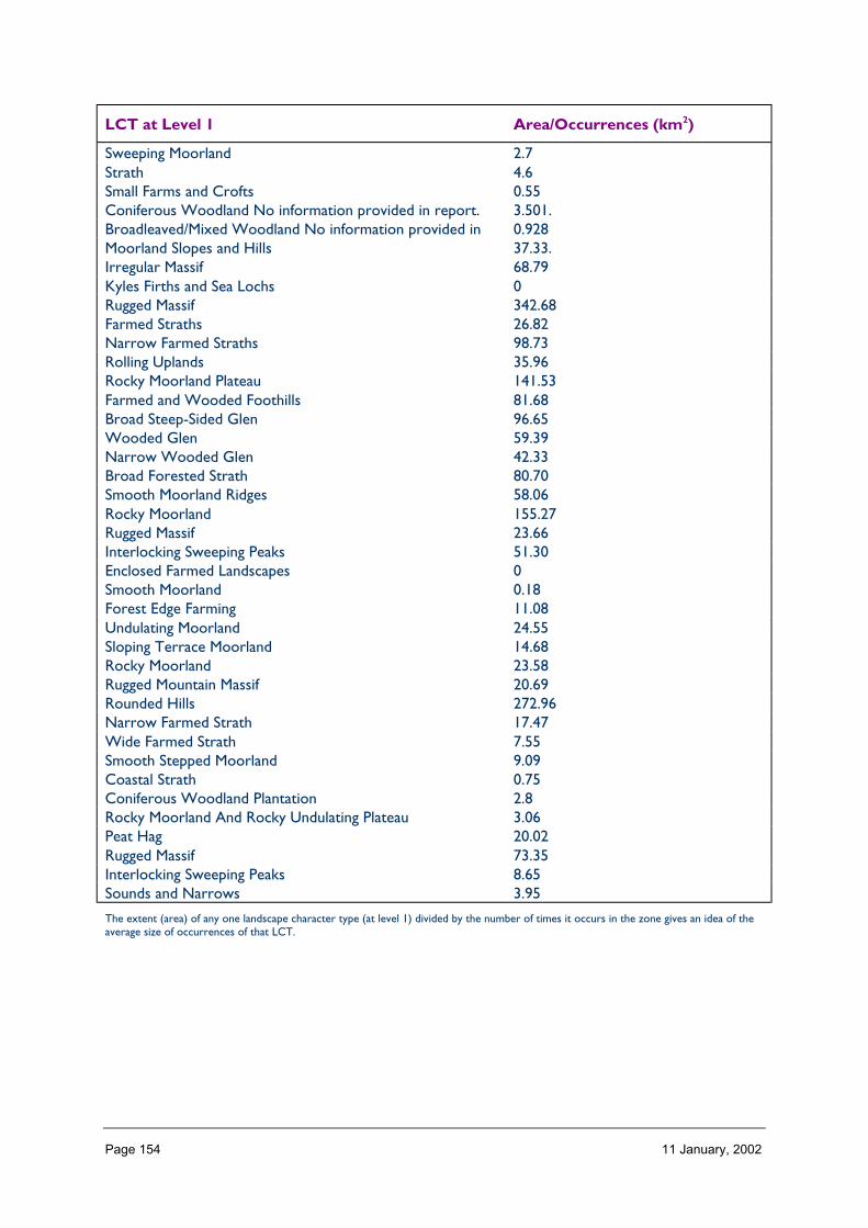
Page 154 11 January, 2002
LCT at Level 1 Area/Occurrences (km2)
Sweeping Moorland 2.7Strath 4.6Small Farms and Crofts 0.55Coniferous Woodland No information provided in report. 3.501.Broadleaved/Mixed Woodland No information provided in 0.928Moorland Slopes and Hills 37.33.Irregular Massif 68.79Kyles Firths and Sea Lochs 0Rugged Massif 342.68Farmed Straths 26.82Narrow Farmed Straths 98.73Rolling Uplands 35.96Rocky Moorland Plateau 141.53Farmed and Wooded Foothills 81.68Broad Steep-Sided Glen 96.65Wooded Glen 59.39Narrow Wooded Glen 42.33Broad Forested Strath 80.70Smooth Moorland Ridges 58.06Rocky Moorland 155.27Rugged Massif 23.66Interlocking Sweeping Peaks 51.30Enclosed Farmed Landscapes 0Smooth Moorland 0.18Forest Edge Farming 11.08Undulating Moorland 24.55Sloping Terrace Moorland 14.68Rocky Moorland 23.58Rugged Mountain Massif 20.69Rounded Hills 272.96Narrow Farmed Strath 17.47Wide Farmed Strath 7.55Smooth Stepped Moorland 9.09Coastal Strath 0.75Coniferous Woodland Plantation 2.8Rocky Moorland And Rocky Undulating Plateau 3.06Peat Hag 20.02Rugged Massif 73.35Interlocking Sweeping Peaks 8.65Sounds and Narrows 3.95
The extent (area) of any one landscape character type (at level 1) divided by the number of times it occurs in the zone gives an idea of theaverage size of occurrences of that LCT.

Page 155 11 January, 2002
LCTs at Level 3 Area km2 Ratio
FRSSEHM 2.70 11Highland Straths 23.00 127Highland and Island Crofting Landscapes 2.22 120 52.52 280 9.28 50HMRRMts 224.03 124HMRSSMts 137.59 76Sea Lochs of the Highlands and Islands 0.00 0HMRSSMts 685.36 380Highland Straths 53.65 29Highland Straths 98.73 54HMRRMts 71.93 39Rocky Moorlands of the Highlands and Islands 283.06 157Highland Foothills 81.68 45Highland and Island Glens 193.31 107Highland and Island Glens 59.39 32Highland and Island Glens 126.99 70Highland Straths 161.40 89HMRRMts 232.25 129Rocky Moorlands of the Highlands and Islands 155.27 86HMRSSMts 47.33 26HMRSSMts 51.30 28Agricultural Lowlands of the North East 0.00 0FRSSEHM 0.18 1Agricultural Lowlands of the North East 66.51 36FRSSEHM 196.44 108FRSSEHM 44.05 24Rocky Moorlands of the Highlands and Islands 282.98 155HMRRMts 165.58 91HMRRMts 1,364.81 758Highland Straths 34.94 18Highland Straths 15.11 83FRSSEHM 18.18 10Highland Straths 2.26 110 5.60 2Rocky Moorlands of the Highlands and Islands 24.53 13Peatland Landscapes of the Highlands and Islands 40.05 22HMRSSMTs 366.76 20HMRSSMTs 8.65 4Sea Lochs of the Highlands and Islands 27.71 15
The ratio of the extent (area) of the level 3 groupings gives an indication of the distribution pattern by proportion of the zone.
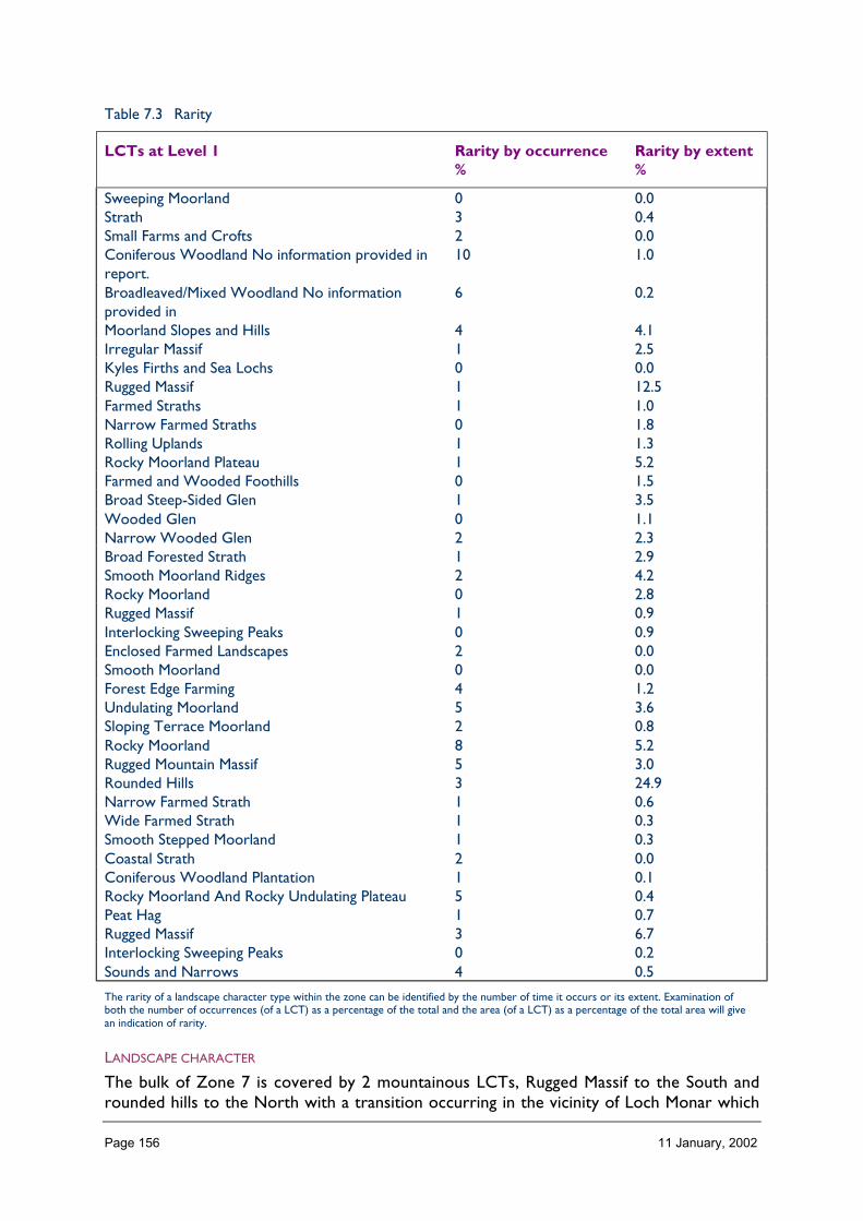
Page 156 11 January, 2002
Table 7.3 Rarity
LCTs at Level 1 Rarity by occurrence%
Rarity by extent%
Sweeping Moorland 0 0.0Strath 3 0.4Small Farms and Crofts 2 0.0Coniferous Woodland No information provided inreport.
10 1.0
Broadleaved/Mixed Woodland No informationprovided in
6 0.2
Moorland Slopes and Hills 4 4.1Irregular Massif 1 2.5Kyles Firths and Sea Lochs 0 0.0Rugged Massif 1 12.5Farmed Straths 1 1.0Narrow Farmed Straths 0 1.8Rolling Uplands 1 1.3Rocky Moorland Plateau 1 5.2Farmed and Wooded Foothills 0 1.5Broad Steep-Sided Glen 1 3.5Wooded Glen 0 1.1Narrow Wooded Glen 2 2.3Broad Forested Strath 1 2.9Smooth Moorland Ridges 2 4.2Rocky Moorland 0 2.8Rugged Massif 1 0.9Interlocking Sweeping Peaks 0 0.9Enclosed Farmed Landscapes 2 0.0Smooth Moorland 0 0.0Forest Edge Farming 4 1.2Undulating Moorland 5 3.6Sloping Terrace Moorland 2 0.8Rocky Moorland 8 5.2Rugged Mountain Massif 5 3.0Rounded Hills 3 24.9Narrow Farmed Strath 1 0.6Wide Farmed Strath 1 0.3Smooth Stepped Moorland 1 0.3Coastal Strath 2 0.0Coniferous Woodland Plantation 1 0.1Rocky Moorland And Rocky Undulating Plateau 5 0.4Peat Hag 1 0.7Rugged Massif 3 6.7Interlocking Sweeping Peaks 0 0.2Sounds and Narrows 4 0.5
The rarity of a landscape character type within the zone can be identified by the number of time it occurs or its extent. Examination ofboth the number of occurrences (of a LCT) as a percentage of the total and the area (of a LCT) as a percentage of the total area will givean indication of rarity.
LANDSCAPE CHARACTER
The bulk of Zone 7 is covered by 2 mountainous LCTs, Rugged Massif to the South androunded hills to the North with a transition occurring in the vicinity of Loch Monar which

Page 157 11 January, 2002
roughly coincides with a change from more dominated geology to one with a greaterproportion of gneiss. The moorland LCTs (LCTS 86, 105,106,121,124,137, Level 1) tend tolie at the edges of this central mountainous area alongside and dissected by the glens andfarmed straths (LCTs 8,35,37,93,131,146,147).
Description
Landform
PROFILE
Most consistent across Zone 7 are its mountains, with pronounced east-west ridges, distinctpeaks, and glens in the south and convex sloped hills with broader glens in the north. Theland profiles which are more prevalent at the edge of the zone tend to be more stepped,with alternating rock and moorland giving a broken outline to the landscape and with thesmoother lines of the glens and straths contrasting with this. In the zone, as a whole, only5% of the land is flat, 52% has a slope of 1 to 10º and 3% > 32º.
SEQUENCE
The sequence of landform within Zone 3 is strongly influenced by the pronounced east-westgrain, with the long, deep lochs of Arkaig, Loyne, Cluanic, Orrin, Mulardoch, Morar, Fannich,Glascarnoch and their glens, cutting into the mountainous mass of the interior of the zone.However, the presence of the Highland Boundary Fault (the Caledonian Canal lochs) and itsassociated landforms gives the landforms of the eastern edge of the zone a pronouncedSW/NE direction.
The predominant aspects in the zone are north, south, south east and north west reflectingthe strength of the described prevailing landform sequences in the landscape.
SCALE
The vertical scale of this landscape is most dominant, with its horizontal scale orextensiveness being only readily appreciated along the glens and straths. In the zone as awhole only 7% of the land lies at < 100 m, whereas 39% lies at >400 m height and 1% liesbetween 900m and 1000m (only zones 11 and 13 are higher in this respect).
LANDMARK FEATURES
Individual landmark peaks, e.g. Beinn Dearg and Ben Wyvis (although a landmark featureparticularly form outwith zone), lochs and glens especially of the Great Glen wherepronounced fault line is clearly visible in the landscape.
EXPERIENCE
The experience of the landscape of this zone is that it is dominated by its massive andextensive hills, mountains and deep lochs, which strongly influence the location of roads andsettlement, and frame views along glens and lochs and to distant peaks.
Containment (created by landform and land cover)
TOPOGRAPHY
Containment offered by topography is a significant part of the experience of this landscape,with steep sided and u-shaped glens occurring throughout the zone.
Page 158 11 January, 2002
LAND COVER
Vegetation adds to the containment offered by landform with glen sides and foothills in theouter parts of the zone often supporting quite large areas of conifer and mixed nativewoodland. Shelter planting in and around settlements offers local containment.
Built development is sparse within this zone except along its eastern peripheries, along theCaledonian Canal (Drumnadrochit) only here does it add to a sense of containment andoften this is derived as much from associated gardens and trees and as much as the buildingsthemselves.
VISIBILITY
Visibility within the glens is limited by landform and so its extent depends on the detailedtopography of the glen relative to the viewer. Views tend to be narrow, other than where abroad Strath or loch allows wider visibility to be achieved.
MICROCLIMATIC EFFECTS
Microclimatic pockets in this landscape often coincide with existing or former settlement,where landform and vegetation have provided a sheltered and favourable site. Theprevalence of slopes with a southerly aspect means that such sites are fairly frequent.
EXPERIENCE
The roads, footpaths and railway which traverse this zone are generally located along theglens, from where the experience is often very contained. However, where elevated viewscan be achieved (high passes) or views across a broad glen, then the experience can be of anopen landscape. e.g. Strath Bran, Glen Morrison.
Accessibility
DISTANCE
Even though Zone 7 stretches quite far south it is still remote from the large centres ofpopulation in the central belt. (approx 2.5 hours from Edinburgh/Glasgow). Inverness is veryclose to the eastern edge of the zone but the western and northern parts of the zone are,however, another hour or so further.
PHYSICAL ACCESS
Three major roads cross the zone – the A87 to Kyle and Skye, the A832 to Achnasheen(alongside which the railway runs) and the A835 to Ullapool. One road, the A82 runs thelength of the Great Glen. Between these roads sit large tracts of mountainous land withlittle public road access. There are a few dead end roads – Strath Connon, Glen Affric,Croick, Kilochhourn and Arkraig, all of which extend into the core of the zone from theeast. Tracks accessing hydro installations extend into the interior, with forestry relatedtracks being more peripheral. Footpaths follow old drove roads and stalking paths throughthe hills, with footworn paths going up onto the summits (especially of munros) and ridges.The terrain is generally rough and steep and going can be difficult and treacherous especiallywhere no footpaths exist. 3.4% of the zone is > 8 km away from public roads which is highwhen compared to most other zones. This most remote category occurs as three blocks,one large area spanning the upper reaches of Glen Affric, Mullardoch and Monar, onesmaller block which includes Beinn Dearg and the lesser hills to the North, and a bit ofLetterewe block which falls mainly in Zone 4. Possibly a more useful measure of the general
Page 159 11 January, 2002
remoteness and wild land qualities of the zone is the fact that 50% is between 2 and 8kmfrom public roads.
CULTURAL ACCEPTANCE OF ACCESS
As there are so many Munros within this zone, access to the hills along recognised routestends to be accepted, if not necessarily encouraged. Access elsewhere, through the glens isfacilitated where there are existing accepted routes (rights of way?), but in some places andat certain times of year access is discouraged usually for land management reasons.
VISUAL ACCESS
Visual access from public places tends to be restricted to views of nearby hills and along theglens, visual penetration into the interior and wilder parts of the zone from public placestends to be limited.
EXPERIENCE
The experience of the landscape of this zone from public places is dominated by thepresence of the hills and glens. Off road the zone provides the qualities of remoteness,challenge and rugged terrain which are so much part of the wildland experience.
Land cover (including vegetation and land use)
VEGETATION
The vegetation cover of this zone in places adds diversity to the landscape character, butmostly it tends to emphasise the dominance of the underlying landform. More than 60% ofthe vegetation cover is of moorland/peatland types with 10% being montane, and 5%grasslands of various types. Coniferous plantation woodland accounts for 8% of thevegetation cover most of which occurs on the glen sides and lower slopes. Recent plantingsand mixed woodland account for a further 5%. It is the grassland and woodland componentswhich in their various forms adds diversity of form, colour and texture particularly in thelower reaches of the glens and straths.
EXPOSED ROCK
Exposed rock is a common feature of the high tops, ridges and corries, particularly in thesouthern part of the zone. Elsewhere exposed rock is found as scree slopes, rocky torrsand knolls and along the sides of deeply cut river gorges.
BUILT DEVELOPMENT
Villages and estate settlements are characteristic of the glens and straths in the east of thiszone but generally built development is sporadic and does not contribute to landscapecharacter in terms of its land cover.
EXPERIENCE
Differing forms of vegetation do influence the experience of this landscape, contributing tothe containment and domestic scale of the landscapes of the lower glens and straths. Amongthe upper glens and hills land cover often serves only to emphasise the scale and simplicityof these extensive tracts of mountainous landscapes.

Page 160 11 January, 2002
Hydrology and water bodies
TYPE
There are over 270 freshwater lochs in Zone 7 with a total area of some 220km2 which isthe highest of all zones (loch state), and some 3,600 km of rivers. Almost all of the lochs arelarge and most are controlled for the production of hydro power, either themselvesdammed or linking via tunnels and pipelines to other generating locations. The rivers fromthese lochs are modified, some dry and some where controlled water release is common-place. As most lochs are larger than their natural size as a result of damming, the characterof the glens and upper straths is also modified. Apart from just clipping the inland end ofLoch Carron, this zone does not include any coastline or sea lochs.
PATTERN
The lochs and rivers of Zone 7 generally echo the grain of the E/W landforms. The mainwatershed is well to the west within the zone and consequently the rivers which flow westtend to be small, short and steep. Those which flow east are more substantial, flowingthrough often long glens and straths to enter the sea by Zone 21 in the inner firths ofMoray Firth. The loch system of the Great Glen flows to both S/West and N/East via therivers of Lochy and Ness, with the natural watershed being breached by the CaledonianCanal between Loch Lochy and Loch Ness.
EXPERIENCE
As with many parts of the Highlands, water is a key feature of the landscape of this zone.However, the zone must be unique in the extent to which water bodies and rivers arecontrolled (for hydro power in the wider zone and transport along its eastern peripheries).Built structures such as dams, and often pronounced draw down scars, are a keycharacteristic of the upland and otherwise wild landscapes, generating stations of river glens,canals, and locks of the Great Glen. High rainfall/rapid snow melt adds to ‘wet’ experienceof this landscape at certain times of the year.
Built and infrastructure development (present day)
NATURE AND PATTERN OF SETTLEMENT
Settlement within the landscape of Zone 7 is very much restricted to its edges, the east inparticular. here the small towns and villages of Spean Bridge, Invergarry, Fort Augustus,Drumnadrochit and Foyers provide local service centres and tourist-related accommodationand businesses. Originally built in connection with the railway and the Caledonian Canal,these settlements exhibit some interesting Victorian architecture. Small villages arecharacteristic of the glens and straths of the eastern parts of the zone, supporting hinterlandand surrounding farmlands with basic services of schools, church and shop. (e.g. Cannich,Tomich, Strath Conon, Garve and Ardross).
Characteristic of the glens of the interior are occasional shooting loges and associatedestate settlements and on the high, through roads and railways from east to west there areinns/hostelries in key locations. (e.g. Tomdoun, Achnasheen and Aultguish).
NATURE AND PATTERN OF INFRASTRUCTURE
Roads are a key characteristic of the glen and Strath landscapes of this zone, with theInverness–Kyle railway and the Caledonian Canal being features of the north and eastern

Page 161 11 January, 2002
parts of the zone respectively. Infrastructure relating to hydro developments (dams, pipes,channels, generating stations and access roads) are common in the interior parts of theZone. Occasional quarrying activity occurs on he peripheries close to larger areas ofsettlement (outwith the zone), e.g. Corpach, Torachilty.
Power lines, especially pylons linking east and west coast sections of the grid, and hydrooutput, are a feature of some of the through glens/routes. A windfarm development on thefoothills of Ben Wyvis at Novar in the north east of the zone forms a more ‘novel’ part ofthe power infrastructure in this landscape.
NATURE AND PATTERN OF INDUSTRIAL DEVELOPMENT
Industrial development is not a feature of the landscape of this zone although elevated viewsout of the zone from its southern and northern edges encompass the industrial sprawl ofboth Fort William, Inverness and Cromarty Firth.
EXPERIENCE
Built development is a key characteristic within some of the landscape character types ofthis zone especially those of the sheltered lower glens and straths. Elsewhere whilstsporadic buildings do occur, they are very much dominated by he natural landform andlandcover characteristics of the landscape.
Visible history (past settlement, landuse, churches, brochs, forts, dykes, standingstones etc.)
TYPES OF VISIBLE HISTORY
Pre-History – Evidence Of Habitation And Land Use.
Charcoal burning site (near Garve).
Shieling sites around edges of he zone and glens.
Ruined crofts, estate bothies, castles and fortified buildings?
Walls, dykes and bridges; military roads; gardens and designed landscapes.
LOCATION/PATTERN
Most of he more visible pre-historical evidence is found in those landscapes which are free-draining, the slopes and straths and especially in the drier eastern parts of he zone wheregrazing may have left upstanding evidence free of woodland vegetation and more visible.
Ruined crofts and estate bothies are found in the upper glens; with castles and large houses(with policy grounds) in lower glens and prominent sites.
EXPERIENCE
Apart from very prominent and highly promoted sites such as Urquhart Castle the mostobvious and consistent visible history in the zone are the large estate houses which occurthroughout the straths and lower glens and occasionally in the more open landscapes of theinterior mountains.

Page 162 11 January, 2002
Wildlife
FORMS OF WILDLIFE
Wildlife which is characteristic of the landscape of this zone include: red deer, golden eagle,other raptors, waders, pine martins and hill foxes? Birds of marginal farmlands andgrassland?
LOCATION
Red deer are common throughout the zone with Sika and Roe being more a feature of thewoodlands and plantations in the upper glens.
Raptors range from eagles amongst the high tops to buzzards and hawks amongst thefootslopes and lesser hills. Pine martins are characteristic of native pinewood landscapes andplantations which extend into the zone from the east.
EXPERIENCE
The landscape experience of the high tops, glens, straths and woodlands of this zone whichare often so dominate by landform are made more ‘alive’ by the presence of wild life.
Climate
CLIMATIC CHARACTERISTICS
The height and non-coastal native of this zone means that it is prone to extremes oftemperature, wind and precipitation, The mean daily maximum and minimum temperaturesfor both January and July show a clear relationship to the upland landmass. Sunshine hoursare generally a bit lower than either zone to east or west.
LOCATIONAL AND SEASONAL EFFECTS
The north east of the zone is markedly drier than the west, sitting as it does in something ofa rain shadow. Deep glens hold pockets of cold air in winter. High tops hold snow oftenwell into the summer months, winds are high in the mountains and funnelled within theglens.
EXPERIENCE
In the west and central parts of the zone the climate is noticeably more extreme andprovides an additional challenge to life/recreation/work in these parts. By comparison theglens and straths of the east have a more moderate climate, drier and more sheltered andwith slightly higher annual average temperatures. Midges?
Designated landscapes
National Scenic AreasZone 7 contains 2 NSAs in their entirety (Glen Affric and Glen Strathfarrer) (0.12 km2 inZone 8 ignored) and parts of the following 3 NSAs, Wester Ross (9%), Kintail (43%),Dornoch Firth (18%).
Page 163 11 January, 2002
CONSTITUENTS – LOCATION AND EXTENT
Wester Ross NSA (6), the bit which falls within Zone 7 lies along the eastern edge of theNSA and includes moorland and rounded hills LCTs, and forms part of the upland ‘foil’ tothe key mountain groups of he Wester Ross NSA which falls into Zone 4.
Kintail NSA (13), the part which falls within Zone 7, approximately the eastern half of it isalmost entirely of the Rugged Masiff LCT (92%), with lesser components of woodland andmoorland LCTs and encompasses Beinn Fada and associated glens of the Kintail andInverinate forests, key components of the NSA.
Glen Affric NSA (14) lies within the zone. The combined characteristics of mountain andglen which this NSA is designated are reflected in the LCTs: Rugged Massif 122km2 (66%)and Narrow Wooded Glen 63km2 (34%).
Glen Strathfarrar (15) NSA is similar to Glen Affric, it is the combination of mountains andwooded river and glen which gives it its important scenic qualities. the 2 LCTs representedin this NSA are Rugged Massif, 20.5km2 (54%) and Narrow Wooded Glen, 17.7 km2 (46%).
Dornich Firth (16) NSA – this NSA is designated for its eclectic mix of landscape character.The LCTs contained within Zone 7 which contribute to that mix lie along its southern edgeand provide the upland backdrop to the coastal and wooded areas along the firth itself.Rounded hills LCT 10.5 km2, moorland slopes and hills 1.2 km2, plus very minor areas ofothers.
EXPERIENCE
The NSAs which fall within this zone focus in on small bits of dramatic landscapecombinations; mountains, glens and high hills. Zone 7 really only provides the landscapebackdrop to the essence of the Wester Ross and Dornoch NSAs which fall outwith thezone. As a consequence the NSAs do not incorporate the qualities of wildland experienceoffered by these extensive upland tracts of Zone 7, albeit modified by hydro developments.
AGLVS and other Local Authority designationsThere is one AGLV in this zone – Glen Docherty.
NATURE OF THE LANDSCAPE DESIGNATED
A narrow, contained glen descending from a high pass on key east/west route, possessesvery deep framed biews of moorland, glen and loch transition – Loch Maree, Slioch and BenEighe.
LOCATION AND EXTENT
Glen Docherty, extent not known.
EXPERIENCE
Gateway experience to the west (when travelling from east).
Historic gardens and designed landscapes2 inventory sites

Page 164 11 January, 2002
LOCATION
Eastern and southern edges of zone.
Recreational landscapes
Nature of location landscapes and activitiesThe interior landscapes of Zone 7 are generally difficult to access other than by walking.They contain a great of numbers of high hills including many Munros and Corbetts, someroad-free through routes along glens, and occasional bothy accommodation.
All told, these areas provide some exceptional remote hillwalking opportunities, with wildcamping and through walking, mountain biking, running, also recognised activities. Rock andice climbing are more common in the west, with a bit of cross-country skiing in the east onthe more rounded hills. Loch fishing and sport shooting form the mainstay activity of thelarge estates which make up the inland area. River fishing is a common activity of the lowerglens and straths.
The large tracts of forestry around the edges of the zone and in the penetrating glensprovide sheltered recreation opportunities often facilitated by constructed foot-paths andinformation.
EXPERIENCE
The landscape of this zone has extensive remote areas which provide opportunities forchallenging recreational experiences. The experience can be influenced by the presencedeep in its ‘heartland’ of modified lochs, drawn down scars and dams, though it is noteveryone who is sensitive to these artefacts as detractors to the wildland experience.
2 Importance and value of the zone landscape
A judgement of the importance or value of the zonal landscape under the followingheadings:

Page 165 11 January, 2002
Category Brief explanation oflandscape importance(if any)
Importance(GB, Scotland,zone)
Landscape Character Importancerarityextent Extensive areas of
mountainous LCTs.Scotland
diversity (including specific landmarks)pattern Pronounced grain echoed
by lochsZonal
integritylocal distinctivenessfragility/sensitivityScenic importancequalities Combinations of
mountains, lochs, glensand strath
Zonal/Scotland
perceptions influenced by hydroinfrastructure
Learning ImportanceEnvironmental Education Poor access, too
extensiveInterpretationEnjoyment ImportanceRecreation Range of challenging
opportunities, presentedby mountain/hilllandscapes
Scotland
Amenitywildness and tranquillity Wildland qualities ScotlandDesignationsNSAs 5
2 (parts of 3)Scotland )
AGLVs 1Regional Landscape DesignationsHistoric Gardens & Designed Landscapes 2 ZonalCultural Importancepre history (designated/non-designated) ?medieval (designated/non-designated) ?recent (designated/non-designated) ?Socioeconomic Importancesocial Landscape of east glens
culturally important, longinhabited, familycontinuity.
Zonal
economic Landscape character inpart relates to continuedland use of deer forest.
Zonal
3 Landscape and trends in the zone
• Pressures/influences which have a particular effect on the landscape of the zone:

Page 166 11 January, 2002
• Nature of landscape pressures/influences – a brief descriptionTrends: increasing, static or declining
− long term (> 5 years), medium term (2 to 5 years),− short term (< 2 years)
• Importance: important, not important
Pressure Nature of landscapepressures/influencesand trends withinzone, relativeimportance within thezone
Scale of landscape influence(+ve/–ve) within zone whenconsidered in an all Scotlandcontext
Major Inter. Minor Negligible
Built developmentResidentialRetailIndustrialOtherInfrastructure TransportRoads and tracks Possible tracks relating to
land use management.Static/increasing
✔
Rail relatedFerry relatedOtherInfrastructure otherTelecoms Along e-w through
routes increasing, longterm, important asinfluences landscapeexperience for people
✔
Water treatment/abstraction Improvements toinfrastructure and access
✔
Waste managementCoastal defencesOtherMineralsOpen cast coalSand and GravelHard rock Local impacts, trend
static, long term✔
PeatOtherForestry and WoodlandsRestructuring of existing Landscape and other
improvements, long term✔
Creation of new small

Page 167 11 January, 2002
Creation of large new/native Possible conflict withwildland qualitiesincreasing, long-term
✔
Other
Aquaculture and FishingFinfish
Shellfish
Fishing River River engineering (?) ✔
Other
Land ManagementSheep production
Crop production
Sport shooting ATV use for access.scaring. increasing, long-term
✔
Other
EnergyNat. grid/infrastructure
Wind Possibilities of furtherdevelopment
✔
Hydro
Wave
Other
Tourism and RecreationGolf
Marinas
Skiing facilities
Leisure facilities/visitorcentresNH Information provision Further erosion and
possible restorationincreasing pressure, long-term
Walking related/footpaths Further erosion andpossible restorationincreasing pressure, long-term
✔

Page 168 11 January, 2002
Other
4 Building a sustainable future
Landscape influences and trends in the zone (table 3)
Aspects ofimportance ofthe zonallandscape
(table 2)
1Tracks/ATV’s
2Telecoms
3WoodlandsForestry
4Quarrying
5Footpaths
A.Landscapecharacter extentand patternB.ScenicimportanceMountain, glen,loch and strathC.Recreation andwildlandD.NSA’S
General landscape objectives required
Specific landscape objectives required

Page 169 11 January, 2002
ZONE 8 WESTERN HIGHLANDS
1 Nature of the landscape resource
Diversity, distribution and rarity of landscape character in the zoneNote: Ignore any LCT which is shown as <10 km sq (if important feature will be coveredelsewhere, if important characteristic locally will be flagged up in description)
Table 8.1 Diversity
Zone LCTLevel 1
LCTLevel 3
Context Areakm2
8 Rocky Coastland Highland and IslandRocky CoastalLandscapes
Highland Coastal 111.74
8 Expansive Moss PeatlandLandscapes of theHighlands andIslands
Highland 18.76
8 Granite Moorland FRSSEHM Highland 172.288 Stepped Basalt
LandscapeFRSSEHM Highland Coastal 13.81
8 Settled Lochs Sea Lochs of theHighlands andIslands
Highland Coastal 88.72
8 Broad Forested Strath Highland Straths Highland 30.818 Smooth Moorland
RidgesHMRRMts Highland 73.87
8 Rugged Massif HMRSSMts Highland 463.608 Interlocking Sweeping
PeaksHMRSSMts Highland Coastal 653.34
8 Rugged Coastal Hills RCUHM Highland Coastal 345.488 Fjord Sea Lochs of the
Highlands andIslands
Highland Coastal 5.70
8 Enclosed Bay andOffshore Islands
Highland and IslandRocky CoastalLandscapes
Highland Coastal 57.51
8 Harbour Settlement Highland and IslandTowns andSettlements
Highland Coastal 3.84
8 Undulating Moorland FRSSEHM Highland 0.128 Rocky Moorland Rocky Moorlands
of the Highlandsand Islands
Highland 66.65
8 Rugged Mountain Massif HMRSSMts Highland 0.068 Rounded Hills HMRRMts Highland 0.198 Wide Farmed Strath Highland Straths Highland 3.708 Smooth Stepped
MoorlandFRSSEHM Coastal Upland 5.94
8 Coastal Strath Highland Straths Coastal 17.13
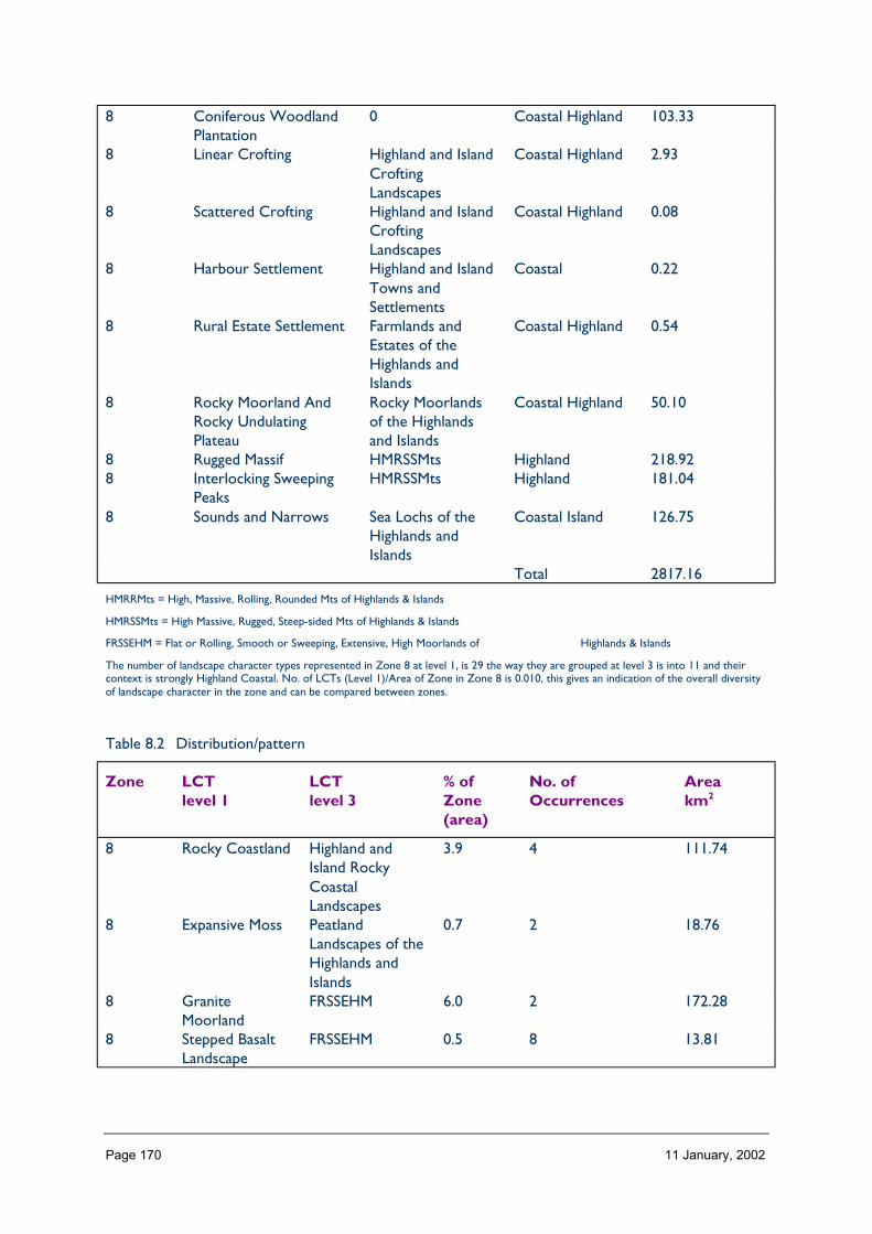
Page 170 11 January, 2002
8 Coniferous WoodlandPlantation
0 Coastal Highland 103.33
8 Linear Crofting Highland and IslandCroftingLandscapes
Coastal Highland 2.93
8 Scattered Crofting Highland and IslandCroftingLandscapes
Coastal Highland 0.08
8 Harbour Settlement Highland and IslandTowns andSettlements
Coastal 0.22
8 Rural Estate Settlement Farmlands andEstates of theHighlands andIslands
Coastal Highland 0.54
8 Rocky Moorland AndRocky UndulatingPlateau
Rocky Moorlandsof the Highlandsand Islands
Coastal Highland 50.10
8 Rugged Massif HMRSSMts Highland 218.928 Interlocking Sweeping
PeaksHMRSSMts Highland 181.04
8 Sounds and Narrows Sea Lochs of theHighlands andIslands
Coastal Island 126.75
Total 2817.16
HMRRMts = High, Massive, Rolling, Rounded Mts of Highlands & Islands
HMRSSMts = High Massive, Rugged, Steep-sided Mts of Highlands & Islands
FRSSEHM = Flat or Rolling, Smooth or Sweeping, Extensive, High Moorlands of Highlands & Islands
The number of landscape character types represented in Zone 8 at level 1, is 29 the way they are grouped at level 3 is into 11 and theircontext is strongly Highland Coastal. No. of LCTs (Level 1)/Area of Zone in Zone 8 is 0.010, this gives an indication of the overall diversityof landscape character in the zone and can be compared between zones.
Table 8.2 Distribution/pattern
Zone LCTlevel 1
LCTlevel 3
% ofZone(area)
No. ofOccurrences
Areakm2
8 Rocky Coastland Highland andIsland RockyCoastalLandscapes
3.9 4 111.74
8 Expansive Moss PeatlandLandscapes of theHighlands andIslands
0.7 2 18.76
8 GraniteMoorland
FRSSEHM 6.0 2 172.28
8 Stepped BasaltLandscape
FRSSEHM 0.5 8 13.81

Page 171 11 January, 2002
8 Settled Lochs Sea Lochs of theHighlands andIslands
3.1 1 88.72
8 Broad ForestedStrath
Highland Straths 1.1 1 30.81
8 SmoothMoorland Ridges
HMRRMts 2.6 2 73.87
8 Rugged Massif HMRSSMts 16.1 6 463.608 Interlocking
Sweeping PeaksHMRSSMts 22.7 3 653.34
8 Rugged CoastalHills
RCUHM 12.0 5 345.48
8 Fjord Sea Lochs of theHighlands andIslands
0.2 1 5.70
8 Enclosed Bayand OffshoreIslands
Highland andIsland RockyCoastalLandscapes
2.0 1 57.51
8 HarbourSettlement
Highland andIsland Towns andSettlements
0.1 4 3.84
8 UndulatingMoorland
FRSSEHM 0.0 2 0.12
8 Rocky Moorland Rocky Moorlandsof the Highlandsand Islands
2.3 2 66.65
8 RuggedMountain Massif
HMRSSMts 0.0 2 0.06
8 Rounded Hills HMRRMts 0.0 1 0.198 Wide Farmed
StrathHighland Straths 0.1 4 3.70
8 Smooth SteppedMoorland
FRSSEHM 0.2 5 5.94
8 Coastal Strath Highland Straths 0.6 12 17.138 Coniferous
WoodlandPlantation
0 3.6 22 103.33
8 Linear Crofting Highland andIsland CroftingLandscapes
0.1 10 2.93
8 ScatteredCrofting
Highland andIsland CroftingLandscapes
0.0 1 0.08
8 HarbourSettlement
Highland andIsland Towns andSettlements
0.0 1 0.22
8 Rural EstateSettlement
Farmlands andEstates of theHighlands andIslands
0.0 3 0.54
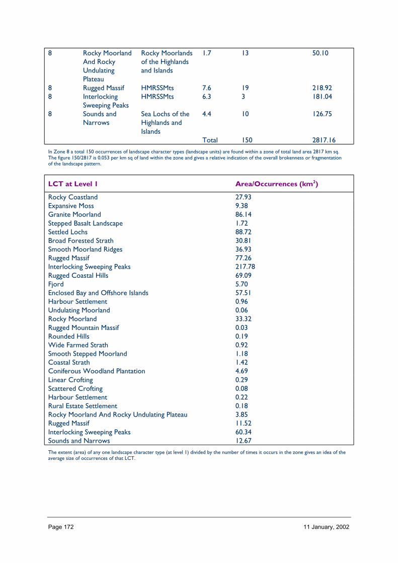
Page 172 11 January, 2002
8 Rocky MoorlandAnd RockyUndulatingPlateau
Rocky Moorlandsof the Highlandsand Islands
1.7 13 50.10
8 Rugged Massif HMRSSMts 7.6 19 218.928 Interlocking
Sweeping PeaksHMRSSMts 6.3 3 181.04
8 Sounds andNarrows
Sea Lochs of theHighlands andIslands
4.4 10 126.75
Total 150 2817.16
In Zone 8 a total 150 occurrences of landscape character types (landscape units) are found within a zone of total land area 2817 km sq.The figure 150/2817 is 0.053 per km sq of land within the zone and gives a relative indication of the overall brokenness or fragmentationof the landscape pattern.
LCT at Level 1 Area/Occurrences (km2)
Rocky Coastland 27.93Expansive Moss 9.38Granite Moorland 86.14Stepped Basalt Landscape 1.72Settled Lochs 88.72Broad Forested Strath 30.81Smooth Moorland Ridges 36.93Rugged Massif 77.26Interlocking Sweeping Peaks 217.78Rugged Coastal Hills 69.09Fjord 5.70Enclosed Bay and Offshore Islands 57.51Harbour Settlement 0.96Undulating Moorland 0.06Rocky Moorland 33.32Rugged Mountain Massif 0.03Rounded Hills 0.19Wide Farmed Strath 0.92Smooth Stepped Moorland 1.18Coastal Strath 1.42Coniferous Woodland Plantation 4.69Linear Crofting 0.29Scattered Crofting 0.08Harbour Settlement 0.22Rural Estate Settlement 0.18Rocky Moorland And Rocky Undulating Plateau 3.85Rugged Massif 11.52Interlocking Sweeping Peaks 60.34Sounds and Narrows 12.67
The extent (area) of any one landscape character type (at level 1) divided by the number of times it occurs in the zone gives an idea of theaverage size of occurrences of that LCT.
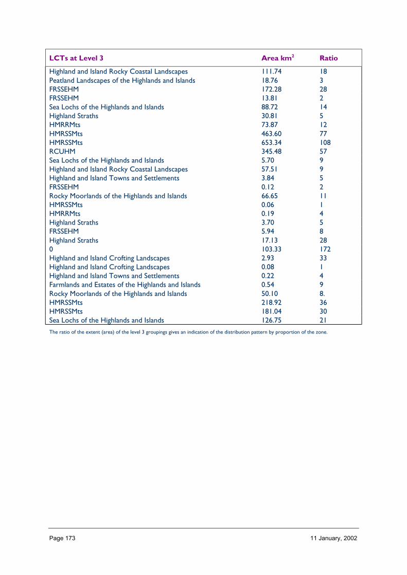
Page 173 11 January, 2002
LCTs at Level 3 Area km2 Ratio
Highland and Island Rocky Coastal Landscapes 111.74 18Peatland Landscapes of the Highlands and Islands 18.76 3FRSSEHM 172.28 28FRSSEHM 13.81 2Sea Lochs of the Highlands and Islands 88.72 14Highland Straths 30.81 5HMRRMts 73.87 12HMRSSMts 463.60 77HMRSSMts 653.34 108RCUHM 345.48 57Sea Lochs of the Highlands and Islands 5.70 9Highland and Island Rocky Coastal Landscapes 57.51 9Highland and Island Towns and Settlements 3.84 5FRSSEHM 0.12 2Rocky Moorlands of the Highlands and Islands 66.65 11HMRSSMts 0.06 1HMRRMts 0.19 4Highland Straths 3.70 5FRSSEHM 5.94 8Highland Straths 17.13 280 103.33 172Highland and Island Crofting Landscapes 2.93 33Highland and Island Crofting Landscapes 0.08 1Highland and Island Towns and Settlements 0.22 4Farmlands and Estates of the Highlands and Islands 0.54 9Rocky Moorlands of the Highlands and Islands 50.10 8.HMRSSMts 218.92 36HMRSSMts 181.04 30Sea Lochs of the Highlands and Islands 126.75 21
The ratio of the extent (area) of the level 3 groupings gives an indication of the distribution pattern by proportion of the zone.

Page 174 11 January, 2002
Table 8.3 Rarity
LCTs at Level 1 Rarity by occurrence%
Rarity by extent%
Rocky Coastland 2 3.9Expansive Moss 1 0.7Granite Moorland 1 6.0Stepped Basalt Landscape 5 0.5Settled Lochs 0 3.1Broad Forested Strath 0 1.1Smooth Moorland Ridges 1 2.6Rugged Massif 4 16.1Interlocking Sweeping Peaks 2 22.7Rugged Coastal Hills 3 12.0Fjord 0 0.2Enclosed Bay and Offshore Islands 0 2.0Harbour Settlement 2 0.1Undulating Moorland 1 0.0Rocky Moorland 1 2.3Rugged Mountain Massif 1 0.0Rounded Hills 0 0.0Wide Farmed Strath 2 0.1Smooth Stepped Moorland 3 0.2Coastal Strath 8 0.6Coniferous Woodland Plantation 14 3.6Linear Crofting 6 0.1Scattered Crofting 0 0.0Harbour Settlement 0 0.0Rural Estate Settlement 2 0.0Rocky Moorland And Rocky Undulating Plateau 8 1.7Rugged Massif 12 7.6Interlocking Sweeping Peaks 2 6.3Sounds and Narrows 6 4.4
The rarity of a landscape character type within the zone can be identified by the number of time it occurs or its extent. Examination ofboth the number of occurrences (of a LCT) as a percentage of the total and the area (of a LCT) as a percentage of the total area will givean indication of rarity.
LANDSCAPE CHARACTER
Landscape character within this zone is most diverse in the north with a mix of highplateaux (106), rugged hills (115) and coniferous plantations, indented by deep sounds andnarrows (127). This gradually leads to a simpler and less fragmented landscape towards thecentral section of Zone 8 with large areas dominated by their mountain types (63, 113 and115) reflecting geology, minimal inhabitation and the impact of land use. The high centralmountains lead to areas of lower moorland (46, 32) to the south and are indented by thepenetration of the sea from the west (119).
Page 175 11 January, 2002
Description
Landform
PROFILE
An aerial view of Zone 8 reveals a clear pattern of mountains running north-south, withlower moorlands and hills extending from these to the west coast. However, on the groundit is more difficult to discern this arrangement and the zone appears as a complex mix oflandform from high mountain peaks with smooth, sweeping slopes and deep glens, to rockymassifs, rocky moorland and an indented coastline, to wide open expanses of moorland.
This complex variation and mix of landform is reflected by there being fairly equalproportions of land within the 100 m intervals to 500 m, then 16% of the zone between 500m and 1100 m.
There is also fairly equal proportions of slopes between 0 and 31°, with only 8% of Zone 8steeper than this.
SequenceThe mountain ranges define the sequence of landform most obviously in this zone, generallyrunning west to east or north west to south east, separated by deep glens and falling tolower hills and moorlands to the west. The Great Glen, however, runs along the southeastern boundary of the zone and effectively cuts through this typical sequence to reveal itin section.
The sea abuts this landform in the west reaching up some glens to divide certain groups ofhills from others with sea lochs.
ScaleThe scale of Zone 8 seems colossal as the high mountains and hills emphasise verticalelevation as much as horizontal distance. This results in the landscape appearing almostexaggerated in its third dimension, and the lack of known size indicators mean that it isdifficult to discern actual scale and distance.
The vertical nature of the mountains mean that it is difficult to view any large areas of thezone from the main viewing points along the glens and coast; this seems to furtheraccentuate a sense of immense scale.
Landmark featuresZone 8 has an abundance of landform landmarks, these characteristics appearing dominantand frequent within the landscape.
The most prominent landform landmarks are the highest and most distinctive mountainpeaks combined with the narrowest and most distinctive glens and lochs. For example,Beinn Sgritheall, Ladhar Bheinn, the Saddle, Rois Bheinn and Glen Shiel, and the lochsCarron, Duich, Hourn, Nevis, Morar, Eil, Sunart and Linnhe. However, with so manymountains, groups of distinctive peaks tend also to be discerned and identified, for examplethe Five Sisters. Prominent and well-known peaks outwith Zone 8 such as Ben Nevis alsoform landmark features.
Page 176 11 January, 2002
During low cloud, greater landmark emphasis is put on foreground and smaller scalefeatures, for example the loch shores and beaches and island such as around Arisaig.
ExperienceAs previously mentioned, landform within Zone 8 plays a major part in forming landscapecharacter. It is so obvious, superlative in quality and diverse in nature to appear almostforced upon the viewer, although much of the landscape within the zone is not actuallyvisible from the main access routes.
As the high numbers of mountains, glens and lochs interweave to form the landscape, thisarrangement can only really be experienced by travelling through the zone.
Visually, however, this experience in fine weather is quite demanding, with a multitude offoci, lines, colours, textures and activity. Indeed, to appreciate the qualities of the mountainlandscape it may be easier to step back from it, for example viewing whilst sitting on a lochshore or beach, rather than moving within the actual mountains themselves. And afterexperiencing the large scale of this landscape, smaller landscape features such as the beachesand promontories of the west coast, seem very welcoming in their intimacy ofcharacteristics.
Containment (created by landform and land cover)
TOPOGRAPHY
Containment within Zone 8 is predominantly high due to the spatial enclosure of the steepand high mountains and deep glens. However, the western and south western part of thezone is more open due to gentler slopes and the neighbouring expanse of the sea. Withinthe mountains ranges, the peaks, passes and ridge tops and lochs offer a sense of localopenness and exposure.
Generally, the elevation of Zone 8 varies considerably with landform, with 56% of the zonecomprising slopes between 11 and 31° and 8% comprising slopes over 32°.
LAND COVER
Vegetation adds little to the containment of Zone 8 with a prevalence of short peatland,moorland, rough grass and montane vegetation comprising 81%. The location of woodlandwithin the zone creates some local containment, adding up to 11% of the zone’s area;however the majority of this is in the form of conifer plantations where the density of treesmeans the woodlands are difficult to penetrate except along tracks; and even in thebroadleaf woodlands, this may partly be the case due to the wind pruning of trees.
Open water within the zone, however, contributes to a sense of openness within certainareas of the landscape, even if the character of these remain influenced by views tosurrounding mountains.
Built development does not contribute greatly to the sense of containment within Zone 8,apart from within Fort William at a local level. Generally built development is too sporadicand occurs as too small foci to create enclosure, although woodlands, hedges and wallsassociated with these settlements do create small pockets of shelter.

Page 177 11 January, 2002
VISIBILITY
Visibility is limited within the mountain areas of this zone, apart from when these areexperiences from the peaks. Generally, most people view the landscape from the glens,where views are channelled along or directly across the linear space, just occasionallyfocusing on focal peaks. Visibility within the western and south western parts of the zone isgreater in extent, apart from within the undulating moorland or coastal woodlands. Thepresence of the sea enables views to the west and up into the zone interior via the coastallochs.
MICROCLIMATIC EFFECTS
Generally Zone 8 is subject to a barrage of westerly Atlantic weather systems so conditionsare changeable. However there is a prevalence of high humidity, cloud and rain due to themaritime conditions and orographic lift which results in condensation over the mountains.These conditions greatly affect the experience of the landscape – most simply contrastingbetween cloudy conditions when the mountains aren’t visible and clear conditions when thefull splendour of the landscape is revealed. Winds from the west are sometimes channelledalong the west to east and south west to north east lochs and glens to impact greatly onsurrounding slopes.
Aspect is also very important upon the steep slopes of this landscape – south facing slopespossessing favourable warm conditions over north facing slopes, some of which lie inshadow throughout the winter.
The high elevation of many of the mountains is clearly evident with most snow fall tendingto occur upon the tops gradually diminishing to the lower slopes and creating a grading ofcolour that emphasises the highest tops.
EXPERIENCE
The experience of containment is very marked by the landform in this landscape, especiallywhen travelling along the glens, channelled between their steep slopes. As one proceeds toareas of undulating moorland further west, the scale of this containment gradually decreasesuntil one reaches the openness of the west coast.
Although most access routes tend to follow the routes of glens in this landscape, movementaway from these up on to the surrounding slopes soon reveals a greater openness and scaleof landscape.
The experience of containment within the landscape of Zone 8 very much depends onweather conditions and the contrast between experiencing this area in low cloud or clearconditions is spectacular. In low cloud, the landscape can seem ‘squashed’ as you are awarethe hill slopes lead to something screened above, creating a sense of anticipation andmystery; and in clear conditions, the composition and prominence of mountains in suchclarity of light can almost seem two-dimensional – unbelievable in its vertical scale andsplendour.
Page 178 11 January, 2002
Accessibility
DISTANCE
Zone 8 as a whole, located on the western edge of the Scottish Highlands, is distant fromthe concentrations of population in the Central Belt of Scotland, and although Fort Williamon its eastern edge is just 133 miles from Edinburgh, this may have a journey time of over 3hours given the indirect nature of the road network in this zone and neighbouring areas.
The main roads entering the southern half of the zone are the A82 from the south andnorth east. The northern part of the zone is accessed via the A890 from the north east andthe A87 from the east. The zone can also be reached by ferry from Skye and the Small Islesto Mallaig. There is no west coast route between this latter village, however, and Glenelgaround the coast to the north in Lochalsh.
PHYSICAL ACCESS
Physical access is restricted in this zone by the orientation and distribution of routes mainlyfollowing the glens and along the coast. The glens tend to run roughly west-east; therefore itis generally difficult to travel north-south, although the route of the Great Glen eases this inthe south eastern corner of the zone. Some glen and coastal roads are ‘no through’ routesand thus prevent circulatory movement through the zone. Around 45% of the zone is morethan 2 km from a public road and 13% is over 5 km from the nearest route.
Many of the mountain core areas are only accessible on foot or by boat, for exampleKnoydart, Morvern, Garbh Shlios, North Morar and Ardgour. Of the main routes, many areindirect, winding and narrow which, combined with high numbers of tourist traffic insummer, impede travelling by car through this landscape.
CULTURAL ACCEPTANCE
Access to Zone 8 off the main public roads is discouraged by some landowners and parkingof cars enabling hillwalkers to travel into the remoter parts of the zone sometimes causesfriction between land users. Access over croftland may also be discourage in some places,especially during spring and summer and when walking with dogs. However considerableparts of the zone are publicly accessible via Forestry Commission tracks.
VISUAL ACCESS
As discussed under ‘Containment’, visual access in this landscape is limited by the nature ofthe landform. Most views from public roads tend to be confined within the glens anddirected to the highest mountain tops. Features upon hill slopes tend to be highly visiblefrom slopes on the opposite side of the glen, as these are seen almost in elevation andagainst a backdrop. Views are more open around the coast where they dart between islandfoci and across the sea, bays and lochs.
EXPERIENCE
Access within this zone along public roads is generally restricted, mainly confined to theglens and coast by the steep slopes which preside in this landscape. This means the only wayto experience the remoter parts of the landscape is on foot and via boat.
Within the less accessible areas of this zone, the perception of remoteness and wild land isquite acute and thus senses are highly activated.

Page 179 11 January, 2002
Land cover
VEGETATION
The land cover of this zone comprises predominately a matrix of peatland and heathermoorland vegetation which collectively makes up around 63% of the zone. This isinterwoven with grassland species (11%) and montane vegetation (7%). Collectively theseland cover types subtly blend to form a fairly simple pattern, texture and colour of landcover that does not distract from the notable landforms. The maritime climate of the areasresults in a lushness of vegetation and, although comprising only 11% of Zone 8, woodlandscreate some local diversity adding to the pattern of colour, elevation and texture within thelandscape and creating local shelter.
EXPOSED ROCK
Exposed rock does not form a major part of Zone 8 as a whole; however, in certainlocalities, its prominence markedly affects the character of the landscape, emphasising thesteep angles of the mountain tops and the rugged nature of some hills.
The exposed rock and cliffs, skerries and islands also feature importantly along the indentedwest coast.
BUILT DEVELOPMENT
Built development does not occur in this zone in any significant proportion (<1%), and itgenerally tends to be concentrated due to the steep nature of the landform throughoutmuch of the landscape. However, where settlements do occur, they tend to create foci inthe landscape, valued for their contrast of scale, colour, form and activity with thesurrounding mountains, the stark differences of these seeming to emphasise the qualities ofeach.
EXPERIENCE
Apart from the small foci of built development in this zone discussed above, land cover doesnot tend to be seen as a dominant feature of this landscape, dominated as it is by thesuperlative landform and sea characteristics. Indeed the experience of it tends to be mostnotable where it affects the experience of these landform characteristics; for example, thesequential screening and revealing of loch side views by trees and the visual emphasis ofmountain burns by threads of riparian trees.
Hydrology and water bodies
TYPE
Water forms a key part of the landscape character of Zone 8, not only in its lochs andrivers but also with the penetration of the sea into the zone and the predominate wetweather and high humidity. All these characteristics emphasise the mountain landforms anddivide and distinguish certain parts of the zone from others. Generally, drainage across thezone is very good on account of the abundance of rivers and lochs and the steepness ofslopes.
The route of rivers and lochs are valued for the access they enable and most settlementsare located next to them or along the coast.

Page 180 11 January, 2002
Most notable within Zone 8 is the long forms of freshwater lochs Quoich, Morar, Arkaigand Shiel; however, apart from their obvious lack of seaweed and tidal banding, these lochstend to be viewed collectively associated with the sea lochs around them.
PATTERN
The rivers and lochs of Zone 8 mainly run along well defined glens, although these are lesspronounced in the gentler moorland areas. The major lochs and rivers run broadlyeast–west, with the minor tributaries at right angles to these.
The distribution of rivers and lochs is fairly even throughout the zone, although there tendsto be fewer rivers in the steep mountain areas where slopes are extremely free draining.
EXPERIENCE
As discussed above, rivers and lochs in combination with the
sea and precipitation result in the character of Zone 8 being
strongly influenced by the presence of water. The need to follow glens delineated or filledby rivers and lochs for access also increases their prominence and greatly influences theexperience of the zone. They tend to lead one through the landscape along their route,discouraging focus at any one point. In a landscape of such great vertical scale, the lochs andrivers provide foreground diversity and attraction providing small scale interest, such asfragments of native woodland, beach deposits and aquatic wildlife.
Built and infrastructure development (present day)
NATURE AND PATTERN OF SETTLEMENT
Settlement within Zone 8 as a whole is infrequent. Where occurring, however, it tends tobe concentrated along the edges of lochs and the coast, within the glens and specifically atbridging points, utilising favourable access, slope and microclimatic conditions. Althoughthere are a few concentrations of settlement at the northern tip, western fringe and easternedge of this zone, much of the remaining area is largely devoid of this.
NATURE AND PATTERN OF INFRASTRUCTURE
Roads, a railway line, estate access tracks and electric powerlines form the majorinfrastructural elements in this zone. Major corridors often accommodate several of theseelements in parallel which may have considerable landscape impact within the confinedspaces of the glens. The central part of this zone, extending from south Morar to Knoydartand Glenshiel Forest is largely devoid of infrastructure, thus possessing qualities of wild land.
NATURE AND PATTERN OF INDUSTRIAL DEVELOPMENT
Zone 8 as a whole has little heavy industrial development. however there are some localisedconcentrations of development mainly linked to natural resources and the sea; for exampleBarmac at Kyle, Mallaig and Arisaig Harbours and various industries at Corpach by FortWilliam, and hydro-electricity at several locations.
In terms of landscape character, the major industry influencing Zone 8 is tourism andassociated services. This is focused at Fort William, but also strongly influences thecharacter of smaller settlements such as Mallaig, Arisaig, Kyle, Glenelg, Plockton andLochcarron and the main access routes.

Page 181 11 January, 2002
EXPERIENCE
Built or infrastructural development is generally seen as just a minor feature of Zone 8 inrelation to the overriding dominance of the ‘natural’ landscape. However, as it tends to belocated in close proximity to the few main access routes, there may be a perception whentravelling through the landscape that there is a greater proportion of this kind ofdevelopment than there actually is when also considering the remoter areas.
The direct link observed between landscapes and industries which utilise their resources,such as hydro-electricity, fishing and forestry, can portray a positive image of peopleworking with their environment. More difficult to comprehend is the development ofservice industries that don’t directly relate to their surroundings and could thus be foundanywhere in the country, or alternatively major tourist developments which are heavilyreliant on unpredictable visitor numbers and weather conditions.
The occurrence of local, small scale industry can feature as an interest in the landscape, itsactivity, diversity and small scale emphasising the contrasting qualities of the surroundinglandscape without seeming to dominate this.
Visible history
TYPES OF VISIBLE HISTORY
Historic features do not appear as prominent in Zone 8 as in other landscapes in theScottish Highlands, mainly on account of the mountain interior deterring settlement. Theprincipal signs of the past are: finery and ritual monuments from the Neolithic and BronzeAge; hut circles and duns dating from the Iron Age, crosses, carved stones or chapel sitesfrom the early Christian period; Medieval castles and churches and the ruined settlementsabandoned during the Clearances in the 18th, 19th and even 20th centuries. Features stillused include crofts, the Caledonian Canal and West Highland Railway, some castles, lodgesand designed landscapes, harbours and military roads and old drove routes.
LOCATION/PATTERN
Most of the historic features in this zone are located upon the shores of the lochs and seaand within the glens where there is favourable climate, water access, defence, ground andgrowing conditions.
EXPERIENCE
Whilst historic features do not dominate the experience of Zone 8 as a whole, they doaffect the character of certain localities and routes. Most notable is the fact that the majorityof historic features occur in areas still favoured for their preferable conditions within aregion of low resident population and a landscape which can still be inhospitable toinhabitation.
The physical remains of crofts abandoned during the Clearances, although less prominentthan in other areas of the Highlands, strongly affect the local character where they occur.This is especially the case as estate land ownership, and the relationship of this to presentday crofters, is still considered unresolved by many.
The historic routes of old military roads and drove routes still appear very impressivewhere present in the landscape. Although many of these have been covered with modern

Page 182 11 January, 2002
surfaces and signs, they remain largely intact and features such as constructed bridges andwalls create interesting foci in the landscape, the details of these in marked contrast to thelarge scale mountainous setting.
The character of historic buildings often seem to relate very strongly to the surroundinglandscape, utilising favourable ground, shelter and local materials. These often seen ‘fitted’or moulded to the landscape, sometimes in great contrast to more recent structures.
Wildlife
FORMS OF WILDLIFE
Both terrestrial and maritime wildlife feature in this zone. Characteristic are red deer,otters, birds of prey, gulls, cormorant, seals, salmon, trout, wild cats, pine martens, mink,chequered skipper, black and red throated divers, herons, badgers, ticks and midges.
The mix of landscape and habitat means, generally, there is great diversity of speciesthroughout the zone.
LOCATION
Species such as deer, birds of prey, wild cats, pine martens and mink tend to be located inthe mountain and moorland areas, the rarest and shyest of these tending to take refuge inthe remotest ‘wild land’. Maritime species obviously concentrate at the coast; howeverparticularly spectacular in this zone is the experience of these, most notably otters and sealswithin the relative intimacy and shelter of some of the narrow and deep sea lochs such asLoch Duich, Kyle Rhea and lochs Hourn, Nevis, Ailort and Sunart.
Some species are prolific throughout the zone – the most unpopular and seemingly robustbeing the midge.
WHEN
Deer are usually most notable during Autumn and Winter on account of their roaring at thebeginning of this season and their descent from the mountains the worst of the weather tograze lower grasslands. Birds tend to be most notable in spring and at dawn when mostactive and vocal, and otters and seals tend to be most obvious when basking on rocks inwarm weather, the first also causing attraction when playing on loch and coast shores.Insects are most prolific through late spring to early autumn until the first frosts.
EXPERIENCE
Although wildlife are not generally seen to greatly affect the experience of the entire Zone8, their prominence in certain places and at certain times of the year do contribute greatlyto local character of the landscape. In particular, the experience of rare species can intensifythe sense of wild land in remote areas and in the small scale glens, this experience can seemamplified by the containment of the landscape. In many instances, it is the sound of wildlifethat first attracts attention in such a large scale landscape; loud noises such as roaring stagsmay echo through the mountains and across the narrow lochs and sounds in quite adisturbing manner, whilst the humming of insects and jumping of fish can seem to add to thesense of tranquillity upon the shores.
In contrast to these positive attributes, however, some species such as midges can beperceived to affect the experience of the landscape in a negative fashion.

Page 183 11 January, 2002
Climate
CLIMATIC CHARACTERISTICS
Climate conditions at a broad scale are fairly consistent throughout Zone 8, dominated bythe westerly passage of Atlantic weather systems. There are two major influences on morelocalised weather – the mountains and proximity to the coast. Mountain areas tend to havegreater extremes of weather, the microclimate affected by altitude and aspect, with highlevels of relief rainfall and snow, greater frost in the glens, more sunlight and warmertemperatures on south facing slopes and more shadow and cooler temperatures on northfacing slopes. Maritime areas are more equable with less extremes of temperature, althoughwith fairly consistent exposure to coastal winds.
Over the zone as a whole, precipitation levels are very high with a mean rainfall of 1981mm.On average there is most rain in December (238 mm) and least in May, although eachmonth of the year receives in excess of 100 mm on average.
Average summer temperatures for Zone 8 are 13.5°C varying over about 5°C between thecoast and eastern areas. Average winter temperature is 3.5°C, varying about 1.5°C fromwest to east of Zone 8.
LOCATIONAL AND SEASONAL EFFECTS
As previously discussed there is a great microclimatic variation within the mountain areas ofthis zone. Apart from these, however, the landscape is generally subject to a wild, wet,western maritime climate. Consequently, seasonal effects are less marked than neighbouringinland regions, although there is some distinction with driest conditions usually occurring inApril and May and the latter month also having most sunshine.
The proximity of the coast to much of Zone 8 provides a great clarity of light over thelandscape when clear conditions preside, and the western emphasis means that sunsetsoften appear quite stunning at the end of the day.
Hours of daylight are few in winter and especially dark on north facing slopes; however, incontrast, hours of daylight in summer are long, resulting in a corresponding increase ofactivity in the landscape. This is most obviously marked with a great influx of visitors to thezone, especially around Kyle and Plockton in the north and Fort William and Mallaig andArisaig in the south of the zone.
EXPERIENCE
Climate conditions greatly affect the experience of this landscape as already discussed under‘Containment’. These most importantly affect whether the unique composition of thislandscape and its key foci – the mountains, can be viewed at all. Yet with a typical maritimeand mountain climate, clear visibility is not a common expectation and only acts in increasingthe delight when clear conditions preside.
In low cloud, the landscape can seem ‘squashed’ as its very vertical emphasis is revealed onlywithin a horizontal band. In such conditions the fact that diagonal footslopes can be seen tolead to something obscured above creates a sense of mystery and anticipation. The focus ofview is directed to the foreground details and particularly the coast and loch shores.
Page 184 11 January, 2002
In contrast, the landscape appears dynamic in changeable conditions, westerly strong windschasing clouds and their shadows over the landform. And in completely clear, brightconditions, although visibility reveals a spectacular landscape, this can appear a bit two-dimensional as the complex landform is difficult to discern without the emphasis of shadow.Generally, periods of dry weather increase outdoor activity and visitor numbers, thesetending to distribute throughout the zone in contrast to wet times when most concentratein the main settlements.
The climatic conditions of this zone are particularly emphasised on the coast by the natureof the sea and how this appears within the intrinsic landscape composition of sky, sea andland. This also affects whether some parts of the zone are accessible at all from mainlandScotland by boat, increasing its importance to everyday activity within some parts of thezone.
Designated landscapes
National Scenic Areas
CONSTITUENTS
Zone 8 contains 7 NSAs. However only two of these occur in their entirety within the zone(Loch Shiel and Knoydart), three of them account for less then 1% of the NSAs area as awhole (Wester Ross, Glen Affric, Ben Nevis and Glen Coe) and the remaining two onlyrepresenting around half of the NSA’s extent (Kintail and Morar, Moidart andArdnamurchan).
Considering only the first and last two of these in any detail, they comprise the followinglandscape character types at level 1: Loch Shiel comprises expansive moss (32), granitemoorland (46) rugged massif (115) and interlocking, sweeping peaks (63). Knoydart NSAcomprises a dominance of interlocking sweeping peaks (63) making up 63% of the area, theremainder consisting mainly of rugged massif (115) 21%, rugged coastal hills (113) 10%, androcky coastland (104) 3%. The part of Kintail NSA within Zone 8, similar to Knoydart, isdominated by interlocking sweeping peaks (63) and rugged massif (115) collectivelyaccounting for 80% of the area, the remainder made up of small fragments of coastal strath(21) coniferous woodland and rocky moorland (105).
The part of the Morar, Moidart and Ardnamurchan NSA contained within Zone 8,comprising 48% of the NSA, comprises mainly rocky coastland (104) 65%, rugged coastalhills (113) 31%, and a small area of expansive moss (32).
LOCATION AND EXTENT
The location and extent of NSAs in Zone 8 vary considerably, distributed throughout and atvarying scales. Loch Shiel NSA is located within the bottom third of Zone 8 and extendsalmost across this, running south west to north east, extending some 128km square.Knoydart NSA is located in the northern third of Zone 8, forming a roughly circular shapearound Loch Hourn, extending to 395 km square. The South western half of the KintailNSA occurs along the north eastern boundary of Zone 8, extending to 90 km square. Thenorth eastern half of the Morar, Moidart and Ardnamurchan NSA is contained within thesouth eastern edge of Zone 8, extending to 75km square. The small fragments of theWester Ross, Glen Affric, Ben Nevis and Glen Coe NSAs occur of the northern, north

Page 185 11 January, 2002
eastern and south eastern edges of Zone 8 respectively, each occurring for <1%, <0.1% and<0.2% of each NSA in the same order.
EXPERIENCE
Although the experience of the four main NSAs contained within Zone 8 varies, Kintail,Knoydart and Glenshiel all represent areas of high, sweeping, steep peaks plummeting intonarrow deep glens and lochs. The latter two of these NSAs are valued specifically for theirsense of remoteness and wild land, being difficult to access. In contrast to this, the Kintailmountains enclosing Glen Shiel and Loch Duich can easily be accessed via the A87, whichalthough affects the sense of remoteness, allows a large number of people to experiencesome of the NSA’s great qualities at close hand.
The scale of the mountains within these 3 NSAs is colossal and quite awe inspiring and,although forming distinct ranges, contain individual landmark peaks too. In contrast, theMorar, Moidart and Ardnamurchan NSA is mainly appreciated for its coastal characteristics– the combination of an indented coast harbouring small scale local features, with openareas of moorland, the sea and offshore views to the Small Isles, Skye and over to Morar.
Historic gardens and designed landscapes
NATURE OF THE LANDSCAPES DESIGNATED AND NON-DESIGNATED
There are two original Historic gardens and designed landscapes (HGDL) In this zone andtwo new HGDL.
Recreationonal Landscapes
Nature and location of landscapesThe main focus of recreation within Zone 8 occurs along the coast, loch shores andmountain areas. Coastal recreation is mainly attracted to the beaches, small harbour townsand ferries to islands around Loch Carron and Plockton in the north of the zone and Arisaigand Mallaig in the south. The key mountain areas visited by hill walkers or ‘wild campers’ arethose which contain Munros (mountains over 3000’) such as Moidart, Morar, Knoydart andGlenshiel, although other areas such as Ardgour and Morvern are also visited due toqualities of remoteness and wild land. Many visitors are attracted to the glens and lochs ofthe zone, often en route and valuing the proximity of services and features to the main roadwithin the confines of glens.
Fort William is the main town within Zone 8 targeted for its provision of services and isstrategically positioned to provide access to the coast and mountain ranges all around andspecifically Ben Nevis to its east.
At the broad scale, the recreational experience of Zone 8 is mainly divided between thecoastal areas and the interior mountains and between the areas serviced by recreationfacilities near the main access routes of settlements and the remote lands. Recreation verymuch concentrates on utilising the landscape resource for outdoor exploration and activesports.
At the foci of recreation, there may be many people concentrated within the landscapeduring the summer season. Although these may create an interesting spectacle inthemselves, especially in the harbour towns adding to the focus of activity, they may appear

Page 186 11 January, 2002
to compromise the quality of landscapes more valued for their ‘wild’ qualities. Despite this,however, the difficulty in accessing the most remote areas of Zone 8 mean that thesequalities can be experienced elsewhere at a more personal level.
One seasonal element that affects the experience of recreation in Zone 8 is the blight ofmidges in summer and this may result in localised concentration of people and where theireffect seems lessened such as on exposed coasts.
2 Importance and value of the zone landscape
A judgement of the importance or value of the zonal landscape under the followingheadings:
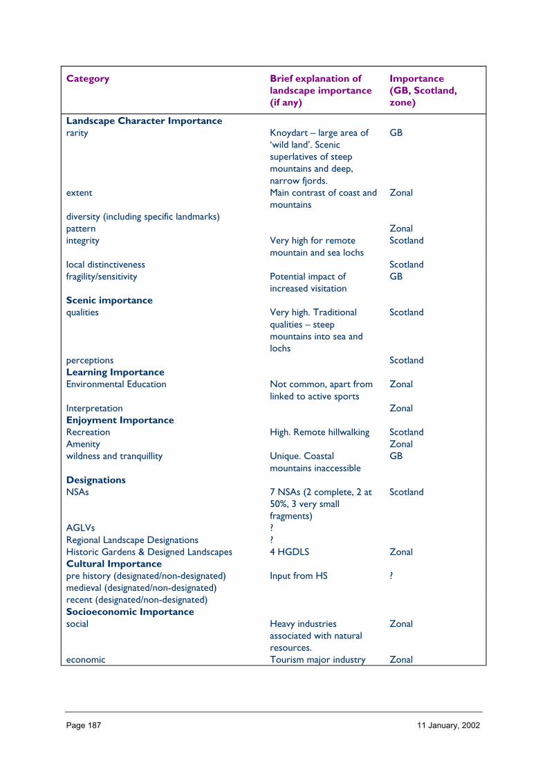
Page 187 11 January, 2002
Category Brief explanation oflandscape importance(if any)
Importance(GB, Scotland,zone)
Landscape Character Importancerarity Knoydart – large area of
‘wild land’. Scenicsuperlatives of steepmountains and deep,narrow fjords.
GB
extent Main contrast of coast andmountains
Zonal
diversity (including specific landmarks)pattern Zonalintegrity Very high for remote
mountain and sea lochsScotland
local distinctiveness Scotlandfragility/sensitivity Potential impact of
increased visitationGB
Scenic importancequalities Very high. Traditional
qualities – steepmountains into sea andlochs
Scotland
perceptions ScotlandLearning ImportanceEnvironmental Education Not common, apart from
linked to active sportsZonal
Interpretation ZonalEnjoyment ImportanceRecreation High. Remote hillwalking ScotlandAmenity Zonalwildness and tranquillity Unique. Coastal
mountains inaccessibleGB
DesignationsNSAs 7 NSAs (2 complete, 2 at
50%, 3 very smallfragments)
Scotland
AGLVs ?Regional Landscape Designations ?Historic Gardens & Designed Landscapes 4 HGDLS ZonalCultural Importancepre history (designated/non-designated) Input from HS ?medieval (designated/non-designated)recent (designated/non-designated)Socioeconomic Importancesocial Heavy industries
associated with naturalresources.
Zonal
economic Tourism major industry Zonal

Page 188 11 January, 2002
3 Landscape and trends in the zone
• Pressures/influences which have a particular effect on the landscape of the zone:• Nature of landscape pressures/influences – a brief description• Trends: increasing, static or declining
− long term (> 5 years), medium term (2 to 5 years),− short term (< 2 years)
• Importance: important, not important
Pressure Nature of landscapepressures/influencesand trends withinzone, relativeimportance within thezone
Scale of landscape influence(+ve/–ve) within zone whenconsidered in an all Scotlandcontext
Major Inter. Minor Negligible
Built developmentResidential Increase in holiday homes
� pressure for newhouses for local people.Many ‘kit’ houses threatenintrinsic landscapecharacter.
�
Retail Universal developmentthreatens uniquecharacter of Fort William
�
Industrial �OtherInfrastructure TransportRoads and tracks Impact of tourist traffic.
Road upgrading difficult toaccommodate on steephills and next to lochs.
�
Rail related Could be utilised further �Ferry related Pressure to replace? �Other New/upgraded bridges �Infrastructure otherTelecoms Numerous individual
applications. Create pointfoci to compete with hillsand distract from linearvisual movement alongglens.
�
Water treatment/abstraction ?Waste management ?Coastal defences Impact on foreground
views from shore sideroads
�
OtherMineralsOpen cast coal

Page 189 11 January, 2002
Sand and Gravel Borrow pits and localquarries
�
Hard rock Borrow pits and localquarries for road building
�
PeatOtherForestry and WoodlandsRestructuring of existing Very visible on steep
slopes. Difficult to accesssome areas.
�
Creation of new small �Creation of large new/native Several proposals –
afforest landscapescurrently open. Piecemealin some very sensitivelandscapes.
�
OtherAquaculture and FishingFinfish Cumulative impact.
Impact in remote areasnot accessible on land.
�
Shellfish �Fishing (River & loch) �OtherLand ManagementSheep production High numbers in some
areas – erosion preventsregen.
�
Crop production Generally decreasing �Sport shooting Conflict with hill walkers.
High deer numbers�
Other Rhododendron clearance �EnergyNat. grid/infrastructure Rationalisation/upgrading
occurring in some places�
Wind Possible proposals �Hydro Number of small scale
proposals�
Wave ?OtherTourism and RecreationGolf Impact on
beaches/machair possible�
Marinas Potential �Skiing facilities Expansion of facilities.
Localised�
Leisure facilities/visitorcentres
High number. Existingcharacter of landscape –active recreation
�
NH Information provision Scattered at present �
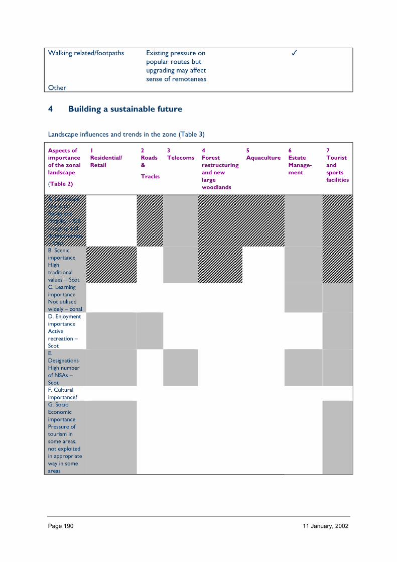
Page 190 11 January, 2002
Walking related/footpaths Existing pressure onpopular routes butupgrading may affectsense of remoteness
�
Other
4 Building a sustainable future
Landscape influences and trends in the zone (Table 3)
Aspects ofimportanceof the zonallandscape
(Table 2)
1Residential/Retail
2Roads&
Tracks
3Telecoms
4Forestrestructuringand newlargewoodlands
5Aquaculture
6EstateManage-ment
7Touristandsportsfacilities
A. LandscapecharacterRarity andFragility – GBIntegrity anddistinctiveness– ScotB. ScenicimportanceHightraditionalvalues – ScotC. LearningimportanceNot utilisedwidely – zonalD. EnjoymentimportanceActiverecreation –ScotE.DesignationsHigh numberof NSAs –ScotF. Culturalimportance?G. SocioEconomicimportancePressure oftourism insome areas,not exploitedin appropriateway in someareas
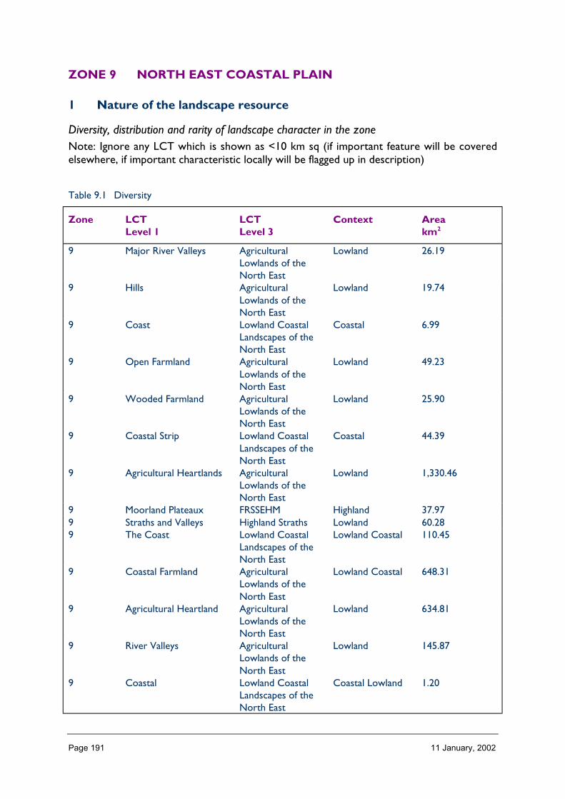
Page 191 11 January, 2002
ZONE 9 NORTH EAST COASTAL PLAIN
1 Nature of the landscape resource
Diversity, distribution and rarity of landscape character in the zoneNote: Ignore any LCT which is shown as <10 km sq (if important feature will be coveredelsewhere, if important characteristic locally will be flagged up in description)
Table 9.1 Diversity
Zone LCTLevel 1
LCTLevel 3
Context Areakm2
9 Major River Valleys AgriculturalLowlands of theNorth East
Lowland 26.19
9 Hills AgriculturalLowlands of theNorth East
Lowland 19.74
9 Coast Lowland CoastalLandscapes of theNorth East
Coastal 6.99
9 Open Farmland AgriculturalLowlands of theNorth East
Lowland 49.23
9 Wooded Farmland AgriculturalLowlands of theNorth East
Lowland 25.90
9 Coastal Strip Lowland CoastalLandscapes of theNorth East
Coastal 44.39
9 Agricultural Heartlands AgriculturalLowlands of theNorth East
Lowland 1,330.46
9 Moorland Plateaux FRSSEHM Highland 37.979 Straths and Valleys Highland Straths Lowland 60.289 The Coast Lowland Coastal
Landscapes of theNorth East
Lowland Coastal 110.45
9 Coastal Farmland AgriculturalLowlands of theNorth East
Lowland Coastal 648.31
9 Agricultural Heartland AgriculturalLowlands of theNorth East
Lowland 634.81
9 River Valleys AgriculturalLowlands of theNorth East
Lowland 145.87
9 Coastal Lowland CoastalLandscapes of theNorth East
Coastal Lowland 1.20
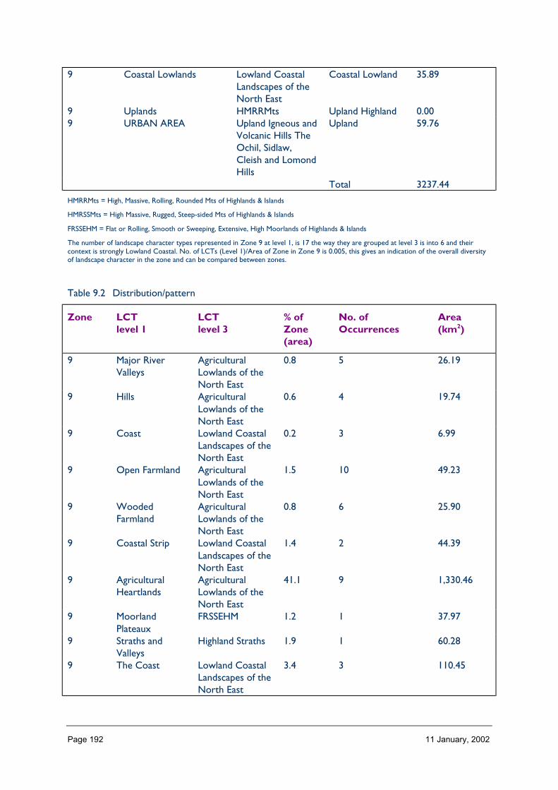
Page 192 11 January, 2002
9 Coastal Lowlands Lowland CoastalLandscapes of theNorth East
Coastal Lowland 35.89
9 Uplands HMRRMts Upland Highland 0.009 URBAN AREA Upland Igneous and
Volcanic Hills TheOchil, Sidlaw,Cleish and LomondHills
Upland 59.76
Total 3237.44
HMRRMts = High, Massive, Rolling, Rounded Mts of Highlands & Islands
HMRSSMts = High Massive, Rugged, Steep-sided Mts of Highlands & Islands
FRSSEHM = Flat or Rolling, Smooth or Sweeping, Extensive, High Moorlands of Highlands & Islands
The number of landscape character types represented in Zone 9 at level 1, is 17 the way they are grouped at level 3 is into 6 and theircontext is strongly Lowland Coastal. No. of LCTs (Level 1)/Area of Zone in Zone 9 is 0.005, this gives an indication of the overall diversityof landscape character in the zone and can be compared between zones.
Table 9.2 Distribution/pattern
Zone LCTlevel 1
LCTlevel 3
% ofZone(area)
No. ofOccurrences
Area(km2)
9 Major RiverValleys
AgriculturalLowlands of theNorth East
0.8 5 26.19
9 Hills AgriculturalLowlands of theNorth East
0.6 4 19.74
9 Coast Lowland CoastalLandscapes of theNorth East
0.2 3 6.99
9 Open Farmland AgriculturalLowlands of theNorth East
1.5 10 49.23
9 WoodedFarmland
AgriculturalLowlands of theNorth East
0.8 6 25.90
9 Coastal Strip Lowland CoastalLandscapes of theNorth East
1.4 2 44.39
9 AgriculturalHeartlands
AgriculturalLowlands of theNorth East
41.1 9 1,330.46
9 MoorlandPlateaux
FRSSEHM 1.2 1 37.97
9 Straths andValleys
Highland Straths 1.9 1 60.28
9 The Coast Lowland CoastalLandscapes of theNorth East
3.4 3 110.45
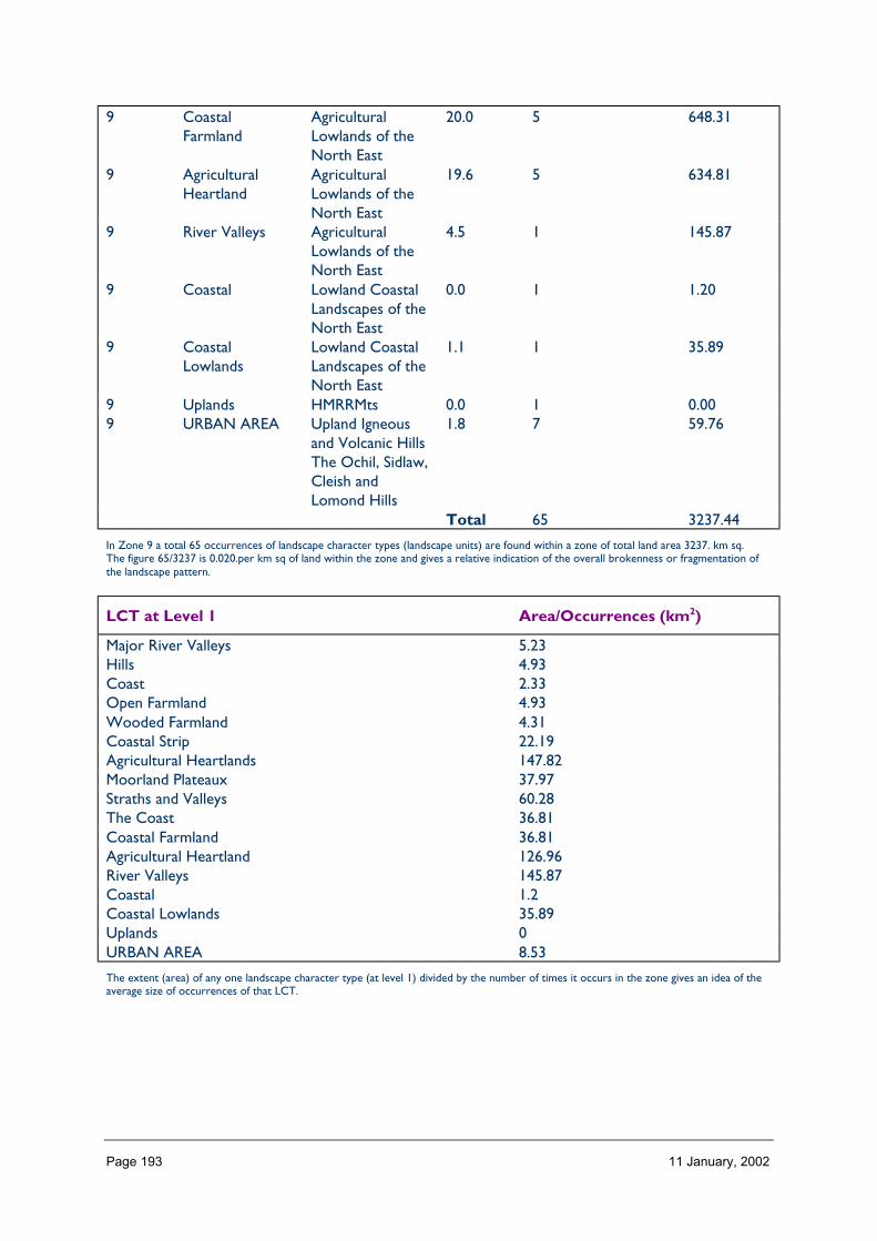
Page 193 11 January, 2002
9 CoastalFarmland
AgriculturalLowlands of theNorth East
20.0 5 648.31
9 AgriculturalHeartland
AgriculturalLowlands of theNorth East
19.6 5 634.81
9 River Valleys AgriculturalLowlands of theNorth East
4.5 1 145.87
9 Coastal Lowland CoastalLandscapes of theNorth East
0.0 1 1.20
9 CoastalLowlands
Lowland CoastalLandscapes of theNorth East
1.1 1 35.89
9 Uplands HMRRMts 0.0 1 0.009 URBAN AREA Upland Igneous
and Volcanic HillsThe Ochil, Sidlaw,Cleish andLomond Hills
1.8 7 59.76
Total 65 3237.44
In Zone 9 a total 65 occurrences of landscape character types (landscape units) are found within a zone of total land area 3237. km sq.The figure 65/3237 is 0.020.per km sq of land within the zone and gives a relative indication of the overall brokenness or fragmentation ofthe landscape pattern.
LCT at Level 1 Area/Occurrences (km2)
Major River Valleys 5.23Hills 4.93Coast 2.33Open Farmland 4.93Wooded Farmland 4.31Coastal Strip 22.19Agricultural Heartlands 147.82Moorland Plateaux 37.97Straths and Valleys 60.28The Coast 36.81Coastal Farmland 36.81Agricultural Heartland 126.96River Valleys 145.87Coastal 1.2Coastal Lowlands 35.89Uplands 0URBAN AREA 8.53
The extent (area) of any one landscape character type (at level 1) divided by the number of times it occurs in the zone gives an idea of theaverage size of occurrences of that LCT.

Page 194 11 January, 2002
LCTs at Level 3 Area (km2) Ratio
Agricultural Lowlands of the North East 26.19 21Agricultural Lowlands of the North East 19.74 16Lowland Coastal Landscapes of the North East 6.99 5Agricultural Lowlands of the North East 49.23 41Agricultural Lowlands of the North East 25.90 21Lowland Coastal Landscapes of the North East 44.39 36Agricultural Lowlands of the North East 1,330.46 1108FRSSEHM 37.97 31Highland Straths 60.28 50Lowland Coastal Landscapes of the North East 110.45 92Agricultural Lowlands of the North East 648.31 540Agricultural Lowlands of the North East 634.81 528Agricultural Lowlands of the North East 145.87 121Lowland Coastal Landscapes of the North East 1.20 1Lowland Coastal Landscapes of the North East 35.89 29HMRRMts 0.00 0Upland Igneous and Volcanic Hills The Ochil, Sidlaw, Cleish andLomond Hills
59.76 49
The ratio of the extent (area) of the level 3 groupings gives an indication of the distribution pattern by proportion of the zone.
Table 8.3 Rarity
LCTs at Level 1 Rarity by occurrence%
Rarity by extent%
Major River Valleys 7 0.8Hills 6 0.6Coast 4 0.2Open Farmland 15 1.5Wooded Farmland 9 0.8Coastal Strip 3 1.4Agricultural Heartlands 13 41.1Moorland Plateaux 1 1.2Straths and Valleys 1 1.9The Coast 4 3.4Coastal Farmland 7 20.0Agricultural Heartland 7 19.6River Valleys 1 4.5Coastal 1 0.0Coastal Lowlands 1 1.1Uplands 1 0.0URBAN AREA 10 1.8
The rarity of a landscape character type within the zone can be identified by the number oftime it occurs or its extent. Examination of both the number of occurrences (of a LCT) as apercentage of the total and the area (of a LCT) as a percentage of the total area will give anindication of rarity.

Page 195 11 January, 2002
LANDSCAPE CHARACTER
The dominant LCTs in Zone 9 are various types of agricultural landscapes. These occurthroughout the Zone covering approximately 85% of its area. The other main LCTs aredetermined by the presence of the coast and rivers. Coastal LCTs occur around theperiphery of the zone, and this is also where the largest urban areas are located. Rivervalleys radiate from the higher ground inland beyond Zone 9, but only where they are well-defined are they classified as separate from the prevailing agricultural lands. This occurs onthe Deveron and the lowest reaches of the rivers Dee and Don. A small part of the area(1–2%) is moorland plateau, and this is an outlier of extensive areas of higher groundoutwith this Zone.
Description
Landform
PROFILE
The landform of almost all of this Zone is gently undulating. Inland, to the west and south, itbegins to rise into the higher ground of adjacent Zones and this western fringe is where thehighest ground of the Zone is located (1531 feet at Glens of Foundland).
Coastal landforms are both extensive and distinctive in this Zone which has east and north-facing coastlines. Rocky cliffs and coasts occur along much of the Moray Firth coast, and aspromontories on the eastern seaboard. Dramatic, sweeping sandy bays with extensive dunesystems are typical of the North Sea edge, where they form one of the longest extents ofsuch coast in the UK.
Rivers and river valleys are locally important landform features. In the Zone they form thelowest reaches of rivers that rise in the Cairngorm mountains further inland.
SEQUENCE
The hinterland of the coastal edge is predominantly gently undulating ground. This ispunctuated by four main river valleys that radiate across the zone from higher groundinland. These rivers flow either northerly or eastwards to the coast.
SCALE
The horizontal scale of the landform can be considerable in the flatter areas of the Zone.This is highlighted on the coast by the adjacent expanse of the sea. Generally, the verticalscale of the Zone is not large (more than two-thirds of the area is lower than 100 m), butlocally the coastal cliffs can provide dramatic vertical contrast to the horizontal emphasis ofthe landform.
The glens are generally medium in scale, with the notable exceptions of the large-scalevalleys of the rivers Dee and Don.
LANDMARK FEATURES
Coastal features are notable in this Zone. The long expanse of dunes and beaches atBalmedie and Forvie north of Aberdeen, and between Peterhead and Fraserburgh, aredistinctive. Amongst the cliffs and promontories of the rocky coastline there are occasional

Page 196 11 January, 2002
arches and caves. Particular named features include the Bullers of Buchan, a blowhole orcollapsed sea cave, located south of Peterhead.
There is little high ground within the Zone, so that even low hills can appear prominent.Mormond Hill near Fraserburgh is only 234 metres high, but it is a distinctive feature forsome distance.
The river valleys are prominent features of this Zone, although those of the Dee and Donare often wide and shallow enough to ‘disappear’ as valleys and instead resemble undulatingground. Parts of the Ythan and Deveron, however, form steep-sided almost gorge-likevalleys. The Tore of Troup, on the north coast near Pennan, is a distinctive, steep-sided,complex valley landform.
EXPERIENCE
Major transport routes tend to follow significant landform features, notably river valleys andthe coast, so that these aspects of the topography are often closely visible. The gentlyundulating land that forms much of this zone is relatively straightforward to travel through,and the subtle variations in topography can be appreciated easily.
Containment
TOPOGRAPHY
Much of the Zone has a low level of containment because of the lack of high ground,predominantly gentle slopes, and also the presence of the coast. Parts of some river valleys,for example the lower reaches of the Dee and Don, have much greater containment; andsome valleys, e.g. the Deveron and Ythan, are gorge-like in places.
LAND COVER
Vegetation is fairly uniform across this Zone (83% is agricultural, 5% is moorland and roughgrassland).
Generally, it does not contribute to containment, except where woodland (8% of landcover) occurs as shelterbelts, policy plantings, or plantations. Built development is asignificant feature (3% of land cover) in this Zone, but it does not significantly contribute tothe sense of containment.
VISIBILITY
Visibility is generally extensive because of the gently rolling topography, low relief, andrelative lack of woodland. Some inland areas can feel highly contained: this occurs mostcommonly in steep river valleys and where policy plantings or shelterbelts block views.
MICROCLIMATIC EFFECTS
Most of the Zone experiences a climate typical of the drier east coast of Scotland. The coastitself has a marked impact on the microclimate of the edges of the zone with, for example,increased wind speeds and frequency. In addition, when the coastal haar or sea fog lowerstemperatures and increases humidity.

Page 197 11 January, 2002
EXPERIENCE
The main transport routes are generally aligned with the most favourable topography (e.g.river valleys) and to serve the main population centres (mostly coastal or riverine). As aresult, the experience of containment varies widely, from the expanse and open-ness of thecoast, to the relative enclosure of the river valley routes. Elsewhere, the amount ofcontainment also varies, with the broadly undulating topography being interspersed withoccasional areas of woodland. The experience of wide views across the agricultural farmlandcontrasts with the enclosure of tree-lined minor roads.
Accessibility
DISTANCE
Zone 9 contains Aberdeen, a major population and service centre from which road, rail, air,and ferry routes radiate. Transport links to the city are straightforward and varied, despiteits distance from the main cities of central Scotland (141 miles from Glasgow, 128 milesfrom Edinburgh). Aberdeen is the traditional mainland link with Orkney and Shetland, aswell as ports in Norway and, more recently, North Sea oil rigs.
There are several other large towns, and numerous villages in the Zone, which is linked tothe Central Belt of Scotland by a coastal trunk road (A90) and railway. The Zone is alsolinked to Inverness by a railway and trunk road (A96). Deeside provides a route westwardstowards Braemar (A93).
PHYSICAL ACCESS
It is a striking feature of Zone 9 that hardly any area is more than 2 km away from a publicroad. The only exceptions are three small areas (Loch of Strathbe.g. Moss of Cruden, andGartly Moor) that lie between 2 and 5 km from a road. This dense network of roads onrelatively easy terrain makes access straightforward.
Two old railway lines (in Buchan and along Deeside) are now partly used as footpaths andcycleways. Parts of the coast have footpaths, and the country parks in the Zone facilitateaccess.
CULTURAL ACCEPTANCE
This probably varies throughout the Zone. Several areas are widely accepted as havingpublic access, for example the country parks (Haddo, Balmedie, Aden); the National NatureReserve at Forvie; National Trust for Scotland properties (e.g. Fyvie, Castle Fraser); ForestEnterprise land (e.g. Tyrebagger Hill, Aberdeen); and council promoted access, for exampleat Duff House, Banff. In contrast, access in the agricultural areas is likely to be lessstraightforward except on locally known routes.
VISUAL ACCESS
Generally, ‘visual access’ in this Zone is widespread due to the lack of containment.
EXPERIENCE
The general experience of access in this Zone is that it is straightforward. The road networkand high level of settlement throughout the Zone make access relatively easy.

Page 198 11 January, 2002
Land cover (including vegetation and land use)
VEGETATION
The vegetation over the vast majority of the area (83%) is agricultural – arable and improvedgrassland – of which arable is much more common. Agricultural land occurs throughout theZone and, although the field pattern varies slightly, most fields are medium-sized.
Traditional field boundaries were drystone dykes, and in certain areas these remain to formdistinctive landscape features. They are particularly noteworthy where they form large‘consumption dykes’, which are broad stone walls built to contain the large number ofboulders that had to be cleared from the fields in some parts of the Zone (e.g. nearAberdeen). Post and wire fences occur in some areas, and elsewhere they have replaced orreinforced some stone dykes.
Woodland, of various types, covers approximately 8% of the Zone. It is often associatedwith river valleys; elsewhere it tends to be rather scattered with only occasional largewoods or plantations. Shelterbelts and policy plantings are the other main categories ofwoodland.
Heather moorland, rough grassland, and peatland together cover about 5% of the area. Theygenerally occur on the fringes of the Zone, on poorer land within the agricultural areas thathas not been improved.
Dune vegetation accounts for 1% of the area, but it has considerable interest as a habitat. Inaddition, it forms a relatively large and distinctive landscape on the coast.
EXPOSED ROCK
This is a major feature of the coast both as rocky cliffs, promontories and foreshore, andalso as sand. Rock is frequently exposed in some river valleys, either on river beds or whereerosion has cut into the country rock. Exposed rock on hillsides is rarer in this Zonebecause the slopes tend to be fairly gentle and covered in vegetation.
BUILT DEVELOPMENT
Urban areas and rural development account for 4% of the Zone. Their impact on thelandscape is even greater than this figure suggests, and they form significant land cover insome areas. It is a very well-settled landscape with a full range of settlement types fromcities, towns, and villages to rows of cottages and individual farmsteads.
The settlement pattern is mixed. The major city (Aberdeen) and largest towns (Peterhead,Fraserburgh, Banff, Cullen) are located on the coast, together with several fishing villages(e.g. Pennan, Portsoy). Many of the inland towns are sited on rivers (e.g. Inverurie on theDon).
Scattered almost evenly throughout the rest of the Zone are numerous villages, hamlets,and individual steadings. They are mostly traditional in style and vary depending on the localbuilding stone.
Usually, steadings and cottages are situated in relatively sheltered locations, and often haveone or more tress nearby.

Page 199 11 January, 2002
There is a large number of castles and mansionhouses in the Zone, and they are oftensignificant local landscape features. Pressure for development in parts of the Zone isconsiderable, and several villages and towns have grown recently, particularly nearAberdeen.
EXPERIENCE
The variety of the landcover, and its often close relationship with the landform, is animportant part of the experience of the landscape of this Zone. This occurs not only invisual terms, but also in its impact on factors such as the amount of shelter or exposure, andthe sense of history that can be appreciated.
Hydrology and water bodies
TYPE
The two major rivers that flow through this Zone are the Dee and the Don. They are moremeandering in their upper reaches within the Zone, where the valleys appear relativelybroad and shallow, but the rivers are rocky and boulder strewn throughout. Lower reachesof other rivers occurring in the Zone are varied – there are steep rocky gorges on parts ofthe Deveron and Ythan, and also wider, gently flowing stretches of these and other riverssuch as the Ugie.
There are only two lochs of any size in the Zone which, partly in consequence of rarity,form notable landmarks. These are the Loch of Strathbeg between Peterhead andFraserburgh; and Loch of Skene east of Aberdeen.
PATTERN
Rivers in the Zone are the lower reaches of rivers flowing out from higher ground inland.There is a roughly radial pattern from these hills, with rivers in the Zone running eithernorthwards (e.g. Deveron) or eastwards (e.g. Dee) to reach the coast. Lochs, being soinfrequent, present no pattern other than very occasional and random.
EXPERIENCE
Rivers and river valleys are major features of this Zone, particularly as they often formsignificant transport routes. Lochs are generally insignificant, except on a very local scale.
Built and infrastructure development (present day)
NATURE AND PATTERN OF SETTLEMENT
Settlement is frequent in this well-populated area and it occurs in a wide range of types andlocations. Aberdeen and some of the largest towns (Peterhead and Fraserburgh) are locatedon the coast, all having evolved, at least in part, due to their harbours. They are still fishingports, although Aberdeen is now more reliant on oil rig supplies. There are smallersettlements all along the coast, ranging from the county town of Banff, and other fishing andtourist settlements such as Cullen, Buckie and Portsoy; to small fishing villages like Pennanand Findon.
Nucleated settlements are frequent inland. Several are located on the larger rivers, forexample Huntly on the Deveron, Inverurie on the Don, and Ellon on the Ythan. Othertowns, such as Oldmeldrum and Turriff, are located at the junction of transport routes, or
Page 200 11 January, 2002
where markets would have been held. In addition to these settlements, smaller villages,hamlets and farmsteads are spread almost evenly across the relatively flat landform of thisZone.
Much of the development is traditional in style and is built from local stone: granite overmuch of the area, with occasional pockets of old red sandstone (e.g. Turriff). Most famouslyin Aberdeen, ‘the Granite City’, this association of building stone with an area is animportant component of the landscape character of the Zone. The formality or symmetry ofsome of the planned villages is another distinctive part of the landscape, particularly in thenorth of the Zone where some were built to house people from the highland clearances.Examples include New Deer and Mintlaw, and estate villages such as Dunecht.
In contrast to the traditional forms of settlement, recent economic growth, particularlyassociated with Aberdeen, has led to the construction of large numbers of new houses. Thenew settlements of Westhill and Kingswells were built as dormitory towns for Aberdeen;and new areas of housing added on to existing settlements, for example at Bridge of Don onthe northern edge of the city. These new areas of housing can have significant impacts onthe landscape of the Zone as they tend to be more visible, being on the edges ofsettlements; and often constructed using colours that contrast with the traditional use ofgrey granite and slate.
NATURE AND PATTERN OF INFRASTRUCTURE
Aberdeen is the focus for the railways and all the main roads in the Zone. Transport routesfan out from the city along the coast (e.g. A90 south and north, railway south); river valleys(e.g. A93 west to Braemar, A96 north-west towards Inverness); and throughout therelatively easily – traversed landscape in a dense network of major and minor roads.Generally, bridges are a feature only on the major rivers and are often only visible for shortdistances. The location of Aberdeen on the coast and two rivers means there are severalnotable bridges in the city and nearby. Aberdeen is also the location for an airport with linksto the rest of Britain and parts of Scandinavia, a busy heliport, and a major harbour.
Other major infrastructural elements tend to be located on the coast. Obvious amongstthese are the many harbours, both large and small. These elements also include the powerstation at Peterhead and the north sea gas terminal at St Fergus, both of which aresignificant landmarks. Oil and gas pipelines, on the other hand, are noticeable only by thesmall fluorescent markers that indicate their routes from St Fergus and Cruden Bay to thesouth.
High voltage power lines radiate from the Peterhead power station and again from sub-stations near Kintore and Aberdeen. Telecommunications masts are spread throughout thearea, and Mormond Hill is currently made more conspicuous in the landscape by thesatellite dishes near its summit.
NATURE AND PATTERN OF INDUSTRIAL DEVELOPMENT
Aberdeen is the major centre for industrial development in the Zone. Near the harbour is arange of buildings for storage and processing, principally linked to the fishing, oil, andtransport industries. On the edges of the city, and often visible from its approaches andsurrounding countryside, are many large offices for oil companies as well development suchas industrial units, pipe storage yards, retail sites, and experimental facilities.

Page 201 11 January, 2002
Elsewhere in the Zone, industry tends to be concentrated around the larger settlements. Inaddition to this, a particular pattern that can be seen is the concentration of large paper(and, previously, textile) mills along the Don. Nowadays these are concentrated in Inverurieand Aberdeen, the remnants of historical use of the water power of the river.
Quarrying, past and present, has occurred at various locations in the Zone, perhaps mostfamously at Rubislaw granite quarry within Aberdeen.
This is now closed, and is not very obvious from the ground: only when approachingAberdeen airport can clear views be had of it. Granite is still quarried on a fairly large scalenear Kemnay, while the relics of slate quarrying can still be seen on the hillside at Glens ofFoundland near Huntly.
EXPERIENCE
There are all types of settlement within the Zone, and the range from city to villages andsteadings is an intrinsic part of the landscape. This is emphasised where the form of buildingechoes the geology and landform, for example where granite buildings are tucked into thefold of a river, or around a natural harbour. The settlements are served by a finely ramifiednetwork of roads, but apart from this the main impacts of infrastructure are limited to oneor two dominant installations at the coast. Industrial development is almost whollyassociated with larger towns so its separate impact is relatively limited.
Visible history
TYPES OF VISIBLE HISTORY
The best known types of archaeological feature in this Zone are standing stones, oftencarved, and stone circles. These occur almost throughout the Zone, and are frequent andobvious features in the landscape. They are ancient and resonant elements of the area,dating from, roughly, 4,000 to 1,500 years ago.
Relics of defences from the iron age onwards include a prominent motte (earth mound) atInverurie, and occasional hill forts (for example at Dunnideer). Many of the castles for whichthe area is famous have their origins in mediaeval times, and these are still notablelandmarks either standing on their own, for example near Oyne; or surrounded by laterparkland, for example at Drum Castle. Later, more peaceful ages allowed the constructionof mansionhouses with no need for defences, and these, particularly when set amongstwooded policies, add variety to the landscape. An example is Leith Hall near Huntly.
Over most of the Zone, the use of stone dykes for field boundaries remains one of themost frequent and obvious remnants of previous times. In certain areas, the high number ofstones to be cleared from fields resulted in them being used in over-sized walls that couldbe wide enough to drive a cart along. These are known as consumption dykes and they area common, and striking feature immediately west of Aberdeen.
LOCATION AND PATTERN
Standing stones and stone circles occur throughout the Zone. Mottes and hill forts aremuch less common, and are concentrated near the eastern edge of the Zone. Castles aresited at strategic locations throughout, including the coast, river promontories, and hillocks.The centres of most established settlements contain historical buildings that can includechurches, houses, mills and so on.

Page 202 11 January, 2002
EXPERIENCE
The range and extent of historical features in this area form an essential part of thelandscape. It also highlights the long history of human impact in the Zone.
Wildlife
FORMS OF WILDLIFE
Grazing and browsing species such as deer and rabbit can have considerable physical impacton the elements of the landscape, although birds are often more visible. This is particularlyso on the coast, where, during spring and early summer, the cliffs can be full of nestingseabirds such as kittiwakes, guillemots, fulmars and puffins. The sight and sound of thesebirds contributes greatly to the experience of the coastal landscape. Aberdeen has greatnumbers of seagulls, to the extent that they can be a nuisance, for example in scatteringrubbish. Over-wintering wildfowl (notably geese) and waders are also present, usually inlarge numbers. In spring and summer, breeding oystercatchers and lapwings are particularlynoticeable on farmland and road side verges across the area.
The waters around the coast are home several species of cetacean of which dolphins andporpoises are the most commonly encountered. Both British species of seal are alsofrequently seen.. Many of the rivers are renowned for trout and salmon, and they are oftenmagnets for other species that feed on fish, for example otters, herons and sawbill duckssuch as goosanders.
LOCATION
The coastal area, and the two main bodies of fresh water (Loch of Skene and Loch ofStrathbeg), account for most of the population of wintering wildfowl, waders, cliff-nestingseabirds, seals, and cetaceans. Woodland, particularly broadleaved or mixed, hosts redsquirrels; grey squirrels are also found in parts of the Zone.
Forvie National Nature Reserve, north of Aberdeen, is designated partly for the populationsof wildfowl/waders including eiders and terns.
WHEN
Winter is when the populations of geese settle to roost on lochs and feed on farmland.While during spring and summer is the time of greatest activity as most species are rearingyoung. Squirrels, badgers, otters, newts, and bats are found all year, as are birds such asmute swan and heron.
EXPERIENCE
Apart from the occasional glimpse of dolphins and seals at the coast, the sight in winter ofskeins of geese overhead is one of the most eloquent of this Zone. There is also the highlydistinctive cry of the oystercatcher, which is the bird most indicative of Aberdeenshireduring the breeding season.
Page 203 11 January, 2002
Climate
CLIMATIC CHARACTERISTICS
Zone 9 is located on the north east coast of Scotland and has, therefore, a drier climatethan average for the country. It is colder than the west coast, and windy. The haar, or east-coast sea fog, is a feature of the coast and, occasionally, of further inland in the area.
LOCATIONAL AND SEASONAL EFFECTS
The coast has a significant influence on the climate of the area. It is cooler, windier, andmore susceptible to haar than the inland parts of the Zone. Snow in winter can besignificant. The latitude of the Zone means the sun is low in winter, and daylight short.Correspondingly, summer days are long.
EXPERIENCE
The haar can affect the experience of the landscape as well as, obviously, reducing theextent of views. The light conditions caused by low sun can emphasise subtle landforms. Thesun shining on granite buildings can highlight the mica flakes in the stone, making themsparkle.
Designated landscapes
National Scenic AreasThere are no National Scenic Areas in this Zone.
AGLVS and other Local Authority designations(no reference made to AGLV map; therefore no measurements)
NATURE OF THE LANDSCAPE DESIGNATED
Much of the coastline, both dunes and cliffs, has been designated as Areas of RegionalLandscape Significance (Grampian Structure Plan 1994). Parts of major river valleys, the Deeand Deveron, also have this designation.
LOCATION AND EXTENT
Most of the coastline apart from that fronting towns and cities is designated. Fairly largestretches of the Dee and Deveron river valleys are also designated.
EXPERIENCE
The fact of designation is not labelled by notices, so the designation cannot be experiencedunless its existence is already known.
Historic gardens and designed landscapes
NATURE OF THE LANDSCAPES DESIGNATED AND NON-DESIGNATED
Several sites are the gardens of relatively small mansion-houses or tower houses, generallywith wooded policies around them. Some, such as Pitmedden, are nationally renowned.However, Zones 9 and 12 are known for their number of large estate houses and castleswith associated landscapes. Many of these are in National Trust for Scotland ownership andreceive large numbers of visitors and tourists.

Page 204 11 January, 2002
LOCATION
They occur throughout the Zone and are fairly evenly spread across it. Designated(‘Inventory’) sites, however, tend to be concentrated in or near river valleys and there arenone in the north-easternmost third of the Zone.
EXPERIENCE
These sites make a significant contribution to the wider landscape, particularly where policywoodlands punctuate an otherwise open area.
Recreational landscapes
Nature of landscapesThere is a range of recreational landscapes in the Zone. For walkers, they include coastalfootpaths, woodlands and forests, designed landscapes (particularly National Trustproperties), and the interest of standing stones. Cyclists and horse riders can also use someof these routes and areas. There are also parts of three regional walking routes, some basedon disused railway lines – the Formartine and Buchan Way, Deeside Way, and GordonWay. There are Country Parks at Haddo, Aden, and Balmedie.
Some sea cliffs are used for climbing, part of the north coast is suitable for scuba diving, andthere is also some sailing. Most rivers are fished, and some are used for canoeing androwing. The bay at Aberdeen is often used for surfing and windsurfing.
LocationMuch recreation is based on the coast and rivers, and near Aberdeen. Forest and woodlandsare also widely used, as are Country Parks and National Trust properties. These occur inmost parts of the Zone. The two disused railway lines run north of Aberdeen to Peterheadand Fraserburgh, and west of Aberdeen towards Peterculter.
ExperienceThe sight of people using the area for recreation can add a dimension of interest to theexperience of the landscape. This is, perhaps, particularly the case when expertise is clearlyinvolved, for example in fishing or sailing.
2 Importance and value of the zone landscape
A judgement of the importance or value of the zonal landscape under the followingheadings:
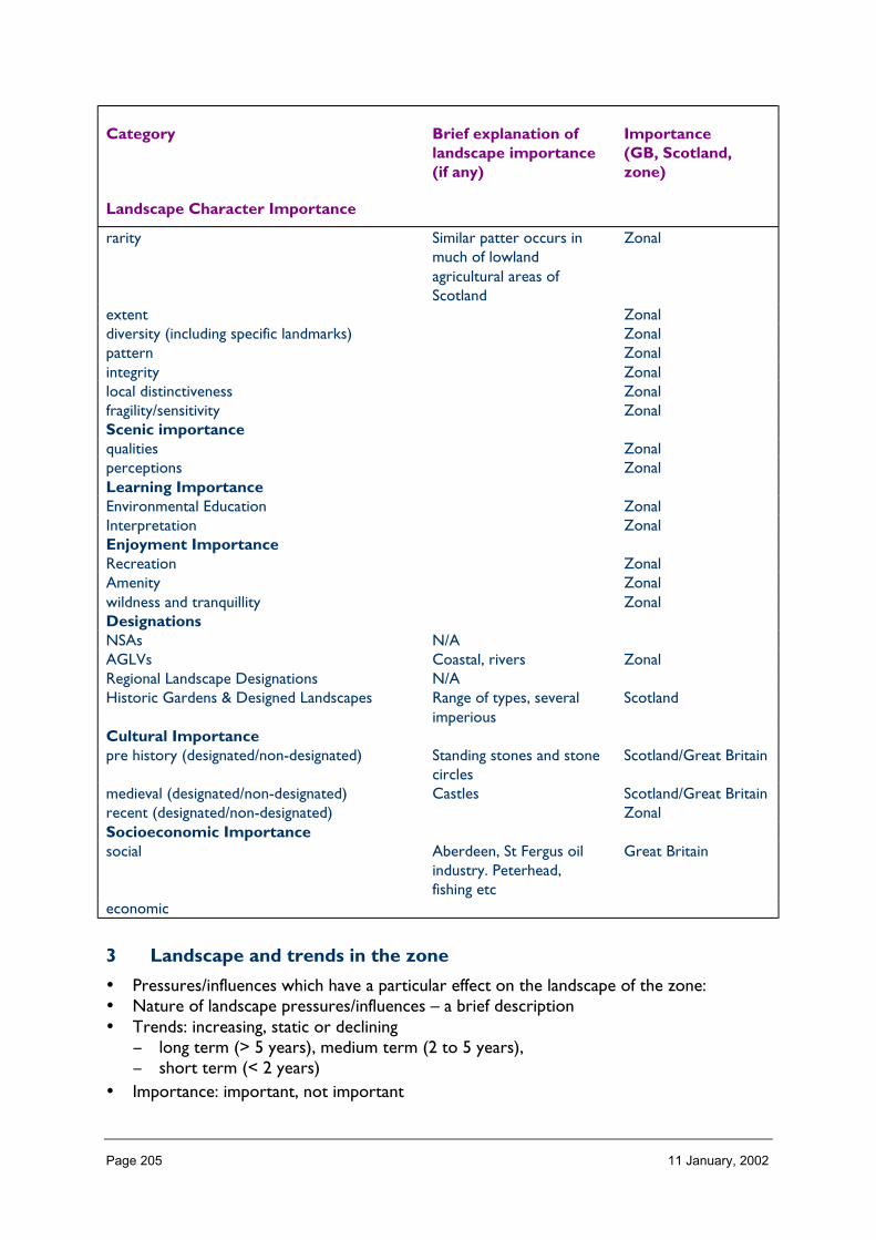
Page 205 11 January, 2002
Category Brief explanation oflandscape importance(if any)
Importance(GB, Scotland,zone)
Landscape Character Importance
rarity Similar patter occurs inmuch of lowlandagricultural areas ofScotland
Zonal
extent Zonaldiversity (including specific landmarks) Zonalpattern Zonalintegrity Zonallocal distinctiveness Zonalfragility/sensitivity ZonalScenic importancequalities Zonalperceptions ZonalLearning ImportanceEnvironmental Education ZonalInterpretation ZonalEnjoyment ImportanceRecreation ZonalAmenity Zonalwildness and tranquillity ZonalDesignationsNSAs N/AAGLVs Coastal, rivers ZonalRegional Landscape Designations N/AHistoric Gardens & Designed Landscapes Range of types, several
imperiousScotland
Cultural Importancepre history (designated/non-designated) Standing stones and stone
circlesScotland/Great Britain
medieval (designated/non-designated) Castles Scotland/Great Britainrecent (designated/non-designated) ZonalSocioeconomic Importancesocial Aberdeen, St Fergus oil
industry. Peterhead,fishing etc
Great Britain
economic
3 Landscape and trends in the zone
• Pressures/influences which have a particular effect on the landscape of the zone:• Nature of landscape pressures/influences – a brief description• Trends: increasing, static or declining
− long term (> 5 years), medium term (2 to 5 years),− short term (< 2 years)
• Importance: important, not important

Page 206 11 January, 2002
Pressure Nature of landscapepressures/influencesand trends withinzone, relativeimportance within thezone
Scale of landscape influence(+ve/–ve) within zone whenconsidered in an all Scotlandcontext
Major Inter. Minor Negligible
Built developmentResidential Significant development
pressure near Aberdeen✔
Retail ✔Industrial ✔Other Offices ✔Infrastructure TransportRoads and tracks ✔Rail related ✔Ferry related ✔OtherInfrastructure otherTelecoms ✔Water treatment/abstraction ✔Waste management ✔Coastal defences Dunes, area of retreating
coast✔
OtherMineralsOpen cast coal N/ASand and Gravel ✔Hard rock ✔Peat ✔OtherForestry and WoodlandsRestructuring of existing ✔Creation of new small ✔Creation of large new/native ✔OtherAquaculture and FishingFinfish Fish farming could be
significant offshorebecause of high visibility
✔
ShellfishFishing River Major fishing rivers but
little developmentgenerally associated withit
✔
OtherLand ManagementSheep production ✔Crop production ✔Sport shooting ✔Other
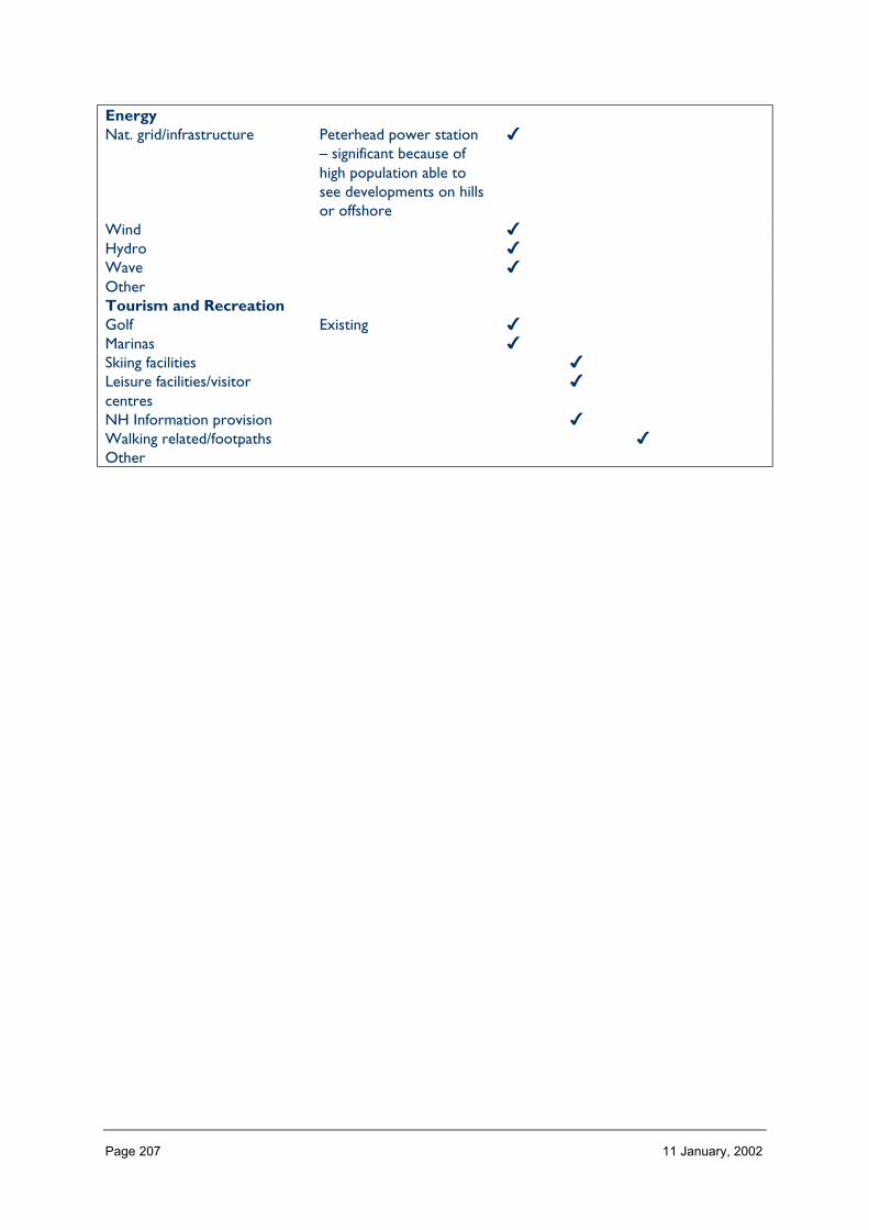
Page 207 11 January, 2002
EnergyNat. grid/infrastructure Peterhead power station
– significant because ofhigh population able tosee developments on hillsor offshore
✔
Wind ✔Hydro ✔Wave ✔OtherTourism and RecreationGolf Existing ✔Marinas ✔Skiing facilities ✔Leisure facilities/visitorcentres
✔
NH Information provision ✔Walking related/footpaths ✔Other
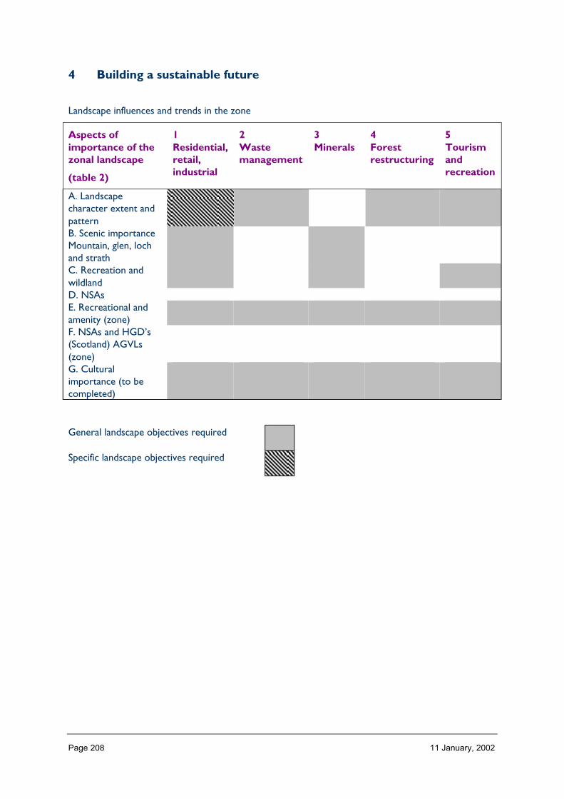
Page 208 11 January, 2002
4 Building a sustainable future
Landscape influences and trends in the zone
Aspects ofimportance of thezonal landscape
(table 2)
1Residential,retail,industrial
2Wastemanagement
3Minerals
4Forestrestructuring
5Tourismandrecreation
A. Landscapecharacter extent andpatternB. Scenic importanceMountain, glen, lochand strathC. Recreation andwildlandD. NSAsE. Recreational andamenity (zone)F. NSAs and HGD’s(Scotland) AGVLs(zone)G. Culturalimportance (to becompleted)
General landscape objectives required
Specific landscape objectives required
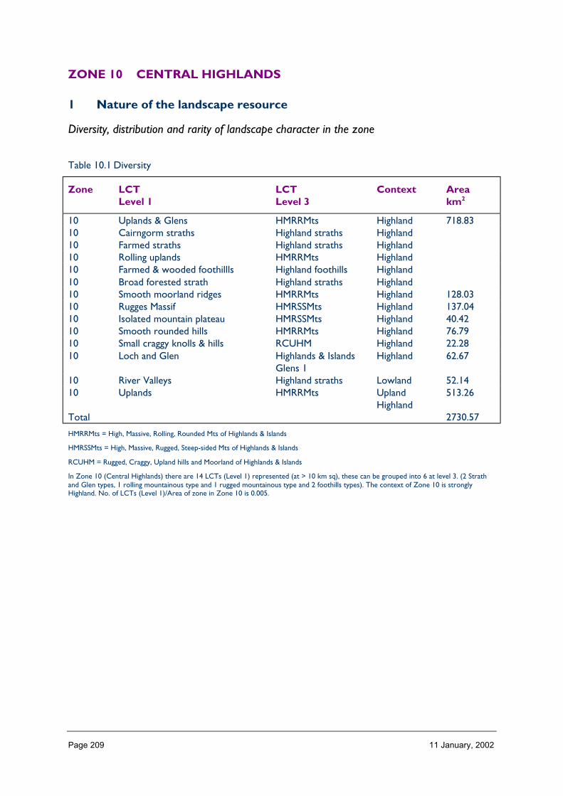
Page 209 11 January, 2002
ZONE 10 CENTRAL HIGHLANDS
1 Nature of the landscape resource
Diversity, distribution and rarity of landscape character in the zone
Table 10.1 Diversity
Zone LCTLevel 1
LCTLevel 3
Context Areakm2
10 Uplands & Glens HMRRMts Highland 718.8310 Cairngorm straths Highland straths Highland10 Farmed straths Highland straths Highland10 Rolling uplands HMRRMts Highland10 Farmed & wooded foothillls Highland foothills Highland10 Broad forested strath Highland straths Highland10 Smooth moorland ridges HMRRMts Highland 128.0310 Rugges Massif HMRSSMts Highland 137.0410 Isolated mountain plateau HMRSSMts Highland 40.4210 Smooth rounded hills HMRRMts Highland 76.7910 Small craggy knolls & hills RCUHM Highland 22.2810 Loch and Glen Highlands & Islands
Glens 1Highland 62.67
10 River Valleys Highland straths Lowland 52.1410 Uplands HMRRMts Upland
Highland513.26
Total 2730.57
HMRRMts = High, Massive, Rolling, Rounded Mts of Highlands & Islands
HMRSSMts = High, Massive, Rugged, Steep-sided Mts of Highlands & Islands
RCUHM = Rugged, Craggy, Upland hills and Moorland of Highlands & Islands
In Zone 10 (Central Highlands) there are 14 LCTs (Level 1) represented (at > 10 km sq), these can be grouped into 6 at level 3. (2 Strathand Glen types, 1 rolling mountainous type and 1 rugged mountainous type and 2 foothills types). The context of Zone 10 is stronglyHighland. No. of LCTs (Level 1)/Area of zone in Zone 10 is 0.005.

Page 210 11 January, 2002
Table 10.2 Distribution/pattern
Zone LCTlevel 1
LCTlevel 3
% ofZone(area)
No. ofOccurrences
Areakm2
10 Uplands & Glens HMRRMts 26 7 718.8310 Cairngorm straths Highland
straths3 6
10 Farmed straths Highlandstraths
1 2
10 Rolling uplands HMRRMts 30 110 Farmed & wooded
foothilllsHighlandfoothills
1 2
10 Broad forested strath Highlandstraths
2 3
10 Smooth moorlandridges
HMRRMts 5 3 128.03
10 Rugged Massif HMRSSMts 5 3 137.0410 Isolated mountain
plateauHMRSSMts 1 1 40.42
10 Smooth rounded hills HMRRMts 3 3 76.7910 Small craggy knolls &
hillsRCUHM 1 2 22.28
10 Loch and Glen Highlands &Islands Glens 1
2 2 62.67
10 River Valleys Highlandstraths
2 1 52.14
10 Uplands HMRRMts 19 6 513.26Total 42 2730.57
In Zone 10 there are 42 occurrences of LCTs at level 1 (where LCT > 10 km sq) found within a zone of total land area 2730. The figure42/2730 is 0.015 given an indication of the overall brokenness or fragmentation of the landscape and can be compared between zones.
LCT at Level 1 Area/
Occurrences (km2)
Uplands & Glens 102.69Cairngorm straths 11.90Farmed straths 12.96Rolling uplands 822.97Farmed & wooded foothillls 6.85Broad forested strath 15.04Smooth moorland ridges 42.68Rugges Massif 45.68Isolated mountain plateau 40.42Smooth rounded hills 25.60Small craggy knolls & hills 11.14Loch and Glen 31.34River Valleys 52.14Uplands 85.54
In Zone 10 the upland LCTs occur as large units (822 km sq → 85 km sq). The Strath and Glen types as one would expect are muchsmaller in extent (52 km sq → 12 km sq), with the more rugged tops, slopes and foothills having a similar range of extent (45 km sq → 7km2).

Page 211 11 January, 2002
LCTs at Level 3 Area km2 Ratio
HMRRMts 2259.88 165Highland straths 194.59 14HMRSSMts 177.46 13Highland Foothills 13.69 1RCUHM 22.28 2Highlands & Islands Glens 62.67 5
The ratio of level 3 LCT groupings gives an indication of the distribution pattern by proportion of the zone, Massive, Rolling, RoundedMountains dominate Zone 10.
Table 10.3 Rarity
LCTs at Level 1 Rarity by occurrence%
Rarity by extent
%
Uplands & Glens 17 26Cairngorm straths 14 3Farmed straths 5 1Rolling uplands 2 30Farmed & wooded foothillls 5 1Broad forested strath 7 2Smooth moorland ridges 7 5Rugged Massif 7 5Isolated mountain plateau 2 1Smooth rounded hills 7 3Small craggy knolls & hills 5 1Loch and Glen 5 2River Valleys 2 2Uplands 14 19
Level 1 LCA
The landscape of Zone 10 is characterised by substantial tracts of the same Upland and mountainous LCTs with lesser areas of Strath andGlen LCTs extending up the main river catchments from the edges of the zone.
The Uplands character types have a marked SW/NE orientation whereas the more rugged mountainous LCTs form a concentrated blockat the southern end of the zone.
Description
Landform
PROFILE
In general, the profile of the landform in Zone 10 is one of smooth and rounded, convexslopes rising to considerable heights.
Deeply incised in places by burns and rivers which towards the edge of the zone oftenoccupy the base of broad glens and straths. In the south the profiles are a good deal moredramatic with rugged and precipitous slopes and corries being common place.
In the zone as a whole 42% of the land area has a slope of 1–5o, 4% is flat and only 1% fallswithin the slope range of 32–40o (max for Zone 10).

Page 212 11 January, 2002
SEQUENCE
A south west/north east section reveals 3 major landform steps from high and ruggedmountains, to high uplands, to moorlands.
diagram
South east/north west sections exhibit more uniformity/consistency rising from northernand southern glens to lower slopes, upper slopes and tops.
The predominant aspects in the zone are south east and north west reflecting thedominance of this section.
SCALE
Although of considerable height (80% of the zone is >300 m, and 26% > 600 m) the verticalscale of much of the zone is difficult to appreciate because of the mass of the uplands andtheir gradual rising slopes. However, in the south the vertical scale is more readilyexperienced owing to the preciptiousness of the slopes. The horizontal scale orexpansiveness of the landscape in the zone is reflected in the uniformity/similarity of theLCTs across the zone and the extent and unbrokenness of the land above 600 m which isgreater even than that seen in Zone 11.
LANDMARK FEATURES
Landform features of landmark ‘quality’ are infrequent within this zone and where theyoccur it tends to be as the individual peaks of the southern mountains e.g. Creag Meagaidhand Carn Liath. The passes of Sloch and Corrieyairack may rank as landmark features.
EXPERIENCE
Public routes through Zone 10 are few and tend to skirt its edges or cut through the landmass in a south east/north west direction. From these locations the sense of the land mass,its continuity and uniformity is foremost. A sense of exposure is emphasised by the generallack of trees, little settlement and ‘in bye’ land and often by snow clad tops and windblastedcorries. This experience of landform dominance in the landscape is only highlighted when anoff-road perspective is taken.
Containment (created by landform and land cover)
TOPOGRAPHY
The containment offered by landform within this zone is generally low because of thecontinuous nature of the upland landmass. The glens which penetrate into this land massand their upper incised reaches result in some containment as illustrated in Strath Dearnand Findhorn the upper Dulnain and the Fechlin, Glen Shirra and Glen Roy where severalsequential elevation classes occur in close proximity to one another.
LAND COVER
Generally vegetation is fairly uniform across the zone and is of a character whichcontributes little to containment other than where woodland occurs within the glens andstraths identified above. The dominant landcover summary classes being Peatland, HeatherMoorland, Montane, rough and improved grassland.

Page 213 11 January, 2002
Built development is only very sporadic within the glens and straths of this zone makes anegligible contribution towards containment.
VISIBILITY
Visibility though wide (reflecting the lack of containment) is often not particularly extensiveowing to the convex nature of the landform. However visibility on the southern andnorthern edges of the zone across neighbouring zones is by contrast often very extensive.
MICROCLIMATIC EFFECTS
The elevation of the zone generally means that it experiences higher levels of precipitationthan the zones immediately to the north and south (21 and 12).
Likewise average windspeeds (and the visible effects of wind in vegetation and snow lie) arehigher. Where significant, year-round shelter exists (really only in the occasional steep sidedglen and gully) this is emphasised by a corresponding luxuriance in the vegetation.
EXPERIENCE
One only experiences much in the way of containment infrequently in this zone and mostoften on the dead-end single track roads which penetrate well into the zone and the narrowgullies and glens which lead off from there.
Accessibility
DISTANCE
Zone 10 is located at some considerable distance form the major population centres of thecentral belt (Edinburgh x miles and Glasgow y miles) but is close to the Invernessconurbation (15 miles or less). The A9 and A86 trunk roads and the east coast railway lineare the principal means of travel to the zone and apart from occasional winter snowproblems, provide relatively easy access.
PHYSICAL ACCESS
Physical access within the zone is however less easy and widespread. The 2 main roadsbisect the zone and traverse its southern boundary, and from that various single track, dead-end roads extend into the zone, mainly as access to the large estates of the interior. Fromhere tracks (some bulldozed) and footpaths penetrate further into the hills providing accessfor sport shooting and fishing. One per cent of the zone is > 8 km from public roads, with asubstantially greater area 15 per cent, being between 5 and 8 km and 39 per cent beingbetween 2 and 5 km from public roads. The terrain of the interior can be difficult totraverse owing to vegetation cover (deep heather and peat hagging).
CULTURAL ACCEPTANCE OF ACCESS
Access within this landscape (i.e. off roads) is tolerated rather than encouraged, access isoften discouraged during the stag season and sometimes also hind.
VISUAL ACCESS
Visual access tends to be along defined corridors into the zone, i.e. up glens and straths.There are however a few high level routes e.g. Corrieyairack and Glen Kyllachy, and peakse.g. in south from where one can see deep into the zone.

Page 214 11 January, 2002
EXPERIENCE
The general experience of access within the zone is that it is restricted both by the natureof the terrain and provision of physical access routes and the lack of explicit encouragement(information, signs etc.). Because of this the zone presents both a physical and psychologicalchallenge and a unique wild land experience.
Land cover (including vegetation and land use)
VEGETATION
The vegetation cover of this zone contributes substantially to its landscape character, withtexture, colours and patterns of montane, peatland and moorland vegetation emphasisingthe underlying upland landforms, and grasslands the glens and straths. In the south of thezone low growing alpine vegetation, heather and poor rough grassland surround areas ofmontane character, the plateaux, summits, ridges and corries of the higher hills.
The central part of the zone is characterised by its vast peatlands, more montane incharacter to the south, heather moorland in the north. This central area then blends intothe drier heather moorlands of the north. At the north east and south east extremities ofthe zone plantation and other mixed woodlands are characteristic. The penetrating glensand straths are characterised by poor and semi-improved grasslands in the south withincreasing component of improved grasslands to the north and even a little cropped groundin the far north of the zone.
EXPOSED ROCK
Exposed rock is common place in the south of the zone where rocky summits, ridges,screes, moraines and corries are key characteristics of the landscape. Elsewhere rockoutcrops, crags and knolls are locally frequent as in the south east of the zone (122 level 1)and north west of zone (37 level 1). In the far north of the zone (141 and 102 level 1) theexposed rock and debris of gorges and deeply incised moorland burns are characteristic.
BUILT DEVELOPMENT
Built development though present and characteristic in its own right does not contributesignificantly to the land cover of the zone. (see also 1.2.6).
EXPERIENCE
The pattern of landcover echoes and emphasises the remote and often exposed characterof this zone, hiding little and expressing the ‘rawness’ of the terrain.
Hydrology and water bodies
TYPE
The rivers and burns of Zone 10 tend to be steep-sided and boulder-strewn. The onlymajor river of the zone is the Findhorn and this along with the tributaries of the Spey andthe Dulnain flow in a north easterly direction.
There are few lochs in the zone and these are only a characteristic feature of the landscapeof the southern part where small upland lochs are to be found around the peaks of BenAlder and Creag Meagaidh and the large reservoirs of Loch Laggan and Loch Ericht (LCTs115 and 72 level 1).

Page 215 11 January, 2002
PATTERN
The pattern of hydrology within the zone, although it has a north east/south west emphasisis not that clearly defined in landscape terms owing to the lack of repetition.
EXPERIENCE
Although not characteristic of the zone as a whole rivers, do have a major effect on theexperience of the landscape of particular parts of the zone, namely the less intensivelyfarmed glens and straths where they form a central feature (LCTs 10, 102 and 35 level 1).
Built and infrastructure development (present day)
NATURE AND PATTERN OF SETTLEMENT
Settlement within Zone 10 is very light. The one or two small nucleated settlements tend torelate to key routes e.g. Tomatin and Roybridge (both railway settlements) and elsewherethere are a scattering of individual dwellings in the various glens and straths, the latterrelating to farming and estate activity. The only strong link in landscape terms is thatbetween the location of settlement the better land, and shelter. Although not within Zone10 the close vicinity of (Inverness, Aviemore, Kingussie, Grantown on Spey) has resulted inthe building of ‘commuter’ residences around the peripheries of Zone 10.
NATURE AND PATTERN OF INFRASTRUCTURE
Roads and railways are the most obvious infrastructure features in this landscape, howeverother than the more major trunk roads (A9 and A96) they are small and tend to fit with theprevailing landscape character.
Quarries other than borrow pits are not a feature of the landscape of this zone.
NATURE AND PATTERN OF INDUSTRIAL DEVELOPMENT
Obvious industrial development is limited to distilling at Tomatin where the distillery is aprominent built feature in the landscape.
EXPERIENCE
The experience of built and infrastructure development is that it is a recognisablecharacteristic of the landscape of Zone 10 but that is dominated by the more naturalcomponents of the landscape especially landform.
Visible history (past settlement, landuse, churches, brochs, forts, dykes, standingstones etc.)
TYPES OF VISIBLE HISTORY
Estate houses, isolated bothies, drystone dykes, shieling sites, archaeological sites, historicartefacts.
LOCATION/PATTERN
Whilst the occasional isolated bothy and estate lodges are often located well into the zoneat the end of the glens, the bulk of visible evidence of past settlement and landuse is to befound on the north western and south eastern edges of the zone (in LCTs 35, 37, 10 and142 level 1), other than the Wade military roads and associated bridges which extendthrough the zone.

Page 216 11 January, 2002
EXPERIENCE
Whilst evidence of previous occupation can be readily discerned in this landscape it is not ofa prominence (to the untrained eye) that makes it a particularly dominant component of thelandscape.
Wildlife
FORMS OF WILDLIFE
Wildlife which is characteristic of this landscape include birds of prey, red deer, mountainhares, red grouse. These can be readily observed in many parts of the zone and along withmoorland birds can form an important part of the landscape experience.
LOCATION
Mountain hares and red grouse are more characteristic of the northern peatlands andheather moorlands, whereas birds of prey (golden eagle, hen harrier, buzzard) can be seenthroughout. Red deer are generally not found in the landscapes of the far north of the zone.
WHEN
Red deer are more visible in winter and in bad weather when they drop down off the hills,mountain hares more visible in their ermine, but present year-round.
Red Grouse and breeding moorland birds (visitors) are more obvious in spring and earlysummer when behaviour and ‘song’ is more pronounced and territorial.
EXPERIENCE
Although the general level of ‘obvious’ wildlife is low compared to many zones, the presenceof species and numbers infrequently experienced elsewhere lends this zone a specialattraction.
Climate
CLIMATIC CHARACTERISTICS
Precipitation AV annual 3200 mm in south to 1200 mm in north.
Windy throughout the zone.
LOCATIONAL AND SEASONAL EFFECTS
Obvious cline of rainfall, snowfall from south west to north east.
EXPERIENCE
Prolonged snow lie emphasises landforms and sense of remoteness.
Designated landscapes
National Scenic AreasThere are no National Scenic Areas in Zone 10.

Page 217 11 January, 2002
AGLVS and other Local Authority designations
NATURE OF THE LANDSCAPE DESIGNATED
There are 2 (HC) designated areas of Great Landscape Value in this zone (to check HC andalso Moray Council), these are both on the river Findhorn at Dulsie and Ardclach and wouldseem to cover sites of historic merit and visitor attraction (check Nairnshire LP, Badenochand Strathspey LP, Strathdearn, Strathnairn and Loch Ness east for other local authoritydesignations).
Historic gardens and designed landscapes
NATURE OF THE LANDSCAPES DESIGNATED
There are no historic gardens and designed landscapes inventory sites in Zone 10. (sectionto be completed after receipt of HGDL profiles).
Recreational landscapes
Nature of location of landscapes and activitiesThe landscapes of Zone 10 in general are remote and not very accessible. These particularwild land characteristics attract the keen hillwalker, ‘through walkers’, runners and mountainbikers, wild campers and bird watchers on day outings.
The more dramatic mountain landscapes in the south of the zone attract great numbers ofhillwalkers (being Munros) and rock and ice climbers in season.
Towards the northern end of the zone the ready road access and good snow lie means thatthese parts are frequented in season by x country skiers.
The tributaries of the Findhorn provide some challenging white water canoeing.
Fishing and sport shooting are widespread ‘recreational’ activities throughout the zone.
EXPERIENCE
The landscape experience provided by the zone is one of wildness, remoteness andchallenging terrain.

Page 218 11 January, 2002
2 Importance and value of the zonal landscape
Category Brief explanation oflandscape importance(if any)
Importance(GB, Scotland,zone)
Landscape Character Importancerarity suspect level of
importance is- Scotland(?)
extent Scottish but need to seein relation
- Scotland(?)
diversity (including specific landmarks) to other zone profilesand national analyses
patternintegrity - Scotland(?)typicalness/local distinctiveness - Scotland(?)fragility/sensitivityCultural Importancepre history (designated/non-designated)medieval (designated/non-designated)recent (designated/non-designated)Socioeconomic Importancesocial large estates provide
much of employmentbasis
zonal
economic zonalScenic importancedesignatednon-designated‘Spiritual’ Importanceremoteness and tranquillity remote and little visited ScotlandLearning ImportanceEnvironmental EducationInterpretationEnjoyment ImportanceRecreation important for particularly
remote experienceScotland
Amenity
Designations
NSAsAGLVsRegional Landscape DesignationsHistoric Gardens & Designed Landscapes

Page 219 11 January, 2002
3 Landscape and trends in the zone
Pressure Nature of pressuretrends within zone,relative importancewithin the zone
Scale of pressures within zonewhen placed in
an all Scotland context
Major Inter. Minor
Built developmentResidentialRetailIndustrialOtherInfrastructure TransportRoads and tracks Road improvement/track
creation for variousactivities includingtelecoms, windfarms,estates
�
Rail relatedFerry relatedOtherInfrastructure otherTelecoms Along road corridors,
effects on wild landexperience and landscapeimpacts. Trend: increasingnumbers
�
Water treatmentWaste managementCoastal defencesOtherMineralsOpen cast coalSand and GravelHard rockPeatOtherForestry and WoodlandsRestructuring of existingCreation of new smallCreation of large new/native Moorland fragmentation,
fencing: Trend for steadyincrease
�
OtherLand ManagementSheep production Localised over-grazing �Crop productionSport shooting Too many deer, access
track creation�
AquacultureFinfish (localised increase)
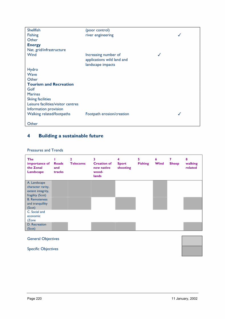
Page 220 11 January, 2002
Shellfish (poor control)Fishing river engineering �OtherEnergyNat. grid/infrastructureWind Increasing number of
applications wild land andlandscape impacts
�
HydroWaveOtherTourism and RecreationGolfMarinasSkiing facilitiesLeisure facilities/visitor centresInformation provisionWalking related/footpaths Footpath erosion/creation �
Other
4 Building a sustainable future
Pressures and Trends
Theimportance ofthe ZonalLandscape
1Roadsandtracks
2Telecoms
3Creation ofnew nativewood-lands
4Sportshooting
5Fishing
6Wind
7Sheep
8walkingrelated
A. Landscapecharacter rarity,extent integrity,fragility (Scot)B. Remotenessand tranquillity(Scot)C. Social andeconomic(ZoneD. Recreation(Scot)
General Objectives
Specific Objectives

Page 221 11 January, 2002
ZONE 11 CAIRNGORM MASSIF
Nature of the landscape resource
Diversity, distribution and rarity of landscape character in the zoneNote: Ignore any LCT which is shown as <10 km sq (if important feature will be coveredelsewhere, if important characteristic locally will be flagged up in description)
Table 11.1 Diversity
Zone LCTLevel 1
LCTLevel 3
Context Areakm2
11 Mountain Plateau High MassiveMountain Plateau ofthe Cairngorms
Highland 568.20
11 Uplands and Glens HMRRMts Highland 1,882.9711 Cairngorm Straths Highland Straths Highland 82.9211 Smooth Rounded Hills HMRRMts Highland 1.5011 Loch and Glen Highland and Island
GlensHighland 10.92
11 Uplands HMRRMts Upland Highland 119.6411 Highland Glens Highland and Island
GlensHighland 298.16
11 Highland Glens withLochs
Highland and IslandGlens
Highland 5.99
11 Highland Summits andPlateaux
HMRRMts Highland 1,065.41
Total 4,035.71
HMRRMts = High, Massive, Rolling, Rounded Mts of Highlands & Islands
HMRSSMts = High Massive, Rugged, Steep-sided Mts of Highlands & Islands
FRSSEHM = Flat or Rolling, Smooth or Sweeping, Extensive, High Moorlands of Highlands & Islands
The number of landscape character types represented in Zone 11 at level 1, is 9 the way they are grouped at level 3 is into 4 and theircontext is strongly Highland. No. of LCTs (Level 1)/Area of Zone in Zone 11 is 0.0025, this gives an indication of the overall diversity oflandscape character in the zone and can be compared between zones.

Page 222 11 January, 2002
Table 11.2 Distribution/pattern
Zone LCTLevel 1
LCTLevel 3
% ofZone(area)
No. ofOccurrences
Areakm2
11 MountainPlateau
High MassiveMountain Plateauof theCairngorms
14.1 3 568.20
11 Uplands andGlens
HMRRMts 46.7 6 1,882.97
11 CairngormStraths
Highland Straths 2.1 20 82.92
11 SmoothRounded Hills
HMRRMts 0.0 1 1.50
11 Loch and Glen Highland andIsland Glens
0.3 2 10.92
11 Uplands HMRRMts 3.0 2 119.6411 Highland Glens Highland and
Island Glens7.4 24 298.16
11 Highland Glenswith Lochs
Highland andIsland Glens
0.1 1 5.99
11 HighlandSummits andPlateaux
HMRRMts 26.4 4 1,065.41
Total 63 4,035.71
In Zone 11 a total 63 occurrences of landscape character types (landscape units) are found within a zone of total land area 4035. km sq.The figure 63/4035 is 0.015.per km sq of land within the zone and gives a relative indication of the overall brokenness or fragmentation ofthe landscape pattern.
LCT at Level 1 Area/Occurrences (km2)
Mountain Plateau 189.40Uplands and Glens 313.82Cairngorm Straths 4.1Smooth Rounded Hills 1.50Loch and Glen 5.46Uplands 59.82Highland Glens 12.43Highland Glens with Lochs 5.99Highland Summits and Plateaux 266.35
The extent (area) of any one landscape character type (at level 1) divided by the number of times it occurs in the zone gives an idea of theaverage size of occurrences of that LCT.

Page 223 11 January, 2002
LCTs at Level 3 Area km2 Ratio
High Massive Mountain Plateau of the Cairngorms 568.20 378HMRRMts 1,882.97 1255Highland Straths 82.92 55HMRRMts 1.50 1Highland and Island Glens 10.92 7HMRRMts 119.64 79Highland and Island Glens 298.16 198Highland and Island Glens 5.99 3HMRRMts 1,065.41 710
The ratio of the extent (area) of the level 3 groupings gives an indication of the distribution pattern by proportion of the zone.
Table 11.3 Rarity
LCTs at Level 1 Rarity by occurrence%
Rarity by extent%
Mountain Plateau 4 14.1Uplands and Glens 9 46.7Cairngorm Straths 31 2.1Smooth Rounded Hills 1 0.0Loch and Glen 3 0.3Uplands 3 3.0Highland Glens 38 7.4Highland Glens with Lochs 1 0.1Highland Summits and Plateaux 6 26.4
The rarity of a landscape character type within the zone can be identified by the number of time it occurs or its extent. Examination ofboth the number of occurrences (of a LCT) as a percentage of the total and the area (of a LCT) as a percentage of the total area will givean indication of rarity.
Landscape characterThe vast majority of this Zone (approximately 90%) consists of high, massive, mountain andmountain plateaux landscape character types. The core mountain plateau of the Cairngormsin the centre of the Zone, and Lochnagar in the east, is surrounded by a ring of high uplandhills.
The remaining character types are highland glens and straths. These are located in small areaon the west of the Zone, and in a series on the southern fringe where they form the upperreaches of the Angus glens. On all sides of the Zone its boundaries link with major glensthat radiate from it.
Description
Landform
PROFILE
This zone is characterised by a mountainous topography of extensive high level plateaux andindividual mountain summits which includes the largest continuous area above 1,000 metresin Britain. The mountains are generally massive and rounded and, together with interveningdeep glens and features such as corries, they display a classic landscape of glacial erosion

Page 224 11 January, 2002
that is internationally important. Therefore, the landform contains frequent examples of U-shaped valleys, corries, truncated spurs, and hanging valleys. Narrow ridges and peaks,however, are absent as the mountains have a smooth outline above the glacially erodedfeatures. Occasional mountain summits have granite tors which form notable landmarks.
SEQUENCE
The main plateau area of the Cairngorms is located in the centre of the Zone, with anoutlier at Lochnagar to the east. Around these areas are successive ridges of roundedsummits that are dissected by a series of wide glens. The fringes of the Zone at west andsouth contain the uppermost reaches of major glens.
SCALE
The landform is very large in scale as well as elevation. None of the zone lies below 200metres, while at its highest it reaches 1,309 metres at Ben Macdui which is the secondhighest mountain in Britain. Most of the Zone lies between 400 and 800 metres above sealevel.
The great breadth as well as the height of these rounded, bulky mountains increases theirscale. Glacially-eroded glens have been deepened and steepened to produce massivefeatures themselves, all on a dramatic scale.
LANDMARK FEATURES
Despite the extent of the mountainous area, and the broad similarity of landform type ofrounded hills and glaciated features, the summits, slopes, and glens of the Zone providealmost numerous landmark features. The core plateaux are widely visible and distinctive. Inaddition, the tors on hills such as Ben Avon and Beinn Mheadhoin are particularlyprominent. The long ‘whaleback’ ridges of hills to the south of the Zone, such as Beinna’Ghlo, are landmarks for stretches of the A9 trunk road.
Glacial erosion has resulted in many distinctive landmarks, including the U-shaped valleysthat the ice deepened. The Lairig Ghru is the largest, and best-known, example of this.Corries can be spectacular features, particularly where the steep, rocky head-wall andgouged-out shape contrast with the more smoothly rounded summits of the mountains. Theset of corries on Braeriach, and the north face of Lochnagar are dramatic examples oferosion.
EXPERIENCE
The few public roads within this Zone are concentrated around the edges. However, theyfollow glens and passes from which the scale and shape of much of the landform can beeasily appreciated. It is, perhaps, the grandeur and remoteness of the area that are its mostobvious features, and this is emphasised when the old drove roads, hill tracks and hill-walking routes are followed into the heart of the Zone.
Containment (created by landform and land cover)
TOPOGRAPHY
Visual containment due to topography varies widely through the Zone, depending onelevation of the viewer. It ranges from relatively narrow valleys and enclosed corries wherecontainment is significant, and emphasised by the large vertical scale of much of the Zone; to

Page 225 11 January, 2002
wider U-shaped glens with long linear views; and to the extraordinarily spacious and openpanoramas that are possible from the upper slopes of the mountains.
LAND COVER
Built development is largely absent over much of the area, and vegetation is limited toground-covering plants, so that land cover does not contribute to a sense of containment.
Elsewhere, however, some lower parts of the Zone are famous for native Caledonianpinewoods, and these grand trees can provide a distinctive form of enclosure while allowingglimpses to the surrounding hills and glens.
VISIBILITY
Visibility largely varies with height, so that it feels almost limitless on the summits in clearweather, but can be relatively limited in some of the lower glens. Throughout the Zone,topography both restricts views while at the same time forming the cynosure or focus ofmany viewpoints.
MICROCLIMATIC EFFECTS
Elevation and the aspect probably have the greatest impact on the microclimate within theZone. Wind speed and frequency increases with height, and this exposure limits the type ofvegetation that can survive at altitude. The greatest visual indicator of this is the tree linewhere woodland growth peters out. Snow and ice lie longest on high ground and in north-facing corries and dips. This again has an impact on vegetation, as well as creating greaterseasonal diversity.
EXPERIENCE
There is dramatic variation in containment throughout the Zone, and this is a characteristicexperience of travelling through the mountains of the area. Hill-walkers, stalkers, and‘Munro-baggers’ experience the greatest change as they climb out of enclosed glens ontothe panoramic extents of the high tops. Areas of pine forest have a characteristically variedelement of containment.
Accessibility
DISTANCE
Zone 11 is located at the north of the Grampian mountains. It lies very approximately 120miles north of Glasgow and Edinburgh, 40 miles south of Inverness, and 60 miles west ofAberdeen. Trunk roads linking these cities pass along the edges of the Zone through largerglens and passes. The Inverness to Perth railway line also follows the main route south overDrumochter in the south of the Zone. Therefore, reaching the fringes of the Zone isrelatively straightforward, although snow occasionally restricts access on all routes forseveral months of the year.
PHYSICAL ACCESS
The mountains of the Zone have always acted as a barrier to communication between thenorth and south of Scotland. The terrain is difficult for access, consisting of high hills, oftenprecipitous slopes and crags, and many rivers. The elevation of the Zone means weatherconditions are often poor and can also hamper access.

Page 226 11 January, 2002
Apart from the trunk roads that skirt the area, only minor roads and tracks penetrate thehills; and these do so for only short distances. Estate routes and bulldozed tracks cover aslightly larger area, and the old drove roads and passes that run north-south are still inexistence, increasingly used for recreation. Footpaths for stalking and hill-walking arefrequent, radiating out from the main entrance points such as Linn of Dee to reach most hillsummits. 12% of the Zone is more than 8 km away from even a minor road, although mostof it (60%) lies between 2 km and 5 km from a road.
CULTURAL ACCEPTANCE
This varies throughout the Zone, largely depending on land ownership. Parts of the areaencourage public access, for example estates owned by the National Trust for Scotland.Most areas are tolerant of responsible access to the hills and Munros of the area.
VISUAL ACCESS
The great height of much of the area means it is visible for large distances, although the mainpoints of access from public roads are limited to the fringes of the Zone. Lower groundlimits visual access to the adjacent hills; high ground opens up a huge area to view –provided the weather conditions also permit it.
EXPERIENCE
Arriving at this Zone from the large population centres to south and east involves abouttwo hours travelling through increasingly large-scale and rural landscapes before the remotearea itself is reached. This can heighten the sense of arriving at a different type of place.Movement within the Zone, apart from the short stretches of trunk road at its fringes,tends to be a highly memorable experience of walking, cycling, or riding through remote anddistinctive uplands. The large extent of the area that is distant from roads and settlementsemphasises this experience.
Land cover (including vegetation and land use)
VEGETATION
Almost two-thirds of the Zone consists of various types of heather moorland, includingmontane moorland. If peatlands and rough grassland are included, then almost 80% of theZone is accounted for. There is a small proportion (5%) of truly montane vegetation, whichis sub-Arctic rather than alpine in character, which is the only plant community able tosurvive the conditions on parts of the summit plateaux.
This means the vast majority of the Zone is covered in low-growing vegetation which tendsto emphasise rather than conceal the landform. Woodlands, including plantations and semi-natural coniferous pine woods, cover only 6% of the area. These, usually located insheltered glens, add variety to the landscape of the Zone by providing a strong contrast withthe open ground of the mountains. Agricultural land is almost absent, with just 2% ofimproved grassland and hardly any arable, and settlement is also a tiny proportion of landcover in this Zone.
EXPOSED ROCK
This is a significant landscape feature in much of the area. Corrie headwalls can be the mostdramatic, forming rugged cliffs to contrast with the smoother summit slopes. There are
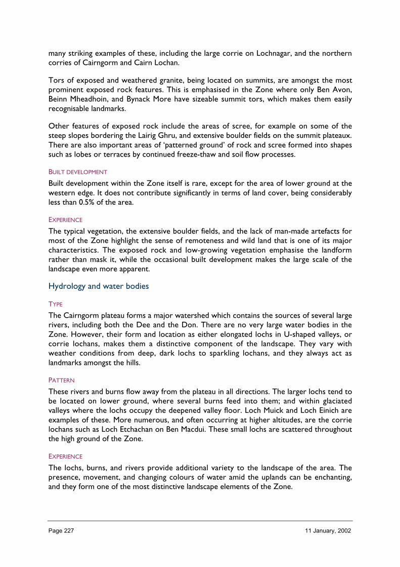
Page 227 11 January, 2002
many striking examples of these, including the large corrie on Lochnagar, and the northerncorries of Cairngorm and Cairn Lochan.
Tors of exposed and weathered granite, being located on summits, are amongst the mostprominent exposed rock features. This is emphasised in the Zone where only Ben Avon,Beinn Mheadhoin, and Bynack More have sizeable summit tors, which makes them easilyrecognisable landmarks.
Other features of exposed rock include the areas of scree, for example on some of thesteep slopes bordering the Lairig Ghru, and extensive boulder fields on the summit plateaux.There are also important areas of ‘patterned ground’ of rock and scree formed into shapessuch as lobes or terraces by continued freeze-thaw and soil flow processes.
BUILT DEVELOPMENT
Built development within the Zone itself is rare, except for the area of lower ground at thewestern edge. It does not contribute significantly in terms of land cover, being considerablyless than 0.5% of the area.
EXPERIENCE
The typical vegetation, the extensive boulder fields, and the lack of man-made artefacts formost of the Zone highlight the sense of remoteness and wild land that is one of its majorcharacteristics. The exposed rock and low-growing vegetation emphasise the landformrather than mask it, while the occasional built development makes the large scale of thelandscape even more apparent.
Hydrology and water bodies
TYPE
The Cairngorm plateau forms a major watershed which contains the sources of several largerivers, including both the Dee and the Don. There are no very large water bodies in theZone. However, their form and location as either elongated lochs in U-shaped valleys, orcorrie lochans, makes them a distinctive component of the landscape. They vary withweather conditions from deep, dark lochs to sparkling lochans, and they always act aslandmarks amongst the hills.
PATTERN
These rivers and burns flow away from the plateau in all directions. The larger lochs tend tobe located on lower ground, where several burns feed into them; and within glaciatedvalleys where the lochs occupy the deepened valley floor. Loch Muick and Loch Einich areexamples of these. More numerous, and often occurring at higher altitudes, are the corrielochans such as Loch Etchachan on Ben Macdui. These small lochs are scattered throughoutthe high ground of the Zone.
EXPERIENCE
The lochs, burns, and rivers provide additional variety to the landscape of the area. Thepresence, movement, and changing colours of water amid the uplands can be enchanting,and they form one of the most distinctive landscape elements of the Zone.

Page 228 11 January, 2002
Built and infrastructure development (present day)
NATURE AND PATTERN OF SETTLEMENT
Built development within the Zone itself is rare, limited to occasional remote lodges,cottages, and bothies, several of which are in ruins.
The exception to this is the area of lower ground at the western edge, where Glenmore,Glen Feshie, and Nethybridge contain groups of cottages, hostels, visitor facilities andrecreational centres. These areas of settlement are mostly located in or near woodland, sotheir visual impact on the wider area is reduced.
Most buildings are vernacular or ‘baronial’ in style. Some of the main lodges can be large,distinctive landmarks. Settlement within the Zone is sparse, but just beyond its boundariesare several population centres which often cater for the visitors attracted by the naturalheritage of Zone 11. These include Aviemore, Braemar, and Tomintoul.
NATURE AND PATTERN OF INFRASTRUCTURE
Infrastructure is limited in this area. It consists mostly of transport routes traversing themountain barrier presented by the Zone to link the north and south of Scotland.
Four ‘A’ class roads cross the Zone, all on or near the boundaries to north, east and south.The A9 trunk road to the south follows the relatively low ground of the Pass ofDrumochter and Glen Garry, a route shared by the Inverness to Perth railway line. The A93from Braemar to Perth follows Glen Shee through the Zone. The other roads, skirting thenorth-east of the Zone, follow old passes that are among the highest in the country,including the Corrbridge to Tomintoul section of the A939 which is notorious for beingfrequently closed by snow. All the roads in this Zone give even the modern-day travellersome of the experience of remoteness and grandeur that the area is renowned for.
Bridges range from old stone arches, some remnants from the eighteenth century militaryroad-building period, to more recent structures designed for heavier modern traffic. Highvoltage electricity lines usually follow the line of the main transport routes, across the Lechtand the Pass of Drumochter.
NATURE AND PATTERN OF INDUSTRIAL DEVELOPMENT
There is no significant industrial development within this Zone.
EXPERIENCE
There is a noticeable lack of settlement, infrastructure and industrial development withinthis remote, upland landscape. This contributes greatly to its wild land qualities and theexperience of being in a distinctive part of the country.
Visible history
TYPES OF VISIBLE HISTORY
This is relatively limited in much of the Zone because its inhospitable climate and terrainmade permanent settlement and transport difficult. However, many of the now desertedglens on the fringes of the area once held low numbers of people who looked after livestockand cultivated small areas of land. Some remnants of their buildings remain as low moundsof stones in areas such as Glen Ey and Glen Clunie. There are also signs of the corrugated
Page 229 11 January, 2002
ground of old run-rig cultivation strips. Some of the upper glens contain remnants ofshielings, or summer pastures.
Some of the old transport routes through the Zone are still used by modern roads andrailways, such as the A9 and A939. Others have become recreational rather thancommercial routes, now used with increasing frequency. The Lairig an Laoigh means ‘pass ofthe cattle’, and the path through it would once have been a droving route. Occasionally, theneed to control such routes or other tracts of land led to the building of defences, and theZone contains the ruins of a few castles.
The sporting estates that developed in the nineteenth century gave rise to shooting lodgesamongst the hills that may have been occupied for as little as two weeks per year. Several ofthese were built in remote locations to facilitate access to certain moors, and many of theseare now in ruins. Examples include Bynack Lodge and Slugain Lodge.
LOCATION/PATTERN
Old farming townships are located on lower, better ground in sheltered glens; shielings canbe sited at higher altitudes. Shooting lodges are often located near the heads of glens, forexample Glenfeshie Lodge. The more remote lodges, such as the ruined Bynack Lodge, canbe located in the upper tributary glens.
The old transport routes generally follow a north – south alignment through glens andpasses, for example the Minigaig linking Atholl and Speyside; and the Mounth Road betweenDeeside and Angus. The ends of these routes was the type of strategic location at whichdefences were built, and the ruined castle at Mark guards the southern entrance to theMounth. A castle with a more dramatic setting is set on an islet in Loch an Eilein nearRothiemurchus.
EXPERIENCE
The presence, occasionally faint, of historical artefacts adds a dimension of time to theexperience of this landscape. Where the remains are of an extinct way of life, such as droveroads or dwellings, in glens that are now deserted, there can be a ghostliness thatemphasises the current remoteness of the area.
Wildlife
FORMS OF WILDLIFE
The summit plateaux support specialised communities of plants, animals and birds that haveadapted to the harsh conditions. Few mammals can exist here throughout the year, and theupland lochs are low in nutrients and support few species. Some of the rivers supportimportant populations of lamprey, salmon and trout, but in themselves these have littleimpact on the landscape.
The large areas of heather moorland, and the remnants of native pine woodland, contain awide range of bird and mammal species. These include capercaille, Scottish crossbill, redgrouse, black grouse, red deer, mountain hare and pine marten.
LOCATION
The summit plateau is limited to species that can survive the particular conditions thatprevail. Three species which are particularly adapted to these conditions are the snow

Page 230 11 January, 2002
bunting, the ptarmigan and the mountain hare. The heather moorland on lower groundsupports a wider range of animals and birds as listed above. Woodland and woodland fringeprovide another important habitat, notably for capercaille, Scottish crossbill, crested tit (inStrathspey) and red squirrel.
WHEN
A few species such as ptarmigan and mountain hare tolerate the extreme conditionsthroughout the year on the high ground. Others such as red deer tend to move to lowermore sheltered ground during the winter months. Migratory birds include the dotterel,present on the summits only in spring and summer.
EXPERIENCE
The movement and noise of wildlife adds an extra dimension to the experience of thislandscape.
Climate
CLIMATIC CHARACTERISTICS
The climate of this Zone is severe with low temperatures, high wind speeds, and highprecipitation. Often, the summits are in cloud while the neighbouring countryside is clear.
LOCATIONAL AND SEASONAL EFFECTS
Apart from seasonal change, variations depend mostly on altitude and aspect. Temperaturesdecrease and wind speeds increase with height and this can have a marked impact on thelandscape with snow lying on the tops, particularly on north-facing slopes and gullies, formuch longer than on low ground. In contrast, sheltered glens can provide conditionssuitable for extensive tree growth.
EXPERIENCE
Considerable variation in colour and texture in the landscape is provided by the blanket ofsnow in winter, and its contrast with lower ground in spring and summer while it melts. Thecloud-covered summits can heighten the sense of scale of the landscape; and blustery,howling winds can emphasise the remoteness of the area.
Designated landscapes
National Scenic Areas
CONSTITUENTS
Most of 2 contiguous NSAs are located within Zone 11: Cairngorm Mountains and Deesideand Lochnagar. They were designated for the large scale and grandeur of the mountains, thedistinctive landform including the corries and passes, the rivers, and the contrast to thebarren summits provided by the woodland in the fringing glens.
LOCATION AND EXTENT
The NSAs are located in the core of the Zone, and cover approximately one-third of itsland area. Only the main valley character areas of the NSAs lie outwith the area, so thatmost of Deeside is beyond Zone 11, and part of Strathspey.

Page 231 11 January, 2002
EXPERIENCE
The areas designated as NSAs include the most dramatic landform and highest mountains ofthe Zone.
AGLVS and other Local Authority designations
NATURE OF THE LANDSCAPE DESIGNATED
Areas to the north and south of the NSAs have been designated of local landscape value.These are upland areas that lack the scale and dramatic landform of the mountainous area ofthe NSAs, but contain distinctive landscapes of hill and glen which are often the focus ofrecreation.
LOCATION AND EXTENT
North-east of the Cairngorms Massif NSA lies the Ladder Hills and parts of Speyside whichhave been designated by Moray Council. The area continues beyond the boundary of Zone11. South and east of the Deeside and Lochnagar NSA, the Angus Glens have beendesignated by Angus Council. These are both sizeable areas of landscapes that are valued fortheir scenery and recreational amenity.
EXPERIENCE
The gentler sloping hills and glens of these landscapes is quite different from the large-scalegrandeur of the nationally designated areas. However, the pleasing combination of hills,glens, rivers, woodland, and open space makes them attractive to visitors and they are oftenwell-used for recreation.
Historic gardens and designed landscapes
NATURE OF THE LANDSCAPES DESIGNATED AND NON-DESIGNATED
The only current Inventory sites in this Zone lies on the western boundary in Strathspey.However, Inshriach Nursery is enclosed and surrounded by woodland and contributes littleto the surrounding landscape. A proposed Inventory site lies north of Nethybridge, again,just within the Zone, but this is also surrounded by woodland and is not an obviouslandscape feature.
Recreational landscapes
Nature of landscapesThis Zone contains a plethora of opportunities, and is of international and nationalimportance for outdoor recreation. A primary activity is walking and hillwalking, in an areathat contains 52 Munros. Rock climbing, gliding, mountain biking, clay-pigeon shooting, andsailing are all popular, as well as the more traditional pursuits of shooting, stalking, andfishing.
The range of winter sports is extensive, including cross-country skiing and ice climbing.Three of the five Scottish down hill skiing centres are located within the Zone.
LOCATION
Many of the activities occur throughout the area, although the greatest numbers of visitorsare probably concentrated on the fringes at areas like Rothiemurchus, Glenmore, and Glen
Page 232 11 January, 2002
Muick. Hill walkers use most of the area for access to the mountains, many of which requirea ‘long walk in’ along the glens or old drove routes. Climbing is generally limited to steeprock faces, for example the Northern Corries. Cross-country skiing occurs throughout theare, while downhill skiing centres are located at Cairngorm, the Lecht, and Glenshee. Sailingis limited to Loch Morlich in Glenmore, where the forest park provides lower level walks.
EXPERIENCE
The sight of other people using the remote areas of the Zone can lessen the sense ofremoteness for which it is known. However, it can also be reassuring to see others in theexpanse of wild land, and other humans give a sense of scale to the vast landscapes of thisZone.

Page 233 11 January, 2002
2 Importance and value of the zone landscape
Category
Brief explanation oflandscape importance(if any)
Importance(GB, Scotland,zone)
Landscape Character Importancerarity Important and distinctive
set of landscapes, highlyrevised for amenities,recreation and beauty
Great Britain
extent Great Britaindiversity (including specific landmarks) Great Britainpattern Great Britainintegrity Great Britainlocal distinctiveness Great Britainfragility/sensitivityScenic importancequalities Great Britainperceptions Great BritainLearning ImportanceEnvironmental Education Important earth science
and ecology resourceGreat Britain
Interpretation Great BritainEnjoyment ImportanceRecreation ZonalAmenity Great Britainwildness and tranquillity Great BritainDesignationsNSAs Great BritainAGLVs ScotlandRegional Landscape DesignationsHistoric Gardens & Designed Landscapes Few ZonalCultural Importancepre history (designated/non-designated) Scotland/Zonemedieval (designated/non-designated) Scotland/Zonerecent (designated/non-designated) Scotland/ZoneSocioeconomic Importancesocial important in attracting
visitors includinginternational
Great Britain
economic
3 landscape and trends in the zone
Pressures/influences which have a particular effect on the landscape of the zone:
• Nature of landscape pressures/influences – a brief description• Trends: increasing, static or declining
− long term (> 5 years), medium term (2 to 5 years),− short term (< 2 years)
• Importance: important, not important

Page 234 11 January, 2002
Pressure Nature of landscapepressures/influencesand trends withinzone, relativeimportance within thezone
Scale of landscape influence(+ve/–ve) within zone whenconsidered in an all Scotlandcontext
Major Inter. Minor Negligible
Built developmentResidential Occasional pressures for
development. Any couldbe significant
✔
RetailIndustrialOtherInfrastructure TransportRoads and tracks Could have major
impacts on landscape andother interests
✔
Rail related N/AFerry relatedOtherInfrastructure otherTelecoms ✔Water treatment/abstractionWaste managementCoastal defences N/AOtherMineralsOpen cast coal N/ASand and Gravel ✔Hard rock ✔Peat ✔OtherForestry and WoodlandsRestructuring of existing ✔Creation of new small Could have high impacts
because of sensitivity ofthe zone
✔
Creation of large new/nativeOtherAquaculture and FishingFinfish Fish farms ✔ShellfishFishing RiverOtherLand ManagementSheep production Major impacts because of
sensitivity✔
Crop production ✔Sport shooting ✔Other

Page 235 11 January, 2002
EnergyNat. grid/infrastructure Major impacts, therefore
sensitivity✔
Wind ✔Hydro ✔Wave N/AOtherTourism and RecreationGolfMarinas N/A ✔Skiing facilities Existing areas ✔Leisure facilities/visitorcentres
✔
NH Information provision ✔Walking related/footpaths Footpath restoration,
management,demonstration etc
Other
4 Building a sustainable future
Landscape influences and trends in the zone (Table 3)
Aspects ofimportance ofthe zonallandscape
(Table 2)
1Residential,retail,industrial
2Wastemanagement
3Minerals
4Forestrestructuring
5Tourismandrecreation
A. Landscapecharacter extentand patternB. ScenicimportanceMountain, glen,loch and strath
SPECIFIC POLICES OR OBJECTIVES REQUIRED THROUGHOUTTHIS ZONE BECAUSE OF ITS HIGH INTERNATIONALIMPORTANCE AND SENSITIVITY TO CHANGE
C. Recreationand wildlandD. NSAs
General landscape objectives required
Specific landscape objectives required
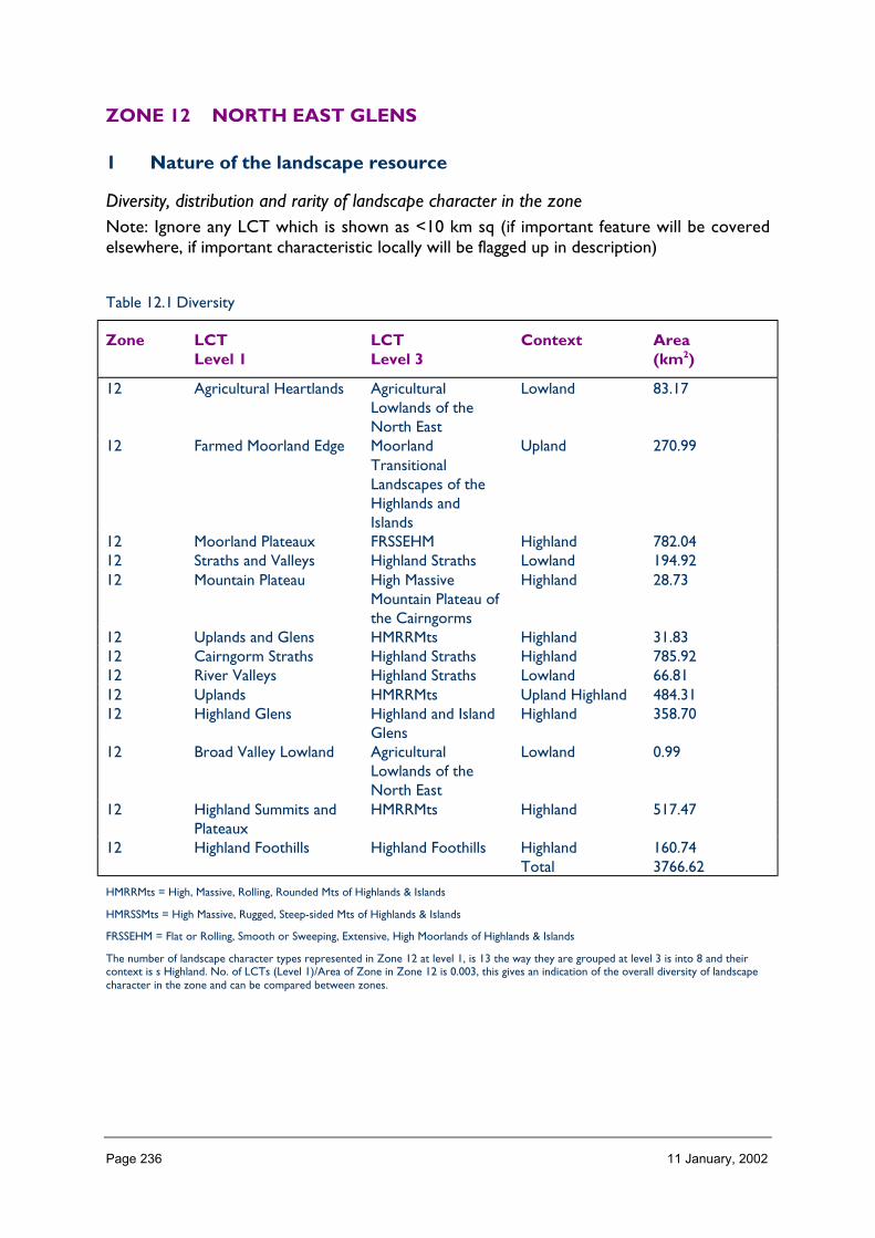
Page 236 11 January, 2002
ZONE 12 NORTH EAST GLENS
1 Nature of the landscape resource
Diversity, distribution and rarity of landscape character in the zoneNote: Ignore any LCT which is shown as <10 km sq (if important feature will be coveredelsewhere, if important characteristic locally will be flagged up in description)
Table 12.1 Diversity
Zone LCTLevel 1
LCTLevel 3
Context Area(km2)
12 Agricultural Heartlands AgriculturalLowlands of theNorth East
Lowland 83.17
12 Farmed Moorland Edge MoorlandTransitionalLandscapes of theHighlands andIslands
Upland 270.99
12 Moorland Plateaux FRSSEHM Highland 782.0412 Straths and Valleys Highland Straths Lowland 194.9212 Mountain Plateau High Massive
Mountain Plateau ofthe Cairngorms
Highland 28.73
12 Uplands and Glens HMRRMts Highland 31.8312 Cairngorm Straths Highland Straths Highland 785.9212 River Valleys Highland Straths Lowland 66.8112 Uplands HMRRMts Upland Highland 484.3112 Highland Glens Highland and Island
GlensHighland 358.70
12 Broad Valley Lowland AgriculturalLowlands of theNorth East
Lowland 0.99
12 Highland Summits andPlateaux
HMRRMts Highland 517.47
12 Highland Foothills Highland Foothills Highland 160.74Total 3766.62
HMRRMts = High, Massive, Rolling, Rounded Mts of Highlands & Islands
HMRSSMts = High Massive, Rugged, Steep-sided Mts of Highlands & Islands
FRSSEHM = Flat or Rolling, Smooth or Sweeping, Extensive, High Moorlands of Highlands & Islands
The number of landscape character types represented in Zone 12 at level 1, is 13 the way they are grouped at level 3 is into 8 and theircontext is s Highland. No. of LCTs (Level 1)/Area of Zone in Zone 12 is 0.003, this gives an indication of the overall diversity of landscapecharacter in the zone and can be compared between zones.

Page 237 11 January, 2002
Table 12.2 Distribution/pattern
Zone LCTLevel 1
LCTLevel 3
% ofZone(area)
No. ofOccurrences
Area(km2)
12 AgriculturalHeartlands
AgriculturalLowlands of theNorth East
2.2 3 83.17
12 FarmedMoorland Edge
MoorlandTransitionalLandscapes of theHighlands andIslands
7.2 3 270.99
12 MoorlandPlateaux
FRSSEHM 20.8 11 782.04
12 Straths andValleys
Highland Straths 5.2 4 194.92
12 MountainPlateau
High MassiveMountain Plateauof theCairngorms
0.8 1 28.73
12 Uplands andGlens
HMRRMts 0.8 25 31.83
12 CairngormStraths
Highland Straths 20.9 11 785.92
12 River Valleys Highland Straths 1.8 1 66.8112 Uplands HMRRMts 12.9 5 484.3112 Highland Glens Highland and
Island Glens9.5 15 358.70
12 Broad ValleyLowland
AgriculturalLowlands of theNorth East
0.0 3 0.99
12 HighlandSummits andPlateaux
HMRRMts 13.7 10 517.47
12 HighlandFoothills
Highland Foothills 4.3 6 160.74
Total 98 3766.62
In Zone 12 a total 98 occurrences of landscape character types (landscape units) are found within a zone of total land area 3766. km sq.The figure 98/3766 is 0.026 per km sq of land within the zone and gives a relative indication of the overall brokenness or fragmentation ofthe landscape pattern.

Page 238 11 January, 2002
LCT at Level 1 Area/Occurrences (km2)
Agricultural Heartlands 27.72Farmed Moorland Edge 90.33Moorland Plateaux 71.09Straths and Valleys 48.73Mountain Plateau 28.73Uplands and Glens 1.27Cairngorm Straths 71.44River Valleys 66.81Uplands 96.86Highland Glens 23.91Broad Valley Lowland 0.33Highland Summits and Plateaux 51.74Highland Foothills 26.79
The extent (area) of any one landscape character type (at level 1) divided by the number of times it occurs in the zone gives an idea of theaverage size of occurrences of that LCT.
LCTs at Level 3 Area (km2) Ratio
Agricultural Lowlands of the North East 83.17 83Moorland Transitional Landscapes of the Highlands and Islands 270.99 273FRSSEHM 782.04 789Highland Straths 194.92 196High Massive Mountain Plateau of the Cairngorms 28.73 29HMRRMts 31.83 32Highland Straths 785.92 793Highland Straths 66.81 67HMRRMts 484.31 489Highland and Island Glens 358.70 362Agricultural Lowlands of the North East 0.99 1HMRRMts 517.47 522Highland Foothills 160.74 162
The ratio of the extent (area) of the level 3 groupings gives an indication of the distribution pattern by proportion of the zone.
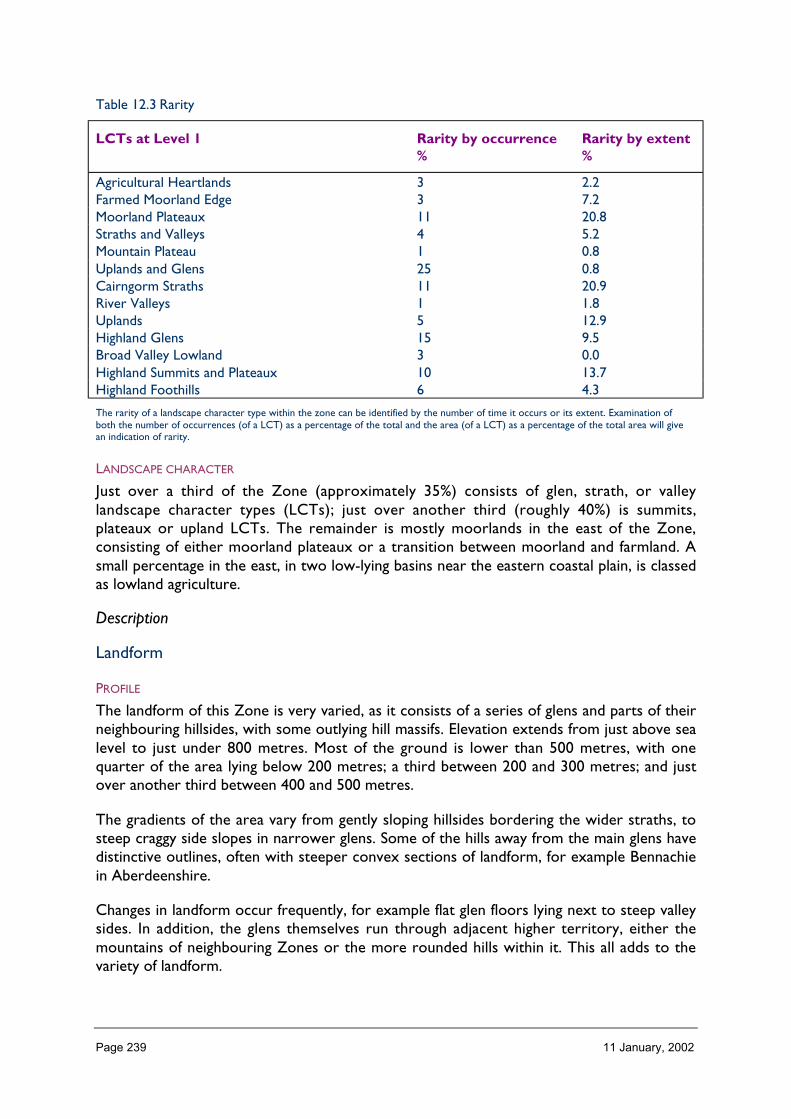
Page 239 11 January, 2002
Table 12.3 Rarity
LCTs at Level 1 Rarity by occurrence%
Rarity by extent%
Agricultural Heartlands 3 2.2Farmed Moorland Edge 3 7.2Moorland Plateaux 11 20.8Straths and Valleys 4 5.2Mountain Plateau 1 0.8Uplands and Glens 25 0.8Cairngorm Straths 11 20.9River Valleys 1 1.8Uplands 5 12.9Highland Glens 15 9.5Broad Valley Lowland 3 0.0Highland Summits and Plateaux 10 13.7Highland Foothills 6 4.3
The rarity of a landscape character type within the zone can be identified by the number of time it occurs or its extent. Examination ofboth the number of occurrences (of a LCT) as a percentage of the total and the area (of a LCT) as a percentage of the total area will givean indication of rarity.
LANDSCAPE CHARACTER
Just over a third of the Zone (approximately 35%) consists of glen, strath, or valleylandscape character types (LCTs); just over another third (roughly 40%) is summits,plateaux or upland LCTs. The remainder is mostly moorlands in the east of the Zone,consisting of either moorland plateaux or a transition between moorland and farmland. Asmall percentage in the east, in two low-lying basins near the eastern coastal plain, is classedas lowland agriculture.
Description
Landform
PROFILE
The landform of this Zone is very varied, as it consists of a series of glens and parts of theirneighbouring hillsides, with some outlying hill massifs. Elevation extends from just above sealevel to just under 800 metres. Most of the ground is lower than 500 metres, with onequarter of the area lying below 200 metres; a third between 200 and 300 metres; and justover another third between 400 and 500 metres.
The gradients of the area vary from gently sloping hillsides bordering the wider straths, tosteep craggy side slopes in narrower glens. Some of the hills away from the main glens havedistinctive outlines, often with steeper convex sections of landform, for example Bennachiein Aberdeenshire.
Changes in landform occur frequently, for example flat glen floors lying next to steep valleysides. In addition, the glens themselves run through adjacent higher territory, either themountains of neighbouring Zones or the more rounded hills within it. This all adds to thevariety of landform.
Page 240 11 January, 2002
SEQUENCE
Throughout the Zone there is a valley sequence of high ground bordering lower, flatterground. The relief, therefore, changes quickly over a small area. The largest glens run in anorth-easterly or easterly direction, while the Angus Glens have a south-easterly direction.Generally, the glens radiate from the higher ground of the mountains of Cairngorm and theMounth.
SCALE
Generally, the Zone landform is medium in scale, as the hills are the foothills of the highermountains located, for example where the transition from the eastern coastal plain occurs.However, the scale of some of the valleys is large, especially Strathspey, Deeside andDonside.
LANDMARK FEATURES
The valleys of the Zone are themselves widely known features: Strathspey, Donside, theAngus Glens, Deeside. Many of the individual hills are distinctive and, therefore, known aslandmarks. Examples include Bennachie for its shape and local associations; Clachnaben forits summit tor; and Knock Hill which stands out due to its relative isolation.
The high hillsides of some of the larger valleys lie within neighbouring Zones (11 and 10),but visible as landmarks from Zone 12. These are often on a larger scale than the landformof this Zone, and include Lochnagar seen from Deeside, and Cairngorm seen fromStrathspey.
EXPERIENCE
The medium scale of the landform, and the way it varies over relatively short distances,mean the experience of the landform is always changing as one travels through it. The focalpoint of views alters quickly, perhaps from one side of a glen to the other; or from a curvein the valley to a long, straight defile.
Many transport routes follow the glens, as easier ways through the country than the nearbyhigh ground. These often provide excellent vantage points from which to experience thelandform.
Containment (created by landform and land cover)
TOPOGRAPHY
Containment by landform in this Zone varies a lot because the topography varies. In thesmaller scale glens it can cause a considerable sense of enclosure, with focused, linearlandscapes for example in parts of Glen Clova. Other glens and straths are much larger,with boundary hillsides sited further apart allowing wider views and giving less containment.Examples include Strathspey, Strathdon, and Deeside.
With higher elevations, wider views become possible and containment is lessened.
For example, from the Cairn o’ Mount viewpoint, from parts of Glenshee, and from hilltopssuch as Bennachie, great swathes of neighbouring countryside can be seen and theexperience is of exposure rather than containment.
Page 241 11 January, 2002
LAND COVER
Many parts of the Zone are wooded and these areas can have a strong sense of enclosure.Woodland and plantation occurs particularly in the sheltered environments provided by theglens, so that the effect of topographical containment is compounded by woodland. Severaltowns and large villages are located within the Zone, but they do not contribute significantlyto containment.
VISIBILITY
The range of enclosure, particularly by topography, means that the amount of visibility alsovaries considerably. Within the glens, views are often limited to the valley itself, with longviews focused along the feature. Nevertheless, these views can often be extensive when theglens or straths are large features, or where the side slopes allow glimpses to other nearbyhills. From higher ground, the visibility can be very extensive, and several hills in the areaprovide renowned viewpoints, for example Bennachie or the Cairn o’ Mount road.
MICROCLIMATIC EFFECTS
Apart from elevation, the amount of shelter provided by landform, and the orientation ofvalleys to the prevailing winds tend to impact on microclimatic effects within the Zone. Lowground in the glens is generally shielded from winds, depending on the orientation of thearea, but may be more susceptible to longer frosts. The higher ground of the hills is, ofcourse, relatively exposed and snow lies for longer.
EXPERIENCE
Usually, main public routes follow the lower, easier terrain of valley floors, so that theexperience of containment is often considerable. This is highlighted by the areas ofwoodland that often grow on lower slopes and floors of the glens. Occasional route takepasses over hill ranges, and these are much less enclosed. The Cairn o’ Mount route overthe eastern Mounth, and parts of the A96 Aberdeen to Inverness road can permit wideviews with a sense of open-ness rather than containment.
Accessibility
DISTANCE
The Zone is widely spread out, and there is a corresponding variation in proximity topopulation centres and accessibility. The eastern area is very close to Aberdeen and parts ofthe north-western area are close to Inverness. The southern area is near Perth and Dundee.Roughly, the southern part of the Zone is 60 – 80 miles from the main population centres ofthe Central Belt.
Access to the Zone is facilitated by its containing several main transport routes betweennorth and south, and east and west of Scotland The A9, A93 and A96 all run through theZone, as do two main railway lines.
PHYSICAL ACCESS
The transport network in the Zone is extensive, including two trunk roads, several ‘A’ classroads, and numerous minor roads. They, and the railway lines, follow the easiest terrain, i.e.valley floors and lowest hill passes. The network covers almost all of the Zone, with no areabeing further than 8km from a road, and with the vast majority of it being no further than5km from a road.
Page 242 11 January, 2002
The terrain is rarely very difficult for access, except on the steepest slopes. The SpeysideWay long distance route follows the river through the Zone, and other footpaths andcycleways are common in much of the area.
CULTURAL ACCEPTANCE
This varies, from widely promoted access on the Speyside Way, to the agricultural andsporting areas where access is less encouraged, although not necessarily opposed. There areseveral Forest Enterprise and National Trust for Scotland sites, as well as commercial ruralattractions which are widely accessible.
VISUAL ACCESS
The considerable network of public roads, and railways, means that much of the Zone isvisually accessible. In some locations, for example the remoter small Angus glens, the bestviews can be had from public roads outwith the Zone. This means few parts of the Zone arecompletely ‘secret’.
EXPERIENCE
Access to the Zone is straightforward from most main population centres. From somedirections, for example the east or south, its landscapes can provide a contrast with thoseof adjacent Zones so that the sense of arrival can be heightened. Within the Zone thenetwork of roads and paths, and the highly varied nature of the landform and landscapes,means that moving around the Zone can be a very distinctive experience.
Land cover (including vegetation and land use)
VEGETATION
Approximately one third of the area is agricultural, of which most is pasture. Moorland andrough grassland account for almost 40% of the area, with woodland covering a quarter. Thewoodland is mostly coniferous, including native pine woods. The woodlands make asignificant contribution to the landscape as they often emphasise the landform by occurringin sheltered, lower lying areas, or on steep inaccessible slopes.
The main agricultural areas are in the east of the Zone where low-lying ground such as theHowe of Alford is contained within surrounding hills. However, most of the flat valleybottoms of the area are given over to agriculture, and this is distinctive both where all theflat land is left open and formed into fields, and also where the fields are punctuated withlines of trees and areas of woodland.
The heather moorland is one of the most notable features of the landcover as it tends tooccur on higher, more prominent ground. Again, this emphasises the landform by its havingparticular vegetation types associated with it. Its open-ness and changing but subtle coloursform a clear contrast with the often vibrant greens or autumn colours of the woodland.
EXPOSED ROCK
The most obvious features of exposed rock are the large summit tors of some of the hills,notably Bennachie and Clachnaben, both in Aberdeenshire. These are dramatic landmarks.Elsewhere, for example in Speyside, there are some areas of scree and crags but, in general,the Zone has more gentle and vegetated slopes than craggy hills.

Page 243 11 January, 2002
BUILT DEVELOPMENT
Built development is frequent in the Zone, in which there are several towns or large villagesas well as numerous hamlets and farmsteads. The settlements tend to be concentrated inthe glens that provided transport links and more cultivable ground, and there is often aseries of villages down the main glens. In Speyside there are Newtonmore, Kingussie,Aviemore, Grantown and Charlestown, as well as many smaller settlements; and similarly onthe Tay there is Dunkeld and several villages.
The settlements are mostly traditional in style, and are often associated with woodland andtrees. Several have centres or squares that are planned (e.g. Keith and Grantown), or atleast have rather grand hotels or halls (e.g. Braemar). They have a distinctive, often well-to-do character.
EXPERIENCE
The variety of vegetation often emphasises the underlying landform, changing from pastureand woodland on flat land and lower slopes to moorland on the hills. Settlements also echothe topography, being built on flat or rising ground by the valley floors, and near rivercrossing points. The frequent harmony between landform, vegetation, and settlement is afeature of the Zone.
Hydrology and water bodies
TYPE
Rivers are the most significant water feature in this Zone, given their fundamentalcontribution to the valleys. However, lochs and lochans are fairly frequent in the area, andthey can be distinctive and dramatic focal points in the landscape. Examples include LochInsh on Speyside and Lochs Davan and Kinnord in Deeside.
PATTERN
The water features are almost wholly found within the valleys, both main and tributary. Nosubstantial lochs are located away from the valley floors.
EXPERIENCE
Water features are a fundamental component of the glen landscapes in this Zone.
The main rivers are wide and silvery, winding through the valleys, often seen from thefrequent river-side roads. Views of the river change frequently as the angle of river to roadalters, which keeps the experience varied, as does the sight of the occasional large lochs.
Built and infrastructure development (present day)
NATURE AND PATTERN OF SETTLEMENT
Most settlement is located on valley floors, often at river crossing points or where transportroutes coincide. There is often a series of settlement down a valley, for example Braemar,Ballater, Aboyne, and Banchory on the Dee.
Generally, buildings are traditional, although pressure for new housing and touristaccommodation has led to modern developments, albeit often based on older styles. The
Page 244 11 January, 2002
centres of settlements are often distinctive, with large hotels, shops or pubs built of localstone and often embellished with features such as turrets or carving.
NATURE AND PATTERN OF INFRASTRUCTURE
Transport routes tend to follow the easier terrain of the river valleys, as do otherinfrastructural elements such as pylon lines. Infrastructure is generally not obtrusive.
NATURE AND PATTERN OF INDUSTRIAL DEVELOPMENT
Industrial development is not common in this Zone. However, whisky distilleries aredistinctive features in the landscape where they occur, for example at Charlestown ofAberlour on Speyside. There is also occasional associated industry such as cooperages andvisitor centres. Tourism and its facilities are a common element in most areas of the Zone.Agricultural industry such as the feed mill at Rothes is infrequent, but testifies to a significanteconomic force in the Zone.
EXPERIENCE
Settlement and infrastructure are a basic part of the landscape of this Zone, because itsvalley topography facilitates its use for transport and settlement. The association of theseelements with the lower ground emphasises the mixture of landform and vegetation,forming a basic set of characteristics in the area. The occasional exception of a distillery onhigh, more remote ground, as at Tormore in Speyside, only highlights this.
Visible history (past settlement, landuse, churches, brochs, forts, dykes, standingstones etc.)
TYPES OF VISIBLE HISTORY
There are many features of visible history in this Zone, most of them defensive and includingbarracks and military roads, but the principal type is castles. These occur as both ruins andwhole buildings, sometimes having been restored. There are also stone circles in the east ofthe Zone.
LOCATION/PATTERN
Castles, mottes, and barracks are often sited on slight rises within wider open ground onvalley floors that command good views of the main, and sometimes also subsidiary, glen.Examples include Mar at Braemar, the motte at Lumphanan, and Ruthven barracks atKingussie. They were also built at important points on transport routes, for exampleCorgarff Castle at the head of Strathdon on the road over the Lecht. Hill summits tend tohave few visible remnants of defences, with the notable exception of the vitrified fort onMither Tap of Bennachie in Aberdeenshire.
Stone circles are located in the east of the Zone, for example near Tarland. They are on theoutskirts of the main area of standing stones and stone circles which lies further east.
Old military routes and drove roads are sited through the Zone, many now used by modernroads such as the A9, and the A939 Corgarff to Tomintoul road. These tend to be lessobvious in the landscape.

Page 245 11 January, 2002
EXPERIENCE
Of the historic features, the castles in particular are often prominent features in thelandscape, still sited at focal points and now often the site of associated visitor facilities suchas car parks. Visible historical features add significantly to the depth of experience of theZone landscapes by providing a sense of time and long human habitation. They also act asfocal points and are often key features within a landscape.
Wildlife
FORMS OF WILDLIFE
The range of habitats provided by the different elevations, landcover, and weatherconditions ensures a variety of wildlife in the Zone. Many species typical of central Scotlandoccur, such as red squirrel, mountain hare, several bat species, and adders.
There is a range of bird species reflecting the habitat spectrum from high inland foothills tolower – lying agricultural ground.
LOCATION
Woodland and woodland fringe species tend to be concentrated in the straths and glenswhere this habitat occurs. Examples include capercaille and red squirrel. Moorland provideshabitat for many species including mountain hare. The agricultural areas are home to brownhare and badger, amongst other species.
WHEN
Many species that are typical of the area are found there all year. Wintering geese may feedon agricultural ground in the east of the Zone. Summer nesting birds occur throughout theZone.
EXPERIENCE
Glimpses of wildlife, for example birds soaring above the hillsides, or hares and squirrelsdarting across roads and clearings are welcome in themselves. They also contribute to thebalance of the Zone in its range of habitats from semi-natural areas and woodland to themore managed heathland and agricultural ground.
Climate
CLIMATIC CHARACTERISTICS
The variety of elevation and shelter in the Zone leads to a corresponding range of climaticcharacteristics. It is often subject to severe weather conditions, particularly the higher partsof the inland glens, and large changes in temperature. Braemar is often known for having thecoldest, and occasionally the highest, temperatures in the country.
LOCATIONAL AND SEASONAL EFFECTS
Altitude affects temperatures, winds, and snow lie. The sheltered glens and howes can oftenhave relatively beneficial climates. North facing slopes in long glens are often in shadow, andthis can have an impact on the perception of the area.

Page 246 11 January, 2002
EXPERIENCE
Snow lying on high ground and on tree branches adds dramatic colour contrast to thelandscapes of the Zone, as can views to even longer-lying snow on the mountains ofadjacent Zones. The amount of wind and shelter varies through the Zone, and thiscontributes to senses such as comfort or remoteness.
Designated landscapes
National Scenic Areas
CONSTITUENTS
Small parts of three NSAs are located in this Zone. To the west, a tiny part of theStrathspey section of the Cairngorm Mountains NSA lies within the Zone. The valley sectionof the Deeside and Lochnagar NSA is located to the east of the Zone and, in the south,there is a part of the River Tay (Dunkeld) NSA. This number of NSA fragments is partlyexplained by the location of the Zone, which wraps around one of the main mountainmassifs of Scotland. In addition, the Zone contains several large scale glens each verydifferent from each other and each renowned for its landscapes.
LOCATION AND EXTENT
The NSA parts are located on the edges of the Zone (although it is a narrow, fragmentedZone rather than a simple, single area of land), to the east, north-west, and south. Theextent of coverage of NSAs in the Zone is small, the largest section being Deeside fromLinn of Dee to just upstream of Ballater.
EXPERIENCE
The NSAs all spill out into neighbouring Zones, and the area of view often extends beyondthe Zone boundaries. As a result, the NSAs tend to be seen in conjunction with the hightops of Zone 11, for example.
AGLVS and other Local Authority designations
NATURE OF THE LANDSCAPE DESIGNATED
There are several areas of local authority designated landscapes, comprising: the areaaround the Cromdale Hills, Glen Livet and Aberlour in the Moray Council area; the AngusGlens in the Angus Council area; and mid and lower Deeside, Strathdon, and parts of theMounth in the Aberdeenshire Council area. The areas exhibit a range of landscape charactertypes of hills and valleys although their orientation and individual character is different.
The Moray area is more highland in nature, made individual by occasional planned villagesand distilleries. The Angus Glens are distinctive, and tend to have less settlement. Deesideand Strathdon are major river valleys with large amounts of woodland and distinctivesettlements.
LOCATION AND EXTENT
The Cromdale Hills area is located at the north of the Zone. The Angus Glens cover alarger area to the south-east. Deeside, Strathdon and the Mounth comprise a significant areain the east of the Zone.

Page 247 11 January, 2002
EXPERIENCE
The hills within the locally designated landscapes are generally smaller in scale, and theyoccur in the transition zone between the inland mountains and the coastal plains of Moray inthe north and Strathmore/Angus/Aberdeenshire in the south and east. Consequently, theircharacter is broadly typical of the rest of the Zone. The areas are popular with visitors, andthe number of tourist attractions, signs, and people can have an impact on the experience ofthese areas.
Historic gardens and designed landscapes
NATURE OF THE LANDSCAPES DESIGNATED AND NON-DESIGNATED
There are many historic gardens and designed landscapes in this Zone. Frequently theyinclude abundant wooded areas as shelterbelts or policy woodland and occasionally asplantations. This often means they merge seamlessly into the well-wooded landscapes of theglens and straths in the Zone.
LOCATION
Most sites are located in sheltered parts of the glens and straths. There seem to be more inthe eastern and southern parts of the Zone than in Strathspey. Of designated ‘Inventory’sites, nearly all are situated in Deeside and Strathdon, and along the southern boundary ofthe Zone. Two proposed new sites in Strathspey, and an existing site near Fochabers arethe only exceptions to this rule.
EXPERIENCE
Most of the sites have significant areas of policy woodland that can act as a particular focuswithin a wider wooded area, although they may not be conspicuous in the landscape as aresult. The occasional high drystone boundary wall or ornate gate piers are often the mainhint of a garden’s presence, despite the significant contribution of policy woodland andshelterbelts.
The most obvious features can be the monuments, obelisks and cairns that are frequentlylocated within or near the designed landscapes. Examples that are visible from main roadsinclude the Duke of Gordon’s Monument near Aviemore and the series of cairns atBalmoral.
Recreational landscapes
Nature of landscapesThe Zone includes the approaches to the Cairngorms and part of the Speyside Way longdistance route. For these reasons, as well as a variety of other recreational opportunities,many of the landscapes of the Zone are well used. Walking is the most popular activity, onseveral hills such as Bennachie as well as on the Speyside Way. The many forests andwoodlands provide facilities mainly for walking, but also for cycling and horse riding.
LOCATION
Opportunities for walking occur throughout the Zone, as do the wider range of facilitiesthat can be provided by woodland and forestry. Main forest areas include Glen Tanar,Clashindaroch, and Fetteresso. Other facilities are more localised, for example water sports
Page 248 11 January, 2002
on Loch Insh in Strathspey, gliding at Glen Feshie and Aboyne, and rock climbing. All themain rivers are used for fishing.
The Zone is easily reached by the many residents of several large cities and towns nearby,including Aberdeen, Inverness, Dundee and Perth. This increases the number of visitors itreceives for recreation.
EXPERIENCE
Several particularly popular areas are often very busy, for example the hill walks onBennachie near Aberdeen, and around Aviemore. This can have an impact on theexperience of the landscape, although certain areas, such as the forests, can contain largenumbers of people without it being obvious. The less popular or accessible hills are oftencorrespondingly quiet, and they can have a quite different atmosphere.
2 Importance and value of the zone landscape
A judgement of the importance or value of the zonal landscape under the followingheadings:
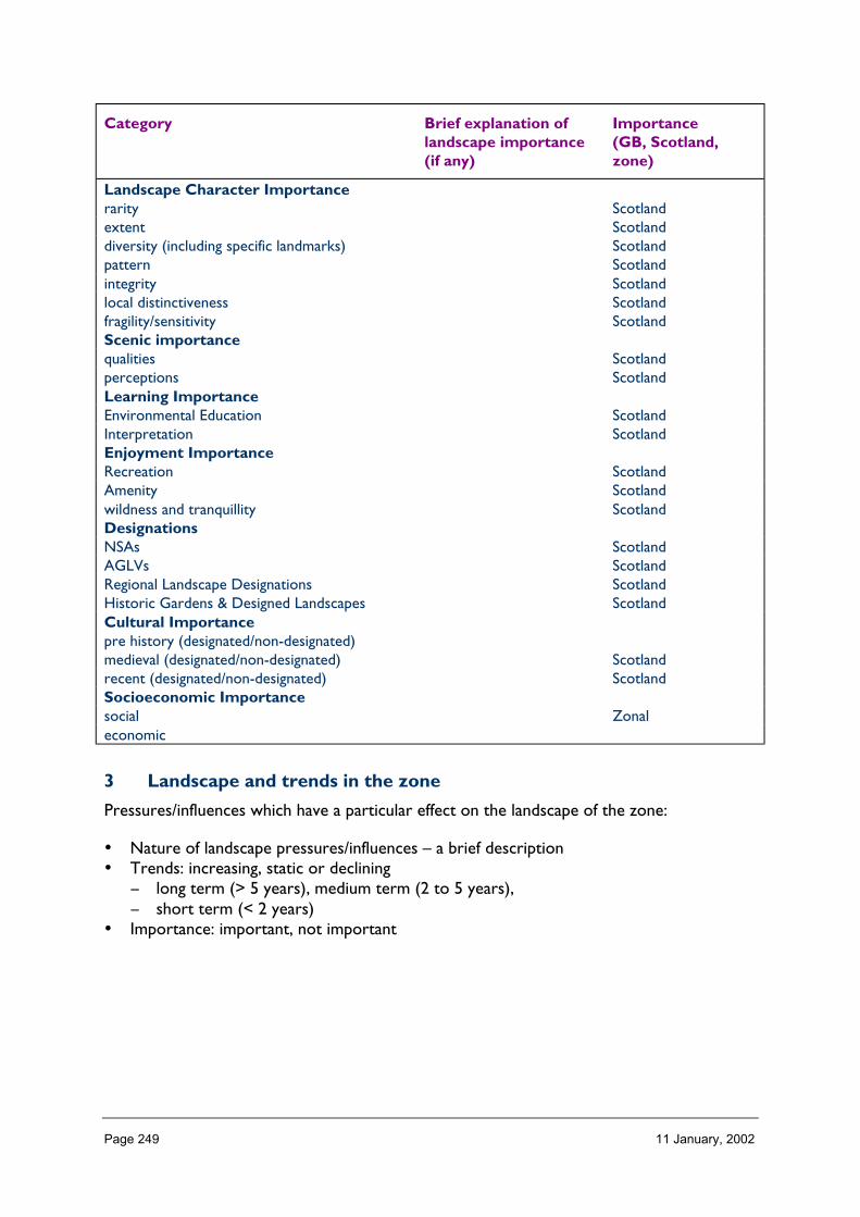
Page 249 11 January, 2002
Category Brief explanation oflandscape importance(if any)
Importance(GB, Scotland,zone)
Landscape Character Importancerarity Scotlandextent Scotlanddiversity (including specific landmarks) Scotlandpattern Scotlandintegrity Scotlandlocal distinctiveness Scotlandfragility/sensitivity ScotlandScenic importancequalities Scotlandperceptions ScotlandLearning ImportanceEnvironmental Education ScotlandInterpretation ScotlandEnjoyment ImportanceRecreation ScotlandAmenity Scotlandwildness and tranquillity ScotlandDesignationsNSAs ScotlandAGLVs ScotlandRegional Landscape Designations ScotlandHistoric Gardens & Designed Landscapes ScotlandCultural Importancepre history (designated/non-designated)medieval (designated/non-designated) Scotlandrecent (designated/non-designated) ScotlandSocioeconomic Importancesocial Zonaleconomic
3 Landscape and trends in the zone
Pressures/influences which have a particular effect on the landscape of the zone:
• Nature of landscape pressures/influences – a brief description• Trends: increasing, static or declining
− long term (> 5 years), medium term (2 to 5 years),− short term (< 2 years)
• Importance: important, not important
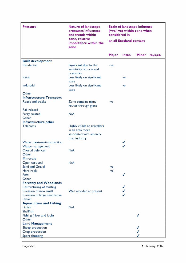
Page 250 11 January, 2002
Pressure Nature of landscapepressures/influencesand trends withinzone, relativeimportance within thezone
Scale of landscape influence(+ve/–ve) within zone whenconsidered in
an all Scotland context
Major Inter. Minor Negligible
Built developmentResidential Significant due to the
sensitivity of zone andpressures
–ve
Retail Less likely on significantscale
ve
Industrial Less likely on significantscale
ve
OtherInfrastructure TransportRoads and tracks Zone contains many
routes through glens–ve
Rail relatedFerry related N/AOtherInfrastructure otherTelecoms Highly visible to travellers
in an area moreassociated with amenitythan industry
Water treatment/abstraction ✔Waste management ✔Coastal defences N/AOtherMineralsOpen cast coal N/ASand and Gravel –veHard rock –vePeat ✔OtherForestry and WoodlandsRestructuring of existing ✔Creation of new small Well wooded at present ✔Creation of large new/native ✔OtherAquaculture and FishingFinfish N/AShellfishFishing (river and loch) ✔OtherLand ManagementSheep production ✔Crop production ✔Sport shooting ✔
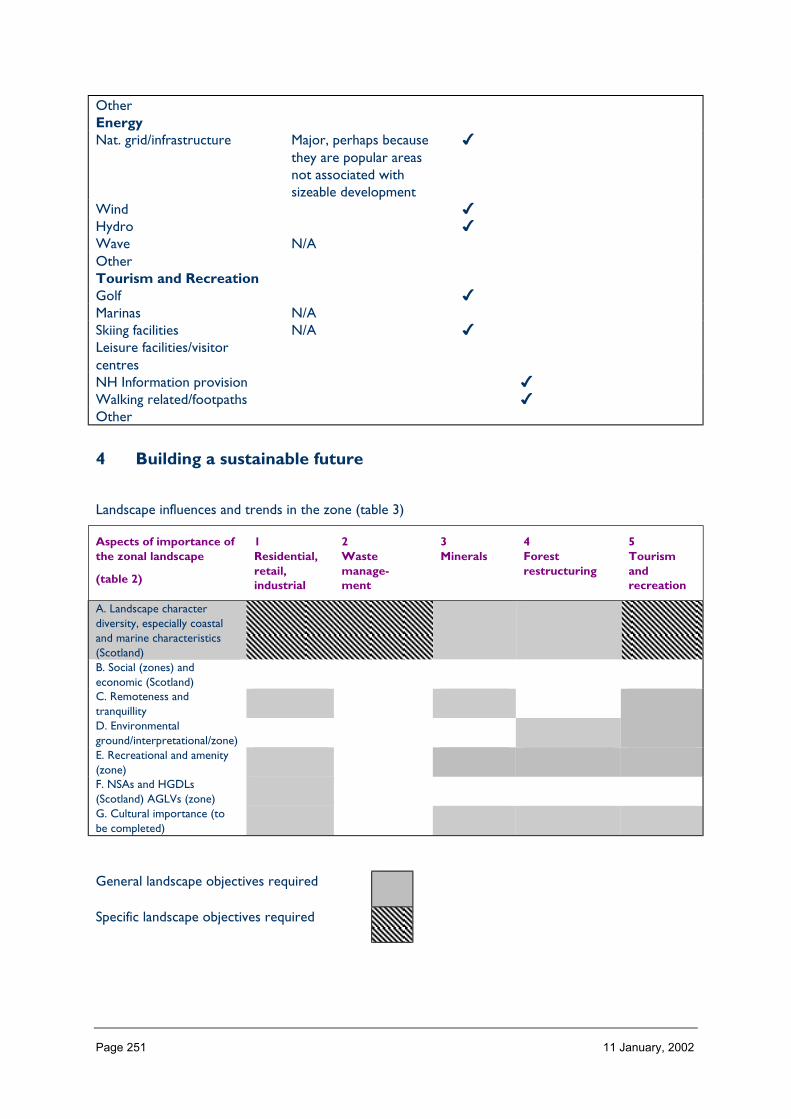
Page 251 11 January, 2002
OtherEnergyNat. grid/infrastructure Major, perhaps because
they are popular areasnot associated withsizeable development
✔
Wind ✔Hydro ✔Wave N/AOtherTourism and RecreationGolf ✔Marinas N/ASkiing facilities N/A ✔Leisure facilities/visitorcentresNH Information provision ✔Walking related/footpaths ✔Other
4 Building a sustainable future
Landscape influences and trends in the zone (table 3)
Aspects of importance ofthe zonal landscape
(table 2)
1Residential,retail,industrial
2Wastemanage-ment
3Minerals
4Forestrestructuring
5Tourismandrecreation
A. Landscape characterdiversity, especially coastaland marine characteristics(Scotland)B. Social (zones) andeconomic (Scotland)C. Remoteness andtranquillityD. Environmentalground/interpretational/zone)E. Recreational and amenity(zone)F. NSAs and HGDLs(Scotland) AGLVs (zone)G. Cultural importance (tobe completed)
General landscape objectives required
Specific landscape objectives required

Page 252 11 January, 2002
ZONE 13 LOCHABER
1 Nature of the landscape resource
Diversity, distribution and rarity of landscape character in the zoneNote: Ignore any LCT which is shown as <10 km sq (if important feature will be coveredelsewhere, if important characteristic locally will be flagged up in description)
Table 13.1 Diversity
Zone LCTLevel 1
LCTLevel 3
Context Area(km2)
13 Steep Ridgeland andMountains
HMRSSMts Highland 16.53
13 High Tops HMRSSMts Highland Island 702.1413 Mountain Glens Highland and Island
GlensHighland 24.26
13 Upland Forest-MoorMosaic
FRSSEHM Highland 2.01
13 Craggy Upland RCUHM Highland 59.3313 Mountains HMRRMts Highland 24.7713 Highland River Valleys Highland and Island
GlensHighland 10.98
13 Blanket Bog PL Highland 203.5213 Craggy Upland RCUHM Highland 19.0713 Mountain Massif HMRSSMts Highland 404.3813 Settled Lochs SL Highland Coastal 34.3013 Broad Forested Strath Highland Straths Highland 28.4913 Smooth Moorland
RidgesHMRRMts Highland 225.38
13 Rugged Massif HMRSSMts Highland 234.5313 Isolated Mountain
PlateauHMRSSMts Highland 77.68
13 Smooth Rounded Hills HMRRMts Highland 11.8513 Loch and Glen Highland and Island
GlensHighland 9.37
13 Mountains and Uplands HMRSSMts Highland 0.0013 Glens and Straths Highland and Island
GlensLowland 43.21
13 Braes of Balquhidder Highland and IslandGlens
Highland 8.73
13 Mountain Plateaux HMRRMts Highland 80.9413 Highland Glens with
LochsHighland and IslandGlens
Highland 31.61
13 Highland Summits andPlateaux
HMRRMts Highland 47.50
13 Plateau Moor PL Highland 130.80Total 2431.38
HMRRMts = High, Massive, Rolling, Rounded Mts of Highlands & Islands
HMRSSMts = High Massive, Rugged, Steep-sided Mts of Highlands & Islands

Page 253 11 January, 2002
FRSSEHM = Flat or Rolling, Smooth or Sweeping, Extensive, High Moorlands of Highlands & Islands
PL = Peatland Landscapes of the Highlands & Islands
SL = Sea Lochs of the Highlands & Islands
The number of landscape character types represented in Zone 13 at level 1, is 24 the way they are grouped at level 3 is into 9 and theircontext is strongly Highland. No. of LCTs (Level 1)/Area of zone in Zone 13 is 0.009, this gives an indication of the overall diversity oflandscape character in the zone and can be compared between zones.

Page 254 11 January, 2002
Table 13.2 Distribution/pattern
Zone LCTLevel 1
LCTLevel 3
% ofZone(area)
No. ofOccurrences
Areakm2
13 Steep Ridgelandand Mountains
HMRSSMts 0.7 4 16.53
13 High Tops HMRSSMts 28.9 2 702.1413 Mountain Glens Highland and
Island Glens1.0 3 24.26
13 Upland Forest-Moor Mosaic
FRSSEHM 0.1 1 2.01
13 Craggy Upland RCUHM 2.4 3 59.3313 Mountains HMRRMts 1.0 1 24.7713 Highland River
ValleysHighland andIsland Glens
0.5 1 10.98
13 Blanket Bog PL 8.4 1 203.5213 Craggy Upland RCUHM 0.8 1 19.0713 Mountain Massif HMRSSMts 16.6 3 404.3813 Settled Lochs SL 1.4 4 34.3013 Broad Forested
StrathHighland Straths 1.2 4 28.49
13 SmoothMoorland Ridges
HMRRMts 9.3 3 225.38
13 Rugged Massif HMRSSMts 9.6 3 234.5313 Isolated
MountainPlateau
HMRSSMts 3.2 1 77.68
13 SmoothRounded Hills
HMRRMts 0.5 1 11.85
13 Loch and Glen Highland andIsland Glens
0.4 1 9.37
13 Mountains andUplands
HMRSSMts 0.0 1 0.00
13 Glens andStraths
Highland andIsland Glens
1.8 2 43.21
13 Braes ofBalquhidder
Highland andIsland Glens
0.4 2 8.73
13 MountainPlateaux
HMRRMts 3.3 3 80.94
13 Highland Glenswith Lochs
Highland andIsland Glens
1.3 1 31.61
13 HighlandSummits andPlateaux
HMRRMts 2.0 2 47.50
13 Plateau Moor PL 5.4 1 130.80Total 49 2431.38
In Zone 13 a total 49 occurrences of landscape character types (landscape units) are found within a zone of total land area 2431. km sq.The figure 49/2431 is 0.020.per km sq of land within the zone and gives a relative indication of the overall brokenness or fragmentation ofthe landscape pattern.
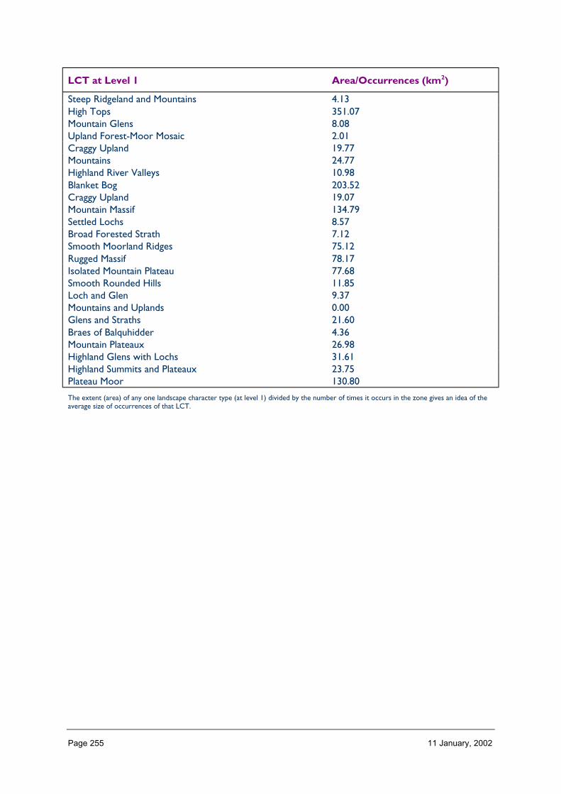
Page 255 11 January, 2002
LCT at Level 1 Area/Occurrences (km2)
Steep Ridgeland and Mountains 4.13High Tops 351.07Mountain Glens 8.08Upland Forest-Moor Mosaic 2.01Craggy Upland 19.77Mountains 24.77Highland River Valleys 10.98Blanket Bog 203.52Craggy Upland 19.07Mountain Massif 134.79Settled Lochs 8.57Broad Forested Strath 7.12Smooth Moorland Ridges 75.12Rugged Massif 78.17Isolated Mountain Plateau 77.68Smooth Rounded Hills 11.85Loch and Glen 9.37Mountains and Uplands 0.00Glens and Straths 21.60Braes of Balquhidder 4.36Mountain Plateaux 26.98Highland Glens with Lochs 31.61Highland Summits and Plateaux 23.75Plateau Moor 130.80
The extent (area) of any one landscape character type (at level 1) divided by the number of times it occurs in the zone gives an idea of theaverage size of occurrences of that LCT.
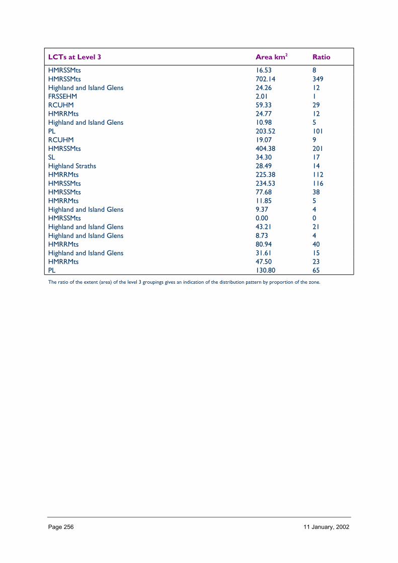
Page 256 11 January, 2002
LCTs at Level 3 Area km2 Ratio
HMRSSMts 16.53 8HMRSSMts 702.14 349Highland and Island Glens 24.26 12FRSSEHM 2.01 1RCUHM 59.33 29HMRRMts 24.77 12Highland and Island Glens 10.98 5PL 203.52 101RCUHM 19.07 9HMRSSMts 404.38 201SL 34.30 17Highland Straths 28.49 14HMRRMts 225.38 112HMRSSMts 234.53 116HMRSSMts 77.68 38HMRRMts 11.85 5Highland and Island Glens 9.37 4HMRSSMts 0.00 0Highland and Island Glens 43.21 21Highland and Island Glens 8.73 4HMRRMts 80.94 40Highland and Island Glens 31.61 15HMRRMts 47.50 23PL 130.80 65
The ratio of the extent (area) of the level 3 groupings gives an indication of the distribution pattern by proportion of the zone.

Page 257 11 January, 2002
Table 12.3 Rarity
LCTs at Level 1 Rarity by occurrence%
Rarity by extent%
Steep Ridgeland and Mountains 8 0.7High Tops 4 28.9Mountain Glens 6 1.0Upland Forest-Moor Mosaic 2 0.1Craggy Upland 6 2.4Mountains 2 1.0Highland River Valleys 2 0.5Blanket Bog 2 8.4Craggy Upland 2 0.8Mountain Massif 6 16.6Settled Lochs 8 1.4Broad Forested Strath 8 1.2Smooth Moorland Ridges 6 9.3Rugged Massif 6 9.6Isolated Mountain Plateau 2 3.2Smooth Rounded Hills 2 0.5Loch and Glen 2 0.4Mountains and Uplands 2 0.0Glens and Straths 4 1.8Braes of Balquhidder 4 0.4Mountain Plateaux 6 3.3Highland Glens with Lochs 2 1.3Highland Summits and Plateaux 4 2.0Plateau Moor 2 5.4
The rarity of a landscape character type within the zone can be identified by the number of time it occurs or its extent. Examination ofboth the number of occurrences (of a LCT) as a percentage of the total and the area (of a LCT) as a percentage of the total area will givean indication of rarity.
LANDSCAPE CHARACTER
Landscape character type is fairly consistent and simple throughout Zone 13 as landformcomprises the dominant factor. The zone contains a few very large areas of mountaincharacter types (51, 88, 124 and 115) in which the route of glens form an integral part, asingle large area of bogland to the east (100) and a small section of craggy moorland on thewest coast (22). Where local variations occur related to land use, these tend to be small inscale on account of the very limited access within the zone and the fact it has a low residentpopulation.
Description
Landform
PROFILE
At its broadest level, Zone 13 contains landform extremes of high, steep sided massivemountains and vast expanses of flat peatland, with a range of hill, moorland and glen types inbetween. This profile has been heavily influenced by glaciation, with the carving of deepcorries and glens in the mountains, leading to some large ‘V’ shaped valleys, areas of craggyuplands and the eroded surfaces of peatlands littered with deposition and lochans.

Page 258 11 January, 2002
Across the zone as a whole this extreme contrast of landform is reflected by 25% of thearea being under 5o slope, yet 21% also being over 24o slope.
SEQUENCE
A sequence of mountains, glens and moorland occurs across Zone 13. The mountain rangesrun west to east or south west to north east, sweeping around the moorland coreconcentrated in the east of Zone 13. This occurs in a radial fashion from the north easterncorner, around to the west and down to the south east of the zone. The straths and glensdividing these broad mountain ranges also tend to radiate from the east, reinforcing thisarrangement. Most of the craggy moorland areas occur in the west of the zone as themountains gradually descend towards the coast, cut by Loch Linnhe, and also towardsArgyll.
SCALE
Moving through the landscape, the landform seems immense, emphasised by the very high,steep and concave nature of the mountain slopes which allow the viewer to directlyappreciate their great elevation from their base. The juxtaposition of these with the wideopen moorlands in the east of the zone emphasises the enormity of each of these areas intheir own right by their contrast of elevation and slope.
However, the absence of known size indicators within most views of the landscape meansthat it is generally difficult to discern actual scale.
LANDMARK FEATURES
The key landform landmarks in this landscape comprise: the highest and most prominent ofmountain peaks such as Ben Nevis; those at the edge of a mountain range, e.g. BenCruachan and Aonach Mor; and those which collectively make a gateway such as the Blackand White Corries either side of Glencoe and Beinn Bhreac-liath and Beinn Dorain. In closeassociation with these peaks, the glens of Zone 13 also form land marks, their simple linearforms often easier to recognise that the linked groups of peaks which surround them. At amore detailed level, waterfalls such as at Falloch, coastal features, and the dubh lochans anddrumlins of Rannoch form local landmarks.
EXPERIENCE
The complex arrangement of mountains within this landscape can appear quite confusing sothese tend to be linked to distinctive glens, the coast and Rannoch by the viewer in order toget some sense of orientation and place.
There are only a few access routes through this zone and thus experience of its entirety canonly be appreciated on foot. The main vehicular routes, due to their scarcity, tend to bevery busy in summer, significantly affecting the experience of the remote qualities of thewider landscape. However off the beaten track, it is easier to appreciate the immensity ofthe landform and an acute sense of wild land occurs in many places.
The main vehicular routes through Zone 13 either run through glens or around the coast,although part of the A82 passes over Rannoch moor. Within the glens, views tend to bechannelled along their route, just occasionally focusing on individual peaks; among the coast,views tend to be directed offshore. This means that, apart from the small section of road
Page 259 11 January, 2002
over moorland, the visual experience of this zone is very blinkered and limited to individualcorridors so there is little appreciation of the zone in its entirety.
Containment
TOPOGRAPHY
Containment within Zone 13 is predominantly very high due to the abundance of high, steepmountains and deep glens represented by 50% of the zone being between 300 and 500mand 22% between 600m and 1100m and 58% over 11 in slope. A lesser degree ofcontainment, mainly occurring at a local level, occurs in the areas of craggy moorland. Theexception to this containment is upon Rannoch Moor in the east of the zone where this isvery low, largely responsible for the 25% of the zone that is lower than 5 slope. A sense ofexposure also occurs upon the mountain tops, ridges and plateaux although the area overwhich this is experienced has limited access.
LAND COVER
Vegetation does not greatly contribute to the containment of Zone 13 as a whole, althoughwoodland adds to the localised sense of enclosure within certain glens. Upon the footslopesor gullies on the hillslopes, this woodland tends to merely accentuate the landform slopeshowever, rather than creating any great containment on its own. Otherwise, thepredominance of low vegetation rather accentuates openness within the landscape,grassland, peatland and montane species collectively making up 79% of the zone. Builtdevelopment creates very little containment in this landscape representing less than 0.5% ofits area and only occurring as isolated settlements. Even within these, the human scale ofbuildings seem dominated by the immense vertical scale of surrounding mountains.
VISIBILITY
Visibility varies considerably from the mountain interior of this zone to the coast andmoorland areas. Within the mountains, visibility is extensive from their tops in clearconditions, yet channelled greatly within the surrounding glens. In coastal areas, views tendto be directed offshore, deflected by the steep inland slopes. In contrast to these, visibilitywithin Rannoch Moor is extensive and panoramic throughout although there is some localscreening caused by occasional glacial mounds and trees.
MICROCLIMATIC EFFECTS
Containment within this landscape is often affected by weather conditions as the maritimeand mountain climate results in a high frequency of cloud cover. This results in the mountainlandscape, typically having vertical emphasis, appearing restricted to a visible horizontalband. This can create a mysterious effect as it is obvious that the diagonal outlines of themountains below the cloud lead to something obscured above. It can also create a strongsense of anticipation so that when the full composition of hills are revealed on clear days,their splendour seems even more intensified.
In changing weather conditions, there is often a very dynamic landscape image, themovement of clouds sometimes obscuring and sometimes revealing the mountain peaks andcreating moving shadows over the ground surface. In contrast, during completely cleartimes, the landscape may actually appear quite 2-dimensional without shadow to highlight itspronounced landform. Generally though, in low cloud conditions, views that otherwise
Page 260 11 January, 2002
concentrate on the mountain foci, are directed to foreground features such as the glenfloors, along loch shores and towards the details of vegetation.
EXPERIENCE
The experience of containment varies through this landscape, most markedly between thelinear enclosure of the glens and the open exposure of the mountain tops and moorlandareas. Within the confines of the glens, one feels restricted visually and physically, but somecomfort is provided by the shelter afforded and the intricacy of foreground details such asrivers and riparian woodland.
In contrast, there is a great sense of personal freedom and remoteness within the openareas of moorland away from public access. Here there is a sense that human scale is quiteinsignificant compared with the surrounding vastness.
Upon the mountain tops, there is also a sense of remoteness and an appreciation of theimmense scale of the landscape; however movement through the landscape is morerestricted on account of the landform characteristics.
Accessibility
DISTANCE
Zone 13 lies at the western edge of mainland Scotland and can only be thus reached via alengthy and time consuming journey from the main population centres in the south of thecountry. Ballachulish in the west of the zone is 120 miles from Edinburgh, a trip that wouldtake approximately 2 and 1/2 hours by car.
Access to the zone in the south is via the A85 west coast route, the A819 from Inveraray,the A82 from Glasgow and the A856 from the east. The eastern part of the zone is onlyaccessible at its far edge via the B846 and the northern part of the zone is reached via theA82 through the Great Glen and the A56 through Glen Spean to the east.
Zone 13 is also accessed by railway, this crossing Rannoch Moor and running along the edgeof Loch Treig, an area inaccessible by road.
The West Highland Way, a long distance footpath, also passes through the zone.
PHYSICAL ACCESS
Physical access is restricted within Zone 13 by the occurrence and route of glens which aidpassage through the mountains; and also the form of the coastal edge and the groundstability of the moorland areas to allow movement upon them.
As most of the mountains broadly run west-east across the zone it is often difficult to travelat right angles to this direction. Many of the roads within this zone are narrow and windingin nature, restricted by the availability of flattish ground which can be built upon. Some arealso no-through routes, preventing circulatory travel.
There are a number of pathways and estate access tracks within this landscape used mainlyfor the purposes of stalking and leading to fishing lochs and the most popular Munros forhillwalking.
Page 261 11 January, 2002
CULTURAL ACCEPTANCE
The high number of visitors to this landscape results in some tension with landowners,especially during the stalking season and near to the main access routes, not only vehicular,but also the West Highland Way and paths to Munros. Tolerance to visitors varies greatlybetween estates; some such as Ben Alder adopt a policy of open access throughout the yearwhilst others create a negative image in the landscape with a profusion of signs aimed atdiscouraging visitors.
Generally settlements within the zone welcome visitors as tourism is a major local industry.
VISUAL ACCESS
Visibility of the interior mountain areas of this zone from public places is very muchrestricted by the screening effect of the mountains themselves, views being mainly containedwithin deep glens. In contrast, visibility across Rannoch Moor is open from the A82;however here, visibility over any distance is distorted by the effect of visual foreshortening.
EXPERIENCE
Generally, access throughout Zone 13 is difficult so that it tends to be mainly experiencedaround its edges and via just one central route.
During summer, this experience is significantly affected by high numbers of motoriststravelling along the main roads, and even the main footpaths often appear busy.
Although it is easier to appreciate the intrinsic qualities of this landscape out of visitorseason, these can still be experienced by walking into the zone interior on foot.
Land cover
VEGETATION
The vegetation of Zone 13 mainly comprises a mix of moorland, peatland and rough grassspecies, collectively accounting for 59% of its area. Montane vegetation is also quite prolificupon the higher mountain reaches forming 11% of the zone area as a whole. The subtle mixof these low lying and similar textured mountain and moorland vegetation emphasises theopenness of the landscape and enables the features of the underlying landform to showthrough.
Woodland accounts for 13% of Zone 13, mainly occurring in the glens and upon the hillfootslopes. Although the native woodlands and recent forestry schemes generally appear tocompliment and emphasise the landscape characteristics of the zone by fitting into the steepfoot slopes, deep gorges and river shores, the conifer plantations representing past forestrypractice tend to appear more incongruous, contrasting in form line, texture and colour tothe surrounding landscape.
Improved grassland, although accounting for only around 3% of Zone 13, contributessignificantly to the character of many of the glen floors in the landscape, its contrast ofcolour and division often creating distinct pattern and a positive image of human integrationand activity in a landscape otherwise largely devoid of these cultural characteristics.
Page 262 11 January, 2002
EXPOSED ROCK
Exposed rock and cliffs account for only 1% of Zone 13. However visibility of this uponmountain tops and along the coast contributes considerably to the character of thelandscape.
Rocky peaks and crags particularly seem to accentuate the landform profile, this oftenappearing to convey an austere image highlighted when partially covered in snow due to astrong contrast of colour and tone.
BUILT DEVELOPMENT
Built development is not a major component of Zone 13, representing less than 0.5% of itsarea. However, the small areas of built development in the landscape tend to form foci –not only in terms of providing services to the surrounding area but also as visual landmarks.These tend to be concentrated with a contrast of form, colour, line, pattern and activity totheir surroundings; and as scale indicators, they seem to emphasise the overwhelmingsuperlative qualities of the mountain landscape around.
EXPERIENCE
The simplicity of ground cover which presides over much of Zone 13 further enables thelandform characteristics to appear the dominant element of the landscape. However,although this may aid our appreciation of the landforms, where differentiation does occur,for example in the form of a settlement, woodland or area of inby, this is often welcomedfor the shelter and visual intricacy created in stark contrast to the surroundings.
Hydrology and water bodies
TYPE
Water is a prominent feature of the landscape of Zone 13, clearly evident not only in thelarge lochs and major rivers, but also along the coast in small streams tumbling over themountains via waterfalls and in the complex pattern of dubh lochans and active blanket bogon Rannoch. The experience of these are also influenced by a prevalence of high humidityconditions and high levels of rainfall.
Some water systems are regulated within the zone for the purposes of hydro-electricitygeneration and fishing.
PATTERN
The main lochs and rivers of this zone are contained within well defined, deep glens, someof these possessing such steep side slopes and being so straight as to form spectaculartrenches. The pattern of these water courses and bodies relate directly to landform, mostof them broadly running west-east or south west – north east. Most freshwater lochs tendto occur in the east of the zone as those towards the west intent in from the coast andLoch Linnhe following the Great Glen.
The minor tributaries within this zone tend to radiate out from the mountain groups or runat fairly regular intervals down from the ridges into the glens. Upon the flat ground ofRannoch, however, the pattern of drainage seems more random, with a dense network ofstreams and dubh lochans, some of which run gradually into large lochs and some which areenclosed.

Page 263 11 January, 2002
EXPERIENCE
As the main access routes within Zone 13 run along the glens and coastal and moorlandedge of this landscape, experience of water forms an integral part of the landscape. Thenarrow nature of many of the glens means that the main access routes seem ‘squeezed’ veryclose to watercourses and waterfalls descending from the mountains, highly visible seenagainst a steep, dark backdrop. The experience of this is not only visual – the activity,reflection and colour of moving water catching the eye, but also strongly affected by sound,particularly in times of spate when the feeling of spray and the smell of lush vegetation beingbashed along the shores can affect the experience.
Access on to the lochs of this zone can combine an experience of tranquillity upon thewaters with a spectacular visual panorama. For although it may be difficult to fully appreciatethe relative arrangement of mountain characteristics whilst at close proximity to these, byviewing this from open waters and at a distance, they create an amphitheatre effectsurrounding one.
Water within the bogland areas of Zone 13 appears as an intricate detail and it is difficult todiscern the overall layout of rivers and lochs and lochans in such flat landscapes on accountof visual foreshortening so they are encountered by surprise. The overall pattern is onlyrevealed when seen from neighbouring high ground.
In the apparent simple landscape of boglands, the presence of water harbours a wealth offoreground interest, from the spongy feel of walking on sphagnum, to the vivid colour andforms of the mosses, the reflection of the sky in small, deep dark pools, and the associatedactivity of insect and bird life.
Built and infrastructure development (present day)
NATURE AND PATTERN OF SETTLEMENT
Settlement within Zone 13 is infrequent, the only centre of any significant size beingKinlochleven, an old industrial village at the head of Loch Leven which utilises local hydro-electricity.
Otherwise, small settlements and clusters of houses tend to occur on the coast, especiallyat bridging points, and at the confluence of glens; many of these incorporate tourist facilitiesand utilise favourable shelter, access and ground conditions. A few small settlements alsooccur around the railway stations of this zone and there are a few within the mountaincore, limited mainly to estate lodges, farmhouses and bothies.
NATURE AND PATTERN OF INFRASTRUCTURE
Roads, railway, estate access tracks, footpaths, car parks and visitor centres and power linesform the main infrastructure in this zone. Of these, the main A82 probably has greatestimpact by enabling large numbers of people to experience the central part of Zone 13. TheWest Highland Way footpath also provides access to this for large numbers of walkers.Apart from these central routes, the main line of routes follow the coast, often pinned to itsedge.
Confinement of infrastructure within parts of the landscape due to the landformcharacteristics means that different elements often cross, overlap or run parallel to eachother. This has cumulative impacts in the landscape and can cause conflict as the experience

Page 264 11 January, 2002
of, for example, a walker along the West Highland Way is affected by having to pass next toand under major powerlines in a landscape which would otherwise be perceived as beingremote and having wild land qualities. Likewise, a motorist may feel their experience of thelandscape is affected by the parallel route of powerlines which deflect their view to one side.
NATURE AND PATTERN OF INDUSTRIAL DEVELOPMENT
Over Zone 13 as a whole there is little heavy industrial development. However there are afew industries linked to natural resources in the landscape such as hydro-electricity andsmall scale quarrying. Kinlochleven was once a major centre for aluminium smelting, utilisinglocal hydro-electricity; however this is soon to be decommissioned.
The main service industry in this zone is tourism linked to recreation. This results in a widedistribution of informal facilities such as parking areas and signs, with accommodation mainlycentred around the villages or old estate lodges which have become hotels, Inns orbunkhouses. There is also occasional formal provision for particular sports such as skicentres at White Corries and Aonach Mor.
EXPERIENCE
Built and infrastructure development generally forms just a small part of Zone 13 in relationto the predominance of ‘natural’ landscape characteristics. However, as most developmentis located at close proximity to the small number of roads through the landscape, there maybe a perception when travelling through Zone 13 that there is actually a far greaterproposition of this than there is if remote areas are appreciated too.
The tourist industry is notoriously fragile in any landscape where appreciation relies onunpredictable weather conditions, both in winter for snow and summer for fine conditions.Thus developments capitalising on the consistent components of the landscape such as itsmountains of remoteness whatever the weather, can often appear most appropriate to thelandscape, their longevity tending to result in an attention to design integration of builtforms that adds positively to the landscape character.
Visible history
TYPES OF VISIBLE HISTORY
Historic features within Zone 13 are not as common place as in some other zones.However, what remains tends to be prominent by the fact that this stands out within alargely uninhabited landscape dominated more by ‘natural’ features. The key historicelements evident are: Neolithic and Bronze Age monuments; hut circles and duns datingback from the Iron Age; crosses, carved stones and chapel sites from the early Christianperiod; medieval churches and castles, the ruins of crofts abandoned during the Clearancesand old military roads and bridges.
LOCATION/PATTERN
Most historic features are located within the glens and near to the coast of this zone,although some cairns and shieling occur upon the hills. Overlapping of features of variousage occur in places where particular favourable local conditions occur, such as shelter,access, water supply, good ground and a defensive position. Where only one or a few ofthese conditions occur, features tend to represent a timescale in which those factors wereof great importance to the particular social/cultural conditions of that time.

Page 265 11 January, 2002
EXPERIENCE
Whilst the experience of historic features do not greatly affect the landscape character ofZone 13 as a whole, they do contribute greatly to the experience of certain locations. Insuch places, historic features often create foci in the landscape, their built form representingpast inhabitation which often seems awe inspiring when considering the harsh physicalconditions of the surrounding mountain landscape. Indeed it is easy to conjure images ofpast battles in a landscape with such contrasts of scale between human and mountainfeatures. These images have been portrayed in the arts and media as representing ‘WildScotland’, recently shown in parts of the film Braveheart filmed in this zone. Related to this,remains of crofting settlements can seem particularly poignant by their fairly intactstructures representing relative recent abandonment.
Wildlife
FORMS OF WILDLIFE
Wildlife within Zone 13 include, red deer, otter, mink, wild cat, badgers, pine marten, bats,eagles, peregrine, dotteral, grouse, waders, divers, salmon and trout, pearl mussels,dragonflies and midges. Some of these species are rare and limited to particular sites, forexample black-throated divers and pearl mussels, whilst others are fairly prolific throughoutthe zone.
LOCATION
Most of the large mammals such as deer, wild cat and badgers concentrate in the mountain,hill and woodland landscape character types, chiefly numbers 88,115,51,22,56 and 57 (level1). The range of these however does vary from season to season, often descending intomore sheltered areas in winter where there is a greater abundance of food. Species such asotters obviously concentrate in the coastal parts of these landscapes. Rannoch Mor (mainlycomprising character type 100 at level 1) accommodates bogland species such as dragonflies and breeding waders. Maritime areas (mainly within LCT 51 and 88 at level 1) alsoharbour distinct species such as dipera and eagles.
WHEN
Deer tend to be most visible, from the public roads in this landscape in winter when theydescend into the glens for shelter and grazing.
Apart from these, however, most species tend to be more noticeable in spring and summerdue to their increased activity and/or sound, particularly birds and insects; although highvolumes of traffic along the main access routes through this zone in summer may locallydeter some of these species.
EXPERIENCE
Although visibility of wildlife from the main public routes through Zone 13 does notcontribute greatly to is landscape character as a whole, the presence of wildlife do affect theexperience of the more remote areas. These areas, despite being subject to changingweather conditions, can sometimes appear quite inactive and sterile as their physical formseems to overwhelm the details of the landscape. However the sound and sight of wildlifesymbolises the value of the landscape as a living system rather than just a two-dimensionalscenery and the experience of rare species can intensify the sense of remoteness and wildland in such areas. Conversely, of course, some species may actually affect the appreciation

Page 266 11 January, 2002
of Zone 13 in a negative way the chief culprit being the midge, whose activity and profusionmany affect how and where people experience the landscape, or if they do at all.
Climate
CLIMATIC CHARACTERISTICS
Climate characteristics across Zone 13 are fairly consistent, although there may be somesubtle differences between the west and east, the zone largely dominated by maritime andmountain climatic conditions distributed via the passing of westerly Atlantic weathersystems.
Precipitation levels are high throughout the zone with average annual levels of around2000mm. These are fairly evenly distributed throughout the year with an average of over100mm for each month; however April and May tend to be the driest months andDecember the wettest. Snow cover can also be great on the mountain tops in winter.
Temperature extremes tend to be highest in the mountains and towards the interior andeast, lowest by the coast and in the west. Over the zone as a whole there is an averagesummer temperature of 14.5°C and an average winter temperature of 3.5°C.
The west coast and mountain tops tend to be subject to the highest and greatest prevalenceof winds. Shelter is afforded by some of the glens; however this very much depends on thedirection of the winds as if these coincide with the orientation of the glens, winds may bechannelled and funnelled by these.
LOCATIONAL AND SEASONAL EFFECTS
Seasons are quite marked in the zone by variation of day length and temperature whichaffects vegetation growth and wildlife activity, and the summer also brings high numbers ofvisitors to the zone. However, the characteristic changeable nature of the weather in thislandscape, particularly in terms of precipitation, is consistent throughout the year. Thismeans that expectations for clear weather in summer are no less borne out thanexpectations of cloud or snow in winter. As a result of this changeable nature, days of clearweather in summer or winter tend to be greeted with great delight.
EXPERIENCE
Climatic conditions greatly affect the experience of this landscape as introduced above anddiscussed under ‘Containment’. The presence of cloud cover obscures mountain tops so thecharacteristic vertical emphasis of the landscape is restricted to a low horizontal band ofvisibility. Here, the diagonal outlines of mountains below the cloud can appear mysterious asthe viewer is aware that there is something obscured above.
In such conditions, views tend to focus on foreground details rather than the mountain tops– the glen floors and rivers, loch shores and vegetation. Changing weather conditions withinthis zone can give quite a dynamic image to the landscape, especially when seen from afarand crossing the landscape from panoramic vantage points within the open moorland areas,mountain tops and coast.
During these times, racing clouds and sheets of rain result in changing visual emphasis in thelandscape, creating excitement and anticipation.
Page 267 11 January, 2002
In contrast, completely clear conditions reveal the full splendour of this landscape as awhole composition. This image may actually appear quite two-dimensional, however,without shadow highlighting the complex form of the mountains nor illustrating distancewithin a landscape which otherwise has few scaleable features or ground coverdifferentiation from which to discern these.
Designated landscapes
National Scenic Areas
CONSTITUENTS
37% of Zone 13 is contained within the Ben Nevis and Glencoe which almost entirelyoccurs within this zone (99.5%). The Ben Nevis and Glencoe NSA mainly comprises HighTops (LCT 51), mountain massif (LCT 88) and rugged massif (LCT115) forming themountain core.
The other major component is Plateau Moor (LCT 100) with small fragments of settledlochs (LCT 119) and smooth moorland ridges (LCT 124).
A tiny fragment (0.7%) of the Loch Rannoch and Glen Lyon NSA is contained within Zone13, comprising Plateau Moor landscape character type (no. 100 level 1), and a small part(1%) of the Lynn of Lorn NSA is also included within the zone, mainly comprising theCraggy Upland landscape character type (LCT 22, level1)
LOCATION AND EXTENT
The Ben Nevis and Glencoe NSA measures 895 km square within Zone 13, encompassing asizeable proportion of the zone in a rounded L shape that descends from its northern edgedown to around two thirds the southern extent of the zone, bending around the Blackwaterreservoir in the east.
The small fragment of the Loch Rannoch and Glen Lyon NSA occurs the far eastern edge ofZone 13 south west of Loch Rannoch, extending to just 3.5km square. The Lynn of LornNSA covers just 0.5km square on the western edge of the zone near to the shore of LochLinnhe.
EXPERIENCE
The Ben Nevis and Glencoe NSA, encompassing a major part of Zone 13 contains many ofthe key characteristics of this zone. It is probably best known for its combination oftowering mountains and deep glens, although it borders the sea to the west and touches onRannoch Moor to the east.
To appreciate the full extent of the NSA, given its large size and few roads, the landscapeneeds to be explored largely on foot, although the very steep glens through which the mainaccess routes pass, with close proximity to mountains, allow viewers from these toappreciate some of the qualities of the landscape. The glens leading away from these mainroutes also provide viewing channels away into the mountain interior. However moredifficult to appreciate from these routes are the great qualities of remoteness which presidein this landscape away from the main roads and settlements.

Page 268 11 January, 2002
Historic gardens and designed landscapes
NATURE OF THE LANDSCAPES DESIGNATED AND NON-DESIGNATED
There is just one original Historic Garden and Designed Landscape (HGDL) in Zone 13 andone new HGDL, although two HGDLs lie close to the south western boundary of the zone.
Recreational landscapes
NATURE OF LANDSCAPES
Zone 13 is used extensively for recreation and although this peaks during summer months,there are high numbers of visitors throughout the year. This recreation is predominantlyassociated with enjoying the landscape and active sports, the most common of these beinghillwalking and mountain and ice climbing on the highest and most accessible peaks such asBen Nevis, Beinn a Bheither, The Three Sisters and the Black and White Corries. Many ofthese are targeted for their demanding but relatively short ascent. High numbers of hillwalkers also pass through the zone via the West Highland Way, and skiing at Aonach Marand White Corries is very popular during the relatively short periods of snow cover.Canoeing and kayaking also occurs on the deeper rivers and some of the lochs
In terms of more passive recreation, many people visit the zone motor touring, often enroute to other west coast destinations. These visitors mainly enjoy the scenic qualities ofthe landscape and do not tend to travel far from the main vehicular routes.
LOCATION
As discussed above, recreation is distributed throughout Zone 13, especially hill walking, butwith highest activity around the main access routes and settlements.
The key access routes through the landscape for motoring/sightseeing visitors is the A82through Glencoe, the A828 linking Oban and Fort William (both centres of recreation andtourist facilities) and the A82 from Inverness along the Great Glen. The main active sportsareas are around the fringes of Fort William, Ben Nevis, Glencoe Aonach Mor andBallachulish.
EXPERIENCE
Although Zone 13 offers a contrast of recreational experience depending on season andweather, it tends to offer only a narrow range of activities, these mainly being directly linkedto enjoying the landscape qualities. However this does vary between passive and activerecreation, with a fairly equal balance of travelling sightseers and active sports goers insummer and a majority of the latter in winter. The concentration of high numbers of peoplepartaking in recreation within the key centre and close to the main access routes in thiszone certainly affects the experience and even the perception and integrity of the landscapein these places at peak times. However there remains large areas of the zone which, due totheir difficulty of access and lack of inhabitants, maintain a sense of remoteness and wild land
2 Importance and value of the zone landscape
A judgement of the importance or value of the zonal landscape under the followingheadings:

Page 269 11 January, 2002
Category Brief explanation oflandscape importance(if any)
Importance(GB, Scotland,zone)
Landscape Character Importancerarity Range of high, very steep
mountains and glens incontrast to bogland
Scotland
extent Large area Scotlanddiversity (including specific landmarks) Mainly mountain, glen and
moorZonal
pattern Some in glen floorscontrasting withmountains
Zonal
integrity Varies within zonebetween public/privateground
Scotland
local distinctiveness Zonalfragility/sensitivity Visitor pressures ScotlandScenic importancequalities Stereotypical Highland
scenery – mountains glensand lochs
Scotland
perceptions High public awareness GBLearning ImportanceEnvironmental Education Geology, natural heritage,
history.zonal
Interpretation Existing facilities zonal
Recreation High numbers for activerecreation
GB
Amenity Motor routes zonalwildness and tranquillity Contrasts greatly within
public/privatezonal
DesignationsNSAs 1 main NSA covering 37%
of zone. 2 small fragmentsof other NSAs
Scotland
AGLVs ?Regional Landscape Designations ?Historic Gardens & Designed Landscapes 2 HGDLs. 2 close by in
Zone 14zonal
Cultural Importancepre history (designated/non-designated) input from HSmedieval (designated/non-designated)recent (designated/non-designated)Socioeconomic Importancesocial low resident population zonaleconomic Draws number of visitors
to zone also surroundingareas
Scotland
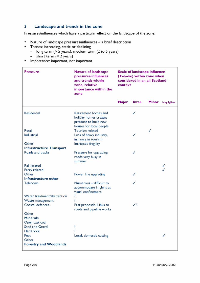
Page 270 11 January, 2002
3 Landscape and trends in the zone
Pressures/influences which have a particular effect on the landscape of the zone:
• Nature of landscape pressures/influences – a brief description• Trends: increasing, static or declining
− long term (> 5 years), medium term (2 to 5 years),− short term (< 2 years)
• Importance: important, not important
Pressure Nature of landscapepressures/influencesand trends withinzone, relativeimportance within thezone
Scale of landscape influence(+ve/–ve) within zone whenconsidered in an all Scotlandcontext
Major Inter. Minor Negligible
Residential Retirement homes andholiday homes createspressure to build newhouses for local people
�
Retail Tourism related �Industrial Loss of heavy industry,
increase in tourism�
Other Increased fragilityInfrastructure TransportRoads and tracks Pressure for upgrading
roads very busy insummer
�
Rail related �Ferry related �Other Power line upgrading �Infrastructure otherTelecoms Numerous – difficult to
accommodate in glens asvisual confinement
�
Water treatment/abstraction ?Waste management ?Coastal defences Past proposals. Links to
roads and pipeline works�?
OtherMineralsOpen cast coalSand and Gravel ?Hard rock ?Peat Local, domestic cutting �OtherForestry and Woodlands

Page 271 11 January, 2002
Restructuring of existing Existing plantations highlyvisible on steep slopes.Existing restructuringworks
�
Creation of new small Can look piecemeal andas isolated blocks. Steadyincrease of proposals.
�
Creation of large new/native Number of new largeproposals. Potential tochange character of large,distinctive areas
�
Other
Aquaculture and Fishing
FinfishShellfishFishing (River & loch) River engineering for
fishing. Can havecumulative impact.
�
OtherLand Management
Sheep production Very high numbers inplaces prevents treeregen and causes erosion
�
Crop production Gradually diminishing toresult in loss of landscapepattern in glens
�
Sport shooting Very high numbers inplaces – erosion
�
Other
Energy
Nat. grid/infrastructure power line upgrading �Wind No current large scale
proposalsHydro Existing characteristic of
landscape�
WaveOtherTourism and Recreation
Golf Not fitting to landscapetype – proposals forcombined recreationprovision
�
Marinas
Skiing facilities Expansion proposed �

Page 272 11 January, 2002
Leisure facilities/visitorcentres
High pressure fornew/change of facilities
�
NH Information provision Existing within Glencoe.New visitor centreproposed.
�
Walking related/footpaths High pressure on existingpaths and car parking
�
Other Potential facilities forsports popularised or infashion, e.g. downhillcycling, heliskiing, rafting
�
4 Building a sustainable future
Landscape influences and trends in the zone (table 3)
Aspects ofimportance ofthe zonallandscape(table 2)
1Residential
2Industrial
3RoadsofTracks
4Telecoms
5Forestryrestructuringand newwoodland
6Estatemanagement
7Tourismandrecreation
A. LandscapecharacterRarity and extent– ScotFragility – ScotB. ScenicimportancePerceptions –GBQualities – ScotC. Learningimportance- zonalD. EnjoymentimportanceActive recreation– GBE. DesignationsLarge area ofNSAF. CulturalimportanceG. SocioEconomicimportanceLow population,tourism

Page 273 11 January, 2002
ZONE 14 ARGYLL WEST & ISLANDS
1 Nature of the landscape resource
Diversity, distribution and rarity of landscape character in the zoneNote: Ignore any LCT which is shown as <10 km_ (if important feature will be coveredelsewhere, if important characteristic locally will be flagged up in description)
Table 14.1 Diversity
Zone LCTLevel 1
LCTLevel 3
Context Areakm2
14 Steep Ridgeland andMountains
HMRSSMts Highland 679.15
14 Upland Parallel Ridges RCUHM Highland 188.2114 Rolling Farmland with
EstatesFarmlands andEstates of theHighlands andIslands
Lowland Coastal 60.81
14 Bay Farmland Farmlands andEstates of theHighlands andIslands
Coastal 37.16
14 Lowland Bog and Moor Low, Flat, and/orSandy CoastalLandscapes of theHighlands andIslands
Island Lowland 55.00
14 Marginal FarmlandMosaic
MTL Island LowlandCoast
188.50
14 Basalt Lowlands MTL Island Lowland 7.6514 Lowland Ridges and
MossHighland and IslandRocky CoastalLandscapes
Coastal Lowland 63.99
14 Coastal Plain Low, Flat, and/orSandy CoastalLandscapes of theHighlands andIslands
Coastal Lowland 16.48
14 High Tops HMRSSMts Highland Island 68.6314 Rocky Mosaic Highland and Island
Rocky CoastalLandscapes
Coastal 267.99
14 Low Coastal Hills Low Coastal Hills ofthe Highlands andIslands
Coastal Lowland 18.82
14 Coastal Parallel Ridges Highland and IslandRocky CoastalLandscapes
Coastal Island 123.46
14 Flat Moss and Mudflats Low, Flat, and/orSandy Coastal
Lowland Coastal 19.80

Page 274 11 January, 2002
Landscapes of theHighlands andIslands
14 Slate Islands Highland and IslandRocky CoastalLandscapes
Island 23.20
14 Sand-Dunes andMachair
Low, Flat, and/orSandy CoastalLandscapes of theHighlands andIslands
Island Coastal 18.03
14 Hidden Glens Highland and IslandGlens
Highland 10.88
14 Mountain Glens Highland and IslandGlens
Highland 13.94
14 Open Ridgeland HMRRMts Highland 101.7314 Upland Forest-Moor
MosaicFRSSEHM Highland 1,089.15
14 Craggy Upland RCUHM Highland 1,001.5814 Moorland Plateau FRSSEHM Island Upland
Coastal602.53
14 Rocky Moorland Rocky Moorlands ofthe Highlands andIslands
Island 83.39
14 Raised Beach Coast Coastal RaisedBeaches andTerraces
Coastal 19.01
14 Rugged Moorland Hillsand Valleys withForestry
Rugged MoorlandHills
Upland 140.68
14 Rugged Granite Upland Rugged GraniteUplands
Highland 168.49
14 Rocky Volcanic Islands Rocky VolcanicIslands
Island 1.14
14 Coastal Fringe withAgriculture
Coastal Margins Coastal Lowland 60.55
14 Coastal Headland Coastal HillsHeadlands Plateauxand Moorlands
Coastal 22.77
14 Coastal Lowland Moor Coastal HillsHeadlands Plateauxand Moorlands
Coastal Lowland 20.62
14 Lowland Ridges andMoss
Highland and IslandRocky CoastalLandscapes
Highland Coastal 8.71
14 Craggy Upland RCUHM Highland 2.9714 Mountain Massif HMRSSMts Highland 1.0414 Settled Lochs SL Highland Coastal 1.0014 Mountains and Uplands HMRSSMts Highland 0.21
Total 5187.27
HMRRMts = High, Massive, Rolling, Rounded Mts of Highlands & Islands
HMRSSMts = High Massive, Rugged, Steep-sided Mts of Highlands & Islands

Page 275 11 January, 2002
FRSSEHM = Flat or Rolling, Smooth or Sweeping, Extensive, High Moorlands of Highlands & Islands
RCUHM = = Rugged, Craggy Upland Hills & Moorlands of the Highlands, including the Trossachs
SL =Sea Lochs of the Highlands & Islands
MTL =Moorland Transitional Landscapes of the Highlands & Islands
The number of landscape character types represented in Zone 14 at level 1 is 35 (of which 7 are <10 km2, or 28 are >10 km2). These canbe grouped into 19 at level 3 and their context is Highland/Island/Coastal. (mountains; upland and rocky or rugged hills and moorlands;coastal hills; sandy or rocky coasts; raised beaches and coastal margins; glens; farmlands & estates; islands, and sea loch.) No. of LCTs(Level 1)/Area of Zone in Zone 14 is 0.006: this gives an indication of the overall diversity of landscape character in the zone which can becompared between zones.
Table 14.2 Distribution/pattern
Zone LCTlevel 1
LCTlevel 3
% ofZone(area)
No. ofOccurrences
Areakm2
14 Steep Ridgelandand Mountains
HMRSSMts 13.1 2 679.15
14 Upland ParallelRidges
RCUHM 3.6 2 188.21
14 Rolling Farmlandwith Estates
Farmlands andEstates of theHighlands andIslands
1.2 4 60.81
14 Bay Farmland Farmlands andEstates of theHighlands andIslands
0.7 1 37.16
14 Lowland Bogand Moor
Low, Flat, and/orSandy CoastalLandscapes of theHighlands andIslands
1.1 3 55.00
14 MarginalFarmland Mosaic
MTL 3.6 7 188.50
14 Basalt Lowlands MTL 0.1 1 7.6514 Lowland Ridges
and MossHighland andIsland RockyCoastalLandscapes
1.2 6 63.99
14 Coastal Plain Low, Flat, and/orSandy CoastalLandscapes of theHighlands andIslands
0.3 3 16.48
14 High Tops HMRSSMts 1.3 10 68.6314 Rocky Mosaic Highland and
Island RockyCoastalLandscapes
5.2 18 267.99
14 Low CoastalHills
Low Coastal Hillsof the Highlandsand Islands
0.4 3 18.82
14 Coastal Parallel Highland and 2.4 11 123.46

Page 276 11 January, 2002
Ridges Island RockyCoastalLandscapes
14 Flat Moss andMudflats
Low, Flat, and/orSandy CoastalLandscapes of theHighlands andIslands
0.4 1 19.80
14 Slate Islands Highland andIsland RockyCoastalLandscapes
0.4 11 23.20
14 Sand-Dunes andMachair
Low, Flat, and/orSandy CoastalLandscapes of theHighlands andIslands
0.3 10 18.03
14 Hidden Glens Highland andIsland Glens
0.2 3 10.88
14 Mountain Glens Highland andIsland Glens
0.3 6 13.94
14 Open Ridgeland HMRRMts 2.0 4 101.7314 Upland Forest-
Moor MosaicFRSSEHM 21.0 8 1,089.15
14 Craggy Upland RCUHM 19.3 9 1,001.5814 Moorland
PlateauFRSSEHM 11.6 5 602.53
14 Rocky Moorland Rocky Moorlandsof the Highlandsand Islands
1.6 3 83.39
14 Raised BeachCoast
Coastal RaisedBeaches andTerraces
0.4 2 19.01
14 RuggedMoorland Hillsand Valleys withForestry
Rugged MoorlandHills
2.7 1 140.68
14 Rugged GraniteUpland
Rugged GraniteUplands
3.2 1 168.49
14 Rocky VolcanicIslands
Rocky VolcanicIslands
0.0 1 1.14
14 Coastal Fringewith Agriculture
Coastal Margins 1.2 3 60.55
14 CoastalHeadland
Coastal HillsHeadlandsPlateaux andMoorlands
0.4 1 22.77
14 Coastal LowlandMoor
Coastal HillsHeadlandsPlateaux andMoorlands
0.4 1 20.62
14 Lowland Ridgesand Moss
Highland andIsland Rocky
0.2 1 8.71
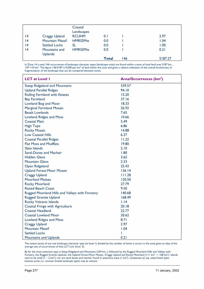
Page 277 11 January, 2002
CoastalLandscapes
14 Craggy Upland RCUHM 0.1 1 2.9714 Mountain Massif HMRSSMts 0.0 1 1.0414 Settled Lochs SL 0.0 1 1.0014 Mountains and
UplandsHMRSSMts 0.0 1 0.21
Total 146 5187.27
In Zone 14 a total 146 occurrences of landscape character types (landscape units) are found within a zone of total land area 5187 km_,139 >10 km2. The figure 146/5187 is 0.028 per km2 of land within the zone and gives a relative indication of the overall brokenness orfragmentation of the landscape that can be compared between zones.
LCT at Level 1 Area/Occurrences (km2)
Steep Ridgeland and Mountains 339.57Upland Parallel Ridges 94.10Rolling Farmland with Estates 15.20Bay Farmland 37.16Lowland Bog and Moor 18.33Marginal Farmland Mosaic 26.92Basalt Lowlands 7.65Lowland Ridges and Moss 10.66Coastal Plain 5.49High Tops 6.86Rocky Mosaic 14.88Low Coastal Hills 6.27Coastal Parallel Ridges 11.22Flat Moss and Mudflats 19.80Slate Islands 2.10Sand-Dunes and Machair 1.80Hidden Glens 3.62Mountain Glens 2.33Open Ridgeland 25.43Upland Forest-Moor Mosaic 136.14Craggy Upland 111.28Moorland Plateau 120.50Rocky Moorland 27.79Raised Beach Coast 9.50Rugged Moorland Hills and Valleys with Forestry 140.68Rugged Granite Upland 168.49Rocky Volcanic Islands 1.14Coastal Fringe with Agriculture 20.18Coastal Headland 22.77Coastal Lowland Moor 20.62Lowland Ridges and Moss 8.71Craggy Upland 2.97Mountain Massif 1.04Settled Lochs 1Mountains and Uplands 0.21
The extent (area) of any one landscape character type (at level 1) divided by the number of times it occurs in the zone gives an idea of theaverage size of occurrences of that LCT (col. 6/col. 5).
By far the most extensive type is Steep Ridgeland and Mountains (339 km_), followed by the Rugged Moorland Hills and Valleys withForestry, the Rugged Granite Uplands, the Upland Forest-Moor Mosaic, Craggy Upland and Rocky Moorland (111 km2 → 168 km2). Islandstend to be small (1 – 2 km2), nor are sand dunes and machair found in extensive areas (1 km2). Comparison of, say, raised beach typesbetween zones (i.e. common Scottish landscape types) may be relevant.

Page 278 11 January, 2002
LCTs at Level 3 Area km2 Ratio
HMRSSMts 679.15 324RCUHM 188.21 89Farmlands and Estates of the Highlands and Islands 60.81 28Farmlands and Estates of the Highlands and Islands 37.16 17Low, Flat, and/or Sandy Coastal Landscapes of the Highlands andIslands
55.00 26
MTL 188.50 89MTL 7.65 3Highland and Island Rocky Coastal Landscapes 63.99 30Low, Flat, and/or Sandy Coastal Landscapes of the Highlands andIslands
16.48 7
HMRSSMts 68.63 32Highland and Island Rocky Coastal Landscapes 267.99 127Low Coastal Hills of the Highlands and Islands 18.82 8Highland and Island Rocky Coastal Landscapes 123.46 58Low, Flat, and/or Sandy Coastal Landscapes of the Highlands andIslands
19.80 9
Highland and Island Rocky Coastal Landscapes 23.20 11Low, Flat, and/or Sandy Coastal Landscapes of the Highlands andIslands
18.03 8
Highland and Island Glens 10.88 5Highland and Island Glens 13.94 6HMRRMts 101.73 48FRSSEHM 1,089.15 518RCUHM 1,001.58 476FRSSEHM 602.53 286Rocky Moorlands of the Highlands and Islands 83.39 39Coastal Raised Beaches and Terraces 19.01 9Rugged Moorland Hills 140.68 66Rugged Granite Uplands 168.49 80Rocky Volcanic Islands 1.14 5Coastal Margins 60.55 28Coastal Hills Headlands Plateaux and Moorlands 22.77 10Coastal Hills Headlands Plateaux and Moorlands 20.62 98Highland and Island Rocky Coastal Landscapes 8.71 4RCUHM 2.97 14HMRSSMts 1.04 4SL 1.00 4HMRSSMts 0.21 1
HMRRMts = High, Massive, Rolling, Rounded Mts of Highlands & Islands
HMRSSMts = High Massive, Rugged, Steep-sided Mts of Highlands & Islands
FRSSEHM = Flat or Rolling, Smooth or Sweeping, Extensive, High Moorlands of Highlands & Islands
RCUHM = Rugged, Craggy Upland Hills & Moorlands of the Highlands, including the Trossachs
PL = Peatland Landscapes of the Highlands & Islands
SL = Sea Lochs of the Highlands & Islands
The ratio of the extent (area) of the level 3 groupings gives an indication of the distribution pattern by proportion of the zone.
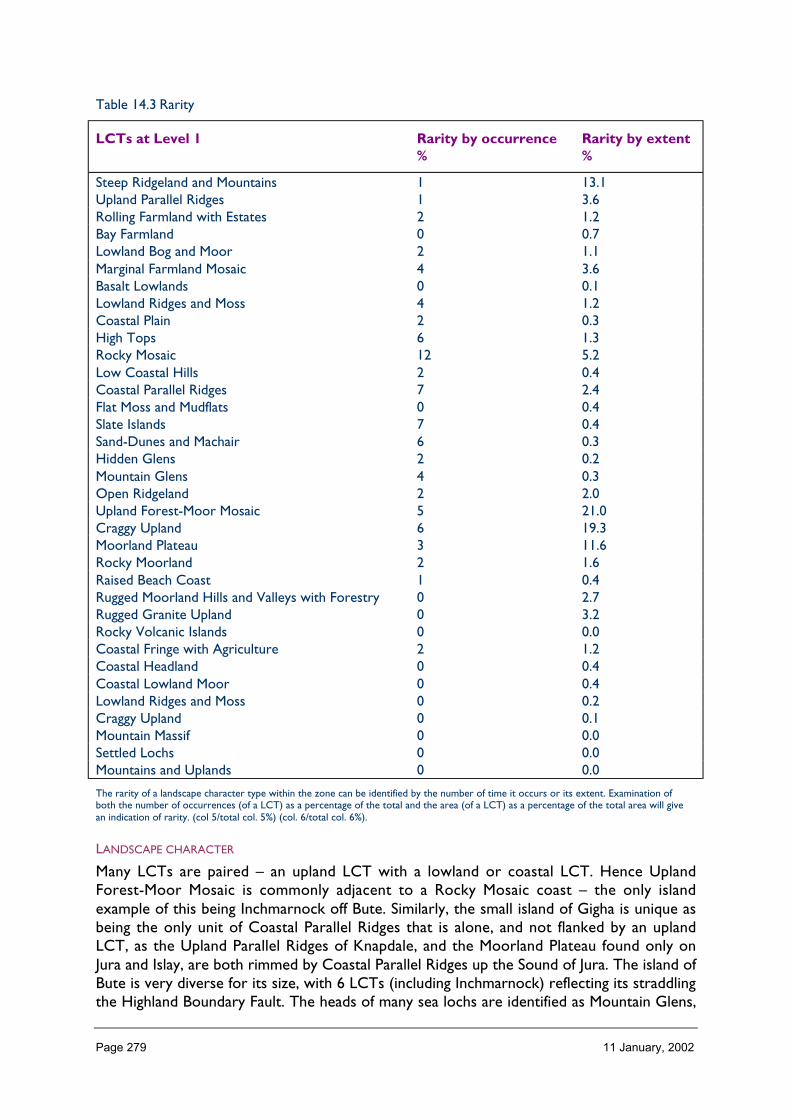
Page 279 11 January, 2002
Table 14.3 Rarity
LCTs at Level 1 Rarity by occurrence%
Rarity by extent%
Steep Ridgeland and Mountains 1 13.1Upland Parallel Ridges 1 3.6Rolling Farmland with Estates 2 1.2Bay Farmland 0 0.7Lowland Bog and Moor 2 1.1Marginal Farmland Mosaic 4 3.6Basalt Lowlands 0 0.1Lowland Ridges and Moss 4 1.2Coastal Plain 2 0.3High Tops 6 1.3Rocky Mosaic 12 5.2Low Coastal Hills 2 0.4Coastal Parallel Ridges 7 2.4Flat Moss and Mudflats 0 0.4Slate Islands 7 0.4Sand-Dunes and Machair 6 0.3Hidden Glens 2 0.2Mountain Glens 4 0.3Open Ridgeland 2 2.0Upland Forest-Moor Mosaic 5 21.0Craggy Upland 6 19.3Moorland Plateau 3 11.6Rocky Moorland 2 1.6Raised Beach Coast 1 0.4Rugged Moorland Hills and Valleys with Forestry 0 2.7Rugged Granite Upland 0 3.2Rocky Volcanic Islands 0 0.0Coastal Fringe with Agriculture 2 1.2Coastal Headland 0 0.4Coastal Lowland Moor 0 0.4Lowland Ridges and Moss 0 0.2Craggy Upland 0 0.1Mountain Massif 0 0.0Settled Lochs 0 0.0Mountains and Uplands 0 0.0
The rarity of a landscape character type within the zone can be identified by the number of time it occurs or its extent. Examination ofboth the number of occurrences (of a LCT) as a percentage of the total and the area (of a LCT) as a percentage of the total area will givean indication of rarity. (col 5/total col. 5%) (col. 6/total col. 6%).
LANDSCAPE CHARACTER
Many LCTs are paired – an upland LCT with a lowland or coastal LCT. Hence UplandForest-Moor Mosaic is commonly adjacent to a Rocky Mosaic coast – the only islandexample of this being Inchmarnock off Bute. Similarly, the small island of Gigha is unique asbeing the only unit of Coastal Parallel Ridges that is alone, and not flanked by an uplandLCT, as the Upland Parallel Ridges of Knapdale, and the Moorland Plateau found only onJura and Islay, are both rimmed by Coastal Parallel Ridges up the Sound of Jura. The island ofBute is very diverse for its size, with 6 LCTs (including Inchmarnock) reflecting its straddlingthe Highland Boundary Fault. The heads of many sea lochs are identified as Mountain Glens,
Page 280 11 January, 2002
although each has their own local identity. The small area of the Moine Mhor is unique toArgyll West and Islands, as it is the only example of the Flat Moss and Mudflats LCT;similarly, the Slate Islands LCT occurs only in one small area on the western seaboard andIslay’s Lowland Bog and Moor are very much part of its identity. The Marginal FarmlandMosaic of Colonsay and parts of Islay is not found on the mainland. Most visual diversity andinterest occurs where several LCTs come together in a small area, as happens byLochgilphead. Jura and Arran are icons in the zone because of their distinctive and markedlyrecognisable profiles – the dramatic rugged peaks of Arran’s core dominates views into theClyde, while Jura’s smoothly rounded Paps are landmarks in many westward views. Thevolcanic island plug of Ailsa Craig forms a pivotal feature in views of the Clyde for Zone 18,Zone 17 and Zone 14.
Description
Landform
PROFILE
The west of the zone and its associated waters and small islands are strongly grained south-west north-east. To the east the grain rotates to align with the Firth of Clyde. Broadly, apartfrom the few distinctive peaks, the landform is undulating, irregular, rounded and somewhatamorphous in the west, with steeper rocky slopes (with the exception of the Paps of Jura) inthe east in Cowal and Arran. Arran is clearly in two near-equal halves – the northern highand heavily serrated, the southern lower with shallow slopes cut into by passes.
SEQUENCE
There is a strong interlock of land and water across the zone, both at small scale and largescale. Uplands tend to be fringed with low lying coastal zones, except where the MoorlandPlateau of Jura’s west coast and Islay plunge steeply into the sea with frequent cliffs andcaves.
SCALE
Scale varies, from intimate islands to the wide bog and moor of Islay and the massive core ofJura, from narrow glens at the head of sea lochs to the large scale upland LCTs up abovethem. Generally, it is an upland rather than mountainous zone.
LANDMARK FEATURES
Arran peaks (e.g. Goat Fell)
Arran shore line – Drumadoon Point
Paps of Jura
Ailsa Craig
islands off western seaboard (e.g. Gigha and the many islands up the Firth of Lorn into LochLinnhe) and Islands seen off southern tips of land masses – Pladda off Arran, Sanda Island offKintyre.
Holy Island off Arran is usually viewed as part of Arran in views from the mainland andother Clyde islands, and is only seen as a separate unit from Arran itself.

Page 281 11 January, 2002
EXPERIENCE
Throughout much of the zone, one is either in sight of water or crossing the isthmus ortarbet/tarbert (tairbeart – ‘transference place’) between two sea lochs or between sea lochand freshwater loch. Local identity is frequently based on the land/water relationship (or thecharacter of the ‘waterscape’ is the dominant feature) rather than landform and landcover;where water is not in view, man made features can be important contributors to regionaldiversity and local distinctiveness. In distinctive hill masses (e.g. Paps of Jura, peaks of Arran)the local sense of place does not borrow from farther views.
Containment (created by landform and land cover)
TOPOGRAPHY
Containment within valley bottoms is more apparent in the glens than the tops, or than thecoastal LCTs, where the adjacent upland landscape forms the local horizon in inland viewsbut views over water are panoramic. None of the zone is higher than 900 m, with only 10%lying between 400 and 900 m.
This is concentrated in Jura, Arran and ‘the Arrochar Alps’. Half the zone is less than 200 mand three quarters is less than 300 m; areas of flat land are not extensive.
LAND COVER
Broad-leaved woodland and commercial conifer plantations are both common and can bothprovide containment that is experienced in different ways. At some shores, tall dunesprevent or channel views of the sea. There is little substantial built development.
VISIBILITY
Visibility varies with topography and the presence or absence of woodland and dunes.Shoreline views may be limited to the opposite side of the loch, or may be long views downthe loch from its head, or at the coast views may be far to islands off shore in the open sea.Ferries provide a different perspective, and like hill tops are the primary locations for 360°panoramic views.
MICROCLIMATIC EFFECTS
Although the climate is mild enough for tender plants (due to the Gulf Stream), the saltladen winter gales mean that shelter is essential. The NTS gardens at Arduaine (near Oban),and Brodick (on Arran), demonstrate this. Coastal trees are bevelled. Snow lies into thespring in high north facing depressions. Passes (e.g. Rest and Be Thankful) may be blocked bysnow, but at the shore snow rarely lies long. In deep east-west valleys, there is a markedcontrast between the sunny south facing slopes and the shaded north facing slopes.
EXPERIENCE
Moving through the landscape by road, inland areas generally fell contained by topography,and the open coast is perceived to be sheltered or protected by the containing islands offshore (in marked contrast to the east coast of Scotland without islands which feels moreexposed, less safe). Views from ferries are generally contained by surrounding hills ratherthan crossing open sea; they provide an unique arrival experience into and within the zone.

Page 282 11 January, 2002
Accessibility
DISTANCE
It is a feature of the area that it can take longer to reach the destination that can be clearlyseen ‘as the crow flies’, because interlocking water and landform necessitates an indirect andoccasionally convoluted route by road and probably a ferry.
A direct distance that would take little more than an hour on a motorway (were a Glasgow– Jura motorway to exist, for example) may take over 6 hours, due to circuitous mainroads, single track roads and multiple ferries. This enhances the apparent remoteness. Theimprovements of the A82 up Loch Lomond over many years has increased tourist pressureon, for example, Inveraray as it is now about one hour’s drive from Glasgow.
On Jura, the presence of a public road on the maps does not indicate that this is in placeslittle more than a rutted track – i.e. the quality of the road surface may also limitaccessibility here and elsewhere, such as the outer fringes of Knapdale. Jura’s west coast isisolated and one of the most remote areas in the zone, due to a combination of a 10 kmwalk across from the one road on Jura up the east coast, together with the island’s distancefrom the mainland – access is generally from Islay, so at least 2 ferry trips are required.Other small islands off the western seaboard are also isolated – and nearly abandoned forthat reason.
By contrast, Holy Isle off Arran is isolated from the main roads of the mainland but does nothave a strong sense of remoteness as there are readily available boat trips from the nearbyholiday resort of Lamlash about 1 km away on Arran, itself easily accessible by a 50 minutesferry from Ardrossan, served by rail from Glasgow. Ailsa Craig is isolated, emphasised by itsvisual isolation in the Firth, but for hill walkers in the zone most peaks are within 5 km of aroad, the most extensive area being the Goat Fell peaks on Arran.
PHYSICAL ACCESS
The commercial conifer forests owned by the Forestry Commission provides free access onits tracks to many hills for walkers and mountain bikers. The tracks serving the wind farm atBeinn Ghlas are likely to be used by mountain bikers, as this has happened at Novar windfarm (another zone.) Central Arran is well served by paths, although the difficulty of walkingthem depends on the level of maintenance; otherwise the zone has few formal pathnetworks except in designed landscapes.
Away from the distinctive mountains of Arran and Jura, the zone is not sought out by hillwalkers. Generally, the terrain is not difficult, but rhododendron can block routes, as canlocal waterlogged areas and commercial forestry. The Crinan Canal gives boats accessacross land, but water can also block access – hence the importance of ferries and smallprivate boats.
CULTURAL ACCEPTANCE
Land owners on Arran can be unsupportive of public access, for example by charging partiescourteous enough to ask permission. (c.f. the Arran Access Initiative.) Defenceestablishments on the sea lochs of the Clyde prevent access to some parts of the coast in anopenly hostile way, by security fencing and many coils of barbed wire. In some places (e.g.Keills in Knapdale), dead end public roads may be gated and signed to deter vehicle access.In other places, dead end public roads may be joined end-to-end into a circuit by a private

Page 283 11 January, 2002
track with no public access, as at Ellary on Loch Caolisport. Otherwise, access is informal,and unsigned outside Forest Enterprise land, so that local residents are at ease with, forexample, walking in policy woodland or on the hills, where a visitor can feel they have notacit permission to do so. Access is discouraged during the shooting season.
VISUAL ACCESS
Not every shore is backed by a public road, so that visual access to parts of some sea lochsis not readily possible except by ferry or on the Waverley paddle steamer trips. Most of theisolated islands can be seen from the mainland or accessible adjacent islands, but visualaccess to the west coast of Jura requires a walk in or being on a passing boat. Otherwise,visual access tends to be along the glens, valleys, inlets and sea lochs.
EXPERIENCE
The general experience of access within Zone 14 is that water, dead-end roads and somedetermined landowners frustrate the wish to experience some areas first hand. This isperhaps why trips on the Waverley are so popular in the Firth of Clyde, as they allow acloser look at some apparently forbidden military areas and loch shores without roads.Given the amount of man’s influence by way of forestry, wild land experiences are generallylimited, but the single-track rural roads allow urban visitors a relative wild land experience.
Land cover (including vegetation and land use)
VEGETATION
Arable land cover is scarce. Broad-leaved woodland is more common than average inScotland (e.g. the Argyll Oak woods, but also in the policy woodlands of designedlandscapes) but so too are commercial conifer plantations, with recent plantingdemonstrating that the trend for afforestation (with the resulting visual containment) iscontinuing. Tall dunes are in places are such a strong feature that at a regional level theyform a landscape type with their associated machair – for example at Machrihanish Bay nearCampbeltown, Laggan Bay and Loch Gruinart on Islay, and on Colonsay; these dunesprevent or channel views of the sea. Rough grazing is typical of much of the zone; heathermoorland with peatland is more common than average for Scotland, but improved grazing isless common: it is almost entirely absent from Jura and Colonsay, but is extensive on Islayand Gigha, and is also found along valley bottoms and some coasts.
EXPOSED ROCK
Several upland Highland landscape types are typified by exposed rock, according to thegeology and glacial action, although the scale is such that the boulders or tiny ridges andcraggy outcrops do not show on the LCS 88 map.
There are notable rocky cliffs on the Rhinns of Islay (Rocky Moorland LCT); north Jura ischaracterised by ‘cnoc and rock’ landscape, and it, like the Rhinns, is edged with cliffs, stacksand arches. Exposed rock marks the coasts of the southern tip of Bute and much of thesouth and west of Arran; the tattered fringes of Knapdale are formed by low rocky (and inplaces, spined) narrow ridges that break up into chains of islands. The Slate islands havedistinctive overlapping ledges of slate jutting out into the sea. The raised beaches of the Mullof Kintyre and Arran are backed by cliffs with gullies and boulders. Otherwise, exposedrock appears in man-made quarries, which are not numerous.

Page 284 11 January, 2002
BUILT DEVELOPMENT
The zone is not heavily urbanised. Rural settlements of any size tend to be found at thecoast and at the edges of valleys and lochs, at the sheltered heads of the sea lochs, atisthmuses, and in scattered clachans.
Grand houses and villas are also characteristic of the shores of the Firth of Clyde, togetherwith settlements associated with the tradition of going ‘doon the Watter’ for holidays;another important resort is Oban. Planned towns such as Inveraray are important features.Given the difficulties of travelling round the zone, it is no surprise that rural development isalso found in association with ferry piers, fishing ports, railway stations or former coachtravel or droving routes. Planned villages such as Inveraray are key features, but ruins ofclachans are evidence of the Clearances throughout much of the zone.
EXPERIENCE
The amount of native landcover, together with large tracts of now unsettled landscape, givethe area a natural quality that is punctuated by the few relatively major settlements. Roadimprovements are tending to urbanise not just main roads, but also roads serving forestedareas and wind farms. This has led to increased pressure on the few towns, especially thosewith views.
Hydrology and water bodies
TYPE
Many long narrow lochs mark the line of faults (e.g. the Highland Boundary Fault on Bute),or indicate the glacial over deepening of valleys (e.g. Loch Eck). Others are held betweenthe minor ridges, for example in Knapdale. A rash of apparently random lochanscharacterises the craggy upland behind Oban.
There are few major rivers. Short rivers drain in all directions, depending on which side ofthe ridge they flow, but are often dwarfed by their valleys.
Significant falls in the zone occur on Arran, where the Falls of Glenashdale at Whiting Bay(the highest in former Strathclyde) are considered to be of national importance; of the 11others on Arran, the Falls of Garbh Allt hanging above Glen Rosa are significant, and alsorecommended for a visit are the Falls of Struey (at Bennan Head on the coast) and Eas Morin Auchenhew Glen (its rainbow is a landmark for mariners in certain weather conditions).There are no outstanding waterfalls of note in the remainder of the zone, reflecting theabsence of appropriate steep topography. Smaller waterfalls are mainly found near Inveraray(Falls of Aray, Eagle’s Fall and Falls of Shira) and Loch Awe (Falls of Avich, Falls of Blairgour,Falls of Cruachan, and Eas nan Clag). The Falls of Lora at the mouth of Loch Etive areunique, created when the ebbing tide rushes over a rocky bar – the mass of water exceedsthat of any other fall in Britain. The picturesque Falls of Glen Massan, by Dunoon areregionally important, while the Falls of Fruin near Helensburgh fall over the edge of theHighland Boundary Fault (and are the subject of a painting by John Milne Donald to be seenat the National Gallery of Scotland).
PATTERN
On the mainland, watercourses and water bodies reflect the dominant SW-NE trend, whileon Arran they tend to radiate from the central crown.

Page 285 11 January, 2002
EXPERIENCE
Generally speaking, lochs (fresh water and sea lochs) are important landscape featuresrather than watercourses. Given the complexity of the coastline and the offshore islandpattern, it is sometimes difficult to distinguish between fresh and sea water lochs. As roadshug loch shores, they are important in the experience of much of the zone, and theyprovide the setting for most key settlements, and for many castles and large houses. Lochsin the lie of the land emphasise the strongly marked grain of Knapdale and theundistinguished terrain above Oban. Lochs are usually quietly enjoyed for fishing andcontemplation; only Loch Awe has pleasure boats, but the noise of Loch Lomond’s jet boatsis generally absent.
Built and infrastructure development (present day)
NATURE AND PATTERN OF SETTLEMENT
The zone is not heavily urbanised. Rural settlements of any size, and designed landscapes,castles and villas, tend to be found at the coast, at the edges of valleys and lochs, at thesheltered heads of the sea lochs, at isthmuses, in hidden glens and in scattered clachans, andassociated with General Wade’s bridges. Rural development is also found in association withferry piers, fishing ports, railway stations or former coach travel or droving routes. Plannedtowns such as Inveraray and Bowmore are key features, but ruins of clachans are evidenceof the Clearances throughout much of the zone.
NATURE AND PATTERN OF INFRASTRUCTURE
The single line Glasgow – Oban railway route touches the zone in the north. Pylons carryingthe power line from Cruachan Power Station (Zone 13) are features in the open uplands.
There are no motorways or dual carriageways, roads tend to hug the shoreline exceptwhen crossing the col or isthmus between lochs. Airports connect Islay and Campbeltownto Glasgow.
NATURE AND PATTERN OF INDUSTRIAL DEVELOPMENT
There is currently one windfarm built in the zone, at Beinn Ghlas above Taynuilt. The windfarm industry in Kintyre may serve to regenerate the shipyard at Campbeltown. Evidence ofsmall scale past industrial development features at Loch Awe where geological resourceswere locally processed, but the armed forces establishments on the deep waters of theClyde coast are very much of this century. The main hydro-electric power station is at BenCruachan in Zone 13, but the associated lower watercourses mirror the road through thenarrow Pass of Brander. Distilleries are features of much of the western fringe of the zone,particularly in Islay, but also Jura and Oban.
EXPERIENCE
Each settlement has its own character which contributes to the local identity of thelandscape unit, and is often a feature in the wider undeveloped landscape. The distilleries ofIslay are important to that island’s character. It is yet to be seen how the new wind turbinesaffect the experience of the zone.
Page 286 11 January, 2002
Visible history (past settlement, landuse, churches, brochs, forts, dykes, standingstones etc.)
TYPES OF VISIBLE HISTORY
The zone has a wealth of archaeological sites. Pre-Christian remains can be foundthroughout the zone, most notably at Moine Mhor in Kilmartin Glen (where Dunadd standsabove the standing stones, stone circles and burial chambers that typify the area and imparta very strong sense of antiquity) and at Machrie Moor on Arran, with its seven groups ofstones – the three tallest being icons of the island. The landscape units that form theircontext are respectively unique in Argyll and Ayrshire. Rock sculpture is elaborate and wellpreserved. Crannogs are prominent features in many lochs. The palimpsest is clearly visiblein the unforested areas, with old field systems, runrig, and dykes. The materials and buildingstyles of the dykes varies throughout the zone. Ancient chapels are prominent features,some with visible evidence of past pagan practices. Jetties built by Telford can be seen atnow deserted landing points, and General Wade’s Military Roads and bridges are small scalelinear and point features in the landscape. There is still evidence of the Clearances, albeit innow deserted glens this may be no more than a regular grouping of rickles of stones barelyvisible through the bracken.
LOCATION/PATTERN
Old roads follow the line of least resistance, along valley bottoms. Ancient stone circles inareas now marked by peat may indicate that areas were once settled and farmed in earliertimes when a drier climate prevailed – runrig patterns and long-derelict head dykes abovethe current head dykes confirm an earlier more intensively farmed past. Chapels tend to besited near to access from the sea. Telford’s jetties build on existing natural rockyadvantages.
EXPERIENCE
The time-depth in the landscape is visible almost throughout the zone, except for forestedareas and the intensively farmed and settled coastal lowlands. Combined with setting, someareas have a very strong sense of place founded on landscape, archaeology and ecology. Therestored clachan at Auchindrain is now a visitor attraction.
Wildlife
FORMS OF WILDLIFE
Birds, otters and other mammals.
LOCATION
The highlight of the zone must be the geese on Islay, followed by Golden Eagles and otherraptors on Arran (usually visible from the car park at the distillery), Kintyre and otheruplands.
WHEN
Geese – autumn to spring.
EXPERIENCE
Raptors, but especially eagles, highlight a day’s walking by emphasising the freedom of thehills. The sight and sound of thousands of geese as they come to roost at dusk is awe-

Page 287 11 January, 2002
inspiring and emphasises the vast scale of the landscape and a sense of continuity back toantiquity.
Climate
CLIMATIC CHARACTERISTICS
The climate varies widely across the zone, according to elevation and distance from the sea.
Locational and seasonal effectsHigh passes can be blocked by snow in winter. The Gulf Stream ensures a relatively mildcoastal belt, but winter gales can damage plants not protected by a blanket of snow andshelter planting. Clarity of light is a feature of the coast.
ExperienceWeather is changeable and localised.
Designated landscapes
National Scenic Areas
CONSTITUENTS
There are 7 NSAs: Ben Nevis and Glen Coe (17) (coastal sliver only); Lynn of Lorn (28);Scarba, Lunga and the Garvellachs (29); Jura (30); Knapdale (31); Kyles of Bute (32); andNorth Arran (33).
Ben Nevis and Glen Coe (17) – Mountain Massif LCT in Zone 14.
Lynn of Lorn (28) is 4,800 ha, with 3 LCTs, the dominant one being Lowland Ridges andMoss, found only in this area of the zone, on the island of Lismore and its neighbours, andthe mainland at Benderloch.
Scarba, Lunga and the Garvellachs (29) is a group of islands covering 1,900 hectares, madeup of only one LCT – craggy upland, which is also found covering an extensive area of themainland.
Jura (30) NSA covers 21,800 ha in the south of the island, with 4 LCTs, the dominant oneby far being moorland plateau, emphasised by the conical High Tops of the three Paps ofJura rising abruptly from the centre.
Knapdale (31) measures 19,800 ha, and its distinctiveness is made up of 5 LCTs, the mostcharacteristic being the Upland Parallel Ridges and their paired type, the Coastal ParallelRidges. The unique Moine Mhor is in marked contrast and contributes to a strong identityfor this NSA.
Kyles of Bute (32) are 4,400 ha, made up of 4 LCTs – Craggy Upland together with SteepRidgeland and Mountains are the key ones, but the island of Bute opposite creates thedistinctive passage of the sea that counterbalances the landform.
North Arran (33) is the largest NSA in the zone, at 23,800 ha. It has 6 LCTs, the mostvisually dominant being the Rugged Granitic Upland; various coastal LCTs fringe this central

Page 288 11 January, 2002
core, with the distinctive Coastal Headland at the Cock of Arran, but the atmosphericMachrie Moor is outside the NSA.
LOCATION AND EXTENT
The NSAs range greatly in size and are typically found along the coast.
EXPERIENCE
The NSAs typically mark the distinctive hills, the relationship between land and sea, and thestrong time-depth with archaeological features.
Recreational landscapes
Nature of landscapesLandscapes are used for hill walking, boating, fishing, mountain biking, garden visiting,castle/country house visiting, art, and touring.
LOCATION
Water’s edge, uplands with distinctive profiles, lochs regardless of setting (anglers), islands,forestry tracks and wind farm tracks.
EXPERIENCE
Zone 14 is best experienced outdoors; varying degrees of wild land are present along thecoast and in the hills.
2 Importance and value of the zone landscape
A judgement of the importance or value of the zonal landscape under the followingheadings:

Page 289 11 January, 2002
Category Brief explanation oflandscape importance(if any)
Importance(GB, Scotland,zone)
Landscape Character Importancerarity several small rare LCTs
occur once onlyGB
extent extensive upland LCTs zonediversity (including specific landmarks) zonally diverse Scotlandpattern coastal and lowland LCTs
have strong connectionbetween landuse andlandform
zone
integrity strong integrity inunforested areas
zone
local distinctiveness strong sense of identity atcoast and lowlands, and atArran & Jura peaks
GB
fragility/sensitivity sensitive to change ScotlandScenic importancequalities mountains, coasts with
islands, strongly ridgeduplands
GB
perceptions GBLearning ImportanceEnvironmental Education ? ?Interpretation ? ?Enjoyment ImportanceRecreation mountains and waters,
archaeology, birds, whiskyGB
Amenitywildness and tranquillity varying grades of wildness
availableGB
arts, crafts, poetry, literature, music all strongly evident Scotland?DesignationsNSAs large number of NSAs GBAGLVs ?Regional Landscape Designations awaiting informationHistoric Gardens & Designed Landscapes sporting estates along
coast and in glens, littleparkland
Scotland
Cultural Importancepre history (designated/non-designated) Moine Mhor and Machrie
Moor very importantGB
medieval (designated/non-designated) castles, few ecclesiasticalsites?
GB
recent (designated/non-designated) Clyde coast resorts,military history (Tridentetc.)
Scotland
Socioeconomic Importancesocial tourism GBeconomic forestry, fishing, wind GB

Page 290 11 January, 2002
3 Landscape and trends in the zone
Pressures/influences which have a particular effect on the landscape of the zone:
• Nature of landscape pressures/influences – a brief description• Trends: increasing, static or declining
− long term (> 5 years), medium term (2 to 5 years),− short term (< 2 years)
• Importance: important, not important
Pressure Nature of landscapepressures/influencesand trends withinzone, relativeimportance within thezone
Scale of landscape influence(+ve/–ve) within zone whenconsidered in
an all Scotland context
Major Inter. Minor Negligible
Built developmentResidential increasing long term ✔Retail increasing slightly with
better roads bringingvisitors
✔
Industrial static ✔OtherInfrastructure TransportRoads and tracks road improvements
continue – urbanising✔
Rail related now static (Oban stationdemolished for shops)
✔
Ferry related increasing – new andreplacement jetties
✔
Other new road bridge overLoch Creran (formerrailway line)
✔
Infrastructure otherTelecoms topography limits
pressure, but increasing✔
Water treatment/abstraction upgrading to EUrequirements –increasing, important
✔
Waste management static ✔Coastal defences static ✔OtherMineralsOpen cast coal N/ASand and Gravel local importance ✔Hard rock short term borrow pits,
long term quarries, AilsaCraig curling stonegranite. Static
✔

Page 291 11 January, 2002
Peat static but important onIslay – links to geese &whisky: long term
✔
OtherForestry and WoodlandsRestructuring of existing increasing, important,
long term✔
Creation of new small increasing? ✔Creation of large new/native increasing? ✔Other creation of new large
sitka plantationsincreasing long term;saturation in places
✔
Aquaculture and FishingFinfish static (boat), increasing
(farmed) long term✔
Shellfish increasing long term ✔Fishing (River & loch) staticOtherLand ManagementSheep production decline long term in
favour of forestry✔
Crop production static ✔Sport shooting decline long term in
favour of forestry✔
Other deer on Jura – static ✔EnergyNat. grid/infrastructure static, but upgrading will
be required to take windfarm output
✔
Wind continuing high pressure,important trend – longterm
✔
Hydro static ✔Wave increasing on Islay ✔Other possible biomass on
Arran abandoned✔
Tourism and RecreationGolf static long term ✔Marinas existing harbours
currently accommodateboats – static pressure
✔
Skiing facilities no pressureLeisure facilities/visitorcentres
increasing ✔
NH Information provision increasing ✔Walking related/footpaths static ✔Other
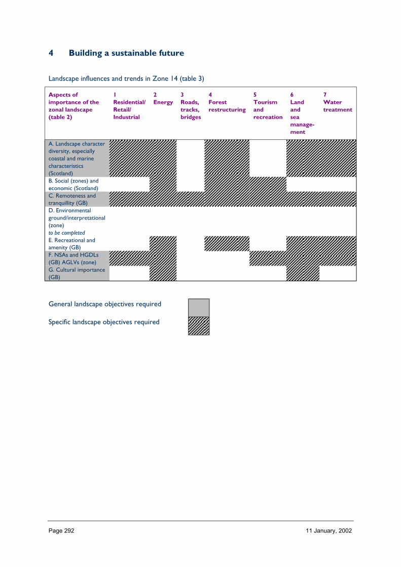
Page 292 11 January, 2002
4 Building a sustainable future
Landscape influences and trends in Zone 14 (table 3)
Aspects ofimportance of thezonal landscape(table 2)
1Residential/Retail/Industrial
2Energy
3Roads,tracks,bridges
4Forestrestructuring
5Tourismandrecreation
6Landandseamanage-ment
7Watertreatment
A. Landscape characterdiversity, especiallycoastal and marinecharacteristics(Scotland)B. Social (zones) andeconomic (Scotland)C. Remoteness andtranquillity (GB)D. Environmentalground/interpretational(zone)to be completedE. Recreational andamenity (GB)F. NSAs and HGDLs(GB) AGLVs (zone)G. Cultural importance(GB)
General landscape objectives required
Specific landscape objectives required
Page 293 11 January, 2002
ZONE 15 CENTRAL ARGYLL AND BREADALBANE
1 Nature of the landscape resource
Diversity, distribution and rarity of landscape character in the zoneNote: Ignore any LCT which is shown as <10 km sq (if important feature will be coveredelsewhere, if important characteristic locally will be flagged up in description)

Page 294 11 January, 2002
Table 15.1 Diversity
Zone LCTLevel 1
LCTLevel 3
Context Areakm2
15 Steep Ridgeland andMountains
HMRSSMts Highland 38.14
15 High Tops HMRSSMts Highland Island 0.1815 Open Ridgeland HMRRMts Highland 0.0015 Mountains HMRRMts Highland 207.3515 Highland River Valleys Highland and Island Highland 13.3515 Highland Lochs Highland and Island Highland 13.4515 Lowland Hills Lowland Hills Lowland 61.9515 Lowland Hill Fringes Lowland Hill
Margins and FringesLowland 0.01
15 Mountains and Uplands HMRSSMts Highland 369.3715 Flanking Hills and Crags Foothills and
Pronounced HillsUpland 39.55
15 Foothills Foothills andPronounced Hills
Upland 24.98
15 Lowland Loch Fringe Lowland LochBasins
Lowland 1.64
15 Loch Islands Lowland LochBasins
Lowland 2.57
15 Rolling Farmland Lowland Rolling orUndulatingFarmlands, Hills andValleys
Lowland 6.17
15 Unit No 4 River Plainwith Settlement
Flatter WiderValleys andFloodplains of theLowlands
Lowland 2.66
15 Loch Basins Lowland LochBasins
Lowland 39.21
15 Forests 0 Upland 107.8415 Glens and Straths Highland and Island
GlensLowland 296.75
15 The Trossachs RCUHM Highland 36.9715 Braes of Balquhidder Highland and Island
GlensHighland 101.62
15 Mountain Plateaux HMRRMts Highland 62.2015 Highland Glens Highland and Island
GlensHighland 569.86
15 Highland Glens withLochs
Highland and IslandGlens
Highland 288.21
15 Highland Summits andPlateaux
HMRRMts Highland 1124.72
15 Lowland Hills Lowland Hills Lowland 60.93Total 3469.68
HMRRMts = High, Massive, Rolling, Rounded Mts of Highlands & Islands
HMRSSMts = High Massive, Rugged, Steep-sided Mts of Highlands Islands
RCUHM = Rugged, Craggy Upland Hills & Moorlands of the Highlands, including the Trossachs

Page 295 11 January, 2002
The number of landscape character types represented in Zone 15 at level 1 is 25; the way they are grouped at level 3 is into 12 and theircontext is broadly Highland.
No. of LCTs (Level 1)/Area of Zone in Zone 15 is 0.007 – this gives an indication of the overall diversity of landscape character in the zoneand can be compared between zones.
Table 15.2 Distribution/pattern
Zone LCTLevel 1
LCTLevel 3
% ofZone(area)
No. ofOccurrences
Areakm2
15 Steep Ridgelandand Mountains
HMRSSMts 1.1 1 38.14
15 High Tops HMRSSMts 0.0 2 0.1815 Open Ridgeland HMRRMts 0.0 1 0.0015 Mountains HMRRMts 5.8 2 207.3515 Highland River
ValleysHighland andIsland
0.4 2 13.35
15 Highland Lochs Highland andIsland
0.4 1 13.45
15 Lowland Hills Lowland Hills 1.7 1 61.9515 Lowland Hill
FringesLowland HillMargins andFringes
0.0 4 0.01
15 Mountains andUplands
HMRSSMts 10.4 6 369.37
15 Flanking Hillsand Crags
Foothills andPronounced Hills
1.1 4 39.55
15 Foothills Foothills andPronounced Hills
0.7 3 24.98
15 Lowland LochFringe
Lowland LochBasins
0.0 1 1.64
15 Loch Islands Lowland LochBasins
0.1 5 2.57
15 Rolling Farmland Lowland Rollingor UndulatingFarmlands, Hillsand Valleys
0.2 4 6.17
15 Unit No 4 RiverPlain withSettlement
Flatter WiderValleys andFloodplains of theLowlands
0.1 1 2.66
15 Loch Basins Lowland LochBasins
1.1 5 39.21
15 Forests 0 3.0 3 107.8415 Glens and
StrathsHighland andIsland Glens
8.4 7 296.75
15 The Trossachs RCUHM 1.0 1 36.9715 Braes of
BalquhidderHighland andIsland Glens
2.9 1 101.62
15 MountainPlateaux
HMRRMts 1.8 3 62.20

Page 296 11 January, 2002
15 Highland Glens Highland andIsland Glens
16.4 11 569.86
15 Highland Glenswith Lochs
Highland andIsland Glens
8.1 7 288.21
15 HighlandSummits andPlateaux
HMRRMts 32.4 11 1124.72
15 Lowland Hills Lowland Hills 1.7 2 60.93Total 89 3469.68
In Zone 15 a total of 89 occurrences of landscape character types (landscape units) are found within a zone of total land area 3469 km2.The figure 89/3469 is 0.025 per km2 of land within the zone and gives a relative indication of the overall brokenness or fragmentation of thelandscape pattern.
Table 15.3 Distribution/pattern and diversity combined
Zone LCTLevel 1
LCTLevel 3
Context % ofZone(area)
No. ofOccurrences
Areakm2
Highland15 Steep
Ridgeland andMountains
HMRSSMts H 1.1 1 38.14
15 High Tops HMRSSMts HI 0.0 2 0.1815 Mountains and
UplandsHMRSSMts H 10.4 6 369.37
15 OpenRidgeland
HMRRMts H 0.0 1 0.00
15 Mountains HMRRMts H 5.8 2 207.3515 Mountain
PlateauxHMRRMts H 1.8 3 62.20
15 HighlandSummits andPlateaux
HMRRMts H 32.4 11 1124.72
15 The Trossachs RCUHM H 1.0 1 36.9715 Highland River
ValleysHighland andIsland
H 0.4 2 13.35
15 Highland Lochs Highland andIsland
H 0.4 1 13.45
15 Glens andStraths
Highland andIsland Glens
L 8.4 7 296.75
15 Braes ofBalquhidder
Highland andIsland Glens
H 2.9 1 101.62
15 Highland Glens Highland andIsland Glens
H 16.4 11 569.86
15 Highland Glenswith Lochs
Highland andIsland Glens
H 8.1 7 288.21
Upland15 Flanking Hills
and CragsFoothills andPronouncedHills
U 1.1 4 39.55

Page 297 11 January, 2002
15 Foothills Foothills andPronouncedHills
U 0.7 3 24.98
15 Forests 0 U 3.0 3 107.84Lowland15 Lowland Hills Lowland Hills L 1.7 1 61.9515 Lowland Hills Lowland Hills L 1.7 2 60.9315 Lowland Hill
FringesLowland HillMargins andFringes
L 0.0 4 0.01
15 Lowland LochFringe
Lowland LochBasins
L 0.0 1 1.64
15 Loch Islands Lowland LochBasins
L 0.1 5 2.57
15 Loch Basins Lowland LochBasins
L 1.1 5 39.21
15 RollingFarmland
Lowland Rollingor UndulatingFarmlands, Hillsand Valleys
L 0.2 4 6.17
15 Unit No 4River PlainwithSettlement
Flatter WiderValleys andFloodplains ofthe Lowlands
L 0.1 1 2.66
Total 89 3469.68

Page 298 11 January, 2002
LCT at Level 1 Area/Occurrences (km2)
Steep Ridgeland and Mountains 38.14High Tops 0.09Open Ridgeland 0Mountains 103.67Highland River Valleys 6.67Highland Lochs 13.45Lowland Hills 61.95Lowland Hill Fringes 0.00Mountains and Uplands 61.56Flanking Hills and Crags 9.88Foothills 8.32Lowland Loch Fringe 1.64Loch Islands 0.51Rolling Farmland 1.54Unit No 4 River Plain with Settlement 2.66Loch Basins 7.84Forests 35.94Glens and Straths 42.39The Trossachs 36.97Braes of Balquhidder 101.62Mountain Plateaux 20.73Highland Glens 51.73Highland Glens with Lochs 41.17Highland Summits and Plateaux 102.25Lowland Hills 30.46
The extent (area) of any one landscape character type (at Level 1) divided by the number of times it occurs in the zone gives an idea of theaverage size of occurrences of that LCT.
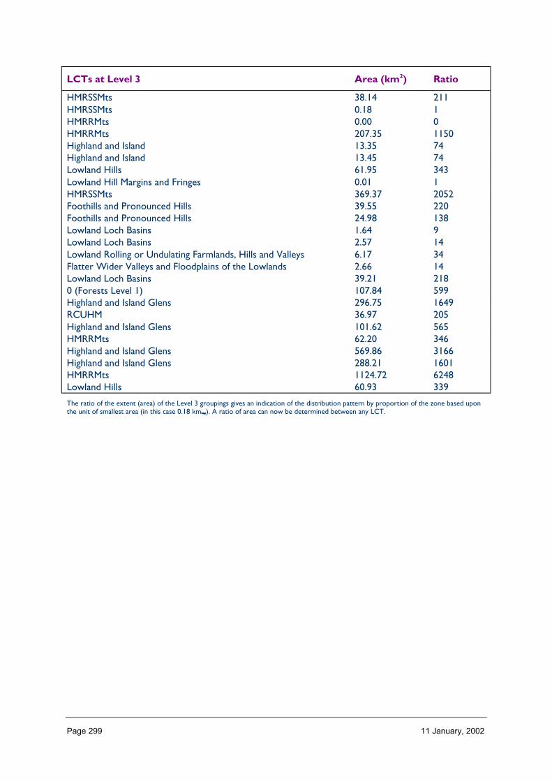
Page 299 11 January, 2002
LCTs at Level 3 Area (km2) Ratio
HMRSSMts 38.14 211HMRSSMts 0.18 1HMRRMts 0.00 0HMRRMts 207.35 1150Highland and Island 13.35 74Highland and Island 13.45 74Lowland Hills 61.95 343Lowland Hill Margins and Fringes 0.01 1HMRSSMts 369.37 2052Foothills and Pronounced Hills 39.55 220Foothills and Pronounced Hills 24.98 138Lowland Loch Basins 1.64 9Lowland Loch Basins 2.57 14Lowland Rolling or Undulating Farmlands, Hills and Valleys 6.17 34Flatter Wider Valleys and Floodplains of the Lowlands 2.66 14Lowland Loch Basins 39.21 2180 (Forests Level 1) 107.84 599Highland and Island Glens 296.75 1649RCUHM 36.97 205Highland and Island Glens 101.62 565HMRRMts 62.20 346Highland and Island Glens 569.86 3166Highland and Island Glens 288.21 1601HMRRMts 1124.72 6248Lowland Hills 60.93 339
The ratio of the extent (area) of the Level 3 groupings gives an indication of the distribution pattern by proportion of the zone based uponthe unit of smallest area (in this case 0.18 km_). A ratio of area can now be determined between any LCT.

Page 300 11 January, 2002
Table 5.4 Rarity
LCTs at Level 1 Rarity by occurrence%
Rarity by extent%
Steep Ridgeland and Mountains 1 1.1High Tops 2 0.0Open Ridgeland 1 0.0Mountains 2 5.8Highland River Valleys 2 0.4Highland Lochs 1 0.4Lowland Hills 1 1.7Lowland Hill Fringes 4 0.0Mountains and Uplands 6 10.4Flanking Hills and Crags 4 1.1Foothills 3 0.7Lowland Loch Fringe 1 0.0Loch Islands 5 0.1Rolling Farmland 4 0.2Unit No 4 River Plain with Settlement 1 0.1Loch Basins 5 1.1Forests 3 3.0Glens and Straths 7 8.4The Trossachs 1 1.0Braes of Balquhidder 1 2.9Mountain Plateaux 3 1.8Highland Glens 11 16.4Highland Glens with Lochs 7 8.1Highland Summits and Plateaux 11 32.4Lowland Hills 2 1.7
The rarity of a landscape character type within the zone can be identified by the number of time it occurs or its extent. Examination ofboth the number of occurrences (of a LCT) as a percentage of the total and the area (of a LCT) as a percentage of the total area will givean indication of rarity.
LANDSCAPE CHARACTER
Most of the south-east boundary of Zone 15 lies along the Highland Boundary Fault. Thismajor fault line lying SW-NE across central Scotland marks a dramatic geological changefrom the hard Dalradian rocks of the north-west to the softer sandstones of the MidlandValley. 99+% of Zone 15 lies to the north of the Highland Fault and the landscape characteris strongly influenced by landform largely resulting from ancient faulting, folding andsubsequent glaciation-related erosion. Broadly, its character is Highland in nature with someUpland areas.
The landscape character of the northern two thirds of Zone 15 – from the Angus foothillsto Loch Voil and the Braes of Balquhidder – is entirely Highland (e.g. Highland Summits andPlateaux, dissected by e.g. Highland Glens, some of which contain lochs).
In the south-western third of the zone from Loch Long in the west to Strathyre and thefoothills of Ben Vorlich in the east, the context is still largely Highland with a convolutedpattern of mountains, lochs and glens. As the elevation decreases the ranges are flanked byareas which are more Upland in character (e.g. Flanking Hills and Crags and Foothills)

Page 301 11 January, 2002
particularly at Loch Lomond and south of the Trossachs towards the Menteith Hills and thezone boundary.
Several relatively small areas of Lowland character occur along the south-eastern boundaryof Zone 15: at the southern end of Loch Lomond (Lowland Loch Fringe); by Aberfoyle (smallareas of Rolling Farmland and River Plain with Settlement); and Uamh Bheag and the Knaik Hillswhich lie to south of Glen Artney (Lowland Hills).
Description
Landform
PROFILE
The profile of much of Zone 15 has been heavily influenced by the action of glaciation onthe heavily folded and faulted hard Dalradian rock. This has resulted, in the northern part ofthe zone, in the rounded summits and rolling plateaux which are dissected by glens withclassic glaciation-related profiles and features.
In the southern part of the zone, to the south of Loch Earn and Loch Voil, the form of theland is more convoluted with flanking hills and crags rising from the shores of Loch Lomondto steep ridged mountains in the west which then fall steeply down to Loch Long. East ofLoch Lomond, around the Trossachs core there is a fragmented pattern of steep-sidedmountains with complex knolls, crags and peaks which are separated by deeply gouged andover-deepened lochs and glens.
The Lowland Hills have a smooth, rounded profile with localised textural interest, becomingmore knobbly to the west because of the resistant outcrops of the Highland BoundaryComplex.
SEQUENCE
The general sequence or broad inter-relationship of landform across Zone 15 is that ofmountains dissected by glens and straths.
The alignment of the mountain ranges and the dissecting glens can be explained by ancientfaulting and later processes of discordant drainage and radial ice dispersal – the latter fromthe ice fields of Rannoch Moor which lies out with this zone to the north-west (in Zone 13).
In the north of the zone the mountain ranges, straths and glens run roughly W-E. The twomain ranges lie to the north-west and south-east of Loch Tay, the former rising to over1000 m along its summits and the latter with much land over 800 m. South of Loch Earn andthe Braes of Balquhidder the glens tend to swing round to run in a NW–SE direction and,finally, in the far south and western part of the zone the main glen contains Loch Lomondwhich runs in a N–S direction. To the west of Loch Lomond, on the border of this zone, theupper reaches of Loch Long continues this pattern with a NNE–SSW orientation.
Broadly, the overall height of the east-west aligned northern ranges decreases towards theeastern and south-eastern boundaries of the zone. At the south-eastern boundary itself, atthe Highland Boundary Fault there is a more dramatic decrease in elevation as the glensmerge with the low lying carselands of the River Forth (Zone 17) and Strathearn (Zone 16).

Page 302 11 January, 2002
SCALE
The summits and ranges of the northern part of the zone form a large-scale, extensivelandscape. The mountain ranges are heavily dissected by glens which increase in scale asoverall elevation decreases. Thus, V-shaped, gouged, small-scale glens descend to wider, U-shaped straths and valleys where broadly curving glaciated slopes contain medium- to large-scale landscapes. Woodland and man-made features such as pylons and telecom masts act asscale indicators in the glens. Above the tree line the deserted higher slopes and summitsappear vast in the absence of elements of known size and scale.
In the southern third of the zone the landscape is still fairly large-scale but the mountainranges are more heavily dissected and the ranges are neither as high or as vast as in thenorth. The glens in this third of the zone are generally small-to-medium scale but are large-scale where they broaden into Lowland character areas at the Highland Boundary Fault byComrie, Kilmahog and Aberfoyle.
The Knaik Hills and Uamh Bheag are medium-to-large in scale and rise to 600 m.
LANDMARK FEATURES
The main landmark features of Zone 15 are those related to landform, particularly theprominent peaks of the mountains, including Ben Venue, Ben Lomond, Schiehallion, Ben An,the Cobbler, Conic Hill and many others.
The larger linear lochs are also strong landmarks, particularly when viewed from the highsummits, where their distinctive outlines help to orientate and aid a sense of direction.
The ‘Trossachs core’, being of international renown, can also be seen as a landmark.
EXPERIENCE
The experience of landform while moving through most of Zone 15 is one of repetition andpredictability. Movement by road tends to follow twisting routes along the larger glens andloch sides. This affords glimpses of distant peaks and plateaux between interlockinghillslopes which can suddenly disappear from view as a road changes direction and,additionally, give an indication of the scale and shape of the high mountains beyond. Withinthe glens themselves the curving sides enclose the valley floor and, locally, the intimacy ofscale in lower-lying glens is reinforced by the human influence of well-managed farmland andwoodland.
From the high summits the landform is experienced as a series of peaks and ranges fadinginto the distance, separated by glens and lochs which are mostly inferred rather thanactually seen. The expanses of plateaux are greater in the north of Zone 15, giving theexperience of a less complex landform.
Along the Highland Boundary Fault and within the Lowland character types to the south andeast of Zone 15 the experience is one of transition – from the Uplands and Highlands of thenorth-west to the lower, flatter carselands of the Midland Valley away to the east and south(in Zones 16 and 17).
In areas covered by great expanses of woodland – particularly with blanket commercialforestry plantations – the shape of the landform is often difficult to visualise because smallvalleys and local textural detail are obscured.
Page 303 11 January, 2002
Containment (created by landform and land cover)
TOPOGRAPHY
Containment afforded by topography varies greatly within Zone 15. In the open, highmountains, which rise from 600 to over 1100 m, containment is negligible but in thedissecting glens it can be high – particularly where the slope of the glen sides is great. Thehigher glens are approximately 1.5 km wide at the crest of enclosing hills and, with sidesrising up to 300 m above the valley floor, are an enclosed, sheltered space. The wide, open,lower valleys offer partial containment having flood plains of up to 1km wide with valleysides rising to 400 m above the valley floor. Where lochs fill the glens containment is lowerbecause the reflective nature of the water increases the sense of volume in the space. Onthe open expanse of Loch Lomond, which is over 1km wide along much of its length (nearly30 km within Zone 15), containment is particularly low.
Containment is lower along the south-eastern boundary of this zone – where hills and glensgive way to the flatter expanses of Lowland Scotland and where Loch Lomond widens outto over 3km. The rounded Lowland Hills straddle the Highland Boundary Fault and havehigher containment on the north-western slopes which overlook Glen Artney than on thesouth and north-eastern slopes which look out over the flat carselands of the Forth andStrathearn.
LAND COVER
The moorland, peatland, grassland and bracken of the high areas give an open landscape andcontribute little to containment. A few areas of semi-natural woodland survive in highsheltered valleys and afford some local enclosure. On the slopes of the dissecting glens andstraths large areas are covered with woodland and commercial forestry which compoundsthe containment already offered by topography. This is particularly true in the high, narrow,sheltered tributary glens. Locally, by the sharp edges of some coniferous plantations and insome areas of clear fell, containment can be high.
On the lower-lying slopes and valley floors throughout the zone, on the rolling Lowlandareas around Aberfoyle, and on the banks of Loch Lomond, areas of rough and improvedgrassland with low hedges, drystone walls and some mixed shelterbelt planting offer fairlyhigh enclosure. There is much policy planting in the lower Highland glens – dating from the18th and 19th centuries – consisting of distinctive and often exotic conifer species whichadd locally to containment. Walls and hedges are sometimes replaced with post-and-wirefences which erode distinctive local character and can reduce local containment andintimacy.
The rounded smooth Lowland Hills are transitional in nature with some pasture, roughgrazing and moorland and containment is low.
There are few built-up areas in this zone. Where small settlements do exist they occuralong the routes of glens where containment may be partial. Local containment is offered byshelter planting and from domestic gardens and planting.
VISIBILITY
The low containment of the high summits and plateaux offers wide, panoramic views. In theglens, where most people experience the landscape, views are contained by the topographybut can also be extensive and corridor in effect when they are focused along the longer,
Page 304 11 January, 2002
wider glens such as Loch Tay and Loch Lomond. Visibility is restricted and contained withinareas of forestry but patches of clear fell can offer surprisingly long views down the length ofwider glens.
Containment decreases with the dramatic change in topography along the south-easternboundary of the zone and views become wide and panoramic over Flanders Moss and thecarselands of the River Forth to the distant outlines of the Campsie Fells (Zones 16 and 17).
MICROCLIMATIC EFFECTS
Elevation and aspect both affect the microclimate of this inland zone where the broad east-west orientation of the mountain ranges channels the wet westerly winds along the lochsand glens. North-facing slopes can lie in shadow and have patches of unmelted snow formuch of the year. South-facing slopes are warmer and thus have a higher treeline. At a localor human scale the microclimate impacts upon vegetation and affects the sense ofcontainment when walking from the bottom of a valley through forested slopes up beyondthe tree line to the exposed summits.
Mists and fog resulting from temperature inversions in the glens are a dramatic feature ofspring mornings in particular. Proximity to a large loch will ameliorate local climateextremes.
EXPERIENCE
The experience of containment is variable as one moves through this zone. Major roads aregenerally located along the glens and lochsides and frequently run through woodland, whichheightens the feeling of containment when travelling through this zone by car or coach.Minor roads and tracks occasionally cross over the high passes which enables experience ofa more open and exposed landscape. There are very few roads above the tree line in thiszone. Within the forests and woodland containment is very high, particularly on the narrowtrails, though areas of clear fell or wider tracks offer some respite. Lochside policywoodlands were planted with the intention of framing views along the loch.
Rain and low cloud will affect visibility and increase the sense of containment, whatever thecharacter of the landscape, frequently cutting off views of the mountains and even the otherside of the wider glens.
Accessibility
DISTANCE
Zone 15 is easily accessible from the major conurbations of the Central Belt, it lies within 1hour of 65% of Scotland’s population and is well served by major roads. Loch Lomond lieson a primary route (A82(T)) northwards from Glasgow, branching off at Tarbet into theA83 for Argyll and the coast. At Crianlarich (having left and re-entered the zone) the A82joins the A85 (main route from Edinburgh to Oban) for a few miles then branches off atTyndrum for Fort William and the north-west. Along the eastern boundary of the zone theA9(T) runs S-N connecting Edinburgh with Inverness via Perth. This is connected to the A85in the west of Zone 15 by the A827 via Aberfeldy and Loch Tay.
The northern boundary of the zone is within a two hour drive along major roads from bothEdinburgh and Glasgow. In summer and at weekends there are often traffic jams and queuesalong the main roads of this zone – thus considerably affecting ease of access.
Page 305 11 January, 2002
PHYSICAL ACCESS
Access within Zone 15 is strongly influenced by topography and is seasonal. Roads followthe main glens and, apart from Loch Katrine, all major lochsides provide access routes. Themountain ranges act as effective barriers to communications and, while there are someminor roads and tracks over the high passes, these are effectively cut off in winter.
Only a very small part of this zone is more than 2 km from a road or a track (six distinctpatches greater than 20 km2), the latter of which penetrate the mountains via a network ofhigh, minor glens. Tracks to power stations located on isolated lochs, to disused mineworkings, through commercial forestry and along disused railway lines increase theaccessibility of this zone and a network of footpaths often fans out from the end of theseroutes. The most remote part of this zone, covering an area of approximately 120 km2, liesat the far north-west and includes part of Breadalbane to the north of Glen Lochay thenswings west and northwards to include the western parts of Loch Lyon and Loch An Daimh.The core of this area is at Meall Buidhe which is 5 km from a road or track.
The longer lochs generally act as barriers to access but three seasonal ferry services operateon Loch Lomond.
CULTURAL ACCEPTANCE
Tolerance and acceptance of public access varies within Zone 15 and depends largely uponthe nature of land ownership. Much of this zone is in the hands of private estates and largetracts are owned by the Forestry Commission.
By the nature of its vicinity to Edinburgh and Glasgow, Zone 15 has been attractive tovisitors for over 100 years and there is a high demand for access. The strong tradition inGlasgow of an exodus to the Loch Lomond and Trossachs area holidays and weekends hasinstilled a feeling of ownership of these hills and, while responsible access is now generallytolerated by the large estates, a network of claimed and vindicated Rights of Way across thiszone attest the tension which has existed at one time. Access is restricted on large estatesduring the shooting season.
Organisations such as the Forestry Commission and the National Trust for Scotlandencourage responsible access to their land. Visitor centres (e.g. Ben Lawyers) andwaymarked tracks and trails (e.g. Drummond Hill) entice visitors and focus them towardsparticular areas. Parts of the Argyll Forest Park and the entire Queen Elizabeth Forest Parkare located within the southern part of this zone. The Loch Lomond Regional Park wasestablished to encourage visitors and, greatly expanded, will form the basis for Scotland’sfirst National Park: extending westwards to include the Cobbler; northwards to GlenDochart; and eastwards to the slopes of Ben Vorlich.
Military Danger Zones exist at the summit of the Lowland Hills and on small part of themountains above Loch Long preventing access to these parts of the zone.
VISUAL ACCESS
Visual access from the network of roads in Zone 15 is largely restricted to the sides of theglens and closest summits while the interior mountain ranges tend to be inaccessiblevisually. Forestry on the glen slopes acts as an additional visual barrier to the higher areas.Visual access is often better from boats on the lochs – where it is possible to see beyondthe forestry to the upper slopes.

Page 306 11 January, 2002
From the high mountain summits themselves it is possible to view great distances across thiszone and, from some points, deep into the glens below. There are a large number of well-known viewpoints beside roads in this zone which afford distant views over hills and lochs.These include the Queen’s View on the B8019 at Loch Tummel, the Rest And Be Thankfulviewpoint on the A83 by Ben Ime and the Duke’s Pass north of Aberfoyle.
EXPERIENCE
The experience of access within this zone varies and is topographically and seasonallydependent. Access potential along the glens and in the Lowland areas is good but inpractice, in the height of summer, visitors and locals can experience frustration due to thegreat number of tourists on the roads and the footpaths, particularly those which have been‘waymarked’ – either on paper in guide books and maps or actually on the route. Suchroutes can heighten the experience for some yet diminish it for others. The West HighlandWay for example is a popular challenge for many but assiduously avoided by others.
The high plateaux of the north western part of this zone in particular offers a wild andremote experience, often necessitating a full day’s trek to its core.
Land cover (including vegetation and land use)
VEGETATION
Zone 15 has a great diversity of land cover types (possibly the most diverse of all theNHZs). 65% of the area consists of montane and heather moorland descending to brackenand rough unimproved hill grassland on the lower or steeper slopes. Much of this ismanaged by the estates for shooting and stalking – pursuits dating from the 18th/19thcentury. The practice of muirburn to manage the land for these activities creates adistinctive and attractive mosaic pattern on the high slopes. However, it also prevents theregeneration of native scrub and woodland.
Forests and woodland, at least two thirds of which is coniferous, account for a further 19%of landcover in Zone 15. The earlier commercial forests were created with little respect forlandscape character and result today in the geometric blocks of single species which coverand obscure much of the landscape detail of this zone. Blanket forestry is the maindeterminant of landscape character in three separate landscape character areas (Level 1) inthe southern part of this zone (Forests – Upland).
Current forestry planting guidelines recommend the use of mixed species (includingbroadleaves) with more subtle margins and a greater proportion of open space. Newplanting (and restructured stands) should integrate with, enhance and empathise with thecharacter of the landscape, respecting views, wildlife and cultural features. (‘Recent planting’accounts for 5.2% of landcover in LCS88.)
Policy woodlands established by the great estates in the 18th century are an important featureof the landscape of Zone 15. Located largely in the lower straths they contain a largenumber of exotic and native species such as beech, Scots pine, lime, oak chestnut, cedarsspruce, larch.
There are some remnants of native woodlands in this zone (e.g. Black Wood of Rannoch onthe southern slopes of Loch Rannoch).

Page 307 11 January, 2002
Agricultural land accounts for 6% and is mostly in the form of improved grassland forgrazing found on the lower-lying valley floors throughout the zone and on the rollingfarmland by Aberfoyle. Shelterbelts provide strong linear landscape features which createpattern and define spaces in these Lowland areas.
EXPOSED ROCK
Exposed rock accounts for only 0.2% of this zone yet it is a significant landscape feature ofthese glaciated uplands. Scree-covered corries emphasise ice-carved summits such as BenLomond, and exposed rock itself forms the summit of landmarks such as Schiehallion, BenAn and Conic Hill. Rock outcrops are particularly characteristic of the mountains in thesouth west of the zone round Ben Vorlich, Ben Vane and the Cobbler. Elsewhere the formsof the underlying rock are clearly visible beneath a thin veneer of soil.
BUILT DEVELOPMENT
Settlement is fairly sparse and built development does not contribute greatly to land coverin most of this zone (0.4%). In general settlements are situated along routeways through themajor glens: along Glen Dochart-Loch Tay; by Loch Earn; by Loch Lomond; along theA84(T); and along the main A9 route in the east. There are some isolated buildings andstructures away from the main roads which are generally associated with activities such aspowerstations or mineworkings rather than with settlement.
There is some recent small-scale expansion of housing in this zone generally around existingsettlements. Development associated with the tourist industry such as caravan sites andchalets can have a negative impact upon the local landscape.
EXPERIENCE
The nature of land cover in Zone 15 affords a range of experience. The large amount oflow-lying, untended, native landcover in the high areas coupled with the lack of settlementand other human artefacts gives a remote and natural quality to most of the zone over 300m. This experience diminishes as elevation decreases down through the forests and areas ofrough grazing on the lower slopes, to the floors of the glens which are likely to containroads, small settlements and steadings with some improved grassland on the flatter, morefertile valley floors. Shelterbelt planting, drystone dykes and beech and hawthorn hedgerowsincrease the awareness of management and human involvement in the landscape.
The colours of the different forms of landcover enhance the landscape experience in thiszone. The dark greens of blanket coverages of Norway and sitka spruce contrast with thebrighter seasonal tones of larch and broadleaved species. Autumn is particularly vibrant withthe strong colours of the changing woodlands contrasting with the more subtle colouring ofthe mosaics of purple heather, muirburn and fading bracken on the higher hills.
Hydrology and water bodies
TYPE
Freshwater accounts for 4.6% of land cover and forms a significant landscape feature in thiszone of high rainfall and relatively impermeable rocks. Britain’s largest river (River Tay) andlargest loch (Loch Lomond) are contained within this zone while at the other end of thescale many small lochans exist at higher altitudes, particularly in the range to the north-east

Page 308 11 January, 2002
of the zone. Small tributaries feed the main rivers and lochs and contribute to the fairly evennetwork of water features across the entire zone.
Much of the power of water in this zone has been harnessed for hydroelectricity and manylochs are artificially regulated for water supply. Several lochs are thus substantially largerthan their natural size as a result of damming, e.g. Loch Turret.
Loch Lomond is soon to become the centrepiece of Scotland’s first National Park which willalso include Lochs Katrine, Venacher, Ard, Lubnaig, Voil, Arklet and Sloy and the westernend of Loch Earn.
PATTERN
At a zonal scale the drainage pattern is complex and is largely related to glaciation-relatedactivity rather than to geology. The majority of rivers and lochs in the northern part of thezone roughly radiate from a point to the north-west (in Zone 13) and flow E or SE alongcourses which are a result of radial ice drainage (see ‘Sequence’). These valleys run contraryto the main, underlying geological structure and cross various rock types.
There are four main sub-catchment systems in this zone. Within each sub-catchment thecontribution of water features to the overall landscape character is fairly consistent.Numerous small burns tumble down from the mountains and plateaux through deeplygouged valleys which widen and flatten as height decreases. Where bands of hard rock crossa glen it often narrows drastically to form a gorge containing dramatic waterfalls and pools –such as above Fortingall where the River Lyon descends to meet the River Tay and at theFalls of Moness above Aberfeldy. The damming of many rivers for water managementpurposes has resulted in the reduction of flow beyond this point and the formation of lochsor raised water levels behind. On reaching the lower valleys the waters flow onto the flatterland, fanning through deltas into large lochs or into misfit rivers which meander acrossshingle-strewn flood plains. In the Appin of Dull, between Kenmore and Aberfeldy, there arebroad, flat, fertile river terraces.
EXPERIENCE
Water features contribute significantly to landscape experience in this zone. The rivers andlochs are an integral part of the overall visual and sensorial landscape experience as well asproviding the main access routes. Water can often be a focus for extremes – reflecting theseasonally changing colours of land cover and of the sky and clouds. In the narrow gorgesfast moving water and waterfalls are dramatic and stimulating whilst the long reflectiveexpanses of lochs and small lochans can offer an element of calm and tranquillity. The glintof small burns tumbling over rocky outcrops can catch and focus the eye from longdistances. On wilder windy days however the water in the larger lochs can be rough anddaunting. Many lochs are enjoyed for fishing or quiet contemplation while others such asLochs Tay, Earn and Lomond are used by water sports enthusiasts. The noise from thelatter can prove a negative experience for many.
Built and infrastructure development (present day)
NATURE AND PATTERN OF SETTLEMENT
Most of the relatively sparse settlement in Zone 15 is found towards the eastern boundaryin the busy A9 corridor (Pitlochry to Dunkeld) and in the eastern part of the River Tayvalley from Aberfeldy to the A9.
Page 309 11 January, 2002
Remaining settlement is situated on the valley floors and reflects the strategic importance ofbridging points, crossroads and confluence points, e.g. Killin, Comrie, Lochearnhead, KinlochRannoch, Tarbet and Aberfoyle.
Vernacular architecture develops in response to physical and cultural influences and many ofthe buildings in these settlements date from the 19th century when there was a flurry ofbuilding in response to the general ‘improving’ nature of the age and also to accommodategrowing numbers of tourists to this area. Many private properties are built in the so-called‘Scots Baronial’ style and surrounded by exotic conifers and rhododendrons.
Zone 15 contains a large number of estates (see also section 1.3.3) the buildings of which(including shooting lodges and workers’ accommodation) are often built in a distinctivearchitectural style which was subsequently reflected in other properties of the area. Anexample of this is the Breadalbane Estate with its steep, pitched roofs and Gothic windows.The Glenlyon Estate village of Fortingall is a local curiosity with thatched cottages which wasinspired by the Arts and Crafts movement. Ornate gatehouses and high walls may be theonly indication visible from the road that an estate lies beyond.
Elsewhere there is dispersed rural development consisting of isolated buildings which areoften linked to agricultural and estate activity and which are generally made of local stoneand sometimes painted white. Corrugated iron is a traditional roofing material.
There is some new housing in this zone, generally associated with the expansion of existingsettlements. New buildings, particularly those in the style of characterless suburban estatescan destroy local distinctiveness, as can the unsympathetic conversion of farm buildings.Tyndrum has expanded rapidly in recent years with many new houses and other buildingscatering for tourists.
NATURE AND PATTERN OF INFRASTRUCTURE
The present-day road pattern within Zone 15 has origins in the strategic network of 18thcentury military roads. Roads are generally aligned with glens because these once providedthe only routes through difficult terrain. Their routes wind sinuously through the landscape(e.g. Duke’s Pass) occasionally punctuated by humped back bridges which also formdistinctive features (e.g. Kenmore Bridge).
Today’s straighter, metalled roads (many based upon the Turnpike roads of the 19thcentury) often run roughly parallel to the (now often disused) early military roads such as inGlen Croe. The main A9(T) corridor is a busy through-route which has undergoneprogressive improvement in recent years, resulting in major engineering works, which havehad a significant impact upon the surrounding landscape – particularly from the easternslopes of the Bishopric Hills. Road improvements on other roads in the zone have beenrestricted to relatively minor realignments and junction upgrading – major rock cutting hastaken place on the A85(T) in Glen Dochart between Killin and Tyndrum and the now-straightened road has remnants of the old route running alongside.
Throughout Zone 15 there is a considerable amount of roadside clutter. Road signs androad paint are eye-catching features particularly where they are indicating tourist routes andtrails. Some attempt is being made to provide landscape character-related gateway signagefor smaller settlements such as at Crianlarich and Strathyre.
Page 310 11 January, 2002
The railways in this zone represent great feats of engineering with rock cuttings,embankments and viaducts. The railway routes are clearly visible and create linear landscapefeatures of interest, though many have now been dismantled, such as the route throughGlen Ogle where semi-native woodland lines the disused track. The only remaining rail linksthrough the zone are on the western and eastern boundaries of the zone.
Other forms of infrastructure – such as telephone poles and lines – can have an impactupon the landscape, particularly in the hills where they are distinctive linear features in anotherwise remote area. Operators are now encouraged to bury such lines.
NATURE AND PATTERN OF INDUSTRIAL DEVELOPMENT
Industrial development in Zone 15 is largely associated with harnessing, extracting andpromoting the natural resources of the area.
Hydroelectric power has been generated since the 1960s and is evident throughout thezone. The dams, sluicehouses and turbine stations are eye-catching point features e.g. theneo-classical sluicehouse on Loch Venarchar and the white Loch Tummel turbine house.Powerlines which radiate from the generating stations are distinctive linear landscapefeatures and frequently follow straight routes which run contrary to landform or landscapecharacter. Six main powerlines radiate from the Loch Tummel hydro station.
There is some evidence of past quarrying in Zone 15. Quarries for building stone androofing slate can have a significant local landscape impact. The disused slate quarry byAberfoyle at the Dukes Pass is still evident in the forest. There are proposals for a barytesmine on the slopes of Beinn Eagagach by Duntanlich in the Loch Tummel NSA. The potentiallandscape impact of the mine itself and of the service tracks and associated infrastructurefor this proposal is causing concern. Permission has been granted recently for the mining ofgold at Cononish by Tyndrum.
Tourism is the mainstay of Zone 15’s economy and is heavily dependent upon the characterand quality of the landscape. It is ironic therefore that tourism-related development isresponsible for many of the negative impacts upon landscape character. Some buildings, suchas wooden kit chalet houses and log cabins, do not integrate well with traditional styles.Static caravan sites and associated infrastructure can detract from the landscape and, evenwhen some attempt has been made to shield these sites with woodland, they can often stillbe seen as dominant and incongruous features from the high slopes. Likewise, facilities suchas car parks and visitor centres need to be integrated with the existing characteristics of anarea.
There are several large timeshare developments in this zone which are distinctive features inthe landscape – notably in the Trossachs, at Kenmore, Rannoch, Aberfeldy and at Dunkeld.
Fish farming is low scale at present in this zone but could have a cumulative impact on thelandscape. There is a discrete farm on Loch Earn.
There are likely to be proposals for wind farms in this zone. The high Summits and Plateauxand the transitional Lowland Hills may be potential areas of search.
Page 311 11 January, 2002
EXPERIENCE
Much of this zone is valued for its natural beauty and remote, wild land feel. 20th/21stcentury clutter will therefore detract significantly from this experience, particularly in thehigh mountains. Powerlines which cross through areas otherwise devoid of human influencecan detract from the remote experience and can clash with the local character of thelandscape, especially if they are not sensitively aligned with the landform.
Services and infrastructure are generally confined to the glens and this in turn can lead tothe loss of landscape character in those areas. Roads, railways, and electric powerlines oftenrun through the same glen corridor which gives an experience of pressure andovercrowding. Small re-alignments of minor roads removes local characteristic features suchas hedgerows, walls and local landmark trees. Faster, straighter roads can also affect theperception of the landscape.
Some elements of the hydro industry can portray a dramatic and positive image, particularlywhen the links between the character of the landscape and the nature of the industry areobvious – high dams holding back the kinetic power of the water for example. Associatedpower lines however can create a negative landscape experience as they cross high landotherwise devoid of man made elements and often in straight lines through woodland andforestry bearing no relationship to the landform.
Visible history (past settlement, landuse, churches, brochs, forts, dykes, standingstones etc.)
TYPES OF VISIBLE HISTORY
There is a wealth of visible history in this zone and thousands of sites have been recorded,including several hundred Scheduled Ancient Monuments. A substantial number of additionalsites may have been eradicated by agricultural improvements, reforestation and the floodingof some valleys. Early pre-Christian evidence in this zone is in the form of monumentsassociated with burials and other rituals. They are evident in the landscape as irregularmounds which break the natural contours of hills, low ridges and river terraces. Earliestevidence of settlements exist from the Iron Age when stone was used for defensivebuildings such as forts. These extensive earthworks with stone walls remain as significantlandscape features.
The Roman remains in this zone are also defensive in the form of garrisons which wereconstructed to supress insurrections from clans.
There is much visible evidence of the large-scale depopulation of this zone in the years post‘45 when crofters were moved from the Highland glens to make way for sheep. Abandonedsettlements, shielings and field systems are scattered throughout the zone.
Deer forests and accompanying shooting lodges were created in mid-Victorian times e.g.Glen Finglas.
There are numerous post-reformation churches in this zone.
Castles and grand estate houses are found throughout the zone (see section 1.3.3)
Page 312 11 January, 2002
LOCATION/PATTERN
Ritual and funerary monuments (cairns, standing stones etc.) are mainly concentrated in thevalleys, lowlands and on mid-altitude slopes of the northern part of this zone and areparticularly concentrated in the glen containing the River Tay and its tributary Glen Lyon.Cup and ring marked stones are often strategically sited at the junction of valley routes e.g.at Mid Lix where Glen Ogle joins Glen Dochart.
The defensive legacy of the Iron Age includes crannogs (e.g. on Loch Tay) and forts whichare situated on hill tops and valley ridges and command views over communications routesand up glens and straths.
The remains of several Roman defensive structures are located along the Highland/LowlandLine on the south-eastern boundary of the zone – e.g. Boschastle Fort by Callander.
Abandoned shielings are scattered throughout the lower mountain slopes but are especiallyconcentrated in the sheltered high glens in the northern part of this zone. Old field systemsand abandoned townships (often on slopes with a southern aspect) remain evident in thislandscape – particularly in the mountains between Glen Lyon and Loch Tay. There are manyruined crofthouses in Braes of Balquhidder and around Killin in Glen Lochay and GlenDochart.
EXPERIENCE
The wealth of visible history in this zone adds to the overall landscape experience bycontributing to a sense of its historical depth. Earthworks and remains of past agriculturalactivity are particularly noticeable when there has been a light covering of snow. They alsoact as landmarks and as focal point and linear features in the landscape. Many castles arenow tourist attractions with associated car parks and other visitor facilities. The abandonedsettlements and shielings act as testament to the once well-settled glens and the subsequentClearances of the 1800s and occasionally become the object of pilgrimages for descendantsof the cleared families.
The spires of post-reformation churches can often be clearly seen rising above thewoodland on the valley floors. They are visible from the surrounding landscape and canpoint to the location of the settlements.
Wildlife
FORMS OF WILDLIFE
Zone 15 contains a large range of native mammals, birds and freshwater species.
LOCATION
The location of wildlife in this zone is dependent upon season, altitude and habitat. Largermammals such as red deer, wildcats, pinemartens, mountain hare, and game birds such asgrouse, are generally found in mountain, moorland and woodland habitats but they leave thehigher ground in winter in search of food and shelter, often venturing into danger on theroads through the glens.
Mammals and birds are generally well camouflaged in their usual habitats. The glens andlower woodlands support smaller mammals and other vertebrates such as adder, bat, frog,hare, newt, red squirrel, toad. Capercaillie are to be found in pinewoods throughout the

Page 313 11 January, 2002
zone. Otters might make a rare appearance along rivers and burns and on the coastal rockyshoreline at the head of Loch Long in the far west of the zone. Midges are prolificthroughout the zone.
WHEN
Deer are commonly spotted at dawn and dusk and against the snow-covered hills in winter.Birds are noticeably active in spring and at dawn. Midges are especially vicious near stillwater on calm overcast days and at dusk.
EXPERIENCE
For many visitors to this zone a distant view of a stag or a group of hinds adds significantlyto the ‘romantic’ image of the Highland landscape which stems from Victorian times.Paintings such as the Monarch of the Glen feed this image.
In general though, wildlife does not significantly affect the visual dimension of landscapecharacter in the predominantly large-scale landscape of Zone 15. The distinctive sounds ofbirds of prey, capercaillie, and of stags roaring can echo across great distances and add tothe remote character. Likewise the quiet atmosphere of forestry tracks can be broken byunseen animals or birds rustling in the dark interior.
Climate
CLIMATIC CHARACTERISTICS
The climate of Zone 15 reflects the interaction of weather systems and topography.
Apart from the far south-west of the zone, this area can be regarded as inland with a semi-continental climate. It falls under the influence of the prevailing wet westerlies for much ofthe year, their frequency being highest in autumn and early winter – the wettest part of theyear. At other times the zone is influenced by northerly and north-westerly systems.Mountains can be shrouded in rain and cloud for many days at all times of the year.
There are greater extremes of climate within the zone as a result of elevation than as aresult of distance from the coast or due to a north/south variation. The greatest extremesof temperature are found between the high summits and the lower-lying valleys(temperature decreasing by 6 degrees every 1000m).
Frequency of snow increases with distance from the coast and lochs and with height.
Days are long in summer and short in winter.
EXPERIENCE
Climate adds significantly to the landscape experience of this zone – racing clouds (reflectedon loch surfaces and shadows), wind-blown trees hugging the landform and sheltering insecluded gorges, mountain summits shrouded in cloud and mist for days. Bright summerdays, strong colours, lochs and burns have cooling effect.
Page 314 11 January, 2002
Designated landscapes
National Scenic Areas
CONSTITUENTS
There are six NSAs in this zone. Three of these are partially in Zone 15 and three containedsolely within the zone. Four of the NSAs are entirely Highland in landscape character; oneHighland and Upland; and one Highland, Upland and Lowland. Details, including landscapecharacter types (LCTs) contained within the NSAs, are listed below:
Loch Rannoch and Glen Lyon NSA (small parts extend into Zones 13 and 11): High Summitsand Plateaux and Highland Glens (Highland LCTs);
Loch Tummel NSA: High Summits and Plateaux and Highland Glens (Highland LCTs);
River Tay (Dunkeld) NSA (extends into zones 12 and 16): High Summits and Plateaux andHighland Glen (Highland LCTs);
River Earn (Comrie to St Fillans) NSA: Highland Summits and Plateaux and Highland Glen(Highland LCTs);
Trossachs NSA: Trossachs core (Highland LCT); Upland Foothills and Upland Forests(Upland LCTs);
Loch Lomond NSA (extends into Zone 17): Mountains and Uplands (Highland LCT);Flanking Hills and Crags, Upland Forest, Upland Foothills (Upland LCTs); Lowland LochIslands, Lowland Glens and Straths, Lowland Loch Fringes and Lowland Rolling Farmland(Lowland LCTs).
LOCATION AND EXTENT
Loch Rannoch and Glen Lyon NSA is the largest NSA in this zone and includes LochRannoch itself, Schiehallion, the Black Wood of Rannoch, much of Glen Lyon, Ben Lawyersand Meall nan Tarmachan.
NB but not including the most remote part of Zone 15 which lies to the west of the NSA byLoch Lyon and Loch An Daimh.
The part of the River Tay (Dunkeld) NSA which is in Zone 15 is a small area around the cityof Dunkeld to the west of the Tay. The NSA lies across the zone of transition of the RiverTay as it joins with the River Braan and changes from a Highland to a Lowland river as itcrosses the Highland Boundary Fault. The NSA includes the HGDLs of The Hermitage andDunkeld.
Loch Tummel NSA lies entirely within Zone 15 and includes the Pass of Killiecrankie, thenorthern part of Loch Faskally, the Linn of Tummel and Loch Tummel and the enclosinghills.
River Earn (Comrie to St Fillans) NSA includes the upper part of Strathearn and the peak ofMor Bheinn.
Page 315 11 January, 2002
The Trossachs NSA lies entirely within Zone 15 and extends from Ben Venue to thesummit ridge of the Menteith Hills. It centres upon Loch Achray and the eastern part ofLoch Katrine.
Loch Lomond NSA lies mostly within Zone 15 and includes the immediate basin but not theentire catchment of Loch Lomond. Its western boundary is defined by the nearest summitsincluding Ben Vorlich, Ben Eich and Balcnock. The eastern hills include Ben Lomond andConic Hill.
EXPERIENCE
The six NSAs in Zone 15 display well-balanced combinations of classic landscape featureswhich typify or epitomise Highland landscape. Four NSAs lie on or near the HighlandBoundary Fault and thus also exhibit classic transitional landscape features.
Loch Rannoch and Glen Lyon NSA is appreciated for a great range and diversity oflandscape character from the open spacious loch with birch woodland on the northernslopes and remnants of native pine woodland on the southern (Black Wood of Rannoch).From the northern slopes there wide panoramic views to Schiehallion and westwards acrossRannoch Moor to the hills of Glen Coe (in Zone 13). The tranquil meadowland ofDunalastair offers an contrast to the larger loch to the west. Glen Lyon has all the featuresof a ‘classic’ highland glen – from tumbling burns in narrow gorges to a meandering river inits lower reaches.
The Loch Tummel NSA is landscape of wood, water and mountains. At the west end of theloch there is a simple open landscape with estate planting, wooded knolls and fertileagricultural land. Eastwards the landscape character becomes more intimate with a woodedlandscape with great diversity of species and deep gorges and dramatic rapids. The NSAextends upwards to include the bare heather-clad summits of the mountains which afford aremote, open landscape experience. There are strong cultural associations with Queen’sView on the northern side of Loch Tummel.
Transitional NSAs (Highland to Lowland landscapes).
River Tay (Dunkeld) NSA is located where two rivers meet at an intimate historicalsettlement. The rivers flow between the rugged hills of the highland edge through richly-wooded designed landscapes. A landscape with waterfalls and rapids which are characteristicof the Highland/Lowland transition.
River Earn NSA is designated for its well-balanced combination of landscape elements whichoccur at the Highland/Lowlands conjunction. The local landscape character is based on therich variety of vegetation and landform. The river forms a central feature following a courseof great variety: alternately swift and then slow and leisurely; open and meadowed orenclosed by alder woodland with a strong sense of enclosure and intimacy.
Trossachs NSA is a complex landscape with knolls, craggy hills and rugged peaks whichstand in contrast to the character of the adjacent lowland. It contains coniferous, deciduousand broadleaved woodland. The richly wooded shores, islands, bays and promontories ofLoch Katrine afford a quiet and intimate landscape. This area has great cultural and literaryassociations notably with Scott and Ruskin. For many tourists the scenery of this NSAepitomises the scenery of Highland Scotland.
Page 316 11 January, 2002
Loch Lomond NSA is appreciated for its loch-based landscape features. Although the NSAcrosses the Highland Boundary Fault it is those features which are of Highland characterwhich are important within Zone 15. The Loch is fjord-like and narrow at northern end ofthe loch and largely wooded along its entire length. There is a rich variety of deciduouswoodland on loch shores and semi-natural woods on islands. Changing seasonal colours ofthe woodland, bracken and heather of the high hills are reflected in the loch waters.
Loch Lomond NSA and Trossachs NSA are within the proposed boundaries of the LochLomond and Trossachs National Park.
AGLVs and other Local Authority Designations
NATURE OF THE LANDSCAPE DESIGNATED
Areas of Great Landscape Value (AGLVs)
One large AGLV from Glen Dochart (including Breadalbane) eastwards including westernhalf of Loch Tay to Callander not including area covered by Loch Lomond NSA, TrossachsNSA or the small settlements of Tyndrum, Crianlarich, Killin, Lochearnhead, Strathyre andAberfoyle (a small part extends into Zone 13) – (Stirling Council)
Sma’ Glen on River Almond – (Perth and Kinross Council)
No AGLVs in Argyll and Bute Council’s small part of this zone
Environmentally Sensitive Areas (ESAs)
Breadalbane ESA covers most of the northern third of this Zone (extending into Zones 12and 13) apart from Rannoch Forest and the area to the west of Meall Buidhe.
Lomond ESA (also extending into Zones 13 and 17)
Historic gardens and designed landscapes
NATURE OF THE LANDSCAPES DESIGNATED AND NON-DESIGNATED
In Zone 15 there are 15 sites listed on the original Inventory of Historic gardens anddesigned landscapes (1987) and two new entries (not yet public).
(HGDL profiles contract let separately)
LOCATION
The following HGDLs are in the 1987 inventory:
Tay valley NSBlair Castle – by Blair Atholl – Glen GarryDunkeld Housethe HermitageMurthly Castle (part)Loch EarnDuniraAberuchillGlen Lyon
Page 317 11 January, 2002
Meggernie Castle –Tay valley WECastle MenziesBolfracksTaymouth CastleGrandtully CastleCluny HouseBy Loch LomondRossdhu HGDL – Loch LomondBy AberfoyleRednock HouseBlairhoyleFalls of Bruar - NS tributary of Glen Garry – w of Blair AthollBalnakeilly HGDL – N of Moulin by Pitlochry
EXPERIENCE
Listed sites epitomise highland estates – *see separate HGDL input to Zone 15.Picturesque/sublime etc...
Recreational landscapes
Nature of landscapesThe landscapes of Zone 15 can be roughly classified into four main recreation-landscapetypes: mountain, woodland, glen and water.
The mountains attract walkers, especially ‘Munro-baggers’, and rock climbers throughoutthe year and ice mountaineering is becoming increasingly popular in the winter. Shootingand stalking are seasonal activities on the large estates.
Large tracts of forestry offer sheltered recreation opportunities. Many tracks arewaymarked and graded for different levels of fitness/ability. Cycle routes have also beendeveloped though some forests and other routes are being promoted for ponytrekking.
The glens are the most-used recreational landscape in this zone, providing through-routesfor large numbers of tourists – particularly car-based sightseers. Small towns act as a focusfor visitors and offer accommodation and information. Recreation in these landscapes tendsto be relatively passive but some small towns, such as Killin, Crianlarich and Aberfoyle haveevolved as popular starting points for walking routes and trails. Associated infrastructuresuch as backpackers’ hostels have recently been built. Picnic places with additional facilitiesare located along busier glens throughout the zone. Large estates and their policies anddesigned landscapes are also situated in the glens – many are open to the public and attracta large number of visitors.
The lochs offer extensive watersports facilities and provide the main venues in Scotland forpower boating and water skiing. Quieter loch-based activities include sailing, canoeing andpleasure-boat trips. Loch-side picnic places (often in areas of woodland) are very popularand offer secluded spots for fishing and bathing.
Page 318 11 January, 2002
LOCATION
Zone 15 has many locations offering opportunities for recreation – both formal andinformal:
Remote mountain walking and climbing – north-west of zone – by Loch Lyon and Loch AnDaimh. This is the only part of Zone 15 which is more than 5km from a road or track.
Highest concentration of peaks over 1000 m (approx. Munro) occur in the north of thezone between Loch Tay and Loch Rannoch on the more expansive ranges, e.g. Ben Lawyers,Schiehallion and Meall nan Tarmachan. In the central part of the zone are the peaks of BenLomond and Ben More. To the west of Loch Lomond lie Ben Ime and Ben Vorlich aboveGlen Croe and Loch Long.
There are many peaks over 800 m (approx. Corbett) in the range to the south-east of LochTay; isolated summits west of Strathyre (Ben Ledi), in the Trossachs (Ben Venue); andseveral summits in the rocky range north of Loch Long (Cobbler, Ben Vane).
There are two forest parks in this zone: the Queen Elizabeth Forest Park in the Trossachs;and the Argyll Forest Park in the far west of the zone. Forest walks and cycle tracks in both.
Water sports: Lochs Tay, Earn and Lomond.
West Highland Way – east side Loch Lomond
Callander to Strathyre cycle path
EXPERIENCE
Zone 15 offers a variety of landscape experience for those taking part in all forms ofrecreation whether passive or active, formal or informal. The attraction of this area is that aHighland experience can be gained within 1 to 1_ hours drive of the Central Belt. Theoverall feeling in the higher areas is one of wildness and remoteness and even car-basedsightseers can experience this to a certain extent when driving over the high passes such asGlen Quaich.
The large number of visitors to this zone – particularly in the valleys – can lead to congestedroads and the overcrowding of some popular spots resulting in a negative impact uponlandscape experience.
The unpredictability of the weather of this zone enhances the wild land feel of the highermountains and lower slopes at all times of the year.

Page 319 11 January, 2002
ZONE 16 WESTERN SEABOARD
1 Nature of the landscape resource
Diversity, distribution and rarity of landscape character in the zoneNote: Ignore any LCT which is shown as <10 km sq (if important feature will be coveredelsewhere, if important characteristic locally will be flagged up in description)
Table 16.1 Diversity
Zone LCTLevel 1
LCTLevel 3
Context Areakm2
16 Coastal Strip Lowland CoastalLandscapes of theNorth East
Coastal 25.56
16 Agricultural Heartlands AgriculturalLowlands of theNorth East
Lowland 382.77
16 Moorland Plateaux FRSSEHM Highland 15.8016 Dissected Plateau
MoorlandUpland Hills, TheLammemuir,Pentland andMoorfoot Hills
Upland 25.62
16 Grassland with RockOutcrops
Upland FringeMoorland
Upland 66.92
16 Grassland with Hills Upland FringeMoorland
Upland 189.38
16 Undulating Grassland Upland FringeMoorland
Upland 78.09
16 Upland Fringe Moorland Upland FringeMoorland
Upland 25.78
16 Lowland with Drumlins Drumlin Lowlands Lowland 297.5616 Rolling Lowland Margin Lowland Hill
Margins and FringesLowland 156.79
16 Lowland Margin withHills
Lowland HillMargins and Fringes
Lowland 66.00
16 Coastal Farmland Low CoastalFarmlands
Lowland Coastal 43.62
16 Plateau Grassland High PlateauMoorlands
Upland 29.66
16 Coastal Pasture Low CoastalFarmlands
Coastal 23.21
16 Coastal Moorland Coastal HillsHeadlands Plateauxand Moorlands
Coastal 26.79
16 Pastoral Upland Valley Upland Glens,Valleys and Dales
Upland 8.58
16 Upland Valley withFarmland
Upland Glens,Valleys and Dales
Upland 51.34
16 Upland Valley withWoodland
Upland Glens,Valleys and Dales
Upland 21.69

Page 320 11 January, 2002
16 Pastoral Upland FringeValley
Upland FringeValleys andFarmlands
Upland 99.60
16 Upland Fringe Valleywith Settlements
Upland FringeValleys andFarmlands
Upland 48.05
16 Wooded Upland FringeValley
Upland FringeValleys andFarmlands
Upland 88.89
16 Lowland Valley withFarmland
Lowland RiverValleys
Lowland 297.88
16 Coastal Valley Low CoastalFarmlands
Coastal Lowland 4.71
16 Southern Uplands withScattered Forest
Upland Hills, TheSouthern Uplandsand Cheviots
Upland 72.54
16 Southern UplandsForest Covered
Upland Hills, TheSouthern Uplandsand Cheviots
Upland 9.31
16 Cheviot Uplands Upland Hills, TheSouthern Uplandsand Cheviots
Uplands 40.98
16 Cheviot Foothills Foothills andPronounced Hills
Upland 75.88
16 Rolling Farmland Lowland Rolling orUndulatingFarmlands, Hills andValleys
Lowland 262.73
16 Platform Farmland Lowland Plateauxand Plains
Lowland 54.19
16 Lowland Hills Lowland Hills Lowland 90.5016 Lowland Hill Fringes Lowland Hill
Margins and FringesLowland 54.20
16 Lowland River Valleys Lowland RiverValleys
Lowland 256.26
16 Lowland Valley Fringes Lowland ValleyFringes
Lowland 81.67
16 Coastal Margins Coastal Margins Coastal 57.4716 The Uplands Upland Igneous and
Volcanic Hills TheOchil, Sidlaw, Cleishand Lomond Hills
Upland 48.56
16 Lowland Loch Basin Lowland LochBasins
Lowland 20.12
16 Coastal Hills Coastal HillsHeadlands Plateauxand Moorlands
Coastal 57.08
16 Coastal Terraces Coastal RaisedBeaches andTerraces
Coastal 63.60
16 Coastal Cliffs Rocky Coasts Cliffsand Braes of theLowlands
Coastal 0.66
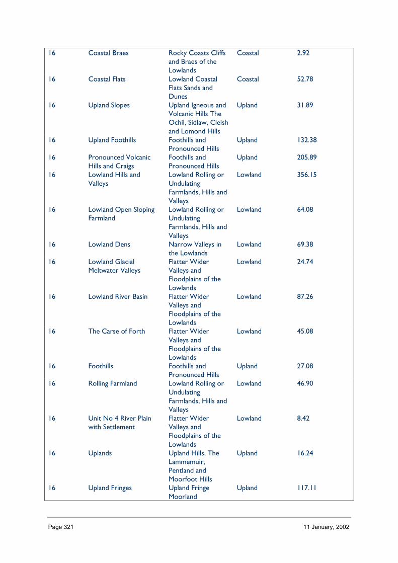
Page 321 11 January, 2002
16 Coastal Braes Rocky Coasts Cliffsand Braes of theLowlands
Coastal 2.92
16 Coastal Flats Lowland CoastalFlats Sands andDunes
Coastal 52.78
16 Upland Slopes Upland Igneous andVolcanic Hills TheOchil, Sidlaw, Cleishand Lomond Hills
Upland 31.89
16 Upland Foothills Foothills andPronounced Hills
Upland 132.38
16 Pronounced VolcanicHills and Craigs
Foothills andPronounced Hills
Upland 205.89
16 Lowland Hills andValleys
Lowland Rolling orUndulatingFarmlands, Hills andValleys
Lowland 356.15
16 Lowland Open SlopingFarmland
Lowland Rolling orUndulatingFarmlands, Hills andValleys
Lowland 64.08
16 Lowland Dens Narrow Valleys inthe Lowlands
Lowland 69.38
16 Lowland GlacialMeltwater Valleys
Flatter WiderValleys andFloodplains of theLowlands
Lowland 24.74
16 Lowland River Basin Flatter WiderValleys andFloodplains of theLowlands
Lowland 87.26
16 The Carse of Forth Flatter WiderValleys andFloodplains of theLowlands
Lowland 45.08
16 Foothills Foothills andPronounced Hills
Upland 27.08
16 Rolling Farmland Lowland Rolling orUndulatingFarmlands, Hills andValleys
Lowland 46.90
16 Unit No 4 River Plainwith Settlement
Flatter WiderValleys andFloodplains of theLowlands
Lowland 8.42
16 Uplands Upland Hills, TheLammemuir,Pentland andMoorfoot Hills
Upland 16.24
16 Upland Fringes Upland FringeMoorland
Upland 117.11

Page 322 11 January, 2002
16 Lowland River Valleys Lowland RiverValleys
Lowland 132.99
16 Lowland Hills andRidges
Lowland Hills Lowland 76.00
16 Lowland Plains Lowland Plateauxand Plains
Lowland 310.02
16 Coastal Margins Coastal Margins Lowland Coastal 326.3116 Highland Glens Highland and Island
GlensHighland 55.28
16 Broad Valley Lowland AgriculturalLowlands of theNorth East
Lowland 816.56
16 Firth Lowlands Lowland CoastalLandscapes of theNorth East
Lowland Coastal 89.54
16 Low Moorland Hills Smooth UplandMoorland Hills
Lowland 118.32
16 Dipslope Farmland AgriculturalLowlands of theNorth East
Lowland 435.69
16 Coast Lowland CoastalLandscapes of theNorth East
Coastal 45.01
16 Highland Summits andPlateaux
HMRRMts Highland 3.10
16 Highland Foothills Highland Foothills Highland 326.9816 Lowland Hills Lowland Hills Lowland 390.7116 Lowland River
CorridorsAgriculturalLowlands of theNorth East
Lowland 106.44
16 Igneous Hills Upland Igneous andVolcanic Hills TheOchil, Sidlaw, Cleishand Lomond Hills
Upland 519.26
16 Dolerite Hills Upland Igneous andVolcanic Hills TheOchil, Sidlaw, Cleishand Lomond Hills
Upland 32.37
16 URBAN AREA Upland Igneous andVolcanic Hills TheOchil, Sidlaw, Cleishand Lomond Hills
Upland 111.96
Total 8504.88
HMRRMts = High, Massive, Rolling, Rounded Mts of Highlands & Islands
HMRSSMts = High Massive, Rugged, Steep-sided Mts of Highlands & Islands
FRSSEHM = Flat or Rolling, Smooth or Sweeping, Extensive, High Moorlands of Highlands & Islands
RCUHM = Rugged, Craggy Upland Hills & Moorlands of the Highlands, including the Trossachs
PL =Peatland Landscapes of the Highlands & Islands
SL =Sea Lochs of the Highlands & Islands
The number of landscape character types represented in Zone 16 at level 1, is 72 the way they are grouped at level 3 is into 27 and theircontext is Highland. No. of LCTs (Level 1)/Area of Zone in Zone 16 is 0.008, this gives an indication of the overall diversity of landscapecharacter in the zone and can be compared between zones.

Page 323 11 January, 2002
Table 16.2 Distribution/pattern
Zone LCTlevel 1
LCTlevel 3
% ofZone(area)
No. ofOccurrences
Areakm2
16 Coastal Strip Lowland CoastalLandscapes of theNorth East
0.3 2 25.56
16 AgriculturalHeartlands
AgriculturalLowlands of theNorth East
4.4 3 382.77
16 MoorlandPlateaux
FRSSEHM 0.2 1 15.80
16 DissectedPlateauMoorland
Upland Hills, TheLammemuir,Pentland andMoorfoot Hills
0.3 3 25.62
16 Grassland withRock Outcrops
Upland FringeMoorland
0.8 4 66.92
16 Grassland withHills
Upland FringeMoorland
2.2 4 189.38
16 UndulatingGrassland
Upland FringeMoorland
0.9 3 78.09
16 Upland FringeMoorland
Upland FringeMoorland
0.3 1 25.78
16 Lowland withDrumlins
DrumlinLowlands
3.4 1 297.56
16 Rolling LowlandMargin
Lowland HillMargins andFringes
1.8 2 156.79
16 Lowland Marginwith Hills
Lowland HillMargins andFringes
0.8 1 66.00
16 CoastalFarmland
Low CoastalFarmlands
0.5 2 43.62
16 PlateauGrassland
High PlateauMoorlands
0.3 2 29.66
16 Coastal Pasture Low CoastalFarmlands
0.3 1 23.21
16 CoastalMoorland
Coastal HillsHeadlandsPlateaux andMoorlands
0.3 1 26.79
16 Pastoral UplandValley
Upland Glens,Valleys and Dales
0.1 2 8.58
16 Upland Valleywith Farmland
Upland Glens,Valleys and Dales
0.6 3 51.34
16 Upland Valleywith Woodland
Upland Glens,Valleys and Dales
0.3 2 21.69
16 Pastoral UplandFringe Valley
Upland FringeValleys andFarmlands
1.1 6 99.60
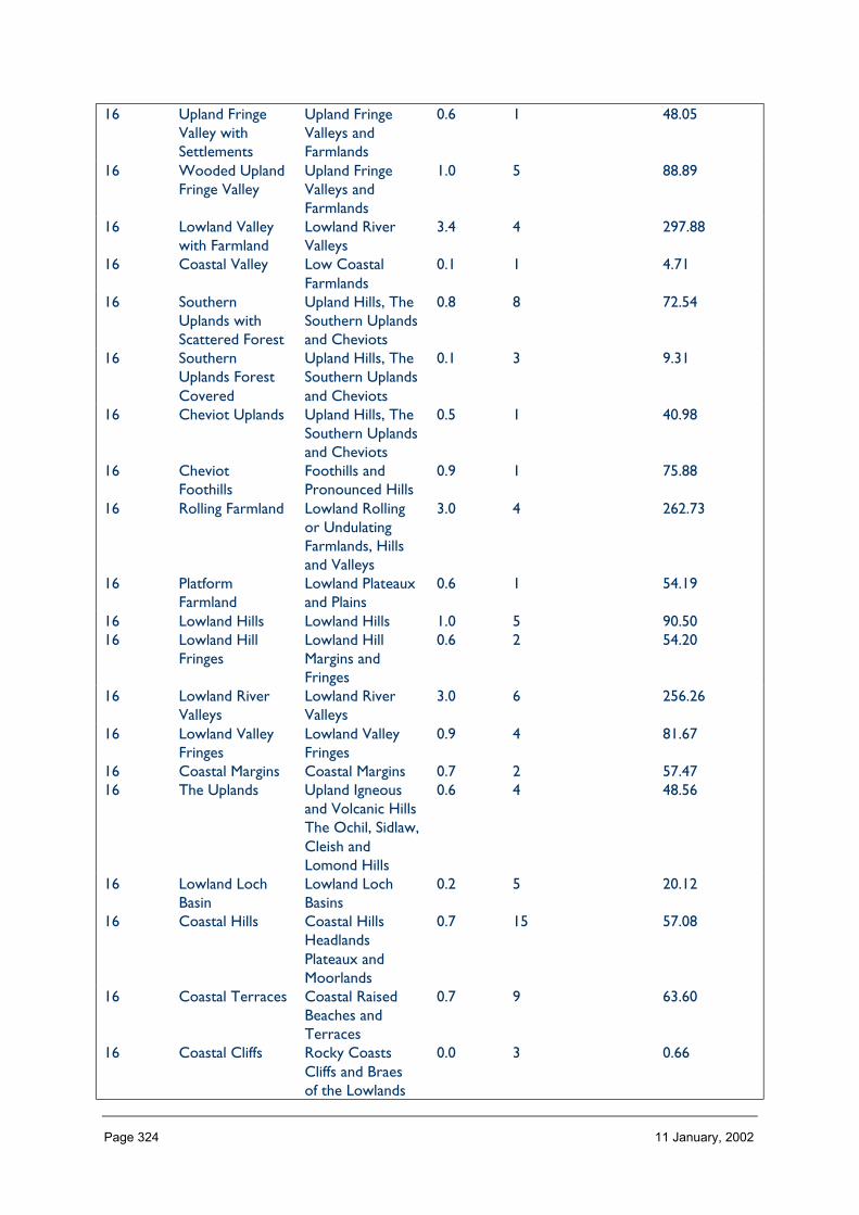
Page 324 11 January, 2002
16 Upland FringeValley withSettlements
Upland FringeValleys andFarmlands
0.6 1 48.05
16 Wooded UplandFringe Valley
Upland FringeValleys andFarmlands
1.0 5 88.89
16 Lowland Valleywith Farmland
Lowland RiverValleys
3.4 4 297.88
16 Coastal Valley Low CoastalFarmlands
0.1 1 4.71
16 SouthernUplands withScattered Forest
Upland Hills, TheSouthern Uplandsand Cheviots
0.8 8 72.54
16 SouthernUplands ForestCovered
Upland Hills, TheSouthern Uplandsand Cheviots
0.1 3 9.31
16 Cheviot Uplands Upland Hills, TheSouthern Uplandsand Cheviots
0.5 1 40.98
16 CheviotFoothills
Foothills andPronounced Hills
0.9 1 75.88
16 Rolling Farmland Lowland Rollingor UndulatingFarmlands, Hillsand Valleys
3.0 4 262.73
16 PlatformFarmland
Lowland Plateauxand Plains
0.6 1 54.19
16 Lowland Hills Lowland Hills 1.0 5 90.5016 Lowland Hill
FringesLowland HillMargins andFringes
0.6 2 54.20
16 Lowland RiverValleys
Lowland RiverValleys
3.0 6 256.26
16 Lowland ValleyFringes
Lowland ValleyFringes
0.9 4 81.67
16 Coastal Margins Coastal Margins 0.7 2 57.4716 The Uplands Upland Igneous
and Volcanic HillsThe Ochil, Sidlaw,Cleish andLomond Hills
0.6 4 48.56
16 Lowland LochBasin
Lowland LochBasins
0.2 5 20.12
16 Coastal Hills Coastal HillsHeadlandsPlateaux andMoorlands
0.7 15 57.08
16 Coastal Terraces Coastal RaisedBeaches andTerraces
0.7 9 63.60
16 Coastal Cliffs Rocky CoastsCliffs and Braesof the Lowlands
0.0 3 0.66
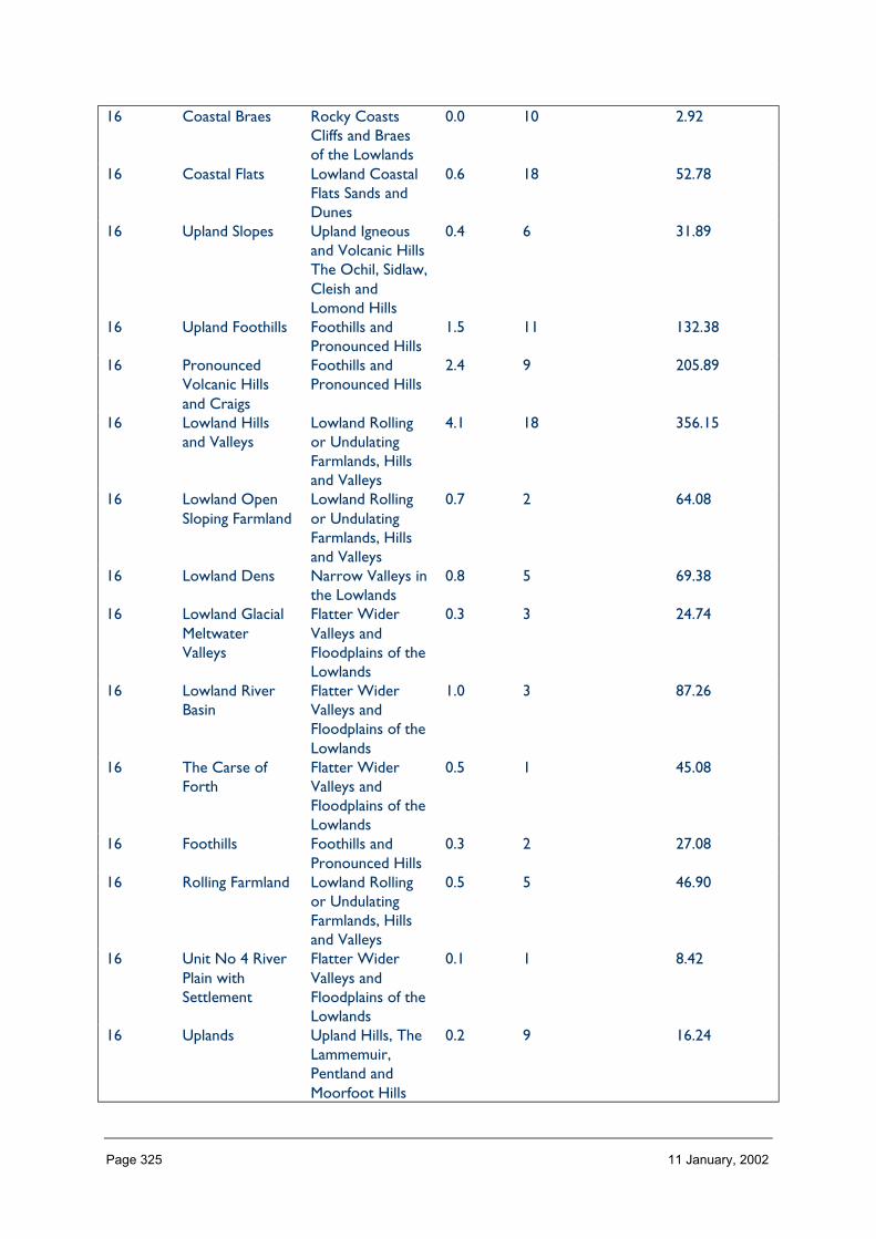
Page 325 11 January, 2002
16 Coastal Braes Rocky CoastsCliffs and Braesof the Lowlands
0.0 10 2.92
16 Coastal Flats Lowland CoastalFlats Sands andDunes
0.6 18 52.78
16 Upland Slopes Upland Igneousand Volcanic HillsThe Ochil, Sidlaw,Cleish andLomond Hills
0.4 6 31.89
16 Upland Foothills Foothills andPronounced Hills
1.5 11 132.38
16 PronouncedVolcanic Hillsand Craigs
Foothills andPronounced Hills
2.4 9 205.89
16 Lowland Hillsand Valleys
Lowland Rollingor UndulatingFarmlands, Hillsand Valleys
4.1 18 356.15
16 Lowland OpenSloping Farmland
Lowland Rollingor UndulatingFarmlands, Hillsand Valleys
0.7 2 64.08
16 Lowland Dens Narrow Valleys inthe Lowlands
0.8 5 69.38
16 Lowland GlacialMeltwaterValleys
Flatter WiderValleys andFloodplains of theLowlands
0.3 3 24.74
16 Lowland RiverBasin
Flatter WiderValleys andFloodplains of theLowlands
1.0 3 87.26
16 The Carse ofForth
Flatter WiderValleys andFloodplains of theLowlands
0.5 1 45.08
16 Foothills Foothills andPronounced Hills
0.3 2 27.08
16 Rolling Farmland Lowland Rollingor UndulatingFarmlands, Hillsand Valleys
0.5 5 46.90
16 Unit No 4 RiverPlain withSettlement
Flatter WiderValleys andFloodplains of theLowlands
0.1 1 8.42
16 Uplands Upland Hills, TheLammemuir,Pentland andMoorfoot Hills
0.2 9 16.24

Page 326 11 January, 2002
16 Upland Fringes Upland FringeMoorland
1.4 5 117.11
16 Lowland RiverValleys
Lowland RiverValleys
1.5 6 132.99
16 Lowland Hillsand Ridges
Lowland Hills 0.9 3 76.00
16 Lowland Plains Lowland Plateauxand Plains
3.6 2 310.02
16 Coastal Margins Coastal Margins 3.8 4 326.3116 Highland Glens Highland and
Island Glens0.6 6 55.28
16 Broad ValleyLowland
AgriculturalLowlands of theNorth East
9.4 5 816.56
16 Firth Lowlands Lowland CoastalLandscapes of theNorth East
1.0 1 89.54
16 Low MoorlandHills
Smooth UplandMoorland Hills
1.4 1 118.32
16 DipslopeFarmland
AgriculturalLowlands of theNorth East
5.0 2 435.69
16 Coast Lowland CoastalLandscapes of theNorth East
0.5 7 45.01
16 HighlandSummits andPlateaux
HMRRMts 0.0 2 3.10
16 HighlandFoothills
Highland Foothills 3.8 7 326.98
16 Lowland Hills Lowland Hills 4.5 4 390.7116 Lowland River
CorridorsAgriculturalLowlands of theNorth East
1.2 1 106.44
16 Igneous Hills Upland Igneousand Volcanic HillsThe Ochil, Sidlaw,Cleish andLomond Hills
6.0 2 519.26
16 Dolerite Hills Upland Igneousand Volcanic HillsThe Ochil, Sidlaw,Cleish andLomond Hills
0.4 3 32.37
16 URBAN AREA Upland Igneousand Volcanic HillsThe Ochil, Sidlaw,Cleish andLomond Hills
1.3 1 111.96
Total 293 8504.88
In Zone 16 a total 89 occurrences of landscape character types (landscape units) are found within a zone of total land area 3469. km sq.The figure 89/3469 is 0.025.per km sq of land within the zone and gives a relative indication of the overall brokenness or fragmentation ofthe landscape pattern.

Page 327 11 January, 2002
LCT at Level 1 Area/Occurrences (km2)
Coastal Strip 12.78Agricultural Heartlands 127.59Moorland Plateaux 15.80Dissected Plateau Moorland 8.54Grassland with Rock Outcrops 16.73Grassland with Hills 47.35Undulating Grassland 26.03Upland Fringe Moorland 25.78Lowland with Drumlins 297.56Rolling Lowland Margin 78.39Lowland Margin with Hills 66.00Coastal Farmland 21.81Plateau Grassland 14.83Coastal Pasture 23.21Coastal Moorland 26.79Pastoral Upland Valley 4.29Upland Valley with Farmland 17.11Upland Valley with Woodland 10.85Pastoral Upland Fringe Valley 16.60Upland Fringe Valley with Settlements 48.05Wooded Upland Fringe Valley 17.78Lowland Valley with Farmland 74.47Coastal Valley 4.71Southern Uplands with Scattered Forest 9.06Southern Uplands Forest Covered 3.10Cheviot Uplands 40.98Cheviot Foothills 75.88Rolling Farmland 65.68Platform Farmland 54.19Lowland Hills 18.10Lowland Hill Fringes 27.10Lowland River Valleys 42.71Lowland Valley Fringes 20.41Coastal Margins 28.73The Uplands 12.14Lowland Loch Basin 4.02Coastal Hills 3.80Coastal Terraces 7.06Coastal Cliffs 0.22Coastal Braes 0.29Coastal Flats 2.93Upland Slopes 5.31Upland Foothills 12.03Pronounced Volcanic Hills and Craigs 22.87Lowland Hills and Valleys 19.78Lowland Open Sloping Farmland 32.04Lowland Dens 13.87Lowland Glacial Meltwater Valleys 8.24Lowland River Basin 29.08The Carse of Forth 45.08Foothills 13.54

Page 328 11 January, 2002
Rolling Farmland 9.38Unit No 4 River Plain with Settlement 8.42Uplands 1.80Upland Fringes 23.42Lowland River Valleys 22.16Lowland Hills and Ridges 25.33Lowland Plains 155.01Coastal Margins 81.57Highland Glens 9.21Broad Valley Lowland 163.32Firth Lowlands 89.54Low Moorland Hills 118.32Dipslope Farmland 217.85Coast 6.43Highland Summits and Plateaux 1.55Highland Foothills 46.71Lowland Hills 97.67Lowland River Corridors 106.44Igneous Hills 259.63Dolerite Hills 10.79URBAN AREA 111.96
The extent (area) of any one landscape character type (at level 1) divided by the number of times it occurs in the zone gives an idea of theaverage size of occurrences of that LCT.
LCTs at Level 3 Area km2 Ratio
Lowland Coastal Landscapes of the North East 25.56 38Agricultural Lowlands of the North East 382.77 57FRSSEHM 15.80 22Upland Hills, The Lammemuir, Pentland and Moorfoot Hills 25.62 37Upland Fringe Moorland 66.92 100Upland Fringe Moorland 189.38 286Upland Fringe Moorland 78.09 18Upland Fringe Moorland 25.78 37Drumlin Lowlands 297.56 45Lowland Hill Margins and Fringes 156.79 23Lowland Hill Margins and Fringes 66.00 100Low Coastal Farmlands 43.62 66High Plateau Moorlands 29.66 44Low Coastal Farmlands 23.21 34Coastal Hills Headlands Plateaux and Moorlands 26.79 39Upland Glens, Valleys and Dales 8.58 12Upland Glens, Valleys and Dales 51.34 77Upland Glens, Valleys and Dales 21.69 31Upland Fringe Valleys and Farmlands 99.60 150Upland Fringe Valleys and Farmlands 48.05 72Upland Fringe Valleys and Farmlands 88.89 133Lowland River Valleys 297.88 451Low Coastal Farmlands 4.71 7Upland Hills, The Southern Uplands and Cheviots 72.54 109Upland Hills, The Southern Uplands and Cheviots 9.31 13Upland Hills, The Southern Uplands and Cheviots 40.98 60Foothills and Pronounced Hills 75.88 113

Page 329 11 January, 2002
Lowland Rolling or Undulating Farmlands, Hills and Valleys 262.73 396Lowland Plateaux and Plains 54.19 81Lowland Hills 90.50 136Lowland Hill Margins and Fringes 54.20 81Lowland River Valleys 256.26 387Lowland Valley Fringes 81.67 122Coastal Margins 57.47 86Upland Igneous and Volcanic Hills The Ochil, Sidlaw, Cleish andLomond Hills
48.56 72
Lowland Loch Basins 20.12 30Coastal Hills Headlands Plateaux and Moorlands 57.08 86Coastal Raised Beaches and Terraces 63.60 95Rocky Coasts Cliffs and Braes of the Lowlands 0.66 1Rocky Coasts Cliffs and Braes of the Lowlands 2.92 4Lowland Coastal Flats Sands and Dunes 52.78 79Upland Igneous and Volcanic Hills The Ochil, Sidlaw, Cleish andLomond Hills
31.89 48
Foothills and Pronounced Hills 132.38 200Foothills and Pronounced Hills 205.89 311Lowland Rolling or Undulating Farmlands, Hills and Valleys 356.15 539Lowland Rolling or Undulating Farmlands, Hills and Valleys 64.08 96Narrow Valleys in the Lowlands 69.38 104Flatter Wider Valleys and Floodplains of the Lowlands 24.74 36Flatter Wider Valleys and Floodplains of the Lowlands 87.26 131Flatter Wider Valleys and Floodplains of the Lowlands 45.08 68Foothills and Pronounced Hills 27.08 40Lowland Rolling or Undulating Farmlands, Hills and Valleys 46.90 69Flatter Wider Valleys and Floodplains of the Lowlands 8.42 12Upland Hills, The Lammemuir, Pentland and Moorfoot Hills 16.24 24Upland Fringe Moorland 117.11 177Lowland River Valleys 132.99 200Lowland Hills 76.00 11Lowland Plateaux and Plains 310.02 46Coastal Margins 326.31 49Highland and Island Glens 55.28 83Agricultural Lowlands of the North East 816.56 123Lowland Coastal Landscapes of the North East 89.54 134Smooth Upland Moorland Hills 118.32 178Agricultural Lowlands of the North East 435.69 65Lowland Coastal Landscapes of the North East 45.01 6HMRRMts 3.10 4Highland Foothills 326.98 493Lowland Hills 390.71 59Agricultural Lowlands of the North East 106.44 16Upland Igneous and Volcanic Hills The Ochil, Sidlaw, Cleish andLomond Hills
519.26 78
Upland Igneous and Volcanic Hills The Ochil, Sidlaw, Cleish andLomond Hills
32.37 48
Upland Igneous and Volcanic Hills The Ochil, Sidlaw, Cleish andLomond Hills
111.96 16
The ratio of the extent (area) of the level 3 groupings gives an indication of the distribution pattern by proportion of the zone.

Page 330 11 January, 2002
Table 16.3 Rarity
LCTs at Level 1 Rarity by occurrence%
Rarity by extent%
Coastal Strip 0 0.3Agricultural Heartlands 1 4.4Moorland Plateaux 0 0.2Dissected Plateau Moorland 0 0.3Grassland with Rock Outcrops 1 0.8Grassland with Hills 1 2.2Undulating Grassland 1 0.9Upland Fringe Moorland 0 0.3Lowland with Drumlins 0 3.4Rolling Lowland Margin 0 1.8Lowland Margin with Hills 0 0.8Coastal Farmland 0 0.5Plateau Grassland 0 0.3Coastal Pasture 0 0.3Coastal Moorland 0 0.3Pastoral Upland Valley 0 0.1Upland Valley with Farmland 1 0.6Upland Valley with Woodland 0 0.3Pastoral Upland Fringe Valley 2 1.1Upland Fringe Valley with Settlements 0 0.6Wooded Upland Fringe Valley 1 1.0Lowland Valley with Farmland 1 3.4Coastal Valley 0 0.1Southern Uplands with Scattered Forest 2 0.8Southern Uplands Forest Covered 1 0.1Cheviot Uplands 0 0.5Cheviot Foothills 0 0.9Rolling Farmland 1 3.0Platform Farmland 0 0.6Lowland Hills 1 1.0Lowland Hill Fringes 0 0.6Lowland River Valleys 2 3.0Lowland Valley Fringes 1 0.9Coastal Margins 0 0.7The Uplands 1 0.6Lowland Loch Basin 1 0.2Coastal Hills 5 0.7Coastal Terraces 3 0.7Coastal Cliffs 1 0.0Coastal Braes 3 0.0Coastal Flats 6 0.6Upland Slopes 2 0.4Upland Foothills 3 1.5Pronounced Volcanic Hills and Craigs 3 2.4Lowland Hills and Valleys 6 4.1Lowland Open Sloping Farmland 0 0.7Lowland Dens 1 0.8Lowland Glacial Meltwater Valleys 1 0.3
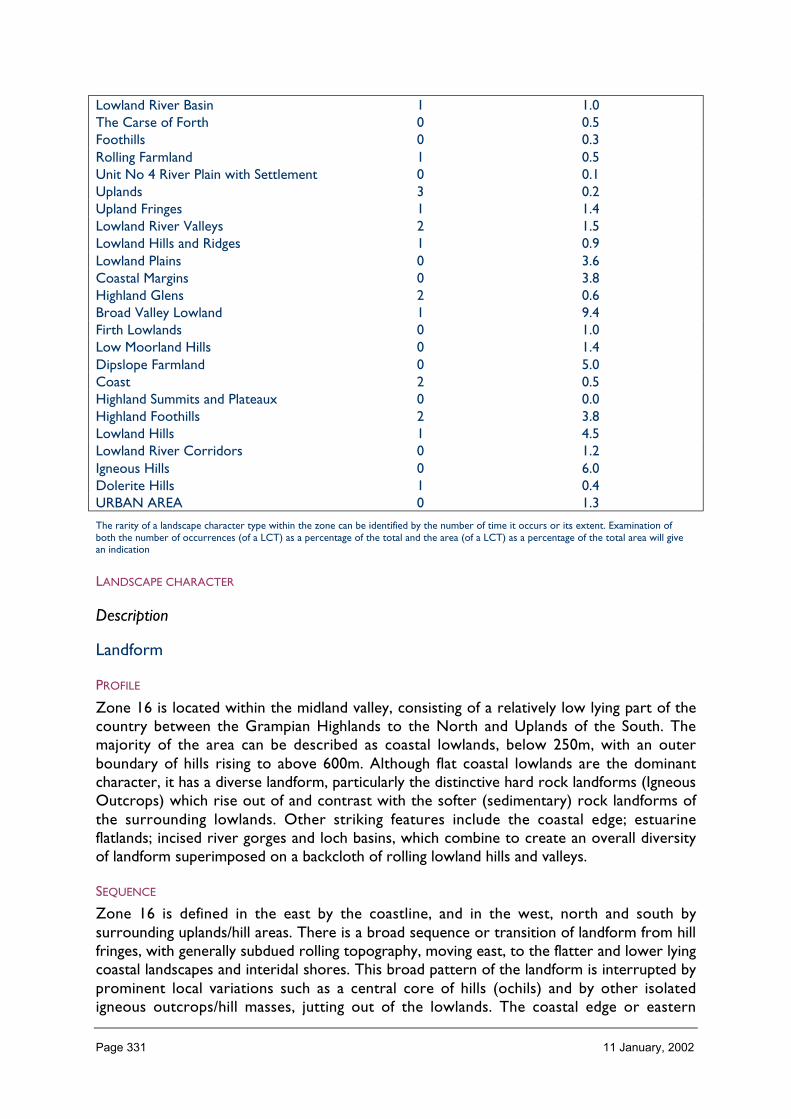
Page 331 11 January, 2002
Lowland River Basin 1 1.0The Carse of Forth 0 0.5Foothills 0 0.3Rolling Farmland 1 0.5Unit No 4 River Plain with Settlement 0 0.1Uplands 3 0.2Upland Fringes 1 1.4Lowland River Valleys 2 1.5Lowland Hills and Ridges 1 0.9Lowland Plains 0 3.6Coastal Margins 0 3.8Highland Glens 2 0.6Broad Valley Lowland 1 9.4Firth Lowlands 0 1.0Low Moorland Hills 0 1.4Dipslope Farmland 0 5.0Coast 2 0.5Highland Summits and Plateaux 0 0.0Highland Foothills 2 3.8Lowland Hills 1 4.5Lowland River Corridors 0 1.2Igneous Hills 0 6.0Dolerite Hills 1 0.4URBAN AREA 0 1.3
The rarity of a landscape character type within the zone can be identified by the number of time it occurs or its extent. Examination ofboth the number of occurrences (of a LCT) as a percentage of the total and the area (of a LCT) as a percentage of the total area will givean indication
LANDSCAPE CHARACTER
Description
Landform
PROFILE
Zone 16 is located within the midland valley, consisting of a relatively low lying part of thecountry between the Grampian Highlands to the North and Uplands of the South. Themajority of the area can be described as coastal lowlands, below 250m, with an outerboundary of hills rising to above 600m. Although flat coastal lowlands are the dominantcharacter, it has a diverse landform, particularly the distinctive hard rock landforms (IgneousOutcrops) which rise out of and contrast with the softer (sedimentary) rock landforms ofthe surrounding lowlands. Other striking features include the coastal edge; estuarineflatlands; incised river gorges and loch basins, which combine to create an overall diversityof landform superimposed on a backcloth of rolling lowland hills and valleys.
SEQUENCE
Zone 16 is defined in the east by the coastline, and in the west, north and south bysurrounding uplands/hill areas. There is a broad sequence or transition of landform from hillfringes, with generally subdued rolling topography, moving east, to the flatter and lower lyingcoastal landscapes and interidal shores. This broad pattern of the landform is interrupted byprominent local variations such as a central core of hills (ochils) and by other isolatedigneous outcrops/hill masses, jutting out of the lowlands. The coastal edge or eastern
Page 332 11 January, 2002
boundary of Zone 16 is also varied and ranges from steep rocky and wooded cliffs to moreopen areas of coastal moorland including small caves and beaches.
SCALE
Is extremely varied from large scale, expansive open moorland, carse and lowland plainscoastal and interidal areas; to intimate and confined, small enclosed landscapes of inclinedriver gorges, farmland alleys, enclosed straths. It is however, predominantly a large tomedium scale landscape, with distinctive local variations.
LANDMARK FEATURES
Zone 16 is large and complex containing many locally distinctive landmark features. At amore broad scale, key features can be described as including:
The Firths of Forth and Tay
Maritime landscapes studded with off-shore islands; navigational infrastructure and slowmoving ships and vessels dominated by spectacular bridges. These are dramatic landscapeswith extensive views dominating the coastal scenery from north and south shores. On thewhole it is a very horizontal, large scale, flat landscape influenced strongly by the weatherand colour of the sea and sky and movement of water. Typically they are busy and activelandscapes.
Coastal features: the north sea itself, vast scale horizontal, natural landscape dominated byweather and colour of sun and sea.
Interidal shores
Extensive areas (e.g., around the Fife coast) natural landscapes dominated by the sea andtidal cycle. At low tide they are typically extensive areas of mudflats with meanderingoutwash channel, or rougher more textured shingle bays and rock shores, or lightersmoother sand beaches. They are exposed, simple landscapes with sinuous lines and mutedcolours with a distinct ‘natural’ character and a wide range of landscape experiencesdepending on the weather conditions and local permutations of mud, sand, shingle, rock orharbour. In some places, on hot days they can be busy, noisy, colourful places, at othertimes they provide solitude.
Rugged and steep cliffs/raised beaches
Steep, wooded cliffs (braes) and a distinct terrace of flat land raised above sea level are twocommon but distinctive features of the eastern coastline of Zone 16. The cliffs form adistinctive rocky gorge and series of coastal features, and occasionally a backdrop tosettlements in views from the firths and sea. The raised terraces result from fluctuations insea levels forming a series of beaches which were once shorelines of the coast. in morerecent times they have become good locations for settlements: being flat and relativelysheltered, but well above the sea which form a distinctive coastal type of landscape. Forexample St Andrew’s is located on one of these raised beaches.

Page 333 11 January, 2002
Carse of Forth
The immensely broad, flat, flood plain of the river forth, forms a dramatic swathe of flat landsweeping from the Highland boundary fault in the west towards the river confluence withthe sea in the east. The flatness is accentuated by predominantly agricultural land cover andthe dramatic contrast with hill lands to north and south. It is important as the landscapesetting of Stirling and Stirling Castle, both for inward and outward views. It has historicinterest, as reclaimed ground (originally moss land) and a historic human influence is evidentthroughout the area. It provides panoramic views of the surrounding areas.
Igneous outcrops and hill masses and craigs
The hills in this zone most commonly derive from outcrops of more resistant igneous rocktypes, epitomised by such distinctive landmark features as Eildon Hills And Traprain Law InThe Borders; Arthur’s Seat In Edinburgh’s Holyrood Park; The Ochils which run from theboundary with Fife/Clackmannanshire as far north as Perth, and the Sidlaw Hills which runfrom Perth, north-east to Forfar. There are also numerous isolated outcrops farmingdistinctive local landmarks, typically rising suddenly out of rolling lowland, with distinctiveskylines, and a clearly recognisable shape which lends a strong distinction and a strong senseof place and orientation.
Loch basins
Loch Leven and the Lake of Mentieth are striking water features within the landscape ofZone 16. They are characterised by a shallow basin landform, and the rounded surroundinghills. The basin landscape round Loch Leven may represent the maximum extent of the lochand its wetlands in post glacial times. The loch basins are characteristically open large scaleflat diverse landscapes. Lake of Mentieth is within a more wooded, rugged landscape whichprovides some containment. The most important characteristic of these landscapes is theinfluence of the water and its islands and shorelines, the relatively low lying landform withstrong horizontal lines, views of fine houses/other historic buildings, and the dominance andenclosure of the surrounding ‘upland’, skylines and slopes. The presence of wild fowl on andaround the water and overhead in flight makes these visual dynamic landscapes.
Incised river channels/gorge
Several of the watercourses within Zone 16 are incised and good examples abound. TheNorth Esk in Midlothian and parts of the Upper Tyne River flow in deep meltwaterchannels. Near East Linton, in the Borders the river is located in a deep gorge, whichprovides a dramatic juxtaposition with the volcanic landform of Traprain law. The DevonGorge, is a dramatic steep sided wooded gorge with river cut into a complex landform ofwell wooded rolling hills.
These landscape features have many views of interest and high aesthetic value.
River Tay corridor
Zone 16 also contains many larger, well defined river corridors set in broader lowlandlandscapes which are occasionally incised. They often contain distinct local features suchrapids, weirs and mills where harder rocks cross the valley. The river Tay, corridor betweenthe Highland boundary and the Firth of Tay at Perth is a good example. This is a large river

Page 334 11 January, 2002
of strategic historical importance, which makes a significant contribution to the landscapecharacter of the areas it flows through. It varies from broad meanders across a wide flatflood plain, to areas where there is no floodplain and the steep river slopes are clothed inwoodland. It is distinctive for its river terraces and Haugh land.
Lowland glacial meltwater valleysThese consist of ‘U’ shaped flat bottomed channel like valleys with distinctive, oftenpronounced and frequent eskers, kames and mounds deposited by melting glaciers.Occurring at three locations in Fife and several are distinctive features in the landscape.They are important geomorphological features and, lie in the Ochil foothills in North Fife.
EXPERIENCE
Extremely varied and contrasting, from the dramatic open exposed and relatively‘naturalness ‘ of the North Sea/coastal landscape; to the intimate confined river gorges andlake/loch edges; to the urban and well settled lowland farming landscape. Generally, apartfrom when on the coastal edge, moving from public to non-public places would involve atransition from busy, settled and more contained landscape, to a more remote andexposed/open landscape. (e.g., settled valley to hill fringe)
Many of hill and exposed outcrops are accessible to public and provide extensive, panoramicviews over the surrounding landscapes, highlighting the vastness of the landscape.
Containment (created by landform and land cover)
TOPOGRAPHY
Varied depending on location but more usually it is an open landscape with any containmentprovided by distant hills. Along the coast there is little containment and vast horizons. Asense of real containment only really relates to where local features such as urbandevelopment; afforestation, gorges and local topographical variation occur. The generalrolling open character of the farmland forming the transition from hills to coastal edge,results in same broad physical/topographical containment, but not confined views.
LAND COVER
Predominantly arable farmland and improved grassland but also includes mosaic ofwoodland, including significant areas of recent planting; rough grassland; heath and montane.Broadleaf woodland tends to be scattered and remnant of previous larger areas. There is adistinct contrast in the landcover pattern of the coastal area south of Edinburgh, ascompared to the greater range and mosaic character of the different landcover typespresent in the central inland areas and Fife.
The lowlands, and in particular East Lothian, have a long history of market gardening andproduce a large proportion of Scotland’s green vegetables. The greatest concentration ofbroadleaf and mixed woodland is found along the river valleys and associated withnumerous large estate houses/designed landscapes and substantial areas of policywoodlands. There are particularly notable non-arable areas of landcover forming a mosaic ofdiverse types around the major ‘new’ urban areas of Dunfermline (to the north) andGlenrothes.

Page 335 11 January, 2002
There is a large urban landcover component to this zone, covering the central belt andmajor urban settlements, which are strung out at strategic locations. There is a distinctdifference between the historical settlement pattern and the new major settlements, forexample the triangle of new urban development around Glenrothes/West Fife. Landcoverscontribution to the landscape character of Zone 16 is variable, in some landscape types it isa dominant feature e.g. open arable agricultural land, the lowlands, and policy landscapes. Inother locations it is secondary to the distinctiveness of the landform itself e.g. rugged coastalcliffs, igneous hills/outcrops.
VISIBILITY
Is general it is very good within this zone, with many expansive views and locations fromwhich there are panoramic views over large tracts of land. Views dominated by the coast orto the distant coastline and limitless horizon of he seascapes are common in this zone.Views are only really ‘locally’ constrained by the landform or other visual obstruction due toclose features e.g. within urban areas; forestry or incised river valleys.
The hill areas provide distinctive elevated views and form the horizons/skylines in sameviews, contrasting with the foreground landscape. From the key point features, views areextremely extensive. (e.g. from Arthur’s Seat which encompasses coast, hills and urbanarea).
MICROCLIMATIC EFFECTS
The eastern lowlands are relatively sunny, but this declines westward and with risingaltitude.
The coastal and hill areas suffer from exposure to high average wind speeds, in contrast thevalleys enjoy generally benign and sheltered conditions, occasionally there are localvariations to the predominantly maritime climate of this zone. (e.g. Fife is influenced bycontinental high pressure systems providing greater extremes in temperature and reducedwind speeds, with less rainfall and more sunshine than the majority of Scotland). Climate is avery influential factor in several of the coastal landscape types, making a major contributionto the character and experience of these landscapes.
EXPERIENCE
Is infrequent along the coastal margin and coastal edge and eastern boundaries of Zone 16.It is also limited in the more inland areas, but can be experienced in the policy and estatelandscapes, and in the more enclosed sections of the river valleys. In some of the islandareas, the hill masses undulating topography create some distant containment, and createsome sense of shelter within the landscape.
Accessibility
DISTANCE
There are many major population centres within this zone including Edinburgh, St Andrewsand Stirling. The coastal edge is generally well settled with some areas of significant newdevelopment. Zone 16 ranges from very industrialised and urban/urban fringe landscapes tomore remote villages and relatively unsettled hill areas.

Page 336 11 January, 2002
However, there is little of this zone that is not readily accessible by road, rail or boat. Therea major motorway links in addition to a dense network of minor roads and tracks.
PHYSICAL ACCESS
There are many roads, tracks and footpaths in this zone and the generally flat coastallandscape, or rolling agriculture lowlands are easily accessible. In contrast some of he hillareas and landmark igneous outcrops are more difficult due to terrain and lack of definedfootpaths. Although this is variable and many of the hill areas have good access. (e.g. Eildonhills and Ochils). There are few long distance routes and coastal access across the shore andcliff edge is not continuous.
Where urban/industrial development has dominated the edges of the coast or estuaries,public access is intermittent or very restricted.
CULTURAL ACCEPTANCE
Variable – restricted/not encouraged in large arable farmed landscapes, and along coastallandscapes access can be intermitted due to private ownership/single use recreationalpursuits such as golf courses.
VISUAL ACCESS
Tends to be good, with many high/elevated view points across the surrounding landscapesor out to coast/sea and into the coastline.
EXPERIENCE
Generally the experience from public to non-public places would be from more settled busylandscape to more remote exposed landscape. This is a very well settled zone, close to largeurban population – existing public places will tend to be overused
Land cover (including vegetation and land use)
VEGETATION
The vegetation cover of this zone in the more inland, sheltered locations makes a significantcontribution to the landscape character. It provides important texture, colour and patternto the landscape. In the more exposed coastal locations and around the large urbansettlements vegetation does not tend to be the dominant feature. (e.g. in the coastalmargins/fringes landscape the field pattern and other features such as seascapes tend todominate the character of these areas).
EXPOSED ROCK
Is an important and valued feature of this zone and includes the rugged exposed cliff edgesof the coast: the steep exposed rock of the river gorges and the often sheer rook faces ofigneous extrusions/some hill masses. Shingle beaches are another example of rock being adominant feature in the landscape.
BUILT DEVELOPMENT
Overall it is a very varied pattern and encompasses just about every conceivable form, fromhistoric coastal village to major cities; new towns and industrial/hi-tech rural development;to isolated traditional house and ‘modern’ contemporary new buildings; to large estate
Page 337 11 January, 2002
houses and planned villages to more recent ‘urban/rural’ settlements centred aroundtraditional industrial activities. (e.g. opencast coal mining)
Development is particularly focused around the Forth Estuary and areas within commutabledistance to major settlements such as Edinburgh, Stirling, and Falkirk. There are also distinctdifferences in the traditional settlements and villages even in similar ‘coastal landscapes’. (e.g.contrasts in the coastal vernacular of Fife and Lothian).
EXPERIENCE
Settlement can be a dominant feature, important to the character and experience of thelandscape and well integrated with the landscape setting. (e.g. coastal villages of Fife).Alternatively settlement can act as a major visual detractor adversely impacting on thelandscape experience, such as new build in the carselands around Stirling which detractsfrom key landscape features and has a poor relationship to landform. Frequently newdevelopment is a conspicuous element in the open rolling lowland and coastal landscapes.
Hydrology and water bodies
TYPE
The hydrology of Zone 16 encompasses a wide range of coastal and freshwater features.Present within the zone are: major river systems such as the Tay catchment, which is fed byseven other significant rivers, including the Leven, flowing East to Fife. There are also 3 mainriver systems draining into Loch Leven, the biggest fresh water body in the zone. The RiverAlmond which originates in the Cant hills near Shotts, becomes a mature river forming partof the western boundary of Zone 16, meandering to the North Sea.
In addition to the main river systems, a notable feature of Fife is the characteristic ‘den’,typically comprising a small fast flowing burn in a deeply incised, narrow often woodedchannel cut through coastal hills and terraces. There are also numerous smaller rivers andburns which drain the coastal margins into the Firth of Forth, one or two larger estuarieswithin the zone. Loch Leven is one of a number of lochs/large freshwater body within Zone16 which are artificially created. (e.g. along the southern periphery of the lowlands)
PATTERN
Drainage across Zone 16 is generally discordant running north west to south east, againstthe grain of the underlying structure which runs south west to north east. There are localvariations to this trend. (e.g. the smaller catchment areas flowing southwards to Firth ofForth), ome of which have created the extensive depositional mudflats associated with theFirth. (e.g. Bluthen Burn forming Tory Bay )
It is a complex zone with a diverse range of features, varied in scale (e.g. from large lochs tosmall manmade reservoirs: from coast/estuaries to small burns and meandering riversystems). There is also a canal system which crosses part of the western edge of the zone(Firth of Forth Canal) and is presently being restored.
EXPERIENCE
Water features and systems make a major contribution to landscape character in this zone,and encompasses a very wide range of contrasting experiences. (e.g. moving form extremesof large scale ‘natural’ and wild experience of coastal and estuarine landscape; to the

Page 338 11 January, 2002
contained; safe and manmade, more controlled and busy landscape of smaller reservoirs;canals; gorges and parts of river systems close to urban areas). The major river systems arekey features of the glens/straths around Perth, and in other areas they provide a commonthread of identity, drawing together the entire landscape from headwater to coast. Manyalso have distinctive attributes in their own rights. Many of the water features/bodiessupport important breeding and wintering bird colonies, which are important to diversityand overall landscape experience.
Built and infrastructure development (present day)
NATURE AND PATTERN OF SETTLEMENT
Residential and industrial development, is a dominant feature in Zone 16, particularly in the‘central’ area, around the Firth of Forth, and in a triangle out from Stirling to Edinburgh inthe south and Dunfermline and Glenrothes in the north. It encompasses an extremely widerange of development/settlement pattern including expansion to major cities (e.g.Edinburgh’s South Wedge; New Towns such as Glenrothes, isolated new settlements, villageexpansions and isolated housing/industrial development in the countryside). This more‘recent’ and continuing development pressure, overlays the varied traditional settlementpattern which includes distinctive coastal villages/towns and villages within ‘glens’/rivervalleys and inland areas isolated from towns.
NATURE AND PATTERN OF INFRASTRUCTURE
It is similar to built development/settlement pattern in that it is a dominant feature in mayparts of zone, particularly in the ‘central cone’ of Zone 16.
Linear features such as the o/h transmissions/power lines follow main road rout. corridorsand cross open countryside. The edges of the estuaries, particularly the Firth of Forth, isheavily industrialised and also clearly has had a strategic influence on the routing of all majorinfrastructure, and on settlement pattern. Road corridors, Telecommunication masts andrail networks are other infrastructure features in the landscape.
NATURE AND PATTERN OF INDUSTRIAL DEVELOPMENT
Again, very varied s this is a particularly large and diverse zone. Industrial development isobviously centred around key features such as the water resource (estuaries/rivers andcoast) and the mineral resources, coal seams etc which in turn have determined the locationof mining settlements. On top of the pattern created by the traditional industries such asfarming; coal mining; petro-chemicals; fishing etc is the more recent high technology cleanindustries which locate in green fields sites, out of town where there is also goodcommunications links. (e.g. Hyundai Microchip plant in Fife).
There is a diverse and changing industrial development pattern, within the landscape ofZone 16, both in scale and location.
Tourism related developments are also expanding across he zone.
EXPERIENCE
Very varied, from a heavily industrialised, fragmented and built landscape, to experiencingremote, historical, sparsely settled landscapes. Experience along the coast is also very variedform areas close to industrial core/major settlements to more remote areas.
Page 339 11 January, 2002
The coast of Fife is well settled, and there are in fact few areas that are any distance forsome form of settlement or formal recreational development.
Areas which have any true sense of ‘tranquillity’ are few, if at all, in the central area of Zone16, but a heavily industrialised landscape such as the Forth Estuary is a very distinctexperience and has its attractions!
Visible history (past settlement, landuse, churches, brochs, forts, dykes, standingstones etc.)
TYPES OF VISIBLE HISTORY
Very rich in many parts of Zone 16 (e.g. Fife and its fishing villages/estate landscapes)andvisible built/industrial history in Midlothian’s/Lothian, in particular mining and recentindustrial past (e.g. mining spoil; Seven Sisters forms a key feature in the landscape).
Transport links such as the Forth and Union Canals and disused Railway links. Visible historyis evident and of interest across the zone from pre-history to present day, but with aparticularly evident, such as 19th industrial past in central ‘core’ of Zone 16.
Wildlife
FORMS OF WILDLIFE
Omitted this section: national assessments and area for information.
LOCATION
Breeding birds/migration patterns – coast boundaries and freshwater bodies.
EXPERIENCE
Very important to landscape experience.
Climate
CLIMATIC CHARACTERISTICS
Already covered partly under microclimate section; maritime, exposed to sheltered inlandglens/hill fringe areas.
LOCATIONAL AND SEASONAL EFFECTS
Very specific (e.g. dependent on whether coast on inland, east or west and on localvariations).
EXPERIENCE
Varied but generally ‘exposed’!
Designated landscapes
National Scenic Areas
CONSTITUENTS
There is one within Zone 16, in the south Eildon and Leaderfoot.
Page 340 11 January, 2002
LOCATION AND EXTENT
The Eildon and Ledderfoot NSA covers the confluence of he Tweed and the Leader waters;the volcanic Eildon hills, Dryburgh, Bowden and Melrose. A total area of 3,600 Ha coveringa wide lowland river valley and defining surrounding hills.
It encompasses hills, enclosed valley and the winding and wooded course of the river,containing moorland; arable and pasture farmland; plantation and a distinct settlementpattern which follows topography. The dramatic Eildon hills dominate the scene.
EXPERIENCE
Very positive, encompassing famous Scott’s View above Dryburgh. Varied landscape, withpanoramic views and interesting historic detail of mansions; abbeys; bridges. Largely acultivated and tended landscape.
AGLVS and other Local Authority designations
NATURE OF THE LANDSCAPE DESIGNATED
Regional – several in this zone.
Recreational landscapes
Nature of landscapesCoastal landscape is a key recreational feature of Zone 16, but it also contains a full range ofrecreational opportunities/landscapes, including both ‘formal’ such as golf courses/visitor’scentres etc to informal walking/beach activities. The diversity range of recreational activitiesand opportunities reflects the diversity of features and landscape types across this zone, andproximity to main population centres.
LOCATION
Across the zone, but concentrated pressure on coastal landscapes and local hills, alsoproximity to ‘central’ developed core of Zone 16 and ease of access form main road routes.
EXPERIENCE
Not sure how to summarise apart from saying it is extremely diverse.

Page 341 11 January, 2002
2 Importance and value of the zone landscape
Category Brief explanation oflandscape importance(if any)
Importance(GB, Scotland,zone)
Landscape Character Importancerarity Fife glacial meltwater
valleyszone
extent coastal/estuarinelandscape
Scotland
diversity (including specific landmarks) coastal and hilllandscapes/igneousextrusions landmarkfeatures e. g Arthur’s seat
Scotland
pattern coastal villages zoneintegrity historic landscapes/estate
landscapeszone
local distinctiveness across zone/rivergorges/lochs/estuaries
zone
fragility/sensitivity carselands/river floodplains/coastallandscapes/some uplandareas
zone
Scenic importancequalities coastal/hill zone/Scotlandperceptions local identity e.g. kingdom
of fife/remote/naturallandscape of coast
zone/Scotland
Learning ImportanceEnvironmental Education geomorpholigical ScotlandInterpretation historical ScotlandEnjoyment ImportanceRecreation coastal
access/hills/proximity toScottish urban population
Scotland
Amenitywildness and tranquillity coast zoneDesignationsNSAs ScotlandAGLVsRegional Landscape Designations across zone zoneHistoric Gardens & Designed Landscapes across zone ScotlandCultural Importancepre history (designated/non-designated) Fife and other sites Scotlandmedieval (designated/non-designated)recent (designated/non-designated)Socioeconomic Importancesocial major pop. centres/cities Scotlandeconomic estuarine/coastal/industrial
/commercialScotland

Page 342 11 January, 2002
3 Landscape and trends in the zone
• Pressures/influences which have a particular effect on the landscape of the zone:• Nature of landscape pressures/influences – a brief description• Trends: increasing, static or declining
− long term (> 5 years), medium term (2 to 5 years),− short term (< 2 years)
• Importance: important, not important
Pressure Nature of landscapepressures/influences and trendswithin zone, relativeimportance within the zone
Scale of landscape influence(+ve/–ve) within zone whenconsidered in
an all Scotland context
Major Inter. Minor Negligible
Built developmentResidential;increasing/long-term
settlement expansion/newsettlements/isolated housing and hitech industrial sites/coastaldevelopment particular issue.
–ve
Retail; increasing/longterm
out of town retail centres/combinedwith some leisure or other dev.
–ve
Industrialincreasing/long-term
varied, but concentrated incore/centre of Zone 16
–ve
OtherInfrastructure TransportRoads and tracksincreasing/long-term
major infrastructure projects e.g.forth/Kincardine bridges andassociated new roadnetwork/duelling of existing roads
–ve
Rail related possibleFerry relatedOtherInfrastructure otherTelecomsincreasing/long-term
masts/o/h power lines –ve
Watertreatment/abstractionWaste managementincreasing/long-term
particularly in central areas/landfill ofquarry sites/landraising ofsensitive/important landscape arease.g. carse lands
canbe–ve
–ve
Coastal defences?increasing/long term
Around Firth of Forth and othercoastal sites?
–ve?
OtherMineralsOpen cast coalincreasing/long term?
Core area related to resource incentre of zone(clackmann./falkirk/dun/fife)cumulativeimpact due to clusterapplications/effects of previousworkings
–ve
Page 343 11 January, 2002
Sand and Gravelincreasing/long term
as above specific areas (relates toresource)wet working and removal oflandscape features
–ve
Hard rock longterm/increasing
Fife in particular/also across zoneigneous extrusions are importantlandscape features/conspicuous inlandscape/under pressure for hardrock quarrying
–ve
PeatOther silica sand Dunfermline –veForestry and WoodlandsRestructuring of existingincreasing long term
Across zone, important inuplands/ochils etc
+ve
Creation of new smallstatic/declining? long-term check with area
Across zone, Fife loss of smallwoodlands/lack of management
–ve
Creation of largenew/nativestatic/declining/long-term
in upland areas and valleys(Ochills)requires active landusestrategy to encourage appropriatewoodland development
–ve
OtherAquaculture and FishingFinfishShellfishFishing RiverOtherLand ManagementSheep productionCrop productionSport shootingOther management ofhistoric landscapes/estatefeatures decliningimpact of changes to Cap
Fife and other areas.coastal lowlands.
–ve
EnergyNat. grid/infrastructureWind increasing/longterm
anticipated pressure on coastalareas/impacts on key views due tooexpansive landscape/visibility ofsurrounding hills
–ve?
HydroWaveOtherTourism and RecreationGolf increasing/long-term
particular pressure Coastallandscapes/gold and hotel/residentialdev. also across zone
–ve –ve?
MarinasSkiing facilitiesLeisure facilities/visitorcentres increasing/long-term
across zone ?
NH Information

Page 344 11 January, 2002
provisionWalkingrelated/footpathsOther
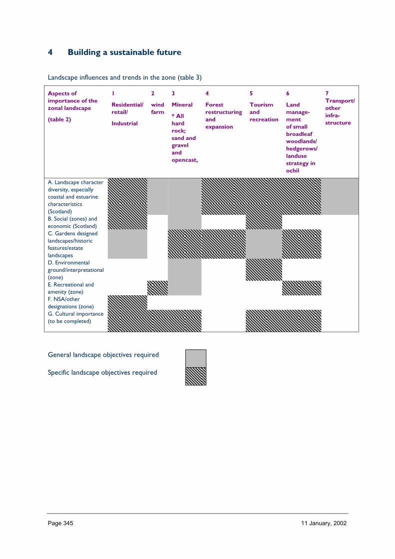
Page 345 11 January, 2002
4 Building a sustainable future
Landscape influences and trends in the zone (table 3)
Aspects ofimportance of thezonal landscape
(table 2)
1
Residential/retail/
Industrial
2
windfarm
3
Mineral
* Allhardrock;sand andgravelandopencast,
4
Forestrestructuringandexpansion
5
Tourismandrecreation
6
Landmanage-mentof smallbroadleafwoodlands/hedgerows/landusestrategy inochil
7Transport/otherinfra-structure
A. Landscape characterdiversity, especiallycoastal and estuarinecharacteristics(Scotland)B. Social (zones) andeconomic (Scotland)C. Gardens designedlandscapes/historicfeatures/estatelandscapesD. Environmentalground/interpretational(zone)E. Recreational andamenity (zone)F. NSA/otherdesignations (zone)G. Cultural importance(to be completed)
General landscape objectives required
Specific landscape objectives required

Page 346 11 January, 2002
ZONE 17 WEST CENTRAL BELT
1 Nature of the landscape resource
Diversity, distribution and rarity of landscape character in the zoneNote: Ignore any LCT which is shown as <10 km sq (if important feature will be coveredelsewhere, if important characteristic locally will be flagged up in description)
Table 17.1 Diversity
Zone LCTLevel 1
LCTLevel 3
Context Areakm2
17 Rolling Farmland withEstates
Farmlands andEstates of theHighlands andIslands
Lowland Coastal 58.18
17 Open Ridgeland HMRRMts Highland 49.6817 Raised Beach Coast Coastal Raised
Beaches andTerraces
Coastal 84.01
17 Upper River Valleys Upland Glens,Valleys and Dales
Upland 26.35
17 Lower Dale Lowland RiverValleys
Lowland 19.90
17 Intimate Pastoral Valleys Upland Glens,Valleys and Dales
Upland 82.17
17 Upland Basin Upland Basin Upland 2.9617 Lowland Hills Lowland Hills Lowland 40.4717 Foothills Foothills and
Pronounced HillsUpland 201.13
17 Foothills with Forest Foothills andPronounced Hills
Upland 75.29
17 Plateau Moorland High PlateauMoorlands
Upland 1.65
17 Lowland Coast Low CoastalFarmlands
Coastal Lowland 37.90
17 Plateau Moorland withForest
High PlateauMoorlands
Upland 103.44
17 Rugged Moorland Hillsand Valleys
Rugged MoorlandHills
Upland 143.62
17 Coastal Fringe withAgriculture
Coastal Margins Coastal Lowland 14.18
17 Coastal Headland Coastal HillsHeadlands Plateauxand Moorlands
Coastal 38.46
17 Coastal Valley withPolicies
Low CoastalFarmlands
Coastal Lowland 17.62
17 Ayrshire Lowlands Lowland Rolling orUndulatingFarmlands, Hills andValleys
Lowland 527.54
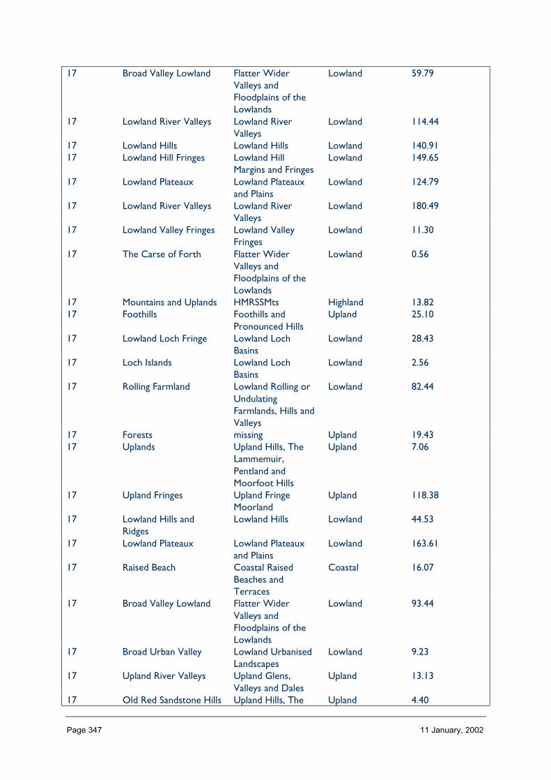
Page 347 11 January, 2002
17 Broad Valley Lowland Flatter WiderValleys andFloodplains of theLowlands
Lowland 59.79
17 Lowland River Valleys Lowland RiverValleys
Lowland 114.44
17 Lowland Hills Lowland Hills Lowland 140.9117 Lowland Hill Fringes Lowland Hill
Margins and FringesLowland 149.65
17 Lowland Plateaux Lowland Plateauxand Plains
Lowland 124.79
17 Lowland River Valleys Lowland RiverValleys
Lowland 180.49
17 Lowland Valley Fringes Lowland ValleyFringes
Lowland 11.30
17 The Carse of Forth Flatter WiderValleys andFloodplains of theLowlands
Lowland 0.56
17 Mountains and Uplands HMRSSMts Highland 13.8217 Foothills Foothills and
Pronounced HillsUpland 25.10
17 Lowland Loch Fringe Lowland LochBasins
Lowland 28.43
17 Loch Islands Lowland LochBasins
Lowland 2.56
17 Rolling Farmland Lowland Rolling orUndulatingFarmlands, Hills andValleys
Lowland 82.44
17 Forests missing Upland 19.4317 Uplands Upland Hills, The
Lammemuir,Pentland andMoorfoot Hills
Upland 7.06
17 Upland Fringes Upland FringeMoorland
Upland 118.38
17 Lowland Hills andRidges
Lowland Hills Lowland 44.53
17 Lowland Plateaux Lowland Plateauxand Plains
Lowland 163.61
17 Raised Beach Coastal RaisedBeaches andTerraces
Coastal 16.07
17 Broad Valley Lowland Flatter WiderValleys andFloodplains of theLowlands
Lowland 93.44
17 Broad Urban Valley Lowland UrbanisedLandscapes
Lowland 9.23
17 Upland River Valleys Upland Glens,Valleys and Dales
Upland 13.13
17 Old Red Sandstone Hills Upland Hills, The Upland 4.40

Page 348 11 January, 2002
Lammemuir,Pentland andMoorfoot Hills
17 Plateau Moorland High PlateauMoorlands
Upland 363.61
17 Floodplain Flatter WiderValleys andFloodplains of theLowlands
Lowland 33.63
17 Rugged Moorland Hills Rugged MoorlandHills
Upland 236.22
17 Greenspace Lowland UrbanisedLandscapes
Lowland 12.89
17 Rolling Farmland Lowland Rolling orUndulatingFarmlands, Hills andValleys
Lowland 76.60
17 Plateau Farmland Lowland Plateauxand Plains
Lowland 596.95
17 Rugged UplandFarmland
Upland FringeValleys andFarmlands
Upland 164.55
17 Fragmented Farmlands Lowland UrbanisedLandscapes
Lowland 41.63
17 Incised River Valleys Narrow Valleys inthe Lowlands
Lowland 95.68
17 Green Corridors Lowland UrbanisedLandscapes
Lowland 1.42
17 missing Upland Igneous andVolcanic Hills TheOchil, Sidlaw, Cleishand Lomond Hills
Upland 414.89
Total 4986.18
HMRRMts = High, Massive, Rolling, Rounded Mts of Highlands & Islands
HMRSSMts = High Massive, Rugged, Steep-sided Mts of Highlands & Islands
The number of landscape character types represented in Zone 17 at level 1 is 52 (of which 8 are <10 km2, or 44 are >10 km2). These canbe grouped into 28 at level 3. (mountains; raised beaches and coastal farmland and margins; upland rugged moorland hills, plateaux, fringes,igneous and coastal hills; lowland hills, fringes and pronounced foothills; lowland plains; lowland farmland and estates; upland valleys;lowland valleys and floodplains; upland and loch basins; and urbanised landscapes.)
The context of Zone 17 is mainly Lowland. No. of LCTs (Level 1)/Area of Zone in Zone 17 is 0.010. This gives an indication of the overalldiversity of landscape character in the zone which can be compared between zones.
Distribution/pattern
Zone LCTlevel 1
LCTlevel 3
% ofZone(area)
No. ofOccurrences
Areakm2
17 Rolling Farmlandwith Estates
Farmlands andEstates of theHighlands andIslands
1.1 1 58.18
17 Open Ridgeland HMRRMts 1.0 2 49.68

Page 349 11 January, 2002
17 Raised BeachCoast
Coastal RaisedBeaches andTerraces
1.6 4 84.01
17 Upper RiverValleys
Upland Glens,Valleys and Dales
0.5 2 26.35
17 Lower Dale Lowland RiverValleys
0.4 1 19.90
17 Intimate PastoralValleys
Upland Glens,Valleys and Dales
1.6 3 82.17
17 Upland Basin Upland Basin 0.1 1 2.9617 Lowland Hills Lowland Hills 0.8 1 40.4717 Foothills Foothills and
Pronounced Hills3.9 3 201.13
17 Foothills withForest
Foothills andPronounced Hills
1.5 3 75.29
17 PlateauMoorland
High PlateauMoorlands
0.0 2 1.65
17 Lowland Coast Low CoastalFarmlands
0.7 3 37.90
17 PlateauMoorland withForest
High PlateauMoorlands
2.0 1 103.44
17 RuggedMoorland Hillsand Valleys
Rugged MoorlandHills
2.8 1 143.62
17 Coastal Fringewith Agriculture
Coastal Margins 0.3 2 14.18
17 CoastalHeadland
Coastal HillsHeadlandsPlateaux andMoorlands
0.7 1 38.46
17 Coastal Valleywith Policies
Low CoastalFarmlands
0.3 1 17.62
17 AyrshireLowlands
Lowland Rollingor UndulatingFarmlands, Hillsand Valleys
10.2 6 527.54
17 Broad ValleyLowland
Flatter WiderValleys andFloodplains of theLowlands
1.2 1 59.79
17 Lowland RiverValleys
Lowland RiverValleys
2.2 7 114.44
17 Lowland Hills Lowland Hills 2.7 2 140.9117 Lowland Hill
FringesLowland HillMargins andFringes
2.9 5 149.65
17 LowlandPlateaux
Lowland Plateauxand Plains
2.4 2 124.79
17 Lowland RiverValleys
Lowland RiverValleys
3.5 7 180.49
17 Lowland ValleyFringes
Lowland ValleyFringes
0.2 1 11.30
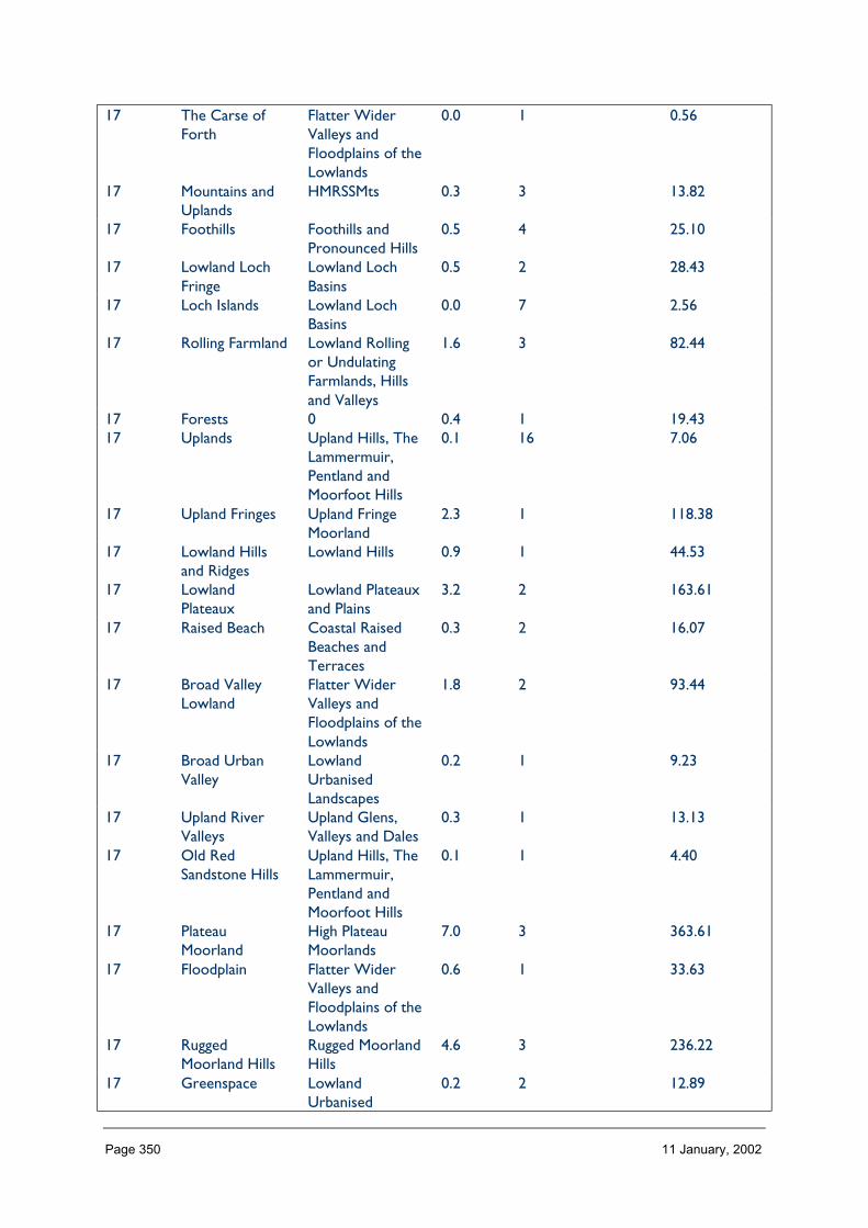
Page 350 11 January, 2002
17 The Carse ofForth
Flatter WiderValleys andFloodplains of theLowlands
0.0 1 0.56
17 Mountains andUplands
HMRSSMts 0.3 3 13.82
17 Foothills Foothills andPronounced Hills
0.5 4 25.10
17 Lowland LochFringe
Lowland LochBasins
0.5 2 28.43
17 Loch Islands Lowland LochBasins
0.0 7 2.56
17 Rolling Farmland Lowland Rollingor UndulatingFarmlands, Hillsand Valleys
1.6 3 82.44
17 Forests 0 0.4 1 19.4317 Uplands Upland Hills, The
Lammermuir,Pentland andMoorfoot Hills
0.1 16 7.06
17 Upland Fringes Upland FringeMoorland
2.3 1 118.38
17 Lowland Hillsand Ridges
Lowland Hills 0.9 1 44.53
17 LowlandPlateaux
Lowland Plateauxand Plains
3.2 2 163.61
17 Raised Beach Coastal RaisedBeaches andTerraces
0.3 2 16.07
17 Broad ValleyLowland
Flatter WiderValleys andFloodplains of theLowlands
1.8 2 93.44
17 Broad UrbanValley
LowlandUrbanisedLandscapes
0.2 1 9.23
17 Upland RiverValleys
Upland Glens,Valleys and Dales
0.3 1 13.13
17 Old RedSandstone Hills
Upland Hills, TheLammermuir,Pentland andMoorfoot Hills
0.1 1 4.40
17 PlateauMoorland
High PlateauMoorlands
7.0 3 363.61
17 Floodplain Flatter WiderValleys andFloodplains of theLowlands
0.6 1 33.63
17 RuggedMoorland Hills
Rugged MoorlandHills
4.6 3 236.22
17 Greenspace LowlandUrbanised
0.2 2 12.89
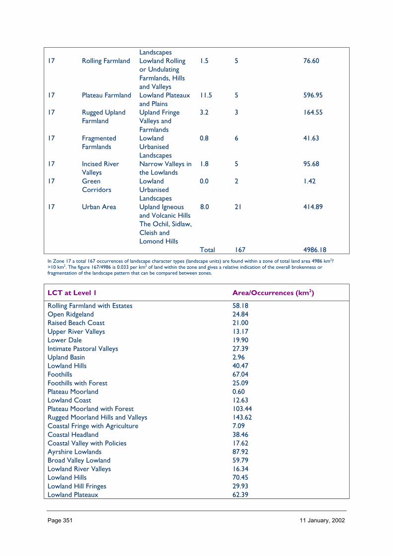
Page 351 11 January, 2002
Landscapes17 Rolling Farmland Lowland Rolling
or UndulatingFarmlands, Hillsand Valleys
1.5 5 76.60
17 Plateau Farmland Lowland Plateauxand Plains
11.5 5 596.95
17 Rugged UplandFarmland
Upland FringeValleys andFarmlands
3.2 3 164.55
17 FragmentedFarmlands
LowlandUrbanisedLandscapes
0.8 6 41.63
17 Incised RiverValleys
Narrow Valleys inthe Lowlands
1.8 5 95.68
17 GreenCorridors
LowlandUrbanisedLandscapes
0.0 2 1.42
17 Urban Area Upland Igneousand Volcanic HillsThe Ochil, Sidlaw,Cleish andLomond Hills
8.0 21 414.89
Total 167 4986.18
In Zone 17 a total 167 occurrences of landscape character types (landscape units) are found within a zone of total land area 4986 km2?>10 km2. The figure 167/4986 is 0.033 per km2 of land within the zone and gives a relative indication of the overall brokenness orfragmentation of the landscape pattern that can be compared between zones.
LCT at Level 1 Area/Occurrences (km2)
Rolling Farmland with Estates 58.18Open Ridgeland 24.84Raised Beach Coast 21.00Upper River Valleys 13.17Lower Dale 19.90Intimate Pastoral Valleys 27.39Upland Basin 2.96Lowland Hills 40.47Foothills 67.04Foothills with Forest 25.09Plateau Moorland 0.60Lowland Coast 12.63Plateau Moorland with Forest 103.44Rugged Moorland Hills and Valleys 143.62Coastal Fringe with Agriculture 7.09Coastal Headland 38.46Coastal Valley with Policies 17.62Ayrshire Lowlands 87.92Broad Valley Lowland 59.79Lowland River Valleys 16.34Lowland Hills 70.45Lowland Hill Fringes 29.93Lowland Plateaux 62.39
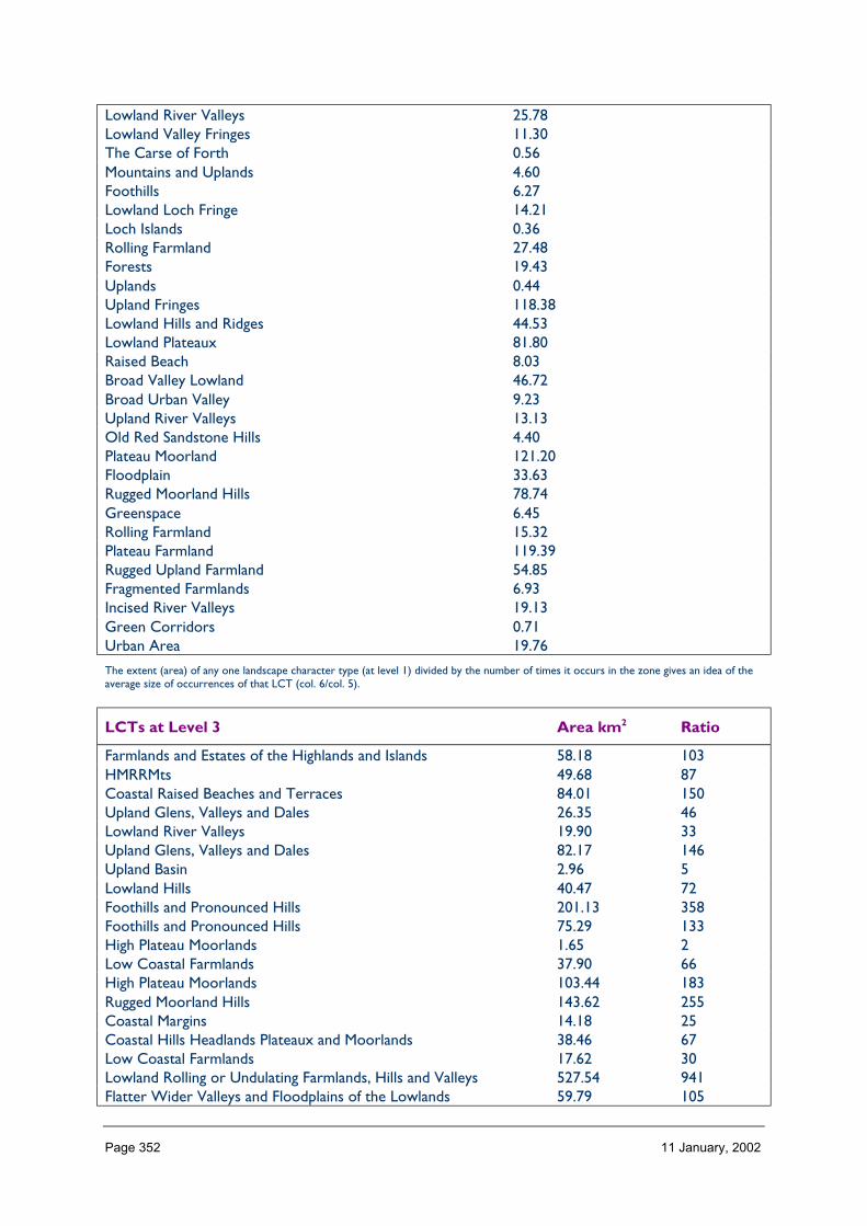
Page 352 11 January, 2002
Lowland River Valleys 25.78Lowland Valley Fringes 11.30The Carse of Forth 0.56Mountains and Uplands 4.60Foothills 6.27Lowland Loch Fringe 14.21Loch Islands 0.36Rolling Farmland 27.48Forests 19.43Uplands 0.44Upland Fringes 118.38Lowland Hills and Ridges 44.53Lowland Plateaux 81.80Raised Beach 8.03Broad Valley Lowland 46.72Broad Urban Valley 9.23Upland River Valleys 13.13Old Red Sandstone Hills 4.40Plateau Moorland 121.20Floodplain 33.63Rugged Moorland Hills 78.74Greenspace 6.45Rolling Farmland 15.32Plateau Farmland 119.39Rugged Upland Farmland 54.85Fragmented Farmlands 6.93Incised River Valleys 19.13Green Corridors 0.71Urban Area 19.76
The extent (area) of any one landscape character type (at level 1) divided by the number of times it occurs in the zone gives an idea of theaverage size of occurrences of that LCT (col. 6/col. 5).
LCTs at Level 3 Area km2 Ratio
Farmlands and Estates of the Highlands and Islands 58.18 103HMRRMts 49.68 87Coastal Raised Beaches and Terraces 84.01 150Upland Glens, Valleys and Dales 26.35 46Lowland River Valleys 19.90 33Upland Glens, Valleys and Dales 82.17 146Upland Basin 2.96 5Lowland Hills 40.47 72Foothills and Pronounced Hills 201.13 358Foothills and Pronounced Hills 75.29 133High Plateau Moorlands 1.65 2Low Coastal Farmlands 37.90 66High Plateau Moorlands 103.44 183Rugged Moorland Hills 143.62 255Coastal Margins 14.18 25Coastal Hills Headlands Plateaux and Moorlands 38.46 67Low Coastal Farmlands 17.62 30Lowland Rolling or Undulating Farmlands, Hills and Valleys 527.54 941Flatter Wider Valleys and Floodplains of the Lowlands 59.79 105

Page 353 11 January, 2002
Lowland River Valleys 114.44 203Lowland Hills 140.91 250Lowland Hill Margins and Fringes 149.65 266Lowland Plateaux and Plains 124.79 221Lowland River Valleys 180.49 321Lowland Valley Fringes 11.30 20Flatter Wider Valleys and Floodplains of the Lowlands 0.56 1HMRSSMts 13.82 23Foothills and Pronounced Hills 25.10 44Lowland Loch Basins 28.43 50Lowland Loch Basins 2.56 4Lowland Rolling or Undulating Farmlands, Hills and Valleys 82.44 1460 19.43 33Upland Hills, The Lammermuir, Pentland and Moorfoot Hills 7.06 12Upland Fringe Moorland 118.38 211Lowland Hills 44.53 78Lowland Plateaux and Plains 163.61 291Coastal Raised Beaches and Terraces 16.07 28Flatter Wider Valleys and Floodplains of the Lowlands 93.44 166Lowland Urbanised Landscapes 9.23 16Upland Glens, Valleys and Dales 13.13 23Upland Hills, The Lammemuir, Pentland and Moorfoot Hills 4.40 7High Plateau Moorlands 363.61 648Flatter Wider Valleys and Floodplains of the Lowlands 33.63 58Rugged Moorland Hills 236.22 421Lowland Urbanised Landscapes 12.89 21Lowland Rolling or Undulating Farmlands, Hills and Valleys 76.60 135Lowland Plateaux and Plains 596.95 106Upland Fringe Valleys and Farmlands 164.55 292Lowland Urbanised Landscapes 41.63 73Narrow Valleys in the Lowlands 95.68 169Lowland Urbanised Landscapes 1.42 2Upland Igneous and Volcanic Hills The Ochil, Sidlaw, Cleish andLomond Hills
414.89 73
The ratio of the extent (area) of the level 3 groupings gives an indication of the distribution pattern by proportion of the zone.
Table 17.3 Rarity (duplications – cannot reach conclusions)
LCTs at Level 1 Rarity by occurrence%
Rarity by extent%
Rolling Farmland with Estates 0 1.1Open Ridgeland 1 1.0Raised Beach Coast 2 1.6Upper River Valleys 1 0.5Lower Dale 0 0.4Intimate Pastoral Valleys 1 1.6Upland Basin 0 0.1Lowland Hills 0 0.8Foothills 1 3.9Foothills with Forest 1 1.5Plateau Moorland 1 0.0

Page 354 11 January, 2002
Lowland Coast 1 0.7Plateau Moorland with Forest 0 2.0Rugged Moorland Hills and Valleys 0 2.8Coastal Fringe with Agriculture 1 0.3Coastal Headland 0 0.7Coastal Valley with Policies 0 0.3Ayrshire Lowlands 3 10.2Broad Valley Lowland 0 1.2Lowland River Valleys 4 2.2Lowland Hills 1 2.7Lowland Hill Fringes 2 2.9Lowland Plateaux 1 2.4Lowland River Valleys 4 3.5Lowland Valley Fringes 0 0.2The Carse of Forth 0 0.0Mountains and Uplands 1 0.3Foothills 2 0.5Lowland Loch Fringe 1 0.5Loch Islands 4 0.0Rolling Farmland 1 1.6Forests 0 0.4Uplands 9 0.1Upland Fringes 0 2.3Lowland Hills and Ridges 0 0.9Lowland Plateaux 1 3.2Raised Beach 1 0.3Broad Valley Lowland 1 1.8Broad Urban Valley 0 0.2Upland River Valleys 0 0.3Old Red Sandstone Hills 0 0.1Plateau Moorland 1 7.0Floodplain 0 0.6Rugged Moorland Hills 1 4.6Greenspace 1 0.2Rolling Farmland 2 1.5Plateau Farmland 2 11.5Rugged Upland Farmland 1 3.2Fragmented Farmlands 3 0.8Incised River Valleys 2 1.8Green Corridors 1 0.0Urban Area 12 8.0
The rarity of a landscape character type within the zone can be identified by the number of time it occurs or its extent. Examination ofboth the number of occurrences (of a LCT) as a percentage of the total and the area (of a LCT) as a percentage of the total area will givean indication of rarity. (col 5/total col. 5%) (col. 6/total col. 6%).
LANDSCAPE CHARACTER
The zone varies widely from north to south and west to east. In parts of the zone, builtdevelopment has changed the original landscape character into an urban or urban fringetype. Two major plateaux (the ‘Ayrshire Rim’ and the Slamannan plateau) separate thewestern Ayrshire basin, the central Clyde valley and the Lothian basin in the east. Anintermittent west-east scarp separates these uplands and lowlands from the Loch Lomondbasin.

Page 355 11 January, 2002
To the west, the zone is dominated by the extensive Ayrshire lowlands, which are dissectedby radiating river valleys of varying character flowing to the lowland coast. These lowlandsare enclosed by moorland hills and plateau, coastal headlands or foothills, all edged by araised beach at the Firth of Clyde shore. Some of the radiating valleys cross the rim to meetsimilar valleys flowing to the Clyde (e.g. Irvine ↔ Avon). To the south the radiating riversgive way to intimate pastoral valleys and wider dales in the uplands, that parallel the SW-NEtear of the Southern Upland Fault in Zone 19.
Rugged moorland hills cross the zone from east to west to the north of the main plateaux,from the Clyde Muirshiel Regional Park area, though the Kilpatrick Hills to the CampsieFells, and the Fintry, Gargunnock, and Touch Hills. while to the north, river valleys such asthe Carron Valley and Endrick Water separate the Slamannan plateau and an east-west chainof hills from an outlier of the central plateau at Kippen Muir.
East of Loch Lomond, rolling farmland – some typified by estate policies – borders theuplands of Loch Ard Forest to the north of the zone.
To the east, the Slamannan plateau blends through upland fringes into the uplands to thesouth (Pentlands); to east and north the plateau is bounded by hills, such as the lowland hillsand ridges of the Bathgate Hills and lowland hill fringes of East Touch, Denny Muir, StockieMuir and Mugdock. Lowland river valleys such as the gorge of the Avon Valley cut into theSlamannan plateau rim in the east.
Description
Landform
PROFILE
The profile varies across the zone. The northern line of hills are steep sided and a stronglyhorizontal escarpment; raised beach coasts are level areas backed by the smallerescarpments of the cliff-line and higher craggy headlands, but other coastal areas arecharacterised by dune profiles; elsewhere, hills tend to have a conical or rounded isolatedform, or to form rounded ridges; plateaux are undulating or strongly folded or softly ridged,in places with craggy bluffs and troughs flooded with reservoirs; valley fringes are also rollingor strongly undulating but with craggy outcrops; large lowland basins contain undulating androunded drumlin landscapes; valleys range from being barely perceptible, to broad and flatbottomed, to narrow steep sided incised valleys and gorges, to valleys where floor andflanks merge together in terraces: some valleys’ profile has been partly hidden by reservoirsor natural flooding, just as some upland landforms are obscured by conifer plantations; lochbasins are similar to the valley fringes bar the characteristic loch, but the southern fringes ofLoch Lomond are gently sloping and nearly flat at the river mouths; there is one extensiveflat flood plain, but like some other landscape types in the zone, built development hasdominated the landform and given the area an urbanised identity. Some other types arefragmented by industrial activity that has modified the landform with quarrying, landfill, opencast mining and spoil heaps, or by major roads carried on substantial embankments.
SEQUENCE
The West Central Belt is predominantly lowland and upland rather than highland, as it alllies below 600 m, with 70% of the zone below 200 m. There is an almost regular sequenceof rise and fall in crossing the zone from west to east, and from north to south. The hills

Page 356 11 January, 2002
that separate and encircle the extensive lowland areas are in 5 main blocks: the moorlandplateaux separate the Ayrshire lowlands from the Clyde Valley; the Slamannan plateau liesbetween the Clyde lowlands and Firth of Forth lowlands; the Kilpatrick Hills and scarp ofthe Campsie Fells form the northward skyline to the Glasgow bowl and floodplain, andseparate the Clyde from Loch Lomond, and the Stirling Carse in Zone 15; finally, the ClydeMuirshiel hills in the west form a pivot to the Firth of Clyde.
SCALE
Scale varies from medium to large in the open upland hill tops and plateau, to intimate in thedeep narrow valleys, and due to topography can also vary with viewpoint travelling throughparts of the zone. There are no vast landscapes in this zone.
LANDMARK FEATURES
Strong scarp of Campsie Fells
Brown Hills of Carrick and Heads of Ayr
Loch Lomond
Islands in Loch Lomond – Inchmurrin, Inchcailloch
the Cumbrae islands in the Firth of Clyde
Falls of Clyde at New Lanark
Volcanic plugs of Loudoun Hill, Knockdolian Hill and Dumbarton Rock
Ayrshire headlands: Turnberry, Troon, Ardrossan, Portencross
Five Sisters Bing (cultural landform)
Forth and Clyde Canal Other landmarks outwith the zone that are dominant in long viewsinclude the Arran peaks and Ailsa Craig in Zone 14, Ben Lomond (and other highland peaks)and Flanders Moss (Carse of Forth) in Zone 15, Tinto Hill in Zone 19.
EXPERIENCE
Experience varies greatly across the zone. Movement by road tends to follow valleysthrough the uplands, but high ground and large scale can be experienced from roads, such asthe Eaglesham Moor road which provides panoramic 360° views. In built up areas, such ascentral Glasgow, the topography is readily experienced by pedestrians walking the grid ofstreets that overlay the steeply rounded drumlins.
Containment (created by landform and land cover)
LAND COVER
Commercial forestry contains views in some upland areas which are otherwise open, whilein valleys the policy woodlands of designed landscapes may limit views along or across thevalley. Native broadleaf woodland along watercourses and loch margins may long interruptviews. While being at street level in some developed areas limits views greatly, the reverseis true of upper floors of flats and tenements, especially where these are tiered up a hillside.

Page 357 11 January, 2002
VISIBILITY
Visibility clearly varies greatly across the zone, according to height and undulations. Viewsfrom the uplands extend deep into neighbouring zones.
MICROCLIMATIC EFFECTS.
Tender plants are to be found in gardens along the Firth of Clyde (which feels the influenceof the Gulf Stream), but depend on shelter from the salty gales. Coastal trees are bevelled,which in places emphasises the slope of the raised beach cliff line. Black ice on EagleshamMoor causes winter accidents. There is great variation in short distances, with Ayrshirehaving sunny weather when Clydebank 30 miles distant is rainy (or vice versa), andClydebank being rainy when Loch Lomond has snow.
The high ground between lowlands are likely to have different weather, -it may be sunny inGlasgow and Edinburgh on the same day but snowing at the highest point on the M8 inbetween; similarly, Dalry lies between the Glasgow and Ayrshire lowlands and is subject tonoticeably worse weather.
EXPERIENCE
Generally, there are few places where topography provides any sense of close containment,except in the incised valleys of south Ayrshire and the Lothians, and the deep valleysthrough the scarp in the north of the zone. The lowland and Loch Lomond basins are wideand open, sheltered by policy and other woodlands, and affording distant views across thebasins to the uplands, islands and mountains of adjacent zones. The upland plateau aresimilarly open except in areas of plantation forestry.
Accessibility
DISTANCE
Glasgow and other major population centres are at the very core of the zone, andEdinburgh is close be to the east. Ease of getting to the farther reaches of the zone whicharen’t served by public transport depends less on distance than on the availability of privatetransport. Much of the area is well served by public transport, particularly Glasgow and thelines of its radiating railways. With a car, major centres are little more than an hour fromthe outermost, rural areas. Almost all the zone is within 5 km of a road; the only areaisolated in transport terms is Little Cumbrae, which is in private ownership but only 2 kmoff shore. Neighbouring Great Cumbrae is easily reached by frequent short ferry crossingsfrom the rail head at Largs.
PHYSICAL ACCESS
Broadly, access is not difficult throughout much of the zone. The West Highland Way toFort William begins officially at Milngavie, but walkways link to Glasgow Green in the heartof the city. Motorways form a central triangle between Glasgow, Edinburgh and Stirling,while the Glasgow – Carlisle motorway follows the Clyde Valley; otherwise, dualcarriageways link the major towns in the zone, and single track roads are few. There areseveral ferry routes across the Firth of Clyde to Zone 14, and sailings are common. SeveralAyrshire towns have, or plan, Paths for All. The Regional Parks (Clyde Muirshiel, PentlandHills and Loch Lomond) are generally well served with paths.

Page 358 11 January, 2002
Many of the parks and river valleys within the Glasgow Conurbation are well provided withfootpath networks under the Countryside Around Towns scheme, some of which useestablished paths in designed landscapes.
CULTURAL ACCEPTANCE
The Regional Parks (Clyde Muirshiel, Pentland Hills and Loch Lomond) and the CATschemes encourage responsible access on foot. The West Highland Way encourages andattracts walkers from all over the world. In former deep coal mining areas, minerstraditionally walked a great deal, and this is demonstrated by some of the Paths for Allschemes in the zone. There are many designed landscapes and gardens open to the public,and many have free access to the public. The cultural history of Glasgow people travellinginto the hills, to Loch Lomond and up the Clyde Valley, to visit waterfalls and other sightson holidays and weekends, has instilled an almost unique sense of ‘ownership’ that will betaken forward by the National Park proposals. Access to beaches is also freely availablewhere physically possible, with public rights of way across private golf courses: the Clydecoast was formerly important as a holiday destination, with many boats taking Glaswegians‘doon the Water’ during the Fair Fortnight, to resorts whose piers are now disused butwhose beaches are now accessed by car or train. Private golf courses in Ayrshire betraytheir urban connections: businessmen would travel from town by rail to Glasgow Gailes orKilmarnock Barassie and other courses which each had their own railway platforms.
VISUAL ACCESS
Visual access is generally easy and wide, with some hidden incised valleys and gorges.
EXPERIENCE
There are few parts of the zone that are not accessible, and the cultural history imparts asense of right of access in most areas.
Land cover (including vegetation and land use)
VEGETATION
Compared to the Scottish average, there is little arable, and less than average commercialconifer planting – although this is based on LCS 88, and the south of the zone is currentlyexperiencing significant afforestation spreading north from Galloway (Zone 19).
While heather does not typify the zone’s upland vegetation, the large area of improvedgrassland (45% of the zone) reflects soils, climate and other factors including golf coursedevelopments. 12% of the zone is urbanised – representing almost half of Scotland’s urbanarea.
Commercial forestry has modified the landscape character in some upland areas which areotherwise open, while some valleys are typified by the policy woodlands of designedlandscapes. Geometric shelterbelts, and farm woodlands, are common in some areas, usuallyrelated to local wind conditions. Native broadleaf woodland and scrub is found alongwatercourses (including the canals) and loch margins, in terraces on valley sides and oninaccessible gorge slopes. The Clyde Valley is famed for its orchards, which are notseparately noted in LCS 88, although these are generally in decline and being replaced by a‘garden centre’ landscape. The beech trees and hedges (mainly derelict) of the Lothians,

Page 359 11 January, 2002
Lanarkshire and parts of Ayrshire are a landscape feature within the zone. Given the largebuilt up area, urban parks and open spaces are important green landcover.
EXPOSED ROCK
Landmark boulders are found on the South Ayrshire coast at Kennedy’s Pass andLendalfoot; quarries (largely whin) are found throughout much of the zone; sheer rock isfound at the volcanic plugs e.g. Dumbarton Rock, and cliffs of gorges e.g. Falls of Clyde,River Ayr and the craggy raised beach escarpment. Horizontal bands of basalt rock formcliffs and scarps in the hills forming the west-east escarpment, breaking out also as rockyknolls. Rock is also temporarily exposed at open cast coal mines, and permanently in somebings, some of which may be of geological interest.
BUILT DEVELOPMENT
Built development is widely found along the coast and the river valleys; towns and citiesdominate the lowland basins. Smaller settlements are found in the uplands where industrysuch as coal mining exists, and farmsteads are scattered widely throughout the zone(although being converted to dwellings in the commuter belts).
EXPERIENCE
Man’s influence on the landscape is widespread, with few entirely natural areas left except indeep gorges and small stretches of coast.
Hydrology and water bodies
TYPE
The zone contains 4% of Scotland’s lochs, but the 44 SSSIs with lochs represent 12% of suchSSSIs, possibly reflecting the level of potential threat as much as the ecological value. Theyare more typical of the lowlands, lying between 8m and 151m, reflecting the manyreservoirs and naturally flooded areas that characterise the zone. The most significant lochis Loch Lomond (shared with Zone 15), and the most significant river is the Clyde, with itstributaries and its estuarine Firth, that dominates much of the zone.
Man made water bodies are found throughout the zone, such as reservoirs, flooded gravelpits and borrow pits, areas of mining subsidence etc. Several canals cross the zone –principally the Forth and Clyde, that links the Firths of Clyde and Forth. The Greenock Cutis also a notable feature.
Waterfalls are found in many parts of the zone, reflecting the topography and hydrologicalevents.
The Falls of Clyde, New Lanark, are of national and possibly international importance – themost substantial falls in Northern Europe, They were harnessed for electricity in 1926, buton ‘waterfall days’ today’s visitors see Bonnington Linn, Cora Linn, Dundaff Linn (besideNew Lanark cotton mills) and Stonebyre’s Linn in spate as the tourists in the past (writersand artists, such as Dorothy and William Wordsworth, and Turner) saw them.
In the south west, adjacent to the boundary with Zone 19, the Stinchar Falls (with a soft ‘ch’as in ‘church’) near Straiton are a significant series, falling 150m in 3 km; other falls nearbyinclude Rossetti Linn and Tairlaw Linn (from Tairbealach – ‘the spray-enshrouded waterfall ofthe pass’), possibly the finest single fall in Galloway Forest Park. Dalcairnie Linn is noted in

Page 360 11 January, 2002
early guide books when nearby Dalmellington was considered a mountain resort. Anotherseries of waterfalls is found near Largs e.g. Black Linn or Falls of Gogo and Kelburn Falls,while the Spout of Garnock may be the most imposing fall in the Renfrewshire Heights.
Significant falls, of regional importance, are found in the north of the zone and celebrate theline of the scarp. They include Ishneich (‘the waterfall of the horse’ probably relating to thenearby former drove road), Spout of Ballagan (much visited in Victorian times, now a SWTnature reserve), Campsie Glen (with nine distinct falls, a popular day trip from Glasgow inthe 19th century), Loup of Fintry (the finest waterfall in Stirlingshire).
There are interesting falls close to and within urban areas – at Whistler’s Glen byHelensburgh (written of by Scott in Heart of Midlothian), Calder Glen (six fine falls in ClydeMuirshiel Regional Park), Gleniffer Linn by Paisley, cascades in Rouken Glen, The Linn(White Cart) in the heart of Glasgow, Calderwood Glen at East Kilbride (a series of fourfalls in the gorge of the Rotten Calder) and Spectacle E’e (formerly harnessed for a watermill), all to the south of Glasgow.
PATTERN
The great Ayrshire and Clyde basins are drained by radiating rivers. Valleys frequently followthe SW-NE grain of the dominant faults, and may be flooded naturally or by man. Importantfeatures occur where steep landforms occur at the coast and the main escarpment, andwhere the hydrology has been altered by natural events, such as the gorge at New Lanarkwhich resulted from the Clyde capturing the headwaters of the Tweed.
EXPERIENCE
The rivers and waterfalls are important for recreation, providing the experience of thenatural environment in the densely built up area. The experience of the Falls of Clyde ismanifested in words and pictures over the past two centuries. Loch Lomond is an icon ofScotland throughout the world, much visited and loved. The River Clyde along its length is anotable element in many parts of the zone.
The proximity to centres of population means that several Country Parks and RegionalParks, together with various River projects, encourage walking along riverbanks (popular ingorges where the wider townscapes or landscapes is not visible, and where the climbpresents wider views of, for example, the Firth of Clyde and its islands.) Open bodies ofwater may be utilised for recreation, be it various forms of boating, or angling. The canalsalso provide various forms of quiet enjoyment. Many of the waterfalls in the area haveinspired novelists, poets and artists, and others are the centred in important designedlandscapes, where their settings are frequently enhanced by planting and they make asignificant contribution to the amenity of the estate (many of which are now publiclyaccessible.)
Built and infrastructure development (present day)
NATURE AND PATTERN OF SETTLEMENT
The zone is heavily settled, settlement locations determined by the source of power (e.g.water), raw materials (e.g. coal), transport routes (road, rail, canal, air) and harbours, heavyindustry (e.g. shipbuilding, steel works), holiday resorts required jetties and sandy beachesand the forestry business. New Towns developed around existing towns. Former Clydecoast holiday resorts mark the beaches and ferry terminals (many now out of use).
Page 361 11 January, 2002
Farmsteads are scattered, on the valley floor or on hill’s lower slopes, though they may bebuilt on historic sites. Villas of wealthy merchants are found on the Clyde coast and in thehills above the smoke of the industrial areas. Glasgow was a religious site, but developedinto a major port and centre for trade and industry, with associated urban development.
NATURE AND PATTERN OF INFRASTRUCTURE
Transport routes – road and rail – tend to follow raised beaches and river valleys incorridors, and dominate the Glasgow basin, especially at the flat alluvial plain at Inchinnan.Throughout the Central Belt’s main motorway corridors, embankments and bridgesfragment the landscape and restrict the views. The power lines from Hunterston and otherPower Stations serving the main population centres are negative features in many skylineviews. There are a number of communication masts, some very prominent such as the threemarking Brown Carrick Hill and at Shotts. Earth dams and reservoirs to supply drinkingwater are common in the uplands.
NATURE AND PATTERN OF INDUSTRIAL DEVELOPMENT
Textile industries that utilised water power are found at various locations, most notablyNew Lanark, but also Catrine and Eaglesham. The distillery in Strathblane utilises the localwater off the Campsie Fells in a different way. Shipbuilding development lines the RiverClyde downstream from Glasgow (marked by prominent cranes and covered yards) andsome Ayrshire harbours (e.g. Troon, Irvine, Girvan). The steel works at Ravenscraig andGartcosh are gone, leaving brownfield sites marked for redevelopment. There are visuallyprominent power stations on the Firth coast at Inverkip (oil, mothballed), and Hunterston(nuclear, being de-commissioned) – with its adjacent ore and coal handling jetties andconveyor belts – and at Hagshaw Hill (wind). New Towns and many other settlements havetheir satellite light industrial ‘parks’, which also line many of the dual carriageways out ofGlasgow. The flat land at Inchinnan was the site of the former Ordnance works, but thisarea and parts of Prestwick are targeted by business parks seeking to capitalise on theproximity of the two airports. Open cast coal mining, sand quarrying and hard rockquarrying are found in many parts of the zone, with coal focused on the west-east Ayrshire– Lanarkshire belt, sand in a parallel belt and quarrying where the resource is available. Bingsare a feature in places. Glasgow and its surrounding towns contain a wide range ofindustries.
EXPERIENCE
Some industries contribute by their prominent landscape features, such as the chimney ofInverkip, the cranes of Govan, the turbines of Hagshaw Hill. The windfarm at Hagshaw Hillappears to be valued by local residents at Coalburn (adjacent to the Dalquhandy open castcoal site), who call the turbines ‘Coalburn’s flowers’ (The Herald, May 1999). The landscapecharacter of the countryside at the margins of the major conurbations is changed byindustrial estates or ‘parks’. Mineral extraction removes most or all of the local time-depth,and with it some of the local identity and associated pride of place; miners rows now appearout of place without a raison d’être since deep mining has ceased throughout the zone.Secondary elements, such as the pylons serving the power stations, also industrialise ruralareas that they pass through, because of their scale, form and materials.

Page 362 11 January, 2002
Visible history (past settlement, landuse, churches, brochs, forts, dykes, standingstones etc.)
TYPES OF VISIBLE HISTORY
Castles and other defensive features, such as hill forts and duns, reflect the raised beach’simportance for defence and communication: later castles form the centre of designedlandscapes. Similarly, forts and castles controlled movement along the breach valleys acrossthe uplands, such as the Garnock Valley. Roman remains are notable, particularly theAntonine Wall and its forts, which take advantage of readily defended higher ground and areprominent in some locations; some settlements relate to the Roman roads serving the Wallthat parallels the Kelvin valley. Rig and furrow field patterns are evident in areas nowunsettled and uncultivated, at an elevation suggesting the 16th century climate was milder.Cathedrals range from those in Glasgow and Paisley to the smallest ‘Cathedral of the Isles’on Great Cumbrae. Covenanters Monuments are found in the area where this activityoccurred, notably the Ayrshire – Edinburgh belt. Historic houses and designed landscapesare found throughout the lowland areas of the zone, particularly along valley bottoms andthe raised beach cliffs. Wooden huts at Lendalfoot are associated with a former fishery.Industrial elements such as viaducts and bridges are prominent features.
LOCATION/PATTERN
Raised beach, slopes overlooking valley bottoms and focusing on fine views, river crossingpoints, breach valleys, defensible high ground – most notably the local scarp used by theRomans to site the Wall which looked north over the then-flooded Kelvin Valley. Little orno evidence in areas of mineral extraction, and little in areas of relatively intensiveagriculture.
EXPERIENCE
The policy woodlands of designed landscapes add visual interest. Broadly speaking, thehistory of settlement has meant that much visual history is now at the core of towns ratherthan in its original rural setting. The Covenanters Monuments are not highly visible, thoughsought out by interested people. The Roman wall is present as a prominent feature inplaces.
Wildlife
FORMS OF WILDLIFE
Plant, bird and mammal life – Whooper Swans are noticeable seasonal visitors, badgers aresurprisingly common, capercaillie and wallabies are found in the zone. Gannets that breedon Ailsa Craig (Zone 14) are commonly seen on the Ayrshire coast.
LOCATION
Bird life is most visible en masse along the cliffs, beaches and sand flats of the Firth of Clydeand inner Clyde coast. Peatland in upland areas, improved grassland. The islands of LochLomond and broadleaf woodlands of the Clyde Valley and other valleys support mammals ofnote. Badgers in much of the woodlands and improved grasslands around many settlements.Urban greenspace is also important.

Page 363 11 January, 2002
WHEN
Wildlife is visible all year, but especially along the coast during the main migratory seasons ofautumn and spring.
EXPERIENCE
Most wildlife is readily accessible, and is well interpreted in the various country parks andnature reserves. Badgers can be enjoyed at night at the Falls of Clyde, when the landscapethey inhabit is less readily appreciated by people in visible terms, and other senses arebrought into use.
Wallabies swim to the Loch Lomond’s shore on occasion, injecting a surreal experience.
Climate
CLIMATIC CHARACTERISTICS
The zone varies widely, according to elevation and the dominance of weather out of thewest or out of the east.
LOCATIONAL AND SEASONAL EFFECTS
The weather can vary greatly between east and west, between lowland and adjacent upland.
EXPERIENCE
As the area is so urbanised, climate is not a marked component of the experience.
Designated landscapes
National Scenic Areas
CONSTITUENTS
West Central Belt contains only one NSA, and part only – Loch Lomond. 15 landscapetypes may characterise the NSA, of which 6 occur in Zone 17. These are rolling farmland,islands, lowland loch fringe (both are 1:25,000 types, not 1:50,000 types) with skirtingforested foothills and uplands.
LOCATION AND EXTENT
The NSA totals 27,400 ha and is split between Zone 17 and Zone 15, along the HighlandBoundary Fault. Although 16,200 ha was formerly in Strathclyde (now Argyll & Bute, andWest Dunbartonshire), only the relatively small lowland section of the former Strathclydelies within the zone. This translates as about 50 km of the NSA’s 360 km length being inZone 17.
EXPERIENCE
It is an inland NSA centred on the loch both topographically and visually. This zone providesa gentler experience of the NSA, with rural long-farmed areas and designed landscapesbordering the loch, backed by softly ridged hills to the west and foothills of Ben Lomond tothe east. The area, being so close to the Glasgow conurbation and an icon of Scotland, ismuch visited and of recreational importance.
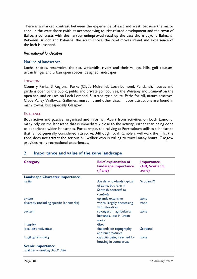
Page 364 11 January, 2002
There is a marked contrast between the experience of east and west, because the majorroad up the west shore (with its accompanying tourist-related development and the town ofBalloch) contrasts with the narrow unimproved road up the east shore beyond Balmaha.Between Balloch and Balmaha, the south shore, the road moves inland and experience ofthe loch is lessened.
Recreational landscapes
Nature of landscapesLochs, shores, reservoirs, the sea, waterfalls, rivers and their valleys, hills, golf courses,urban fringes and urban open spaces, designed landscapes.
LOCATION
Country Parks, 3 Regional Parks (Clyde Muirshiel, Loch Lomond, Pentland), houses andgardens open to the public, public and private golf courses, the Waverley and Balmoral on theopen sea, and cruises on Loch Lomond, Sustrans cycle route, Paths for All, nature reserves,Clyde Valley Walkway. Galleries, museums and other visual indoor attractions are found inmany towns, but especially Glasgow.
EXPERIENCE
Both active and passive, organised and informal. Apart from activities on Loch Lomond,many rely on the landscape that is immediately close to the activity, rather than being doneto experience wider landscapes. For example, the rallying at Forrestburn utilises a landscapethat is not generally considered attractive. Although local Ramblers will walk the hills, thezone does not attract the serious hill walker who is willing to travel many hours. Glasgowprovides many recreational experiences.
2 Importance and value of the zone landscape
Category Brief explanation oflandscape importance(if any)
Importance(GB, Scotland,zone)
Landscape Character Importancerarity Ayrshire lowlands typical
of zone, but rare inScottish context? tocomplete
Scotland??
extent uplands extensive zonediversity (including specific landmarks) varies, largely decreasing
with elevationzone
pattern strongest in agriculturallowlands, lost in urbanareas
zone
integrity dittolocal distinctiveness depends on topography
and built featuresScotland
fragility/sensitivity capacity being reached forhousing in some areas
zone
Scenic importancequalities – awaiting AGLV data

Page 365 11 January, 2002
perceptions ‘ye banks and braes’ (andother Burns poems),‘...take the high road’colour perceptions ofAyrshire and LochLomond
GB
Learning ImportanceEnvironmental Education CAT, Regional Parks,
Country Parks, Reserveszone
Interpretation ditto zoneEnjoyment ImportanceRecreation Clyde coast resorts, Loch
Lomond, Country Parks,Regional Parks, Reserves,Paths for All
Scotland
wildness and tranquillity these are rare, exceptfrom child’s perspective
zone
Amenity urban parks, river valleyprojects
zone
arts, crafts, poetry, literature, music all strongly evident, espGlasgow and Falls ofClyde
Scotland?
DesignationsNSAs the major part of the NSA
is in Zone 15.zone
AGLVsRegional Landscape Designations awaitinginformation
zone?
Historic Gardens & Designed Landscapes large numbers ScotlandCultural Importancepre history (designated/non-designated) Roman wall remains, but
much else lost to orsubsumed intodevelopment
Scotland
medieval (designated/non-designated) much subsumed intodevelopment. Museum ofCountry Life.
zone
recent (designated/non-designated) bridges and viaducts ScotlandSocioeconomic Importancesocial urban areas GBeconomic urban areas, minerals GB
3 Landscape and trends in the zone
Pressures/influences which have a particular effect on the landscape of the zone:
• Nature of landscape pressures/influences – a brief description• Trends: increasing, static or declining
− long term (> 5 years), medium term (2 to 5 years),− short term (< 2 years)
• Importance: important, not important

Page 366 11 January, 2002
Pressure Nature of landscapepressures/influencesand trends withinzone, relativeimportance within thezone
Scale of landscape influence(+ve/–ve) within zone whenconsidered in
an all Scotland context
Major Inter. Minor Negligible
Built developmentResidential major greenbelt releases,
individual houses in agricareas. Important andincreasing, long term.
✔
Retail retail parks important andincreasing, long term
✔
Industrial shipbuilding and othermajor industries indecline, but ‘silicon glen’industries important albeitcurrently static shortterm.
✔
OtherInfrastructure TransportRoads and tracks improvements to major
roads e.g. M77, M8, M80link – important, but longterm due to financialconstraints
✔
Rail related pressure to re-openformer lines in widerconurbation, and to linkthe 2 Glasgow stations –increasing but little NHimportance
✔
Ferry related no new terminals, butnew routes tested e.g.Troon-Belfast
✔
Other air – Glasgow Abbotsinchrecently improved,pressure to improve railaccess
✔
Infrastructure otherTelecoms increasing, trend for
multiple masts and mastsharing – medium term(saturation soon)
✔
Water treatment/abstraction previous disposal ofuntreated sewage at seabeing phased out. Shortterm
✔
Waste management landfill – static? important,long term
✔
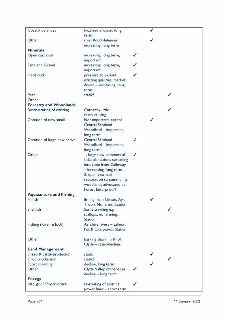
Page 367 11 January, 2002
Coastal defences localised erosion, longterm
✔
Other river flood defencesincreasing, long term
✔
MineralsOpen cast coal increasing, long term,
important✔
Sand and Gravel increasing, long term,important
✔
Hard rock pressure to extendexisting quarries, marketdriven – increasing, longterm
✔
Peat static? ✔OtherForestry and WoodlandsRestructuring of existing Currently little
restructuring.✔
Creation of new small Not important, exceptCentral ScotlandWoodland – important,long term
✔
Creation of large new/native Central ScotlandWoodland – important,long term
✔
Other 1. large new commercialsitka plantations spreadinginto zone from Galloway– increasing, long term.2. open cast coalrestoration to communitywoodlands advocated byForest Enterprise??
✔
Aquaculture and FishingFinfish fishing from Girvan, Ayr,
Troon. No farms. Static?✔
Shellfish Some trawling e.g.scallops, no farming.Static?
✔
Fishing (River & loch) Ayrshire rivers – salmon.Put & take ponds. Static?
Other basking shark, Firth ofClyde – static/decline.
Land ManagementSheep & cattle production static ✔Crop production static? ✔Sport shooting decline, long term ✔Other Clyde Valley orchards in
decline – long term✔
EnergyNat. grid/infrastructure re-routing of existing
power lines – short term.✔

Page 368 11 January, 2002
Scotland – N IrelandInterconnector – mediumterm.
Wind 1. pressure increasedsince Interconnectorapproved; long term2. Wind farms to serveindividual industrial sitesin future, long term?
✔
Hydro static, exists at Falls ofClyde
✔
Wave not suited ✔Other landfill gas, waste to
energy – urban by-products: pressureincreasing, long term
✔
Tourism and RecreationGolf increasing markedly esp
pay as you play; longterm, important
✔
Marinas increasing, extendingmarinas rather than new,important – coast andLoch Lomond
✔
Skiing facilities Not suitedLeisure facilities/visitorcentres
Visitor centres masking asshops increasing, nearingsaturation?
✔
NH Information provision static? ✔Walking related/footpaths increasing e.g. Paths for
All, CAT etc.✔
Other

Page 369 11 January, 2002
4 Building a sustainable future
Landscape influences and trends in Zone 17 (Table 3)
Aspects of importance ofthe zonal landscape
(table 2)
1Residential/
Retail/
Industrial
2Wastemanagement
3Minerals
4Infra-structure
5Tourismandrecreation
6Land
manage-ment
A. Landscape character esplocal identity (zone)B. Social (zones) andeconomic (Scotland)C.Environmental/interpretational(zone)D. Recreational and amenity(zone)E. NSAs and HGDLs(Scotland) AGLVs (zone)F .Cultural importance(Scotland)
General landscape objectives required
Specific landscape objectives required

Page 370 11 January, 2002
ZONE 18 WIGTOWN MACHAIRS & OUTER SOLWAY
1 Nature of the landscape resource
Diversity, distribution and rarity of landscape character in the zoneNote: Ignore any LCT which is shown as <10 km sq (if important feature will be coveredelsewhere, if important characteristic locally will be flagged up in description)
Table 18.1 Diversity
Zone LCTLevel 1
LCTLevel 3
Context Area(km2)
18 Peninsula Rocky Coasts Cliffsand Braes of theLowlands
Coastal 520.13
18 Drumlin Pasture inMoss and MoorLowland
Drumlin Lowlands Lowland 0.11
18 Drumlin Pastures Drumlin Lowlands Lowland 43.4918 Upland Fringe Upland Fringe
Valleys andFarmlands
Upland 11.57
18 Peninsula with GorseyKnolls
Rocky Coasts Cliffsand Braes of theLowlands
Coastal 80.55
18 Coastal Flats Lowland CoastalFlats Sands andDunes
Coastal 127.64
18 Narrow Wooded RiverValleys
Narrow Valleys inthe Lowlands
Lowland 0.01
Total 783.5
The number of landscape character types represented in Zone 18 at level 1 is 7 (of which 2 are <10, or 5 are >10 km_). These can begrouped into 5 at level 3 and their context is lowland and strongly coastal. (rocky and sandy coasts, drumlin, upland fringe and narrowvalley.) No. of LCTs (Level 1)/Area of Zone in Zone 18 is 0.008. This gives an indication of the overall diversity of landscape character inthe zone and which be compared between zones.

Page 371 11 January, 2002
Table 18.2 Distribution/pattern
Zone LCTLevel 1
LCTLevel 3
% ofZone(area)
No. ofOccurrences
Area(km2)
18 Peninsula Rocky CoastsCliffs and Braesof the Lowlands
65.0 3 520.13
18 Drumlin Pasturein Moss andMoor Lowland
DrumlinLowlands
0.0 4 0.11
18 DrumlinPastures
DrumlinLowlands
5.4 1 43.49
18 Upland Fringe Upland FringeValleys andFarmlands
1.4 1 11.57
18 Peninsula withGorsey Knolls
Rocky CoastsCliffs and Braesof the Lowlands
10.1 3 80.55
18 Coastal Flats Lowland CoastalFlats Sands andDunes
16.0 3 127.64
18 NarrowWooded RiverValleys
Narrow Valleys inthe Lowlands
0.0 1 0.01
Total 16 783.5
In Zone 18 a total 16 occurrences of landscape character types (landscape units) are found within a zone of total land area 783 km_,11>10 km_. The figure 16/783 is 0.020 per km_ of land within the zone and gives a relative indication of the overall brokenness orfragmentation of the landscape pattern that can be compared between zones.
LCT at Level 1 Area/Occurrences (km2)
Peninsula 173.37Drumlin Pasture in Moss and Moor Lowland 0.027Drumlin Pastures 43.49Upland Fringe 11.57Peninsula with Gorsey Knolls 26.85Coastal Flats 42.54Narrow Wooded River Valleys 0.01
The extent (area) of any one landscape character type (at level 1) divided by the number of times it occurs in the zone gives an idea of theaverage size of occurrences of that LCT (col. 6/col. 5).
The narrow wooded valley is a local feature, but the peninsula type (without gorsey knolls) is the most extensive.

Page 372 11 January, 2002
LCTs at Level 3 Area (km2) Ratio
Rocky Coasts Cliffs and Braes of the Lowlands 520.13 472Drumlin Lowlands 0.11 1Drumlin Lowlands 43.49 39Upland Fringe Valleys and Farmlands 11.57 10Rocky Coasts Cliffs and Braes of the Lowlands 80.55 73Lowland Coastal Flats Sands and Dunes 127.64 115Narrow Valleys in the Lowlands 0.01 0
The ratio of the extent (area) of the level 3 groupings gives an indication of the distribution pattern by proportion of the zone. The rockycoasts, cliffs and braes dominate the lowland Zone 18.
Table 18.3 Rarity
LCTs at Level 1 Rarity by occurrence%
Rarity by extent%
Peninsula 18 65.0Drumlin Pasture in Moss and Moor Lowland 25 0.0Drumlin Pastures 6 5.4Upland Fringe 0 1.4Peninsula with Gorsey Knolls 18 10.1Coastal Flats 18 16.0Narrow Wooded River Valleys 6 0.0
The rarity of a landscape character type within the zone can be identified by the number of time it occurs or its extent. Examination ofboth the number of occurrences (of a LCT) as a percentage of the total and the area (of a LCT) as a percentage of the total area will givean indication of rarity. (col 5/total col. 5%) (col. 6/total col. 6%). Upland Fringe is rare in this zone, although common in adjacent Zone 19.Narrow Wooded River Valley at Glen Luce occurs only once, and is a local feature.
Description
Landform
PROFILE
Wigtown Machairs & Outer Solway.
LANDMARK FEATURES
Early Christian and pre-Christian monuments and remains.
Cliffs at Mull of Galloway.
Monument near Lochnaw estate, Rhinns of Galloway.
Military installations at Torrs Warren.
Cluster of masts on Rhinns of Galloway.
Monkey Puzzle wood at Monreith, Port William; monkey puzzle avenue at Castle Kennedy.

Page 373 11 January, 2002
Containment (created by landform and land cover)
TOPOGRAPHY
The entire area lies below 200 m above sea level, with the majority (86%) less than 100 m.In terms of aspect, little of the area is flat (2.5%), but there is no one dominant aspect.
LAND COVER
Wigtown Machairs & Outer Solway are notable for the extent of improved grassland (64%area) and the related relative absence of rough grazing, heather and coniferous plantation.
VISIBILITY
Often limited inland by landform (relative to location of public routes) especially in theRhinns’ deeper folds; contrasts markedly with coastline where a great breadth of visibility ischaracteristic: the Mull of Galloway is noted for its panoramic views that can include Ireland,the Isle of Man and the Lake District. The flanks of Loch Ryan provide a funnelling effect,channelling views north from the head of the Loch at Stranraer to focus on Ailsa Craig(Zone 14), with Goat Fell on Arran directly behind on a clear day.
MICROCLIMATIC EFFECTS
The area’s characteristic beef and dairy regime depends in part on the mild and dampclimate and the lush grass that results, particularly in the Rhinns. The relative mildness is dueto a combination of the warm Gulf Stream and the southern location. Although the climateis mild enough for tender plants, the salt laden winter gales mean that shelter is essential inexposed areas – the Botanic Gardens at Logan, near Portpatrick, demonstrate this. Coastaltrees at headlands are bevelled, but topography provides shelter within a short distanceinland.
EXPERIENCE
The sense of containment is affected strongly by the topography and by orientation relativeto the shores of the North Channel, Luce Bay, and Wigtown Bay where views are wide. AtLoch Ryan, in contrast, there is a sheltered experience due to the closeness of the enclosingflanks, with views east up to distant hills, and views north channelled far off to Ailsa Craig.
Accessibility
DISTANCE
Wigtown Machairs & Outer Solway is located at some distance from major populationcentres (Edinburgh 124 miles, Glasgow 84 miles, Carlisle 101 miles), but roads are generallygood so Glasgow is about 2 hours’ drive. There is a rail link from Stranraer to Glasgow, butthe railway line from Stranraer to Carlisle was closed some years ago. The A75 thatparallels or is superimposed upon it is a busy EuroRoute notorious for the volume of freighttraffic to and from the ferry terminals at Stranraer and Cairnryan, and for its associatedaccident rate. Ferries run to Belfast and Larne, in Northern Ireland.
PHYSICAL ACCESS
In Wigtown Machairs & Outer Solway, the road network is extensive with nowhere morethan 5 km from a public road. The Southern Upland Way crosses the zone, beginning orending at Portpatrick. Other footpaths are few other than to recognised visitor sites, andthere are established paths in the designed landscapes. Access to the shore is fairly easy for
Page 374 11 January, 2002
boat owners, with frequent harbours. Beaches are readily accessed (e.g. Port Logan baypopular with wind surfers), except where military installations block access from the road.
CULTURAL ACCEPTANCE
Generally a good level of acceptance of responsible open access on hill land, less so on in-bye/enclosed farmland. There are several designed landscapes and gardens open to thepublic, and some have free access to the public. Access to beaches is also freely availablewhere physically possible.
VISUAL ACCESS
Visual access of inland areas is very limited from low ground in rolling topography, with wideviews from adjacent higher ground or low lying flat ground. Visual access along coastal areasgood, except where dunes and vegetation prevent this at military installations. Generally,there are few long views along valleys.
EXPERIENCE
Despite the often short distances to roads, access combined with vegetation and sense ofantiquity in the central Machairs creates potential for a readily accessible wild landexperience.
Land cover (including vegetation and land use)
VEGETATION
The colour and textural contrasts between the LCTs (the mosaic of browns, russets andlush greens, with yellow gorse notable, with the policy woodlands behind the coast) are animportant part of the zone’s landscape character.
EXPOSED ROCK
Only the Rhinns (Peninsula type) are particularly noteworthy for the presence of exposedrock in the form of cliffs at the coastline forming narrow Mull of Galloway.
BUILT DEVELOPMENT
Towns are generally around the coast, each having its own character due to thecharacteristic local building styles, with no one layout dominating but mostly terraced andfacing the streets. Farmsteads tend to be larger dairy farms, and typify the Rhinns to thewest. Fishing ports and harbours such as Kirkcudbright and Portpatrick are features in thelandscape.
EXPERIENCE
In an area that generally feels settled and safe, the tall exposed cliffs of Mull of Gallowayprovide a unique experience of risk. Kirkcudbright was home for a renowned group ofartists that included Jessie M King and EA Hornel. The largest town, Stranraer, is a busyferry port, and its noise and almost constant movement contrasts with other harbours usedby yachts and fishing boats, or silted up.

Page 375 11 January, 2002
Hydrology and water bodies
TYPE
There are no large lochs or watercourses in the zone, watercourses are not a feature,except drainage ditches in the flat low-lying isthmus south of Stranraer. There are a fewsmall lochs and large ponds, many of which are contained within designed landscapes such asCastle Kennedy (White Loch and Black Loch) and Logan.
PATTERN
The pattern is not clearly defined.
EXPERIENCE
The presence of the salt sea is almost always more dominant than any inland water. Thelochs which are focal points within the designed landscapes contribute visual diversity andscope for quiet contemplation of the reflections of Technicolor rhododendrons.
Built and infrastructure development (present day)
NATURE AND PATTERN OF SETTLEMENT
Settlements tend to be focused on the coastal harbours, or serving the original road and railroutes to Stranraer. Wigtown is the former County town, with a central market space andgrand buildings falling into decay, but with its current Book Town status reversing this trend.
Farms are painted white which contrasts with the lush green of the grazing land and the greyof the dykes. There is a ‘static caravan’ settlement above Portpatrick and smaller sites alongthe coast.
NATURE AND PATTERN OF INFRASTRUCTURE
The area is dominated by the A75 EuroRoute which runs along a modern alignmentbypassing most towns, and utilising the bed of the former railway in places; a high voltagepower line runs parallel. Quarries are infrequent. There has been some interest in singledomestic wind turbines and one commercial windfarm is being considered at CraigenleeFell. Military bases are located at several sites along the coast.
NATURE AND PATTERN OF INDUSTRIAL DEVELOPMENT
Heavy industry is not characteristic of the zone, and low key or light industrial developmentis found mainly at Stranraer. The zone was formerly more industrialised with textile mills inseveral towns.
EXPERIENCE
Each town has its own character that contributes to its wider setting; the lack of obviousheavy industry emphasises the rural character of the zone except where the A75 and theports of Stranraer and Cairnryan introduce noise and movement. With the A75improvements, the contribution of the settlements to the experience of the wider landscapehas been reduced.
Page 376 11 January, 2002
Visible history (past settlement, landuse, churches, brochs, forts, dykes, standingstones etc.)
TYPES OF VISIBLE HISTORY
Pre-Christian
Christian
Medieval
Improvements
The zone is wealthy in pre-Christian remains such as forts, standing stones and burial cairns.Medieval runrig field patterns are visible in areas previously cultivated but now roughgrazing. There are numerous castles, tower houses and designed landscapes, together withabbeys and chapels. The geometric nature of the majority of the lowland fields reflect theImprovement period, but drystone dykes are common.
LOCATION/PATTERN
Visible history can be found in most of the zone.
EXPERIENCE
Historic features are typical of the experience of the zone, which has a rich time-depth.
Wildlife
FORMS OF WILDLIFE
Birds and mammals.
LOCATION
Cliffs, beaches, woodlands, lochs.
WHEN
All year.
EXPERIENCE
Most walks and drives throughout the zone are rewarded by sightings of wildlife of interest.Together with the wealth of archaeological interest, the zone is a notable holisticexperience.
Climate
CLIMATIC CHARACTERISTICS
The zone is typically mild and damp, with a long growing season and a notable absence offrost.
LOCATIONAL AND SEASONAL EFFECTS
The zone is notably mild, with little lying snow and plants early into flower.
Page 377 11 January, 2002
EXPERIENCE
The clarity of light enhances enjoyment.
Designated landscapes
National Scenic Areas
CONSTITUENTS
Part of the Fleet Valley NSA lies in this zone: peninsula with gorsey knolls LCT provides thelower enclosing relief to the east, with coastal plain and estuarine flats. The narrow woodedvalley, and upland LCTs are outwith this zone.
LOCATION AND EXTENT
There is only part of one NSA – the Fleet Valley. It is one of the smallest NSAs, in total5,300 ha, of which part only is in this zone.
EXPERIENCE
The NSA is bisected by the zone boundary. The combination of enclosing relief, landcover(especially policy woodland and farming) and the distinctive coastal flats, together with thetown of Gatehouse of Fleet (Zone 19), and evidence of long established prosperity, providean assemblage which typifies the identity of the eastern end of the zone, but which does notappear elsewhere.
Recreational landscapes
Nature of landscapesPeople are drawn to the sandy shores around the coast, and to walk the Southern UplandWay that crosses the zone en route to Berwick. Visits to designed landscapes (not justInventory sites) are popular, as well as Historic Scotland castles and other properties andthe publicly accessible ancient monuments such as cairns. The Whithorn Dig is a well-knowntourist attraction. Relatively wild land accessible by car encourages strolls. There is someyachting, but this tends to keep away from the treacherous shifting channels of the coastalflats.
LOCATION
These landscapes occur largely around the shore.
EXPERIENCE
Climate and visible time-depth and antiquity provide two key landscape experiences.

Page 378 11 January, 2002
2 Importance and value of the zone landscape
Category Brief explanation oflandscape importance(if any)
Importance(GB, Scotland,zone)
Landscape Character Importancerarity Water of Luce is unique
to zone and to Dumfries& Galloway, small
zone?
extent peninsula and variationsextensive
zone?
diversity (including specific landmarks) visually diverse zone Scotland?pattern strong Scotland?integrity high level of integrity Scotland?local distinctiveness peninsula landscapes are
typical of zone, but notfound elsewhere atregional level. Stronglyassociated with coastalplain or isthmus, andestuary mudflats typical ofwider Solway.
GB?
fragility/sensitivity medium zone?Scenic importancequalities coastal + diversity Scotland?perceptions ? ?Learning ImportanceEnvironmental Education ? ?Interpretation ? ?Enjoyment ImportanceRecreation golf, walking, houses &
gardens etc.Scotland?
Amenity Scotland?wildness and tranquillity relative wild pockets to be
foundzone?
arts, crafts, poetry, literature, music active arts & crafts Scotland?DesignationsNSAs Scotland?AGLVs N/ARegional Landscape Designations robustly determined zone?Historic Gardens & Designed Landscapes Scotland?Cultural Importancepre history (designated/non-designated) wealth of chambered
cairns, stone circles etc.GB?
medieval (designated/non-designated) Pilgrim’s Trail, WhithornDig etc.
Scotland?
recent (designated/non-designated) designed landscapestypified by Monkey Puzzle;military heritage
GB?
Socioeconomic Importancesocial zonal?

Page 379 11 January, 2002
economic farming, tourism, ferry-related
Scotland?
3 Landscape and trends in the zone
• Pressures/influences which have a particular effect on the landscape of the zone:• Nature of landscape pressures/influences – a brief description• Trends: increasing, static or declining
− long term (> 5 years), medium term (2 to 5 years),− short term (< 2 years)
• Importance: important, not important
Pressure Nature of landscapepressures/influencesand trends withinzone, relativeimportance within thezone
Scale of landscape influence(+ve/–ve) within zone whenconsidered in
an all Scotland context
Major Inter. Minor Negligible
Built developmentResidential single houses, increasing,
long term�
Retail static �Industrial declining, long term �Other- recreational chalets and caravan sites –
increasing, long term�
Infrastructure TransportRoads and tracks continuing A75
improvements – shortterm, important
�
Rail related static �Ferry related medium term – new ferry
route from Troon toBelfast has moved out ofStranraer
�
OtherInfrastructure otherTelecoms increasing – medium term �Water treatment/abstraction static �Waste management static �Coastal defences static �Other- power lines re-routing in progress –
short term�
MineralsOpen cast coal �Sand and Gravel �Hard rock borrow pits �PeatOtherForestry and WoodlandsRestructuring of existing long term �
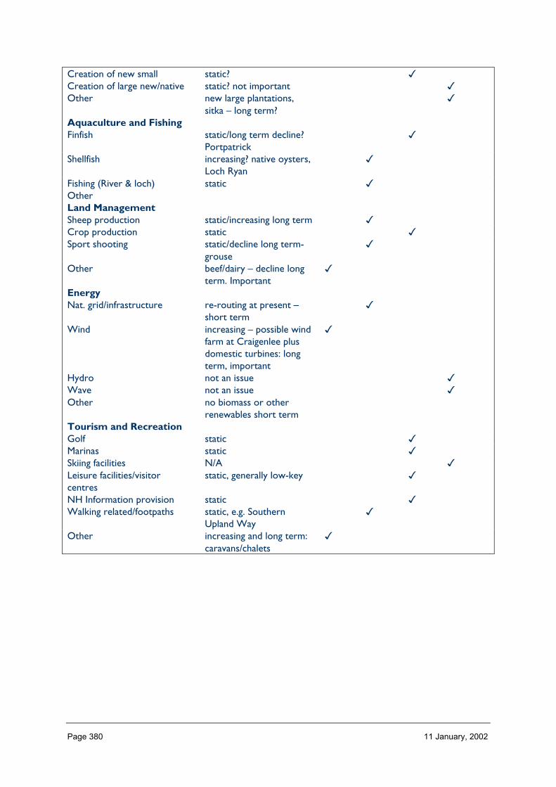
Page 380 11 January, 2002
Creation of new small static? �Creation of large new/native static? not important �Other new large plantations,
sitka – long term?�
Aquaculture and FishingFinfish static/long term decline?
Portpatrick�
Shellfish increasing? native oysters,Loch Ryan
�
Fishing (River & loch) static �OtherLand ManagementSheep production static/increasing long term �Crop production static �Sport shooting static/decline long term-
grouse�
Other beef/dairy – decline longterm. Important
�
EnergyNat. grid/infrastructure re-routing at present –
short term�
Wind increasing – possible windfarm at Craigenlee plusdomestic turbines: longterm, important
�
Hydro not an issue �Wave not an issue �Other no biomass or other
renewables short termTourism and RecreationGolf static �Marinas static �Skiing facilities N/A �Leisure facilities/visitorcentres
static, generally low-key �
NH Information provision static �Walking related/footpaths static, e.g. Southern
Upland Way�
Other increasing and long term:caravans/chalets
�

Page 381 11 January, 2002
4 Building a sustainable future
Landscape influences and trends in Zone 19 (Table 3)
Aspects ofimportance ofthe zonallandscape
(Table 2)
1Builtdevelopment
2Tourismandrecreation
3Landmanagement
4Energy(turbines,hydro)
5Telecoms
A. Landscapecharacterdiversity, anddistinctiveness(Scotland)B. Social (zones)and economic(Scotland)C. Recreationaland amenity(Scotland)D. NSAs andHGDLs (Scotland)AGLVs (zone)E. Culturalimportance (GB)
General landscape objectives required
Specific landscape objectives required

Page 382 11 January, 2002
ZONE 19 WESTERN SOUTHERN UPLANDS & INNERSOLWAY
1 Nature of the landscape resource
Diversity, distribution and rarity of landscape character in the zoneNote: Ignore any LCT which is shown as <10 km sq (if important feature will be coveredelsewhere, if important characteristic locally will be flagged up in description)
Table 19.1 Diversity
Zone LCTLevel 1
LCTLevel 3
Context Area(km2)
19 Raised Beach Coast Coastal RaisedBeaches andTerraces
Coastal 4.99
19 Upper River Valleys Upland Glens,Valleys and Dales
Upland 107.95
19 Intimate Pastoral Valleys Upland Glens,Valleys and Dales
Upland 43.97
19 Upland Glen Upland Glens,Valleys and Dales
Upland 31.70
19 Upland Basin Upland Basin Upland 35.8719 Foothills Foothills and
Pronounced HillsUpland 43.42
19 Foothills with Forest Foothills andPronounced Hills
Upland 143.53
19 Plateau Moorland High PlateauMoorlands
Upland 308.00
19 Plateau Moorland withForest
High PlateauMoorlands
Upland 182.42
19 Southern Uplands Upland Hills, TheSouthern Uplandsand Cheviots
Upland 96.33
19 Southern Uplands withForest
Upland Hills, TheSouthern Uplandsand Cheviots
Upland 86.75
19 Rugged Granite Upland Rugged GraniteUplands
Highland 57.37
19 Rugged Granite Uplandwith Forest
Rugged GraniteUplands
Highland 32.07
19 Ayrshire Lowlands Lowland Rolling orUndulatingFarmlands, Hills andValleys
Lowland 50.82
19 Lowland River Valleys Lowland RiverValleys
Lowland 2.58
19 Upper Dale (Valley) Upland Glens,Valleys and Dales
Upland 209.66
19 Upland Glens Upland Glens,Valleys and Dales
Upland 66.81

Page 383 11 January, 2002
19 Moss and ForestLowland
Lowland Plateauxand Plains
Lowland 44.30
19 Drumlin Pasture inMoss and MoorLowland
Drumlin Lowlands Lowland 120.36
19 Drumlin Pastures Drumlin Lowlands Lowland 438.8219 Coastal Plateau Coastal Hills
Headlands Plateauxand Moorlands
Coastal 44.60
19 Flow Plateau Coastal HillsHeadlands Plateauxand Moorlands
Coastal 76.85
19 Upland Fringe Upland FringeValleys andFarmlands
Upland 466.19
19 Plateau Moorland High PlateauMoorlands
Upland 230.12
19 Plateau Moorland withForest
High PlateauMoorlands
Upland 293.00
19 Peninsula with GorseyKnolls
Rocky Coasts Cliffsand Braes of theLowlands
Coastal 12.91
19 Foothills Foothills andPronounced Hills
Upland 305.27
19 Foothills with Forest Foothills andPronounced Hills
Upland 521.74
19 Southern Uplands Upland Hills, TheSouthern Uplandsand Cheviots
Upland 386.60
19 Southern Uplands withForest
Upland Hills, TheSouthern Uplandsand Cheviots
Upland 196.41
19 Coastal GraniteUplands
Coastal HillsHeadlands Plateauxand Moorlands
Coastal Upland 281.50
19 Rugged Granite Upland Rugged GraniteUplands
Highland 250.78
19 Rugged Granite Uplandwith Forest
Rugged GraniteUplands
Highland 48.46
19 Coastal Flats Lowland CoastalFlats Sands andDunes
Coastal 250.58
19 Shallow Flat BottomedValley
Flatter WiderValleys andFloodplains of theLowlands
Lowland 6.00
19 Narrow Wooded RiverValleys
Narrow Valleys inthe Lowlands
Lowland 92.88
19 Intimate Pastoral Valley Upland Glens,Valleys and Dales
Lowland 46.39
19 Lower Dale (Valley) Lowland RiverValleys
Lowland 189.53
19 Middle Dale (Valley) Narrow Valleys in Lowland 199.40

Page 384 11 January, 2002
the Lowlands19 Flooded Valley Flatter Wider
Valleys andFloodplains of theLowlands
Lowland 45.60
19 Upland River Valleys Upland Glens,Valleys and Dales
Upland 57.59
19 Broad Valley Upland Upland Glens,Valleys and Dales
Upland 77.61
19 Upland Glen Upland Glens,Valleys and Dales
Upland 13.86
19 Foothills Foothills andPronounced Hills
Upland 125.56
19 Plateau Moorland High PlateauMoorlands
Upland 200.99
19 Southern Uplands Upland Hills, TheSouthern Uplandsand Cheviots
Upland 176.10
19 Plateau Farmland Lowland Plateauxand Plains
Lowland 8.59
Total 6712.83
The number of landscape character types represented in Zone 19 at level 1 is 47 (of which are 4 are <10 km2, or 43 are >10 km2). Thesecan be grouped into 15 at level 3 and their context is upland. (rocky and sandy coasts and raised beaches; coastal hills; upland and granitehills; upland valleys and basins; foothills and upland fringe; plateau moorlands; lowland farmland; lowland valleys, floodplains and plains;drumlin lowlands) No. of LCTs (Level 1)/Area of Zone in Zone 19 is 0.007. This gives an indication of the overall diversity of landscapecharacter in the zone and can be compared between zones.
Tabe 19.2 Distribution/pattern
Zone LCTLevel 1
LCTLevel 3
% ofZone(area)
No. ofOccurrences
Area(km2)
19 Raised BeachCoast
Coastal RaisedBeaches andTerraces
0.1 1 4.99
19 Upper RiverValleys
Upland Glens,Valleys and Dales
1.6 6 107.95
19 Intimate PastoralValleys
Upland Glens,Valleys and Dales
0.7 3 43.97
19 Upland Glen Upland Glens,Valleys and Dales
0.5 3 31.70
19 Upland Basin Upland Basin 0.5 1 35.8719 Foothills Foothills and
Pronounced Hills0.6 3 43.42
19 Foothills withForest
Foothills andPronounced Hills
2.1 4 143.53
19 PlateauMoorland
High PlateauMoorlands
4.6 8 308.00
19 PlateauMoorland withForest
High PlateauMoorlands
2.7 4 182.42
19 Southern Upland Hills, The 1.4 4 96.33
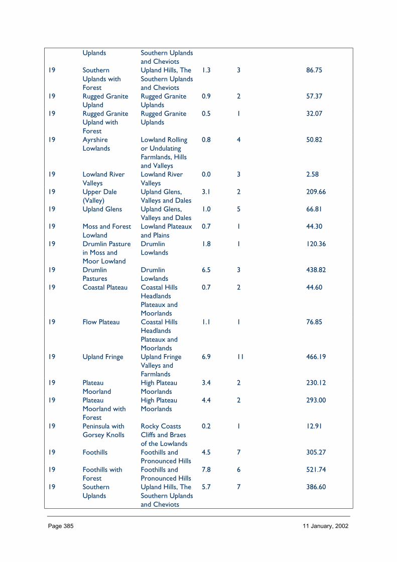
Page 385 11 January, 2002
Uplands Southern Uplandsand Cheviots
19 SouthernUplands withForest
Upland Hills, TheSouthern Uplandsand Cheviots
1.3 3 86.75
19 Rugged GraniteUpland
Rugged GraniteUplands
0.9 2 57.37
19 Rugged GraniteUpland withForest
Rugged GraniteUplands
0.5 1 32.07
19 AyrshireLowlands
Lowland Rollingor UndulatingFarmlands, Hillsand Valleys
0.8 4 50.82
19 Lowland RiverValleys
Lowland RiverValleys
0.0 3 2.58
19 Upper Dale(Valley)
Upland Glens,Valleys and Dales
3.1 2 209.66
19 Upland Glens Upland Glens,Valleys and Dales
1.0 5 66.81
19 Moss and ForestLowland
Lowland Plateauxand Plains
0.7 1 44.30
19 Drumlin Pasturein Moss andMoor Lowland
DrumlinLowlands
1.8 1 120.36
19 DrumlinPastures
DrumlinLowlands
6.5 3 438.82
19 Coastal Plateau Coastal HillsHeadlandsPlateaux andMoorlands
0.7 2 44.60
19 Flow Plateau Coastal HillsHeadlandsPlateaux andMoorlands
1.1 1 76.85
19 Upland Fringe Upland FringeValleys andFarmlands
6.9 11 466.19
19 PlateauMoorland
High PlateauMoorlands
3.4 2 230.12
19 PlateauMoorland withForest
High PlateauMoorlands
4.4 2 293.00
19 Peninsula withGorsey Knolls
Rocky CoastsCliffs and Braesof the Lowlands
0.2 1 12.91
19 Foothills Foothills andPronounced Hills
4.5 7 305.27
19 Foothills withForest
Foothills andPronounced Hills
7.8 6 521.74
19 SouthernUplands
Upland Hills, TheSouthern Uplandsand Cheviots
5.7 7 386.60
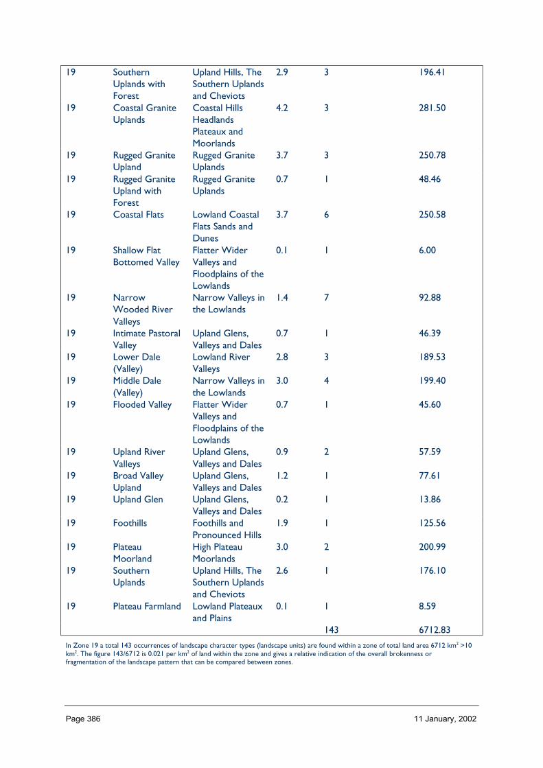
Page 386 11 January, 2002
19 SouthernUplands withForest
Upland Hills, TheSouthern Uplandsand Cheviots
2.9 3 196.41
19 Coastal GraniteUplands
Coastal HillsHeadlandsPlateaux andMoorlands
4.2 3 281.50
19 Rugged GraniteUpland
Rugged GraniteUplands
3.7 3 250.78
19 Rugged GraniteUpland withForest
Rugged GraniteUplands
0.7 1 48.46
19 Coastal Flats Lowland CoastalFlats Sands andDunes
3.7 6 250.58
19 Shallow FlatBottomed Valley
Flatter WiderValleys andFloodplains of theLowlands
0.1 1 6.00
19 NarrowWooded RiverValleys
Narrow Valleys inthe Lowlands
1.4 7 92.88
19 Intimate PastoralValley
Upland Glens,Valleys and Dales
0.7 1 46.39
19 Lower Dale(Valley)
Lowland RiverValleys
2.8 3 189.53
19 Middle Dale(Valley)
Narrow Valleys inthe Lowlands
3.0 4 199.40
19 Flooded Valley Flatter WiderValleys andFloodplains of theLowlands
0.7 1 45.60
19 Upland RiverValleys
Upland Glens,Valleys and Dales
0.9 2 57.59
19 Broad ValleyUpland
Upland Glens,Valleys and Dales
1.2 1 77.61
19 Upland Glen Upland Glens,Valleys and Dales
0.2 1 13.86
19 Foothills Foothills andPronounced Hills
1.9 1 125.56
19 PlateauMoorland
High PlateauMoorlands
3.0 2 200.99
19 SouthernUplands
Upland Hills, TheSouthern Uplandsand Cheviots
2.6 1 176.10
19 Plateau Farmland Lowland Plateauxand Plains
0.1 1 8.59
143 6712.83
In Zone 19 a total 143 occurrences of landscape character types (landscape units) are found within a zone of total land area 6712 km2 >10km2. The figure 143/6712 is 0.021 per km2 of land within the zone and gives a relative indication of the overall brokenness orfragmentation of the landscape pattern that can be compared between zones.
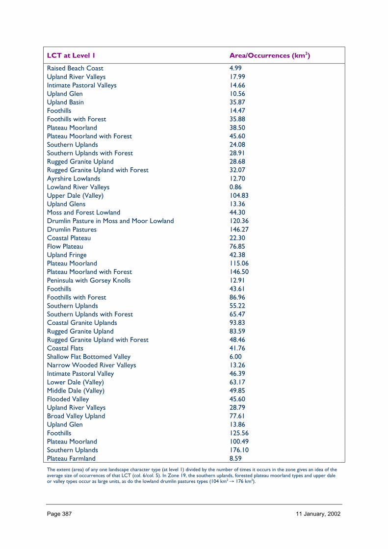
Page 387 11 January, 2002
LCT at Level 1 Area/Occurrences (km2)
Raised Beach Coast 4.99Upland River Valleys 17.99Intimate Pastoral Valleys 14.66Upland Glen 10.56Upland Basin 35.87Foothills 14.47Foothills with Forest 35.88Plateau Moorland 38.50Plateau Moorland with Forest 45.60Southern Uplands 24.08Southern Uplands with Forest 28.91Rugged Granite Upland 28.68Rugged Granite Upland with Forest 32.07Ayrshire Lowlands 12.70Lowland River Valleys 0.86Upper Dale (Valley) 104.83Upland Glens 13.36Moss and Forest Lowland 44.30Drumlin Pasture in Moss and Moor Lowland 120.36Drumlin Pastures 146.27Coastal Plateau 22.30Flow Plateau 76.85Upland Fringe 42.38Plateau Moorland 115.06Plateau Moorland with Forest 146.50Peninsula with Gorsey Knolls 12.91Foothills 43.61Foothills with Forest 86.96Southern Uplands 55.22Southern Uplands with Forest 65.47Coastal Granite Uplands 93.83Rugged Granite Upland 83.59Rugged Granite Upland with Forest 48.46Coastal Flats 41.76Shallow Flat Bottomed Valley 6.00Narrow Wooded River Valleys 13.26Intimate Pastoral Valley 46.39Lower Dale (Valley) 63.17Middle Dale (Valley) 49.85Flooded Valley 45.60Upland River Valleys 28.79Broad Valley Upland 77.61Upland Glen 13.86Foothills 125.56Plateau Moorland 100.49Southern Uplands 176.10Plateau Farmland 8.59
The extent (area) of any one landscape character type (at level 1) divided by the number of times it occurs in the zone gives an idea of theaverage size of occurrences of that LCT (col. 6/col. 5). In Zone 19, the southern uplands, forested plateau moorland types and upper daleor valley types occur as large units, as do the lowland drumlin pastures types (104 km2 → 176 km2).
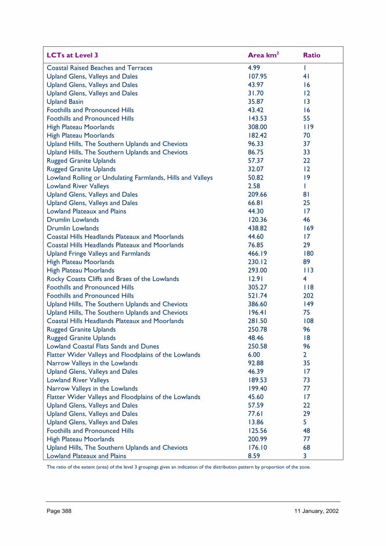
Page 388 11 January, 2002
LCTs at Level 3 Area km2 Ratio
Coastal Raised Beaches and Terraces 4.99 1Upland Glens, Valleys and Dales 107.95 41Upland Glens, Valleys and Dales 43.97 16Upland Glens, Valleys and Dales 31.70 12Upland Basin 35.87 13Foothills and Pronounced Hills 43.42 16Foothills and Pronounced Hills 143.53 55High Plateau Moorlands 308.00 119High Plateau Moorlands 182.42 70Upland Hills, The Southern Uplands and Cheviots 96.33 37Upland Hills, The Southern Uplands and Cheviots 86.75 33Rugged Granite Uplands 57.37 22Rugged Granite Uplands 32.07 12Lowland Rolling or Undulating Farmlands, Hills and Valleys 50.82 19Lowland River Valleys 2.58 1Upland Glens, Valleys and Dales 209.66 81Upland Glens, Valleys and Dales 66.81 25Lowland Plateaux and Plains 44.30 17Drumlin Lowlands 120.36 46Drumlin Lowlands 438.82 169Coastal Hills Headlands Plateaux and Moorlands 44.60 17Coastal Hills Headlands Plateaux and Moorlands 76.85 29Upland Fringe Valleys and Farmlands 466.19 180High Plateau Moorlands 230.12 89High Plateau Moorlands 293.00 113Rocky Coasts Cliffs and Braes of the Lowlands 12.91 4Foothills and Pronounced Hills 305.27 118Foothills and Pronounced Hills 521.74 202Upland Hills, The Southern Uplands and Cheviots 386.60 149Upland Hills, The Southern Uplands and Cheviots 196.41 75Coastal Hills Headlands Plateaux and Moorlands 281.50 108Rugged Granite Uplands 250.78 96Rugged Granite Uplands 48.46 18Lowland Coastal Flats Sands and Dunes 250.58 96Flatter Wider Valleys and Floodplains of the Lowlands 6.00 2Narrow Valleys in the Lowlands 92.88 35Upland Glens, Valleys and Dales 46.39 17Lowland River Valleys 189.53 73Narrow Valleys in the Lowlands 199.40 77Flatter Wider Valleys and Floodplains of the Lowlands 45.60 17Upland Glens, Valleys and Dales 57.59 22Upland Glens, Valleys and Dales 77.61 29Upland Glens, Valleys and Dales 13.86 5Foothills and Pronounced Hills 125.56 48High Plateau Moorlands 200.99 77Upland Hills, The Southern Uplands and Cheviots 176.10 68Lowland Plateaux and Plains 8.59 3
The ratio of the extent (area) of the level 3 groupings gives an indication of the distribution pattern by proportion of the zone.
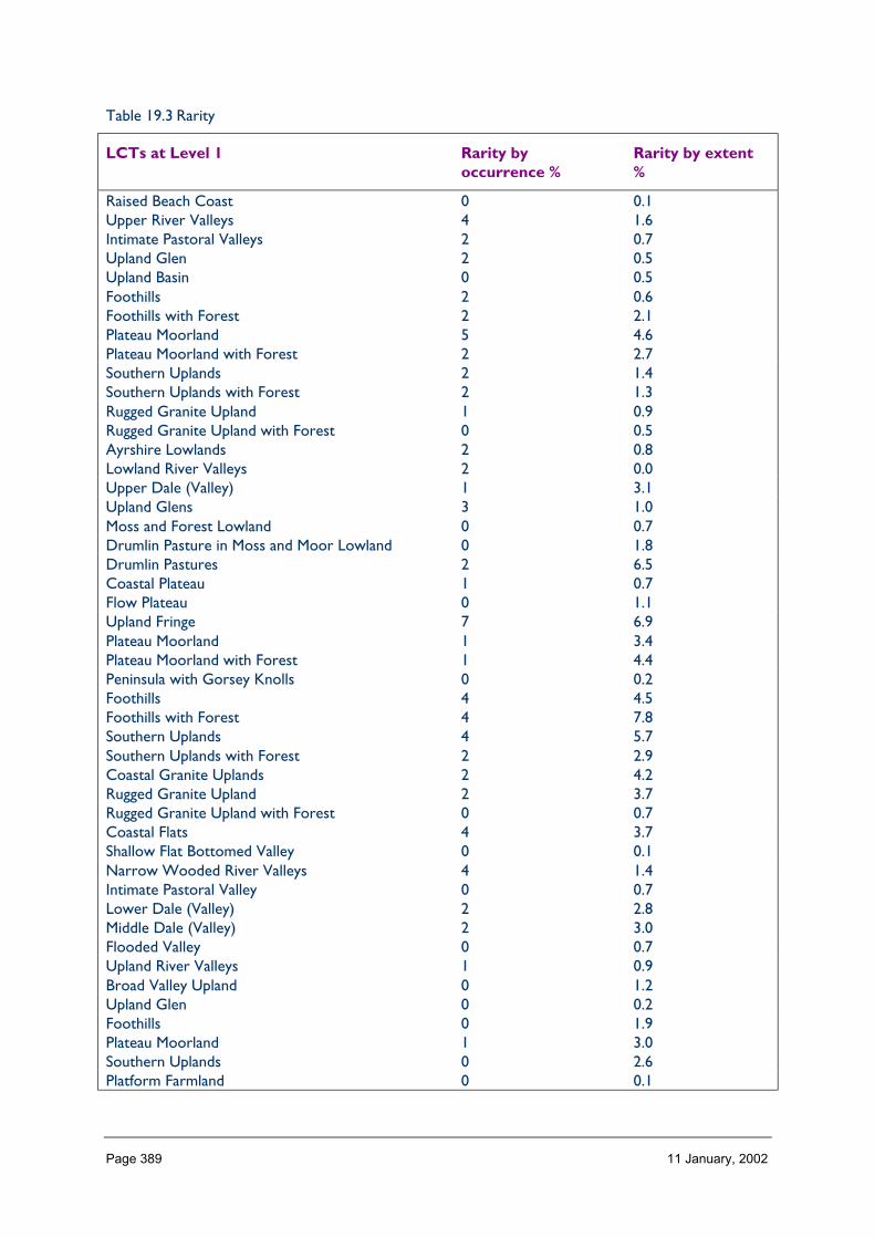
Page 389 11 January, 2002
Table 19.3 Rarity
LCTs at Level 1 Rarity byoccurrence %
Rarity by extent%
Raised Beach Coast 0 0.1Upper River Valleys 4 1.6Intimate Pastoral Valleys 2 0.7Upland Glen 2 0.5Upland Basin 0 0.5Foothills 2 0.6Foothills with Forest 2 2.1Plateau Moorland 5 4.6Plateau Moorland with Forest 2 2.7Southern Uplands 2 1.4Southern Uplands with Forest 2 1.3Rugged Granite Upland 1 0.9Rugged Granite Upland with Forest 0 0.5Ayrshire Lowlands 2 0.8Lowland River Valleys 2 0.0Upper Dale (Valley) 1 3.1Upland Glens 3 1.0Moss and Forest Lowland 0 0.7Drumlin Pasture in Moss and Moor Lowland 0 1.8Drumlin Pastures 2 6.5Coastal Plateau 1 0.7Flow Plateau 0 1.1Upland Fringe 7 6.9Plateau Moorland 1 3.4Plateau Moorland with Forest 1 4.4Peninsula with Gorsey Knolls 0 0.2Foothills 4 4.5Foothills with Forest 4 7.8Southern Uplands 4 5.7Southern Uplands with Forest 2 2.9Coastal Granite Uplands 2 4.2Rugged Granite Upland 2 3.7Rugged Granite Upland with Forest 0 0.7Coastal Flats 4 3.7Shallow Flat Bottomed Valley 0 0.1Narrow Wooded River Valleys 4 1.4Intimate Pastoral Valley 0 0.7Lower Dale (Valley) 2 2.8Middle Dale (Valley) 2 3.0Flooded Valley 0 0.7Upland River Valleys 1 0.9Broad Valley Upland 0 1.2Upland Glen 0 0.2Foothills 0 1.9Plateau Moorland 1 3.0Southern Uplands 0 2.6Platform Farmland 0 0.1

Page 390 11 January, 2002
The rarity of a landscape character type within the zone can be identified by the number of time it occurs or its extent. Examination ofboth the number of occurrences (of a LCT) as a percentage of the total and the area (of a LCT) as a percentage of the total area will givean indication of rarity. (col 5/total col. 5%) (col. 6/total col. 6%).
PROFILE
Western Southern Uplands & Inner Solway generally comprises a series of upland massifs ofundulating, rounded, domed, conical and craggy hills, drumlins, peninsulas and plateauxseparated by valleys, dales and glens of varying cross-sections, tending to open to coastalflats at the Solway shore and raised beach at the Clyde shore.
SEQUENCE
Variation occurs both along-shore and from the shore inland. Valleys are broadly alignednorth-south in the south of the zone. The Southern Upland Fault introduces a parallel seriesof valley alignments (approximately south west to north east) to the north of the zonewhich bisect the north-south valleys. Drumlin landscapes typify the south west of the zoneand the highest peaks are found in the centre, with the exception of the coastal granite hillsthat separate the low-lying river mouths. To the north, the hills are replaced by lowerplateaux.
SCALE
The scale varies greatly, from the extremes of narrow intimate valleys through wide dales tolarge scale domed hills of the Southern Uplands to the wide open coastal areas.
LANDMARK FEATURES
Wind farms at Hagshaw Hill (by Douglas) and Windy Standard (by New Cumnock).
Coastal sands and channels
Loch Ken
Tinto Hill
Criffel
Nick of the Balloch
Lighthouse at Southerness Point
EXPERIENCE
Roads tend to follow the Solway coast or the valleys. Orientation is confused in the north ofthe zone where the north–south routes zigzag across the parallel tears of the SouthernUpland Fault valleys. Owing to the number of valleys, there are few high roads providingviews down to lower ground.
Containment (created by landform and land cover)
TOPOGRAPHY
Over half the zone is below 200 m in elevation, concentrated at the Inner Solway hinterlandand up the main valleys. None of the area is higher than 800 m. The highest quartile(300–800 m) is concentrated in a band across the centre of the zone, sliced into threeblocks (Merrick range extended to Cairnsmore of Fleet, the central hills east of Cairnsmore

Page 391 11 January, 2002
marked by Windy Standard wind farm, and the Lowther Hills). As would be expected, thesteepest slopes are found in hills of the central core, while the flattest areas are found incertain LCTs typified by wide flat valley bottoms. Aspect varies – the line of the SouthernUpland Fault and its associated parallel valleys are distinct features, and the south-westnorth-east trend is also followed by the Solway Firth. However, although this grain appearsfrom small scale aerial maps to be reflected in the hills across the zone, this is not readilyapparent on the ground. Instead, driving through the area one is more aware of thedissecting radii of the valleys cutting across the grain.
LAND COVER
The zone has less arable than the average for Scotland, but much more coniferousplantation, rough grazing and improved grazing. Heather moorland is less common thanother zones. Built development tend to occur along the coast in varying locations and atriver crossings or communication junctions.
VISIBILITY
This varies widely: within the dissected uplands, views tend to be limited along the valleys;along the indented coast views may be very wide southwards out to the Solway, or limitedto the opposite shore of the estuary; public roads over the hilltops are limited in number,and one must walk for panoramic views in all directions.
MICROCLIMATIC EFFECTS
The zone differs widely in its snow cover and exposure to winds. both north-south andvalley bottom to hill top. Coastal trees are bevelled. Rivers flood regularly in some southernlowland valleys and notably at Dumfries. In deep east-west valleys in the north of the zone,there is a marked contrast between the sunny south facing slopes and the shaded northfacing slopes.
EXPERIENCE
The sense of containment (or exposure) is affected largely by the topography (valley/upland)and especially the relationship to the exposed Solway coast, except in areas typified bycommercial conifer plantations that have not yet been restructured, where views arechannelled and limited.
Accessibility
DISTANCE
The area is readily accessible within 3 hours from the population centres of Glasgow andEdinburgh, and the north of England. None of the zone is isolated from a road, and verylittle (less than 1% of the area) is more than 8 km from a road – the most remote areas areto be found in the Merrick range centred on Mullwharchar.
PHYSICAL ACCESS
The commercial conifer forests owned by the Forestry Commission provides free access onits tracks to many hills for walkers and mountain bikers. Many paths have faint paths to thesummit. The Southern Upland Way crosses west-east, using minor roads where no pathsexist. Although it is not possible to walk continuously along the shore, access at points iseasy except at military installations. Care must be taken on beaches at low tide to avoidbeing cut off, as the tide waters appear to rise up out of the sand, rather than coming in –

Page 392 11 January, 2002
and walkers can be surprised. At the north of the zone, the open cast coal mining areas arelocally important for recreation, as former deep miners traditionally walked a great deal.Drove roads are potentially important north-south pedestrian links between east-westcommunication routes, and some paths to Covenanters sites are used as conventicles arestill held outdoors.
CULTURAL ACCEPTANCE
At popular beaches, a charge may be made for parking in the summer, and at Southernessthe parking restrictions set by holiday home owners and businesses suggests visitors are notwelcome. Generally a good level of acceptance of responsible open access on hill land(though there are certain land owners who do not welcome public access), less so onenclosed farmland. The commercial conifer forests owned by the Forestry Commissionprovides free access on its tracks to many hills for walkers and mountain bikers, especially inthe Galloway Forest Park. There are several designed landscapes and gardens open to thepublic. Access is discouraged during the shooting season. Covenanters, and other near-legendary people and groups, relied on (secret and free) movement across the countryside,and this culture remains today to a certain extent.
VISUAL ACCESS
Roads along the valleys and along the coast make it easy it to see into and appreciate thelandscape of the zone, except where conifer plantations restrict the view. The Merrickrange forms a circle of hills, and the core can only be viewed on foot from the surroundingpeaks. Views of the Lake District peaks and coastal industrial features (and their lighting) arecomponents of the Solway landscape experience in clear weather, day and night.
EXPERIENCE
The exposed coast, with its huge skies, wide views and shifting channels, its memories ofdangerous sands, give opportunities for what could be described as a wild sea experiencefrom dry land. Much of the coastal experience is also weather dependent, and magnified bythe scale. The zone attracts artists and craftsmen, many of whom respond directly to theirsurroundings. Despite the lack of a Munro, the zone attracts walkers who appreciate aquieter day on the hills on varied terrain.
The commercially forested areas, with their sheltered and signed-posted path and tracknetworks through conifer plantations, provide an apparently safer experience of theoutdoors and the (largely sitka based) natural heritage.
Land cover (including vegetation and land use)
VEGETATION
The area has much less arable than the average for Scotland, but more than twice theaverage coniferous plantation (and felled woodland as these areas are restructured in turn)– many upland LCTs are forested subtypes. Rough grazing (usually the landcover prior toafforestation) is also more common than the average, but heather moorland – especiallycombined with peat – is less evident except in the northern hills of the zone. The high levelof improved grazing in the lowland LCTs may reflect the milder climate and longer growingseason. Water is less characteristic than some other zones, and despite the coast, dunes arenot a notable feature except near Southerness.
Page 393 11 January, 2002
EXPOSED ROCK
Exposed rock is largely found only in quarries and at a few coastal promontories such asSoutherness.
BUILT DEVELOPMENT
Settlements vary in their location and pattern according to their original rationale. Coachingtowns may mark river crossings, and are typified by ribbon development along the mainroad, as at New Galloway or formal geometric layout parallel to the main axis, as at CastleDouglas – which was also one of a chain of towns along the former railway from Carlisle toStranraer. Gretna Green developed around the ‘industry’ of marriages immediately north ofthe border with England, and has a strong local identity due to its function rather than itsappearance. Mining communities (typically with a high proportion of Local Authorityhousing) serve past and present mining in the north of the zone, as at Kirkconnel, Muirkirkand Douglas Water – and may be removed because of it (for example, Glenbuck: birth placeof ‘football legend’ Bill Shankley). Lead mining at Wanlockhead resulted in a settlement thatis at a higher elevation than typical of the zone. The largest town is Dumfries. The A75bypasses the towns along its route, as does the M74 – with these improvements, thecontribution of the settlements to the experience of the wider landscape has been reduced.
Typically, the traditional building material used reflects the local geology or building stone,with different colours characteristic in different LCTs. Each settlement has a strong localidentity, although standard catalogue kit houses are weakening this distinctiveness across thezone.
Farm settlements tend to have a central steading with wings forming a courtyard, with moremodern ancillary buildings separate from this group, although usually parallel to the wings.
The great houses at the core of designed landscapes are a feature of the landscape in thelowland LCTs dominated by pastoral land use (such as Drumlanrig) and typically (but notexclusively) take advantage of seaward or hillward views.
Coastal resorts are generally not a feature.
EXPERIENCE
The contribution of built settlement within the rich mosaic of landform and landcover –largely determined by the agricultural land use or the forestry that replaces uneconomicagriculture – highlights the interrelationship between the landscape and those who live andwork in it. This relationship is also marked by the high number of artists and craftsmenworking in the area, many of whom are strongly responsive to the landscapes of the area.
Hydrology and water bodies
TYPE
Lochs in the north of the zone are typically dammed as part of the water supply forAyrshire and Glasgow e.g. Loch Doon. Lochs in the central part of the zone on the RiverDee are dammed in sequence for power generation. In the Merrick area, e.g.Clatteringshaws Loch, Glen Trool, the water bodies are unmodified. Other natural lochs aresmall.
Page 394 11 January, 2002
Notable waterfalls are found at Glen Trool (the Buchan Falls, the Falls of Minnoch and Fallsof Gairland Burn) and by Thornhill (the Grey Mare’s Tail at Closeburn, Glenmarlin Falls, andCrichope Linn. There is another Grey Mare’s Tail at Talnotry by Newton Stewart – thename is a common one in the Pictish-Celtic parts of Scotland, not because the falls resemblea horse’s tail (not all do) but because it is the English pronunciation of Greith Mear Eas TadhAil – ‘the glistening cascade rushing forth from the rocky ledge’.
PATTERN
In the north of the zone, watercourses have exploited the Southern Upland Fault and itsparallel valleys to flow generally west; to the south the rivers drain ultimately to the Solway,but the lattice of deep east-west valleys disguise this.
EXPERIENCE
The authors Dorothy L Sayers, John Buchan, Burns and Scott are associated with variouswatercourses or waterbodies, and Covenanters may have chosen waterfalls as hiding places– visitors may be attracted to various sites for these reasons as much as their naturalbeauty. The distinctive 1930s buildings associated with the River Dee hydro-electricschemes are notable landmarks. Hidden lochs are a feature of the hill walks of the Merrickrange. Several lochs are used for recreation such as angling. The extensive Loch Ken and theDee Marshes attract people keen on water sport, bird watching etc. The cluster of lochs inthe Machairs are to be seen off minor roads – their naturalness contributes to the wild landcharacter of the locality
Built and infrastructure development (present day)
NATURE AND PATTERN OF SETTLEMENT
Settlements vary in their location and pattern according to their original rationale. Coachingtowns mark river crossings, and are typified by ribbon development along the main road, asat New Galloway or formal geometric layout parallel to the main axis, as at Castle Douglas– which was also one of a chain of towns along the former railway from Carlisle toStranraer. Gretna Green developed around the ‘industry’ of marriages immediately north ofthe border with England, and has a strong local identity due to its function rather than itsappearance. Mining communities (typically with a high proportion of Local Authorityhousing) serve past and present mining in the north of the zone, as at Kirkconnel, Muirkirkand Douglas Water (partly Zone 17) – and may be removed because of it (for example,Glenbuck, birth place of ‘football legend’ Bill Shankley). Lead mining at Wanlockheadresulted in a settlement that is at a higher elevation than typical of the zone. The largesttown is Dumfries. The A75 bypasses the towns along its route, as does the M74 – withthese improvements, the contribution of the settlements to the experience of the widerlandscape has been reduced. Farm settlements tend to be situated on hills. The great housesat the core of designed landscapes are a feature of the landscape in the lowland LCTsdominated by pastoral land use (such as Drumlanrig) and typically (but not exclusively) takeadvantage of seaward or hillward views. Coastal resorts are generally not a feature.
NATURE AND PATTERN OF INFRASTRUCTURE
Power lines transmit energy from the hydro electric scheme at Loch Dee.
The south of the zone is dominated by the A75 EuroRoute which runs east-west along amodern alignment bypassing most towns, and utilising the bed of the former railway in

Page 395 11 January, 2002
places; the high voltage power line runs parallel, as does the old military road. To the east,the M74 running north-south similarly is a key feature, and similarly is mirrored by thepowerline of the Anglo-Scottish electricity Interconnector, and a major Intercity railway line.A minor rail line from Carlisle passes behind the Inner Solway to Dumfries and thence northto Kilmarnock and Glasgow. The Scotland – Northern Ireland electricity Interconnector willrun across the north of the zone, in part utilising the intimate valley of the Southern UplandFault to minimise visual impact.
NATURE AND PATTERN OF INDUSTRIAL DEVELOPMENT
The zone is not noted for large scale industrial development except around Dumfries and atthe nuclear power station near Annan, that is a feature of the Inner Solway. Quarriesexploit rock at Dalbeattie and in the Beattock/Moffat area, where the motorwayconstruction has provided a ready local market. Open cast coal mining typifies the north ofthe zone, within East Ayrshire, South Lanarkshire and more recently Nithsdale. Wind farmat Windy Standard, Carsphairn.
EXPERIENCE
The power station near Annan has a scale and presence that emphasises the local large scalelandscape, and its cooling towers’ clouds are an ever-present feature. The turbines of WindyStandard line the horizon above New Cumnock, and in winter are seen looming through thesmoke of coal fires in a curious demonstration of contrasting energy forms. The open castareas have a distinctive experience – boarded up shops point to high unemployment ratesthat would suggest short-term job creation in the mining industry would be welcome, butcyclical destruction of local landscapes that give a sense of place close to homes is a long-term negative factor in areas noted for their strong sense of community. Typically, thetraditional building material used reflects the local geology or building stone, with differentcolours characteristic in different LCTs. Each settlement has a strong local identity, althoughstandard catalogue kit houses are weakening this distinctiveness across the zone.
Visible history (past settlement, landuse, churches, brochs, forts, dykes, standingstones etc.)
TYPES OF VISIBLE HISTORY
The Solway hinterland is wealthy in pre-Christian remains such as forts, standing stones andburial cairns – Cairn Holy being particularly evocative. But forts, duns, stones, cairns and hutcircles are also found on higher ground throughout the zone. Medieval runrig field patternsare visible in areas previously cultivated but now rough grazing, and mottes are notuncommon in the long-settled Solway lowlands. There are numerous castles, tower houses,designed landscapes and abbeys especially in the west coastal area. Covenanting memorialsare to be found throughout the zone. The geometric nature of the majority of the lowlandfields reflect the Improvement period, but drystone dykes are common some LCTs. Theabandoned settlement at Polmaddie (near New Galloway) is interpreted by a ForestryCommission leaflet. Visible history is generally not present in areas that have been thesubject of open cast coal mining. except for isolated point features such as monuments.
LOCATION/PATTERN
Visible history can be found in much of the zone, but particularly along the Solway coastlineand its immediate hinterland. Other features tend to relate to ancient long-distancecommunication routes e.g. an alleged Pilgrims’ route to Whithorn, pack tracks etc.
Page 396 11 January, 2002
EXPERIENCE
Visible history gives much of the south western part of the zone a sense of tangible time-depth, a rich palimpsest. Many features are visually prominent, and add to the enjoyment ofthe view.
Wildlife
FORMS OF WILDLIFE
Although raptors contribute to the experience of the central hills for many walkers, and thewetland birds of Loch Ken are a feature sought out by keen bird watchers, it is the Solwayshore at Caerlaverock, with its massive flocks of geese in season, which epitomise the InnerSolway.
LOCATION
Hills, wetlands, improved grassland and shore.
WHEN
Geese – autumn to spring.
EXPERIENCE
The scale of the flocks of geese and the noise of the birds is readily appreciated and enjoyed,even without specialist equipment or knowledge, but are well interpreted at Caerlaverockand the RSPB hides in the zone.
Climate
CLIMATIC CHARACTERISTICS
Vary widely across the zone, according to elevation and distance from the sea.
LOCATIONAL AND SEASONAL EFFECTS
Vary widely.
EXPERIENCE
Vary widely.
Designated landscapes
National Scenic Areas
CONSTITUENTS
Western Southern Uplands & Inner Solway contains 3 NSAs, the Nith Estuary (38), EastStewartry Coast (39) (majority – sliver in west is within Zone 18) and Fleet Valley (40)(inland section – coast section within Zone 18). The Nith Estuary NSA contains 3 LCTs,East Stewartry Coast contains 5 LCTs in total of which 4 are in Zone 19, and Fleet ValleyCoast contains 6 LCTs in total which are all represented.
Page 397 11 January, 2002
LOCATION AND EXTENT
All the NSAs are located along the coast at river inlets, and are amongst the smallest: NithEstuary (38) is 9,300 ha, East Stewartry Coast (39) totals 4,500 ha (Zone 19’s shareunknown) and Fleet Valley (40) totals 5,300 ha (Zone 19’s share unknown).
EXPERIENCE
The enclosing hills forms a major contribution to all three NSAs, while coastal features andtidal estuaries typify all the NSAs, including the tidal movement – the Nith Estuary has a‘horizontal scale unusual in Scotland’. All are notably visually diverse, due to the variety oflandcover.
Recreational Landscapes
Nature of landscapesBeaches, open hills, valleys forests, lochs, gardens, designed landscapes, Christian attractions,forestry, waterfalls, golf courses, boats, with the experience demonstrated at galleries andcraft workshops.
LOCATION
Much of the area, especially to the west and centre, is recreational – beaches, hills, forests,lochs, pottering from sites listed in ‘Gardens open to the public’ to historic designedlandscapes, following the brown tourist road signs with the distinctive Celtic cross to findthe Christian attractions, driving the Forest Drives opened up by the Forestry Commission,sailing at high tide, water skiing on Loch Ken, fishing, golfing.
EXPERIENCE
Although the area has much to offer, most recreational experiences are marked by theirbeing notably quieter, or less busy, than similar forms of recreation closer to Glasgow. Thisisolation is considered a well-kept secret by those who enjoy it, but is a matter of concernto the tourist industry.

Page 398 11 January, 2002
2 Importance and value of the zone landscape
Category Brief explanation oflandscape importance(if any)
Importance(GB, Scotland,zone)
Landscape Character Importancerarity several landscape types
occur once only in thezone
Scottish?
extent small LCTs scatteredwidely, extensive uplandLCTs subdivided byforestry dominance
zone?
diversity (including specific landmarks) varies – to be completed zone?pattern ditto zone?integrity ditto zone?local distinctiveness primarily at river valleys
and coastScotland?
fragility/sensitivity sensitive to forestry andopen cast coal, wide viewsat coast give it sensitivityto prominent devt
Scotland?
Scenic importancequalities visually diverse coast Scotland?perceptions few distinctive peaks and
inland lochs or elsecentral zone would havebeen NSA
zone?
Learning ImportanceEnvironmental Education ? ?Interpretation ? ?Enjoyment ImportanceRecreation golf, walking, visiting
houses & gardens, birdwatching
Scotland?
Amenitywildness and tranquillity a form of wildness can be
found at coast and hillszone?
arts, crafts, poetry, literature, music active arts & crafts, music(mining)
Scotland?
DesignationsNSAs coastal Scotland?AGLVs N/ARegional Landscape Designations robustly determined zoneHistoric Gardens & Designed Landscapes lowland parts of zone ScotlandCultural Importancepre history (designated/non-designated) wealth of sites Scotland?medieval (designated/non-designated) wealth of sites esp
ecclesiasticalScotland?
recent (designated/non-designated) textile mills, militaryheritage
Scotland?
Socioeconomic Importance

Page 399 11 January, 2002
social Gretna Green is unique, ifunlovely
Scotland?
economic forestry, industrial Scotland?
3 Landscape and trends in the zone
Pressures/influences which have a particular effect on the landscape of the zone:
• Nature of landscape pressures/influences – a brief descriptionTrends: increasing, static or declining
− long term (> 5 years), medium term (2 to 5 years),− short term (< 2 years)
• Importance: important, not important
Pressure Nature of landscapepressures/influencesand trends withinzone, relativeimportance within thezone
Scale of landscape influence(+ve/–ve) within zone whenconsidered in
an all Scotland context
Major Inter. Minor Negligible
Built developmentResidential increasing, long term ✔Retail static ✔Industrial increasing – e.g. forestry
associated, medium term✔
Other chalets and caravans –long term
✔
Infrastructure TransportRoads and tracks increasing, significant,
medium term✔
Rail related static ✔Ferry related N/AOtherInfrastructure otherTelecoms increasing, cumulative,
medium term✔
Water treatment/abstraction static? may increasemedium term
✔
Waste management static? may increasemedium term
✔
Coastal defences static/increasing medium-long term
✔
OtherMineralsOpen cast coal increasing, significant. long
term✔
Sand and Gravel increasing, long term ✔Hard rock increasing – short term
due to M74, then✔

Page 400 11 January, 2002
slower??Peat static ✔OtherForestry and WoodlandsRestructuring of existing increasing, significant, long
term✔
Creation of new small static ✔Creation of large new/native increasing short term due
to M74✔
Other Creation of large newsitka dominatedplantations continues -long term
✔
Aquaculture and FishingFinfish static/decline of salmon
netting✔
Shellfish cockle fishing is anecological issue
✔
Fishing (River & loch) static, important ✔OtherLand ManagementSheep production decline in favour of
forestry – long term✔
Crop production static ✔Sport shooting declining esp grouse –
long term✔
OtherEnergyNat. grid/infrastructure static, but power lines are
key features✔
Wind increasing medium term,including NoFFO sites;utilise Anglo-ScottishInterconnector
✔
Hydro increasing – mediumterm, same areas valuedfor recreation
✔
Wave nil at present, but pastproposals for barragewhich long term may beresurrected
✔
Other offshore wind, important,medium term
✔
Tourism and RecreationGolf static ✔Marinas nil – unsuited ✔Skiing facilities nil – unsuitedLeisure facilities/visitorcentres
increasing long term e.g.growth of Gretna Green,forest based centres
✔
NH Information provision increasing in proportionto interest
✔
Walking related/footpaths coastal path?? drove ✔
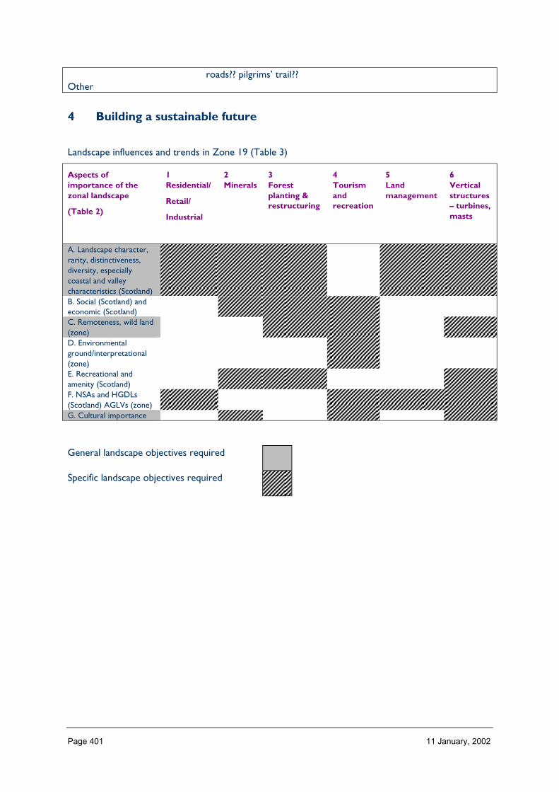
Page 401 11 January, 2002
roads?? pilgrims’ trail??Other
4 Building a sustainable future
Landscape influences and trends in Zone 19 (Table 3)
Aspects ofimportance of thezonal landscape
(Table 2)
1Residential/
Retail/
Industrial
2Minerals
3Forestplanting &restructuring
4Tourismandrecreation
5Landmanagement
6Verticalstructures– turbines,masts
A. Landscape character,rarity, distinctiveness,diversity, especiallycoastal and valleycharacteristics (Scotland)B. Social (Scotland) andeconomic (Scotland)C. Remoteness, wild land(zone)D. Environmentalground/interpretational(zone)E. Recreational andamenity (Scotland)F. NSAs and HGDLs(Scotland) AGLVs (zone)G. Cultural importance
General landscape objectives required
Specific landscape objectives required
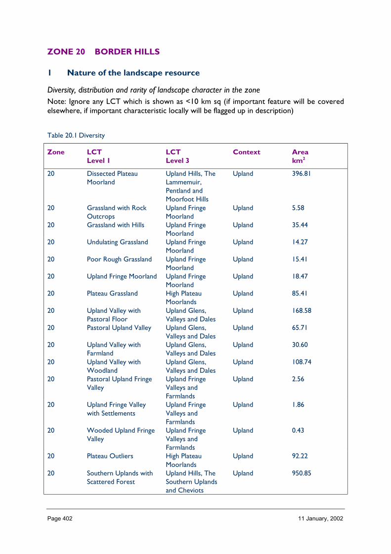
Page 402 11 January, 2002
ZONE 20 BORDER HILLS
1 Nature of the landscape resource
Diversity, distribution and rarity of landscape character in the zoneNote: Ignore any LCT which is shown as <10 km sq (if important feature will be coveredelsewhere, if important characteristic locally will be flagged up in description)
Table 20.1 Diversity
Zone LCTLevel 1
LCTLevel 3
Context Areakm2
20 Dissected PlateauMoorland
Upland Hills, TheLammemuir,Pentland andMoorfoot Hills
Upland 396.81
20 Grassland with RockOutcrops
Upland FringeMoorland
Upland 5.58
20 Grassland with Hills Upland FringeMoorland
Upland 35.44
20 Undulating Grassland Upland FringeMoorland
Upland 14.27
20 Poor Rough Grassland Upland FringeMoorland
Upland 15.41
20 Upland Fringe Moorland Upland FringeMoorland
Upland 18.47
20 Plateau Grassland High PlateauMoorlands
Upland 85.41
20 Upland Valley withPastoral Floor
Upland Glens,Valleys and Dales
Upland 168.58
20 Pastoral Upland Valley Upland Glens,Valleys and Dales
Upland 65.71
20 Upland Valley withFarmland
Upland Glens,Valleys and Dales
Upland 30.60
20 Upland Valley withWoodland
Upland Glens,Valleys and Dales
Upland 108.74
20 Pastoral Upland FringeValley
Upland FringeValleys andFarmlands
Upland 2.56
20 Upland Fringe Valleywith Settlements
Upland FringeValleys andFarmlands
Upland 1.86
20 Wooded Upland FringeValley
Upland FringeValleys andFarmlands
Upland 0.43
20 Plateau Outliers High PlateauMoorlands
Upland 92.22
20 Southern Uplands withScattered Forest
Upland Hills, TheSouthern Uplandsand Cheviots
Upland 950.85

Page 403 11 January, 2002
20 Southern UplandsForest Covered
Upland Hills, TheSouthern Uplandsand Cheviots
Upland 407.67
20 Cheviot Uplands Upland Hills, TheSouthern Uplandsand Cheviots
Uplands 77.90
20 Cheviot Foothills Foothills andPronouncedHills
Upland 6.16
20 Rolling Farmland Lowland Rolling orUndulatingFarmlands, Hills andValleys
Lowland 88.38
20 Upland Glens Upland Glens,Valleys and Dales
Upland 62.44
20 Upland Fringe Upland FringeValleys andFarmlands
Upland 19.73
20 Foothills Foothills andPronouncedHills
Upland 178.83
20 Foothills with Forest Foothills andPronouncedHills
Upland 110.01
20 Southern Uplands Upland Hills, TheSouthern Uplandsand Cheviots
Upland 263.33
20 Southern Uplands withForest
Upland Hills, TheSouthern Uplandsand Cheviots
Upland 156.58
20 Narrow Wooded RiverValleys
Narrow Valleys inthe Lowlands
Lowland 61.69
20 Intimate Pastoral Valley Upland Glens,Valleys and Dales
Lowland 31.44
20 Middle Dale (Valley) Narrow Valleys inthe Lowlands
Lowland 4.83
20 Uplands Upland Hills, TheLammemuir,Pentland andMoorfoot Hills
Upland 202.92
20 Upland Fringes Upland FringeMoorland
Upland 90.24
20 Lowland River Valleys Lowland RiverValleys
Lowland 15.69
20 Lowland Hills andRidges
Lowland Hills Lowland 0.10
20 Broad Valley Upland Upland Glens,Valleys and Dales
Upland 7.82
20 Upland Glen Upland Glens,Valleys and Dales
Upland 44.05
20 Foothills Foothills andPronouncedHills
Upland 80.19
20 Old Red Sandstone Hills Upland Hills, TheLammemuir,Pentland andMoorfoot Hills
Upland 39.53

Page 404 11 January, 2002
20 Southern Uplands Upland Hills, TheSouthern Uplandsand Cheviots
Upland 148.34
20 Platform Farmland Lowland Plateauxand Plains
Lowland 29.87
Total 4120.68
HMRRMts = High, Massive, Rolling, Rounded Mts of Highlands & Islands
HMRSSMts = High Massive, Rugged, Steep-sided Mts of Highlands & Islands
FRSSEHM = Flat or Rolling, Smooth or Sweeping, Extensive, High Moorlands of Highlands & Islands
RCUHM = Rugged, Craggy Upland Hills & Moorlands of the Highlands, including the Trossachs
PL = Peatland Landscapes of the Highlands & Islands
SL =Sea Lochs of the Highlands & Islands
The number of landscape character types represented in Zone 20 at level 1, is 39 the way they are grouped at level 3 is into 13 and theircontext is mainly upland. No. of LCTs (Level 1)/Area of Zone in Zone 20 is 0.009, this gives an indication of the overall diversity oflandscape character in the zone and can be compared between zones.
Table 20.1 Distribution/pattern
Zone LCTLevel 1
LCTLevel 3
% ofZone(area)
No. ofOccurrences
Area(km2)
20 DissectedPlateauMoorland
Upland Hills, TheLammemuir,Pentland andMoorfoot Hills
9.6 4 396.81
20 Grassland withRock Outcrops
Upland FringeMoorland
0.1 2 5.58
20 Grassland withHills
Upland FringeMoorland
0.9 4 35.44
20 UndulatingGrassland
Upland FringeMoorland
0.3 2 14.27
20 Poor RoughGrassland
Upland FringeMoorland
0.4 1 15.41
20 Upland FringeMoorland
Upland FringeMoorland
0.4 1 18.47
20 PlateauGrassland
High PlateauMoorlands
2.1 2 85.41
20 Upland Valleywith PastoralFloor
Upland Glens,Valleys and Dales
4.1 7 168.58
20 Pastoral UplandValley
Upland Glens,Valleys and Dales
1.6 3 65.71
20 Upland Valleywith Farmland
Upland Glens,Valleys and Dales
0.7 2 30.60
20 Upland Valleywith Woodland
Upland Glens,Valleys and Dales
2.6 4 108.74
20 Pastoral UplandFringe Valley
Upland FringeValleys andFarmlands
0.1 4 2.56
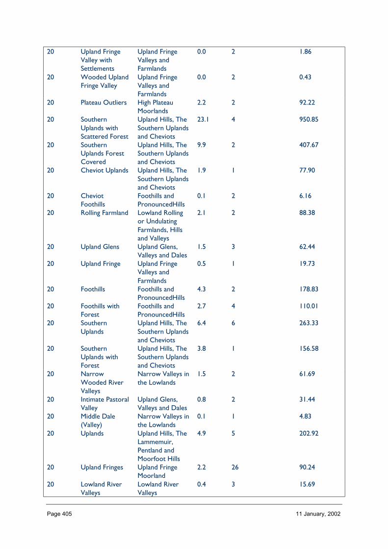
Page 405 11 January, 2002
20 Upland FringeValley withSettlements
Upland FringeValleys andFarmlands
0.0 2 1.86
20 Wooded UplandFringe Valley
Upland FringeValleys andFarmlands
0.0 2 0.43
20 Plateau Outliers High PlateauMoorlands
2.2 2 92.22
20 SouthernUplands withScattered Forest
Upland Hills, TheSouthern Uplandsand Cheviots
23.1 4 950.85
20 SouthernUplands ForestCovered
Upland Hills, TheSouthern Uplandsand Cheviots
9.9 2 407.67
20 Cheviot Uplands Upland Hills, TheSouthern Uplandsand Cheviots
1.9 1 77.90
20 CheviotFoothills
Foothills andPronouncedHills
0.1 2 6.16
20 Rolling Farmland Lowland Rollingor UndulatingFarmlands, Hillsand Valleys
2.1 2 88.38
20 Upland Glens Upland Glens,Valleys and Dales
1.5 3 62.44
20 Upland Fringe Upland FringeValleys andFarmlands
0.5 1 19.73
20 Foothills Foothills andPronouncedHills
4.3 2 178.83
20 Foothills withForest
Foothills andPronouncedHills
2.7 4 110.01
20 SouthernUplands
Upland Hills, TheSouthern Uplandsand Cheviots
6.4 6 263.33
20 SouthernUplands withForest
Upland Hills, TheSouthern Uplandsand Cheviots
3.8 1 156.58
20 NarrowWooded RiverValleys
Narrow Valleys inthe Lowlands
1.5 2 61.69
20 Intimate PastoralValley
Upland Glens,Valleys and Dales
0.8 2 31.44
20 Middle Dale(Valley)
Narrow Valleys inthe Lowlands
0.1 1 4.83
20 Uplands Upland Hills, TheLammemuir,Pentland andMoorfoot Hills
4.9 5 202.92
20 Upland Fringes Upland FringeMoorland
2.2 26 90.24
20 Lowland RiverValleys
Lowland RiverValleys
0.4 3 15.69

Page 406 11 January, 2002
20 Lowland Hillsand Ridges
Lowland Hills 0.0 1 0.10
20 Broad ValleyUpland
Upland Glens,Valleys and Dales
0.2 1 7.82
20 Upland Glen Upland Glens,Valleys and Dales
1.1 2 44.05
20 Foothills Foothills andPronouncedHills
1.9 1 80.19
20 Old RedSandstone Hills
Upland Hills, TheLammemuir,Pentland andMoorfoot Hills
1.0 1 39.53
20 SouthernUplands
Upland Hills, TheSouthern Uplandsand Cheviots
3.6 1 148.34
20 PlatformFarmland
Lowland Plateauxand Plains
0.7 1 29.87
Total 117 4120.68
In Zone 20 a total 117 occurrences of landscape character types (landscape units) are found within a zone of total land area 4120. km sq.The figure 117/4120 is 0.028 per km sq of land within the zone and gives a relative indication of the overall brokenness or fragmentationof the landscape pattern.

Page 407 11 January, 2002
LCT at Level 1 Area/Occurrences (km2)
Dissected Plateau Moorland 99.20Grassland with Rock Outcrops 2.79Grassland with Hills 8.86Undulating Grassland 7.13Poor Rough Grassland 15.41Upland Fringe Moorland 18.47Plateau Grassland 42.70Upland Valley with Pastoral Floor 24.08Pastoral Upland Valley 21.90Upland Valley with Farmland 15.30Upland Valley with Woodland 27.18Pastoral Upland Fringe Valley 0.64Upland Fringe Valley with Settlements 0.93Wooded Upland Fringe Valley 0.21Plateau Outliers 46.11Southern Uplands with Scattered Forest 237.72Southern Uplands Forest Covered 203.83Cheviot Uplands 77.90Cheviot Foothills 3.08Rolling Farmland 44.19Upland Glens 20.81Upland Fringe 19.73Foothills 89.41Foothills with Forest 27.50Southern Uplands 43.88Southern Uplands with Forest 156.58Narrow Wooded River Valleys 30.85Intimate Pastoral Valley 15.72Middle Dale (Valley) 4.83Uplands 40.58Upland Fringes 3.47Lowland River Valleys 5.32Lowland Hills and Ridges 0.1Broad Valley Upland 7.82Upland Glen 22.02Foothills 80.19Old Red Sandstone Hills 39.53Southern Uplands 148.34Platform Farmland 29.87
The extent (area) of any one landscape character type (at level 1) divided by the number of times it occurs in the zone gives an idea of theaverage size of occurrences of that LCT.
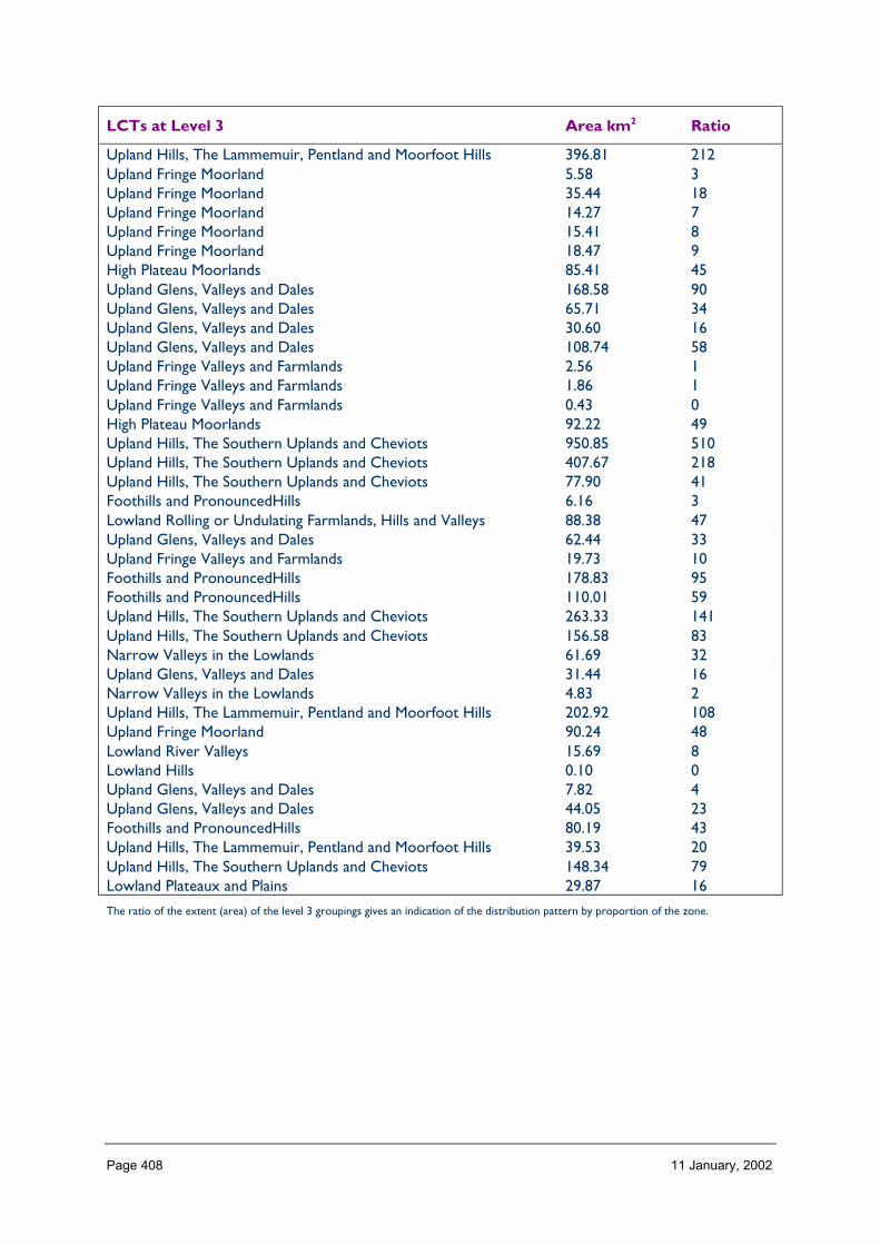
Page 408 11 January, 2002
LCTs at Level 3 Area km2 Ratio
Upland Hills, The Lammemuir, Pentland and Moorfoot Hills 396.81 212Upland Fringe Moorland 5.58 3Upland Fringe Moorland 35.44 18Upland Fringe Moorland 14.27 7Upland Fringe Moorland 15.41 8Upland Fringe Moorland 18.47 9High Plateau Moorlands 85.41 45Upland Glens, Valleys and Dales 168.58 90Upland Glens, Valleys and Dales 65.71 34Upland Glens, Valleys and Dales 30.60 16Upland Glens, Valleys and Dales 108.74 58Upland Fringe Valleys and Farmlands 2.56 1Upland Fringe Valleys and Farmlands 1.86 1Upland Fringe Valleys and Farmlands 0.43 0High Plateau Moorlands 92.22 49Upland Hills, The Southern Uplands and Cheviots 950.85 510Upland Hills, The Southern Uplands and Cheviots 407.67 218Upland Hills, The Southern Uplands and Cheviots 77.90 41Foothills and PronouncedHills 6.16 3Lowland Rolling or Undulating Farmlands, Hills and Valleys 88.38 47Upland Glens, Valleys and Dales 62.44 33Upland Fringe Valleys and Farmlands 19.73 10Foothills and PronouncedHills 178.83 95Foothills and PronouncedHills 110.01 59Upland Hills, The Southern Uplands and Cheviots 263.33 141Upland Hills, The Southern Uplands and Cheviots 156.58 83Narrow Valleys in the Lowlands 61.69 32Upland Glens, Valleys and Dales 31.44 16Narrow Valleys in the Lowlands 4.83 2Upland Hills, The Lammemuir, Pentland and Moorfoot Hills 202.92 108Upland Fringe Moorland 90.24 48Lowland River Valleys 15.69 8Lowland Hills 0.10 0Upland Glens, Valleys and Dales 7.82 4Upland Glens, Valleys and Dales 44.05 23Foothills and PronouncedHills 80.19 43Upland Hills, The Lammemuir, Pentland and Moorfoot Hills 39.53 20Upland Hills, The Southern Uplands and Cheviots 148.34 79Lowland Plateaux and Plains 29.87 16
The ratio of the extent (area) of the level 3 groupings gives an indication of the distribution pattern by proportion of the zone.

Page 409 11 January, 2002
Table 20.3 Rarity
LCTs at Level 1 Rarity byoccurrence %
Rarity by extent%
Dissected Plateau Moorland 3 9.6Grassland with Rock Outcrops 1 0.1Grassland with Hills 3 0.9Undulating Grassland 1 0.3Poor Rough Grassland 0 0.4Upland Fringe Moorland 0 0.4Plateau Grassland 1 2.1Upland Valley with Pastoral Floor 5 4.1Pastoral Upland Valley 2 1.6Upland Valley with Farmland 1 0.7Upland Valley with Woodland 3 2.6Pastoral Upland Fringe Valley 3 0.1Upland Fringe Valley with Settlements 1 0.0Wooded Upland Fringe Valley 1 0.0Plateau Outliers 1 2.2Southern Uplands with Scattered Forest 3 23.1Southern Uplands Forest Covered 1 9.9Cheviot Uplands 0 1.9Cheviot Foothills 1 0.1Rolling Farmland 1 2.1Upland Glens 2 1.5Upland Fringe 0 0.5Foothills 1 4.3Foothills with Forest 3 2.7Southern Uplands 5 6.4Southern Uplands with Forest 0 3.8Narrow Wooded River Valleys 1 1.5Intimate Pastoral Valley 1 0.8Middle Dale (Valley) 0 0.1Uplands 4 4.9Upland Fringes 22 2.2Lowland River Valleys 2 0.4Lowland Hills and Ridges 0 0.0Broad Valley Upland 0 0.2Upland Glen 1 1.1Foothills 0 1.9Old Red Sandstone Hills 0 1.0Southern Uplands 0 3.6Platform Farmland 0 0.7
The rarity of a landscape character type within the zone can be identified by the number of time it occurs or its extent. Examination ofboth the number of occurrences (of a LCT) as a percentage of the total and the area (of a LCT) as a percentage of the total area will givean indication of rarity.
PROFILE
Zone 20 consists of a central core of upland; the Lammermuir and moorfoot hills; Centraland Southern Uplands and the Cheviot Hills. These hill areas are bounded on the East andSouth by lower ground, and cover the catchment of one major river system, the Tweed andits tributaries.
Page 410 11 January, 2002
In general the profile of the landform in Zone 20 is one of uplifted mountain ranges, hillslopes and summits, e.g. southern upland hills. The form is typically smooth, rounded andconvex.
SEQUENCE
The highest ground (generally above 600 m) is located mainly to the west, around theheadwater of the Tweed and Annan, with the lower ground (below 600 m) forming theeastern boundary, and located in the valleys between the upland areas. The landform ofZone 20 has a predominantly east and north-east trend away from main upland mass intoward the coast. (Zone 16 ).
The landform creates a distinct stepped sequence, which is reflected in the 3 broadlandscape character types of Zone 20. Moving through the landscape, from West to East,the landscape character changes from the Upland hill areas, which are open, large andexposed, with high plateaus and distant, panoramic views; to the upland fringe areas, orfoothills, which exhibit a more complex morphology of mounds, hummocks and varyingslope angles. In contrast to these areas are the river valley landscapes, which run throughand link the upland (hill) and upland fringe (foothill) areas, but are typically much moreenclosed, and intimate in character.
SCALE
The scale of the landscape varies, but generally it is a large to medium scale landscape.
The large horizontal scale or expansiveness of the landscape in Zone 20, is best reflected inthe ‘remote’ open landscape of the Moor foot and Lammermuir plateaus along the Northand west boundary of Zone 20. There are panoramic distant views from the upland areasto, and across, the surrounding landscape.
Within the river valleys, where deep sided valleys separate the ridges and hills, the landscapeis often more strongly enclosed, more intimate/medium scale.
The landscape of the lower foothills (upland fringes) and the river valleys is also oftendominated by the surrounding uplands/hill areas, and there is a strong intervisualrelationship. However, these areas also retain a sense of enclosure, with more confinedviews. The smaller scale landscape of the river valleys is accentuated in places by thewooded river bluffs.
LANDMARK FEATURES
Zone 20 includes several Landform features of landmark ‘quality’.
The Cheviot Hills
Extending along the English border, forming part of the southern boundary of Zone 20, aredifferent from the remainder of the upland areas within this zone. The Cheviots aredominated by volcanic rocks which produce a distinctive landscape of conical or domeshaped summits, with steep sided river valleys. This area also contains some of the bestprehistoric landscapes in Britain with evidence of the areas strategic importance as a gateway fromEngland dating from pre-roman times, with remains of medieval agricultural systems and fortifiedhouses.
Page 411 11 January, 2002
The Pentland Hills
Although of modest height, are by virtue of their dominant location and visual prominence,important as a landscape feature, and provide a valuable and well recognised recreationalresource. The proximity of the Edinburgh city fringes, the settled river valleys and theencircling main roads emphasise the regional importance of the pentlands as a landscapefeature. The hills extend for more than 15 miles from the edge of Edinburgh, where theyoverlook the city, into Zone 20. They consist of two parallel and visually distinctive ridgelines, separated by a deep internal valley containing reservoirs.
Lammermuir and Moorfoot Plateau
Located in the north of Zone 20, are two distinctive plateau areas, consisting of a series oflevel topped hills and ridges with a distinct sense of ‘wildness’ created by wide horizons anddistant unobstructed views.
Zone 20 also has several River Valleys which make important contributions to the landscapecharacter and distinctiveness of the area.
In particular the Tweed valley between Broughton and Peebleshire, where the upper courseof the River Tweed is contained in a narrow Steepsided Valley flanked by rounded hills. Theriver valley widens at the convluxes of the Holm, yne and Manor waters/tributaries to givelonger views into the tributary Glens and the surrounding higher summits at the heads ofthe glens. The river Tweed itself is a landmark feature winding through the valley. Otherimportant examples of river valleys which form landmark features include the Upper Ettrickwhere there is a dramatic river gorge with exposed rock strata at Ettrick bridge, and theGala water valley which is prominent in the valley floor.
Fluvioglacial features are also a feature on the low ground and valleys within Zone 20, andthe glacial moraine (till) often forms locally distinctive landscape features e.g. there areparticularly fine examples of eskers, Kames and till terraces. For example those found in theupper Tweed valley around Peebles and in the Eddleston water valley. The area aroundWest Linton consists of a broad undulating corridor of land enclosed on the north andsouth by uplands with a distinctive topography of Eskers and Kaimes. Landform is thedominant element contributing to the landscape character of the area.
EXPERIENCE
The experience of the landscape varies from areas such as the plateau tops where there isan impression of considerable wildness and remoteness, and open horizons, to the valleyswhere views are restricted by topography or woodland and the scale is more intimate andsettled. In contrast to these areas, are the forest parks and associated woodland walks, withcontained views and defined routes through the landscape.
There are a number of medium distance walking routes across the landscape, and smallerones immediately around settlements, in addition to some more long distance and wellknown routes such as the Southern Upland Way.
It is possible to access and experience a full range of the landscape types of Zone 20, andthere is a distinct feeling of distance and remoteness in some of the upland areas away frommain road corridors.

Page 412 11 January, 2002
Improvements could be made and access strengthened, particularly along river corridors.
Containment (created by landform and land cover)
TOPOGRAPHY
The containment offered by landform within this zone is variable, depending on location, butit is mainly an expansive and open landscape, and contained areas generally only occurwhere there are enclosed river valleys between the higher ground.
There is often good intervisibility from one landscape Type into and across the surroundinglandscape.
The recognised ‘stepped ‘ morphology of the Border uplands/Hill country, is a result oferosion, and has created 4 distinct drops in contour levels across the landscape of Zone 20.These divisions often correspond with changes in landcover and have contributedsignificantly to classification of the landscape into character types.
LAND COVER
The broad vegetation cover pattern is a moorland ‘mosaic’ of landcover types. Thedominant landcover summary classes are Heather moorland; montane; poor roughgrassland; improved grassland; woodland which predominantly consists of significant areas ofplantation woodland and some more isolated blocks of recent conifer planting. Theselandcover types generally exist in broad swathes, and reflect the distinct topographical‘steps’ across Zone 20.
The moorland vegetation, and grassland areas, exert a strong influence on characteristiccolours and experience of this landscape. There is distinctive seasonal variation in thecolour of the landcover, which combined with effects of light, serves to accentuate thelandform features of this zone. For example the distinctive Borders landscape of openundulating/rolling landform, combined with the autumn russet and gold of the grassland,accentuated by the low winter sunlight, which also creates shadows in the landscape,emphasising the subtle folds and ripples in the landform.
In the Valley landscapes the landcover is mainly improved pasture, enclosed in medium sizedfields with occasional scrub willow and gorse vegetation. The regular pattern of smoothgreen improved pastures contrasts with the rough textured mosaic appearance of theheather moorland and coarse grasses of the surrounding hill areas.
Trees can form a strong element in these landscapes with mainly broadleaves on the valleyslopes and lower floors. In many places coniferous plantations and shelter belts extend upthe valley sides to the surrounding hills. On the lower ground the rivers and streamsrepresent a significant refuge for seminatural woodland and scrub and support importantfragments of seminatural communities, which also contribute to the diversity and characterof the landscape. There are also some valley and basin mires, forming one of the mostimportant nature conservation assets of the area.
BUILT DEVELOPMENT
The close proximity and influence of Edinburgh, a major city, is significant on this zone.Otherwise built development is focused on the town of peebles/Innerleithen, and the townsof Selkirk, Galashiels, and Moffat, which are located on the boundaries of Zone 20.

Page 413 11 January, 2002
The Tweed lowlands are a prehistoric area of settlement, important as a link in a series ofrouteways leading to the midland valley via the coast. The modern industrial age settlementpatterns have focused on a central node at the western edge of the lowlands where theTweed and its chief tributaries exit from the uplands.
In the northern upland areas of Zone 20, the Lammermuir and Moorfoot hills, settlement ismainly confined to scattered building groups within the more sheltered valleys. In the south,in the Cheviot hills, the rural poulation is also dispersed mainly in scattered valleyfarmsteads, however this area also has a greater number of large settlements. In the west ofZone 20 the rural settlement pattern is dominated by the thriving small town of WestLinton.
VISIBILITY
There is often good intervisibility within this zone from one landscape Type into and acrossthe surrounding landscape. The frequent uninterrupted and panoramic views obviouslyreflect the predominance of upland landscapes in this zone. Visibility is generally onlyrestricted within the valleys, along the river corridors or where the local woodland patternof shelterbelts or forested areas or other obstructions break views.
MICROCLIMATIC EFFECTS
There are distinct local variations or microclimates between the low and high ground, andthe eastern and western parts of the zone.
The elevation of the zone generally means that it experiences higher levels of precipitation,and in the more uplands areas generally the climate is harsh wet and usually cool, becomingcold on the highest summits, which include some of the most southerly areas of late snowlie in Scotland. Likewise average windspeeds (and the visible effects of wind in vegetationand snow lie) are higher. Where significant, year-round shelter exists this is emphasised by acorresponding luxuriance in the vegetation.
The prevailing airflows are westerly so that annual rainfall can vary from 2,000 mm in thewesten uplands to around 600 mm in the more sheltered lowland areas, on the easternedge of the zone. There is also a particularly steep decline in temperature with altitude.
The length of the growing season falls from around 220 days in lower areas to around 150days in the highest areas of the uplands.
EXPERIENCE
One only experiences much in the way of containment infrequently in this zone, and mostoften where the roads are enclosed by undulating topography or woodland. There are alsosome narrow valleys, associated with the river corridors which create a more intimateenclosed character. Generally however, as one moves through the landscape the areas ofvisual containment and enclosure are limited, and it is more frequently an experience ofbeing in an open, and large to medium scale landscape.

Page 414 11 January, 2002
Accessibility
DISTANCE
The northern boundary of Zone 20 is located close to Edinburgh, a major population centreof the central belt, and also contains several large market Towns. Significant parts of thiszone are clearly easily accessible from Edinburgh, and other large settlements.
However away from the main road corridors and in the more central and southern parts ofthis zone access is available, but reduced and more tortuous, winding through the valleys, oracross upland, so that many areas have a sense of remoteness from major populationcentres.
PHYSICAL ACCESS
Linear access and walking routes are of importance in this zone and include the SouthernUpland way, Pennine Way and Dere Street. There are no main roads traversing the plateauxtops and higher ground, although there are minor road across the Lammermuirs and theMoorfoot hills. However these areas are still visible from the main road corridors withinZone 20, although direct physical access is more restricted.
The A7, a major road route which links Edinburgh to Carlisle, follows the valley floor, andthe Broadlaw hill group is also traversed by the A701, which links the south with Edinburgh.Other routes exist as links between main towns e.g. A708 linking Galashiels with Selkirk.
The cheviot foothills are relatively densely settled with a strong network of minor roads andtracks which link farmsteads with numerous small villages and hamlets. The presence ofmany minor roads, tracks, footpaths, provides relatively good access in this area.
VISUAL ACCESS
Visual access tends to be good, and there are a few high level routes, e.g. southern uplandway from where one can see deep into the zone.
EXPERIENCE
Public/road access provides a varied landscape experience, but tends to involve distant viewsto hills and a more immediate enclosed and settled landscape is experienced. In contrast,non-public places the experience would tend to more remote/exposed open landscape ofhigher hill areas.
Land cover (including vegetation and land use)
VEGETATION
The vegetation cover of this zone contributes substantially to its landscape character, withtexture, colours and patterns of montane, and moorland vegetation, grassland emphasisingthe underlying upland landforms, and changes in contour levels.
EXPOSED ROCK
Exposed rock is not a dominant feature of this zone although does occur locally e.g. theexposed rock associated with steep valleys/river corridors and the tops of exposed hillareas.
Page 415 11 January, 2002
BUILT DEVELOPMENT
Overall the pattern of settlement is varied, but commonly includes scattered farms, stonebuilt villages, mill towns, tower houses, mansions and other dwellings dispersed along riverterraces, lower valley sides and tributary valleys, although settlement tends to be mainlyconfined to sheltered valleys. There are contrasting areas which are relatively denselysettled areas with numerous small villages/hamlets linked by a minor road or grid network,for example in the Cheviots.
EXPERIENCE
The pattern of landcover and settlement, emphasises the remote and often exposedcharacter of this zone, particularly the swathes of moorland in sparsely settled upland areas.In the upland fringes and lower ground/wide open valleys, the simplicity of extensive areas ofopen grassland highlights the subtle but important and distinctive undulating topography ofthis zone, and it is also generally a more settled landscape with villages well set into thevalleys landform or following road or river corridor. Settlements on the whole still tend tobe well related to landfrorm pattern.
Hydrology and water bodies
TYPE
The major river of the zone is the River Tweed system which is a central part of Zone 20,providing a common thread of identity, drawing together the landscape from headwaters tolowlands to the adjoining coast of Zone 16. The Tweed also has had an important influenceon human activity, from ancient times to today, and is important to the Borders Regionalidentity. It has for example influenced siting of settlements; transport routes, growth oftrade and industry.
It is an important present day source of income from angling and fishing and is a valuablenature conservation habitat (the whole system is designated SSSI).
This zone is also characterised by many minor burns and the Tweed tributaries and their offshoots. There are also several lochs and some manmade reservoirs, which are readilyaccessible and popular recreational areas.
PATTERN
The rivers and tributaries create a distinctive pattern and dense network of corridorsbetween high ground across Zone 20. There are also isolated medium to large areas offreshwater/lochs in the middle of Zone 20.
EXPERIENCE
The Rivers, do have an important effect on the experience of particular parts of thelandscape of Zone 20. For example in the East, the mainroads between settlements, A71and A7, follow the river corridor, and the river is a dominant landmark/feature, contributingmuch to the character of views from the road.
The landform of the valley floors and lower sides has been modified by the rivers, and insome places these have cut steep bluffs or terraces, and at the floodplain edges thelandscape has frequently been eroded by the rivers wanderings. The meandering river valleyof the middle Tweed, strongly enclosed by uplands is a good example of this. In the south of
Page 416 11 January, 2002
Zone 20, there are deeply incised river channels with dramatic river cliffs of exposed rock,creating distinctive narrow vistas along the river corridors. These provide importantcontrast with the experience of the landscape elsewhere on the higher and more openuplands.
Built and infrastructure development (present day)
NATURE AND PATTERN OF SETTLEMENT
Settlements and built development generally make a significant contribution to landscapecharacter, because where present they frequently are prominent on the valley floor andsides, clearly visible in the wider landscape from surrounding higher ground, and many are ofdistinct historic character. There is significant urban settlement in Peebles and Innerleithen,otherwise it is generally a low to medium pattern of dispersed rural development.
NATURE AND PATTERN OF INFRASTRUCTURE
Roads are the most obvious infrastructure features in this zone, and vary from convolutedroutes in the valleys following the landform and river corridors to a more grid like patternof minor roads in the higher areas. Several major road corridors cross this landscape, and aswith settlements, can be very visually prominent in the landscape.
NATURE AND PATTERN OF INDUSTRIAL DEVELOPMENT
There has historically been fairly significant exploitation of minerals, however historicallyindustrial developments/associated infrastructure has related to textiles, located on the rivervalley bottoms and haughlands of the mill towns. Present day pattern of industrialdevelopment is concentrated around north-west Tweedale where there is pressure for sandand gravel working,s e.g. in West Linton/Dolphington area, where the distinctive landformof Eskers and Kaimes and other fluvioglacial deposits provides a rich resource, as well asbeing a significant feature in the landscape. Otherwise pressure for new or commercial sitesis not high apart from windfarms which have focused on the more remote upland areas.
EXPERIENCE
Zone 20 is not therefore typically an industrial landscape, and industrial activities/otherinfrastructure rarely dominates the large scale rural landscape.
The experience of built and infrastructure development is that it is a recognisablecharacteristic of the landscape of Zone 20 but that is dominated by the more naturalcomponents of the landscape especially landform.
Visible history (past settlement, landuse, churches, brochs, forts, dykes, standingstones etc.)
TYPES OF VISIBLE HISTORY
There are many estate houses, drystone dykes, archaeological sites, historic artefactsthroughout Zone 20.
Fortified settlements dating from Iron Age times are a prominent feature on the Moorfootand lammermuir Plateau margins, generally sited on hill promontories commanding wideviews over the river valleys. The central section landscape of the Plateaus, bounded by the

Page 417 11 January, 2002
Leader and Gala valleys also contains a Plateau Grassland landscape type that only occurs inthis area, and is of distinct historical interest.
Prior to its enclosure this area was a true common, its marches demarked by cairns andpoliced by commons ridings, as elsewhere in Border grazing lands.
The Cheviots, on the southern boundary of Zone 20, contain some of the best prehistoriclandscapes in Britain. Elsewhere numerous forts, cairns and stone circles which testify to theimportance of the hill landscapes for agriculture in earlier times.
Wildlif
Climate
CLIMATIC CHARACTERISTICS
This section also/also already partly covered in previous text under microclimate sectionwhich contains relevant info from LCA.
Refer to Met DATA/Area Office local knowledge?
Designated landscapes
National Scenic AreasThere is one NSA, located within in the centre of Zone 20, the Upper Tweedale NSA,which covers part of the Tweed Valley between Broughton and Peebles.
It covers an area where the course of the river Tweed is contained in a narrow steepsidedvalley, lanked by high rounded hills. The river itself contributes greatly to the scene, and it isa diverse area containig woodlands, contrasting topography and historical landscapefeatures, such as castles, ansions, irks.
AGLVS and other Local Authority designationsInsufficient information available.
NATURE OF THE LANDSCAPE DESIGNATED
The majority of Zone 20 is designated an ESA, excluding only the northern and southernextremities of the zone.
Recreational landscapes
Nature Location of Landscapes and activitiesLinear access routes of importance include the southern upland way, Pennine way and DereStreet. The area is also well endowed with resources for traditional outdoor persuits ofwhich angling is prime. Grouse shooting, olf and horse riding continue to be popular.
The Forestry commissions Border Forest Park also straddles Zone 20 and the Border withEngland, nd provides facilities for walking, nature trails, camping cycling. Walking and cyclingis also actively propoted on trails in the Tweed valley and elsewhere.

Page 418 11 January, 2002
The more dramatic landscapes in the the zone attract great numbers of hillwalkers, andthere is relatively good access to these areas.
2 Importance and value of the zone landscape
Category Brief explanation oflandscape importance(if any)
Importance(GB, Scotland,zone)
Landscape Character Importancerarity Plateau landscapes
occur in only one limited area.Zone
extent Southern Uplands/extensive hilllandscapes, major part of Zone20 Important in otherwiseScottish ‘lowland’ area. (level 3and 1 LCA data )
Scotland?Zone
diversity (including specific landmarks) Landscape of zone is diverse Zonepattern Exhibits a regular clear pattern
and scale (steppedmorphology)Landcover largelyreflects landform andsettlement pattern is also inmain well related to landform.
zone
integrity Upland areas/and the distinctvisual and physical relationshipof the uplands to valleylandscapes. Apart from somelimited areas where thispattern is broken, .g poorlydesigned/sited coniferousplanting, there is a distinct andwell related pattern ofvegetation and settlement.
zone
local distinctiveness Locally distinct landforms,Eskers Kaimes, in valleylandforms.
check with areazone or Scotland
fragility/sensitivity Upland areas?sense ofremoteness
zone
Scenic importancequalities Combination of distinct and
varied landform/combinationslandform, strong visible historiccharacter, relativelyundeveloped.
Zone i.e River Tweedand CatchmentScotland; Southernuplands andCheviots/culturalassociations withBorder as ‘gateway’ toScotland from Englandprovide distinct scenicand cultural identity
perceptions Remote, wild upland areas,dramatic river gorges, secure
zone

Page 419 11 January, 2002
contained visually diverse rivervalleys
Learning ImportanceEnvironmental Education Geomorphology/importance of
landform. Archaelogical e.g.ScotlandGB; Cheviots?
Interpretation Historic developmentsettlements/management ofland
GB; Cheviots?
Enjoyment ImportanceRecreation high recreational value due to
diversity of features e.g.physical and, historical andrelative ease ofaccess/proximity to majorcity/population centres.
zone or Scotland
Amenity High visual attractiveness anduplands very visible from widerlandscape/other areas.Proximity to major city e.g.Pentlands
Scotland
wildness and tranquillity There is a Distinct sense ofremoteness and wildness inupland/plateau areas.
Zone or Scotland?
DesignationsNSAs 1 Upper Tweedale ScotlandAGLVsRegional Landscape DesignationsHistoric Gardens & Designed LandscapesCultural Importancepre history (designated/non-designated) Need more information. But at
least Scotland?GB? or Scotland
medieval (designated/non-designated)recent (designated/non-designated) NSA also ESA ScotlandSocioeconomic Importancesocialeconomic farming/primarily agricultural
area; Tourism recreationScotland?
3 Landscape and trends in the zone
• Pressures/influences which have a particular effect on the landscape of the zone:• Nature of landscape pressures/influences – a brief description• Trends: increasing, static or declining
− long term (> 5 years), medium term (2 to 5 years),− short term (< 2 years)
• Importance: important, not important
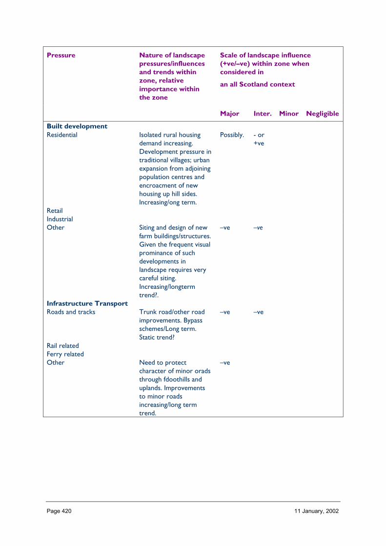
Page 420 11 January, 2002
Pressure Nature of landscapepressures/influencesand trends withinzone, relativeimportance withinthe zone
Scale of landscape influence(+ve/–ve) within zone whenconsidered in
an all Scotland context
Major Inter. Minor Negligible
Built developmentResidential Isolated rural housing
demand increasing.Development pressure intraditional villages; urbanexpansion from adjoiningpopulation centres andencroacment of newhousing up hill sides.lncreasing/ong term.
Possibly. - or+ve
RetailIndustrialOther Siting and design of new
farm buildings/structures.Given the frequent visualprominance of suchdevelopments inlandscape requires verycareful siting.Increasing/longtermtrend?.
–ve –ve
Infrastructure TransportRoads and tracks Trunk road/other road
improvements. Bypassschemes/Long term.Static trend?
–ve –ve
Rail relatedFerry relatedOther Need to protect
character of minor oradsthrough fdoothills anduplands. Improvementsto minor roadsincreasing/long termtrend.
–ve

Page 421 11 January, 2002
Infrastructure otherTelecoms check with area,
numerous applicationsrecently in visuallyprominent landscapes/inNSA etc increasing andmedium to long termtrend. sensitivity ofsouthern uplands scarpand other prominentareas.
negative impact
Watertreatment/abstraction
check with area.
Waste managementCoastal defencesOtherMineralsOpen cast coalSand and Gravel one of most significant
pressures.static/Increasing andlong term i.e ofteninvolves permanentremoval of glaciallandform.
–ve sometimes, ependingon location/scale =negative. or
Hard rockPeatOtherForestry and WoodlandsRestructuring of existing need for visual
integration of forestryedges, and removal ofsome areas. static/longterm trend.
potential majorpositive effect.
Creation of new small Potential landuse changeon marginal farms.Incremental loss of hillfarm land toforestry.increasing/longterm trend. Need toretain, in valleys balanceof small broadleafwoodlands, pasture andcreate appropriatetransitin to higherground.
positive or negativedepending onlocation/relationshipto landscape character
Creation of large new/native potential significantVisual encroachment onimportant openground/wild land;,obscuring oftopographicalinterest,.Long
–ve opportunity forpositive impact.(newnative )

Page 422 11 January, 2002
term/increasing trend?.Other Large scale forest
expansion/visualintrusion from forestexpansion intowildland/remote uplandlandscapes is a threatand the ipotentialnegative impact offorestry on the integrityof the valleys and theirimportant visualrelationship tosurroundinguplands.Potential loss ofcontrast between openhill tops andsurrounding farmland.increasing. long term.Management of existingbroadleaf woodlandstructure required.static to declining atpresent. Declinig/Longterm impacts.
–veopportunityfor majorpositiveimpact butpresenttrend nonmanagementis likely toresult inmajornegativeimpact.
Aquaculture and FishingFinfishShellfishFishing (River & loch) check with AreaOther Tipping in rivers and
riparian woodland–ve
Land ManagementSheep production check area
knowledge/potentialdecline of role offarming as means ofmaintainig landscape ofloweer slopes andgrazed moorlands.
-v
Crop production recent interest in biofuels * check area
Sport shooting

Page 423 11 January, 2002
Other Hedgerow loss/localiseddecline of dry stonedykes longterm.Increasing/statictrend? check witharea/uptake ofESA/effectiveness?decline/long termImportance ofconserving areas andfeatures of historicaland archaelogivcalsignifcance andprotecting settings tothese. decline/long term
–ve–ve
EnergyNat. grid/infrastructureWind Increasing and long term
trend. large 30 plusturbines located onprominent hills/veryvisible/potential majorimpact on plateaulandscapes of particularconcern
potentiallynegative
negative
Hydro Check with AreaWaveOtherTourism and RecreationGolf Potential increaing.Long
term potential concernin wide rivervalleys/very visible andassociated with isolatednew built devlopment
–ve
MarinasSkiing facilitiesLeisure facilities/visitorcentres
Increasing Long term.Particular threat toDesigned landscapes i.echalet/holidaydevelopments withinhistoric estates/designedlandscapes
–ve
NH Information provisionWalking related/footpaths Increasing demand, long
term+ve
Other check area

Page 424 11 January, 2002
4 Building a sustainable future
Landscape influences and trends in Zone 19 (Table 3)
Aspects of importanceof the zonal landscape
(Table 2)
1Residentialfarmbuildings
2Roads
3Mirerals(sand/gravel)
4Forestrestructurint/new/expansion
5Tourismandrecreation(golf,eisure,dev)
6Landmanage-ment
7Windenergy
A. Landscape characterdiversity (zone)B. Fragility/sensitivityC. Remoteness and sensewildness (zone)D. Environmentalground/interpretational(zone)E. Recreational andamenity (zone)
General landscape objectives required
Specific landscape objectives required

Page 425 11 January, 2002
ZONE 21 MORAY FIRTH
1 Nature of the landscape resource
Diversity, distribution and rarity of landscape character in the zoneNote: Ignore any LCT which is shown as <10 km sq (if important feature will be coveredelsewhere, if important characteristic locally will be flagged up in description)
Table 21.1 Diversity
LCTLevel 1
LCTLevel 3
Context Areakm2
21 Sweeping Moorland FRSSEHM Highland 0.0021 Coastal Shelf Low, Flat, and/or
Sandy CoastalLandscapes of theHighlands andIslands
Highland Coastal 2.67
21 Town Highland and IslandTowns andSettlements
Highland 2.09
21 Small Farms and Crofts Highland and IslandCrofting Landscapes
Highland 27.37
21 Coniferous WoodlandNo informationprovided in report.
0 NULL 21.62
21 Broadleaved/MixedWoodland Noinformation provided in
0 NULL 8.74
21 Moorland Slopes andHills
HMRRMts Highland 0.71
21 Long Beaches Dunesand Links
Low, Flat, and/orSandy CoastalLandscapes of theHighlands andIslands
Highland Coastal 10.29
21 Kyles Firths and SeaLochs
SL Highland Coastal 36.97
21 Farmed Straths Highland Straths Highland 39.4321 Rolling Farmland and
WoodlandAgriculturalLowlands of theNorth East
Highland 95.46
21 Enclosed Farmland AgriculturalLowlands of theNorth East
Highland 31.44
21 Inverness Highland and IslandTowns andSettlements
Highland Coastal 19.50
21 Rocky Moorland Plateau Rocky Moorlands ofthe Highlands andIslands
Highland 0.00
21 Rocky Moorland Plateau Rocky Moorlands of Highland 86.81

Page 426 11 January, 2002
with Woodland the Highlands andIslands
21 Flat Moorland Plateauwith Woodland
FRSSEHM Highland 49.84
21 Farmed and WoodedFoothills
Highland Foothills Highland 0.00
21 Broad Steep-Sided Glen Highland and IslandGlens
Highland 38.89
21 Coastal Lowland CoastalLandscapes of theNorth East
Coastal Lowland 112.43
21 Coastal Lowlands Lowland CoastalLandscapes of theNorth East
Coastal Lowland 279.59
21 River Valleys Highland Straths Lowland 36.5921 Uplands HMRRMts Upland Highland 93.1321 Forested Backdrop Highland Foothills Lowland Coastal 69.5021 Enclosed Firth Lowland Coastal
Landscapes of theNorth East
Coastal Lowland 341.65
21 Narrow Firth Corridor Lowland CoastalLandscapes of theNorth East
Lowland Coastal 54.54
21 Hard Coastal Edge Lowland CoastalLandscapes of theNorth East
Lowland Coastal 28.12
21 Crofting Highland and IslandCrofting Landscapes
Lowland 33.61
21 Open Farmed Slopes AgriculturalLowlands of theNorth East
Lowland 199.57
21 Forest Edge Farming AgriculturalLowlands of theNorth East
Lowland 256.41
21 Enclosed FarmedLandscapes
AgriculturalLowlands of theNorth East
Lowland 122.90
21 Intensive Farming AgriculturalLowlands of theNorth East
Lowland 29.82
21 Forest Edge Farming AgriculturalLowlands of theNorth East
Highland 34.47
21 Rocky Moorland Rocky Moorlands ofthe Highlands andIslands
Highland 0.00
21 Rounded Hills HMRRMts Highland 2.4821 Narrow Farmed Strath Highland Straths Highland 0.0021 URBAN AREA Upland Igneous and
Volcanic Hills TheOchil, Sidlaw, Cleishand Lomond Hills
Upland 9.37
Total 2176.01

Page 427 11 January, 2002
HMRRMts = High, Massive, Rolling, Rounded Mts of Highlands & Islands
HMRSSMts = High Massive, Rugged, Steep-sided Mts of Highlands & Islands
FRSSEHM = Flat or Rolling, Smooth or Sweeping, Extensive, High Moorlands of Highlands & Islands
RCUHM = Rugged, Craggy Upland Hills & Moorlands of the Highlands, including the Trossachs
PL = Peatland Landscapes of the Highlands & Islands
SL = Sea Lochs of the Highlands & Islands
The number of landscape character types represented in Zone 21 at level 1, is 36 the way they are grouped at level 3 is into 11 and theircontext is Highland. No. of LCTs (Level 1)/Area of Zone in Zone 21 is 0.016, this gives an indication of the overall diversity of landscapecharacter in the zone and can be compared between zones.
Table 21.2 Distribution/pattern
Zone LCTLevel 1
LCTLevel 3
% of Zone(area)
No. ofOccurrences
Areakm2
21 SweepingMoorland
FRSSEHM 0.0 1 0.00
21 Coastal Shelf Low, Flat, and/orSandy CoastalLandscapes ofthe Highlandsand Islands
0.1 1 2.67
21 Town Highland andIsland Towns andSettlements
0.1 3 2.09
21 Small Farms andCrofts
Highland andIsland CroftingLandscapes
1.3 10 27.37
21 ConiferousWoodland Noinformationprovided in report.
0 1.0 20 21.62
21 Broadleaved/MixedWoodland Noinformationprovided in
0 0.4 15 8.74
21 Moorland Slopesand Hills
HMRRMts 0.0 4 0.71
21 Long BeachesDunes and Links
Low, Flat, and/orSandy CoastalLandscapes ofthe Highlandsand Islands
0.5 3 10.29
21 Kyles Firths andSea Lochs
SL 1.7 2 36.97
21 Farmed Straths Highland Straths 1.8 1 39.4321 Rolling Farmland
and WoodlandAgriculturalLowlands of theNorth East
4.4 1 95.46
21 Enclosed Farmland AgriculturalLowlands of the
1.4 1 31.44

Page 428 11 January, 2002
North East21 Inverness Highland and
Island Towns andSettlements
0.9 5 19.50
21 Rocky MoorlandPlateau
Rocky Moorlandsof the Highlandsand Islands
0.0 1 0.00
21 Rocky MoorlandPlateau withWoodland
Rocky Moorlandsof the Highlandsand Islands
4.0 1 86.81
21 Flat MoorlandPlateau withWoodland
FRSSEHM 2.3 1 49.84
21 Farmed andWooded Foothills
HighlandFoothills
0.0 1 0.00
21 Broad Steep-SidedGlen
Highland andIsland Glens
1.8 1 38.89
21 Coastal Lowland CoastalLandscapes ofthe North East
5.2 10 112.43
21 Coastal Lowlands Lowland CoastalLandscapes ofthe North East
12.8 3 279.59
21 River Valleys Highland Straths 1.7 2 36.5921 Uplands HMRRMts 4.3 3 93.1321 Forested Backdrop Highland
Foothills3.2 5 69.50
21 Enclosed Firth Lowland CoastalLandscapes ofthe North East
15.7 5 341.65
21 Narrow FirthCorridor
Lowland CoastalLandscapes ofthe North East
2.5 3 54.54
21 Hard Coastal Edge Lowland CoastalLandscapes ofthe North East
1.3 1 28.12
21 Crofting Highland andIsland CroftingLandscapes
1.5 4 33.61
21 Open FarmedSlopes
AgriculturalLowlands of theNorth East
9.2 8 199.57
21 Forest EdgeFarming
AgriculturalLowlands of theNorth East
11.8 9 256.41
21 Enclosed FarmedLandscapes
AgriculturalLowlands of theNorth East
5.6 3 122.90
21 Intensive Farming AgriculturalLowlands of theNorth East
1.4 1 29.82

Page 429 11 January, 2002
21 Forest EdgeFarming
AgriculturalLowlands of theNorth East
1.6 3 34.47
21 Rocky Moorland Rocky Moorlandsof the Highlandsand Islands
0.0 1 0.00
21 Rounded Hills HMRRMts 0.1 3 2.4821 Narrow Farmed
StrathHighland Straths 0.0 1 0.00
21 URBAN AREA Upland Igneousand VolcanicHills The Ochil,Sidlaw, Cleishand Lomond Hills
0.4 15 9.37
Total 152 2176.01
In Zone 21 a total 152 occurrences of landscape character types (landscape units) are found within a zone of total land area 2176. km sq.The figure 152/2176 is 0.069 per km sq of land within the zone and gives a relative indication of the overall brokenness or fragmentationof the landscape pattern.
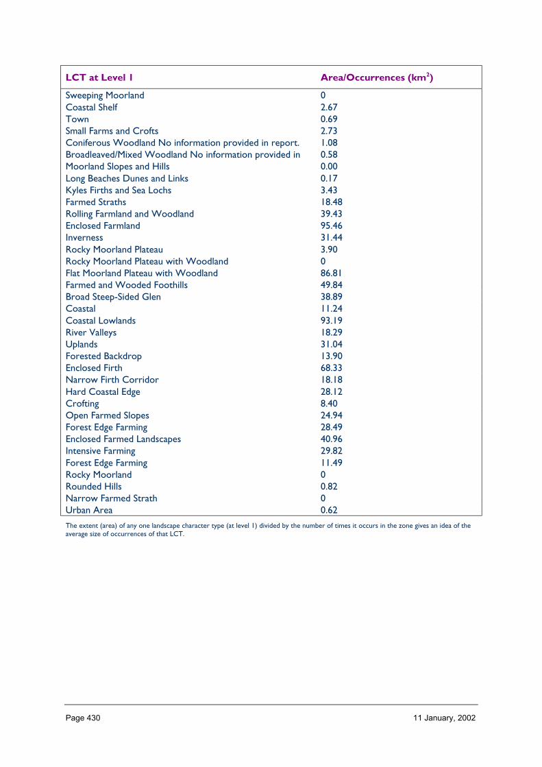
Page 430 11 January, 2002
LCT at Level 1 Area/Occurrences (km2)
Sweeping Moorland 0Coastal Shelf 2.67Town 0.69Small Farms and Crofts 2.73Coniferous Woodland No information provided in report. 1.08Broadleaved/Mixed Woodland No information provided in 0.58Moorland Slopes and Hills 0.00Long Beaches Dunes and Links 0.17Kyles Firths and Sea Lochs 3.43Farmed Straths 18.48Rolling Farmland and Woodland 39.43Enclosed Farmland 95.46Inverness 31.44Rocky Moorland Plateau 3.90Rocky Moorland Plateau with Woodland 0Flat Moorland Plateau with Woodland 86.81Farmed and Wooded Foothills 49.84Broad Steep-Sided Glen 38.89Coastal 11.24Coastal Lowlands 93.19River Valleys 18.29Uplands 31.04Forested Backdrop 13.90Enclosed Firth 68.33Narrow Firth Corridor 18.18Hard Coastal Edge 28.12Crofting 8.40Open Farmed Slopes 24.94Forest Edge Farming 28.49Enclosed Farmed Landscapes 40.96Intensive Farming 29.82Forest Edge Farming 11.49Rocky Moorland 0Rounded Hills 0.82Narrow Farmed Strath 0Urban Area 0.62
The extent (area) of any one landscape character type (at level 1) divided by the number of times it occurs in the zone gives an idea of theaverage size of occurrences of that LCT.
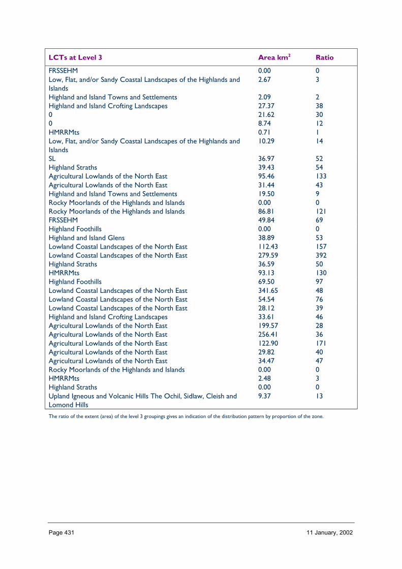
Page 431 11 January, 2002
LCTs at Level 3 Area km2 Ratio
FRSSEHM 0.00 0Low, Flat, and/or Sandy Coastal Landscapes of the Highlands andIslands
2.67 3
Highland and Island Towns and Settlements 2.09 2Highland and Island Crofting Landscapes 27.37 380 21.62 300 8.74 12HMRRMts 0.71 1Low, Flat, and/or Sandy Coastal Landscapes of the Highlands andIslands
10.29 14
SL 36.97 52Highland Straths 39.43 54Agricultural Lowlands of the North East 95.46 133Agricultural Lowlands of the North East 31.44 43Highland and Island Towns and Settlements 19.50 9Rocky Moorlands of the Highlands and Islands 0.00 0Rocky Moorlands of the Highlands and Islands 86.81 121FRSSEHM 49.84 69Highland Foothills 0.00 0Highland and Island Glens 38.89 53Lowland Coastal Landscapes of the North East 112.43 157Lowland Coastal Landscapes of the North East 279.59 392Highland Straths 36.59 50HMRRMts 93.13 130Highland Foothills 69.50 97Lowland Coastal Landscapes of the North East 341.65 48Lowland Coastal Landscapes of the North East 54.54 76Lowland Coastal Landscapes of the North East 28.12 39Highland and Island Crofting Landscapes 33.61 46Agricultural Lowlands of the North East 199.57 28Agricultural Lowlands of the North East 256.41 36Agricultural Lowlands of the North East 122.90 171Agricultural Lowlands of the North East 29.82 40Agricultural Lowlands of the North East 34.47 47Rocky Moorlands of the Highlands and Islands 0.00 0HMRRMts 2.48 3Highland Straths 0.00 0Upland Igneous and Volcanic Hills The Ochil, Sidlaw, Cleish andLomond Hills
9.37 13
The ratio of the extent (area) of the level 3 groupings gives an indication of the distribution pattern by proportion of the zone.
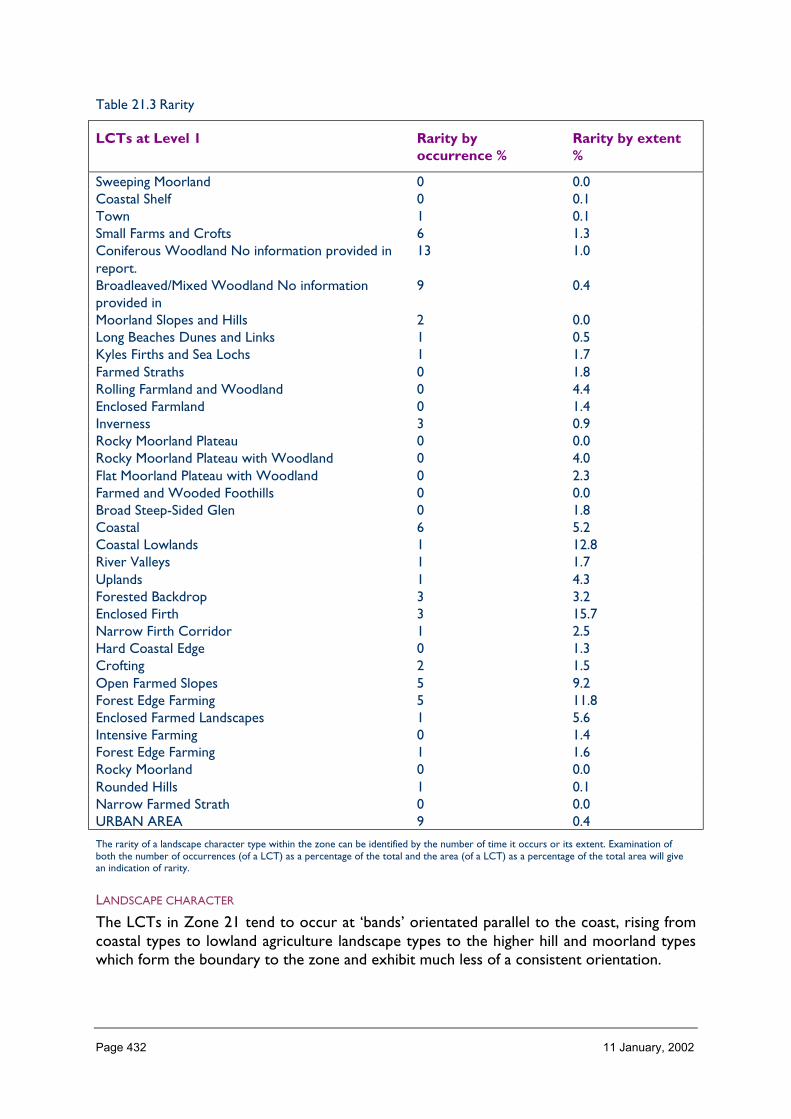
Page 432 11 January, 2002
Table 21.3 Rarity
LCTs at Level 1 Rarity byoccurrence %
Rarity by extent%
Sweeping Moorland 0 0.0Coastal Shelf 0 0.1Town 1 0.1Small Farms and Crofts 6 1.3Coniferous Woodland No information provided inreport.
13 1.0
Broadleaved/Mixed Woodland No informationprovided in
9 0.4
Moorland Slopes and Hills 2 0.0Long Beaches Dunes and Links 1 0.5Kyles Firths and Sea Lochs 1 1.7Farmed Straths 0 1.8Rolling Farmland and Woodland 0 4.4Enclosed Farmland 0 1.4Inverness 3 0.9Rocky Moorland Plateau 0 0.0Rocky Moorland Plateau with Woodland 0 4.0Flat Moorland Plateau with Woodland 0 2.3Farmed and Wooded Foothills 0 0.0Broad Steep-Sided Glen 0 1.8Coastal 6 5.2Coastal Lowlands 1 12.8River Valleys 1 1.7Uplands 1 4.3Forested Backdrop 3 3.2Enclosed Firth 3 15.7Narrow Firth Corridor 1 2.5Hard Coastal Edge 0 1.3Crofting 2 1.5Open Farmed Slopes 5 9.2Forest Edge Farming 5 11.8Enclosed Farmed Landscapes 1 5.6Intensive Farming 0 1.4Forest Edge Farming 1 1.6Rocky Moorland 0 0.0Rounded Hills 1 0.1Narrow Farmed Strath 0 0.0URBAN AREA 9 0.4
The rarity of a landscape character type within the zone can be identified by the number of time it occurs or its extent. Examination ofboth the number of occurrences (of a LCT) as a percentage of the total and the area (of a LCT) as a percentage of the total area will givean indication of rarity.
LANDSCAPE CHARACTER
The LCTs in Zone 21 tend to occur at ‘bands’ orientated parallel to the coast, rising fromcoastal types to lowland agriculture landscape types to the higher hill and moorland typeswhich form the boundary to the zone and exhibit much less of a consistent orientation.

Page 433 11 January, 2002
The diversity and fragmentation of LCTs increased from south to north, from the Morayplains, to the Black Isle and south east Sutherland. In the west of the zone coastal charactertypes extend well into the farmland landscape types.
Landform
PROFILE
Most consistent across Zone 21 are the gently rolling landforms, shallow valleys near-flatcoastal areas and shallow firths and a generally smooth sweeping coastline. Very noticeablewithin this are the steep and rugged cliffs of the northern end of the Highland boundaryfault, less obvious are the incised burns of the south/eastern boundary where Zone 21meets Zone 10, and the raised beaches and moraines of the inner Moray Firth.
In the zone as a whole 28% of the land areas is flat and 58% has a slope of 1° to 5° only 4%has a slope of 100. The Black Isle though only rising to 841 ft is very prominent.
SEQUENCE
The sequence of land forms within Zone 21 is strongly influenced by the hierarchy of thefirths. A north/south section in the east of the zone reveals a fairly consistent sequencethrough soft coast to fault and gently rolling farmland to moorland slopes and hills. Incontrast a roughly north/south section through the western part of the zone (west ofHighland Boundary fault), reveals an alternating sequence of rolling farmland, firth, rollingfarmland, firth, rolling farmland firth.
The predominant aspects in this zone are north and north west and south east, reflectingthe general fall of the land towards the main body of the Moray Firth.
SCALE
With most (89%) of Zone 21 lying below the 200 m contour the vertical scale of itslandform is generally not significant in the landscape other than where through sheernessand contrast of slope a feature such as the Highland Boundary fault assumes greaterprominence.
In terms of its horizontal scale the landform of Zone 21 with its shallow first, and low lyingcoastal farmland lends an expansiveness to this landscape.
LANDMARK FEATURES
Highland Boundary fault – Craigiehowe, Sutors, Tarbot Ness;
Glacial features – Chanonry Point and Ardersier;
Prominent small hills – Knockfarrel, Craig Phadraig, Nigg, Hill of Wangie;
Coastal features – Culbin Sands, Monich Mor, Torvean.
EXPERIENCE
Because of the generally low-lying nature of this zone, upstanding features (hills and cliffs)and edge features (coastal) play a particularly important part in determining the characterand experience of its landscape. Also of great importance is the penetration of the sea quite

Page 434 11 January, 2002
far inland and the sequence of experience of water and landform as one moves through thelandscape.
Containment (created by landform and land cover)
TOPOGRAPHY
Containment offered by topography is generally slight within the zone apart from around itslandward extremities where the inland landform is rising into Zones 10 and 7. Here glenssuch as Convinth, the glen of the Peffrey, and the river valleys of the Nairn and the Findhornprovide a much more enclosed experience. Elsewhere local glacial moraines, small hills anddeeply cut burns provide local, small-scale containment.
LAND COVER
Vegetation cover across the zone is diverse in its range of components, but it is woodlandwhich particularly contributes to landscape containment. On the slightly higher ground awayfrom the coast, coniferous plantation woodland covers substantial areas and within it andaround it are enclosed and semi-enclosed pockets of farmland. Elsewhere, coniferouswoodland and to a lesser extent broadleaved woodland are commonplace, giving partialcontainment, localised shelter and framed views.
Small farm woodlands, policy woodlands and hedgerow trees are characteristic of the moreopen farmed landscape types, as part and linear features in the landscape those can providea partial containment.
Built development within this zone takes several different forms; dispersal farms, smallnucleated villages, coastal villages, and small towns and the large conurbation of Invernessand its commuter ‘belt’. It is only within the larger towns, e.g. Inverness, Culloden, Balloch,Dingwall, Invergordon, Nairn, Forres and Elgin where built development creates a verycontained landscape/townscape.
VISIBILITY
Visibility is often limited by vegetation and local, though minor, landform variation.However, where advantage can be taken of even a slight increase in elevation, wide andextensive visibility can be achieved, often across expanses of open water.
MICROCLIMATIC EFFECTS
Microclimatic pockets are typical of this landscape, though often hidden from view. Naturalsheltered hollows and deep burns often contain lush vegetation quite a-typical of the widerlandscape, e.g. wooded dens, gorges, kettle holes.
EXPERIENCE
Owing to the generally low-lying nature of the landform, it is the diversity of vegetationcover and containment which tends to most influence one’s experience of this landscape,however, where elevated views can be achieved from public places (especially roads) theyare widely appreciated locally.

Page 435 11 January, 2002
Accessibility
DISTANCE
All parts of the zone are within an hour or so’s drive from Inverness, which at pop. X is thegreatest population north of Aberdeen. From Glasgow and Edinburgh, travel distances are Yand Z miles (approx. 3–5 hours by car/train). From Aberdeen, the distance is A miles(approx. 2.5 hours by car/train). Apart from disruption caused by occasional winter storms,the zone can be accessed with relative ease.
PHYSICAL ACCESS
Within the zone, access by public road is good with a hierarchy of A, B, and C roads servingthe area. Rail is limited. Prior to the mid-1980s, access throughout much of the north andwest of the zone was in part reliant upon a series of small vehicular ferries across the firths.Since their replacement by bridges, the ease and quality of access has markedly increased.
The terrain is itself not difficult, but as the majority of land is wider farmland or forestry,there are other impediments. Tracks and footpaths, at one time widespread, have, in manyplaces, fallen into disuse and effectively no longer exist. In some areas, particularly aroundtowns, these are being brought back into use as part of local networks.
CULTURAL ACCEPTANCE
On the pre-existing and recognised routes and paths, access is accepted and encouraged.On open farmland, the absence of provision and intensive use of the land effectivelyprecludes casual access from all but the most persistent. At the edges of the zone, accessonto the open hill is in some places hindered by reluctant landowning interests. Thesubstantial area of publicly owned forestry in the zone provides a focus for much publicaccess. Access to beaches generally ‘protected’ and accepted, access to other parts of coastnot encouraged.
VISUAL ACCESS
Many public places are contained/partly enclosed by woodland. From these places visualaccess, although potentially good, is limited. Visual access from public roads is varied, withlong views across and outwith the zone being valued, particularly those over water.
EXPERIENCE
In comparison to other Highland zones, Zone 21 is very populous. Moving around with thezone by public road is generally characterised by the high level of other road users.Contrastingly, the experience of off-road access can often be the landscape other than atkey locations such as beaches and historic properties.
Land cover (including vegetation and land use)
VEGETATION
The vegetation cover of this zone contributes much to the diversity of its landscapecharacter, mainly through the pattern of farmland and forestry. 40% of the zone is underarable rotation and 24% is woodland, of which 20% is coniferous plantation. On higherground, forestry is characteristic with open areas typically being of improved grassland(especially on north facing slopes). At the peripheries of the zone, forestry gives way toopen heather moorland, both of these forming a backdrop to many views across the zone.

Page 436 11 January, 2002
Shelter woodlands and smaller plantations (apart from Culbin’s, which is huge) arecharacteristic of the low-lying and rolling farmland where the alternating crops of the arablerotation give a changing colour and emphasis to the landscape. The scale and pattern offields and field boundaries creates subtle differences in the landscape, reflecting subtledifferences in geology, soil and land ownership.
EXPOSED ROCK
Apart from the cliffs along the Highland Boundary fault and the rocky boulder strewnshorelines of the outer firths, there is little exposed rock in this zone. Occasional exposuresin the landward parts of the zone, or outcropping glacial boulders on un-cleared marginalland do occur, but are unusual in this landscape.
BUILT DEVELOPMENT
Build development makes a significant contribution to landcover and therefore to thelandscape of this zone. Much of the zone is within easy access of the main (3% of the landarea is classed as urban, only Zones 16 and 17 have greater urban areas). Employmentcentres around the Moray Firth and so the rural landscape is often characterised bysporadic residential developments as well as the longer-established scattered farms andsteadings.
Both small and large towns characteristically possess an older core and residential area withindustrial and retail areas and housing developments expanding out on the peripheries. Themajority of towns and villages are found within farmland landscape character types (LCTs,174, 180, 233, level 1) reflecting their origins as agricultural services centres.
EXPERIENCE
The dynamic pattern of landcover arising principally from this agricultural land use and a highlevel of economic activity and built development activity gives the landscape of Zone 21 agenerally ‘busy’ feel. This means that the contrasting experience of landscapes which aresecluded, quiet, dominated by natural influences, e.g. woodlands and the coast are highlyvalued.
Hydrology and water bodies
TYPE
There are 34 freshwater lochs in Zone 21 and 1,200km of rivers; however, apart from thelarger rivers of the Nairn, Findhorn, Ness, Beauly, Conon and Bonar, it is the presence ofthe sea which dominates the hydrology of the zone from a landscape point of view.Extending a long way inland, the inner firths and their expansive mudflats means that the seais very close to much of Zone 21.
PATTERN
Rivers flow in a general south-west to north-east direction, reflecting the prevailing grain ofthe land. The inner firths of Beauly, Cromarty, Dornoch and Fleet give a rhythmic pattern tothe landscape of the northern part of the zone.
EXPERIENCE
Small rivers, burns, and small lochs are often ‘lost’ in the wider landscape owing to theirbeing deeply cut, or surrounded by vegetation. Larger rivers are important features in the

Page 437 11 January, 2002
landscape of Zone 21, often emphasised by riparian woodland, though their catchments arein all cases outwith the zone. The firths and sea are an essential part of the landscapeexperience of this zone, often impinging on views when least expected.
Built and infrastructure development (present day)
NATURE AND PATTERN OF SETTLEMENT
Settlement within Zone 21 is widespread and, in places, results in a landscape character inits own right (in Inverness, Culloden, Smithton, Elgin, Forres, Nairn, Dingwall, Invergordon,Alness and Tain). Originally developed as agricultural service centres for a local hinterland,these settlements now have their own light industries and retail developments; the majorityare also within commuting distance of Inverness. Beauly and Cromarty were planned townsand have the typical gridlike structure (check!) Nairn was very much a Victorian resorttown, a feature being its large detached residences (formerly guest houses). Farm housesand farm buildings scatter the landscape, more widely spaced in the south of the zone wherelandholders and the buildings themselves tend to be larger. Residential developmentunrelated to agriculture is common place in this landscape, with individual houses andgroups of houses, often of kit house construction, to be found around the edges of existingsettlements, in the open agricultural landscapes and woodland edges.
Large country houses often set in policy woodlands are a particular feature of this zone inmarked contrast to adjoining Zones of 10 and 7.
NATURE AND PATTERN OF INFRASTRUCTURE
Roads are a key characteristic of the landscape of this zone with the A9T and A96 carryinglarge volumes of traffic particularly in and around Inverness. The Kessock Bridge, CromartyCauseway and Dornoch Bridges are prominent related features. Rail links to the south east,north and west are not particularly prominent, being only single track lines for the mostpart, often surrounded by trees. Pylons and masts are commonplace in the landscapes, oftenrising out of plantation woodland on prominent high points around the inner firths. Activeharbours at Inverness and Invergordon mean that sea traffic (commercial and touristrelated) is typical.
NATURE AND PATTERN OF INDUSTRIAL DEVELOPMENT
A degree of industrial sprawl is typical around the edges of settlements, and is sometimesvery incongruous in landscape terms. Elsewhere, occasional large developments (e.g. the oil-related developments at Nigg and Ardesier, rigs in the Cromarty Firth, pipeline assembly atInvergordon, Norbord plant near Nairn, distilleries at Tain and Invergordon, grain plant onthe Black Isle, and military at Lossiemouth are prominent features in the landscape.
EXPERIENCE
Built and infrastructure development is a key characteristic of the landscape of Zone 21,experienced as built development but also as the high degree of activity in the landscape thatis generated by an active primary (farming, industry) and secondary economy (servicerelated).

Page 438 11 January, 2002
Visible history (past settlement, landuse, churches, brochs, forts, dykes, standingstones, landmarks, etc.)
TYPES OF VISIBLE HISTORY
Castles, forts and large country houses, dykes, walls and gateways, and bridges associatedwith farms, large houses and network of single track roads. Designed landscapes: avenues,woodlands, walled gardens. Pre-historic sites – hut circles, field systems, chambered cairns,forts and standing stones (often Pictish).
LOCATION/PATTERN
The larger elements of visible history, the castles and large country houses set in designedlandscapes tend to be a feature of the more lowland agricultural LCTs, e.g. 162, 174 and 180(level 1) whereas the visible pre-historic sites tend to be in areas of more marginalagricultural land and are especially prevalent in the west and north of the zone (eg LCTs(level 1) 8, 24, 35, 40, 107, 123). Britt features such as walls, dykes, and bridges are foundthroughout, but particularly in and around settlements and on unimproved stretches ofsingle track roads.
EXPERIENCE
The visible history lends a richness to the landscape character of Zone 21, which, owing tothe complexity of other elements and a high degree of activity, is not always immediatelyobvious. This can give a sense of discovery and time depth, which is a valuable part of thelandscape experience.
Wildlife
FORMS OF WILDLIFE
Wildlife which is characteristic of this landscape includes;
birds of prey (especially red kite and buzzard), agricultural birds (especially skylark, lapwing,linnet, yellow hammer), geese (of various kinds), seals and dolphins, and gulls of variouskinds.
LOCATION
Red kites and buzzards range widely over the zone, but most common where farmland andforestry meet. The characteristic song of the skylark can be heard from February onwardsin even quite intensive arable landscapes. These and the lapwing, linnet and yellow hammerare commonplace on farmland throughout the zone. The presence of extensive mud flatsand their close vicinity to much of the land area of the zone, means that geese are acommon feature of the landscape. Seals and dolphins are found regularly at particular ‘haulout’ sites and feeding areas.
WHEN
Much of this wildlife presence is year-round, though its behaviour is different. In Spring, lateAutumn and Winter, the sounds and movements of feeding and migrating geese is difficult toignore in most of the inner firth area.
Conversely, the farmland birds are more obvious in Spring and Summer, when establishingnesting territories and nesting and rearing young.

Page 439 11 January, 2002
EXPERIENCE
The forms of wildlife which form a constant backdrop of natural activity to the zone are thegulls (even in central Inverness), and the woodland and garden birds. However, thosementioned above occur in sufficient high numbers, or at times of year, or are so striking(red kites and dolphins) in their own right, that they add considerable value to theexperience of the landscape of Zone 21.
Climate
CLIMATIC CHARACTERISTICS
This zone (21), the Inner Moray Firth, is renowned for the moderating effect of the sea, theresult being that Winter and Summer temperatures are less extreme than a short distanceinland. However, the area is prone to biting easterly winds in the last Winter and Spring.Rainfall is low in a Scottish context with most of the zone getting less than 800mm/year (31inches).
LOCATIONAL AND SEASONAL EFFECTS
Prone to summer haars and winter inversions, which can result in a sea fog sitting overmuch of the zone, with areas above 200 m often emerging through. Long hours of daylightin summer months.
EXPERIENCE
Vicinity to coast and visible effects of wind-tide often increase the awareness of the weatherin this landscape.
Designated landscapes
National Scenic AreasThere is 1 NSA in Zone 21: the Dornoch Firth.
CONSTITUENTS
Key aspects of description: variety of landscapes enclosed by prominent landforms,woodland (deciduous and coniferous), designed landscape, farmland, sandy links, bays, flatsand promontories. ‘The last undeveloped estuary of its kind on the east coast’.
Landscape character types: contains 10 LCTs at areas of 1km sq, sweeping moorland, smallfarms and crofts, coniferous woodland, BL woodland, moorland slopes and hills, longbeaches and dunes, kyles, fresh and sea lochs, enclosed firth, with intensive farming androunded hills.
Confirm which LCTs fall in Zone 21 of zones 7 and 5.
LOCATION AND EXTENT
A narrow NSA which surrounds the Dornoch Firth from Bonar Bridge to Whiteness Sands.It is a small NSA extending only to 7,500 ha (75km sq including the Firth) and partly fallswithin the adjoining zones 7 and 5.

Page 440 11 January, 2002
EXPERIENCE
This is an NSA that gives a varied landscape experience. Its boundaries being marked by agradual transition from many small occurrences of LCTs to fewer, larger occurrences ofupland LCTs.
AGLVS and other Local Authority designations
NATURE OF THE LANDSCAPE DESIGNATED
There are 2 Highland Council SGLVs in Zone 21; at Rosemarkie Burn on the Black Isle andthe Sutors of Cromarty. Both are sites of geomorphological/geological and natureconservation interest and the Sutors are on extremely prominent landscape feature withhistorical importance (WWII).
Check local plans, especially Moray.
LOCATION AND EXTENT
Areas are < 100 ha.
EXPERIENCE
Rosemarkie Burn – enclosed landscape, ‘hermitage’ type walk to falls.
Sand cliffs of significant geological interest – SSSI.
Sutors of Cromarty – prominent twin cliffs, masking entrance to Cromarty Firth. Dramaticnatural features in the landscape.
Historic gardens and designed landscapes
NATURE OF THE LANDSCAPES DESIGNATED AND NON-DESIGNATED
24 inventory sites in this zone.
Recreational landscapes
Nature and location of landscapes and activitiesThe landscapes of Zone 21 are generally very accessible with only small areas being in therange 2 km to 5 km from public roads. These tend to be remote coastal areas/forestedareas, eg. Culbin, Morich or and Central Black Isle. Elsewhere are the forested landscapes,coastal and firth landscapes and farmland landscapes where the majority of recreation is.Forested areas (usually FC owned) provide for active recreational use in the form of off-road cycling, orienteering, walking, horse-riding. These forested areas, which are within easyaccess of urban areas, tend to have way-marked routes of varying lengths and some form ofassociated interpretation. The coast provides for beach recreation and nature study/birdwatching at key locations with coastalmud flats being favoured sites for facilities andinterpretation. Access to the shoreline away from these sites is often restricted/difficult.Sailing is a common activity throughout the Inner Moray Firth in particular and mooringsand launching facilities are found at North Kessock, Nairn, Invergordon and Fortrose. Withother boating andcanoeing activity on the rivers and north end of Loch Ness which is softcoastal landscapes. Urban-edge farmland and parkland landscapes provide the locations andbackdrop for a significant amount of golfing activity.

Page 441 11 January, 2002
The zone possesses some of the best known courses in Scotland, e.g. Royal Dornoch andNairn. Driving and visiting gardens, large houses and historic sites is a common recreationaland tourist activity, mostly occurring in the farmland LCTs. The small, quieter roads of theseareas are also used by club and non-club road cyclists. Footpaths, tracks and former railwaylines, especially those close to settlements, are well used for informal recreation, especiallywalking and running, and the northern part of the Speyside Way (LDP) is in this zone.
EXPERIENCE
The landscape of this zone provides for a diverse range of outdoor recreationalexperiences.
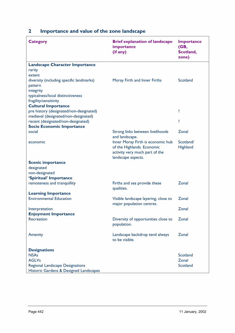
Page 442 11 January, 2002
2 Importance and value of the zone landscape
Category Brief explanation of landscapeimportance(if any)
Importance(GB,Scotland,zone)
Landscape Character Importancerarityextentdiversity (including specific landmarks) Moray Firth and Inner Firths Scotlandpatternintegritytypicalness/local distinctivenessfragility/sensitivityCultural Importancepre history (designated/non-designated) ?medieval (designated/non-designated)recent (designated/non-designated) ?Socio Economic Importancesocial Strong links between livelihoods
and landscape.Zonal
economic Inner Moray Firth is economic hubof the Highlands. Economicactivity very much part of thelandscape aspects.
Scotland/Highland
Scenic importancedesignatednon-designated‘Spiritual’ Importanceremoteness and tranquillity Firths and sea provide these
qualities.Zonal
Learning ImportanceEnvironmental Education Visible landscape layering, close to
major population centres.Zonal
Interpretation ZonalEnjoyment ImportanceRecreation Diversity of opportunities close to
population.Zonal
Amenity Landscape backdrop tend alwaysto be visible.
Zonal
DesignationsNSAs ScotlandAGLVs ZonalRegional Landscape Designations ScotlandHistoric Gardens & Designed Landscapes
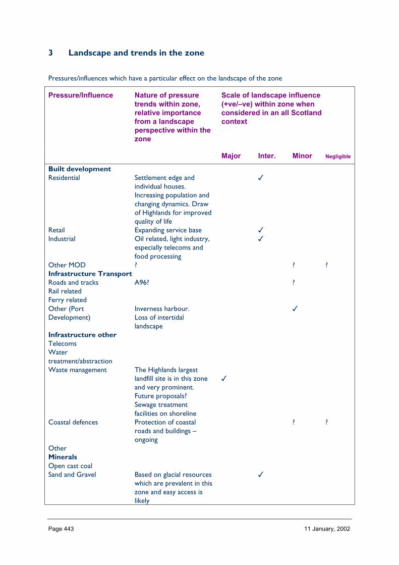
Page 443 11 January, 2002
3 Landscape and trends in the zone
Pressures/influences which have a particular effect on the landscape of the zone
Pressure/Influence Nature of pressuretrends within zone,relative importancefrom a landscapeperspective within thezone
Scale of landscape influence(+ve/–ve) within zone whenconsidered in an all Scotlandcontext
Major Inter. Minor Negligible
Built developmentResidential Settlement edge and
individual houses.Increasing population andchanging dynamics. Drawof Highlands for improvedquality of life
�
Retail Expanding service base �Industrial Oil related, light industry,
especially telecoms andfood processing
�
Other MOD ? ? ?Infrastructure TransportRoads and tracks A96? ?Rail relatedFerry relatedOther (PortDevelopment)
Inverness harbour.Loss of intertidallandscape
�
Infrastructure otherTelecomsWatertreatment/abstractionWaste management The Highlands largest
landfill site is in this zoneand very prominent.Future proposals?Sewage treatmentfacilities on shoreline
�
Coastal defences Protection of coastalroads and buildings –ongoing
? ?
OtherMineralsOpen cast coalSand and Gravel Based on glacial resources
which are prevalent in thiszone and easy access islikely
�

Page 444 11 January, 2002
Hard rock Reflects current economicsituation. Obj 1 and otherprojects. Likely thatexisting sites will expand,e.g. Daviot.
�
PeatOtherForestry and WoodlandsRestructuring of existing Trend towards landscape
improvement in mediumto long term, butdecrease in pine.
�
Creation of new small Especially on marginalfarmland in upland partsof zone.
�
Creation of largenew/nativeOther Increasing community
involvement/management.More sensitive landscapemanagement.
�
Aquaculture and FishingFinfish Landscape and visual
impacts on zone’s keylandscape asset. Unlikelyto increase significantly
�
ShellfishFishing River River engineering? ?Other (Commercial seafishing)
On land infrastructureand activities �
Land ManagementSheep production Decline in sheep numbers.
Increase in woodland�
Crop production Recent years have seen anincrease in intensificationand shift to winter-sowncrops – now fairly stablefrom landscapeperspective
�
Sport shootingOther (Christmas treeproduction
Long term crop �
EnergyNat. grid/infrastructureWindHydroWaveOtherTourism and RecreationGolf Ongoing management of
existing coursesMarinas Localised development �Skiing facilities

Page 445 11 January, 2002
Leisure facilities/visitorcentresNH Information provision Increase in small scale
facilities�
Walking related/footpaths Expansion of provision �Other
4 Building a sustainable future
Landscape influences and trends
Aspects ofimportance of theZonal Landscape
1
Residential/Retail/Industrial
2
Wastemanage-ment
3
Minerals
4
Forest
Restructuring
5
Tourism
and
Recreation
6
Landmanage-ment
A. Landscape characterdiversity, especiallycoastal and marinecharacteristics(Scotland)B. Social (zones) andeconomic (Scotland)C. Remoteness andtranquillity (zone)D. Environmentalground/interpretational(zone)E. Recreation andamenity (zone)F. NSAs and HGDLs(Scotland)AGLVs (zone)G. Cultural importance(to be completed)
General landscape objectives required
Specific landscape objectives required