feasibility planning report keechelus reservoir-to … · kkc feasibility planning report ... adult...
TRANSCRIPT

U.S. Department of the Interior State of Washington Bureau of Reclamation Department of Ecology Pacific Northwest Region Office of Columbia River February 2016 Columbia-Cascades Area Office
Yakima River Basin Integrated Water Resource Management Plan
Feasibility Planning Report Keechelus Reservoir-to-Kachess Reservoir Conveyance FINAL DRAFT
Kittitas County, Washington

MISSION STATEMENTS
U.S. Department of the Interior
Protecting America’s Great Outdoors and Powering our Future.
The U.S. Department of the Interior protects America’s natural resources and heritage, honors our cultures and Tribal communities, and supplies the energy to power our future.
Bureau of Reclamation
The mission of the Bureau of Reclamation is to manage, develop, and protect water and related resources in an environmentally and economically sound manner in the interest of the American public.
Washington State Department of Ecology
The Mission of the Washington State Department of Ecology is to protect, preserve and enhance Washington’s environment, and promote the wise management of our air, land, and water for the benefit of current and future generations.
If you need this document in a format for the visually impaired, call the Office of Columbia River at (509) 575-2490. Persons with hearing loss can call 711 for Washington Relay Service. Persons with a speech disability can call 877-833-6341.
6
6
66
§̈¦90
§̈¦90
§̈¦90
§̈¦90
§̈¦90
¬«906
"
Alternative 2,South Tunnel
"
Alternative 1,North Tunnel
KachessKachessReservoirReservoir
KeechelusKeechelusReservoirReservoir
YYaakkiimmaa
RRiivveerr
W
Sparks RdKachess La
keRd Via
KachessRd
NF-4828(West Kachess
Rd)NF-4818 (Kachess Dam
Rd)
Easton
Hyak
KDRPP(See Note)
LegendMajor Road
6 PortalAlternative 1(North Tunnel Alignment)Alternative 2(South Tunnel Alignment)
Conveyance Option AConveyance Option B
W a s h i n g t o nW a s h i n g t o n
I da h oI da h o
O r e g o nO r e g o n
C A N A D AC A N A D A
§̈¦5
§̈¦84
§̈¦90
§̈¦82
YakimaRiverBasinYakima
Ellensburg
YYaakkiimmaa RRiivveerr
Bumping LakeBumping LakeReservoirReservoir
RimrockRimrockReservoirReservoir
Cle ElumCle ElumReservoirReservoir
"
Kachess ReservoirKachess Reservoir"
Keechelus ReservoirKeechelus Reservoir
§̈¦82§̈¦182
§̈¦90
§̈¦90
µ0 1.25
Miles
0 7,000
Feet
Note: General location of the Kachess DroughtRelief Pumping Plant (KDRPP). The KDRPPis a separate but related project currently in thefeasibility design phase.
Keechelus-to-KachessConveyance

This page left intentionally blank.

Yakima River Basin Integrated Plan KKC Feasibility Planning Report – Final DRAFT i February 2016
Glossary and Acronyms
ASR aquifer storage and recovery
BTE bull trout enhancement (program)
cfs cubic feet per second
Corps U.S. Army Corps of Engineers
DAHP Washington State Department of Archaeology and Historic Preservation
Ecology Washington State Department of Ecology
EFH Essential Fish Habitat EIS Environmental Impact Statement
EPA U.S. Environmental Protection Agency
Integrated Plan Yakima River Basin Integrated Water Resource Management Plan
KDRPP Kachess Drought Relief Pumping Plant
KKC Keechelus Reservoir-to-Kachess Reservoir Conveyance
NED National Economic Development
NEPA National Environmental Policy Act
NMFS National Marine Fisheries Service
PEIS Programmatic Environmental Impact Statement
RED Regional Economic Development
SAR smolt-to-adult survival rate
SEPA State Environmental Policy Act
Service U.S. Fish and Wildlife Service
SOAC System Operations Advisory Committee
TBM tunnel boring machine
TWSA total water supply available
USFS U.S. Forest Service
WDFW Washington Department of Fish and Wildlife
WSDOT Washington State Department of Transportation
YRBWEP Yakima River Basin Water Enhancement Project

Yakima River Basin Integrated Plan KKC Feasibility Planning Report – Final DRAFT ii February 2016
(This page intentionally left blank)

Yakima River Basin Integrated Plan KKC Feasibility Planning Report – Final DRAFT iii February 2016
Contents Executive Summary .................................................................................................................. 1
Introduction .......................................................................................................................1 Background ........................................................................................................................1 KKC Alternatives ................................................................................................................4 Cost-Risk Analysis ..............................................................................................................7 Summary of Expected Results ........................................................................................... 7 Economic Analyses ............................................................................................................9 Cost Allocation .................................................................................................................13 Climate Change Modeling ................................................................................................ 13 Environmental Considerations ......................................................................................... 13 Consultation and Coordination ......................................................................................... 14 Conclusions ......................................................................................................................14
1.0 Location, Background, Purpose, and Authority ..................................................... 15 1.1 Project Location and Description ........................................................................... 15 1.2 Background ............................................................................................................18 1.3 Purpose of the KKC ................................................................................................ 28 1.4 Authority ................................................................................................................29
2.0 Plan Formulation ......................................................................................................... 31 2.1 Need for Action ...................................................................................................... 31 2.2 Prior Investigations ................................................................................................ 32 2.3 Public Involvement ................................................................................................ 34 2.4 YRBWEP Workgroup Participation .......................................................................... 35 2.5 Agency Coordination .............................................................................................. 38 2.6 Tribal Consultation and Coordination ..................................................................... 41
3.0 Alternative Formulation ............................................................................................. 42 3.1 Alternatives Formulation and Evaluation ............................................................... 42
4.0 Alternatives................................................................................................................... 47 4.1 No Action Alternative ............................................................................................. 47 4.2 Action Alternatives Overview ................................................................................. 47 4.3 Project Schedule .................................................................................................... 53 4.4 Operations .............................................................................................................58 4.5 Alternative Comparison .......................................................................................... 60 4.6 Preferred Alternative Not Determined.................................................................... 62 4.7 Recommendations for Further Study ..................................................................... 62
5.0 Related Projects ........................................................................................................... 65 5.1 Kachess Drought Relief Pumping Plant ............................................................ 65 5.2 Bull Trout Enhancement Plan ................................................................................. 66
6.0 Expected Results ......................................................................................................... 70 6.1 Streamflow Results ................................................................................................ 70
Yakima River Basin Integrated Plan KKC Feasibility Planning Report – Final DRAFT iv February 2016
6.2 Streamflow Results under Adverse Climate Change .............................................. 71 6.3 Fisheries Production ............................................................................................... 73 6.4 Water Supply ......................................................................................................... 76 6.5 Water Supply Results under Adverse Climate Change ........................................... 76
7.0 Environmental Considerations .................................................................................. 78 7.1 NEPA Compliance Activities ................................................................................... 78 7.2 Anticipated Permits and Regulatory Approvals ...................................................... 79
8.0 Cost Estimate ............................................................................................................... 81 8.1 Quality Assurance .................................................................................................. 81 8.2 Field Cost Estimate ................................................................................................ 81 8.3 Ancillary Costs........................................................................................................ 86 8.4 Total Cost .............................................................................................................. 88 8.5 Cost-Risk Analysis .................................................................................................. 88
9.0 Four Accounts Analysis ............................................................................................... 90 9.1 Relationship of KKC NED Results to Full Integrated Plan Results .......................... 90 9.2 National Economic Development ........................................................................... 91 9.3 Regional Economic Development ......................................................................... 100 9.4 Environmental Quality and Other Social Effects Methodology ............................. 106 9.5 Financial Feasibility .............................................................................................. 116
10.0 Conclusions and Recommendations ...................................................................... 117 10.1 Findings ............................................................................................................ 117 10.2 Conclusions ...................................................................................................... 121
11.0 References .................................................................................................................. 122 12.0 List of Preparers ........................................................................................................ 127
List of Tables Table 1. Comparison of KKC Alternatives ........................................................................... 6 Table 2. Adult Fish Production in the Keechelus Reach ...................................................... 8 Table 3. Summary of Integrated Plan Benefits and Costs .......................................... 11 Table 4. Net Present Value of Benefits and Costs of KKC Over 100 Years ....................... 11 Table 5. Net Present Value Benefits and Costs of Initial Development Phase .................. 12 Table 6. Reclamation Integrated Plan Agency Coordination Activities (2013 to 2015) .... 40 Table 7. Example North Tunnel Alignment Construction Schedule and Sequencing ........ 54 Table 8. Example South Tunnel Alignment Construction Schedule and Sequencing ........ 56 Table 9. Comparison Summary of KKC Alternatives ......................................................... 60 Table 10. Steelhead Production Inputs and Assumptions in the Keechelus Reach ............ 74 Table 11. Spring Chinook Production Inputs and Assumptions in the Keechelus Reach .... 75 Table 12. Adult Fish Production in the Keechelus Reach .................................................... 76 Table 13. Summary of Potential Permit Requirements and Other Approvals ..................... 79 Table 14. Summary of Markup Percentages ....................................................................... 83

Yakima River Basin Integrated Plan KKC Feasibility Planning Report – Final DRAFT v February 2016
Table 15. Rock Support Classes and Percentage of Tunnel Alignment .............................. 85 Table 16. Field Costs for KKC Alternatives.......................................................................... 85 Table 17. Summary of Non-Contract Costs ........................................................................ 86 Table 18. Comparison of North Tunnel and South Tunnel Estimated Costs (Present Value)
........................................................................................................................... 88 Table 19. Present Value of KKC Keechelus Reach Salmon Benefits (2014$) ...................... 95 Table 20. Net Farm Earnings Benefits of KKC .................................................................... 95 Table 21. Avoided Municipal Water Costs, Cities of Yakima and Ellensburg Combined ..... 96 Table 22. Net Present Value of Benefits and Costs of KKC Over 100 Years ....................... 98 Table 23. Unquantified Benefits and Costs of the KKC ....................................................... 99 Table 24. Net Present Value Benefits and Costs of Initial Development Phase .................. 99 Table 25. KKC North Tunnel Alignment with Option B Construction Impacts, by Type, $
Millions .............................................................................................................. 102 Table 26. KKC South Tunnel Alignment with Option B Construction Impacts, by Type, $
Millions .............................................................................................................. 103 Table 27. KKC North Tunnel Alignment with Option B Operating Impacts, by Type,
Rounded ........................................................................................................... 103 Table 28. KKC South Tunnel Alignment with Option B Operating Impacts, by Type,
Rounded ........................................................................................................... 104 Table 29. KDRPP/KKC Impacts Marginal to KDRPP Alone, Historical Conditions .............. 105 Table 30. KDRPP/KKC Impacts Marginal to KDRPP Alone Under Adverse Climate Change
......................................................................................................................... 105 Table 31. KKC EQ Resource Categories ............................................................................ 107 Table 32. OSE Resource Categories ................................................................................. 109 Table 33. Comparative Display of Alternatives for EQ Categories .................................... 111 Table 34. Comparative Display of Alternatives for OSE Categories .................................. 114 Table 35. Summary Comparison of KKC Alternatives ....................................................... 118
List of Figures Figure 1. Keechelus-to-Kachess Conveyance, North and South Tunnel Alignments ............ 5 Figure 2. KKC Conveyance Project Location ...................................................................... 17 Figure 3. Yakima River Basin Water Enhancement Project Timeline ................................. 21 Figure 4. Implementation Schedule for the Integrated Plan Initial Development Phase ... 26 Figure 5. Implementation Schedule for the Integrated Plan ............................................. 27 Figure 6. Water Resource Planning Process for the Integrated Plan ................................. 37 Figure 7. Keechelus-to-Kachess Conveyance Alternatives ................................................. 46 Figure 8. Keechelus-to-Kachess Conveyance, North and South Tunnel Alignments .......... 48 Figure 9. Existing Keechelus Area Facilities ....................................................................... 49 Figure 10. Keechelus Reservoir Profile ................................................................................ 50 Figure 11. Proposed Keechelus Area and Kachess Area Facilities ....................................... 53

Yakima River Basin Integrated Plan KKC Feasibility Planning Report – Final DRAFT vi February 2016
Figure 12. Keechelus Reach Instream Flow Results ............................................................ 71 Figure 13. Keechelus Reach Instream Flow Results under Adverse Climate Change .......... 73 Figure 14. EQ Resource Category Results ......................................................................... 113 Figure 15. OSE Resource Category Results ....................................................................... 115

Yakima River Basin Integrated Plan KKC Feasibility Planning Report – Final DRAFT 1 February 2016
Executive Summary Introduction The U.S. Department of the Interior Bureau of Reclamation performed a feasibility study in partnership with the Washington State Department of Ecology to investigate the proposed Keechelus Reservoir-to-Kachess Reservoir Conveyance (KKC) a component of the Initial Development Phase of the Yakima River Basin Integrated Water Resource Management Plan (Integrated Plan). The project area is located in Kittitas County, Washington, approximately 20 miles northwest of the City of Cle Elum. This Feasibility Planning Report discusses the background, purpose, alternatives, costs, and expected outcomes of the KKC.
The purpose of the KKC is to better utilize the storage volumes in these two reservoirs to meet the goals of the Integrated Plan; and to reduce high flows at certain times of year in the Yakima River below Keechelus Reservoir to provide benefits to fish and wildlife, particularly Chinook and steelhead. In the event that the separate Kachess Drought Relief Pumping Plant (KDRPP) is constructed, an additional purpose of the KKC project is to accelerate refill of Kachess Reservoir in years following pumping by KDRPP. The project would divert water from the Yakima River immediately downstream from the Keechelus Dam and convey it through a new tunnel to Kachess Reservoir.
There is a close relationship among KKC and two other components of the Initial Development Phase of the Integrated Plan that Reclamation and Ecology are proposing to carry out at Keechelus and Kachess Reservoirs. These are: 1) the proposed Kachess Drought Relief Pumping Plant (KDRPP) and 2) the proposed Bull Trout Enhancement (BTE) program. The two agencies are preparing an Environmental Impact Statement that addresses different configurations of the KDRPP, KKC and BTE. This report analyzes KKC independently from KDRPP and BTE, except where specifically noted.
Draft legislation approved by the Senate Energy and Natural Resources Committee in November 2015 indicates that KKC would be funded using non-Federal funding sources. Since Federal authorization and appropriations are not requested for the project at this time, Reclamation and Ecology have decided to leave this Planning Report in “final draft” status. Under these circumstances, the specific procedures required under the Principles and Requirements for Federal Investments in Water Resources (CEQ 2013) do not apply, and Reclamation will perform only the limited work needed to document the process to date. Reclamation and Ecology will continue to support KKC for advancement as a component of the larger Integrated Plan, contingent on results of ongoing studies and environmental analyses as well as support from project sponsor(s), funding availability from non-Federal sources, and all other applicable information.
Background Reclamation’s mission is to manage, develop, and protect water and related resources in an environmentally and economically sound manner in the interest of the American public. To advance this mission within the Yakima Project, Reclamation and Ecology worked with the Yakama Nation and Yakima River basin stakeholders to develop the 2011 Yakima River Basin Integrated Water Resource Management Plan (Integrated Plan) (Reclamation and

Yakima River Basin Integrated Plan KKC Feasibility Planning Report – Final DRAFT 2 February 2016
Ecology, 2011c). Development of the Integrated Plan serves several elements of Reclamation’s Strategic Plan for Fiscal Years 2014-2018, including managing water and related resources in the Columbia River Basin; strengthening tribal nations; protection and recovery of endangered species; and addressing climate change and resilience.
The current lack of facilities in which to store the full water supply of the basin, operational constraints, and the legal framework affecting water resources in the Yakima River basin illustrate the challenges for residents, businesses, Tribal communities, and ecosystem resources. The Integrated Plan aims to address the following challenges for Yakima River basin water users:
• Water reliability for the Yakama Nation. The Yakama Nation water supply needs must be met as there is potential for expensive and time-consuming litigation in resolving treaty issues in regard to water rights. The Integrated Plan would help assure Tribal officials that their instream and out-of-stream water supply needs would be met.
• Water reliability for proratable water users. In severe drought years, proratable water users receive sharply diminished supplies from the Yakima Project ― in one year, as little as 38 percent of their full allotment. Junior users can be cut off completely. These diminished water supplies reduce agricultural production and associated jobs. Fruit growers may also face early loss of vines and trees that could have remained economically productive, sometimes for several additional years.
• Water reliability for municipal and domestic water users. Municipal and domestic water users rely on junior water rights for their drinking water. The Yakama Nation and irrigation users, including proratable irrigation users, hold water rights and entitlements that are senior to most municipal and domestic uses. In drought conditions, municipal and domestic water users face the very real risk that their supplies could be cut off as a result of litigation brought by senior water users. This affects current residents and limits the ability of local communities to grow and develop. The State of Washington and local governments have identified averting such litigation as a key objective.
• Ecosystem restoration in the Yakima River basin. Restoration on a watershed scale includes habitat and floodplain restoration in combination with land management that would ultimately improve conditions for listed species of fish (bull trout and steelhead) that rely on the Yakima River system and potentially avoid a need for Federal enforcement actions that would undermine economic uses of water in the basin.
• Climate change effects on the Yakima River basin. Scientists studying the Columbia River basin predict that less water would be stored as snowpack in the Cascade Range in future decades compared with current conditions. Snowpack currently provides a substantial portion of runoff into the Yakima River basin. Reduced snowpack in the future would compromise water supply, streamflow, and aquatic habitat conditions. There is no single type of action that can address the multiple effects of climate change on snowpack, runoff conditions, water temperature, aquatic life, and forest health. Reclamation and Ecology have determineed that an integrated approach that includes consideration of water storage, water conservation, streamflow management,

Yakima River Basin Integrated Plan KKC Feasibility Planning Report – Final DRAFT 3 February 2016
fish passage, and habitat improvements offers the best opportunity to mitigate climate change impacts on the Yakima River basin’s aquatic habitat and economy.
• Adverse effects on forest resources, land, and terrestrial habitat. The Yakima River basin also faces risks associated with large wildfires, fragmented land ownership, and land-use practices that have adverse impacts on forest resources, land, and terrestrial habitat. These risks exacerbate the other risks to water resources and aquatic habitats in the basin. The Integrated Plan includes approaches to coordinate land and water management to help manage these risks.
The Integrated Plan encompasses seven elements: (1) habitat and watershed protection and enhancement, (2) reservoir fish passage, (3) surface storage, (4) enhanced water conservation, (5) structural and operational changes, (6) groundwater storage, and (7) the use of market-based forces to reallocate water and habitat among willing buyers and sellers. The goals of the Integrated Plan are to protect, mitigate, and enhance fish and wildlife habitat; provide increased operational flexibility to manage instream flows to meet ecological objectives; and improve the reliability of the water supply for irrigation, municipal supply and domestic uses.
The seven elements each include recommended projects to meet the goals (Reclamation and Ecology, 2012d). The KKC proposal is included in the structural and operational changes element, the KDRPP proposal is included in the surface water storage element, and the BTE is part of the habitat and watershed protection and enhancement element. These proposed actions would contribute toward achieving the overall goals of the Integrated Plan. Chapter 4 of the Integrated Plan PEIS evaluates the impacts of the proposals at a programmatic level. The PEIS provides further assessment of Integrated Plan outcomes (Reclamation and Ecology, 2012c). Reclamation and Ecology are currently developing an EIS that evaluates the project level environmental impacts associated with the KDRPP, KKC, and BTE.
Reclamation and Ecology intend that components associated with the elements of the Integrated Plan be implemented with a balanced approach, so that the full and synergistic benefits of the Integrated Plan for ecosystem improvement and water supply can be achieved. A “balanced approach” means advancing projects associated with each element of the plan during the same development phase. The Initial Development Phase, covering the first ten-year period (2014-2023), advances all seven plan elements and represents approximately one-quarter of the estimated plan cost (about $900 million).
The KKC would be a structural change to existing facilities that would contribute to meeting the goals of the Integrated Plan. While KKC alone cannot meet all of the goals of the plan, KKC would reduce unnaturally high flows in the Keechelus Reach of the Yakima River to improve rearing habitat for steelhead and spring Chinook, complementing the actions in the plan that meet other goals. Reclamation has performed the KKC feasibility study, including preparation of this Feasibility Planning Report, as one step in advancing the Integrated Plan. As a whole, the Integrated Plan would benefit fish and irrigation and offer a synergy that would otherwise be unattainable without the plan.

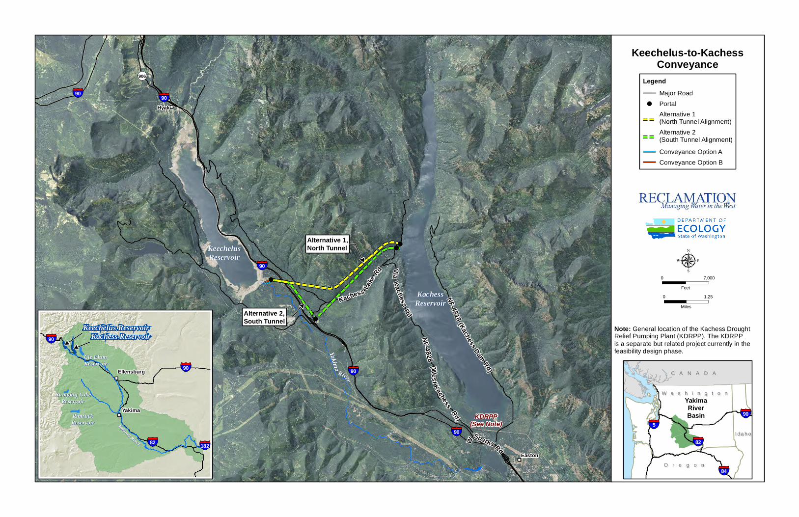
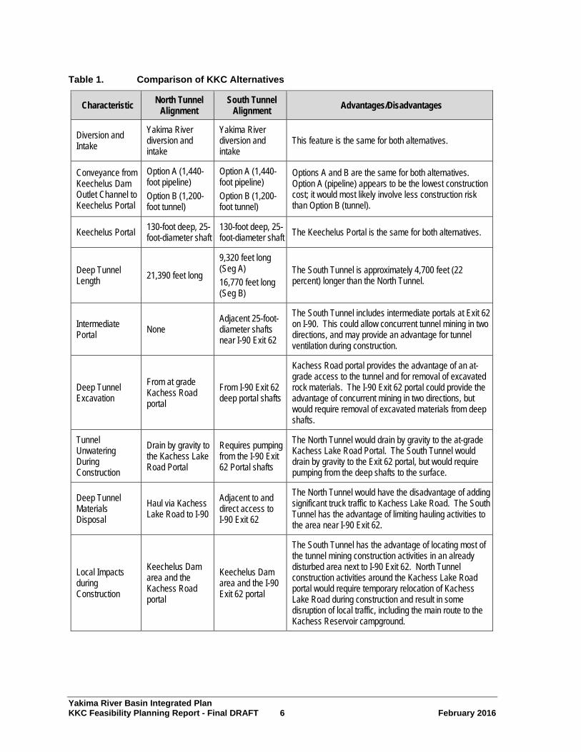
KKC Alternatives The KKC would divert water from the Yakima River immediately downstream from the Keechelus Dam outlet works and convey it through a new tunnel to Kachess Reservoir. Reclamation and Ecology considered a wide range of alternatives for the project prior to selecting two alternatives for consideration in this feasibility study. In addition to the No Action Alternative, two action alternatives1 remain under consideration as follows:
• Alternative 1 – North Tunnel Alignment2: This alternative would consist of an approximately 21,390-foot-long, continuous, deep tunnel.
• Alternative 2 – South Tunnel Alignment: This alternative would consist of two tunnel segments excavated from a portal shaft located next to I-90 at Exit 62, for a combined length of approximately 26,090 feet.
Figure 1 illustrates the North Tunnel and South Tunnel alignments and diversion pipeline options. Table 1 summarizes characteristics and relative advantages and disadvantages of the two project alternatives. Construction costs (including field costs and non-contract cost) are estimated to be approximately $241 million for Alternative 1 and $272 million for Alternative 2. When escalation to the midpoint of construction is included, these costs become $252 million for Alternative 1 and $285 million for Alternative 2.
Reclamation and Ecology will complete further geotechnical investigations and the Final Environmental Impact Statement (EIS) prior to selecting the preferred alternative.
Yakima River Basin Integrated Plan KKC Feasibility Planning Report – Final DRAFT 4 February 2016
1 The EIS for the KDRPP and KKC refers to the KKC North Tunnel Alignment as Alternative 3A and the KKC South Tunnel Alignment as Alternative 3B. For the purpose of this Feasibility Planning Report, the KKC North Tunnel Alignment is referred to as Alternative 1 and the KKC South Tunnel is referred to as Alternative 2.
2 A shorter straight North Tunnel Alignment from the Keechelus Portal to the Kachess Lake Road Portal may also be viable. However, due to the greater depth from the surface and associated anticipated rock mass pressures, the straight tunnel alignment may result in more robust and costly tunnel support systems than those required for the curved tunnel alignment.

Yakima River Basin Integrated Plan KKC Feasibility Planning Report - Final DRAFT 5 February 2016
Figure 1. Keechelus-to-Kachess Conveyance, North and South Tunnel Alignments
Yakima River Basin Integrated Plan KKC Feasibility Planning Report - Final DRAFT 6 February 2016
Table 1. Comparison of KKC Alternatives
Characteristic North Tunnel Alignment
South Tunnel Alignment Advantages/Disadvantages
Diversion and Intake
Yakima River diversion and intake
Yakima River diversion and intake
This feature is the same for both alternatives.
Conveyance from Keechelus Dam Outlet Channel to Keechelus Portal
Option A (1,440-foot pipeline) Option B (1,200-foot tunnel)
Option A (1,440-foot pipeline) Option B (1,200-foot tunnel)
Options A and B are the same for both alternatives. Option A (pipeline) appears to be the lowest construction cost; it would most likely involve less construction risk than Option B (tunnel).
Keechelus Portal 130-foot deep, 25-foot-diameter shaft
130-foot deep, 25-foot-diameter shaft The Keechelus Portal is the same for both alternatives.
Deep Tunnel Length 21,390 feet long
9,320 feet long (Seg A) 16,770 feet long (Seg B)
The South Tunnel is approximately 4,700 feet (22 percent) longer than the North Tunnel.
Intermediate Portal None
Adjacent 25-foot-diameter shafts near I-90 Exit 62
The South Tunnel includes intermediate portals at Exit 62 on I-90. This could allow concurrent tunnel mining in two directions, and may provide an advantage for tunnel ventilation during construction.
Deep Tunnel Excavation
From at grade Kachess Road portal
From I-90 Exit 62 deep portal shafts
Kachess Road portal provides the advantage of an at-grade access to the tunnel and for removal of excavated rock materials. The I-90 Exit 62 portal could provide the advantage of concurrent mining in two directions, but would require removal of excavated materials from deep shafts.
Tunnel Unwatering During Construction
Drain by gravity to the Kachess Lake Road Portal
Requires pumping from the I-90 Exit 62 Portal shafts
The North Tunnel would drain by gravity to the at-grade Kachess Lake Road Portal. The South Tunnel would drain by gravity to the Exit 62 portal, but would require pumping from the deep shafts to the surface.
Deep Tunnel Materials Disposal
Haul via Kachess Lake Road to I-90
Adjacent to and direct access to I-90 Exit 62
The North Tunnel would have the disadvantage of adding significant truck traffic to Kachess Lake Road. The South Tunnel has the advantage of limiting hauling activities to the area near I-90 Exit 62.
Local Impacts during Construction
Keechelus Dam area and the Kachess Road portal
Keechelus Dam area and the I-90 Exit 62 portal
The South Tunnel has the advantage of locating most of the tunnel mining construction activities in an already disturbed area next to I-90 Exit 62. North Tunnel construction activities around the Kachess Lake Road portal would require temporary relocation of Kachess Lake Road during construction and result in some disruption of local traffic, including the main route to the Kachess Reservoir campground.

Yakima River Basin Integrated Plan KKC Feasibility Planning Report - Final DRAFT 7 February 2016
Characteristic North Tunnel Alignment
South Tunnel Alignment Advantages/Disadvantages
Hydraulics Uniform gravity free flow
Gravity and pressure flow
The North Tunnel provides the advantage of a uniform gravity free flow for its entire length. The South Tunnel would be a combination of gravity free flow (Segment A) and pressurized flow (Segment B) hydraulics with an intermediate drop shaft.
Kachess Discharge Structure
Drop structure, box culvert and spillway
Cut and cover pipeline to dis-charge structure
The North Tunnel discharge system is more complex and visible than the South Tunnel discharge structure.
Geotechnical Deeper tunnel alignment
Shallower tunnel alignment
There is limited geotechnical information available for both alternatives. More information would be required to determine any specific advantages or disadvantages for either alignment.
Estimated Construction Cost
$241 million ($252 million with escalation)
$272 million ($285 million with escalation)
Based upon currently available information, the North Tunnel would be approximately $31 million (11 percent) less in construction cost than the South Tunnel. Construction cost includes total field cost plus non-contract cost.
Operations and Maintenance
Most operational activities would be at the Yakima River diversion and intake
Most operational activities would be at the Yakima River diversion and intake
System operations and maintenance would be similar for both alternatives, and operating costs are nearly identical. Both alternatives rely on gravity flow and do not require pumping.
Cost-Risk Analysis Reclamation and Ecology held a two-day cost-risk analysis workshop on the KKC project in March 2015. Cost-risk analysts from HDR Engineering led the event, which included experts on cost estimation, geology, construction engineering, and tunneling as well as members of the feasibility design team. The range of costs based on expected values at the 10th and 90th percentiles is relatively narrow, with the 90th percentile value approximately 20 percent higher than the 10th percentile value. Risk-mitigation strategies for the North Tunnel Alternative provide only a minor impact on expected value costs; while risk-mitigation strategies for the South Tunnel Alternative could have a larger effect.
Summary of Expected Results This section describes three categories of KKC results: streamflow, fish production, and water supply. Results are the same for both of the alternatives described in the previous section.

Yakima River Basin Integrated Plan KKC Feasibility Planning Report - Final DRAFT 8 February 2016
Streamflow Results The KKC provides a means for Reclamation to reduce unnaturally high flows in the Keechelus Reach of the Yakima River in July, August, and September by transferring water from Keechelus Reservoir into Kachess Reservoir. From Kachess Reservoir, Reclamation can release the water to Lake Easton and bypass the Keechelus Reach. Reclamation and Ecology have determined that re-routing flows in this way will not simply transfer habitat challenges from one area to another, because the Kachess River between Kachess Dam and Lake Easton is a much shorter reach (1.0 mile instead of 10.5 miles) that offers only limited potential habitat value in comparison to the Keechelus Reach of the Yakima River. The Keechelus Reach is a 10.5-mile stretch of the river from the Keechelus Dam outlet works to Lake Easton. Reclamation’s objective is to reduce flows to 500 cubic feet per second (cfs) during July and ramp flows down from 500 cfs on August 1 to 120 cfs by the first week of September. Without KKC, Reclamation can satisfy these objectives only 3 percent of the time in July and 9 percent of the time in August. With KKC in operation, Reclamation’s ability to satisfy these objectives would rise to 99 percent of the time in July and 100 percent of the time in August.
Fish Production Results Reclamation and Ecology intend that reducing unnaturally high flows will improve rearing habitat for steelhead and spring Chinook. Table 2 summarizes the projected increases in populations of these two species in the Keechelus Reach of the Yakima River that would result from operation of the KKC, as studied by Reclamation.
Table 2. Adult Fish Production in the Keechelus Reach
Species Baseline1 With KKC
Flow Regime Net Min 60 610 550
Steelhead Avg 80 810 730
Max 100 1,010 910
Min 48 463 415
Spring Chinook Avg 169 1,646 1,477
Max 479 4,660 4,181 Min = minimum; Avg = average; Max = maximum. 1 Currently, steelhead are not known to be present in the Keechelus Reach, but the baseline for steelhead includes some re-colonization potential.
Water Supply Results One of the goals of the Integrated Plan is to improve water supplies for proratable users. Reclamation used the RiverWare® model to evaluate how operation of the KKC would affect water supplies in the Yakima River basin for proratable water users. Improvements in water supply metrics from KKC are essentially zero except under climate change conditions, which would produce small benefits.

Yakima River Basin Integrated Plan KKC Feasibility Planning Report - Final DRAFT 9 February 2016
Reclamation also examined how the addition of the KKC to the separate KDRPP would affect water supply results. KKC would provide on the order of 15,000 acre-feet of additional water deliveries in drought years and would increase the prorationing level by approximately one percent in those years (Reclamation and Ecology, 2015c). (For comparison, KDRPP alone would increase prorationing by approximately 10 percent in drought years.)
Kachess Reservoir Refill Results KKC provides a refill benefit when combined with KDRPP. KDRPP would draw down Kachess Reservoir in drought years to a minimum pool level up to 80 feet below the current Kachess Reservoir minimum pool level. In years following drawdown, an extended period would be needed to refill Kachess Reservoir to normal pool levels. The Draft EIS prepared for KKC and KDRPP (Reclamation and Ecology, 2015d) indicates that drawdown of the Kachess Reservoir pool would impact recreational uses, scenic qualities, and bull trout use of Kachess Reservoir and its tributaries. KKC would reduce the duration of Kachess Reservoir drawdown in years following activation of the KDRPP. For example, compared to baseline conditions, the KDRPP would draw the reservoir level down below the existing outlet works (elevation 2,192) for an average duration of 191 days. The KKC combined with the KDRPP would reduce the duration of draw down to an average of 179 days, which is a 6 percent reduction in the duration of drawdown. KKC would also slightly raise average pool levels in Kachess Reservoir during years when it is drawn down.
Economic Analyses Economic outcomes of the KKC are projected using procedures consistent with the Federal Economic and Environmental Principles and Guidelines for Water and Related Land Resource Implementation Studies (U.S. Water Resources Council, 1983) (Principles and Guidelines), which includes requirements for analysis of four “accounts.” The four accounts are National Economic Development (NED), Regional Economic Development (RED), Environmental Quality (EQ), and Other Social Effects (OSE). The four accounts analysis performed for the KKC feasibility study builds on the Four Accounts analysis of the entire Integrated Plan that Reclamation and Ecology completed in 2012 (Reclamation and Ecology, 2012a).
Relationship of KKC NED Analysis to Full Integrated Plan Analysis The Integrated Plan is a comprehensive approach to manage water resources and ecosystem restoration improvements in the face of ongoing climate change and recurring droughts in the Yakima River basin. Reclamation and Ecology in collaboration with the Yakama Nation, irrigation districts, environmental groups, other Federal agencies, and State and county governments developed the Integrated Plan in 2011. The Integrated Plan addresses seven elements: reservoir fish passage, structural and operational changes to existing facilities, surface water storage, groundwater storage, habitat and watershed protection and enhancement, enhanced water conservation, and market reallocation.

Yakima River Basin Integrated Plan KKC Feasibility Planning Report - Final DRAFT 10 February 2016
Reclamation estimates that the total cost for implementing the Integrated Plan is between $3 and $5 billion (plus annual operation and maintenance costs estimated at $10 million), and is anticipated to be implemented over 30 years. In March 2014, the Yakima River Basin Water Enhancement Project (YRBWEP) Workgroup proposed an Initial Development Phase, covering the first ten-year period (2014 to 2023), which advances all seven plan elements and represents approximately one-quarter of the estimated plan cost (about $900 million). Key projects include implementation of Cle Elum Fish Passage, Cle Elum Pool Raise, KDRPP, KKC; and various projects associated with each element of the Integrated Plan, such as habitat and tributary restoration, agricultural conservation, and groundwater recharge projects.
Reclamation and Ecology would implement the Integrated Plan using a balanced approach. A “balanced approach” means advancing projects associated with each element of the plan during the same development phase. As a whole, Integrated Plan activities benefit fish and irrigation and offer a synergy that would otherwise be unattainable without the plan.
The KKC is a component within the broader Integrated Plan and is part of the Initial Development Phase. Reclamation and Ecology intend to implement components associated with the elements of the Integrated Plan concurrently, to achieve the full and synergistic benefits of the Integrated Plan for ecosystem improvement and water supply. The two agencies recognize that if the Integrated Plan were separated into pieces, economic analysis of the pieces would not result in all components showing favorable benefit-to-cost ratios by themselves. While, the Federal Principles and Guidelines typically evaluate components on an individual basis, it is appropriate to perform sensitivity analyses and display results in an array to provided decision-makers a complete picture by which to make an informed decision.
KKC was included in the Initial Development Phase for two primary reasons. First, conveying water from Keechelus Reservoir to Kachess Reservoir will enable Reclamation to refill Kachess Reservoir more quickly after dry years when water is pumped from the Kachess Reservoir inactive pool using KDRPP. Since KDRPP is included in the Initial Development Phase, it makes sense to also include KKC in this phase. Second, KKC will improve the stream flow regime for steelhead in the Keechelus Reach of the upper Yakima River. Reclamation and Ecology intend that the Initial Development Phase should provide concurrent benefits for water supply and fisheries, and implementation of KKC during the Initial Development Phase contributes to the achievement of fish habitat improvement in the upper watershed, balancing water supply improvements from KDRPP and other actions.
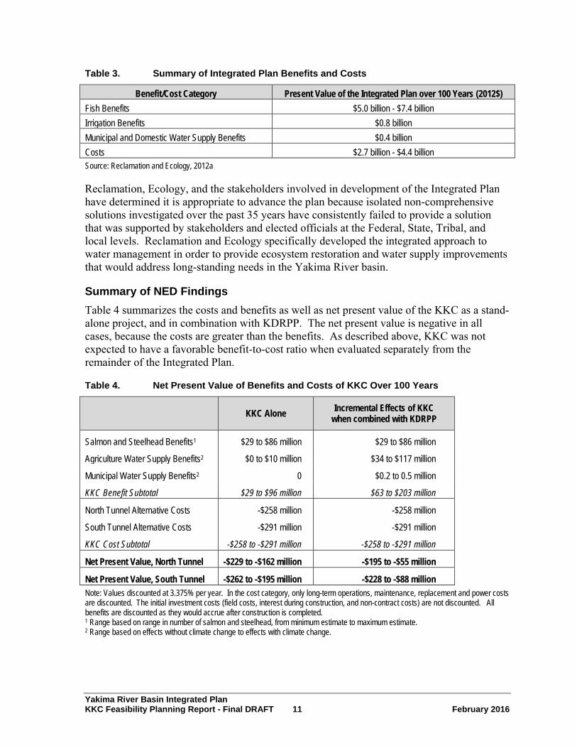
Reclamation and Ecology issued a Four Accounts Analysis of the full Integrated Plan at full build out (30-year costs) in 2012 (Reclamation and Ecology, 2012a). That report tabulated the combined benefits and costs of the full suite of Integrated Plan projects and programs. Table 3 summarizes the overall present value of the benefits and costs over the next 100 years for each benefit and cost category. Analyzed as a whole, the Integrated Plan yields a highly favorable benefit-to-cost ratio ranging from 1.4 to 3.2.
Yakima River Basin Integrated Plan KKC Feasibility Planning Report - Final DRAFT 11 February 2016
Table 3. Summary of Integrated Plan Benefits and Costs
Benefit/Cost Category Present Value of the Integrated Plan over 100 Years (2012$) Fish Benefits $5.0 billion - $7.4 billion Irrigation Benefits $0.8 billion Municipal and Domestic Water Supply Benefits $0.4 billion Costs $2.7 billion - $4.4 billion Source: Reclamation and Ecology, 2012a
Reclamation, Ecology, and the stakeholders involved in development of the Integrated Plan have determined it is appropriate to advance the plan because isolated non-comprehensive solutions investigated over the past 35 years have consistently failed to provide a solution that was supported by stakeholders and elected officials at the Federal, State, Tribal, and local levels. Reclamation and Ecology specifically developed the integrated approach to water management in order to provide ecosystem restoration and water supply improvements that would address long-standing needs in the Yakima River basin.
Summary of NED Findings Table 4 summarizes the costs and benefits as well as net present value of the KKC as a stand-alone project, and in combination with KDRPP. The net present value is negative in all cases, because the costs are greater than the benefits. As described above, KKC was not expected to have a favorable benefit-to-cost ratio when evaluated separately from the remainder of the Integrated Plan.
Table 4. Net Present Value of Benefits and Costs of KKC Over 100 Years
KKC Alone Incremental Effects of KKC
when combined with KDRPP
Salmon and Steelhead Benefits1 $29 to $86 million $29 to $86 million
Agriculture Water Supply Benefits2 $0 to $10 million $34 to $117 million
Municipal Water Supply Benefits2 0 $0.2 to 0.5 million
KKC Benefit Subtotal $29 to $96 million $63 to $203 million
North Tunnel Alternative Costs -$258 million -$258 million
South Tunnel Alternative Costs -$291 million -$291 million
KKC Cost Subtotal -$258 to -$291 million -$258 to -$291 million
Net Present Value, North Tunnel -$229 to -$162 million -$195 to -$55 million
Net Present Value, South Tunnel -$262 to -$195 million -$228 to -$88 million Note: Values discounted at 3.375% per year. In the cost category, only long-term operations, maintenance, replacement and power costs are discounted. The initial investment costs (field costs, interest during construction, and non-contract costs) are not discounted. All benefits are discounted as they would accrue after construction is completed. 1 Range based on range in number of salmon and steelhead, from minimum estimate to maximum estimate. 2 Range based on effects without climate change to effects with climate change.

Yakima River Basin Integrated Plan KKC Feasibility Planning Report - Final DRAFT 12 February 2016
Readers should consider the results shown in Table 4 in the context of the full Integrated Plan, and more particularly the Initial Development Phase. Table 5 shows the estimated costs and benefits of the Initial Development Phase as a whole. Even without all of the benefits quantified, the overall benefits of this phase substantially outweigh the overall costs.
Table 5. Net Present Value Benefits and Costs of Initial Development Phase
Project Costs Benefits Cle Elum Fish Passage $130M1 $1,300M to 1,900M KDRPP $437M to $446M $215 to $317M KKC (incremental with KDRPP) $258M to $291M $63 to $203M Bull Trout Enhancement $13M Not quantified Cle Elum Pool Raise $18M Not quantified Habitat Projects $85M Not quantified Water Conservation Projects $70M Not quantified
Totals $1,011 M to $1,053M $1,578M to $2,420M (plus unquantified benefits)
1 Costs of Cle Elum Fish Passage and Cle Elum Pool Raise are not discounted.
Summary of RED Findings The estimated economic impacts of construction of the KKC North Tunnel Alternative would be 1,094 job-years within the four-county local region and 1,780 job-years for the State of Washington as a whole. This includes $60 million in personal income for the four-county region and $92 million at the State level. The estimated corresponding job-years for the South Tunnel Alternative would be 1,223 job-years in the four-county region and 2,001 job-years for the State as a whole. Personal income under the South Tunnel Alternative construction would be an estimated $67 million in the four-county region and $103 million for the State as a whole. The KKC would also generate three additional job-years annually through the life of the project.
Increases in agricultural activity provided by the KKC if constructed in addition to the KDRPP would generate 212 local job-years during drought years over the 100-year timeframe, under historical water supply conditions, and this increases to 340 job-years per drought year under adverse climate change. This would be in addition to the effects of the KDRPP by itself. There also would be an additional 10 job-years in the rest of Washington under historical water supply conditions, and 16 job-years, under adverse climate change. The incremental increase of constructing the KKC in addition to the KDRPP, for total economic output under historical conditions for the four-county region, would be an estimated $28 million, and it would be $46 million under adverse climate change conditions.
Summary of EQ Findings Results from the EQ analysis suggest that under the No Action Alternative, conditions for most EQ resources would stay the same or decline. This is especially true for instream flows.

Yakima River Basin Integrated Plan KKC Feasibility Planning Report - Final DRAFT 13 February 2016
Implementation of the KKC would produce a moderate positive impact on instream flows and bull trout. The KKC would produce moderate positive impacts on fish abundance, including middle-Columbia-River steelhead. The KKC would provide minor positive impacts to adaptability to climate change. Other EQ resources would experience minor negative impacts under the KKC. The KKC would produce significant negative construction impacts during the construction period.
Summary of OSE Findings Results from the OSE analysis suggest that the No Action Alternative would have moderate negative impacts on long-term productivity.
The KKC alternatives would produce minor negative effects from construction worker impacts and minor to moderate benefits to long-term productivity. The KKC would have minor negative urban and community impacts.
Cost Allocation Reclamation prepared a preliminary cost allocation for the Integrated Plan (Reclamation and Ecology, 2012b) based on programmatic level analysis of project features and benefits. If KKC is funded using non-Federal sources, a project-specific cost allocation would not be required.
Climate Change Modeling Global climate change has the potential to impact water resources in the Keechelus and Kachess watersheds and the Yakima River basin. Potential climate change-related impacts could result from changes in future temperatures and precipitation patterns, with resulting implications for stream runoff volume and timing, water temperatures, and reservoir operations.
In general, the KKC would have a positive impact on the ability of water agencies, the agriculture sector of the economy, and fish and wildlife to better withstand and adapt to changing conditions, including the changes associated with climate change. The predicted changes in snowpack and runoff associated with climate change would alter KKC operations only slightly. These changes could slightly decrease the need for KKC, because reduced storage in Keechelus Reservoir would reduce the amount of water released from the reservoir that causes artificially high flows in Keechelus Reach of the Yakima River. On the other hand, the smaller proratable water supply associated with climate change could increase the need to release large volumes of water late in the summer, and thus increase the need for the operational flexibility provided by KKC.
Environmental Considerations Reclamation and Ecology are preparing an EIS for the KKC and KDRPP. This will serve as the required environmental analysis document under both the National Environmental Policy Act (NEPA) and State Environmental Policy Act (SEPA). The Draft EIS was released in January 2015. Reclamation and Ecology plan to release a Supplemental Draft EIS in 2016 to include impact analysis on a KDRPP floating pumping plant alternative. A Final EIS and

Yakima River Basin Integrated Plan KKC Feasibility Planning Report - Final DRAFT 14 February 2016
Record of Decision would then be issued with all the responses to comments on the Draft and Supplemental Draft EISs.
The EIS evaluates environmental considerations and potential impacts of the project on elements of the environment, such as air, soil, water resources, aesthetic values, cultural resources, wildlife, and vegetation. If the one of the action alternatives for KKC is selected for implementation, the results of the EIS analysis would inform the final design of the project to mitigate environmental concerns.
Consultation and Coordination Reclamation will consult with the U.S. Fish and Wildlife Service (Service) and National Marine Fisheries Service (NMFS) under the Endangered Species Act (ESA) and has begun initial conversations about the consultation. Consultation with the Service under the Fish and Wildlife Coordination Actis on-going. Reclamation has initiated consultation with the Washington Department of Archaeology and Historic Preservation (DAHP) under Section 106 of the National Historic Preservation Act. Government-to-Government consultation with the Confederated Tribes of the Yakama Nation, the Confederated Tribes of the Umatilla Indian Reservation (CTUIR), and the Confederated Tribes of the Colville Reservation is ongoing. Reclamation has contacted the Bureau of Indian Affairs (BIA) Yakima Office and the BIA Colville Tribes Office regarding Indian Trust Assets or trust lands in the project area.
Reclamation and Ecology are committed to ongoing coordination with the Tribes and resource agencies. Reclamation will complete ESA coordination with the Service and NMFS. Reclamation will complete cultural resource surveys and will continue coordination with the DAHP on impacts to cultural resources. Reclamation and Ecology will continue to consult with the Yakama Nation, CTUIR, and Colville Confederated Tribes.
Conclusions Reclamation and Ecology will postpone selection of a preferred alternative for the KKC pending completion of the EIS and analysis of additional geotechnical information on the proposed tunnel alignments.
Reclamation and Ecology do not envision the KKC as a stand-alone project, but rather as one component of the overall Integrated Plan. Reclamation and Ecology will continue to consider KKC for advancement as a component of the larger Integrated Plan.

Yakima River Basin Integrated Plan KKC Feasibility Planning Report - Final DRAFT 15 February 2016
1.0 Location, Background, Purpose, and Authority
The U.S. Department of the Interior Bureau of Reclamation and the Washington State Department of Ecology are conducting a feasibility study to investigate the proposed Keechelus Reservoir-to-Kachess Reservoir Conveyance (KKC). This project is part of the Initial Development Phase of the Yakima River Basin Integrated Water Resource Management Plan (Integrated Plan). The subsequent sections of this chapter present the location, background, purpose, and authority for the KKC.
This Feasibility Planning Report is prepared in compliance with the requirements of the Economic and Environmental Principles and Guidelines for Water and Related Land Resource Implementation Studies (U.S. Water Resources Council, 1983) (Principles and Guidelines). The Principles and Guidelines represent the main set of project evaluation guidelines for Federal water management agencies. This report presents a discussion of the formulation of alternatives, a description of the alternatives considered, and the results of the Principles and Guidelines-specific analyses. This Feasibility Planning Report also includes information on the cost estimates and a preliminary schedule for constructing the KKC.
Information in this Feasibility Planning Report is based on a variety of sources, including the Integrated Plan, Framework for Implementation Report, KKC Value Analysis Final Report (March 2014), KKC Draft Feasibility Design Report, Draft Environmental Impact Statement (EIS), and Draft Economic Analyses of Proposed Keechelus-to-Kachess Conveyance Technical Memorandum.
1.1 Project Location and Description Keechelus and Kachess Reservoirs are located in the upper Yakima River basin (Frontispiece and Figure 2). Keechelus Reservoir is located approximately 20 miles northwest of the city of Cle Elum, Washington. At river mile 214.5, it is farther upstream than any other reservoir in the Yakima River system. Reclamation constructed Keechelus Reservoir over a natural lake. It is impounded by Keechelus Dam, which was completed in 1917. Keechelus Dam is an earthfill structure 128 feet high and 6,650 feet wide at the crest. Keechelus Reservoir drains an area of 54.3 square miles and has an active capacity of 157,800 acre-feet (Reclamation, 2002). The Yakima River flows out of the outlet works of the dam.
Kachess Reservoir is located about 15 miles northwest of Cle Elum. It releases water into the Kachess River, which flows into the Yakima River at river mile 203.5. Like Keechelus Reservoir, Reclamation constructed Kachess Reservoir over a natural lake. The natural lake included two basins ― the upper Little Kachess Lake and the lower Big Kachess Lake. Kachess Reservoir’s earthfill dam, completed in 1912, is 115 feet high and 1,400 feet wide at the crest. Kachess Reservoir drains an area of 63 square miles and has an active storage capacity of 239,000 acre-feet above the existing gravity outlet (Reclamation, 2002).

Yakima River Basin Integrated Plan KKC Feasibility Planning Report - Final DRAFT 16 February 2016
The KKC would divert water from the Yakima River immediately downstream from the Keechelus Reservoir outlet works and convey it to Kachess Reservoir via a diversion pipeline and deep tunnel. The tunnel outlet would be located on the west shore of Kachess Reservoir. Reclamation is currently investigating two alternative alignments for the KKC, the North Tunnel3, and the South Tunnel. Section 4.0, Alternatives, discusses details of each alternative.
Existing Reclamation facilities associated with this project are located in the Keechelus Dam area. The KKC project would not modify or affect Keechelus Dam itself (Reclamation and Ecology, 2015e). Reclamation does not currently own or operate facilities on the shoreline of Kachess Reservoir near the proposed KKC discharge structure, although Reclamation does own and operate Kachess Reservoir as a multipurpose water storage reservoir.
3 A shorter straight North Tunnel Alignment from the Keechelus Portal to the Kachess Lake Road Portal may also be viable. However, due to the greater depth from the surface and associated anticipated rock mass pressures, the straight tunnel alignment may result in more robust and costly tunnel support systems than those required for the curved tunnel alignment.

Yakima River Basin Integrated Plan KKC Feasibility Planning Report - Final DRAFT 17 February 2016
Figure 2. KKC Conveyance Project Location

Yakima River Basin Integrated Plan KKC Feasibility Planning Report - Final DRAFT 18 February 2016
1.2 Background
1.2.1 Yakima Project The Yakima Project provides irrigation water for a comparatively narrow strip of fertile land that extends for 175 miles on both sides of the Yakima River in south-central Washington State. The irrigable land eligible for service under Reclamation’s Yakima Project total approximately 465,000 acres. The project has seven divisions ― a reservoir storage division and six water delivery divisions: Kittitas (59,123 acres), Tieton (27,271 acres), Sunnyside (103,562 acres), Roza (72,511 acres), Kennewick (19,171 acres), and Wapato. The Bureau of Indian Affairs operates the Wapato Division, which receives most of its water supply from the Yakima Project for irrigation of 136,000 acres of land. Reclamation provides irrigation water for over 45,000 acres not included in the seven divisions under supplemental water supply contracts (Reclamation and Ecology, 2011c).
The Yakima Project includes five major storage reservoirs ― Keechelus, Kachess, Cle Elum, Bumping, and Rimrock. Reclamation operates the Kachess and Keechelus Reservoirs as part of the Yakima Project. Congress authorized the Yakima Project in 1905, directing Reclamation to develop irrigation facilities in the Yakima River basin. The five reservoirs store and release water to meet irrigation demands, flood control needs, and instream flow requirements. Reclamation operates the reservoirs as a pooled system with no reservoir or storage space designated for a specific area. The Yakima Field Office Manager is ultimately responsible for operations of the Yakima Project (Reclamation and Ecology, 2015d).
A complex group of Federal and State statutes and regulations, as well as court decisions and orders regulate water management in the Yakima River basin. Sections 1.6.3 and 1.6.4 of the Integrated Plan Programmatic Environmental Impact Statement (PEIS) (Reclamation and Ecology, 2012c) describe the regulations and legal decisions related to water management in the basin. The following paragraphs describe the key issues relevant to understanding the KKC, KDRPP, and BTE.
There are two classes of entitlements, or water rights, in the Yakima River basin: nonproratable and proratable. Nonproratable entitlements are “senior” and generally held by water users who were irrigating prior to construction of the Yakima Project reservoirs. Water users with nonproratable water rights receive water first. All other Yakima Project water rights are proratable, and are junior to the senior nonproratable water rights. Holders of junior water rights share equally any water shortages. "Prorationing" refers to the process of equally reducing the amount of water delivered to proratable water right holders in deficit years based on total water supply available (TWSA). The definition of TWSA is as follows:
That amount of water available in any year from natural flow of the Yakima River, and its tributaries, from storage in the various Government reservoirs on the Yakima River watershed, and from other sources, to supply the contract obligations of the United States to the Yakima River and its tributaries (Civil Action No. 21 (1945 Consent Decree) Article 4, 1st Para.).
Reclamation estimates TWSA annually based on forecasted runoff, forecasted return flows, and reservoir storage contents.
Yakima River Basin Integrated Plan KKC Feasibility Planning Report - Final DRAFT 19 February 2016
In 1981, the Reclamation Yakima Field Office Manager established the System Operations Advisory Committee (SOAC) to advise Reclamation on how to manage the Yakima Project to reduce flow-related impacts on fish. SOAC consists of fishery biologists from four member agencies: the Yakama Nation, the U.S. Fish and Wildlife Service (Service), Washington Department of Fish and Wildlife (WDFW), and irrigation entities represented by the Yakima Basin Joint Board. SOAC provides information, advice, and assistance to Reclamation on fish-related issues associated with the operations of the Yakima Project (Reclamation and Ecology, 2015d).
The following are the objectives of the current Yakima Project operation:
• Store as much water as possible up to the reservoir system’s full active capacity of about 1 million acre-feet following the end of the irrigation season through early spring.
• Provide for target flows and diversion entitlements downstream from the dams, meeting Title XII flows at Sunnyside and Prosser Diversion Dams.
• Provide reservoir space for flood control operations.
The SOAC has advised Reclamation on “flip-flop” operations to mitigate the impacts on spawning fish in the Yakima River basin. Flip-flop operation involves reducing releases from one reservoir while increasing releases in another. This was instituted to encourage spring Chinook to spawn at a lower streamflow that requires less stored water to be released during the egg incubation period to protect spawning nests (redds). As an example, starting in late August and continuing to about September 12, Cle Elum Reservoir releases are reduced substantially from about 3,000 cfs or greater down to near 200 cfs, and releases from Rimrock Reservoir are increased substantially to meet the September and October irrigation demands downstream from the confluence of the Naches and Yakima rivers.
Reclamation performs a similar operation in years of sufficient water supply, referred to as “mini flip-flop,” between Keechelus and Kachess Reservoirs, for similar reasons as discussed for the flip-flop operation that occurs downstream from Easton and Cle Elum Dams. Reclamation’s releases for irrigation supply from Keechelus Reservoir are substantially greater than from Kachess Reservoir during the June to mid-August period. Beginning in late August, Reclamation gradually switches the flow levels between the two reservoirs. By September and October, reservoir releases from Keechelus Reservoir are reduced to 100 cfs (or 80 cfs in dry years), and flows from Kachess Reservoir are raised to 1,000 to 1,400 cfs. However, Reclamation cannot always reduce flows to the target level from Keechelus Reservoir because Reclamation must continue to supply downstream users in this time period and at times more water is needed from Keechelus Reservoir. Under current conditions, flows more than 10 cfs above the target level occur about 15 percent of the time, and flows of 400 cfs or greater above the target level occur about 2 percent of the time.

Yakima River Basin Integrated Plan KKC Feasibility Planning Report - Final DRAFT 20 February 2016
Yakima Project Operation of Keechelus Reservoir
Reclamation fills the Keechelus Reservoir from early September to typically mid-April. Keechelus usually continues to fill until late May or early June but the outflows are typically higher. In mid-April when Kittitas Reclamation District starts diverting from Lake Easton, the flow from Keechelus Reservoir increases as needed up to about 1,100 to 1,300 cfs in June and July. In August, Reclamation ramps down the releases from Keechelus Reservoir, per the “mini flip-flop” operation discussed above, and the cycle starts over again.
Yakima Project Operation of Kachess Reservoir
Reclamation fills Kachess Reservoir from mid-October to June or July with reservoir releases typically in the 20 to 60 cfs range – saving water supply for flip-flop operations explained above. After storage control and into August, Kachess Reservoir spills inflows or makes releases in the 50 to 400 cfs range. During mini flip-flop, starting in late August and continuing into October, Reclamation releases up to 1,000 to 1,200 cfs to meet demands. Diversions from the reservoir decline from the end of September to mid-October, and the cycle starts over again.
1.2.2 Relationship of Other Water and Related Resources Activities to Study
The KKC Feasibility Study and Draft EIS are conducted within the framework of the Integrated Plan. The Integrated Plan developed out of several prior initiatives, including the Yakima River Basin Water Enhancement Project (YRBWEP) and the Yakima River Basin Water Storage Feasibility Study.
Yakima River Basin Water Enhancement Project
Congress initiated the Yakima River Basin Water Enhancement Project (YRBWEP) in 1979 in recognition of the extreme water shortage problems of the basin. YRBWEP has the following objectives: develop a plan that would provide (1) supplemental water for presently irrigated lands; (2) water for new lands within the Yakama Indian Reservation; (3) water for increased instream flows for aquatic life; and (4) a comprehensive plan for efficient management of basin water supplies. Since 1979, State and Federal YRBWEP feasibility study activities have been ongoing with the objective to develop and implement a comprehensive solution for efficient management of Yakima River basin water supplies (Figure 3) (Reclamation and Ecology, 2012d).

Yakima River Basin Integrated Plan KKC Feasibility Planning Report - Final DRAFT 21 February 2016
Figure 3. Yakima River Basin Water Enhancement Project Timeline
Yakima River Basin Water Enhancement Plan Phase 1
Early in the study process, the YRBWEP identified fish passage problems as needing immediate attention. Congressional legislation in 1984 (Public Law 98-381) authorized Reclamation to design, construct, and operate fish passage facilities within the Yakima River basin in accordance with the Northwest Power and Conservation Council’s Columbia River Fish and Wildlife Program (YRBWEP Phase 1). Congress enacted a companion law on August 22, 1984, to provide, among other things, for operations and maintenance costs related to fish facilities (Public Law 98-381, Section 109 of Hoover Powerplant Act of 1984). The YRBWEP efforts proceeded through the 1980s, but were not fully completed, primarily due to issues and uncertainties associated with basin surface water rights adjudication (Reclamation and Ecology, 2012d).
Yakima River Basin Water Enhancement Plan Phase 2
In 1994, Congress passed legislation for YRBWEP Phase 2 (Public Law 103-434), which provided for significant water conservation and acquisition activities; studies to define the long-term water needs of fish and irrigators; improvements to the Wapato Irrigation Project; and development of an interim operations plan for management of basin water supplies.

Yakima River Basin Integrated Plan KKC Feasibility Planning Report - Final DRAFT 22 February 2016
In compliance with the 1994 YRBWEP Act (Phase 2 Legislation – Public Law 103-434), Reclamation and Ecology are cost-sharing partners in the Basin Conservation Program, with Reclamation funding 65 percent of the cost and Ecology and participating irrigation districts each funding 17.5 percent. Under this program, two-thirds of the water savings remains in the river and the irrigation districts retain one-third (Reclamation and Ecology, 2012d).
As of December 2014, Reclamation, Ecology, and irrigation entities have cost-shared to develop eight Comprehensive Conservation Plans and four conservation Feasibility Investigation Reports for Yakima River basin irrigation systems. They also implemented a number of projects to generate water savings and improve streamflows. For more information, see the Reclamation’s Web site at http://www.usbr.gov/pn/programs/yrbwep/phase2/basinconservation.html.
Yakima River Basin Water Storage Feasibility Study and Development of the Integrated Plan Alternative
In 2003, Congress directed Reclamation to conduct a feasibility study of options for additional water storage in the Yakima River basin. The authorization for the study is contained in Section 214 of the Act of February 20, 2003 (Public Law 108-7). The authorization states that the study would place “…emphasis on the feasibility of storage of Columbia River water in the potential Black Rock Reservoir and the benefit of additional storage to endangered and threatened fish, irrigated agriculture, and municipal water supply.”
Reclamation began the Storage Study in May 2003. The State of Washington joined Reclamation in that effort after the State’s 2003-2005 capital budget provided funding.
In 2007, Reclamation and Ecology initiated an environmental review for the Storage Study. The Draft Planning Report and Environmental Impact Statement was prepared as a combined NEPA and SEPA document, entitled the Yakima River Basin Water Storage Feasibility Study Draft Planning Report/Environmental Impact Statement (Reclamation and Ecology, 2008).
Reclamation understood that Federal funds provided under Section 14 of the Act of February 20, 2003, were restricted to the study of Black Rock Reservoir and other potential storage facilities in the Yakima River basin. Reclamation considered the following alternatives:
• No Action Alternative
• Black Rock Reservoir Alternative
• Wymer Dam and Reservoir Alternative
• Wymer Dam Plus Yakima River Pump Exchange Alternative
The January 2008 draft planning report and EIS referred to these storage facilities as the "Joint Alternatives" because Reclamation and Ecology advanced them jointly. Under its SEPA authority, Ecology determined the need to evaluate both storage and nonstorage means of achieving the objectives. Thus, the January 2008 draft planning report and EIS considered three “State Alternatives” in addition to the Joint Alternatives:
• Enhanced Water Conservation Alternative
• Market-based Reallocation of Water Resources Alternative

• Groundwater Storage Alternative
Reclamation and Ecology held a public comment period on the January 2008 draft planning report and EIS from January 29 to March 31, 2008. A number of the comments received asserted that Reclamation and Ecology had failed to evaluate an adequate range of reasonable alternatives. Ecology consulted with Reclamation concerning whether additional alternatives should be evaluated, and Ecology concluded that the scope of the EIS should be expanded; however, Reclamation determined that its congressional authorization precluded it from expanding its analysis under NEPA to include nonstorage alternatives. Therefore, Ecology decided to separate from the joint NEPA and SEPA process for the study and to pursue completion of a stand-alone SEPA Supplemental EIS. Ecology continued to act as a cooperating agency for Reclamation’s NEPA process, while Reclamation acted in a similar capacity for the SEPA process. Reclamation pursued completion of the final planning report and EIS for the Storage Study, while Ecology prepared a SEPA Supplemental Draft EIS and a Final EIS.
Reclamation released its final planning report and EIS on December 29, 2008. It included only the storage facilities in the Joint Alternatives and responses to comments on the Joint Alternatives. Reclamation determined based on the results of the final planning report and EIS that none of the storage features by themselves met Federal criteria for an economically and environmentally sound water project and recommended the No Action Alternative as the Preferred Alternative. On April 3, 2009, Reclamation, in a concluding letter, announced that it had concluded the Yakima River Basin Water Storage Feasibility Study (Reclamation and Ecology, 2012d).
Ecology’s Yakima River Basin Water Storage Feasibility Study and Supplemental SEPA Analysis
Ecology released its Supplemental Draft EIS on December 10, 2008, which evaluated an integrated approach to water management in the Yakima River basin. Ecology selected the Integrated Water Resource Management Alternative as the preferred alternative for the Final EIS. This alternative proposed seven elements to increase water supplies for agricultural and municipal needs and to improve habitat for anadromous and resident fish. The seven elements were fish passage, modifying existing structures and operations improvements, new surface storage, groundwater storage, fish habitat enhancement, enhanced water conservation, and market-based reallocation of water resources. Ecology prepared its EIS at a programmatic level, and issued the Final EIS in June 2009. It presents an integrated package of opportunities to address water resource problems in the Yakima River basin (Reclamation and Ecology, 2012d).
Yakima River Basin Integrated Water Resource Management Plan
In 2009, Reclamation and Ecology convened the YRBWEP Workgroup to review studies produced since the 1979 YRBWEP feasibility study authorization, including Ecology’s Final EIS (2009), in order to formulate a comprehensive and integrated solution for the basin’s water resource problems and ecosystem restoration needs. The Workgroup is composed of representatives of the Yakama Nation, Federal agencies, Washington State and local governments, environmental organizations, and irrigation districts. Workgroup activities have included development of an initial Integrated Plan proposal; performance of multiple
Yakima River Basin Integrated Plan KKC Feasibility Planning Report - Final DRAFT 23 February 2016

Yakima River Basin Integrated Plan KKC Feasibility Planning Report - Final DRAFT 24 February 2016
analyses to examine a range of technical, engineering, and economic topics; and preparation of the Integrated Plan.
The current lack of facilities in which to store the full water supply of the basin, operational constraints, and the legal framework affecting water resources in the Yakima River basin illustrate the challenges for residents, businesses, Tribal communities, and ecosystem resources. The Integrated Plan aims to address the following challenges for Yakima River basin water users:
• Water reliability for the Yakama Nation. The Yakama Nation water supply needs must be met as there is potential for expensive and time-consuming litigation in resolving treaty issues in regard to water rights. The Integrated Plan would help assure Tribal officials that their instream and out-of-stream water supply needs would be met.
• Water reliability for proratable water users. In severe drought years, proratable water users receive sharply diminished supplies from the Yakima Project ― in one year, as little as 38 percent of their full allotment. Junior users can be cut off completely. These diminished water supplies reduce agricultural production and associated jobs. Fruit growers may also face early loss of vines and trees that could have remained economically productive, sometimes for several additional years.
• Water reliability for municipal and domestic water users. Municipal and domestic water users rely on junior water rights for their drinking water. The Yakama Nation and irrigation users, including proratable irrigation users, hold water rights and entitlements that are senior to most municipal and domestic uses. In drought conditions, municipal and domestic water users face the very real risk that their supplies could be cut off as a result of litigation brought by senior water users. This affects current residents and limits the ability of local communities to grow and develop. The State of Washington and local governments have identified averting such litigation as a key objective.
• Ecosystem restoration in the Yakima River basin. Restoration on a watershed scale includes habitat and floodplain restoration in combination with land management that would ultimately improve conditions for listed species of fish (bull trout and steelhead) that rely on the Yakima River system and potentially address the risk of Federal enforcement actions that would undermine economic uses of water in the basin.
• Climate change effects on the Yakima River basin. Scientists studying the Columbia River basin expect that less water would be stored as snowpack in the Cascade Range in future decades compared with current conditions. Snowpack currently provides a substantial portion of runoff into the Yakima River basin. Reduced snowpack would compromise water supply, streamflow, and aquatic habitat conditions. There is no single type of action that can address the multiple effects of climate change on snowpack, runoff conditions, water temperature, aquatic life, and forest health. Reclamation and Ecology believe that an integrated approach that includes consideration of water storage, water conservation, streamflow management, fish passage, and habitat improvements offers the best opportunity to mitigate climate change impacts on the Yakima River basin’s aquatic habitat and economy.

Yakima River Basin Integrated Plan KKC Feasibility Planning Report - Final DRAFT 25 February 2016
• Adverse effects on forest resources, land, and terrestrial habitat. The Yakima River basin also faces risks associated with large wildfires, fragmented land ownership, and land-use practices that have adverse impacts on forest resources, land, and terrestrial habitat. These risks exacerbate the other risks to water resources and aquatic habitats in the basin. The Integrated Plan includes approaches to coordinate land and water management to help manage these risks.
The Integrated Plan encompasses seven elements: (1) habitat and watershed protection and enhancement, (2) reservoir fish passage, (3) surface storage, (4) enhanced water conservation, (5) structural and operational changes, (6) groundwater storage, and (7) the use of market-based forces to reallocate water and habitat among willing buyers and sellers. The goals of the Integrated Plan are to protect, mitigate, and enhance fish and wildlife habitat; provide increased operational flexibility to manage instream flows to meet ecological objectives; and improve the reliability of the water supply for irrigation, municipal supply and domestic uses.
The seven elements each include recommended projects to meet the goals (Reclamation and Ecology, 2012d). The KKC proposal is included in the structural and operational changes element, the KDRPP proposal is included in the surface water storage element, and the BTE is part of the habitat and watershed protection and enhancement element. These proposed actions would contribute toward achieving the overall goals of the Integrated Plan. Chapter 4 of the Integrated Plan PEIS evaluates the impacts of the proposals at a programmatic level. The PEIS provides further assessment of Integrated Plan outcomes (Reclamation and Ecology, 2012c). Reclamation and Ecology are currently developing an EIS that evaluates the project level environmental impacts associated with the KDRPP, KKC, and BTE.
Reclamation and Ecology intend that components associated with the elements of the Integrated Plan be implemented with a balanced approach, so that the full and synergistic benefits of the Integrated Plan for ecosystem improvement and water supply can be achieved. A balanced approach means advancing projects associated with each element of the plan during the same development phase. Reclamation and Ecology are advancing an Initial Development Phase, covering the first ten-year period (2014-2023), which advances all seven plan elements and represents approximately one-quarter of the estimated plan cost (about $900 million).
The following websites contain information about implementation of the Integrated Plan:
• http://www.usbr.gov/pn/programs/yrbwep/2011integratedplan/index.html • http://www.ecy.wa.gov/programs/wr/cwp/YBIP.html
Integrated Plan Schedule: Timing, Sequence, and Triggers
Figure 4 shows the implementation schedule for the projects in the Initial Development Phase of the Integrated Plan, including KKC, KDRPP, and the BTE program. Figure 5 shows how the Initial Development Phase relates to the implementation schedule for the remaining actions in the Integrated Plan. This schedule is subject to revision as Reclamation and Ecology further define project feasibility, funding strategies, and implementation pathways. Colors used in the figure show three stages of activity: (1) studies; (2) action-specific environmental review, permitting, and design; and (3) project construction or program activation.

Yakima River Basin Integrated Plan KKC Feasibility Planning Report - Final DRAFT 26 February 2016
'14 '15 '16 '18 '19 '20 '21 '22 '23Infrastructure in Initial Development Phase
Kachess Drought Relief Pumping Plant (KDRPP)K-to-K Conveyance (KKC)
Bull Trout Enhancement Program (BTE)1 P1 P2
Raise Pool Level at Cle Elum ReservoirFish Passage at Cle Elum Dam Fish Passage - TietonAgricultural Conservation (P)Tributaries Habitat Enhancement Program (P)Mainstem Floodplain Restoration Program (P)Municipal Aquifer Storage and Recovery
Programmatic and Operational ActionsConservation Land Acquisition ? ?Market Reallocation (P)Municipal Conservation (P)
Subordinate Power Diversions, Roza & Chandler2
(P) = Programmatic Actions ? = T iming uncertain.1 The BTE will be implemented in two phases.2 Further power subordination subject to approval by Reclamation, BPA, and either Roza or Kennewick Irrigation District, as applicable.
Color Codes:
Studies Project-level environmental review, permitting & design
Project Construction or Program Activation
10-Year Initial Development Phase (2014 - 2023)'17
?
Figure 4. Implementation Schedule for the Integrated Plan Initial Development Phase

Yakima River Basin Integrated Plan KKC Feasibility Planning Report - Final DRAFT 27 February 2016
14 15 16 18 19 20 21 22 23 24 25 26 27 28 29 30 31 32 33 34 35 36 37 38 39 40 41 42 43Infrastructure in Initial Development Phase
Kachess Drought Relief Pumping Plant (KDRPP)K-to-K Conveyance (KKC)
Bull Trout Enhancement Program (BTE)1 P1 P2
Raise Pool Level at Cle Elum ReservoirFish Passage at Cle Elum Dam Fish Passage - TietonAgricultural Conservation (P)Tributaries Habitat Enhancement Program (P)Mainstem Floodplain Restoration Program (P)Municipal Aquifer Storage and Recovery
Programmatic and Operational ActionsConservation Land Acquisition ? ? ? ? ? ?Market Reallocation (P)Municipal Conservation (P)
Subordinate Power Diversions, Roza & Chandler2
Subsequent Phases, Infrastructure Projects
Wymer and/or Bumping Reservoirs 3, 4 ? ?
Fish Passage - KeechelusFish Passage - Clear LakeFish Passage - Kachess
Fish Passage - Bumping5 ?
KRD Main Canal and South Branch ModificationsConveyance Improvements at Wapatox
Ground Water Infiltration at Regional Scale
Projects Requiring Further Development(Implementation and T iming Contingent on Study Results and Future Decision-making)
Update Water Needs Assessment
Periodic Review of Integrated Plan
Potential Columbia R. Storage/Pump 4,6 T T T T
Roza Alternate Supply & Dam Removal4 T T T T
(P) = Programmatic Actions ? = T iming uncertain. T = Assess triggers for possible implementation.1 The BTE will be implemented in two phases.2 Further power subordination subject to approval by Reclamation, BPA, and either Roza or Kennewick Irrigation District, as applicable.
4 Roza alternate supply to be considered as part of Wymer Project or storage/pump exchange projects such as Columbia River supply. 5 T iming of fish passage at Bumping Lake depends on when the enlarged reservoir project is constructed.6 Step 1 in feasibility study of potential future storage/pump exchange projects.
Color Codes:
Studies Project-level environmental review, permitting &
Project Construction or Program Activation
3 Outcomes from studies will be used to determine actual sequencing of Wymer and Bumping Reservoir projects.
30-Year Program Activities (2014 - 2043)17
?
Figure 5. Implementation Schedule for the Integrated Plan

Yakima River Basin Integrated Plan KKC Feasibility Planning Report - Final DRAFT 28 February 2016
Yakima River Basin Study
In early 2010, Reclamation and Ecology conducted further evaluation and analysis of the Integrated Plan with funding from the Department of Interior’s WaterSMART Basin Study Program. The Yakima River Basin Study (Basin Study) supplements information provided through previous efforts to evaluate water supply and aquatic resource problems in the basin and identifies potential remedies. It characterizes and quantifies basin water resources and current and future water needs for both instream and out-of-stream uses.
The Basin Study and associated interaction with the workgroup and its subcommittees specified basin needs in detail. Reclamation and Ecology further defined, evaluated, and updated actions in the Integrated Plan. The agencies also further characterized expected hydrologic, fish habitat, fisheries, and economic effects for the Integrated Plan and the future without the Integrated Plan. They evaluated potential impacts of future climate change and factored them into the instream and out-of-stream projections for future water availability and demands. They also modeled storage and flow projections for plan elements based on accepted climate change projections.
The Basin Study, including modeling and analysis results, cost estimates, assessments of barriers and risks, and potential economic effects was completed in 2011. The Integrated Plan and supporting technical documents are located on Reclamation’s website at: http://www.usbr.gov/pn/programs/yrbwep/2011integratedplan/index.html.
1.3 Purpose of the KKC Reclamation’s mission is to manage, develop, and protect water and related resources in an environmentally and economically sound manner in the interest of the American public. Ecology’s mission is to protect, preserve, and enhance the State of Washington’s environment for current and future generations. The State Legislature authorized Ecology to implement actions that provide concurrent benefits for instream and out-of stream uses for the Yakima River basin. To advance these missions, Reclamation and Ecology are developing a comprehensive program of water resource and habitat improvements focused on fish passage, aquatic habitat, and water supply.
The KKC, as a component of the Yakima Project, would contribute to meeting the goals of the Integrated Plan. The objectives of the KKC are as follows (Reclamation and Ecology, 2015e):
• Capture excess runoff from the Keechelus watershed • Improve capabilities for refilling Kachess Reservoir during and following dry and
drought years • Reduce high flows from Keechelus Dam in the upper Yakima River during irrigation
season to improve rearing habitat for steelhead and spring Chinook upstream of Lake Easton
Section 2.1, Need for Action, provides further detail on the purpose and need for the KKC.

Yakima River Basin Integrated Plan KKC Feasibility Planning Report - Final DRAFT 29 February 2016
1.4 Authority Federal authority is from congressional legislation. State authority is through State legislation and the State Capital Budget as discussed below (Reclamation and Ecology, 2012d).
1.4.1 Federal Authority Congress authorized Reclamation to conduct a feasibility study to address the water resource needs of the Yakima River basin in the Act of December 28, 1979 (93 Stat. 1241, Public Law 96-162, Feasibility Study - Yakima River Basin Water Enhancement Project). Other authorities relevant to the YRBWEP include the YRBWEP 1979 Feasibility Study Authorization, the Hoover Power Plant Act of 1984, and the Yakima River Basin Water Enhancement Project Act of 1994.
1.4.2 Washington State Authority Chapter 90.90 RCW, the Columbia River Basin Water Supply legislation approved by the Washington State Legislature in 2006, provides authority for the State of Washington:
(1) The legislature finds that a key priority of water resource management in the Columbia river basin is the development of new water supplies that includes storage and conservation in order to meet the economic and community development needs of people and the instream flow needs of fish. (2) The legislature therefore declares that a Columbia river basin water supply development program is needed, and directs the department of ecology to aggressively pursue the development of water supplies to benefit both instream and out-of-stream uses.
In 90.90.010 RCW, the legislature created the Columbia River Basin water supply development account in the state treasury to use as follows:
Assess, plan, and develop new storage, improve or alter operations of existing storage facilities, implement conservation projects, or any other actions designed to provide access to new water supplies within the Columbia river basin for instream and out-of-stream uses.
During the 2013 legislative session the Legislature passed Second Substitute Senate Bill 5367 providing specific authority for implementing the Yakima River basin Integrated Plan. The bill states that
The department [of Ecology] is authorized to implement the integrated water resource management plan in the Yakima River basin, through a coordinated effort of affected federal, state, and local agencies and resources, to develop water supply solutions that provide concurrent benefits to both instream and out-of-stream uses, and to address a variety of water resource and ecosystem problems affecting fish passage, habitat functions, and agricultural, municipal, and domestic water supply in the Yakima River basin, consistent with the Integrated Plan.

Yakima River Basin Integrated Plan KKC Feasibility Planning Report - Final DRAFT 30 February 2016
The bill further authorizes Ecology to assess, plan and develop projects under the Integrated Plan, including water storage projects and structural and operational modifications to existing facilities.
Additional authority for the State of Washington is contained in the 2011 to 2013 Capital Budget, Yakima Basin Integrated Water Management Plan Implementation (30000278) C 49, L 11, E1, Sec 3033. This budget provided funding to implement the Integrated Plan.
Related Projects
There is a close relationship between the KKC and two other projects proposed under the Integrated Plan, which are located in the Keechelus and Kachess Reservoirs area. These are the Kachess Drought Relief Pumping Plant (KDRPP) and the bull trout enhancement (BTE) program. Section 5.0, Related Projects, describes these projects.
Yakima River Basin Integrated Plan KKC Feasibility Planning Report - Final DRAFT 31 February 2016
2.0 Plan Formulation This chapter defines the background problems, opportunities, needs, prior investigation, and public and agency participation, which contributed to plan formulation.
2.1 Need for Action The Integrated Plan PEIS confirms that current water resources infrastructure, programs, and policies in the Yakima River basin are not capable of consistently meeting the demands for fish and wildlife, dry-year irrigation, and municipal water supply. The Preferred Alternative identified in the Integrated Plan PEIS includes a wide range of actions to respond to the basin’s water supply and aquatic ecosystem needs. KKC is noted in the Record of Decision for the Integrated Plan PEIS as an improvement necessary to help address water supply, instream flow, and aquatic habitat deficiencies in the Yakima River basin (Reclamation, 2013b).
Reclamation and Ecology identified the proposed KKC to respond to specific conditions in the Yakima River basin that adversely affect and are affected by Reclamation’s facilities and operations. The following conditions are identified here as the need associated with the KKC (Reclamation and Ecology, 2015d):
• Runoff from the Keechelus watershed in a typical year is greater than can be contained in the reservoir for release when most needed for instream, agricultural, municipal, and domestic uses.
• Current operations at Keechelus Dam result in high flows in the upper Yakima River during the irrigation season that impair rearing habitat for steelhead and spring Chinook upstream of Lake Easton.
The objective of KKC is to (Reclamation and Ecology, 2015d):
• Capture excess runoff from the Keechelus watershed • Improve capabilities for refilling Kachess Reservoir during and following dry and
drought years • Reduce high flows from Keechelus Dam in the upper Yakima River during irrigation
season to improve rearing habitat for steelhead and spring Chinook upstream of Lake Easton
The storage capacity of Kachess Reservoir is greater than the runoff in the Kachess watershed. Because of this, Kachess Reservoir does not refill in some years, especially after droughts, creating a need for additional inflow to the reservoir. On the other hand, total available runoff in the Keechelus watershed is greater than the storage capacity of Keechelus Reservoir. Consequently, this water is released down-river during the spring runoff period and is not utilized for TWSA or targeted for fish benefits.
During the irrigation season, releases of stored water from Keechelus Reservoir create undesirably high flows in the Keechelus reach of the Yakima River that affect rearing habitat for steelhead and spring Chinook. As part of Reclamation’s operation of the Yakima Project, these releases are necessary to meet contractual obligations to various water users. An alternative means to convey water stored in Keechelus Reservoir to points of diversion

Yakima River Basin Integrated Plan KKC Feasibility Planning Report - Final DRAFT 32 February 2016
farther down the system would enable Reclamation to reduce high flows in the Yakima River and improve fish habitat while meeting contractual obligations.
2.2 Prior Investigations The KKC project is currently at a feasibility stage of development. The following prior project-level studies contributed to the development of the KKC feasibility design:
• Final Planning Report/Environmental Impact Statement for the Yakima River Basin Water Storage Feasibility Study (Reclamation and Ecology, 2008)
• Screening of Alternatives for the Keechelus-to-Kachess Conveyance Project (Reclamation and Ecology, 2013)
• Value Analysis; Keechelus-to-Kachess Conveyance Project (Reclamation, 2014c)
• Hydrologic Modeling of System Improvements (Reclamation and Ecology, 2015c)
• Geology Report, Keechelus to Kachess Conveyance Project (Shannon & Wilson, 2014)
• Value Planning Report, Keechelus to Kachess Conveyance Project 2014
These studies contributed to the following findings and decisions regarding the KKC feasibility design:
Hydrologic Investigations
• Reclamation and Ecology evaluated a pipeline alternative for KKC in the 2008 Storage Study. The analysis found that the KKC would improve Kachess Reservoir storage in only 1 year out of the 23-year period of record used at that time (1981-2003); and that it did not move the flow regime in the Keechelus Reach of the Yakima River towards a “normative” flow regime.
• Updated hydrologic analysis performed in 2014 under the Integrated Plan used a longer, 85-year period of record and a different framework for water transfers. Rather than limiting transfers to a maximum flow rate of 210 cfs concurrent with the late summer period when flows in the Keechelus Reach are unnaturally high, the new concept involves transferring water at any time of year when conditions in the two reservoirs are favorable. This would allow Reclamation to store less water in Keechelus Reservoir by late summer, and more water in Kachess Reservoir. The 2014 analysis using this approach showed that flow reductions benefitting steelhead and spring Chinook could be achieved in the Keechelus Reach. The analysis confirmed that KKC provides minimal benefit to water supply, though it would speed up refill of Kachess Reservoir after dry years, if KDRPP is constructed.
• Reclamation analyzed KKC tunnel capacities from 200 to 1,000 cfs. The results showed that increasing KKC capacity above 200 cfs has very little effect on instream flow and essentially no effect on water supply. After conferring with stakeholders and considering construction advantages associated with a larger diameter tunnel, Reclamation established the KKC average flow capacity at 400 cfs (Reclamation and Ecology, 2015c).
Yakima River Basin Integrated Plan KKC Feasibility Planning Report - Final DRAFT 33 February 2016
Engineering Investigations
• Evaluation of the pipeline alternative under the Integrated Plan identified substantial impacts, including the permanent removal of 40 to 50 acres of vegetation in the pipeline corridor, permanent removal of wildlife habitat, and potential impacts to cultural resources (Reclamation and Ecology, 2012c). In response, Reclamation and Ecology developed and evaluated conveyance routes with fewer impacts (discussed further in Section 3.1, Alternatives Formulation and Evaluation) (Reclamation, 2014c).
• Compared to other alternatives considered, the North Tunnel Alignment and South Tunnel Alignment would reduce environmental impacts, reduce thickness of overlying rock and soil, and maximize fish habitat benefits in the Keechelus Reach (Reclamation, 2014c). Section 3.1, Alternatives Formulation and Evaluation, provides further detail on alternatives evaluation.
• Reclamation and Ecology considered the potential for the generation of hydropower from the KKC, but concluded it was infeasible due to the additional costs, infrequent operation, varying flow rates that would not be optimal for hydropower, and maintenance requirements (Reclamation and Ecology, 2013).
Geotechnical Investigations
• There is limited geotechnical information available regarding the rock quality for the North Tunnel Alignment. Based upon evaluation of the local geology, the design team assumes that the full length of tunnel between the Keechelus Portal and the Kachess Portal would be in rock (Reclamation and Ecology, 2015b). At the time the feasibility design and cost estimate were prepared, there was no geotechnical information available for the South Tunnel Alignment. Reclamation completed four borings along a separate proposed alignment in the fall of 2013. Subsequent to that testing, Reclamation decided to focus attention on the North Tunnel Alignment and South Tunnel Alignment. Reclamation completed two additional geotechnical exploration boreholes in fall 2014. Based on the initial analysis of the borehole on the South Tunnel Alignment in 2014, Reclamation decided to focus on the North Tunnel Alignment. In 2015 Reclamation drilled two boreholes associated with that alignment. The first drill hole was located southeast of Keechelus Dam at the proposed west portal for both tunnel alignments. The second borehole was located west of Kachess Reservoir about half way on the Keechelus Ridge and the proposed north tunnel alignment. Both holes were completed and geotechnical samples are being analyzed. Reclamation will use the findings of these two additional boreholes to verify the assumptions used for the feasibility design and cost estimates..
Based on these findings, Reclamation and Ecology decided to move forward with the North Tunnel and South Tunnel alignments for feasibility study. Section 3.1, Alternatives Formulation and Evaluation, provides further description of the alternative formulation process.

Yakima River Basin Integrated Plan KKC Feasibility Planning Report - Final DRAFT 34 February 2016
2.3 Public Involvement Public involvement is a process where interested and affected individuals, organizations, agencies, and governmental entities are consulted and included in the decision making process. Reclamation and Ecology have engaged the public and stakeholders at multiple stages during the formulation of the KKC, including during the development of the Integrated Plan, the PEIS, and the KKC and KDRPP EIS. In addition, the YRBWEP Workgroup hold regular meetings that are open to the public (discussed further in Section 2.4, YRBWEP Workgroup Participation).
2.3.1 Integrated Plan and Programmatic Environmental Impact Statement Involvement
As part of the Integrated Plan, Reclamation established a coordinated public participation program with willing agencies and groups and pursued public participation. Several agencies, entities, organizations, and groups participated in the development of the Integrated Plan. The degree of participation ranged from providing viewpoints and general observations to direct contributions to plan formulation (Reclamation and Ecology, 2012c).
During development of the Integrated Plan, Reclamation provided information to the public regarding the Final PEIS. Reclamation and Ecology solicited responses regarding the public’s needs, values, and evaluations of the proposed Integrated Plan alternatives. The two agencies conducted joint SEPA and NEPA scoping with public meetings in the spring of 2011, and held additional public meetings to discuss the Draft PEIS in December 2011. Both formal and informal input was encouraged and used (Reclamation and Ecology, 2011c).
2.3.2 KKC Environmental Impact Statement Involvement Reclamation filed a Notice of Intent in the Federal Register on October 30, 2013 regarding its intent to prepare an EIS on the KKC and KDRPP projects, informing the public of the proposed environmental analysis, and identifying opportunities for involvement during EIS preparation. On November 4, 2013, Ecology issued a SEPA Determination of Significance for the KKC and KDRPP projects. The Notice of Intent and Determination of Significance initiated the scoping process. During the scoping period, Reclamation, Ecology, and the cooperating agencies collaborated with the public and interested parties to define a range of issues and alternatives for the KKC and KDRPP EIS.
Reclamation and Ecology held public scoping meetings on November 20, 2013, in Yakima and November 21, 2013, in Cle Elum, Washington. During scoping, commenters identified certain issues regarding the KKC proposal, including whether the project would benefit flows and fish in the upper Yakima River and impacts on aquatic species from the transfer of water between reservoirs. Other concerns included impacts of a tunnel on groundwater flow and transportation corridors, coordination of the project with other activity in the area such as the Interstate 90 (I-90) Snoqualmie East Project, and construction impacts (Reclamation and Ecology, 2015d). The scoping report is available at http://www.usbr.gov/pn/programs/eis/kdrpp/index.html.

Yakima River Basin Integrated Plan KKC Feasibility Planning Report - Final DRAFT 35 February 2016
On January 9, 2015, Reclamation released the KDRPP and KKC Draft EIS (discussed further in Section 7.0, Environmental Considerations) for review and comment to engage interested members of the public, agencies, stakeholders, and Tribes. Public Meetings were held in February and May, 2015.
Reclamation and Ecology plan to release a Supplemental Draft EIS in 2016 to include impact analysis on a KDRPP floating pumping plant alternative. A Final EIS and Record of Decision would then be issued with all the responses to comments on the Draft and Supplemental Draft EISs.
2.4 YRBWEP Workgroup Participation In 2009, Reclamation and Ecology convened the YRBWEP Workgroup to review studies produced since the 1979 YRBWEP feasibility study authorization, including Ecology’s Final EIS (2009), to formulate a comprehensive and integrated solution for the basin’s water resource problems and ecosystem restoration needs. The Workgroup is composed of representatives of the Yakama Nation, Federal agencies, Washington State and local governments, an environmental organization, and irrigation districts. Staff representing the State’s congressional delegation also attended regularly to observe Workgroup discussions. Meetings have been open to the public with opportunities for public input; public attendance has regularly numbered 20 to 30 individuals.
The YRBWEP Workgroup has met 35 times between June 2009 and December 2014 (10 times in 2009, 9 times in 2010, and 4 times each year in 2011 through 2014). From 2009 through 2010, activities included development of an initial Integrated Plan proposal; performance of multiple analyses to examine a range of technical, engineering, and economic topics; and preparation of the Integrated Plan. Following issuance of the Integrated Plan in March 2011, Reclamation and Ecology have provided quarterly updates on additional or related studies, and on-the-ground implementation of select projects authorized under State or Federal authorities. Workgroup members themselves have provided quarterly briefings on related activities and efforts to advance the Integrated Plan toward implementation.
Members of the Workgroup include the following organizations:
State and Federal Agencies Bureau of Reclamation National Marine Fisheries Service
Irrigated Agriculture Kennewick Irrigation District Kittitas Reclamation District
U.S. Fish and Wildlife Service U.S. Forest Service Washington State Department of Agriculture Washington State Department of Ecology Washington Department of Fish & Wildlife
Roza Irrigation District Sunnyside Valley Irrigation District Yakima-Tieton Irrigation District Other Stakeholders American Rivers
Yakama Nation National Wildlife Federation Yakama Nation Natural Resources Trout Unlimited Yakima/Klickitat Fisheries Project
Yakima Basin Fish & Wildlife Recovery Board
Local Governments Benton County
Yakima Basin Storage Alliance

Yakima River Basin Integrated Plan KKC Feasibility Planning Report - Final DRAFT 36 February 2016
Kittitas County Yakima County City of Yakima
Figure 6 summarizes the YRBWEP’s process for evaluating and selecting Integrated Plan projects, including the KKC. The current Feasibility Study, EIS, and related activities occur between the “Framework for Implementation” stage and the “Proposed Implementation” stage. Note that for KKC, activation of the “Proposed Implementation” stage in Figure 6 is subject to authorization by Congress.

Yakima River Basin Integrated Plan KKC Feasibility Planning Report - Final DRAFT 37 February 2016
Figure 6. Water Resource Planning Process for the Integrated Plan

Yakima River Basin Integrated Plan KKC Feasibility Planning Report - Final DRAFT 38 February 2016
2.5 Agency Coordination Reclamation planning and NEPA compliance activities for the KKC project have included extensive coordination with State, Federal, and Tribal agencies, and this coordination would continue during the construction phase of the project (Reclamation and Ecology, 2015e). Agencies involved would include those listed below:
• United States Forest Service (USFS) – Reclamation would construct some project facilities on Federal land within the Okanogan-Wenatchee National Forest administered by USFS. The USFS is responsible for regulating occupancy and use of National Forest land under the National Forest Management Act and Northwest Forest Plan. There would be need for coordination to finalize site selection and configurations; to minimize and mitigate impacts on forest resources and recreational users; and to coordinate construction, permanent access, and traffic considerations. Reclamation may need to site spoils disposal areas on land within the national forest and this would require coordination with USFS. Following construction, restoration of vegetation on some disturbed areas outside the permanent project footprint would require coordination and compliance with USFS requirements.
• United States Fish and Wildlife Service (Service) – Reclamation would coordinate with the Service, including achieving consistency with the Fish and Wildlife Coordination Act report developed for the Integrated Plan. In addition, Reclamation will consult with the Service under the Endangered Species Act to determine effects on threatened and endangered species.
• National Marine Fisheries Service (NMFS) – Reclamation would coordinate with NMFS, including achieving consistency with the Fish and Wildlife Coordination Act report developed for the Integrated Plan. Reclamation would also consult with NMFS regarding the Federal Endangered Species Act and to verify compliance with the Magnuson-Stevens Act.
• Yakama Nation – Reclamation would coordinate with the Yakama Nation, including achieving consistency with the Fish and Wildlife Coordination Act report developed for the Integrated Plan, and in regards to cultural resources that may be present in areas that would be disturbed by construction activities or permanent facilities, as described further in Section 2.6, Tribal Consultation and Coordination.
• Washington Department of Fish and Wildlife (WDFW) – Reclamation would coordinate with WDFW, including achieving consistency with the Fish and Wildlife Coordination Act report developed for the Integrated Plan.
• Washington State Department of Ecology – Ecology is a partner with Reclamation in funding and leading development of the Integrated Plan and its various projects, including the KKC project. Reclamation would coordinate with Ecology’s Office of Columbia River, which manages the agency’s activities in this regard. Reclamation would also coordinate with Ecology’s Water Quality Program related to protection of water quality during project construction.

Yakima River Basin Integrated Plan KKC Feasibility Planning Report - Final DRAFT 39 February 2016
• Washington State Department of Transportation (WSDOT) – Interstate 90 (I-90) lies immediately adjacent to the Keechelus Dam area, and the KKC tunnel (both alignments) would pass beneath the highway. Reclamation would coordinate with WSDOT in planning for the passage beneath the freeway; and for traffic management issues that may arise in connection with construction activity and use of the highway for workers, materials, equipment, and spoils transportation.
• Washington Department of Archeology and Historic Preservation – Reclamation will consult with DAHP to determine whether the project would impact historic or cultural resources.
• Kittitas County and local cities – Reclamation would inform Kittitas County and the Cities of Easton, Cle Elum, and Ellensburg of construction planning and construction progress, to enable these cities and the county to anticipate and respond to impacts or needs affected by the project.
• Irrigation districts served by water from the Yakima Irrigation Project – Reclamation would inform irrigation districts that have Federal contracts of construction planning and construction progress. In general, Reclamation does not expect construction to affect irrigation districts, unless there is need for special provisions for drawdown of Kachess Reservoir to accommodate construction of the KKC tunnel outlet works in the reservoir.
• U.S. Army Corps of Engineers (Corps) – Reclamation would work with the Corps to permit the project under Section 404 of the Clean Water Act.
• U.S. Environmental Protection Agency (EPA) – Reclamation would coordinate with the EPA to review air quality for compliance with the Clean Air Act. The EPA would also review and file the EIS.
Table 6 provides a summary of Reclamation’s recent coordination efforts.
In addition to overall coordination activities, Reclamation or its contractor would need to acquire a number of permits to construct the KKC.

Yakima River Basin Integrated Plan KKC Feasibility Planning Report - Final DRAFT 40 February 2016
Table 6. Reclamation Integrated Plan Agency Coordination Activities (2013 to 2015)
Date Coordination Activity Description
2009 - 2015 39 meetings of YRBWEP Workgroup covering a wide range of projects and Integrated Plan and providing specific briefings on KKC and KDRPP.
issues related to the
April 11, 2013 Meeting with USFWS and NMFS to coordinate agencies with regard to the Yakima Basin Integrated Water Resource Management Plan.
Meeting with USFWS, Yakama Nation, USFS, and NMFS to discuss alternative descriptions and May 29, 2013 data gaps for potential upcoming environmental compliance for the Integrated Plan and to review
status of ongoing geologic investigations.
June 30, 2013 Washington State passed legislation on Integrated Plan.
July/August 2013 Draft KKC, and KDRPP alternative descriptions sent to Yakama Nation and Agencies.
July 2013-present Monthly meetings with Yakama Nation staff, Reclamation and Ecology
September 24, 2013 Meeting with Ecology to discuss the KKC and KDRPP EIS.
October 9, 2013 Meeting with USFWS and WDFW to discuss KDRPP bull trout passage in reservoir tributaries.
January 9, 2014 Meeting with Yakama Nation, USFWS, NMFS, and WDFW to discuss the gap analysis.
January 31, 2014 Hydrologic modeling results made available to agency partners.
January 31, 2014 Scoping summary made available to agency partners.
February 2014 Hydrologic modeling meeting with stakeholders and agencies.
May 29, 2014 Meeting with the Service, Ecology, Yakama Nation, and WDFW to discuss BTE plan formulation.
June 3, 2014 Meeting with Yakama Nation, WDFW, and USFWS to discuss Keechelus Reach of the Yakima River.
habitat benefits of KKC in the
July 8, 2014 Meeting with USFWS and WDFW to discuss KDRPP bull trout passage into reservoir tributaries.
July 16, 2014 Meeting with USFWS, NMFS, Yakama Nation, WDFW would relate to potential future fish passage facilities at
to discuss how KKC and KDRPP Kachess and Keechelus Dams.
facilities
November 7, 2014 Meeting with the Service, Ecology, memorandum of understanding
Yakama Nation, and WDFW to discuss BTE plan and
Meeting with Ecology, Yakama Nation, USFS, NMFS, Service, WDFW, KID, Roza, KRD to May 27, 2015 discuss BTE program and memorandum of understanding and provide update on KDRPP and
KKC
June 15, 2015 Meeting with Yakama Nation, Keechelus Dams.
NMFS, Service, WDFW, to discuss fish passage at Kachess and
July 17, 2015 Meeting with Ecology, Yakama Nation, USFS, Service, memorandum of understanding
and WDFW, to finalize bull trout
Meeting with Ecology, Yakama Nation, USFS, NMFS, Service, WDFW, KID, Roza, SVID, KRD to July 17, 2015 discuss operations of Yakima Project with Initial Development Phase of Integrated Plan, including
KDRPP and KKC

Yakima River Basin Integrated Plan KKC Feasibility Planning Report - Final DRAFT 41 February 2016
2.6 Tribal Consultation and Coordination Reclamation and Ecology have determined that the project area lies within the ceded territory of the Yakama Nation. The Yakama Nation is a major partner in the overall Integrated Plan and has been involved in all aspects of the Integrated Plan, including the KKC. Additionally, the Yakama Nation is conducting Historic Resource surveys to assist Reclamation and Ecology with compliance activities associated with the NHPA and Washington State preservation laws. Reclamation received a letter from the Chairman of the Tribal Council in April 2014 indicating the Yakama Nation would participate as a Cooperating Agency in the NEPA/SEPA process for KKC and KDRPP; anticipating continuation and extension of ongoing contracted activities involving evaluation of cultural and other resources; and anticipating continuation of this relationship on other phases of the Integrated Plan.
Reclamation is consulting with the Colville Confederated Tribes under the NHPA. The Confederated Colville Tribes will receive copies of the Draft EIS and the Final EIS for the KKC and KDRPP.
Reclamation sent a letter on July 24, 2014, requesting Government-to-Government consultation with the CTUIR. Reclamation will schedule meetings to discuss the project. The CTUIR will also receive copies of the Draft EIS and the Final EIS for the KKC and KDRPP.

Yakima River Basin Integrated Plan KKC Feasibility Planning Report - Final DRAFT 42 February 2016
3.0 Alternative Formulation This chapter discusses the project formulation process. Reclamation and Ecology developed the alternatives for the KKC in a systematic manner to ensure evaluation of all reasonable alternatives via processes that conform to the Principles and Guidelines.
3.1 Alternatives Formulation and Evaluation The KKC was developed at a conceptual level in the Integrated Plan and in supporting technical memoranda (Reclamation and Ecology, 2011a; Reclamation and Ecology, 2011c). Section 2.2 of the Integrated Plan PEIS provides detailed information about the development of the KKC (Reclamation and Ecology, 2012c). Additional reports (discussed in Section 2.2, Prior Investigations) provide further alternatives analysis for the KKC.
3.1.1 Screening of Alternatives Reclamation evaluated three pipeline alternatives and three tunnel alternatives during initial screening (Reclamation and Ecology, 2013). These alternatives were refined during the Value Planning Study (Reclamation, 2014c). The project team screened alternatives based upon reviews and discussions of the following project criteria with USFS, Reclamation, and Ecology staffs (Reclamation and Ecology, 2013).
• Design for average capacity of 400 cfs and a maximum capacity of 500 cfs.
• Reduce flow rate in the Keechelus reach from 500 cfs in early August to 120 cfs by early September to improve fish productivity.
• Maintain a minimum Keechelus Reservoir target storage equal to 80,000 acre-feet.
• Rely on gravity flow (no pumping).
• Minimize capital, operations, and maintenance costs.
• Minimize negative environmental or public impacts.
• Coordinate with State, Federal, and Tribal agencies.
The project team evaluated a range of alternatives based on these project criteria. Figure 7 illustrates the alignments of these alternatives. The following are the results of this screening process:
• Pipeline Alternative P1: The Alternative P1 route begins at the existing Keechelus Dam outlet works and runs along the north side of the Yakima River and parallel to I-90 before crossing under I-90. Once on the east side of I-90, the pipeline would cross open and forested areas to intersect Lake Kachess Road. After intersecting the road, this route continues along the shoulder of the road until reaching the discharge point on the west shoreline of Kachess Reservoir. The Alternative P1 pipeline had an estimated length of approximately 26,000 feet. Construction would require excavating a trench along the entire route, installing the pipeline, then filling the trench. U.S. Forest Service representatives expressed concerns about this alternative because it would disturb high-value habitat between the Yakima River and I-90 and

Yakima River Basin Integrated Plan KKC Feasibility Planning Report - Final DRAFT 43 February 2016
an important wildlife migration corridor. The alternative was eliminated primarily due to these considerations.
• Pipeline Alternative P2: Alternative P2 was developed to avoid sensitive forest resource areas by following existing USFS roads NF-5480 and NF-5400. The pipeline would begin at the existing outlet works and then continue to the southwest along the treeline below the dam, then turn to the southeast and finally to the northeast along USFS roads. This route would then intersect and be adjacent to Lake Kachess Road all the way to a discharge or outfall structure at Kachess Reservoir. With a total length of about 35,000 feet, Alternative P2 is approximately 9,000 feet longer than Alternative P1. The alternative was eliminated due to hydraulic considerations. Forest Road NF-5480 rises and falls as it follows the local topography. A pipeline following this route would permit gravity flow as identified in the project criteria.
• Pipeline Alternative P3: This route is similar to Alternative P1, except that it was modified to connect to a new Keechelus Reservoir outlet structure to mitigate concerns regarding excavating and connecting a pressurized conduit to the existing Keechelus Dam outlet channel. For Alternative P3, the outlet structure would be connected to a siphon pipeline at the north end of the dam. Alternatively, a deep trenchless construction method could be considered to connect to a new Keechelus Reservoir outlet structure. The upper reach of Alternative P3 was rerouted in an attempt to minimize habitat impacts near the dam, then to more closely parallel I-90, and then to use already disturbed areas (roads and campsites) through the closed USFS campground at Crystal Springs near I-90, Exit 62. With a total length of approximately 29,000 feet, this route is approximately 3,000 feet longer than Alternative P1. In spite of rerouting the upper end of the alignment, Alternative P3 would still require construction activities in the sensitive area between the Yakima River and I-90 and along Lake Kachess Road . Reclamation and Ecology eliminated Alternative P3 due to comparatively greater environmental impacts and construction costs.
• Tunnel Alternative T1: Tunnel Alternatives 1 and 2 (T1 and T2) were developed as the shortest length between the Keechelus Reservoir outlet near the north end of the dam and a potential portal site at Kachess Reservoir. The lengths of the deep tunnel segments for Alternatives T1 and T2 are approximately 19,700 feet and 20,100 feet respectively. The only difference between Alternatives T1 and T2 is the Keechelus Reservoir portal location. Reclamation and Ecology eventually modified this approximately 19,700-foot-long straight tunnel from near the Keechelus Dam to the Kachess Reservoir shoreline to create the alternatives evaluated in the feasibility study, as described in Section 3.1.2 below.
• Tunnel Alternative T2: Similar to Alternative T-1. Reclamation and Ecology eliminated this approximately 20,100-foot-long straight tunnel due to comparatively greater environmental impacts and construction costs compared to Tunnel Alternative T1.
• Tunnel Alternative T3: Tunnel Alternative T3 was developed as an alternative to diverting water directly from Keechelus Reservoir. A preliminary hydraulics analysis
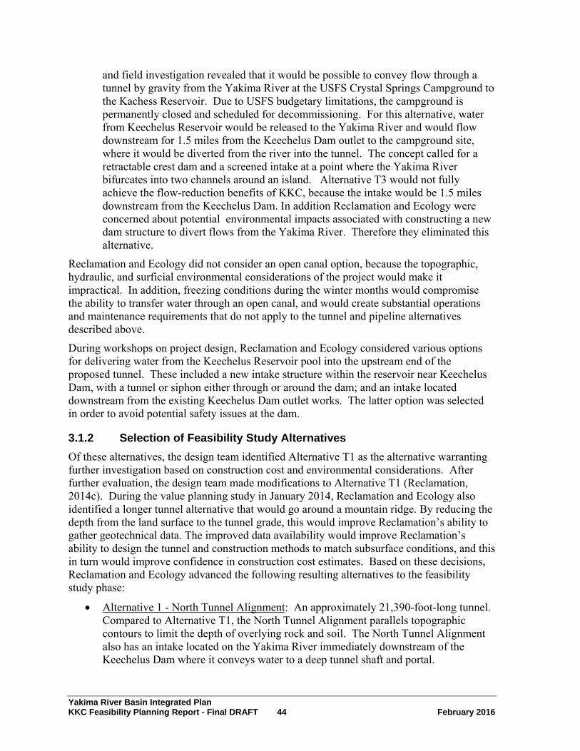
Yakima River Basin Integrated Plan KKC Feasibility Planning Report - Final DRAFT 44 February 2016
and field investigation revealed that it would be possible to convey flow through a tunnel by gravity from the Yakima River at the USFS Crystal Springs Campground to the Kachess Reservoir. Due to USFS budgetary limitations, the campground is permanently closed and scheduled for decommissioning. For this alternative, water from Keechelus Reservoir would be released to the Yakima River and would flow downstream for 1.5 miles from the Keechelus Dam outlet to the campground site, where it would be diverted from the river into the tunnel. The concept called for a retractable crest dam and a screened intake at a point where the Yakima River bifurcates into two channels around an island. Alternative T3 would not fully achieve the flow-reduction benefits of KKC, because the intake would be 1.5 miles downstream from the Keechelus Dam. In addition Reclamation and Ecology were concerned about potential environmental impacts associated with constructing a new dam structure to divert flows from the Yakima River. Therefore they eliminated this alternative.
Reclamation and Ecology did not consider an open canal option, because the topographic, hydraulic, and surficial environmental considerations of the project would make it impractical. In addition, freezing conditions during the winter months would compromise the ability to transfer water through an open canal, and would create substantial operations and maintenance requirements that do not apply to the tunnel and pipeline alternatives described above.
During workshops on project design, Reclamation and Ecology considered various options for delivering water from the Keechelus Reservoir pool into the upstream end of the proposed tunnel. These included a new intake structure within the reservoir near Keechelus Dam, with a tunnel or siphon either through or around the dam; and an intake located downstream from the existing Keechelus Dam outlet works. The latter option was selected in order to avoid potential safety issues at the dam.
3.1.2 Selection of Feasibility Study Alternatives Of these alternatives, the design team identified Alternative T1 as the alternative warranting further investigation based on construction cost and environmental considerations. After further evaluation, the design team made modifications to Alternative T1 (Reclamation, 2014c). During the value planning study in January 2014, Reclamation and Ecology also identified a longer tunnel alternative that would go around a mountain ridge. By reducing the depth from the land surface to the tunnel grade, this would improve Reclamation’s ability to gather geotechnical data. The improved data availability would improve Reclamation’s ability to design the tunnel and construction methods to match subsurface conditions, and this in turn would improve confidence in construction cost estimates. Based on these decisions, Reclamation and Ecology advanced the following resulting alternatives to the feasibility study phase:
• Alternative 1 - North Tunnel Alignment: An approximately 21,390-foot-long tunnel. Compared to Alternative T1, the North Tunnel Alignment parallels topographic contours to limit the depth of overlying rock and soil. The North Tunnel Alignment also has an intake located on the Yakima River immediately downstream of the Keechelus Dam where it conveys water to a deep tunnel shaft and portal.
Yakima River Basin Integrated Plan KKC Feasibility Planning Report - Final DRAFT 45 February 2016
• Alternative 2 - South Tunnel Alignment: An approximately 26,090-foot-long tunnel. Compared to Alternative T1, the South Tunnel Alignment is split into two segments with a second portal located at just off I-90 Exit 62. The South Tunnel Alignment has an intake located on the Yakima River immediately downstream of the Keechelus Dam where water flows to a deep tunnel shaft and portal.
Section 4.0, Alternatives, provides a detailed description of the North Tunnel Alignment and South Tunnel Alignment as evaluated in the feasibility study, including a map displaying their locations.
The Federal planning process in the Principles and Guidelines includes four criteria for consideration in evaluating the feasibility study alternatives: (1) completeness, (2) effectiveness, (3) efficiency, and (4) acceptability (U.S. Water Resources Council, 1983). Completeness is a determination of whether a plan includes all elements necessary to realize planned effects, and the degree that intended benefits of the plan depend on the actions of others. Effectiveness is the extent to which an alternative alleviates problems and achieves objectives. Efficiency is the measure of how efficiently an alternative alleviates identified problems while realizing specified objectives consistent with protecting the Nation’s environment. Acceptability is the workability and viability of a plan with respect to its potential acceptance by other Federal agencies, State and local governments, and public interest groups and individuals. Section 10.0, Conclusions, provides a comparison of the feasibility study alternatives (North Tunnel Alignment and South Tunnel Alignment) based on these criteria.
Decision makers also rely on the four accounts analysis to facilitate evaluation and to display effects of the alternatives. Section 8.5, Four Accounts Analysis, describes the four-accounts analysis for the North Tunnel Alignment and South Tunnel Alignment.

Yakima River Basin Integrated Plan KKC Feasibility Planning Report - Final DRAFT 46 February 2016
Figure 7. Keechelus-to-Kachess Conveyance Alternatives

Yakima River Basin Integrated Plan KKC Feasibility Planning Report - Final DRAFT 47 February 2016
4.0 Alternatives This chapter presents a description and summary comparison of the no action baseline and the alternatives considered. Reclamation and Ecology are evaluating the following alternatives in the Feasibility Study and EIS.
4.1 No Action Alternative The No Action Alternative represents the most likely future in the absence of implementing the Proposed Action and provides a baseline for comparison of potential impacts of the proposed action and its alternatives. Under the No Action Alternative, Reclamation and Ecology would not implement the KKC, KDRPP, or BTE. Reclamation would continue to manage water supply provided by Kachess and Keechelus Reservoirs consistent with current operational practices and constraints.
For the purpose of this report, Reclamation and Ecology consider the No Action Alternative to include the following:
• Planned and designed projects
• Authorized projects that have identified funding for implementation
• Projects scheduled for implementation
The KKC Draft EIS provides a detailed description of the No Action Alternative (Reclamation and Ecology, 2015d).
4.2 Action Alternatives Overview Figure 8 shows the KKC alternatives that Reclamation identified following the Value Planning Study: Alternative 1, North Tunnel Alignment, and Alternative 2, South Tunnel Alignment. The Keechelus-to-Kachess Conveyance Draft Feasibility Design Report provides further details on both alternatives (Reclamation and Ecology, 2015e).

Yakima River Basin Integrated Plan KKC Feasibility Planning Report - Final DRAFT 48 February 2016
Figure 8. Keechelus-to-Kachess Conveyance, North and South Tunnel Alignments

Yakima River Basin Integrated Plan KKC Feasibility Planning Report - Final DRAFT 49 February 2016
4.2.1 Existing Facilities The existing Reclamation facilities associated with this project are located in the Keechelus Dam area including Keechelus Dam, outlet works, spillway, stilling basin and gaging station. The project would affect the following existing facilities:
• The east end of the riprap-lined outlet channel below Keechelus Dam
• The Yakima River gaging station, which would have to be relocated
• Existing three-phase power, which would be extended to provide power to the new facilities
The KKC project would not modify or affect Keechelus Dam itself. Other non-affected facilities at the site include dam operations buildings and recreational vehicle pads located north of the outlet channel. Figure 9 shows the locations of existing facilities in the Keechelus Dam area.
Proposed Intake Project Area
Yakima River Gage Site
Nor
th
Existing Keechelus Dam Operations
Facilities and RV pads
Proposed Keechelus Portal
Shaft Area Existing 3-Phase Power Supply
Figure 9. Existing Keechelus Area Facilities
Figure 10 shows a profile view of Keechelus Reservoir and its maximum pool and minimum pool elevations. There would be no change to the dam, reservoir footprint, or maximum and minimum pool elevations due to construction of KKC. However Reclamation operations with KKC in place would involve some change to the timing and duration of reservoir drawdown from year to year. These operational changes are described in the DEIS (Reclamation and Ecology 2015d).
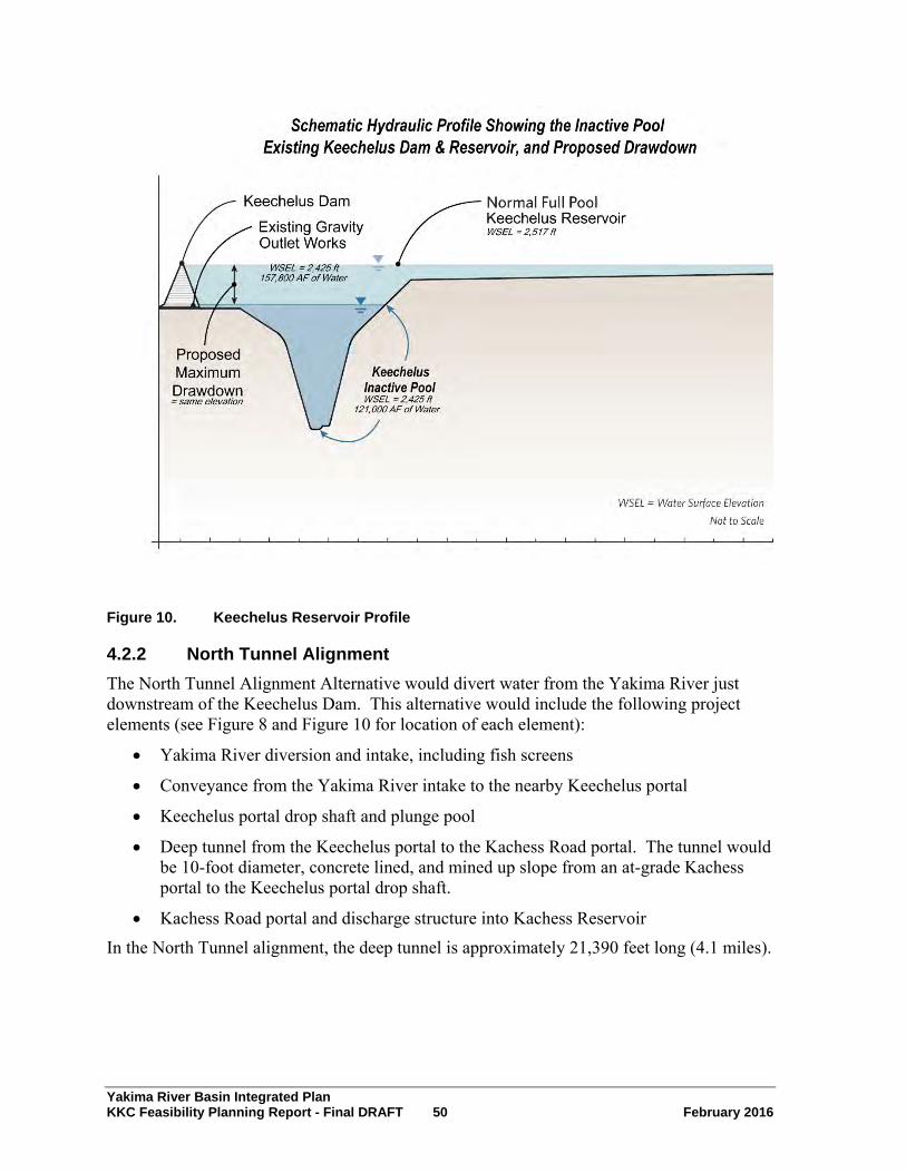
Yakima River Basin Integrated Plan KKC Feasibility Planning Report - Final DRAFT 50 February 2016
Figure 10. Keechelus Reservoir Profile
4.2.2 North Tunnel Alignment The North Tunnel Alignment Alternative would divert water from the Yakima River just downstream of the Keechelus Dam. This alternative would include the following project elements (see Figure 8 and Figure 10 for location of each element):
• Yakima River diversion and intake, including fish screens
• Conveyance from the Yakima River intake to the nearby Keechelus portal
• Keechelus portal drop shaft and plunge pool
• Deep tunnel from the Keechelus portal to the Kachess Road portal. The tunnel would be 10-foot diameter, concrete lined, and mined up slope from an at-grade Kachess portal to the Keechelus portal drop shaft.
• Kachess Road portal and discharge structure into Kachess Reservoir
In the North Tunnel alignment, the deep tunnel is approximately 21,390 feet long (4.1 miles).

Yakima River Basin Integrated Plan KKC Feasibility Planning Report - Final DRAFT 51 February 2016
Note a proposed variation to the North Tunnel Alignment is a shorter, straight-tunnel alignment between the Keechelus and Kachess Portals. It would be identical to the North Tunnel except its route is a straight line directly under a mountain ridge. Due to topography, this straight tunnel alternative alignment could create challenges for gathering drilling data and potentially result in more problematic rock stresses affecting the tunnel compared with the curved alignment shown in Figure 8. As such, the selection of this straight tunnel variation is subject to geotechnical investigation.
4.2.3 South Tunnel Alignment The South Tunnel Alignment would consist of two tunnel segments excavated from a portal shaft located in a construction staging area next to I-90 at Exit 62. Workers would mine Tunnel Segment A by driving a tunnel-boring machine up gradient toward the same Keechelus portal drop shaft. Workers would mine Tunnel Segment B by driving a tunnel-boring machine up gradient northeast to a discharge structure at the Kachess Reservoir shoreline.
Several project elements located in the Keechelus Dam area would be the same as proposed for the North Tunnel Alignment (Section 4.2.2, North Tunnel Alignment). These include the following project elements (see Figure 8 and Figure 10 for location of each element):
• Yakima River diversion and intake, including fish screens
• Conveyance from the Yakima River intake to the Keechelus portal
• Keechelus portal drop shaft and plunge pool
Additional project elements required for the South Tunnel Alignment include (see Figure 8 and Figure 10 for location of each element):
• I-90 Exit 62 portal
• Deep tunnel mined up gradient from the I-90 Exit 62 portal to the Keechelus portal (Segment A)
• Deep tunnel mined up gradient from the I-90 Exit 62 portal to the Kachess Reservoir discharge portal (Segment B)
• Kachess Reservoir portal and discharge structure (Note the Alternative 2 Kachess Reservoir portal is different from the Alternative 1 Kachess Road portal.)
In the South Tunnel Alignment, Segment A of the deep tunnel is approximately 9,320 feet long, and Segment B of the deep tunnel is approximately 16,770 feet long, for a combined length of approximately 26,090 feet (4.9 miles). Both segments would be 10-foot diameter and concrete lined.
4.2.4 Conveyance from Intake to Keechelus Portal Under each of the alternatives described above, a 96-inch-diameter pipeline or tunnel would convey water from the Yakima River intake to the nearby Keechelus portal. There are two different options for constructing and aligning this pipeline, Options A and B. Options A and B are the same for both the North Tunnel Alignment or South Tunnel Alignment alternatives.

Yakima River Basin Integrated Plan KKC Feasibility Planning Report - Final DRAFT 52 February 2016
Option A
Option A would be to construct an approximately 1,440 foot-long conventional open-cut-and-cover pipeline from the Yakima River intake structure to the Keechelus portal (Figure 10). The pipeline would skirt the wetland area below the dam and follow the lowest topographic elevations to reduce the depth of excavation required. To reduce streamside impact, the contractor could construct 250 feet of this pipeline through the embankment next to the river using a trenchless method such as pipe ramming. The total length of this option would be 1,440 feet.
Option B
Option B would be to construct a 1,200-foot-long shallow tunnel from the Keechelus portal to the Yakima River intake structure (Figure 10). Construction of the tunnel would utilize trenchless installation methods, such as bore and jack. Option B would utilize the Keechelus portal excavation as the launch point of the tunneling equipment for the pipeline. This would require a larger Keechelus portal shaft than Option A to accommodate the additional use of the shaft excavation.
Figure 10 illustrates the general intake and discharge structure features for both alternatives (note Figure 10 is not to scale).
Combinations
Reclamation has identified the following four overall combinations of alternatives, using the two different tunnel alignments (North and South) and the two different conveyance options near Keechelus Reservoir (Options A and B) (Reclamation and Ecology, 2015e):
• North Tunnel Alignment – Option A
• North Tunnel Alignment – Option B
• South Tunnel Alignment – Option A
• South Tunnel Alignment – Option B

Yakima River Basin Integrated Plan KKC Feasibility Planning Report - Final DRAFT 53 February 2016
Figure 11. Proposed Keechelus Area and Kachess Area Facilities
4.3 Project Schedule Table 7 and Table 8 provide examples of potential construction sequencing and scheduling for the construction of the North and South Tunnel Alignment alternatives. These sequences and construction durations represent only one of several ways that a construction contractor could elect to build the facilities for each alternative, so the actual sequences and construction durations may vary significantly from these examples (Reclamation and Ecology, 2015e).

Yakima River Basin Integrated Plan KKC Feasibility Planning Report - Final DRAFT 54 February 2016
4.3.1 North Tunnel Alignment
Table 7. Example North Tunnel Alignment Construction Schedule and Sequencing
Quarter Accumulated
Duration (Months)
North Tunnel Alignment Example Construction Sequencing
1 3
Clear the site and realign USFS NF-4900 (extension of Kachess Lake Road). Begin excavating the Kachess Lake Road mining portal; use the excavated material to enlarge the site area. Clear the site for the Keechelus portal, begin shoring the portal shaft, and begin installing the Yakima River Diversion cofferdam and temporary bypass. Order or initiate TBM refurbishing.
Complete the Kachess Lake Road realignment and prepare the mining portal headwall for initial tunnel excavation.
2 6 Complete excavating and lining the Keechelus portal shaft to shallow tunnel or pipeline depth. Complete the Yakima River cofferdam and begin excavation and forming for the river diversion, intake portal, and fish screen structure. Install a temporary Yakima River gauge in the outlet channel upstream of the site.
3 9
Begin the Kachess Lake Road starter tunnel. Mobilize the TBM for the KKC tunnel mining. Complete excavation of the Keechelus portal shaft to the depth to begin mining the shallow tunnel to the Yakima River intake. Complete excavation of the Yakima River intake portal to receive the shallow tunnel. Continue construction of the Yakima River diversion and fish screen structure.
4 12 Install the TBM and begin mining of the KKC tunnel from the Kachess Road portal. Begin mining the Keechelus shallow tunnel, or open trench construction. Continue construction of the diversion and fish screen structure.
5 15 Continue TBM mining of the deep tunnel. Continue mining and lining of the shallow tunnel. River fish screen and intake structure.
Continue construction of the Yakima
6 18
Continue TBM mining of the deep tunnel. Complete mining and lining of the shallow tunnel; restart excavation and lining of the Keechelus portal shaft to the deep tunnel. Complete construction of the fish screen and intake structure.
7 21 Continue TBM mining of the deep tunnel. Continue excavation and lining of the Keechelus portal shaft to deep tunnel depth. Complete construction of the fish screen controls and mechanical systems.
8 24 Continue TBM mining of the deep tunnel. Complete construction of the Keechelus portal shaft to tunnel depth. Begin construction of the de-aeration chamber and deep tunnel receiving section.
9 27 Begin construction of the Kachess Lake Road discharge structure and conveyance. Continue TBM mining of the deep tunnel. Complete construction of the de-aeration chamber and plunge pool; begin construction of remaining deep tunnel portal structure.

Yakima River Basin Integrated Plan KKC Feasibility Planning Report - Final DRAFT 55 February 2016
Quarter Accumulated
Duration (Months)
North Tunnel Alignment Example Construction Sequencing
10 30
Continue TBM mining of the deep tunnel. Begin construction of the Kachess Lake Road tunnel discharge drop structure, and box culvert to spillway. Depending upon reservoir elevation, place Kachess Reservoir riprap. Begin construction of the Keechelus portal shaft lid and installation of remaining mechanical, electrical, and control systems at the portal and Yakima River intake.
11 33
Complete TBM mining of the deep tunnel and removal of the TBM. Begin tunnel lining. Relocate and open Kachess Lake Road. Construct remaining portions of Kachess discharge transition and spillway. Begin site restoration and cleanup. Complete placing Kachess Reservoir riprap. Complete construction of the Keechelus portal shaft and installation of remaining mechanical, electrical, and control systems at the portal and Yakima River intake.
12 36 Continue tunnel lining. Complete Keechelus site work and restoration.
13 39
Complete tunnel lining. Remove and restore temporary road alignment and site. Final conveyance system inspection. Restore roads used for access. Startup and testing. Restore Kachess Lake Road as needed and required.
14 42 Complete final testing and acceptance, and place tunnel in operation.
Kachess Road Portal Construction Sequencing
The construction sequencing at the Kachess Road portal would be as follows:
1. Clear a route and prepare a road grade for relocating about 1,100 feet of Kachess Lake Road.
2. Close the existing road and reroute traffic to a temporary detour.
3. Begin excavation into the hillside to create the vertical face for the tunnel-mining portal. Use the excavated materials to create a relatively level work area in front of the portal.
4. Haul out excess excavated material.
5. Stabilize the hillside around the portal with benching or shotcrete, or both.
6. Construct the portal face and drill and blast mine the first approximately 50 feet of tunnel into the rock face of the portal.
7. Mobilize and launch the tunnel-boring machine toward the Keechelus portal.
8. Load tunnel muck onto trucks for hauling away on Kachess Lake Road to I-90 and then on to a disposal site that is yet to be determined.
9. Store and provide tunnel-lining materials as the tunnel advances.
10. Once tunnel mining and lining are complete, excavate in front of the portal for the discharge drop structure.
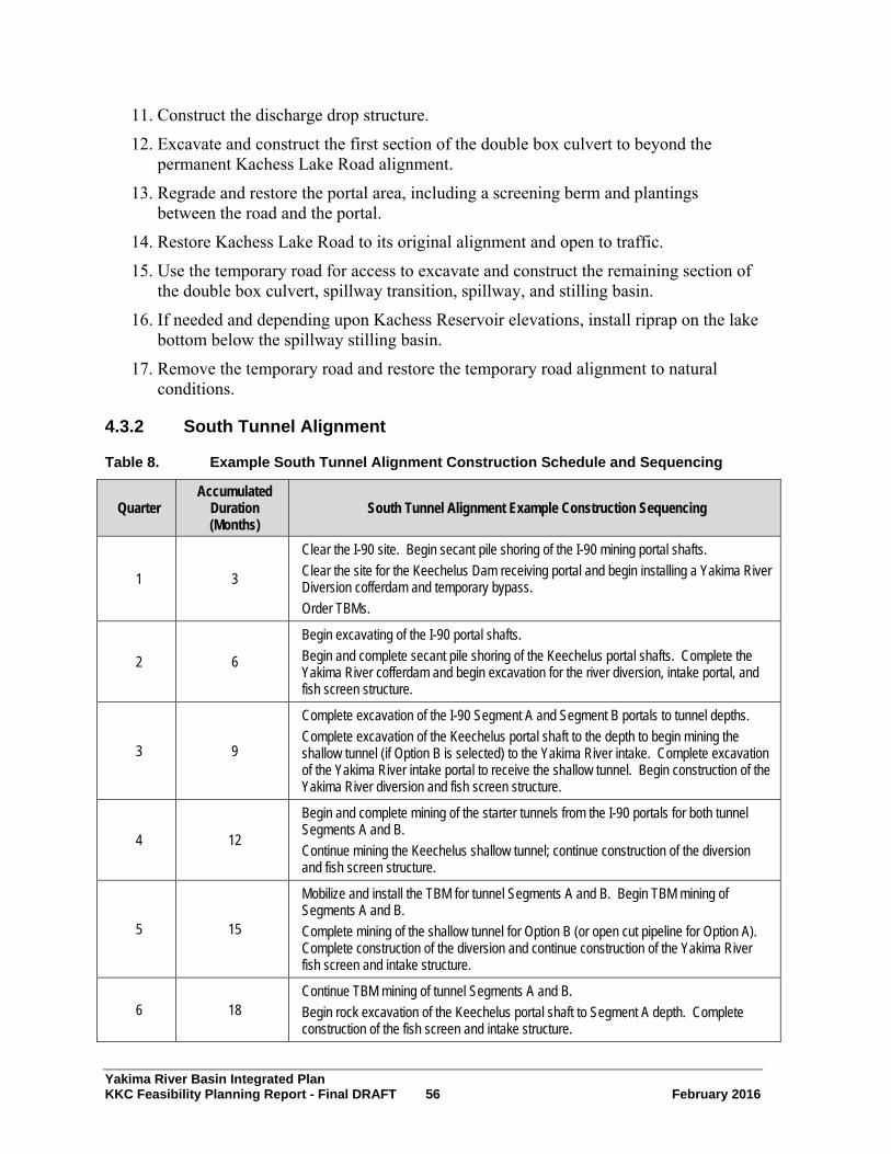
Yakima River Basin Integrated Plan KKC Feasibility Planning Report - Final DRAFT 56 February 2016
11. Construct the discharge drop structure.
12. Excavate and construct the first section of the double box culvert to beyond the permanent Kachess Lake Road alignment.
13. Regrade and restore the portal area, including a screening berm and plantings between the road and the portal.
14. Restore Kachess Lake Road to its original alignment and open to traffic.
15. Use the temporary road for access to excavate and construct the remaining section of the double box culvert, spillway transition, spillway, and stilling basin.
16. If needed and depending upon Kachess Reservoir elevations, install riprap on the lake bottom below the spillway stilling basin.
17. Remove the temporary road and restore the temporary road alignment to natural conditions.
4.3.2 South Tunnel Alignment
Table 8. Example South Tunnel Alignment Construction Schedule and Sequencing
Quarter Accumulated
Duration (Months)
South Tunnel Alignment Example Construction Sequencing
1 3
Clear the I-90 site. Begin secant pile shoring of the I-90 mining portal shafts. Clear the site for the Keechelus Dam receiving portal and begin installing a Yakima River Diversion cofferdam and temporary bypass. Order TBMs.
2 6
Begin excavating of the I-90 portal shafts. Begin and complete secant pile shoring of the Keechelus portal shafts. Complete the Yakima River cofferdam and begin excavation for the river diversion, intake portal, and fish screen structure.
3 9
Complete excavation of the I-90 Segment A and Segment B portals to tunnel depths. Complete excavation of the Keechelus portal shaft to the depth to begin mining the shallow tunnel (if Option B is selected) to the Yakima River intake. Complete excavation of the Yakima River intake portal to receive the shallow tunnel. Begin construction of the Yakima River diversion and fish screen structure.
4 12
Begin and complete mining of the starter tunnels from the I-90 portals for both tunnel Segments A and B. Continue mining the Keechelus shallow tunnel; continue construction of the diversion and fish screen structure.
5 15
Mobilize and install the TBM for tunnel Segments A and B. Begin TBM mining of Segments A and B. Complete mining of the shallow tunnel for Option B (or open cut pipeline for Option A). Complete construction of the diversion and continue construction of the Yakima River fish screen and intake structure.
6 18 Continue TBM mining of tunnel Segments A and B. Begin rock excavation of the Keechelus portal shaft construction of the fish screen and intake structure.
to Segment A depth. Complete

Yakima River Basin Integrated Plan KKC Feasibility Planning Report - Final DRAFT 57 February 2016
Quarter Accumulated
Duration (Months)
South Tunnel Alignment Example Construction Sequencing
7 21 Continue TBM mining of tunnel Segments A and B. Complete excavation of the Keechelus receiving portal shaft to Segment A depth. Complete construction of the fish screen and support facilities for the intake structure.
8 24
Complete TBM mining Segment A and remove TBM. Begin Segment A lining. Continue mining Segment B. Begin construction of the Kachess Reservoir cofferdam and discharge structure. Complete construction of the deep tunnel shaft lining. Begin construction of the de-aeration chamber and deep tunnel receiving section.
9 27 Continue Segment A lining, continue TBM mining of Segment B; Complete construction of the de-aeration chamber, and excavate Keechelus plunge pool. Complete the first stage of construction of the Kachess Reservoir discharge structure.
10 30 Complete Segment A lining. Complete Segment B tunnel mining and dismantle and remove the TBMs from the Kachess portal. Begin Segment B lining. Begin Keechelus portal and plunge pool concrete lining.
11 33 Continue Segment B lining. Complete Keechelus portal and plunge pool concrete lining.
12 36
Continue Segment B lining. Complete construction of the I-90 portals connection, hydraulic control structure, plunge pool, and shaft portal lids. Begin and complete construction of the second stage of the Kachess Reservoir tunnel discharge structure. Complete remaining Keechelus portal structure (lid and control features) and the installation of remaining mechanical, electrical, and control systems at the portals and Yakima River intake.
13 39
Complete Segment B lining. Complete construction of the Kachess Reservoir tunnel discharge structure. Depending upon reservoir elevation, place Kachess Reservoir riprap. Begin and complete Keechelus, I-90, Kachess disturbed areas site work and site restoration.
14 42 Complete final testing and acceptance, and place tunnel in operation.
Kachess Reservoir Portal Construction Sequencing
Construction access to the site would be via I-90, Exit 62 and Kachess Lake Road.
The construction sequencing at the Kachess Reservoir portal would be as follows:
1. Clear a route and prepare an access road to the South Tunnel discharge site.
2. Clear and grub the site.
3. Excavate and level the site for the headwall and discharge structure.
4. Haul out the excess excavated material.
5. Construct the headwall, and rock anchor and shotcrete the bank to stabilize the tunnel exit point.
6. Construct the discharge structure, spillway bottom, and sidewalls.
Yakima River Basin Integrated Plan KKC Feasibility Planning Report - Final DRAFT 58 February 2016
7. As reservoir elevations permit, construct the stilling basin slab and walls and install riprap (if needed) into the reservoir.
8. Receive and disassemble the tunnel-boring machine and remove it from the site.
9. Construct the discharge structure top slab, interior walls, and bar rack.
10. Restore the site and finish the road as a permanent gated access road to the site.
4.4 Operations Reclamation would own and operate the KKC. The following subsections summarize operational considerations (Reclamation and Ecology, 2015e).
4.4.1 Screen Cleaning System There are two common types of fish screen cleaning systems: brush cleaning systems and airburst cleaning systems. A brush cleaning system physically cleans the screen using the brush to lift debris off the screen surface. An airburst cleaning system uses high-pressure air to blow debris off the screen.
The most applicable screen cleaning identified for this fish screen is an airburst cleaning system. The physical location within the water channel, the anticipated high sweeping velocities (greater than 0.8 fps), minimal debris from the dam outlet works, and the additional need to control frazil and anchor ice makes the airburst cleaning system more desirable.
Because of the large size of the diversion and the NMFS requirement of an automated fish cleaning system completing a debris removal cycle within a five-minute period, the airburst system would be divided into four stand alone systems, one for each of the four intake bays.
Each intake bay would have a dedicated 500-gallon air receiver with a 30-horsepower (HP) compressor capable of recharging in no greater than five minutes. The cleaning cycle would be activated first on the upstream most bay and proceed downstream in secession to the fourth bay. The system would release air for approximately two seconds at each bay and the controller would have a 10-second delay before activating the next downstream air cleaning system.
4.4.2 Sediment and Debris Management The project team expects sediment load in the existing channel to be minimal since most sedimentation occurs in the Keechelus Reservoir, the channel is relatively short, and there are a limited number of trees only on a portion of the south side of the channel. The team expects debris to be limited to leaves and tree branches blown into the channel by the wind.
When the dam is fully retracted, the concrete apron and sloping concrete lip below the fish screens are designed to promote flushing of any accumulated sediment or debris downstream. During low river flow periods, Reclamation could also remove sections of the lower metal deck above the fish screen to provide access for dredging any sediment that may have accumulated within the fish screen and intake structure.

Yakima River Basin Integrated Plan KKC Feasibility Planning Report - Final DRAFT 59 February 2016
4.4.3 Ice Management To prevent ice from plugging or damaging the screen, Reclamation would need to implement several measures. First, the screen would be thermally isolated using a neoprene strip between the top of the screen and the structural members above the low water level. This would help prevent conduction cooling of the metal screen below the water surface to the air temperature, which may be much colder than the temperature of the water released from Keechelus Dam. Because channel velocities would be greater than 3 fps and water discharged from the bottom of the Keechelus Reservoir outlet works would be warmer, the design team would not expect frazil ice to form on the screen. Using a small, low pressure air bubbler that releases a small constant air flow across the four intake bays both reduces anchor ice and also assists in keeping floating debris moving across the screens. This small air system would consist of one 15 HP low-pressure air compressor with dedicated two-inch supply lines.
4.4.4 Flow Control The design uses a programmable logic controller to accept inputs for the desired KKC diversion flow, the Keechelus Dam release rate, and the Yakima River instream flow requirement. The programmable logic controller would use those parameters, and real-time water surface elevation and discharge pipeline flow meter data, to adjust the flow diversion dam height and the motorized flow control gate settings. Reclamation would need to test the system during initial operations to refine the programmable logic controller algorithm controlling the flow rates at various Keechelus release and KKC diversion rates.
4.4.5 Safety Safety considerations include fencing to discourage animals and people from entering the area; locked hatches and fish screens to keep fish, animals, and people out of the structures and pipeline; and ladders to allow access into and out of enclosed spaces. Railing would be included at the tops of walls, such as around the fish ladder. Additional signage would indicate that access to the site is restricted to authorized personnel. Section 22 of the Reclamation Safety and Health Standards for excavation operations lists other safety standards, while Section 23 lists tunnel and shaft construction safety standards. During construction, the contractor would be responsible for safety measures, including when working around the river during construction.
4.4.6 Operations and Maintenance Day to day operations would consist of checking on the equipment (SCADA, gates, adjustable crest dam, fish screen, and screen cleaning system), basic maintenance and cleaning, and drive by checks on the portals and outlet structures. Some of these items, such as cleaning the outlet structures, may only occur once or twice a year.
This facility would need a part time operator. Although Reclamation could set up the control system to control the flow rate using the gates and can remotely monitor the equipment, the facility contains some equipment such as the fish screens that would need regular maintenance. Reclamation could assign this task to someone working at Keechelus dam. Another task for this operator would include checking on the Kachess portal and discharge

Yakima River Basin Integrated Plan KKC Feasibility Planning Report - Final DRAFT 60 February 2016
structures. Heavy concrete lids would seal the I-90 Exit 62 portal and Keechelus portal, so regular checking would probably not be required.
4.4.7 Replacement The project team anticipates that Reclamation would inspect these facilities on a five-year cycle. Inspections would look at the condition of the discharge structures, portals, and tunnels.
The project team anticipates a 50-year cycle of replacement for the equipment. This includes the fish screens and their cleaning system, gates, the adjustable crest dam, and the control systems.
4.4.8 Power Power is necessary for air compressors for the fish screen cleaning system, gates, adjustable crest dam, control systems, and regular building functions like lights and outlets. There are no seasonal power demands since this is a gravity system and there are no pumps.
4.5 Alternative Comparison Table 9 presents a summary of the basic project characteristics and a discussion of relative advantages and disadvantages of the project alternatives.
Table 9. Comparison Summary of KKC Alternatives
Characteristic North Tunnel Alignment
South Tunnel Alignment Advantages/Disadvantages
Diversion and Intake
Yakima River diversion and intake
Yakima River diversion and intake
This feature is the same for both alternatives.
Conveyance from Option A (1,440- Option A (1,440- Options A and B are the same for both alternatives. Keechelus Dam foot pipeline) foot pipeline) Option A (pipeline) appears to be the lowest construction Outlet Channel to Option B (1,200- Option B (1,200- cost; it would most likely involve less construction risk than Keechelus Portal foot tunnel) foot tunnel) Option B (tunnel).
Keechelus Portal 130-foot deep, 25-foot-diameter shaft
130-foot deep, 25-foot-diameter shaft The Keechelus Portal is the same for both alternatives.
Deep Tunnel Length 21,390 feet long
9,320 feet long (Seg A) 16,770 feet long (Seg B)
The South Tunnel is approximately 4,700 feet longer than the North Tunnel.
(22 percent)
Intermediate Portal None
Adjacent 25-foot-diameter shafts near I-90 Exit 62
The South Tunnel includes intermediate portals at Exit 62 on I-90. This could allow concurrent tunnel mining in two directions, and may provide an advantage for tunnel ventilation during construction.

Yakima River Basin Integrated Plan KKC Feasibility Planning Report - Final DRAFT 61 February 2016
Characteristic North Tunnel Alignment
South Tunnel Alignment Advantages/Disadvantages
Deep Tunnel Excavation
From at grade Kachess Road portal
From I-90 Exit 62 deep portal shafts
Kachess Road portal provides the advantage of an at-grade access to the tunnel and for removal of excavated rock materials. The I-90 Exit 62 portal could provide the advantage of concurrent mining in two directions, but would require removal of excavated materials from deep shafts.
Tunnel Unwatering During Construction
Drain by gravity to the Kachess Lake Road Portal
Requires pumping from the I-90 Exit 62 Portal shafts
The North Tunnel would drain by gravity to the at-grade Kachess Lake Road Portal. The South Tunnel would drain by gravity to the Exit 62 portal, but would require pumping from the deep shafts to the surface.
Deep Tunnel Materials Disposal
Haul via Kachess Lake Road to I-90
Adjacent to and direct access to I-90 Exit 62
The North Tunnel would have the disadvantage of adding significant truck traffic to Kachess Lake Road. The South Tunnel has the advantage of limiting hauling activities to the area near I-90 Exit 62.
Local Impacts during Construction
Keechelus Dam area and the Kachess Road portal
Keechelus Dam area and the I-90 Exit 62 portal
The South Tunnel has the advantage of locating most of the tunnel mining construction activities in an already disturbed area next to I-90 Exit 62. North Tunnel construction activities around the Kachess Lake Road portal would require temporary relocation of Kachess Lake Road during construction and result in some disruption of local traffic, including the main route to the Kachess Reservoir campground.
Hydraulics Uniform gravity free flow
Gravity and pressure flow
The North Tunnel provides the advantage of a uniform gravity free flow for its entire length. The South Tunnel would be a combination of gravity free flow (Segment A) and pressurized flow (Segment B) hydraulics with an intermediate drop shaft.
Kachess Discharge Structure
Drop structure, box culvert and spillway
Cut and cover pipeline to dis-charge structure
The North Tunnel discharge system is more complex and visible than the South Tunnel discharge structure.
Geotechnical Deeper tunnel alignment
Shallower alignment
tunnel There is limited geotechnical information available for both alternatives. More information would be required to determine any specific advantages or disadvantages for either alignment.
Estimated Construction Cost
$241 million ($252 million with escalation)
$272 million ($285 million with escalation)
Based upon currently available information, the North Tunnel would be approximately $31 million (11 percent) less in construction cost than the South Tunnel. Construction cost includes total field cost plus non-contract cost.
Operations and Maintenance
Most operational activities would be at the Yakima River diversion and intake
Most operational activities would be at the Yakima River diversion and intake
Both alternatives rely on gravity flow and do not require pumping. System operations and maintenance would be similar for both alternatives, and operating costs would be very similar.

Yakima River Basin Integrated Plan KKC Feasibility Planning Report - Final DRAFT 62 February 2016
4.6 Preferred Alternative Not Determined At this time, the project team has gathered only limited geotechnical data for the North and South Tunnel Alignments. Reclamation is currently analyzing additional geotechnical data prior to determining whether the North Tunnel Alignment or South Tunnel Alignment is preferred from an engineering and cost standpoint. In addition, Reclamation needs to complete environmental evaluation and issue a Final EIS prior to determining the preferred alternative. Limited geotechnical investigation was performed in fall 2014 and in 2015. This information was not available in time to use for in the Feasibility Design Report (Reclamation and Ecology, 2015e), but will be used in evaluating a preferred alternative. Evaluation of the KKC during design, estimating, and construction review revealed that the South Tunnel I-90 Exit 62 portal site and staging area may not be available based on initial feedback regarding U.S. Forest Service (USFS) intentions for site restoration at that location. If this site were not available, the South Tunnel Alignment may not be viable as designed (Reclamation, 2014a).
4.7 Recommendations for Further Study This section lists additional information necessary for continuing the next phase of design.
4.7.1 Surveying The following list identifies surveying needs:
• Aerial LiDAR or photogrammetric survey of the selected tunnel alignment corridor. Reclamation scheduled additional LiDAR data collection for the summer of 2014.
• Consolidation of survey information that Reclamation has assembled for the Keechelus Dam area. There is a datum discrepancy between the two survey files provided by Reclamation.
• Additional, as required, ground survey of the Keechelus Dam and Kachess Reservoir project facilities sites to identify tree-obscured areas and locations not covered by the aerial survey.
4.7.2 Geotechnical Geological borings, monitoring wells, and a testing program are necessary to support the tunnel design effort and the dewatering system for the KKC project. Reclamation would use the information gathered to improve characterization of geological conditions; to refine parameters that affect tunneling activities and structural design; and for the eventual development of a Geotechnical Baseline Report. The Geotechnical Interpretation Technical Memorandum (Reclamation and Ecology, 2014b) provides detailed recommendations for field investigations. Further information was gathered from two boreholes completed in 2015.

Yakima River Basin Integrated Plan KKC Feasibility Planning Report - Final DRAFT 63 February 2016
Keechelus Dam Area The project team has identified the following geotechnical needs in the Keechelus Dam area (Reclamation and Ecology, 2015e):
• Depth to rock, presence of boulders and parameters for pipe jacking, and dewatering are the greatest uncertainties and data gaps along the conveyance Options A and B and require additional investigation.
• Pump tests in the Keechelus diversion and conveyance routes area are needed to better determine the range of expected dewatering system flow rates, well sizes, and well spacing for the dewatering wells that would be required to construct either alternative. The contractor would use the pump test information to plan both initial and long-term dewatering rates for the dewatering effort.
• The hydrogeologic data currently available for the dewatering design is limited to a few shallow borings and test pits within the pipeline alignment and portal shafts and one deep boring north of the project area. No aquifer hydraulic parameters are available within the project area.
• The depth to a suitable cut off layer for dewatering, the lacustrine deposits, is a data gap and requires additional investigation. Geophysics survey and analysis of the project area below Keechelus Dam would help determine the depth to rock in the area. Additional geotechnical borings and monitoring wells at the Keechelus portal sites and along the Option A and Option B conveyance alignments would help determine depth of rock and dewatering requirements.
• A cofferdam structure for the diversion and care of the Yakima River during construction of the diversion and intake is also an uncertainty. The foundation conditions related to the construction and performance of the cofferdam is a data gap and requires additional investigation.
North and South Tunnel Alignments There is a large data gap related to subsurface information, including geo-mechanical and hydrogeological, along most of the tunnel alignments (Reclamation and Ecology, 2015e). The project team has identified the following geotechnical needs for both tunnel alignments:
• Reclamation needs additional geotechnical borings and testing to look at rock strength and in-situ stresses in the rock mass. Complete and accurate rock mass characterization is the greatest uncertainty for both alternate tunnel alignments, in particular in areas of the tunnel with the greatest thicknesses of overlying rock and soil.
• The hydrogeology and groundwater conditions along the tunnel alignments are also major risk and uncertainties.
Information on rock parameters would inform the use of tunneling equipment, the amount of rock bolting necessary, the parameters for tunnel lining, and the parameters to support shaft and tunnel design for either alternative.

Yakima River Basin Integrated Plan KKC Feasibility Planning Report - Final DRAFT 64 February 2016
Kachess Reservoir Areas Depth to rock and accurate rock mass characterization are the greatest uncertainties and data gaps for the Kachess Road portal and require additional investigation.
Continuing Data Collection The project team installed instrumentation in some of the 2013 borings. Reclamation needs to collect data from existing piezometers, where possible, on a regular basis and in sufficient quantities to be valuable for continuing design efforts. Any new exploration boreholes should also include a vibrating wire piezometer. In addition, Reclamation performed additional geotechnical exploration, testing, and reporting in fall 2014 and in 2015. Reclamation will use the findings of these explorations, testing, and reporting to refine the design of the selected alternative.
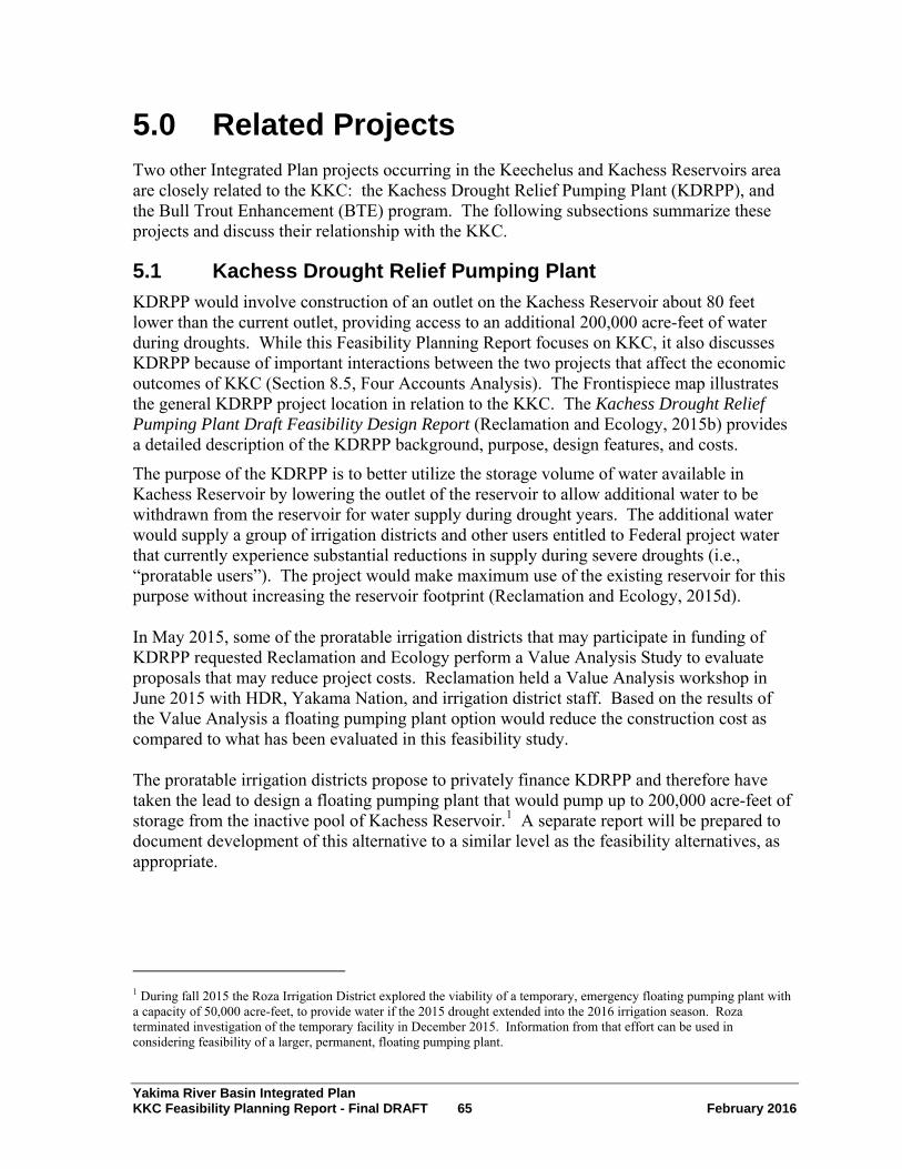
Yakima River Basin Integrated Plan KKC Feasibility Planning Report - Final DRAFT 65 February 2016
5.0 Related Projects Two other Integrated Plan projects occurring in the Keechelus and Kachess Reservoirs area are closely related to the KKC: the Kachess Drought Relief Pumping Plant (KDRPP), and the Bull Trout Enhancement (BTE) program. The following subsections summarize these projects and discuss their relationship with the KKC.
5.1 Kachess Drought Relief Pumping Plant KDRPP would involve construction of an outlet on the Kachess Reservoir about 80 feet lower than the current outlet, providing access to an additional 200,000 acre-feet of water during droughts. While this Feasibility Planning Report focuses on KKC, it also discusses KDRPP because of important interactions between the two projects that affect the economic outcomes of KKC (Section 8.5, Four Accounts Analysis). The Frontispiece map illustrates the general KDRPP project location in relation to the KKC. The Kachess Drought Relief Pumping Plant Draft Feasibility Design Report (Reclamation and Ecology, 2015b) provides a detailed description of the KDRPP background, purpose, design features, and costs.
The purpose of the KDRPP is to better utilize the storage volume of water available in Kachess Reservoir by lowering the outlet of the reservoir to allow additional water to be withdrawn from the reservoir for water supply during drought years. The additional water would supply a group of irrigation districts and other users entitled to Federal project water that currently experience substantial reductions in supply during severe droughts (i.e., “proratable users”). The project would make maximum use of the existing reservoir for this purpose without increasing the reservoir footprint (Reclamation and Ecology, 2015d).
In May 2015, some of the proratable irrigation districts that may participate in funding of KDRPP requested Reclamation and Ecology perform a Value Analysis Study to evaluate proposals that may reduce project costs. Reclamation held a Value Analysis workshop in June 2015 with HDR, Yakama Nation, and irrigation district staff. Based on the results of the Value Analysis a floating pumping plant option would reduce the construction cost as compared to what has been evaluated in this feasibility study.
The proratable irrigation districts propose to privately finance KDRPP and therefore have taken the lead to design a floating pumping plant that would pump up to 200,000 acre-feet of storage from the inactive pool of Kachess Reservoir.1 A separate report will be prepared to document development of this alternative to a similar level as the feasibility alternatives, as appropriate.
1 During fall 2015 the Roza Irrigation District explored the viability of a temporary, emergency floating pumping plant with a capacity of 50,000 acre-feet, to provide water if the 2015 drought extended into the 2016 irrigation season. Roza terminated investigation of the temporary facility in December 2015. Information from that effort can be used in considering feasibility of a larger, permanent, floating pumping plant.
Yakima River Basin Integrated Plan KKC Feasibility Planning Report - Final DRAFT 66 February 2016
KDRPP would allow Kachess Reservoir to be drawn down approximately 80 feet lower than the current outlet, accessing an additional 200,000 acre-feet of water stored in the reservoir. This additional water is “inactive” reservoir storage as it is located at an elevation below the existing outlet (2,192.75 feet). Eighty feet represents the maximum drawdown, but in many drought years, the drawdown would be limited to 40 feet or less.
Reclamation could construct the KDRPP and KKC together to provide more flexible water management. Water transferred from Keechelus Reservoir to Kachess Reservoir under the KKC would speed up the refill of Kachess Reservoir after it was drawn down in drought years by the KDRPP. In normal and wet years, KKC would enable Reclamation to maintain higher pool levels in Kachess Reservoir. In addition, the KKC would enhance the capacity to reduce artificially high flows in the upper Yakima River by the ability to convey water through the KKC and release it from Kachess Reservoir (Reclamation and Ecology, 2015d).
Similar to KKC, the KDRPP project is currently at a feasibility stage of development.
5.2 Bull Trout Enhancement Plan To help meet the goals of the Integrated Plan, Reclamation and Ecology propose to enhance the resiliency of bull trout populations in Kachess and Keechelus reservoirs, as well as elsewhere in the Yakima River basin. Reclamation and Ecology developed the Bull Trout Enhancement (BTE) Program in coordination with biologists from the Service, NMFS, WDFW, and the Yakama Nation. The BTE would support the objectives of the Integrated Plan by addressing problems with depleted populations of anadromous and resident fish and their habitat (Reclamation and Ecology, 2015d, Sections 1.5.1, and 2.4.7). The BTE actions are consistent with recommendations in the Yakima Bull Trout Action Plan (Reiss et al., 2012). A 2015 Memorandum of Understanding among Reclamation, WDFW, the Service, USFS, and Yakama Nation defines roles in the development and implementation of bull trout restoration and enhancement actions as part of the Integrated Plan (Reclamation Agreement No. R15MU13704).
Historically, bull trout populations in the Yakima River basin interacted with one another and contributed to the overall resiliency of the species. Passage barriers, including reservoir dams, have reduced movement of fish, limiting the potential for genetic exchange between populations. Currently, 8 of the 15 populations of bull trout in the Yakima River basin, including those in Kachess and Keechelus reservoirs, are isolated from one another.
Three populations of adfluvial fish (fish that live in lakes and migrate to rivers or streams) inhabit Kachess and Keechelus reservoirs: Box Canyon Creek and Kachess River populations in Kachess Reservoir, and the Gold Creek population in Keechelus Reservoir. Each population has chronically low abundance. The Yakima Bull Trout Action Plan (Reiss et al., 2012) identified the most common significant threats to bull trout populations as low abundance, passage barriers from storage dams and reservoir drawdowns, and dewatering in tributary streams where bull trout spawn and rear.
The BTE includes actions to improve habitat function and directly increase the abundance of bull trout in the reservoirs. For the Keechelus Reservoir (including its Gold Creek and Cold Creek tributaries) and the Kachess Reservoir, the BTE addresses low abundance, passage barriers, dewatering, and prey base threats. Additional elements of the BTE include two studies at Kachess and Keechelus reservoirs. One study would evaluate the enhancement of

Yakima River Basin Integrated Plan KKC Feasibility Planning Report - Final DRAFT 67 February 2016
bull trout populations by translocating fish. The second study would evaluate means to improve productivity and food resources. The Bull Trout Enhancement technical memorandum provides further details of the BTE projects and actions (Reclamation and Ecology, 2014a).
The proposed enhancement projects are separate from the mitigation actions that may be required for the proposed KDRPP and KKC. The mitigation actions are described here as a reference and to clearly delineate the differences between mitigation and enhancement projects. Additional mitigation may be identified through environmental compliance processes. To address KDRPP and KKC project-specific bull trout impacts, Reclamation proposes to conduct the following activities:
• Adaptively manage Reclamation’s emergency monitoring and passage program so that it is responsive to increased passage risk into spawning tributaries.
• Construct permanent fish passage structures or habitat modifications to minimize or fully address potential passage barriers
• Examine reservoir productivity and food web impacts from future use of Kachess Reservoir inactive storage.
• Address increased entrainment risk associated with new facilities.
In conducting mitigation and enhancement activities, Reclamation will adhere to state, Federal, and local regulations as well as consult with the Service and NMFS on ESA requirements. The Bull Trout Enhancement technical memorandum provides further details of mitigation actions (Reclamation and Ecology, 2014a).
5.2.1 Gold Creek and Cold Creek Enhancements Gold Creek and Cold Creek are tributaries that flow into Keechelus Reservoir near the upstream end of the reservoir. Reclamation and Ecology evaluate proposed BTE actions at Gold Creek and Cold Creek, for which conceptual designs are available, at a programmatic level within the KKC and KDRPP Draft EIS (Reclamation and Ecology, 2015d). Reclamation and Ecology would undertake site-specific environmental analysis after completion of the KKC and KDRPP designs.
Gold Creek Passage and Habitat Improvements
To facilitate bull trout passage to upstream spawning grounds, improve rearing habitat, and reduce stranding, Reclamation and Ecology would undertake several specific actions:
• Restore the stream channel in the lower reach of Gold Creek by removing dikes, installing engineered logjams, adding downed wood debris, and reestablishing native plant communities.
• Improve the habitat value of Gold Creek Pond by returning it to a smaller natural functioning wetland. Restore groundwater flow to Gold Creek, relocating the trail away from the creek, replacing the outlet culvert with a bridge to allow fish passage, creating short kokanee spawning channels at the two inlet channels for bull trout forage, adding in-stream structures to create in-channel diversity, and laying down spawning gravels.
Yakima River Basin Integrated Plan KKC Feasibility Planning Report - Final DRAFT 68 February 2016
• Fill the artificial Helis Pond to restore groundwater flow to Gold Creek.
• Replace the bridge on USFS Road NF-4832 to restore the Gold Creek floodplain, a project for which the USFS has already prepared a NEPA Environmental Assessment and Finding of No Significant Impact (USFS, 2010).
Channel restoration would require in-water work and possibly short-term diversion of flows. Construction would require temporary access roads and the operation of heavy equipment in riparian areas. During construction, Reclamation and Ecology would implement erosion and sediment control plans. Immediately after construction, the agencies would restore disturbed areas and plant native species. All in-water work would be subject to work windows that minimize disturbance to bull trout and other species in the project area.
Cold Creek Passage Improvement
Reclamation and Ecology would remove a passage barrier at the mouth of Cold Creek at Washington State Park’s John Wayne Trail to provide bull trout access to the creek. The proposal includes several activities:
• Remove the culvert that blocks passage.
• Restore the Cold Creek stream channel.
• Install a bridge over Cold Creek to replace the culvert.
Removal of the culvert would require excavation of a portion of the John Wayne Trail where it crosses Cold Creek. To preserve recreational access, Reclamation could install the new bridge prior to excavation of the trail. Channel excavation and culvert removal would require in-water work and diversion of flow from the existing channel. Construction would require temporary access roads and the operation of heavy equipment in the riparian area. During construction, Reclamation and Ecology would implement erosion and sediment control plans. Immediately after construction, the agencies would restore disturbed areas and plant native species. In-water work would be subject to work windows that minimize disturbance to bull trout and other species in the project area.
5.2.2 Kachess Reservoir Tributary Enhancements The BTE includes proposals to assess additional opportunities for improved bull trout passage and habitat conditions at Kachess Reservoir tributaries and at the South Fork Tieton River. If the assessments were favorable, Reclamation and Ecology would proceed with design of specific projects. The agencies would then conduct site-specific environmental analysis of the proposed improvements (Reclamation and Ecology, 2015d). They would consider the following proposals:
• Kachess River Assessment and Project Identification – Identify restoration actions to reduce or eliminate dewatering events in the Kachess River upstream of the reservoir.
• Box Canyon Creek Passage Assessment and Design – Assess the potential to provide bull trout passage over a natural passage barrier (Peek-a-boo Falls) and expand habitat upstream of the falls.

Yakima River Basin Integrated Plan KKC Feasibility Planning Report - Final DRAFT 69 February 2016
5.2.3 South Fork Tieton River Passage Improvement Reclamation owns and operates Rimrock Reservoir on the Tieton River, which is part of the Yakima River basin. The BTE proposes to analyze the opportunities to provide bull trout passage at USFS Road 1200 in the vicinity of Rimrock Reservoir. This would include evaluating whether Reclamation could improve bull trout passage and habitat function downstream by adjusting Rimrock Reservoir operations.
5.2.4 Bull Trout Translocation and Nutrient Enhancement The BTE proposes to evaluate the potential to enhance bull trout populations in the Kachess and Keechelus Reservoirs by translocating bull trout from external populations to habitats at the reservoirs. Reclamation and Ecology would undertake a feasibility assessment to consider population status, habitat quality and quantity, habitat-limiting factors in reservoirs and tributaries, entrainment risk, fish health, threats, population dynamics, genetic analysis, extinction risk, and donor-recipient sensitivity analysis. If the evaluation recommends implementation, Reclamation and Ecology would obtain regulatory approvals, including Endangered Species Act consultation, and implement on-the-ground translocation activities (Reclamation and Ecology, 2015d).
To address the effects of reduced food sources on bull trout in the Kachess and Keechelus Reservoirs, the BTE includes proposals to increase nutrients in the nutrient-poor (oligotrophic) reservoirs and to increase abundance of the species’ kokanee prey base. Reclamation and Ecology would conduct a study to evaluate the potential for nutrient enhancement and its associated impacts. Using results of the study, Reclamation and Ecology would identify and implement the best method for enhancing nutrients. In a related study, the agencies would determine whether the abundance of prey is a limiting factor for bull trout in Kachess and Keechelus reservoirs, using results of Ecology and WDFW’s ongoing food web study and the bull trout translocation feasibility study. If warranted, Reclamation and Ecology would stock additional kokanee in the reservoirs (Reclamation and Ecology, 2015d).

Yakima River Basin Integrated Plan KKC Feasibility Planning Report - Final DRAFT 70 February 2016
6.0 Expected Results This section summarizes expected results of the proposed KKC, for streamflow, fisheries production, and water supply. Results are presented for KKC under both current conditions and with potential changed hydrologic conditions associated with climate change. In addition, this section describes the effect KKC would have on results from the separate KDRPP project. The results described in this section and in the Four Accounts analysis in Section 9 do not include BTE.
6.1 Streamflow Results Reclamation analyzed streamflow hydrology using Reclamation’s RiverWare® model of the Yakima River basin water supply system. Reclamation upgraded the model in 2013 to support the KKC feasibility study and related studies, and performed model runs to support project design and to evaluate project results. Reclamation and Ecology, 2015c provides the details of the hydrologic modeling analysis.
Reclamation’s delivery of water from Keechelus Reservoir to meet water supply needs during the late summer constrains fish-rearing potential in the Keechelus Reach of the Yakima River. Currently, flows are too high from July through early September when juvenile spring Chinook and steelhead (and potentially coho, if reestablished) would be rearing in this reach. Juvenile salmon seek protection against high-velocity flows to avoid moving downstream into less desirable habitat and to minimize energy expenditures. High summer flows cause higher velocities that reduce the amount of suitable rearing habitat for these species. The negative effects on rearing juvenile salmonids from high summer flow conditions in this reach occur during all water years but are most significant in wet years. Flows in summer during a wet year, such as 2002, average about 1,000 cfs.
The project team derived the recommended flow objectives for the hydrologic modeling evaluation of the KKC from flow objectives for the Keechelus Reach listed in the Integrated Plan. The objectives for this reach after implementation of the full Integrated Plan are as follows:
• Reduce flows to 500 cfs during July (key metric).
• Ramp flows down from 500 cfs on August 1 to 120 cfs the first week of September (key metric).
• Increase the base flow to 120 cfs year-round (however, this objective is only 100 cfs for KKC alone).
• Provide one pulse flow (500 cfs peak) in early April (not evaluated).
• In drought years, provide an additional pulse of 500 cfs in early May (not evaluated).
The KKC provides a means for Reclamation to achieve the first two objectives listed above: reducing unnaturally high flows in July, August, and September. Reclamation would achieve these two objectives by shunting water into Kachess Reservoir, for release to Lake Easton, and bypassing the Keechelus Reach. Therefore, for streamflow management purposes, simulations of the KKC project using RiverWare® focused on achieving the July-August streamflow objectives, without compromising achievement of the other goals.

Yakima River Basin Integrated Plan KKC Feasibility Planning Report - Final DRAFT 71 February 2016
Figure 12 shows how the installation of the KKC would affect Reclamation’s ability to achieve the July-August streamflow objectives. The column labeled “No Action” represents an expected future in which existing water storage facilities remain in place and there are no new storage facilities. (It includes conservation projects already funded that Reclamation expects to be constructed plus certain other changes from status quo.) Under the No Action scenario, Reclamation can satisfy the two pertinent streamflow objectives only 3 percent of the time in July and 9 percent of the time in August. The column labeled “KKC” represents streamflows with KKC in operation. With KKC in operation, Reclamation’s ability to satisfy the objectives would rise to 99 percent of the time in July and 100 percent of the time in August. If Reclamation constructs the KKC and KDRPP, then Reclamation could satisfy the objectives 94 percent of the time in July and 96 percent of the time in August (Reclamation and Ecology, 2015c).
0%
10%
20%
30%
40%
50%
60%
70%
80%
90%
100%
No Action KKC KKC and KDRPP
Tim
e Fl
ow T
arge
t Ach
ieve
d (%
)
Scenario
Keechelus Reach Instream Flow Results WY 1926 - 2009
July (Reduce flow to maximum of 500 cfs) August (Ramp down from 500 to 120 cfs)
Figure 12. Keechelus Reach Instream Flow Results
6.2 Streamflow Results under Adverse Climate Change Global climate change has the potential to impact water resources in the Keechelus and Kachess watersheds and the Yakima River basin. Potential climate change-related impacts could result from changes in future temperatures and precipitation patterns, with resulting implications for stream runoff volume and timing, water temperatures, and reservoir operations.

Yakima River Basin Integrated Plan KKC Feasibility Planning Report - Final DRAFT 72 February 2016
Reclamation and Ecology evaluated the potential effects associated with climate change at a programmatic level in the Integrated Plan PEIS (Reclamation and Ecology, 2012c). Building on those studies, project-level hydrologic modeling studies of potential changes associated with climate change were conducted for the KDRPP and KKC EIS. The results of these studies are presented in the Hydrologic Modeling Report (Reclamation and Ecology, 2015c). The Integrated Plan considered three climate change scenarios: “less adverse”, “adverse”, and “more adverse”. The adverse scenario incorporates a 1.7° C average increase in temperature, and a 3.7 percent average increase in precipitation during the 30-year period from 2030 to 2059. These changes are smaller than the changes predicted under certain sets of emission assumptions and global climate models, but are larger than others. Thus they are near the middle of (or central to) the range of climate changes predicted using global climate models considered and their assumptions.
Under the climate change scenarios less water would be stored in the five existing Yakima River basin reservoirs, particularly during dry years. Because less water would be stored in Keechelus Reservoir, less water would run through the Keechelus Reach. In effect, climate change would partly reduce the current high flows observed in July and August (though it would also have other effects that would be harmful to salmonids).
Under the adverse climate change scenario without the KKC, the streamflow objectives would be met 74 percent of the time in July and 24 percent of the time in August (Figure 13). With KKC installed, Reclamation could boost achievement of the goals to 97 percent of the time in July and 100 percent of the time in August. If Reclamation constructs the KKC and KDRPP, then Reclamation could satisfy the objectives 94 percent of the time in July and 91 percent of the time in August. This means that for this particular set of objectives, KKC’s value in terms of streamflow would still be present under climate change, but would be somewhat reduced (Reclamation and Ecology, 2015c).

Yakima River Basin Integrated Plan KKC Feasibility Planning Report - Final DRAFT 73 February 2016
Figure 13. Keechelus Reach Instream Flow Results under Adverse Climate Change
6.3 Fisheries Production Reclamation staff from the Columbia-Cascades Area Office conferred with National Marine Fisheries Service staff from the Columbia Basin Branch to assess fish productivity potential in the Keechelus Reach. The assessment drew from field observations of habitat conditions and available information on fish distribution, together with professional judgment.
In comparison with other parts of the Yakima River basin, the Keechelus Reach is disproportionately valuable as fish habitat, for the following reasons:
• The channel is braided with multiple side channels through significant portions of the Keechelus Reach. This multiplies the available linear quantity of habitat by a factor of perhaps five times compared with an unbraided channel.
• Habitat in the Keechelus Reach is high quality compared with other areas. There is a lot of large woody debris and high channel complexity.
• Reclamation can use releases from Keechelus to mimic something like normative flows in this reach. This is not possible in downstream reaches of the Yakima River because irrigation-season releases to meet the needs of water users control flows downstream of Lake Easton.
• Spring Chinook are concentrated in select areas within the Yakima River system, and the Keechelus Reach is one of these areas.

Yakima River Basin Integrated Plan KKC Feasibility Planning Report - Final DRAFT 74 February 2016
6.3.1 Expected Changes in Fish Productivity The Expected Improvement in Fish Productivity in the Keechelus Reach with Implementatioof the Proposed Keechelus-to-Kachess Conveyance evaluated fish production associated witthe KKC (Reclamation, 2014b). Reclamation and NMFS expect that the improvements in the streamflow conditions discussed in Section 6.1, Streamflow Results, would increase steelhead and spring Chinook fish production in the Keechelus Reach. The agencies appliedthe following figures for the Keechelus Reach to the analysis of fish productivity:
• Keechelus Reach length equal to 10.5 river miles or 55,440 linear feet
• Average channel width of 30 feet
• Total area of 1,663,220 square feet (ft2)
Steelhead Fish Production Analysis and Assumptions
Steelhead are currently recolonizing the upper Yakima River. Reclamation expects that spawner abundance in the Keechelus Reach would increase naturally over time, but that the changes in flow due to the KKC are necessary for optimizing juvenile survival. Table 10 summarizes the key inputs and assumptions for average steelhead production based on the maximum carrying capacity in the Keechelus Reach.
Table 10. Steelhead Production Inputs and Assumptions in the Keechelus Reach
n h
Current
Conditions With KKC Flow
Regime (Average) Units
Parr (i.e., juvenile salmon) Density 0 6.2a parr per 100 ft2
Estimated Parr Production 0 103,118 parr
Parr-to-Smolt Survival Rate 0 25 %
Estimated Emergent Smolt Production 0 25,780 smolt
Average SAR (based on returns to the brood year) 0 3.15b %
Estimated Average Adult Production 0 812 adult steelhead SAR = smolt-to-adult survival rate a Parr density from personal communication with D. Bambrick, National Marine Fisheries Service, who cited Mullan et al. 1992. b SAR based on value from 1985-1999 for Yakima River basin steelhead, from Yakama Nation, Yakama/Klickitat Fisheries Project.
Steelhead are gradually recolonizing the upper Yakima River, but so far have not been observed in the Keechelus Reach. Reclamation anticipates that some steelhead could eventually survive in the Keechelus Reach, but their numbers would be severely constrained under the current flow regime. Steelhead fry emerge in late June and July when the regulated hydrograph in the Keechelus Reach is increasing under current conditions, instead of rapidly decreasing following the spring/early summer snow melt. By emerging under high flow conditions it is assumed that fry survival would be poor since the amount and spatial distribution of rearing habitat would be “washed out” by the high summer flows. KKC would reduce summer flows to lower levels in the Keechelus reach, which would bring them closer to natural (unregulated) conditions. Reclamation assumes this would improve post emergence fry survival. For purposes of this assessment, Reclamation assumes that 10 percent of the fish listed in Table 10 could survive without the KKC flow improvements;

Yakima River Basin Integrated Plan KKC Feasibility Planning Report - Final DRAFT 75 February 2016
and the remaining 90 percent would survive if Reclamation implemented the KKC flow improvements. Ten percent of 812 fish is 81 fish, or rounded to 80 fish. Ninety percent of 812 fish is 729 fish, or rounded to 730 fish.
To account for variations in the adult production estimate, Reclamation assumed a range of plus or minus 25 percent for adult steelhead production. Table 12 summarizes the results of these maximum and minimum scenarios.
Spring Chinook Fish Production Analysis and Assumptions
Table 11 summarizes the key inputs and assumptions for average spring Chinook production based on the maximum carrying capacity in the Keechelus Reach.
Table 11. Spring Chinook Production Inputs and Assumptions in the Keechelus Reach
Baseline (Average)
With KKC Flow Regime
(Average) Units
Estimated Number of Redds (egg deposits by female spawners) 60 579 redds Fecundity 4,150 a 4,150 eggs/female Estimated Egg Production 246,925 2,404,203 eggs Egg-to-fry Survival Rate 59.6 b 59.6 % Estimated Emergent Fry Production 147,167 1,432,905 fry Fry-to-smolt Survival Rate 10.1 10.1 % Estimated Smolt Production 14,864 144,723 smolts Average SAR 1.1 1.1 % Estimated Adult Production 169 1,646 Adult spring Chinook
The National Marine Fisheries Service Science Center provided spring Chinook baseline input assumptions. a Yakama Nation, Yakima-Klickitat Fisheries Project. b Fast et al., 1991. c Quinn, 2005, p. 254.
To account for variations in the adult production estimate, Reclamation assumed a maximum SAR of 3.22 percent, a minimum SAR of 0.32 percent, and an average SAR of 1.14 percent (Sampson et al., 2013). Table 12 summarizes the results of these maximum and minimum scenarios.

Yakima River Basin Integrated Plan KKC Feasibility Planning Report - Final DRAFT 76 February 2016
Table 12. Adult Fish Production in the Keechelus Reach
Species Baseline1 With KKC Flow
Regime Net
Min 60 610 550
Steelhead Avg 80 810 730
Max 100 1,010 910
Min 48 463 415
Spring Chinook Avg 169 1,646 1,477
Max 479 4,660 4,181 Min = minimum; Avg = average; Max = maximum. 1 See discussion in text regarding potential future re-colonization by steelhead. Currently, steelhead are not known to be present in the Keechelus Reach, but the baseline for steelhead includes some re-colonization potential.
6.4 Water Supply One of the goals of the Integrated Plan is to improve water supplies for proratable users. Reclamation used the RiverWare® model to evaluate how operation of the KKC would affect water supplies in the Yakima River basin for these users.
One of the original purposes of KKC was to improve water supply by improving Reclamation’s ability to balance storage of runoff from the Keechelus and Kachess River basins together. Development of operational rules to guide the modeling effort identified certain constraints that affect achievement of this goal. Water can only be diverted into the KKC when Keechelus Reservoir has surplus water. Water shunted to Kachess Reservoir can only be held in storage when Kachess Reservoir has excess capacity available.
Reclamation examined several metrics to assess how KKC would affect water supply, given these and other constraints. Key metrics include the prorationing percentage applied to proratable water users, the TWSA, and reserve held in storage by all five reservoirs at the end of each irrigation season. Focusing on dry years when prorationing would be in effect, Reclamation found that none of these metrics improves with operation of the KKC by itself. Therefore, Reclamation and Ecology concluded that KKC by itself does not offer benefits for proratable water supply in the Yakima River basin.
6.5 Water Supply Results under Adverse Climate Change The study explored how climate change affects water supply results during the 40 years when prorationing would be less than 70 percent under the Integrated Plan Conservation Scenario (IP0) under the “adverse” climate change conditions. Output from hydrologic modeling adverse climate change scenario shows KCC would provide improvements of about 1 percent in prorationed water supply in less severe droughts, and would provide no improvements in water supply metrics during the most severe droughts (Reclamation and Ecology, 2015a).

Yakima River Basin Integrated Plan KKC Feasibility Planning Report - Final DRAFT 77 February 2016
6.5.1 KKC in Combination with KDRPP Reclamation also examined how the addition of the KKC to the separate KDRPP would affect water supply results. KKC would provide on the order of 15,000 acre-feet of additional water deliveries in drought years and would increase the prorationing level by approximately one percent in those years (Reclamation and Ecology, 2015c). ( For comparison, KDRPP alone would increase prorationing by approximately 10 percent in drought years.)
KKC also would provide another benefit when combined with KDRPP. In some drought years, KDRPP would draw down Kachess Reservoir to a minimum pool level that is 80 feet below the current Kachess Reservoir minimum pool level. In other drought years, the drawndown would be limited to 40 feet or less. In years following drawdown, Kachess Reservoir would need an extended period to refill to normal pool levels. The Draft EIS prepared for KKC and KDRPP (Reclamation and Ecology, 2015d) indicates that drawdown of the Kachess Reservoir pool would impact recreational uses, scenic qualities, and bull trout use of Kachess Reservoir and its tributaries. KKC would reduce the duration of Kachess Reservoir drawdown in years following activation of the KDRPP. For example, compared to baseline conditions, the KDRPP would draw the reservoir level down below the existing outlet works (elevation 2,192) for an average duration of 191 days. The KKC combined with the KDRPP would reduce the duration of drawdown to an average of 179 days. By doing so, KKC would reduce the impacts of the KDRPP. Kachess Reservoir levels with the KDRPP and KKC would be similar to those for KDRPP alone; however, the magnitude of change from the baseline would be reduced by up to 6.9 feet. Under climate change conditions, the magnitude of change from the baseline would be reduced by up to 8 feet, reflecting that KKC helps to accelerate the refill of Kachess Reservoir (Reclamation and Ecology, 2015d).

Yakima River Basin Integrated Plan KKC Feasibility Planning Report - Final DRAFT 78 February 2016
7.0 Environmental Considerations 7.1 NEPA Compliance Activities The National Environmental Policy Act of 1969 (40 U.S.C. Section 4321 et seq.) requires that the action agency determine whether or not there are any environmental impacts associated with proposed Federal actions. The action agency must document this evaluation and present it to the public. The State of Washington has similar requirements under SEPA. Reclamation and Ecology are preparing an EIS for the KKC and KDRPP as a combined NEPA and SEPA document. Reclamation and Ecology issued the Draft EIS on January 9, 2015.
Reclamation plans to issue a Record of Decision following completion of a Final EIS. The Record of Decision will document the decision on which alternative, if any, Reclamation will choose to implement and the reasons for its selection. When issued, the Record of Decision will complete the NEPA compliance process.
The KKC and KDRPP EIS evaluates environmental considerations and potential impacts of the project on elements of the environment, such as air, soil, water resources, aesthetic values, cultural resources, wildlife, and vegetation. If Reclamation and Ecology advances the KKC to final design, results of the EIS analysis would inform design decisions to mitigate environmental impacts.
The Draft EIS provides a comprehensive discussion of the environmental impacts associated with the KKC. Notable environmental impacts are summarized here (Reclamation and Ecology, 2015d):
• During post-drought years, Keechelus Reservoir maximum pool elevations would be lower and minimum elevations higher. Keechelus Reservoir levels would fall below elevation 2,466 in 10 percent fewer years than the no action baseline and for 15 fewer days during those years. This would be a significant benefit to fish passage. Summer streamflows in the Keechelus Reach would be reduced by 400 cfs, greatly improving fish habitat conditions.
• If a severe long-term drought occurs or conditions worsen because of climate change, water levels in the reservoirs could drop, affecting long-term water quality conditions in Kachess Reservoir for dissolved oxygen and temperature. Water quality in Kachess Reservoir could be modified by the introduction of contaminants from Keechelus Reservoir inflow.
• Fish impacts could include the following:
o Available prey would be reduced in Kachess Reservoir, but would increase within Keechelus Reservoir.
o Greater fluctuations in Kachess Reservoir level would reduce shoreline vegetation and habitat complexity. However, smaller fluctuations in Keechelus Reservoir level would increase shoreline vegetation and habitat complexity.
Yakima River Basin Integrated Plan KKC Feasibility Planning Report - Final DRAFT 79 February 2016
o Lower reservoir levels would reduce connectivity between reservoir and tributary habitats in Kachess Reservoir. Reduced frequency and duration of passage impediments would increase connectivity between reservoir and tributary habitats in Keechelus Reservoir.
o Summer instream flows in the Yakima River would meet targets in most years and increase salmon production and resident fish habitat in the Keechelus Reach.
o The conveyance of water would increase the risk of transmitting diseases and exotic species to Kachess Reservoir.
7.2 Anticipated Permits and Regulatory Approvals To construct the KDRPP and KKC projects, Reclamation and Ecology would obtain all required permits and meet other requirements set forth by law, regulation, ordinance, and policy. Table 13 summarizes the potential permit requirements identified to date (Reclamation and Ecology, 2015b).
Table 13. Summary of Potential Permit Requirements and Other Approvals
Agency Permits and Other Requirements Jurisdiction/Purpose
Federal Agencies
Service and NMFS Endangered Species Act (16 USC § 1531)
Consultation to determine effects on threatened and endangered species.
NMFS Magnuson-Stevens Fishery Conservation and Management Act (16 USC §§ 1801-1802)
Reclamation required to consult with NMFS on activities that may adversely affect Essential Fish Habitat (EFH) to determine whether the Proposed Action “may adversely affect” designated EFH for relevant commercially, federally-managed fisheries species within the Proposed Action area.
Service Fish and Wildlife Coordination Act (16 USC 661066c)
Coordination with the Service on the effects of the project on federally listed species.
U.S. Army Corps of Engineers (Corps)
If required, Clean Water Act Section 404 (§ 404, 33 USC § 1251 et seq.)
Potential impacts associated with the discharge of dredged or fill material into Waters of the United States, including wetland.
State Agencies
Ecology Clean Water Act Section 401 (33 USC § 1251 et seq.)
Ecology would issue a Section 401 Water Quality Certification in response to the Corps Section 404 permit.
Ecology
Construction National Pollution Discharge Elimination System (NPDES) (90.48 RCW). Clean Water Act Section 402 (§ 402, 33 USC § 1251 et seq.)
Construction Stormwater General Permit required for construction projects engaged in clearing, grading, and excavating activities that disturb one or more acres.
WDFW Hydraulic Project Approval (77.55 RCW)
Required for construction projects that use, divert, obstruct, or change the natural bed or flow of state waters.
WDFW Fish and Wildlife Coordination Act (16 U.S.C. 661066c)
Coordination with WDFW on effects of the project on fish and wildlife species.

Yakima River Basin Integrated Plan KKC Feasibility Planning Report - Final DRAFT 80 February 2016
Agency Permits and Other Requirements Jurisdiction/Purpose
Department of Archaeology and Historic Preservation (DAHP)
National Historic Preservation Act (NHPA) (16 U.S.C. § 470 et seq.)
Reclamation and Ecology would complete Section 106 consultation to determine whether the project would impact historic or cultural resources.
Department of Archaeology and Historic Preservation (DAHP)
Governor’s Executive Order 05-05
Ecology required to review capital projects with DAHP and affected Tribes; conduct appropriate surveys; and take reasonable actions to avoid, minimize, or mitigate adverse effects to historic properties.
Local Agencies
Kittitas County Shoreline Management Program Required for actions on private lands taking place within the shoreline jurisdiction.
Kittitas County Critical Areas Ordinance Required for actions on private lands that affect wetlands and streams.

Yakima River Basin Integrated Plan KKC Feasibility Planning Report - Final DRAFT 81 February 2016
8.0 Cost Estimate This section summarizes estimated costs of the alternatives. Estimates were prepared using the same assumptions and unit prices to be directly comparable from a cost standpoint. Additional information on methods and results of cost estimation are described in Keechelus-to-Kachess Conveyance Field Cost Estimate (Reclamation and Ecology, 2015f) and Ancillary Costs of Keechelus-to-Kachess Conveyance (HDR, 2015). Costs described in this section include the following:
• Field costs
• Non-contract costs
• Operation, maintenance, replacement and power costs
• Interest during construction
8.1 Quality Assurance Reclamation utilizes a quality assurance plan to ensure comprehensive identification and accurate quantification during cost estimating.
The HDR cost estimating team employed quality assurance procedures throughout development of the KKC field cost estimate. The team developed the feasibility-level cost estimate format and approach by building on the appraisal-level cost estimate in consultation with Reclamation Technical Service Center estimators. HDR cost estimators prepared the draft field cost estimate based on the feasibility-level design. HDR also engaged additional staff from HDR, Brierley Associates, and Engineering Solutions to perform independent quality reviews of the field cost estimate. The team evaluated the independent reviewers’ comments and incorporated revisions where appropriate. Reclamation staff then thoroughly reviewed the draft cost estimate, provided comments, and discussed them with the team. A final estimate was then prepared.
8.2 Field Cost Estimate A technical memorandum titled, Keechelus-to-Kachess Conveyance Field Cost Estimate (Reclamation and Ecology, 2015f) documents the field cost estimates. "Field costs" are capital costs from procurement to construction closeout. Field costs include mobilization by the construction contractor, materials, fabrication, and installation. Field costs also include construction contingencies and sales tax, as well as allowances for unlisted items and procurement strategies. The following section summarizes the KKC field cost estimate approach and results.
8.2.1 Field Cost Estimating Approach HDR developed the field cost estimates at the feasibility level in accordance with the following sections of the Reclamation Manual:
• FAC P09, Policy
• FAC 09-01, Cost Estimating
Yakima River Basin Integrated Plan KKC Feasibility Planning Report - Final DRAFT 82 February 2016
• FAC 09-02, FAC 0-02, Construction Cost Estimates and Project Cost Estimates
The Reclamation Manual provides policies, directives, and standards for Reclamation activities. The “FAC” series pertains to project planning activities, including feasibility-level studies.
HDR developed the field cost estimates using a combination of stochastic and deterministic methodology, whichever was the most appropriate for each aspect of the project. “Stochastic methodology” involves estimation-based variables, such as total cost per unit of storage or flow, based on similar projects constructed elsewhere with appropriate adjustments for location and time. “Deterministic methodology” involves calculations from definable project information. This information is usually developed to the point where specific quantities may be estimated (e.g., reinforced concrete walls) and costs determined by using forecast unit prices (e.g., price per cubic yard) for those estimated quantities (Reclamation and Ecology, 2015f).
The feasibility study quantified the work to the greatest extent practical from existing feasibility design documents, standard designs for similar work, and supplemental drawings to provide a mix of deterministic and stochastic methodologies. Notes were included within the individual estimate item descriptions to document the assumptions and clarifications necessary to estimate the project. HDR used the following procedures, tools, and database to develop these field cost estimates:
1. First, the HDR cost estimating team reviewed the feasibility design documents, drawings, photos, and reports in sufficient depth to have an understanding of the feature characteristics of the proposed projects and developed questions for the design team. The HDR design team and estimating team discussed the project features.
2. Second, HDR developed the pay items for each project element to comply with the Reclamation Uniform Classification Accounts Pay Items.
3. Next, the HDR design team provided the estimating team with the project work breakdown structure and developed quantities for the estimators to use. The HDR design team also provided estimates for items not included in the RS Means Construction Cost database.
4. In addition, HDR contacted a tunneling consultant, Gregg Sherry, P.E. of Brierley Associates, to advise on tunneling and the associated costs. HDR used an Opinion of Probable Cost provided by Brierley Associates from a similar sized project to verify projected costs and production rates.
5. Finally, the HDR estimating team estimated the work in Timberline EOS Extended Estimating software using the latest RS Means Construction Cost database. The RS Means database contains over 75,000 individual unit prices updated quarterly. The bases of labor costs were wages for 46 building trades in 314 major cities in North America. The bases for costs at individual locations were indices for 930 zip code locations.
Construction costs shown in this section have been indexed to the midpoint of construction. Therefore the costs shown are different from those used in the economic analysis described in Section 9. The economic analysis uses unescalated costs.

Yakima River Basin Integrated Plan KKC Feasibility Planning Report - Final DRAFT 83 February 2016
Table 14 is a summary of the markup percentages used in each field cost estimate. The design team examined Reclamation documents and previous estimates for project-by-project features and combined them with the estimating team’s experience for this type of work to select appropriate markup percentages for each of the following components. Markup values should be revisited once Reclamation establishes specific requirements related to field activities and reporting for the construction contractor (Reclamation and Ecology, 2015f):
Table 14. Summary of Markup Percentages
Cost Item Percentage Comment
Contractor’s field overhead 8.0
Includes additional project management and field overhead time to account for typical minimum government requirements for Environmental, Quality, Safety and Permitting. The field overhead estimated costs will be updated after the final project construction monitoring and reporting requirements have been determined.
Mobilization of contractor personnel and equipment 5.0 Typical industry standard.
Unlisted Minor Items 4.0 Appropriate for feasibility level. Design and Scope Changes Minor 4.0 Appropriate for feasibility level. Cost Refinements Minor 2.0 Appropriate for feasibility level. Contractor’s fee for office overhead and profit 15.0 Based on high risk construction activities.
Contractor’s bonds and insurance 1.5 Typical industry standard. Construction contingencies (includes overruns on quantities, changed site conditions, and change orders)
25.0 Appropriate for feasibility level.
Sales Tax Estimate (Equipment and Labor) 8.2 Based on project location.
Escalation to Mid-Point of Construction 5.4 Based on RS Means CCI for Yakima, averaged over the previous four years and projected two years (11/30/2016) from the date of the cost estimate
Gross Receipts Tax (Business and Occupation Tax) 0.484 Washington State Tax
Based on the nature and size of the work, HDR did not include any markup percentage for procurement strategy, but rather elected to base each estimate on an open competition, sealed bid procurement strategy.

Yakima River Basin Integrated Plan KKC Feasibility Planning Report - Final DRAFT 84 February 2016
8.2.2 Specialty Item Quotes For specialty items, HDR obtained quotes from manufacturers and suppliers for the field cost estimates. (See Reclamation and Ecology, 2015f for documentation of specialty quote items.) HDR obtained quotes for the following items:
• 96-inch-diameter steel pipe
• Adjustable crest dam and air supply system
• Fish screens and air cleaning systems
8.2.3 Tunneling Cost Assumptions HDR used the following assumptions to develop the field cost estimates related to deep tunneling (Reclamation and Ecology, 2015f). The limited available geotechnical data influenced the assumptions. The KKC Geotechnical Interpretation Technical Memorandum contains more details related to the project geotechnical information (Reclamation and Ecology, 2014b).
• For cost estimating purposes, the North Tunnel Alignment field cost estimate assumes a 13-foot-diameter tunneling section, increased from the 12-foot-diameter minimum tunneling section indicated in the feasibility design documents. The finished inside diameter of the North Tunnel Alignment remains 10 feet. The use of a larger tunneling section is to account for the potential that the contractor may elect to upsize the tunnel-boring machine to assist with mucking and ventilation during construction. With the long distance of the North Tunnel Alignment and no intermediate shaft, the larger tunnel cross section allows the contractor more space for mucking and ventilation.
• The South Tunnel Alignment field cost estimate assumes the 12-foot-diameter tunneling section indicated in the feasibility design documents. Since the South Tunnel Alignment is separated into two segments with the I-90 Exit 62 Portal, it allows for shorter tunnel mucking and ventilation distances that are feasible with the 12-foot-diameter tunnel.
• There are four rock support classes developed for the KKC tunnel alignments:
o Class I, Spot bolting
o Class II, Systematic bolting, 7.5 feet rock bolts on 5.5 feet spacing
o Class III, Systematic bolting, 7.5 feet rock bolts on 3.5 feet spacing
o Class IV, Structural Steel Ribs, 4.0 feet on center with lagging as needed
HDR’s geotechnical engineer provided assumed percentages of the tunnel alignment for each support class. Table 15 provides the percentages for both the North Tunnel Alignment and the South Tunnel Alignment; the percentages for both alignments are the same. The basis of the percentages are rock support classes evaluated for conditions of medium stress and minor water inflows with adjustments to address additional rock support required for weak zones, shear or clay zones, and potential high water inflows. HDR used the percentages to calculate quantities of rock bolts and support framing in the field cost estimates.

Yakima River Basin Integrated Plan KKC Feasibility Planning Report - Final DRAFT 85 February 2016
Table 15. Rock Support Classes and Percentage of Tunnel Alignment
Rock Support Class Class I Class II Class III Class IV Percent of Total Alignment 64 15 11 10
8.2.4 Summary of Field Cost Estimate Table 16 summarizes the total field cost estimates developed for the two KKC alternatives and two options for each alternative (Reclamation and Ecology, 2015f). Estimated costs are in 2014 dollars (second quarter).
Table 16. Field Costs for KKC Alternatives
North Tunnel Alignment South Tunnel Alignment Item % Option A Option B Option A Option B
Materials & Labor Cost1 - $ 113,120,000 $ 113,090,000 $ 130,360,000 $ 130,330,000 Contractor's Field Overhead 8.0% $ 9,050,000 $ 9,048,000 $ 10,429,000 $ 10,427,000 Mobilization 5.0% $ 5,656,000 $ 5,655,000 $ 6,518,000 $ 6,517,000 Unlisted Items Minor 4.0% $ 4,525,000 $ 4,524,000 $ 5,215,000 $ 5,214,000 Design and Scope Changes Minor 4.0% $ 4,525,000 $ 4,524,000 $ 5,215,000 $ 5,214,000 Cost Estimate Refinements Minor 2.0% $ 2,263,000 $ 2,262,000 $ 2,608,000 $ 2,607,000 Contractor's Fee 15% $ 20,871,000 $ 20,866,000 $ 24,052,000 $ 24,047,000 Contractor's Bond & Insurance 2% $ 2,401,000 $ 2,400,000 $ 2,766,000 $ 2,766,000 Sales Tax (Materials & Equipment) 8.2% $ 1,908,000 $ 1,874,000 $ 2,049,000 $ 2,016,000 Contract Cost - $ 164,319,000 $ 164,243,000 $ 189,212,000 $ 189,138,000 Contingency 25% $ 41,080,000 $ 41,061,000 $ 47,303,000 $ 47,285,000 Subtotal - $ 205,399,000 $ 205,304,000 $ 236,515,000 $ 236,423,000 Escalation to Midpoint of Construction (11/30/2016) 5.4% $ 11,092,000 $ 11,087,000 $ 12,772,000 $ 12,767,000
Gross Receipts Tax 0.484% $ 1,048,000 $ 1,048,000 $ 1,207,000 $ 1,207,000 Field Cost (Low End)2 -20% $ 174,100,000 $ 174,000,000 $ 200,400,000 $ 200,400,000 Field Cost2 - $ 217,600,000 $ 217,500,000 $ 250,500,000 $ 250,400,000 Field Cost (High End) 2 40% $ 304,700,000 $ 304,500,000 $ 350,700,000 $ 350,600,000 1. Subtotal includes labor, materials, equipment, and subcontractors. 2. Values have been rounded up to the nearest $100,000.
The low and high costs reported in Table 16 represent a slightly wider range (-20 percent to +40 percent) than the range used for KDRPP (-15 percent to +30 percent). This is because a large share of the costs of KKC represents underground construction, and only limited geotechnical information for the tunnel route and shaft locations was available at the time Reclamation prepared the cost estimate. KDRPP also includes major underground features, but they represent a smaller portion of the total cost than KKC, and Reclamation has more information on subsurface conditions at key locations.

Yakima River Basin Integrated Plan KKC Feasibility Planning Report - Final DRAFT 86 February 2016
8.3 Ancillary Costs In addition to field costs, the following are other cost categories needed to complete the feasibility study.
• Non-contract costs
• Operations, maintenance, replacement and power costs
• Interest during construction
Summarized below are these ancillary cost categories. The Ancillary Costs of Keechelus-to-Kachess Conveyance memorandum (HDR, 2015) describes them in detail.
8.3.1 Non-Contract Cost Estimate "Non-contract costs" are work or services provided in support of the project. They include investigations, design and specifications, construction management, environmental compliance, archeological considerations, and operation and maintenance during construction (if applicable); as well as lands and rights; and relocation of property by others. Reclamation FAC 09-01 “Cost Estimating” and FAC 09-02 “Construction Cost Estimates and Project Cost Estimates” provide further explanation of non-contract cost estimates.
HDR and Reclamation staff reviewed these guidance materials and identified cost categories applicable to KKC. Table 17 shows the categories and estimated costs. Reclamation used the more expensive of the two alternatives considered in the feasibility study, which is the South Tunnel Alignment, to estimate non-contract costs. However, for geotechnical investigation, the team used a hybrid between the North and South Tunnel Alternatives. HDR, 2015 provides further documentation for each cost category.
Table 17. Summary of Non-Contract Costs
Item Staff Days Staff Cost Other Costs Total I. Design Data Collection
A. Land Survey - 0 $90,000 $90,000 B. Geotechnical Investigation 390 $600,000 $9,000,000 $9,600,000 C. Special Studies - 0 $480,000 $480,000 D. Design Engineering 1,240 $2,000,000 $60,000 $2,060,000 E. Cost Estimating, 60%, 90% and 100% 440 $110,000 $0 $110,000 F. Procurement 24 $19,200 $0 $19,200 G. Design Oversight 310 $310,000 $30,000 $340,000
Subtotals 2,404 $3,039,200 $9,660,000 $12,699,200 II. Construction Engineering
A. Construction Engineering & Management 14200 $18,100,000 $2,200,000 $20,300,000 B. Materials Testing - - $100,000 $100,000 C. Project Management 610 $960,000 $20,000 $980,000 D. Safety Program 24 $19,200 $0 $19,200
Subtotals 14,834 $19,079,200 $2,320,000 $21,399,200

Yakima River Basin Integrated Plan KKC Feasibility Planning Report - Final DRAFT 87 February 2016
Item Staff Days Staff Cost Other Costs Total III. Other Items
A. Lands and Rights 60 $36,500 $118,500 $155,000 B. General Costs N/A N/A N/A N/A C. Environmental Mitigation N/A N/A N/A N/A D. Legal Services 40 $48,000 $0 $48,000 E. Permit Acquisition 40 $32,000 $0 $32,000 F. Value Engineering 10 $50,000 $10,000 $60,000
Subtotals 190 $166,500 $128,500 $295,000
Totals (rounded) 17,428 $22,300,000 $12,100,000 $34,400,000
8.3.2 Operation, Maintenance, Replacement, and Power Costs Operations, maintenance, replacement, and power costs include the following components. The Ancillary Costs of Keechelus-to-Kachess Conveyance Memorandum (HDR, 2015) provides details of these costs.
• Annual costs of operating and maintaining the project: $127,600 per year
• Annual costs of power: $9,000 per year
• Maintenance inspections: $82,000 once every 4 years
• Periodic costs for replacement/refurbishment of major equipment or infrastructure elements: $3,990,000 once every 50 years
In present value terms, for Alternative 1, total costs of operations, maintenance, replacement and power over 100 years would be $5.0 million, or $50,000 per year on average. For Alternative 2, this would be $5.2 million over 100 years, or $52,000 per year on average.
Under the No Action Alternative, Reclamation would not construct new facilities and therefore would not incur construction costs. Since neither the KKC nor the KDRPP would be in place, the operations, maintenance, replacement, and power costs for the No Action Alternative is zero. Reclamation would continue its operations, maintenance, replacement, and power costs on existing facilities.
8.3.3 Interest during Construction Interest during construction represents the Federal cost of interest while constructing the project. (It does not include interest on the costs of design, planning or permitting.) To calculate interest during construction, HDR used a spreadsheet provided by Reclamation. Estimated interest during construction is $12,421,000 for the North Tunnel Alignment and $14,034,000 for the South Tunnel Alignment (HDR, 2015).

Yakima River Basin Integrated Plan KKC Feasibility Planning Report - Final DRAFT 88 February 2016
8.4 Total Cost Table 18 lists the estimated total 100-year costs for the North Tunnel Alignment and South Tunnel Alignment. The values assume selection of Option B for the Yakima River to Keechelus Portal Conveyance. Reclamation prepared these cost estimates for comparison between the alternatives. Both alternatives used the same assumptions and unit prices to allow costs to be directly comparable (Reclamation and Ecology, 2015d). Costs are expressed in present value terms, discounted at 3.375 percent.
Table 18. Comparison of North Tunnel and South Tunnel Estimated Costs (Present Value)
Cost Categories North Tunnel Alignment ($) South Tunnel Alignment ($) Field Cost 206,413,000 237,633,000
Noncontract Cost 34,400,000 34,400,000
Subtotal: Construction Cost 240,813,000 272,033,000
Interest during Construction 12,421,000 14,034,000
O&M Cost (100 yrs.) 4,031,000 4,201,000
Power Cost (100 yrs.) 257,000 257,000
Replacement Cost (100 yrs.) 734,000 734,000
Subtotal: OMR&P 5,022,000 5,192,000
100-Year Total 258,256,000 291,259,000
Note: O&M costs in this table are discounted at 3.375% O&M = operations & maintenance; OMRP = operations, maintenance, replacement and power.
8.5 Cost-Risk Analysis Reclamation uses cost-risk analysis to provide confidence in cost estimates and help make informed decisions while evaluating a project. Reclamation and Ecology held a two-day cost-risk analysis workshop on the KKC in March 2015. Cost-risk analysts from HDR Engineering led the event, which included experts on cost estimation, geology, construction engineering, and tunneling as well as members of the feasibility design team. Participants examined the material quantities and unit rates in the base cost estimate and established uncertainty ranges for these values. They identified a range of risks and opportunities that could increase or decrease the construction schedule duration, construction cost, or both. For each risk/opportunity event, the workshop team estimated a probability of occurrence and level of impact. The group also identified risk-response strategies that could mitigate each risk item.

Yakima River Basin Integrated Plan KKC Feasibility Planning Report - Final DRAFT 89 February 2016
The HDR Engineering cost-risk analysis team used information from the workshop to model the overall uncertainty of cost and schedule. Monte-Carlo simulation was used to generate differing combinations of risk/opportunity events based on their respective probabilities of occurrence. This provided probabilistic estimates of the expected value of project costs. The analysis considered both alternatives, and two sub-options for each alternative, for a total of four combinations. The range of costs based on expected values at the 10th and 90th percentiles is relatively narrow, with the 90th percentile value approximately 20 percent higher than the 10th percentile value. Risk-mitigation strategies for the North Tunnel Alternative provide only a minor impact on expected value costs; while risk-mitigation strategies for the South Tunnel Alternative could have a larger effect. The top risk mitigation strategies for both alternatives are:
• Complete the full geotechnical investigation as early as possible.
• Pre-qualify the tunnel-construction contractor and provide performance-based specifications for the tunnel-boring machine.
• If the KDRPP environmental review encounters significant delays, consider completing the environmental review for KKC separately from KDRPP.
• Perform public outreach related to construction-activity impacts; and stipulate hours of construction operation to manage impacts on local residents.
An additional risk mitigation strategy for the South Tunnel Alternative is:
• Change the profile (depth and slope) of tunnel Segment B to enable the tunnel to be constructed in rock only and avoid “mixed face” tunneling conditions.
Yakima River Basin Integrated Plan KKC Feasibility Planning Report - Final DRAFT 90 February 2016
9.0 Four Accounts Analysis Economic outcomes of the KKC are projected using procedures consistent with the Federal Principles and Guidelines (1983). It builds on the four accounts analysis of the entire Integrated Plan completed in October 2012 (Reclamation and Ecology, 2012a). That analysis described the economic effects of the Integrated Plan in the aggregate. The 2012 analysis did not assess the effects of specific projects included under the Integrated Plan. For the KKC, ECONorthwest applied the models and data developed and compiled for the overall plan to the fullest extent appropriate for the individual project analyses, with data updates and adjustment to 2014 dollars. The four accounts are National Economic Development (NED), Regional Economic Development (RED), Environmental Quality, and Other Social Effects.
The subsections below present results for each of the four accounts. The Economic Analyses of Proposed Keechelus-to-Kachess Conveyance Project technical memorandum (Reclamation and Ecology, 2015a) provides details on the four accounts analysis.
The results described in this section include consideration of KKC alone and KKC with the related KDRPP. However this section does not include BTE.
9.1 Relationship of KKC NED Results to Full Integrated Plan Results
The Integrated Plan is a comprehensive approach to managing water resources and ecosystem restoration improvements, responding to recurring droughts in the Yakima River basin and the risk of climate change. Reclamation and Ecology developed the Integrated Plan in 2011 in collaboration with the Yakama Nation, irrigation districts, environmental groups, other Federal agencies, the State of Washington, and local governments. The Integrated Plan addresses seven elements: reservoir fish passage, structural and operational changes to existing facilities, surface water storage, groundwater storage, habitat/watershed protection and enhancement, enhanced water conservation, and market reallocation. As a whole, the Integrated Plan would benefit fish and irrigation and offer a synergy that would otherwise be unattainable without the plan.
Reclamation and Ecology estimate the total cost for implementing the Integrated Plan at $3 to $5 billion (plus annual operation and maintenance costs estimated at $10 million), and anticipates its implementation over 30 years.
Reclamation and Ecology would implement the Integrated Plan in phases, using a balanced approach. A balanced approach means that during each phase, Reclamation and Ecology would advance activities representing the full spectrum of Integrated Plan components (e.g., storage, fish passage, water conservation, habitat restoration, etc.). Concurrent implementation of balanced elements is needed in order to achieve the full and synergistic benefits of the Integrated Plan for ecosystem improvement and water supply

Yakima River Basin Integrated Plan KKC Feasibility Planning Report - Final DRAFT 91 February 2016
In March 2014, Reclamation and Ecology identified an Initial Development Phase, covering the first ten-year period (2014-2023). It would advance all seven plan elements and would represent approximately one-quarter of the estimated plan cost (about $900 million). The Initial Development Phase would include implementation of Cle Elum Fish Passage, Cle Elum Pool Raise, KDRPP, and KKC; and components associated with each element of the Integrated Plan, such as habitat restoration, agricultural conservation, and groundwater recharge. The Initial Development Phase would also supplement a $99 million acquisition of watershed lands under the Integrated Plan, executed in 2013 by the State of Washington in the Teanaway River subbasin (the Teanaway River flows into the Yakima River).
KKC was included in the Initial Development Phase for two primary reasons. First, conveying water from Keechelus Reservoir to Kachess Reservoir will enable Reclamation to refill Kachess Reservoir more quickly after dry years when water is pumped from the Kachess Reservoir inactive pool using KDRPP. Since KDRPP is included in the Initial Development Phase, it makes sense to also include KKC in this phase. Second, KKC will improve the stream flow regime for steelhead in the Keechelus Reach of the upper Yakima River. Reclamation and Ecology intend that the Initial Development Phase should provide concurrent benefits for water supply and fisheries, and implementation of KKC during the Initial Development Phase contributes to the achievement of fish habitat improvement in the upper watershed, balancing water supply improvements from KDRPP and other actions
Reclamation and Ecology recognize that if the Integrated Plan is separated into pieces, economic analysis of the pieces would not result in all components showing positive benefit-to-cost ratios by themselves. However, the Federal Economic and Environmental Principles and Guidelines for Water and Related Land Resources Implementation Studies (Principles and Guidelines) (Water Resources Council, 1983) indicate that components should be analyzed individually. Reclamation developed the information presented in this section in order to address this requirement.
Reclamation and Ecology issued a Four Accounts analysis of the Integrated Plan at full build out (30-year costs) in 2012. That report tabulated the combined benefits and costs of the full suite of Integrated Plan projects and programs. Analyzed as a whole, the Integrated Plan yields a highly favorable benefit-to-cost ratio ranging from 1.4 to 3.2. The costs of the KKC represent approximately 7 percent of the total cost of the Integrated Plan. The quantified benefits of the KKC represent slightly less than 1 percent of the total quantified benefits of the Integrated Plan if the KKC is implemented by itself; or slightly less than 2 percent if the KKC is implemented together with the KDRPP.
9.2 National Economic Development The National Economic Development (NED) account displays changes in the economic value of the national output of goods and services attributable to the individual project. The Federal objective is to contribute to national economic development consistent with protecting the Nation’s environment. The NED account measures the beneficial and adverse monetary effects of projects and actions in terms of changes in the value of the national output of goods and services. It includes value estimates for project benefits and costs (Reclamation and Ecology, 2015a).

Yakima River Basin Integrated Plan KKC Feasibility Planning Report - Final DRAFT 92 February 2016
9.2.1 Overview of Federal Guidance The definition of beneficial effects in the NED account includes increases in three categories: (1) the economic value of the national output of goods and services from a plan; (2) the value of output resulting from external economies caused by a plan; and (3) the value associated with the use of otherwise unemployed or under-employed labor resources.
Adverse effects in the NED account are the opportunity costs of resources used in implementing a plan. These adverse effects include implementation outlays, associated costs, and other direct costs.
The NED analysis includes the following set of basic assumptions:
• Installation period (the number of years required for installation)
• Installation expenditures (cost incurred for each year of installation)
• Period of analysis (lifespan or time horizon of the project over which benefits and costs occur, which includes installation and a period of time sufficient to capture significant beneficial or adverse effects, not to exceed 100 years)
• Benefit stream (the pattern of benefits that materialize over the period of analysis, calculated in average annual equivalent terms)
• Operation, maintenance, and replacement costs (the pattern of costs that materialize over the period of analysis necessary to maintain the stream of benefits)
• Discount rate (the rate at which both benefits and costs are adjusted)
The following sections describe the analysis assumptions.
9.2.2 Assumptions for the Analysis • Analytical Approach. The directions outlined in Chapter II of the Principles and
Guidelines provide methods to estimate each type of benefit and cost included in the KKC economic analyses. The quantitative analyses focus on benefits and costs expected to arise from significant project effects. The Economic Analyses of the Proposed Keechelus Reservoir-to-Kachess Reservoir Conveyance report analyzes KKC relative to a baseline scenario without KKC. In addition, it also analyzes KKC under adverse climate change conditions (Reclamation and Ecology, 2015c). Where relevant, the analyses also consider KKC in the context of KDRPP implementation when the joint effect is greater than the sum of the individual effects.
• Installation Period and Installation Expenditures. The analysis tailored the installation period to the construction period for each project component and alternative, as detailed in the feasibility design studies (e.g. Reclamation and Ecology, 2015f). Expenditures come from the feasibility design study field cost estimates and noncontract costs. See Section 8.0, Cost Estimate, for more detailed information on project costs.

Yakima River Basin Integrated Plan KKC Feasibility Planning Report - Final DRAFT 93 February 2016
• Period of Analysis. The analysis considers all projects and effects within a 100-year timeframe that begins when project benefits begin to occur. For the KKC, this period begins in the year following completion of construction. Therefore, construction costs occur prior to the 100-year project timeframe.
• Benefit Stream. Benefits include improved net farm earnings that are possible because of increased irrigation water supply, avoided groundwater pumping costs for municipal water supply, and instream fish benefits. Fish populations are based on the public’s willingness-to-pay for improvements in salmon and steelhead populations in the Columbia River Basin. Reclamation carefully structured the NED analysis to avoid “double-counting” of benefits. Fisheries benefits derive from changes in flow, and irrigation and municipal benefits derive from additional supply held in storage. The hydrologic model used to analyze outcomes includes both flow outcomes and storage outcomes. These are interdependent, but not overlapping. The breakdown of irrigation and municipal benefits is based on relative shares of water supply allocated to different water users within these categories and this approach also avoids overlaps in quantifying benefits. The following subsections provide discussion of the specific categories of benefits evaluated for each project and alternative.
• Benefit Prioritization and Uncertainties. These benefit categories were selected for analysis because they are the most pronounced categories of effects on valuable goods and services quantifiable for KKC. The hydrologic model used to analyze outcomes generally prioritizes reach-by-reach streamflow objectives under the Integrated Plan ahead of improvements in water supply. Once the model achieves flow objectives, it assigns available water to be held in storage up to the limits of storage capacity and other operational rules. The NED analysis addresses uncertainties in water supply benefits primarily through consideration of extensive water supply and drought historical data, and simulation of effects on those data of adverse climate change conditions. The analysis characterizes uncertainties in the benefits from fish population improvements by using expected ranges of population effects as well as ranges of economic value provided by those population effects.
• Operation, Maintenance, and Replacement Costs. The proposed projects include operation and maintenance costs for the full timeframe, as well as scheduled capital replacement costs based on equipment lifespans. The following subsections provide discussion of the specific categories of costs evaluated for each project alternative.
• Discount Rate. The analysis incorporates a discount rate of 3.375 percent where appropriate, which is the applicable rate that Federal agencies are expected to use in the formulation and evaluation of water and related land resources plans in fiscal year 2015, October 1, 2014 to September 30, 2015 (Reclamation, 2013a). Discounting of costs and benefits begins in the first year of the 100-year period of analysis, which for the KKC is the first year after completion of construction.

Yakima River Basin Integrated Plan KKC Feasibility Planning Report - Final DRAFT 94 February 2016
9.2.3 Challenges and Solutions to Address Independent Project Effects To quantify the benefits and costs of the KKC consistent with the guidelines and assumptions outlined above for the NED, one must be able to describe the effects of each project separately from the total effects of the seven program elements and related projects and actions that are part of the Integrated Plan. The Integrated Plan, by definition, is an integrated system, with individual projects and actions operating together to produce synergistic effects to achieve the overall goals and objectives of the plan. For example, the water supply benefits provided by the combination of KKC and KDRPP are greater than the two projects modeled alone and summed. Consequently, in practice, it is unlikely that Reclamation and Ecology would undertake individual projects without all or at least a subset of the complete system designed to yield a spectrum of benefits. Any analysis of an individual element of the plan in isolation requires careful consideration of several factors:
• Is the project capable of producing effects in isolation, or is the stream of benefits (and costs) dependent on other project elements?
• Is the analysis likely to underestimate or overestimate the full value of any of the effects when analyzed in isolation?
• Is the analysis, when added to independent assessments of other project elements, likely to double-count or exclude specific benefits or costs?
Due to these concerns and requirements for individual project analysis, the analyses in this report do not include any water quantity trading benefits attributable to project alternatives. There is a baseline level of trading under drought conditions as described and applied during the 2012 Four Accounts analyses and this same level of trading activity is part of the baseline in these analyses. However, this report has no benefits of trading attributed to individual project alternatives. Similarly, the Integrated Plan has no water conservation benefits attributed to these project alternatives, although there are water conservation effects on water availability and prorationing incorporated into the baseline water supply.
9.2.4 National Economic Development Quantified Benefits
Value of Fish Production in the Keechelus Reach
The Expected Improvement in Fish Productivity in the Keechelus Reach with Implementation of the Proposed Keechelus-to-Kachess Conveyance (Reclamation, 2014b) describes fish production associated with the KKC. Analysts used the improvements in Chinook and steelhead productivity (presented in Section 6.3, Fisheries Production) to calculate the value of fish production in the Keechelus Reach (Reclamation, 2014b).
In 1999, the Ecology commissioned the development and application of a model (LBP Study) for estimating the total economic value of benefits derived from potential future programs to increase fish populations in waterways across the State (Layton et al., 1999). The LBP Study relies upon sophisticated extrapolation from survey results in consideration of a change in overall salmonid population sizes in terms of percentages in the Columbia River Basin, over twenty year periods. It accounts for declining marginal value with improvements to the various salmonid populations. For consistency with the 2012 Four Accounts study moving forward, Reclamation interpolates a value for salmonid production attributable to KKC as a proportion of the overall Integrated Plan estimated salmonid

Yakima River Basin Integrated Plan KKC Feasibility Planning Report - Final DRAFT 95 February 2016
benefits. In the 2012 Four Accounts study, the overall salmonid population improvement estimates evaluated were 181,650 to 472,450 fish per year. The improvements available under KKC after summing Chinook and steelhead production and aligning the corresponding range maxima and minima represent 0.5 percent of the low end to 1.1 percent of the high end of the overall Integrated Plan benefit estimates. These improvements equate to value in the range of $18 to $54 million over 40 years for Washington residents, and $29 to $86 million when including Oregon residents (Table 19). The values are not applied for years more than 40 out in the timeframe, because the LBP model is not specified for such long-term interpretation of willingness-to-pay values. It is likely that benefits would continue to accrue, but are not calculated in this analysis.
Table 19. Present Value of KKC Keechelus Reach Salmon Benefits (2014$)
Percent of Total Integrated Plan Increase (%) Washington Washington and Oregon
Minimum 0.5 $18.3 million $29.1 million
Maximum 1.1 $54.3 million $86.3 million Source: Based on calculations in Reclamation and Ecology, 2012a. Updated to 2014 dollars, with 3.375% discount rate.
Water Supply for Agriculture
Analysis of water supply results from KKC (presented in Section 6.4, Water Supply) showed that under current conditions the project by itself would not improve water supply, due to the combination of runoff conditions and constraints on reservoir operations. Therefore, KKC would not generate net farm earnings if constructed by itself. However, if KDRPP were also implemented, the addition of KKC to KDRPP could be worth over $100 million (undiscounted) over 100 years (Table 20) or $34 million discounted.
There is considerable uncertainty regarding likely future drought severity and frequency patterns for the Yakima River basin. Choosing varying lengths of historical data generate quite varied average annual estimates. When combined with adverse climate conditions, these estimates can vary even more widely. Without assuming historical conditions for the first 20 years of the timeframe, and rather assuming adverse climate change conditions for the entire 100-year timeframe, the incremental benefit of the KKC combined with the KDRPP would climb from $117 million to $200 million. This may be relevant because Reclamation and Ecology cannot know for certain whether climate change conditions are, or are not, already affecting the frequency and severity of droughts in the Yakima River basin.
Table 20. Net Farm Earnings Benefits of KKC
KKC Alone KKC when Added to
KDRPP
Annual, with Historical Conditions - $1.1 million
100-Year NPV, with Historical Conditions - $34 million
Annual, with Climate Change $730,000 $7 million
100-Year NPV, with Climate Change $10.2 million $117 million

Yakima River Basin Integrated Plan KKC Feasibility Planning Report - Final DRAFT 96 February 2016
Water Supply for Municipal Use
The City of Yakima has 5,083 acre-feet of proratable entitlements, as well as other water rights (Reclamation and Ecology, 2011b). The City of Yakima is moving forward with plans for aquifer storage and recovery (ASR) by injecting water through its wells into the aquifer during nondrought years, and anticipates meeting all drought needs via this strategy. The City of Ellensburg also has proratable water rights, of 6,000 acre-feet (Reclamation and Ecology, 2011b). Ellensburg does not yet have an ASR program.
Benefits of the KKC and KDRPP to the City of Yakima were estimated based on the avoided cost of groundwater pumping during droughts. For the City of Ellensburg, benefits were estimated based on avoided cost of leasing replacement water during droughts. The sum of these benefits for the two communities, if measuring KKC’s contribution as the difference between benefits of KDRPP alone and KDRPP with KKC would be $154,000 to $524,500 over the 100-year timeframe (Table 21). If an ASR program were developed for Ellensburg, these avoided costs would in total for the two cities be less, while if ASR were unsuccessful and Yakima would also be required to purchase water, the avoided costs could climb in value. If only considering KKC benefits in terms of the contribution of KKC alone, the net present value under adverse climate change would be$43,000.
Table 21. Avoided Municipal Water Costs, Cities of Yakima and Ellensburg Combined
Scenario Prorationing Acre-Feet Available
Drought Year Avoided Cost
Average Annual NPV
Current Conditions Baseline 48.3% 5,355 - - - KKC only 48.3% 5,353 $0 $0 $0 KDRPP only 58.8% 6,517 $194,698 $32,449 $926,691 KKC and KDRPP 60.5% 6,710 $227,029 $37,837 $1,080,573 Climate Change Conditions (“Adverse” Scenario) Baseline 42.3% 4,688 - - $43,458 KKC only 42.6% 4,725 $6,205 $3,064 $1,367,802 KDRPP only 49.2% 5,457 $128,691 $63,551 $1,892,306 KKC and KDRPP 52.7% 5,837 $192,517 $95,070 $926,691
9.2.5 National Economic Development Unquantified Benefits KKC has other categories of potential benefits that could arise that are unquantified at this point. The increased flexibility and option value of KKC operations, both for consumptive uses (primarily irrigation) and instream habitat effects, would likely provide situational benefits that are difficult to predict at this time. Water transactions, for example, require adaptability so that water can be used even if the geography or timing of demand varies somewhat. This can hold for both out-of-stream and instream uses.
The option value might also allow more efficient uses of other components of water supply systems in the Yakima River basin. For example, if additional storage or diversion capacity is available, Reclamation might use other storage more freely, such as drawing down another reservoir to lower levels that might otherwise seem too risky without increased options for storage and diversion with KKC.

Yakima River Basin Integrated Plan KKC Feasibility Planning Report - Final DRAFT 97 February 2016
The KKC would accelerate refill of the proposed the KDRPP if the KDRPP were constructed. This, in turn, would lessen potential impacts that KD RPP would have on bull trout, particularly at times when drawdown of Kachess Reservoir hampers bull trout movement from the main Kachess Reservoir into the upstream portion known as Little Kachess Lake. Accelerating refill would also reduce impacts to recreational users from drawdown of Kachess Reservoir by the KDRPP.
Bull Trout Enhancement Program
The U.S. Fish and Wildlife Service listed bull trout populations in both Keechelus Reservoir and Kachess Reservoir watersheds as “threatened” under the Endangered Species Act. These two sub-populations are among the numerically lowest populations in the Yakima River basin. The BTE program would generate long-term benefits for bull trout populations in both the Keechelus and Kachess Reservoir watersheds. Reclamation and Ecology would activate the BTE in conjunction with either the KKC or KDRPP.
Reestablished year-round tributary passage between Gold Creek, Cold Creek, and potentially upper Kachess River into the reservoirs would increase the number of spawning fish and the redds they deposit. While quantitative projections are not available, Federal biologists indicate this would lead to increased population productivity and abundance. Artificial nutrient enrichment of these watersheds would most directly increase juvenile abundance with the expected improvement in the prey base for sub-adult and adult bull trout residing in the reservoirs. This would also result in expected increase in growth, condition factors, and survival rates, which over time would result in an increase in population abundance and productivity. In addition, artificial nutrient enrichment would be beneficial to the future reintroduction of sockeye into these two reservoirs. If proven feasible, there is the potential to expand the amount of spawning and juvenile rearing habitat in Box Canyon Creek above the lowest impassable falls by approximately 3 miles, which would lead to increased population abundance for the Box Canyon population. Reestablished passage into Cold Creek in the Keechelus Reservoir would open up approximately 2.2 miles of habitat that is currently inaccessible.
The BTE plan also has the potential to accelerate the rate of population recovery greatly in terms of abundance and increased genetic diversity for the Keechelus and Kachess populations by translocation of fish from healthier populations in the Yakima River basin.
Reclamation expects these collective actions to increase bull trout abundance, productivity, and genetic diversity for the Keechelus and Kachess populations. Because of these actions, these populations should become more resilient to the natural fluctuation in environmental factors that can negatively impact population abundance and productivity. These actions would also provide benefits for overall ecosystem health in the reservoirs and their tributaries.
Bull trout are a particularly scarce fish species, and high scarcity creates opportunities for high value improvements. Research on the value of listed threatened and endangered species consistently demonstrates the substantial importance to people of protecting and maintaining these rare species (Loomis and White, 1996). Reclamation has not quantified the value of the BTE program because the small fish populations involved are difficult to model accurately, and because means of establishing monetary equivalents are not readily available.

Yakima River Basin Integrated Plan KKC Feasibility Planning Report - Final DRAFT 98 February 2016
9.2.6 National Economic Development Quantified Costs KKC involves two alternative construction options based upon two tunnel alignments: the North Tunnel Alternative and South Tunnel Alternative. Both alternatives would take an estimated 3 years of construction to complete. Both alternatives involve annual operation and maintenance expenses, including energy costs (HDR, 2015). They also involve intermittent additional costs over time, the largest of which involves some capital equipment replacement at 50 years. Together, these costs are $272 million undiscounted or $258 million present value for the North Tunnel Alternative, and $306 million undiscounted or $291 million discounted for the South Tunnel Alternative. Observing the occurrence of these costs over time, the capital construction costs over the first 3 years dominate overall costs.
Construction and operation of KKC has the potential to generate other financial and nonfinancial costs. These could include effects such as disruption of access to homes or facilities, or other construction or operational disturbances. The current understanding of the project alternatives suggests little disruption to recreation and related activities attributable to KKC, as well as little change in Keechelus Reservoir levels both in terms of fluctuations and in long-term reduced levels.
9.2.7 Summary of Quantified NED Benefits and Costs Table 22 summarizes benefits and costs quantified for KKC. The net present values are negative, because the costs are greater than the benefits. As described in Section 9.1, KKC was not expected to have a favorable benefit-to-cost ratio when evaluated separately from the remainder of the Integrated Plan.
Table 22. Net Present Value of Benefits and Costs of KKC Over 100 Years
KKC Alone Incremental Effects of KKC
when combined with KDRPP Salmon and Steelhead Benefits1 $29 to $86 million $29 to $86 million Agriculture Water Supply Benefits2 $0 to $10 million $34 to $117 million Municipal Water Supply Benefits2 0 $0.2 to 0.5 million KKC Benefit Subtotal $29 to $96 million $63 to $203 million North Tunnel Alternative Costs -$258 million -$258 million South Tunnel Alternative Costs -$291 million -$291 million KKC Cost Subtotal -$258 to -$291 million -$258 to -$291 million Net Present Value, North Tunnel -$229 to -$162 million -$195 to -$55 million Net Present Value, South Tunnel -$262 to -$195 million -$228 to -$88 million BTE Benefits Not quantified Not quantified BTE Costs -$6.7 to -13.3 million -$6.7 to -13.3 million Note: Values discounted at 3.375% per year. In the cost category, only long-term operations, maintenance, replacement and power costs are discounted. The initial investment costs (field costs, interest during construction, and non-contract costs) are not discounted. All benefits are discounted as they would accrue after construction is completed. 1 Range based on range in number of salmon and steelhead, from minimum estimate to maximum estimate. 2 Range based on effects without climate change to effects with climate change.

Yakima River Basin Integrated Plan KKC Feasibility Planning Report - Final DRAFT 99 February 2016
The values shown in Table 22 do not include additional, unquantified costs and benefits. These are listed in Table 23.
Table 23. Unquantified Benefits and Costs of the KKC
Unquantified Benefits Unquantified Costs
As an element of the overall Integrated Plan, the KKC is expected to reduce conflict over management of water resources and fisheries in the Yakima River basin, reduce potential for litigation and improve certainty for stakeholders.
Increased flexibility of Yakima Project operations may provide undefined benefits for fisheries and water supply, and greater opportunities to employ market-based transactions to allocate water among uses.
If the KDRPP is constructed, the KKC would accelerate refill of Kachess Reservoir in years following drawdown. This will help to reduce the KDRPP impacts on bull trout, recreational uses of Kachess Reservoir, and aesthetic qualities of Kachess Reservoir.
The agencies would implement BTE only if the KKC or the KDRPP were implemented. The BTE would provide benefits to listed bull trout by improving access to reservoir tributaries for spawning, improving nutrient availability, and improving genetic diversity.
The benefit-transfer method used to estimate the economic value of improved fisheries is limited to the first forty years of benefits. If the public continues to value the improved fisheries after that, then additional benefits would accrue to the projects.
Travel restrictions, noise, and other construction impacts on local residents and users of Kachess Reservoir Road, during the 3-year construction period for the KKC.
Readers should consider the results shown in Table 22 and Table 23 in the context of the full Integrated Plan, and more particularly the Initial Development Phase. Table 24 shows the estimated costs and benefits of the Initial Development Phase as a whole. Even without all of the benefits quantified, the overall benefits of this phase substantially outweigh the overall costs.
Table 24. Net Present Value Benefits and Costs of Initial Development Phase
Project Costs Benefits Cle Elum Fish Passage $130M1 $1,300M to 1,900M KDRPP $437M to $446M $215 to $317M KKC (incremental with KDRPP) $258M to $291M $63 to $203M Bull Trout Enhancement $13M Not quantified Cle Elum Pool Raise $18M Not quantified Habitat Projects $85M Not quantified Water Conservation Projects $70M Not quantified 1 Costs of Cle Elum Fish Passage and Cle Elum Pool Raise are not discounted.

Yakima River Basin Integrated Plan KKC Feasibility Planning Report - Final DRAFT 100 February 2016
9.3 Regional Economic Development The Regional Economic Development (RED) account registers changes in the distribution of regional economic activity that result from each project. Evaluations of regional effects use nationally consistent projections of income, employment, output, and population. This account evaluates the beneficial and adverse impacts of projects and actions on the economy of the affected region, with particular emphasis on income and employment measures. The affected region reflects the geographic area where Reclamation and Ecology expect significant impacts to occur. Both monetary and nonmonetary terms can be measures of impacts (Reclamation and Ecology, 2015a).
9.3.1 Overview of Federal Guidance The RED account uses two measures of the effects of the plan on regional economies: regional income and regional employment.
• Regional Output: The value of goods and services produced is the broadest measure of economic activity. It is the sum of expenditures, employee income, proprietor income, profits, and taxes.
• Regional Income: The positive effects of a plan on a region’s income are equal to the sum of the NED benefits that accrue to that region, plus transfers of income to the region from outside the region.
• Regional Employment: The positive effects of a plan on regional employment are directly parallel to the positive effects on regional income, so that the organization of the analysis of regional employment effects is in the same categories, using the same conceptual bases as the analysis of positive regional income effects.
The regions used for RED analysis are those regions within which the plan would have particularly significant income and employment effects, described below.
9.3.2 Assumptions for the Analysis Analytical Approach. The RED analysis applies IMPLAN (Impact Analysis for PLANning) modeling software to examine the economic impacts of the Integrated Plan across the region. IMPLAN is an input-output model that utilizes local industry-level data and traces spending associated with a specific project as it moves through the defined impact area. The RED analysis uses IMPLAN default conditions and other regional economic data to represent the baseline conditions. The RED analysis used the most-current available IMPLAN data (2012).
Regional Definition. The Yakima River basin defines the region for the analysis. As was done for the 2012 RED analysis of the Integrated Plan, this RED analysis uses the counties of the Yakima River basin (Kittitas, Yakima, and Benton) and Franklin County, which incorporates the entire Kennewick-Richland-Pasco metropolitan area into the analysis. The RED analysis also identifies economic impacts that would occur for the State of Washington as a whole. Although effects associated with implementing these projects would occur outside these counties, for the purposes of the RED analysis, this area adequately captures the regional effects of implementing the projects.

Yakima River Basin Integrated Plan KKC Feasibility Planning Report - Final DRAFT 101 February 2016
For the purposes of this analysis, Reclamation assumes that roughly 10 percent of the capital cost expenditures would accrue in the four-county area, 60 percent would accrue in other Washington State counties, and 30 percent would accrue in other U.S. states. The exact breakdown of these expenditures would depend on the procurement approach and the contractor(s) Reclamation and Ecology select to perform the work. Reclamation would likely draw 100 percent of operation and maintenance labor from the four-county area.
Categories of Impacts. The analysis incorporates the following categories of impacts:
• Spending associated with construction • Spending associated with operation, maintenance, replacement, and power • Changes in the value of agricultural production between alternatives
Accounting for Local Contributions. RED impacts only capture those that are not paid for by local contributions. In other words, these impacts do not include the local money that is simply transferred from one group to another within the defined region. Reclamation and Ecology assume that, for the KKC, local contributions would pay 25 percent of capital and local sources would pay 100 percent of operating expenses.
Although effects analyzed in the NED analysis may result in changes in the value of other goods and services that could affect the level of income and employment in the region (e.g., changes in recreation and property values), existing data are insufficient to include them in the RED modeling using IMPLAN. The RED analysis also analyzed spending associated with construction, operation, and maintenance of BTE projects and presented these results separately.
9.3.3 Challenges and Solutions to Address Independent Project Impacts As described above for the NED analysis, the challenge of identifying and attributing effects to the KDRPP and KKC projects separately arises because the design of these two projects is to work together to generate the intended effect. However, this issue is less likely to confound the RED analysis.
The impacts on RED largely stem from spending on construction and operation and maintenance. The cost data are available separately for the two projects and their alternatives, and sufficiently detailed to support the IMPLAN modeling process. The costs of each project are not dependent on each other or other major cost factors, such as implementation of the Integrated Plan. Thus, the IMPLAN modeling process addresses KDRPP and KKC separately, and if both projects are completed, the costs and impacts would sum linearly. However, the impacts of agricultural production do involve consideration of KKC in tandem with KDRPP.
The IMPLAN analysis of spending stemming from changes in the value of agricultural production mirrors the relevant scenarios used to examine the effect in the NED analysis.
9.3.4 RED Analysis Findings The RED analysis utilizes identified expenditures associated with KKC to identify the value of economic output, the volume of employment, and the amount of income generated by construction and operation of KKC (Reclamation and Ecology, 2015a).

Yakima River Basin Integrated Plan KKC Feasibility Planning Report - Final DRAFT 102 February 2016
The RED analysis is broken down into the four-county immediate region, the remainder of Washington State, and the State as a whole. To the extent that Reclamation and the State of Washington would spend these funds within the four-county region without KKC, the net impacts would be less. However, it is unlikely that Reclamation would spend the same Federal dollars in the four-county region without KKC, rather than assigning them to water infrastructure projects elsewhere. The variety of competing demands for State spending similarly make corresponding state-level spending unlikely to occur within the four-county region, although some is probable. The irrigation and agriculture impacts though, do likely represent the net impacts for the region. Without the available water supply, fields would not be in production, produce would not be sold, and revenue would not be generated. Residents might spend the small share of final consumer demand for agriculture within the four-county region similarly without KKC, but the vast majority of these impacts would likely not occur within the region without the water made available by KKC. That is, the proportion of produce supported by KKC and consumed locally would be grown elsewhere.
KKC Construction, Operation, and Maintenance Expenditures
The KKC would include $240.81 million in expenditures for construction of the North Tunnel alignment and $244.14 million for the South Tunnel alignment. For purposes of the economic modeling, Reclamation assumed a 3-year construction period. Additionally, the KKC would include $343,200 in average annual operating expenditures for the North Tunnel Alignment and $348,200 for the South Tunnel Alignment (Reclamation and Ecology, 2015a).
The total construction impacts for the four-county region, when including indirect and induced expenditures for the construction of the KKC would involve 1,094 to 1,223 job-years and $59.5 to $66.5 million in personal income, depending on the construction alternative (Table 25 and Table 26). For the State as a whole, the value of output would be $270 to $304 million with 1,780 to 2,001 job-years.
Table 25. KKC North Tunnel Alignment with Option B Construction Impacts, by Type, $ Millions
Region / Impact Measure Direct Indirect Induced Total Multiplier
4 County Region
Output $122.5 $12.6 $30.2 $165.2 1.35
Personal Income $46.9 $3.8 $8.8 $59.5 1.27
Job Years 736 100 258 1,094 1.49
Rest of Washington
Output $56.9 $23.1 $24.7 $104.7 1.84
Personal Income $18.2 $6.5 $7.3 $32.0 1.76
Job Years 380 127 179 686 1.81
Total Washington State
Output $179.3 $35.7 $54.9 $269.9 1.51
Personal Income $65.1 $10.3 $16.1 $91.5 1.41
Job Years 1,116 227 438 1,780 1.60

Yakima River Basin Integrated Plan KKC Feasibility Planning Report - Final DRAFT 103 February 2016
Table 26. KKC South Tunnel Alignment with Option B Construction Impacts, by Type, $ Millions
Region / Impact Measure Direct Indirect Induced Total Multiplier
4 County Region
Output $138.1 $13.9 $33.7 $185.7 1.34 Personal Income $52.5 $4.2 $9.8 $66.5 1.27 Job Years 825 110 288 1,223 1.48 Rest of Washington
Output $64.7 $26.2 $27.9 $118.8 1.84 Personal Income $20.7 $7.4 $8.3 $36.3 1.76 Job Years 431 144 203 778 1.80 Total Washington State
Output $202.7 $40.1 $61.6 $304.5 1.50 Personal Income $73.1 $11.6 $18.1 $102.8 1.41 Job Years 1,256 254 491 2,001 1.59
During a typical year of operation, the KKC would generate approximately 0.4 net additional job-years with total net increases in personal income of $17,309 statewide (Table 27 and Table 28). These annual job-years would last for the life of KKC.
Table 27. KKC North Tunnel Alignment with Option B Operating Impacts, by Type, Rounded
Region / Impact Measure Direct Indirect Induced Total Multiplier
4 County Region
Output $29,925 $5,731 $7,771 $43,427 1.45 Personal Income $9,782 $1,848 $2,262 $13,892 1.42 Job Years 0.2 0.0 0.1 0.3 1.54 Rest of Washington
Output $0 $8,168 $2,985 $11,153 - Personal Income $0 $2,560 $857 $3,417 - Job Years 0.0 0.0 0.0 0.1 - Total Washington State
Output $29,925 $13,899 $10,756 $54,581 1.82 Personal Income $9,782 $4,408 $3,119 $17,309 1.77 Job Years 0.2 0.1 0.1 0.4 1.89

Yakima River Basin Integrated Plan KKC Feasibility Planning Report - Final DRAFT 104 February 2016
Table 28. KKC South Tunnel Alignment with Option B Operating Impacts, by Type, Rounded
Region / Impact Measure Direct Indirect Induced Total Multiplier
4 County Region
Output $29,925 $5,731 $7,771 $43,427 1.45 Personal Income $9,782 $1,848 $2,262 $13,892 1.42 Job Years 0.2 0.0 0.1 0.3 1.54 Rest of Washington
Output $0 $8,168 $2,985 $11,153 - Personal Income $0 $2,560 $857 $3,417 - Job Years 0.0 0.0 0.0 0.1 - Total Washington State
Output $29,925 $13,899 $10,756 $54,581 1.82 Personal Income $9,782 $4,408 $3,119 $17,309 1.77 Job Years 0.2 0.1 0.1 0.4 1.89
BTE Construction Expenditures
The BTE Plan would include $13.3 million in expenditures for construction. For economic modeling, Reclamation assumed a four-year construction period. These expenditures would generate 59 job-years within the four-county region, 98 job-years for the State as a whole, and $5 million in personal income. If Reclamation also constructs the KDRPP, then the BTE effects would be shared with the KDRPP.
Agricultural Expenditures
The change in agricultural activity projected from KKC alone is negligible. Therefore, ECONorthwest did not estimate economic impacts in this category from KKC alone.
However, when added to KDRPP, KKC does generate economic activity that produces impacts at substantial levels. Therefore this section provides impact estimates for the share of agriculture activity that the combined KKC and KDRPP alternative generates beyond the KDRPP alternative alone. The incremental impact of KKC via the combined KKC and KDRPP alternative relative to KDRPP alone, under historical climate conditions, results in 212 additional job-years in the four-county region over the 100-year timeframe (Table 29). While the majority of these impacts are experienced in the agriculture sector, they also accrue in transportation and trade (Reclamation and Ecology, 2015a).
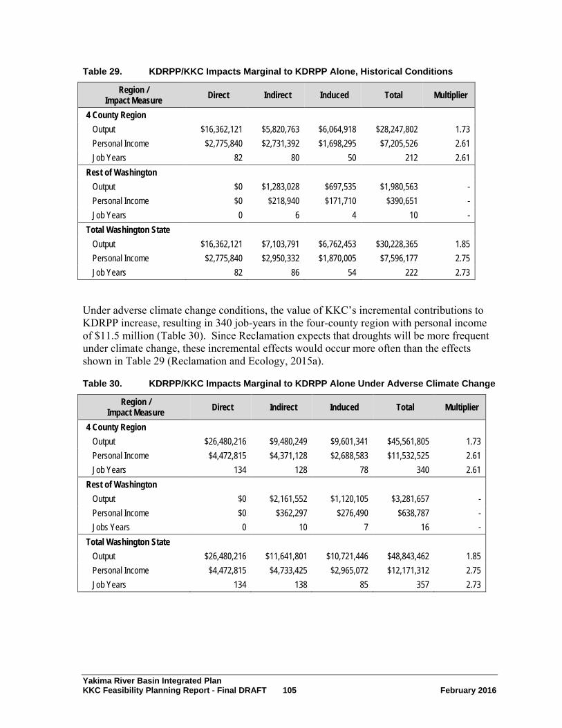
Yakima River Basin Integrated Plan KKC Feasibility Planning Report - Final DRAFT 105 February 2016
Table 29. KDRPP/KKC Impacts Marginal to KDRPP Alone, Historical Conditions
Region / Impact Measure Direct Indirect Induced Total Multiplier
4 County Region
Output $16,362,121 $5,820,763 $6,064,918 $28,247,802 1.73 Personal Income $2,775,840 $2,731,392 $1,698,295 $7,205,526 2.61 Job Years 82 80 50 212 2.61 Rest of Washington
Output $0 $1,283,028 $697,535 $1,980,563 - Personal Income $0 $218,940 $171,710 $390,651 - Job Years 0 6 4 10 - Total Washington State
Output $16,362,121 $7,103,791 $6,762,453 $30,228,365 1.85 Personal Income $2,775,840 $2,950,332 $1,870,005 $7,596,177 2.75 Job Years 82 86 54 222 2.73
Under adverse climate change conditions, the value of KKC’s incremental contributions to KDRPP increase, resulting in 340 job-years in the four-county region with personal income of $11.5 million (Table 30). Since Reclamation expects that droughts will be more frequent under climate change, these incremental effects would occur more often than the effects shown in Table 29 (Reclamation and Ecology, 2015a).
Table 30. KDRPP/KKC Impacts Marginal to KDRPP Alone Under Adverse Climate Change
Region / Impact Measure Direct Indirect Induced Total Multiplier
4 County Region
Output $26,480,216 $9,480,249 $9,601,341 $45,561,805 1.73 Personal Income $4,472,815 $4,371,128 $2,688,583 $11,532,525 2.61 Job Years 134 128 78 340 2.61 Rest of Washington
Output $0 $2,161,552 $1,120,105 $3,281,657 - Personal Income $0 $362,297 $276,490 $638,787 - Jobs Years 0 10 7 16 - Total Washington State
Output $26,480,216 $11,641,801 $10,721,446 $48,843,462 1.85 Personal Income $4,472,815 $4,733,425 $2,965,072 $12,171,312 2.75 Job Years 134 138 85 357 2.73

Yakima River Basin Integrated Plan KKC Feasibility Planning Report - Final DRAFT 106 February 2016
9.4 Environmental Quality and Other Social Effects Methodology
A team that included staff from Reclamation, Ecology, and environmental consultants to the agencies conducted the EQ and OSE evaluations. All members of the team had worked on the KDRPP and KKC Draft EIS (Reclamation and Ecology, 2015d) and have expertise in environmental analysis, engineering, and Yakima Project operations. Reclamation and Ecology conducted the EQ and OSE evaluations in a workshop format. Participants applied their subject area expertise, experience, and knowledge of the project and project area in their evaluations. Workshop participants also utilized information and analysis documented in the Draft EIS. All decisions made during the workshops used group consensus.
The Reclamation and Ecology team met to conduct the initial EQ and OSE evaluation on February 4, 2015. Reclamation and Ecology reviewed the evaluation with technical experts from Federal and Washington State resource agencies, the Yakama Nation, and Yakima River basin irrigation districts to receive additional input on the evaluations.
The Reclamation and Ecology team considered the input of the technical experts; revised resource categories, subcategories, weighting, and scoring; and made final decisions on the EQ and OSE evaluations.
The process used during the EQ and OSE workshops involved five major steps:
1. Identifying environmental resource categories from the Draft EIS that were most important for decision making
2. Prioritizing the resource categories
3. Dividing some resource categories into subcategories to better capture the benefits and impacts of the alternative
4. Weighting the EQ and OSE categories or subcategories
5. Scoring the benefits and impacts of the EQ and OSE categories or subcategories
9.4.1 Overview of Federal Guidance The Principles and Guidelines include criteria for evaluating alternatives based on the EQ and OSE accounts to display the effects of the alternatives. The Principles and Guidelines define these accounts as follows:
• The EQ account displays nonmonetary effects on significant natural and cultural resources. This account displays the effects on ecological, cultural, and aesthetic attributes of significant natural and cultural resources, which cannot be adequately measured in monetary terms within the NED and RED accounts.
• The OSE account registers plan effects from perspectives that are relevant to the planning process, but not reflected in the other three accounts.

Yakima River Basin Integrated Plan KKC Feasibility Planning Report - Final DRAFT 107 February 2016
9.4.2 EQ Assumptions for the Analysis Table 31 lists the EQ resource categories selected by the team along with a brief explanation of the resource categories. The Reclamation and Ecology team included the resource categories that (1) have the most effect on the purpose and need for the KKC, and (2) the KKC would potentially most impact. The team divided some resource categories into subcategories to allow for more refined evaluation of the benefits and impacts. Table 31 includes these subcategories.
The Draft EIS evaluated other resources, but Reclamation and Ecology did not include them in the EQ evaluation because the evaluation focuses on resources that are most important for decision making. The agencies did not include vegetation and wetlands in the EQ evaluation because they are committed to mitigating impacts to ensure no net loss to wetlands or vegetation.
The team assigned weights to resource categories based on their priorities and scaled so the weights totaled to 1.0. The team then weighted the EQ subcategories. Similar to the prioritization process, the team assigned weights to subcategories based on the participants’ estimation of how the subcategories would meet the purpose and need of the KKC and potential impacts on the resources. Within each category, the subcategory weights total 1.0. The team multiplied category weights by the subcategory weights to obtain the final weights for the EQ resources. Section 9.4.5 summarizes the weights and results of the EQ evaluation.
Table 31. KKC EQ Resource Categories
EQ Resource Category EQ Resource Subcategories Background
Surface water
Water supply
Instream flows
Improved water supply is part of the purpose and need for the KKC. As used here, water supply includes the benefits that would occur from improved water supplies that have not been monetized in the NED or RED, such as benefits of a more stabilized economy. Instream flows are included to represent the benefits other than those to fish that accrue from improved streamflows, such as improved water quality, aesthetics, etc.
Bull trout Food-based prey
Habitat
Passage
Enhancements to bull trout habitat is part of the purpose and need for the KKC. This category includes the subcategories of food-based prey, habitat, and passage, which are key indicators of improvements to the productivity and function of aquatic habitat conditions for bull trout.
Fish
Fish abundance
Fish passage
Fish habitat improvements are part of the purpose and need for the KKC. This resource category includes anadromous and resident fish that are not listed as threatened or endangered under the Endangered Species Act. Fish abundance accounts for overall improvements in fish populations, health, and distribution that will occur under the plan. Fish passage refers to ecosystem benefits of providing fish with access to more habitat.
Surface water quality Reservoir water quality
Import of water from Keechelus Reservoir could introduce contaminants to Kachess Reservoir.

Yakima River Basin Integrated Plan KKC Feasibility Planning Report - Final DRAFT 108 February 2016
EQ Resource Category EQ Resource Subcategories Background
Wildlife Wildlife habitat Construction could disrupt wildlife species in the area and the proposed action could improve wildlife habitat in some areas.
Other threatened and endangered species
Northern spotted owl
MCR steelhead The northern spotted owl and MCR steelhead are federally listed species that the project could affect.
Recreation Changed character of recreation
The BTE habitat improvements could change the character of recreation at Gold and Cold creeks.
Land use Property/easement acquisition
The project will require acquisition of some real property or easements.
Cultural Resources Cultural and archaeological resources
Subsistence resources
Construction of the KKC facilities and BTE habitat improvements at Gold and Cold creeks could disturb cultural resources. Improved habitat from reduced flows in the Keechelus Reach could improve subsistence resources.
Climate Change Adaptability to climate change
The KKC is included in the Integrated Plan as a project to help meet the Integrated Plan’s purpose of anticipating climate change and increasing Reclamation’s flexibility in responding to those changes.
Construction Impacts Construction impacts
Transportation
Construction could cause temporary impacts such as increased emissions, fugitive dust, noise, and vibration. Construction vehicles could increase traffic on local roads and Interstate 90.
MCR= Mid-Columbia River (steelhead).
9.4.3 OSE Assumptions for the Analysis The team also identified and prioritized the OSE account. As noted above, the OSE account includes perspectives that are not included in the NED, RED, or EQ accounts. The team identified two resource categories to include in the OSE account -- urban and community, and long-term productivity. The urban and community category includes impacts to local communities caused by large numbers of construction workers. Long-term productivity includes the subcategories of improved fish populations and resilience to climate change. These subcategories capture the social benefits of improved fish populations and resilience to climate change. OSE accounts often include environmental justice, but the team decided not to include that category because the KDRPP and KKC Draft EIS did not identify any potential environmental justice impacts (Reclamation and Ecology, 2015b). Table 32 lists and describes the OSE categories. Section 9.4.5 summarizes the weights and results of the OSE evaluation.

Yakima River Basin Integrated Plan KKC Feasibility Planning Report - Final DRAFT 109 February 2016
Table 32. OSE Resource Categories
OSE Resource Category
OSE Resource Subcategories Background
Urban and community Construction worker
impacts
This category is included to capture the impacts that would occur in communities surrounding the construction area from the large number of construction workers employed on the project. These impacts include housing demand.
Long-term productivity
Improved fish populations
Long-term productivity includes the nonmonetary and social benefits that accrue from the project. Sub categories include improved fish populations and resilience to climate change.
Resilience to climate change
9.4.4 EQ and OSE Impact Rating After the team identified, ranked, and weighted the EQ and OSE resource categories, the team rated the impacts. The EQ and OSE evaluations compared the impacts of the No Action Alternative and the two action alternatives (KKC North Tunnel Alignment and KKC South Tunnel Alignment) as described in the Draft EIS (Reclamation and Ecology, 2015b). The team rated the impacts by comparing the impacts of the No Action Alternative and the two action alternatives to the existing baseline conditions.
During the rating process, the Reclamation and Ecology team rated the No Action Alternative based on current Yakima Project operations and the projects and actions identified to occur under the No Action Alternative --Yakima River Basin Water Enhancement Project Phase II conservation projects, and the Washington State Department of Transportation Interstate 90 Snoqualmie Pass East Phase 2A project. For all alternatives, the team considered impacts and benefits over a 50-year period. The team also considered potential impacts of climate change, changes in vegetation and wildlife, and anticipated development that would occur in the next 50 years for both alternatives.
To compare the effects of the alternatives, the team developed a scale that accounts for both positive and negative impacts. The scale, listed below, also includes a zero rating to indicate no change relative to existing conditions.
0 = no change from existing conditions
3 = major positive impact -3 = major negative impact
2 = moderate positive impact -2 = moderate negative impact
1 = minor positive impact -1 = minor negative impact

Yakima River Basin Integrated Plan KKC Feasibility Planning Report - Final DRAFT 110 February 2016
The team rated the impacts using the same consensus-based approach as the rankings. To determine the final scores for the EQ and OSE evaluations, the team multiplied the resource category scores for each alternative by the category or subcategory weight. The resulting numbers reflect both the potential significance of the effect and the relative importance of the resource category or subcategory.
9.4.5 Environmental Quality and Other Social Effects Analysis Results Table 33 shows that under the No Action Alternative, conditions for most EQ resources would stay the same or decline. This is especially true for instream flows. The KKC would have a moderate positive impact on instream flows and bull trout. Non-listed fish abundance and MCR steelhead would also experience moderate positive impacts. The KKC would provide minor positive impacts to adaptability to climate change. Totals and subtotals in Table 33 may not add up exactly due to rounding. Figure 14 shows the EQ results graphically.
For the EQ resource categories, the KKC provides benefits for the resources that most directly meet the purpose and need for the project -- instream flows, fish, and bull trout. Other EQ resources would experience minor negative impacts with the exception of construction impacts. Significant but temporary negative construction impacts would occur for the KKC as indicated by the significance rating in Table 33. These include travel restrictions, localized traffic congestion on rural roads, and noise, during portions of the three-year construction period.
For the OSE resources, Table 34 shows that the KKC alternatives would have minor negative effects from construction worker impacts and minor to moderate benefits to long-term productivity, whereas the No Action Alternative would have moderate negative impacts on long-term productivity. The KKC would have minor negative urban and community impacts. For Table 34, totals and subtotals may not add up exactly due to rounding. Figure 15 shows the OSE results graphically.

Yakima River Basin Integrated Plan KKC Feasibility Planning Report - Final DRAFT 111 February 2016
Table 33. Comparative Display of Alternatives for EQ Categories
No Action Alternative KKC North Tunnel KKC South Tunnel EQ Resource Category Weight Significance Score Significance Score Significance Score Surface water Water supply 0.1 -2 -0.2 0 0 0 0
Instream flows 0.1 -3 -0.3 2 0.2 2 0.2
Subtotal 0.2
-0.5
0.2
0.2
Bull trout Food base 0.067 -1 -0.067 1 0.067 1 0.067
Habitat 0.067 -2 -0.133 2 0.133 2 0.133
Passage 0.067 -1 -0.067 2 0.133 2 0.133
Subtotal 0.20
-0.267
0.333
0.333
Fish (not Fish abundance 0.1 -2 -0.2 2 0.2 2 0.2 ESA-listed) Fish passage 0.1 0 0 1 0.1 1 0.1
Subtotal 0.2
-0.2
0.3
0.3
Surface water quality
Reservoir water quality 0.05 0 0 -1 -0.05 -1 -0.05
Subtotal 0.05
0
-0.05
-0.05
Wildlife Wildlife 0.05 0 0 1 0.05 1 0.05
Subtotal 0.05
0
0.05
0.05
Other threatened Northern spotted owl 0.025 0 0 -1 -0.025 -1 -0.025
and MCR steelhead 0.025 -1 -0.025 2 0.05 2 0.05 endangered species Subtotal 0.05
-0.025
0.025
0.025
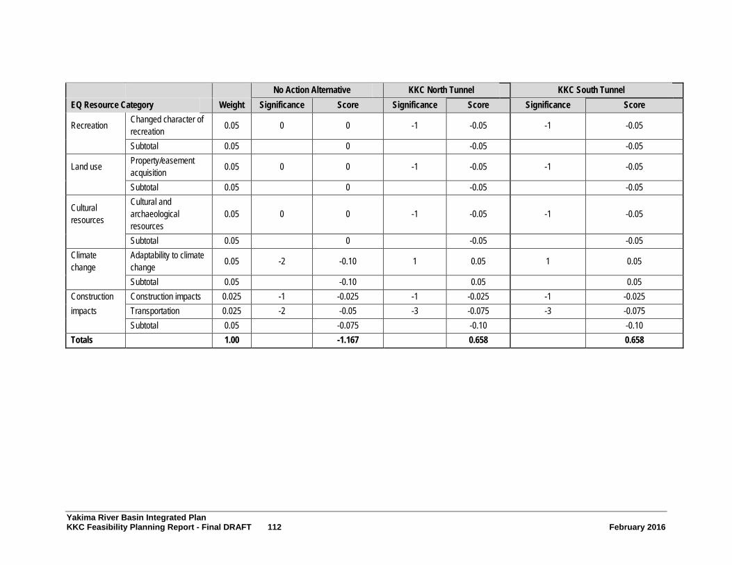
Yakima River Basin Integrated Plan KKC Feasibility Planning Report - Final DRAFT 112 February 2016
No Action Alternative KKC North Tunnel KKC South Tunnel EQ Resource Category Weight Significance Score Significance Score Significance Score
Recreation
Changed character recreation
of 0.05 0 0 -1 -0.05 -1 -0.05
Subtotal 0.05
0
-0.05
-0.05
Land use
Property/easement acquisition 0.05 0 0 -1 -0.05 -1 -0.05
Subtotal 0.05
0
-0.05
-0.05
Cultural resources
Cultural and archaeological resources
0.05 0 0 -1 -0.05 -1 -0.05
Subtotal 0.05
0
-0.05
-0.05 Climate change
Adaptability to climate change 0.05 -2 -0.10 1 0.05 1 0.05
Subtotal 0.05
-0.10
0.05
0.05 Construction impacts
Construction impacts 0.025 -1 -0.025 -1 -0.025 -1 -0.025 Transportation 0.025 -2 -0.05 -3 -0.075 -3 -0.075 Subtotal 0.05
-0.075
-0.10
-0.10
Totals 1.00
-1.167
0.658
0.658

Yakima River Basin Integrated Plan KKC Feasibility Planning Report - Final DRAFT 113 February 2016
Figure 14. EQ Resource Category Results

Yakima River Basin Integrated Plan KKC Feasibility Planning Report - Final DRAFT 114 February 2016
Table 34. Comparative Display of Alternatives for OSE Categories
No Action Alternative KKC North Tunnel KKC South Tunnel
OSE Resource Category Weight Significance Score Significance Score Significance Score Urban and Construction worker impacts 0.20 0 0.00 -1 -0.20 -1 -0.20 community Subtotal 0.20 0.00 -0.20 -0.20
Long-term Improved fish populations 0.40 -2 -0.80 2 0.80 2 0.80 productivity Resilience to climate change 0.40 -2 -0.80 1 0.40 1 0.40
Subtotal 0.80 -1.60 1.20 1.20 Total 1.00 -1.60 1.00 1.00

Yakima River Basin Integrated Plan KKC Feasibility Planning Report - Final DRAFT 115 February 2016
Figure 15. OSE Resource Category Results

Yakima River Basin Integrated Plan KKC Feasibility Planning Report - Final DRAFT 116 February 2016
9.5 Financial Feasibility
9.5.1 Cost Allocation Analysis and Repayment Reclamation uses cost allocation as a transitional step leading from economic evaluation to repayment analysis. Allocation is not a means of justifying an alternative or project but follows the determination of economically feasible project alternatives.
The objective of cost allocation is to equitably distribute economically justified project costs of feasible alternatives among the purposes served. The purposes allocated to can be either reimbursable or nonreimbursable based on existing legislative authority. Formulation of plans by incremental analysis normally assures that the cost of the plan increments is justifiable for each project purpose. Based on the assumption that project formulation principles have been applied, equitable cost distribution may be obtained by preventing costs allocated to any purpose from exceeding corresponding benefits. This establishes, for reimbursable project functions, the cost base from which repayment schedules are developed.
Principles of cost allocation are as follows:
• Each purpose is allocated directly, as a minimum, the identifiable separable cost (costs omitted from total project costs if one purpose is excluded).
• Project purposes should not be assigned costs in excess of benefits or the assigned costs should not be greater than the cost of a single-purpose alternative that could likely be built as a Federal project. Thus, the lesser of either benefits or the most likely Federal alternative costs is the justifiable expenditure or maximum allocation for a purpose.
• The costs remaining, after separable costs are identified and deducted from the justifiable expenditure, are allocated to each purpose in the same ratio as the remaining benefits.
• Include all costs necessary to achieve benefits claimed.
Reclamation prepared a preliminary cost allocation for the Integrated Plan (Reclamation and Ecology, 2012b) based on programmatic level analysis of project features and benefits. Implementation of the Integrated Plan would provide more accurate information on plan benefits and costs.
If KKC is funded using non-Federal sources, a project-specific cost allocation would not be required.
Repayment
Reimbursable project functions included in the Integrated Plan are agricultural irrigation and municipal and domestic water supply. Construction costs allocated to agricultural irrigation are generally reimbursable without interest, while those allocated to municipal and domestic supply are reimbursable with interest. For the Integrated Plan, cost-share partners such as the State of Washington, local governments, or other parties, may participate in reimbursement.

Yakima River Basin Integrated Plan KKC Feasibility Planning Report - Final DRAFT 117 February 2016
10.0 Conclusions and Recommendations This chapter summarizes Reclamation and Ecology’s findings and conclusions from the analyses conducted for the KKC.
10.1 Findings Reclamation developed the alternatives discussed in this Feasibility Planning Report using processes that conform to the Principles and Guidelines (U.S. Water Resources Council, 1983). The four criteria for evaluating a Federal water resource project are as follows:
• Completeness – The extent to which the alternative provides and accounts for all necessary investments and actions to implement the plan
• Effectiveness – The extent to which the alternative alleviates the problems and accomplishes the objectives
• Efficiency – The extent to which the alternative is cost effective in accomplishing the project objectives
• Acceptability – The workability and viability of the plan in terms of acceptance by Federal, State, and local governments and the public and compatibility with existing laws, regulations, and public policies
Table 35 summarizes these criteria and how they apply in helping to compare the feasibility study alternatives.
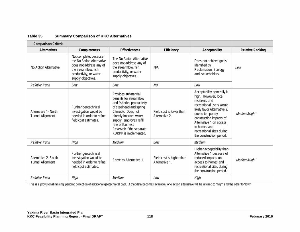
Yakima River Basin Integrated Plan KKC Feasibility Planning Report - Final DRAFT 118 February 2016
Table 35. Summary Comparison of KKC Alternatives
Comparison Criteria Alternatives Completeness Effectiveness Efficiency Acceptability Relative Ranking
No Action Alternative
Not complete, because the No Action Alternative does not address any of the streamflow, fish productivity, or water supply objectives.
The No Action Alternative does not address any of the streamflow, fish productivity, or water supply objectives.
N/A Does not achieve goals identified by Reclamation, Ecology and stakeholders.
Low
Relative Rank Low Low N/A Low
Alternative 1- North Tunnel Alignment
Further geotechnical investigation would be needed in order to refine field cost estimates.
Provides substantial benefits for streamflow and fisheries productivity of steelhead and spring Chinook. Does not directly improve water supply. Improves refill rate of Kachess Reservoir if the separate KDRPP is implemented.
Field cost is lower than Alternative 2.
Acceptability generally is high. However, local residents and recreational users would likely favor Alternative 2, due to temporary construction impacts of Alternative 1 on access to homes and recreational sites during the construction period.
Medium/High 1
Relative Rank High Medium Low Medium
Alternative 2- South Tunnel Alignment
Further geotechnical investigation would be needed in order to refine field cost estimates.
Same as Alternative 1. Field cost is higher than Alternative 1.
Higher acceptability than Alternative 1 because of reduced impacts on access to homes and recreational sites during the construction period.
Medium/High 1
Relative Rank High Medium Low High
1 This is a provisional ranking, pending collection of additional geotechnical data. If that data becomes available, one action alternative will be revised to “high” and the other to “low.”

Yakima River Basin Integrated Plan KKC Feasibility Planning Report - Final DRAFT 119 February 2016
10.1.1 Technical Viability Based on feasibility-level engineering and design, both of the action alternatives are technically viable.
10.1.2 Economically Justified Feasibility studies conducted by Reclamation are detailed investigations specifically authorized by law to determine the desirability of seeking congressional authorization for implementation of a preferred alternative, normally the NED Alternative, which reasonably maximizes net national economic development benefits. The Integrated Plan proposes a suite of projects that together maximize the net national development benefit. This Feasibility Planning Report includes only one of the actions listed in the Integrated Plan. This action is part of the NED Alternative comprising the full Integrated Plan; however, it does not individually produce benefits greater than its cost. The alternatives do result in positive effects on regional income and regional employment as shown in the RED analysis. This Feasibility Planning Report presents the alternatives because of these positive effects and the role the KKC plays within the overall Integrated Plan.
10.1.3 Financially Feasible After Reclamation finds a project to be economically justified, it undertakes analyses to determine if the Federal project cost outlays are recoverable from the project beneficiaries. Financial feasibility is the process of analyses identifying reimbursable and nonreimbursable financial costs and the ability to recover reimbursable costs from project beneficiaries. The analyses consist of a cost allocation and subsequent repayment analyses. Reclamation has not yet performed the financial feasibility analysis at the project level.
10.1.4 Four Account Analysis The following subsections summarize the results of the NED, RED, Environmental Quality, and Other Social Effects analyses.
Summary of NED Findings
The KKC would provide instream flow improvements for the Keechelus Reach of the Yakima River, which benefit Chinook salmon and steelhead. The improvement in salmon and steelhead populations would be worth an estimated $18 to $54 million over 40 years to Washington residents. This would increase to $29 to $86 million when including Oregon residents as well. The NED analysis considers the KKC in the context of the KDRPP implementation for cases when the joint effect is greater than the sum of the individual effects. When combined with the KDRPP, the KKC would increase agricultural benefits compared to the KDRPP alone. The KKC would increase water availability to prorationed water users under drought conditions. These benefits, via increased net farm earnings, would be worth an estimated $34 million in discounted NPV over 100 years, and would increase to $117 million under future, adverse climate change conditions. Municipal water supply benefits to the Cities of Yakima and Ellensburg under drought conditions equate to an estimated $20,879 over 100 years under historical conditions, and $71,165 under adverse climate change.

Yakima River Basin Integrated Plan KKC Feasibility Planning Report - Final DRAFT 120 February 2016
Estimated costs for KKC are $272 million undiscounted or $258 million present value for the North Tunnel Alternative, and $306 million undiscounted or $291 million discounted for the South Tunnel Alternative.
Summary of RED Findings
The estimated economic impacts of construction of the KKC North Tunnel Alternative would be 1,094 job-years within the four-county local region and 1,780 job-years for the State of Washington as a whole. This includes $60 million in personal income for the four-county region and $92 million at the State level. The estimated corresponding job-years for the South Tunnel Alternative would be 1,223 job-years in the four-county region and 2,001 job-years for the State as a whole. Personal income under the South Tunnel Alternative construction would be an estimated $67 million in the four-county region and $103 million for the State as a whole. The KKC would also generate three additional job-years annually through the life of the project.
The BTE program would generate an estimated 59 job-years in the four-county region and 98 job-years for the State as a whole. It would also generate an estimated $3.2 million locally in personal income and $5 million for the State as a whole.
Increases in agriculture activity provided by KKC in conjunction with KDRPP would generate 212 local job-years during drought years over the 100-year timeframe, under historical water supply conditions, and this increases to 340 job-years per drought year under adverse climate change. There are also an additional 10 job-years in the rest of Washington under historical water supply conditions, and 16 job-years, under adverse climate change. The total economic output increase under historical conditions for the four-county region would be an estimated $28 million, and it would be $46 million under adverse climate change conditions.
Summary of EQ Findings
Results from the EQ analysis suggest that under the No Action Alternative, conditions for most EQ resources would stay the same or decline. This is especially true for instream flows.
Implementation of the KKC would produce a moderate positive impact on instream flows and bull trout. The KKC would produce moderate positive impacts on fish abundance, including middle-Columbia-River steelhead. The KKC would provide minor positive impacts to adaptability to climate change. Other EQ resources would experience minor negative impacts under the KKC. The KKC would produce significant negative construction impacts during the construction period.
Summary of OSE Findings
Results from the OSE analysis suggest that the No Action Alternative would have moderate negative impacts on long-term productivity.
The KKC alternatives would produce minor negative effects from construction worker impacts and minor to moderate benefits to long-term productivity. The KKC would have minor negative urban and community impacts.
Yakima River Basin Integrated Plan KKC Feasibility Planning Report - Final DRAFT 121 February 2016
10.2 Conclusions The KKC North Tunnel Alignment has an estimated construction cost that is $31 million less (11 percent less) than the South Tunnel Alignment. Operating costs for both alternatives are comparable. However, the South Tunnel Alignment would create less impact on local residents and recreational users of the Wenatchee National Forest during the three-year construction period than the North Tunnel Alignment. Reclamation and Ecology will defer selection of the preferred alternative until the EIS is complete.
The NED analysis indicates that costs are greater than benefits for both alternatives. However, benefits of the full Integrated Plan and the Initial Development Phase of the Integrated Plan are higher than the costs. Reclamation and Ecology are considering the KKC as a component of the overall Integrated Plan rather than as a stand-alone project.
Draft legislation approved by the Senate Energy and Natural Resources Committee in November 2015 indicates that KKC would be funded using non-Federal funding sources. Since Federal authorization and appropriations are not requested for the project at this time, Reclamation and Ecology have decided to leave this Planning Report in “final draft” status. In addition, the specific procedures required under Principles & Requirements do not apply, and Reclamation has performed only the limited work needed to document the process to date. Reclamation and Ecology will continue to support KKC for advancement as a component of the larger Integrated Plan, contingent on results of ongoing studies and environmental analyses, as well as well as support from project sponsor(s), funding availability from non-Federal sources and all other applicable information.

Yakima River Basin Integrated Plan KKC Feasibility Planning Report - Final DRAFT 122 February 2016
11.0 References Brekke, et al, 2010
Brekke, L., B. Kuepper and S. Vaddey, 2010. Climate and Hydrology Datasets for use in the RMJOC Agencies’ Longer-Term Planning Studies. December 2010.
Fast et al., 1991 Fast et al. 1991. Yakima River spring Chinook enhancement study, final report. BPA Fish and Wildlife Publication. Project No. 1982-16, Contract No. DE-A179-1983BP39461.
HDR, 2015 HDR Engineering, Inc. 2015. Ancillary Costs of Keechelus-to-Kachess Conveyance (KKC). Memorandum. U.S. Bureau of Reclamation. March 2015.
Layton et al., 1999
Layton, D., G. Brown, and M. Plummer. 1999. Valuing Multiple Programs to Improve Fish Populations. Washington State Department of Ecology.
Loomis and White, 1996
Loomis, J. B., and White, D. S. 1996. Economic benefits of rare and endangered species: summary and meta-analysis. Ecological Economics, 18(3), 197-206.
Mullan et al., 1992
Mullan, J.W., K.R. Williams, G. Rhodus, T.W. Hillman, J.D. McIntyre. 1992. Production and habitat of salmonids in Mid-Columbia River tributary streams. USFWS Monograph I. Leavenworth, WA. 489 pp.
Quinn, 2005 Quinn, Thomas. 2005. The behavior and ecology of Pacific Salmon and Trout. pg 254
Reclamation, 2002
Bureau of Reclamation. 2002. Interim Comprehensive Basin Operating Plan, Yakima Project, Washington. U.S. Department of the Interior, Bureau of Reclamation, Pacific Northwest Region, Upper Columbia Area Office, Yakima, Washington.
Reclamation, 2008
Bureau of Reclamation. 2008. Yakima River Basin Water Storage Feasibility Study Final Planning Report/Environmental Impact Statement. December 19, 2008.
Reclamation, 2013a
Bureau of Reclamation. 2013. Change in Discount Rate for Water Resources Planning. Federal Register. https://www.federalregister.gov/articles/2013/11/12/2013-27089/change-in-discount-rate-for-water-resources-planning. November 2013.

Yakima River Basin Integrated Plan KKC Feasibility Planning Report - Final DRAFT 123 February 2016
Reclamation, 2013b
Bureau of Reclamation. 2013. Record of Decision for the Yakima River Basin Integrated Water Resource Management Plan Final Programmatic Environmental Impact Statement. U.S. Department of the Interior, Bureau of Reclamation, Pacific Northwest Region, Columbia-Cascades Area Office, Yakima, Washington.
Reclamation, 2014a
Bureau of Reclamation. 2014. Design, Estimating and Construction Review Report Keechelus-to-Kachess Conveyance Project. Prepared by U.S. Bureau of Reclamation. September 2014.
Reclamation, 2014b
Bureau of Reclamation. 2014. Expected Improvement in Fish Productivity in the Keechelus Reach with Implementation of the Proposed Keechelus-to-Kachess Conveyance (KKC) Memorandum. U.S. Department of the Interior, Bureau of Reclamation. October 2014.
Reclamation, 2014c
Bureau of Reclamation. 2014. Value Analysis Final Report; Keechelus-to-Kachess Conveyance Project. Prepared by U.S. Bureau of Reclamation. March 2014.
Reclamation and Ecology, 2008
Bureau of Reclamation and Washington State Department of Ecology. 2008. Draft Planning Report/Environmental Impact Statement for the Yakima River Basin Water Storage Feasibility Study. U.S. Department of the Interior, Bureau of Reclamation and Washington State Department of Ecology.
Reclamation and Ecology, 2011a
Bureau of Reclamation and Washington State Department of Ecology. 2011. Costs of the Integrated Water Resource Management Plan. Technical Memorandum. Prepared by HDR Engineering and Anchor QEA, for the U.S. Bureau of Reclamation. Contract No. 08CA10677A ID/IQ. March 2011.
Reclamation and Ecology, 2011b
Bureau of Reclamation and Washington State Department of Ecology. 2011. Water Needs for Out-of-Stream Uses. Technical Memorandum. Prepared by HDR Engineering, Inc. and Anchor QEA, for the U.S. Bureau of Reclamation. Contract No. 08CA10677A ID/IQ. June 2011.
Reclamation and Ecology, 2011c
Bureau of Reclamation and Washington State Department of Ecology. 2011. Yakima River Basin Study; Volume 1, Proposed Integrated Water Resource Management Plan. Prepared by HDR Engineering, Inc., Anchor QEA, ECONorthwest, ESA Adolfson, and Golder Associate, for the U.S. Bureau of Reclamation. Contract No. 08CA10677A ID/IQ. April 2011.

Yakima River Basin Integrated Plan KKC Feasibility Planning Report - Final DRAFT 124 February 2016
Reclamation and Ecology, 2011d
Bureau of Reclamation and Washington State Department of Ecology. 2011. Yakima River Basin Water Resources. Technical Memorandum. Prepared by Anchor QEA, for the U.S. Department of the Interior, Bureau of Reclamation, Contract No. 08CA10677A ID/IQ. March 2011.
Reclamation and Ecology, 2012a
Bureau of Reclamation and Washington State Department of Ecology. 2012. Four Accounts Analysis of the Integrated Plan. Technical memorandum. Prepared by ECONorthwest, Natural Resource Economics, and ESA. U.S. Bureau of Reclamation and Washington State Department of Ecology. Contract No. 08CA10677A ID/IQ. October 2012.
Reclamation and Ecology, 2012b
Bureau of Reclamation and Washington State Department of Ecology. 2012. Preliminary Cost Allocation for Proposed Integrated Water Resource Management Plan. Technical memorandum. Prepared by HDR Engineering, Inc. for the U.S. Department of the Interior, Bureau of Reclamation. Contract No. 08CA10677A ID/IQ. October 2012
Reclamation and Ecology, 2012c
Bureau of Reclamation and Washington State Department of Ecology. 2012. Yakima River Basin Integrated Water Resource Management Plan, Final Programmatic Environmental Impact Statement. Prepared by ESA and HDR Engineering, Inc., for the U.S. Department of the Interior, Bureau of Reclamation. March 2012.
Reclamation and Ecology, 2012d
Bureau of Reclamation and Washington State Department of Ecology. 2014. Yakima River Basin Integrated Water Resource Management Plan, Framework for Implementation Report. Prepared by HDR Engineering, Inc., Anchor QEA, ECONorthwest, Natural Resource Economics, and ESA, for the U.S. Department of the Interior, Bureau of Reclamation, Contract No. 08CA10677A ID/IQ. October 2012.
Reclamation and Ecology, 2013
Bureau of Reclamation and Washington State Department of Ecology. 2013. Screening of Alternatives for the Keechelus-to-Kachess Conveyance Project. Technical memorandum. Prepared by HDR Engineering and Anchor QEA, for the U.S. Department of the Interior, Bureau of Reclamation, Contract No. 08CA10677A ID/IQ. September 2013.
Reclamation and Ecology, 2014a
Bureau of Reclamation and Washington State Department of Ecology. 2014. Bull Trout Enhancement; Kachess Drought Relief Pumping Plant and Keechelus-to-Kachess Conveyance. Prepared by Anchor QEA, for the U.S. Bureau of Reclamation. September 2014.

Yakima River Basin Integrated Plan KKC Feasibility Planning Report - Final DRAFT 125 February 2016
Reclamation and Ecology, 2014b
Bureau of Reclamation (U.S. Department of the Interior) and Washington State Department of Ecology. 2014. Keechelus-to-Kachess Conveyance Geotechnical Interpretation- Gravity Tunnel. Technical memorandum. Prepared by HDR Engineering, Inc., for U.S. Bureau of Reclamation, Contract No. 08CA10677A ID/IQ. August 2014.
Reclamation and Ecology, 2015a
Bureau of Reclamation and Washington State Department of Ecology. 2015. Economic Analyses of the Proposed Keechelus-to-Kachess Conveyance Project. Technical memorandum. Prepared by ECONorthwest, for the U.S. Bureau of Reclamation, Contract No. R13PC10006 ID/IQ. (DRAFT). April 2015.
Reclamation and Ecology, 2015b
Bureau of Reclamation and Washington State Department of Ecology. 2015. Feasibility Design Report, Kachess Drought Relief Pumping Plant. Prepared by HDR Engineering, Inc., for the U.S. Bureau of Reclamation, Contract No. R13PC10006 ID/IQ. (DRAFT). March 2015.
Reclamation and Ecology, 2015c
Bureau of Reclamation and Washington State Department of Ecology. 2015. Hydrologic Modeling of System Improvements, Phase 1 Report. Prepared by HDR Engineering, Inc., for the U.S. Department of the Interior, Bureau of Reclamation, Contract No. R13PC10006 ID/IQ. March 2015.
Reclamation and Ecology, 2015d
Bureau of Reclamation and Washington State Department of Ecology. 2015. Kachess Drought Relief Pumping Plant and Keechelus Reservoir-to-Kachess Reservoir Conveyance Draft Environmental Impact Statement. Prepared by ESA and HDR Engineering, Inc., for the U.S. Department of the Interior, Bureau of Reclamation. Contract No. R13PC10006 ID/IQ. (DRAFT). January 2015.
Reclamation and Ecology, 2015e
Bureau of Reclamation and Washington State Department of Ecology. 2015. Keechelus-to-Kachess Conveyance Feasibility Design Report. Prepared by HDR Engineering, Inc., Brierley Associates, Dr. Mole, Inc., and Engineering Solutions, LLC, for the U.S. Bureau of Reclamation, Contract No. R13PC10006 ID/IQ. (DRAFT). March 2015.
Reclamation and Ecology, 2015f
Bureau of Reclamation and Washington State Department of Ecology. 2015. Keechelus-to-Kachess Conveyance Field Cost Estimate. Technical memorandum. Prepared by HDR Engineering, Inc., U.S Bureau of Reclamation, Contract No. R13PC10006 ID/IQ. February 2015.
Reiss et. al, 2012 Reiss, Y.K., J. Thomas, E. Anderson, and J. Cummins. 2012. Final Yakima Bull Trout Action Plan. September 2012.

Yakima River Basin Integrated Plan KKC Feasibility Planning Report - Final DRAFT 126 February 2016
Sampson et al., 2013
Sampson, M.R., D.E. Fast, and W.J. Bosch (editors). 2013. Yakima-Klickitat Fisheries Project Monitoring and Evaluation – Yakima Subbasin, Final Report for the performance period May/2012-April/2013. Project number 1995-063-25, 241 electronic pages.
Shannon & Wilson, 2014
Shannon & Wilson, Inc. 2014. Geology Report, Keechelus to Kachess Conveyance Project (KKC). Kittitas County, Washington.
USFS, 2011 U.S. Forest Service. 2011. Environmental Assessment – Gold Creek Bridges and F.S. Road #4832 Reconstruction. Cle Elum Ranger District, Okanogan-Wenatchee National Forest, Kittitas County, Washington. June 2011.
U.S. Water Resources Council, 1983
U.S. Water Resources Council. 1983. Economic and Environmental Principles and Guidelines for Water and Related Land Resources Implementation Studies. U.S. Government Printing Office. March 1983. Washington DC.

Yakima River Basin Integrated Plan KKC Feasibility Planning Report - Final DRAFT 127 February 2016
12.0 List of Preparers Name Background Responsibility
HDR Engineering, Inc. Andrew Graham Water Resource Planning Lead Author, HDR Project Manager
Sarah Pistorese Water Resource Planning Co-Author
Jim Peterson Engineering KKC Design and Cost Estimating Task Manager
Steve Thurin Engineering/Hydrology Hydrologic Modeling
Colleen Petilla Engineering Project Engineer
Sri Rajah Engineering Hydraulics
John Ballegeer Engineering Geotechnical
John Charlton Geology Geology
John Koreny Hydrogeology Dewatering
George (Herb) Hickman Cost Estimating Cost Estimator
Richard Glassen Cost Estimating Cost Estimate Quality Control Review
Mark Ohlstrom Engineering Quality Control Review
Brierley Associates Gregg Sherry Engineering Tunneling Quality Control Review
Dr. Mole, Inc. Gary Brierley Engineering Geotechnical Quality Control Review
Engineering Solutions, LLC Dan Hertel Engineering Civil Constructability Quality Control Review
ECONorthwest Mark Buckley, Ph.D. Natural Resource Economics Economics Lead
Ed MacMullan, M.S. Agricultural Economics Economics Contributor
ESA Ann Root NEPA/SEPA Documentation SEPA and NEPA document management
Anchor QEA
Bob Montgomery Water Resources Planning and Engineering Environmental Impact- Water Resources
Reclamation
Wendy Christensen Engineering Reclamation Lead for Integrated Plan, Report Review
Jeremy Lorberau Engineering Design and Estimating Oversight; Report Review
Dan Maag Cost Estimating Cost Estimate Review
Randy Christopherson Economics NED/RED Review
Yakima River Basin Integrated Plan KKC Feasibility Planning Report - Final DRAFT 128 February 2016
Name Background Responsibility
Joel Hubble Fisheries Biology Fisheries Benefits Estimation
Chris Lynch Yakima Project Operations Hydrologic Modeling Review
Corey Carmack Environmental Compliance Project Activity Manager
Ecology
Derek Sandison Environmental Sciences/Water Resource Management State Lead for Integrated Plan