effects of land use on forms of phosphorus in coastal
TRANSCRIPT
31
Effects of Land use on forms of phosphorus in coastal plain sands of Nigeria
ARTICLE INFO Article history: Received May 12, 2020 Received in revised form August 17 2020 Accepted August 28, 2020 Available online September 20, 2020
ABSTRACT
This research studied the effect of land uses changes on the forms of phosphorus within the coastal plain sands landscape of southeastern Nigeria. Satellite image-ries and soil data including phosphorus fractions were used for the study. Spatial coverage of forest and agricultural (fallow and farmland) land uses, accompany-ing soil properties and forms of phosphorus were estimated. There was progres-sive increase in the agricultural land use over the years to as much as 85.7% of the study area. The agricultural land use continually undergoes circles of crop-fallow with accompanying influence on nutrient cycling and pedogenesis. Land uses studied influenced available, organic, total, bound, iron and occluded iron and aluminium forms of phosphorus whereas topography influenced iron forms. Particle size distribution influenced available, organic, total, bound iron and oc-cluded forms of phosphorus. Soil pH influenced available and iron forms of phosphorus whereas organic matter is a major determinant in the distribution and variability of iron, occluded, occluded iron and aluminium, calcium and residual forms. Progressive increases in the spatial coverage of agricultural land use under the present production system results to preponderance of recalcitrant phosphorus in larger portion of the study area to the detriment of available forms, crop growth and yield
Keywords:
land use phosphorus fractions remote sensing acid sands pedogenesis toposequence
Corresponding Author’s E-mail Address:
[email protected]; +2348033497933
https://doi.org/10.36265/njss.2020.300305
ISSN-1597-4488 © Publishing Realtime.
All rights reserved.
Department of Soil Science and Land Resources Management, University of Uyo, Uyo, Nigeria.
1.0 Introduction
The coastal plain sands of Benin formation comprised del-taic marine sediments of cretaceous to recent age and pos-sess characteristics dominated by sandstone and siltstone lithofacies. These dominant lithofacies are quartz arenite and originate from acidic plutonic igneous rocks. The in-teractions between these geological materials and the envi-ronment give rise to acid sands of southeastern Nigeria. These acid sands are highly weathered and dominantly ulfisols or acrisols (Akpan-Idiok and Ukwang, 2012). The dynamics of phosphorus (P) has been found to associate with parent material, extent of weathering, drainage, pH and anion exchange capacity of soils. Highly weathered tropical Ferralsols, Acrisols, and Luvisols are generally deficient in P as a result of high degree of sorption in the presence of large quantities of exchangeable aluminium
(Al) and total iron (Fe), low pH and low organic matter content.
Land use and changes have been associated with soil de-velopment (Obi, 2015; Obi and Ituen, 2017) and there is a strong relationship between P forms and stages of soil de-velopment. The implication is the significant effect of land use and changes on the dynamics of phosphorus in the soil. Selmants and Hart (2010) reported that primary forms of phosphorus dominate the soil at the initial stage of de-velopment but the progress of weathering give rise to or-ganic, non-occluded and occluded forms. Therefore, at the late stage of soil development, phosphorus is dominated by organic and occluded forms (Yang and Post, 2011). These are indications that as soil development progresses from the young (entisols or arenosol) through maturity to
Obi*, J. C., Ibia, T. O. and Ikott, I. E.
Obi, et al., NJSS 30(3) 2020 31-41

32
senile stage (oxisols or ferralsols), there is gradual reduc-tion and eventual exhaustion of mineral P (apatite).
The effect of land use on the dynamics of P is associated with plant nutrition, rhizosphere interaction and extrinsic factors such as management (Walker et al., 2010). Chang-es in land use result to very highly significant differences in status of P in the soil (Lou et al., 2015). For instance, significant differences were reported on the levels of labile and recalcitrant forms of P contents of oxisols on natural savanna, arable, pasture and reforested lands (Neufeldt et al., 2000). Chimdi et al. (2014) reported that changing from forest and grazing to cultivated land decreased the amount of extractable Al and Fe resulting in lower total P contents of the cultivated compared to other land uses.
The highly weathered acid sand of southeastern is increas-ingly subject to intensive and extensive utilization in a low input and low efficiency agricultural production system. The consequence is progressive conversion of forest to arable land use. Additionally, the reduction of fallow peri-od has almost eliminated the concept of fallow in the pro-duction system of the study area. These affect the dynam-ics of P within the landscape of coastal plain sands of southeastern Nigeria. Therefore, this research studied the effect of changes from forest to agricultural land use on the dynamics of P in the coastal plain sands of Akwa Ibom State, southeastern Nigeria.
2.0 Materials and Methods
2.1 Description of the study area
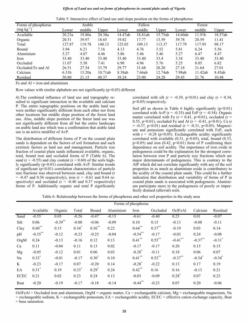
The study was carried out in locations underlain by coastal plain sands (CPS) in Akwa Ibom State, southeastern Nige-ria (Fig. 1). The State is located between approximately latitudes 4° 30ʹ and 5° 30ʹ N and longitudes 7° 28ʹ and 8°
20ʹ E, and covers approximately 7249 km2 out of which 70% and 5% are CPS and accompanying alluvium respec-tively. Akwa Ibom State was carved out of Cross River State in 1987 and Uyo the Capital City is enclosed be-tween latitude 4° 50' and 5° 07' N and longitude 7° 45' and 8° 05' E and falls with the coastal plain sands. In 1986, the human population was 2,100,565 but has grown to 3,902,051 and 5,272,029 in 2006 and 2015 respectively.
The climate is characterized by distinct wet (March/April to October) and dry (November to March) seasons. Rain-fall distribution in a year is bimodal (with peaks in July and September) and high intensity with annual range of 2000 to 4000 mm. Temperature is uniformly high ranging between 28 °C and 30 °C and relative humidity is high (approximately 75%). Previously the study area belonged to the humid tropical forest zone of southern Nigeria but currently characterized by secondary forest of predomi-nantly wild oil palm trees of various densities, woody shrubs and various grass undergrowth.
The predominant land use is the cropping-bush fallow-cropping closed system operated with hoes and machetes. The constraints of fragmentation and primitive hand tools restrict average farm size to a maximum of 0.5 ha per site. A farmer could have several small parcels of farm scat-tered over a wide area. The principal food crops grown are yam, cassava, maize and cocoyam and the dominant tree crop is oil palm.
The profiles of soils formed from coastal plain sands vary from sand on the surface to fine loamy in the subsurface and have low physical and chemical fertility due to domi-nance of low-activity kaolinitic clays and low organic mat-ter content (Chikezie et al., 2010). They are well drained, deeply weathered and classified as Haplic Acrisol (Hyperdystric) of the World Reference Base. Overall
Effects of Land use and on forms of phosphorus in coastal plain sands of Nigeria
Fig. 1: Map of Akwa Ibom State showing area covered by coastal plain sands
33
2.2 methodology and pre-processing
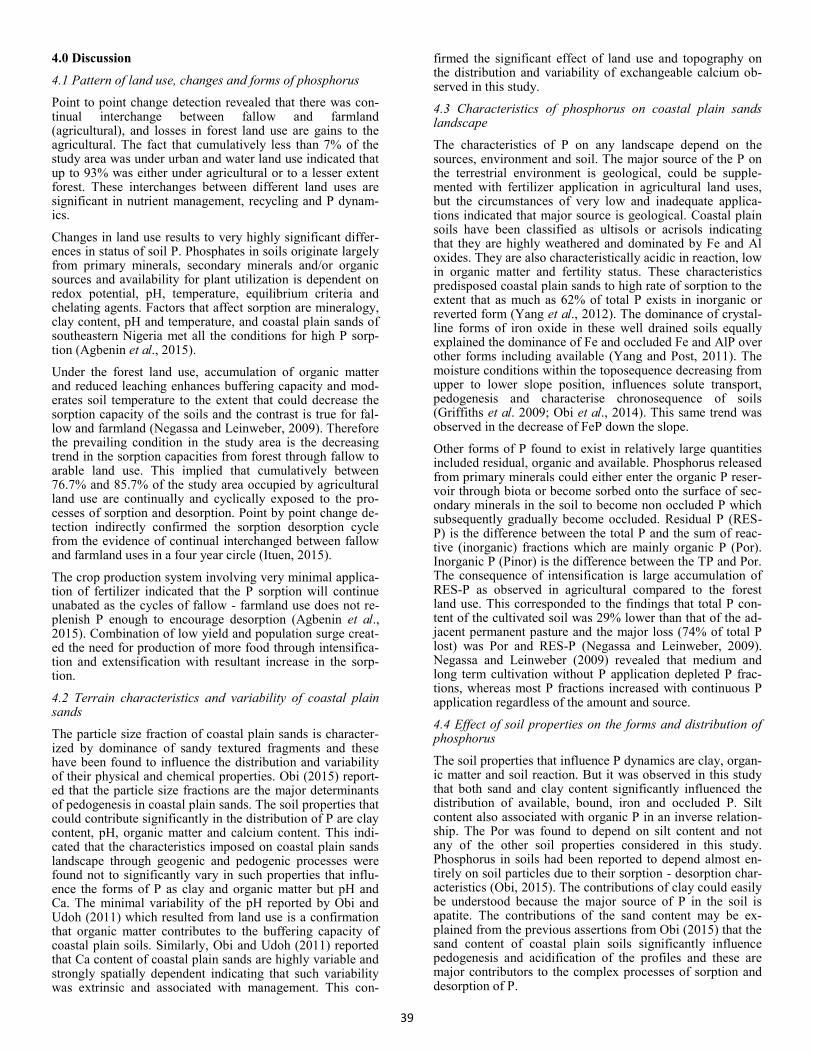
Population is a major driver of land use changes and re-sponsible for the decrease in the arable land in Akwa Ibom State from 0.22 to 0.11 ha per person between 1986 and 2013. Therefore, the changes in the different land uses from 1986 to 2013 were estimated with the aid of remote sense techniques. The images utilized in the study based on availability were those captured in 1986, 2003, 2008 and 2013.
Landsat TM and ETM+ images with spatial resolution of 30 m2 captured in 1986 and 2003 and Nigeriasat 1 images captured in 2008 and 2013 with spatial resolution of 32 m2 were acquired and used for the study. Large-scale aerial photographs of 2002 were also acquired from Akwa Ibom State Ministry of Lands and Housing for selection of train-ing areas and accuracy assessment of the classified imag-es. The steps involved in image processing were as de-scribed in Tokula and Ejaro, (2012). Anderson et al. (1976) classes was modified for use in the study area and five land use and land cover classes were defined and adopted for use. The modified land use and cover classes include water body, forest, fallow, farmland and urban. Supervised signature extraction was adopted in conjunc-tion with the maximum likelihood algorithm to derive meaningful classes from the images.
2.3 Field studies and laboratory analysis
Typical toposequences of gently undulating coastal plain
sands geomorphic unit is characterised by slopes of less that 5%. Three representative and contiguous toposequences per land use (i.e. forest, fallow and arable) were selected in three villages to give a total of nine sam-pling locations within the coastal plain sands geomorphic unit. The villages include Use Offot (longitude 7° 58' 396'' and latitude 5° 01' 849''), Ntak Inyang (longitude 7° 55' 818'' and latitude 5° 04' 964'') and Idu (longitude 8° 00' 212'' and latitude 5° 01' 895''). Oil palm plantation that is more than 40 years of age was used to represent forest land use. Fallow land use is land formerly used for crop production but abandoned as a result of very poor yield and has stood for a minimum of four years. Arable land use is a cassava farm from which maize crop have been harvested.
A total of 54 auger soil samples comprising 27 each from the surface (0-15 cm) and subsurface (15-30 cm) were collected from the upper, middle and lower slope positions of the selected toposequences and preserved for laboratory analysis. The samples were pulverized, sieved through 2.0 mm mesh sieve and used for laboratory analysis. Particle size analysis was carried out using the method of Dane and Topp (2002). Soil organic carbon (OC) content was deter-mined as described in Sparks (1996) and organic matter content is OC multiplied by 1.729 (Odu et al., 1986). Soil pH was determined in 1:2.5 (soil:water) solution using pH meter (McLean, 1982).

34
Effects of Land use and on forms of phosphorus in coastal plain sands of Nigeria

35
Fig. 2: Land use/cover map of area covered by coastal plain sands in Akwa Ibom State
Exchangeable bases were extracted with Mehlich No. 3 ex-traction (Mehlich, 1984). Potassium (K) and sodium (Na) contents were determined with flame emission spectropho-tometer, calcium (Ca) and magnesium (Mg) with atomic absorption spectrophotometer (AAS). Available P (AvP) was extracted according to the Bray and Kurtz (1954). Ex-changeable acidity (EA) was extracted with unbuffered po-tassium chloride solution and titration with 0.01 M solution of sodium hydroxide to the first permanent pink endpoint, while effective cation exchange capacity (ECEC) and base saturation (BS) determinations were as described by Ander-son and Ingram (1993).
Organic phosphorus (Por) content was measured by the igni-tion method (Kuo, 1996), for which phosphorus in the ignit-ed (550 °C) and unignited soil samples were extracted by 0.5 M H2SO4. Selective sequential fractionation of inorganic phosphorus (Pinor) in the soil was performed, using the step-wise extraction scheme. Soluble and loosely bound phospho-rus (S/LP), aluminium bound phosphorus (AlP), iron bound phosphorus (FeP) and Ca bound phosphorus (CaP) were selectively extracted by NH4Cl, NH4F, NaOH, Na2S2O4, and H2SO4, respectively (Kuo, 1996). Phosphorus in the extract-ed supernatants was determined colorimetrically using the blue colour method of Murphy and Riley (1962). The sec-ondary mineral or occluded form of phosphorus was deter-mined using 0.1 M NaOH, 0.3 M NaC3H6O7 + 1M NaHCO3 + Na2S2O4. Residual phosphorus (RES-P) was given by the difference between the total phosphorus (TP) content and the sum of inorganic and organic fractions.
2.4 Statistical analysis
Soil samples were collected in a 3 x 3 factorial experiment in
randomized complete block design (RCBD) with three repli-cations. The two factors were land use and slope position while locations served as the blocks. Data collected were analysed using analysis of covariance with subsurface and surface soil as the dependent and independent variables re-spectively. The subsurface soil is not as variable as the sur-face soil. Pair wise comparisons were conducted with least squares means. Pearson’s correlation was carried out to es-tablish the relationship between the different forms of P and other soil properties. All statistical analyses were carried out using Statistical Analysis System.
3.0 Results
3.1 Changes in land uses within coastal plain sands
The land use maps of coastal plain sands geomorphological unit in Akwa Ibom State between 1986 and 2013 were shown in Figure 2. The distribution of urban land use indi-cated a drift towards few central locations. Farmlands were equally found to concentrate within the fringes of urban land use while fallow and forest land uses followed in that order. These confirmed indiscriminate establishments of small farms by large number of individuals in a low input low effi-ciency crop production system within the fringes of urban land use.
The result revealed that there was gradual and progressive increase in the coverage of agricultural (farmland and fallow) to the detriment of forest land use (Table 1). Cumulatively, agricultural land use occupied between 76.7% and 85.7% which implied that this amount of land is constantly going through the circles of cropping and fallowing with accompa-nying influence on nutrient recycling and pedogenesis

36
Farmland Fallow Forest Urban Water body Total
1986 Area (ha) 182360.3 234410.9 58043.2 67144.9 1715.7 543675 (%) 33.5 43.1 10.7 12.4 0.3 100 Cumulative (%) 33.5 76.7 87.3 99.7 100
2003 Area (ha) 203807.6 262332.3 69874.5 5516.6 2144.0 543675 (%) 37.5 48.3 12.9 1.0 0.4 100 Cumulative (%) 37.5 85.7 98.6 99.6 100
2008 Area (ha) 233009.2 223468.4 52764.8 32267.7 2164.8 543675 (%) 42.9 41.1 9.7 5.9 0.4 100 Cumulative (%) 42.9 84.0 93.7 99.6 100
2013 Area (ha) 214905.0 246690.7 56835.6 23174.1 2069.6 543675 (%) 39.5 45.4 10.5 4.3 0.4 100 Cumulative (%) 39.5 84.9 95.4 99.6 100
Table 1: Spatial coverage different of land uses within the study area between 1986 and 2013
3.2 Effect of land use and slope positions on soil properties
The results shown in Tables 2 and 3 indicated that land use and topography did not significantly affect the distribution of sand and clay, but silt content. The silt content of the forest was lower than that of fallow and arable and this could be attributed to similarity in the two land uses. Fallow
and farmland are continually interchanged in a circle of at least one in four years. The effect of topography on the par-ticle size distribution of the soils revealed that the silt con-tent of the upper slope position was not significantly differ-ent from that of the middle, but from that of the lower slope, while that of the middle slope was also not significantly dif-ferent from that of lower. This indicated the overlapping
Land use Slope position Soil properties Arable Fallow Forest Upper Middle Lower Sand --(g kg-1)-- 825.2 829.8 834.2 827.6 843.1 818.7 Silt 56.2a 47.6a 25.1b 47.3ab 27.3b 56.2a Clay 118.4 120.7 138.4 125.1 127.3 125.1 Organic matter 4.0 3.8 4.4 4.0 4.00 4.3 pH 5.72a 5.54b 5.57ab 5.68 5.63 5.52 Calcium ----(cmol kg-1)--- 3.91a 3.44ab 3.29b 4.18a 2.93b 3.53b Magnesium 1.29 1.33 1.07 1.37 0.98 1.33 Potassium 0.09ab 0.10a 0.08b 0.09 0.09 0.08 Sodium 0.06 0.06 0.06 0.06 0.06 0.06 Acidity 1.92 2.36 2.52 2.29 2.10 2.29 ECEC 7.27 7.30 7.02 8.00a 6.16b 7.44a Base saturation (%) 72.9a 68.3ab 63.8b 70.4 68.0 66.6
Table 2: Effect of land use and slope position on the soil properties in the study area
ECEC=Effective cation exchange capacity
Row values with similar alphabets are not significantly (p<0.05) different
Arable Fallow Forest
Soil properties Lower Middle Upper Lower Middle Upper Lower Middle Upper
Sand --(g kg-1)-- 838.0 867.6 838.0 807.4 826.2 832.8 846.1 791.5 820.8
Silt 53.8ab 31.8ab 45.6ab 71.8a 37.5ab 46.4ab 24.2b 37.0ab 44.7ab
Clay 105.03 103.39 119.24 123.39 132.45 120.00 131.69 164.15 133.33
Organic matter 4.34 4.21 3.82 4.13 3.66 3.83 4.15 4.45 4.03
pH 5.52 5.78 5.52 5.56 5.56 5.76 5.58 5.62 5.59
Exchangeable Calcium ---(cmol kg-1)---
3.79b 2.79bc 4.88a 3.24b 3.33bc 3.80ab 3.65bc 2.64c 3.82ab
Magnesium 1.21 0.91 1.72 1.72 1.09 1.20 1.07 0.94 1.22
Potassium 0.08b 0.08b 0.09ab 0.11a 0.09ab 0.10ab 0.07b 0.08b 0.09ab
Sodium 0.06 0.07 0.06 0.07 0.06 0.05 0.06 0.06 0.06
Acidity 2.04 1.92 2.32 2.58 2.56 2.05 2.73 1.96 2.27
ECEC 7.06 5.68 8.96 7.83 6.78 7.34 7.48 6.01 7.64
Base saturation (%) 71.87 68.00 73.10 67.33 66.52 70.38 63.53 64.40 70.00
Table 3: Interaction of land use and slope position on the variation of soil properties in the study area
ECEC=Effective cation exchange capacity
Row values with similar alphabets are not significantly (p<0.05) different
Effects of Land use and on forms of phosphorus in coastal plain sands of Nigeria

37
effect of gravity and erosion on the distribution of the parti-cle size fractions. Particle size distribution is a compositional soil variable and the accumulation of sand fractions at the lower slope position will invariably lead to a reduction in the either silt or clay content and in this case silt. It was further confirmed that the locations that manifested significant dif-ferences in the silt content were the lower slope positions of forest and fallow land uses (Table 3). This is a further confir-mation of the similarity in the particle size distribution of the agricultural land use.
Land use influenced the variability of pH, Ca, K content and base saturation, whereas topography influenced Ca content and ECEC. The effect of land use resulted in the similar trends observed in the variability of calcium, potassium con-tent and base saturation (Table 3). Topographic factors are responsible for variation in the Ca content and ECEC of the soils. The combined effect of land use and topography result to decreases in Ca content from the upper slope downwards (Table 3).
3.2 Forms and distribution of phosphorus on coastal plain sand
The relative abundance of the different forms of P within
coastal plain sands of Benin formation was as shown in Fig. 3 while the influence of land use and topography were as shown in Tables 4 and 5. The relative abundance of P was found to be more similar in the agricultural compared to the forest land use. The available, organic, total, bound, iron and occluded Fe and AlP P were influenced by land use. Topog-raphy was the major determinant of distribution of FeP and there were interactions between land use and topography in AvP and CaP. The AvP and TP content of the agricultural land use were similar while arable and forest land use were significantly different from each other. The total P was sig-nificantly different from each other in the fallow and forest land uses. The highest iron oxide (37.42 mg kg-1) and occlud-ed Fe and AlP (33.07 mg kg-1) content was found in fallow land use and these were significantly different from 32.22 mg kg-1 and 27.47 mg kg-1 respectively found in forest land use. The lowest amount of iron oxide (30.56 mg kg-1) and occlud-ed Fe and AlP (27.24 mg kg-1) content was found in farmland use. Relative similarity was observed in the forms and distri-bution of P as a result of the influence of topography because significant differences were found only in the iron occluded P. The iron occluded P content of the upper (34.73 mg kg-1), middle (33.24 mg kg-1) and lower (32.24 mg kg-1) slope posi-tions were significantly different from each other (Table
Fig. 3:
Forms of phosphorus (mg kg-1) Land use Slope position Arable Fallow Forest Upper Middle Lower
Available 20.44a 17.17ab 13.87b 17.78 15.50 18.20 Organic 24.30 15.51 27.55 17.89 22.77 26.71 Total 125.22a 132.99a 98.19b 124.12 106.06 126.22 Bound 6.00 4.27 5.51 5.20 5.38 5.20 Aluminium 4.93 5.87 5.07 4.93 5.60 5.33 Iron 30.56c 37.42a 32.22b 34.73a 33.24b 32.22c Occluded 7.87 4.80 8.27 7.20 5.47 8.27 Occluded Fe and Al 27.24b 33.07a 27.47b 29.42 29.42 28.93 Calcium 10.53 11.09 8.00 11.02 10.40 8.20 Residual 38.09 36.48 11.91 31.88 16.55 38.07
Fe and Al = iron and aluminium
Row values with similar alphabets are not significantly (p<0.05) different
Table 4: Effect of land use and slope position on the forms of phosphorus
38
4).The combined influence of land use and topography re-sulted to significant interaction in the available and calcium P. The entire topographic positions on the arable land use were neither significantly different from each other nor from other locations but middle slope position of the forest land use. Also, middle slope position of the forest land use was not significantly different from all but the entire landscape on arable land use which was a confirmation that arable land use is an active modifier of AvP.
The distribution of different forms of P on the coastal plain sands is dependent on the factors of soil formation and such extrinsic factors as land use and management. Particle size fraction of coastal plain sands influenced available, organic, total, bound iron and occluded forms of P (Table 6). The sand (r = -0.55) and clay content (r = 0.60) of the soils high-ly significantly (p<0.01) correlated with AvP. Similar trends of significant (p<0.01) correlation characteristics of particle size fractions was observed between sand, clay and bound (r = -0.47 and 0.56 respectively), iron (r = -0.61 and 0.64 re-spectively) and occluded (r = -0.40 and 0.37 respectively) forms of P. Additionally organic and total P significantly
correlated with silt (r = -0.39, p<0.01) and clay (r = 0.34, p<0.05) respectively.
Soil pH as shown in Table 6 highly significantly (p<0.01) correlated with AvP (r = -0.35) and FeP (r = -0.54). Organic matter correlated with Fe (r = 0.41, p<0.01), occluded (r = 0.55, p<0.01), occluded Fe and Al (r = -0.41, p<0.01), Ca (r = -0.37, p<0.01) and residual (r = -0.31, p<0.05). Magnesi-um and potassium significantly correlated with FeP, each with r = -0.28 (p<0.05). Exchangeable acidity significantly correlated with available (0.31, p<0.05), total, bound (0.33, p<0.05) and iron (0.42, p<0.01) form of P confirming their dependence on soil acidity. The importance of iron oxide in pedogenesis could be the explanation for the strongest corre-lation between iron P and particle size fractions which are major determinants of pedogenesis. This is contrary to the AlP which did not correlate significantly with any of the soil properties in as much as aluminium oxide is contributory to the acidity of the coastal plain sands. This could be a further indication that distribution and variability of forms of P in coastal plain sands is associated with pedogenesis. Alumini-um participate more in the pedogenesis of poorly or imper-fectly drained (alluvial) soils.
Forms of phosphorus (mg kg-1)
Arable Fallow Forest Lower middle Upper Lower middle Upper Lower middle Upper
Available 20.23a 19.80a 20.30a 14.47ab 18.81ab 15.75ab 14.60ab 11.91b 18.57ab Organic 20.51 39.97 18.65 19.82 17.77 13.59 39.78 20.59 11.41 Total 127.87 119.78 140.13 125.03 109.13 113.37 117.79 117.95 98.17 Bound 3.94 6.21 7.16 4.13 4.76 3.52 5.81 6.24 5.56 Aluminium 5.27 4.87 4.46 5.86 5.46 5.46 5.27 6.47 4.47 Iron 33.40 33.40 33.40 33.40 33.40 33.4 3.34 33.40 33.40 Occluded 11.07 5.58 7.41 6.90 4.96 5.76 5.25 8.05 6.82 Occluded Fe and Al 26.51 27.54 33.79 29.77 31.68 28.20 27.18 31.64 27.01 Calcium 6.31b 15.20a 10.71ab 8.38ab 7.66ab 12.74ab 7.98ab 11.42ab 8.45ab Residual 50.80 21.15 40.37 38.24 23.00 24.28 29.45 21.76 10.48
Table 5: Interactive effect of land use and slope position on the forms of phosphorus
Fe and Al = iron and aluminium
Row values with similar alphabets are not significantly (p<0.05) different
Forms of phosphorus
Available Organic Total Bound Aluminium Iron Occluded OclFeAl Calcium Residual
Sand -0.55** 0.05 -0.26 -0.47** -0.15 -0.61** -0.40** 0.23 0.01 -0.07
Silt 0.06 -0.39** -0.08 -0.06 -0.09 0.10 0.15 -0.13 -0.08 -0.11
Clay 0.60** 0.15 0.34* 0.56** 0.22 0.64** 0.37** -0.19 0.03 0.14
pH -0.35** -0.12 -0.23 -0.25 -0.04 -0.54** -0.17 -0.03 0.24 -0.08
OrgM 0.24 -0.13 -0.16 0.12 0.13 0.41** 0.55** -0.41** -0.37** -0.31*
Ca 0.11 -0.04 0.11 0.13 0.02 -0.17 -0.17 0.20 0.15 0.15
Mg -0.05 -0.12 0.01 0.06 0.03 -0.28* -0.11 0.18 0.06 0.07
Na 0.33* -0.01 -0.17 0.30* 0.10 0.41** 0.52** -0.37** -0.34* -0.34*
K -0.23 -0.17 0.07 -0.20 0.14 -0.28* -0.22 0.13 0.17 0.19
EA 0.31* 0.19 0.33* 0.29* 0.24 0.42** 0.16 0.16 -0.13 0.21
ECEC 0.21 0.02 0.23 0.24 0.13 -0.03 -0.09 0.28* 0.07 0.23
Bsat -0.20 -0.19 -0.17 -0.18 -0.14 -0.44** -0.23 0.07 0.20 -0.06
Table 6: Relationship between the forms of phosphorus and other soil properties in the study area
OclFeAl = Occluded iron and aluminium, OrgM = organic matter, Ca = exchangeable calcium, Mg = exchangeable magnesium, Na = exchangeable sodium, K = exchangeable potassium, EA = exchangeable acidity, ECEC = effective cation exchange capacity, Bsat = base saturation.
Effects of Land use and on forms of phosphorus in coastal plain sands of Nigeria
39
4.0 Discussion
4.1 Pattern of land use, changes and forms of phosphorus
Point to point change detection revealed that there was con-tinual interchange between fallow and farmland (agricultural), and losses in forest land use are gains to the agricultural. The fact that cumulatively less than 7% of the study area was under urban and water land use indicated that up to 93% was either under agricultural or to a lesser extent forest. These interchanges between different land uses are significant in nutrient management, recycling and P dynam-ics.
Changes in land use results to very highly significant differ-ences in status of soil P. Phosphates in soils originate largely from primary minerals, secondary minerals and/or organic sources and availability for plant utilization is dependent on redox potential, pH, temperature, equilibrium criteria and chelating agents. Factors that affect sorption are mineralogy, clay content, pH and temperature, and coastal plain sands of southeastern Nigeria met all the conditions for high P sorp-tion (Agbenin et al., 2015).
Under the forest land use, accumulation of organic matter and reduced leaching enhances buffering capacity and mod-erates soil temperature to the extent that could decrease the sorption capacity of the soils and the contrast is true for fal-low and farmland (Negassa and Leinweber, 2009). Therefore the prevailing condition in the study area is the decreasing trend in the sorption capacities from forest through fallow to arable land use. This implied that cumulatively between 76.7% and 85.7% of the study area occupied by agricultural land use are continually and cyclically exposed to the pro-cesses of sorption and desorption. Point by point change de-tection indirectly confirmed the sorption desorption cycle from the evidence of continual interchanged between fallow and farmland uses in a four year circle (Ituen, 2015).
The crop production system involving very minimal applica-tion of fertilizer indicated that the P sorption will continue unabated as the cycles of fallow - farmland use does not re-plenish P enough to encourage desorption (Agbenin et al., 2015). Combination of low yield and population surge creat-ed the need for production of more food through intensifica-tion and extensification with resultant increase in the sorp-tion.
4.2 Terrain characteristics and variability of coastal plain sands
The particle size fraction of coastal plain sands is character-ized by dominance of sandy textured fragments and these have been found to influence the distribution and variability of their physical and chemical properties. Obi (2015) report-ed that the particle size fractions are the major determinants of pedogenesis in coastal plain sands. The soil properties that could contribute significantly in the distribution of P are clay content, pH, organic matter and calcium content. This indi-cated that the characteristics imposed on coastal plain sands landscape through geogenic and pedogenic processes were found not to significantly vary in such properties that influ-ence the forms of P as clay and organic matter but pH and Ca. The minimal variability of the pH reported by Obi and Udoh (2011) which resulted from land use is a confirmation that organic matter contributes to the buffering capacity of coastal plain soils. Similarly, Obi and Udoh (2011) reported that Ca content of coastal plain sands are highly variable and strongly spatially dependent indicating that such variability was extrinsic and associated with management. This con-
firmed the significant effect of land use and topography on the distribution and variability of exchangeable calcium ob-served in this study.
4.3 Characteristics of phosphorus on coastal plain sands landscape
The characteristics of P on any landscape depend on the sources, environment and soil. The major source of the P on the terrestrial environment is geological, could be supple-mented with fertilizer application in agricultural land uses, but the circumstances of very low and inadequate applica-tions indicated that major source is geological. Coastal plain soils have been classified as ultisols or acrisols indicating that they are highly weathered and dominated by Fe and Al oxides. They are also characteristically acidic in reaction, low in organic matter and fertility status. These characteristics predisposed coastal plain sands to high rate of sorption to the extent that as much as 62% of total P exists in inorganic or reverted form (Yang et al., 2012). The dominance of crystal-line forms of iron oxide in these well drained soils equally explained the dominance of Fe and occluded Fe and AlP over other forms including available (Yang and Post, 2011). The moisture conditions within the toposequence decreasing from upper to lower slope position, influences solute transport, pedogenesis and characterise chronosequence of soils (Griffiths et al. 2009; Obi et al., 2014). This same trend was observed in the decrease of FeP down the slope.
Other forms of P found to exist in relatively large quantities included residual, organic and available. Phosphorus released from primary minerals could either enter the organic P reser-voir through biota or become sorbed onto the surface of sec-ondary minerals in the soil to become non occluded P which subsequently gradually become occluded. Residual P (RES-P) is the difference between the total P and the sum of reac-tive (inorganic) fractions which are mainly organic P (Por). Inorganic P (Pinor) is the difference between the TP and Por. The consequence of intensification is large accumulation of RES-P as observed in agricultural compared to the forest land use. This corresponded to the findings that total P con-tent of the cultivated soil was 29% lower than that of the ad-jacent permanent pasture and the major loss (74% of total P lost) was Por and RES-P (Negassa and Leinweber, 2009). Negassa and Leinweber (2009) revealed that medium and long term cultivation without P application depleted P frac-tions, whereas most P fractions increased with continuous P application regardless of the amount and source.
4.4 Effect of soil properties on the forms and distribution of phosphorus
The soil properties that influence P dynamics are clay, organ-ic matter and soil reaction. But it was observed in this study that both sand and clay content significantly influenced the distribution of available, bound, iron and occluded P. Silt content also associated with organic P in an inverse relation-ship. The Por was found to depend on silt content and not any of the other soil properties considered in this study. Phosphorus in soils had been reported to depend almost en-tirely on soil particles due to their sorption - desorption char-acteristics (Obi, 2015). The contributions of clay could easily be understood because the major source of P in the soil is apatite. The contributions of the sand content may be ex-plained from the previous assertions from Obi (2015) that the sand content of coastal plain soils significantly influence pedogenesis and acidification of the profiles and these are major contributors to the complex processes of sorption and desorption of P.
40
The association between Por and silt content may be explain from the context that the Por is yet to be reverted. It has been established that the characteristics of the soil that influence acidification and subsequent sorption is dependent on the sand fractions and previous study have shown that silt con-tent of coastal plain sands had minimal relationship with sesquioxides (Obi, 2015). Silt is unreactive and their pres-ence could inhibit organocomplex formation (Schlichting, et al., 2002) hence the inverse relationship between Por and silt content of coastal plain sands. The increasing presence of iron oxides in the coastal plain sands acts parallel to the for-mation of Por with which silt does not associate as it does not directly influence the extent of weathering and soil gene-sis. Then it could be averred that sand content of the coastal plain sands indirectly modify the distribution and variability of the forms of P. The association between clay content and forms of P is direct while that of sand is indirect. These im-plied that increase in the sand content could lead to higher acidification, higher sorption capacity and increase in Pinor. The significant correlation between total P and clay content is a confirmation of the major source of P in coastal plain sands.
The pH of the coastal plain sands associated with Avp and FeP both in an inverse relationship as a result of its effect on sorption – desorption processes and the influence of sesqui-oxides on the soil reaction. The exchangeable acidity was found to associate with available, total, bound and FeP which is almost similar to the relationship they shared with clay content but for the occluded form. Proper understanding of the relationship between exchangeable acidity and the forms of P will be more appropriate when these relationships were studied on the basis of the individual components of the exchangeable acidity (i.e. hydrogen and aluminium ions). The coastal plain sands are characteristically low in soil or-ganic matter which has been found to be reservoir for availa-ble and non-occluded P as they are released from the prima-ry mineral before occlusion progresses. These may explain the relationship between the soil organic matter and the re-sidual P. Other forms such as Fe, occluded, occluded Fe and Al and Ca could be associated with the capacity of the or-ganic matter to form organometacomplexes.
There is an indication that the process of deforestation tend to deplete the TP content of the soils converting them to available. The TP content of the soil decreased as the land is opened for agricultural use (fallow and arable interchange) and the consequence is the increase in AvP at the detriment of TP in the forest land use. Available P does not exist in same form for a long time in the soil but are quickly convert-ed to occluded and consequently reverted to inorganic forms under the favourable conditions of coastal plain sands and the prevailing humid tropical environmental conditions of southeastern Nigeria. The extensive, intensive and low effi-ciency cropping which utilizes low input system made it difficult for sustained high yield in as much as up to 85% of the land is under agricultural use. This is a confirmation that as more land is converted to agricultural use recalcitrant P will continue to dominate to the detriment of the available.
The importance of iron oxide in pedogenesis could be the possible explanation for existence of strongest correlation found between FeP and particle size fractions which are ma-jor determinants of pedogenesis and with most of other soil properties (i.e. 75% of soil properties studied) compared to other forms. This is contrary to the AlP which did not corre-late with any of the soil properties in as much as Al2O3 is contributory to the acidity of the coastal plain sands. This
could be a further indication that distribution and variability of forms of P in coastal plain sands is associated with pedo-genesis. Additionally, aluminium manifests itself more in the pedogenesis of poorly or imperfectly drained (alluvial) soils.
5.0 Conclusion
This research studied the effect of changes in land use on the forms of P in coastal plain sands. The trend observed in the spatial coverage of the land uses was fallow > arable > for-est. The agricultural land use occupied approximately 86% of the study area. The dominance of crystalline iron oxide explained the dominance of Fe and occluded Fe and AlP over other forms. The gradual but continuous increase in the spatial coverage of agricultural land use results to dominance of recalcitrant P to the detriment of available forms, crop growth and yield.
References
Agbenin, A. E., E. G., Ilori, and J. O. Ehigiator. 2015. Phos-phorus sorption by some hydromorphic soils of southern Nigeria. Nigeria Journal of Soil Science. 25: 108-115
Akpan-Idiok, A. U., and E. E. Ukwang. 2012. Characteriza-tion and classification of coastal plain soils in Calabar, Nigeria. Journal of Agriculture, Biotechnology and Ecology. 5(3): 19-33
Anderson, J. M., and J. S. I. Ingram, 1993. Tropical Soil Bi-ology and Fertility. A Handbook of Methods 2nd edi-tion. CAB International 221p.
Anderson, J. R., E. E., Hardy, J. T., Roach, and R. E. Witmer, 1976. A land use and land cover classification system for use with remote sensor data. Geological Sur-vey Professional Paper 964. A revision of the land use classification system as presented in U.S. Geological Survey Circular 671. United States Government Printing Office, Washington.
Bray, R. H., and L. T. Kurtz. 1954. Determination of total, organic and available forms of P in soils. Soil Sci. 59, 45–59.
Chikezie, I. A., H., Eswaran, D. O., Asawalam, and A. O. Ano. 2010. Characterization of two benchmark soils of contrasting parent materials in Abia State, southeastern Nigeria. Global Journal of Pure and Applied Sciences 16(1): 23-29
Chimdi, A., M., Esala, and K. Ylivainio. 2014. Sequential fractionation patterns of soil phosphorus collected from different land use systems of Dire Inchine District, West Shawa Zone, Ethiopia. Am-Eura J. Sci. Res., 9(3): 51-57.
Dane, J. H., and G. C. Topp. 2002. Methods of soil analysis, Part 4: physical methods. Madison (WI): SSSA; 1692p.
Griffiths, R. P., M. D., Madritch, and A. K. Swanson. 2009. The effect of topography on forest soil characteristics in the Oregon Cascade Mountains (USA): implication for the effects of climate change on soil properties. For. Ecol. Manag., 257: 1–7.
Ituen, U. J. 2015. Land Cover Dynamics of Akwa Ibom State. In: Peterrs, S. W. and Ibia, T. O. Geology, Soils and land degradation in Akwa Ibom State, Nigeria. Uyo: Shamba Grafitech printers. . pp. 297.
Kuo, S. 1996. Phosphorus: In Sparks D. L.. Methods of Soil Analysis: Part 3, SSSA Book Series No. 5, SSSA and
Effects of Land use and on forms of phosphorus in coastal plain sands of Nigeria
41
ASA, Madison, pp. 869-919.
Lou, H., S., Yang, C., Zhao, Q., Zhou, J., Bai, F., Hao, and L. Wu. 2015. Phosphorus risk in an intensive agricultur-al area in a mid-high latitude region of China. Catena 127: 46–55.
McLean, E. O. 1982. Soil pH and lime requirement. In: Page, A. L., Miller, R. H., Keeney, D. R. Methods of soil analysis, Part 2 - Chemical and microbiological properties. ASA Monograph No. 9. Madison (WI): ASA. pp. 199–223.
Mehlich, A. 1984. Mehlich 3 soil test extractant: a modifica-tion of Mehlich 2 extractant. Comm Soil Sci. Plant Anal. 15: 1409–1416.
Murphy J., and J. P. Riley. 1962. A modified single solution method for the determination of phosphorous in natural water. Anal. Chim. ACTA. 27: 31 – 36.
Negassa, W., and P.Leinweber, 2009. How does the Hedley sequential phosphorus fractionation reflect impacts of land use and management on soil phosphorus: A re-view. J. Plant Nutr. Soil Sci. 172: 305-325.
Neufeldt, H., J. E., da silva, M. A., Ayarza, and W. Zech. 2000. Land use effects on phosphorus fractions in Cer-rado oxisols. Biol. Fert. Soils. 31: 30-37.
Obi, J. C. 2015. Particle size fractions and pedogenesis of coastal plain sands, Archives of Agronomy and Soil Science. 1-18.
Obi, J. C. and U. J. Ituen, 2017. Timescale Changes in suit-ability units of arable land in Akwa Ibom State, Nigeria. International Journal of Social Sciences, 11(1): 160-173.
Obi, J. C., P. I., Ogban, U. J., Ituen, and B. T. Udoh. 2014. Development of pedotransfer functions for coastal plain soils using terrain attributes. Catena, 123: 252–262.
Obi, J. C., and B. T. Udoh. 2011. Identification of soil man-agement factors from spatially variable soil properties
of coastal plain sands in Southeastern. Open Journal of Soil Science, 1: 25-39.
Odu, C. T. I., O., Babalola, E. J., Udo, A. O., Ogunkunle, T. A., Bakare, and G. O. Adeoye. 1986. Laboratory manual for agronomic studies in soil, plant and microbiology. Ibadan: University of Ibadan. 83p.
Renneson, M., J., Dufey, L., Bock, and G. Colinet, 2010. Effects of parent material and land use on soil phospho-rus forms in Southern Belgium. 19th World Congress of Soil Science, Soil Solutions for a Changing World. 1 – 6 August 2010, Brisbane, Australia.
Schlichting, A., P., Leinweber, R., Meissner, and M. Alter-mann. 2002. Sequentially extracted phosphorus fractions in peat derived soils. J. Nutr. Soil Sci., 165: 290–298.
Selmants, P., and S. Hart, 2010. Phosphorus and soil devel-opment: Does the Walker and Syers model apply to sem-iarid ecosystems? Ecology, 91: 474–484.
Sparks, D. L. 1996. Methods of soil analysis. Part 3, Chemi-cal methods. Soil Science Society of America. Book Series No. 5. Madison (WI): SSSA.
Tokula, A. E., and S. P. Ejaro. 2012. Dynamics of Land Use/Land Cover Changes and Its Implication on Food Securi-ty in Anyigba, North Central Nigeria. Con. J. Envtal Std, 7: 42-52.
Walker, L. R., D. A., Wardle, R. D., Bardgett, and B. D. Clarkson, 2010. The use of chronosequences in studies of ecological succession and soil development. Journal of Ecology, 98 (4): 725–736
Yang, W., H., Cheng, F., Hao, W., Ouyang, S., Liu, and C. Lin, 2012. The influence of land-use change on the forms of phosphorus in soil profiles from the Sanjiang Plain of China. Geoderma, 189–190: 207–214.
Yang, X., and W. M. Post, 2011. Phosphorus transformations as a function of pedogenesis: A synthesis of soil phos-phorus data using Hedley fractionation method. Biogeo-sciences, 8: 2907–2916.