drought monitoring in rhmss - · drought monitoring in rhmss: ... (pdsi) and palmer z index; ......
TRANSCRIPT

Drought Monitoring in
RHMSS: Drought Indices and Application of Remote Sensing
in Agricultural Meteorology (FVC index)
Republic of Serbia
Republic Hydrometeorological Service of Serbia
Division for Applied climatology and agrometeorology
www.hidmet.gov.rs

Republic Hydrometeorological Service of Serbia
(RHMSS)
specialized organization within the public administration system
expert activities in the field of meteorology, hydrology and climate change
only public administration body in charge of issuing alerts and warnings from the field of meteorology and hydrology
fulfils its international obligations from the field of meteorology and hydrology, meteorological air and river traffic security, transboundary air and water pollution monitoring, climate and climate change monitoring and research
fulfils obligations assumed by the ratification, related to the early warning of natural disasters and dangerous concentrations of substances resulting from nuclear disasters and industrial accidents

Meteorological Observation System - Meteorological Station Network -
Programs of meteorological surface measurements and observations:
• Synoptical program - 32
• Climatological program - 97
• Precipitation program - 558
• Soil moisture program - 4
• Phenological program - 52
Observatories - 3 (Belgrade, Novi Sad and Nis)
Upper air observations - 1 (Belgrade)
Automatic meteorological stations - 30

Scope in the field of Agrometeorology in RHMSS
Monitoring of the implementation of the observation program and participation in special agrometeorological observations (lysimeter measurements, measurement of the soil moisture)
Processing and analysis of agrometeorological data and publishing of agrometeorological yearbooks: phenological, soil temperature, transpiration and evapotranspiration;
Analysis, monitoring and assessment of conditions for agricultural development, as well as the assessment of potential impacts of expected climate change on agriculture in Serbia
Monitoring, analysis and assessment of weather and climate condition impact are based on values of agrometeorological indices, application of agrometeorological models and results of climate models
In the area of applied researches - studying of climate extremes and meteorological phenomena causing major damages in agriculture and their consequences (drought, extremely high and low air temperatures)

Extreme weather conditions in Serbia
− The analysis of the years characterized by drought trend in Serbia indicates the
increasing frequency of very dry years in the last decades, covering most of the territory
of Serbia
− The last decade was marked by 6 years with severe drought in Serbia (2000, 2003,
2007, 2011, 2012, 2015) •Extreme height of snow cover, cold wave
•Heat wave, drought, forest fire 2012
•Spring mini tornado (Torda, Indjija)
•Summer forest fires (Prijepolje) 2013
•Snowdrift
•Extreme precipitation (floods)
•Freezing rain 2014
•Heat wave
•Forest fires 2015

Example of Drought Monitoring and Early Warning
Heavy drought in 2012
Moisture
conditions in
Serbia estimated
on the basis of the
Standardised
Precipitation Index
(SPI-2)
determined for 60
days period
Moisture conditions
in Serbia estimated
on the basis of the
Standardised
Precipitation Index
(SPI-2) forecast for
next 30 days, based
on precipitation
forecast
(ECMWF/RHMSS)
Moisture conditions in
Serbia estimated on the
basis of the Standardised
Precipitation Index (SPI-3)
determined for 90 days
period
(July, August, September)
Monitoring
29.07.2012.
Forecast
29.07.2012.
Heavy drought in
2012 – record long
registered wave of
extremely high air
temperatures,
material damage
around 2 billion USD
in the agricultural
sector

The Program of Operative Tasks
-25
-20
-15
-10
-5
0
5
10
15
20
25
1-4
8-4
15-4
22-4
29-4 6-5
13-5
20-5
27-5 3-6
10-6
17-6
24-6 1-7
8-7
15-7
22-7
29-7 5-8
12-8
19-8
26-8 2-9
9-9
16-9
23-9
30-9
Евап
отра
нспи
раци
ја, п
адав
ине,
mm 250
225
200
175
150
125
100
75
50
25
0
Влаж
ност
зем
љиш
та (%
при
ступ
ачне
вод
е)
Влажност земљишта
40mm
48mm
Operational production and analysis of a number of humidity/drought indices and parameters in the framework of drought monitoring:
•Standardized Precipitation Index (SPI)
•Standardized Precipitation Evapotranspiration Index (SPEI)
•Palmer Drought Stress Index (PDSI) and Palmer Z Index;
•Evapotranspiration
•Value of the soil moisture obtained by measurement;
Operational use of products from agrometeorological models:
•CROPSYST (Cropping Systems Simulation Model) used for the simulation
of growth, development and forecast of maize
Application of remote sensing observations in agrometeorology
•The Fractional Vegetation Cover (FVC) index
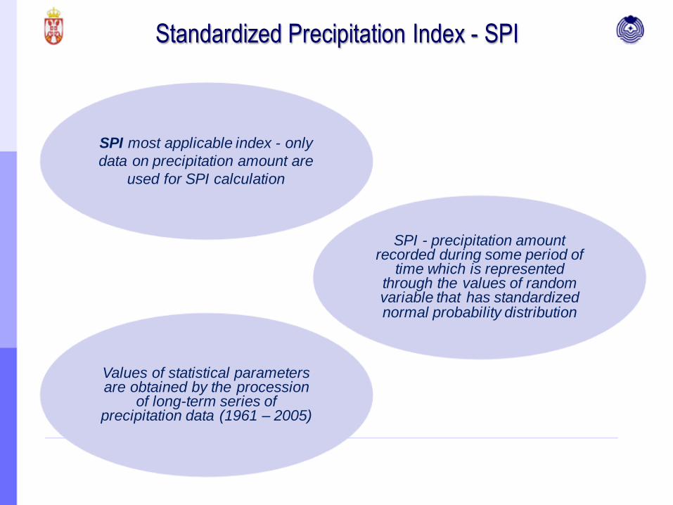
Standardized Precipitation Index - SPI
SPI most applicable index - only
data on precipitation amount are
used for SPI calculation
SPI - precipitation amount recorded during some period of
time which is represented through the values of random variable that has standardized normal probability distribution
Values of statistical parameters are obtained by the procession
of long-term series of precipitation data (1961 – 2005)

Standardized Precipitation Index - SPI
Quality assessment of the moisture conditions as
per criteria defined for operative use
Criteria are defined only on the basis of SPI
probability distribution
Not defined by cause/effect analysis
Value Moisture conditions Symbol
SPI ≤ -2.326 Exceptional drought IS
-2.326 SPI ≤ -1.645 Extreme drought ES
-1.645 SPI ≤ -1.282 Severe drought JS
-1.282 SPI ≤ -0.935 Moderate drought US
-0.935 SPI ≤ -0.524 Minor drought S
-0.524 SPI +0.524 Near normal N
+0.524 ≤ SPI +0.935 Slightly increased moisture MV
+0.935 ≤ SPI +1.282 Moderately increased moisture UV
+1.282 ≤ SPI +1.645 Considerably increased moisture JV
+1.645 ≤ SPI +2.326 Extremely wet EV
SPI ≥ +2.326 Exceptionally wet IV
Quite a frequent there is a
significant correlation between the
magnitude and duration of
precipitation regime anomaly and
consequences in agriculture, water
management

Standardized Precipitation Index - SPI
SPI values defined for the periods of one to three months - relatively well correlated
with storage of productive moisture in surface soil layers (assessment of moisture
conditions for the growth and development of agricultural crops)
SPI values defined for longer time periods indicate to prevailing characteristics of
moisture conditions during vegetation period, calendar year…
Example: good correlation
between SPI1,2,3 and
measurements of soil
moisture up to 1 m depth
R

SPI Operative Use
Calculation of SPI values
one-day time step
period of 30 days – SPI1
period of 60 days – SPI2
period of 90 days – SPI3
at the end of the month
period of 1 - 12 months

SPI Operative Use
Obtained SPI analysis - accessible and regularly
updated on the web page of RHMSS presentation
”Moisture conditions” and in various bulletins

Standardized Precipitation Evapotranspiration
Index - SPEI
SPEI - the difference between rainfall and potential evapotranspiration
(PET) represented by the corresponding statistical distributions that takes
into account both negative values
• PET - calculated according to the Hargreaves's equation
SPEI - easily identifies the role of evapotranspiration and temperature
variability in drought analysis
Operatively SPEI is calculated for the periods of 30, 60 and 90 days for 18
selected main meteorological stations on the territory of Serbia
Same categorization as for values of SPI

Standardized Precipitation Evapotranspiration Index -
SPEI
-4
-2
0
2
4
-4
-3
-2
-1
0
1
2
3
4
03-0
4
10-0
4
17-0
4
24-0
4
01-0
5
08-0
5
15-0
5
22-0
5
29-0
5
05-0
6
12-0
6
19-0
6
26-0
6
03-0
7
10-0
7
17-0
7
24-0
7
31-0
7
07-0
8
14-0
8
21-0
8
28-0
8
04-0
9
11-0
9
18-0
9
25-0
9
Сомбор
Нови Сад
Кикинда
Вршац
Зрењанин
Ср. Митровица
-4
-2
0
2
4
-4
-3
-2
-1
0
1
2
3
4
03-0
4
10-0
4
17-0
4
24-0
4
01-0
5
08-0
5
15-0
5
22-0
5
29-0
5
05-0
6
12-0
6
19-0
6
26-0
6
03-0
7
10-0
7
17-0
7
24-0
7
31-0
7
07-0
8
14-0
8
21-0
8
28-0
8
04-0
9
11-0
9
18-0
9
25-0
9
Београд
Крагујевац
Лозница
В. Градиште
См. Паланка
Неготин
-4
-2
0
2
4
-4
-3
-2
-1
0
1
2
3
4
03-0
4
10-0
4
17-0
4
24-0
4
01-0
5
08-0
5
15-0
5
22-0
5
29-0
5
05-0
6
12-0
6
19-0
6
26-0
6
03-0
7
10-0
7
17-0
7
24-0
7
31-0
7
07-0
8
14-0
8
21-0
8
28-0
8
04-0
9
11-0
9
18-0
9
25-0
9
Ћуприја
Краљево
Пожега
Ниш
Димитровград
Врање

CROPSYST – Cropping Systems Simulation Model Mr. Stockle, Mr. Nelson, Biological Systems Engineering Dept. Washington State University
Data Input Output
Climatic Daily maximum and minimum air temperature, rainfall, air relative humidity (%), solar radiation and mean wind speed
Products of statistical analysis of climatic parameters: mean validity, standard deviation, maximum and minimum value
Crop Planting date, thermal crop requests for specific growth level progress, morphological attributes crops (maximum index leaf area, depth root)
Date of growing stage, length of growing season, estimation yield depending on variability of climatic components, depth root
Soil Hidropedological parameters of soil, soil texture
Potential and actual evapotranspiration, soil moisture deficit
Irrigation Irrigation scheduling criteria Estimated yield depending on the application of agrotechnical practice
CROPSYST - crop growth model; simulate biomass and crops yield, water and nitrogen
reserves in the soil and crop phenology.

Operative use of CropSyst model
Model has been applied on 15 selected
locations on the territory of Serbia for maize
crop since 2007
The agrometeorological conditions analyzed
and monitored during the period April-
October
Ten-day Bulletin with selected products
obtained by using CROPSYST model

Ten-day CropSyst Bulletin
The values of actual and potential evapotranspiration, daily precipitation
sum and water content in soil up to 1 m depth, as well as cumulative
values of actual and potential evapotranspiration and daily precipitation
sum since the date of planting until date of simulation presented in the
bulletin in a graphic form
Prognostic part of simulation presented in tabular form: cumulative
values of potential and actual evapotranspiration and precipitation since
the beginning of the vegetative period till the forecasted end of the
growing season, the dates of corn phenophases, forecasted yield for the
three weather scenarios

Example of CropSyst Bulletin

Analysis of soil moisture
(CropSyst and measurements)
Station Banatski Karlovac
Year 2012 and 2013

Drought Frequency “Climate characteristics and analysis of meteorological hazards
for the Republic of Serbia”
The role of the RHMSS in the field of risk assessment and risk map
production for hail, windstorms, drought, snow drifts, blizzards and
icing – is defined within the framework of the Serbian legislation, the
Law on Meteorological and Hydrological Activity (“Official Gazette of
RS” No. 88/2010), and the Guidelines on the methodology for the
production of vulnerability assessments and plans for protection and
rescue in emergency situations (“Official Gazette of RS” No. 096/2012)
In addition to the above hazards, RHMSS is authorised for assessing
the risk of large precipitation amounts, heat and cold waves (based on
the new methodology, adopted in March 2017)

Drought Frequency “Climate characteristics and analysis of meteorological hazards
for the Republic of Serbia”
“Climatic characteristics and analysis of meteorological hazards for the
Republic of Serbia” was made in 2014 (applying "Methodology for the
Development of Risk Assessment and Plans for Protection and Rescue in
Emergency Situations“)
Analysis of risk assessment for four hazards (drought, wind storm, snowstorm
and hale) and maps of their frequencies was made - for the territory of the
Republic of Serbia and for districts and municipalities individually
Estimation of drought frequency and intensity influence on agriculture:
• three-month SPI index for May and August (critical months in the
development of agricultural crops)
• six-month SPI index for September (moisture conditions during growing
season)

Drought Frequency “Climate characteristics and analysis of meteorological hazards
for the Republic of Serbia”

Remote Sensing Products – LSA SAF
Satellite data provides data for larger areas and measurements are taken once or several
times a day - daily monitoring of soil, better insight into the state of vegetation
SAF (Satellite Application Facilities) – a service for the processing of satellite data, created
by experts from the National Services of the EUMETSAT Member States.
LSA (Land Surface Analysis) SAF - products related to the analysis of the soil surface
Daily in RHMSS arriving satellite data, LSA SAF among others, which are sent by
EUMETSAT and DWDSAT-a (2009 Serbia signed an agreement on cooperation with
EUMETSAT)
LSA SAF archived data available on web page http://landsaf.ipma.pt
Experts from RHMSS attended:
• Training course “Application of remote sensing data for drought monitoring;
introduction to EUMETSAT LANDSAF products”, 2013, Slovenia
• Secondment of experts to the Drought Management Center for Southeastern Europe,
2014, Slovenia

Application of Remote Sensing Products in Agricultural
Meteorology
(Fractional Vegetation Cover - FVC)
On secondment of experts a remote-sensing index is calibrated with
drought indicator
• analyzed four areas planted with grapevines, three areas with maize in Serbia
• chosen representative meteorological station for each area
• Daily precipitation data collected from 6 meteorological stations is used for calculation of SPI1
(30 days accumulated precipitation), SPI2 (60 days accumulated precipitation) and SPI3 (90
days accumulated precipitation).
• Values of FVC index for same areas was calibrated with calculated SPI1, SPI2, SPI3
Two locations in Serbia with dominant grapevine production (Veliko
Srediste in vineyards Vrsac and Malo Orasje in vineyards Smederevo)
were chosen for Drought Monitoring Bulleting of Drought Management
Center for Southeasttern Europe - DMCSEE

Correlation coefficient (R) between FVC and SPI 1, 2 and 3
Grapevine
Location SPI1 SPI2 SPI3
Sremski
Karlovci 0.7956 0.8192 0.8405
Alibunar 0.7382 0.8249 0.8776
Veliko Srediste 0.7906 0.9109 0.9604
Malo Orasje 0.8887 0.9502 0.9114
Maize
Rimski Sancevi 0.7858 0.7707 0.8926
Stara Pazova 0.7129 0.5485 0.5731
Kanjiza 0.6823 0.8217 0.5515
Application of Remote Sensing Products in Agricultural
Meteorology
(Fractional Vegetation Cover - FVC)

Within the RHMSS drought monitoring:
• downloaded available historical LSA SAF products (FVC) for the period 2007 - 2016
in .hdf5 format from: http://landsaf.ipma.pt/
• performed selection of location with homogeneous agricultural crops (areas covered
with vineyards)
• files from original .hdf5 format were converted to .txt format and numerical values of
FVC index for selected locations on the territory of Serbia and time period were
extracted, using programming language for the statistical analysis of data R
Currently only FVC index is in operational use
Application of Remote Sensing Products in Agricultural
Meteorology
(Fractional Vegetation Cover - FVC)

FV
C
measure of which part of the total satellite image pixel area is covered with green vegetation
depending on condition of vegetation and damages caused by natural disasters (droughts, floods, frost etc.)
values of FVC are smallest at the beginning of the growing season, the biggest in full vegetative development followed by slowly decline
Application of Remote Sensing Products in Agricultural
Meteorology
(Fractional Vegetation Cover - FVC)

FVC index during the growing season 6 locations in Serbia mostly covered with vineyards

THANK YOU FOR
YOUR ATTENTION
Ana Šovljanski
Slavica Radovanović
www.hidmet.gov.rs
www.seevccc.rs