detailed project report dpr_draft_30dec2013.pdf · pollution control board, assam conservation of...
TRANSCRIPT

Pollution Control Board, Assam
Conservation of River Bharalu, Guwahati
Detailed Project Report
December 2013
Draft
Joint Venture of THE Louis Berger Group, INC and DHI (India) Water & Environment Pvt. Ltd.

DPR - Bharalu

DPR - Bharalu page i
CONTENTS
contents i
FIGURES vi
LIST OF ABBREVIATIONS ........................................................................................................... ix
EXECUTIVE SUMMARY ................................................................................................................. 1
1 About the Project Area .............................................................................................1-1
1.1 Authority for preparation of project .............................................................................1-1
1.2 Description of Project Area .........................................................................................1-1
1.2.1 Brief History of the town .............................................................................................1-1
1.2.2 Geographical Location ...............................................................................................1-1
1.3 Population in the Project Area ....................................................................................1-1
1.4 Status of water supply ................................................................................................1-1
1.5 Status of existing waste water disposal system ..........................................................1-1
1.6 Status of drains ..........................................................................................................1-1
1.7 River Water quality .....................................................................................................1-1
1.8 Justification of the project for pollution abatement of the river ....................................1-1
2 Collection of Data .....................................................................................................2-1
2.1 Introduction ................................................................................................................2-1
2.2 Data Required at Different Levels ...............................................................................2-1
2.2.1 Drainage Basin Map ...................................................................................................2-1
2.2.2 Raster Layers .............................................................................................................2-3
2.2.3 Shape Layers .............................................................................................................2-3
2.3 Town Related Data .....................................................................................................2-5
2.3.1 Maps Related to Town ...............................................................................................2-5
2.3.2 Land Use, Contour, Drainage and Other Thematic Maps: ..........................................2-6
2.3.3 Use of State of Art Tools like Remote Sensing and GIS .............................................2-6
2.3.4 Population of the Town ...............................................................................................2-6
3 Conservation Measures ...........................................................................................3-1
3.1 General Conservation Framework ..............................................................................3-1
3.2 Road Map for the Conservation of Bharalu River .......................................................3-1

page ii DPR - Bharalu
3.3 Root Cause Analysis & Measures Solution Options ................................................... 3-4
4 Sewerage Schemes ................................................................................................. 4-1
4.1 Status of Existing Waste Water Disposal Works ........................................................ 4-1
4.1.1 Existing Works ........................................................................................................... 4-1
4.1.2 Project under process ................................................................................................ 4-2
4.2 Population Projections of Each District in Design Years ............................................ 4-3
4.3 Projected Waste Water Flows in each District in Design years .................................. 4-5
4.4 Sewage Collection and Treatment Options ................................................................ 4-7
4.4.1 Availability of Land for various Components in each District ...................................... 4-9
4.5 Decentralized Option ............................................................................................... 4-10
4.6 Operation and Maintenance ..................................................................................... 4-14
5 Solid Waste Management ........................................................................................ 5-1
5.1 Introduction ................................................................................................................ 5-1
5.2 Existing Situation ....................................................................................................... 5-2
5.2.1 Quantity of solid waste generation, its composition, and characteristics .................... 5-3
5.2.2 Industrial waste .......................................................................................................... 5-7
5.2.3 Biomedical waste ....................................................................................................... 5-7
5.2.4 Solid waste segregation, collection and storage ........................................................ 5-8
5.2.4.1 Segregation ............................................................................................................... 5-8
5.2.4.2 Collection ................................................................................................................... 5-9
5.2.4.3 Transfer and Transportation of Solid Waste ............................................................... 5-9
5.2.5 Solid waste processing and disposal ....................................................................... 5-10
5.2.6 Organization and Staffing of GMC ........................................................................... 5-11
5.2.7 Major Gaps in the SWM System .............................................................................. 5-12
5.2.8 Identified Key Issues ................................................................................................ 5-14
5.3 Proposed Schemes ................................................................................................. 5-14
5.4 Cost Estimate .......................................................................................................... 5-18
5.5 Implementation Plan ................................................................................................ 5-18
6 River Environment Improvement ............................................................................ 6-1
6.1 Need of an improved river environment ..................................................................... 6-1
6.1.1 Maintaining biodiversity ............................................................................................. 6-1
6.1.2 For the people ........................................................................................................... 6-1
6.1.3 Bridge to Beauty: ....................................................................................................... 6-1
6.2 River Front Development along Bharalu River ........................................................... 6-2
6.3 Borosola Beel Development ...................................................................................... 6-6

DPR - Bharalu page iii
6.4 Cost Estimate .............................................................................................................6-1
7 Other Non-Sewerage Schemes ...............................................................................7-1
7.1 Community toilets .......................................................................................................7-1
7.2 Community Kiosks ......................................................................................................7-2
7.3 Cost Estimate .............................................................................................................7-3
8 Water Augmentation and Channel Improvement Schemes...................................8-1
8.1 River Network .............................................................................................................8-1
8.2 Modelling ....................................................................................................................8-3
8.2.1 Rainfall-Runoff modelling ...........................................................................................8-3
8.2.2 Hydrodynamic Modelling ............................................................................................8-4
8.3 Water Augmentation Scheme .....................................................................................8-6
8.3.1 Re-connecting Bahini River near Nutan Bazar area ...................................................8-6
8.3.2 The Scheme ...............................................................................................................8-8
8.3.3 The New Sluice Gate .................................................................................................8-9
8.3.4 The New Channel..................................................................................................... 8-10
8.4 Desiltation ................................................................................................................ 8-11
8.4.1 Desiltation of Bahinin, Bharalu and Dead Bharalu rivers........................................... 8-11
8.4.2 Pre-construction Activities ........................................................................................ 8-15
8.4.3 Temporary River Diversions ..................................................................................... 8-15
8.4.4 Sediment Excavation ................................................................................................ 8-15
8.4.5 Removal of Solid Waste ........................................................................................... 8-16
8.4.6 Sediment Processing and Disposal .......................................................................... 8-16
8.5 Cost Estimate ........................................................................................................... 8-17
8.5.1 Cost Estimate of Water Augmentation ...................................................................... 8-17
8.5.2 Cost Estimate of Desiltation ..................................................................................... 8-17
9 River Monitoring Schemes ......................................................................................9-1
9.1 General Technical Concept ........................................................................................9-1
9.2 Design Principles........................................................................................................9-1
9.3 Functional Requirements ............................................................................................9-1
9.4 Technical Specifications .............................................................................................9-2
9.5 Telemetry (GSM/GPRS Communication) ...................................................................9-4
9.5.1 GSM/GPRS Data Collection Station ...........................................................................9-5
9.6 Data Centre ................................................................................................................9-5
9.7 Equipment Specifications ...........................................................................................9-6
9.7.1 Data Collection Platform .............................................................................................9-6

page iv DPR - Bharalu
9.7.2 GSM/GPRS Radio and Antenna ................................................................................ 9-6
9.7.3 Water Level Sensors ................................................................................................. 9-6
9.7.4 Rainfall Sensors ........................................................................................................ 9-7
9.7.5 Solar Power and Battery ............................................................................................ 9-8
9.7.6 Current Meters ........................................................................................................... 9-8
9.7.7 Water Quality Sensors ............................................................................................... 9-9
9.7.7.1 Specification for pH.................................................................................................... 9-9
9.7.7.2 Specification for Turbidity........................................................................................... 9-9
9.7.7.3 Specification for Conductivity ..................................................................................... 9-9
9.7.7.4 Specification for Water Temperature ....................................................................... 9-10
9.7.7.5 Specification for Dissolved Oxygen .......................................................................... 9-10
9.7.7.6 Specification for Dissolved Ammonia ....................................................................... 9-10
9.7.7.7 Specification for COD .............................................................................................. 9-11
9.7.7.8 Specification for Nitrates .......................................................................................... 9-11
9.7.7.9 Specification for Chlorides ....................................................................................... 9-11
9.8 River Monitoring Network......................................................................................... 9-12
9.9 Cost Estimate .......................................................................................................... 9-13
10 Environment Impact Assessment ........................................................................ 10-1
10.1 Present Environmental Conditions ........................................................................... 10-1
10.1.1.1 Water Quality of the River ........................................................................................ 10-1
10.1.2 Fishes in the River ................................................................................................... 10-1
10.1.2.1 Industries around the River ...................................................................................... 10-3
10.1.2.2 Water supply in Guwahati City ................................................................................. 10-3
10.1.2.3 Forest and Biodiversity ............................................................................................ 10-4
10.1.2.4 Health and Sanitation in the City and around the River ............................................ 10-5
10.1.2.5 Socioeconomic and Livelihood ................................................................................ 10-7
10.2 Proposed Actions to restore Bharalu River and its Environmental Impacts .............. 10-8
10.2.1 Sewer network and STPs, ....................................................................................... 10-9
10.2.1.1 New Sewage Treatment Plants (STPS) ................................................................... 10-9
10.2.2 River Front Development Activities ........................................................................ 10-10
10.2.3 Water Augmentation schemes and Desilting operations in Bharalu River .............. 10-12
10.2.4 Community toilets/ sanitation ................................................................................. 10-13
10.2.5 Solid waste management (collection, transport and disposal). ............................... 10-14
10.3 Concluding Remarks ............................................................................................. 10-15

DPR - Bharalu page v
11 Stakeholder Involvement ....................................................................................... 11-1
11.1 Initial fact finding meetings ....................................................................................... 11-1
11.2 Community consultations ......................................................................................... 11-2
11.3 Inception Workshop .................................................................................................. 11-4
11.4 Stakeholder Consultation Workshop......................................................................... 11-5
11.5 Public Consultation Workshop .................................................................................. 11-9
11.6 Consultation with other officials and individuals ........................................................ 11-9
12 Education and Public Awareness Schemes ......................................................... 12-1
12.1 Introduction .............................................................................................................. 12-1
12.2 Enhancement of public awareness & public participation ......................................... 12-1
12.3 Education and awareness based on issues .............................................................. 12-2
12.4 Specific awareness campaign against for solid waste dumping ................................ 12-2
12.5 Partnership for education and awareness programmes ............................................ 12-6
12.6 Monitoring ................................................................................................................ 12-6
12.7 Cost Estimate ........................................................................................................... 12-6
13 Capacity Building and Training ............................................................................. 13-1
13.1 Introduction .............................................................................................................. 13-1
13.2 Institutional Arrangement .......................................................................................... 13-2
13.2.1 Project management Unit ......................................................................................... 13-3
13.3 Capacity Building Framework ................................................................................... 13-3
13.4 Training needs Assessment ..................................................................................... 13-4
13.5 Training Programmes ............................................................................................... 13-6
13.6 Cost Estimate ........................................................................................................... 13-7
14 Project Implementation Plan ................................................................................. 14-1
14.1 Project Management Unit ......................................................................................... 14-1
14.2 Project Management Consultancy ............................................................................ 14-1
14.3 Review and approvals .............................................................................................. 14-2
14.4 Monitoring and Evaluation ........................................................................................ 14-2
14.5 Completion Reports .................................................................................................. 14-2
14.6 Schemes Implementation Plan ................................................................................. 14-2

page vi DPR - Bharalu
15 Cost Estimate ......................................................................................................... 15-1
16 Financial and Economic Analysis ........................................................................ 16-1
17 References ............................................................................................................. 17-1
Annex -1: Water Quality Test Reports ......................................................................................... 3
Annex- 2: Maps ............................................................................................................................. 4
Annex- 3: Drawings ...................................................................................................................... 5
Annex- 4: Detailed Calculation of Dredging ................................................................................ 6
Annex- 5: International and National Best Practices .................................................................. 7
FIGURES
Figure 3-1 Framework of River Conservation ............................................................................... 3-1
Figure 4-1 Proposed sewerage Zones of Guwahati ..................................................................... 4-3
Figure 4-2 Decentralized sewerage treatment option for Bharalu ................................................. 4-8
Figure 4-3 Interceptor and overflow arrangements ..................................................................... 4-11
Figure 4-4 Outfall Locations along Bharalu ................................................................................ 4-12
Figure 4-5 Typical Modular structure of a decentralized STP (bio-reactor type) ......................... 4-12
Figure 5-1 Effect of Municipal Solid Waste on Environment and Health ....................................... 5-2
Figure 5-2 Indiscriminate dumping of solid waste along Bharalu (photo: LBG-DHI Nov 2013) ..... 5-5
Figure 5-3 Wards linked to solid waste dumping into Bahini-Bharalu rivers .................................. 5-5
Figure 5-4 Rag Pickers segregating the solid waste .................................................................... 5-8
Figure 5-5 Containerized Tricycle used for primary waste collection ............................................ 5-9
Figure 5-6 A typical dumper placer container proposed to be placed along the banks of Bharalu .................................................................................................................... 5-16
Figure 5-7 Proposed Dumpers for transporting solid waste ........................................................ 5-16
Figure 6-1 Existing sidewalk on Narayan Nagar Road along Bharalu River ................................. 6-2
Figure 6-2 Bharalu river front development works ........................................................................ 6-3
Figure 6-3 Cross Section of rive walkway .................................................................................... 6-4
Figure 6-4 Park and jogging track ................................................................................................ 6-5
Figure 6-5 Borosola Beel Full of Water Hyacinth .......................................................................... 6-6
Figure 6-6 Barsola Beel Mechanical Aeration .............................................................................. 6-7
Figure 6-7 Plan section of Borosola beel development ................................................................ 6-8
DPR - Bharalu page vii
Figure 6-8 Section of the proposed foot bridge across Borosola Bridge .......................................6-9
Figure 6-9 Outlet structure of Borosola beel development scheme ............................................. 6-10
Figure 7-1 Community Toilet ........................................................................................................7-1
Figure 7-2 community toilets with hygiene messages ...................................................................7-2
Figure 7-3 A tea & snacks vendor over Bharalu under unhygienic conditions ...............................7-3
Figure 8-1 Bharalu River system network .....................................................................................8-2
Figure 8-2 Catchment delineation for rainfall-runoff modelling ......................................................8-3
Figure 8-3 Simulated discharge of Basistha River at Nutan Bazaar ..............................................8-4
Figure 8-4 Bharalu River Model network .......................................................................................8-5
Figure 8-5 L-profile of Basistha .....................................................................................................8-5
Figure 8-6 Discharge hydrograph of Basistha river at Nutan Bazaar ............................................8-6
Figure 8-7 Location of Bahini-Basista connection .........................................................................8-7
Figure 8-8 Survey of India Map showing the Basishta-Bahini connection .....................................8-7
Figure 8-9 The closed sluice gate of Bahini at Nutan Bazaar ........................................................8-8
Figure 8-10 The new Channel connection arrangement ...............................................................8-9
Figure 8-11 Design of the new sluice gate .................................................................................. 8-10
Figure 8-12 Longitudinal profile and Cross sections of Bahini (for dredging) .............................. 8-11
Figure 8-13 Longitudinal profile and Cross sections of Bharalu (for dredging) ............................ 8-12
Figure 8-14 Longitudinal profile of Bahini- Bharalu River (Before dredging allowing 0.5cumecs through the new sluice) ............................................................................................ 8-12
Figure 8-15 : Longitudinal profile of Bahini- Bharalu River (After dredging allowing 0.5cumecs through the new sluice) ............................................................................................ 8-13
Figure 8-16 Longitudinal profile of Bahini- Bharalu River (Before Dredging- after connecting with the upstream Bahini through the new sluice) ..................................................... 8-13
Figure 8-17 Longitudinal profile of Bahini- Bharalu River (After Dredging- after connection with the upstream Bahini through new sluice) ........................................................... 8-14
Figure 8-18 Longitudinal profile of Dead Bharalu River (Before Dredging) .................................. 8-14
Figure 8-19 : Longitudinal profile of Dead Bharalu River (After Dredging) ................................... 8-14
Figure 8-20 Typical desiltation arrangement .............................................................................. 8-16
Figure 9-1: Automatic Rainfall Station...........................................................................................9-2
Figure 9-2: Typical arrangement of radar sensor for bridge sites ..................................................9-3
Figure 9-3: Typical arrangement of Stilling Well/Shaft Encoder ....................................................9-3
Figure 9-4: Typical Current meter .................................................................................................9-4
Figure 9-5: Monitoring System Overview . ...................................................................................9-5
Figure 9-6: Typical data collection platform and online battery charger........................................9-6
Figure 9-7: Map showing Monitoring Stations for Bharalu river Basin ....................................... 9-12
Figure 10-1 Bharalu River present environmental condition ........................................................ 10-1
Figure 10-2 Fishes recorded in Bhasista River ........................................................................... 10-2

page viii DPR - Bharalu
Figure 10-3 Indigenous iron filter system ................................................................................... 10-3
Figure 10-4 Bharalu biodiversity ................................................................................................ 10-4
Figure 10-5 Fauna found in Bharalu ........................................................................................... 10-5
Figure 11-1 Common Interest sectors for river restoration ......................................................... 11-1
Figure 11-2: Interactions with local people during field trips in Guwahati-I. ................................ 11-3
Figure 11-3 Interaction with public along Bharalu river ............................................................... 11-3
Figure 11-4 Stakeholders Meeting at Guwahati ......................................................................... 11-8
Figure 11-5 Public notie by PCBA ............................................................................................ 11-10
Figure 12-1 Strategy for Public Awareness Program against solid waste dumping .................... 12-4
Figure 12-2 GMC’s Newspaper campaign on Solid Waste (Source: Assam Tribune, 22 Dec 2013) ....................................................................................................................... 12-5
Figure 13-1 Levels of Capacity Building ..................................................................................... 13-1
Figure 13-2 Capacity building framework ................................................................................... 13-4
Figure 14-1 Project Implementation Plan ................................................................................... 14-1

DPR - Bharalu page ix
LIST OF ABBREVIATIONS
AUWSSB : Assam Urban Water Supply and Sewerage Board
BOD : Biological Oxygen Demand
CDM : Clean Development Mechanism
COD : Chemical Oxygen Demand
CPCB : Central Pollution Control Board
CPHEEO : Central Public Health Environmental Engineering Organisation
CSP : City Sanitation Plan
CWC : Central Water Commission
DA : Drainage Area
DBO : Design, Build & Operate
DO : Dissolved Oxygen
DPR : Detailed Project Report
GIS : Geographical Information System
GJB : Guwahati Jal Board
GL : Ground Level
GMA : Guwahati Metropolitan Area
GMC : Guwahati Municipal Corporation
GMDA : Guwahati Metropolitan Development Authority
GoI : Government of India
ICT : Information and communications technology
IEC : Information, Education & Communication
JNNURM : Jawahar Lal Nehru National Urban Renewable Mission
LPD : Litres Per Day
MLD : Million Litres per Day
MoEF : Ministry of Environment and Forests, Govt. of India
MSW : Municipal Solid Waste
NGRBA : National Ganga River Basin Authority
NRCD : National River Conservation Directorate
NRCP : National River Conservation Plan
O&M : Operation and Maintenance
PCBA : Pollution Control Board, Assam
PFR : Project Feasibility Report

page x DPR - Bharalu
PHE : Public Health Engineering
PMU : Project Management Unit
PS : Pumping Station
RFD : River Front Development
SPS : Sewage Pumping Station
SS : Suspended Solids
STP : Sewerage Treatment Plant
SWM : Solid Waste Management
TSS : Total Suspended Solids
ULB : Urban Local Bodies

EXECUTIVE SUMMARY
DPR - Bharalu page S-1
EXECUTIVE SUMMARY
The Bharalu River which runs through the city of Guwahati is heavily polluted resulting into serious environmental degradation of the area and has caused serious concerns on the health of inhabitants. The sources of pollution that have been identified are discharge of untreated waste water to the river at various places, flow of street pollution, solid waste dumped into the river and its banks. Key water quality parameters measured during the preparation of the DPR (December 2013) also show that the river water is not suitable for human use. For example, the average BOD5 ranged from 56 mg/l to 85 mg/l measured at eight key locations of the river. These values are much higher than NRCD’s prescribed standards of 3 mg/l for bathing water quality in a river. Similarly Dissolve Oxygen levels were found to be from 2.2 mg/l to 3.7 mg/l below the NRCD standard of 5 mg/l. Lack of civil amenities along the river is also a reason for the river being abandoned by the public. Due to heavy siltation, the carrying capacities of the Bharalu and Bahini channels are drastically reduced.
Therefore, the Pollution Control Board. Assam has given a high priority in restoring the river by adopting a series of conservation measures. The conservation measures being studied include wastewater management, solid waste management, water augmentation, improvement of channel conveyance, development of water fronts, provision of civil amenities along the river. and creation of awareness among communities and stakeholders not to abuse the river. The conservation measures are analysed and documented in a Detailed Project Report (DPR) following the Guidelines of National River Conservation directorate (NRCD), Ministry of Environment and Forest (MOEF), New Delhi. The DPR will serve the main purpose for funding of conservation measures by NRCD. NRCD may consider funding of conservation schemes which are related to treatment of waste water, removal and management of solid waste directly dumped in the river and banks, desilting of river channel, river front development, community sanitation, capacity building and public education and awareness programmes. NRCD does not provide funds for overall municipal solid waste management because this may be funded by the Ministry of Urban Development. NRCD does not provide fund industrial pollution control schemes, hospital waste management etc, because they are required to comply with effluent regulation set by the Government.
The overall aim of the project is to restore and develop the Bharalu River that will enable and promote social and cultural activities along the river to the delight of the habitants living in Guwahati and of the tourists that visit Assam in addition to the full lives of flora and fauna in the river. The present project is one component of the overall road map and one of the several initiatives being taken by the Government of Assam to improve the living conditions of the habitants in Guwahati.
The DPR also addresses diverse yet related issues like environmental sustainability and dependency of local communities, including capacity building of institutions and related individuals of related stakeholders to sustain the development. The DPR is prepared following an extensive consultation with stakeholders which include Government agencies, local municipal bodies, NGOs and civil societies, academic

page S-2 DPR- Bharalu
institutions and individuals, communities affected and to be benefitted, and the public at large. The Draft DPR is made available at the PCBA Website (www.pcbassam.org) for public study and comments. Comments and suggestions received before 6th January 2014 will be considered in finalizing the DPR. However, PCBA will welcome suggestions from stakeholders any time before and during implementation so that the conservation measures being adopted serve the greater interest of the stakeholders.
Prior to the preparation of the DPR a City Sanitation Plan (CSP) has been prepared for the City of Nagaon followed by a project Feasibility Report (PFR) for sewerage schemes.
Conservation Schemes and Summary of Costs
Package No.
Scheme Name Scheme Description Approx. cost
(Rs. Crore)
P-1 Water Augmentation Opening of sluice of Bahini river to divert regulated flow form Basistha
7.868
P-2 Desilting of Rivers for improvement of conveyance
Desilting of Bahini, Bharalu and dead Bharalu rivers.
23.651
P-3 Interception of Waste Water Intercepting structures for waste water along the Bharalu River
11.580
P-4 Sewage Treatment Decentralized Sewage treatment plants along Bharalu River
179.661
P-5 Solid Waste Management Management of solid waste directly dumped to the river and its banks
6.978
P-6 River Environmental Improvement
Development of walk, and Parks, community toilets & amenities
19.920
P-7 Development of Borosola beel
Development of the Borosola beel
16.194
P-8 Education, public awareness, capacity building
Capacity building of institutions, staff development, education and public awareness campaigns
4.043
P-9 River monitoring & warning system
Establishment & operation of river monitoring (flood and water quality), and
3.908
EXECUTIVE SUMMARY
DPR - Bharalu page S-3
warning system
P-10 Project Management Establishment of Project Management Unit and operation, support of Project Management Consultancy to implement the project
24.623
TOTAL Project Cost 298.424


About the Project Area
DPR - Bharalu page 1-1
1 About the Project Area
Details of this chapter are presented in the City Sanitation plan as well as in the Project Feasibility Report.
1.1 Authority for preparation of project
The authority for preparation of the project is:
Pollution Control Board:: Assam
Bamunimaidam; Guwahati-21
Ph.No.: 2652774 & (M) 9435343530
Fax: 0361-2550259
Website: www.pcbassam.org
1.2 Description of Project Area
1.2.1 Brief History of the town
1.2.2 Geographical Location
1.3 Population in the Project Area
1.4 Status of water supply
1.5 Status of existing waste water disposal system
1.6 Status of drains
1.7 River Water quality
1.8 Justification of the project for pollution abatement of the river

Collection of Data
DPR - Bharalu page 2-1
2 Collection of Data
2.1 Introduction
As per the NRCD guidelines data requirement of stated Project has been captured at different levels with the required levels of information. The collected data has been used for preparation of Detailed Project Report for pollution abatement is a three step process namely: City Sanitation Plan (CSP), Project Feasibility Report (PFR) for Sewerage works, followed by the Detailed Project Report (DPR). The Gaps of the Data at the required stretches of the polluted river has been filled by field surveys. The CSP, PFR & DPR have been prepared on the basis of available / surveyed data (Primary / Secondary Data) that have been generated by the concerned agencies.
Detailed data and maps collected and prepared during the course of this study are presented in Annex 1.
2.2 Data Required at Different Levels
i. Required data Drainage basin of the Bharaloo River has been prepared. In the basin map the polluted stretches have been identified and in respect of which the pollution abatement project has been prepared. This will help in identifying at priority basis for taking up pollution abatement works to improve the river water quality.
ii. The town which is causing pollution of the river and for which an integrated project has been prepared for the abatement of pollution from waste water and solid waste.
iii. Data of the rivers are required for detailed analysis, planning and design of the conservation measures.
2.2.1 Drainage Basin Map
A map of the basin on 1:50,000 scale SOI topographical sheet showing the following features has been prepared.

page 2-2 DPR - Bharalu
Drainage map
S. No Item Complied (Y/N)
i. Tributaries, Y
ii. Main stem and Y
iii. Existing water bodies Y
Cities / Town in the basin with
S. No Item Complied (Y/N)
i. River water quality being below the desired level
Y
ii. Cities with cultural, social and tourism importance
Y
Recent Land Use, if available, from State Remote Sensing Centre
S. No Item Complied (Y/N)
i. Agriculture Y
ii. Forests Y
iii. Mining.
iv. Industrial Areas
Sites from where samples for testing water quality were drawn by the CPCB/SPCB/ by the project team.

Collection of Data
DPR - Bharalu page 2-3
Site Locations of Bharalu from where the Samples were taken are as under.
S.No Location Lat Long Station Name
1. Near Bharalu Bridge-Rupnagar Main Road 91.76 26.17 S1
2. Borshala beel outlet near Bharalu 91.74 26.17 S2
3. Bhralu river point near Aryanagar Bishnupur 91.74 26.17 S3
4. Bharalumukh near Brahmaputra 91.73 26.17 S4
5. Refinary drain mouth at Bharalu near RGB road Jonali point
91.78 26.17 S5
6. Bharalu upstream at Refinary drain mouth near RGB road Jonali point
91.78 26.17 S6
7. Bharalu downstream near RGB road Jonali point 91.78 26.17 S7
8. Bharalu NH-37 crossing point near Basistha Chariali 91.80 26.11 S8
2.2.2 Raster Layers
This report uses different sets of satellite and Elevation data to produce different sets of Maps. The satellite data has been used from ISRO, Bhuwan, DEM from CGIAR-CSI – SRTM & CartoSat.
The Satellite data used from Bhuwan is AWiFS, which is Multispectral Data with 56 m Resolution. It has a coverage size of 370 km x 370 km and gives data in 3 or 4 Bands. The data from Google has also been used to analyses different layers of the Maps. Google provides the data of high resolution of Approx 2 Meter to 5 Meter in the Project Area.
2.2.3 Shape Layers
Shape file are the base database for preparing different maps of the Region. There is a set of different Shape Layers / Shape Files used for creating different maps for the Bharaloo region having different purpose. The lists of Shape Files Created for the Report are as below:
S. No Shape File Name Type Remarks
1. Country Polygon The Indian Country.
2. Assam State Polygon The State of Assam.
3. Kamrup District Polygon The District of Kamrup.
4. Zone Map Polygon The Zones of Kamrup. Metropolitan / Guwahati Town.
5. Ward Map Polygon The Ward Map of Guwahati Town.
6. Wetland Polygon Wetland area showing the location of Dippbor Bill and other small wetland Locations
7. River Front Development Polygon The Development location along the River.
8. Water Body Polygon Water Body Location of the Guwahati Town Area.
9. Road Line Road Network of the Guwahati Town

page 2-4 DPR - Bharalu
10. River / Drainage Line Bharaloo River Network of the Town.
11. Contour Map - Zone 1 Line This Map shows the contour Maps of Guwahati Town Area.
12. Outfall Locations Point Outfall Location of the Bharaloo River Network
13. Solid Waste Point Solid Waste Dumping Location
14. Structures Point Showing location of Sluice, Bridges etc over Bharaloo River N/W
15. STP Location Point STP Location for Guwahati Town
16. Crematoria Point Cremation Location for Project Area
17. Water Sampling Location Point Location of the Places where Water samples were collected.
The coordinate system specification followed for the Shape Files are:
Property Specification
PROJCTION: WGS 1984 UTM Zone 46N.
GEOGCS: GCS WGS 1984.
DATUM: D WGS 1984.
SPHEROID: WGS 1984, 6378137.0, 298.257223563.
PRIMEM: Greenwich, 0.0.
UNIT: Degree, 0.0174532925199433.
PROJECTION: Transverse Mercator.
PARAMETER: false easting, 500000.0.
PARAMETER: false northing, 0.0.
PARAMETER: Central meridian, 93.0.
PARAMETER: Scale factor, 0.9996.
PARAMETER: Latitude of origin, 0.0.
UNIT: Meter, 1.0
Source of Different Data:
Category Data Concerned Department
Available
River and Hydrology
Related data
Cross Section Water Resource Department
Yes
Water Levels Water Resource Department
Yes
Water Quality Data PCBA, New sampling by project
Yes , EREC lab
Soil Map Land Use (If Available)
State remote sensing center
Yes
Sewerage Map of Existing Sewarge System, if any
N/A
Area Name various Yes
Drainage System and Related Data if
various Yes

Collection of Data
DPR - Bharalu page 2-5
any
Building and Temple Locations
maps yes
Road Network GMDA Yes
Location of Outfalls Field surveys Yes
Diameter of the Pipes
Form GMDA Master Plan
Yes
Manholes Form GMDA Master Plan
Yes
Structures on the River and Sewarge System
Survey & Project survey Yes
Slope Survey Yes
Spot Levels Survey yes
Water Supply Existing Water Supply
GMC / GMDA Yes
Demand and sources GMC / GMDA Yes
Demography Population of wards as per Census
Municipal Corporation Yes
Slums Detail GMC yes
Other data GMC / others NA
Crematoria Location of Crematorium
GMC yes
River front development
Location of River Front Development
Survey Yes
Low cost Sanitation
Location of Public Toilets
Municipal Corporation yes
Solid Waste Location of Waste Disposal, if any
GMC yes
2.3 Town Related Data
2.3.1 Maps Related to Town
The Town has been covered in the report as different maps in Digital Format. These digital Formats are the combination of Raster and Vector Data.
To prepare Maps different data and sources in the form of Vector and Raster Layer has been used. The maps contain the layers as listed below:
i. Important land marks of the city. ii. Rivers and their flood plains. iii. Other water bodies. iv. River banks where solid waste is dumped.
page 2-6 DPR - Bharalu
v. Drains, and their respective outfalls and catchments (drainage areas). vi. Streets. vii. Municipal wards. viii. Open spaces. ix. Residential areas. x. Industrial estates. xi. Industrial units outside industrial estates. xii. Points of discharge of industrial effluents. xiii. Slums. xiv. STPs and sewage pumping stations. xv. Crematoria. xvi. River front (ghats) developed in the past. xvii. Sites on river banks for cattle wallowing, dhobi ghats, washing of motor
vehicles and carcasses are dumped. xviii. Garbage dumping sites including landfills. xix. Pollution abatement works carried out in the past.
2.3.2 Land Use, Contour, Drainage and Other Thematic Maps:
The thematic maps related to Landuse have been created using suitable SOI Maps and Satellite data. These maps are used to categorise the Landuse patterns and find the suitable locations required for the project in creating STP and other related locations. The Data has been prepared using the latest Satellite data to the actual satiation present on the ground to have the optimized solution of the situation. The land used has been created using LISS-III and AWiFCS Data along with the usage of Google Earth Imageries. SOI Toposheet has been used as the Base Point of starting of GIS Database to the authentic source of base map data.
2.3.3 Use of State of Art Tools like Remote Sensing and GIS
For creating maps and other data Latest tools and technology has been used. Tools like MIKEbyDHI, ArcGIS & AutoCAD has been used to create, Process, edit and finalize the Maps & Database and reports. These tools have been used to generate different themes and layouts in GIS and AutoCAD Formats. The different layout depicts the water-bodies, River Network, Drainage Network, Structures and Outfall Location etc.
2.3.4 Population of the Town
The ward-wise Population load using the suitable trend analysis has been calculated to get the pollution load on different river stretch along the river. Data for Population has been referred from Census of India database. The ward wise population has been referred from Municipal Reports and their database to prepared maps and reports. The population trend analysis has been done using arithmetic, incremental increase, geometric, and exponential methods.

Conservation Measures
DPR - Bharalu page 3-1
3 Conservation Measures
3.1 General Conservation Framework
Figure 3-1 shows the general framework of conservation of the Bharalu river.
Figure 3-1 Framework of River Conservation
3.2 Road Map for the Conservation of Bharalu River
Table 3.1 presents a road map for the conservation of Bharalu River. The road map addresses the related issues such as institutional, waste water management, solid waste management and river front development distinctly and is therefore presented in four sub-tables.
The road map briefly describes the existing situation, and states the desired goal. Then a phase wise implementation plan is proposed consisting of immediate, mid- and long-term activities. The present investment project for which this DPR is prepared deals with the immediate action plan required to improve the present situation of unacceptable water quality in the river. It is expected that Government of Assam will implement other complementary projects to achieve the long term goal shown in the road map.
page 3-2 DPR - Bharalu
Table 3.1 Road Map for the conservation of Bharalu River
1. Institutional aspects
Existing Situation Immediate term
(2014-2017)
Goal
River & Lake
Conservation Cell
under Pollution
Control Board,
Assam.
Several Institutions
active, inadequate
coordination
mechanism
Mandate & functions
not clearly defined.
Funding of river
conservation
measures & related
development works
not ensured
Use the proposed
Conservation
project to
establish the
Assam River
Conservation
Authority, build
capacity
(supported by
PMU)
A fully functional
Assam River &
Lake Conservation
Authority, with
clear mandates,
ensured funding
and capacity to
restore & conserve
key water bodies to
desired level.
2. Solid Waste Management
Existing
Situation
Immediate action
(2014-2017)
Mid-term long
term (by 2020)
Goal
Bharalu river is
abused with solid
waste dumped
into the channel
and banks, also a
major source of
water pollution.
1.Remove solid waste
form the river and banks
2. Establish garbage
collection along the
banks and transport to
dumping sites.
3. Public awareness
campaign to stop
dumping waste into the
river
Solid Waste
management
system in
Guwahati city
fully functional as
in a modern city
A clean &
livable Guwahti
city (including
all water
bodies) free of
unwanted solid
wastes

Conservation Measures
DPR - Bharalu page 3-3
3. Waste Water Management
Existing
Situation
Immediate term (2014-
2017)
Mid- & Long
Term Actions
(by 2025)
Goal
River receives
untreated
sewage and
septic tank
effluent making,
one of the most
polluted rivers in
India.
Intercept waste water
coming from the
Bharalu catchment area
(wards), and discharge
treated effluent from
decentralized STPs.
(to be integrated into
the sewerage master
plan)
Guwahati city
Sewarage and
drainage project
implemented, city
fully covered with
piped water
supply.
A clean Bharalu
river sustaining
desired national
environmental
conditions.
4. River Environment Improvement
Existing Situation Immediate term
(2014-2017)
Long term (by
2025
Goal
River disconnected
from society /
public; lack of
recreation areas
River front
development along
the lower reach of
Bharalu, walkways,
greenways.
Development of
Borosola beel –
cleaning, water
retention, improved
walkways.
Further
development of the
whole reach.
Fully developed
Borosola beel as a
water recreation
facility
Encourage public,
private and cultural
groups to use river
front.
Bharalu river is
the center of
recreation &
public life in
Guwahati City

page 3-4 DPR - Bharalu
3.3 Root Cause Analysis & Measures Solution Options
The conservation measures proposed are part of the roadmap presented above and also are based on the root cause analysis of pollution and other river degradation factors. Table 3.2 Presents the details of the root cause analysis and the proposed measured.
Table 3.2 Root Cause Analysis and Proposed Solution Options
Causes / Pollution
sources
Solution Options Conservation Packages
Lack of dry season flow
from upstream
Flow augmentation
to the most polluted
section (Bahini-
Bharalu)
P-1: Water Augmentation by
reopening the sluice gate in
Bahini from Basistha, weir in
Basistha, trenchless pipe
Reduced carrying
capacity of river channel
due to siltation & solid
waste disposal
Improve
conveyance by
dredging & solid
waste removal
P-2: Solid waste removal,
Desiltation
Pollution due to solid
waste disposal into the
channel and in river
banks
Solid waste
management,
Awareness
programms
P-7: Solid waste
management plan
P-8: Public awareness &
education programs
Causes / Pollution
sources
Solution Options Conservation
Packages
Sewage and septic tank
effluent discharged
directly into the river
(including street
pollution)
1. Full separation of domestic
sewage, transported to a
centralized STP near Deepor
Beel (GMDA sewerage DPR)
2. Full separation but
decentralized STPs
3. Interceptor drains for DWF
along the river and transported
to a centralized STP
4. Interceptor drains for DWF
along the river, decentralized
STPs along the river
P-3:Interceptor
drain Parallel
to Bharalu for
DWF only,
allowing storm
water overflow
to the river
P-4:
Decentralized
STPs along
Bharalu

Conservation Measures
DPR - Bharalu page 3-5
Causes /
Pollution sources
Solution Options Conservation Packages
River disconnected
to society / public;
lack of recreation
areas
Water Front
development
programmes,
awareness,
education
P-5: Water Front development
along the Bharalu
P-6: Development of Borosola
beel, outlet structure
Inadequate
information & data
for decision making
River monitoring &
warning systems
P-10: Establishment and
operation of a river monitoring &
warning system (water quality
and flood)
Lack of ownership,
capacity,
sustainability
issues
Education &
Awareness
programmes,
capacity building &
training
P-8: Education awareness &
capacity building programmes
P-9: Establishment of Project
Management Unit (PMU),
provision of O&M budget


Sewerage Schemes
DPR - Bharalu page 4-1
4 Sewerage Schemes
4.1 Status of Existing Waste Water Disposal Works
Presently there is no organized sewerage system in Guwahati City. Untreated or semi-treated sewage are discharged to the storm water drains due to lack of a proper sewerage and sanitation system in the city. There is one STP in Guwahati located at the northern end of Borsola Beel which discharges to the Bharalu. The SPT serves the area to the north-east of AK Azard Road. The plant was developed by the GMAC and is reported to have a capacity of 1.5 MLD.
In the older part of Guwahati un-treated sewage and sullage is discharged into storm water drains causing unhygienic conditions for the city dwellers and also a grave risk to health of sanitation workers. Newer houses in relatively better planned and organized colonies have septic tanks but most of them lack soak pits. Partially treated effluent is usually discharged into open road drains which flow into the natural drainage channels that pass through the city. In view of existing status of environment of Guwahati without any engineered sewage system and treatment facilities, it is extremely important to plan and implement a scientific system of underground sewerage and sewage treatment to save the population from a calamity in the near future. Further, in accordance with the norms of the Government of India, a city like Guwahati with a population over 7.5 lakhs, falls under the obligation of having adequate facilities of sewerage and sewage treatment in the city.
4.1.1 Existing Works
The primary development of Guwahati is carried out by two main agencies, namely the GMC and the GMDA. These two agencies operate under the Guwahati Development Department (GDD), Government of Assam. It is important to understand the domain and responsibilities of such government organizations to better appreciate the issue of ownership and operation of infrastructure facilities.
At present, the institutional arrangements to deal with sewerage issues are inefficient and rest with a number of agencies. While the GMC is responsible for water supply only for a part of the city, its primarily responsibility is managing the solid waste, along with maintenance of storm drains and cleaning of septic tanks. GMDA is responsible for planning and carrying out some of the major developmental works to be undertaken in the city in future.
The following observations apply to the about existing sewerage and sanitation facilities in Guwahati:
Service delivery for sanitation in Guwahati does not match the requirements of the city and also the stipulated service level benchmarks (SLBs) by the Ministry of Urban Development, Government of India. Further, the presence of multiple agencies with similar duties might have compounded the problem of service delivery.
Guwahati Metropolitan Water Supply and Sewerage Board or the “Jal Board” (also under GDD) has been established with the responsibility of creation of the assets and operation and maintenance of the water supply and sewerage components for the city. Septage management, once implemented, is expected to be handled in the future by the Guwahati Municipal Corporation. Decentralised waste water treatment systems, if implemented, may also be handled by either the Corporation or the Jal Board.

page 4-2 DPR - Bharalu
In the older parts of Guwahati untreated sewage and sullage discharged directly into storm water drains causes a severe health risks for the citizens. Newer houses in more planned and organised colonies have septic tanks but most lack soak pits. The partially treated effluent is usually discharged into open road drains which flow into the natural drainage channels that pass through the city. This results in unhygienic conditions of the surrounding areas as well as pollution of ground and surface water sources. This also poses even greater health risks as ground water is also extracted for using as potable water in some areas pending the commissioning of the ongoing water supply systems. The two main causes of concern from the sanitation and health perspective are the untreated or partially treated effluent stream from septic tanks (if not being soaked into a soak pit) and the septage being emptied from the septic tanks.
4.1.2 Project under process
The DPR for the Sewerage Network of Guwahati prepared by GMDA (2012) is based on the available survey data projected on topographical contour maps. The proposed sewerage system is divided into three distinct sewerage zones characterized by an independent collection, conveyance, treatment, and disposal system (Figure 2-1).
The complete new network system will provide house or service connections to the public municipal sewer. The trunk main routes in each zone have been reported to be marked along the side/ centre (as applicable) of existing roads along natural slopes with due consideration to crossings of existing drainage courses, railway lines, storm water drains, etc. The zoning of the sewerage system and natural valleys will result in minimal depth of cutting for laying of sewers (which has been restricted to 8 m). Intermediate sewage pumping stations and lift sewage pumping stations have been considered, as necessary.
The treatment processes have been selected based on technical and economic feasibility and suggestions from the funding agency (JICA) and the approving authority.
Relevant elements of this proposal are as follows:
The treated sewage discharge will be disposed to the Brahmaputra from the respective Sewerage Treatment Plants (STPs) through pumping mains (for Zone 1) and through gravity mains (for Zones 2 and 3). Alternatively, the treated waste water will be used for watering agricultural fields or for horticulture. Solids generated through the waste water treatment process are proposed to be transported to a landfill or used as fertilizer on agricultural fields after being sufficiently dried at the STPs.
The sewerage system will significantly improve the overall environmental condition and reduce the risk of contagious diseases. Of particular note for this report is the recognition of low-lying pockets (or very low density populations in the city), which have not been covered under the proposed sewer network. It may be proposed to provide on-site treatment options or septage collection facilities for these areas. This in turn suggests due consideration of a septage management and decentralized waste water treatment options as an integral part of the solution for Guwahati, which may be restricted to such low-lying areas while all other areas are being covered by centralized sewerage system for their hydraulic amenability.
Sewerage Schemes
DPR - Bharalu page 4-3
Figure 4-1 Proposed sewerage Zones of Guwahati
4.2 Population Projections of Each District in Design Years
The Bharalu River flows through the central part of Guwahati where most of the population lives. The catchment area of the Bharalu includes 36 wards of the city of which 16 contribute to the Bahini River, while 20 contribute to the Refinery Ditch and the Bharalu. The ward wise population data for all wards in the city are presented in Tables 4-1 and 4-2. The wards within the Bharalu catchment area and Bahini catchment area are presented.
Table 4-1 Ward Wise Population in Bharalu Catchment
Bhalaru River
Ward No. Population
2020 2035 2050
11 13,480 17,760 8,133
14 23,093 30,426 8,447
17 18,679 29,476 62,704
18 6,803 8,040 22,662

page 4-4 DPR - Bharalu
20 10,911 12,894 13,142
21 6,047 7,146 10,756
22 26,914 42,471 7,648
23 10,148 11,993 6,225
25 16,953 20,035 11,308
26 9,850 11,640 9,158
27 9,868 11,662 12,135
28 9,047 10,691 16,678
32 9,427 11,140 17,529
33 9,690 11,451 11,786
35 13,083 17,238 25,215
36 16,382 21,584 14,077
37 15,901 20,951 22,828
38 8,880 11,700 18,987
39 14,492 19,094 59,011
40 3,739 4,926 14,800
41 22,257 29,325 19,213
Total 2,75,644 3,61,643 3,92,442
Table 4-2 Ward wise population in Bahini Catchment
Bahini River
Ward No. Population
2020 2035 2050
24 27,295 43,073 8,084
42 13,316 17,544 45,623

Sewerage Schemes
DPR - Bharalu page 4-5
43 5,903 7,778 21,330
44 16,525 21,773 1,81,978
45 17,099 22,529 54,490
46 30,386 43,464 90,151
47 8,525 11,233 1,46,675
48 12,705 16,739 48,074
49 28,765 37,900 93,634
50 11,951 15,747 46,980
51 59,180 1,00,196 1,12,100
52 14,779 25,021 90,412
53 14,779 25,021 90,412
54 19,601 33,187 94,780
55 34,947 59,168 7,716
56 20,151 31,799 16,030
57 33,656 53,111 12,176
58 27,603 43,559 20,016
Total 3,97,166 6,08,842 11,80,661
4.3 Projected Waste Water Flows in each District in Design years
At present, the city of Guwahati does not have an integrated sewerage system except for select residential areas such as the Railway Colonies, the Oil Refinery colonies and residential areas under defence establishments which have their own sewerage and treatment facilities. The only collection and treatment process followed is use of septic tanks. Therefore, much of the waste water generated in the city is being disposed of into rivers without treatment (Tables 4-3 and 4-4).
Sewage generated is considered as 80% of the water supplied for residential area and 70% of Non-Residential demand. This figure is used for estimation of sewage flow. The Domestic sewage generation is considered as 135 LPCD at the consumer end up to the year 2040 for the permanent residential area and 45 LPCD for the migrating population. (ii) Industrial, commercial and institutional demand (ICI demand).
No major industrial unit in the designated sewerage zones is considered. Hence contribution from major industry is not considered for the analysis and design of the

page 4-6 DPR - Bharalu
sewerage system. Some small scale industries, institutions and hotels are located in the project area. An allowance of 10% over and above the drinking water demand is considered while estimating wastewater from such areas. This number also accounts for the marginal population which enters the catchment are on a daily basis.
Estimate of flow in sanitary sewer may include certain flows due to infiltration of ground water through joints. The quantity will depend upon workmanship in laying the sewers and level of ground water table. Since sewers are designed for peak discharges, allowance for ground water infiltration for the worst condition in the area has been taken as an additional 5% of the estimated sewage flow.
The waste water collection system has been considered a "Separate System". For the waste water collection system design, the parameters and guidelines of CPHEEO "Manual on Sewerage and Sewage Treatment" second edition were adopted. The sewerage system will be designed for the peak flow for year 2050. The projected population considered for the water supply system was adopted for the sewerage system.
Since the City of Guwahati currently has a DPR for the complete sewer separation within the city, an option for the Bhalaru River restoration is to prioritize the sewer system in the catchment area, and build a sewage treatment plant which can be expanded for future flows.
Table 4-3: Calculation of per Capita Sewage Generation
Description Demand (lpcd)
Net per capita water demand for South Guwahati (proposed in Water Supply Project) 135
Add 10% for ICI demand @ 10% 13.5
Add ground water infiltration @ 5% 6.75
Sub Total 155
Considering 80% for sewage generation 124
USE 125
Notes: 1. As the Guwahati is a fast growing city and Industrial, Commercial and Institutional (ICI) activities are taking place at a rapid pace in some areas of the city, so a 10% provision has been used for ICI demand over the per capita demand of water supply for the whole population. This will eventually cover the need of ICI demand for the city as a whole taking care of unevenness of ICI demand distribution. This also accounts for the floating population which will be working in the ICI facilities. 2. Per capita sewage generation is considered as 125 lpcd for GMDA area. 3. The catchment area of the Bharalu includes 36 wards of the city and a projected 2035 population of approximately 870,000. The equivalent waste water generation from the projected population is shown in Table 2-5 below
The Bhalaru catchment area has projected 2035 population of approximately 1.0 million people. The sewerage system will be designed as STP for the intermediate design period (i.e., for 2035) and a sewer network for the ultimate design year of 2050.
The sewerage system for the Bharalu catchment area will be taken up after the water supply system is implemented in these wards.

Sewerage Schemes
DPR - Bharalu page 4-7
Table 4-4: Projection for Total Waste Water Generation for Bharalu Catchment Area
River
Population Sewage
Contribution (lpcd)
Sewage Generation in MLD
2020 2035 2050 2020 2035 2050
Bahini 3,97,166 6,08,842 11,80,661 125 44 58 137
Bharalu 2,75,644 3,97,984 4,09,605 125 25 33 38
Total 6,96,916 10,06,826 15,90,266 69 91 175
4.4 Sewage Collection and Treatment Options
As part of the restoration of the Bharalu, four (4) options for the removal of raw sewage from polluting the river were considered and are discussed below. Details of the four options are presented in the Project Feasibility report (December 2013).
Option 1, will consist of full separation of the domestic waste in a separate sanitary sewer collection system and will convey the collected waste to a 95 STP central sewage treatment plant. This option is consistent with the DPR developed by the GMAC for the collection and treatment of sewage for the South Central and Eastern portion of Guwahati, as identified as Zone 1, with the exception that only the areas contributing to the Bharalu are considered for this plan.
Option 2 is contains the same principals as Options 1 and includes the installation of a separate sewer system. But rather than conveying the collected waste to a central STP, multiple de-centralized STPs would be located throughout the city, along the river, and possibly over the river, as availability of government owned land along the river is scarce. If a maximum 5 MLD decentralized STP is considered and is the largest decentralized facility that can be constructed at multiple locations, nineteen (19) decentralized plants will be required to treat the 95 MLD estimated for the population projection in the Bharalu catchment area for 2035.
Option 3 includes the collection of the existing sewage and storm water drains in interceptor pipes which would run parallel to the length of Bahini/Bharalu on both the north and south sides as well as along the Refinery Ditch. Intercepted flows would be conveyed to the proposed 95 MLD STP which would be located on government owned land near the Deepor Beel. The interceptor system would be sized to collect and convey the full capacity of a separated system, but would not be able to convey storm water drainage during wet weather, which would overflow into the Bharalu. This is a less desirable option as during the wet weather the combined sewage overflow could potentially add diluted sewage to the river.
Option 4 proposes to intercept the sewage and storm drainage in interceptor sewers along the river but this flow would be treated at numerous decentralized STPs located throughout the city as indicated in Option 2. If a maximum 5 MLD decentralized STP is considered and is the largest decentralized facility which could be constructed at multiple locations, nineteen (14) decentralized plants will be required to treat the 70 MLD estimated for the population projection in the Bharalu catchment area for 2020, Figure 4-2.

page 4-8 DPR - Bharalu
Figure 4-2 Decentralized sewerage treatment option for Bharalu

Sewerage Schemes
DPR - Bharalu page 4-9
4.4.1 Availability of Land for various Components in each District
The availability of government owned land within the Bharalu catchment area is limited. The location of the de-centralized STPs proposed for this feasibility report is over the Bharalu River, Refinery Ditch, and Bahini River. It is anticipated that each de-centralized STP will have a capacity of 5 MLD. Based on the projection of wastewater generated through 2020 14 STPs would be required to meet the demands of the Bharalu catchment area. Each STP is estimated to require approximately 800 square meters of land area.
Due to the scarcity of available government owned land in the urbanized wards of the City of Guwahati, it is proposed to site the 5 MLD STPs over the rivers. This will require the bridging of the rivers and provision of access to the sites from the adjoining roads.
The 5 MLD STP can be describe as follows:
The suggested 5 MLD de-centralized STP is proposed to be a Submerged Aerated Fixed Film process containing the following process equipment:
Influent pump station equipped with two submersible pumps, pump pedestals, control box, alarm system that would be installed on site casted concrete tank 100 m3.
The hydraulic load for this size treatment plant will be 10 m3/min. The duplex influent pump station will be sized to handle 3 time average daily flow rates up to 30 m3/min. The 100 m3 pump well will level out the hydraulic load, thus in normal operation only one pump would be required and the second would be provided for back-up and alternating operation.
Pre-treatment Screening would be accomplished with a fine mesh screen and combined sand, fat and grease trap in one single Chamber. The screening unit would be sized to handle up to 18 m3/min. The pre-treatment would remove sand, fat and grease simultaneously as following:
The sand is transported to a waste bin container by screw conveyer.
The grease is scraped off into a small container.
The screening material is washed and compressed and end up into a waste bin container.
The sand, fat and grease trap will be constructed locally in concrete tanks.
Equilization tanks (2 × 500 m3) - In order to make the biologically treatment work efficiently, the key factor is loading the bioreactor with a constant flow. Two 500 m3 equalization tanks will ensure the hydraulic load to the bioreactors is constant during the day.
The biological treatment zone will consists of an aerated filter media, where the microorganism grows. The microorganisms perform the degradation of the organic load in the influent sewage water to the required treatment level. The biological cleaning process is performed by natural and indigenous bacteria only, without adding any other microorganisms. In order the system perform fully, needs about 3 – 6 weeks from the beginning of wastewater loading into it, which allows the bacteria are fully established and acclimated on the filter media. Each individual bioreactor cleaning unit is a self-contained system comprises an active aerated cleaning section. The bioreactor units will be installed in an onsite built concrete tank for this specific system. In addition, air blowers and diffusers will be incorporated into the biological treatment process.

page 4-10 DPR - Bharalu
The biological sludge will be removed by three drum filters with 20 μm filter elements. The sludge cake will be deposited onto a conveyor and discharge into a waste bin. The reject water from the drum filters (150 m3/day) will be discharged into a sludge pit decanting tank. In the tank, the suspended solids level will be increase to about 2%. The overflow water from sludge pit will be piped into the inlet pump well. The sludge pit will require dewatered from the bottom by a dewatering machine. The machine will run continuously.
Disinfection system – An Ultraviolet (UV) medium pressure UV system complete with UV sensor will be provided. Painted steel control panel. UV dose 400J/m2 at end of lamp life. System fitted with 6 UV lamps WTL2000. UV system features:
Pressure drop at 208m3/hr: 3cm H2O
Maximum active power: 19300W
Maximum apparent power: 20470VA
UV transmittance: T10mm = 60%
Required UV dose: 400 J/m2
Total average power consumption over 9,000 hrs: 14390W
The UV Technology Advantages:
To control all types of microorganisms, including those which are chlorine-resistant, without using any chemicals.
Improves disinfection efficacy
Reduces environmental, health and safety risks
Eliminates formation of disinfection by-products
The treated effluent will be discharged back into the Bharalu River at each STP location.
4.5 Decentralized Option
The decentralized option is shown in Figure 4-2.
The main consideration behind this option is to allow treated effluent discharge into Bharalu to sustain flora, fauna and life. The sewerage scheme to be taken up during the project as part of the first phase is designed for the Bharalu catchment areas (wards) directly discharging waste water to the river. This addresses the needs for providing an effective interception of sewage before it enters into the river, conveyance, treatment, and disposal system to safeguard the River and also to maintain normal ecological system of the river. A series of decentralised treatment plants have been proposed to be implemented. This option will be constructed as a first phase of the Guwahati Sewerage Master Plan and therefore, is designed for waste water generation of 2020 only (70 MLD). 14 sets of modular decentralized STPs will be installed along the Bharalu river.
Figure 4-3 shows the interceptor arrangements at the waste water outfalls.

Sewerage Schemes
DPR - Bharalu page 4-11
Figure 4-3 Interceptor and overflow arrangements
As shown in Figure 4-4 total outfalls in Bharalu from Bahini at Nutan bazaar to Bharaumukh are given in Table 4-5. Three minor outfalls will be combined into one structure to provide inflow to one set of interceptor chamber. Therefore, a total of 42 such chamber arrangements will be made along the Bharau river.
Table 4-5 Number of Outfalls and proposed interceptor chambers
Type Left Bank
Right Bank
Total
Major (with gate)
3 15 18
Minor 31 47 78
Total 96
Proposed interceptors combined overflow structures
11 31 42

page 4-12 DPR - Bharalu
Figure 4-4 Outfall Locations along Bharalu
Figure 4-5 shows a typical modular STP for a decentralized arrangement.
Figure 4-5 Typical Modular structure of a decentralized STP (bio-reactor type)
In the above figure the various components are arranged as follows:

Sewerage Schemes
DPR - Bharalu page 4-13
1. Inlet Pump Well 2. Pre-treatment : Sand, Grease, Fat, Oil trap 3. Buffer Tanks 4. Bio Reactors 5. Removal of Bio Sludge 6. Sludge Dewatering 7. Tertiary Treatment : UV and / or Chlorination for disinfection.
An estimated of cost of the Decentralized STP option is given Table 4-6 and for the interceptor structure the estimated cost is given in Table 4-7.
Table 4-6 Estimate d cost of Decentralized STP option
S.No. Item Qty Unit Rate (Rs.) Amount (Rs.)
1
14 sets of 5 MLD decentralized STPS including installation, all inclusive 70 MLD 2,37,30,000 166,11,00,000
2
O& M cost for 5 years @ Rs. 4000/MLD/day, with escalation adjusted factor 1 LS
13,55,06,250
Grand Total 179,66,06,250
Approx 180 Crore
Table 4-7 Estimated cost of Interceptor Structures for the Decentralized STP option
S.No. Item Qty Unit Rate (Rs.) Amount (Rs.)
1 Intercepting Chamber 42 No 750,000 3,15,00,000
2 Interceptor 32 km 500,000 1,60,00,000
3 Repair of outfall drains 96 No 400,000 3,84,00,000
4 Other civil works, gates 1 LS 1,00,00,000 1,00,00,000
5 Sub total 9,59,00,000
6 Contingencies 5% 47,95,000
TOTAL 10,06,95,000
2
O& M cost for 5 years @ 2% of capital cost per year with escalation adjustment factor 1 LS
1,51,04,250
Grand Total 11,57,99,250
Approx 11.60 Crore

page 4-14 DPR - Bharalu
Total of STP and the interceptor structures is estimated to be about 191.60 Crore Rs.
4.6 Operation and Maintenance
Operation and Maintenance of the de-centralized STPs, will require expertise in wastewater treatment plant operations. The operation of 14 de-centralized STPs will require a staff of maintenance personnel and equipment such as pick-up truck, sludge removal equipment, by-pass pumps, vacuum trucks, etc. In addition, for the interceptor sewer option, Option 4, a septage management plan will need to be implemented to remove the setpage from the household septic tanks. This can be taken up by individual households with motivational support form PCBA/GMC. This will not require any additional costs, as costs of awareness and education will be included in a separate component of the DPR.

Solid Waste Management
DPR - Bharalu page 5-1
5 Solid Waste Management
5.1 Introduction
Municipal solid waste includes domestic waste, waste from fruits and vegetable markets, hotels
and restaurants, office/ institutions, shops and commercial establishments, street sweeping,
construction and demolition waste etc. The activities associated with the management of MSW
from its point of generation to final processing and disposal is grouped into six functional
elements. These are Waste Generation, Waste handling and sorting, storage and processing at
the source, Collection, Sorting, processing and transformation, Transfer and transport and
Processing and Disposal. Of the total expenditure incurred in municipal solid waste
management, typically 70 to 80 percent is spent on the collection and transportation of wastes.
As per the provision made in the 74th Constitutional Amendment Act, 1992, the urban local
bodies are primarily responsible for management of Municipal Solid Waste (MSW) of the
respective cities and towns. Accordingly, Guwahati Municipal Corporation (GMC) is the agency
who is primarily responsible for the MSW management of the city.
Waste is a major health hazard that undermines people’s right to a safe life. All forms of waste-
municipal, biomedical, e-waste or industrial, if not treated and disposed of carefully are a threat
to the health of people as well as to the environment. Improper solid waste management system
may cause environmental degradation and adverse effects on public health as highlighted
below:
Disease transmission and risk to public health: Putrefying organic materials pose great
public health risks. They can become breeding grounds for disease vectors such as rats and
flies. Waste-handlers and waste-pickers risk contracting and transmitting diseases, especially if
human or animal excreta or medical waste is in the municipal waste stream. Populations are
also at an increased risk for poisoning, cancer, birth defects, and other ailments.
Contamination of ground and surface water: Uncontrolled open dumping of solid wastes
cause ground water and surface water pollution. The pollutants may be organic, inorganic, toxic
and pathogenic. If the landfill is unlined, depending on the drainage system and the
composition of the underlying soils, this runoff can contaminate ground or surface water. When
leachate from landfill or waste dumping sites is discharged into surface water, it will similarly
contaminate such water bodies.
Air pollution including greenhouse gas emission: When organic wastes are dumped in bulk
quantity or ordinary landfills, these wastes undergo anaerobic degradation and become
significant sources of methane, a greenhouse gas that is 20 times more harmful than carbon
dioxide. Municipal solid waste is often burned in residential areas and in landfills to reduce
volume and to recover metals. Burning of waste emits carbon monoxide, soot, and nitrogen
oxide. All of these are hazardous to human health and degrade urban air quality. Combustion of
polyvinyl chlorides (PVCs) generates highly carcinogenic dioxins.
Damage and Degradation of Ecosystem: When solid waste is dumped into rivers or streams,
it can alter the aquatic habitat and harm native plants and animals. High nutrient contents can
deplete dissolved oxygen in the water body. Similarly, sedimentation of solids can cause change
the stream’s flow and affect life of bottom inhabitants. Dumping of solid waste or landfills in
sensitive ecosystems zones may destroy or significantly damage valuable natural resources and
damage biodiversity.
Water accumulation and flooding: The accumulation of waste along streets can clog drains
and cause water logging.

page 5-2 DPR - Bharalu
Injury to people and damage of property: In locations where shanty habitations have been
developed near open dumps or badly designed or operated landfills, landslides can damage
houses and injure or kill residents.
Figure-1 shows the effect of Municipal Solid Waste on Environment and Health.
Figure 5-1 Effect of Municipal Solid Waste on Environment and Health
The poor solid waste collection system in Guwahati has a direct impact on the River Bharalu in
terms of both the river pollution and its carrying capacity. In absence of proper collection and
secondary storage facility of the solid waste, people residing adjoining to the river
indiscriminately dispose of their waste into the river. Accumulation of such waste not only
reduces the carrying capacity of the river but also cause for environmental degradation and
public health concern in the surrounding areas.
5.2 Existing Situation
The present level of services provided by the GMC is inadequate and far from satisfactory.
Details of the existing situation of municipal solid waste management in Guwahati city are
described in the following sections.

Solid Waste Management
DPR - Bharalu page 5-3
5.2.1 Quantity of solid waste generation, its composition, and characteristics
According to a recent study (July, 2011) conducted by the Indian Institute of Technology,
Guwahati, the quantity of solid waste generated in Guwahati is in the range of 532-623 metric
tons per day with an average per capita generation of 0.42-0.49 kg/day. As per the projection
made in the study, the quantity of solid waste generation of Guwahati will increase to about
2660 metric tons with average per capita generation of 0.656 kg/day by the year 2041. As per
the data obtained from the GMC, present daily quantity of solid waste generation of the city from
all sources is about 600 MT that is on an average 0.62 kg/day of per capita generation based
on the 2011 provisional census population of 963,429. Major sources of municipal solid waste
generation are domestic (about 183,000 households), Commercial establishments (about
17,000), main market places (17 numbers) and institutions (14 numbers). Percentages of the
total quantity of municipal solid waste generated in Guwahati from various sources is furnished
in Table 5.1
Table 5.1: Percentages of Solid Waste Generation from Different Sources
Source Per cent Waste Generation
Domestic 54.39
Commercial Establishments 17.85
Restaurants 2.95
Hotels 0.85
Markets 3.78
Schools and Institutions 0.95
Street Sweepings & Drain Cleanings 15.16
Temples 0.40
Bio Medical Waste (Domestic) 1.30
Construction 0.79
Others 1.58
Total 100
(Source: Detailed Project Report for Integrated Solid Waste Management System for Guwahati)
The Bharalu and Bahini rivers pass through 11 numbers of municipal wards of the GMC area. A
large part of the city population resides in these wards. It is most likely that in absence of
adequate waste collection facilities, these people contribute their solid waste to these two rivers

page 5-4 DPR - Bharalu
(Figure 5-2). The ward wise population and estimated solid waste generation in the municipal
wards that fall en route of the above-mentioned rivers are furnished in Table-2. Wards fall en
route to the Bharalu-Bahini River stretch are shown in Figure 5-3.
Table-2: Ward Wise Population and Quantity of Solid Waste Generation
Sl. Ward Number Population
(2013)1
Quantity of Waste Generation
(MT)2
1 8 1025 0.64
2 9 7298 4.52
3 10 12357 7.66
4 11 12357 7.66
5 18 7420 4.60
6 20 11884 7.37
7 22 15766 9.77
8 23 11055 6.85
9 25 18451 11.44
10 59 18641 11.56
11 60 20482 12.70
Total 84.77
Note: 1- Projected population based on 2011 provisional census population
2-Considering per capita solid waste generation @0.62 kg/day
From Table 5.2, it reveals that about 85 MT of solid waste is generated from the wards is
dumped into the Bharalu-Bahini Rivers and their banks.
Figure 2: Wards En Route to Bhalaru-Bahini Stretch

Solid Waste Management
DPR - Bharalu page 5-5
Figure 5-2 Indiscriminate dumping of solid waste along Bharalu (photo: LBG-DHI Nov 2013)
Figure 5-3 Wards linked to solid waste dumping into Bahini-Bharalu rivers

page 5-6 DPR - Bharalu
The composition and characteristics of municipal solid wastes vary throughout the world. Even
in the same country it changes from place to place as it depends on number of factors such as
social customs, standard of living, geographical location, climate etc. MSW is heterogeneous in
nature and consists of a number of different materials derived from various types of activities.
An analysis of the composition, characteristics and quantities of solid wastes is essential for the
following reasons:
It provides the basic data on which the management system is planned, designed and operated.
The changes/trend in composition and quantity of waste over a period are known which help in
future planning.
It provides the information for the selection of equipment and appropriate technology.
It indicates the amount and type of material suitable for processing, recovery and recycling.
The forecast trends assist designers and manufacturers in the production of vehicles and
equipment suitable for future needs.
The average physical and chemical composition and characteristics of solid waste generated
from residential, commercial, and vegetable market area of Guwahati city is presented in Table
5.3.
Table 5.3: Physical and Chemical Composition and Characteristics of Solid Waste in Guwahati City
Characteristics Percentage
Composition
Physical
Paper and Plastic 17.44
Food/vegetable/Fruit 37.42
Textile 4.94
Glass 4.14
Leather 1.97
Rubber 0.45
Metals 16.41
Lawn/tree leaves 5.25
Wood scraps 2.45
Miscellaneous 9.53
Chemical
Moisture Content 64.83±6.05
Volatile Matter 51.31±10.84

Solid Waste Management
DPR - Bharalu page 5-7
Fixed Carbon 3.61±3.01
Calorific Value (Kcal/Kg) 2531.7±553.4
(Source: Interim Project Report-Quantity and Characteristics Analysis of Solid Waste Generated from Guwahati)
From Table 5.3, it reveals that the MSW of Guwahati city constitutes about 45-50% of
biodegradable waste that mainly includes the organic wastes such as food, vegetable, fruit,
garden and wood scraps. Recyclable waste comprising of paper, plastic, textile, glass, leather,
rubber and metals contributes about 45% and the remaining is the non-biodegradable waste,
which mainly consists of inert materials.
5.2.2 Industrial waste
Guwahati is one of the major industrial centres of Assam and the North Eastern Region. The
major types of industries in Guwahati include Chemicals and Fertilizers, Engineering Industries,
Petroleum and Refineries, and Agro Based Industries.
Management of Industrial Solid Waste (ISW) is not the responsibility of the Guwahati Municipal
Corporation. Industries generating solid should manage such waste by themselves and are
required to seek authorizations from the Pollution Control Board (PCB), Assam under relevant
rules. However, through joint efforts of the PCB, Assam, GMC and the industries, a mechanism
could be evolved for better management.
Although the industrial waste is not included in the MSW stream, there are very few industries in
the city, which are contributing to the total MSW in the city. Bigger units like the IOC, Guwahati
Refinery and others have their own treatment system. Only the treated and the non-industrial
waste come into the main municipal solid waste stream of the city.
5.2.3 Biomedical waste
Medical care is vital for our life, health and well-being. However, the waste generated from
medical activities can be hazardous, toxic and even lethal because of their high potential for
diseases transmission. The hazardous and toxic parts of waste from health care establishments
comprising infectious, bio-medical and radio-active material as well as sharps (hypodermic
needles, knives, scalpels etc.) constitute a grave risk, if these are not properly treated/disposed
or are allowed to get mixed with other municipal waste. Its propensity to encourage growth of
various pathogen and vectors and its ability to contaminate other non-hazardous/non-toxic
municipal waste jeopardises the efforts undertaken for overall municipal waste management.
The rag pickers and waste workers are often worst affected, because unknowingly or
unwittingly, they rummage through all kinds of poisonous material while trying to salvage items
which they can sell for reuse. At the same time, this kind of illegal and unethical reuse can be
extremely dangerous and even fatal.
The rules framed by the Ministry of Environment and Forests (MoEF), Govt. of India, known as
‘Bio-medical Waste (Management and Handling) Rules, 1998,’ notified on 20th July 1998,
provides uniform guidelines and code of practice for the whole nation. It is clearly mentioned in
this rule that the ‘occupier’ (a person who has control over the concerned institution / premises)
of an institution generating bio-medical waste (e.g., hospital, nursing home, clinic, dispensary,
veterinary institution, animal house, pathological laboratory, blood bank etc.) shall be
responsible for taking necessary steps to ensure that such waste is handled without any
adverse effect to human health and the environment.
A number of hospitals and medical establishments including Down Town Hospital and Good
Health Institute of Neurological Science are situated close to the Bharalu River stretch. Despite

page 5-8 DPR - Bharalu
the above-referred regulation, the biomedical waste finds its way in to the MSW stream to some
extent in Guwahati.
5.2.4 Solid waste segregation, collection and storage
5.2.4.1 Segregation
Segregation of waste at source is mostly absent except segregation of some recyclable items
such as newspapers, bottles, metals etc. at the household level. The un-organized rag pickers
at the secondary and intermediate storage points and at the waste disposal sites mainly carry
out segregation of the recyclable items.
The rag pickers mainly collect the recyclable items of the MSW. The rag pickers play a
prominent role in the SWM system. They contribute to the segregation and sorting of the
recyclables in the MSW. Their role begins right at the generation sources including residences,
offices, shops, markets and others from where they collect paper, plastic bottles, buckets,
metals and other recyclable items and sell them for reuse. They also pick up recyclables from
the secondary collection points, roadsides, open sites and the land fill site (Figure 5.4). This
unorganized sector affects the final quantity of the waste reaching the landfill site significantly.
Generally, these rag pickers are strewn over in busy places like Fancy Bazar, Paltan Bazar, Pan
Bazar, Ganeshguri, Chandmari, Maligaon and others. They collect the recyclable waste and sell
it to contractors who again sell in whole sale markets for recycle waste processing. Some of the
selling points are at Lakhotia (under the over bridge), Beltola Charali, Khanapara, Lakhotai,
Fatasil, Dhirenpara and Chatribari.
Figure 5-4 Rag Pickers segregating the solid waste

Solid Waste Management
DPR - Bharalu page 5-9
5.2.4.2 Collection
Primary collection of municipal solid waste is absent in many parts of the Guwahati city.
According to the information provided by the GMC, about 55% of the city population is covered
by primary collection system. Guwahati Waste Management Company Limited (GWMCL) has
outsources the primary door-to-door waste collection to 26 number of NGOs. GWMCL has
recently deployed about 295 containerised tri-cycles for door-to-door waste collection of the city.
Apart from this, in some of the housing societies, door to door collection system exists
mainly through private initiatives of the Resident Welfare Associations. For example, few of
the colonies where such an initiative is being taken are Rehawari, Uzan Bazaar,
Chandmari, Silpukhri and Pan Bazaar. In absence of inadequate coverage of primary
collection, people Cusually throw their wastes in to the nearby roadside, open spaces, river and
water bodies.
The MSW strewn around is mainly collected through street sweeping. The municipal
sweeper collects the waste in heaps along the road sides and the cart man carries the
waste to secondary collection points by means of hand cart. At present about 500 sweepers are
involved for sweeping of the city roads. Existing primary collection of waste is done in alternate
days.
As per the estimation provided in the Detailed Project Report on Integrated Solid Waste
Management for the GMC area, 2006, there are 778 secondary waste storage points within the
GMC area. Out of these 460 are open storage depots and remaining are the
RCC/Masonry/Metallic containers. Based on the recommendations of the DPR, GWMCL has
procured and deployed additional 398 secondary storage metallic containers (each having
capacity of 3.5 m3) to the city. Out of 398 secondary storage containers, only 200 are existing at
present. As per GMC, collection of waste from the secondary storage points is done on daily
basis. In addition to the above mentioned containers, GWMCL has also procured 400 litter bins
and placed them at different locations such as major temple premises, open spaces, parks, bus
stations, market area and central city area.
Figure 5-5 Containerized Tricycle used for primary waste collection
5.2.4.3 Transfer and Transportation of Solid Waste
The vehicles that are primarily used for transportation of solid waste from the secondary storage
points are dumper placer vehicles, tipper trucks, ordinary trucks and compactors. Most of the
vehicles that transport solid waste are uncovered. The vehicles that are engaged for transfer
and transportation of solid waste are provided in the Table 5.4.
Table 5.4: Vehicles and Equipment Engaged for Transportation of Solid Waste
Type of Vehicle Quantity

page 5-10 DPR - Bharalu
(Source: GMC)
GMC has
outsourced the solid waste transportation to private operators on Public Private Partnership
(PPP). These private operators are responsible for collection of waste from the secondary
collection points and dispose it off at the dumping sites. They have annual contracts with the
GMC and are paid according to the quantity of waste cleared by them from the respective area
assigned to them. The private operators maintain their own vehicles. GMC has its own
workshop that is used for maintenance of all the vehicles owned by GMC.
Solid waste is mainly transferred from the secondary storage points to the solid waste transport
vehicles manually. GWMCL has engaged two JCBs for mechanical loading of solid waste on to
the solid waste transport vehicles. Generally, the sanitary workers who are involved in manual
transfer of solid waste to the transport vehicles do not have any health protection such as
uniform, gloves, boots, helmets, masks etc. and therefore, they are subject to health risk and
occupational hazards. It is reported that there is no regular medical check-up facility to these
workers. However, periodic medical check-up of the workers are done by the senior Medical
Officer.
5.2.5 Solid waste processing and disposal
At present solid waste collected is disposed at Boragaon site by open dumping. M/s North East
Green Tee, a private agency has taken a small-scale initiative by setting up a vermi-compost
plant with a capacity of 50 MT/Month in the outskirts of the city at Panikheti. In order to improve
the municipal solid waste management system of Guwahati city, GMC had entered into a
Memorandum of Agreement dated 3rd August 2007 (“MOA”) with IDCAL, to evaluate
suitable waste management solution and to develop and bid out a project for enabling the
collection, transportation, processing and disposal of MSW under PPP framework. Under the
MoA, it is envisaged that a Special Purpose Company (SPV) shall be set up by IDCAL to
develop the project and to obtain requisite clearances necessary for implementing an integrated
waste management facility including an integrated waste processing facility at Boragaon in
Guwahati. It is also envisaged under MoA that IDCAL shall select a suitable private Party
through competitive bidding process that shall implement the Project after taking over entire
equity shareholding in SPV, along with all the rights and responsibilities vested therein. Accordingly, a SPV with the name Guwahati Waste Management Company Private Limited
(GWMCL) has been set up to develop the project and to obtain requisite clearances necessary
for implementing an integrated waste management facility including an integrated waste
processing facility at Boragaon in Guwahati.
The scope of the Project includes the following:
Primary and Secondary Collection
Transportation to processing site
Auto Tipper 58
Open Tipper 22
Dumper Placer 18
Compactor 14
Loader 10
Excavator 2
Dozer 1

Solid Waste Management
DPR - Bharalu page 5-11
Deployment of Transport and Processing equipment and machineries.
Processing and Disposal of MSW
Collection and Proper Utilization of Recyclables.
Landfilling for Inert materials
Accordingly, GWMCL has set up a 50 TPD capacity compost plant at West Boragaon, Guwahati
(Reference Figure-8) under the “Guwahati Integrated Municipal Waste Management Project”.
GMC has obtained a grant of Rs. 3634.47 Lakhs for the project under “Jawahar Lal Nehru
National Urban Renewal Mission (JnNURM)” by the Ministry of Urban Development, Govt of
India for improvement of solid waste management of Guwahati city. The compost plant is using
the windrow method of composting for processing of biodegradable waste and is fully
operational. The plant has the infrastructure facilities such as Weigh Bridge, administrative
building, car parking yard and workshop. In addition, about 2500 samplings have been planted
within the premises of the plant for development of green belt.
5.2.6 Organization and Staffing of GMC
The Guwahati Municipal Corporation is the creation of the Guwahati Municipal Corporation Act,
1971. The Corporation was duly constituted in 1974 in the first meeting of the elected councilors
as per provision of Sec. 45 of this Act. The Corporation has the following major branches:
Engineering & Conservancy
Water Works Tax Division
Public Works
Building Permission
Street light and Electrical Section
Municipal Markets
Sanitation & Health
Veterinary
Enforcement
Property Tax
Mutation Branch
Trade License
Advertisement
Slow Moving Vehicle Branch
Dead body and Night Soil Removal Branch
Poverty Alleviation
Birth and Death Registration
Garage Branch
Accounts Branch
The Corporation is headed by a Council of 71 elected Ward Councilors. The Council is headed
by a Mayor and then a Deputy Mayor. There are five standing committees of the council to
supervise various works. The Commissioner is the executive head of the corporation. He is
assisted by Additional and Joint Commissioners. The Engineering Department of GMC is
responsible for collection and transportation of Solid Waste generated in the GMC Area. The
Engineering Department of Guwahati Municipal Corporation has at total employee strength of
2800 out of which 997 are working on solid waste management. The Chief Engineer is assisted
by six Executive Engineers each in charge of one division. Details of GMC staff of Engineering
and Conservancy Department and their duties are furnished in Table 5.5.

page 5-12 DPR - Bharalu
Table 5.5: Details of GMC Staff of Engineering & Conservancy Department and their Duties
Designation Number
of posts
Duties
Chief Engineer 1 Responsible for management of all
engineering & sanitation works.
Superintending
Engineer
1 Overall engineering and sanitary operations
Executive
Engineer
6 Construction & maintenance of roads, drains,
municipal buildings and SWM operations
Zonal Engineers 23 Supervision of the construction works, street sweeping, collection, transportation and
disposal of wastes
Supervisors 180 Supervision & monitoring of SWM operations
Workers 500 Street sweeping, nalla cleaning, assisting loading
unloading operation
Drain Cleaners 270 Cleaning of drains
Drivers 16 Operation of collection drain cleaning vehicles &
equipment
(Source: Detailed Project Report for Integrated Solid Waste Management System for Guwahati & GMC)
5.2.7 Major Gaps in the SWM System
Major gaps in the ongoing MSW management system can broadly be categorized into the
following three aspects:
Legislative Gap
Service Delivery Gaps
Public Awareness Gaps
Legislative Gaps: The overarching framework for management of MSW in the urban areas was
developed by the Ministry of Environment & Forest in 2000 with the enactment of MSW
(Management & Handling ) Rules, 2000 under the Environment Protection Act, 1986 that
entrusted the ULBs with the responsibility of managing MSW. Box 1.0 summarizes the salient
features of the MSW Rules. These Rules along with other legislations pertaining to plastic,
biomedical, hazardous and other wastes, aimed at instilling safe and environmentally sound
waste management practices.

Solid Waste Management
DPR - Bharalu page 5-13
Service Delivery Gaps: Following are the main service delivery gaps.
No primary collection of waste in more than 45% areas under the jurisdiction of GMC
Collection of solid waste is irregular and not on daily basis
Limited segregation of waste at source within the GMC area
Inadequate secondary storage facilities
Inadequate solid waste transportation system
No safe disposal of waste (e.g. no sanitary landfills)
Poor Health and Hygiene conditions of Sanitary Workers
Limited Community Participation
Public Awareness Gaps: The human resource element is pivotal in ensuring the success of
any component of the solid waste management system. Waste generators need to be aware of
their roles in eliminating indiscriminate dumping. The collectors must know the routes to be
serviced and be familiar with the proper operation and maintenance of vehicles. The
administrators must be clear on the integration of all the components of the system. Solid Waste
Management (SWM) is one such activity, where public participation is a key to success. The
local body (City corporation/municipality) can never be successful in Solid Waste Management
without active community participation, whatever may be the investments made from the
municipal or Government funds. Community will not be willing to participate unless they are
aware of the negative impact of the solid waste mismanagement on their health, hygiene, and
environment. It is therefore essential to encourage public awareness for successful
implementation of any solid waste management plan. Gaps with respect to public awareness as
envisaged in the GMC area are as follows:
Limited and piecemeal initiatives of GMC for building public awareness and community
mobilisation
No long term planning for public awareness campaign program covering the entire GMC
area.
Below are the salient features of MSW Management & Handling Rules, 2000
Municipal Solid Waste (MSW) includes commercial and residential wastes generated in municipal or
notified areas in either solid or semi-solid form excluding industrial hazardous wastes but including
treated bio-medical wastes.
Prohibition on littering of MSW in cities, towns, notified urban areas.
Bio-Medical and industrial waste not to be mixed with MSW.
Responsibility of waste generators to avoid littering and ensure delivery of waste in accordance
with the collection and segregation notified by municipal authorities.
Municipal Corporations shall undertake awareness campaigns for source segregation of MSW.
Prohibition of manual handling of wastes.
The storage facilities set up by municipal authorities shall be daily attended for cleaning of wastes.
Municipal authorities shall adopt suitable technology or combination of such technologies to make
use of wastes so as to minimise burden on landfill. (Composting, incineration, etc.)
Land filling shall be restricted to non-biodegradable, inert waste and other waste that are not
suitable either for recycling or for biological processing.

page 5-14 DPR - Bharalu
The municipal authority shall undertake phased programme to ensure community participation in
waste segregation.
5.2.8 Identified Key Issues
After analysing the present situation with respect to the overall MSW management of the
Guwahati city following are the key issues identified:
It is mandatory for all urban local bodies in India to comply the MSW (Management & Handling)
Rules, 2000 of Government of India. However, Guwahati is well behind in regards to the compliance
of this mandate primarily with regards to the MSW operational management aspect.
A part of the uncollected solid waste are disposed into the water bodies of the city including the
Bharalu River. This results in accumulation of solid waste and deposition of silt within the River along
its entire stretch. This in turn reduces the water carrying capacity of the River besides polluting it and
acting as a breeding ground of mosquitoes and other disease causing elements.
Dumping of solid wastes in the open and leaving it for a longer period causes generation of
leachates from such waste. There is a high probability of contamination of ground water resource of
the Bharalu basin and also deterioration of the river water quality due to seepage of such leachate.
Major part of the Bharalu River stretch which is passing through the densely populated and
developed areas are unprotected with respect to having side walls and top cover except a very small
portions where there are side walls. It is a common tendency of the residents and other
establishments located adjoining the river to throw their garbage into the river particularly in the
unprotected stretches.
Although there exists a number of containers and vats along the Bharalu River route but these are
not properly designed and are widely spaced. Most of these waste storage facilities are either having
under or over capacities and some of these are uncovered. As a result, wastes from these
containers/vats either are overflown or provide easy access to the stray animals. A part of such
waste therefore finds its way to the River.
5.3 Proposed Schemes
Based on analysis of the existing solid waste management scenario for the Guwahati city as a
whole and Bharalu-Bahini River in particular, it reveals that the rivers are mostly unprotected
from pollution due to solid waste load in to the river. It is therefore, envisaged that a set of
measures is necessary to protect the river from solid waste pollution and improve its
environmental condition. In view of this, the following schemes are proposed for the solid waste
sector:
Providing screens at the outfall points of the secondary drains that meet the river
Providing storage containers at the existing secondary solid waste collection points along the
entire river stretch
Procurement of vehicles for transporting solid waste
Conduct public awareness programs
Providing screens at the outfall points of the secondary drains that meet the river: It is
observed that about 13 numbers of secondary drains are joining the Bharalu river stretch only.
These drains are flowing through different areas of the city and are carrying a substantial
quantity of solid waste. A part of the solid waste carried by these secondary drains is finally
Solid Waste Management
DPR - Bharalu page 5-15
disposed in to the Bharalu River. Details of the major secondary drains those outfalls at Bharalu
River are provided in Table 5.6.
Table 5.6: Major Secondary Drains Outfall at Bharalu River
Name of Drain Route Approx.
Length (m)
Lachit Nagar Area Storm
Drain
Lachit Nagar Road to Bharalu River
Channel via B.T. College Road
1000
R.G. Baruah Road Drain From Zoo Narengi Tiniali to Bharalu
River
1000
Chandmari - Bharalu
Secondary drain
Chandmari area, Bhaskar Nagar,
Rajgarh, Nabin Nagar, part from
Pub-Sarania and Anil Nagar
4954
Underground drain along
the boundary of Nabin
Nagar and Anil Nagar to
Bharalu
Via Anil Nagar 1400
Kumarpara Mashkhowa
Area Storm Water Drain
From Athgaon ROB to Bharalu
Drainage Channel, T.R. Phukan
Road through Mashkhowa Sanskritik
Prakalpa to Bharalu River.
2995
The purpose of providing screens at the outfall points of these secondary drains is to trap the
solid waste carried by these secondary drains before its entry in to the rivers so that the solid
waste pollution load to these rivers is further reduced. It is therefore, proposed to provide
manual screens at each of such secondary drainage outfall points. The screens shall be
manually operated and should be cleaned regularly so that the normal flow in the secondary
drains is maintained. Total number of such screens proposed is 20.
Providing storage containers at the existing secondary solid waste collection points
along the entire river stretch: At present the secondary solid waste storage facility along the
Bharalu and Bahini River banks are inadequate. Figure 5-2 depicts the locations of the existing
solid waste secondary storage containers (8 numbers) along the river stretches. In absence of
adequate secondary storage facilities, people residing in the vicinity, dump their wastes on the
side of the roads adjacent either to the rivers or dispose it directly in to the rivers.
Similarly, solid waste generated by the shops, markets and other commercial and institutional
establishments situated adjacent to the rivers is also disposed on the side of the roads or in to
the rivers. Providing additional secondary storage facility at suitable locations along the river
stretch and improvement of primary collection system in these areas on priority basis may
lessen this problem. Accordingly, 92 numbers of additional metallic dumper placer containers
each with 3.5 m3 storage capacity (Figure 5-6) is being proposed to minimize the secondary
solid waste storage gap along the Bharalu and Bahini River stretch. The number of additional
metallic dumper placer containers is estimated with the following considerations:
a. Entire MSW generated in the eleven wards through which the Bharalu-Bahini River is passing
will be covered.
b. Average spacing between the secondary storage containers will be 300 m.
c. Life of the containers is 3 years.

page 5-16 DPR - Bharalu
d. Proposed number of containers includes onetime replacement of all the proposed containers.
e. Average density of solid waste is 450 Kg/M3 (Reference “Detailed Project Report for Integrated
Solid Waste Management System for Guwahati”, 2006)
Figure 5-6 A typical dumper placer container proposed to be placed along the banks of Bharalu
Procurement of vehicles for transporting solid waste: Transportation of waste collected in
the above mentioned secondary storage facility to the solid waste processing and disposal sites
will require adequate number of solid waste transportation vehicles. Considering the number of
additional dumper placer containers proposed for secondary storage of solid waste, 10 number
of Twin Dumper Placer Vehicle (Figure 5-7) is proposed. The proposed solid waste storage and
transportation assets will be handed over to the GMC for operation and maintenance so that it
can be integrated with the overall Guwahati City municipal solid waste management system.
Estimation of the proposed dumper placer vehicles is made based on the following
considerations:
a. Each dumper place vehicle is capable of carrying two 3.5 m3 capacity containers in each trip.
b. Two dumper placer vehicles (20%) will be on standby to supplement, in case of repair/servicing
of the regular vehicles and for emergency deployment required for handling extra waste.
c. Each dumper place vehicle will make three trips a day for transporting the waste to the
designated waste disposal site at Boragaon.
Figure 5-7 Proposed Dumpers for transporting solid waste

Solid Waste Management
DPR - Bharalu page 5-17
Conduct public awareness programs: The main objectives of conducting public awareness
programs is to educate public about the effects of solid waste on the health, hygiene &
environment and to encourage them in participating solid waste management activities in order
to safeguard the Bharalu River and its surroundings from solid waste pollution.
The education plan must begin by introducing people to waste management needs and
concepts, explaining clearly how to participate, and then effectively encouraging them to adopt
the desired waste management behaviour. Once people are participating in the programme,
incentives and reinforcements can be used to maintain and increase participation rates.
Developing an effective education programme requires planning and research. Different
strategies will need to be used for different groups, such as homeowners, apartment dwellers,
business people, slum dwellers, market committees, and school children. However, it must be
noted that awareness campaigns on SWM are effective when they are coordinated with
Municipal actions.
Prior to implementing Public Awareness Strategies the following base works are proposed to be
adopted by the PMU before implementation of full-fledged public awareness programmes.
Identification of Groups of People to be addressed
o Residential Areas: Community may be classified into three categories
High Income Group - the affording
Middle Income Group - educated, sensitive, less affording
Low Income Group – un-affording
o Markets /Commercial Area s/ Offices/ Banks etc.: These places may be classified into three
broad categories
Vegetable Markets
Shopping areas
Offices/Institutional areas
Identification of the Issues in Solid Waste Management for Which Community awareness
is Essential
The Solid Waste Management involves several stages of activities where people's participation is
critically required in some of them and the PMU has to do the rest of the work. It has been
envisaged that people's participation is essential in the following issues and public
awareness programme must include them with greater emphasis.
Reduce, Reuse & Recycling (R R R) of waste
Storage of organic/bio-degradable and recyclable waste separately at source
Not to throw the waste/litter on the streets/roads, drains, open spaces, water bodies, etc.
Responding adequately during primary collection of waste
Community storage/collection of waste in flats, multi-storied buildings, societies, commercial
complexes, etc.
Pay adequately for the services provided.
Door to door collection system is proposed for primary collection system. Hence, it is very
important to apprise the community of the system’s merits and demerits.
The actual public awareness program should be conducted in the three modes. In the first
Mode, the implementers (PMU) will provide information and directives to the citizens; in Mode II,
people will directly interact with the implementers at spot and in the third one people will convey
their opinion and information to the PMU to have feedback and action from PMU.

page 5-18 DPR - Bharalu
5.4 Cost Estimate
The capital cost of the proposed components of solid waste management sector has been
estimated based on the SoR, prevalent market rates and consultants experience in other
projects. Component wise details of capital cost and O&M cost estimates furnished in Table 5.7.
Table 5.7: Cost for Solid Waste Management
S.No. Item Qty Unit Rate Amount
1 Providing screens at the outfalls of secondary drains 200 sq.m 5130 10,26,000
2
Providing storage containers at the existing secondary
solid waste collection points along the river stretch 92 No 75000 69,00,000
3 Procurement of vehicles for transporting solid waste 10 No 1800000 1,80,00,000
4 Subtotal 2,59,26,000
5 Contingencies 5% 12,96,300
6 O&M cost for 3 years 1 LS 4,25,53,350
7 Grand TOTAL 6,97,75,650
Operation & maintenance (annual)
1 Maintenance of screens @ 5% 200 sq.m. 256.5 51,300
2 Maintenance / replacement of containers @ 5% 92 no 3750 3,45,000
3
O&M of vehicles fuel (considering 3 trips per day
50km each trip) 90000 lit 60 54,00,000
SW Collection & segregration 12 mon 50000 6,00,000
4 Repair & maintenace of vehicles (5%) 10 no 90000 9,00,000
5 Drivers 10 120 mon 8000 9,60,000
6 Helpers 20 240 mon 5000 12,00,000
7 Total for 1 year 94,56,300
8 Total for 3 years including escallation. 4,25,53,350.00
After the project, GMC will take over the responsibility
of MSW management
Recovery of O & M Cost
A part of the total O & M cost can be recovered by providing rights of using space of the
proposed sidewalls for commercial advertisements in the form of banners/ hoardings etc.
5.5 Implementation Plan
As a part of the project implementation plan, a Project Management Unit (PMU) will be formed.
The PMU will have representatives from the key stakeholders such as the Pollution Control
Board, Assam (PCBA) and the Guwahati Municipal Corporation (GMC). The PMU will be overall
responsible for the management and implementation of the project including procurement and
construction activities during the entire tenure of the project. Implementation of all the proposed
solid waste management components will be carried out in the first five years of the project
period. The solid waste transportation service will be outsourced to a private agency on PPP
mode. All the solid waste management assets created in the project such as secondary solid
waste storage containers, transport vehicles etc. will be handed over to the GMC after
implementation of the project.

River Environment Improvement
DPR - Bharalu page 6-1
6 River Environment Improvement
6.1 Need of an improved river environment
While the highest priority in conserving a river is accorded to stopping all forms of pollution from
affecting the river including sewage, industrial effluent, debris and garbage, improving the
physical environment of the river and its surrounding is required to connect the river to people.
Therefore, a holistic approach in restoring the river environment is adopted in a restoration plan
centred on the river is successful. Any river that is clean and flows perennially, is an asset to the
city. In the meantime, there have to be facilities build and maintain for people to utilise the river
environment. There is a saying that “a river must have banks.” Without its banks, the river is
a drain. There can be no compromise on this count and all encroachments up to a certain width
on either side of the banks must be cleared making it a zone of zero tolerance. The width may
be slightly reduced in the urban reaches of the river.
6.1.1 Maintaining biodiversity
In order to main the biodiversity of the river environment, there should be green areas along
both banks. Vitiver grass, native to India should be planted all along the river course and
especially near the water's edge. It is excellent at erosion control which will help in stabilizing the
banks reducing sedimentation. The much polluted banks of the river will greatly benefit from the
Vitiver's ability to remove oils, fuels and heavy metals accumulated over the years in the soil by
a process known as Phytoremediation. This “Zone of Zero Tolerance” is meant to be a no
development zone which would partially or fully cover a flood plain for a once in 25 years rainfall
event and also overlap with the minimum distance from the water level. However, certain
activities can be permitted, including - agricultural uses such as outdoor plants, nurseries and
horticulture and recreational uses such as jogging tracks, wildlife and nature preserves, fishing
areas.
6.1.2 For the people
The River Corridor Parks and walkways will attract several citizens and tourists each day. The
central idea of the corridor is a place that embraces people from all walks of life and makes
them feel special. Water fountains and public toilets (clean and aesthetically designed) must be
made available in adequate numbers. These must necessarily be designed to be gender
friendly, senior citizen friendly, child friendly and disabled friendly. Similarly, waste management
must be given very high priority during the planning process and adequate space and resources
must be provided to encourage source segregation and recycling. Ignoring waste management
will lead to uncontrolled littering as is typical of most public spaces in Indian cities. Aesthetically
designed lighting, street furniture and rain shelters must also be planned at the outset. Transport
linkages and public amenities should be planned keeping in mind that the park and walkways
will also be heavily used in the late evenings. Local markets around the corridor must also be
made accessible to users creating a unique shopping environment which is both safe and
enjoyable and simultaneously improves the local economy. Safety and security of the users
cannot be compromised at any stage. The corridor should be thoroughly patrolled by security
guards at all times and be well connected to all police stations in the vicinity.
6.1.3 Bridge to Beauty:
New, aesthetically pleasing bicycle-cum-pedestrian bridges should be constructed across the
river at key locations. As presented in Annex-5: International and National best Practices,

page 6-2 DPR - Bharalu
significant investments are made (Example of Bridge across the Nervion River in Bilbao in
northern Spain). Such audaciously designed bridges become iconic landmarks for the entire
city.
6.2 River Front Development along Bharalu River
The success of the river restoration project is dependent upon the acceptance and ownership by the public. Currently the Bharalu River is not considered a resource to the citizens of Guwahati, but rather an eye sore. The Bharalu extends through the heart of the city and has the potential to be of considerable aesthetic and economic value to the community. By improving the water quality of the river, removing the solid waste, providing adequate resources and collection point for waste deposit, removing the legacy contamination within the river, and restoring flow, the Bharalu has the potential to attract both commercial and residential developments.
As part of the river restoration scheme, a river walkway has been proposed for the lower Bharalu River, extending from AT Road to the Borsola Beel (Figure 6-1). In addition, improvements to the beel in the form of water level regulation, aeration, and community access will provide a destination for the community in the immediate area.
Figure 6-1 Existing sidewalk on Narayan Nagar Road along Bharalu River
The main component of river front development is a walkway along both banks of Bharalu river at the lower reaches where there is no concrete walls. The total length in one side is about 3 km. Figure 6-2 shows the reach in which a walkway will be built.
River Environment Improvement
DPR - Bharalu page 6-3
Figure 6-2 Bharalu river front development works
The river walkway improvements consist of a 3000 mm wide concrete walkway built along the edge of the river where a current sidewalk exists. This walkway would provide vistas of the river as well as access from homes and businesses located on the opposite side of the street. The total length of the riverfront walkway improvements from AT Road to Barsola Beel is approximately 3 km. The installation of the riverfront walkway would require the construction of a reinforced concrete retaining wall along the riverside of the walkway, precast concrete or cast-in-place sideway panels, and steel tubular decorative railing and lighting.
Figure 6-3 shows the plan and cross section of the walkway indicated as section 1 in
Figure 6-2. Figure 6-4 shows a green park to be developed along the walkways.

page 6-4 DPR - Bharalu
Figure 6-3 Cross Section of rive walkway

River Environment Improvement
DPR - Bharalu page 6-5
Figure 6-4 Park and jogging track

page 6-6 DPR - Bharalu
6.3 Borosola Beel Development
The riverfront walkway proposed for the Bharalu River would lead and tie into improvements proposed along Barsola Beel. Barsola Beel is a 53,600 sq.m. open water body which is presently choked with water hyacinth (Figure 6-5). Improvements proposed to Barsola Beel include dredging of accumulated sediments and organic materials to restore the original cross section and remove the water hyacinth, restoration of the perimeter walkway, construction of a new outlet spillway and gated control structure, a pedestrian bridge with resting huts, and installation of aerator/fountains throughout the water body to increase dissolved oxygen and reduce the potential for eutrophication.
Figure 6-5 Borosola Beel Full of Water Hyacinth
It is proposed to develop the Borosola beel to a water environment centre in Guwahai.
The components to be developed are:
Repairing of the walkway all around the beel

River Environment Improvement
DPR - Bharalu page 6-7
Providing water fountains in the beel to enhance environmental attraction as well as generate oxygen to water
Develop the outlet structure as an attractive waterfall structure
Development of the Borosola beel by dredging and landscaping
Construct a pedestrian bridge across the beel as hangout for people
As a means of improving water quality within the Barsola Beel, installation of mechanical aerators is proposed which, using a combined system of low-energy aerators and diffusers, would improve water quality of the lake and arrest degradation caused by sewage draining into the lake. The aerators introduce atmospheric oxygen to dissolve in the water which assists in the reduction of algae, weeds, improves fish growth and health, and reduces odours.
Aeration of the lake can be accomplished by different methods including mixing by machines, water agitation or air injection (Figure 6-6). Aeration can be accomplished in the form of a fixed system with submerged diffusers at the bottom of the lake or can be mobile, traversing the lake area. For this project however, fixed systems are more suitable as mobile aeration requires expensive and continuous operation and maintenance, while fixed systems will provide continuous laminar inversion of water column and perpetual aeration with relatively lower costs and personnel requirement. Therefore fixed aerators-diffuser systems are proposed to be included to achieve this objective.
Figure 6-6 Barsola Beel Mechanical Aeration
Figure 6-7 shows a plan and section of Borosola beel development. Figure 6-8 shows the proposed foot bridge.
Figure 6-9 shows the outfall structure at the Borosola beel.

page 6-8 DPR - Bharalu
Figure 6-7 Plan section of Borosola beel development

River Environment Improvement
DPR - Bharalu page 6-9
Figure 6-8 Section of the proposed foot bridge across Borosola Bridge

page 6-10 DPR - Bharalu
Figure 6-9 Outlet structure of Borosola beel development scheme

River Environment Improvement
DPR - Bharalu page 6-1
6.4 Cost Estimate
The estimates of costs the two components namely Bharalu river front development and Borosola beel development are given below:
Cost estimate of Bharalu river front development works
S.No. Item Qty Unit Rate Amount
1 3 km walkway on both sides 6 km 27500000 16,50,00,000
2 Lighting (Solar) 1 Lot 1000000 10,00,000
5 Subtotal 16,60,00,000
6 Contingencies 5% 83,00,000
7
O&M cost for 5 years @ 2% of capital cost per
year adjusted to excalation factor 2,49,00,000
Grand TOTAL 19,92,00,000
Cost of Borosola beel development works
S.No. Item Qty Unit Rate Amount
1 Borosola beel walkway 1650 m 25000 4,12,50,000
2 Pedestrain bridge 1 No 29700000 2,97,00,000
3 Outlet spillway structure 1 No 20000000 2,00,00,000
4 Dredging & landscaping 1 LS 40000000 4,00,00,000
5 Water Fountains 4 Nos 1000000 40,00,000
6 Subtotal 13,49,50,000
7 Contingencies 5% 67,47,500
8
O&M @ 2 % of capital cost per year
wuth escalation factor adjustment 2,02,42,500
9 Grand TOTAL 16,19,40,000

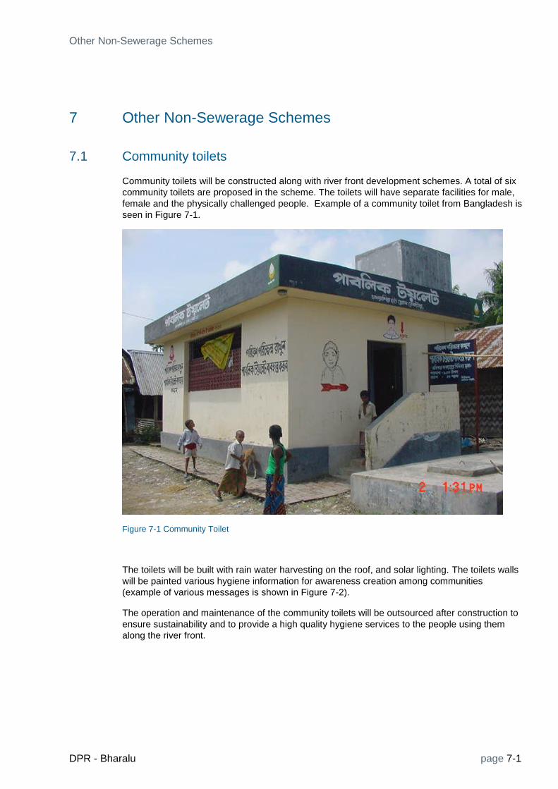
Other Non-Sewerage Schemes
DPR - Bharalu page 7-1
7 Other Non-Sewerage Schemes
7.1 Community toilets
Community toilets will be constructed along with river front development schemes. A total of six
community toilets are proposed in the scheme. The toilets will have separate facilities for male,
female and the physically challenged people. Example of a community toilet from Bangladesh is
seen in Figure 7-1.
Figure 7-1 Community Toilet
The toilets will be built with rain water harvesting on the roof, and solar lighting. The toilets walls
will be painted various hygiene information for awareness creation among communities
(example of various messages is shown in Figure 7-2).
The operation and maintenance of the community toilets will be outsourced after construction to
ensure sustainability and to provide a high quality hygiene services to the people using them
along the river front.

page 7-2 DPR - Bharalu
Figure 7-2 community toilets with hygiene messages
7.2 Community Kiosks
Community kiosks will consist of small houses along the river front. Their purpose is to let individual for small business activities, such as saloon, water, tea/cold drink, snacks, vending, selling pan, providing first aid treatment and emergency medicines. The individual may also have basic health checking facilities, such as blood sugar and blood pressure. This will enhance the use of river fronts. Currently, the conditions of such kiosks, as seen in Figure 7-3, is very unhygienic and unattractive.
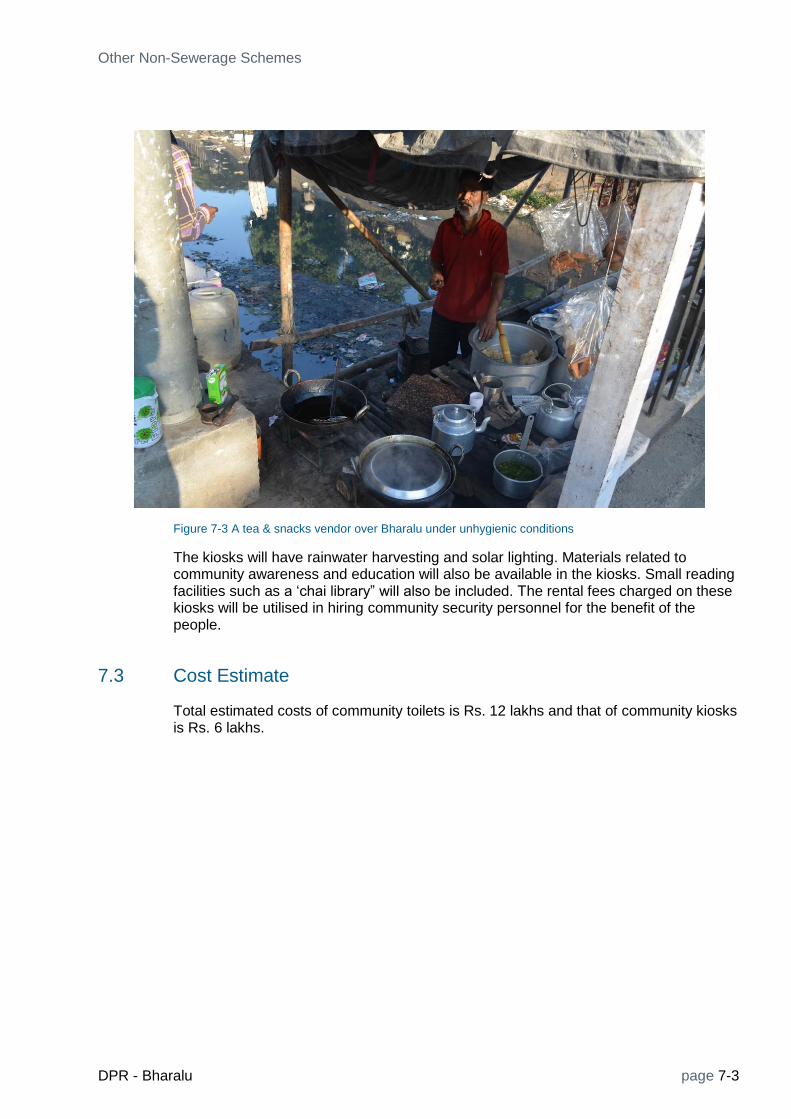
Other Non-Sewerage Schemes
DPR - Bharalu page 7-3
Figure 7-3 A tea & snacks vendor over Bharalu under unhygienic conditions
The kiosks will have rainwater harvesting and solar lighting. Materials related to community awareness and education will also be available in the kiosks. Small reading facilities such as a ‘chai library” will also be included. The rental fees charged on these kiosks will be utilised in hiring community security personnel for the benefit of the people.
7.3 Cost Estimate
Total estimated costs of community toilets is Rs. 12 lakhs and that of community kiosks is Rs. 6 lakhs.


Water Augmentation and Channel Improvement Schemes
DPR - Bharalu page 8-1
8 Water Augmentation and Channel Improvement Schemes
8.1 River Network
Figure 8-1 shows the river network of the Bharalu River system with its catchment area. The origin of the Bharalu river is from the Meghayala hills, from where two tributaries namely Basistha and Bahini originate. The Basistha is 27 km long from the Basistha temple to its outfall into deepor Bill and the Bahini is 15.70 km long from its origin to the Jonali bridge in Guwahati city. From Jonali Bridge after it is joined by the Guwahati refinery drain, the Bharalu river is 7km long to its mouth (Bhalaumukh) at the Brahmaputra. The dead Bharalu River taking off upstream of the sluice gate at Shantipur is 6.50 km long to its meeting point with the Basistha near ISBT. Table 8.1 shows the lengths of the rivers. There is no proper record of flow measurement in these rivers. However, based on published literature the peak flow at Bharalumukh is about 35m3/s. Rainfall-runoff models developed during the present study have produced a peak flow of about 35 m3/s and the low flow which is only the base flow before the river enters the urban catchment ranges from 0.10 to 0.65 m3/s. After receiving the urban water the low flow at Bharalumukh is about 2.50 m3/s.

page 8-2 DPR - Bharalu
Figure 8-1 Bharalu River system network
Table 8.1 Lengths of rivers
River / tributary name
from to length
(km)
Basistha Basistha temple Deepor Bill 27.00
Bahini Meghalaya hills Nautan bazaar (at closed sluice gate)
8.00
Bahini Nautan bazaar (at closed sluice gate)
Jonali Bridge 8.70
Bharalu Jonali bridge Bharalu Mukh at Brahmaputra
7.00
Dead Bharalu Bharalu Sluice gate (Shantipur)
Near ISBT (confluence of
6.50

Water Augmentation and Channel Improvement Schemes
DPR - Bharalu page 8-3
Basitha & dead Bharalu)
Pamohi Deepor Beel Brahmaputra (near Garigaon)
7.00
8.2 Modelling
8.2.1 Rainfall-Runoff modelling
In order to simulate available runoff from rainfall over the catchment of the Bharalu river the entire catchment has been delineated as shown in Figure 8-2.
Figure 8-2 Catchment delineation for rainfall-runoff modelling
Using available historical daily rainfall data for 2006-2012 years the model simulation result is presented in Figures 8-3. at Nutan Bazaar. The simulated discharges are used as inflows to the hydrodynamic model.

page 8-4 DPR - Bharalu
Figure 8-3 Simulated discharge of Basistha River at Nutan Bazaar
8.2.2 Hydrodynamic Modelling
The hydrodynamic model of the Bharalu river system is developed to simulate flow and water level along its length both during the rainy and dry season. River cross section and other data were obtained from WRD Guwahati. The model includes the length of Brahmaputra from Dibrugarh to Dhubri in order to avoid any influence of local boundary condition. This allows the siumaltion of backwater effects from Brahmaputra to the Bharalu system. Figure 8-4 shows schematized model network.

Water Augmentation and Channel Improvement Schemes
DPR - Bharalu page 8-5
Figure 8-4 Bharalu River Model network
The model was run with data from 2006- 2012 to simulate existing conditions and to compare with proposed water augmentation and channel improvement conditions.
Figure 8-5 shows Longitudinal profile of Baistha river. Resultas for other rivers are presented below in connection with desilting and water augmentation.
Figure 8-5 L-profile of Basistha
Figure 8-6 shows discharge hydrograph of Basistha at Nutan bazaar for a typical year.

page 8-6 DPR - Bharalu
Figure 8-6 Discharge hydrograph of Basistha river at Nutan Bazaar
8.3 Water Augmentation Scheme
8.3.1 Re-connecting Bahini River near Nutan Bazar area
Basistha and Bahini rivers are naturally flowing from south to north direction (Figures 8-7 and 8-8). From the Survey of India map/ Google imagery, it is seen
that there was and still is a connection between Bahini and Basistha rivers at location 2. From the site visit, one sluice gate is found on Bahini at location 1 ( Figure 8-9) that is currently defunct and the Bahini river stretch between location 2 to location 3 has also become defunct/ encroached or might have been silted up which resulted in a disconnection in this stretch of Bahini. In other words, the Bahini is now flowing from location 3 onwards. The Bahini at location 2 has joined Bashishtha and is flowing further down.

Water Augmentation and Channel Improvement Schemes
DPR - Bharalu page 8-7
Figure 8-7 Location of Bahini-Basista connection
Figure 8-8 Survey of India Map showing the Basishta-Bahini connection

page 8-8 DPR - Bharalu
Figure 8-9 The closed sluice gate of Bahini at Nutan Bazaar
8.3.2 The Scheme
As shown in Figure 8-10, the connection will be reestablished by constructing a channel from the Basistha point to meet Bahini 500 m downstream. It is proposed to reconnect two stretches of Bahini by providing a new channel along Bashishtha road connecting at location 2 and location 3. The Bahini river’s reconnection scheme has been conceptualized. The reconnection scheme has a new RCC box channel and a new sluice gate, the details of the scheme are given below.

Water Augmentation and Channel Improvement Schemes
DPR - Bharalu page 8-9
Figure 8-10 The new Channel connection arrangement
8.3.3 The New Sluice Gate
A New sluice as shown in Figure -11 is proposed at Location point 2 as seen in figure above to divert water from Basistha to Bahini. A new channel has been proposed to Connect Basistha to Bahini
The Sluice Gate Details are:
Size of Gate : 2 x (1 x 2)
Number: 2 Nos
Width : 1 m
Depth : 2m
Maximum design discharge capacity:12 m3/s

page 8-10 DPR - Bharalu
Figure 8-11 Design of the new sluice gate
Gate operation condition: In a critical condition, allowing both gates to be opened by 1.5m a maximum discharge of approximately 12 m3/s water from Basishtha to Bahini assuming that the upstream depth (y1) is 3m (Bank full level flow in the Bashistha)
8.3.4 The New Channel
A new channel conecting Basistha at Location 2 and Bahini at Location 3 is proposed for widhdrawal of water from Bashistha to Bahini. The details of the RCC covered channel proposed are as below.
Size of the channel: 2 x 2 m
Length of the Channel: 500m
Slope of the Channel: 1: 250
At Location point 2 Sill level: B
Size of the channel: 2 x 2 m
Thickness: 100 mm
Length of the Channel: 500m
Slope of the Channel: 1: 250
Sill level: Bed level of Basistha (loc. 2)
Sill level at loc. 3: Bed level of Bahini

Water Augmentation and Channel Improvement Schemes
DPR - Bharalu page 8-11
8.4 Desiltation
8.4.1 Desiltation of Bahinin, Bharalu and Dead Bharalu rivers
As part of the restoration and conservation of the river, deposited sediment will be removed to improve river conveyance and carrying capacity. Specifically, the river will be excavated to create a uniform slope along the silted reaches to the mouth at the Brahmaputra (Bharalumikh). The main desiltation works will be carried along the Bahini and Bharalu Rivers for a total length of 15.70 km from Nautan Bazaar to Bharalu Mukh Figures 8-12 shows the Longitudinal profile of Bahini along with corresponding sample cross sections. Similarly, Figures 8-13 shows the Longitudinal profile of Bharau and corresponding sample cross sections. Detailed cross sections for calculating dredging quantities are presented in Annex. Calculation has also been done for the dredging of Dead Bharalu.
Figure 8-12 Longitudinal profile and Cross sections of Bahini (for dredging)

page 8-12 DPR - Bharalu
Figure 8-13 Longitudinal profile and Cross sections of Bharalu (for dredging)
The change in water surface profiles due to desiltation along the river reaches are presented in Figures 8-14 to 8-19.
Figure 8-14 Longitudinal profile of Bahini- Bharalu River (Before dredging allowing 0.5cumecs through the new sluice)

Water Augmentation and Channel Improvement Schemes
DPR - Bharalu page 8-13
Figure 8-15 : Longitudinal profile of Bahini- Bharalu River (After dredging allowing 0.5cumecs through the new sluice)
Figure 8-16 Longitudinal profile of Bahini- Bharalu River (Before Dredging- after connecting with the upstream Bahini through the new sluice)

page 8-14 DPR - Bharalu
Figure 8-17 Longitudinal profile of Bahini- Bharalu River (After Dredging- after connection with the upstream Bahini through new sluice)
Figure 8-18 Longitudinal profile of Dead Bharalu River (Before Dredging)
Figure 8-19 : Longitudinal profile of Dead Bharalu River (After Dredging)

Water Augmentation and Channel Improvement Schemes
DPR - Bharalu page 8-15
This sediment removal is also expected to address some of the legacy sediment pollution that has resulted from sewage and industrial discharges, and as such, would help to accelerate the Bharalu’s recovery.
Removal of sediment for all alternatives involves bank to bank removal of deposited sediments and accumulated debris along the entire length of the river. The removal/restoration plan consists of the following activities.
8.4.2 Pre-construction Activities
o Sediment Testing and Analysis: sediment will be tested in-situ to determine level of contamination and characterize the sediment for disposal.
o Surveying: River bed and river bank elevations will be surveyed to establish pre-construction conditions and develop sediment removal limits and cut lines to estimate removal volumes.
o Bench Scale and Treatability Studies: Sediment will be tested to assess cement amendment mixing ratios for desiccation or to assess other dewatering options.
o During the design phase of the project other disposal options can be evaluated such as bioremediation of waste for beneficial use.
8.4.3 Temporary River Diversions
Sediment removal activities will be performed in dry conditions. Cofferdams consisting of sand-filled geotextile bags or similar materials will be installed as necessary to block flow from the work area and the flow will be conveyed around the work area by gravity flow and pumping as site conditions permit. Pumps will be powered by diesel generators or other power sources as available.
8.4.4 Sediment Excavation
River sediment deposits will be removed with a mechanical excavator from the shoreline. After sediment excavation a thin layer of clean backfill material will be placed over the surface. The temporary cofferdam structure will be removed and moved further downstream to continue sediment removal operations. Upland areas disturbed by construction equipment will be re-graded and seeded.

page 8-16 DPR - Bharalu
Figure 8-20 Typical desiltation arrangement
8.4.5 Removal of Solid Waste
Solid waste accumulated on river banks will be removed by manual labor (using rakes and shoves). The solid waste will be collected, loaded, and transported via truck to a local landfill for disposal. Where possible the removal of the solid waste will attempt to limit the removal of river bank soil. For areas where the solid waste is lodged in the river bank soils and significant incidental soil removal is necessary, a bar screen can be used to separate the soil from the solid waste for reuse. Disturbed river bank areas will be backfilled, re-graded, and seeded with native plant material.
8.4.6 Sediment Processing and Disposal
Excavated sediment will be placed in dump trucks and transported to a series of central processing area. The spacing and size of the processing areas will be determined based on specific site conditions. The processing area will consist of one or more roll-off containers but, if site conditions permit, could be configured in larger temporary containment units such as berms created using jersey concrete barriers and geotextile liners. The excavated sediment will be placed in the temporary containment units and supernatant liquid will be collected and flowed or pumped back to the river. After a period of dewatering, the partially dewatered sediment will be amended with cement to desiccate additional moisture in order to make the material transportable. The amended sediment will be transported to a local landfill facility for disposal. Amended material should be tested to confirm suitability for landfill disposal per the requirements of the landfill.

Water Augmentation and Channel Improvement Schemes
DPR - Bharalu page 8-17
8.5 Cost Estimate
8.5.1 Cost Estimate of Water Augmentation
S.No. Item Qty Unit Rate Amount
1
Construction of RCC covered channel along the side
road
2
1. Earthwork excavation in hard soil, including site
clearance, disposal of earth (2m x2mX500m+10%) 20200 cu.m 434 87,64,218
3 2. Form Work 3000 sq.m. 17,960 5,38,80,142
4 3. RCC (cement concrete grade 20) 400 cu.m. 6,467 25,86,959
5
4. Manholes with cast iron covers @ 100 m interval,
size 60 cm X 60 cm 5 No 8,063 40,314
6
Iron Sluice Gate, fabrication, transportation,
installation, painting, all complete 350 Kg 119 41,576
7
Site management before, during & after
construction (clearance, dewatering, etc.) 1 Lot 2,50,000 2,50,000
8 Sub total 6,55,63,209
9 Contengencies 5% 32,78,160
10
O&M cost for 5 years @2 % of capital cost, inflation
factor adjusted 98,34,481
TOTAL 7,86,75,850
8.5.2 Cost Estimate of Desiltation
S.No. Item Qty Unit Rate Amount
1
Desilting of Bahini ( 8.7 km) from Nutan Bazar
to Jonali Bridge
1,28,282 cu.m.
2Desilting of Bharalu ( 7.0 km) from Jonali
Bridge to Bharalumukh 79,662
cu.m.
3
Desilting of Dead Bharalu (6.5 km) Sluice gate
at Shantipur to ISBT (ner confluence with
Basistha
63,343
cu.m.
4
Total desilting quantity including adidtional
10% fro unforeseen places 2,98,416
cu.m. 495 14,77,15,899
5
Cartage of excavated debris including
necessary loading, unloading and conveying
and disposing as directed, to a disposal site
(Distance = 5 KM)
2,98,416 cu.m. 251.1 7,49,32,247
4
Removal of solid waste from banks
(approximate length) 26 km 100000 26,00,000
5 Sub Total 22,52,48,145
6 Contingencies 5% 1,12,62,407
GRAND TOTAL 23,65,10,552


River Monitoring Schemes
DPR - Bharalu page 9-1
9 River Monitoring Schemes
9.1 General Technical Concept
The concept of implementation of river monitoring scheme, on which the present technical specifications and special conditions are based intends to combine the advantages of modern Data Collection Platform (DCP), data storage, processing and data communication technologies with the requirements of high availability and sustainability required by such an important project. Preference will be given to robust, reliable technology. Some data collection sites are located in remote areas and should require annual maintenance only, so the selection of equipment and civil design will consider this aspect.
Wherever possible, the data from stations or sensors in close proximity will be gathered using wireless, unlicensed radio transmissions to a single point, then employing GSM/GPRS data communications from that location to SCADA. It is recognized that the maintenance of a monitoring network is often grossly underestimated as well as underperformed task. This leads to reduced life expectancy of the equipment and possibly the collection of misleading data during the period of operation. A strong maintenance plan will be provided for sustaining the monitoring network operation over the expected lifetime of the technology, which is considered to be 10-15 years. The proposed data communication will be through GSM/GPRS. The service provider will be responsible for making all arrangements for the sites requiring GSM/GPRS.
9.2 Design Principles
The following basic principles have been applied to the design of the real time hydro-meteorological data acquisition system network for Bharalu River basin.
a) New stations being installed to improve estimations of areal precipitation and mean areal precipitation.
b) Climate stations will be fully automated and transmit data in real time
c) Precipitation gauges (Rain gauges) will have the primary function of measuring accumulated precipitation accurately. Rain gauges will be equipped with either a siphon system or software to eliminate over or under-measurement due to varying rates of precipitation being measured by a tipping bucket.
d) For river water levels radar and stilling well type will be installed.
e) The discharge measurements will be using current meters
9.3 Functional Requirements
Transition to automated observations with real time data communication can lead to a discontinuity in the measurement record if the process is not specified and managed carefully. The benefits of automation with real time data communication include cost

page 9-2 DPR - Bharalu
effectiveness, high frequency data, better ability to detect problems with measurements, faster access to data, consistency and objectiveness in measurement, and ability to perform automatic quality monitoring.
The water level and rainfall data will also be measured and logged every 1 hour and transmitted using both self-timed and random transmissions.
9.4 Technical Specifications
The technical Specifications of the stations in the monitoring network would be as follows:
1. Automated Rainfall Stations (ARS)
The ARS (Figure 9-1) , which will be tipping bucket type, will measure precipitation and transmit this data to data centre through GSM/GPRS communication. The rain gauge will be mounted 0.8 to 1m above the ground and will be located in such a way where the WMO guidelines on exposure are followed (i.e. structures, trees can not be closer than twice the difference between the orifice height and the height of the object). The approximate dimensions required for stations are 7m x 7m. The approximate gauge house building area may be about 5 sq. m. Concrete support block for both the tipping bucket gauge and pole for mounting various accessories etc. will be 0.45m X 0.45m X 0.9m deep approximately.
Figure 9-1: Automatic Rainfall Station.
2. Automated River Water Level Stations (ARWLS)
The ARWLS, river stage and transmit this data to data centre through GSM/GPRS communication. The water level measurement technology will either be made from a radar sensor and/or a stilling well/shaft encoder principal. River Water level recording stations will have a gauge house, wherever available or outdoor poles will be used. Figure 9-2 & Figure 9-3.
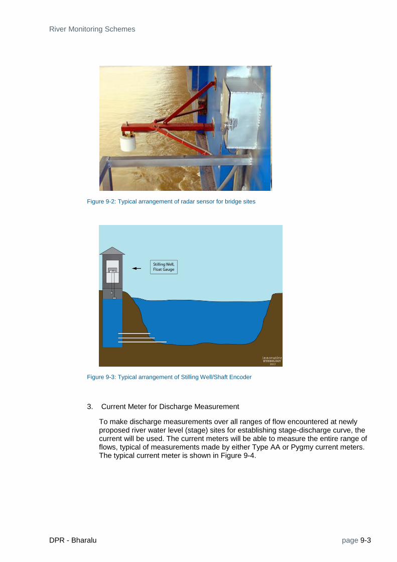
River Monitoring Schemes
DPR - Bharalu page 9-3
Figure 9-2: Typical arrangement of radar sensor for bridge sites
Figure 9-3: Typical arrangement of Stilling Well/Shaft Encoder
3. Current Meter for Discharge Measurement
To make discharge measurements over all ranges of flow encountered at newly proposed river water level (stage) sites for establishing stage-discharge curve, the current will be used. The current meters will be able to measure the entire range of flows, typical of measurements made by either Type AA or Pygmy current meters. The typical current meter is shown in Figure 9-4.

page 9-4 DPR - Bharalu
Figure 9-4: Typical Current meter
4. Water Quality Stations (WQS)
The various water quality measurements will include the following parameters.
1. pH
2. Turbidity
3. Conductivity
4. Temperature
5. Dissolved Oxygen (DO)
6. Dissolved Ammonia
7. Bio-Chemical Oxygen Demand (BOD)
8. Chemical Oxygen Demand (COD)
9. Nitrates
10. Chlorides
Most of the parameters will be measured using real time sensors and few will be monitored manually and will be incorporated in data base.
9.5 Telemetry (GSM/GPRS Communication)
The data communications employed on river monitoring network will use GSM/GPRS radio communications. All stations have had in in-situ radio path survey, where a mobile phone signal was detected.
In GSM(Global System for Mobile Communications) / GPRS(General Packet Radio Service), the transmission is generally with 900 MHz and 1,8 GHz frequencies. It is open for public use and just requires the service agreement with service provider. The area coverage and economy of this option makes it a popular choice.

River Monitoring Schemes
DPR - Bharalu page 9-5
9.5.1 GSM/GPRS Data Collection Station
One GSM/GPRS data collection station shall be established at Project Management Unit (PMU) office in PCBA, Guwahati. The GSM/GPRS data collection station shall be able to interrogate the DCPs based on a given schedule. The GSM/GPRS Data Collection Station will also be able to receive data sent by the remote stations, whether the data is sent via SMS text or over GPRS internet connectivity.
9.6 Data Centre
The objective of establishing of a Data Center is to ensure that the high quality data collection, compilation, processing and analyses are available for monitoring. The data centre will be located at Project Management Unit (PMU) office in PCBA, Guwahati, and the access to the data will be given to Guwahati Municipal Corporation (GMC) and WRD offices in Guwahati . The data centre will receive data from the GSM/GPRS enabled remote stations and will store this data in the data base. There will be a minimum of 100 days of data stored.. Figure 9-6 provides a overview of river monitoring system and how the data will be transmitted to data centre. The components of the system include GSM/GPRS communication system and data collection/application servers for the collection, quality control and relay of information. The Web Portal that serves the public authorities want can have the data published on it.
Figure 9-5: Monitoring System Overview .
The data flow will be as follows:
Each DCP will automatically measure precipitation and reservoir/river water level every regular interval of 1 hour and transmit the data. It will store this observed data in its memory and then transmit it in self timed manner in its prescribed time slot every hour.
Data communication will be through GSM/GPRS network and received at the ground stations.
The Real Time Data Monitoring system will be based on Mike Customized s/w, in which the data will be brought into the server. The Mike Customized s/w will

page 9-6 DPR - Bharalu
perform the quality control processing and data visualization function. The similar system are successfully implemented and operation in Control Rooms of Bhakra Bias management Board (BBMB) in Chandigarh and Basin Simulation Division, WRD in Pune.
9.7 Equipment Specifications
The following equipment specifications will apply for all stations and equipment listed below. All sensors shall have operating temperature from 0 to +60ºC, relative humidity 0% to 100% non-condensing and located at an altitude ranging from 200 to 2000 m. The complete tool kit for installation and routine maintenance along with manuals, documentation etc. in English shall be provided.
9.7.1 Data Collection Platform
The conditions and constraints of hydrologic monitoring require long periods of autonomy. The Data Collection Platforms shall be capable of unattended operation for upto a year. The continuous power is not available for most of the network, so the power will need to be supplied on-site with the use of solar panels. Figure 9-6 shows the typical data collection platform and online battery charger for solar panel input.
Figure 9-6: Typical data collection platform and online battery charger
9.7.2 GSM/GPRS Radio and Antenna
The GSM/GPRS data radio communications equipment shall meet the requirements of regulating agencies in India. The GSM/GPRS technology will allow for on-demand data collection and reprogramming of the data collection platform. The GSM/GPRS antenna shall also meet the requirements of the GSM/GPRS provider and regulatory agencies.
9.7.3 Water Level Sensors
As described in 9.4, water level sensing technology includes shaft encoders and radar systems. The sensor shall be compatible with the data collection platform.
(a) The shaft encoder shall meet the following specifications:
Shaft encoder shall have digital readout

River Monitoring Schemes
DPR - Bharalu page 9-7
Measuring range: 0 – 80 m water column
Power supply provided through data collection platform
Shaft encoder will be compatible with data collection platform input
Resolution shall be 3mm or less
All standard accessories shall be included such as floats, wheels, tapes, counterweight and connecting parts
The sensor shall keep track of rapid water level movements without suffering from missing increments due to too slow operation
Wheels and tapes shall be metric
Tape shall be graduated
Shaft encoder fabrication shall be of high quality using stainless steel or similar material that can resist corrosion
Shaft encoder electronics are fully protected against ingress of water, moisture, dust etc.
The Schedule of Requirements gives the numbers to be quoted for and their associated ranges and is provided in Appendix- A. The bidder shall specify for the closest standard range of the offered product with respect to the required measuring range. The quoted range shall be equal or larger than the required range.
(b) The radar sensor shall meet or exceed the following specifications:
Power input: 10 – 15 V DC
Power consumption: ≤ 20 mA Active, ≤ 10 mA sleep
Power should be able to be cycled so that power is only applied prior and during measurement
Range: 0-30 m water column
Mounting supports shall be as required
Accuracy(linearity, repeatability, hysteresis): 0.03% or less
Resolution shall be 3 mm or less
The Schedule of Requirements gives the numbers to be quoted for and their associated ranges and is provided in Appendix- A. The bidder shall specify for the closest standard range of the offered product with respect to the required measuring range. The quoted range shall be equal or larger than the required range.
9.7.4 Rainfall Sensors
The precipitation/rainfall sensor shall meet or exceed the following specifications:
Tipping bucket base and collector: durable and rigid of cast metal, moulded thermoplastic, FRP or equivalent; galvanized iron sheet is not permitted
Rim material: gun metal/ brass/ stainless steel or equivalent
Rainfall shall be measured using a tipping bucket method and shall be able to record rainfall cumulatively with the data collection platform
Rainfall sensor shall be of such a design that it operates reliably and accurately under prevailing environmental and weather conditions
Raingauge is easy to operate and easy to calibrate
Minimum expected operational lifetime shall be 15 years or greater
Bucket capacity: 1 mm equivalent rainfall

page 9-8 DPR - Bharalu
Focus on rainfall gauge is the accurate measurement of rainfall totals, not necessarily rainfall rates. The use of a siphon system to normalize rainfall rate to achieve accurate total rainfall is specified, or software which will also normalize varying rainfall rates and errors caused by changing rainfall rates
Intensity: 0 – 500 mm/hr
Accuracy: 2% of reading
Contact system using dual reed switches with varistor protection
Insect covers on all openings
Collecting funnel diameter: close to 200 mm internal diameter
The gauge will have leg adjusters to set the level horizontally
Certified calibration test document shall be included with every gauge. The calibration may be performed just prior to installation to assure accuracy of certified calibration test.
Ability to service tipping bucket gauge without re-leveling the gauge.
Calibration kit for tipping buckets (10 units)
Necessary cables to connect precipitation gauge to data logger as required
9.7.5 Solar Power and Battery
All systems will rely on solar power charging system and battery backup for extended operation during periods of extended cloudiness or loss of charging system. The solar panel and battery system shall satisfy the following specifications:
12V solar photo voltaic system with the capacity to power all equipments associated with the station
The solar panels shall be capable of not only powering the equipment, but charging the batteries to provide continuous operations
The battery system must be capable of operating all components of the monitoring station for 20 days without charging
The solar panel system shall be capable of full charging the battery system that has gone 20 days without charge within 2 days in full sunlight.
A solar regulator will be supplied at each station to regulate power and maintain optimum battery and data collection platform operation
9.7.6 Current Meters
One set of current meter with all accessories required to make discharge measurements over all ranges of flow encountered at newly proposed river water level (stage) sites for establishing stage-discharge curve. Accessories include Price-type current meters or equivalent. The current meters should be able to measure the entire range of flows, typical of measurements made by either Type AA or Pygmy current meters. The bidder will provide the complete specifications of the equipment as part of the bid.
The current meter accessories will include wading rods, cranes, sounding weights to make measurements from a bridge, cableway or wading. This equipment will be used by the bidder and serviced by the bidder for repair due to malfunction or other equipment breakdown.

River Monitoring Schemes
DPR - Bharalu page 9-9
9.7.7 Water Quality Sensors
The specifications for water quality sensors viz. pH, Turbidity, Conductivity, Temperature, Dissolved Oxygen (DO), Dissolved Ammonia, Chemical Oxygen Demand (COD), Nitrates and Chlorides are described in following sections. The Bio-Chemical Oxygen Demand (BOD) measurements will be done weekly by sample collection manually and lab analysis.
9.7.7.1 Specification for pH
9.7.7.2 Specification for Turbidity
9.7.7.3 Specification for Conductivity
Measuring Range 0.0 to 14 units of pH
Accuracy ≤ 0.01 units of pH
Resolution ≤ 0.01 units of pH
Precision ≤ 0.03 units of pH
Response Time ≤ 60 seconds
Operating Temperature 0 to 40°C
Operating Humidity 5 to 95% non-condensing
Power 12 VDC Nominal
Signal Output Compatible with Data Acquisition System
Cleaning Self-Cleaning (Automatic)
pH
Measuring Range 0 to 1000 NTU
Accuracy ≤ 3 % of certified reference standard
Resolution ≤ 0.1 NTU
Response Time ≤ 60 seconds
Operating Temperature 0 to 40°C
Operating Humidity 5 to 95% non-condensing
Power 12 VDC Nominal
Signal Output Compatible with Data Acquisition System
Cleaning Self-Cleaning (Automatic)
Turbidity
Measuring Range 0.0 to 5000 μS/cm
Accuracy ± 0.1% of full scale
Resolution ≤ 0.01 μS/cm
Precision ≤ 3 μS/cm
Response Time ≤ 60 seconds
Operating Temperature 0 to 40°C
Operating Humidity 5 to 95% non-condensing
Power 12 VDC Nominal
Signal Output Compatible with Data Acquisition System
Cleaning Self-Cleaning (Automatic)
Conductivity (EC)

page 9-10 DPR - Bharalu
Measuring Range 0.0 to 100 mg/L
Accuracy ≤ 3% of full scale
Resolution ≤ 0.1 mg/L
Precision ≤ 0.3 mg/L
Response Time ≤ 60 seconds
Operating Temperature 0 to 40°C
Operating Humidity 5 to 95% non-condensing
Power 12 VDC Nominal
Signal Output Compatible with Data Acquisition System
Cleaning Self-Cleaning (Automatic)
Ammonia (NH4)
9.7.7.4 Specification for Water Temperature
9.7.7.5 Specification for Dissolved Oxygen
9.7.7.6 Specification for Dissolved Ammonia
Measuring Range 0 to 40°C
Accuracy ≤ 0.1 C
Resolution ≤ 0.1 C
Precision ≤ 0.1 C
Response Time ≤ 60 seconds
Operating Temperature 0 to 40°C
Operating Humidity 5 to 95% non-condensing
Power 12 VDC Nominal
Signal Output Compatible with Data Acquisition System
Cleaning Self-Cleaning (Automatic)
Temperature
Measuring Range 0 to 20 mg/L
Accuracy ≤ 1% of Full Scale
Resolution ≤ 0.01 mg/L
Precision ≤ 0.02 mg/L
Response Time ≤ 60 seconds
Operating Temperature 0 to 40°C
Operating Humidity 5 to 95% non-condensing
Power 12 VDC Nominal
Signal Output Compatible with Data Acquisition System
Cleaning Self-Cleaning (Automatic)
Dissolved Oxygen (DO)

River Monitoring Schemes
DPR - Bharalu page 9-11
Measuring Range 1 to 50 mg/L
Accuracy ± 2% + 0.5 mg/L ofcertified reference standard
Resolution ≤ 0.1 mg/L
Precision ≤ 0.25 mg/L
Response Time ≤ 60 seconds
Operating Temperature 0 to 40°C
Operating Humidity 5 to 95% non-condensing
Power 12 VDC Nominal
Signal Output Compatible with Data Acquisition System
Cleaning Self-Cleaning (Automatic)
Nitrates (NO3)
Measuring Range 0.0 to 500 mg/l
Accuracy ± 2% + 5 mg/L of certified reference standard
Resolution ≤ 1 mg/L
Response Time ≤ 60 seconds
Operating Temperature 0 to 40°C
Operating Humidity 5 to 95% non-condensing
Power 12 VDC Nominal
Signal Output Compatible with Data Acquisition System
Cleaning Self-Cleaning (Automatic)
Chemical Oxygen Demand (COD)
9.7.7.7 Specification for COD
9.7.7.8 Specification for Nitrates
9.7.7.9 Specification for Chlorides

page 9-12 DPR - Bharalu
9.8 River Monitoring Network
The real time network of rainfall and river water monitoring is depicted in Figure 9-7: Map showing Monitoring Stations for Bharalu river Basin. It is proposed to have 5 rain gauge stations, 2 river water level station and 4 Water Quality stations. The BOD measurements would be taken at these six stations in each week manually. There would be one current meter for discharge measurement.
Figure 9-7: Map showing Monitoring Stations for Bharalu river Basin

River Monitoring Schemes
DPR - Bharalu page 9-13
9.9 Cost Estimate
Table 9.1 and 9.2 elaborates the Cost estimates for Bharalu River including Operation and maintenance Costs,
Table 9.1 The Cost Estimate for Bharalu River
Sl No. Item QTY Unit Unit Cost (INR) Total Cost (INR)
1 Automatic Rainfall Station 5 No 150,000 750,000
2 Automatic River WL Station 2 No 300,000 600,000
3 Water Quality Stations (excluding BOD) 4 No 850,000 3,400,000
SubTotal 4,750,000
5 Transport, Transit Insurance, Installation 1 Lot 20% 950,000
6 Establishment of gauge-discharge station 1 No 250,000 250,000
7 Current meter and related accessories 1 Lot 100,000 100,000
8 Database Server 1 No 500,000 500,000
9 High End Desk Tops 5 No 80,000 400,000
10 Display (Plazma 51") 4 No 100,000 400,000
11 SCADA & data base software 1 No 1,200,000 1,200,000
12 Data integration and modelling software 1 No 5,000,000 5,000,000
13 SubTotal 13,550,000
16 Contingencies 5% 677,500
17 subtotal 14,227,500
18 O&M for 5 years 24,847,000
TOTAL 39,075,500
19 Consultancy for implementation of the monitoring, modelling and warning system - included in the PMC cost
The Consultancy cost of 6 International Mon-months and 24 National man-Months will be included in the budget PMC.

page 9-14 DPR - Bharalu
Table 9.2 The O & M Cost Estimate for Bharalu River monitoring component.
1 BOD Sampling and lab testing 3 stations, 52 weeks 208 No 1000 208000
2
Other water quality parameters sampling & lab testing (monthly) 48 No 10000 480000
3 Cost of mobile network use 11 No 10000 110000
4 Annual maintenance cost 1 years 10% 475000
5
Flow measurement (weekly) at the G-D station - to be outsourced to hydrologists 52 week 20000 1040000
6
Maintenance of hardware and software at the SCADA Center 1 LS 1000000 1000000
7 Total for one year
3,313,000
8 Total for 5 years (incl. escalation)
24,847,500
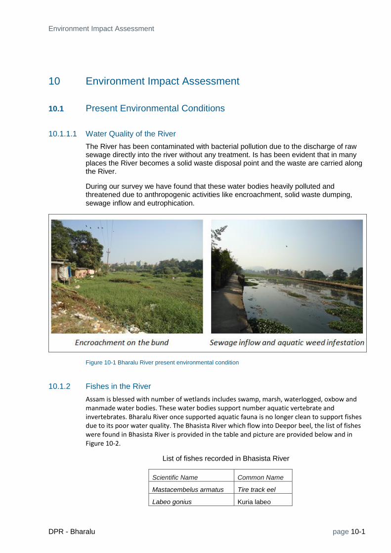
Environment Impact Assessment
DPR - Bharalu page 10-1
10 Environment Impact Assessment
10.1 Present Environmental Conditions
10.1.1.1 Water Quality of the River
The River has been contaminated with bacterial pollution due to the discharge of raw sewage directly into the river without any treatment. Is has been evident that in many places the River becomes a solid waste disposal point and the waste are carried along the River.
During our survey we have found that these water bodies heavily polluted and threatened due to anthropogenic activities like encroachment, solid waste dumping,
sewage inflow and eutrophication.
Figure 10-1 Bharalu River present environmental condition
10.1.2 Fishes in the River
Assam is blessed with number of wetlands includes swamp, marsh, waterlogged, oxbow and manmade water bodies. These water bodies support number aquatic vertebrate and invertebrates. Bharalu River once supported aquatic fauna is no longer clean to support fishes due to its poor water quality. The Bhasista River which flow into Deepor beel, the list of fishes were found in Bhasista River is provided in the table and picture are provided below and in Figure 10-2.
List of fishes recorded in Bhasista River
Scientific Name Common Name
Mastacembelus armatus Tire track eel
Labeo gonius Kuria labeo

page 10-2 DPR - Bharalu
Cirrhinus mrigala Mrigal carp
Puntius sophore Pool barb
Pethia conchonius Rosy Barb
Mystus bleekeri Day's Mystus
Figure 10-2 Fishes recorded in Bhasista River

Environment Impact Assessment
DPR - Bharalu page 10-3
10.1.2.1 Industries around the River
Assam Industrial Development Corporation Ltd. was incorporated in the year 1965 under the Companies Act 1956 started with the objective of Identification and promotion of medium and large industrial projects in the state. Some of the Major Industries and Industrial areas are Guwahati Refinery (Indian Oil Corporation) India Carbon Ltd, Amingaon Industrial area, Bamunimaidam Industrial Estate and Kalapahar Industrial Estate.
10.1.2.2 Water supply in Guwahati City
The water supply facilities in Guwahati Metropolitan area are operated by three departments, viz., Guwahati Municipal Corporation (GMC), Assam Urban Water Supply and Sewerage Board (AUWSSB) and Public Health Engineering Department (PHED). The existing systems cater to about 30% of the residents. Besides this the households are mainly dependent on the groundwater and the water supplied through the tankers. The safety of ground water for drinking purposes is a concern due to contamination by high levels of dissolved solids, iron, and fluorides in many areas.
The Guwahati Jal Board (GJB) was established as a single organisation responsible for Water Supply & Sewerage services to the residents of the Guwahati Metropolitan Area (GMA). Upon completion, the water supply facilities now under implementation will be taken over by the Guwahati Jal Board, which will be responsible for operating and maintaining them on a sustainable basis.
Figure 10-3 Indigenous iron filter system
Present sources of water are:
1. Surface sources: River Brahmaputra. Raw water is drawn from the river by raw water pumps mounted on eight floating barges located at different places.
2. Ground Water: 14 deep tube wells constructed by GMC.
Apart from the municipal water supply, we found that people are using hand pump to draw ground water. Along the Bashita River people drawing water from shallow wells which have excess iron, the collected iron rich water is filtered through indigenous filter system in order to remove dissolved iron. Though excess iron does not have major health problem, but it stains and has aesthetic problem.

page 10-4 DPR - Bharalu
The beel, Silsako beel, Narengi beel, Borsola beel and Sarusola beel. Beel means wetland or large aquatic body in Assamese. The Deepor beel is the largest among these, it is biological and environmental important site also designated a Ramsar site in 2002, it is the largest wetland located on the foothills of Rani and Garbanga Reserve forest. Apart from the various natural water bodies, there are a number of historic water tanks or ponds within the city. These tanks which include, Dighalipukhuri, Silpukhuri, Joorpukhuri, Nagputapukhuri, Kamakhyapukhuri, etc. The locations of these beels are provided in the map.
10.1.2.3 Forest and Biodiversity
The State of Assam is a constituent unit of the Eastern Himalayan Biodiversity Region; one of the two biodiversity “Hot Spots” in the country. The reserved forests within the limits of Guwahati Municipal Corporation, are Hengrabari, Phatasil and Jalukbari. the other reserved forests around Guwahati are Rani and Garbhanga RFs.Deepar Beel, is a vast expanse of water body on the western side of the city is Ramsar site and also is a Wildlife Sanctuary. The Assam State Zoo cum Botanical Garden located in Guwahati city supports number of free ranging species of flora and fauna, the details are provided below.
Figure 10-4 Bharalu biodiversity
Flora
Terrestrial and aquatic flora data was collected during the survey. The Bharalu river banks are infested with Ricinus communis, it invades and displaces native vegetation. Most of the species listed in the table are non-native and invasive in nature.
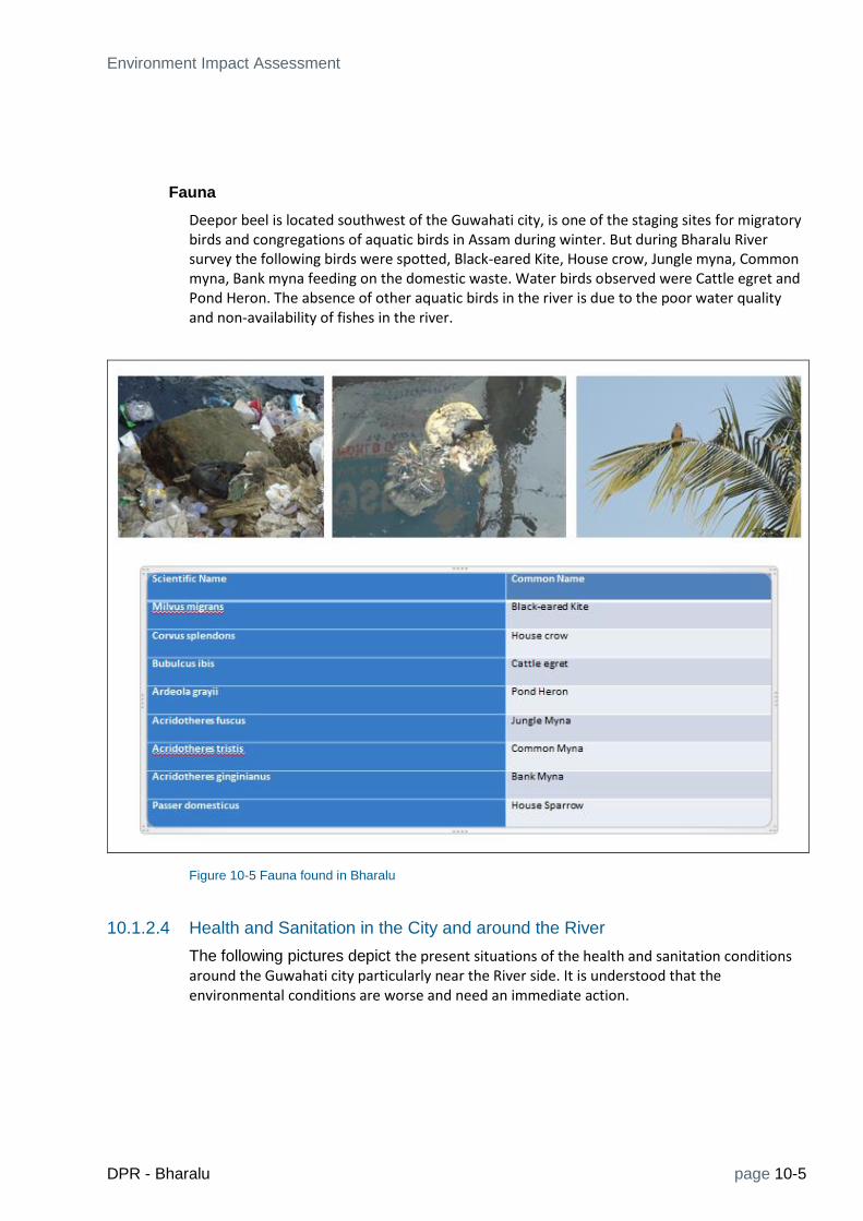
Environment Impact Assessment
DPR - Bharalu page 10-5
Fauna
Deepor beel is located southwest of the Guwahati city, is one of the staging sites for migratory birds and congregations of aquatic birds in Assam during winter. But during Bharalu River survey the following birds were spotted, Black-eared Kite, House crow, Jungle myna, Common myna, Bank myna feeding on the domestic waste. Water birds observed were Cattle egret and Pond Heron. The absence of other aquatic birds in the river is due to the poor water quality and non-availability of fishes in the river.
Figure 10-5 Fauna found in Bharalu
10.1.2.4 Health and Sanitation in the City and around the River
The following pictures depict the present situations of the health and sanitation conditions around the Guwahati city particularly near the River side. It is understood that the environmental conditions are worse and need an immediate action.

page 10-6 DPR - Bharalu
Open toilet block along Bahini River Newly constructed open toilet block
Mosquito Larva Mosquito Breeding
Fish Market waste (Beltola Market) Chicken shop waste inside the river
Dead animal floating on the river Solid waste dumping

Environment Impact Assessment
DPR - Bharalu page 10-7
10.1.2.5 Socioeconomic and Livelihood
Deepor beel provides a means of livelihood for a number of local families. Nymphaea nuts, flowers, etc., are harvested for sale in the local markets and these constitute valuable natural crops. The seeds of giant water lily, annually leased by the government revenue department, are also another major source of revenue after fish.
Cultivation of edible plants, ginger, flowers, grazing, feeding ground for ducks, washing, bathing, fishing. People collect the corms for sale, and the blades and petioles are collected as fodder for pigs
Fodder collection
Grasses from swampy area are collected for fodder purpose, during our survey we identified Colocasia esculenta leaves and petioles are collected as fodder for pigs and Eichornia crassipes leaves and petioles are collected as fodder for cows.
Wild Taro collection Water hyacinth Collection
Livestock and Poultry
Animal husbandry is a sub-sector of agricultural economy and plays a significant role in rural economy by providing gainful employment to the small and marginal farmers, women and agricultural labourers. During our survey we identified that livestock and poultry rearing is common in the outskirts of Guwahati. The identified animals are cattle, goat, sheep, pig, fowl and duck. Vegetation on the river banks provides grazing opportunity to cattle, goat and sheep. Livestock’s plays an important role in economy through production of Milk, Egg and Meat.

page 10-8 DPR - Bharalu
Agriculture/Horticulture
There are no agricultural activity observed along the river side, there are some minimal horticulture activities like ginger, vegetable and flower cultivation for their own use were observed.
Ginger cultivation Vegetable and flower cultivation
10.2 Proposed Actions to restore Bharalu River and its Environmental Impacts
When identifying the potential impacts of a new project on the existing environment, such as the proposed Restoration of Bharalu River, it is necessary that it should be measured against the existing baseline conditions. Construction of sewer line with sewage treatment plant and there after operation of this system, if undertaken without a proper understanding of the relationships inherent in environmental function, can be accompanied by disruptions to the environment, from which it may take a long time to
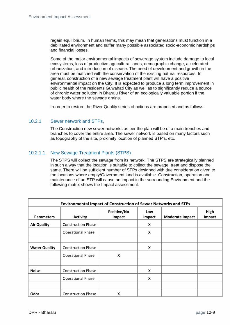
Environment Impact Assessment
DPR - Bharalu page 10-9
regain equilibrium. In human terms, this may mean that generations must function in a debilitated environment and suffer many possible associated socio-economic hardships and financial losses.
Some of the major environmental impacts of sewerage system include damage to local ecosystems, loss of productive agricultural lands, demographic change, accelerated urbanization, and introduction of disease. The need of development and growth in the area must be matched with the conservation of the existing natural resources. In general, construction of a new sewage treatment plant will have a positive environmental impact on the City. It is expected to produce a long term improvement in public health of the residents Guwahati City as well as to significantly reduce a source of chronic water pollution in Bharalu River of an ecologically valuable portion if the water body where the sewage drains.
In-order to restore the River Quality series of actions are proposed and as follows.
10.2.1 Sewer network and STPs,
The Construction new sewer networks as per the plan will be of a main trenches and branches to cover the entire area. The sewer network is based on many factors such as topography of the site, proximity location of planned STP’s, etc.
10.2.1.1 New Sewage Treatment Plants (STPS)
The STPS will collect the sewage from its network. The STPS are strategically planned in such a way that the location is suitable to collect the sewage, treat and dispose the same. There will be sufficient number of STPs designed with due consideration given to the locations where empty/Government land is available. Construction, operation and maintenance of an STP will cause an impact in the surrounding Environment and the following matrix shows the Impact assessment.
Environmental Impact of Construction of Sewer Networks and STPs
Parameters Activity Positive/No
Impact Low
Impact Moderate Impact High
Impact
Air Quality Construction Phase
X
Operational Phase X
Water Quality Construction Phase X
Operational Phase X
Noise Construction Phase X
Operational Phase X
Odor Construction Phase X

page 10-10 DPR - Bharalu
Environmental Impact of Construction of Sewer Networks and STPs
Parameters Activity Positive/No
Impact Low
Impact Moderate Impact High
Impact
Operational Phase X
Socio-Economic Construction Phase X
Operational Phase X
Cultural Construction Phase X
Operational Phase X
It can be seen that the construction of Sewer networks and STPs will have positive impact on Water Quality, Odor, Cultural and Socio-Economics. The construction of the proposed sewage treatment plant may generate noise during the constructional phase due to activities of loading unloading, material handling and machine operation equipment & vehicular movement. The main sources of noise during the operations phase would include compressor and pumping station, producing wells (including occasional flaring), and vehicle traffic. Other noise pollution during operation would be generated by other mechanical equipment, and sludge dewatering units. During the operational phase of STP’s there will be some noise due to the aerators and other machineries but predicted to be very low.
Inlet chamber, grit channels, screening and grit handling, aeration tanks, and sludge holding and dewatering units are the main sources of odor at the Sewage treatment plant during the operational times.
During the treatment of the Sewerage there will be some release of toxic gases which is a part of the Sewerage Treatment Plants, in the case of a domestic waste the impact expected will be low. The major temporary air pollution is dust generated as a result of these construction works. Cutting and welding operation, loading-unloading, operation is mainly responsible for the release of SPM, SO2, NOx, etc. However the overall impact may be rated as direct, short-term, adverse, and reversible.
The primary emission sources during the operations phase would include compressor and pumping station operations, vehicular traffic, carbon dioxide and a small quantity of Hydrogen sulphide may be produced in Aerobic Tank.
There will not be any adverse impact on the ground water quality since the treated effluent will be within the standards prescribed by the Assam Government. The contaminated discharge will be highly reduced in the River and over a period of time the restoration of natural process, like self-cleaning of the river will enhance. Also, this activity will provide employment to the people during the constructional and operational phase hence creating a positive impact due to this project.
10.2.2 River Front Development Activities
The Water front development activities are planned along the Bharalu about 2 km distance. This basically to enhance the River front and helping the shareholders to

Environment Impact Assessment
DPR - Bharalu page 10-11
sworn the ownership. There will be new walkways and the river banks will be stabilised fro people to walk safely.
The Borosola beel development activities include constructing aeration fountains, walkway improvement, repair of sluice gates, walls etc., to enhance the aesthetic value of the River banks are planned. Some of these activities may cause an Impact to the Environment, the details are detailed below.
Environmental Impact of River Front Development Activities
Parameters Activity Positive/No
Impact Low
Impact Moderate Impact High
Impact
Air Quality Construction Phase X
Operational Phase X
Water Quality Construction Phase X
Operational Phase X
Noise Construction Phase X
Operational Phase X
Odor Construction Phase X
Operational Phase X
Socio-Economic Construction Phase X
Operational Phase X
Cultural Construction Phase X
Operational Phase X
The river front development activities will mainly improve the water quality in the River and due course of time the River will restore its lost glory. It is expected that the River restoration will generate socio-economic value of the people surrounding. This is because, once the River started to restore the zooplankton (fish, etc) will came to life again leading to fish catching and the treated water can be used for other domestic purposes. Also, this activity will provide employment to the people during the constructional and operational phase hence creating a positive impact due to this project.

page 10-12 DPR - Bharalu
10.2.3 Water Augmentation schemes and Desilting operations in Bharalu River
The Water Augmentation in Bharalu is planned by reopening the sluice gate in Bahini from Basistha with a new structure in Basistha and trenchless pipe in respected areas. The detailed project features are described below,
1. Construction of new sluice gate to divert water to the Bahinin at Nutan Bazaar
2. Construction of RCC channel to reactivate the Bahini flow.
The above two constructions will have no impact on the environment because they will be constructed in available land along the road.
The Desilting of Bharalu including removal of solid waste is a major project component. The desilting will be carried out along Bahini, Bharalu and the ded Bharalu rivers.
The following EIA matrix describes the activity Impacts.
Environmental Impact of Water Augmentation and Desilting operations in Bharalu River
Parameters Activity Positive/No Impact Low
Impact Moderate Impact High
Impact
Air Quality Construction Phase X
Operational Phase X
Water Quality Construction Phase X
Operational Phase X
Noise Construction Phase X
Operational Phase X
Odor Construction Phase
X
Operational Phase X
Socio-Economic Construction Phase
X
Operational Phase X
Cultural Construction Phase X
Operational Phase X
Low environmental impacts are predicted during the construction phase. The construction activities may cause some noise and while removing the solid waste in the river will cause odor problems of low intensity. And during the construction phase of the

Environment Impact Assessment
DPR - Bharalu page 10-13
trenchless pipes, new control structure in Basistha with a sluice gate, Construction of Upstream & downstream connecting structures, including site cleaning, etc., may invite some social disturbances.
10.2.4 Community toilets/ sanitation
The people living along the River side have practicing the open toilet system which creates lot of health problems and the sanitation of the area becomes worst. In-order to improve the living conditions and sanitation along the riverside community toilets were proposed at necessary places.
When it comes down to it, maintenance is the crux of the whole project. It’s also the key area where one could see a long-term role for community participation for successful implementation of Community toilets and its persistent operation. A community awareness has to be planned so that the people who use the toilets, to manage it themselves. The proposed Toilets and Sanitation systems are planned for such sustainable long term use which will highly beneficial for the River restoration and improving the water quality and sanitation and also the health benefits.
Environmental Impact of Construction of Community Toilets and Sanitation
Parameters Activity Positive/No Impact Low
Impact Moderate Impact High
Impact
Air Quality Construction Phase X
Operational Phase X
Water Quality Construction Phase X
Operational Phase X
Noise Construction Phase X
Operational Phase X
Odor Construction Phase X
Operational Phase X
Socio-Economic Construction Phase X
Operational Phase X
Cultural Construction Phase X
Operational Phase X

page 10-14 DPR - Bharalu
It is expected that there will not be any environmental damage due to the Construction of Community toilets and in other hand it will help to improve the sanitation of the locality.
10.2.5 Solid waste management (collection, transport and disposal).
The most obvious environmental damage caused by solid wastes is aesthetic, the ugliness of street litter and degradation of the urban environment and beauty of the city. More serious, however, and often unrecognized, is the transfer of pollution to water, ground water. Air pollution can be caused from the inefficient burning of wastes, either in open air, or in plants that lack effective treatment facilities from the gaseous effluents.
Solid Waste Management involves various activities like storage, collection, transportation, disposal etc. These activities even if properly controlled and with proper precautionary measures adopted, may have adverse impact on land, water and air environment, human and environmental health, aesthetics and quality of life. The Environmental Impact Assessment may help in assessing the potential adverse effects of these activities and in formulation of precautions which could prevent these effects from taking place.
The city has a major problem in solid waste management particularly the collection and disposal. The solid waste disposal in hap hazard manner creates a huge problem for the municipality. The leachetes, direct disposal of solids into the River, runoff, turns the River into septic conditions. Unless an organic waste is appropriately managed, its adverse impact will continue until it has fully decomposed or otherwise stabilized. Uncontrolled or poorly managed intermediate decomposition products can contaminate air, water and soil resources. The wards were identified where the solid waste generation is of high threat to the Bharalu River. Hence it is proposed to have a proper solid waste management system for the wards with due interest to the collection, transport and disposal of the solid waste.
Environmental Impact Assessment of Solid Wate System
Parameters Activity Positive/No Impact Low
Impact Moderate Impact High
Impact
Air Quality Construction Phase X
Operational Phase X
Water Quality Construction Phase X
Operational Phase X
Noise Construction Phase X
Operational Phase X
Odor Construction Phase X
Operational Phase X

Environment Impact Assessment
DPR - Bharalu page 10-15
Environmental Impact Assessment of Solid Wate System
Parameters Activity Positive/No Impact Low
Impact Moderate Impact High
Impact
Socio-Economic Construction Phase X
Operational Phase X
Cultural Construction Phase X
Operational Phase X
The solid waste management system will facilitate improvement of water quality in and around the Bharalu River and the Ground water Conditions by avoiding the unhygienic disposal of the raw solid waste in to the River and avoiding leachates during rainy seasons. Most development activities are expected to have a beneficial effect on human health by increasing the resources available for food, education, employment, water supply, sanitation and health services. Proper management of solid waste should have minimum effects on environment and health impacts.
10.3 Concluding Remarks
The Environment Impact Assessment gives the following facts.
The proposed project activities will not result in any significant negative impact to Environment. Instead, various beneficial impacts have been envisaged.
The proposed measures will give a positive impact in all sectors/segments and will help to improve the river water quality to a great extent.


Stakeholder Involvement
DPR - Bharalu page 11-1
11 Stakeholder Involvement
The success of development largely lies in adopting an integrated or holistic approach that takes into account the considerations of the stakeholders, especially the people for whom it is primarily intended. Accordingly a participatory approach was used during the preparation of the DPR both at the field level and institutional levels. Specific attention was given to the people living near the river banks. Figure 11-1 illustrates a common interests form three key sectors – Public, private and the civil society/community.
Figure 11-1 Common Interest sectors for river restoration
11.1 Initial fact finding meetings
After the contract signing, consultants visited various departments and local authorities to collect the data and information about the project. The discussions also were help with the locals.
Pollution Control Board
Water Resource Department
Guwahati Metropolitan Development Authority
Town and Country Planning
Guwahati Municipal Corporation
Other government/non-government agencies related to this project
Local Community

page 11-2 DPR - Bharalu
Table 11-1: List of officials with whom the consultations were held.
11.2 Community consultations
The Table 11-1 shows a list of some of the officials and others consulted so far. Various community members, who are concerned with the conditions of the Bharalu River, were consulted at different locations. They provided valuable suggestions to restoration of Bharalu. The consultation is an on-going process and during the course of the project the consultations will be continuing.
The Inception report along with initial recommendations of conservation measures were presented to PCBA at the Inception Workshop held on December 4, 2013. Suggestions and feedback obtained from the PCBA team and invited experts were considered in the CSP as well as are being incorporated in the DPR. The consultant team interviewed several members of the community, who reside along the Bharalu river and are affected by the present quality of river. A resident indicated that the increased flow of freshwater from the Basistha into the Bahini by opening the existing sluice gate (which has been permanently closed) will help to improve the river conditions (Figure 11-2).
During the field visits to Guwahati town, especially in Zone 1, where Bharalu exists, the consultations with local people at various places along the Bharalu river were held about water quality, Sanitation and Sewerage etc.
The consultant team met a group of morning walkers, who emphasized the need for a clean river (Figure 11-2). A lady who lives in close proximity to the bank of the Bharalu explained the flooding/water logging issues faced by the residents during the rainy season (Figure 11-3). A street vendor who runs a makeshift tea stall directly over the Bharalu, selling food to locals indicated that his business will expand significantly, if the Bharalu was cleaned as it will attract more people to buy food from his shop (Figure 11-3).

Stakeholder Involvement
DPR - Bharalu page 11-3
Figure 11-2: Interactions with local people during field trips in Guwahati-I.
Figure 11-3 Interaction with public along Bharalu river

page 11-4 DPR - Bharalu
11.3 Inception Workshop
The inception report was presented in the Inception Workshop held on the 4th of December, 2013 to the Pollution Control Board. The workshop was chaired by Mr. Dubey, Chairman, Pollution Control Board Assam. Table 11-2 provides the list of participants who attended the Inception workshop.
Table 11-2: List of Stakeholder that attended the meeting on the 4th
December 2013.
S.No. Name Designation, Organisation
1 Mr. R M Dubey Chairman, Pollution Control Board
2 Mr. R.M.Das Consultant, GMDA
3 Mr. Dutta Consultant, PCBA
4 Mr. Gokul Bhuyan Executive officer, River and Lake conservation cell
5 Prof Chandan Mahanta Professor, IIT Guwahati
6 Dr Guna Nidhi Paudyal Managing Director, DHI (India)
7 Mr. Subrata Mazumdar Vice President, The Louis Berger Group (India)
8 Dr Flemming Jakobsen Technical Director, DHI (India)
9 Mr. Louis Ragozzino Waste Water Expert, The Louis Berger Group
10 Mr. Harshad Dhande Waste Water and Sewerage Expert, DHI (India)
11 Mr. Rajiv Sinha The Louis Berger Group, Inc.
12 Mr. Lalit Mohan Remote Sensing Expert, DHI(India) Water and Environment

Stakeholder Involvement
DPR - Bharalu page 11-5
13 Mr. Rupesh Gupta Project Coordinator, DHI(India) Water and Environment
14 Prof. Tarun Acharya Solid Waste Management, The Louis Berger Group
15 Mr. Ayan Dey Cost Estimation Expert, The Louis Berger Group
The agenda of the workshop, in addition to discuss the Inception Report, was to review the overall progress of the project, identification of pollution sources and possible solutions to conserve the river as per NRCD guidelines. The suggestions of the committee members and experts present in the work shop are provided below:
All the experts and officials from PCBA mentioned that the flow augmentation from Basistha river into Bahini river should be considered, so that some flow is there in Bharalu. The possibility of maintaining the Flow in Bharalu by using sluice gate and weir at Basistha river should be given a thought.
Sewage Collection and Treatment, including Decetralized STPs.
Solid Waste Collection and Management, particulrly along river banks
No use of plastic bags (subsidized jute/cloth bags)
Removal of Legacy Pollution from river bed with measures like dredging
Improving hygiene and sanitation conditions by community toilets and hygienic facilities like provision of washing and bathing ghats
Community access and benefits by providing human connections to the waterway using greenways along the waterfront and points of interest
Awareness to educate the community on conservation features and ecological resources.
Setting of monitoring systems for flood and water quality monitoring as well as generating warnings & dissemination.
11.4 Stakeholder Consultation Workshop
After the submission of City Sanitation Plan for Guwahati, covering Bharalu river stretch, the stakeholder meeting was held on 18th December, 2013 by Pollution Control Board Assam (PCBA) in Guwahati to discuss various option proposed by consultant and the findings during the study. List of stake hoders who attended the meeting is given in Table 11-3.
Table 11-3: List of stake holders that attended the meeting on the 18th
December 2013.
SI No.
Details of Attending Stakeholder
Name Designation Association Contact Phone #
1 R. M. Dubey Chairman PCBA +91 9435067690

page 11-6 DPR - Bharalu
2 A. K. Jowari Chief Conservator of Forests Forest Dept +91 8876565345
3 Kumar Sanjay Krishal Principal Secretary Forest Dept +91 9864844444
4 V. B. Pyarelal Additional Chief Secretary GDD & PDD
5 M. M. Borah CE GMC +91 9435031675
6 R. M. Das Consultant and Member NRLCC GMDA +91 9864046288
7 Gokul Bhuiyan Executive Officer PCBA +91 9435348580
8 Moloy Bora Joint Secretary F&E
9 D. Bezbaruah Deputy Director T&CP +91 9435031895
10 P. K. Dutta AEE AUWSSB
11 Bhaskar J. Sarmah AEE WRD +91 9435062926
12 P. Hazarika SE WRD +91 9435046645
13 Subrata Mazumdar Vice President LBG +91 9811102882
14 Raed El-Farhan Vice President LBG
15 Guna Nidhi Paudyal Managing Director DHI
16 Jaideep Baruah
17 Rakesh Roymedhi Secretary General ACC +91 9864538045
18 Ranjan Kalita Director Assam Prabha
19 Uttanarn Dutta CEE Northeast +91 9401834609
20 Biplab Barman CEE Northeast +91 9707679776
21 Representative Library and Cultural Research DoE +91 9435547445
22 Dhorajendra Nath Das SEE PCBA +91 9935308456
23 Mousumi Bardalah Assistant Executuve Engineer PCBA +91 8876508998
24 K. K. Dutta PCBA
26 I. Dey AEE PCBA
27 M. Bora Senior Environmental Engineer PCBA
28 P. C. Nath Executive Engineer PCBA
29 Rajiv Sinha Principal Engineer LBG +91 3022641192
30 Tarun Acharya Solid Waste Consultant LBG +91 9891216351
31 Flemming Jakobsenn Technical Director DHI +91 9910032436
32 Lalit Mohan GIS Specialist DHI
33 Sandeep Gupta Environmental Engineer DHI
34 R. Samuel Devadoss Coastal Engieer DHI
Stakeholder meeting started at 11.00am and Chairman, PCBA explained the project to stakeholders and also requested to give their opinion on the options proposed by consultants for waste water and solid waste management in City sanitation Plan. After that Dr. Guna from DHI presented the problems of Bharalu River and various measures planned for Bhralu river conservation. His presentation focused on the following points.

Stakeholder Involvement
DPR - Bharalu page 11-7
1) Sources of pollution the river Bharalu.
2) Solid Waste Management along the Bharalu river stretch in Guwahati
3) Possible measures for restoration of Bharalu river.
Mr. R. M. Dubey, Chairman of Pollution Control Board of Assam (PCBA) welcomed the attendees to the Stakeholder Meeting held on December 18, 2013 in Guwahati, Assam, India. Special mention was made to the presence of Mr. Krishnal, Principal Secretary, Forest Department of Assam, Mr, Pyarelal, Additional Chief Secretary of GDD & PDD. He also welcomed other representatives from various institutional stakeholders (namely, GMC, GMDA, WRD, Irrigation Department, etc
Mr. Krishnal, Principal Secretary, Forest Department of Assam thanked PCBA for taking the initiative about the restoration of Bharalu and Kolong Rivers. He also was appreciative that Government of India (GoI) had provided the funds for the creation of the Detailed Project Reports (DPRs). He indicated that the project has been going on for a while and was hopeful that the work being undertaken at this time will be successful in its objectives. With that he welcomed all the attendees to the Stakeholders Meeting.
Mr. Mazumder stressed upon the importance of the Stakeholder Meeting and obtaining input from all present in order to develop a more inclusive DPR. He indicated that it would be wise to consider the potential to install decentralized Sewage Treatment Plant (STP) within the footprint of the Bharalu to avoid land acquisition issues.
Mr. Raed El-Farhan,LBG, requested the stakeholders to ponder upon the proposed options and urged them to provide feedback, as it was crucial to the formulation of the DPR.
Mr. Dubey explained how the water quality of Bharalu will be augmented by bringing it from Bahini as the existing control structure/sluice gate had been closed for over 20 years. Mr. Mazumder stated that the proposal was to refurbish the sluice gate by installing underground pipe using trenchless pipe technology, thereby limiting the disruption in the lives of residents who live around the sluice gate structure. The goal would be to divert approximately 500 liters/second flow from Basistha into Bahini/Bharalu. Additionally, remote telemetry equipment will be installed in the Bharalu river system to enable monitoring of the water flow/level/quality measurements to control the flow between Basistha and Bahini.
Mr. Dubey agreed that it was a good plan as it was not desirable to have flood waters from Brahmaputra into the city. He continued that the DPR should also address measures to maintain minimum water level in Bharalu from Bharalumukh to Joymati Road/Borsola Beel to allow for river rafting and boating activities. It in his opinion will add beauty to the city.
Mr. R. M. Das, Consultant for GMDA requested information about the proposed plan of action for Dead Bharalu (Morabharalu). Untreated wastewater was finding its way from Basistha and Dead Bharalu into Deepor Beel and was deteriorating the condition of the beel to a point where its Ramsar site status may be withdrawn. He stated that by installing a STP for the city will help in restoring the water quality of the effluent entering the beel. Mr. Paudyal stated that the stakeholder’s opinion calls for restoration of Bharalu. He cautioned that if a centralized STP was installed, water from the Bharalu system will be returned back to the Bharalu rendering it dry. Therefore, Mr. Paudyal reiterated the proposal for multiple STPs along Bharalu. Mr. R. M. Das requested the the LBG/DHI team review the Noonmati Basin Project as it may provide solutions for

page 11-8 DPR - Bharalu
increasing the water flow in Bharalu from the Brahmaputra at the Bonda Sluice gate. He suggested that the LBG/DHI team discuss this further with GMDA.
There were questions about solid waste disposals from the participants to which Prof Tarun Acharya and Mr Dubey provided the explanations as well as also highlighted the limitations of this particular projects.
Mr. Dubey, thanked all attendees in the stakeholders meeting. He stated that the presentations for both Bharalu and Kolong River DPRs were an eye opener that the conservation and restoration of these river systems were in process. He noted that these two DPRs is a special initiative taken up by his Honorable Chief Minister (CM) of Assam for 2013-2015 and the goal was to present the findings for CM review by January 15, 2014. He explained that funds have been sectioned for restoration of the two rivers. He requested everyone present to send their frank comments and opinions expeditiously in the next two days to the Pollution and Conservation Cell of PCBA and additional stakeholder meeting will be held when the DPRs are ready. He asked all attendees to join for lunch and thereafter adjourned the meeting.
Figure 11-4 Stakeholders Meeting at Guwahati

Stakeholder Involvement
DPR - Bharalu page 11-9
11.5 Public Consultation Workshop
A public consultation workshop is planned to be held on 6 January 2014 at Guwahati to discuss the draft DPR and obtain feedback from public. The Draft DPR has been published in the PCBA Website (www.pcbassam.org). PCBA has published a general information in newspapers (Figure 11-5) informing the public about the DPR’s availability in its website as well as about the public consultation meetings on the 6th January 2014.
Findings of the consultation meeting will be incorporated in the Final DPR.
11.6 Consultation with other officials and individuals
The formal and informal discussions were held with the government officials from NMB, WRD, Forest Department, Agriculture Department, Town and Country Planning department, NE Council for Science and Technology, etc. The discussions also held with academicians from IIT, Guwahati, Assam Engineering College, Guwahati University, College of Fisheries. The informal discussions were held with the renowned retired personalities of government departments and academic institutions in Assam.

page 11-10 DPR - Bharalu
Figure 11-5 Public notie by PCBA

Education and Public Awareness Schemes
DPR - Bharalu page 12-1
12 Education and Public Awareness Schemes
12.1 Introduction
Any river conservation project to be implemented successfully, public awareness is of utmost importance. Unless the public are made aware about the irreversible damage and pollution caused by indiscriminate littering and dumping of waste and garbage in drains and water bodies connected to Bharalu River, the project cannot be implemented in true sense of the word to achieve conservation. Some members of the communities are already aware that there is a need for Bharalu conservation programme and that they will benefit from it. Hence, it should be ensured that;
The communities are effectively involved in all the stages of the project cycle from conceptualization, to preparation, to finalization, to implementation and finally O & M.
Public Awareness & Public Participation should be a front-end activity of the project.
The entire programme of conservation should be conceived, formulated, implemented, monitored and evaluated in close consultation with the stake holding communities.
Therefore, education and awareness programmes are key to the sustainability of the various components implemented as part of the river restoration project.
12.2 Enhancement of public awareness & public participation
The Bharalu river pollution is a manmade crisis which calls for concurrent initiative and intervention by several quarters including the public. The following activities will be carried out.
Sensitization of local population on the environmental crisis they have brought upon themselves in the form of polluting the Bharalu river.
Educating the public in scientific but simple terms about pollutants, untreated sewage and noxious matters in the Bharalu river and their impact on flora and fauna.
Educate the people on health problems (skin diseases, gastro-intestinal infection etc) arising out of using the polluted and dirty waters of Bharalu.
Educate the people and make them aware of the health hazards involved in the consumption of milk and meat products from animals that drink polluted water, as well as the consumption of vegetables grown on the beds and banks of polluted Bharalu river.
Educate the people and motivate them to segregate domestic waste and to use bio degradable packaging products.
Work with religious leaders to educate people regarding risks of immersion of idols in the rivers.
Provide information on STPs in different locations and other planned technical works, as it is likely to motivate them to adopt pollution prevention practices.

page 12-2 DPR - Bharalu
Low income households may be informed about low cost sanitation and stop open air defecation.
Organise extensive media campaign for different target groups, device messages, and choose medium, format and time slot so as to maximize campaign’s reach and impact. The campaign may draw upon traditional media (puppet show etc.) as well as modern media (street play, video clipping etc) to reach the message of river restoration. Develop procedure to obtain feedback of the presentations under the campaign, both in quantitative and qualitative terms so that mid course corrections are introduced and desired impact is obtained.
Organise exposure visit for community leaders, NGOs and civil society members to other states to observe best practices adopted in river restoration, hygiene and sanitation improvement.
In order to carry out the above activities successfully partnership will be required to be developed with NGOs and civil society including community based organizations (CBO). Therefore, a cost component is included in the project budget for these activities.
12.3 Education and awareness based on issues
Education and awareness programmes can be effective if they are conducted focussing on specific issues rather than on general aspects. In the conservation of the Bharalu River the public awareness and education will focus on the following issues:
To address the sources of pollutants causing the degradation of the Bharalu river. The most pressing issue is disposal of garbage into the river and its banks. Therefore, major efforts related to community education will be focussed on stopping the disposal of garbage near the river.
Development, improvement, use and maintenance of river front walkways, parks and other amenities. For example, the river front facilities may be flooded during monsoon. The community should be prepared on the flooding issues by installing a flood warning system. After the floods, he communities should be motivated to repair the facilities and clean them off accumulated sediments, debris and waste.
To remove existing encroachments and refrain from new encroachments in the river banks.
To utilize the open space along the river and organise socio-cultural and business activities.
12.4 Specific awareness campaign against for solid waste dumping
The main objectives of conducting public awareness programs is to educate public about the
effects of solid waste on the health, hygiene & environment and to encourage them in
participating solid waste management activities in order to safeguard the Bharalu River and its
surroundings from solid waste pollution.
The education plan must begin by introducing people to waste management needs and
concepts, explaining clearly how to participate, and then effectively encouraging them to adopt
the desired waste management behaviour. Once people are participating in the programme,
incentives and reinforcements can be used to maintain and increase participation rates.

Education and Public Awareness Schemes
DPR - Bharalu page 12-3
Developing an effective education programme requires planning and research. Different
strategies will need to be used for different groups, such as homeowners, apartment dwellers,
business people, slum dwellers, market committees, and school children. However, it must be
noted that awareness campaigns on SWM are effective when they are coordinated with
Municipal actions.
Prior to implementing Public Awareness Strategies the following base works are proposed to be
adopted by the PMU before implementation of full-fledged public awareness programmes.
Identification of Groups of People to be addressed
o Residential Areas: Community may be classified into three categories
High Income Group - the affording
Middle Income Group - educated, sensitive, less affording
Low Income Group – un-affording
o Markets /Commercial Area s/ Offices/ Banks etc.: These places may be classified
into three broad categories
Vegetable Markets
Shopping areas
Offices/Institutional areas
Identification of the Issues in Solid Waste Management for Which Community
awareness is Essential
(1) The Solid Waste Management involves several stages of activities where people's participation is critically required in some of them and the PMU has to do the rest of the work. It has been envisaged that people's participation is essential in the following issues and public awareness programme must include them with greater emphasis.
Reduce, Reuse & Recycling (R R R) of waste
Storage of organic/bio-degradable and recyclable waste separately at source
Not to throw the waste/litter on the streets/roads, drains, open spaces, water bodies, etc.
Responding adequately during primary collection of waste
Community storage/collection of waste in flats, multi-storied buildings, societies, commercial
complexes, etc.
Pay adequately for the services provided.
(2) Door to door collection system is proposed for primary collection system. Hence, it is very important to apprise the community of the system’s merits and demerits.
The actual public awareness program should be conducted in the three modes. In the first Mode, the
implementers (PMU) will provide information and directives to the citizens; in Mode II, people will directly
interact with the implementers at spot and in the third one people will convey their opinion and information to
the PMU to have feedback and action from PMU. For each mode of awareness, some tools and components
are recommended in Table 12.1 for sustainable progress of the programme.
Table 12.1: Tools and Components Required for Different Modes of Public Awareness Programs
MODE- I - Information dissemination
MODE-II – Interaction, dissemination and input of information
MODE-III- Input of information
Use of Print Media
Use of TV /
Mass Awareness Camp
Involvement of School Children
Opinion Survey
Information
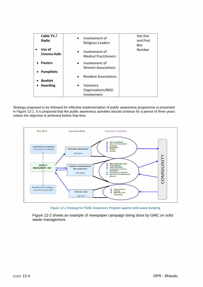
page 12-4 DPR - Bharalu
Cable TV / Radio
Use of Cinema Halls
Posters
Pamphlets
Booklet
Hoarding
Involvement of Religious Leaders
Involvement of Medical Practitioners
Involvement of Women Associations
Resident Associations
Voluntary Organizations/NGO involvement
Hot-line and Post Box Number
Strategy proposed to be followed for effective implementation of public awareness programme is presented
in Figure 12-1. It is proposed that the public awareness activities should continue for a period of three years
unless the objective is achieved before that time.
Figure 12-1 Strategy for Public Awareness Program against solid waste dumping
Figure 12-2 shows an example of newspaper campaign being done by GMC on solid waste management.

Education and Public Awareness Schemes
DPR - Bharalu page 12-5
Figure 12-2 GMC’s Newspaper campaign on Solid Waste (Source: Assam Tribune, 22 Dec 2013)

page 12-6 DPR - Bharalu
12.5 Partnership for education and awareness programmes
Partnership will be developed with a number of local and national agencies to plan, implement and coordinate the education and awareness programmes. Some of the known agencies are: Centre for Environment Education, Nature’s Beacon, Environ, Aaranyak, TERI (Northeast). Local community organizations like the Mahila Samity, Rotary club, Lion’s club, are also identified with a view to involve them on issues relating to protection and improvement and cleaning of the Bharalu River, and its sub-drains. A massive program of environment education and awareness is imperative for saving the Bharalu River from further degradation.
12.6 Monitoring
There will be monitoring of social issues like public awareness, and public participation in the project both at the initial stage and during the course of its progress. It is mostly seen that often in projects, success depends mainly on active participation of the public as well as their awareness and compliance to the specifications set out in the project. Although initial enthusiasm by the public is noticed in many projects, at the later stage, unless sufficiently monitored, public often becomes negligent and their interest fritters away. To sustain public awareness and participation, periodic monitoring is a must and whenever necessary, awareness campaign has to be undertaken.
12.7 Cost Estimate
The total cost for this component is estimated at INR 300.00 lakhs for the following sub- components
1. Development of IEC materials
2. Public awareness programmes including media campaigns
3. Partnership programmes with local and national resources centers, cultural groups etc.
4. Engagement of NGOs for 3 years
5. Exposure visits for community leaders, CBO and NGOstaff
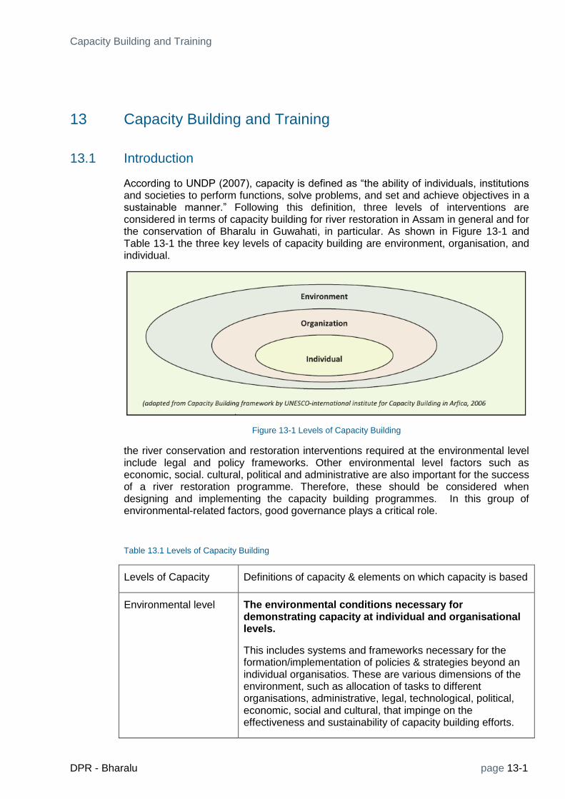
Capacity Building and Training
DPR - Bharalu page 13-1
13 Capacity Building and Training
13.1 Introduction
According to UNDP (2007), capacity is defined as “the ability of individuals, institutions and societies to perform functions, solve problems, and set and achieve objectives in a sustainable manner.” Following this definition, three levels of interventions are considered in terms of capacity building for river restoration in Assam in general and for the conservation of Bharalu in Guwahati, in particular. As shown in Figure 13-1 and Table 13-1 the three key levels of capacity building are environment, organisation, and individual.
Figure 13-1 Levels of Capacity Building
the river conservation and restoration interventions required at the environmental level include legal and policy frameworks. Other environmental level factors such as economic, social. cultural, political and administrative are also important for the success of a river restoration programme. Therefore, these should be considered when designing and implementing the capacity building programmes. In this group of environmental-related factors, good governance plays a critical role.
Table 13.1 Levels of Capacity Building
Levels of Capacity Definitions of capacity & elements on which capacity is based
Environmental level The environmental conditions necessary for demonstrating capacity at individual and organisational levels.
This includes systems and frameworks necessary for the formation/implementation of policies & strategies beyond an individual organisatios. These are various dimensions of the environment, such as allocation of tasks to different organisations, administrative, legal, technological, political, economic, social and cultural, that impinge on the effectiveness and sustainability of capacity building efforts.

page 13-2 DPR - Bharalu
Organizational level It refers to anything that will influence an organisation’s performance.
It includes: human resources (capacities of individuals in the organisation); physical resources (for example, facilities, equipment and materials) and capital; intellectual resources, management, process management (for example, problem solving skills, decision-making process and communications.); inter-institutional linkages (for example network and partnership); incentive and reward systems; organisational culture and leadership.
Individual (or Human Resources Development) Level. The will and ability of an individual to set objectives and achieve them using one’s knowledge and skills.
Individual capacity building is also referred to as human resources development. It includes knowledge, skills, values, attitude and health, and awareness. It can be developed through various ways such as formal, non-formal and/or informal education, training and on-the-job-training.
During the DPR preparation, two broad principles of capacity building were considered: i) emphasizing the ownership by organisations; and ii) recognising capacity building as a long-term process.
13.2 Institutional Arrangement
Many times there is an overlap in the roles of several bodies with the result that the efficiency with which the function should be performed suffers. The state Government needs to resolve such overlaps. The role of each institution involved needs to be very clearly specified. As the Bharalu River flows through diverse landscape, catering to various needs, multiple agencies can be having different roles in its management. That is why, an umbrella organization with core overall responsibility coordinating with all such bodies listed below will be necessary to avoid overlap or any conflict of interest.
Pollution Control Board of Assam
Guwahati Municipal Corporation
Guwahati Municipal Development Authority
Public Health Engineering Department, Assam
Town and Country Planning Department, Assam
Water Resources Department, Assam
The institutions that are involved in the conservation programme of the Bharalu River and the towns on its bank suffer from certain weaknesses that need to be overcome. Major among them are:
Lack of adequate and trained manpower
Lack of sufficient technical knowledge and awareness
Lack of decision making capacity
Lack of tools and utilities
Lack of coordination between concerned departments
Absence of an established institutional mechanism

Capacity Building and Training
DPR - Bharalu page 13-3
It is expected that with the formation of a dedicated agency with adequate devolution of power, most of the above shortcomings can be addressed.
13.2.1 Project management Unit
For the implementation of the project, a Project Management Unit (PMU) will be established under PCBA, which will take care of funds related to the project and manage the planning and implementation of the project. PMU will ensure a clear allocation of funds for the management of the activities related to the project and will orient the internal organization towards an integrated functioning of the project. Such board form of management will ensure a clear cut budget and allocation of expenditures, allows better management of tasks and integrated planning, execution and maintenance of the project. PMU will also coordinate with all the departments connected with the project and the general stakeholders. PMU will be supported by a Project Management Consultant (PMC) during the project implementation period. Capacity building needs of PMU include, but not limited to the following:
Administrative: Administrative capacity building would focus on strengthening of administrative functioning of the project and also to ensure accountability and transparency.
Legal: Legal capacity building initiative would include adherence to all regulations pertaining to river water pollution.
Project management: For the Successful project management, manpower skills would be enhanced through sufficient and relevant training, and sufficient physical and financial resources would be generated during the course of the project to deal with all the aspects mentioned above in all the phases of the project.
Human resources: Human resources are increasingly recognized as a key asset of any successful and visionary project plan. Poorly trained human resources leads to poor performance and functioning of the project and will lead to ill management and poor quality in performance. Human Resources Development will deal with appropriate skill development in the organizations involved in the planning, design and management of the project. The main activities are listed below.
13.3 Capacity Building Framework
Figure 13.2 presents a capacity building framework used for designing and implementing capacity building programmes.

page 13-4 DPR - Bharalu
Figure 13-2 Capacity building framework
13.4 Training needs Assessment
Human resources and related training needs are different for different fields. For example, for a sewerage system, there is the necessity of identifying the manpower training needs in managing the sewerage plants, power stations, in monitoring water quality and maintenance of equipment. skilled manpower is needed, particularly for maintenance of developed works, equipment and manning of the sewerage and pumping stations. For the handling of various instruments, special training is needed as good handling of the machine increases their lifespan; moreover, regular wear and tear of the machinery can be rectified and repaired by the project manpower if they are trained appropriately. This will go a long way in reducing unnecessary overhead costs.
Presently, different organizations viz. PHED, AUWS&SB and GMC are responsible in different areas of Guwahati cities for the issues related to Sewerage. Though most of the employees of the existing organizations are qualified by education required for the O & M of the Sewerage system, they are not trained to handle and properly operate and maintain, the latest equipment of drain cleaning. They are not aware of preventive maintenance, resulting in reoccurrence of flooding in same place during monsoon. Training on Concept of separate sewerage system and its merits and demerits is required.
Recruitment of trained engineering personnel for management of sewerage works is an important issue confronting the organizations in Assam. Special efforts to impart in-service training or continuing professional education should go along with employment of such personnel. In view of the rapidly changing pace of technology, engineers need to get updated periodically about newly incorporated instruments and technologies through

Capacity Building and Training
DPR - Bharalu page 13-5
training and workshops. Enhancement of knowledge, both operational and theoretical will help in running such services smoothly.
Training employees at different levels is recognized as an essential aspect in any public utility agency. However, training cannot end with just one course. To be effective, it has to be a continuous process. In Guwahati, due to lack of sufficient training of field staff, maintenance personnel and engineers, public utility systems like the GMC, GMDA do not function satisfactorily. It is therefore necessary to provide intensive training to the operation staff which may include:
Dealing with public and stakeholders
Importance of proper and efficient sewerage
Importance of proper and efficient sewerage system
Advanced training of handling instruments and other accessories required for
maintenance work
Training on maintenance of instruments and works
Emergency restoration work after flooding and choking of drains
Efficiency in record keeping
others
The outcome of the training will include
Increased efficiency with advanced knowledge
Organizational uplifting including economics
Improvement in quality of Sewerage system;
Improved public relations; and
Improved public health conditions due to superior quality and efficient maintenance by trained O & M staff
The following training needs have been identified for the operational staff
Basic principle of Sewerage, catchment areas, runoff etc.
Basic Knowledge in the working of Sewerage cleaning equipments.
Reasons of blockage of drains
Reasons of Flooding & Flood mitigation methods
Preventive maintenance of electrical and mechanical equipment
Attending to minor repairs, major repairs – procedure to be followed
Log books – maintenance & upkeep of records
Importance of keeping good health and hygiene
Management crises in the operation & Maintenance
Local agencies are capable for providing technical training for operational staff. Some of them are:
Industrial Institute of Technology, Guwahati – This organization can conduct training for field staff
Government Engineering College, Guwahati conduct can short term courses for Sewerage
Institution of Engineers (India), Guwahati Center, can also conduct training course for O & M for field staff
The Indian Institute of Technology, Guwahati
State Resource Centre, Department of Public Health and Engineering, Guwahati
Staff College
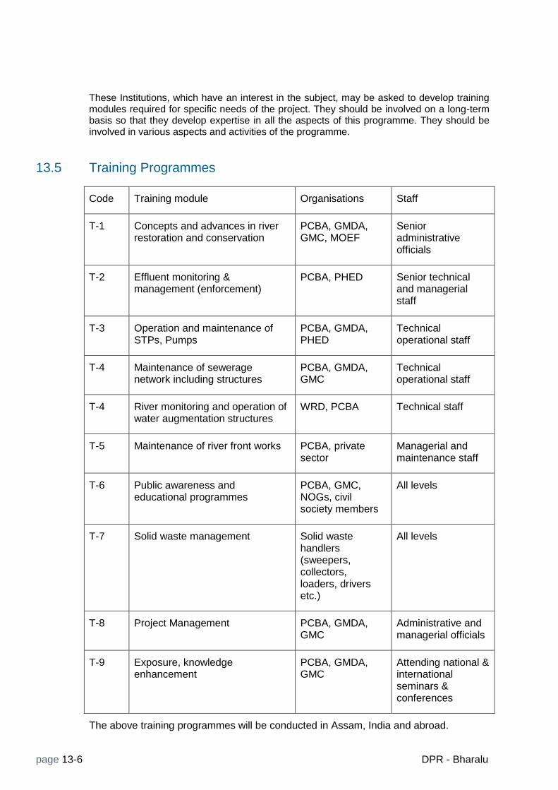
page 13-6 DPR - Bharalu
These Institutions, which have an interest in the subject, may be asked to develop training modules required for specific needs of the project. They should be involved on a long-term basis so that they develop expertise in all the aspects of this programme. They should be involved in various aspects and activities of the programme.
13.5 Training Programmes
Code Training module Organisations Staff
T-1 Concepts and advances in river restoration and conservation
PCBA, GMDA, GMC, MOEF
Senior administrative officials
T-2 Effluent monitoring & management (enforcement)
PCBA, PHED Senior technical and managerial staff
T-3 Operation and maintenance of STPs, Pumps
PCBA, GMDA, PHED
Technical operational staff
T-4 Maintenance of sewerage network including structures
PCBA, GMDA, GMC
Technical operational staff
T-4 River monitoring and operation of water augmentation structures
WRD, PCBA Technical staff
T-5 Maintenance of river front works PCBA, private sector
Managerial and maintenance staff
T-6 Public awareness and educational programmes
PCBA, GMC, NOGs, civil society members
All levels
T-7 Solid waste management Solid waste handlers (sweepers, collectors, loaders, drivers etc.)
All levels
T-8 Project Management PCBA, GMDA, GMC
Administrative and managerial officials
T-9 Exposure, knowledge enhancement
PCBA, GMDA, GMC
Attending national & international seminars & conferences
The above training programmes will be conducted in Assam, India and abroad.

Capacity Building and Training
DPR - Bharalu page 13-7
13.6 Cost Estimate
Code Training module No. of training (one week duration)
Training venue
No of trainees in one batch
Total Cost (lakhs)
T-1 Concepts and advances in river restoration and conservation
2 Thailand, Singapore
6 20.00
T-2 Effluent monitoring & management (enforcement)
2 India/ NEERI 6 10.00
T-3 Operation and maintenance of STPs, Pumps
1 Europe 6 5.00
T-4 Maintenance of sewerage network including structures
2 Guwahati (IIT, AEC)
10 8.00
T-4 River monitoring and operation of water augmentation structures
1 Europe 6 22.00
T-5 Maintenance of river front works
2 Guwahati 10 5.00
T-6 Public awareness and educational programmes
2 Guwahati 10 5.00
T-7 Solid waste management 6 Guwahati 25 10.00
T-8 Project Management 2 Guwahati (Staff college)
6 10.00
T-9 Exposure (seminars & conferences)
2 (national)
2 (int’l)
6 25.00
Total 120.00


Project Implementation Plan
DPR - Bharalu page 14-1
14 Project Implementation Plan
14.1 Project Management Unit
The Bharalu River Conservation project will be implemented by Project Management Unit (PMU) to be established at PCBA immediately after the DPR is approved. PMU will be headed by a Project Director appointed by the Government of Assam. The Project Director will be assisted by other officers and staff deputed to PMU by PCBA. One fo the key staff will be an Accounts Manager. Additional support staff will be hired form the project budget for the duration of the project, which is planned to be of 42 months. The first six months will be used for preparation of detailed designs, fine tuning of the conservation schemes, further consultation with stakeholders, site fixing, preparation of tender documents, obtaining required government approvals etc. Some of the planned capacity building activities will also take place from the beginning. The implementation of the conservation schemes will be completed in 3 years. The estimated cost of the Project Management Unit is given below.
Table 14.1 Cost estimate for the Project Management Unit
S.No. Item Qty Unit Rate Amount
1 Office furniture 1 LS 1000000 10,00,000
2 Computers & peripherals 1 LS 1000000 10,00,000
3 Vehicles 3 nos 1200000 36,00,000
local transportation 42 month 20000 8,40,000
4 Support staff 294 manmonths 40000 1,17,60,000
5 Review committee meetings 10 nos 10000 1,00,000
6 Travel of officers 10 trips 100000 10,00,000
7 Seminars and conferences 6 LS 500000 30,00,000
8 Communication 42 month 15000 6,30,000
9
office maintenace, supplies,
operation 42 month 25000 10,50,000
10 Sub Total 2,39,80,000
11 Contingencies 5% 11,99,000
12 GRAND TOTAL 2,51,79,000
14.2 Project Management Consultancy
The PMU will be supported by a Project Management Consultancy (PMC) in all its activities related to the implementation of the Project. The work of PMC is expected to commence from the beginning of the 42 months period. Activities of PMC will include, among others, Fine tuning of the plans and designs, detailed investigation required for some engineering conservation measures, preparation of engineering designs and specifications for construction, preparation of tender documents, assisting PMU in pre-qualification and selection of contractors and suppliers for various project components, check invoices and process payments, assist in management of accounts and assisting PMU in all other activities as required. PMC will be responsible for quality control of all works and will ensure timely completion of the project. PMC will also include the provision of expert services international and national experts for setting up the river monitoring and warning system.
The PMC will be headed by a Project Manager/Team leader supported by adequate number of staff.

page 14-2 DPR - Bharalu
14.3 Review and approvals
The Government of Assam will appoint a project committee to review and approve various documents, designs and tenders. The Project Director will be the member Secretary of the committee.
14.4 Monitoring and Evaluation
Periodic monitoring and evaluation will be carried out by PMU with the support of PMC, who will engage a separate team for monitoring and evaluation. The monitoring and evaluation reports will be reviewed and approved by the project committee.
14.5 Completion Reports
Completion reports will be prepared by PMC for all components and for the whole project for review and approval by the project committee and ultimately bythe government of Assam.
14.6 Schemes Implementation Plan
A GNAT Chart sowing implementation pan of the schemes is presented in Figure 14-1.

Project Implementation Plan
DPR - Bharalu page 14-1
Figure 14-1 Project Implementation Plan


Cost Estimate
DPR - Bharalu page 15-1
15 Cost Estimate
Bharalu DPR Summary of Cost
package
No. Package / Scheme Name Scheme description
Estimated Cost
(in crore) % of total
1 Water Augmentation
Water Augmentation by reopening the
sluice gate in Bahini from Basistha, weir in
Basistha, trenchless pipe 7.868 2.64
2 Desilting of Rivers
Desilting of Bahini, Bharalu & dead Bharalu
rivers including removal of solid waste 23.651 7.93
3 Intercepting system for DWF
Intercetor chambers with overflow
arrangement, interceptin conduit to STP 11.580 3.88
4 STPS Decentralised STPS 179.661 60.20
5 River Front Environment Water front development along Bharalu (2
km) 19.920 6.68
6 Borosola Beel developmentDevlopment of Borosola beel including
areation fountains, walkway improvemnet,
repair of sluice gates, walls etc 16.194 5.43
7 Solid waste management
Management of solid waste direclty
affectingn the river 6.978 2.34
8
Public awareness, education
and capacity building
Public awareness, capacitybuilding,
training, stakeholder engagement 4.043 1.35
9
Project Management Unit
(PMU)
Establsihment of project management unit,
operational costs, O&M for 5 years 2.518 0.84
10
River Monitoring & warning
System
Establsihment & operation of a river
monitoring and warning system 3.908 1.31
Sub total 276.319 92.59
11
Project Management
Consultancy (PMC) : 7 % for
PMC, 1 % for DPR cost
PMC incl. detailed design, tendering,
construction supervision and support to
PMU, expertise (consultatns) for the
establsihment of monitoring and warning
system @8% of total project cost 22.105 7.41
GRAND TOTAL (Crore Rs.) 298.424 100%

page 15-2 DPR - Bharalu
Package No. P-1
Scheme Name Water Augmentation
Component: RCC Channel and new sluice gate
S.No. Item Qty Unit Rate Amount
1
Construction of RCC covered channel along the side
road
2
1. Earthwork excavation in hard soil, including site
clearance, disposal of earth (2m x2mX500m+10%) 20200 cu.m 434 87,64,218
3 2. Form Work 3000 sq.m. 17,960 5,38,80,142
4 3. RCC (cement concrete grade 20) 400 cu.m. 6,467 25,86,959
5
4. Manholes with cast iron covers @ 100 m interval,
size 60 cm X 60 cm 5 No 8,063 40,314
6
Iron Sluice Gate, fabrication, transportation,
installation, painting, all complete 350 Kg 119 41,576
7
Site management before, during & after
construction (clearance, dewatering, etc.) 1 Lot 2,50,000 2,50,000
8 Sub total 6,55,63,209
9 Contengencies 5% 32,78,160
10
O&M cost for 5 years @2 % of capital cost, inflation
factor adjusted 98,34,481
TOTAL 7,86,75,850
Package No. P-2
Scheme Name
S.No. Item Qty Unit Rate Amount
1
Desilting of Bahini ( 8.7 km) from Nutan Bazar
to Jonali Bridge
1,28,282 cu.m.
2Desilting of Bharalu ( 7.0 km) from Jonali
Bridge to Bharalumukh 79,662
cu.m.
3
Desilting of Dead Bharalu (6.5 km) Sluice gate
at Shantipur to ISBT (ner confluence with
Basistha
63,343
cu.m.
4
Total desilting quantity including adidtional
10% fro unforeseen places 2,98,416
cu.m. 495 14,77,15,899
5
Cartage of excavated debris including
necessary loading, unloading and conveying
and disposing as directed, to a disposal site
(Distance = 5 KM)
2,98,416 cu.m. 251.1 7,49,32,247
4
Removal of solid waste from banks
(approximate length) 26 km 100000 26,00,000
5 Sub Total 22,52,48,145
6 Contingencies 5% 1,12,62,407
GRAND TOTAL 23,65,10,552
Desilting of Bharalu , Bahini and dead Bharalu

Cost Estimate
DPR - Bharalu page 15-3
Package No. P-3
Scheme Name Intercepting system for DWF
S.No. Item Qty Unit Rate Amount
1 Intercepting Chamber 42 No 750000 3,15,00,000
2 Interceptor 32 km 500000 1,60,00,000
3 Pumps 0 No 2000000 -
4 Repair of outfall drains 96 No 400000 3,84,00,000
5 Other ciivl and gate works 1 LS 10000000 1,00,00,000
11 Subtotal 9,59,00,000
12 Contingencies 5% 47,95,000
TOTAL 10,06,95,000
15 O&M costs for 5 Years 1 LS 1,51,04,250
15 Grand TOTAL 11,57,99,250
O&M Costs for 5 years
@ 2 % of the capital cost per year
includingescallation
2% 1,51,04,250.0
Package No. P-4
Scheme Name STPS
S.No. Item Qty Unit Rate Amount
1 Decentarlised STP 5 MLD, all inclusive 70 MLD 23730000 1,66,11,00,000
O&M cost 5 years 5 years 1,80,67,500 13,55,06,250
15 Grand TOTAL 1,79,66,06,250
O&M costs @ rs. 4000/MLD/day 1,80,67,500.00
Package No. P-5
Scheme Name River front Environment development
S.No. Item Qty Unit Rate Amount
1 3 km walkway on both sides 6 km 27500000 16,50,00,000
2 Lighting (Solar) 1 Lot 1000000 10,00,000
5 Subtotal 16,60,00,000
6 Contingencies 5% 83,00,000
7
O&M cost for 5 years @ 2% of capital cost per
year adjusted to excalation factor 2,49,00,000
Grand TOTAL 19,92,00,000

page 15-4 DPR - Bharalu
Package No. P-6
Scheme Name Borosola Beel development
S.No. Item Qty Unit Rate Amount
1 Borosola beel walkway 1650 m 25000 4,12,50,000
2 Pedestrain bridge 1 No 29700000 2,97,00,000
3 Outlet spillway structure 1 No 20000000 2,00,00,000
4 Dredging & landscaping 1 LS 40000000 4,00,00,000
5 Water Fountains 4 Nos 1000000 40,00,000
6 Subtotal 13,49,50,000
7 Contingencies 5% 67,47,500
8
O&M @ 2 % of capital cost per year
wuth escalation factor adjustment 2,02,42,500
9 Grand TOTAL 16,19,40,000
Package No. P-7
Scheme Name Solid waste management
S.No. Item Qty Unit Rate Amount
1 Providing screens at the outfalls of secondary drains 200 sq.m 5130 10,26,000
2
Providing storage containers at the existing secondary
solid waste collection points along the river stretch 92 No 75000 69,00,000
3 Procurement of vehicles for transporting solid waste 10 No 1800000 1,80,00,000
4 Subtotal 2,59,26,000
5 Contingencies 5% 12,96,300
6 O&M cost for 3 years 1 LS 4,25,53,350
7 Grand TOTAL 6,97,75,650
Operation & maintenance (annual)
1 Maintenance of screens @ 5% 200 sq.m. 256.5 51,300
2 Maintenance / replacement of containers @ 5% 92 no 3750 3,45,000
3
O&M of vehicles fuel (considering 3 trips per day
50km each trip) 90000 lit 60 54,00,000
SW Collection & segregration 12 mon 50000 6,00,000
4 Repair & maintenace of vehicles (5%) 10 no 90000 9,00,000
5 Drivers 10 120 mon 8000 9,60,000
6 Helpers 20 240 mon 5000 12,00,000
7 Total for 1 year 94,56,300
8 Total for 3 years including escallation. 4,25,53,350.00
After the project, GMC will take over the responsibility
of MSW management

Cost Estimate
DPR - Bharalu page 15-5
Package No. P-8
Scheme Name Education, Capacity building
S.No. Item Qty Unit Rate Amount
1 Development IEC materials 1 LS 2500000 25,00,000
2
Training of PCBA, GMC, GMDA and other
stakeholders 1 LS 1,20,00,000.00 1,20,00,000
3
Public awareness programs, including media
campaigns 3 Years 2500000 75,00,000
4
Partnership with local and national resource
centers, cultural groups etc 3 Years 2500000 75,00,000
5 NGO staff for 3 years 3 Years 2500000 75,00,000
6
Exposure visits for community leaders, CBO
and NGO staff 3 yaers 500000 15,00,000
7 Subtotal 3,85,00,000
8 Contingencies 5% 19,25,000
9 GRAND Total 4,04,25,000
Package No. P-9
Scheme Name Project Management Unit (PMU)
S.No. Item Qty Unit Rate Amount
1 Office furniture 1 LS 1000000 10,00,000
2 Computers & peripherals 1 LS 1000000 10,00,000
3 Vehicles 3 nos 1200000 36,00,000
local transportation 42 month 20000 8,40,000
4 Support staff 294 manmonths 40000 1,17,60,000
5 Review committee meetings 10 nos 10000 1,00,000
6 Travel of officers 10 trips 100000 10,00,000
7 Seminars and conferences 6 LS 500000 30,00,000
8 Communication 42 month 15000 6,30,000
9
office maintenace, supplies,
operation 42 month 25000 10,50,000
10 Sub Total 2,39,80,000
11 Contingencies 5% 11,99,000
12 GRAND TOTAL 2,51,79,000

page 15-6 DPR - Bharalu
Package No. P-10
Scheme Name River Monitoring & warning System
Sl No. Item QTY Unit Unit Cost (INR) Total Cost (INR)
1 Automatic Rainfall Station 5 No 1,50,000 7,50,000
2 Automatic River WL Station 2 No 3,00,000 6,00,000
3
Water Quality Stations
(excluding BOD) 4 No 8,50,000 34,00,000
SubTotal 47,50,000
5
Transport, Transit Insurance,
Installation 1 Lot 20% 9,50,000
6
Establishment of gauge-
discharge station 1 No 2,50,000 2,50,000
7
Current meter and related
accessories 1 Lot 1,00,000 1,00,000
8 Database Server 1 No 5,00,000 5,00,000
9 High End Desk Tops 5 No 80,000 4,00,000
10 Display (Plazma 51") 4 No 1,00,000 4,00,000
11 SCADA & data base software 1 No 12,00,000 12,00,000
12
Data integration and modelling
software 1 No 50,00,000 50,00,000
13 SubTotal 1,35,50,000
16 Continegcnies 5% 6,77,500
17 subtotal 1,42,27,500
18 O&M for 5 years 2,48,47,500
TOTAL 3,90,75,000
19
Consultancy for
implementation of the
monitoring, modelling and
warning system - included in
the PMC cost
O&M of the monitoring system
For one year
1
BOD Sampling and lab testing 4
stations, 52 weeks 208 No 1000 208000
2
Other water quality
parameters sampling & lab
testing (monthly) 48 No 10000 480000
3 Cost of moblie network use 11 No 10000 110000
4 Anual maintenance cost 1 years 10% 475000
5
Flow measurement (weekly) at
the G-D station - to be
outsourced to hydrologists 52 week 20000 1040000
6
Maintenance of hardware and
software at the SCADA Center 1 LS 1000000 1000000
7 Total for one year 33,13,000
8 Total for 5 years (incl. escallation) 2,48,47,500

Financial and Economic Analysis
DPR - Bharalu page 16-1
16 Financial and Economic Analysis
Being carried out


References
DPR - Bharalu page 17-1
17 References
NRCD (Ministry of Environment & Forests, National River Conservation Directorate, New Delhi). 2010. Guidelines for Preparation of Project Reports under National River Conservation Plan and National Ganga River Basin Authority. Prepared by Alternate Hydro Energy Centre, Indian Institute of Technology (December 2010).
Pollution Control Board, Assam 2010, Detailed Project Report for Conservation of River Bharalu. Prepared by Centre for the Environment, Indian Institute of Technology, Guwahati
2006. City Development Plan (July 2006) by GMDA.
The Energy and Resources Institute. Assam State Action Plan on Climate Change. Draft Report, 2012 – 2017, New Delhi.
Water Supply, Storm Water Drainage, Underground Sewerage & Road Restoration of Guwahati City under JNNURM, Detailed Project Report - Water Supply - South Guwahati Central Tahal Consultant,
District Disaster Management Plan, Kamrup Metropolitan district.
Eco-restoration strategy for wetlands in Assam: a case study in the southern part of Deepor Beel, Assam, India. Praschaya Kaushik, Department of Urban and Regional planning, CEPT University, Ahmadabad, India
Census of India 2011 data
Status of Water Quality in India- 2010 by Pollution Control Board
Pollution Control Board, Assam Water quality data for Bharalu 2004-2013.
Cross-Section of Bharalu, Water Resource Department, Guwahati Mechanical Division.
Cross-Section of Bahini River, Guwahati East, Water Resource Division.
Interim Project Report - Quantity And Characteristics Analysis Of Solid Waste Generated from Guwahati City, prepared by the Indian Institute of Technology Guwahati (Assam) in July – 2011 and submitted to the GMC
Concession Agreement between GMC and Guwahati Waste Management Company Private Limited with respect to the “Integrated MSW Management System Project”, February 2008.
Municipal Solid Waste (Management and Handling Rules), 2000 by MoEF, Government of India.
Manual on Municipal Solid Waste Management by CPHEEO, MoUD, Government of India.
Detailed Project Report on Integrated Waste Management Complex, Guwahati, submitted by Guwahati Waste Management Company Private Limited. Detailed Project

page 17-2 DPR - Bharalu
Report for Integrated Municipal Solid Waste Management System for Guwahati (Vol.1) prepared by IL & FS and ECOSMART, August 2006.
PCBA, City Sanitation Plan (CSP), Louis Berger Inc. and DHI (India) Water & Environment, December 2013.
PCBA, Project Feasibility Report (PFR) for Sewerage Scheme, Louis Berger Inc. and DHI (India) Water & Environment, December 2013.
UNDP, May 2007: Capacity Assessment methodology User’s Guide.

Annex -1: Water Quality Test Reports
DPR - Bharalu page 3
Annex -1: Water Quality Test Reports

page 4 DPR - Bharalu
Annex- 2: Maps

Annex- 3: Drawings
DPR - Bharalu page 5
Annex- 3: Drawings
(Presented in a separate Volume)

page 6 DPR - Bharalu
Annex- 4: Detailed Calculation of Dredging

Annex- 5: International and National Best Practices
DPR - Bharalu page 7
Annex- 5: International and National Best Practices

page 8 DPR - Bharalu