d:\data\mark cowin\calfed\surface storage\reservoir screening
TRANSCRIPT

IntegratedStorageInvestigation
Initial Surface Water Storage Screening
CALFED Bay-Delta Program1416 Ninth Street, Suite 1155Sacramento, California 95814
916-657-2666
August 2000

CALFED Bay-Delta Program Initial Surface Water Storage ScreeningAugust 2000i
Summary
This report summarizes the initial screening for potential new surface water storage reservoirs tohelp meet the objectives of the CALFED Bay-Delta Program. CALFED plans to use a variety ofwater management tools to improve water supply reliability for environmental, agricultural, andurban water uses. One of the water management tools CALFED is evaluating is new surfacewater storage. This report presents an initial screening of potential reservoir sites and a list ofpotential projects remaining for additional consideration by CALFED. The results of thescreening could be incorporated in a alternative analysis prepared as a component of a futureClean Water Act Section 404 permit application for one or more of these surface storageprojects.
CALFED began the initial screening with a list of fifty-two potential reservoir sites. The initialscreening was conducted to reduce the number of sites to a more manageable number for moredetailed evaluation during project-specific studies. CALFED eliminated sites providing less than200 TAF storage and those that conflicted with CALFED solution principles, objectives, orpolicies. Forty surface storage sites were removed from CALFED’s list during the initialscreening shown in the remainder of this report. CALFED is specifically looking for projectsthat could contribute significantly to CALFED’s multiple purpose objectives. These includepotential sites that could provide broad benefits for water supply, flood control, water quality,and the ecosystem. Those sites not retained for additional CALFED consideration may still becandidates for development by others for other purposes.
The initial screening resulted in a list (see following table) of twelve surface reservoir sites forfurther CALFED consideration. Based on existing information, some potential storage facilitiesappear to be more promising in contributing to CALFED goals and objectives and moreimplementable due to relative costs and stakeholder support. Subsequent evaluation will focuson surface storage sites with the most potential for helping meet CALFED goals and objectivesin Stage 1. These will include Shasta Lake Enlargement, Los Vaqueros Enlargement, and In-Delta Storage. In addition, CALFED will evaluate Millerton Lake Enlargement or equivalentand Sites Reservoir to better define benefits, impacts, and potential implementation. Investigations will be based on engineering, economic, and environmental considerations.

CALFED Bay-Delta Program Initial Surface Water Storage ScreeningAugust 2000ii
Potential Storage Retained for Additional CALFED ConsiderationGross Storage
Project Location Type Capacity
Storage Projects to Be PursuedShasta Lake Enlargement (6 to8 foot raise of existing dam)(Site 43)
Shasta CountySacramento River
On-Stream Storage Approximately 300 TAF Additional
Los Vaqueros Enlargement(Site 30)
Contra Costa CountyKellogg Creek
Off-Stream Storage 300-400 TAF Additional(up to 965 TAF potential)
In-Delta Storage (Site 14)
Sacramento/San JoaquinDelta
Island Storage in theDelta
250 TAF
Groundwater Conjunctive Use Sacramento Valley, SanJoaquin Valley & So. CA
Long-Term FundingLocally Supported
500 TAF - 1 MAF
Millerton Lake Enlargement orEquivalent(Site 32)
Fresno CountySan Joaquin River
On-Stream Storage Additional 720 TAF
Sites Reservoir(Site 44)
Colusa and Glenn CountiesFunks & Stone Corral Cks
Off-Stream Storage 1,200 to 1,900 TAF
Storage Projects to be DeferredIngram Canyon Reservoir[Complete ongoing estimates ofcost, benefits and impacts, thenno further action](Site 25)
Stanislaus CountyIngram Creek
Off-Stream Storage 333 to 1,201 TAF
Montgomery Reservoir(Site 34)
Merced CountyDry Creek
Off-Stream Storage 240 TAF
Panoche Reservoir(Site 37)
Fresno CountySilver Creek
Off-Stream Storage 160 to 3,100 TAF
Quinto Creek Reservoir (Site 39)
Merced/Stanislaus CountyQuinto Creek
Off-Stream Storage 332 to 381 TAF
Colusa Reservoir Complex (Site 9)
Colusa/Glenn CountiesFunks Creek
Off-Stream Storage 3,300 TAF
Schoenfield Reservoir portion ofthe Red Bank Project (Site 40)
Tehama CountyS.F. Cottonwood Creek
Off-Stream Storage Schoenfield-250 TAF
Thomes-Newville Reservoir(Site 48)
Glenn CountyThomes & Stoney Creek
Off-Stream Storage 1,840 - 3,080 TAF
CALFED Bay-Delta Program Initial Surface Water Storage ScreeningAugust 2000iii
TABLE OF CONTENTS
Page
SUMMARY . . . . . . . . . . . . . . . . . . . . . . . . . . . . . . . . . . . . . . . . . . . . . . . . . . . . . . . . . . . . . . . . . i
INTRODUCTION . . . . . . . . . . . . . . . . . . . . . . . . . . . . . . . . . . . . . . . . . . . . . . . . . . . . . . . . . . . . 1
Background . . . . . . . . . . . . . . . . . . . . . . . . . . . . . . . . . . . . . . . . . . . . . . . . . . . . . . . . . . . . 1Clean Water Act Section 404 . . . . . . . . . . . . . . . . . . . . . . . . . . . . . . . . . . . . . . . . . . . . . . . 2Screening Process . . . . . . . . . . . . . . . . . . . . . . . . . . . . . . . . . . . . . . . . . . . . . . . . . . . . . . . 3
INITIAL SCREENING . . . . . . . . . . . . . . . . . . . . . . . . . . . . . . . . . . . . . . . . . . . . . . . . . . . . . . . . 4
Inventory . . . . . . . . . . . . . . . . . . . . . . . . . . . . . . . . . . . . . . . . . . . . . . . . . . . . . . . . . . . . . . 4Small Storage Capacity Screening . . . . . . . . . . . . . . . . . . . . . . . . . . . . . . . . . . . . . . . . . . 10Conflict with CALFED Objectives, Solution Principles, or Policy . . . . . . . . . . . . . . . . 11
SITES REMAINING FOR ADDITIONAL CALFED CONSIDERATION . . . . . . . . . . . . 30
West Side Sacramento Valley . . . . . . . . . . . . . . . . . . . . . . . . . . . . . . . . . . . . . . . . . . . . . 30East Side Sacramento Valley . . . . . . . . . . . . . . . . . . . . . . . . . . . . . . . . . . . . . . . . . . . . . . 35West Side/Off-Aqueduct San Joaquin Valley . . . . . . . . . . . . . . . . . . . . . . . . . . . . . . . . . 35In- or Near-Delta . . . . . . . . . . . . . . . . . . . . . . . . . . . . . . . . . . . . . . . . . . . . . . . . . . . . . . . 36East Side San Joaquin Valley . . . . . . . . . . . . . . . . . . . . . . . . . . . . . . . . . . . . . . . . . . . . . 37
CONTINUING EVALUATIONS . . . . . . . . . . . . . . . . . . . . . . . . . . . . . . . . . . . . . . . . . . . . . . . 40

CALFED Bay-Delta Program Initial Surface Water Storage ScreeningAugust 20001
Introduction
This report presents results of this initial screening of potential CALFED surface water storage. This screening analysis could be used in future permitting processes under Section 404 of theClean Water Act.
Background
The Bay-Delta is the hub of California’s two largest water distribution systems - the CentralValley Project (CVP) operated by the U.S. Bureau of Reclamation and the State of California’sState Water Project (SWP). The CVP and SWP were built to provide river regulation,improvements in navigation and flood control, water supplies for irrigation, municipal, andindustrial uses, and hydroelectric power generation. In addition, at least 7,000 other permittedwater diverters, some large and some small, have developed water supplies from the watershedfeeding the Bay-Delta estuary. Together, these water development projects divert about 20percent to 70 percent of the natural flow in the system depending on the amount of runoffavailable in a given year.
There are approximately 1,400 existing surface storage reservoirs (those with dams 25 feet orhigher or those holding 50 acre-feet or more) in California that collectively hold more than 40million acre-feet of water. With this large number of existing reservoirs and with heightenedenvironmental awareness, it is becoming increasingly difficult to find and develop acceptablesurface sites to provide for increasing demands for water.
The CALFED Bay-Delta Program was established to reduce conflicts in the San FranciscoBay/Sacramento-San Joaquin Delta estuary (Bay-Delta) system by solving problems inecosystem quality, water quality, water supply reliability, and levee and channel integrity. TheProgram seeks to accomplish this by developing a long-term comprehensive plan that willrestore ecological health and improve water supply and water supply reliability for beneficialuses of the Bay-Delta system.
As summarized in the CALFED Phase II Report (July 2000), the primary water supply reliabilityobjective of the Program is to "Reduce the mismatch between Bay-Delta water supplies andcurrent and projected beneficial uses dependent on the Bay-Delta system." CALFED hasamplified this objective by developing a strategy to improve water supply reliability. To guidethe implementation of this multi-part strategy, CALFED identified three primary goals:
C Goal A: Increase the utility of available water supplies (making water suitablefor more uses and reuses).
C Goal B: Improve access to existing or new water supplies, in an economicallyefficient manner, for environmental, urban and agricultural beneficial uses.

CALFED Bay-Delta Program Initial Surface Water Storage ScreeningAugust 20002
C Goal C: Improve flexibility of managing water supply and demand in order toreduce conflicts between beneficial uses, improve access to water supplies, anddecrease system vulnerability.
The Program's water management strategy for meeting these goals is to further develop andutilize all appropriate water management tools available in a coordinated fashion. Since thehydrology of the Bay-Delta system is extremely variable, management of water to satisfy thewide array of demands (environmental, agricultural, and urban) requires water managers to use awide array of tools. These tools include water conservation, surface and groundwater storageand releases, recycling, transfers, conjunctive use, and control of source water quality.
CALFED completed the Final Programmatic Environmental Impact Statement/EnvironmentalImpact Report (EIS/EIR) in July 2000. A programmatic EIS/EIR, also referred to as a first-tierdocument, is typically prepared for a series of actions that can be characterized as one largeproject and is required for actions proposed by or approved by State and Federal agencies. Sincethis work is programmatic in nature, it is intended to help agencies and the public makedecisions on the broad methods to meet program objectives. It is not intended to define theproject-specific actions that will ultimately be implemented. As part of this work, CALFEDdeveloped a Preferred Program Alternative and an implementation plan for Stage 1 of theProgram.
As mentioned above, new surface storage is one of the water management tools that can be usedwith others to improve water supply reliability. In addition, analysis conducted for theEnvironmental Water Account (EWA) has shown a strong need for additional storage to make anEWA work. Without access to additional storage, it is much more difficult to acquire theresources (water) to make an EWA work and provide adequate fish protection, while at the sametime maintaining and improving water supply reliability. In the short term, the EWA will needto depend on water purchases/transfers, and this will dominate the water transfers market,making transfers more difficult and or more expensive for other water users. In the longer term,it appears that new or expanded storage will be necessary so that transfer water and conveyancecapacity can be made available for other users including upstream environmental users. Thosesites that clearly do not meet CALFED’s needs or those that clearly conflict with its goals orsolution principles can be eliminated from further CALFED consideration at this time.
Clean Water Act Section 404
Section 404 of the Clean Water Act requires that a project proponent obtain a permit from theU.S. Army Corps of Engineers (USACE) for activities that involve the discharge of dredged orfill material into waters of the United States (33 USC 1344). A 404 Permit is not required forProgrammatic EIS/EIR because no projects will be started. However, because implementationof the CALFED Bay-Delta Program provides for construction of new surface storage reservoirs,the evaluations for potential storage sites are being conducted in light of the requirements of theSection 404(b)(1) Guidelines.

CALFED Bay-Delta Program Initial Surface Water Storage ScreeningAugust 20003
The USACE and U.S. Environmental Protection Agency (EPA) have determined that the level ofdetail in the programmatic EIS/EIR for the CALFED Preferred Program Alternative will notestablish a sufficient basis for a final determination of compliance with the Section 404(b)(1)Guidelines as to any specific projects at the time of the Record of Decision, prior to thebeginning of Stage 1. Although no project-specific Section 404 permits will be available at thetime of the Record of Decision, the USACE and EPA have developed a Memorandum ofUnderstanding to facilitate consideration of Section 404 permits for CALFED projects. Thisinitial screening of potential CALFED surface storage projects will contribute to futureevaluations for compliance with the Clean Water Act Section 404 Guidelines.
Screening Process
The screening of the potential reservoir sites for further CALFED consideration consists of twostages. The initial screening is the subject of this report.
C Initial screening - to identify and eliminate those reservoir sites that are clearlyimpracticable for the CALFED Bay-Delta Program. The initial screening wasbased on minimum storage capacity and potential for conflict with CALFED'srestoration programs, solution principles and policies. An interagency teamdrawn from CALFED participating agencies cooperated in the initial screening. The team included specialists in wildlife biology, fisheries, botany, civilengineering, geology, hydrology, economics, and cultural resources. The initialscreening was based on available information; more information was available forsome potential reservoir sites than for others. Since CALFED was seeking toeliminate those reservoir sites that are clearly impracticable for the Program, thedifference in available information was not important. For example, a site withlittle engineering information could be in a location clearly in conflict with theCALFED Ecosystem Restoration Program and should be removed from CALFEDconsideration. Other sites, with little available information, were retainedbecause no clear reason was found for removing them from consideration.
C Project Specific Evaluations (future) - will focus subsequent evaluation onsurface storage sites with the most potential of helping meet CALFED goals andobjectives.
Where feasible, quantitative evaluations were used to compare potential reservoir sites. Wherequantitative information was not available, qualitative evaluation and reasoning were applied. This report only describes the screening process for new or expanded surface water reservoirs;evaluation of other components (groundwater conjunctive use, demand management, watertransfers, etc.) will be performed in the future as part of CALFED’s water management strategy.

CALFED Bay-Delta Program Initial Surface Water Storage ScreeningAugust 20004
Initial Screening
CALFED began the initial screening with a list of fifty-two potential reservoir sites. The initialscreening was conducted to reduce the number of sites to a more manageable number for moredetailed evaluation in second stage screening. CALFED is specifically looking for sites that helpmeet its program objectives. Those sites not retained for additional CALFED consideration may still be candidates for development by others for other purposes such as meeting local watersupply, flood control, or environmental needs.
The initial screening consists of the following steps:
C Develop an inventory of potential new reservoir sitesC Eliminate sites with storage capacity which is too small to materially contribute to
meeting CALFED goalsC Eliminate sites which conflict with CALFED objectives, solution principles, or
policies
Inventory
CALFED developed an inventory of surface storage sites that have potential to contribute toimproving water management for beneficial uses of the Bay-Delta system. To aid developmentof the inventory, the following selection criteria were used:
C The storage facility must have a minimum new capacity of 100 thousand acre-feet(TAF); [Note that a minimum capacity of 200 TAF was later used in screening asdescribed on page 10]
C The storage facility must not conflict with existing laws.C The storage facility must have the potential to significantly contribute to the
Program’s objective of improving water supply reliability in the Bay-Deltasystem by increasing water supply and/or improving operational flexibility.
The results of this inventory are contained in the March 7, 1997 draft report, CALFED Bay-DeltaProgram Storage and Conveyance Component Inventories. The inventory was based oninformation in reports prepared over the last 40 years by Federal, State, and local agencies. Fifty-one potential surface water storage sites are identified in the inventory and are shown onthe following figure and table. Subsequent to the 1997 inventory, CALFED added the San LuisEnlargement to the list of potential sites for the initial screening.


CALFED Bay-Delta Program Initial Surface Water Storage ScreeningAugust 20006
Surface Water Storage ComponentsGross Storage
Component Location Type Description CapacityWest Side Sacramento Valley
Trinity Lake Enlargement (Site 6) Trinity CountyTrinity River
Enlarged Existing On-StreamStorage
Develop in conjunction with pump/conveyance facility;transports Shasta storage to Trinity Lake.
Additional 4,800 TAF
Colusa Reservoir Complex (Site 9) Colusa/Glenn CountiesFunks Creek
Off-Stream Storage Storage for new westside canal and Sacramento River flows. 3,300 TAF
Cottonwood Creek Reservoir Complex(Site 11)
Tehama/Shasta CountiesCottonwood Creek
Combined On-stream and Off-Stream Storage
Storage for new westside canal and Sacramento River flows.Includes Dutch Gulch and Tehama Reservoirs.
1,600 TAF
Fiddlers Reservoir (Site 17) Tehama/Shasta CountiesM.F. Cottonwood Creek
On-Stream Storage Storage for new westside canal and Sacramento River flows. 310 to 545 TAF
Gallatin Reservoir (Site 20) Tehama CountyElder Creek
On-Stream Storage Increase regulating capabilities and yield opportunities. 183 TAF
Glenn Reservoir (Site 23) Glenn/Tehama CountiesStony Creek
Off-Stream Storage Storage for Tehama-Colusa Canal or new westside canal. 8,206 TAF
Hulen Reservoir (Site 24) Shasta CountyN.F. Cottonwood Creek
On-Stream Storage Increase regulating capabilities and yield opportunities. 96 to 244 TAF
Lake Berryessa Enlargement (Site 4) Napa CountyPutah Creek
Off-Stream Storage Storage for North Bay Aqueduct and/or new westside canal. Additional 4.4 to 11.7 TAF
Red Bank Project (Dippingvat-Schoenfield Project) (Site 40)
Tehama CountyS.F. Cottonwood Creek
Off-Stream Storage - SchoenfieldReservoir; On-Stream Storage -DippingvatReservoir
Provide flood control and water supply opportunities. Dippingvat-104 TAFSchoenfield-250 TAF
Rosewood Reservoir (Site 42) Shasta/Tehama CountiesSalt Creek and Dry Creek
On-Stream Storage Increase regulating capabilities and yield opportunities. 155 TAF
Shasta Lake Enlargement (Site 43) Shasta CountySacramento River
On-Stream Storage Increase regulating capabilities and yield opportunities. Up to additional 9,750 TAF
Sites Reservoir (Site 44) Colusa and Glenn CountiesFunks & Stone Corral Cks
Off-Stream Storage Storage for Tehama-Colusa Canal or new westside canal. 1,200 to 1,900 TAF
Thomes-Newville Reservoir (Site 48) Glenn CountyThomes & Stoney Creek
Off-Stream Storage Storage for Tehama-Colusa Canal or new westside canal. 1,840 - 3,080 TAF

CALFED Bay-Delta Program Initial Surface Water Storage ScreeningAugust 20007
Surface Water Storage ComponentsGross Storage
Component Location Type Description CapacityEast Side Sacramento ValleyAllen Camp Reservoir (Site 1) Modoc County
Pit RiverOn-Stream Storage Increase regulating capabilities and yield opportunities. 196 TAF
Auburn Reservoir (Site 2) Placer CountyN.F. American River
On-Stream Storage Increase regulating capabilities and yield opportunities. 315 to 2,300 TAF
Bella Vista Reservoir (Site 3) Shasta CountyLittle Cow Creek
On-Stream Storage Increase regulating capabilities and yield opportunities in thenorthern Sacramento Valley.
146 TAF
Coloma Reservoir (Site 8) El Dorado CountyS.F. American River
On-Stream Storage Increase regulating capabilities and yield opportunities. 710 TAF
Deer Creek Meadows Reservoir (Site12)
Tehama CountyDeer Creek
On-Stream Storage Increase regulating capabilities and yield opportunities. 200 TAF
Folsom Reservoir Enlargement (Site18)
El Dorado, Placer, and SacramentoCountiesAmerican River
Enlarged Existing On-StreamStorage
Increase regulating capabilities and yield opportunities. Additional 365 TAF
Freemans Crossing Reservoir (Site 19) Yuba/Nevada CountiesMiddle Yuba River
On-Stream Storage Increase regulating capabilities and yield opportunities. 300 TAF
Garden Bar Reservoir (Site 21) Sutter CountyBear River
On-Stream Storage Provide water supply opportunities in conjunction with CampFar West and Oroville Reservoirs.
245 TAF
Kosk Reservoir (Site 27) Shasta CountyPit River
On-Stream Storage Increase regulating capabilities and yield opportunities. 800 TAF
Marysville Reservoir (Site 31) Yuba CountyYuba River
On-Stream Storage Increase regulating capabilities and yield opportunities fromthe Yuba River.
916 TAF
Millville Reservoir (Site 33) Shasta CountySouth Cow Creek
On-Stream Storage Increase regulating capabilities and yield opportunities. 206 TAF
Squaw Valley Reservoir (Site 46) Shasta CountySquaw Valley Creek
Combined Off-Stream and On-Stream Storage
Storage for Sacramento River flows. 400 TAF
Tuscan Buttes Reservoir (Site 49) Tehama CountyPaynes & Inks Creeks
Off-Stream Storage Increase regulating capabilities and yield opportunities. 3,675 to 5,500 TAF
Waldo Reservoir (Site 50) Yuba CountyDry Creek
Off-Stream Storage Storage for Yuba River flows. 60 to 300 TAF
Wing Reservoir (Site 51) Shasta CountyInks Creek
On-Stream Storage Increase regulating capabilities and yield opportunities. 244 TAF
Surface Water Storage Components
CALFED Bay-Delta Program Initial Surface Water Storage ScreeningAugust 20008
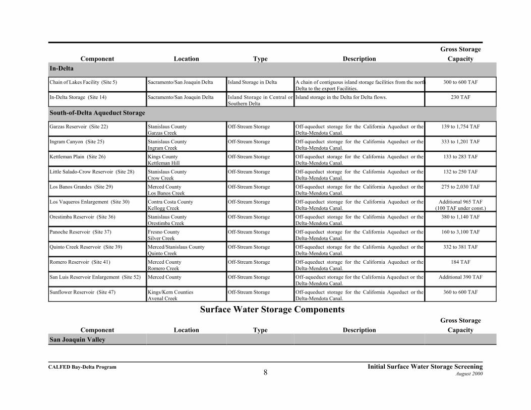
Gross StorageComponent Location Type Description Capacity
In-Delta
Chain of Lakes Facility (Site 5) Sacramento/San Joaquin Delta Island Storage in Delta A chain of contiguous island storage facilities from the northDelta to the export Facilities.
300 to 600 TAF
In-Delta Storage (Site 14) Sacramento/San Joaquin Delta Island Storage in Central orSouthern Delta
Island storage in the Delta for Delta flows. 230 TAF
South-of-Delta Aqueduct Storage
Garzas Reservoir (Site 22) Stanislaus CountyGarzas Creek
Off-Stream Storage Off-aqueduct storage for the California Aqueduct or theDelta-Mendota Canal.
139 to 1,754 TAF
Ingram Canyon (Site 25) Stanislaus CountyIngram Creek
Off-Stream Storage Off-aqueduct storage for the California Aqueduct or theDelta-Mendota Canal.
333 to 1,201 TAF
Kettleman Plain (Site 26) Kings CountyKettleman Hill
Off-Stream Storage Off-aqueduct storage for the California Aqueduct or theDelta-Mendota Canal.
133 to 283 TAF
Little Salado-Crow Reservoir (Site 28) Stanislaus CountyCrow Creek
Off-Stream Storage Off-aqueduct storage for the California Aqueduct or theDelta-Mendota Canal.
132 to 250 TAF
Los Banos Grandes (Site 29) Merced CountyLos Banos Creek
Off-Stream Storage Off-aqueduct storage for the California Aqueduct or theDelta-Mendota Canal.
275 to 2,030 TAF
Los Vaqueros Enlargement (Site 30) Contra Costa CountyKellogg Creek
Off-Stream Storage Off-aqueduct storage for the California Aqueduct or theDelta-Mendota Canal.
Additional 965 TAF(100 TAF under const.)
Orestimba Reservoir (Site 36) Stanislaus CountyOrestimba Creek
Off-Stream Storage Off-aqueduct storage for the California Aqueduct or theDelta-Mendota Canal.
380 to 1,140 TAF
Panoche Reservoir (Site 37) Fresno CountySilver Creek
Off-Stream Storage Off-aqueduct storage for the California Aqueduct or theDelta-Mendota Canal.
160 to 3,100 TAF
Quinto Creek Reservoir (Site 39) Merced/Stanislaus CountyQuinto Creek
Off-Stream Storage Off-aqueduct storage for the California Aqueduct or theDelta-Mendota Canal.
332 to 381 TAF
Romero Reservoir (Site 41) Merced CountyRomero Creek
Off-Stream Storage Off-aqueduct storage for the California Aqueduct or theDelta-Mendota Canal.
184 TAF
San Luis Reservoir Enlargement (Site 52) Merced County Off-Stream Storage Off-aqueduct storage for the California Aqueduct or theDelta-Mendota Canal.
Additional 390 TAF
Sunflower Reservoir (Site 47) Kings/Kern CountiesAvenal Creek
Off-Stream Storage Off-aqueduct storage for the California Aqueduct or theDelta-Mendota Canal.
360 to 600 TAF
Surface Water Storage ComponentsGross Storage
Component Location Type Description CapacitySan Joaquin Valley

CALFED Bay-Delta Program Initial Surface Water Storage ScreeningAugust 20009
Clay Station (Site 7) Sacramento CountyLaguna Creek
Off-Stream Storage Storage for American River flows. 170 TAF
Cooperstown Reservoir (Site 10) Stanislaus County Off-Stream Storage Storage for Stanislaus and Tuolumne River flows. 609 TAFDeer Creek Reservoir (Site 13) Sacramento County
near Rancho MuriettaOff-Stream Storage Storage for American River flows. 600 TAF
Duck Creek Reservoir (Site 15) San Joaquin CountyCalaveras watershed
Off-Stream Storage Storage for Mokelumne and Calaveras River flows. 100 TAF
Farmington Reservoir Enlargement (Site 16) San Joaquin CountyLittlejohns Creek
Combined On-Stream and Off-Stream Storage
The existing reservoir would be improved for conservationstorage of surplus Stanislaus River flows conveyed throughthe Upper Farmington Canal.
100 TAF
Millerton Lake Enlargement (Site 32) Fresno CountySan Joaquin River
On-Stream Storage Increase flow regulating opportunities. 720 TAF
Montgomery Reservoir (Site 34) Merced CountyDry Creek
Off-Stream Storage Capture and store spills from Lake McClure. 240 TAF
Nashville Reservoir (Site 35) El Dorado/Sacramento Counties -Cosumnes River
Combined Off-Stream and On-Stream Storage
Storage for Cosumnes River flows. 1,155 TAF
Pardee Reservoir Enlargement (Site 38) Calaveras/Amador CountiesMokelumne River
On-Stream Storage Increase regulating capabilities and yield opportunities. Additional 150 TAF
South Gulch Reservoir (Site 45) San Joaquin CountySouth Gulch tributary to CalaverasRiver
Off-Stream Storage Store flows from the Calaveras and Stanislaus Rivers. 180 TAF

CALFED Bay-Delta Program Initial Surface Water Storage ScreeningAugust 200010
Small Storage Capacity Screening
Reservoirs could help meet CALFED objectives by capturing water for flood control, watersupply, water quality control, and environmental enhancement. The storage and conveyanceevaluation process is designed to address the resource conflicts surrounding the timing andallocation of flows within the Bay-Delta system, including its tributaries. In order tosignificantly affect the CALFED solution for these conflicts, the cumulative volume of newsurface storage would likely need to be significant; on the order of a million acre-feet or more(see the range of analyses presented in the June 1999 Draft Programmatic EIS/EIR).
There are many small reservoir sites available for development by CALFED but the inventory ofpotential reservoir sites includes only those larger than 100,000 acre-feet. While new storagevolume to meet CALFED objectives might be obtained by the combined effect of several smallreservoirs, the cumulative cost and environmental impact of constructing several small reservoirswould be much higher than one larger project. For example, depending on the location, anindividual 100,000 acre-foot reservoir would be expected to improve dry year water yield byonly 10 to 30 TAF. Many of these smaller reservoirs would be required to have an influence onmeeting CALFED objectives. More surface area and riverine habitat would likely be inundatedthrough construction of several of these small facilities as compared to construction of one largerfacility. Therefore, CALFED has applied a threshold of 200,000 acre-feet for initial screening. CALFED Agencies believe the smaller reservoirs are best left as candidates for potentialdevelopment by local entities to meet specific local needs. Reservoir sites recommended forelimination from further CALFED consideration based on the minimum capacity criterioninclude:
Sites Eliminated Based on Small CapacitySite Number on Figure 1 Reservoir Site Gross Storage
Capacity
1 Allen Camp Reservoir 196 TAF
3 Bella Vista Reservoir 146 TAF
7 Clay Station Reservoir 170 TAF
15 Duck Creek Reservoir 100 TAF
16 Farmington Reservoir Enlargement 100 TAF
20 Gallatin Reservoir 183 TAF
38 Pardee Reservoir Enlargement Additional 150 TAF
41 Romero Reservoir 184 TAF
42 Rosewood Reservoir 155 TAF
45 South Gulch Reservoir 180 TAF

CALFED Bay-Delta Program Initial Surface Water Storage ScreeningAugust 200011
CALFED BAY-DELTA PROGRAM MISSION STATEMENT, OBJECTIVES
AND SOLUTION PRINCIPLES
The mission of the CALFED Bay-Delta Program is to develop a long-term comprehensiveplan that will restore ecological health and improve water management for beneficial usesof the Bay-Delta system.
CALFED developed the following objectives for a solution:
C Provide good water quality for all beneficial uses;C Improve and increase aquatic and terrestrial habitats and improve ecological functions in the Bay-Delta to
support sustainable populations of diverse and valuable plant and animal speciesC Reduce the mismatch between Bay-Delta water supplies and current and projected beneficial uses
dependent on the Bay-Delta system C Reduce the risk to land use and associated economic activities, water supply, infrastructure and the
ecosystem from catastrophic breaching of Delta levees.
In addition, any CALFED solution must satisfy the following solution principles:
C Reduce Conflicts in the System Solutions will reduce major conflicts among beneficial uses of water.
C Be Equitable Solutions will focus on solving problems in all problem areas. Improvements for someproblems will not be made without corresponding improvements for other problems.
C Be Affordable Solutions will be implementable and maintainable within the foreseeable resources of the
Program and stakeholders.
C Be Durable Solutions will have political and economic staying power and will sustain the resources theywere designed to protect and enhance.
C Be Implementable Solutions will have broad public acceptance and legal feasibility, and will be timelyand relatively simple to implement compared with other alternatives.
C Have No Significant Redirected Impacts Solutions will not solve problems in the Bay-Delta system byredirecting significant negative impacts, when viewed in their entirety, within the Bay-Delta or to otherregions of California.
Conflict with CALFED Objectives, Solution Principles, or Policy
Early in the Program, CALFED developed a mission statement, a set of objectives, and a set ofsolution principles to guide a solution to problems in the Bay-Delta system. Potential newsurface storage reservoirs must not violate these (see the following box).

CALFED Bay-Delta Program Initial Surface Water Storage ScreeningAugust 200012
Essential Fish Habitat (EFH)
Public Law 104-267, the Sustainable Fisheries Act of 1996,amended the Magnuson-Stevens Fishery Conservation andManagement Act to establish new requirements for“Essential Fish Habitat” description in Federal FisheryManagement Plans (FMPs) and to require Federal agenciesto consult with the National Marine Fisheries Service onactivities that may adversely affect EFH. The amended actrequires the National Marine Fisheries Service to assist thePacific Fisheries Management Council in the description andidentification of EFH for each managed fishery and toprovide the Pacific Fishery Management Council withproposed recommendations for EFH (National MarineFisheries Service 1998a).
Essential Fish Habitat is the aquatic habitat necessary toallow for salmon production needed to support a long-termsustainable salmon fishery and salmon contributions to ahealthy ecosystem. The salmon fishery EFH includes allthose streams, lakes, ponds, wetlands, and other water bodiescurrently or historically accessible to salmon. In theestuarine and marine areas, salmon EFH extends from thenearshore and tidal submerged environments to 60 kmoffshore. Salmon EFH excludes areas upstream oflongstanding naturally impassible barriers (i.e., naturalwaterfalls in existence for several hundred years) (NationalMarine Fisheries Service 1998a).
The designation of these habitats is important to allow thesystematic protection of biological diversity within distinctgeographic regions. The application of such a conservation-oriented classification system is of particular importance inthe Central Valley where a rapidly growing humanpopulation and large tracts of irrigated agriculture competewith aquatic organisms for water (Moyle and Ellison 1991).
References
Moyle. P.B., and J.P. Ellison. 1991. A conservation-orientedclassifications system for the inland waters ofCalifornia. California Fish and Game 77(4):161-180.
National Marine Fisheries Service. 1998a. Proposedrecommendations for Amendment 14 to the PacificCoast Salmon Plan for Essential Fish Habitat(Draft). March 26, 1998. 256 pp.
While CALFED considered potentialconflicts with each of the four objectivesin the above table, only the ecosystemobjective resulted in conflicts for thisinitial screening. To meet the ecosystemobjective, the CALFED EcosystemRestoration Program (ERP) is proposingsubstantial actions to rehabilitate thenatural processes in the Bay-Deltaestuary and its watershed to support, withminimal ongoing human intervention,natural aquatic and associated terrestrialbiotic communities, in ways that favornative members of those communities. Reservoir sites which significantlylimit the success of the ERP are indirect conflict with the CALFEDecosystem objective. The “EssentialFish Habitat” covered in the SustainableFisheries Act of 1996 is one helpfulmeasure of potential conflict. Thosereservoir sites which conflict withCALFED objectives are considered to beinfeasible based on logistics as defined inthe Section 404(b)(1) Guidelines.
The six solution principles (see box onprevious page) have guided CALFEDProgram development from thebeginning. Reservoir sites that violatethese solution principles should not becarried forward. Reservoir sites whichviolate one or more of the CALFEDsolution principles would also generallybe infeasible based on cost or logistics asdefined in the Section 404(b)(1)Guidelines. For example, a site that isnot durable or implementable would beinfeasible based on logistics as defined inthe Section 404(b)(1) Guidelines. A siteconsidered to unaffordable based on theCALFED solution principle would alsobe infeasible based on cost in the Section404(b)(1) Guidelines.

CALFED Bay-Delta Program Initial Surface Water Storage ScreeningAugust 200013
Offstream Storage
Traditionally, reservoirs have been created byconstructing dams on major rivers to formartificial lakes. These reservoirs areconsidered onstream storage. In contrast, anoffstream storage reservoir is typicallyconstructed on a small and generally seasonalstream that does not significantly contribute tothe water supply of the reservoir. Offstreamstorage involves diverting water out of a riverand transporting the water through canals orpipelines to a reservoir that may be milesaway from the river. Therefore, offstreamstorage investigations include extensiveevaluation of conveyance facilities to carrythe water to the reservoirs.
As a mater of policy, CALFED will focus on off-stream reservoir sites for new surface storage,but will consider expansion of existing on-stream reservoirs. CALFED will not pursuestorage at new on-stream reservoir sites due toenvironmental impacts and implementabilityissues. Off-stream storage generally results infewer environmental impacts then new on-streamstorage. On-stream storage generally has muchhigher impacts on the aquatic environment thanoff-stream storage. For example, on-stream storagechanges free flowing stream habitat to stillreservoir habitat, blocks fish movement, and blockssediment and nutrient transport to downstreamareas. The off-stream sites, filled primarily bydiversion, are generally located on small orintermittent drainages where the impacts on theaquatic environment are much smaller than withon-stream reservoirs located on major rivers or tributaries. CALFED Agencies believemitigation costs will be substantially less with the off-stream reservoirs which will make the on-stream reservoirs infeasible based on cost in the Section 404(b)(1) Guidelines. In addition,CALFED Agencies believe that most on-stream sites will have such high aquatic environmentalimpacts, that cannot be mitigated, that the sites would not be able to be developed. This wouldmake the sites infeasible based on logistics as defined in the Section 404(b)(1) Guidelines. The following table shows those sites that were screened out due to conflicts with CALFEDobjectives, solution principles or policy. The paragraphs following the table provide a briefexplanation of each reservoir and why they are recommended for elimination from furtherCALFED consideration.

CALFED Bay-Delta Program Initial Surface Water Storage ScreeningAugust 200014
Sites Eliminated Based on Conflicts with CALFED Objectives and Solution Principles
Site No. ( Figure 1)
Reservoir Site Conflict
2 Auburn Reservoir Implementability
4 Lake Berryessa Enlargement Implementability & significant redirected impacts
5 Chain of Lakes Facility Implementability & durability
6 Trinity Lake Enlargement Affordability & immpementability
8 Coloma Reservoir Implementability
10 Cooperstown Reservoir Implementability
11 Cottonwood Creek Complex Ecosystem objectives
12 Deer Creek Meadows Reservoir Ecosystem objectives
13 Deer Creek Reservoir Ecosystem objectives
17 Fiddlers Reservoir Ecosystem objectives
18 Folsom Reservoir Enlargement Implementability
19 Freemans Crossing Reservoir Does not reduce conflicts in the system
21 Garden Bar Reservoir Policy
22 Garzas Reservoir Implementability
23 Glenn Reservoir Implementability
24 Hulen Reservoir Ecosystem objectives
26 Kettleman Plain Implementability & does not reduce conflicts in the system
27 Kosk Reservoir Implementability & does not reduce conflicts in the system
28 Little Salado-Crow Reservoir Affordability, implementability & does not reduce conflicts in the system
29 Los Banos Grandes Reservoir Significant redirected impacts
31 Marysville Reservoir Ecosystem objectives
33 Millville Reservoir Ecosystem objectives
35 Nashville Reservoir Ecosystem objectives
36 Orestimba Reservoir Implementability
52 San Luis Reservoir Enlargement Implementability, significant redirected impacts & does not reduce conflicts in the system
46 Squaw Valley Reservoir Implementability
47 Sunflower Reservoir Implementability & does not reduce conflicts in the system
49 Tuscan Buttes Reservoir Ecosystem objectives
51 Wing Reservoir Ecosystem objectives
52 Waldo Reservoir Implementability
Auburn Reservoir (No. 2 on Figure 1) - Auburn Reservoir would be located on the North Fork

CALFED Bay-Delta Program Initial Surface Water Storage ScreeningAugust 200015
American River, upstream of Folsom Reservoir. Reservoir sizes up to 2.3 million acre-feet wereconsidered. The largest dam would inundate over 40 miles of the north and middle forks of theAmerican River and 10,000 acres of the American River Canyon. Adverse environmentalimpacts have been termed unacceptable and unmitigable by the U.S. Environmental ProtectionAgency, U.S. Fish and Wildlife Service (USFWS), and California Department of Fish and Game. The reservoir would not be implementable due to these impacts and lack of public support. Since the reservoir would be on-stream, it is not consistent with CALFED policy. For thesereasons, Auburn Reservoir is recommended for elimination from further CALFED consideration.
Lake Berryessa Enlargement (No. 4 on Figure 1) - The existing Lake Berryessa (1.6 MAF) islocated on Putah Creek about 8 miles west of the town of Winters in Solano County. Theenlargement would require a new dam about 2 miles downstream of the existing dam. Depending on the dam size, the enlarged reservoir would have a gross capacity from 6.0 to 13.3MAF. The enlargement would also include the construction of new conveyance facilitiesfeaturing a 12,000-foot-long tunnel that would serve to move water into and out of storage. Theprimary purpose of enlarging Lake Berryessa would be to store a portion of high flows from theSacramento River.
The Department of Fish and Game has concluded that the enlargement of Lake Berryessa wouldadversely impact wildlife (including endangered species) as a result of loss of habitat. The LakeBerryessa Enlargement would inundate an additional 15,600 to 43,600 acres (dependent on theenlargement option) of terrestrial wildlife habitat and several miles of warm water streamhabitat. Vegetation within the inundation area of the 13.3 MAF lake consists primarily of thefollowing approximate acreages: 24,000 acres of foothill woodland, 10,400 acres of scrub, 6,700acres of grassland, 4,000 acres of agricultural lands, 1,600 acres of riparian vegetation, and 900acres of disturbed areas. The large lake size would also result in larger diversions from theSacramento River than most of the other potential storage sites creating increased impacts onSacramento River fisheries.
Additional concerns associated with the Berryessa Enlargement stem from the potential seismicactivity in the area and the filling of the large reservoir. The northwest-southeast trendingridge-valley topography of the Coast Range north of San Francisco Bay results from thenorthwest-southeast trending faults which cover much of the area. These faults runapproximately parallel to the San Andreas Fault, which lies about 50 miles west of the projectlocation.
Considerable development around the existing lake would be inundated by an enlargement of thelake. Because of this development and the environmental concerns, the enlargement of LakeBerryessa would be very controversial. The enlargement would violate CALFED solutionprinciples due to the significant redirected impacts on the ecosystem and would not beimplementable due to these impacts, lack of public support, and extremely large size of thedevelopment. For these reasons, the enlargement of Lake Berryessa is recommended forelimination from further CALFED consideration. Chain of Lakes Facility (No. 5 on Figure 1) - With this facility, six major Delta islands would

CALFED Bay-Delta Program Initial Surface Water Storage ScreeningAugust 200016
be converted to reservoirs connected with siphons and pumps to act as a conveyance of watersupply through the Delta and water storage up to 600 TAF. This facility would result in largescale loss of prime agricultural lands, would have significant potential for degrading the qualityof export water supplies, and would be very expensive, compared to other conveyance andstorage alternatives. The Chain of Lakes Facility was originally conceived primarily as onepotential form of an isolated conveyance facility. However, it would be considerably moreexpensive than an isolated facility sited along the eastern side of the Delta. In addition,CALFED has decided that its Preferred Program Alternative does not include an isolated facility(see the June Draft Programmatic EIS/EIR). The storage included with the Chain of LakesFacility would have been a secondary function of the facility. Since the Chain of Lakes primarypurpose of conveyance is not feasible for the CALFED Program, CALFED Agencies believethat further consideration of In-Delta storage be conducted solely as a storage function (see In-or Near Delta Storage on page 36).
Based on these factors, the Chain of Lakes Facility violates several CALFED solution principles. The project would not be affordable for the above mentioned reasons. The project would not beimplementable due to widespread opposition to the large scale disruption of the Delta. Inaddition, the durability of the project is questionable due to uncertainty on several factorsincluding how it could affect in-Delta and export water quality or potential vulnerability toearthquakes. Therefore, the Chain of Lakes Facility is recommended for elimination fromfurther CALFED consideration.
Trinity Lake Enlargement (No. 6 on Figure 1) - The existing Trinity Lake (formerly know asClair Engle Lake) is located on the Trinity River. Since 1963, a portion of Trinity River flowshave been diverted through a tunnel into the Sacramento River basin to augment Central ValleyProject water supplies in the Sacramento and San Joaquin valleys. These diversions haveaveraged about 880,000 acre-feet annually. Minimum flow released to the Trinity River wereinitially set at 120,500 acre-feet per year but have been temporarily increased to 340,000 acre-feet due to severe declines in Trinity River salmon and steelhead trout runs. Permanent flowrelease criteria have been recommended based on the Secretary of Interior’s flow evaluationstudy and EIS. The flow evaluation study results in more water remaining in the Trinity River,especially during wetter years when higher flows help maintain the configuration and health ofthe river channel, and less water will be available for diversion to the Sacramento River basin. This will result in less natural runoff available for storage.
Given that less water will be available for storage during wetter years, it is unlikely that anenlargement of Trinity Lake can develop significant water from the natural watershed. Thissmall potential for increased water supply would not significantly reduce conflicts in the system. The project could be expanded by pumping unregulated flood flows from Shasta Lake forstorage in Trinity Lake and returning water to Shasta Lake in time of need. A 200-foot raise ofthe dam would increase the storage of Trinity Lake by about 4.8 million acre-feet. Thecommunities of Trinity Center, Coffee Creek, and Coveington Mill and numerous resort areasand recreational facilities along with 20 miles of State Highway 30 would need to be relocated. The expanded lake would flood numerous historical sites along with a significant coniferous-hardwood forest, meadow, and riparian habitats. CALFED Agencies believe that expansion of

CALFED Bay-Delta Program Initial Surface Water Storage ScreeningAugust 200017
the lake, and the large diversions from Shasta Lake to support it, would create significantenvironmental impacts. The scale of the project is so large that CALFED Agencies believe itwould not be affordable nor implementable within a reasonable period to help meet CALFEDobjectives. Therefore, the Trinity Lake Enlargement is recommended for elimination fromfurther CALFED consideration.
The US Bureau of Reclamation is investigating options to correct potential dam safety concernsrelated to spillway capacity and potential for an earthquake-triggered landslide in the reservoirarea. These concerns have led to a temporary limit on maximum reservoir storage. The optionsof a small raise in the reservoir embankment and modifications to spillways and outlets are underconsiderations to correct the dam safety concerns. Investigation of these dam safety concernsand correction measures is supported by CALFED.
Coloma Reservoir (No. 8 on Figure 1) - The reservoir site is located on the South ForkAmerican River and would flood the Gold Discovery Site State Park at Coloma. The CaliforniaWater Code provides for protection of the historic site as follows:
Water Code 10001.5. ?Notwithstanding any provisions of this article or any otherprovision of law to the contrary, the project known as the "Coloma Dam and Reservoir"constitutes no part of the State Water Plan. In no event shall a permit to appropriatewater be issued by the State for the purposes of a project which will flood any portion ofthe Gold Discovery Site State Park at Coloma unless such issuance is specificallyauthorized by law.”
Since this project would be in conflict with existing law, it is not considered implementable. Themaximum size reservoir that would not flood the State Park is 200 TAF which would not passthe minimum capacity criterion described above. Also, since the reservoir would be on-stream,it is not consistent with CALFED policy. For these reasons, the Coloma Reservoir isrecommended for elimination from further CALFED consideration.
Cooperstown Reservoir (No. 10 on Figure 1) - Cooperstown Reservoir would be located inStanislaus County on Dry Creek between Stanislaus and Tuolumne Rivers. Most of theinformation on the project comes from a 1949 report (A Comprehensive Department Report onthe Development of Water and Related Resources of the Central Valley Basin, and Commentsfrom the State of California and Federal Agencies) by the Department of the Interior. While thespecific facility designs have not been determined for Cooperstown, the reservoir would have acapacity up to 609 TAF. The general project features would include a new embankment dam,and fourteen to sixteen saddle dams depending on the size of reservoir selected. Project costswould be driven up significantly by the numerous saddle dams that would be required to developthis project. The reservoir would be relatively shallow, inundating an area of 15,400 acres. Noenvironmental analysis has been conducted for the Cooperstown Reservoir.
Cooperstown could operate in conjunction with the upstream New Melones Reservoir and NewDon Pedro Reservoirs by storing a portion of the flows released from both reservoirs. Inaddition, Cooperstown Reservoir could enhance operations of the New Melones Reservoir by

CALFED Bay-Delta Program Initial Surface Water Storage ScreeningAugust 200018
storing winter power releases, thus permitting power production during the non-irrigation seasonwithout loss of irrigation water.
There has been very little information developed on this project in the last 50 years which raisesuncertainties regarding its viability. Considering that the dam site is not a particularly good onedue to the many required saddle dams, it is unlikely to compare favorably with other potentialreservoir sites. CALFED does not consider Cooperstown Reservoir to be implementablecompared to other reservoirs remaining for CALFED consideration.
Cottonwood Creek Reservoir Complex (No. 11 on Figure 1) - The Cottonwood Creekcomplex would consist of a major (900 TAF) reservoir on the mainstem of Cottonwood Creekand a major (700 TAF) reservoir on the South Fork Cottonwood Creek. The complex wouldinundate 28 miles of stream and riparian habitat. Cottonwood Creek is the largest undammedtributary in the upper Sacramento River basin and is the most important source of sediments tothe Sacramento River. These sediments are necessary to drive river meander and riparianrejuvenation that is important to the CALFED ERP. The creek is likely to be designated (still indraft proposal stage) as Essential Fish Habitat (EFH) by the National Marine Fisheries Serviceand the Pacific Fisheries Management Council. The creek provides spawning for fall-run andlate-fall-run chinook salmon and supports spring-run chinook salmon in some years.
Given the importance of Cottonwood Creek to Sacramento River health and fishery production,CALFED Agencies believe that Cottonwood Creek Reservoir Complex would be in directconflict with the CALFED ecosystem restoration objectives. Since the reservoir would be on-stream, it is not consistent with CALFED policy. For these reasons, the Cottonwood CreekReservoir Complex is recommended for elimination from further CALFED consideration. Deer Creek Meadows Reservoir (No. 12 on Figure 1) - Deer Creek Meadows Reservoir wouldbe located on Deer Creek in Tehama County. The creek is likely to be designated (still in draftproposal stage) as Essential Fish Habitat by the National Marine Fisheries Service and thePacific Fisheries Management Council. The creek supports an important population of spring-run chinook salmon and is a priority watershed for early implementation of the ERP.
CALFED Agencies believe that Deer Creek Meadows Reservoir would be in direct conflict withthe CALFED ecosystem restoration objectives. In addition, since the reservoir would be on-stream, it is not consistent with CALFED policy. Therefore, the Deer Creek Meadows Reservoiris recommended for elimination from further CALFED consideration.
Deer Creek Reservoir (No. 13 on Figure 1) - Deer Creek Reservoir would be an off-streamreservoir to store American River water. Downstream from Nimbus Dam, the American River islikely to be designated (still in draft proposal stage) as Essential Fish Habitat and supports fall-run chinook salmon and steelhead. The two ecological factors with the greatest influence onanadromous fishes of the lower American River are seasonal stream flow and water temperature. New storage on the American River could help the seasonal flows and the cold water pool, butdiversions to an off-stream reservoir could jeopardize opportunity to provide cold water to thelower American River.

CALFED Bay-Delta Program Initial Surface Water Storage ScreeningAugust 200019
CALFED Agencies believe that Deer Creek Reservoir would be in direct conflict with theCALFED ecosystem restoration objectives. Therefore, the Deer Creek Reservoir isrecommended for elimination from further CALFED consideration.
Fiddlers Reservoir (No. 17 on Figure 1) - Fiddlers Reservoir would be located on the MiddleFork Cottonwood Creek. Like the Cottonwood Creek Complex, Fiddlers Reservoir would blockimportant sediment flow to the Sacramento River and is likely to be designated (still in draftproposal stage) as Essential Fish Habitat. Fiddlers Reservoir has been suggested as analternative to the Cottonwood Creek Complex and has also been considered in combination withHulen and Dippingvat Reservoirs. Fiddlers Reservoir, by itself or in conjunction with Hulen andDippingvat Reservoirs, could not provide the same level of benefits as either the CottonwoodCreek Complex or the Red Bank Project.
CALFED Agencies believe that Fiddlers Reservoir would be in direct conflict with the CALFEDecosystem restoration objectives. Also, since the reservoir would be on-stream, it is notconsistent with CALFED policy. Therefore, the Fiddlers Reservoir is recommended forelimination from further CALFED consideration.
Folsom Reservoir Enlargement (No. 18 on Figure 1) - The existing Folsom Reservoir canstore approximately 1 million acre-feet on the American River east of Sacramento. The potential30-foot raise of the dam and its many saddle dams would store an additional 365 TAF. Since the reservoir is located within a populated area, enlargement by 30 feet would face major legal,institutional, and socioeconomic issues. Folsom Lake State Recreation Area is one of the mostpopular units in the State Park System hosting upwards of 2-3 million visitors each year. Theenlargement would inundate 3.4 miles of stream habitat and high instream recreational uses onthe South and North Fork American River.
Options for increased flood protection for the City of Sacramento have been under investigationby the USACE and the Sacramento Area Flood Control Agency since a major flood on theAmerican River in 1986. Potential options include modifications to Folsom Dam, its operation,and downstream levees to reduce flood risk along the lower American River. Operation rules forthe existing Folsom Dam have already been modified to temporarily improve flood protectionuntil a more permanent solution is found and implemented. These operations for flood controlhave resulted in reduced winter-time conservation storage for water supply. Potential floodcontrol modifications to the dam include constructing new low level outlets so flood storagecould be more quickly evacuated in anticipation of flood events and raising the dam and saddledams by as much as 12 feet. Preliminary studies by the USACE indicate that the 12-foot raise,which would add about 140,000 acre-feet flood storage capacity, is near the practical physicallimit and could provide Sacramento 200 year flood protection. The studies found that a largerraise would require major reconstruction of the interface between the main concrete dam and itsearthfill embankments and the increased lake level would begin to significantly impact existinglakeside development.
CALFED Agencies believe that the 30-foot Folsom Reservoir Enlargement is not implementableas a CALFED project. There would be significant local resistance to the enlargement

CALFED Bay-Delta Program Initial Surface Water Storage ScreeningAugust 200020
considering the existing adjacent development, the number of saddle dams that must be raisedabove populated areas, and the high recreational use. The cost of raising the dam (30 feet) andmany saddle dams would be very high considering the relatively small increase in storagecapacity. The value of any CALFED related enlargement for water supply would likely bediminished by local plans for flood control for the City of Sacramento. The smaller, morepractical, raise of approximately 12 feet (140,000 acre-feet) is smaller than the CALFEDminimum capacity criterion described above. CALFED Agencies believe that any potentialFolsom Dam modifications should be reserved for local flood control needs. Therefore, theFolsom Dam Enlargement is recommended for elimination from further CALFED consideration.
Freemans Crossing Reservoir (No. 19 on Figure 1) - Freemans Crossing, on the Middle ForkYuba River, was proposed in DWR Bulletin 3 in 1957 as a place to store water diverted from theNorth Fork Yuba River. In the late 1960s, Yuba County Water Agency's New Bullards BarProject developed the upper Yuba by putting the major storage on the North Fork and diverting abig share of the Middle Fork water to it via the Camptonville Tunnel. This has significantlyreduced the water available for a Freemans Crossing Reservoir.
Due to the lack of water, this project will do little to reduce conflicts in the system. Also, sincethe reservoir would be on-stream, it is not consistent with CALFED policy. Therefore, theFreemans Crossing Reservoir is recommended for elimination from further CALFEDconsideration.
Garden Bar Reservoir (No. 21 on Figure 1) - Garden Bar reservoir would be located on theBear River upstream of Camp Far West Reservoir. The 320-foot-high dam would form a 245TAF reservoir and inundate 2,000 acres of deer wintering, riparian, and wetlands habitat. Theriver is likely to be designated (still in draft proposal stage) as Essential Fish Habitat andsupports anadromous fish during the wetter years downstream of Camp Far West Reservoir. Storage of water in the new reservoir would reduce these wetter year flows and negativelyimpact anadromous fish. The gross storage capacity (245 TAF) is only slightly larger than thosereservoir sites eliminated due to small storage capacity. Since the reservoir would be on-stream,it is not consistent with CALFED policy. Therefore, the Garden Bay Reservoir is recommendedfor elimination from further CALFED consideration.
Garzas Reservoir (No. 22 on Figure 1) - Garzas Reservoir would be an off-stream reservoir inStanislaus County, west of the California Aqueduct. Its potential active storage range if from139 to 1,754 TAF. The project would inundate 15 miles of Garzas Creek, and 2,600 acres ofwildlife habitat.
The USFWS (draft letter May 21, 1999) provided the following information on the habitat valuesof the Garzas and Orestimba Reservoir sites:
This property, including these reservoir sites, is an important component of a habitatcorridor connecting the northernmost population of the endangered San Joaquin kit fox(Vulpes macrotis mutica) in Contra Costa County to the southern portions of the kit fox’srange in Merced County and further south. Localized kit fox populations, like the one in

CALFED Bay-Delta Program Initial Surface Water Storage ScreeningAugust 200021
Contra Costa County, are known to undergo occasional, rapid declines; long-termmaintenance of such populations depends on the preservation of viable corridorsallowing the migration of individual kit fox among populations. Preservation of thishabitat corridor is identified in the Service’s 1998 “Recovery Plan for Upland Species ofthe San Joaquin Valley, California,” as necessary to prevent a significant decline in thepopulation of San Joaquin kit foxes. However, this habitat corridor has already beengreatly narrowed by the conversion of natural and range lands, as well as some rowcrops, to orchards or more intensive agricultural development, and by developmentalong the I-5 corridor. In addition, the construction and operation of San Luis Reservoirand its ancillary facilities just south of this site has created a narrow pinch point in thehabitat corridor, which increases the value of a wider, more diverse and protectivecorridor both north and south of San Luis. Construction of either proposed reservoirwould extend this too-narrow habitat corridor so far that its long-term existence, andthus the maintenance of gene flow between the northern and southern components of thekit fox’s range, could not be assured. This would result in a significant risk to the long-term survival and recovery of the San Joaquin kit fox.
Stream corridors on this property, including Garzas and Orestimba creeks, also containthe largest known population of threatened California red-legged frogs (Rana auroradraytonii) in the Central Valley watershed. California red-legged frogs were historicallycommon in the Central Valley (they are now unknown from the valley floor), andrecovery of the frog will likely depend on the reestablishment of several viablepopulations throughout its historic range. The frogs on this property are thought to bethe closest genetic descendants of the red-legged frogs once found throughout the valley,and are expected to have and important role in the potential reintroduction of Californiared-legged frogs to suitable habitat elsewhere in the Central Valley watershed. Thus,construction of either reservoir could not only affect one of the few remaining red-leggedfrog populations but also, through its effects on that population, pose a significant risk tothe recovery of the California red-legged frog.
The Garzas Reservoir site is on land recently acquired by The Nature Conservancy to protect thehabitat and other ecological values of the property. A portion of the funding for this acquisitionwas provided by the Department of the Interior, as part of a program to mitigate for the impactsof the Central Valley Project. One condition of the Department in providing funds to supportthis acquisition was that the nature Conservancy grant a perpetual conservation easement toprotect the fish and wildlife value at his site. The terms of this easement, which prohibitadditional water development on the property, would preclude construction of the storagereservoir.
Based on the above information, this project is not implementable and is recommended forelimination from further CALFED consideration.
Glenn Reservoir (No. 23 on Figure 1) - The Glenn Reservoir Project would be located in Glennand Tehama counties. The Newville Dam would be located on the North Fork of Stony Creekand the Rancheria Dam would be constructed on the main stem of Stony Creek. The two

CALFED Bay-Delta Program Initial Surface Water Storage ScreeningAugust 200022
reservoir compartments would merge to form Glenn Reservoir with a combined storage capacityup to 8,206 TAF. A new 15-mile conveyance component between Glenn Reservoir and theSWP, a large Rancheria Dam on the main stem of Stony Creek and a Newville Dam on the NorthFork of Stony Creek would comprise the major components of the Glenn Reservoir Project. Glenn Reservoir would provide off-stream storage of runoff from Stony and Thomes Creeks andpumped flows from the Sacramento River. The reservoir would inundate several miles
The largest Glenn Reservoir alternative would require a dam about 420 feet above the riverplain. The reservoir would inundate over 50,000 acres. Vegetation in the project area consistsprimarily of grasslands, oak savannah, oak-pine woodland, and chaparral. Riparian vegetationoccurs along the numerous rivers and streams in the area. Vernal pools have been foundscattered throughout the project area. In addition, the reservoir would inundate an estimated 223prehistoric, 35 ethnographic and 70 significant historic sites in the project area.
One of the more significant results of constructing this complex would be the loss of criticalwinter range for an estimated 1,100 deer of the Thomes Creek (Lake Hollow) herd and thedisplacement of over 600 migratory and resident deer. Construction will block migration routesfor mule deer. Potential impacts to steelhead and salmon may also result from the loss of aportion of their periodic run. Impacts include blockages of migration routes, migration delays,loss of spawning habitat, changes in spawning substrate, loss of directional flows, decreasedwater quality, and increased water temperatures. The impact of run blockage for Sacramentosquawfish and suckers is expected to be significant. Indirect fish losses can be expected at theproject's Sacramento River diversion. The Newville Reservoir on North Fork Stony Creek couldinundate stretches of perennial and intermittent streams that are used primarily by roach, suckersand squawfish migrating from Black Butte Reservoir to spawn and rear.
Additional environmental concerns relate to the excessive sediment, debris, and fishery problemsassociated with winter diversion of approximately 10,000 cfs from critical reaches of theSacramento River. Some other potential problems that became apparent during earlier studies are(1) local opposition related to displacing the town of Elk Creek and numerous ranches, (2)inundation of the Grindstone Indian Rancheria, (3) possible water quality impacts of releasesback to the river, and (4) unresolved seismicity issues. In addition, the size of the reservoir ismuch larger than that considered viable at this point in the CALFED Bay-Delta Program. CALFED Agencies believe the project would not be implementable due to these impacts, lack ofpublic support, and extremely large size of the development. For these reasons, the GlennReservoir is recommended for elimination from further CALFED consideration.
Hulen Reservoir (No. 24 on Figure 1) - Hullen Reservoir would be located on North Fork ofCottonwood Creek. Its maximum potential size (244 TAF) is only slightly larger than thosereservoir sites eliminated due to small storage capacity. In addition it, like the CottonwoodCreek Complex, would block important sediment flow to the Sacramento River and is likely tobe designated (still in draft proposal stage) as Essential Fish Habitat.
CALFED Agencies believe that Hulen Reservoir would be in direct conflict with the CALFEDecosystem restoration objectives. Also, since the reservoir would be on-stream, it is not
CALFED Bay-Delta Program Initial Surface Water Storage ScreeningAugust 200023
consistent with CALFED policy. Therefore, the Hulen Reservoir is recommended forelimination from further CALFED consideration.
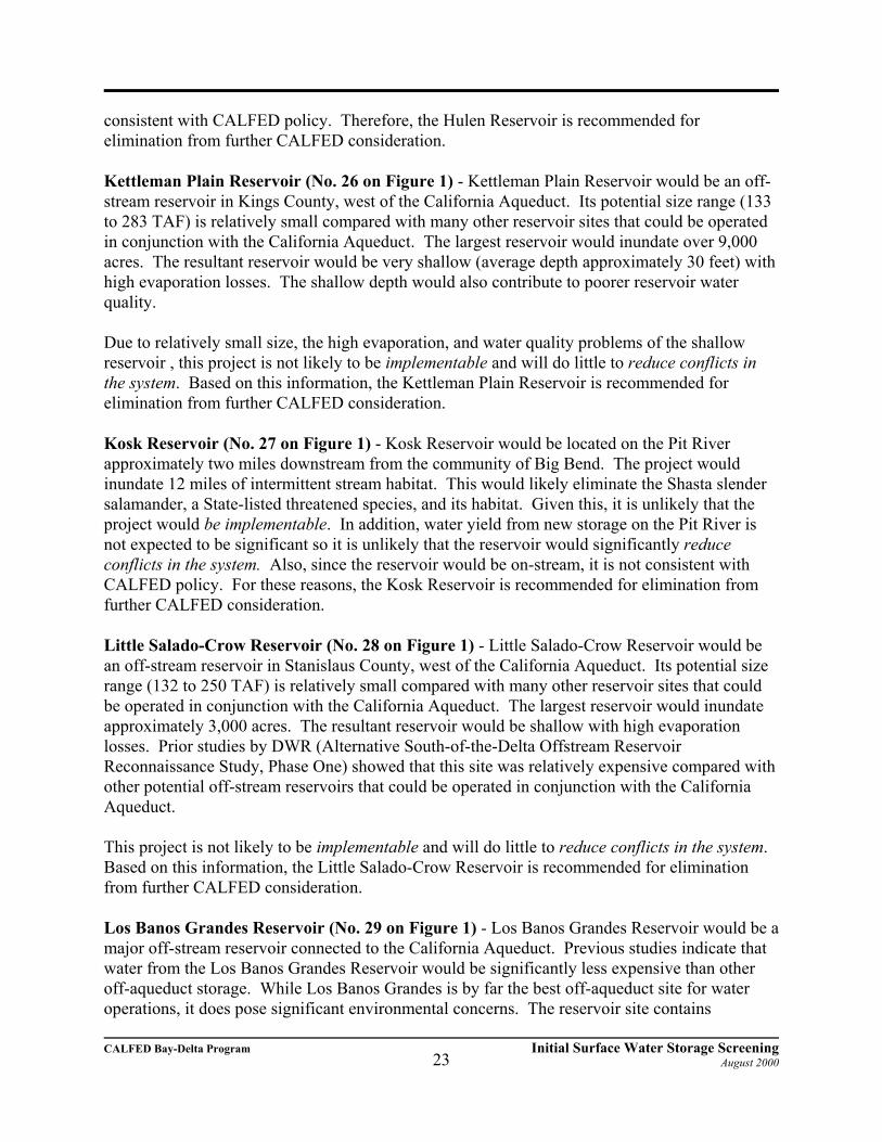
Kettleman Plain Reservoir (No. 26 on Figure 1) - Kettleman Plain Reservoir would be an off-stream reservoir in Kings County, west of the California Aqueduct. Its potential size range (133to 283 TAF) is relatively small compared with many other reservoir sites that could be operatedin conjunction with the California Aqueduct. The largest reservoir would inundate over 9,000acres. The resultant reservoir would be very shallow (average depth approximately 30 feet) withhigh evaporation losses. The shallow depth would also contribute to poorer reservoir waterquality.
Due to relatively small size, the high evaporation, and water quality problems of the shallowreservoir , this project is not likely to be implementable and will do little to reduce conflicts inthe system. Based on this information, the Kettleman Plain Reservoir is recommended forelimination from further CALFED consideration.
Kosk Reservoir (No. 27 on Figure 1) - Kosk Reservoir would be located on the Pit Riverapproximately two miles downstream from the community of Big Bend. The project wouldinundate 12 miles of intermittent stream habitat. This would likely eliminate the Shasta slendersalamander, a State-listed threatened species, and its habitat. Given this, it is unlikely that theproject would be implementable. In addition, water yield from new storage on the Pit River isnot expected to be significant so it is unlikely that the reservoir would significantly reduceconflicts in the system. Also, since the reservoir would be on-stream, it is not consistent withCALFED policy. For these reasons, the Kosk Reservoir is recommended for elimination fromfurther CALFED consideration.
Little Salado-Crow Reservoir (No. 28 on Figure 1) - Little Salado-Crow Reservoir would bean off-stream reservoir in Stanislaus County, west of the California Aqueduct. Its potential sizerange (132 to 250 TAF) is relatively small compared with many other reservoir sites that couldbe operated in conjunction with the California Aqueduct. The largest reservoir would inundateapproximately 3,000 acres. The resultant reservoir would be shallow with high evaporationlosses. Prior studies by DWR (Alternative South-of-the-Delta Offstream ReservoirReconnaissance Study, Phase One) showed that this site was relatively expensive compared withother potential off-stream reservoirs that could be operated in conjunction with the CaliforniaAqueduct.
This project is not likely to be implementable and will do little to reduce conflicts in the system. Based on this information, the Little Salado-Crow Reservoir is recommended for eliminationfrom further CALFED consideration.
Los Banos Grandes Reservoir (No. 29 on Figure 1) - Los Banos Grandes Reservoir would be amajor off-stream reservoir connected to the California Aqueduct. Previous studies indicate thatwater from the Los Banos Grandes Reservoir would be significantly less expensive than otheroff-aqueduct storage. While Los Banos Grandes is by far the best off-aqueduct site for wateroperations, it does pose significant environmental concerns. The reservoir site contains

CALFED Bay-Delta Program Initial Surface Water Storage ScreeningAugust 200024
approximately one-quarter of the Central California Sycamore Alluvial Woodland naturalcommunity. The Los Banos Reservoir site contains the largest stand (426 acres) while all otherstands in Central California are under 250 acres. Depending on the reservoir size, up to 13,000acres of terrestrial wildlife habitat and 13 miles of intermittent stream and associated habitatwould be inundated. The six listed species that could be affected by the proposed reservoirinclude Valley elderberry longhorn beetle (Federal threatened), blunt-nosed leopard lizard(Federal endangered/State endangered), bald eagle (State endangered), Swainson’s hawk (Statethreatened), giant kangaroo rat (Federal and State endangered), and San Joaquin kit fox (Federalendangered/State threatened). Additionally, the Arburua Ranch jewelflower (Streptanthusinsignis spp. Iyonii) is known only from the Los Banos Grandes area and locations nearby. Thisproject would inundate some population of this species. Although this plant is currently unlisted,construction of this project would cause serious concerns for its future viability.
In a September 18, 1997 letter to the CALFED Bay-Delta Program, the USFWS stated that LosBanos Grandes Reservoir would not be easily mitigated and suggested that attempts to mitigatefor the reservoir could fail. The letter states:
Special attention should be given to impacts at the Los Banos Grandes and Auburnreservoir sites. We believe that full mitigation for these impacts would not be easy. Thisis not just a question of economic feasibility; rather, the fish and wildlife resources thatwould be impacted by construction of either project are extremely valuable, and existinghabitat restoration techniques--and the geographic extent of appropriate land--areextremely limited, and that mitigation could likely fail regardless of the financialresources available to attempt it.
The sycamore woodlands at this site are one of the oldest and most pristine in the State. If itwere possible to replace these woodlands, it would take over 200 years to reach the existingmaturity of the stand. Flooding of the sycamore woodlands and grasslands pose concerns for theSan Joaquin kit fox due to the loss habitat for the reservoir and ancillary facilities and due to thebarrier that the reservoir would create to movement of kit fox from one side to the other:
C Flooding the site would result in displacement of the only known population (12-28 individuals) inhabiting Valley floor grasslands and loss of 13,000 acres ofdenning and foraging habitat including 50 known kit fox dens and 425 potentialdens. The displacement of this kit fox population would result in them moving toother areas where they would experience increased competition and mortalityfrom the non-native red fox and feral dogs. These impacts would be amplified byproject oriented recreation and ongoing operation and maintenance.
C The reservoir would reduce free movement of kit fox from one side to the other. This loss of transportation corridor would isolate up to 65 kit foxes and negativelyimpact the gene flow between populations north and south of the reservoir.
These major environmental concerns would constitute significant redirected impacts. The LosBanos Grandes Reservoir is recommended for elimination from further CALFED consideration.

CALFED Bay-Delta Program Initial Surface Water Storage ScreeningAugust 200025
However, this may essentially eliminate the potential of economical off-aqueduct storage sinceother off-aqueduct options are significantly more expensive than Los Banos Grandes. New off-aqueduct storage could significantly increase overall water supply reliability and flexibility ofDelta export operations. If more detailed evaluations show that remaining off-aqueduct storageoptions are not affordable or should be eliminated from consideration for other reasons, thenCALFED’s ability to accomplish its water supply reliability objectives could be significantlyaffected.
Marysville Reservoir (No. 31 on Figure 1) - Marysville Reservoir would be located on themainstem of the Yuba River downstream of Englebright Reservoir. The river is likely to bedesignated (still in draft proposal stage) as Essential Fish Habitat and supports fall-run andspring-run chinook salmon. The Yuba River has the largest naturally spawning population ofsalmon in the Central Valley.
The reservoir would inundate 47 miles of stream habitat and would incorporate the storage ofEnglebright Reservoir. Englebright Reservoir was built in 1941 to collect placer mining debris. The ERP proposes an evaluation of removing or modifying Englebright Reservoir to reopenupstream areas to anadromous fish. Marysville Reservoir would not only block a length of theYuba River currently open to the fish, but would preclude the possibility of opening additionallength above Englebright. CALFED Agencies believe that Marysville Reservoir would be indirect conflict with the CALFED ecosystem restoration objectives. Also, since the reservoirwould be on-stream, it is not consistent with CALFED policy. Therefore, the MarysvilleReservoir is recommended for elimination from further CALFED consideration.
Millville Reservoir (No. 33 on Figure 1) - Millville Reservoir would be located on south CowCreek. The creek is likely to be designated (still in draft proposal stage) as Essential FishHabitat. CALFED Agencies believe that Millville Reservoir would be in direct conflict with theCALFED ecosystem restoration objectives. Since the reservoir would be on-stream, it is notconsistent with CALFED policy. In addition, its proposed size of 206 TAF is only slightly largerthan the reservoirs screened out for small storage capacity. Therefore, the Millville Reservoir isrecommended for elimination from further CALFED consideration.
Nashville Reservoir (No. 35 on Figure 1) - Nashville Reservoir would be located on theCosumnes River approximately five miles north of Plymouth. The river has been designated asEssential Fish Habitat. In addition, the Cosumnes is the largest undammed tributary in theSierras. CALFED Agencies believe that Nashville Reservoir would be in direct conflict with theCALFED ecosystem restoration objectives. Since the reservoir would be on-stream, it is notconsistent with CALFED policy. Therefore, the Nashville Reservoir is recommended forelimination from further CALFED consideration.
Orestimba Reservoir (No. 36 on Figure 1) - Orestimba Reservoir would be an off-streamreservoir in Stanislaus County, west of the California Aqueduct. Its potential active storagerange is from 295 to 1,137 TAF. The project would inundate 33 miles of Orestimba Creek, and2,200 acres of wildlife habitat.
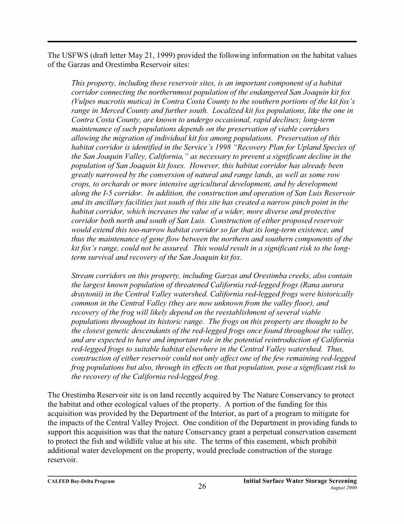
CALFED Bay-Delta Program Initial Surface Water Storage ScreeningAugust 200026
The USFWS (draft letter May 21, 1999) provided the following information on the habitat valuesof the Garzas and Orestimba Reservoir sites:
This property, including these reservoir sites, is an important component of a habitatcorridor connecting the northernmost population of the endangered San Joaquin kit fox(Vulpes macrotis mutica) in Contra Costa County to the southern portions of the kit fox’srange in Merced County and further south. Localized kit fox populations, like the one inContra Costa County, are known to undergo occasional, rapid declines; long-termmaintenance of such populations depends on the preservation of viable corridorsallowing the migration of individual kit fox among populations. Preservation of thishabitat corridor is identified in the Service’s 1998 “Recovery Plan for Upland Species ofthe San Joaquin Valley, California,” as necessary to prevent a significant decline in thepopulation of San Joaquin kit foxes. However, this habitat corridor has already beengreatly narrowed by the conversion of natural and range lands, as well as some rowcrops, to orchards or more intensive agricultural development, and by developmentalong the I-5 corridor. In addition, the construction and operation of San Luis Reservoirand its ancillary facilities just south of this site has created a narrow pinch point in thehabitat corridor, which increases the value of a wider, more diverse and protectivecorridor both north and south of San Luis. Construction of either proposed reservoirwould extend this too-narrow habitat corridor so far that its long-term existence, andthus the maintenance of gene flow between the northern and southern components of thekit fox’s range, could not be assured. This would result in a significant risk to the long-term survival and recovery of the San Joaquin kit fox.
Stream corridors on this property, including Garzas and Orestimba creeks, also containthe largest known population of threatened California red-legged frogs (Rana auroradraytonii) in the Central Valley watershed. California red-legged frogs were historicallycommon in the Central Valley (they are now unknown from the valley floor), andrecovery of the frog will likely depend on the reestablishment of several viablepopulations throughout its historic range. The frogs on this property are thought to bethe closest genetic descendants of the red-legged frogs once found throughout the valley,and are expected to have and important role in the potential reintroduction of Californiared-legged frogs to suitable habitat elsewhere in the Central Valley watershed. Thus,construction of either reservoir could not only affect one of the few remaining red-leggedfrog populations but also, through its effects on that population, pose a significant risk tothe recovery of the California red-legged frog.
The Orestimba Reservoir site is on land recently acquired by The Nature Conservancy to protectthe habitat and other ecological values of the property. A portion of the funding for thisacquisition was provided by the Department of the Interior, as part of a program to mitigate forthe impacts of the Central Valley Project. One condition of the Department in providing funds tosupport this acquisition was that the nature Conservancy grant a perpetual conservation easementto protect the fish and wildlife value at his site. The terms of this easement, which prohibitadditional water development on the property, would preclude construction of the storagereservoir.

CALFED Bay-Delta Program Initial Surface Water Storage ScreeningAugust 200027
Based on the above information, this project is not implementable and is recommended forelimination from further CALFED consideration.
San Luis Reservoir Enlargement (No. 52 on Figure 1) - The San Luis Reservoir is an existingoff-stream reservoir which stores water exported from the Delta through the Delta MendotaCanal and the California Aqueduct. It stores over 2 million acre-feet and is a key component inserving water to agricultural and urban water users. San Luis Reservoir already creates a narrowpinch pint in the habitat corridor which runs along the west side of the San Joaquin Valley. A40-foot raise of the dam would further narrow the habitat corridor in this area. To increase thedam height by 40 feet to store and additional 390 TAF, a portion of the existing dam structurewould have to be excavated to allow for the extension of the drain and filter zones. A total of 16million cubic yards of material would be removed from the existing dam requiring that thereservoir be out of service for two years. CALFED Agencies believe that the two year shut-down would create unacceptable water supply impacts. The two year shut-down would violateseveral CALFED solution principles. The shut-down for the enlargement would intensifyconflicts rather than reduce conflicts in the system. The enlargement would create significantredirected impacts to water users while the existing San Luis Reservoir is out of service. Theproject would not be implementable unless the existing reservoir needed to be out-of-service formajor repairs or other reasons sometime in the future. An enlargement in conjunction with aplanned outage for another reason could be very attractive. Also, the enlargement could becomeimplementable if it is preceded by another new large (1 to 2 million acre-feet) reservoir thatcould be filled through the Delta Mendota Canal and the California Aqueduct. At the currenttime, however, the San Luis Reservoir Enlargement is recommended for elimination from furtherCALFED consideration.
Squaw Valley Reservoir (No. 46 on Figure 1) - Squaw Valley Reservoir would be located onSquaw Valley Creek, a tributary to the McCloud River. The reservoir would inundate 7 miles ofriparian and stream habitat in an area which receives heavy recreational use. It would storenatural runoff and water diverted through an 11 mile-long tunnel from the Sacramento River. The diversion would significantly reduce flows in the upper Sacramento River which wouldcause a major impact on its premium riverine habitat. Based on the heavy recreational use andthe reduced flow in the upper Sacramento River, CALFED Agencies believe the projects wouldnot be implementable. In addition, the proposed 400 TAF of storage appears larger than isjustified based on the natural flow in Squaw Valley Creek and diversions from the Sacramento. The Squaw Valley Reservoir is recommended for elimination from further CALFEDconsideration.
Sunflower Reservoir (No. 47 on Figure 1) - Sunflower Reservoir would be an off-streamreservoir in Kings and Kern Counties, west of the California Aqueduct. Its potential size range(322 to 535 TAF) is relatively small compared with many other reservoir sites that could beoperated in conjunction with the California Aqueduct. The largest Sunflower Reservoir wouldinundate almost 11,000 acres. The resultant reservoir would be very shallow (average depthapproximately 50 feet) with high evaporation losses. The shallow depth would also contribute topoorer reservoir water quality. An extensive conveyance system consisting of 10 miles of canaland three pumping-generating plants would be required. In addition, over 130 active oil wells

CALFED Bay-Delta Program Initial Surface Water Storage ScreeningAugust 200028
are located within the reservoir area.
Due to relatively small size, the high evaporation, and water quality problems of the shallowreservoir , this project is not likely to be implementable and will do little to reduce conflicts inthe system. Based on this information, the Sunflower Reservoir is recommended for eliminationfrom further CALFED consideration.
Tuscan Buttes Reservoir (No. 49 on Figure 1) - Tuscan Buttes would be located on Paynes andInks Creeks to store water diverted from the Sacramento River. While Tuscan Buttes Reservoiris classified as an off-stream reservoir since it would be filled primarily from diversions, it alsowould create fishery impacts of an on-stream reservoir. Paynes Creek supports a smallpopulation of fall-fun chinook salmon and some steelhead trout and there are records of fall-runchinook salmon in Inks Creek. The creeks are likely to be designated (still in draft proposalstage) as Essential Fish Habitat. The potential storage size is from 3,675 to 5,500 TAF. TheReservoir would inundate 6 miles of cold-water stream habitat, 19,000 acres of primarily blueoak woodland and grassland habitat. One of the biggest concerns with the project is that due toits size, a much larger diversion (than say Sites Reservoir) would be required from theSacramento River with associated impacts on salmon populations in the Sacramento River.
CALFED Agencies believe that Tuscan Buttes Reservoir would be in direct conflict with theCALFED ecosystem restoration objectives. Therefore, the Tuscan Buttes Reservoir isrecommended for elimination from further CALFED consideration.
Waldo Reservoir (No. 50 on Figure 1) - Waldo Reservoir would be located in Yuba County onDry Creek and would serve as an off-stream storage facility primarily for Yuba River flows (upto 1000 cfs) diverted from Englebright Lake. Water from the Bear River would also be divertedfor storage in the reservoir. Waldo Reservoir could have a gross storage capacity from 60 to 300TAF and inundate up to 4,220 acres, including 3,600 acres of the Spenceville Wildlife Area.
The wildlife area is managed by the State Department of Fish and Game and is primarily foothilloak woodland. The quitclaim between the United States and the Department of Fish and Gamefor the lands that now make up the Spenceville Wildlife Area reserved the right for the UnitedStates to inundate the area below elevation 440.0 feet MSL. Dry Creek within the SpencevilleWildlife Area is spawning habitat for fall-run chinook salmon and steelhead trout. TheDepartment of Fish and Game concludes that the project will impact numerous plant and animalspecies and habitats including known and potential State-and Federally-listed rare, threatenedand endangered animal species, resident and migratory deer and deer migratory routes, knownand potential State-and Federally-listed plant species, and numerous potential and designatedState Species of Special Concern. In a Department of Fish and Game letter (January 27, 1997)on the project, the Department summarizes these impacts:
The Spenceville Wildlife Area has exceptional species richness and contains many gameand nongame species and unique and diminishing habitats. The project will also affectherpetofauna, waterfowl, upland game, resident and winter migrant raptors, neotropicalmigrants, hardwood habitats, wetland habitats, riparian habitats, oak savannah habitats,

CALFED Bay-Delta Program Initial Surface Water Storage ScreeningAugust 200029
and animal movement corridors.
There are also numerous recreational activities and facilities in the Spenceville Wildlife Areathat would be inundated by a reservoir. DFG manages the Spenceville Wildlife Area to supporthunting, fishing, horseback riding, bike trails, hiking, camping, and general outdoor activities.
In addition to the above environmental and recreational concerns, there may be a need tomitigate on site water quality. The abandoned Spenceville mine would be inundated by theproposed reservoir. The mine site includes an estimated 100,000 cubic yards of mine tailingsand discharge of acidic (heavy metal) mine drainage that would likely need cleanup prior tobuilding the project.
CALFED is currently investigating the potential of removal or modification of Englebright Damto reopen areas upstream of the dam to anadromous fish. If it proves viable to open the upperYuba River to anadromous fish, the diversion to Waldo Reservoir could pose a significantnegative impact to the fisheries. In addition, the diversion could become significantly moreexpensive without Englebright Dam.
Waldo Reservoir is being pursued as a local project by the Yuba County Water Agency. Thereservoir could provide local flood control benefits, water for Area-of-Origin water users, andwater for transfer. Project planning includes a pipeline to northern Sacramento Metropolitanarea.
The reservoir is relatively small in size to contribute significantly to CALFED's water supplyreliability objective. Considering this small size and the interest in Waldo Reservoir as a localproject, CALFED Agencies believe that Waldo Reservoir would not significantly reduceconflicts in the system and is not likely implementable as a CALFED project. Therefore, WaldoReservoir is recommended for elimination from further CALFED consideration. The site is bestleft for further evaluation and potential development as a local project.
Wing Reservoir (No. 51 on Figure 1) - Wing Reservoir would be located on Inks Creek at thesame location as the Tuscan Buttes Reservoir. Wing Reservoir would directly store flows fromInks Creek and flows diverted by gravity from adjacent Paynes and Battle Creeks. All threecreeks are likely to be designated (still in draft proposal stage) as Essential Fish Habitat. Themajor diversion would be from Battle Creek. Battle Creek supports fall- and spring-run chinooksalmon and steelhead trout. Battle Creek is a priority watershed for early implementation of theERP. Part of the ERP is removal of some diversions from Battle Creek. CALFED Agenciesbelieve that Wing Reservoir would be in direct conflict with the CALFED ecosystem restorationobjectives. Therefore, the Wing Reservoir is recommended for elimination from furtherCALFED consideration.

CALFED Bay-Delta Program Initial Surface Water Storage ScreeningAugust 200030
Sites Remaining for Additional CALFEDConsiderationAfter the above screening based on small size and conflict with CALFED objectives and solutionprinciples and policy focusing on off-stream reservoirs, twelve sites remain from the originalinventory:
No. 9 Colusa Reservoir No. 14 In-Delta StorageNo. 25 Ingram CanyonNo. 30 Los Vaqueros EnlargementNo. 32 Millerton Lake Enlargement No. 34 Montgomery Reservoir No. 37 Panoche ReservoirNo. 39 Quinto Creek ReservoirNo. 40 Schoenfield ReservoirNo. 43 Shasta Lake Enlargement No. 44 Sites Reservoir No. 48 Thomes-Newville Reservoir
A brief description of each reservoircan be found on the following pages. Those remaining following thescreening are summarized for each offive regions: West Side SacramentoValley, East Side SacramentoValley, West Side/Off-Aqueduct SanJoaquin Valley, In- or Near Delta,and East Side San Joaquin Valley.
West Side Sacramento Valley
Runoff from upstream tributaries to the Delta usually occurs in large volumes over short periodsof time in the winter and spring. New storage upstream of the Delta could store a portion ofthese flows in excess of instream flow requirements and water supply needs. While detainingwater in storage, care must be taken to maintain periodic peak flow events in rivers that providefor natural fluvial geomorphological processes, including the moving and cleansing of gravels,which are important to aquatic ecosystems. This is a more vital consideration associated withenlarged on-stream storage compared to off-stream storage; large amounts of water can quicklybe detained in on-stream storage, while due to conveyance capacity constraints, only a minorpercentage of large peak river flows can be diverted to off-stream storage.

CALFED Bay-Delta Program Initial Surface Water Storage ScreeningAugust 200031
Water could be released from upstream surface storage when needed to supplement instreamflows and water supply. Water could be released to meet direct needs or to provide additionalbenefits through exchanges. For example, water could be released from off-stream storage in theSacramento River basin directly to local water users, reducing existing diversions from theSacramento River during periods critical to fisheries. Water released for environmental purposescould include pulse flows to help transport fish through the Delta. Water could also be releasedto provide sustained flows for riverine and shallow water habitats and improve water quality inthe Delta during drier years.
Five potential reservoirs were retained for additional CALFED consideration:
Colusa Reservoir Complex (No. 9 of Figure 1) - The Colusa Reservoir Complex would be anoff-stream storage located in Antelope Valley (within Colusa and Glenn counties) about 10 mileswest of Maxwell. The Complex would be an extension of Sites Reservoir (see No. 44 below) tothe north and would include two additional large dams where Hunters and Logan Creeks passthrough the Logan Ridge and numerous small saddle dams along Logan Ridge. The Complexwould have a total of 3.3 MAF of storage capacity and would be filled through pumpeddiversions from the Sacramento River from several alternative diversion configurations.
One alternative is the enlargement of the Tehama-Colusa Canal to a capacity of 5,000 cfs. Anadditional evaluation for a new diversion from the Sacramento River near Chico Landing, theChico Landing Intertie, would include a new screened diversion facility from the SacramentoRiver and conveyance facility, which would connect it to the Tehama-Colusa Canal upstream ofSites/Colusa Reservoir. The present evaluation of the Sites/Colusa Project will be combinedwith both of the above evaluations to develop several alternative comprehensive projects, whichcould become part of the CALFED solution strategy.
The Colusa Reservoir Project could inundate 29,600 acres of terrestrial wildlife habitat and 25miles of intermittent stream habitat. Vegetation at the Colusa Reservoir Project consistsprimarily of grasslands (23,065 acres) comprised of wild oat, brome grass, and fescues. About10 percent of the land is planted in barley (1,300 acres of agriculture). Some valley needlegrassgrassland communities may be found in the area. The woodlands (1,345 acres) are comprisedmostly of blue oaks and can be found throughout the area, particularly in the western uplandareas. Riparian vegetation (220 acres) occurs along Antelope, Stone Corral, Funks, andGrapevine Creeks; however, these areas have been severely degraded as a result of overgrazingand extensive cultivation to the stream edges. The majority of the riparian vegetation found inthis area consists of sycamore, willow, and cottonwood. Aquatic plant species found in thedrainage areas include bulrush, cattail, rush, and smartweed. Approximately 120 acres ofdisturbed area exists within the reservoir area.
Additional environmental concerns are associated with the diversion of water from theSacramento River for storage. Neither the Tehama-Colusa nor the GCID diversions are designedfor winter use, when sediment and debris may compound fish screening difficulties. Potentialwater quality problems associated with releases back to the river can be circumvented viaexchanges whereby existing canal diversions would be all or partially replaced by releases from
CALFED Bay-Delta Program Initial Surface Water Storage ScreeningAugust 200032
storage.
Schoenfield Reservoir (No. 40 on Figure 1) - The Red Bank project is comprised a 104 TAFDippingvat Reservoir on South Fork Cottonwood Creek, a 250 TAF Schoenfield Reservoir onRed Bank Creek and connecting tunnels, canals, and two small reservoirs. The primary sourceof water developed by the project would be from South Fork Cottonwood Creek with waterdiverted from Dippingvat Reservoir to Schoenfield Reservoir. However, the Red Bank Projectmay better contribute to CALFED objectives in a reconfigured form.
The reconfigured project would be centered around storage in Schoenfield Reservoir that couldbe used early in the irrigation season to serve demands of the Corning and Tehama-Colusacanals. In turn, diversions to the canals from the Sacramento River at Red Bluff Diversion Damwould be unnecessary during this period. Fish passage at the Red Bluff Diversion Dam is alongstanding problem that has been partially solved through reoperation. The gates are currentlyin place from mid-May to mid-September to form Lake Red Bluff and facilitate diversion to thecanals. The remainder of the year, when the gates are raised, the lake is gone and fish can freelypass the dam. Serving the Corning and Tehama-Colusa canals from Schoenfield Reservoir earlyin the irrigation season could allow raising the gates at Red Bluff Diversion Dam an additionalmonth or more. This could provide significant benefit for fish passage at the dam.
As mentioned previously, Cottonwood Creek is the largest undammed tributary in the upperSacramento River basin and is the most important source of sediments to the Sacramento River. These sediments are necessary to drive river meander and riparian rejuvenation that is importantto the CALFED ERP. The South Fork is likely to be designated (still in draft proposal stage) asEssential Fish Habitat (EFH) by the National Marine Fisheries Service and the Pacific FisheriesManagement Council. The creek provides spawning for fall-run and late-fall-run chinook salmonand supports spring-run chinook salmon in some years. Given the importance of South ForkCottonwood Creek to Sacramento River health and fishery production, CALFED Agenciesbelieve that Dippingvat Reservoir should not be considered at the scale shown in the inventory. However, a smaller diversion structure which does not prevent the passage of the sediments orfish may be warranted. An optional small diversion from the Sacramento River to SchoenfieldReservoir should also be evaluated. This would allow transfer of water from Shasta Dam toSchoenfield Reservoir on a reliable basis.
Shasta Lake Enlargement (No. 43 on Figure 1) - The existing Shasta Lake on the upperSacramento River has a storage capacity of about 4.5 million acre-feet. Potential enlargementsof the existing dam up to 202.5 feet higher were considered in the above water yield andeconomic screening. The highest dam would store over 9 million acre-feet more than theexisting dam. The highest dam would inundate 30,000 acres of Shasta-Trinity nation Recreationarea, 4 miles of the McCloud River, and 6 miles of the Sacramento River. About 42 miles oftributary stream would be inundated. The highest dam would also require relocation of morethan 800 people, 800 camp units, 100 picnic units, marinas and moorings for 2800 boats, 14resorts, Interstate Highway 5, the Southern Pacific Railroad, and PG&E’s Pit No. 7 Power Plant. Based on these significant impacts and the above water yield and economic screening, only asmall Shasta Lake Enlargement appears implementable for CALFED consideration.

CALFED Bay-Delta Program Initial Surface Water Storage ScreeningAugust 200033
In the California Pubic Resources Code Section 5093.542, the Legislature declared that “theMcCloud River possesses extraordinary resources in that it supports one of the finest wild troutfisheries in the state”. The Code Section further states:
No dam, reservoir, diversion, or other water impoundment facility shall be constructedon the McCloud River from Algoma to the confluence with huckleberry Creek, and 0.25mile downstream from the McCloud Dam to the McCloud River Bridge: nor shall anysuch facility be constructed on Squaw Valley Creek from the confluence with CabinCreek to the confluence with the McCloud River.
While the Code seeks to protect the free-flowing state of the McCloud River, it also provides forpotential enlargement of Shasta Dam:
Except for participation by the Department of Water Resources in studies involving thetechnical and economic feasibility of enlargement of Shasta Dam, no department oragency of the state shall assist or cooperate with, whether by loan, grant, license, orother wise, any agency of the federal, state, or local government in the planning orconstruction of any dam, reservoir, diversion, or other water impoundment facility thatcould have an adverse effect on the free-flowing condition of the McCloud River, or onits wild trout fishery.
Preliminary water yield and economic evaluations shows that an option with a 6.5 foot raise ofthe existing Shasta Dam to produce the most economical water of any site investigated. Thisoption maximizes storage without relocating Interstate Highway 5 and the Union PacificRailroad and minimizes relocation of recreational facilities within the reservoir area. Based onthis information, CALFED will not consider a Shasta Lake Enlargement larger than the 6.5 footraise.
Sites Reservoir (No. 44 on Figure 1) - Sites Reservoir would be an off-stream storage locatedabout 10 miles west of Maxwell in Antelope Valley across the drainages of Stone Corral andFunks Creeks. The main dams and most of the project area would lie within northern ColusaCounty. Two alternative Sites Reservoirs are being considered including, the Small SitesReservoir with 1.2 MAF of total storage capacity, and the Large Sites Reservoir with 1.9 MAFof total storage capacity. The Small Sites Reservoir would be formed by two large zoned-earthdams: Golden Gate Dam on Funks Creek and Sites Dam on Stone Corral Creek. Five earthendikes would also be required. The maximum operating water surface elevation would be at 480feet above mean sea level (MSL) and would inundate approximately 12,300 acres. The LargeSites Reservoir, with a maximum operating water surface elevation of 532 feet, would inundateapproximately 14,700 acres. The reservoir would be formed by Golden Gate Dam on FunksCreek, Sites Dam on Stone Corral Creek, and 12 saddle dams, ranging in height from 27 to 112feet, along Logan Ridge. As with the dams described for the Small Sites Reservoir Project,Golden Gate and Sites Dams would be zoned earth embankments.
The reservoir would be filled through pumped diversions from the Sacramento River. Onealternative for filling of Sites Reservoir is the enlargement of the Tehama-Colusa Canal to a

CALFED Bay-Delta Program Initial Surface Water Storage ScreeningAugust 200034
capacity of 5,000 cfs. An additional alternative under evaluation is for a new pumped diversionfrom the Sacramento River near Chico Landing.
The most significant loss of wildlife habitat would be 700 acres of oak-woodland, which isconsidered breeding habitat for many species of reptiles, amphibians, birds, and mammals. Vegetation at the Sites Project area consists primarily of grasslands comprised of wild oat,brome grass, and fescues. About 10 percent of the land is planted in barley. Some valleyneedlegrass grassland communities may be found in the area. The woodlands comprised mostlyof blue oaks and can be found throughout the area, particularly in the western upland areas.Riparian vegetation occurs along Antelope, Stone Corral, Funks, and Grapevine Creeks;however, these areas have been severely degraded as a result of overgrazing and extensivecultivation to the stream edges. The majority of the riparian vegetation found in this areaconsists of sycamore, willow, and cottonwood. Aquatic plant species found in the drainage areasinclude bulrush, cattail, rush, and smartweed.
Additional environmental concerns are associated with the diversion of water from theSacramento River for storage. Neither the Tehama-Colusa nor the GCID diversions is designedfor winter use, when sediment and debris may compound fish screening difficulties; however, Potential water quality problems associated with releases back to the river can be circumventedvia exchanges whereby existing canal diversions would be all or partially replaced by releasesfrom storage.
Preliminary water yield and economic evaluations shows that, after the small Shasta Lakeenlargement, Sites Reservoir produces the most economical water of the site investigated.
Thomes-Newville Reservoir (No. 48 on Figure 1) - Thomes-Newville Reservoir would belocated on the North Fork Stony Creek and would filled by diversions from the mainstem ofStony Creek, Thomes Creek, and the Sacramento River. The Newville Dam site would belocated about 10 miles upstream of Black Butte Dam. Newville Dam would fill a low gap in thenorth-south trending Rocky Ridge. The Thomes-Newville Reservoir Project has been evaluatedat two storage capacities: 1.84 MAF and 3.08 MAF. The smaller Thomes-Newville Reservoirwould have a normal pool elevation of 900 feet above MSL. The larger Thomes-NewvilleReservoir would have a normal pool elevation of 980 feet above MSL. A small (32,500acre-feet) afterbay, Tehenn Reservoir, would be located Newville Dam.
Depending on the reservoir configuration selected, the project could inundate up to 15,000 acresof terrestrial wildlife habitat and up to 35 miles of perennial stream habitat. One of the moresignificant results of constructing this complex would be the loss of over 2,000 acres of criticalwinter range for an estimated 1,100 deer of the Thomes Creek (Lake Hollow) herd and thedisplacement of over 600 migratory and resident deer. Construction will block migration routesfor mule deer. Potential impacts to steelhead and salmon may also result from the loss of aportion of their periodic run. Impacts include blockages of migration routes, migration delays,loss of spawning habitat, changes in spawning substrate, loss of directional flows, decreasedwater quality, and increased water temperatures. The impact of run blockage for Sacramentosquawfish and suckers is expected to be significant. Indirect fish losses can be expected at the

CALFED Bay-Delta Program Initial Surface Water Storage ScreeningAugust 200035
project's Sacramento River diversion. The Newville and Tehenn Reservoirs on North ForkStony Creek could inundate stretches of perennial and intermittent streams that are usedprimarily by roach, suckers and squawfish migrating from Black Butte Reservoir to spawn andrear. The remaining free-flowing streams above the reservoirs could be used for spawning andthe reservoir would create sufficient suitable habitat for adults and for rearing juveniles.
Vegetation at the Thomes-Newville Reservoir Project consists primarily of grasslands, oak-pinewoodland, and chaparral. Riparian vegetation occurs along the numerous rivers and streams inthe area. Vernal pools have been found scattered throughout the project area in the past. In1983, vegetation types were mapped and acreages were calculated utilizing maps and aerialphotographs from U.S. Geological Survey (USGS) and USFWS. Habitat inventory of theproject area was reported as follows: 12,020 acres of grasslands, 1,850 acres oak savannah, 420acres of oak-pine woodland, 110 acres of chaparral, and 600 acres of riparian habitat.
In addition to significant impacts on wildlife and plants within the reservoir area, potentialproblem areas include sediment and groundwater impacts on Thomes Creek and seismicityissues (including the possibility of reservoir-induced seismicity). The dam site is within theCoast Range geomorphic province immediately west of the boundary with the Great Valleygeomorphic province.
East Side Sacramento Valley
None of the potential reservoirs on the east side of the Sacramento Valley were retained foradditional CALFED consideration. Some of the reservoirs eliminated from CALFEDconsideration may be candidates for potential development by local entities to meet specificlocal needs.
West Side/Off-Aqueduct San Joaquin Valley
A version of off-stream storage, south of Delta off-aqueduct storage could be filled by diversionsthrough the Delta Mendota Canal or the California Aqueduct. Examples of existing off-aqueductstorage include San Luis Reservoir and Castaic Lake. New off-aqueduct storage would be filledby increasing Delta exports during periods of high flows and least potential harm to Deltafisheries. Water stored in new off-aqueduct storage could be released to meet export needs whilecurtailing export pumping from the Delta during times of heightened environmental sensitivity inthe Delta. Filling of off-aqueduct storage is limited by the capacity of export facilities. However, water stored in off-aqueduct storage is of great value to export water users, since it canbe delivered directly for use without Delta operational constraints. Off-aqueduct storage cansignificantly improve system operational flexibility.
Three potential reservoirs of different sizes were retained for additional CALFED consideration:
Ingram Canyon Reservoir (No. 25 on Figure 1) - Ingram Canyon Reservoir would provide

CALFED Bay-Delta Program Initial Surface Water Storage ScreeningAugust 200036
new off-stream storage for flows pumped from the Delta. The site is located west of theCalifornia Aqueduct in Stanislaus County on Ingram Creek. Potential storage sizes range from333 to 1,201 TAF. This is the medium size of the three sites retained. Very little engineering orenvironmental work has been conducted on the Ingram Canyon Reservoir Project.
Panoche Reservoir (No. 37 on Figure 1) - Panoche Reservoir would provide new off-streamstorage for flows pumped from the Delta. The site is located west of the California Aqueduct inFresno/San Benito Counties on Panoche and Silver Creeks. Potential storage sizes range from160 to 3,100 TAF. This is the large size of the three sites retained. Panoche Reservoir couldprovide varying benefits for recreation, flood protection, and local water supply. However, thesystem wide water supply and increased flexibility of operation to offset the impacts on Deltafish are considered to be the major benefits of this project. As with the existing San LuisReservoir, a portion of the pumping energy would be recovered as water was released from theoffstream reservoir to the aqueduct. A two-way water transfer between the reservoir and theCalifornia Aqueduct would include conveyance facilities and one or two pumping-generatingplants. Very little engineering or environmental work has been conducted on the PanocheReservoir Project.
Quinto Creek Reservoir (No. 39 on Figure 1) - Quinto Creek Reservoir would provide newoff-stream storage for flows pumped from the Delta. The site is located west of the CaliforniaAqueduct in Merced and Stanislaus County on Quinto Creek. Potential storage sizes range from332 to 381 TAF. This is the small size of the three sites retained. Very little engineering orenvironmental work has been conducted on the Quinto Creek Reservoir Project.
In- or Near-Delta
A major concern in the south Delta is the effect of continuing exports, specifically entrainmentand salvage of important fish species. To address this concern, CALFED is evaluating theconcept of flexible operations. Flexible operations would allow reducing export pumping attimes critical to fish and increasing export pumping at other times. For example, the SWP andCVP could reduce pumping when Delta inflow is low or when fish are present in large numbersand increase pumping when Delta inflow is high and few fish are present. New in-Delta or near-Delta storage could significantly facilitate flexible operations by allowing pumping from storageat times rather than reducing pumping.
Two of the reservoirs retained for future CALFED consideration include an in-Delta reservoirand an enlargement of the Los Vaqueros Reservoir.
In-Delta Reservoir (No. 14 on Figure 1) - In-Delta storage would be formed by converting oneor more Delta islands to water storage of 200 TAF or more. Existing levees would bereconstructed and screened facilities for diverting water into the islands would be provided. In-Delta storage would be filled during high flow periods when potential harm to fisheries would belowest. The storage could be filled and emptied several times in a year. Water could be releaseddirectly into the Delta during drier periods for environmental, in-Delta water supply, or water

CALFED Bay-Delta Program Initial Surface Water Storage ScreeningAugust 200037
quality needs. A direct connection to State Water Project (SWP) and Central Valley Project(CVP) export facilities might also be provided to allow stored water to be exported duringperiods when curtailing south Delta diversions could benefit fisheries.
Several concerns regarding in-Delta storage must be resolved. If the stored water is to be usedfor drinking water purposes, there may be a need to evaluate sealing or removing the naturallyoccurring peat soils from the islands to avoid the release of organic carbons (organic carbons in adrinking water source contribute to the formulation of undesirable byproducts when treated withchlorine). This could add significant expense to any in-Delta storage project. Foundation andslope stability concerns associated with Delta levees could limit the rate of water removal fromin-Delta storage, thereby reducing operational flexibility and potential benefits. Once thebenefits and concerns are better defined, the need, size, and value of in-Delta storage can bebetter determined. In-Delta storage needs to remain a viable option for future evaluation.
Los Vaqueros Reservoir (No. 30 on Figure 1) - The existing Los Vaqueros Reservoir (100TAF) is located in Contra Costa County, on the eastern slope of the Coast Range about 11 milessouth of Antioch and 7 miles northwest of the Clifton Court Forebay. The enlargement wouldgenerally include the main Los Vaqueros Dam and Reservoir, one saddle dam, the KelloggForebay, and conveyance facilities including canals, pipelines, and pumping-generating plants. The enlarged Los Vaqueros Dam would create a reservoir with a normal water surface elevationof 780 feet above mean sea level (MSL), and area of 4,830 acres, and a storage capacity of 1.065MAF .
The enlarged Los Vaqueros Reservoir would be a multipurpose water storage project designed toimprove the water quality and reliability of the CVP and SWP and would be operated to augmentthe yield of the CVP and SWP, to increase the flexibility of Delta export operations for bothprojects, and to continue to meet the needs of CCWD. Available Delta flows would be pumpedfrom Clifton Court Forebay to Kellogg Forebay via the Tuway Canal and then into the enlargedLos Vaqueros Reservoir via the Los Vaqueros Pumping-Generating Plant. Storage releaseswould also generate energy at the Los Vaqueros Pumping-Generating Plant.
Depending on the configuration selected and the amount of right-of-way needed, enlarging theLos Vaqueros Reservoir from 100,000 acre-feet to just over one million acre-feet could impactup to 3,340 acres of primarily annual grasslands and terrestrial wildlife habitat. Approximately92 percent of these lands are grasslands, seven percent are woodlands, and the remaining onepercent is riparian.
East Side San Joaquin Valley
This storage, upstream of the Delta, could provide similar benefits as storage in the SacramentoValley. Runoff from upstream tributaries to the Delta usually occurs in large volumes over shortperiods of time in the winter and spring. New storage upstream of the Delta could store aportion of these flows in excess of instream flow requirements and water supply needs. Watercould be released from upstream surface storage when needed to supplement instream flows and

CALFED Bay-Delta Program Initial Surface Water Storage ScreeningAugust 200038
water supply. Water could be released to meet direct needs or to provide additional benefitsthrough exchanges. Water released for environmental purposes could include pulse flows tohelp transport fish through the Delta. Water could also be released to provide sustained flowsfor riverine and shallow water habitats and improve water quality in the Delta during drier years.
Two potential reservoirs were retained for additional CALFED consideration:
Millerton Lake Enlargement - The existing Millerton Lake is located on the San Joaquin Riverabout 25 miles east of Fresno. Millerton Lake inundates a portion of the Sierra Nevada foothillareas of Fresno and Madera Counties. The Millerton Lake Enlargement would consist of raisingthe height of the existing Friant Dam to increase the storage capacity of the reservoir by about720,000 acre-feet (1,240,000 acre-feet total). Existing facilities such as the Madera andFriant-Kern Canals would require some modification at the outlet work from Friant Dam so theycould continue to operate. The existing dam would be enlarged by adding concrete to the crestand downstream face. The crest height would be raised 144 feet to an elevation of 725 feetabove MSL. An enlarged Millerton Lake would have a normal water surface elevation of 700feet above MSL. The increased surface area and water surface elevation would inundate theMillerton Lake Recreational Area and PG&E's Kerckhoff No. 1 and No. 2 Powerhouses. Threesaddle dams would be required to enlarge Millerton Lake. Two of the saddle dams would beadjacent to the main dam; the third would be about 3 miles east of the main dam.
The Millerton Lake Enlargement could provide (1) greater flood control on the San JoaquinRiver, (2) additional water supplies to meet local needs, and (3) additional water supplies forwater quality, agricultural, environmental, and urban uses in eastern San Joaquin Valley (ortransfers to the South Coast). The project would store flows that are normally released or spilledduring high flow times to the lower San Joaquin River and the Sacramento-San Joaquin Delta.
Enlargement of the Millerton Reservoir could inundate up to 3,500 acres of wildlife habitatconsisting primarily of blue-oak woodland, annual grassland, and chaparral. Other habitat typeslocated around and upstream of the lake include montane hardwood- conifer, blue oak- diggerpine, valley foothill riparian, and riverine. These habitats provide foraging areas and cover for anumber of wildlife species. Vegetation in the area surrounding the lake is classified as UpperSonoran Life Zone. There are two significant natural areas near Millerton Lake: the Friant SouthSignificant Natural Area, located just below Friant Dam along the San Joaquin River and the BigTable Mountain Significant Natural Area, located on the southeast side of Millerton Lake. Thearea that would be impacted by the proposed enlargement is estimated to support approximately10 miles of intermittent streambed, 2 miles of scrub-shrub wetlands (wet meadow), 5 miles ofemergent temporarily flooded wetlands (wet meadow), 3 miles of upper perennial rock wetlands,and 3 miles of diked/impounded, emergent seasonally flooded wetlands (shallow marsh).
Montgomery Reservoir - The Montgomery Reservoir Project would be a new offstreamreservoir in northeastern Merced County about 60 miles southeast of the Sacramento-SanJoaquin Delta. The potential storage is approximately 240 TAF. The dam site is located on DryCreek about 16 miles above the confluence with the Merced River near the town of Snelling. The zoned earthfill dam would be constructed to a total height of 101 feet above the original

CALFED Bay-Delta Program Initial Surface Water Storage ScreeningAugust 200039
streambed. The crest of the dam would be at an elevation of 336 feet above mean sea level(MSL). At maximum conservation pool, the reservoir would have a water surface elevation of325 feet above MSL. The 1961 Reclamation feasibility-level design includes eight saddle damsof various lengths and heights.
The reservoir site would be located within the service area of Merced Irrigation District (MID),which supplies about 570,000 acre-feet of water per year for municipal and agricultural usesthrough its operation of New Exchequer Dam (Lake McClure). The primary purpose of theMontgomery Reservoir would be to develop an additional source to serve the local demands andto provide off-stream storage of spills on the Merced River and flood control on Dry Creek butcould free up other water for CALFED purposes. A portion of high flows from the MercedRiver stored in Montgomery Reservoir would be used to meet local water needs by allowingwater stored in Lake McClure to supplement environmental or water supply uses on either theSan Joaquin River or the Delta. The water stored in Montgomery Reservoir would not bereturned to the Merced River but would be discharged to an expanded North Side Canal via apumping plant and new discharge pipeline. Some water placed in the canal would flow west bygravity to meet the needs of MID water users downstream of the turnout. Additional waterplaced in the canal would flow upstream from the pumping plant (east) in the North Side Canalto meet needs of MID customers located along the expanded North Side Canal between theMerced Falls Diversion Dam and Montgomery Reservoir. A portion of the water conveyedthrough the North Side Canal would be conveyed through the new Main Canal Pipeline to theMID Main Canal downstream of Snelling Dam. This water would be used to meet MIDdemands south of the Merced River.
Depending on the reservoir configuration selected, the project could inundate up to 8,100 acresof terrestrial wildlife habitat. Vegetation at the Montgomery Reservoir site consists primarily ofannual grasslands with many vernal pools. Many of the creeks and drainages in the MontgomeryReservoir area have one or more areas that support stands of cattails and tules. These wet areasoccur both naturally along the creek bed and artificially in areas where impoundments have beenconstructed across the creek. The project area contains the following types of wetlands: emergent wet meadows, emergent shallow marshes, emergent deep marshes, scrub-shrubwetlands, ten lower perennial stream wetlands, two upper perennial stream wetlands, 18intermittent streambeds, and numerous farm ponds.

CALFED Bay-Delta Program Initial Surface Water Storage ScreeningAugust 200040
Continuing EvaluationsAs part of its ongoing evaluation of storage, CALFED has initiated the Integrated StorageInvestigation (ISI). The ISI will coordinate existing storage investigations by individualCALFED Agencies, CALFED-initiated storage evaluations and broader water managementstrategies and analysis to provide a comprehensive assessment of alternative storage options andtheir utility to overall water management.
Project-specific studies of storage opportunities will be coordinated under the ISI. Specifically,the ISI will evaluate surface storage, groundwater storage, power facility reoperation whereappropriate and the potential for conjunctive operation of these different types of storage. Theseinvestigations, as part of the water management strategy, will contribute to compliance with theClean Water Act Section 404 Guidelines requirement to select the least environmentallydamaging practicable alternative to constructing new storage facilities. Additionally, theseinvestigations will provide a comprehensive assessment and prioritization of critical fishmigration barriers for modification or removal.
DWR is continuing work on its North of Delta Offstream Storage Study. Work during Statefiscal year 1999-2000 is focusing on environmental issues associated with construction ofalternative offstream reservoirs, including 1) botanical, general vegetation, and sensitive plantspecies surveys, 2) wetlands delineations, 3) wildlife special status species inventories, and 4)avian, fish, amphibian, and reptile surveys. Some additional engineering and economic studieson storage and conveyance configurations will help focus environmental studies. A progressreport documenting findings of the investigation to date was released to the public in February2000.
Reclamation recently completed an appraisal assessment of the potential for enlarging ShastaDam and Reservoir. Three enlargement options were evaluated that involved a structural raiseof the crest height of Shasta Dam by 6.5, 102.5, and 202.5 feet. Reclamation concluded that he6.5 foot raise has the least unit cost, minimizes both environmental and socioeconomic impacts,and would be the most viable project for further analysis in a feasibility-level investigation. Aerial photography was completed in August, 1999, however, anticipated topographic work wasnot completed due to high water levels in the reservoir. Reclamation will initiate a program tocollect environmental baseline data from habitat surveys. Work continues on detailed scopingand work plans for an anticipated feasibility investigation focusing on a 6- to 8-foot dam raise ofthe dam.
As these and other evaluations progress, and as the beneficiaries become more evident, CALFEDwill complete additional project-specific evaluations of surface storage opportunities. This willtake into account engineering feasibility, potential environmental impacts, costs, and benefits,and will be documented in a future report.
Based on existing information, some potential storage facilities appear to be more promising incontributing to CALFED goals and objectives and more implementable due to relative costs and

CALFED Bay-Delta Program Initial Surface Water Storage ScreeningAugust 200041
stakeholder support. As part of the Preferred Program Alternative in the Final ProgrammaticEnvironmental Impact Statement/Report, CALFED has decided to pursue some new reservoirsand defer others.

CALFED Bay-Delta Program Initial Surface Water Storage ScreeningAugust 200042
Potential Storage Retained for Additional CALFED ConsiderationGross Storage
Project Location Type Capacity
Storage Projects to Be PursuedShasta Lake Enlargement (6 to8 foot raise of existing dam)(Site 43)
Shasta CountySacramento River
On-Stream Storage Approximately 300 TAF Additional
Los Vaqueros Enlargement(Site 30)
Contra Costa CountyKellogg Creek
Off-Stream Storage 300-400 TAF Additional(up to 965 TAF potential)
In-Delta Storage (Site 14)
Sacramento/San JoaquinDelta
Island Storage in theDelta
250 TAF
Groundwater Conjunctive Use Sacramento Valley, SanJoaquin Valley & So. CA
Long-Term FundingLocally Supported
500 TAF - 1 MAF
Millerton Lake Enlargement orEquivalent(Site 32)
Fresno CountySan Joaquin River
On-Stream Storage Additional 720 TAF
Sites Reservoir(Site 44)
Colusa and Glenn CountiesFunks & Stone Corral Cks
Off-Stream Storage 1,200 to 1,900 TAF
Storage Projects to be DeferredIngram Canyon Reservoir[Complete ongoing estimates ofcost, benefits and impacts, thenno further action](Site 25)
Stanislaus CountyIngram Creek
Off-Stream Storage 333 to 1,201 TAF
Montgomery Reservoir(Site 34)
Merced CountyDry Creek
Off-Stream Storage 240 TAF
Panoche Reservoir(Site 37)
Fresno CountySilver Creek
Off-Stream Storage 160 to 3,100 TAF
Quinto Creek Reservoir (Site 39)
Merced/Stanislaus CountyQuinto Creek
Off-Stream Storage 332 to 381 TAF
Colusa Reservoir Complex (Site 9)
Colusa/Glenn CountiesFunks Creek
Off-Stream Storage 3,300 TAF
Schoenfield Reservoir portion ofthe Red Bank Project (Site 40)
Tehama CountyS.F. Cottonwood Creek
Off-Stream Storage Schoenfield-250 TAF
Thomes-Newville Reservoir(Site 48)
Glenn CountyThomes & Stoney Creek
Off-Stream Storage 1,840 - 3,080 TAF

CALFED Bay-Delta Program Initial Surface Water Storage ScreeningAugust 200043
Storage Projects to be Pursued These projects appear to be the most promising in helping tomeet CALFED goals and objectives including providing water for a long-term EWA. Based onexisting information, they would provide significant benefits and generally result in lowerenvironmental impacts than the remaining sites. Overall, they appear to be the mostimplementable of the potential storage sites. CALFED will aggressively pursue these projectsthrough full State and Federal commitment to the process and evaluations necessary forimplementation. Decisions on the implementation could occur early in Stage 1. CALFED willfocus the ISI evaluations on the following projects:
Shasta Lake Enlargement - The Shasta Lake Enlargement would include a 6- to 8-footraise of the existing dam, expanding capacity by approximately 300 TAF. Theenlargement could help offset losses of Trinity River diversions to the Sacramento River,improve the cold water reserve in Shasta Lake to regulate Sacramento River watertemperatures, and improve overall water supply reliability. The most significantenvironmental impact appears to be inundation of a few hundred yards of the McCloudRiver; the California Public Resources Code Section 5093.542 seeks to protect the free-flowing McCloud River but also provides for investigations for potential enlargement ofShasta Dam.
Los Vaqueros Enlargement - A 300 to 400 TAF enlargement of the existing LosVaqueros Reservoir could provide unique opportunities for blending to improve Bay-Area drinking water quality and water supply reliability. Its proximity to the Delta wouldallow filling during times of better Delta water quality. As an existing offstreamreservoir, environmental impacts are expected to be relatively low. This effort is subjectto a number of mandates and agreements, including a requirement for local voterapproval.
In-Delta Storage - Evaluations for the Environmental Water Account have shown theadvantages of having storage near the south Delta export facilities. This storage canprovide significant benefits in providing additional flexibility in timing of Delta exportsand in improving overall water supply reliability. The storage would be formed bytransforming one or more Delta islands into storage reservoirs with a capacity ofapproximately 250 TAF. Impact concerns for in-Delta storage include water qualitydegradation from storage of water over peat soils and change of land use fromagricultural to a storage reservoir.
Groundwater Conjunctive Use - Groundwater conjunctive use can provideopportunities to improve timing and availability of water for all users. Generally,groundwater projects are viewed as having more benign on-site environmental and landuse impacts than surface storage. CALFED plans funding for 500 TAF to 1 MAF of newlocally supported groundwater projects in Stage 1. While CALFED may also participatein projects in the Sacramento Valley and Southern California, the San Joaquin Valleyappears to provide significant opportunities for early implementation of valuablegroundwater conjunctive use projects.

CALFED Bay-Delta Program Initial Surface Water Storage ScreeningAugust 200044
In addition, CALFED will study two potential reservoir locations through partnerships with localagencies:
Millerton Lake Enlargement or Equivalent - An enlargement of Millerton Lake, orequivalent, should be considered in the context of broader San Joaquin River watermanagement including flow and habitat restoration, flood management, conjunctive use,reservoir re-operation and water transfers. The offstream Montgomery Reservoir wouldbe evaluated as one alternative to a Millerton Lake Enlargement. A feasibility study isneeded to better define potential benefits and impacts and how the project couldcomplement other ongoing restoration activities on the San Joaquin River.
Sites Reservoir - Sites Reservoir could help water supply reliability for all uses. Theproject formulation includes consideration of a water exchange program to use the watersupply of the project for agricultural and wetland uses within the Colusa Basin inexchange for modifications to diversion patterns from the Sacramento River. Based onpreliminary information from the ongoing feasibility evaluation, Sites Reservoir wouldhave less environmental impacts than Thomes-Newville Reservoir, the Colusa ReservoirComplex, or Schoenfield Reservoir. The feasibility study will provide informationnecessary for a decision on implementation of Sites Reservoir or alternatives.
These two projects will require substantial technical work and further environmental review anddevelopment of cost-sharing agreements before decisions to pursue them as part of the CALFEDProgram. Decisions on implementation would occur in Stage 1.
Storage Projects to be Deferred The remaining sites do not appear to significantly contributeto program goals and objectives at this time. Some of these may be retained solely for analysispurposes and could serve as alternatives to the above projects. Future progress and experiencewith implementation of other parts of the Program, such as the Environmental Water Account orsouth Delta conveyance improvements, could better define potential benefits of these storageprojects. CALFED does not plan to pursue implementation of any of the following projects atthis time.
Ingram Canyon Reservoir - CALFED is conducting preliminary estimates of costs,benefits and impacts of Ingram Canyon Reservoir. CALFED will complete thispreliminary study and then take no further action in Stage 1. New off-aqueduct storagedoes not show significant contributions to the program goals and objectives at this time. Current limitations in Delta export capacity also limit the effectiveness of new off-aqueduct storage such as Ingram Canyon. In addition, operation of the EnvironmentalWater Account could further limit the effectiveness of off-aqueduct storage. Newgroundwater storage in the San Joaquin Valley could further reduce need for off-aqueduct storage. Improvements in the export capacity, experience with operationsassociated with the Environmental Water Account, and experience on the effectiveness ofnew groundwater conjunctive use projects are required before potential benefits of off-aqueduct storage can be better defined.

CALFED Bay-Delta Program Initial Surface Water Storage ScreeningAugust 200045
Montgomery Reservoir - Montgomery Reservoir will be evaluated as an off-streamreservoir alternative to the Millerton Lake Enlargement above.
Panoche Reservoir - New off-aqueduct storage, such as Panoche Reservoir, does notshow significant contributions to the program goals and objectives at this time. (SeeIngram Canyon Reservoir).
Quinto Creek Reservoir - New off-aqueduct storage, such as Quinto Creek Reservoir,does not show significant contributions to the program goals and objectives at this time.(See Ingram Canyon Reservoir).
Colusa Reservoir Complex - Preliminary information from the ISI indicates that thecost of the Colusa Reservoir Complex is high compared with Sites Reservoir. TheColusa Reservoir Complex could be evaluated as an alternative to Sites Reservoir.
Schoenfield Reservoir - CALFED initially envisioned that Schoenfield Reservoir couldbe economically operated such that the gates at Red Bluff Diversion Dam could be leftopen longer in the late spring and early summer for fish passage benefits. However, nowother promising alternatives for dealing with fish passage at Red Bluff are underinvestigation by the USBR and may better meet the fish passage needs. In addition,Schoenfield Reservoir appears to have significantly higher environmental impacts thanSites Reservoir. Schoenfield Reservoir could be evaluated as an alternative to SitesReservoir.
Thomes-Newville Reservoir - Preliminary information from the ISI indicates that theenvironmental impacts of Thomes Newville Reservoir are high compared with SitesReservoir. The Thomes Newville Reservoir could be evaluated as an alternative to SitesReservoir.
The relationship of water supply benefits to groundwater and surface storage volume is highlydependent on operating assumptions. More detailed information about specific locations of newstorage, potential allocation of storage benefits, and operational goals and constraints would benecessary to determine an optimal volume of storage from a water supply perspective. Inaddition, long-term effective groundwater management throughout California will be essential toa range of CALFED programs, including water transfers, groundwater banking, watershedmanagement, and water use efficiency programs.
A fundamental principle of the CALFED Program is that the costs of a program should be borneby those who benefit from the program. That principle is especially relevant in the decisionabout new storage facilities. CALFED will seek public financing for the planning andevaluation of storage projects to ensure a comprehensive and fair comparison of storage options. However, should a storage project proceed to construction, then the public funds used forplanning and evaluation will be reimbursed by the project beneficiaries. This "beneficiary pays"principle is critical to the overall CALFED goal of increasing the efficiency of water use inCalifornia.

CALFED Bay-Delta Program Initial Surface Water Storage ScreeningAugust 200046
Decisions to construct groundwater or surface water storage will be predicated on compliancewith all environmental review and permitting requirements, and maintaining balancedimplementation of all program elements. CALFED will undertake an annual review to assessprogress toward balanced implementation of the Program.
Subject to these conditions, new groundwater and surface water storage will be developed andconstructed, together with aggressive implementation of water conservation, recycling, animproved water transfer market, and habitat restoration, as appropriate to meet CALFEDprogram goals. During Stage 1, through the water management strategy (including the ISI)CALFED will continue to evaluate surface water and groundwater storage; identify acceptableproject-specific locations; and initiate permitting, NEPA and CEQA documentation, andconstruction—if all conditions are satisfied.
In addition, groundwater/conjunctive use programs will be developed in tandem with thefollowing actions:
C Groundwater monitoring, and modeling programs are established
C Full recognition is given to the rights of landowners under existing law
C Guidelines are in place to protect resources, address local concerns, and avoidpotential impacts prior to and during implementation of a conjunctivemanagement operation.
The CALFED Program has no specific objectives for hydropower generation. However,CALFED does seek to minimize negative impacts on resources, such as hydropower generation,during and after implementation. The Program may result in temporary or long-term changes inriver and reservoir operations, which may affect the quantity, timing and value of hydropowerproduced within the Bay-Delta system. CALFED is coordinating with the Western Area PowerAdministration to assure that issues are identified and properly framed, so consequences andoptions are clear to stakeholders, the public, and CALFED.