cooperative environmental monitoring in the coastal … · 2017-09-07 · cooperative environmental...
TRANSCRIPT
Cooperative Environmental Monitoringin the Coastal Regionsof India and Pakistan
Gaurav RajenPresident
Gaia Research, Inc.Albuquerque, New Mexico, USA
Cooperative Monitoring Center Occasional Paper/11
SAND 98-0505/11Unlimited ReleaseJune 1999
CMC Paper: Potential Nuclear Cooperative Measures for Safety, the Environment and Nonproliferation in East Asia
http://www.cmc.sandia.gov/issues/papers/coastal/index.html (1 of 28) [8/23/1999 1:21:00 PM]
Sandia is a multiprogram laboratory operatedby Sandia Corporation, a Lockheed MartinCompany, for the United States Department ofEnergy under contract DE-AC04-94AL85000.
Menus
CMCHome Papers
The Cooperative Monitoring Center (CMC) at Sandia National Laboratories assists political and technical experts fromaround the world to acquire the technology-based tools they need to assess, design, analyze and implement
nonproliferation, arms control and other cooperative security measures. As part of its mission, the CMC sponsorsresearch on cooperative security and the role of technology. Reports of that work are provided through the OccasionalPapers series. Research is conducted by Sandia staff as well as visiting scholars. The CMC visiting scholars program is
administered by the Institute for Public Policy at the University of New Mexico. For additional information on theprograms of the CMC, visit the CMC home page on the World Wide Web at http://www.cmc.sandia.gov or write to:
Cooperative Monitoring CenterSandia National Laboratories
Mail Stop 1373Albuquerque, NM 87185-1373
For specific information on this report contact:Kent Biringer at the above address.
This report was prepared by Sandia National LaboratoriesAlbuquerque, NM 87185 and Livermore, CA 94550
Cooperative Environmental Monitoringin the Coastal Regionsof India and Pakistan
Abstract
The cessation of hostilities between India and Pakistan is an immediate need and of global concern, as these countrieshave tested nuclear devices, and have the capability to deploy nuclear weapons and long-range ballistic missiles.Cooperative monitoring projects among neighboring countries in South Asia could build regional confidence, and,through gradual improvements in relations, reduce the threat of war and the proliferation of weapons of massdestruction. This paper discusses monitoring the trans-border movement of flow and sediment in the Indian and Pakistani coastal
CMC Paper: Potential Nuclear Cooperative Measures for Safety, the Environment and Nonproliferation in East Asia
http://www.cmc.sandia.gov/issues/papers/coastal/index.html (2 of 28) [8/23/1999 1:21:00 PM]
areas. Through such a project, India and Pakistan could initiate greater cooperation, and engender movement towards theresolution of the Sir Creek territorial dispute in their coastal region. The Joint Working Groups dialogue being conducted by India and Pakistan provides a mechanism for promoting such aproject. The proposed project also falls within a regional framework of cooperation agreed to by several South Asiancountries. This framework has been codified in the South Asian Seas Action Plan, developed by Bangladesh, India,Maldives, Pakistan and Sri Lanka. This framework provides a useful starting point for Indian and Pakistani cooperativemonitoring in their trans-border coastal area. The project discussed in this paper involves computer modeling, the placement of in situ sensors for remote dataacquisition, and the development of joint reports. Preliminary computer modeling studies are presented in the paper.These results illustrate the cross-flow connections between Indian and Pakistani coastal regions and strengthen theargument for cooperation. Technologies and actions similar to those suggested for the coastal project are likely to beapplied in future arms control and treaty verification agreements. The project, therefore, serves as a demonstration ofcooperative monitoring technologies. The project will also increase people-to-people contacts among Indian andPakistani policy makers and scientists. In the perceptions of the general public, the project will crystallize the idea thatthe two countries share ecosystems and natural resources, and have a vested interest in increased collaboration.
Acronyms
C-MMACS Indian Center for Mathematical Modeling and Computer SimulationsCOMAPS Coastal Ocean Monitoring and Prediction SystemCPCB Central Pollution Control BoardCSBM Confidence and Security Building MeasureDOD Department of Ocean DevelopmentEEZ Exclusive Economic ZoneIUCN World Conservation Union MOEF Indian Ministry of Environment and ForestsNIO National Institute of Oceanography (India and Pakistan)SAARC South Asian Association for Regional CooperationSACEP South Asia Cooperative Environment ProgrammeSUPARCO Pakistani Space and Upper Atmosphere Research CommissionTMAP Trilateral Monitoring and Assessment ProgramUNCLOS United Nations Convention on the Law of the SeaUNIDIR United Nations Institute for Disarmament ResearchUSGS U.S. Geological Survey
Contents
1. Introduction *
1.1. Historical Background *
1.2. Proposed Steps Toward Resolution of the Sir Creek and Related Maritime Disputes *
CMC Paper: Potential Nuclear Cooperative Measures for Safety, the Environment and Nonproliferation in East Asia
http://www.cmc.sandia.gov/issues/papers/coastal/index.html (3 of 28) [8/23/1999 1:21:00 PM]
1.3. Defining a Geographical Area of Focus and Issues of Concern *
2. Environmental Conventions and Monitoring Agreements *
2.1. The United Nations Convention on the Law of the Sea *
2.2. South Asian Seas Action Plan *
2.3. Examples of Cooperative Coastal Monitoring Programs from Other Regions *
2.4. Indian Coastal Monitoring Programs *
2.4.1. The COMAPS Program of the Department of Ocean Development *
2.4.2. Coastal Monitoring Programs of the Ministry of Environment and Forests *
2.5. Pakistani Coastal Monitoring Programs *
2.6. Scope of Cooperation between Indian and Pakistani Coastal Monitoring Programs in Their Trans-border CoastalRegions *
2.6.1. Impacts of the Indus Waters on Coastal Ecosystems *
3. Monitoring Tidal Flows and Sediment Transport in the Indus Delta and Gulf of Kachchh Region *
3.1. Initiating Indian and Pakistani Coastal Environmental Monitoring Projects: First Steps *
3.2. Selecting a Monitoring Location *
3.3. Monitoring Objectives *
3.4. Conceptual Model *
3.5. Monitoring Plan Elements *
4. Concluding Remarks *
References *
Appendix A: Marine Cooperation Projects *
A-1 The Wadden Sea Trilateral Monitoring and Assessment Program *
A-2 The Gulf of Aqaba and the Red Sea Marine Peace Park *
About the Author *
Figures
Figure 1. Model of CSBM processes leading to peace *
Figure 2. Sir Creek area in South Asia *
Figure 3. Proposed area for a cooperative coastal monitoring project *
Figure 4. Discretization of the study area into a set of 25 superposed and interlocking computational grids to achieve a high resolutionof spatial characterization *
Figure 5. Computational results of flows created by regional ocean currents (excluding tidal oscillations, and assuming atwo-dimensional flow model) *
Figure 6. Computer-generated tidal flow model using TRIM-2Dl *
CMC Paper: Potential Nuclear Cooperative Measures for Safety, the Environment and Nonproliferation in East Asia
http://www.cmc.sandia.gov/issues/papers/coastal/index.html (4 of 28) [8/23/1999 1:21:00 PM]
Figure 7. Space-based photograph of the Indus Delta region (NASA, 1994). *
Figure 8. A photograph and schematic of a submersible flow and sediment transport monitoring system developed by the USGS(1998) *
Cooperative Environmental Monitoring in the CoastalRegions of India and Pakistan
Executive SummaryThis paper proposes a cooperative environmental monitoring project in coastal ecosystems shared by India and Pakistan.Cooperative monitoring involves the collection and sharing of data among parties to an agreement. The technologiesused are sharable (that is, not classified or with export restrictions), and all parties have equal access to the data. Acooperative monitoring regime includes procedures for understanding anomalies. Such cooperative monitoring projectsstrengthen agreements among the participants, and are essential aspects of Confidence and Security Building Measures(CSBMs). The shared ecosystems of India’s and Pakistan’s coastal regions present unique opportunities for cooperativeenvironmental monitoring. This paper discusses the need for such cooperation and suggests a series of steps for creatinga suitable project.
India and Pakistan have two disputed border areas: Kashmir and the maritime border. Kashmir is in a state of lowintensity warfare. The disputed coastal territory, comparatively, is far more tranquil. Army units patrol the area forsmugglers and the infiltration of terrorists. However, unlike as in Kashmir, there are no military confrontations and noincidents of artillery and cross-border firing. The coastal region is, therefore, quite suitable as an area in which to initiateCSBMs. In the future, these could lead to CSBMs on more contentious issues.
The Indian and Pakistani territorial dispute in their coastal regions covers the demarcation of approximately 100 km ofthe border along the Sir Creek. Based on maps from the early part of the century, the two governments have differingviewpoints on where the border lies. This dispute impacts the demarcation of the maritime border and the ExclusiveEconomic Zones within the ocean. The maritime border is currently undefined.
As a step toward the resolution of these disputes, this paper proposes the designation of a narrow zone straddling the SirCreek maritime border between India and Pakistan as a zone of mutual cooperation. In this zone of initial study, Indiaand Pakistan would temporarily set aside territorial disputes and undertake joint maritime studies in a cooperativemonitoring experiment. The steps for the project would include the following:
Create a draft document that would govern coastal environmental projects between India and Pakistan. 1.
Compile existing environmental data from the coastal regions into a joint baseline document and share thedata.
2.
Harmonize existing measurements of environmental parameters through transparency in the sampling3.
CMC Paper: Potential Nuclear Cooperative Measures for Safety, the Environment and Nonproliferation in East Asia
http://www.cmc.sandia.gov/issues/papers/coastal/index.html (5 of 28) [8/23/1999 1:21:00 PM]
methodologies and reporting procedures.
These three steps are proposed as precursors for a more complex cooperative environmental monitoring project.
A regional initiative to implement provisions of the United Nations Convention on the Law of the Sea is proposed as asuitable framework within which to build Indian and Pakistani cooperation in coastal environmental monitoring. Thisframework is provided by the South Asian Seas Action Plan being executed by the South Asia Cooperative EnvironmentProgramme (with government representatives from Bangladesh, Bhutan, India, Maldives, Nepal, Pakistan and SriLanka).
Using this framework, India and Pakistan could create and jointly manage a data collection platform at the mouth of SirCreek. The mouth of Sir Creek is a region where military sensitivities are minimal, political interest is high, and usefulenvironmental information can be gathered. At this location, a bottom-mounted Acoustic Doppler Current Profilersystem is proposed to obtain measurements of sedimentary processes and currents. Data on currents and sedimentconcentrations would be gathered at this location and shared by the two countries using telemetry and automated dataacquisition systems. A complementary effort would create a computer model of flow in the region and the data gatheredwould validate the computer model.
To develop a computer model would require input data, such as the bathymetry in the region. At first, the project couldrely on readily available published data from the region. This data could be used in the model to predict the resuspensionand flux of particles within Sir Creek’s waters. These particle fluxes largely determine the eventual sites of accumulationof silt and clay, the movement and deposition of contaminants, and water quality. If physical data gathered from SirCreek does not match the model results, then additional data-gathering exercises can be designed. Such exercises could,for example, gather bathymetry data at a higher resolution.
Preliminary computer modeling results have been obtained for portions of the shared coastal regions of India andPakistan. These results provide qualitative and conceptual insights into the flow regimes in the region. The resultsdemonstrate that there is considerable cross-flow across the India-Pakistan maritime border.
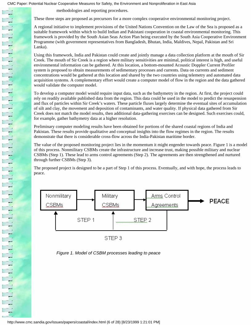
The value of the proposed monitoring project lies in the momentum it might engender towards peace. Figure 1 is a modelof this process. Nonmilitary CSBMs create the infrastructure and increase trust, making possible military and nuclearCSBMs (Step 1). These lead to arms control agreements (Step 2). The agreements are then strengthened and nurturedthrough further CSBMs (Step 3).
The proposed project is designed to be a part of Step 1 of this process. Eventually, and with hope, the process leads topeace.
Figure 1. Model of CSBM processes leading to peace
CMC Paper: Potential Nuclear Cooperative Measures for Safety, the Environment and Nonproliferation in East Asia
http://www.cmc.sandia.gov/issues/papers/coastal/index.html (6 of 28) [8/23/1999 1:21:01 PM]
This page intentionally left blank.
Cooperative Environmental Monitoringin the Coastal Regions of India and Pakistan
Introduction
The cessation of hostilities between India and Pakistan is of global concern, as these countries have tested nucleardevices and have the capability to build nuclear weapons and long-range ballistic missiles. Cooperative monitoringprojects amongst neighboring countries in South Asia could build regional confidence, and, through gradualimprovements in relations, reduce the threat of conventional war and the proliferation of weapons of massdestruction.
A recent collaborative study by an Indian and a Pakistani scholar has concluded, ?nonmilitary confidence buildingmeasures could create conditions for an incremental reduction in tensions between India and Pakistan? (Ahmedand Das, 1998). This study also identified technological collaboration in critical infrastructure areas as a key steptoward a South Asian peace. Such Confidence and Security Building Measures (CSBMs) are usually theprecursors to more significant weapons nonproliferation and reduction agreements.
For India and Pakistan, a lack of trust and confidence makes the development of CSBMs problematic. To initiate aprocess of incremental progress towards greater trust and confidence and improved relations, this paperinvestigates the prospect of a cooperative environmental monitoring project in the trans-border coastal region ofIndia and Pakistan. The paper discusses monitoring the trans-border movement of flow and sediment in the Indianand Pakistani coastal areas as well as the movement of marine pollution as a useful project through which Indiaand Pakistan could initiate cooperation. The proposed project falls within a regional framework of cooperationagreed to by several South Asian countries.
The design of cooperative monitoring projects involves the following steps: (1) a study of the context defining theproject; (2) an examination of the existing agreements; (3) the definition of the parameters that are required to bemonitored; and (4) the selection of the technologies that will be used in the cooperative monitoring project.(Pregenzer, Vannoni, and Biringer, 1996.)
The structure of this paper mirrors the steps involved in designing cooperative monitoring projects. Section 1presents information on the context of the Indian and Pakistani dialogue on boundary disputes in their sharedcoastal areas. Section 1 also describes and defines a region of interest. Section 2 discusses existing environmentalconventions and relevant monitoring agreements. Section 3 proposes a specific cooperative monitoring project forthe region of interest, a definition of parameters that need to be monitored, and suitable technology. Finally,Section 4 presents some concluding remarks.
The study provides a sufficiently detailed design to create and guide the implementation of a specific project.Given the recent thaw in Indian and Pakistani relations, this moment seems opportune for implementing a projectthat benefits both countries.
1.
CMC Paper: Potential Nuclear Cooperative Measures for Safety, the Environment and Nonproliferation in East Asia
http://www.cmc.sandia.gov/issues/papers/coastal/index.html (7 of 28) [8/23/1999 1:21:01 PM]
India and Pakistan have two areas of territorial dispute: Kashmir and the trans-border coastal region. In Kashmir,the two countries are involved in low-intensity warfare. In the coastal region, the main concerns of army patrolsare smugglers and the infiltration of terrorists. The trans-border coastal zone is, comparatively, far more tranquilthan Kashmir, and therefore, could be a starting place for the resolution of the territorial dispute.
The Indian and Pakistani trans-border coastal area is also of current high-level political interest in India andPakistan. In October 1998, India and Pakistan (after direct talks between their respective Prime Ministers) reviveda process of dialogue through Joint Working Groups. Eight working groups deal with the following subjects:Kashmir, Peace and Security, the Siachen Glacier, the Wullar Barrage, Sir Creek, Terrorism and Drug-Trafficking,Economic and Commercial Cooperation, and Promotion of Friendly Exchanges in Various Fields. The Sir Creekworking group deals with the demarcation of the border in the Indian and Pakistani shared coastal regions as wellas related maritime issues. The area is well suited as a region for proposing cooperative environmental monitoringstudies and experiments that could form the basis for improved relations.
Among the contentious issues being dealt with by the working groups, the Sir Creek issue seems one amenable toan early settlement. The history of the last fifty years, though, precludes an uncritical optimism.
Historical Background
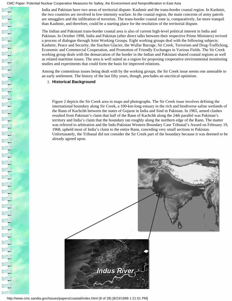
Figure 2 depicts the Sir Creek area in maps and photographs. The Sir Creek issue involves defining theinternational boundary along Sir Creek, a 100-km-long estuary in the rich and biodiverse saline wetlands ofthe Rann of Kachchh between the states of Gujarat in India and Sind in Pakistan. In 1965, armed clashesresulted from Pakistan’s claim that half of the Rann of Kachchh along the 24th parallel was Pakistan’sterritory and India’s claim that the boundary ran roughly along the northern edge of the Rann. The matterwas referred to arbitration and the Indo-Pakistan Western Boundary Case Tribunal’s Award on February 19,1968, upheld most of India’s claim to the entire Rann, conceding very small sections to Pakistan.Unfortunately, the Tribunal did not consider the Sir Creek part of the boundary because it was deemed to bealready agreed upon.
1.
CMC Paper: Potential Nuclear Cooperative Measures for Safety, the Environment and Nonproliferation in East Asia
http://www.cmc.sandia.gov/issues/papers/coastal/index.html (8 of 28) [8/23/1999 1:21:01 PM]
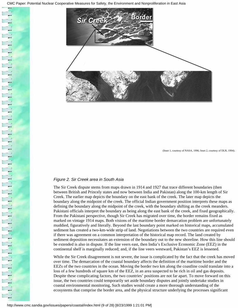
(Inset 1, courtesy of NASA, 1996; Inset 2, courtesy of DLR, 1994).
Figure 2. Sir Creek area in South Asia
The Sir Creek dispute stems from maps drawn in 1914 and 1927 that trace different boundaries (thenbetween British and Princely states and now between India and Pakistan) along the 100-km length of SirCreek. The earlier map depicts the boundary on the east bank of the creek. The later map depicts theboundary along the midpoint of the creek. The official Indian government position interprets these maps asdefining the boundary along the midpoint of the creek, with the boundary shifting as the creek meanders.Pakistani officials interpret the boundary as being along the east bank of the creek, and fixed geographically.From the Pakistani perspective, though Sir Creek has migrated over time, the border remains fixed asmarked on vintage 1914 maps. Both visions of the maritime border demarcation problem are unfortunatelymuddied, figuratively and literally. Beyond the last boundary point marked on historical maps, accumulatedsediment has created a two-km-wide strip of land. Negotiations between the two countries are required evenif there was agreement on a common interpretation of the historical map record. The land created bysediment deposition necessitates an extension of the boundary out to the new shoreline. How this line shouldbe extended is also in dispute. If the line veers east, then India’s Exclusive Economic Zone (EEZ) in thecontinental shelf is marginally reduced; and, if the line veers westward, Pakistan’s EEZ is lessened.
While the Sir Creek disagreement is not severe, the issue is complicated by the fact that the creek has movedover time. The demarcation of the coastal boundary affects the definition of the maritime border and theEEZs of the two countries in the ocean. Moving the border two km along the coastline could translate into aloss of a few hundreds of square km of the EEZ, in an area suspected to be rich in oil and gas deposits.Despite these complicating factors, the two countries’ positions are not far apart. To move forward on thisissue, the two countries could temporarily set aside boundary disputes and jointly undertake studies incoastal environmental monitoring, Such studies would create a more thorough understanding of theecosystems that comprise the border area, and the physical structure underlying the processes significant
CMC Paper: Potential Nuclear Cooperative Measures for Safety, the Environment and Nonproliferation in East Asia
http://www.cmc.sandia.gov/issues/papers/coastal/index.html (9 of 28) [8/23/1999 1:21:01 PM]
within the ecosystems.
Proposed Steps Toward Resolution of the Sir Creek and Related Maritime Disputes2.
To break the impasse in Indian and Pakistani maritime disputes, a narrow zone straddling the Sir Creek disputedmaritime border could become a zone of mutual cooperation, with territorial claims within this zone held in temporaryabeyance. This zone would be used for the initial deployment of a cooperative monitoring experiment. The studies couldbegin by measuring currents and sediment transport and observing how land-based activity impacts the coastal ocean.The studies would lead to estimates of the shoreline accretion rates, and the likely scale of the future meander of SirCreek. Further studies would assess the potential of the zone for sustainable development and natural resource use.Provided with new information, the countries would have a more thorough understanding of the real value of the area anda better understanding of adjacent areas within their sovereign territories. Negotiations on a final demarcation of themaritime border within this zone could then proceed on the basis of common understanding. The expertise gained byboth countries in studying the zone of mutual cooperation would be of value in their independent studies of the marineareas fully within their sovereign and undisputed control.
The idea of putting aside territorial disputes while undertaking joint studies for shared benefits has been successfullyapplied by 39 countries in the Treaty of Antarctica (ACDA, 1990). For ending the armed conflict on the Siachen Glacierbetween India and Pakistan, a similar concept in the form of a Siachen Science Center has also been proposed (Biringer,1998). Another example is a series of workshops convened by Indonesia to resolve the dispute over the Spratly Islands inthe South China Sea. The workshops ?have initiated steps towards cooperative marine scientific research and geologicalsurveys, temporarily setting aside the fundamental problems of sovereignty and maritime boundaries. These workshopsand associated activities have proceeded on the assumption that resolution of territorial and jurisdictional disputes in theregion is not possible without first addressing cooperation on other levels such as navigation and the environment.?(Bateman, 1996).
Participants at a recent meeting on ?Trust- and Confidence-Building Measures in South Asia? have also identifiedCSBMs in the India-Pakistan trans-border coastal regions among other important bilateral measures for progress. Manysubject areas could form the basis of maritime nonmilitary CSBMs between India and Pakistan. A list (by no meansexhaustive) of potential areas of cooperation follows:
Demarcation of maritime borders ●
Joint search and rescue protocols●
Protocols for dealing with captured trespassing fishermen and their safe and expedited return●
Commercial fisheries development●
Protection of migratory species and their habitats●
Cooperative development of ecotourism●
Extraction of natural resources (oil and gas, seabed mining)●
Coping with oil spills and other marine disasters ●
Monitoring marine pollution from shipping●
Scientific projects (e.g., monitoring sea-level rise or ocean-atmosphere interactions)●
This paper’s approach focuses specifically on a cooperative monitoring project related to flow and sediment transportprocesses in the Indian and Pakistani shared coastal areas. Understanding flow and transport dynamics is key to thefurther analyses of other bio-geochemical processes, as well as understanding coastal pollution from land-basedactivities.
Defining a Geographical Area of Focus and Issues of Concern1.
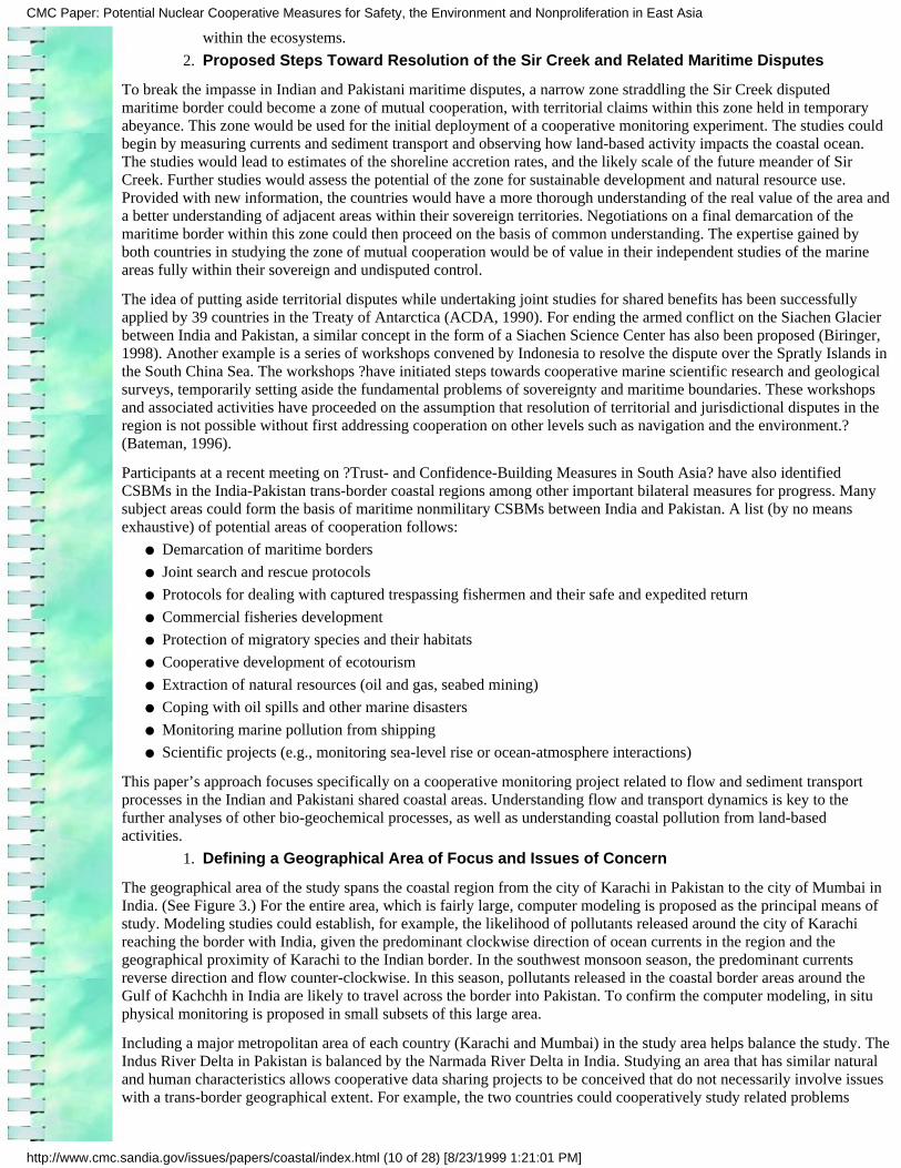
The geographical area of the study spans the coastal region from the city of Karachi in Pakistan to the city of Mumbai inIndia. (See Figure 3.) For the entire area, which is fairly large, computer modeling is proposed as the principal means ofstudy. Modeling studies could establish, for example, the likelihood of pollutants released around the city of Karachireaching the border with India, given the predominant clockwise direction of ocean currents in the region and thegeographical proximity of Karachi to the Indian border. In the southwest monsoon season, the predominant currentsreverse direction and flow counter-clockwise. In this season, pollutants released in the coastal border areas around theGulf of Kachchh in India are likely to travel across the border into Pakistan. To confirm the computer modeling, in situphysical monitoring is proposed in small subsets of this large area.
Including a major metropolitan area of each country (Karachi and Mumbai) in the study area helps balance the study. TheIndus River Delta in Pakistan is balanced by the Narmada River Delta in India. Studying an area that has similar naturaland human characteristics allows cooperative data sharing projects to be conceived that do not necessarily involve issueswith a trans-border geographical extent. For example, the two countries could cooperatively study related problems
CMC Paper: Potential Nuclear Cooperative Measures for Safety, the Environment and Nonproliferation in East Asia
http://www.cmc.sandia.gov/issues/papers/coastal/index.html (10 of 28) [8/23/1999 1:21:01 PM]
within their territories and then share the data generated. If each country monitors an environmental problemindependently, and then shares the data generated, the project would be similar to transparency measures useful forsecurity-related issues. The study of trans-border issues, such as the trans-border movements of pollutants, remains usefulin a process of incremental improvement in relations as both countries have a vested interest in the results.
For selecting a trans-border critical issue suitable for cooperative monitoring, the most important criterion is that thescale should be large enough to affect the coastal border areas of both India and Pakistan. The trans-border character ofan issue stems from the geographical extent of its direct and indirect effects. Pressures on a coastal zone have localimpacts as well as indirect consequences in other parts of the zone. So, for example, contaminated sediments present inareas well within one country will have effects on the local marine life; but they may also affect indirectly, throughmigratory species, the health of marine life across the border. For a pilot cooperative monitoring project, the issueselected for study should require a short time frame.
Figure 3. Proposed area for a cooperative coastal monitoring project
Another criterion for selection is to pick a subject for which considerable data already exists that is readily available for
CMC Paper: Potential Nuclear Cooperative Measures for Safety, the Environment and Nonproliferation in East Asia
http://www.cmc.sandia.gov/issues/papers/coastal/index.html (11 of 28) [8/23/1999 1:21:01 PM]
sharing. A process of sharing existing data is a good first step in crafting a cooperative monitoring project and, therefore,it is important that such data be available for the area and issue selected for study. Finally, the issues should be such thatthe results of the joint study will not be unduly sensitive in nature or embarrassing to any of the parties, and of mutualbenefit.
In keeping with an approach based on incremental progress, initiating cooperative monitoring projects within a subset ofthe larger area depicted in Figure 3 is the most feasible approach. Such a subset area could include the Indus Delta inPakistan and the Gulf of Kachchh in India. At an even smaller scale, and for the start of a project, the subset area shouldinclude only the Sir Creek inter-tidal region. In future phases, after a process of confidence building has been initiatedthrough the cooperative study of a trans-border issue, separate small subset areas that relate to similar environmentalproblems could be studied independently by each country and the data shared as a transparency measure. Such a project,for example, could be to study contamination in creeks near Karachi and Mumbai. The exact geographical extent of thearea of study for fielding cooperative monitoring projects will be determined by the political willingness of Indian andPakistani leaders. The project proposed in this study is, therefore, designed to be scaleable and encompass larger orsmaller areas without losing its utility.
In the entire area described in Figure 3, the cities of Karachi and Mumbai play an extremely vital economic role. Eachcity accounts for almost 20 to 30 percent of the revenues generated in its respective country. Both are giant urban centerswith approximately 14 million people in their greater metropolitan environs. The area of study includes the Indus Deltain Pakistan, the Narmada Delta in India, and the Gulfs of Kachchh and Khambat in India. Major population centers,naval bases, ports, industrial areas, nuclear facilities, and unique ecosystems and habitats of endangered species lie withinthis region.
Existing international environmental conventions and treaties could provide the framework within which to develop jointIndian and Pakistani coastal environmental monitoring projects within the selected area of study. The next sectiondiscusses these conventions and treaties in more detail.
Environmental Conventions and Monitoring Agreements
Numerous studies predict a link between environmental scarcity and violent conflict. Environmental securityissues (such as the control of pollution, greenhouse gas emissions reductions, and effective management of waterresources) require cooperative solutions. No state can hope to solve these global and regional problems inisolation. Over the years, various international conventions have emerged that allow states to work together onsolving environmental problems.
Several multilateral and regional efforts are underway currently to create a community of littoral and island statesin the Indian Ocean. Countries such as Australia, India, and South Africa are leading these efforts. The IndianOcean is an extremely strategic region, providing transit routes (1) for the movement of petroleum products fromthe Arabian Gulf to Europe and North and South America and (2) for all maritime traffic between Asia and Africa.Large reserves of hydrocarbons exist in the offshore areas of Saudi Arabia, Iran, India, and Western Australia, andan estimated 40% of the world's offshore oil production comes from the Indian Ocean. Many countries activelyexploit beach sands and offshore deposits rich in heavy minerals. The fishing fleets of several nations ply thesewaters. Given the strategic importance of the Indian Ocean region, coupled with the economic value of its mineralsand marine life, issues of maritime security and maritime CSBMs in this region are increasing in significance.Strengthening existing international maritime conventions and treaties in this region is, therefore, becomingincreasingly important.
India and Pakistan are signatories to or have ratified several international conventions on protecting theenvironment. Some of these conventions require the creation of regional mechanisms of cooperation with relatedplans for the monitoring of environmental indicators. One of these conventions, the United Nations Convention onthe Law of the Sea (UNCLOS) provides a good basis for an Indian and Pakistani coastal environmental monitoringproject.
Section 2.1 of this paper focuses on the UNCLOS as it has considerable relevance to the Indian and Pakistanitrans-border coastal region. The convention (1) has been signed and ratified by India and signed by Pakistan withratification pending; (2) is well established; (3) is relevant to the trans-border coastal area; and (4) most important,it is a driver of regional cooperative monitoring with some efforts already begun. Although Pakistan has not yetratified the UNCLOS, it has signed and ratified agreements that have emerged from this convention. Otherconventions meet some of these selection criteria, for example, the Convention on Biodiversity, the RamsarConvention on the Protection of Wetlands, and the Convention on the Prevention of Desertification. The UNCLOS
1.
CMC Paper: Potential Nuclear Cooperative Measures for Safety, the Environment and Nonproliferation in East Asia
http://www.cmc.sandia.gov/issues/papers/coastal/index.html (12 of 28) [8/23/1999 1:21:01 PM]
is unique in the South Asian context in that, under its aegis, a subregional mechanism of cooperation has beenestablished. Over the last four years, a South Asian Seas Action Plan has been developed through a collaborativeprocess. The governments of India and Pakistan have agreed to this regional plan along with the governments ofother cooperating South Asian countries. The South Asia Cooperative Environment Programme (SACEP) based inColombo, Sri Lanka, is responsible for implementing the plan. The plan includes strategies for promoting regionalcooperative environmental monitoring and, therefore, represents an excellent opportunity for promoting greatercooperation between India and Pakistan in coastal issues. Section 2.2 discusses the South Asian Seas Action Plan.Section 2.3 discusses how states in other regions have created cooperative monitoring projects dealing with thecoastal environment.
The United Nations also operates several global environmental monitoring programs, including the GlobalEnvironment Measurement System and the Global Resource Information Database. Data generated through suchprograms could form the basis of an effort to collect and disseminate existing data on the Indian and Pakistanicoasts. The International Coral Reef Initiative is a similar multinational initiative involving a monitoring network.These existing international environmental monitoring networks could serve to initiate environmental data sharingbetween India and Pakistan. More important, Sections 2.4 and 2.5 present details of ongoing Indian and Pakistanicoastal monitoring programs. A cooperative monitoring project could begin by sharing the data generated throughsuch programs. Section 2.6 discusses the scope of cooperation by Indian and Pakistani coastal environmentalmonitoring projects.
The United Nations Convention on the Law of the Sea
The UNCLOS was opened for signature on December 10, 1982. The date of entry into force is when a treatybecomes binding upon the states that have expressed their willingness to abide by it. This is usuallyactivated by a specific clause in the text of the treaty. India signed the UNCLOS on December 10, 1982, andthe date of entry into force for India was July 29, 1995. Pakistan signed the convention on December 10,1982. According to the Environmental Treaties and Resource Indicators database, the UNCLOS has yet toenter into force for Pakistan. However, Pakistan has signed and ratified or simply signed agreements thathave emerged out of, or in parallel to, this convention. The UNCLOS recognizes the importance of theoceans in sustaining our lives and the threats facing the oceans. This force of sustenance is now in perilthrough increasing pollution loads. More than half the world’s population and most species live along theworld’s coasts. Eighty percent of all life forms live in the ocean. The greatest diversity and number of thesespecies is found living, birthing, and nurturing in the coastal transition zone of land and ocean, in sea grassbeds, coral reefs, and coastal wetlands. Tropical rain forests that support the next largest diversity of speciesare also intimately linked with the oceans through rain and the river basins that bring the rain back to itsocean source. Recognizing the importance of the ocean, the aim of UNCLOS is to protect and preserve thisvital force.
The UNCLOS combines many pre-existing conventions and agreements. It deals with a wide variety ofsubjects—ocean resources (such as fish, oil, and gas) and the Exclusive Economic Zones of states, rights ofpassage and navigation, enforcement, marine research—and has emerged through many years ofnegotiations. From the perspective of this study, Part 12 of the UNCLOS is the most relevant. Part 12 dealswith the protection and preservation of the marine environment. Section 2 of this part deals with global andregional cooperation, and Section 4 deals with monitoring and environmental assessment. The two mostrelevant articles of these sections state the following:
Part 12 - Protection and Preservation of the Marine Environment
Section 2 - Global and Regional Cooperation
Article 200 - Studies, research programs and exchange of information and data
States shall co-operate, directly or through competent international organizations, for the purpose ofpromoting studies, undertaking programs of scientific research and encouraging the exchange ofinformation and data acquired about pollution of the marine environment. They shall endeavor toparticipate actively in regional and global programs to acquire knowledge for the assessment of the natureand extent of pollution, exposure to it, and its pathways, risks and remedies.
Part 12 - Protection and Preservation of the Marine Environment
Section 4 - Monitoring and Environmental Assessment
1.
CMC Paper: Potential Nuclear Cooperative Measures for Safety, the Environment and Nonproliferation in East Asia
http://www.cmc.sandia.gov/issues/papers/coastal/index.html (13 of 28) [8/23/1999 1:21:01 PM]
Article 204 - Monitoring of the risks or effects of pollution
States shall, consistent with the rights of other States, endeavor, as far as practicable, directly or throughthe competent international organizations, to observe, measure, evaluate and analyze, by recognizedscientific methods, the risks or effects of pollution of the marine environment.
To implement requirements such as these of the UNCLOS, various regions of the world have set upRegional Seas Programs with the assistance of the United Nations Environment Program. The South AsianRegional Seas Program involves the marine member states of South Asia: Bangladesh, India, Maldives,Pakistan, and Sri Lanka. These countries adopted a South Asian Seas Action Plan at a meeting ofplenipotentiaries in New Delhi in March 1995; the plan came into force in January 1998. SACEP has beendesignated as the Secretariat for the implementation of the Action Plan.
SACEP was established through the initiative of the United Nations Environment Program–Regional Officeof Asia Programs. The member countries of SACEP are Afghanistan (not an active member), Bhutan,Bangladesh, India, Maldives, Pakistan, and Sri Lanka.
South Asian Seas Action Plan
One of the key elements of the South Asian Seas Action Plan is to encourage collaboration among regionalscientists and technicians and their institutions through the ?establishment of a coordinated regional marinepollution monitoring program, based on intercomparable methods, for the study of the various processesoccurring in the coastal areas and open ocean of the region and the assessment of the sources and levels ofpollutants and their effects on marine life and human health.? (Dias, 1998).
The UNCLOS has specific provisions relating to the prevention, reduction, and control of marine pollutionfrom land-based activities. In keeping with these provisions, Annex IV of the South Asian Seas Action Planincludes a ?Regional Program of Action for the Protection of the Marine Environment of the South AsianSeas from Land-based Activities.? The proposed activities include the ?Development of a Regional Programfor Monitoring of Marine Pollution in the Coastal Waters of the South Asian Seas and the Regular Exchangeof Relevant Data and Information.?
The implementation of the South Asian Seas Action Plan is in its nascent phase, pending the availability offunds. As an existing regional framework for cooperative environmental monitoring, it provides an excellentopportunity for promoting Indian and Pakistani joint efforts.
2.
Examples of Cooperative Coastal Monitoring Programs from Other Regions
There are valuable lessons to be learned from marine cooperative monitoring programs in other regions ofthe world: (1) the Wadden Sea Trilateral Monitoring and Assessment Program (TMAP) created byDenmark, Germany, and The Netherlands; and (2) the Red Sea Marine Peace Park, created by Israel andJordan. (These programs are discussed in Appendix A.)
The success of the Wadden Sea TMAP has many lessons for India and Pakistan. Even among friendlycountries, it has taken a series of conferences and almost four years from the start of negotiations for acommon monitoring program and management scheme to emerge. A formal agreement between India andPakistan for cooperative monitoring in their coastal areas will take a considerable length of time. Thecooperative monitoring program in the Wadden Sea began with a subset of selected parameters, which werealready a part of national programs. The program then worked to harmonize these existing measurements.This kind of a phased approach to cooperative monitoring could be valuable in South Asia.
The main lesson for India and Pakistan from the Red Sea Marine Peace Park is that formerly hostilecountries can work together to benefit economically from the sustainable development of a coastal resource.The park is also a useful example of how externally funded feasibility studies (in this case by the U.S.government) can successfully promote cooperation in a region of tension.
It will not be easy for India and Pakistan to emulate the example of the Wadden Sea Cooperation Area andthe Red Sea Marine Peace Park. An increase in cooperation between India and Pakistan in coastal regionscould begin by sharing existing environmental data. Details of existing Indian and Pakistani coastalmonitoring programs are presented in the next sections.
3.
CMC Paper: Potential Nuclear Cooperative Measures for Safety, the Environment and Nonproliferation in East Asia
http://www.cmc.sandia.gov/issues/papers/coastal/index.html (14 of 28) [8/23/1999 1:21:01 PM]
Indian Coastal Monitoring Programs
Two national governmental organizations in India are actively involved in the monitoring of India’s coastalenvironment: (1) the Department of Ocean Development (DOD) working with the National Institute ofOceanography, and (2) the Ministry of Environment and Forests, working through an autonomous bodycalled the Central Pollution Control Board. These organizations are linked with many regional research andacademic institutes.
The COMAPS Program of the Department of Ocean Development1.
4.
Since 1991, the DOD has scientifically measured marine environmental parameters under its Coastal Ocean Monitoringand Prediction System (COMAPS). The DOD collects data on 25 parameters from 77 locations with the help of 11regional research and development institutions. The COMAPS program is administered for the DOD, with headquartersin New Delhi, by the Indian National Institute of Oceanography (NIO), with headquarters in Panjim, Goa, through theNIO’s Regional Center in Mumbai. The regional institutions responsible for monitoring the Indian side of theIndia-Pakistan trans-border coastal zone (described in Figure 3) are the Central Salts and Marine Chemical ResearchInstitute, Bhavnagar, Gujarat, and the NIO’s Regional Center in Mumbai, Maharashtra.
Data collected under the COMAPS program is used by the DOD to categorize Indian coastal areas into the followingfour types:
Areas of clean sea water quality●
Coastal locations of no concern●
Potential areas of pollution with a need for continued intensive monitoring●
Areas of concern with a need for continued intensive monitoring●
The COMAPS program collects environmental data on an annual basis and each data location represents 100 km of theIndian coastline. Areas of potential or real concern are monitored more intensively.
Within the coastal zone of interest in this study, the COMAPS program has identified several areas of potential andknown concern. In the areas of known concern, ?the levels of dissolved oxygen reached ‘nil’ values during low tides andshowed abnormal values of human pathogens.? (DOD, 1998) These levels are presumed to occur mainly because of thedisposal of untreated sewage and industrial effluents.
As a part of the COMAPS program, the DOD is also developing a mathematical model to predict diffusion anddispersion characteristics of pollutants. This project is in partnership with the Indian Center for Mathematical Modelingand Computer Simulations (C-MMACS). Field data on tide, current, and bathymetry required for computer modelingwere collected during 1996 and 1997.
Coastal Monitoring Programs of the Ministry of Environment and Forests1.
The Indian Ministry of Environment and Forests (MOEF) is the central environmental decision- and policy-makingbody. The MOEF has several autonomous agencies linked to it, one of which is the Central Pollution Control Board(CPCB). (Each Indian state has a counterpart state-level Pollution Control Board.) The CPCB provides technical servicesto the MOEF, and gathers water pollution and coastal environmental data. Some of this data (in a summary form anddating from the preceding three to four years) is posted on the Internet. In Bengal, a zonal office of the CPCB participatesin the COMAPS program. In the India-Pakistan trans-border coastal area, the CPCB compiles baseline data for the Gulfof Kachchh through a national program to gather baseline data on selected ?Coastal Fragile Areas.? The baseline datainclude information on climate, water and sediment quality, solid waste generation, tourism, urbanization,industrialization, natural calamities, fishing, other biological resources, and biodiversity.
The CPCB publishes a series of annual reports that deal with coastal pollution control. One set of reports designates usesof coastal areas, and describes existing conflicts with such uses caused by pollution. The CPCB prepares summaryreports of coastal water quality statistics, and reports on the pollution potential of industries located in coastal areas. Thepublished reports usually present historical data that is two or three years old; that is, the most current publications dealwith data from 1995 to 1996.
Pakistani Coastal Monitoring Programs1.
The Pakistan Council for Scientific and Industrial Research and Pakistan’s National Institute of Oceanography (NIO)conduct periodic studies on coastal pollution and heavy metals accumulation in marine life. The Pakistani NIO wasestablished in 1982 to conduct research in the 990 sq. km. of Pakistan’s coastal areas, and the 24,000 sq. km. ofPakistan’s EEZ. Among its many objectives, the Pakistani NIO is involved in
CMC Paper: Potential Nuclear Cooperative Measures for Safety, the Environment and Nonproliferation in East Asia
http://www.cmc.sandia.gov/issues/papers/coastal/index.html (15 of 28) [8/23/1999 1:21:01 PM]
mission-oriented, multi-disciplinary research in physical, chemical, biological, geological, and geophysicaloceanography in Pakistan’s maritime areas,
❍
establishment of a National Oceanographic Data Center to serve as a national repository for alloceanographic data and information concerning Pakistan’s maritime areas, and
❍
integrated coastal zone management.❍
Coastal environmental issues are under the purview of the Ministry of Environment and Urban Affairs. Within thisministry, a Marine Environmental Unit (MEU) monitors water, air, sediment, and biota quality. In 1994, Pakistan’sgovernment created a Marine Pollution Control Board (MPCB) to supervise and implement pollution control measuresalong Pakistan’s coastline.
A Pakistani coastal monitoring project that illustrates the benefits of international cooperation involved a scientist fromthe Pakistani Space and Upper Atmosphere Research Commission (SUPARCO) and European collaboration (Raouf andLichtenegger, 1997). In this project, a synthesis of optical and Synthetic Aperture Radar satellite imagery was used totrack changes in mangrove vegetation in the Indus Delta.
The World Conservation Union (IUCN)-Pakistan serves as a network of several government and non-governmentalagencies, including SUPARCO and the Pakistani NIO. The IUCN-Pakistan has a Coastal Ecosystems Programme that isworking on the reforestation and rehabilitation of degraded mangroves in the coastal areas around Karachi. TheIUCN-Pakistan is also expanding its coastal program to include issues such as marine protected areas, fisheries, coastalzone development, endangered marine species, and coastal community development. Such nongovernmentalorganizations could be instrumental in fostering greater Indian and Pakistani cooperation in coastal monitoring programs.
Scope of Cooperation between Indian and Pakistani Coastal Monitoring Programs in TheirTrans-border Coastal Regions
There is ample scope for the coastal monitoring programs of India and Pakistan to cooperate in monitoringtheir trans-border coastal regions. For example, Indian agencies that have significant data gathering andanalysis capabilities could voluntarily share data with Pakistan and other South Asian countries. India couldunilaterally initiate greater regional cooperation in the use of satellite imagery for earth and atmosphericstudies, and, in return, India could get better ground information for validation of data on a regional scale.
Recently, India has acquired the capability to generate large amounts of data on ocean resources with thesuccessful launch of OCEANSAT, a satellite dedicated to ocean monitoring. To be more cost-effective andhave improved value, analyses of some of the data generated by OCEANSAT could occur cooperatively byIndia and Pakistan, especially for their shared coastal ecosystems. The INSAT series of Indian satellitescontinuously monitor the dynamics of clouds over the Indian Ocean region and the Indian MeteorologicalDepartment uses meteorological data from these satellites for operational weather forecasting. Cooperationin the use of such space-based data for the joint surveillance of ocean resources could be of great value inSouth Asia.
Cross-flow connections exist between the Indian and Pakistani trans-border coastal regions. The main oceancurrents in the region turn clockwise and counter-clockwise with the monsoon seasons. Tidal flows alsocreate fluctuating cross-border flows.
The silt and fresh waters carried by the Indus are the food and life-blood of the trans-border region,regulating the stability and primary productivity of the mudflats and the salinity of the creeks. The IndusDelta sustains the largest area of arid climate mangroves in the world. The mangroves of the Indus Delta areunder threat from reduced freshwater flows of the Indus and rapid declines in the available quantities of siltand nutrients.
Most rivers of South Asia carry huge quantities of sediment, created primarily by tectonic uplift and thegeologically young mountains of the northern borders of this region. Human deforestation activitiesaugment this sediment load. The turbidity created in the coastal waters has prevented the formation of coralreefs in most of South Asia’s delta regions. Corals require clear waters that allow the penetration of sunlight.The Gulf of Kachchh is unique in supporting coral reefs, despite its proximity to the Indus Delta.Understanding the long-term threats to the coral reefs of the Gulf of Kachchh will require simultaneousstudy of the Indus Delta.
Impacts of the Indus Waters on Coastal Ecosystems1.
1.
The Indus Waters Treaty of 1960 between India and Pakistan resolved water-sharing disputes between the two countries.
CMC Paper: Potential Nuclear Cooperative Measures for Safety, the Environment and Nonproliferation in East Asia
http://www.cmc.sandia.gov/issues/papers/coastal/index.html (16 of 28) [8/23/1999 1:21:01 PM]
This led to a substantial increase in barrages, dams, and link canals that have reduced the freshwater outflow of the Industo the sea to less than 25 percent of that available – from 180 billion m3/year to less than 43 billion m3/year. (IUCN,1991a) A portion of the current annual outflow is permitted for use but not currently utilized by India. Within Pakistan,current development proposals indicate that the outflow into the sea may be reduced to 12 billion m3/year (Meynell andQureshi, 1993). One of the current development proposals is the Kalabagh Dam on the Indus in the North-West FrontierProvince proposed by the government of Pakistan. The state government of Sind opposes this dam. From the Sindhiperspective, the dam primarily benefits Punjab and is likely to deprive the desert regions of Sind of water. Punjabisdominate the present government of Pakistan, and this exacerbates the situation, adding the fires of regional animositiesinto an already explosive mix. If Indian state governments increase utilization of their allocation of Indus waters (anaction extremely likely in the next five to ten years), the government of India could become embroiled in the situation ofreduced flows of freshwater into the Indus Delta. The reduced flow of the Indus into the sea has reduced the annualquantity of silt delivered into the delta. If the government of Pakistan implements further development proposals, andreduces the Indus’ outflow to 12 billion m3/year, the annual quantity of silt delivered could become dangerously low andaffect the long-term sustainability of the Indus Delta.
Reduced freshwater flows in the Indus will increase the salinity of the tidal creeks in the delta system, and could stuntmangrove growth. A single species of mangrove dominates the Indus Delta (over 95% of the trees). Increasing salinitylevels in some regions of the mangrove forests have already created observable declines in the growth of new trees. Theloss of silt is even more dangerous given the sea-level rise of 1.1 mm/year known to occur near Karachi. (IUCN, 1991b)Mangroves can survive sea-level increases as high as 2.5 mm/year if there is a sufficient discharge of sediment-bearingwaters into the mangrove forests. Without any delivery of silt, mangroves cannot sustain themselves for rates of sea-levelrise of 1.2 mm/year. (IUCN, 1991b) With increases in sea-level rise expected as a result of global warming, themangroves of the Indus Delta could suffer a severe long-term threat. In the short term, increased tidal areas will probablyprovide expanded opportunities for mangrove propagation.
Tidal currents in the Gulf of Kachchh set up a hydraulic barrier that prevents sediment discharged by the Indus fromentering the Gulf (Nair, 1984). Turbidity is still fairly high from cyclones, wind-blown sediment, discharge from minorrivers along the southern shore, and numerous human activities (such as salt mining and agriculture). The strong currentswithin the Gulf are the features that have allowed coral reefs to develop in these turbid waters. Living corals in the Gulfare usually found on the northern and western sides of islands within the Gulf and in patches between islands in areasexposed to the strongest tidal currents. On the landward side of the corals, mangroves are always present on the islands.Mangroves and coral reefs are symbiotically joined. Mangroves filter sediment and allow corals to grow in waters thatmight otherwise be excessively turbid. Coral reefs, the rainforests of the ocean, support the marine life that nurses andbreeds among the roots of mangroves, cleansing the forest litter and maintaining the health of the mangroves.
Current threats to the Gulf of Kachchh stem primarily from human industrial activities. Dredging sand for the cementindustry has caused reef damage and increased turbidity sufficiently to destroy almost 50 percent of the coral. By the year2007, almost 50 percent of India’s crude oil imports (about 80 million tons) will be handled by ports in the area. Thiscould create severe pollution problems from oil spills. In 1997, about 12 million tons of crude oil were discharged at afloating oil terminal near the Gulf. Minor oil spills have damaged mangroves and marine life. Oil and heavy metalspollution that stems from a ship-breaking yard along the coast north of the Gulf has also damaged marine life and theGulf’s ecosystems. Residues from salt mining on the southern shores of the Gulf are other contributors to pollution in theGulf. Finally, the loss of mangroves in the area has allowed the fury of cyclones to reach far inland and extensive damagehas often been caused to life in the area from typhoons and cyclones.
Apart from its sediment load, the Indus River affects the delta region through its influx of freshwater and the concomitantimpact on salinity levels. At this time, the impact of this freshwater on the salinity levels across the border is unknown. Ifthe salinity levels increase sufficiently within the inter-tidal creeks that make up the trans-border areas and there is asignificant impact on mangroves, coastal erosion could increase rapidly. This could alter turbidity levels within the Gulfof Kachchh. A thorough understanding of issues such as these will require cooperation between India and Pakistan. Thenext section provides details of a specific project that could foster greater Indian and Pakistani cooperation in this region.
Monitoring Tidal Flows and Sediment Transport in the Indus Delta and Gulfof Kachchh Region
Despite the lack of overt conflict in their coastal regions, the development of Indian and Pakistani environmentallyrelated CSBMs in coastal areas is not likely to be easy. Decades of hostility and the political sensitivities involvedpose significant barriers to progress. Therefore, an Indian and Pakistani CSBM project needs to be composed of aseries of mini-CSBMs that will lead up to the larger CSBM, which itself is a part of a greater trust- and
1.
CMC Paper: Potential Nuclear Cooperative Measures for Safety, the Environment and Nonproliferation in East Asia
http://www.cmc.sandia.gov/issues/papers/coastal/index.html (17 of 28) [8/23/1999 1:21:01 PM]

confidence-building movement. From this perspective, a series of steps are first proposed that could serve as thebuilding blocks of a larger cooperative environmental monitoring project in the Indian and Pakistani coastaltrans-border region.
Initiating Indian and Pakistani Coastal Environmental Monitoring Projects: First Steps1.
The following steps are proposed for developing collaborative bilateral coastal projects:
Create a draft document that will govern coastal environmental projects between the two countries.Signing off on the document, akin to a Code of Conduct, need not be a precondition of progress on datagathering and data sharing. Such activities could proceed on the basis of existing regional cooperativeframeworks, or through nongovernmental channels. Preparing and discussing a working draft of a documenton governing principles for cooperation would allow both sides to present and better understand each other’sviews. The document could be designed as a statement of existing practices and principles. It would avoidcontentious issues and be written for easy acceptance. The existing high-level dialogue through JointWorking Groups could be a suitable forum for discussion of such a document, especially in the WorkingGroup discussing the Sir Creek issue.
1.
Compile existing environmental data from the coastal regions into a joint baseline document. The processof conducting cooperative environmental projects needs to begin by sharing available data and creating abaseline document. A reference baseline provides a foundation for monitoring trends and identifying criticalissues. The sharing of available baseline data could be institutionalized through a series of workshopsculminating in a binational conference and then continued through an Internet-based dissemination system.Sharing existing data that is already in the public domain would be relatively easier than generating newdata jointly. The political benefits of a joint document would, however, be considerable and establish asense of progress early in the effort. This baseline document could also include satellite maps of the Indianand Pakistani coastal regions. Space-based photographs of both countries’ border areas could be a powerfultool for illustrating the shared nature of ecosystems. A satellite atlas would be very useful in schooleducational curricula. Possessing its own satellite imagery, India could offer some of this imagery toPakistan as a goodwill gesture.
2.
Harmonize existing measurements of environmental parameters through transparency in the samplingmethodologies and reporting procedures. The major initial focus of an effort to create a reference baselinedocument and then initiate a program to monitor changes has to be the identification of suitable indicatorsthat reflect environmental changes. The measurement procedures for these indicators need to beintercomparable.
3.
The three steps described here for initiating environmental monitoring projects are common to efforts that promotecooperation between states. Specific projects in the Indian and Pakistani coastal areas will need to incorporate elementsof these steps. One such specific project is monitoring tidal flows and sediment transport in the Indus Delta and the Gulfof Kachchh region.
Selecting a Monitoring Location
Investigating flow and sediment transport processes in the Indus Delta and the Gulf of Kachchh requiresstudying historical records, analyzing cores and samples of sediment, measuring current speeds and othervariables, and analyzing satellite images. Such studies will create an understanding of the natural evolutionof the complex environment of the region, the impact of human activities, and the mechanisms by whichsediments and other particles move through the region.
The sensitivity of the data being gathered will be a determining factor in the successful implementation of acooperative monitoring experiment. From a military standpoint, data on bathymetry, ocean currents, andeven salinity can be used to improve submarine navigation and detection. The Gulf of Kachchh region hostsIndian ports and infrastructure for oil and gas extraction and import. These facilities could be likely targetsin a future war. Similarly, Karachi is Pakistan’s major port facility and was a target of Indian missile boatattacks in the India-Pakistan war of 1971. Therefore, it is conceivable that Indian and Pakistani strategicplanners and military analysts would be highly suspicious of projects that collect marine data in the Gulf ofKachchh and near Karachi. To counter such suspicions, monitoring locations would be chosen also for theirmilitary and political acceptability.
The mouth of the Gulf of Kachchh is probably too sensitive a location from an Indian military point of viewfor locating a bottom-mounted current and sediment concentrations meter that shared information withPakistani counterparts. From the viewpoint of an environmental study such a location might be ideal. The
1.
CMC Paper: Potential Nuclear Cooperative Measures for Safety, the Environment and Nonproliferation in East Asia
http://www.cmc.sandia.gov/issues/papers/coastal/index.html (18 of 28) [8/23/1999 1:21:01 PM]
mouth of Sir Creek, however, is a region where military sensitivities are minimal and useful environmentalinformation could be gathered.
The added benefit of selecting the mouth of Sir Creek as a location for a cooperative monitoring project isthat this territory is in dispute. A part of this dispute stems from the migration of Sir Creek and theaccumulation of sediment that is creating new land in the area. A joint experiment would assist the twocountries’ scientists to better understand the hydrodynamics and sediment transport processes in thislocation. From an optimistic perspective, this understanding could allow policy makers to make morerational decisions.
Monitoring Objectives2.
Sediment deposition in a coastal region is not an easy physical process to predict. It occurs over seasonal and long-termtemporal scales. Even predicting whether deposition or erosion is likely to occur is fraught with uncertainty. The lawsgoverning flow dynamics are much better understood (except for turbulent flows). This is why most coastalenvironmental monitoring projects involve the combined use of predictive flow models and observation. The primarymonitoring objective becomes the validation of modeled results.
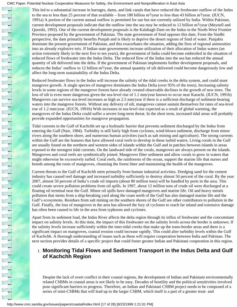
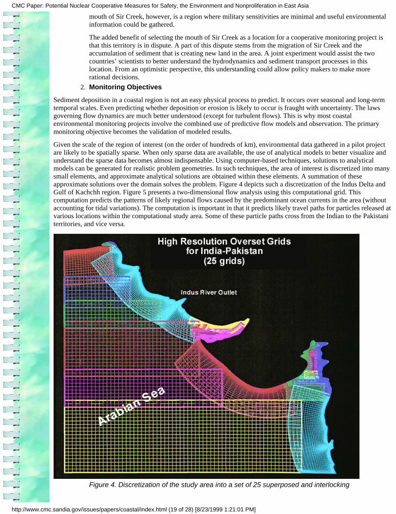
Given the scale of the region of interest (on the order of hundreds of km), environmental data gathered in a pilot projectare likely to be spatially sparse. When only sparse data are available, the use of analytical models to better visualize andunderstand the sparse data becomes almost indispensable. Using computer-based techniques, solutions to analyticalmodels can be generated for realistic problem geometries. In such techniques, the area of interest is discretized into manysmall elements, and approximate analytical solutions are obtained within these elements. A summation of theseapproximate solutions over the domain solves the problem. Figure 4 depicts such a discretization of the Indus Delta andGulf of Kachchh region. Figure 5 presents a two-dimensional flow analysis using this computational grid. Thiscomputation predicts the patterns of likely regional flows caused by the predominant ocean currents in the area (withoutaccounting for tidal variations). The computation is important in that it predicts likely travel paths for particles released atvarious locations within the computational study area. Some of these particle paths cross from the Indian to the Pakistaniterritories, and vice versa.
Figure 4. Discretization of the study area into a set of 25 superposed and interlocking
CMC Paper: Potential Nuclear Cooperative Measures for Safety, the Environment and Nonproliferation in East Asia
http://www.cmc.sandia.gov/issues/papers/coastal/index.html (19 of 28) [8/23/1999 1:21:01 PM]
computational grids to achieve a high resolution of spatial characterization
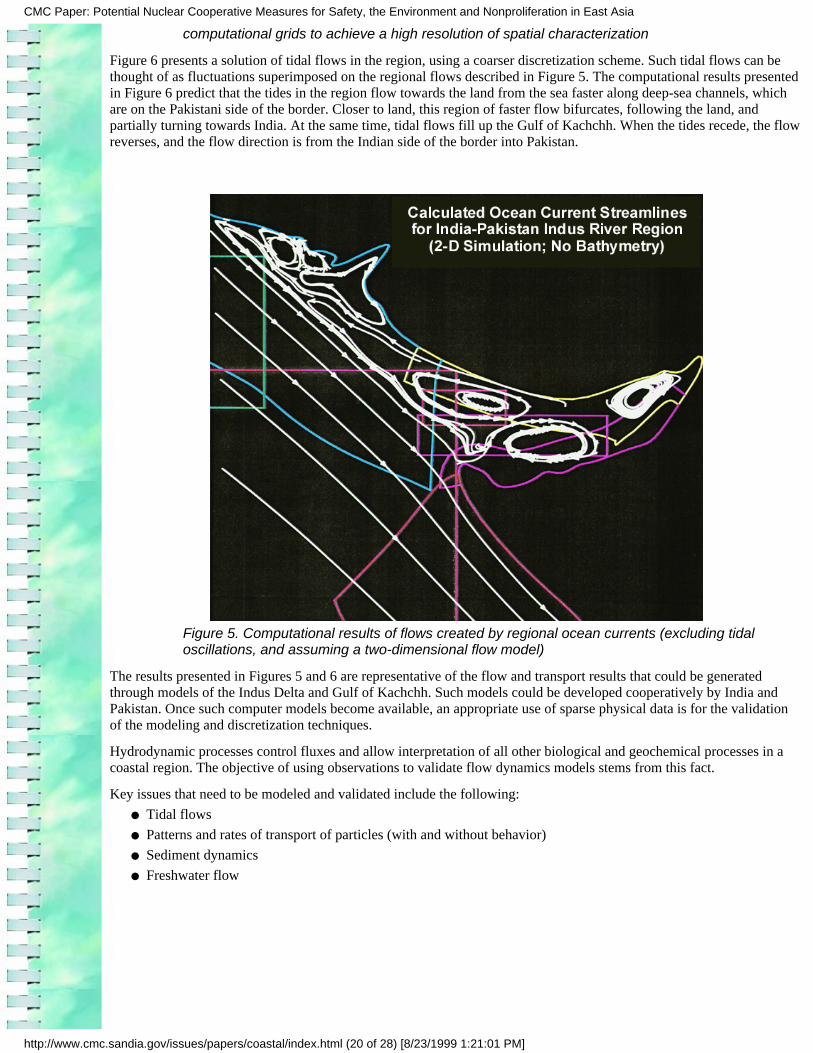
Figure 6 presents a solution of tidal flows in the region, using a coarser discretization scheme. Such tidal flows can bethought of as fluctuations superimposed on the regional flows described in Figure 5. The computational results presentedin Figure 6 predict that the tides in the region flow towards the land from the sea faster along deep-sea channels, whichare on the Pakistani side of the border. Closer to land, this region of faster flow bifurcates, following the land, andpartially turning towards India. At the same time, tidal flows fill up the Gulf of Kachchh. When the tides recede, the flowreverses, and the flow direction is from the Indian side of the border into Pakistan.
Figure 5. Computational results of flows created by regional ocean currents (excluding tidaloscillations, and assuming a two-dimensional flow model)
The results presented in Figures 5 and 6 are representative of the flow and transport results that could be generatedthrough models of the Indus Delta and Gulf of Kachchh. Such models could be developed cooperatively by India andPakistan. Once such computer models become available, an appropriate use of sparse physical data is for the validationof the modeling and discretization techniques.
Hydrodynamic processes control fluxes and allow interpretation of all other biological and geochemical processes in acoastal region. The objective of using observations to validate flow dynamics models stems from this fact.
Key issues that need to be modeled and validated include the following:
Tidal flows●
Patterns and rates of transport of particles (with and without behavior)●
Sediment dynamics●
Freshwater flow●
CMC Paper: Potential Nuclear Cooperative Measures for Safety, the Environment and Nonproliferation in East Asia
http://www.cmc.sandia.gov/issues/papers/coastal/index.html (20 of 28) [8/23/1999 1:21:01 PM]
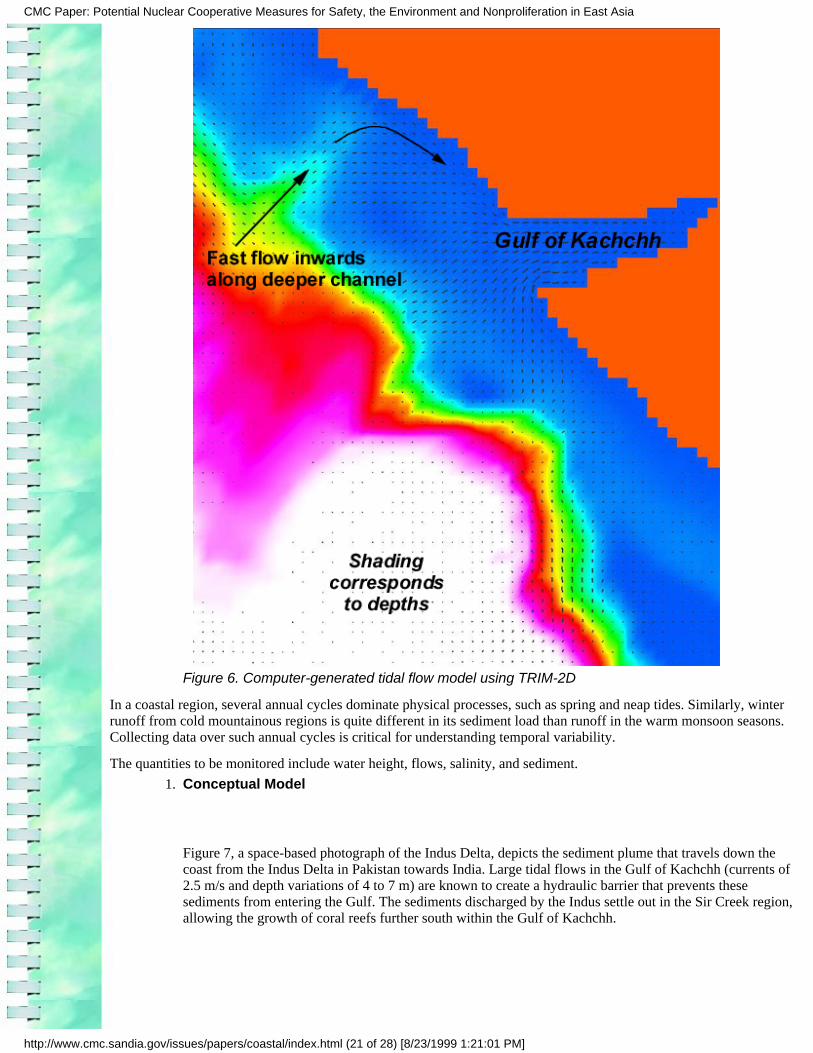
Figure 6. Computer-generated tidal flow model using TRIM-2D
In a coastal region, several annual cycles dominate physical processes, such as spring and neap tides. Similarly, winterrunoff from cold mountainous regions is quite different in its sediment load than runoff in the warm monsoon seasons.Collecting data over such annual cycles is critical for understanding temporal variability.
The quantities to be monitored include water height, flows, salinity, and sediment.
Conceptual Model
Figure 7, a space-based photograph of the Indus Delta, depicts the sediment plume that travels down thecoast from the Indus Delta in Pakistan towards India. Large tidal flows in the Gulf of Kachchh (currents of2.5 m/s and depth variations of 4 to 7 m) are known to create a hydraulic barrier that prevents thesesediments from entering the Gulf. The sediments discharged by the Indus settle out in the Sir Creek region,allowing the growth of coral reefs further south within the Gulf of Kachchh.
1.
CMC Paper: Potential Nuclear Cooperative Measures for Safety, the Environment and Nonproliferation in East Asia
http://www.cmc.sandia.gov/issues/papers/coastal/index.html (21 of 28) [8/23/1999 1:21:01 PM]
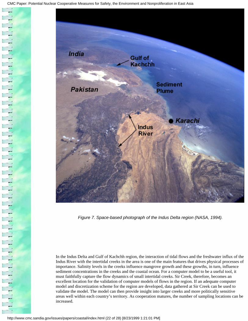
Figure 7. Space-based photograph of the Indus Delta region (NASA, 1994).
In the Indus Delta and Gulf of Kachchh region, the interaction of tidal flows and the freshwater influx of theIndus River with the intertidal creeks in the area is one of the main features that drives physical processes ofimportance. Salinity levels in the creeks influence mangrove growth and these growths, in turn, influencesediment concentrations in the creeks and the coastal ocean. For a computer model to be a useful tool, itmust faithfully capture the flow dynamics of small intertidal creeks. Sir Creek, therefore, becomes anexcellent location for the validation of computer models of flows in the region. If an adequate computermodel and discretization scheme for the region are developed, data gathered at Sir Creek can be used tovalidate the model. The model can then provide insight into larger creeks and more politically sensitiveareas well within each country’s territory. As cooperation matures, the number of sampling locations can beincreased.
CMC Paper: Potential Nuclear Cooperative Measures for Safety, the Environment and Nonproliferation in East Asia
http://www.cmc.sandia.gov/issues/papers/coastal/index.html (22 of 28) [8/23/1999 1:21:01 PM]
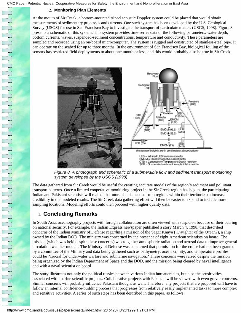
Monitoring Plan Elements2.
At the mouth of Sir Creek, a bottom-mounted tripod acoustic Doppler system could be placed that would obtainmeasurements of sedimentary processes and currents. One such system has been developed by the U.S. GeologicalSurvey (USGS) for use in San Francisco Bay to investigate the transport of particulate matter. (USGS, 1998). Figure 8presents a schematic of this system. This system provides time-series data of the following parameters: water depth,bottom currents, waves, suspended-sediment concentrations, temperature and conductivity. These parameters aresampled and recorded using an on-board microcomputer. The system is rugged and constructed of stainless-steel pipe. Itcan operate on the seabed for up to three months. In the environment of San Francisco Bay, biological fouling of thesensors has restricted field deployments to about one month or less, and this would probably also be true in Sir Creek.
Figure 8. A photograph and schematic of a submersible flow and sediment transport monitoringsystem developed by the USGS (1998)
The data gathered from Sir Creek would be useful for creating accurate models of the region’s sediment and pollutanttransport patterns. Once a limited cooperative monitoring project in the Sir Creek region has begun, the participatingIndian and Pakistani scientists will realize that more data is needed from regions within their territories to increasecredibility in the modeled results. The Sir Creek data gathering effort will then be easier to expand to include moresampling locations. Modeling efforts could then proceed with higher quality data.
Concluding Remarks1.
In South Asia, oceanography projects with foreign collaboration are often viewed with suspicion because of their bearingon national security. For example, the Indian Express newspaper published a story March 4, 1998, that describedconcerns of the Indian Ministry of Defense regarding a mission of the Sagar Kanya (?Daughter of the Ocean?), a shipowned by the Indian DOD. The ministry was concerned by the presence of eight American scientists on board. Themission (which was held despite these concerns) was to gather atmospheric radiation and aerosol data to improve generalcirculation weather models. The Ministry of Defense was concerned that permission for the cruise had not been grantedby a committee of the Ministry and data being gathered such as bathymetry, ocean salinity, and temperature profilescould be ?crucial for underwater warfare and submarine navigation.? These concerns were raised despite the missionbeing organized by the Indian Department of Space and the DOD, and the mission being cleared by naval intelligenceand with a naval scientist on board.
The story illustrates not only the political tussles between various Indian bureaucracies, but also the sensitivitiesassociated with marine scientific projects. Collaborative projects with Pakistan will be viewed with even graver concerns.Similar concerns will probably influence Pakistani thought as well. Therefore, any projects that are proposed will have tofollow an internal confidence-building process that progresses from relatively easily implemented tasks to more complexand sensitive activities. A series of such steps has been described in this paper, as follows:
CMC Paper: Potential Nuclear Cooperative Measures for Safety, the Environment and Nonproliferation in East Asia
http://www.cmc.sandia.gov/issues/papers/coastal/index.html (23 of 28) [8/23/1999 1:21:01 PM]
Create a draft document that will govern coastal environmental projects between the two countries.Preparing and discussing a working draft of a document on governing principles for cooperation wouldallow both sides to present and better understand each other’s views.
1.
Compile existing environmental data from the coastal regions into a joint baseline document. The processof conducting cooperative environmental projects needs to begin by sharing available data and creating abaseline document. A reference baseline provides a foundation for monitoring trends and identifying criticalissues.
2.
Harmonize existing measurements of environmental parameters through transparency in the samplingmethodologies and reporting procedures. Harmonize the data in a reference baseline document and theninitiate a joint program to monitor environmental changes.
3.
Using this approach, a cooperative monitoring project between India and Pakistan would begin with identifying a subsetof selected parameters that are already a part of national programs. Next, the two countries could collaborate on theharmonization of sampling methodologies and the sharing of existing measurements. This phased approach would lead toa technologically sophisticated cooperative monitoring experiment.
Advanced technologies could help reduce tensions between India and Pakistan through the strengthening of monitoring,verification, and communication means. As stated by Jasjit Singh, the Director of the Indian Institute of Defense Studiesand Analyses (Singh, 1996), ?Given the high level of mutual mistrust, especially between India and Pakistan, any CSBMagreement would still raise the problem of verification. CSBMs could rapidly become counterproductive if violationsstart taking place and cannot be arrested in time. But both India and Pakistan have very limited technical means ofverification, and it is highly unlikely that third-party assistance in this field would be acceptable to either side. This iswhy there is a need for countries such as the United States to support the strengthening of national technical means ofverification in India and Pakistan.?
The demonstration of cooperative monitoring technologies for nonmilitary purposes will develop and establish theabilities of India and Pakistan to document the verifiability of agreements. The documentation of the ability to verifycompliance is an essential part of building a national consensus in support of the ratification of agreements. Further,cooperative monitoring projects in areas other than military or security-related matters could build an Indian andPakistani infrastructure for future cooperative monitoring projects that would deal more directly with weapons controlagreements. Finally, cooperative environmental monitoring projects will promote Indian and Pakistani security bypreventing the degradation of land and natural resources.
Much of South Asia consists of semi-arid regions and the regional economy is predominantly based on rain-fedagriculture. Proper use of the region’s water resources is key to the long-term sustainability of the region. Parts of thisregion of 1.5 billion people are already facing acute scarcities of clean drinking water. Water scarcity is expected tobecome worse in the future. Ineffective water management leads to annual devastation from floods, followed by periodsof severe drought. With increasing use of the Indus River waters, there is a possibility that the Indus Waters Treatybetween India and Pakistan could break down. This could seriously exacerbate tensions in the region. For more effectivewater management based on reliable and current data, there is an urgent need to facilitate a process of water-related datasharing among countries in South Asia.
The outflows to the sea of the Indus River’s waters are not wasted from an economic valuation perspective. These waterssustain export-oriented fisheries. A great diversity of species lives, births, and nurtures in the sea grass beds, coral reefs,and coastal wetlands of the Indus Delta and Gulf of Kachchh region. Understanding the interactions between the IndusRiver, the Delta region, and the adjoining Gulf of Kachchh through sharing of data could begin a process of moreeffective management by India and Pakistan of the natural resources in their coastal areas.
Resolution of territorial disputes stemming from the deposition of sediments, the creation of new land, and the migrationof a boundary creek would be easier based on a common understanding of the underlying physical processes. Theresolution of these territorial disputes could initiate improved relations between India and Pakistan. Environmentalscarcity and struggles over natural resources are expected to grow in the future. In South Asia, degradation and thedepletion of agricultural land, forest, water resources, and fish stocks are some of the environmental factors that couldcause or exacerbate future armed conflict. To diminish such environmental causes of conflict and strengthen theirenvironmental security, India and Pakistan are seeking to establish a regional and cooperative approach. The projectproposed in this paper is a part of this emerging structure of regional environmental cooperation.
CMC Paper: Potential Nuclear Cooperative Measures for Safety, the Environment and Nonproliferation in East Asia
http://www.cmc.sandia.gov/issues/papers/coastal/index.html (24 of 28) [8/23/1999 1:21:01 PM]
ReferencesAhmed, S., and S. Das, 1998, Movements of People, Ideas, Trade and Technology: Toward a PeacefulCoexistence of India and Pakistan, Occasional Paper, Cooperative Monitoring Center, Sandia NationalLaboratories, Albuquerque, New Mexico, USA, SAND98-0505/3.
Arms Control and Disarmament Agency, 1990, Arms Control and Disarmament Agreements: Texts and Historiesof the Negotiations, Washington DC.
Bateman, S., 1996, Asia-Pacific Maritime Confidence Building, in Maritime Confidence Building in Regions ofTension, ed. Jill R. Junnola, Report No. 21, Henry L. Stimson Center, Washington DC, USA.
Biringer, K.L., 1998, Siachen Science Center: A Concept for Cooperation at the Top of the World, OccasionalPaper, Cooperative Monitoring Center, Sandia National Laboratories, USA, SAND98-0505/2
Bryceson, I. and K.H.J. Wijayadasa, 1998, ?Review of Strategy and Programmes I ? II of South Asia Co-operativeEnvironment Programme?, Final Report prepared for South Asia Co-operative Environment Programme,Colombo, Sri Lanka.
Department of Ocean Development (DOD), 1998, Annual Report, 1997-98, Government of India, New Delhi,India (available at http://www.nic.in/dod).
Deutsches Zentrum fur Luft-und Raumfahrt, (DLR) 1994, Synthetic Aperture Radar image of mouth of Sir Creek.Database of images taken from a German satellite, available athttp://satftp.soest.hawaii.edu/dlr/catalog/jpeg/q118631.jpg.
Dias, P., 1998, Personal communication, South Asia Cooperative Environmental Program, Kandy, Sri Lanka,e-mail: [email protected].
Ganguly, S. and T. Greenwood, eds., 1996, Mending Fences: Confidence and Security-Building in South Asia.Editors: Westview Press, Colorado, USA.
Gleditsch, N. P., 1998, ?Armed Conflict and the Environment: A Critique of the Literature,? Journal of PeaceResearch, Vol. 35, No. 3, Sage Publications, London, pp. 381-400.
IUCN, 1991a, ?Possible Effects of the Indus Water Accord on the Indus Delta Ecosystem,? IUCN-Pakistan,Karachi. World Conservation Union
IUCN, 199lb, ?Sea-level Rise – Possible Impacts on the Indus Delta? IUCN-Pakistan, Karachi. WorldConservation Union
Junnola, J.R., ed., 1996, Maritime Confidence Building in Regions of Tension, Report No. 21, Henry L. StimsonCenter, Washington DC, USA.
Menon, K.R., 1996, ?Maritime Confidence Building in South Asia,? in Maritime Confidence Building in Regionsof Tension, ed. J.R. Junnola, Report No. 21, Henry L. Stimson Center, Washington DC, USA.
Meynell, P.J, and M. Tahir Qureshi, 1993, ?Sustainable Management of Mangroves in the Indus Delta, Pakistan,?in Towards the Wise Use of Wetlands, ed. T.J. Davis, The Ramsar Library, available athttp://ramsar.org/lib_wise_16.htm.
Nair, R.R., 1984, ?The Indus Paradox,? New Scientist, Vol. 1397, pp. 41-42.
Noorani, A.G., 1993, ?CBMs for the Siachen Glacier, Sir Creek, and Wullar Barrage,? in Crisis Prevention,Confidence Building, and Reconciliation in South Asia, eds. Michael Krepon and Amit Sevak, Henry L. StimsonCenter book, published by St. Martin’s Press, New York, USA.
Pregenzer, A., M. Vannoni, and K. Biringer, 1996, Cooperative Monitoring of Regional Security Agreements,Cooperative Monitoring Center, Sandia National Laboratories, USA, SAND96-1121.
Rajen, G., D. Barnette, R.T. Cheng, K. Biringer, and J.D. Betsill, 1999, ?Modeling Flow and Transport in theIndus Delta: An Opportunity for Promoting Indian and Pakistani Cooperation? (to be published).
Raouf, A., and Juerg Lichtenegger, 1997, ?Integrated Use of SAR and Optical Data for Coastal ZoneManagement?, available on earthnet online, a service provided by the European Space Agency, at
CMC Paper: Potential Nuclear Cooperative Measures for Safety, the Environment and Nonproliferation in East Asia
http://www.cmc.sandia.gov/issues/papers/coastal/index.html (25 of 28) [8/23/1999 1:21:01 PM]
http://florence.ers-symposium.org/data/lichtenegg/index.htm
South Asia Association for Regional Cooperation, 1998, Spectrum Magazine, Volume III, No. 1, April, Magazinepublished by the South Asia Association for Regional Cooperation, Katmandu, Nepal.
Singh, J., 1996, ?Military Postures, Risks, and Security Building,? in Mending Fences: Confidence andSecurity-Building in South Asia. Editors: Sumit Ganguly and Ted Greenwood. Westview Press, Colorado, USA.pp. 163-180.
United Nations Institute for Disarmament Research, 1998, UNIDIR web site, available athttp://www.unog.ch/unidir.
U.S. Geological Survey, 1998, from the ?Access USGS? web site, available athttp://sfbay.wr.usgs.gov/DaveC/DC-TrpdDiagPhto.html.
U.S. National Aeronautics and Space Agency, 1994, from the EarthRISE database of photographs taken by SpaceShuttle astronauts, ID # STS062-0086-0021, available at http://earthrise.sdsc.edu.
U.S. National Aeronautics and Space Agency, 1996, from the EarthRISE database of photographs taken by SpaceShuttle astronauts, ID # STS075-0706-0021, available at http://earthrise.sdsc.edu.
Appendix A: Marine Cooperation Projects
A-1 The Wadden Sea Trilateral Monitoring and Assessment Program
The Wadden Sea is a shallow sea extending along the North Sea coasts of Denmark, Germany, and The Netherlands.This dynamic ecosystem contains tidal channels, sands, mud flats, salt marshes, beaches, dunes, river mouths, and atransition zone to the North Sea. Protection of the Wadden Sea is a fine example of a coordinated effort by a group ofcountries for protection of a coastal ecosystem. An area of 13,500 sq. km in the Wadden Sea is designated as theCooperation Area for trilateral cooperation. Some areas on the mainland, which are important for birds, are also a part ofthe cooperation area.
From the early 1970s, there was increasing recognition and public pressure on politicians that protection of the WaddenSea could not be effective if responsibilities were divided along national boundaries. Environmental scientists madestrong arguments at various fora that the Wadden Sea is, from an ecological point of view, one system. The first trilateralgovernmental conference on the protection of the Wadden Sea was held in 1978 in The Hague, The Netherlands. Thesecond Wadden Sea Conference took place two years later in Bonn, Germany. At the third Conference in Copenhagen,Denmark, in 1982, the three countries agreed upon a Joint Declaration. According to the Joint Declaration, ?The WaddenSea countries declare their intention to coordinate their activities and measures to implement a number of internationallegal instruments in the field of natural environmental protection, amongst others the Ramsar Convention and theEuropean Commission Bird Directive, for a comprehensive protection of the Wadden Sea region as a whole, including itsflora and fauna.? Since 1982, four more Governmental Wadden Sea Conferences have been held and the trilateralcooperation has strengthened and intensified.
In 1991 and 1993, the three Wadden Sea countries prepared a series of Quality Status Reports. These reports describedlarge data gaps in knowledge of the Wadden Sea, including problems that occurred because the data were gathered byvery different, incompatible methods and the data were stored in many locations. A trilateral expert working groupproposed an ?Integrated Monitoring Program of the Wadden Sea Ecosystem? in 1993. This report became the genesis ofthe Trilateral Monitoring and Assessment Program (TMAP). This program first identified all possible anthropogenicimpacts on the Wadden Sea. Then, issues of concern were selected. For each issue, hypotheses were formulated. Finally,monitoring parameters were derived on the basis of proving or disproving the hypotheses. This approach has resulted in asound monitoring program agreed to by each participating country.
The TMAP periodically evaluates sampling locations to ensure that they represent areas of concern, tracks changes intime and space of monitoring parameters, and stays linked with ecosystem research to better understand processes atwork. Most importantly, the TMAP is building a common database of the three national databases with a trilateralharmonized data format. Issues of concern to the TMAP are the following: (1) climate change; (2) the input of nutrients,heavy metals, organic-micropollutants, and solid wastes; (3) commercial fisheries; (4) recreation; and (5) agriculturalpractices and the response of salt marsh communities. For each issue of concern and the respective hypotheses,parameters to be monitored were deduced.
CMC Paper: Potential Nuclear Cooperative Measures for Safety, the Environment and Nonproliferation in East Asia
http://www.cmc.sandia.gov/issues/papers/coastal/index.html (26 of 28) [8/23/1999 1:21:01 PM]
The parameters are classified into groups: general (geomorphology, weather, hydrology); chemical (nutrients, heavymetals, organic-micropollutants); biological (plankton, benthos, fish, seals, birds, salt marsh flora and fauna); and humanuse parameters (fishery, recreational activities, agricultural use). Over 200 parameters have been recommended formonitoring, with 87 presently covered under national programs. These 87 are now being harmonized so they areintercomparable.
A-2 The Gulf of Aqaba and the Red Sea Marine Peace Park
Similar to the Wadden Sea Cooperation Area of Denmark, Germany, and The Netherlands, Israel and Jordan havecreated the Red Sea Marine Peace Park. This park – created by two formerly hostile countries – also provides manylessons for India and Pakistan.
The Gulf of Aqaba is approximately 180 km long, starting from the shores of Jordan and Israel and extending along thecoasts of Egypt and Saudi Arabia to the Straits of Tiran. The Straits of Tiran, only 800 meters wide, provide an openinginto the Red Sea. The Gulf of Aqaba is a semi-contained system that circulates pollutants in alternating directions,ensuring the passage of pollution from one jurisdiction to the next. Exceptionally clear waters in the Gulf of Aqaba allowphotosynthesis to occur at great depths. This has created coral reef formations considered to be among the mostspectacular and diverse in the world.
Jordan and Israel share 27 km and 14 km respectively of the coastline at the head of the Gulf. The largest urban centers inthe region are located within these two countries: Aqaba in Jordan with 55,000 residents, and Eilat in Israel with 36,000residents. A rapidly increasing number of divers, snorkelers, and boaters visit the reefs in this region and have causedconsiderable damage. In Eilat, 200,000 to 300,000 dives are conducted annually by diving clubs along a 1-km coralreserve. The city of Aqaba has seen a six-fold increase in population in the last two decades. Industrial activity hasincreased in Aqaba, with Aqaba being the third largest Red Sea port (after Suez in Egypt and Jeddah in Saudi Arabia),and home to large fertilizer and mineral processing plants. To protect the Gulf of Aqaba from the pressures of tourism,urban development, and industrial pollution, Jordan and Israel have begun to work together.
A multi-use Marine Park has been established on the south coast of the Jordanian portion of the Gulf of Aqaba. Thispark, the Red Sea Marine Peace Park, emerged out of the peace treaty between Israel and Jordan. The aim of the park isto carefully balance the needs of conservation with the requirements of development. A multi-million dollar project(funded by the World Bank and the United Nations through the Global Environmental Facility) is now specificallyaddressing transboundary environmental protection issues. Efforts to create this bi-national Marine Peace Park benefitedenormously from initial feasibility studies carried out by U.S. agencies, such as the National Oceanic and AtmosphericAdministration and the U.S. Agency for International Development.
About the AuthorGaurav Rajen is a senior environmental scientist and the president of Gaia Research, Inc., a company that specializes inenvironmental engineering, computer modeling and international cooperation, and technology transfer. He has a Ph.D. inmechanical engineering from the University of Delaware, USA, and Master’s and Bachelor’s degrees in aeronauticalengineering from the Indian Institute of Technology, Mumbai, India. In his career, Dr. Rajen has worked on numerousenvironmental security issues, including waste management, water resources, remote sensing, and electronic data andinformation networks. In 1998, he organized a session at a conference in India on ?Environmental Management in SouthAsia: Opportunities for Regional Cooperation.? Dr. Rajen is the author of over 30 scientific papers and numerous reportsdealing with environmental fluid dynamics and related issues. He maintains a close affiliation with the University ofNew Mexico’s College of Engineering as an adjunct faculty member and consultant. He has worked with the U.S.Environmental Protection Agency and the U.S. Department of Energy, as well as other U.S. and internationalgovernment and private agencies.
Distribution350 MS 1373 CMC Library, 5341
1 MS 9018 Central Tech Files, 8940-2
2 MS 0899 Technical Library, 4916
CMC Paper: Potential Nuclear Cooperative Measures for Safety, the Environment and Nonproliferation in East Asia
http://www.cmc.sandia.gov/issues/papers/coastal/index.html (27 of 28) [8/23/1999 1:21:01 PM]

1 MS 0619 Review ? Approval Desk, 00111
Menus
CMCHome Papers
Page: Deborah Haycraft EvankoModified: 12 Jul 99
CMC Paper: Potential Nuclear Cooperative Measures for Safety, the Environment and Nonproliferation in East Asia
http://www.cmc.sandia.gov/issues/papers/coastal/index.html (28 of 28) [8/23/1999 1:21:01 PM]