conservation threat of increasing fire frequencies in the western ghats, india
TRANSCRIPT

Conservation Threat of Increasing FireFrequencies in the Western Ghats, IndiaNARENDRAN KODANDAPANI,∗‡ MARK A. COCHRANE,∗ AND R. SUKUMAR†∗Center for Global Change and Earth Observations, Michigan State University, 1405 S. Harrison Road, Room 101,Manly Miles, East Lansing, MI 48823-5243, U.S.A.†Center for Ecological Sciences, Indian Institute of Science, Bangalore 560 012, India
Abstract: The acceleration of processes such as forest fragmentation and forest fires in landscapes underintense human pressures makes it imperative to quantify and understand the effects of these processes on theconservation of biodiversity in these landscapes. We combined information from remote-sensing imagery andground maps of all fires in the Mudumalai Wildlife Sanctuary (MWLS) in the Western Ghats of India over14 years (1989–2002). These spatial data on fire occurrence were integrated with maps of vegetation typesfound in the MWLS to examine fire conditions in each. We calculated the average fire-return interval for eachof the vegetation types individually and for the MWLS as a whole. Using vegetation data from the larger NilgiriBiosphere Reserve and the entire Western Ghats region, we conservatively estimated fire-frequency informationfor these larger regions. Because the MWLS does not contain tropical evergreen or montane forests, we wereunable to estimate fire conditions in these forest types, which represent 31% of all Western Ghats vegetationcover. For the MWLS, all vegetation types had average fire-return intervals of <7 years, and the sanctuary as awhole had a fire-return interval of 3.3 years. Compared with a 13-year MWLS fire data set from 1909–1921,this represents a threefold increase in fire frequency over the last 80 years. We estimated average fire-returnintervals of roughly 5 years for both the larger Nilgiri Biosphere Reserve and the entire Western Ghats region.Given other recent reports, the estimated fire frequencies for the Western Ghats forests outside protected reservesare conservative. We conclude that the current fire regime of the Western Ghats poses a severe and persistentconservation threat to forests both within and outside protected reserves.
Key Words: fire frequency, fire-return interval, forest fires, Western Ghats
Amenaza del Incremento de Frecuencias de Incendios a la Conservacion en las Ghats Occidentales, India
Resumen: La aceleracion de procesos como la fragmentacion de bosques e incendios forestales en paisajesbajo intensa presion humana hace imperativo cuantificar y comprender los efectos de estos procesos sobrela conservacion de biodiversidad en estos paisajes. A partir de imagenes de sensores remotos y mapas com-binamos informacion sobre todos los incendios en el Santuario Mudumalai de Vida Silvestre (SMVS) en lasGhats Occidentales a lo largo de 14 anos (1989-2002). Los datos espaciales de la ocurrencia de incendiosfueron integrados con mapas de tipos de vegetacion del SMVS para examinar las condiciones de fuego en cadauno. Calculamos el intervalo promedio de retorno de fuego individualmente para cada uno de los tipos devegetacion y en conjunto para el SMVS. Utilizando datos de vegetacion de la Reserva de la Biosfera Nilgiri y detoda la region de las Ghats Occidentales conservadoramente estimamos informacion de frecuencia de incen-dios para estas regiones mas extensas. Debido a que el SMVS no contiene bosques tropicales siempre verdes nimontanos, no pudimos estimar las condiciones de fuego en estos tipos de bosque, que representan el 31% dela cobertura vegetal de las Ghats Occidentales. Para el SMVS, todos los tipos de vegetacion tuvieron intervalospromedio de retorno de fuego de <7 anos, y el santuario como un todo tuvo un intervalo de retorno de fuegode 3.3 anos. En comparacion con un conjunto de datos sobre fuego de 13 anos en el SMVS de 1909-1921,
‡email [email protected] submitted September 25, 2003; revised manuscript accepted April 6, 2004.
1553
Conservation Biology, Pages 1553–1561Volume 18, No. 6, December 2004

1554 Fire Analysis in the Western Ghats Kodandapani et al.
esto representa un incremento de tres veces en la frecuencia de incendios en los ultimos 80 anos. Estimamosintervalos promedio de retorno de fuego de aproximadamente 5 anos para Reserva de la Biosfera Nilgiri y detoda la region de las Ghats Occidentales. Dados otros reportes recientes, las estimaciones de frecuencias de in-cendios para bosques en las Ghats Occidentales afuera de reservas protegidas son conservadoras. Concluimosque el actual regimen de fuego en las Ghats Occidentales constituye una amenaza severa y persistente a losbosques tanto dentro como afuera de reservas protegidas.
Palabras Clave: frecuencia de incendios, Ghats Occidentales, intervalo de retorno de fuego
Introduction
Research in the tropics has focused on deforestation orstatic evaluations of forested areas and seldom has con-sidered the contributing effects of landscape processesand biotic pressures in the loss of biodiversity (Sanchez-Azofeifa et al. 1999). Although studied separately to vary-ing degrees, the combined ecological impacts of forestfragmentation and biotic pressures, such as grazing, log-ging, and forest fires, are poorly understood. The interac-tions and synergies between multiple disturbances haverecently become a focus of study in the New World tropics(e.g., Cochrane 2001; Peres 2001; Laurance & Williamson2001; Peres et al. 2003). Similar research and understand-ing, however, is lacking in the Old World tropics, whichhave been affected by millennia of human occupationand associated disturbances. Regions such as the WesternGhats in India are logical places in which to evaluate theongoing effects of multiple, human-related disturbances.
In the Old World tropics, especially in India, humanpopulation growth has led to extensive deforestation,greatly fragmenting remaining forests (Menon & Bawa1998; Jha et al. 2000). Rainforests in various countries,including India, have largely been deforested in recentdecades (Myers 1994; Whitmore 1997). Reports from theMinistry of Environment and Forests in India suggest thatforest fires affect 37 million ha of forests annually, andabout 55% of the country’s forest areas are being sub-jected to forest fires each year (Gubbi 2003). The WesternGhats is one of the world’s biodiversity hotspots (Myers etal. 2000), but reserves are limited in size and surroundedby an intervening matrix of land that is under intense hu-man pressures. Furthermore, landscape processes suchas fragmentation and forest fires have been overlookedin conservation studies in the Western Ghats (Daniels etal. 1995; Jha et al. 2000). The spatial and temporal scalesof disturbance, forest-fragment configuration and shape,land-use activity in the surrounding matrix, and additionalongoing disturbances can synergistically manifest as sub-tle deforestation events in tropical landscapes, threaten-ing forest remnants with elimination (Aubreville 1947;Cochrane et al. 1999; Gascon et al. 2000; Cochrane &Laurance 2002). Thus, understanding the effects of thesedisturbances, especially forest fires and forest fragmenta-tion, can provide insights into current deforestation pro-
cesses and help direct conservation programs in theseecosystems.
As in other parts of the world, fire has been the toolof choice for clearing forests in the Western Ghats. Re-searchers have examined the rates of deforestation anddegree of fragmentation in the region, but they assumedthat forest remnants remain unchanged (Menon & Bawa1997; Nagendra & Utkarsh 2003). Furthermore, the po-tential synergistic effects of fragmentation and fire havenot been considered. Disturbance in ecosystems occursat various scales. Certain events are fine grained and affectindividuals in a population, whereas other disturbancesare larger grained and affect assemblages of species in acommunity. Still larger disturbance events affect entirelandscapes and ecosystems (Forman 1995; Ross et al.2002). Although spatial scale is an important variable in alldisturbance events, the spatial configuration of landscapeelements and the disturbance history of the landscape arevital to the holistic understanding of disturbance eventsin ecosystems (Turton & Freiburger 1997).
In human-affected landscapes, the current distributionof forests is largely a result of the spatial and temporal in-teractions between humans and their environment. Onedisturbance that is strongly related to human activity isfire. The nature, amount, and spatial distribution of ig-nitable fuel largely govern the character of the fire inany forest location (Goldammer 1990). Increasing depen-dence on forests by humans for a variety of uses leadsto forest fragmentation that further exacerbates futurefire events in the landscape (Cochrane 2003). The spatialjuxtaposition of forests and other land covers, derivedthrough anthropogenic land use, has a large influence onthe extent and frequency of fire events on fragmentedlandscapes (Cochrane et al. 1999; Cochrane 2001). Theecological characteristics of forests, combined with previ-ous disturbance history and prevalent weather patterns,lead to variability in the pattern of burning in forests (Uhl& Kauffman 1990; Glitzenstein et al. 1995; Cochrane &Schulze 1999). The differences among forests in termsof ecological characteristics, climatic factors, and asso-ciated disturbance histories translates into differences insusceptibility to and intensity of forest fires among vegeta-tion communities across the landscape. Within the West-ern Ghats, the remaining forests are fragmented and im-mersed in a human-dominated landscape, where fire is
Conservation BiologyVolume 18, No. 6, December 2004
Kodandapani et al. Fire Analysis in the Western Ghats 1555
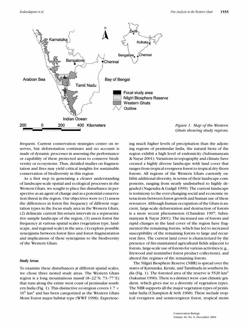
Figure 1. Map of the WesternGhats showing study regions.
frequent. Current conservation strategies center on re-serves, but deforestation continues and no account ismade of dynamic processes in assessing the performanceor capability of these protected areas to conserve biodi-versity or ecosystems. Thus, detailed studies on fragmen-tation and fires may yield critical insights for sustainableconservation of biodiversity in this region.
As a first step in generating a clearer understandingof landscape-scale spatial and ecological processes in theWestern Ghats, we sought to place fire disturbance in per-spective as an agent of change and as a potential conserva-tion threat in the region. Our objectives were to (1) assessthe differences in forest fire frequency of different vege-tation types in the focus study area in the Western Ghats,(2) delineate current fire-return intervals in a representa-tive sample landscape of the region, (3) assess forest firefrequency at various spatial scales (vegetation type, land-scape, and regional scale) in the area, (4) explore possiblesynergisms between forest fires and forest fragmentationand implications of these synergisms to the biodiversityof the Western Ghats.
Study Areas
To examine these disturbances at different spatial scales,we chose three nested study areas. The Western Ghatsregion is a long mountainous massif (8–22◦N, 73–77◦E)that runs along the entire west coast of peninsular south-ern India (Fig. 1). This distinctive ecoregion covers 1.7 ×10⁵ km2 and has been categorized as the Western GhatsMoist Forest major habitat type (WWF 1998). Experienc-
ing much higher levels of precipitation than the adjoin-ing regions of peninsular India, the natural biota of theregion exhibit a high level of endemicity (Subramanyam& Nayar 2001). Variations in topography and climate havecreated a highly diverse landscape with land cover thatranges from tropical evergreen forest to tropical dry thornforests. All regions of the Western Ghats currently ex-hibit additional diversity, in terms of their landscape com-ponents, ranging from nearly undisturbed to highly de-graded (Nagendra & Gadgil 1999). The current landscapeis testimony to the ever-changing social and economic in-teractions between forest growth and human use of theseresources. Although human occupation of the Ghats is an-cient, large-scale deforestation and destruction of forestsis a more recent phenomenon (Chandran 1997; Subra-manyam & Nayar 2001). The increased use of forests andrapid changes in the land cover of the region have frag-mented the remaining forests, which has led to increasedsusceptibility of the remaining forests to large and recur-rent fires. The current land cover is characterized by thepresence of fire-maintained agricultural fields adjacent toforests, large-scale use of forests for various activities (e.g.,firewood and nontimber forest product collections), andaltered fire regimes of the remaining forests.
The Nilgiri Biosphere Reserve (NBR) is spread over thestates of Karnataka, Kerala, and Tamilnadu in southern In-dia (Fig. 1). The forested area of the reserve is 5520 km2
(Sukumar 1990). There is a distinct west–east climatic gra-dient, which gives rise to a diversity of vegetation types.The NBR supports all the major vegetation types of penin-sular India (Champion & Seth 1968). These include trop-ical evergreen and semievergreen forest, tropical moist
Conservation BiologyVolume 18, No. 6, December 2004

1556 Fire Analysis in the Western Ghats Kodandapani et al.
deciduous forest, tropical dry deciduous forest, and trop-ical dry thorn forest. At higher elevations (>1800 m) thereare characteristic patches of tropical montane stunted ev-ergreen forest in the valleys and folds of the hills and ex-tensive grassland on the hill slopes. More detailed descrip-tions of the vegetation are available elsewhere (Nair et al.1977). The NBR is representative of the Western Ghats interms of its vegetation types and, despite its protections,a region under immense human pressures.
We conducted detailed analysis of fire-return intervalsacross the different vegetation types in the MudumalaiWildlife Sanctuary (MWLS). The sanctuary, a long-termecological research site, is part of the NBR. The sanctuaryis 320 km2 and harbors diverse flora and fauna, including616 vascular plant species. A single 50-ha plot in decidu-ous forest at the sanctuary contained 71 woody species≥1 cm dbh (Sukumar et al. 1992). Fire maps for the sanc-tuary were available from 1989 to 2002, and annual areasburned for an earlier period (1909–1921) were also avail-able from a working plan for the sanctuary (Hicks 1928).
Methods
We surveyed and mapped fire occurrence in the MWLSon topographic maps of 1:50,000 scale. Two topographicmaps covering the entire sanctuary were used, mapsheets 58 A6 and 58 A10 (of the Survey of India). Theburned areas were first located on the ground and thenon the topographic maps based on key features such asrivers, swamps, or roads. Burned areas were mapped af-ter walking the perimeter of the affected vegetation. Map-ping of burned areas was done during April and May, thedry season, before the onset of the southwestern mon-soon. Mapping took about 2 weeks; there were occa-sions, however, when the source and timing of ignitionsincreased mapping time. These detailed maps are avail-able for the years 1989 to 2002. During 1996 and 1997the western part of the sanctuary could not be mapped;therefore, we used remotely sensed data to complete themapping. Fire maps of MWLS from 1989 to 2002 wereindividually overlaid with the vegetation map of the sanc-tuary. The resultant map yielded polygons with attributesof vegetation type and presence or absence of fire. Weobtained proportion of area burned in the different vege-tation types for the different years from this map and usedstatistical tests to examine differences in fire frequencyacross the different vegetation types.
We used satellite data from (Indian Remote Sensing)IRS I-B, (LISS II, row 60, path 26; 6 March 1996) and1997 satellite data from Landsat (L5, row 144, path 52;16 March 1997). Satellite data for the study area wereextracted, geocorrected, and classified into burned andunburned areas with supervised classification. We usedERDAS Imagine 8.3 (Leica Geosystems GIS & MappingDivision, Leica Geosystems, Heerbrugg, Switzerland), to
analyze the satellite data. The raster data for these 2 yearswere converted into vector form and combined alongwith the vector data of other years. We assigned uniqueidentity values to the burned and unburned areas. Thedata for 14 years were combined and a single compositemap obtained.
We estimated fire frequency by spatially quantifying thenumber of fires for each location in the composite map.There were 1727 distinct areas in the combined map.Frequency of burning in each location was calculated asthe number of years (out of 14) in which fire had beendetected. We converted fire-frequency maps into an esti-mated fire-return interval map for each forest land-covertype. A fire-return interval is the amount of time requiredto burn an area, equivalent to the entire forested area,with the understanding that some areas may not burnwhereas others may burn more than once during a cycle(Van Wagner 1978).
We delineated the vegetation map of MWLS with super-vised classification of the IRS I-D (LISS III row 65, path99, 27 March 1996) satellite data. Six land-cover typeswere classified: tropical dry deciduous forests, tropicaldry deciduous (Shorea) forests, tropical moist deciduousforests, tropical moist deciduous (degraded) forests, trop-ical dry thorn forests, and settlements (Fig. 2). The classi-fication system followed by Prabhakar and Pascal (1996)served as a reference in the preparation of the vegetationmap. The accuracy of vegetation types ranged from 80%in the case of the tropical moist deciduous (degraded)type to 100% in the case of the tropical dry thorn type.
To extrapolate the results from the MWLS to both theentire NBR and the larger area of the Western Ghats, wemade the conservative assumption that the results fromthe various vegetation cover types within the MWLS arerepresentative of fire frequency and extent of these vege-tation types in these larger regions. This extrapolation isconservative because the MWLS is a protected region offorest, nested within a similar, but larger, protected area,the NBR. Human use of these forests is therefore limited,and because 90% of all forest fires are estimated to be an-thropogenic in origin (Bahuguna 1999), fire conditions
Figure 2. Vegetation map of the Mudumalai WildlifeSanctuary, Western Ghats.
Conservation BiologyVolume 18, No. 6, December 2004

Kodandapani et al. Fire Analysis in the Western Ghats 1557
are expected to be less severe than those in the majorityof unprotected forests of the Ghats. Unfortunately, theMWLS does not contain two Western Ghats forest types,the tropical evergreen forests and the high-elevation mon-tane/grassland ecosystems. These forests are known toburn (Hegde et al. 1998), but because we do not havequantitative data on fire occurrence in these vegetationtypes, we excluded them from the larger scale estimationsof regional burning. For the estimation of mid-level-scalefire extent in the NBR, we used the vegetation cover datafrom Narendran et al. (2001). Of the total forested area of5520 km2, the tropical dry thorn, tropical dry deciduous,and tropical moist deciduous forest types are the predomi-nant land covers, accounting for 38%, 29.7%, and 16.3% ofthe area, respectively. The tropical evergreen forests andtropical montane forests/grasslands accounted for the re-maining land cover in the NBR, 10.6% and 5.2% of thearea, respectively.
For the regional scale assessment, we adapted the veg-etation cover information from a recent assessment ofterrestrial ecoregions (Olson et al. 2001). In the assess-ment, distinction was made between northern and south-ern tropical moist and tropical montane rainforests, butwe combined northern and southern classes because wewere concerned with physiological conditions and notspecies compositions. Therefore, for the subsequent anal-yses, tropical dry deciduous and tropical moist forestsaccounted for 27% and 42% of the area, respectively.Tropical evergreen and grassland/montane rainforests ac-counted for roughly 31% of the vegetation cover but wereexcluded from the fire analysis because they do not occurin the MWLS.
Results
Forest fires were common in forests of the MWLS andan average of 30% of the landscape burned in a givenyear (Table 1). The vegetation type with the highest mean
Table 1. Mean area and percentage of area burned in different landcover types of the Mudumalai Wildlife Sanctuary, Western Ghats,between 1989 and 2002.∗
Mean area (km2) Fire-returnburned/year Vegetation interval
Vegetation type (±SE) type (%) (years)
Dry deciduous 62 ± 45.0 34.0 2.9Dry deciduous 17 ± 9.0 56.6 1.7
Shorea typeMoist deciduous 2.3 ± 4.9 15.0 6.6
(degraded)Dry thorn 8.8 ± 15.8 14.6 6.8Moist deciduous 7.5 ± 12.0 18.3 5.5Total area 98 ± 74.0 30.0 3.3
∗The sixth land use-type settlement was excluded.
Figure 3. Temporal variability in the area burnedacross the different vegetation types in the MudumalaiWildlife Sanctuary, Western Ghats.
area burned was the tropical dry deciduous (Shorea) with56.6%, whereas the tropical dry thorn vegetation had thelowest mean area burned with 14.6%.
There was variability in the susceptibility to fires acrossthe different vegetation types (Fig. 3). Significant differ-ences existed between the tropical dry deciduous vege-tation and all other vegetation types in the MWLS ( p <
0.01). Fire extent in the tropical dry deciduous (Shorea)vegetation was significantly higher than the tropical moistdeciduous (degraded), tropical dry thorn, and tropicalmoist deciduous vegetation types ( p < 0.001–0.100). Toinvestigate whether small sample sizes were responsiblefor these patterns, we also conducted Mann-Whitney Utests, which also showed significant differences (all p <
0.01). Because these samples were random and indepen-dent, we ruled out inflation of results resulting from tem-poral auto correlation. Spatiotemporal auto correlation,however, is important in assessing patterns of fire occur-rence across a landscape, and this is under investigation.Fuel loads from both grasses and leaf litter were also sig-nificantly higher in tropical dry deciduous (Shorea) andtropical dry deciduous forests compared with all othervegetation types (H.S. Dattaraja, unpublished data).
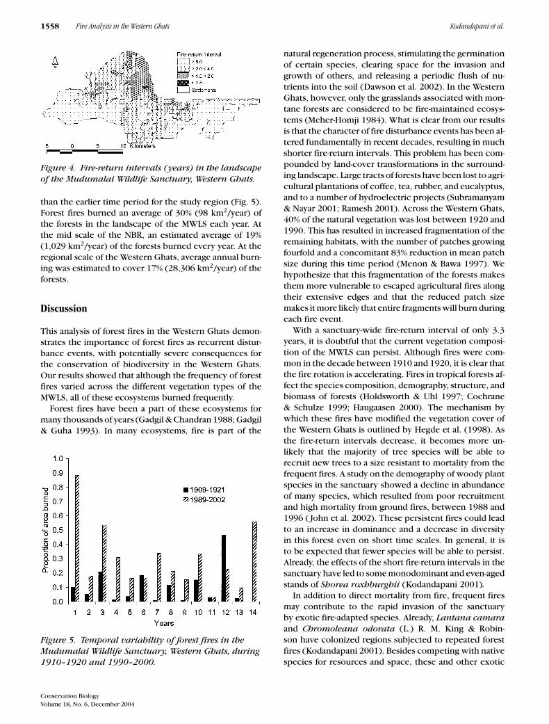
The fire-return intervals in the forests of the study re-gion were short. More than 50% of the study site experi-enced fire between 4–10 times in the past 14 years (1989–2002), implying that half the study site will experience afire every 3.5 or fewer years (Fig. 4). The tropical dry de-ciduous (Shorea) type had the shortest fire-return intervalof 1.7 years, whereas the tropical dry thorn forests hadthe longest fire-return interval of 6.8 years. Based on thelast 14 years of fire data, the average fire-return intervalof the entire sanctuary is 3.3 years. This was considerablyshorter than the average 10-year fire-return interval for asimilar period 90 years ago (1909–1921). The current firedynamic is one of rapid-return fires and is more frequent
Conservation BiologyVolume 18, No. 6, December 2004
1558 Fire Analysis in the Western Ghats Kodandapani et al.
Figure 4. Fire-return intervals (years) in the landscapeof the Mudumalai Wildlife Sanctuary, Western Ghats.
than the earlier time period for the study region (Fig. 5).Forest fires burned an average of 30% (98 km2/year) ofthe forests in the landscape of the MWLS each year. Atthe mid scale of the NBR, an estimated average of 19%(1,029 km2/year) of the forests burned every year. At theregional scale of the Western Ghats, average annual burn-ing was estimated to cover 17% (28,306 km2/year) of theforests.
Discussion
This analysis of forest fires in the Western Ghats demon-strates the importance of forest fires as recurrent distur-bance events, with potentially severe consequences forthe conservation of biodiversity in the Western Ghats.Our results showed that although the frequency of forestfires varied across the different vegetation types of theMWLS, all of these ecosystems burned frequently.
Forest fires have been a part of these ecosystems formany thousands of years (Gadgil & Chandran 1988; Gadgil& Guha 1993). In many ecosystems, fire is part of the
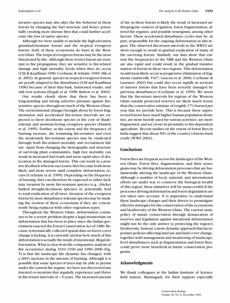
Figure 5. Temporal variability of forest fires in theMudumalai Wildlife Sanctuary, Western Ghats, during1910–1920 and 1990–2000.
natural regeneration process, stimulating the germinationof certain species, clearing space for the invasion andgrowth of others, and releasing a periodic flush of nu-trients into the soil (Dawson et al. 2002). In the WesternGhats, however, only the grasslands associated with mon-tane forests are considered to be fire-maintained ecosys-tems (Meher-Homji 1984). What is clear from our resultsis that the character of fire disturbance events has been al-tered fundamentally in recent decades, resulting in muchshorter fire-return intervals. This problem has been com-pounded by land-cover transformations in the surround-ing landscape. Large tracts of forests have been lost to agri-cultural plantations of coffee, tea, rubber, and eucalyptus,and to a number of hydroelectric projects (Subramanyam& Nayar 2001; Ramesh 2001). Across the Western Ghats,40% of the natural vegetation was lost between 1920 and1990. This has resulted in increased fragmentation of theremaining habitats, with the number of patches growingfourfold and a concomitant 83% reduction in mean patchsize during this time period (Menon & Bawa 1997). Wehypothesize that this fragmentation of the forests makesthem more vulnerable to escaped agricultural fires alongtheir extensive edges and that the reduced patch sizemakes it more likely that entire fragments will burn duringeach fire event.
With a sanctuary-wide fire-return interval of only 3.3years, it is doubtful that the current vegetation composi-tion of the MWLS can persist. Although fires were com-mon in the decade between 1910 and 1920, it is clear thatthe fire rotation is accelerating. Fires in tropical forests af-fect the species composition, demography, structure, andbiomass of forests (Holdsworth & Uhl 1997; Cochrane& Schulze 1999; Haugaasen 2000). The mechanism bywhich these fires have modified the vegetation cover ofthe Western Ghats is outlined by Hegde et al. (1998). Asthe fire-return intervals decrease, it becomes more un-likely that the majority of tree species will be able torecruit new trees to a size resistant to mortality from thefrequent fires. A study on the demography of woody plantspecies in the sanctuary showed a decline in abundanceof many species, which resulted from poor recruitmentand high mortality from ground fires, between 1988 and1996 ( John et al. 2002). These persistent fires could leadto an increase in dominance and a decrease in diversityin this forest even on short time scales. In general, it isto be expected that fewer species will be able to persist.Already, the effects of the short fire-return intervals in thesanctuary have led to some monodominant and even-agedstands of Shorea roxhburghii (Kodandapani 2001).
In addition to direct mortality from fire, frequent firesmay contribute to the rapid invasion of the sanctuaryby exotic fire-adapted species. Already, Lantana camaraand Chromoleana odorata (L.) R. M. King & Robin-son have colonized regions subjected to repeated forestfires (Kodandapani 2001). Besides competing with nativespecies for resources and space, these and other exotic
Conservation BiologyVolume 18, No. 6, December 2004
Kodandapani et al. Fire Analysis in the Western Ghats 1559
invasive species may also alter the fire behavior in theseforests by changing the fuel structure and hence poten-tially creating more intense fires that could further accel-erate the loss of native species.
Although we were unable to include the high-elevationgrassland/montane forests and the tropical evergreenforests, both of these ecosystems do burn in the West-ern Ghats. The tropical evergreen forests may be the mostthreatened by fire. Although these wetter forests are resis-tant to fire propagation, they are sensitive to fire-relateddamage and high mortality levels when fires do occur(Uhl & Kauffman 1990; Cochrane & Schulze 1999; Slik etal. 2002). In general, species in tropical evergreen forestsare poorly adapted to fire disturbance (Uhl and Kauffman1990) because of their thin bark, buttressed trunks, andstilt root systems (Hegde et al. 1998; Barlow et al. 2003).
Our results clearly show that there has been along-standing and strong selective pressure against fire-sensitive species throughout much of the Western Ghats.The environmental changes brought about by forest frag-mentation and accelerated fire-return intervals are ex-pected to favor deciduous species at the cost of shade-tolerant and moisture-loving evergreen species (Danielset al. 1995). Further, as the extent and the frequency ofburning increase, the remaining fire-sensitive and eventhe moderately fire-resistant species may be eradicatedthrough both fire-related mortality and recruitment fail-ure. Apart from changing the demography and structureof surviving plant communities, high tree mortality canresult in increased fuel loads and more rapid rates of des-iccation in the damaged forests. This can result in a posi-tive feedback wherein successive fires become both morelikely and more severe until complete deforestation oc-curs (Cochrane et al. 1999). Depending on the frequencyof burning, fires can therefore be expected to either facil-itate invasion by more fire-resistant species (e.g., thickerbarked drought-deciduous species) or, potentially, leadto total eradication of all trees. Invasion of the evergreenforests by more disturbance-tolerant species may be mask-ing the erosion of these ecosystems if they are concur-rently being replaced with other vegetation types.
Throughout the Western Ghats, deforestation contin-ues to be a severe problem despite a legal moratorium ondeforestation that has been in place since the Indian gov-ernment enacted the Forest Conservation Act of 1980. Be-cause systematically collected spatial data on forest coverchange is lacking, it is currently unclear how much of thisdeforestation is actually the result of intentional, illegal de-forestation. What is clear from the comparative analysis offire occurrence during 1910–1920 and 1990–2000 (Fig.5) is that the landscape fire dynamic has changed, witha 200% increase in the amount of burning. Although it ispossible that some species of trees may be able to persistunder the current fire regime, we have not discovered anyforested ecosystems that regularly experience and thrivein fire-return intervals of <5 years. The increased amount
of fire in these forests is likely the result of increased an-thropogenic sources of ignition, forest fragmentation, al-tered fire regimes, and possible synergisms, among otherfactors. These accelerated disturbance cycles may be, inpart, responsible for the ongoing deforestation in this re-gion. The observed fire-return intervals in the MWLS areshort enough to result in gradual eradication of many ofthe surviving forests. Similarly, our data show that cur-rent fire frequencies in the NBR and the Western Ghatsare also rapid and could result in the gradual transfor-mation of forests in these two regions. This deforestationwould most likely occur as progressive elimination of frag-ments (Aubreville 1947; Gascon et al. 2000; Cochrane &Laurance 2002) but could also occur rapidly in sectionsof interior forests that have been severely damaged byprevious disturbances (Cochrane et al. 1999). We stressthat the fire-return intervals for regions of the WesternGhats outside protected reserves are likely much worsethan the conservative estimate of roughly 17% burned peryear that we provide here. This is because these unpro-tected forests have much higher human population densi-ties, are more heavily used for various activities, are morefragmented, and are closer in proximity to fire-dependentagriculture. Recent studies on the extent of forest fires inIndia suggest that about 50% of the country’s forests burnyearly (WWF 2003).
Conclusions
Forest fires are frequent across the landscapes of the West-ern Ghats. Forest fires, fragmentation, and their syner-gisms may be driving deforestation processes that are fun-damentally altering the landscape of the Western Ghats.Although a number of local, national, and internationalefforts are under way to conserve the biological wealthof this region, these initiatives will be unsuccessful if theprocesses driving deforestation and forest degradation arenot taken into account. It is imperative to understandthese landscape changes and their drivers to promulgateeffective strategies for the conservation of the ecosystemsand biodiversity of the Western Ghats. The current staticpolicy of nature conservation through demarcation ofreserves and legislation against intentional deforestationmight not be the only answer to protecting the region’sbiodiversity. Instead, a more dynamic approach that incor-porates policies affecting land use and land cover change,together with management and monitoring of landscape-level disturbances such as fragmentation and forest fires,could prove more beneficial in future conservation pro-grams.
Acknowledgments
We thank colleagues at the Indian Institute of Sciencefield station, Masinagudi, for their support especially
Conservation BiologyVolume 18, No. 6, December 2004

1560 Fire Analysis in the Western Ghats Kodandapani et al.
during the fieldwork in the MWLS. We also thank H. S.Dattaraja, H. S. Suresh, R. Arumugam, C. Arivazhagan, andM. S. Nagaraj. K. Preevish and C. Barber provided usefulassistance in organizing the GIS. S. M. Hermann and D.Brownlie of Tall Timbers Research Station provided valu-able comments on an earlier version of the manuscript.We thank F. Putz, V. Radeloff, and an anonymous reviewerfor helpful comments on earlier drafts of this paper. Finan-cial support was received from the Ministry of Environ-ment and Forests, India, and the Department of Space,India.
Literature Cited
Aubreville, A. M. A. 1947. The disappearance of the tropical forests ofAfrica. Unasylva 1:5–11.
Bahuguna, V. K. 1999. Forest fire prevention and control strategies inIndia. International Forest Fire News 20:5–9.
Barlow, J., B. O. Lagan, and C. A. Peres. 2003. Morphological correlatesof tree mortality induced by surface fires in a central Amazonianforest. Journal of Tropical Ecology 19:291–300.
Champion, H. G., and S. K. Seth. 1968. A revised survey of forest typesof India. Government of India, New Delhi.
Chandran, M. D. S. 1997. On the ecological history of the Western Ghats.Current Science 73:146–155.
Cochrane, M. A., and M. D. Schulze. 1999. Fire as a recurrent event intropical forests of the eastern Amazon: effects on forest structure,biomass, and species composition. Biotropica 31:2–16.
Cochrane, M. A., A. Alencar, M. D. Schulze, C. M. Souza Jr., D. C. Nepstad,P. Lefebvre, and E. A. Davidson. 1999. Positive feedbacks in the firedynamic of closed canopy tropical forests. Science 284:1832–1835.
Cochrane, M. A. 2001. Synergistic interactions between habitat fragmen-tation and fire in evergreen tropical forests. Conservation Biology15:1515–1521.
Cochrane, M. A., and W. F. Laurance. 2002. Fire as a large-scale edge effectin Amazonian forests. Journal of Tropical Ecology 18:311–325.
Cochrane, M. A. 2003. Fire science for rainforests. Nature 421: 913–919.Daniels, R. J. R., M. Gadgil, and N. V. Joshi. 1995. Impact of human
extraction on tropical humid forests in the Western Ghats UttaraKannada, South India. Journal of Applied Ecology 32:866–874.
Dawson, T. P., N. Butt, and F. Miller. 2002. The ecology of forest fires.ASEAN Biodiversity 1:18–21.
Forman, R. T. T. 1995. Land mosaics: the ecology of landscapes andregions. Cambridge University Press, New York.
Gadgil, M., and M. D. S. Chandran. 1988. On the history of Uttara Kan-nada forest. Pages 47–58 in J. Dargavel, K. Dixon, and N. Semple,editors. Changing tropical forests. Centre for Resource and Environ-mental Studies, Canberra, Australian Capitol Territory.
Gadgil, M., and R. Guha. 1993. This fissured land. Oxford UniversityPress, New Delhi.
Gascon, C., G. B. Williamson, and G. A. B. da Fonseca. 2000. Recedingedges and vanishing fragments. Science 288:1356–1358.
Glitzenstein, J. S., W. J. Platt, and D. R. Streng. 1995. Effects of fire regimeand habitat on tree dynamics in North Florida longleaf pine savannas.Ecological Monographs 65:441–476.
Goldammer, J. G. 1990. Fire in tropical biota: ecosystem processes andglobal challenges. Springer-Verlag, Berlin.
Gubbi, S. 2003. Fire, fire burning bright! Deccan Herald, Bangalore, In-dia. Available from http://www.wildlifefirst.info/images/wordfiles/fire.doc (accessed January 2004).
Haugaasen, T. 2000. Effects of ground fires on understorey birds in cen-tral Amazonia, Brazil. M. S. dissertation. University of East Anglia,Norwich, United Kingdom.
Hegde, V., M. D. S. Chandran, and M. Gadgil. 1998. Variation in barkthickness in a tropical forest community of Western Ghats in India.Functional Ecology 12:313–318.
Hicks, H. G. 1928. Revised working plan for the Mudumalai Forests(Nilgiri-Wynad). Proceedings of the chief conservator of forests,Madras, India.
Holdsworth, A. R., and C. Uhl. 1997. Fire in the eastern Amazonianlogged rain forest and the potential for fire reduction. EcologicalApplications 7:713–725.
Jha, C. S., C. B. S. Dutt, and K. S. Bawa. 2000. Deforestation and land-usechanges in Western Ghats, India. Current Science 79:231–237.
John, R., H. S. Dattaraja, H. S. Suresh, and R. Sukumar. 2002. Density-dependence in common tree species in a tropical dry forest in Mudu-malai, southern India. Journal of Vegetation Science 13:45–56.
Kodandapani, N. 2001. Forest fires: origins and ecological paradoxes.Resonance 6:34–41.
Laurance, W. F., and B. Williamson 2001. Positive feedbacks among forestfragmentation, drought, and climate change in the Amazon. Conser-vation Biology 15:1529–1535.
Meher-Homji, V. M. 1984. Udhagamandalam (Ootacamund): a biogeo-graphic perspective. Indian Geographical Journal 59:205–213.
Menon, S., and K. S. Bawa. 1997. Applications of geographic informa-tion systems, remote-sensing, and a landscape ecology approachto biodiversity conservation in the Western Ghats. Current Science73:134–144.
Menon, S., and K. S. Bawa. 1998. Tropical deforestation: reconcilingdisparities in estimates for India. Ambio 27: 576–577.
Myers, N. 1994. Tropical deforestation: rates and patterns. Pages 27–40 in K. Brown and D. W. Pearce, editors. The causes of tropicaldeforestation. University College London Press, London.
Myers, N., R. A. Mittermeier, C. G. Mittermeier, G. A. B. da Fonseca,and J. Kent. 2000. Biodiversity hotspots for conservation priorities.Nature 403:853–858.
Nagendra, H., and M. Gadgil. 1999. Biodiversity assessment at multiplescales: linking remotely sensed data with field information. Proceed-ings of the National Academy of Sciences, USA 96:9154–9158.
Nagendra, H., and G. Utkarsh. 2003. Landscape ecological planningthrough a multi-scale characterization of pattern: studies in the West-ern Ghats, South India. Environmental Monitoring and Assessment87:215–233.
Nair, S. S., P. V. Nair, H. C. Sharatchandra, and M. Gadgil. 1977. Journalof Bombay Natural History Society 74:401–435.
Narendran, K., I. K. Murthy, H. S. Suresh, H. S. Dattaraja, N. H. Ravin-dranath and R. Sukumar. 2001. Nontimber forest product extraction,utilization and valuation: a case study from the Nilgiri Biosphere Re-serve, southern India. Economic Botany 55:528–538.
Olson, D. M., et al. 2001. Terrestrial ecoregions of the world: a new mapof life on earth. BioScience 51:933–938.
Peres, C. A. 2001. Synergistic effects of subsistence hunting and habitatfragmentation on Amazonian forest vertebrates. Conservation Biol-ogy 15:1490–1505.
Peres, C. A., J. Barlow, and T. Haugaasen. 2003. Vertebrate responses tosurface wildfires in a central Amazonian forest. Oryx 37:97–109.
Prabakhar, R., and J. P. Pascal. 1996. Nilgiri biosphere reserve area:vegetation and land-use (western, eastern and southern sheets1:100,000). Indian Institute of Science, Bangalore, and Institute Fran-cais de Pondicherry, Pondicherry, India.
Ramesh, B. R. 2001. Patterns of vegetation, biodiversity and endemismin the Western Ghats. Memoir Geological Society of India 47:973–981.
Ross, K. A., B. J. Fox, and M. D. Fox. 2002. Changes to plant speciesrichness in forest fragments: fragment age, disturbance and firehistory may be as important as area. Journal of Biogeography 29:749–765.
Sanchez-Azofeifa, G. A., C. Quesada-Mateo, P. Gonzales-Quesada, S.Dayanandan, and K. S. Bawa. 1999. Protected areas and conservationof biodiversity in the tropics. Conservation Biology 13:407–411.
Conservation BiologyVolume 18, No. 6, December 2004

Kodandapani et al. Fire Analysis in the Western Ghats 1561
Slik, J. W., R. W. Verburg, and P. J. A. Kebler. 2002. Effects of fire and selec-tive logging on the tree species composition of lowland dipterocarpforest in East Kalimantan, Indonesia. Biodiversity and Conservation11:85–98.
Subramanyam, K., and M. P. Nayar. 2001. Vegetation and phytogeog-raphy of the Western Ghats. Memoir Geological Society of India47:945–959.
Sukumar, R. 1990. Nilgiri Biosphere Reserve—from theory to prac-tice. Pages 27–33 in Proceedings MAB regional training work-shop. Tropical forest ecosystem conservation and development inSouth and South-East Asia. Kerala Forest Research Institute, Peechi,India.
Sukumar, R., H. S. Dattaraja, H. S. Suresh, J. Radhakrishnan, R. Vasudeva,S. Nirmala, and N. V. Joshi. 1992. Long-term monitoring of vegetationin a tropical deciduous forest in Mudumalai, southern India. CurrentScience 62:608–616.
Turton, S. M., and H. J. Freiburger. 1997. Edge and aspect effects onthe microclimate of a small tropical forest remnant on the Atherton
Tableland, Northeastern Australia. Pages 45–54 in W. F. Laurance andR. O. Bierregaard, editors. Tropical forest remnants: ecology, man-agement, and conservation of fragmented communities, Universityof Chicago Press, Chicago.
Uhl, C., and J. B. Kauffman. 1990. Deforestation, fire susceptibility,and potential tree responses to fire in the Eastern Amazon. Ecology71:437–449.
Van Wagner, C. E. 1978. Age-class distribution and the forest fire cycle.Canadian Journal of Forestry Research 8:220–227.
Whitmore, T. C. 1997. Tropical forest disturbance, disappearance, andspecies loss. Pages 3–12 in W. F. Laurance and R.O. Bierregaard,editors. Tropical forest remnants: ecology, management, and con-servation of fragmented communities, University of Chicago Press,Chicago.
World Wildlife Fund (WWF). 1998. Global 200 ecoregions. WWF, Wash-ington, D.C.
World Wildlife Fund (WWF). 2003. Forest fires in India. WWF, NewDelhi.
Conservation BiologyVolume 18, No. 6, December 2004