celtic interconnector project
TRANSCRIPT

1
Celtic Interconnector Project
Marine archaeological impact assessment for proposed
ground investigation surveys
for
EirGrid plc
CA Project: 770617
CA Report: 18056
April 2018

ii
Celtic Interconnector Project Marine archaeological impact assessment for proposed ground investigation surveys
Celtic Interconnector Project
Marine archaeological impact assessment for proposed ground investigation surveys
CA project: 770617
CA report: 18056
prepared by
Michael Walsh, Senior Heritage Consultant - Marine
date April 2018
checked by Michael Walsh, Senior Heritage Consultant - Marine
date April 2018
approved by John Dillon, Deputy CEO
signed
date April 2018
issue 1.2
The sole responsibility of this publication lies with the author. The European Union is not responsible for any use that may be made of the information contained therein.
This report is confidential to the client. Cotswold Archaeology accepts no responsibility or liability to any third
party to whom this report, or any part of it, is made known. Any such party relies upon this report entirely at their own risk. No part of this report may be reproduced by any means without permission.
Cirencester Building 11 Kemble Enterprise Park Kemble, Cirencester Gloucestershire GL7 6BQ t.01285 771022 f.01285 771033
Milton Keynes Unit 8 – The IO Centre Fingle Drive Stonebridge Milton Keynes Buckinghamshire MK13 0AT t.01908 564660
Andover Stanley House Walworth Road Andover Hampshire SP10 5LH t.01264 347 630
Exeter Unit 53 Basepoint Business Centre Yeoford Way Marsh Barton Trading Estates Exeter EX2 8LB t. 01392 826185

iii
Celtic Interconnector Project Marine archaeological impact assessment for proposed ground investigation surveys
CONTENTS
1. INTRODUCTION ............................................................................................................. 1
Legislative framework ...................................................................................................... 2
2. METHODOLOGY ............................................................................................................ 2
Approach ........................................................................................................................... 2
Scope of proposed ground investigation (GI) works .................................................... 2
Potential impacts .............................................................................................................. 4
Assessment of potential effects ..................................................................................... 4
Magnitude of change ....................................................................................................... 5
Significance of effect ....................................................................................................... 5
3. EXISTING ENVIRONMENT ............................................................................................ 6
Assessment of significance ............................................................................................ 6
Assessment of magnitude and significance of effect ................................................ 11
4. PROPOSED MITIGATION ............................................................................................ 13
5. REFERENCES .............................................................................................................. 22
LIST OF TABLES
Table 1 Significance of the historic asset ................................................................................................ 4 Table 2 Magnitude of impact .................................................................................................................. 5 Table 3 Significance of potential impacts ............................................................................................... 6 Table 4 Recorded historic assets within the study area ....................................................................... 15 Table 5 Identified marine geophysical anomalies within the study area ............................................. 16 Table 6 Identified marine geophysical anomalies within the study area ............................................. 17 Table 7 Potential archaeological remains identified during the metal detecting and walkover surveys at Claycastle beach, Redbarn beach and Ballinwilling Strand .............................................................. 18
LIST OF ILLUSTRATIONS
Figure 1 Heavily encrusted circular object, possible pot ........................................................................ 8 Figure 2 Exposed peat on the foreshore ................................................................................................. 8 Figure 3 Remains of tree trunks and roots in the exposed peat ............................................................ 9 Figure 4 Dilapidated timber groyne on the foreshore ............................................................................ 9 Figure 5 Upstanding stones, possibly the remains of sea defences ..................................................... 10 Figure 6 A close up of the metal detecting anomalies and area of depression from Redbarn beach . 11 Figure 7 Proposed exclusion zones on Claycastle beach ...................................................................... 19 Figure 8 Proposed exclusion zones on Redbarn beach ......................................................................... 20 Figure 9 Wrecks and obstructions with proposed offshore locations for GI works ............................. 21

1
Celtic Interconnector Project Marine archaeological impact assessment for proposed ground investigation surveys
1. INTRODUCTION
Cotswold Archaeology was commissioned by EirGrid plc to undertake 1.1.
archaeological assessments at three potential landfall sites for the Celtic
Interconnector project on the south coast of Ireland.
The assessments included a desk-based assessment (Cotswold Archaeology 1.2.
2017), non-intrusive marine and foreshore surveys to the west of Youghal, Co. Cork
in two new locations, Claycastle and Redbarn beaches, and a re-assessment of a
previously assessed site at Ballinwilling Strand (Cotswold Archaeology 2018). The
aim was to assess and to map the extent of archaeological remains at these three
potential landfall locations.
The foreshore assessments included walkover, hand-held metal detector, and 1.3.
geophysical (electrical conductivity) surveys at two new locations (Claycastle &
Redbarn), and a walkover survey on the previously assessed beach (Ballinwilling
Strand). The marine archaeological assessment comprised a review of offshore
geophysical survey data collected over the proposed route corridors in Irish
territorial waters by Next Geosolutions Group, out to the 12 nautical mile (nm)
territorial limit. The proposed cable routes beyond the territorial limit remain
unchanged from the previous assessments.
These assessments have been undertaken by Cotswold Archaeology in 1.4.
collaboration with our colleagues at Coastal and Offshore Archaeological Research
Services (COARS), University of Southampton, who undertook the offshore
geophysical analysis, and Headland Archaeology Ltd who undertook the foreshore
geophysical survey and assessment.
The purpose of these archaeological assessments was to identify known and 1.5.
potential sites and features of archaeological interest in the cable survey corridor
that might be impacted by the project. The aim of this impact assessment is to
assess the impact of the project on those sites which will then be limited through
the adoption of appropriate mitigation measures as set out below.

2
Celtic Interconnector Project Marine archaeological impact assessment for proposed ground investigation surveys
Legislative framework
As this impact assessment only covers the cable route within Irish territorial waters 1.6.
it takes account of the appropriate national legislation:
• National Monuments Acts (1930-2004); and
• Heritage Act (Ireland, 1995).
2. METHODOLOGY
Approach
This impact assessment has been undertaken in the following stages: 2.1.
• Assessment of potential development effects: description of change to the
historic asset and the effect on the significance of the historic asset;
• Identification of mitigation measures; and
• Assessment of residual effects, taking into account the proposed mitigation.
Scope of proposed ground investigation (GI) works
The exact locations of the geotechnical sampling sites within the survey corridors 2.2.
will be determined following the completion of the interpretation of the data from the
completed geophysical marine survey.
Foreshore / intertidal zone
It is estimated, currently, that approximately ten bore holes and / or trial pits will be 2.3.
drilled / dug in order to determine soil conditions in the intertidal zone. The
maximum depth below surface for boreholes and trial pits will be up to 20m and 3m
respectively. The dimensions of the trial pits will typically be 3m x 1m whilst
boreholes will be approximately 10cm in diameter. The trial pits will be backfilled
using only native materials while the boreholes will be backfilled using pellet
bentonite (compactonite).
The equipment to be used will include the following or similar: 2.4.
• Borehole – PSM-8G Hydraulic Drilling Rig / Pagani TG 63-200 Penetrometer
• Trial Pit - Backhoe loader, JCB 3CX or 4CX

3
Celtic Interconnector Project Marine archaeological impact assessment for proposed ground investigation surveys
The Backhoe loader and PSM-8G hydraulic drilling rig measure approximately 5.5m 2.5.
x 2.25m and 2.75m x 1.9m respectively. The drilling of boreholes may be
complemented at certain locations by the Pagani TG 63-200 penetrometer which is
approximately 2.3m x 1.1m. If different equipment is used it is expected to be of
similar dimensions. All equipment will be wheeled or tracked and will be driven
onto the beach via public access points.
Subject to site and tidal conditions, some of the boreholes in the intertidal zone may 2.6.
be drilled from a jack-up self-elevating platform barge with a typical platform of
approximately 18.3m x 18.3m, a depth of 1.53m and a leg length of 27m.
Shallow water (nearshore) survey area (LWM to 10m LAT)
An estimated seven vibrocores and / or Cone Penetrometer Tests (CPTs) will be 2.7.
acquired at a spacing of 1km between each sample. The standard vibrocore will
have a 5m depth capability and a 75mm nominal core diameter. The CPT will have
a maximum depth penetration of 5m below seabed. The acquisition of vibrocore
and CPTs in the shallow water area may be substituted by use of a drilling rig from
a jack-up barge. This would likely be the same drilling rig and jack-up barge as may
be used in the intertidal zone.
The equipment to be used from the nearshore survey vessel or aforementioned 2.8.
jack-up barge, in the nearshore zone, may include some or all of the following or
similar:
• Roson 100 CPT
• Geo-Vibro Corer 3000
• Borehole – PSM-8G Hydraulic Drilling Rig
Offshore survey area (10m LAT to 12nm limit)
An estimated 39 co-located vibrocores and CPTs will be conducted every 1.5km in 2.9.
Irish waters to a maximum depth of 5m. The footprint of the CPT unit is < 3m x 3m.
The downward force of the, typically 5cm2, cone will be up to a maximum of 100 kN.
If further qualification is required, ground-truthing may be undertaken using 2.10.
still photography or by grab sampling, using a Van Veen grab and a drop camera. If

4
Celtic Interconnector Project Marine archaeological impact assessment for proposed ground investigation surveys
required, the number of grab samples is likely to be low and will typically involve a
sample of 25 litres or less, taken from the seabed. Samples will be bagged and
sent to the laboratory (EirGrid 2017).
Potential impacts
The wheels or tracks of the vehicles driven onto the beach and the four 2.11.
(typically 762mm diameter) legs of the jack-up barge have the potential to impact
archaeological assets. The jack-up barge will be used without anchors and will be
positioned by the attending tug. Mitigation has been identified below to address
these potential impacts.
Assessment of potential effects
The methods used for the assessment of development effects begins with an 2.12.
assessment of the significance of each historic asset, assessed on a scale ranging
from very high to very low. Significance can be defined as the sum of cultural
heritage values, such as evidential, historical, aesthetic, and communal values. The
following assessment of significance is based on the professional judgement of the
assessor informed by these values and by the criteria presented in Table 1.
Table 1 Significance of the historic asset
Historic asset significance Description / reason
Very high • Historic assets of international importance
High
• Designated wrecks and scheduled monuments • Historic assets of national importance • Maritime losses where the position is known and has been positively
identified • Targets of high archaeological potential identified in the geophysical survey
Medium
• Historic assets of regional importance • Targets identified in the geophysical survey of medium archaeological
potential • Obstructions that could be indicative of wreckage or submerged features
Low • Targets of low potential identified in the geophysical survey • Stray archaeological find spots
Very low • Targets identified through the assessment of geophysical survey data as likely to represent a natural feature

5
Celtic Interconnector Project Marine archaeological impact assessment for proposed ground investigation surveys
Magnitude of change
Unlike terrestrial assessments, the method to determine the magnitude of 2.13.
impact in the context of marine archaeology is limited to the severity of impact. For
the purpose of this assessment severity is considered to be synonymous with
magnitude.
The magnitude of change is a measure of the scale or extent of change in 2.14.
baseline conditions, irrespective of the value of the heritage assets affected. The
criteria used to inform the assessment of the magnitude of change are set out in
Table 2.
Table 2 Magnitude of impact
Magnitude Definition
Very high Total loss or major alteration of the historic asset removing the asset’s value
High Loss of one or more key elements of the historic asset substantially reducing the asset’s value
Medium Slight physical alteration of the historic asset not affecting key elements, slightly reducing the asset’s value
Low Very slight or negligible alteration of the historic asset
Very Low Almost no alteration of the historic asset
Significance of effect
The assessment of the significance of an effect was undertaken using 2.15.
professional judgement, guided where necessary by the matrix shown in Table 3.
The assessment of significance is influenced by the value of a receptor and the
magnitude of the predicted change from the baseline condition.

6
Celtic Interconnector Project Marine archaeological impact assessment for proposed ground investigation surveys
Table 3 Significance of potential impacts Re
cept
or si
gnifi
canc
e
Magnitude of impact
Very High High Medium Low Very Low
Very High Major Major Moderate Minor Minor
High Major Moderate Minor Minor Negligible
Medium Moderate Minor Minor Negligible Negligible
Low Minor Minor Negligible Negligible Negligible
Very Low Minor Negligible Negligible Negligible Negligible
Note: Red shaded cells are defined as significant impacts.
3. EXISTING ENVIRONMENT
Assessment of significance
The key results of the DBA (Cotswold Archaeology 2017), the foreshore surveys 3.1.
and archaeological assessment of marine geophysical survey data (Cotswold
Archaeology 2018) are as follows:
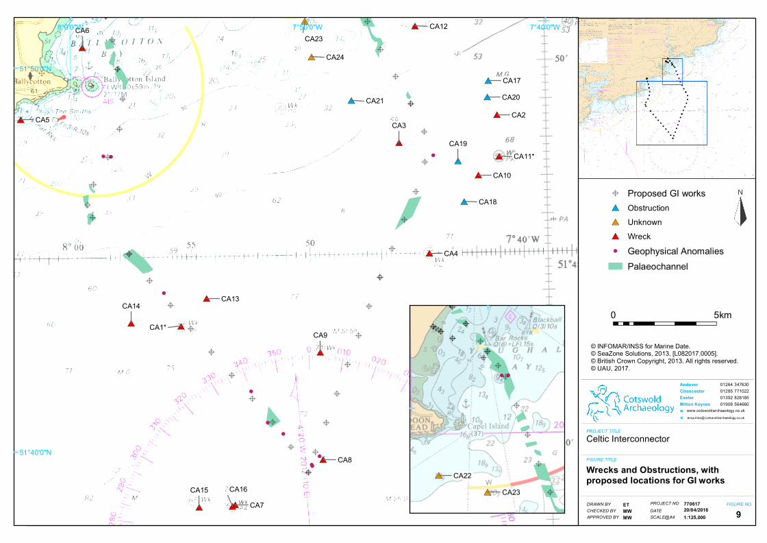
• 24 previously recorded marine assets or potential marine assets. These
comprise:
o 16 wrecks, four of which are known (CA2-5) and 11 which remain
unidentified (CA1 & CA6-16); unidentified wrecks are automatically
protected under Irish legislation (Section 3 of the National
Monuments (Amendment) Act, 1987) until they have been further
assessed. Of these 16 assets, the significance of 15 has been
assessed to be high, while the significance of the remaining one
(CA6) is assessed as medium. CA6 is recorded as a ‘dead’ wreck
which suggests that subsequent surveys have failed to find anything
in the recorded location;
7
Celtic Interconnector Project Marine archaeological impact assessment for proposed ground investigation surveys
o 5 unidentified obstructions (CA17-21) are assessed as of medium
significance; and
o 3 unknown sites (CA22-4) are assessed as of low significance.
• One previously recorded terrestrial site (CA25) comprising a flint blade
dating from c. 3000BC, found in association with a fulacht fiadh on the edge
of Ballycrenane beach (National Museum of Ireland (NMI) accession number
1972:354), has been assessed as of high significance (see Table 4);
• One probable wreck (CA1001), which corresponds to a previously recorded
site (CA8) is of high significance, nine magnetic anomalies (CA1002-9 &
CA1011) are assessed as of medium significance while two (CA1010 &
CA1012) are considered of low significance (see Table 5).
• A review of the sub-bottom seismic survey data identified 21 areas (CA2001-21) where features with archaeological palaeo-environmental potential are
present. Previous assessments suggest that these deposits are pre-Holocene
and therefore of low archaeological potential so they will not be considered
further (see Table 6).
In addition, the foreshore geophysical, metal detecting, and walkover surveys at the 3.2.
three potential landfall locations identified the following (see Table 7):
Claycastle beach
• An eroded and heavily encrusted circular object, possibly a pot (CA3001)
lying half exposed in the intertidal zone (Fig. 1). It could, possibly, be the
fossilised remains of a hollowed out trunk but this seems less likely as the
other wooden remains associated with the peat do not appear fossilised.
Until further investigation, this has been assessed to be of high significance;

8
Celtic Interconnector Project Marine archaeological impact assessment for proposed ground investigation surveys
Figure 1 Heavily encrusted circular object, possible pot
• Extensive areas of exposed peat (CA3002-11; Fig. 2) with associated
remains of tree trunks and roots (Fig. 3), which the geophysical survey
seems to have detected extending under the beach sand both landward and
seaward. This has been assessed to be of high significance;
Figure 2 Exposed peat on the foreshore

9
Celtic Interconnector Project Marine archaeological impact assessment for proposed ground investigation surveys
Figure 3 Remains of tree trunks and roots in the exposed peat
• The dilapidated remains of eight timber groynes (CA3012-9), which emerged
in the intertidal zone, have been assessed as of medium significance (Fig.
4); and
Figure 4 Dilapidated timber groyne on the foreshore
• 22 individual buried metal finds (CA3020-41), which appear to represent
casual losses, are of very low archaeological significance.
Redbarn beach
• A line of upstanding stones (CA3042), running E-W and standing up to 0.4m
high, which appear to be the remains of earlier sea defences (Fig. 5). These
have been assessed as of medium significance;

10
Celtic Interconnector Project Marine archaeological impact assessment for proposed ground investigation surveys
Figure 5 Upstanding stones, possibly the remains of sea defences
• 24 individual buried metal finds (CA3043-61 & CA3119-23) which appear to
represent casual losses are of very low archaeological significance; and
• 57 readings on the metal detector (CA3062-118) which appear to be aligned
in three rows on a NE-SW alignment over an area of c 60m x 300m. These
buried magnetic anomalies seem to correlate with a sub-surface depression
identified in the geophysical survey (Fig. 6). These have been assessed as
of medium significance.
Ballinwilling Strand
• Very few heritage assets were observed within the survey areas from the
walkover survey on Ballinwilling Strand. The remains of sea defences,
concrete breakwaters and groynes along the edge of Ballinwilling Strand
comprise low value heritage assets. In addition, the 51 responses from the
metal detector survey on Ballinwilling Strand appear to relate to buried
casual losses of objects on the beach and are not considered of any heritage
significance. They will not therefore be considered further.

CA 3050CA 3051
CA 3055
CA 3056CA 3057
CA 3059CA 3060
CA 3061
CA 3062 CA 3063 CA 3064CA 3065CA 3066CA 3067CA 3068
CA 3069CA 3070
CA 3071CA 3072CA 3073CA 3074CA 3075CA 3076
CA 3077CA 3078CA 3079
CA 3080CA 3081
CA 3083CA 3084 CA 3085
CA 3086 CA 3087CA 3088
CA 3089 CA 3090CA 3091 CA 3092
CA 3093CA 3094 CA 3095 CA 3096 CA 3097 CA 3098 CA 3099
CA 3100
CA 3101 CA 3102CA 3103
CA 3105CA 3106
CA 3107CA 3108CA 3109CA 3110
CA 3111CA 3112CA 3113
CA 3114
CA 3115CA 3116
CA 3117CA 3118
CA 3120CA 3121
CA 3122
CA 3123 Source: Esri, DigitalGlobe, GeoEye, Earthstar Geographics, CNES/Airbus DS, USDA, USGS, AeroGRID, IGN, and the GIS UserCommunity
PROJECT TITLE
FIGURE TITLE
Celtic Interconnector
A close up of the metal detectinganomalies and area of depressionfrom Redbarn beach.
DRAWN BYCHECKED BY
FIGURE NO.
© Crown copyright and database rights 2018Ordnance Survey 0100031673
PROJECT NO
0 0.02km
1:750APPROVED BY
RPMWMW
770617DATESCALE@A3 14
01264 34763001285 77102201392 82618501908 564660
www.cotswoldarchaeology.co.uk
Andover CirencesterExeterMilton Keynes we
09/02/2018
LegendMetaldetector survey points
WallQuadrature survey
±

12
Celtic Interconnector Project Marine archaeological impact assessment for proposed ground investigation surveys
Assessment of magnitude and significance of effect
The assessment of magnitude and significance of effect are presented in Tables 4-3.3.
7 along with any mitigation proposed and assessment of the significance of residual
effects.
The magnitude of impact on the assets listed in Tables 4 (CA1-25) and 5 (CA1001-3.4.
12) is assessed as either low or very low. This is because none of the current
proposed offshore coring locations are within 50m of the known / potential assets or
geophysical anomalies identified as having archaeological potential (see Fig. 9).
The closest coring location to a geophysical anomaly with archaeological potential
is located c. 70m north of CA1004. Consequently, the significance of potential
effects on them is considered negligible as their distance from the proposed survey
locations negates any potential impact. Should the locations of the proposed GI
works change considerably, greater than 30m for example, then the new locations
should be reassessed. CA25 is the only asset with a low assessment; this is the
location of the possible fulacht fiadh from which a flint blade was recovered, but it is
unclear what, if anything, of archaeological potential survives in this location.
This assessment has identified potential for impacts on a number of assets 3.5.
recorded during the foreshore surveys (CA3001-123; see Table 7) including:
• CA3001 a possible pot adjacent to one of the groynes in the inter-tidal zone;
• CA3002-11 the exposed palaeo-environmental remains;
• CA3042 the line of upright stones that may be the remains of sea defences;
and
• CA3062-118 the triple alignment of metal anomalies
The magnitude of impact on these assets has been assessed as medium, so the
significance of potential effects is minor and mitigation is therefore required.
Although the magnitude of impact on the stone sea defences on Redbarn beach 3.6.
has been assessed as medium, the magnitude on the timber sea defences on
Ballinwilling Strand and the timber groynes on Claycastle beach have been
assessed as very low and low respectively, for a number of reasons. Chiefly, unlike
the upstanding stones, the timber sea defences on Ballinwilling Strand and on

13
Celtic Interconnector Project Marine archaeological impact assessment for proposed ground investigation surveys
Claycastle beach are clearly sea defences and are therefore less likely to be
damaged. Second, the Ballinwilling Strand defences appear considerably more
modern than the other installations.
Other than the foreshore/intertidal areas, terrestrial historic assets have not been 3.7.
assessed as the significance of potential effects on them is considered negligible as
impacts on their settings from the proposed marine ground investigations would be
minimal and transitory.
4. PROPOSED MITIGATION
As stated, there is potential for impact on the following identified assets: 4.1.
• CA3001 a possible pot adjacent to one of the groynes in the inter-tidal zone;
• CA3002-11 the exposed palaeo-environmental remains;
• CA3042 the line of upright stones that may be the remains of sea defences;
and
• CA3062-118 the triple alignment of metal anomalies
The potential impact is primarily from vehicles and machinery moving around the 4.2.
beach. To mitigate this impact an archaeological exclusion zone of 10m around the
edge of these assets will be observed by all vehicles, machinery and operatives
(see Figs 7 & 8). After mitigation the effect on these historic assets has been
assessed to be negligible.
In addition, there is potential for an impact on buried palaeo-environmental deposits 4.3.
from the ground investigations. This impact, however, is potentially a minor benefit
as coastal and inter-tidal Mesolithic deposits are a relatively under-studied resource
so this survey could contribute to our knowledge and understanding of these
deposits.
The investigations are very small scale compared to the potential size of the deposit 4.4.
and the recovered samples will undergo full environmental assessment and, if
required, analysis. To mitigate this impact it is proposed that the results of the GI
are made available for inclusion in any future palaeo-environmental or geo-
archaeological studies of the area. After mitigation the effect on this historic asset
has been assessed to be negligible.
14
Celtic Interconnector Project Marine archaeological impact assessment for proposed ground investigation surveys
In consultation with the UAU it has been agreed that an appropriately licensed 4.5.
archaeologist will be in attendance throughout the GI works on the foreshore and in
the intertidal zones. The need for a monitoring archaeologist to be in attendance
throughout the offshore investigations has yet to be determined, but is thought
unnecessary as the proposed borehole locations are sufficiently distant from
identified assets to have any impact.
The provision and implementation of a reporting protocol for archaeological 4.6.
discoveries is however recommended. The protocol would simply:
• outline what actions would need to be undertaken in the event that anything
potentially archaeological should be encountered;
• the likely nature of any potential archaeological discoveries;
• the roles and responsibilities of the survey teams; and
• contact details for the archaeological consultant (who would then liaise with
the UAU).
A reporting protocol is intended to mitigate risks to potential unidentified marine 4.7.
archaeology and cultural heritage that may result from the ground investigation
works. This would entail the engagement of an archaeological consultant
throughout the period of the surveys who would be available to provide advice and
guidance to the survey teams.
The potential to encounter unknown archaeology or archaeological remains during 4.8.
the course of these works is considered very low owing to the sparsity of known
archaeology within the study areas.

15
Celtic Interconnector Project Marine archaeological impact assessment for proposed ground investigation surveys
Table 4 Recorded historic assets within the study area
CA report reference
UAU reference Site name Type Significance Magnitude of impact
Significance of potential effects
Proposed mitigation
Residual effect
CA1 W09134 Unidentified Wreck High Very low Negligible None Negligible CA2 WIID ref 9017 SS Gracia Wreck High Very low Negligible None Negligible CA3 W05360 SV William Martyn Wreck High Very low Negligible None Negligible CA4 FV Kindred Star (LT 399) Wreck High Very low Negligible None Negligible CA5 W08471 Joseph Mitchell Wreck High Very low Negligible None Negligible CA6 W10772 Unidentified Wreck Medium Very low Negligible None Negligible CA7 W11561 Unidentified Wreck High Very low Negligible None Negligible CA8 W11319 Unidentified = CA1001 Wreck High Very low Negligible None Negligible CA9 W11037 Unidentified Wreck High Very low Negligible None Negligible CA10 W10756 Unidentified Wreck High Very low Negligible None Negligible CA11 W11587 Unidentified Wreck High Very low Negligible None Negligible CA12 - Unidentified Wreck High Very low Negligible None Negligible CA13 - Unidentified Wreck High Very low Negligible None Negligible CA14 - Unidentified Wreck High Very low Negligible None Negligible CA15 - Unidentified Wreck High Very low Negligible None Negligible CA16 W09131 Unidentified Wreck High Very low Negligible None Negligible CA17 W10767 Foul Obstruction Medium Very low Negligible None Negligible CA18 W10751 Foul Obstruction Medium Very low Negligible None Negligible CA19 W10758 Foul Obstruction Medium Very low Negligible None Negligible CA20 - Foul Obstruction Medium Very low Negligible None Negligible CA21 W10766 Foul Obstruction Medium Very low Negligible None Negligible CA22 W11039 Unknown Unknown Low Very low Negligible None Negligible CA23 W11044 Unknown Unknown Low Very low Negligible None Negligible CA24 W11036 Unknown Unknown Low Very low Negligible None Negligible CA25 NMI acc. no. 1972:354 Fulacht fiadh Flint blade High Low Negligible None Negligible

16
Celtic Interconnector Project Marine archaeological impact assessment for proposed ground investigation surveys
Table 5 Identified marine geophysical anomalies within the study area
CA report reference
Site description Significance Magnitude of impact
Significance of potential impacts
Proposed mitigation
Residual effect
CA1001 Geophysical anomaly - probable wreck = CA8 High Very low Negligible None Negligible CA1002 Geophysical anomaly - metal debris (?) Medium Very low Negligible None Negligible CA1003 Geophysical anomaly - magnetic Medium Very low Negligible None Negligible CA1004 Geophysical anomaly - magnetic Medium Very low Negligible None Negligible CA1005 Geophysical anomaly - bathy/mag Medium Very low Negligible None Negligible CA1006 Geophysical anomaly - magnetic cluster Medium Very low Negligible None Negligible CA1007 Geophysical anomaly - magnetic Medium Very low Negligible None Negligible CA1008 Geophysical anomaly - magnetic Medium Very low Negligible None Negligible CA1009 Geophysical anomaly - magnetic Medium Very low Negligible None Negligible CA1010 Geophysical anomaly - magnetic cluster Low Very low Negligible None Negligible CA1011 Geophysical anomaly - magnetic Medium Very low Negligible None Negligible CA1012 Geophysical anomaly - magnetic Low Very low Negligible None Negligible

17
Celtic Interconnector Project Marine archaeological impact assessment for proposed ground investigation surveys
Table 6 Identified marine geophysical anomalies within the study area
CA report reference Site description Type Significance
Magnitude of impact
Significance of potential effects
Proposed mitigation
Residual effect
CA2001 Palaeo-landscape Sub-bottom feature Low Low Negligible None Negligible
CA2002 Palaeo-landscape Sub-bottom feature Low Low Negligible None Negligible
CA2003 Palaeo-landscape Sub-bottom feature Low Low Negligible None Negligible
CA2004 Palaeo-landscape Sub-bottom feature Low Low Negligible None Negligible
CA2005 Palaeo-landscape Sub-bottom feature Low Low Negligible None Negligible
CA2006 Palaeo-landscape Sub-bottom feature Low Low Negligible None Negligible
CA2007 Palaeo-landscape Sub-bottom feature Low Low Negligible None Negligible
CA2008 Palaeo-landscape Sub-bottom feature Low Low Negligible None Negligible
CA2009 Palaeo-landscape Sub-bottom feature Low Low Negligible None Negligible
CA2010 Palaeo-landscape Sub-bottom feature Low Low Negligible None Negligible
CA2011 Palaeo-landscape Sub-bottom feature Low Low Negligible None Negligible
CA2012 Palaeo-landscape Sub-bottom feature Low Low Negligible None Negligible
CA2013 Palaeo-landscape Sub-bottom feature Low Low Negligible None Negligible
CA2014 Palaeo-landscape Sub-bottom feature Low Low Negligible None Negligible
CA2015 Palaeo-landscape Sub-bottom feature Low Low Negligible None Negligible
CA2016 Palaeo-landscape Sub-bottom feature Low Low Negligible None Negligible
CA2017 Palaeo-landscape Sub-bottom feature Low Low Negligible None Negligible
CA2018 Palaeo-landscape Sub-bottom feature Low Low Negligible None Negligible
CA2019 Palaeo-landscape Sub-bottom feature Low Low Negligible None Negligible
CA2020 Palaeo-landscape Sub-bottom feature Low Low Negligible None Negligible
CA2021 Palaeo-landscape Sub-bottom feature Low Low Negligible None Negligible

18
Celtic Interconnector Project Marine archaeological impact assessment for proposed ground investigation surveys
Table 7 Potential archaeological remains identified during the metal detecting and walkover surveys at Claycastle beach, Redbarn beach and Ballinwilling Strand
Location CA report reference
Site description Type Significance Magnitude of impact
Significance of potential effects
Proposed mitigation
Residual effect
Clay
cast
le
CA3001 Possible pot Metal High Medium Minor AEZ of 10m Negligible
CA3002-11 Palaeo-environmental remains Peat,
timber High Medium Minor AEZ of 10m Negligible
CA3012-9 Beach defences - groynes Timber Medium Low Negligible None Negligible
CA3020-41 Metal detections - casual losses Metal Very low Very low Negligible None Negligible
Redb
arn
CA3042 Sea defences Stone Medium Medium Minor AEZ of 10m Negligible
CA3043-61 Metal detections - casual losses Metal Very low Very low Negligible None Negligible
CA3062-118 Metal detections - possible alignment Metal Medium Medium Minor AEZ of
10m Negligible
CA3119-23 Metal detections - casual losses Metal Very low Very low Negligible None Negligible
Balli
nwill
ing
Stra
nd HA 101* Cutwater Concrete Very low Very low Negligible None Negligible
HA 102* Sea defences Wood Very low Very low Negligible None Negligible
HA 103* Slipway Concrete Very low Very low Negligible None Negligible
* Headland Archaeology 2015

!(
_̂
_̂
_̂"/
CA3001
7°51'20"W7°51'30"W7°51'40"W51
°56'0
"N51
°55'5
0"N
PROJECT TITLE
FIGURE TITLE
Celtic Interconnector
Proposed exclusion zones onClaycastle beach
DRAWN BYCHECKED BY
FIGURE NO.PROJECT NO
0 100M
1:3,000APPROVED BY
KDMWMW
770617DATESCALE@A4
Cable RouteSurvey AreaArchaeological Exclusion Zone Exposed Peat
_̂ Borehole"/ Trial Pit
7
01264 34763001285 77102201392 82618501908 564660
Andover CirencesterExeterMilton Keynes we
20/04/2018
Service Layer Credits: Source: Esri, DigitalGlobe,GeoEye, Earthstar Geographics, CNES/Airbus DS,USDA, USGS, AeroGRID, IGN, and the GIS UserCommunity

_̂
_̂
_̂
_̂"/
7°52'0"W7°52'10"W7°52'20"W
51°55'30"N
51°55'20"N
PROJECT TITLE
FIGURE TITLE
Celtic Interconnector
Proposed exclusion zones onRedbarn beach
DRAWN BYCHECKED BY
FIGURE NO.PROJECT NO
0 100M
1:3,000APPROVED BY
KDMWMW
770617DATESCALE@A4
Cable RouteSurvey AreaArchaeological Exclusion Zone Beach Defences
_̂ Borehole"/ Trial Pit
8
01264 34763001285 77102201392 82618501908 564660
Andover CirencesterExeterMilton Keynes we
20/04/2018
Service Layer Credits: Source: Esri, DigitalGlobe,GeoEye, Earthstar Geographics, CNES/Airbus DS,USDA, USGS, AeroGRID, IGN, and the GIS UserCommunity
!(!(
!(
!(
!(
!(
!(
!(!(
!(
!(
!(
!(
!(
!(
!(
!(
!(
!(!(!(
!(
!(!(
!(
!(
!(
!(
!(
!(
!( !(!(
!(
!(!(
!(
!(
!(!(!(
!(
!(!(
!(
!(
!(
!(
!(
!(
!(!(
!(!(!(!(!(!( !(!(!(
!(!(!(!(
!(!(!(!(
#*
#*
#*
#*
#*
#*
#*
#*
#*
#*
#*
#*
#*
#*
#* #*
#*
#*
#*
#*#*
#*
#*
!
!
!
!
!
!
!
!
!
!
AA
A
A
A
A
A
AA
A
A
A
A
A
A
A
A
A
AAA
A
A
A
A
A
A
A
A
A
AAA
A
AA
A
A
AAA
A
AA
A
A
A
CA1*
CA2CA3
CA4
CA5
CA6
CA7
CA8
CA9
CA10
CA11*
CA12
CA13CA14
CA15 CA16
CA17
CA18
CA19
CA20CA21
CA23
CA24
7°40'0"W7°50'0"W8°0'0"W
51°50'0"N
51°40'0"N
PROJECT TITLE
FIGURE TITLE
Celtic Interconnector
Wrecks and Obstructions, with proposed locations for GI works
DRAWN BYCHECKED BY
FIGURE NO.PROJECT NO
0 5km
1:125,000APPROVED BY
ETMWMW
770617DATESCALE@A4
A Proposed GI works#* Obstruction#* Unknown#* Wreck! Geophysical Anomalies
Palaeochannel
9
01264 34763001285 77102201392 82618501908 564660
Andover CirencesterExeterMilton Keynes we
20/04/2018
© INFOMAR/INSS for Marine Date.© SeaZone Solutions, 2013, [L082017.0005].© British Crown Copyright, 2013. All rights reserved.© UAU, 2017.
#*
#*
! !
A
A
A
A
A
A
AA
AAAAA
A AA
A
A
A
AA
AAAA
CA22CA23

22
Celtic Interconnector Project Marine archaeological impact assessment for proposed ground investigation surveys
5. REFERENCES
Cotswold Archaeology. 2018. Celtic Interconnector Project: Archaeological review
of foreshore walkover, and foreshore and offshore geophysical survey data.
CA report no. 17758.
Cotswold Archaeology. 2017. Celtic Interconnector Project: Marine archaeology
desk-based assessment. CA report no. 17489.
EirGrid plc. 2017. Attachment A: Schedule of survey works.
Headland Archaeology. 2015. Celtic (Ireland-France) Interconnector:
Archaeological Review of Foreshore Geophysical, Walkover Surveys and
Offshore Geophysical Survey Data. Ref: EIFI/06.
